Embed Size (px)
Citation preview
SDMS DocID
Five-Year Review Report
Fourth Five-Year Review for
Beacon Heights Landfill Superfund Site Beacon Falls, Connecticut
September 2008
Prepared by:
The United States Environmental Protection Agency Region 1, New England Boston, Massachusetts
• • ' . eA • • " •
O EPA New F.ngland
295588
Five-Year Review Report
Fourth Five-Year Review for
Beacon Heights Landfill Superfund Site Beacon Falls, Connecticut
September 2008
Prepared by:
The United States Environmental Protection Agency Region 1, New England Boston, Massachusetts
«EPA New England
7/35/05-, James T. Owens, III Director
Office of Site Remediation and Restoration U.S. EPA, New England
TABLE OF CONTENTS FOURTH FIVE-YEAR REVIEW
BEACON HEIGHTS LANDFILL SUPERFUND SITE BEACON FALLS, CONNECTICUT
SECTION PAGE
ACRONYMS AC-1
EXECUTIVE SUMMARY ES-1
1.0 INTRODUCTION 1
2.0 SITE CHRONOLOGY 2
3.0 BACKGROUND 2 3.1 Physical Characteristics 3 3.2 Land and Resource Use 3 3.3 History of Contamination 4 3.4 initial Response 4 3.5 Basis for Taking Action 4
4.0 REMEDIAL ACTIONS 5 4.1 Remedy Selection 5 4.2 Remedy Implementation 7 4.3 Operation and Maintenance 8
5.0 PROGRESS SINCE LAST REVIEW 9
6.0 FIVE-YEAR REVIEW PROCESS 10 6.1 Administrative Components 10 6.2 Community Involvement 10 6.3 Document Review 10 6.4 Data Review 11 6.5 Site Inspection 14 6.6 Interviews 17
7.0 TECHNICAL ASSESMENT 18 7.1 Question A: Is the Remedy Functioning as Intended by the Decision
Documents? 18 7.2 Question B: Are the Exposure Assumptions, Toxicity Data, Cleanup Levels,
and Remedial Action Objectives Used at the Time of the Remedy Selection Still Valid? 20
7.3 Question C: Has Any Other Information Come to Light that Could Call into Question the Protectiveness of the Remedy? 25
7.4 Technical Assessment Summary 26
8.0 ISSUES 27
9.0 RECOMMENDATIONS AND FOLLOW-UP ACTIONS 28
10.0 PROTECTIVENESS STATEMENT{S) 29
11.0 NEXT REVIEW 30
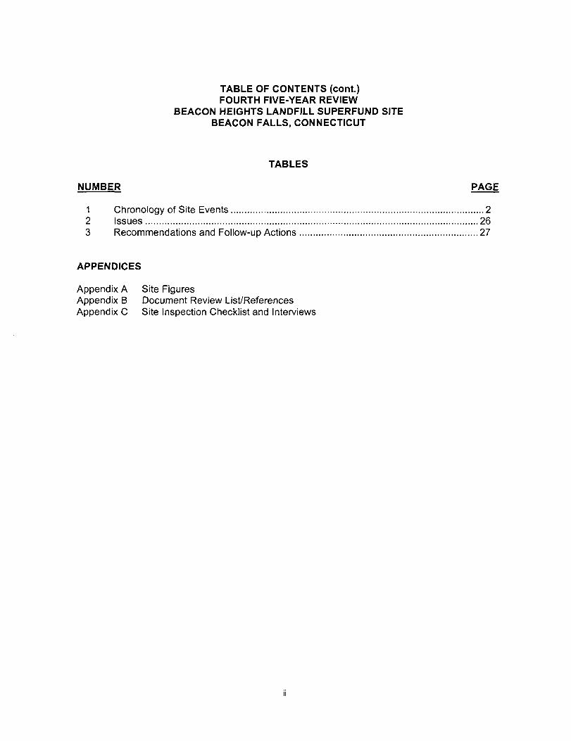
TABLE OF CONTENTS (cont.) FOURTH FIVE-YEAR REVIEW
BEACON HEIGHTS LANDFILL SUPERFUND SITE BEACON FALLS, CONNECTICUT
TABLES
NUMBER PAGE
1 Chronology of Site Events 2 2 issues 26 3 Recommendations and Follow-up Actions 27
APPENDICES
Appendix A Site Figures Appendix B Document Review List^References Appendix C Site inspection Checklist and Interviews
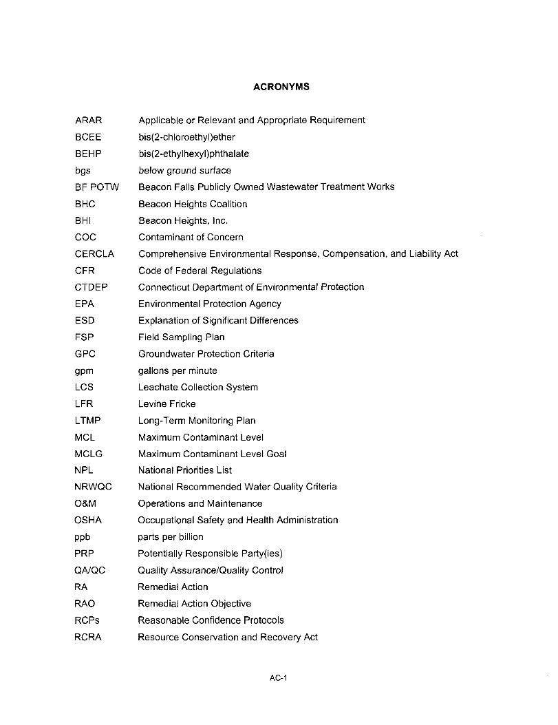
ACRONYMS
ARAR Applicable or Relevant and Appropriate Requirement
BCEE bis(2-chloroethyl)ether
BEHP bis(2-ethylhexyl)phthalate
bgs below ground surface
BF POTW Beacon Falls Publicly Owned Wastewater Treatment Works
BHC Beacon Heights Coalition
BHI Beacon Heights, Inc.
COG Contaminant of Concern
CERCLA Comprehensive Environmental Response, Compensation, and Liability Act
CFR Code of Federal Regulations
CTDEP Connecticut Department of Environmental Protection
EPA Environmental Protection Agency
ESD Explanation of Significant Differences
FSP Field Sampling Plan
GPC Groundwater Protection Criteria
gpm gallons per minute
LCS Leachate Collection System
LFR Levine Fricke
LTMP Long-Term Monitoring Plan
MCL Maximum Contaminant Level
MCLG Maximum Contaminant Level Goal
NPL National Priorities List
NRWQC National Recommended Water Quality Criteria
O&M Operations and Maintenance
OSHA Occupational Safety and Health Administration
ppb parts per billion
PRP Potentially Responsible Party(ies)
QA/QC Quality Assurance/Quality Control
RA Remedial Action
RAO Remedial Action Objective
RCPs Reasonable Confidence Protocols
RCRA Resource Conservation and Recovery Act
AC-1
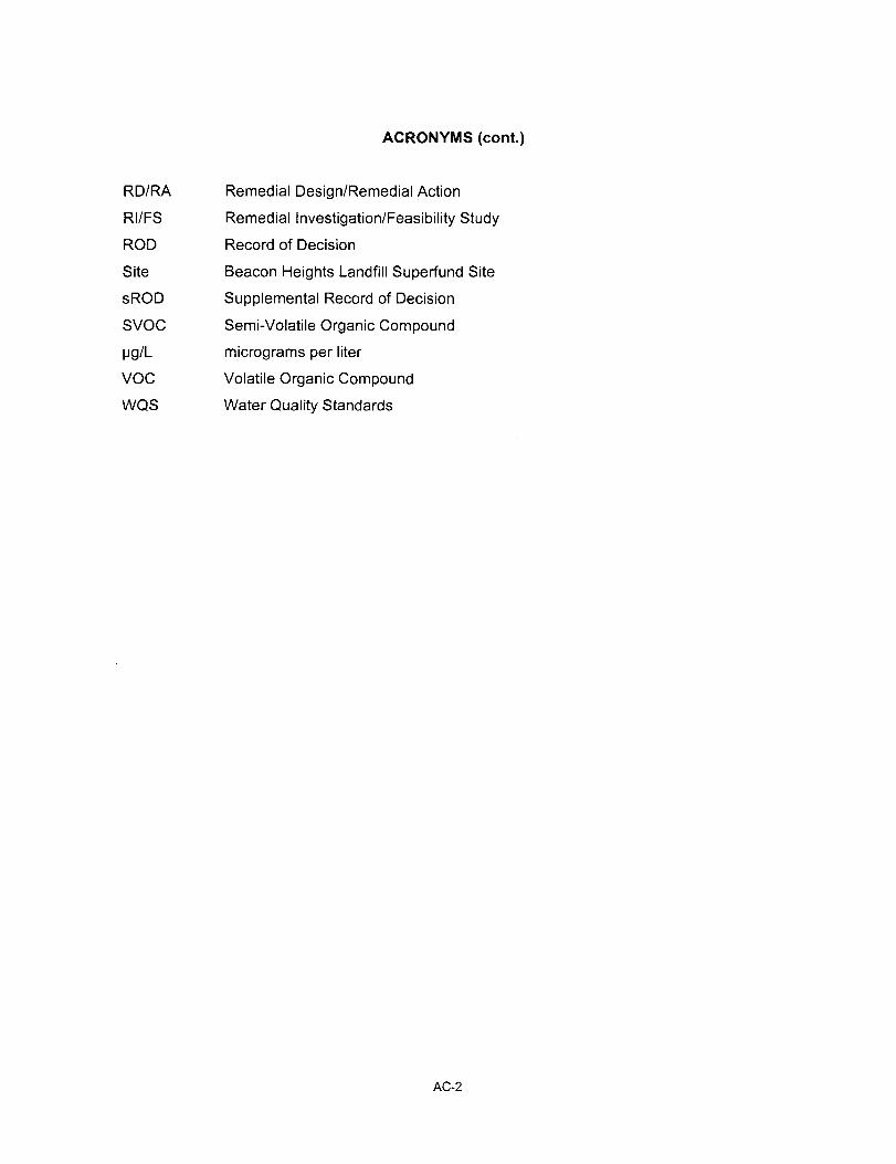
ACRONYMS (cont.)
RD/RA Remedial Design/Remedial Action
RI/FS Remedial Investigation/Feasibility Study
ROD Record of Decision
Site Beacon Heights Landfill Superfund Site
sROD Supplemental Record of Decision
SVOC Semi-Volatile Organic Compound
|jg/L micrograms per liter
VOC Volatile Organic Compound
WQS Water Quality Standards
AC-2
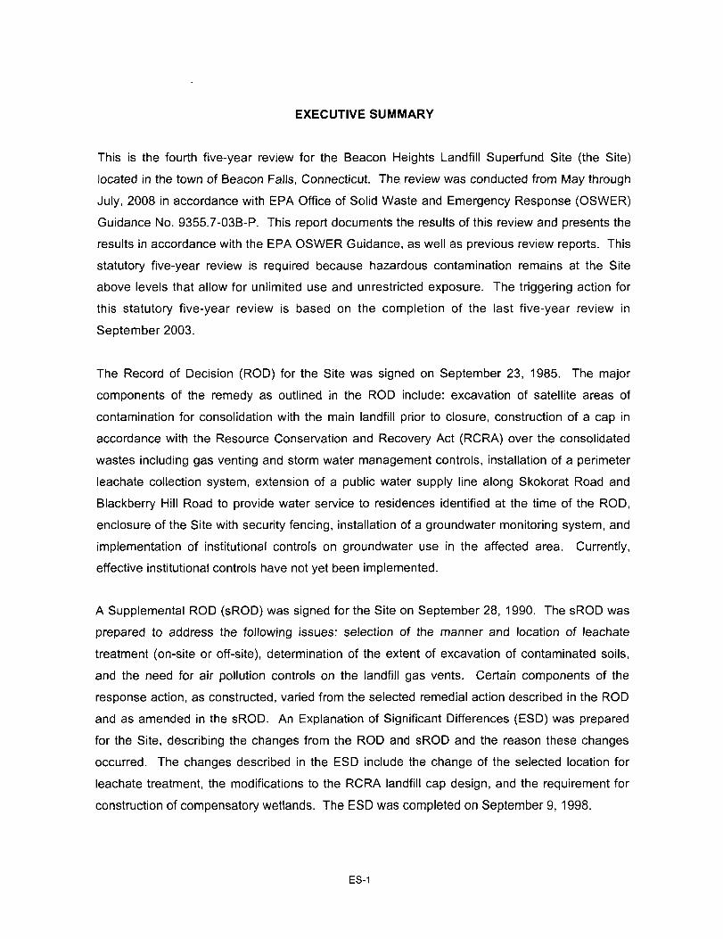
EXECUTIVE SUMMARY
This is the fourth five-year review for the Beacon Heights Landfill Superfund Site (the Site)
located in the town of Beacon Falls, Connecticut. The review was conducted from May through
July, 2008 in accordance with EPA Office of Solid Waste and Emergency Response (OSWER)
Guidance No. 9355.7-03B-P. This report documents the results of this review and presents the
results in accordance with the EPA OSWER Guidance, as well as previous review reports. This
statutory five-year review is required because hazardous contamination remains at the Site
above levels that allow for unlimited use and unrestricted exposure. The triggering action for
this statutory five-year review is based on the completion of the last five-year review in
September 2003.
The Record of Decision (ROD) for the Site was signed on September 23, 1985. The major
components of the remedy as outlined in the ROD include: excavation of satellite areas of
contamination for consolidation with the main landfill prior to closure, construction of a cap in
accordance with the Resource Conservation and Recovery Act (RCRA) over the consolidated
wastes including gas venting and storm water management controls, installation of a perimeter
leachate collection system, extension of a public water supply line along Skokorat Road and
Blackberry Hill Road to provide water service to residences identified at the time of the ROD,
enclosure of the Site with security fencing, installation of a groundwater monitoring system, and
implementation of institutional controls on groundwater use in the affected area. Currently,
effective institutional controls have not yet been implemented.
A Supplemental ROD (sROD) was signed for the Site on September 28, 1990. The sROD was
prepared to address the following issues: selection of the manner and location of leachate
treatment (on-site or off-site), determination of the extent of excavation of contaminated soils,
and the need for air pollution controls on the landfill gas vents. Certain components of the
response action, as constructed, varied from the selected remedial action described in the ROD
and as amended in the sROD. An Explanation of Significant Differences (ESD) was prepared
for the Site, describing the changes from the ROD and sROD and the reason these changes
occurred. The changes described in the ESD include the change of the selected location for
leachate treatment, the modifications to the RCRA landfill cap design, and the requirement for
construction of compensatory wetlands. The ESD was completed on September 9, 1998.
ES-1
The remedy has made progress in achieving the Remedial Actions Objectives specified in the
ROD. Periodic site inspections indicate that the landfill components are in good condition and
largely functioning as intended in the ROD. Ongoing operations and maintenance of the landfill
and the leachate collection system and long-term monitoring are helping to maintain the current
protectiveness of the remedy. While there have been changes to the ARARs cited in the ROD,
updates in toxicity factors and chemical characteristics, and updated risk assessment methods,
the remedy is still largely effective because capping and provision of a waterline prevent
potential exposure to contaminated landfill materials and ingestion of groundwater
contaminants.
Most of the contaminated overburden groundwater migrating from the landfill appears to be
captured by the perimeter leachate collection system. However, contaminated groundwater is
still migrating downwards into the fractured bedrock and downgradient beyond the influence of
leachate collection system. Local hydrogeologic conditions cause groundwater to enter into the
landfill from the bedrock unit, causing chemicals to leach and then migrate off site. Although a
waterline had been installed to provide potable water to nearby residences, some residents
declined the opportunity to connect in 1989 and 1994. More residential developments have
been constructed since the extension of the water line in 1989 and it is uncertain whether all
new residences near the Site are connected to a public water supply. New residential
developments are being constructed or are planned on parcels that abut the Site to the
northeast and to the south. Nearby residents with private water supply wells may be exposed to
contaminated bedrock groundwater. The vapor intrusion pathway has not been evaluated
previously. This pathway should be evaluated with respect to all nearby homes. Contaminated
bedrock groundwater may also be discharging to an adjacent surface water body. Institutional
controls (e.g., deed restrictions) to restrict groundwater use in the vicinity of the Site have not
been implemented.
The remedy currently protects human health and the environment in the short term because the
cap and leachate collection system are containing overburden groundwater contaminants on
site, and the watertine installed along Blackberry Hill Road and Skokorat Road helps to ensure
that most nearby residents are not exposed to contaminants that may remain in the
groundwater. However, based on changes identified after the third five-year review, evaluation
of the future protectiveness of the remedy is deferred until additional information can be
ES-2

acquired and evaluated. It is expected that these additional actions will require approximately
18 months (or less) to complete.
The next five-year review will be conducted by September 2013.
ES-3
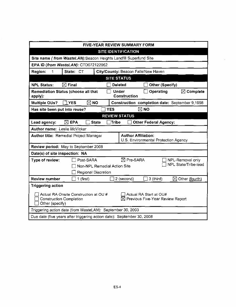
FIVE-YEAR REVIEW SUMMARY FORM
SITE IDENTIFICATION
Site name ( f rom WasteLAN):Beacon Heights Landfill Superfund Site
EPA ID {from WasteLAN): CTD072122062
Region: 1 I State: CT City/County: Beacon Falls/New Haven
SITE STATUS
NPL Status: ^ Final
Remediation Status (choose all that apply):
D Deleted Q Other (Specify)
n Under D Operating ^ Complete Construction
Multiple OUs? n YES M NO
Has site been put into reuse?
Construction completion date: September 9,1998
D YES K NO
REVIEW STATUS
Lead agency: EPA D State DTribe • Other Federal Agency:
Author name: Leslie McVickar
Author title: Remedial Project Manager Author Affiliation: U.S. Environmental Protection Agency
Review period: May to September 2008
Date(s) of site inspection: NA
Type of review: D Post-SARA S Pre-SARA
n Non-NPL Remedial Action Site
n Regional Discretion
• NPL-Removal only n NPL State/Tribe-lead
Review number D 1 (first) n 2 (second) D 3 (third) Other (fourth)
Triggering action
• Actual RA Onslte Construction at OU # • Construction Completion n Other (specify)
n Actual RA Start at OU# ^ Previous Five-Year Review Report
Triggering action date (from WasteLAN): September 30, 2003
Due date (five years after triggering action date): September 30, 2008
ES-4
Five-Year Review Summary Form, Cont'd
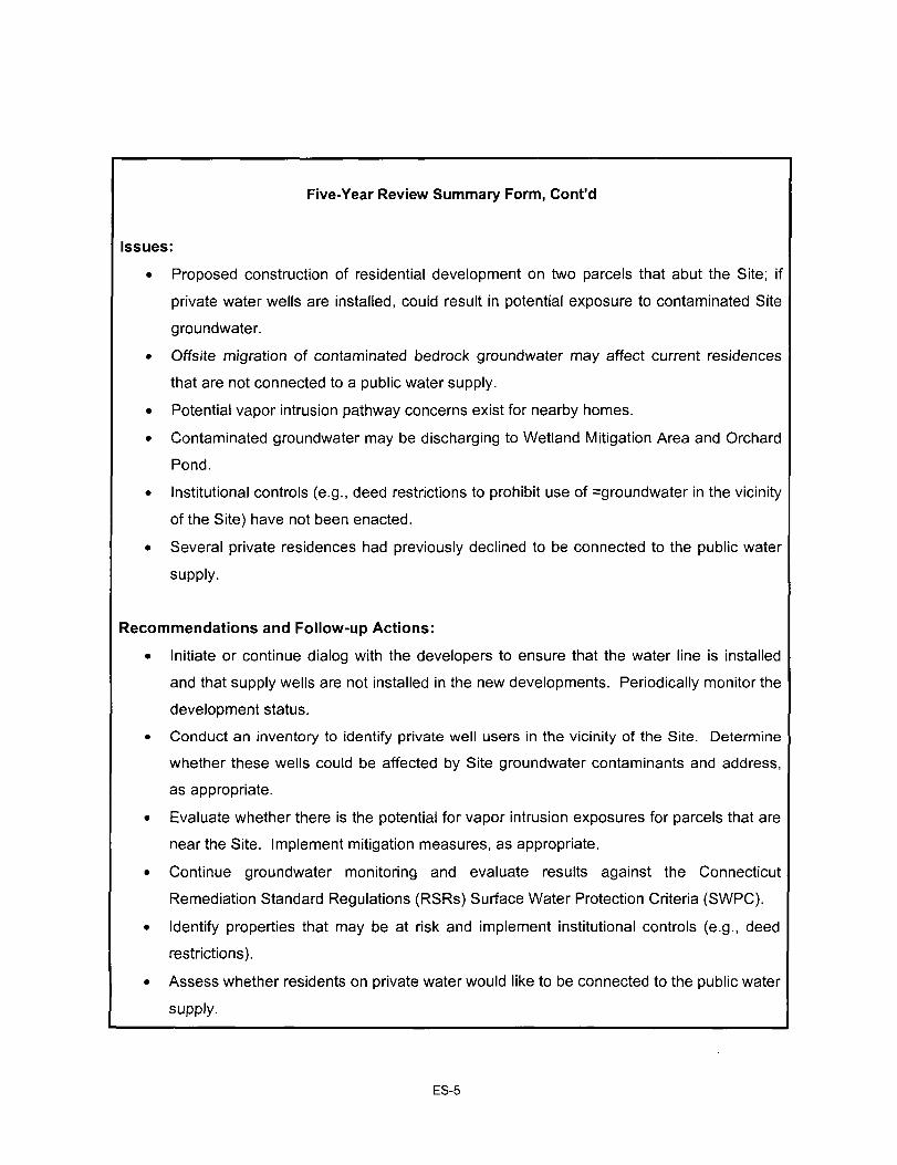
Issues:
• Proposed construction of residential development on two parcels that abut the Site; if
private water wells are installed, could result in potential exposure to contaminated Site
groundwater.
• Offsite migration of contaminated bedrock groundwater may affect current residences
that are not connected to a public water supply.
• Potential vapor intrusion pathway concerns exist for nearby homes.
• Contaminated groundwater may be discharging to Wetland Mitigation Area and Orchard
Pond.
• Institutional controls (e.g., deed restrictions to prohibit use of =groundwater in the vicinity
of the Site) have not been enacted.
• Several private residences had previously declined to be connected to the public water
supply.
Recommendations and Follow-up Actions:
• Initiate or continue dialog with the developers to ensure that the water line is installed
and that supply wells are not installed in the new developments. Periodically monitor the
development status.
• Conduct an inventory to identify private well users in the vicinity of the Site. Determine
whether these wells could be affected by Site groundwater contaminants and address,
as appropriate.
• Evaluate whether there is the potential for vapor intrusion exposures for parcels that are
near the Site. Implement mitigation measures, as appropriate.
• Continue groundwater monitoring and evaluate results against the Connecticut
Remediation Standard Regulations (RSRs) Surface Water Protection Criteria (SWPC).
• Identify properties that may be at risk and implement institutional controls (e.g., deed
restrictions).
• Assess whether residents on private water would like to be connected to the public water
supply.
ES-5
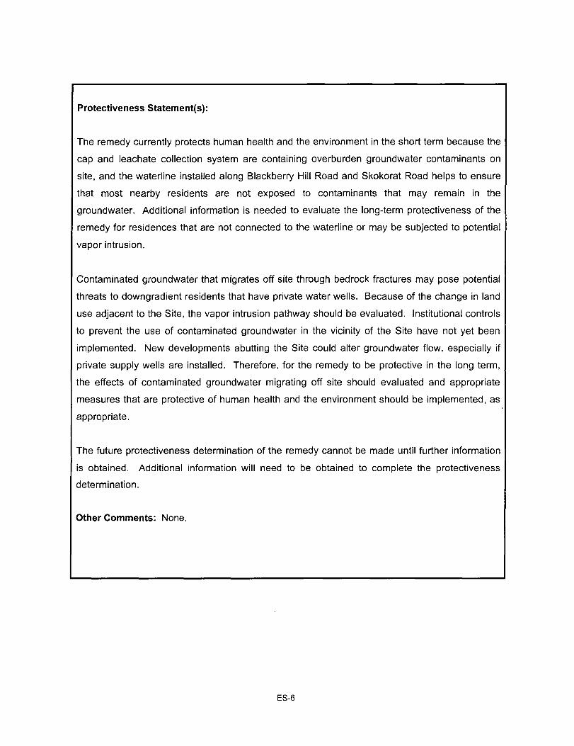
Protectiveness Statement(s):
The remedy currently protects human health and the environment in the short term because the
cap and leachate collection system are containing overburden groundwater contaminants on
site, and the waterline installed along Blackberry Hill Road and Skokorat Road helps to ensure
that most nearby residents are not exposed to contaminants that may remain in the
groundwater. Additional information is needed to evaluate the long-term protectiveness of the
remedy for residences that are not connected to the waterline or may be subjected to potential
vapor intrusion.
Contaminated groundwater that migrates off site through bedrock fractures may pose potential
threats to downgradient residents that have private water wells. Because of the change in land
use adjacent to the Site, the vapor intrusion pathway should be evaluated. Institutional controls
to prevent the use of contaminated groundwater in the vicinity of the Site have not yet been
implemented. New developments abutting the Site could alter groundwater flow, especially if
private supply wells are installed. Therefore, for the remedy to be protective in the long term,
the effects of contaminated groundwater migrating off site should evaluated and appropriate
measures that are protective of human health and the environment should be implemented, as
appropriate.
The future protectiveness determination of the remedy cannot be made until further information
is obtained. Additional information will need to be obtained to complete the protectiveness
determination.
Other Comments: None.
ES-6
1.0 INTRODUCTION
As requested by the Environmental Protection Agency (EPA), a five-year review was conducted
of the remedial actions selected for the Beacon Heights Landfill, in Beacon Falls, Connecticut.
The purpose of the five-year review is to determine whether the remedy being implemented at
the Site remains protective of human health and the environment. The methods, findings, and
conclusions of the five-year review are documented in this Five-Year Review Report. In
addition, this report presents issues identified during the review and provides recommendations
to address them.
This Five-Year Review Report was prepared pursuant to CERCLA §121 and the National
Contingency Plan. CERCLA § 121(c) states:
"If the President selects a remedial action that results in any hazardous substances, pollutants, or contaminants remaining at the site, the President shall review such remedial action no less than each five years after the initiation of such remedial action to assure that human health and the environment are being protected by the remedial action being implemented. In addition, if upon such reviews it is the judgment of the President that the action is appropriate at such site in accordance with section [104] or [106], the president shall take or require such action. The President shall report to the Congress a list of facilities for which such review is required, the results of all such reviews and any actions taken as a result of such reviews."
The Agency interpreted this requirement further in the National Contingency Plan (NCP); 40
CFR § 300.430 (f)(4)(ii) states:
"If a remedial action is selected that results in hazardous substances, pollutants, or contaminants remaining at the site above levels that allow for unlimited use and unrestricted exposure, the lead agency shall review such action no less often than every five years after the initiation of the selected remedial action."
This is the fourth five-year review for the Site. The triggering action for this statutory review is
the completion of the last five-year review in 2003. The five-year review is required because
contaminants remain at the Site above levels that allow for unlimited use and unrestricted
exposure.
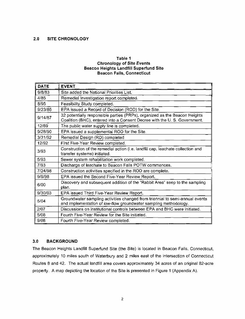
2.0 SITE CHRONOLOGY
Table 1 Chronology of Site Events
Beacon Heights Landfill Superfund Site Beacon Falls, Connecticut
DATE
9/8/83 4/85 8/95
9/23/85
9/14/87
12/89
9/28/90 3/31/92 12/92
3/93
5/93 7/93 7/24/98 9/9/98
6/00
9/30/03
5/04
2/07 5/08 9/08
EVENT
Site added the National Priorities List. Remedial Investigation report completed. Feasibility Study completed. EPA issued a Record of Decision (ROD) for the Site. 32 potentially responsible parties (PRPs), organized as the Beacon Heights Coalition (BHC), entered into a Consent Decree with the U. S. Government. The public water supply line is completed. EPA issued a supplemental ROD for the Site. Remedial Design (RD) completed First Five-Year Review completed. Construction of the remedial action (i.e. landfill cap, leachate collection and transfer systems) initiated. Sewer system rehabilitation work completed. Discharge of leachate to Beacon Falls POTW commences. Construction activities specified in the ROD are complete. EPA issued the Second Five-Year Review Report. Discovery and subsequent addition of the "Rabbit Area" seep to the sampling plan. EPA issued Third Five-Year Review Report.
Groundwater sampling activities changed from triennial to semi-annual events and implementation of low-flow groundwater sampling methodology. Discussions on institutional controls between EPA and BHC were initiated. Fourth Five-Year Review for the Site initiated. Fourth Five-Year Review completed.
3.0 BACKGROUND
The Beacon Heights Landfill Superfund Site (the Site) is located in Beacon Falls, Connecticut,
approximately 10 miles south of Waterbury and 2 miles east of the intersection of Connecticut
Routes 8 and 42. The actual landfill area covers approximately 34 acres of an original 82-acre
property. A map depicting the location of the Site is presented in Figure 1 (Appendix A).
3.1 Physical Characteristics
The Beacon Heights Landfill sits atop a ridge southeast of the intersection of Skokorat and
Blackberry Hill Roads. Chain-link fencing surrounds the perimeter of the capped landfill area.
The landfill cap consists of a multi-barrier cover system with a vegetative grass cover as the top
layer. A leachate collection system consisting of perforated pipe and drainage media surrounds
the landfill cap. Areas outside the landfill cap, but within the perimeter of the fence, are
generally vegetated with bushes and trees. Low-density residential areas border the Site to the
north along Blackberry Hill Road, to the southwest on Kaleas Way and Morning Wood Drive,
and further to the west along Skokorat Road. The closest residence is situated approximately
500 feet to the southwest of the capped landfill area on Kaleas Way.
The Site is located within the Hockanum Brook drainage area. Hockanum Brook, a tributary of
the Naugatuck River, is located about 0.5 miles northwest of the Site. Bedrock outcrops appear
in many areas around the Site. The bedrock surface is fractured and dips from the south/
southeast of the Site towards the north/northwest, parallel to surface water drainage.
Groundwater in the region occurs in both the unconsolidated deposits and in the bedrock and
generally flows to the north/northwest. A map depicting the Site features is presented in
Figure 2 (Appendix A).
3.2 Land and Resource Use
From the 1920s until 1979 the Site was used as an active landfill. The Site is currently a closed
landfill and will likely remain as such because of the need to protect the integrity of the landfill
cap and because the Site is privately owned. Adjacent land uses include farming, forested
areas, gravel excavation operations, and residential development. Hockanum Brook is
presently classified as recreational use water (Class C/B) with a goal of becoming a potential
drinking water source (Class B/A). The Naugatuck River, located west of the Site, is classified
as restricted recreational use water with a goal of becoming recreational use water.
Groundwater in the area continues to be used as a drinking water supply; however, many of the
surrounding properties replaced their private water supplies with public water when the public
water supply system was extended along Skokorat and Blackberry Hill Roads as part of the
cleanup in 1989.
3.3 History of Contamination
From the 1920s until 1970 a small portion of what is now known as the Beacon Heights Landfill
Superfund Site was known as "Betkoski's Dump" and consisted of approximately 6 acres of
active dumping and open burning in the northwestern corner of the existing Site. The dump
accepted a variety of waste including municipal refuse, rubber, plastics, and industrial chemical
and sludges. During this period of operation, there were general complaints and concerns due
to fumes, smoke and blowing litter. The Site was not regulated by the State until 1970.
In 1970, Beacon Heights, Incorporated (BHI) purchased the Site, which included the Betkoski
Dump area. BHI and its owner, Harold Murtha, owned and operated the Site as Beacon
Heights Landfill and expanded the landfill area to approximately 34 acres.
From 1970 until the its closure in July 1979, the Site was used for the disposal of various waste
materials including: rubber, plastics, oils, hydrocarbons, chemical liquids and sludges, and
solvents. In 1977 the Connecticut Department of Environmental Protection (CTDEP) approved
the spreading of wastewater sludge from the Naugatuck municipal/industrial wastewater
treatment facility over covered areas of the landfill. These activities continued until the summer
of 1984.
3.4 Initial Response
On June 20, 1979 BHI signed a Consent Order to close the Site by July 1, 1979. This Consent
Order was entered as a final order of the Connecticut Commissioner of Environmental
Protection on July 24, 1979. The closure requirements of the Order, which included the
placement of a final cover and implementation of a groundwater monitoring system, were never
implemented. However, on December 4, 1979, the CTDEP inspected the Site and reported that
landfill operations had ceased.
3.5 Basis for Taking Action
The Remedial Investigation (Rl) concluded that leachate from the landfill was migrating off site
and contaminating nearby residential drinking water wells and surface water bodies (i.e., the
tributary of Hockanum Brook). The leachate was generated as a result of precipitation
percolating through the landfill wastes and causing various chemical contaminants to be
mobilized, which then migrated into the water table. On-site soils were also contaminated by
leachate; however, direct releases of waste materials to the ground surface also contributed as
a major source of soil contamination.
Based on the results of sampling conducted as part of the Rl, ingestion of groundwater
represented the most significant risk to human health. Benzene, chlorobenzene, chloroethanes,
bis(2-chloroethyl) ether, xylenes and other site-related hazardous compounds, were detected in
groundwater at concentrations well above levels considered to be protective. Moreover, as long
as precipitation was allowed to percolate through the landfill wastes and soils contaminated by
that waste, the potential existed for further degradation of groundwater quality to levels that
would endanger public health, if consumed.
4.0 REMEDIAL ACTIONS
4.1 Remedy Selection
The objectives of the remedial action described in the 1985 ROD are to:
• Reduce the generation of contaminated leachate and thereby mitigate future
groundwater and surface water contamination;
• Minimize off-site migration of contaminants via surface runoff;
• Minimize direct human contact with on-site contaminated soils; and
• Assure a safe drinking water supply for area residents.
These objectives would be achieved by source control actions supplemented by off-site actions.
To meet these broad objectives, the landfill wastes would be isolated to minimize contact with
groundwater and surface water, and to prevent human and animal exposure.
The initial recommendations in the ROD consisted of the following activities:
• Excavation of satellite areas of contamination for consolidation with the main landfill prior
to closure.
RCRA capping of the consolidated wastes, including gas venting and stormwater
management controls.
• Installation of a perimeter leachate collection system.
•
•
Extension of a public water supply line along Skokorat Road and Blackberry Hill Road to
provide water service to current residences.
Enclosure of the Site with security fencing.
Installation of an extensive groundwater monitoring system.
Collection of leachate generated by the landfill and transportation of it to a licensed
wastewater treatment facility or an on-site treatment facility followed by discharge to a
tributary of Hockanum Brook.
Preparation of further studies and a supplemental ROD (sROD) to select the manner
and location of leachate treatment (on-site or off-site), the extent of excavation of
contaminated soils, and the need for air pollution controls on the landfill gas vents.
The ROD was completed in September 1990 that utilized information contained in a Pre-Design
Study, prepared by the Potentially Responsible Parties (PRPs), to evaluate on-site and off-site
treatment alternatives. The major components of the sROD included:
• Contaminated leachate from the Site would be transported and subsequently treated at
the Naugatuck, Connecticut wastewater treatment facility (the Naugatuck facility).
• Contaminated soils, located outside the main landfill, would be excavated to chemical
concentrations specified within the sROD and placed under the cap.
• Landfill cap gas vents would be constructed such that they could be augmented with air
pollution mitigating devices in the event that future air monitoring should require such
action. In addition, post-construction air quality monitoring would be conducted at the
Site, specifically at, but not limited to, the location of each gas vent.
Certain components of the response action (i.e., the selection of leachate treatment facility), as
constructed, varied from the selected remedial action described in the ROD and as amended in
the sROD. An Explanation of Significant Differences (ESD) was prepared for the Site,
describing the changes from the ROD and sROD and the reason these changes occurred. The
ESD was completed in September 1998.
4.2 Remedy Implementation
In a Consent Decree (CD) signed with EPA on September 14, 1987, the Beacon Heights
Coalition (BHC), consisting of the 32 PRPs, agreed to perform the remedial design/remedial
action (RD/RA) specified in the 1985 ROD. However, because of the uncertainty associated
with: (1) the method of leachate treatment; (2) the extent of excavation of contaminated soils;
and (3) the need for air pollution controls on the landfill gas vents, the RD for the Site did not
commence until after the sROD was completed in September 1990. Prior to this date, the PRPs
extended the existing public water supply waterline along Skokorat and Blackberry Hill Roads
so that by the end of 1989, a permanent safe drinking water supply was provided to most of the
homes affected by the Site. Of the initial 57 offers to connect to the waterline, 49 residents
accepted the offer in 1989. At the request of the regulatory agencies in 1994, the BHC
extended a final offer, resulting in the total of 52 hookups (51 single connections and one
multiple connection). The old private wells were decommissioned. In Spring 2000, the BHC
sampled seven homes along Skokrat and Blackberry Hill Roads where the property owners had
refused BHC's offer to connect to the waterline. These sampling results did not show water
quality issues related to the Site. No sampling at these seven homes has been completed since
2000.
The Remedial Design (RD) was completed in January 1992, and conditionally approved by EPA
on March 31, 1993. Construction of the Remedial Action (RA) began on the Site in March 1993.
The BHC reached an agreement with the Town of Beacon Falls to treat the leachate at the
Town's Publicly Owned Treatment Works (POTW), rather than constructing a leachate
transportation pipeline to the Naugatuck Wastewater Treatment Facility, as called for in the
sROD. This agreement allowed the BHC to connect the transportation pipeline directly to the
Beacon Falls sewer system. Leachate collection and conveyance systems construction was
completed and discharge of leachate to the POTW began in July 1993. As part of the
agreement with Beacon Falls, the BHC contributed to an upgrade of the Beacon Falls treatment
facility. This upgrade was completed and operational in June 1995.
The completion of the landfill cap was delayed by more than 24 months as the result of several
construction problems including slope failure in a portion of the landfill which damaged abutting
wetlands. However, all construction problems were subsequently addressed by the BHC and
the landfill cap was determined to be substantially complete by December 1995. In 1996 and
1997, the BHC performed the following activities at the Site: (1) wetlands mitigation; (2)
operation and maintenance; (3) groundwater, surface water, sediment and seep monitoring; and
(4) repair and improvement of portions of the landfill cap and the leachate collection and
conveyance systems. On July 24, 1998, EPA performed a final inspection of the Site and
determined that the RA activities were completed according to the requirements of the ROD,
sROD, and ESD.
The Site achieved construction completion status when the Preliminary Closeout Report was
signed on September 9, 1998.
4.3 Operation and Maintenance
The BHC conducts long-term monitoring and routine maintenance activities in accordance with
the Operation and Maintenance (O&M) plan that was approved by EPA on January 22, 1999.
Long-term monitoring of groundwater, surface water, and seep is conducted in accordance with
the Long-term Monitoring Plan (LTMP) that was approved by EPA on November 25, 1998, and
the Revised Field Sampling Plan, approved by EPA in 2006. The primary activities associated
with O&M and long-term monitoring include:
• Monthly inspections of the landfill cap, leachate collection and transportation systems,
and other components of the remedy;
• Semi-annual groundwater sampling events; and
• Documentation of O&M and LTM activities on a semi-annual and annual basis.
Since the last five-year review, modifications to the long-term monitoring program were
requested by the PRPs in 2004, which were subsequently approved by EPA:
• Groundwater sampling activities were reduced from triennial to semi-annual events;
• During the 2005 program, EPA approved the elimination of two surface water sample
locations from the LTMP: "Orchard Pond" (SW-04) and "blob" (SW-05);
• On March 1, 2006, the EPA approved the revised Field Sampling Plan (FSP), which was
revised to in order to include low-flow groundwater sampling procedures;
• In 2007, BHC changed the sampling frequency of monitoring wells MW-15 and TH-10
from annual sampling to semi-annual sampling; and
• During the second half of 2007, BHC adopted the CTDEP Reasonable Confidence
Protocols (RCPs) to achieve Quality Assurance/Quality Controls (QA/QC) requirements
during 2008.
5.0 PROGRESS SINCE LAST REVIEW
This is the fourth five-year review for the Site. The three previous Five-Year Review Reports
were completed in December 1992, September 1998, and September 2003. All issues
identified in the prior reviews have been addressed. Significant activities completed after the
last five-year review included the following:
• Flow restrictions were observed in several manholes during 2006 that were caused by
the buildup of precipitated iron and iron-fixing bacteria. The manholes were cleared by
flushing the leachate lines. Sampling and testing were performed in October 2006 to
ensure that the Town of Beacon Heights POTW was not affected by the line flushing.
• As a result, the leachate lines are now flushed every other month to clear the iron and
biological buildup, which improves overall leachate collection system efficiency and
reduces downtime.
• The landfill cap is mowed twice per year to facilitate easier site inspections.
• As recommended by the EPA during the third five-year review, BHC implemented low-
flow groundwater sampling methodology began during the 2004 LTM program.
• The sinkhole near Berm #16, noted during the 2003 five-year review, was repaired.
• In February 2007, EPA requested that the BHC prepare draft institutional controls for the
Site. A draft proposal was sent by the BHC to the EPA in April 2007. The issue of
institutional controls was discussed at a meeting between the EPA met with the BHC on
October 9, 2007. The BHC indicated that they would perform research on the various
types of institutional controls proposed by the EPA.
6.0 FIVE-YEAR REVIEW PROCESS
6.1 Administrative Components
EPA, the lead agency for this five-year review, notified CTDEP and the PRPs in eariy 2008 that
the five-year review would be completed. The five-year review team was led by Ms. Leslie
McVickar of EPA, Remedial Project Manager for the Beacon Heights Landfill Superfund Site,
and included staff from Nobis Engineering, Inc., EPA's technical support contractor. Ms. Sheila
Gleason, of the CTDEP, was also part of the review team.
From May 2008, the review team established the review schedule whose review components
included:
• Community Involvement;
• Document Review;
• Data Review;
• Site Inspection and Observations;
• Local Interviews; and
• Five-Year Review Report Development and Review.
The review was completed during September 2008.
6.2 Community Involvement
EPA notified the community in a July 19, 2008 public notice, published in a local newspaper, its
review of the progress of the Beacon Heights Landfill Site.
6.3 Document Review
This Five-Year Review consisted of a review of relevant documents including decision
documents, O&M records, and monitoring reports. The documents reviewed are listed in
Appendix B.
10
6.4 Data Review
As part of the review, EPA evaluated the surface water, leachate seep, air, and groundwater
data collected by the BHC to confirm that contaminants within the landfill are being contained by
the cap and the leachate collection system. The documents reviewed are listed in Appendix B.
A summary of the data review is provided below.
Groundwater Monitoring
Groundwater monitoring is performed to assess the effectiveness of the cap and leachate
collection system in decreasing the generation of contaminated leachate and minimizing the
offsite migration of contaminants. Groundwater elevations are gauged to evaluate whether the
leachate generation has been reduced or eliminated, and whether the water table under the
landfill cap has been lowered. Groundwater from the overburden and bedrock is sampled and
analyzed semiannually to assess whether contaminant concentrations are increasing or
decreasing. Analyses include: volatile organic compounds (VOCs) via EPA Method 8260, semi-
volatile organic compounds (SVOCs) via EPA Method 8270, Total Priority Pollutant List of 13
Metals via EPA Method 200.7 and 7474 (mercury), total iron and manganese via EPA Method
6010, and Total Kjeldahl Nitrogen (TKN) via Method SM420A. The analytical data are
evaluated by comparing the results to the federal Maximum Contaminant Levels (MCL), which
are cited in the ROD, and the Groundwater Protection Criteria (GPC) established in the
Connecticut Remediation Standard Regulations.
a) Leachate Level - Monitoring well TH-10 is gauged semi-annually to evaluate the
leachate level in the landfill. The leachate level has decreased by more than 11 feet
(since the well was first gauged in 1997). However, the leachate level decline appears
to be stabilizing, which indicates that an estimated 26 feet of landfill wastes remain
saturated and continue to contribute contaminants to groundwater.
b) Chemical Trends - As part of the five-year review, EPA evaluated groundwater data
collected from 2004 through 2007 to evaluate the effectiveness of the remedy. While the
data indicated only sporadic detections of VOCs and SVOCs, the 2007 sampling results
indicated more wells and more contaminants were present at concentrations exceeding
the federal MCLs and the Connecticut GPCs than observed during previous years.
VOCs and SVOCs detected in overburden and bedrock wells situated downgradient of
11
the capped landfill indicate that the ROD cleanup goals are not yet attained and that
contaminants are continuing to migrate from the landfill. The primary contaminants of
concern continue to consist of benzene, chlorobenzene, bis(2-chloroethyl)ether [BCEE],
bis(2-ethyihexyl)phthalate [BEHP], and to a lesser extent, antimony.
Data for overburden monitoring wells indicate that BEHP was detected once in MW-15
exceeding the CT GPC during 2004 through 2007. In 2007, BEHP was detected at 2.2
pg/L (higher than the CT GPC of 2 pg/L). For the bedrock monitoring wells, benzene,
chlorobenzene, BCEE, and BEHP have been detected periodically. In 2007, the VOCs
benzene and chlorobenzene were detected in the bedrock monitoring well MW-11,
which has been the primary well of concern, at concentrations exceeding the MCLs and
the CT GPC. In 2007, benzene was detected at a concentration of 6.1 pg/L (higher than
the MCL of 5 pg/L and the CT GPC of 1 pg/L), and chlorobenzene was detected at 390
pg/L (higher than the MCL and CT GPC of 100 of pg/L). BEHP was detected in bedrock
well MW-13 at 32 pg/L (higher than the MCL of 6 pg/L and the CT GPC of 2 pg/L).
A statistical analysis of the analytical data indicated that there were no discernable
trends for the detected VOCs and SVOCs in individual wells, and an upward trend for
iron in one well.
These results indicate that contaminated groundwater containing VOCs and SVOCs that
exceed standards are migrating beyond the capped landfill perimeter in both the
overburden and bedrock units.
c) Hydraulic Containment - Previously, the BHC completed several investigations to
assess the infiltration of groundwater into the landfill and the discharge of groundwater
into the leachate collection system and various seeps occurring on the landfill's surface.
Investigation results indicated that precipitation infiltrated into the landfill through the
overburden unit from the upgradient direction while groundwater migrated into landfill
through high angle fractures. Contaminants mobilized by the infiltration migrated out
beyond the landfill through the bedrock fractures during period of vertical hydraulic
gradients. While pumping tests were performed to assess potential containment and
capture of contaminated groundwater, it was concluded that pumping may not provide
an appreciable reduction leachate generation.
12
As evidenced by the leachate level and chemical data for the downgradient monitoring
wells, a significant portion of the landfill material remains saturated and contaminants
are migrating beyond the landfill cap in both the overburden and bedrock units.
Surface Water Monitoring
Surface water monitoring is performed to evaluate potential contamination from seeps and
runoff that are ultimately discharged to the Hockanum Brook, which is used for recreational
purposes. From 2004, samples are collected from three surface water stations located in the
northeastern portion of the Site. The VOCs, SVOCs, and metals results are compared with the
Federal National Recommended Water Quality Criteria (NRWQC) and the Connecticut Water
Quality Standards (WQS). No VOCs were detected in any of the surface water samples
collected during sampling events from 2002 through 2007. During both the 2006 and 2007
samplings, BEHP was detected above the NRWQC in the upstream sample (SW-01). The
detection of BEHP in the SW-01 samples indicates a potential upstream, off-site source may be
affecting surface water quality entering the Site. The surface water monitoring does not indicate
any problems associated with the capped landfill. However, as discussed below, no monitoring
is occurring with respect to a wetland and a pond near the Site.
Leachate Seep Monitoring
During the implementation of remedial actions, several seeps were observed in proximity of the
landfill and a seep monitoring program was established. The Rabbit Area Seep has been
monitored periodically at the Site since its discovery in 2000. Other known seeps have been
adequately characterized and are no longer sampled. The leachate seep analytical data are
compared to applicable NRWQC and CT WQS criteria. One "Stream" sample is collected from
below the effluent of the drainage pipe that extends beneath the road to determine whether the
seep is affecting this surface water body.
Review of the seep data from 2004 through 2007 indicated that benzene, chlorbenzene, BEHP,
antimony, copper, iron, and manganese have occasionally been detected at concentrations
exceeding the NRWQC or the CT WQS at the Rabbit Seep, but were generally not detected at
13
the downstream "Stream" location. These results indicate that leachate seeps emanating from
the Rabbit Seep are not significantly affecting the stream on the Site.
Based on a risk evaluation performed in June 2006, the EPA concluded that the Rabbit Area
Seep does not pose a threat to the stream or downgradient groundwater, and because the Site
is secured by a fence, the possibility for human exposure to leachate via the Rabbit Area Seep
is limited.
Stormwater Monitoring
Stormwater runoff diverted from the landfill cap is sampled and analyzed for oil and grease, pH,
chemical oxygen demand, total suspended solids, total phosphorus, TKN, nitrate as nitrogen,
total copper, total zinc, total lead, and aquatic toxicity. Only TKN exceeded the permit standard,
and is likely the result of vegetative decay and possible animal waste. The landfill does not
appear to represent a threat to stormwater runoff quality.
Air Monitoring
The analytical data for landfill gas samples collected by the BHC in August 2008 are
forthcoming. The data will be evaluated and compared with applicable air regulations. During
the previous sampling, the reported releases of contaminates were very low, and applicable
state and federal air regulations did not require any actions at this Site.
6.5 Site Inspection
During May 2005 and May 2006, formal inspections of the landfill and the landfill components
were conducted. A site-specific checklist was used to document the observations made during
those inspections. During 2007 and 2008, additional observations were made of the landfill and
its components including the leachate collection system in conjunction with oversight of
groundwater sampling activities. A summary of the observations made between 2005 and 2008
is provided below. A Site Inspection Checklist is included as Appendix C.
• Landfill Surface - The landfill cover was firm and stable on the days of the site
inspections with no apparent signs of cracks, erosion, or settlement. A small area of
stressed vegetation was observed on the northeast slope. It was recommended the
14
area be monitored and reseeded if erosion occurred. During the 2006 inspection an
area on the north face of the landfill surface was observed to have been taken over by
brambles. It was recommended that the area be monitored to ensure that cap soils in
the area remain stabilized. In May 2007, a settlement feature was noted near the area
referred to as "K-2". The settlement was repaired in August 2007 by grading, filling with
topsoil, compacting, and seeding the area.
• Benches (berms) - The length of each slope bench was inspected during the site
inspections. The benches were in good condition with no signs of sedimentation,
breaching, or bypass. Areas where erosion had been observed during the Spring 2004
site inspection (intersection of Berm #11 with the North Downchute and the northern end
of Berm #16) were repaired and appeared stable. During the 2006 inspection, erosion
was observed at the northern end of Bench #13 where storm water enters the riprap
lined perimeter drainage ditch. Riprap had been placed in the bottom of the bench at
this area to repair past erosion.
• Letdown Channels (downchutes) - The riprap lined downchute channels on the north
and east sides of the landfill were inspected for settlement, material degradation,
erosion, undercutting, obstructions or vegetative growth. The East and North
Downchutes appeared to be in good condition at the time of the 2006 inspection. The
repair area in the lower portion of the North Downchute was in good condition with no
apparent indications of settlement. Some minor sedimentation was observed at the
bottom of the North Downchute.
• Cover penetrations - Cover penetrations through the landfill cover system include 12
leachate collection system manholes and 17 passive gas vent structures. The
aboveground portions of the manholes appear to be vertical or neariy vertical and in
good condition with no obvious signs of damage. The gas vents all appeared to be
vertical or neariy vertical at the time of the inspection. Wire mesh bird screens were
secured to the openings of all of the gas vents during the 2005 inspection. Missing bird
screens noted during the Spring 2004 site inspection have apparently been replaced.
During the 2006 inspection, the wire mesh bird screen was observed to be missing from
gas vent #7.
15
• Cover drainage layer - During both the 2005 and 2006 inspections, the riprap outlet of
the drainage layer at the perimeter of the cover system appeared to be in good condition
with no obvious damage and no displacement of the riprap. There was no evidence of
erosion or flow bypassing in the riprap drainage ditch from the high wall slope.
• Retaining wall - The retaining wall at the north end of the landfill appeared to be in
good condition at the time of the inspection. During the 2005 inspection, water was
observed trickling from the weep hole in the retaining wall at a rate of less than one
gallon per minute. During the 2006 inspection, water was observed flowing from the
weep hole in the retaining wall at a rate of less than 5 gallons per minute.
During May 2007, surficial cracks were noted in the retaining wall at the top of the
Florida Area. The retaining wall was evaluated by a structural engineer, and it was
deemed that the cracks were minor and not due to failure modes. The cracks were filled
with hydraulic cement in June 2007, and since that time no additional cracks have been
observed.
• Leachate collection system - The above ground portions of the system appeared to be
in good overall condition.
• Seeps - On the day of the 2005 Site inspection, water was flowing from the Rabbit Area
Seep on the northeast side of the landfill. The flow from the Rabbit Seep appeared
darker in color and slightly larger than it had during previous inspections. During the
2006 inspection, observations of this area were consistent with conditions observed in
2005. The dark coloring likely consisted of dissolved manganese that had precipitated
when exposed to ambient air.
• Perimeter ditches and off-site discharge - The perimeter ditches were in good
condition, with no significant sedimentation or vegetation. During both the 2005 and
2006 inspections, possible flow bypass conditions were observed under the 24-inch
concrete drainage culvert just north of the Rabbit Area seep. Water appeared to be
flowing underneath the concrete culvert pipe from the rip rap perimeter ditch and then re
entering the culvert pipe at the first joint between the concrete pipe sections. Although
16
there was no evidence of erosion of the culvert, potential erosion may occur during
significant rainfall events.
• Fencing and roads - The fence that surrounds the landfill cap and the gravel roads
were generally in good condition during the site inspections.
Recommendations for corrective actions based on the site inspections included the following:
• Continuing the existing O&M programs;
• Continue monitoring for cap settlement;
• Continue monitoring of the Rabbit Area leachate seep and document changes in the
seep characteristics;
• Continue the monitoring of the leachate collection system components to ensure proper
operation;
• Monitoring the vegetative cover for areas of brambles and stressed vegetation, and
reseeding as needed to stabilize erosion; and
• Monitoring the 24-inch concrete culvert for erosion.
6.6 Interviews
As part of the preparation of this Five-Year Review Report, interviews were conducted with local
town officials and persons knowledgeable about the Site. Refer to Appendix C for an Interview
List of the individuals contacted.
Mr. Russ Dirienzo, a Senior Associate of LFR, the BHC's operation and maintenance
contractor, was interviewed on July 2, 2008, to identify any current issues at the Site. Mr.
Dirienzo indicated that the Site is in excellent condition and is being maintained in accordance
with the O&M Plan. However, Mr. Dirienzo indicated that the remedy is not functioning as
expected in the ROD because it is assumed that leachate levels will decrease to zero over a 20
year period, but this hasn't been the trend, and is likely due to springs that exist under the
landfill cap.
17
Mr. Dirienzo identified several changes to O&M activities at the Site including the following:
• The leachate system lines are flushed every other month, which is not required in the
O&M Plan. This practice was implemented because of biological build-up in the system
lines and more frequent cleaning result in less downtime;
• The sampling methodology for groundwater was changed to low-flow sampling; and
• The landfill is mowed twice per year instead of once to facilitate easier site inspections.
According to Mr. Dirienzo, in the last 5 years the most significant change is the planned
construction of residential subdivisions that will abut the Site to the North, East, and West. The
new homes will be serviced by the public water supply.
Ms. Sheila Gleason, Remedial Project Manager at the CTDEP, was interviewed on July 9, 2008,
regarding the Site. Ms. Gleason indicated that her involvement with the Site is limited, but to the
best of her knowledge, the Site is in good condition and functioning as planned. Ms. Gleason is
aware of the development next to the Site.
On July 10, 2008, Ms. Susan Ann Cable, First Selectman of the Town of Beacon Falls, was
interviewed regarding the Site. According to Ms. Cable, the Site is in good condition, and the
town is pleased that development is occurring in the area, Ms. Cable was not aware of any
issues or problems with the Site.
7.0 TECHNICAL ASSESMENT
7.1 Question A: Is the Remedy Functioning as Intended by the Decision
Documents?
No. Although review of documents, evaluation of compiled data, and the inspection results
indicate that the remedy is generally functioning as intended in the ROD, there are certain
exceptions. The various components of the landfill cover system and leachate collection system
are working as designed. The cap and the leachate collection system have reduced the release
or migration of contaminants to other environmental media, and have prevented direct contact
with or ingestion of contaminants in soil. However, contaminated groundwater continues to
migrate beyond the capped landfill and leachate collection system and effective institutional
18
controls (e.g., deed restrictions) have not been implemented. These issues and the
performance of the rest of the remedy are reviewed below.
The multi-layer cap has achieved the objective for reducing leachate generation by minimizing
precipitation infiltration. The cap and leachate collection system together have helped to lower
the liquid level within the capped area, resulting in less leachate generation. Capping has also
achieved the objectives to minimize surface runoff and potential direct contact threats. The
leachate collection system appears to be functioning as designed by intercepting overburden
groundwater migrating from the landfill. However, because of recharge through the bedrock
(i.e., groundwater enters the landfill wastes from below) contaminants continue to be leached
from the landfill wastes. This contaminated groundwater may migrate out of the landfill through
the overburden unit and through bedrock fractures underlying the Site.
Review of the available data indicates that the hydrogeological setting of the landfill precludes
eliminating leachate generation in the long term. Upgradient groundwater enters the Site along
the landfill's eastern perimeter through the overburden and through the bedrock fractures
underiying the landfill when the vertical gradient is upwards. Contaminants are leached
periodically from the landfill waste materials and migrate off site through the bedrock fractures
under downward vertical gradients conditions. Contaminated groundwater may also be
migrating out of the overburden, but VOCs were not detected in monitoring wells situated
downgradient of the landfill. Although the water table has been lowered approximately 11 feet,
an estimated 26 feet of saturated thickness remains. Past hydrogeologic studies have indicated
that extracting (pumping) groundwater from the shallow and deep bedrock has limited effect on
leachate capture. While the remedy components were constructed as designed, the local
hydrogeology limits their effectiveness to lower the water table below the waste materials.
A wateriine was installed and a safe drinking water supply was provided to local area residents
during the Remedial Action (1989 and 1994). Additional residences have since been
constructed and some of these residences may not be connected to a public water supply. In
addition it appears that several previously constructed residences are still using groundwater
based on their refusal to connect to public water at the time the water lines were constructed.
The BHC has been performing environmental monitoring and routine site inspections as
required by the remedy. The results of these activities have been submitted to and reviewed by
19
EPA and its technical consultant. Review of the records and site observations indicate that the
cap and leachate collection system have been well maintained and required repairs are made in
a timely manner. Issues identified during the routine site inspections have been corrected or
are continuing to be monitored.
There were no opportunities for system optimization observed during this review. The landfill
cap and leachate collection system continue to function as designed. However, because of the
increase in detected contaminant concentrations in downgradient monitoring wells, EPA will
continue to evaluate the groundwater data to determine whether there is a need to implement
additional remedial measures.
The maintenance program should be continued as designed, including monitoring the leachate
seeps and surrounding leachate collection system components to ensure proper leachate
system operation and to document and changes in the seep characteristics.
Current institutional controls include ownership of the land to the west of the landfill to provide a
buffer zone, the public supply of water to nearby residents, and the fencing of the Site to prevent
unauthorized access. Institutional controls to restrict groundwater use (e.g., deed restrictions)
for the area affected by Site contamination have not yet been implemented. Given that
contaminated groundwater is migrating beyond the capped landfill perimeter in both the
overburden and bedrock units, and given that some residents are not connected to public water,
restricting groundwater use is an important follow-up issue. Aside from this issue and the
continued saturation of the landfill waste, the remedy is generally functioning as intended.
7.2 Question B: Are the Exposure Assumptions, Toxicity Data, Cleanup
Levels, and Remedial Action Objectives Used at the Time of the
Remedy Selection Still Valid?
No, the exposure assumptions and toxicity data used at the time of the remedy selection are no
longer valid. Toxicity values, exposure assumptions, exposure pathways to be considered, and
methods of evaluating risk have all been updated since the time of the remedy selection.
Potential dermal contact with groundwater used as a household water source, inhalation of
VOCs during household water use, and the vapor intrusion pathway have not previously been
evaluated. The 1990 ROD established soil clean-up goals protective of the aquifer based on
the MCLs. The MCLs listed in the 1990 ROD for establishing soil clean-up goals protective of
20
the aquifer continue to be valid, with the exception of the MCLG for toluene. The RAOs used at
the time of the remedy selection are still valid. Toluene has only been detected infrequently in
groundwater samples, but at concentrations well below the MCL during this review period.
Changes in Standards or TBCs
The 1985 ROD, page 21, identifies the following laws, regulations and guidance as applicable to
the remedy. Changes in standards since the 1985 ROD do not appear to change the
protectiveness of the remedy, except potentially with respect to nearby residents with private
wells (e.g., residents who have declined to connect to public water).
• Resource Conservation and Recovery Act (RCRA) Part 264. The landfill cap and all
subsequent repairs and modifications to the cap were designed in accordance with
applicable RCRA requirements. EPA approved the cap on September 9, 1998, and the
BHC continues to perform O&M as necessary. Groundwater monitoring is performed in
accordance with the RCRA Groundwater Protection Standard specified in 40 CFR
264.97.
• Clean Water Act. Leachate from the landfill is transported to Town of Beacon Falls
Publicly Owned Treatment Works (POTW) where it is commingled with other wastes,
then treated in accordance with regulatory criteria.
• Clean Air Act. Landfill gas emissions at the Site continue to be well below
concentrations that would trigger requirements under the federal Clean Air Act.
• Safe Drinking Water Act; EPA Groundwater Protection Strategy. New applicable or
relevant and appropriate requirements (ARARs) promulgated since the 1985 ROD and
1990 ROD include Maximum Contaminant Levels (MCLs) and non-zero Maximum
Contaminant Level Goals (MCLGs). The 1985 ROD specified groundwater clean-up
levels based on MCLs, background, or alternate concentration levels. The MCLs listed
in the 1990 ROD for establishing soil clean-up goals (based on leaching calculations)
protective of the aquifer continue to be valid, with the exception of the MCLG for toluene,
which has been reduced from 2,000 pg/L to 1,000 pg/L. Because current concentrations
of toluene in groundwater at the Site are below the current MCL, indicating that toluene
21
is not leaching from soils into groundwater at unacceptable concentrations, the
protectiveness of the remedy is not affected by the changes in MCL values. At the time
of the 1990 ROD, there was no MCL for BEHP; therefore, a soil clean-up value was
developed based on a 3 microgram per liter (pg/L) groundwater value, which was
considered to represent a cancer risk level of 10"®. Currently, the MCL for BEHP of 6
pg/L is available. This also does not affect protectiveness because the ROD standard
for BEHP is lower than the current MCL. Additionally neither of the new MCLs would
affect the protectiveness of the remedy with respect to most nearby residences, which
rely on public water.
Newly Promulgated Standards
• Connecticut Remediation Standard Regulations (RSRs) (Section 22a-133k-1 through
22a-133k-3 of the Regulations of Connecticut State Agencies). The RSRs were
promulgated in 1996 and contain numeric and narrative standards for soil and
groundwater remediation, and take into consideration factors that include land use,
groundwater classification, and proximity to sensitive receptors. The Groundwater
Protection Criteria (GPC) of the RSRs identifies the numeric chemical concentrations to
be attained for groundwater plume remediation in GA and GB aquifers. Bedrock
groundwater is sampled, analyzed, and evaluated against the RSR GPC under the Site's
long-term monitoring program.
• Groundwater plumes that discharge to a surface water body must attain the numerical
limits established under the Surface Water Protection Criteria (SWPC). Because
groundwater discharges to the Wetland Mitigation Area and Orchard Pond in the vicinity
of the landfill, it is possible some groundwater contaminants are migrating into this
surface water body. Evaluation of groundwater with respect to the SWPC should be
performed. If groundwater concentrations exceed the SWPC in the vicinity of the
groundwater discharge, then Orchard Pond should be sampled to assess potential
impacts from the groundwater discharge.
• Groundwater containing VOCs within 15 feet of the ground surface or an occupied
industrial or residential structure will need to comply with the RSRs' Volatilization Criteria
22
(VC). If contaminated overburden groundwater is determined to be migrating off site and
may be affecting downgradient residences, then these regulations will be applicable.
• Proposed Revisions (2003) to the Connecticut RSRs Volatilization Criteria. The
Proposed Revisions modify the applicability of the groundwater VC from 15 to 30 feet.
Based on new toxicity data and new exposure assumptions, numerical limits for many
groundwater VOCs were lowered and new limits were proposed for VOCs that were not
addressed in the 1996 RSRs. If downgradient potential residential properties are
affected by contaminated overburden groundwater, then the proposed VC revisions will
need to be assessed.
Changes in Exposure Pathways
The exposure pathways considered in the public health and environmental analysis performed
during the 1985 RI/FS included: (1) ingestion of groundwater; (2) direct contact with leachate;
(3) inhalation of the contaminants from the soil, groundwater, surface water, and leachate by
workers, and (4) consumption of fish. With the completion of the landfill cap, leachate collection
system, and security fence, each of these pathways except the ingestion of groundwater
pathway, is no longer applicable. Potential dermal contact with groundwater used as a
household water source and inhalation of VOCs during household water use have not
previously been evaluated. Despite the expansion of the public water supply in 1989, the
potential ingestion of contaminated groundwater remains a concern and dermal contact and
inhalation of VOCs from groundwater used as a household water source present additional
concerns because of the lack of institutional controls prohibiting groundwater use as drinking
water at neighboring properties and the refusal of some neighboring property owners to hook up
to the public water supply system.
The vapor intrusion pathway was not evaluated in the original public health and environmental
assessment.
Because more residences have been built and more will be built adjacent to the landfill, it is
unknown whether they may be at risk from VOCs associated with offsite migration of
contaminated groundwater. Current and past analytical data indicate the presence of VOCs in
23
bedrock groundwater along the northwestern portion of the landfill perimeter. It is unknown
whether the bedrock groundwater could discharge to the overburden unit.
Changes in Toxicity and Other Contaminant Characteristics
Since the time of the original public health and environmental assessment performed as part of
the RI/FS, EPA has re-examined and updated toxicity factors for each of the indicator
contaminants evaluated. In addition, since the 1985 ROD and the 1990 sROD, toxicity factors
used in developing MCLs, MCLGs, and risk-based groundwater concentrations, which were the
basis for the soil clean-up goals, have been updated for several of the contaminants. Changes
in these toxicity factors do not affect the remedy's protectiveness, except potentially with respect
to residents who have private wells (e.g., residents who have declined to hook up to public
water). For everyone else, the reliance on public water and the prevention of direct contact with
soil minimizes the impacts of updated toxicity factors.
Changes in Risk Assessment Methods
Since the public health and environmental analysis performed during the 1985 RI/FS and the
1985 ROD, changes have occurred in the formulas used to calculate risks from exposures to
soil and groundwater (including the additional pathways of dermal contact and inhalation
discussed above) and the methods for evaluating the vapor intrusion pathway. However,
changes in risk assessment methods do not affect the remedy, except potentially with respect to
residents who have private wells. For everyone else, the reliance on public water and the
prevention of direct contact with soil minimizes the impacts of updated risk assessment
methods.
New Contaminants and/or Contaminant Sources
No new contaminants or contaminant sources have been identified since startup of the remedy.
The contaminants detected at highest concentrations in groundwater samples are those
identified in the ROD as contaminants of concern. No new contaminants of concern have been
identified. No toxic byproducts of the remedy were identified during the review.
24
Expected Progress Towards Meeting RAOs
The remedy is making progress toward achieving RAOs. The landfill cap and leachate
collection system have reduced the release of contaminants from the landfill to groundwater,
surface water, sediments, soils, and air. Capping and fencing are preventing potential direct
human contact with contaminated soils in the source area. The provision of the public water
distribution system to nearby homes along Blackberry Hill Road and Skokorat Road has
eliminated exposures to groundwater as the primary drinking water source at the majority of
homes in the area identified during the time of the 1985 ROD.
While progress has been made, several significant issues remain unresolved. Groundwater
concentrations exceeding drinking water standards at bedrock monitoring wells MW-11 and
MW-13 indicate that contaminants are bypassing the perimeter leachate collection system and
continuing to be present downgradient from the Site. Institutional controls in the form of deed
restrictions prohibiting groundwater use as drinking water at neighboring properties are not in
place, and some neighboring property owners have not connected to the public water supply
system. Public exposures to contaminants in groundwater may still be occurring. The vapor
intrusion pathway has not been evaluated previously. Because residential development is
occurring, more homes are being constructed closer to the landfill. It is unknown whether these
residences may be subject to vapor intrusion issues.
7.3 Question C: Has Any Other Information Come to Light that Could
Call into Question the Protectiveness of the Remedy?
Yes. Construction of a 17-unit development to the northeast of the Site is ongoing, and a
development of 55 residential units on parcels that abut the Site to the south has been proposed
(Figure 3, Appendix A). These new homes have the potential to affect the protectiveness of the
remedy. If supply wells are installed in the new development, contaminated groundwater could
be drawn to these residential units and pose potential health risks through ingestion, dermal
contact, or inhalation of contaminants or vapor intrusion threats resulting from volatilization of
VOCs in inhabited structures. Since the 1985 ROD and the 1990 sROD, more residential
structures have been built along Blackberry Hill Road and Skokorat Road. While many
residential units are connected to a public water supply, information obtained from the Aquarion
Water Company indicates that there are homes in the vicinity of the Site that are not customers.
The closest home is approximately 400 feet southwest of the capped landfill perimeter.
25
Continued development of parcels that abut the Site has the potential to affect the local
groundwater flow regime. Potential effects of local development include: installation of private
water supply wells that may be affected by contaminated bedrock groundwater and could alter
groundwater flow; an increase in the amount of water discharged to the subsurface through
septic discharge if there is no sewerage; the elimination of trees and other vegetated areas
allow for more complete infiltration of precipitation (eliminating uptake); and the re-grading of
these parcels, which has the potential to alter the physical behavior as well as the geochemistry
of the flow systems. The PRPs have been in discussion with the developer to consider
connections to the wateriine. Continued groundwater monitoring at the Site as well as the
continued evaluation of activities surrounding the Site will be required. Other steps to address
issues raised by recent and future construction near the Site are discussed below.
7.4 Technical Assessment Summary
Based on the data reviewed, the site inspection, and interviews, the remedy is generally
functioning as intended by the ROD, except that landfill waste remains largely saturated and
effective institutional controls have not been implemented. There have been no changes in the
physical conditions of the Site that would affect the protectiveness of the remedy. While there
have been changes to the ARARs cited in the ROD, updates in toxicity factors and chemical
characteristics, and updated risk assessment methods, the remedy is still effective with respect
to most potentially impacted individuals, because capping and provision of the wateriine prevent
potential exposure to contaminated landfill materials and ingestion of groundwater contaminants
by the majority of nearby residents (i.e., those on public water).
Most of the contaminated overburden groundwater migrating from the landfill is being captured
by the perimeter leachate collection system. However, contaminated groundwater is still
migrating downwards into the fractured bedrock and downgradient beyond the influence of
leachate collection system. More residential developments have been constructed since the
extension of the water line and it is uncertain whether all new constructions near the Site are
connected to the water line. Nearby residents with private water supply wells may be exposed
to contaminated bedrock groundwater. With new developments occurring on two parcels
abutting the Site, alteration in groundwater flow may be possible. The vapor intrusion pathway
had not been evaluated previously. Because of the proximity of newer and future residential
constructions, this pathway should be evaluated. Contaminated bedrock groundwater may also
26
be discharging to an adjacent surface water body. Institutional controls to prohibit the use of
bedrock groundwater in the vicinity of the Site have not been implemented.
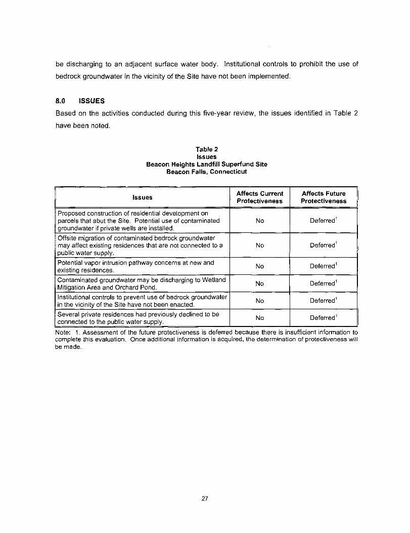
8.0 ISSUES
Based on the activities conducted during this five-year review, the issues identified in Table 2
have been noted.
Table 2 Issues
Beacon Heights Landfill Superfund Site Beacon Falls, Connecticut
Issues
Proposed construction of residential development on parcels that abut the Site. Potential use of contaminated groundwater if private wells are installed.
Offsite migration of contaminated bedrock groundwater may affect existing residences that are not connected to a
1 public water supply.
Potential vapor intrusion pathway concerns at new and existing residences.
Contaminated groundwater may be discharging to Wetland Mitigation Area and Orchard Pond.
Institutional controls to prevent use of bedrock groundwater in the vicinity of the Site have not been enacted.
Several private residences had previously declined to be connected to the public water supply.
Affects Current Protectiveness
No
No
No
No
No
No
Affects Future Protectiveness
Deferred^
Deferred^
Deferred^
Deferred''
Deferred^
Deferred^
Note: 1. Assessment of the future protectiveness is deferred because there is insufficient information to complete this evaluation. Once additional information is acquired, the determination of protectiveness will be made.
27
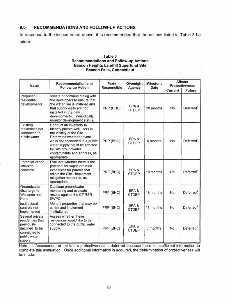
9.0 RECOMMENDATIONS AND FOLLOW-UP ACTIONS
In response to the issues noted above, it is recommended that the actions listed in Table 3 be
taken:
Table 3 Recommendations and Follow-up Actions
Beacon Heights Landfill Superfund Site Beacon Falls, Connecticut
Issue
Proposed residential developments
Existing residences not connected to public water
Potential vapor intrusion concerns
Groundwater discharge to Wetlands and Pond
Institutional controls not implemented Several private residences that previously declined to be connected to public water supply
Recommendation and Follow-up Action
Initiate or continue dialog with the developers to ensure that the water line is installed and that supply wells are not installed in the new developments. Periodically monitor development status. Conduct an inventory to identify private well users in the vicinity of the Site. Determine whether private wells not connected to a public water supply could be affected by Site groundwater contaminants and address, as appropriate. Evaluate whether there is the potential for vapor intrusion exposures for parcels that adjoin the Site. Implement mitigation measures, as appropriate.
Continue groundwater monitoring and evaluate results against the CT RSR SWPC. Identify properties that may be at risk and implement institutional. Assess whether these residences would like to be connected to the public water supply.
Party Responsible
PRP (BHC)
PRP (BHC)
PRP (BHC)
PRP (BHC)
PRP (BHC)
PRP (BPC)
Oversight Agency
EPA& CTDEP
EPA& CTDEP
EPA& CTDEP
EPA& CTDEP
EPA& CTDEP
EPA& CTDEP
Milestone Date
18 months
6 months
18 months
18 months
18 months
6 months
Affects Protectiveness
Current
No
No
No
No
No
No
Future
Deferred1
Deferred1
Deferred1
Deferred1
Deferred1
Deferred1
Note: 1. Assessment of the future protectiveness is deferred because there is insufficient information to complete this evaluation. Once additional information is acquired, the determination of protectiveness will be made.
28
10.0 PROTECTIVENESS STATEMENT(S)
The remedy at the Beacon Heights Landfill Superfund Site currently (in the short term) protects
human health and the environment because the cap and leachate collection system are
containing overburden groundwater contaminants on site, and the wateriine installed along
Blackberry Hill Road and Skokorat Road helps to ensure that most nearby residents are not
exposed to contaminants that may remain in the groundwater. Additional information is needed
to evaluate the long-term protectiveness of the remedy for residences that are not connected to
the wateriine or may be subjected to potential vapor intrusion.
Contaminated groundwater that migrates off site through bedrock fractures may pose potential
threats to downgradient residents that have private water wells. Because of the change in land
use adjacent to the Site, the vapor intrusion pathway should be evaluated. Effective institutional
controls to prevent the use of contaminated groundwater in the vicinity of the Site have not yet
been implemented. New developments abutting the Site could alter groundwater flow,
especially if private supply wells are installed. Therefore, for the remedy to be protective in the
long term, the effects of contaminated groundwater migrating off site should evaluated and
appropriate measures that are protective of human health and the environment should be
implemented, as appropriate. The future protectiveness determination of the remedy cannot be
made until further information is obtained. Additional information will be obtained by the
following actions:
• Continuing discussions with the developer and ensuring that nearby residential
developments will be connected to a public water supply, and that use restrictions are
evaluated and implemented, as necessary.
• Conducting an inventory of private well users and determining whether they may be
affected by contaminated Site groundwater.
• Evaluating whether properties near the Site may be at risk from vapor intrusion.
• Identifying properties that may require institutional controls and implementing the
controls.
29
• Evaluating whether contaminated groundwater migrating off site may pose potential
threats to surface water quality in the wetland.
• Assessing whether residences who previously declined connection to the public water
supply would like to be connected.
11.0 NEXT REVIEW
The next five-year review will be conducted by September 2013.
30
APPENDIX A
FIGURES
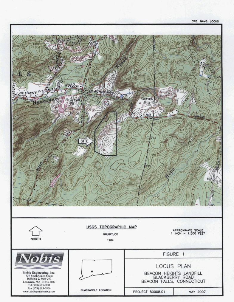
Nobis E n r g , Inc. 439 Sou UnmnSacd Buildlnl( 2. Suite 207
Lawrence, MA 01843-UW Td (978) 683-0891 Fax (978) 683-09&5
w w w d s m ~ n r n ' ~ ~ ~ g . r m
FIGURE 1
LOCUS PLAN BEACON HEIGHTS LANDFILL
BLACKBERRY ROAD BEACON FALLS, CONNECTICUT
PROJECT 80008.01 1 MAY 2007
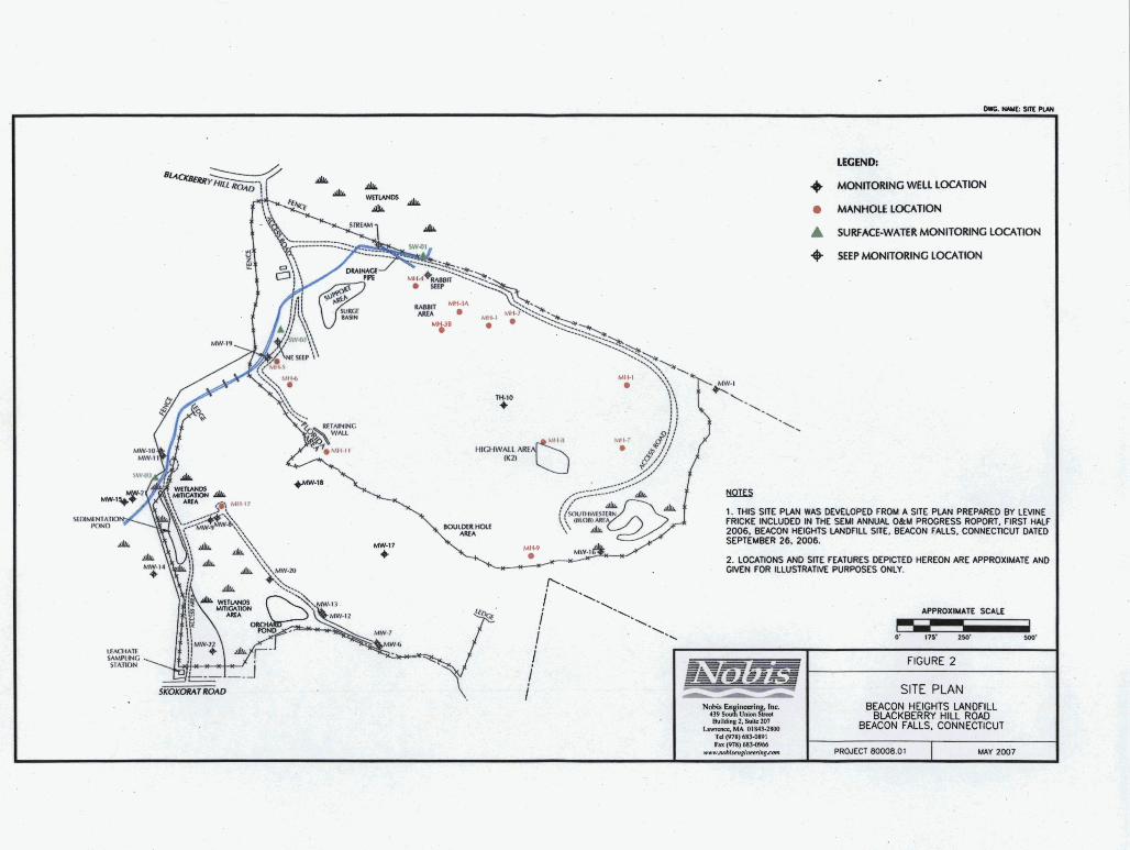
FIGURE 2
SITE PLAN W O N HEIGHTS W I L L
BUCKBERRY HILL ROAD BEACON FALLS. CONNECTICUT
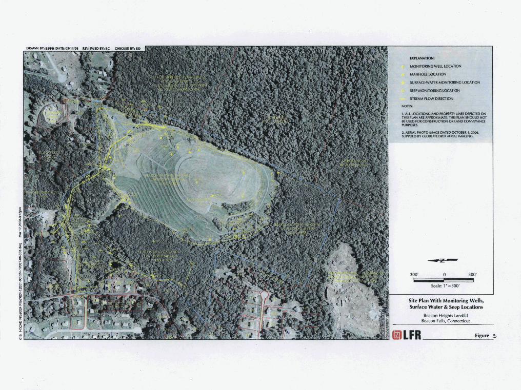
APPENDIX B
DOCUMENT REVIEW LIST/REFERENCES
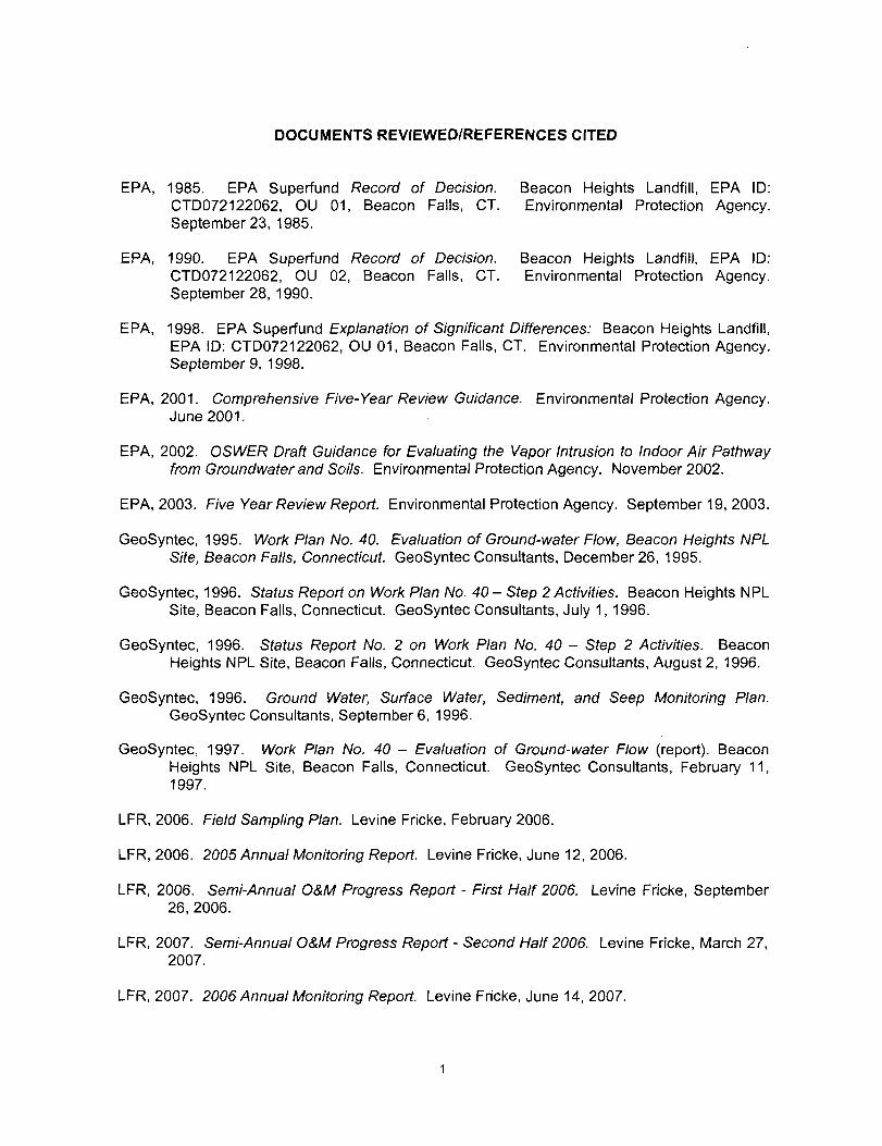
DOCUMENTS REVIEWED/REFERENCES CITED
EPA, 1985. EPA Superfund Record of Decision. Beacon Heights Landfill, EPA ID: CTD072122062, OU 01, Beacon Falls, CT. Environmental Protection Agency. September 23, 1985.
EPA, 1990. EPA Superfund Record of Decision. Beacon Heights Landfill, EPA ID: CTD072122062, OU 02, Beacon Falls, CT. Environmental Protection Agency. September 28, 1990.
EPA, 1998. EPA Superiund Explanation of Significant Differences: Beacon Heights Landfill, EPA ID: CTD072122062, OU 01, Beacon Falls, CT. Environmental Protection Agency. September 9, 1998.
EPA, 2001. Comprehensive Five-Year Review Guidance. Environmental Protection Agency. June 2001.
EPA, 2002. OSWER Draft Guidance for Evaluating the Vapor Intrusion to Indoor Air Pathway from Groundwater and Soils. Environmental Protection Agency. November 2002.
EPA, 2003. Five Year Review Report. Environmental Protection Agency. September 19, 2003.
GeoSyntec, 1995. Work Plan No. 40. Evaluation of Ground-water Flow, Beacon Heights NPL Site, Beacon Falls, Connecticut. GeoSyntec Consultants, December 26, 1995.
GeoSyntec, 1996. Status Report on Work Plan No. 40 - Step 2 Activities. Beacon Heights NPL Site, Beacon Falls, Connecticut. GeoSyntec Consultants, July 1, 1996.
GeoSyntec, 1996. Status Report No. 2 on Work Plan No. 40 - Step 2 Activities. Beacon Heights NPL Site, Beacon Falls, Connecticut. GeoSyntec Consultants, August 2, 1996.
GeoSyntec, 1996. Ground Water, Surface Water, Sediment, and Seep Monitoring Plan. GeoSyntec Consultants, September 6, 1996.
GeoSyntec, 1997. Work Plan No. 40 - Evaluation of Ground-water Flow (report). Beacon Heights NPL Site, Beacon Falls, Connecticut. GeoSyntec Consultants, February 11, 1997.
LFR, 2006. Field Sampling Plan. Levine Fricke, February 2006.
LFR, 2006. 2005 Annual Monitoring Report. Levine Fricke, June 12, 2006.
LFR, 2006. Semi-Annual O&M Progress Report - First Half 2006. Levine Fricke, September 26,2006.
LFR, 2007. Semi-Annual O&M Progress Report - Second Half 2006. Levine Fricke, March 27, 2007.
LFR, 2007. 2006 Annual Monitoring Report. Levine Fricke, June 14, 2007.
LFR, 2007. Semi-Annual O&M Progress Report - First Half 2007. Levine Fricke, September 25, 2007.
LFR, 2008. Semi-Annual O&M Progress Report - Second Half 2007. Levine Fricke, March 31, 2008.
LFR, 2008. 2007 Annual Monitoring Report. Levine Fricke, June 13, 2008.
TRC, 2005. Semi-Annual Inspection Report, Spring 2005. TRC, July 11, 2005.
TRC, 2006. Annual Inspection Report, Spring 2006. TRC, June 9, 2006.
APPENDIX C
SITE INSPECTION CHECKLIST AND INTERVIEWS

Site Inspection Checklist
I. SITE INFORMATION
Site name: Beacon Heights Landfill
Superfund Site
Date of inspection: N/A
Location and Region: Beacon Falls, CT -
Region 1
EPA ID: CTD072122062
Agency, office, or company leading the
five-year review: EPA
Weather/temperature: N/A
Remedy Includes: (Check all that apply)
0 Landfill cover/containment D Monitored natural attenuation
0 Access controls 0 Groundwater containment
0 Institutional controls D Vertical barrier walls
0 Groundwater pump and treatment
D Surface water collection and treatment
D
Other
Attachments: D Inspection team roster attached D Site map attached
II. INTERVIEWS (Check all that apply)
1. O&M site manager Russ Dirienzo, P.G.. LEP Senior Associate
7/2/2008
Name Title Date
Inten/iewed Q at site D at office 0 by phone Phone no. (203) 364-9700
Problems, suggestions; D Report attached Mr. Dirienzo reported that the remedy is not
functioning as intended because leachate levels from the landfill have not decreased as thev were
expected to.
Five-year Review Report - 1
2. O&M staff
Name
Interviewed D at site D at office D by phone
Problems, suggestions;
Title
Phone no.
D
Date
Report attached
Five-year Review Report - 2
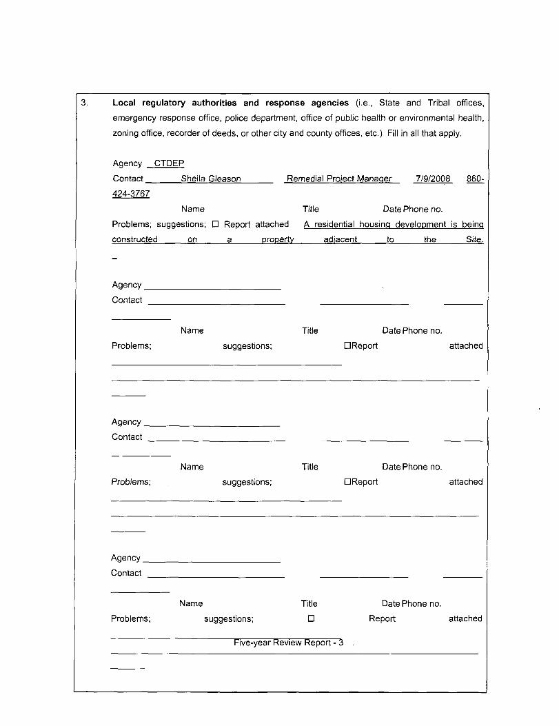
Local regulatory authorities and response agencies (i.e.. State and Tribal offices,
emergency response office, police department, office of public health or environmental health,
zoning office, recorder of deeds, or other city and county offices, etc.) Fill in all that apply.
Agency
Contact
CTDEP
Sheila Gleason Remedial Project Manager 7/9/2008 860-
424-3767
Name Title Date Phone no.
Problems; suggestions; D Report attached A residential housing development is being
constructed on a property adjacent to the Site.
Agency
Contact
Problems;
Name Title
suggestions;
Date Phone no.
n Report attached
Agency
Contact
Problems;
Name Title
suggestions;
Date Phone no.
DReport attached
Agency
Contact
Problems;
Name Title
suggestions; D
Five-year Review Report •
Date Phone no.
Report attached
"^
other interviews (optional) D Report attached.
Five-year Review Report - 4
III. ON-SITE DOCUMENTS & RECORDS VERIFIED (Check all that apply)
O&M Documents
n O&M manual
D As-built drawings
n Maintenance logs
Remarks
D Readily available D Up to date 0 N/A
D Readily available D Up to date 0 N/A
n Readily available D Up to date 0 N/A
Site-Specific Health and Safety Plan D Readily availableD Up to date 0 N/A
D Contingency plan/emergency response plan D Readily available D Up to date 0
N/A
Remarks
3. O&M and OSHA Training Records
Remarks
D Readily available D Up to date 0 N/A
Permits and Service Agreements
DAir discharge permit
D Effluent discharge
D Waste disposal, POTW
D Other permits
Remarks
D Readily available D Up to date 0 N/A
D Readily available D Up to date 0 N/A
D Readily availableD Up to date 0 N/A
D Readily available D Up to date 0N/A
Five-year Review Report - 5
5.
6.
7.
8.
9.
Gas Generation Records
Remarks
Settlement Monument Records
Remarks
Groundwater Monitoring Records
Remarks
Leachate Extraction Records
Remarks
Discharge Compliance Records
D Air
D Water (effluent)
Remarks
n Readily available D Up to date
D Readily available D Up to date
D Readily available D Up to date
O Readily available D Up to date
D Readily available D Up to date
D Readily available D Up to date
0 N/A
0 N/A
0 N / A
0 N / A
0 N/A
0 N/A
Five-year Review Report - 6
10. Daily Access/Security Logs
Remarks
n Readily available D Up to date 0 N / A
Five-year Review Report - 7
IV. O&M COSTS
1.
2.
O&M Organization
D State in-house
D PRP in-house
D Federal Facility in-house
D
Other
O&M Cost Records
D Readily available
n Funding mechanism/
Original O&M cost estir
Tota
From To
Date
From To
Date
From To
Date
From To
Date
From To
Date
n Contractor for State
0 Contractor for PRP
D Contractor for Federal Facility
n Up to date
agreement in place
nate D Breakdown attached
annua
Date
Date
Date
Date
Date
cost by year for review period if available
D Breakdown attached
Total cost
D Breakdown attached
Total cost
D Breakdown attached
Total cost
D Breakdown attached
Total cost
D Breakdown attached
Total cost
Five-year Review Report - 8
Unanticipated or Unusually High O&M Costs During Review Period
Describe costs and reasons:
V. ACCESS AND INSTITUTIONAL CONTROLS 0 Applicable D N/A
A. Fencing
1. Fencing damaged D Location shown on site map 0 Gates secured D
N/A
Remarks:
B. Other Access Restrictions
Signs and other security measures D Location shown on site map D N/A
Remarks: Warning signs are posted on all gates and manhole covers.
Five-year Review Report - 9
C. Institutional Controls (ICs)
1. Implementation and enforcement
Site conditions imply ICs not properly implemented D Yes D No 0
N/A
Site conditions imply ICs not being fully enforced D Yes D No 0
N/A
Type of monitoring (e.g., self-reporting, drive by)
Frequency
Responsible party/agency
Contact
Name Title Date Phone no.
Reporting is up-to-date D Yes D No 0 N/A
Reports are verified by the lead agency D Yes D No 0
N/A
Specific requirements in deed or decision documents have been met D Yes D No 0
N/A
Violations have been reported D Yes D No 0 N/A
Other problems or suggestions: D Report attached
Institutional controls outlined in the Record of Decision (ROD) have not yet been implemented
at the
Site.
Five-year Review Report - 10
Adequacy D ICs are adequate D ICs are inadequate 0 N/A
Remarks
D. General
Vandalism/trespassing D Location shown on site map 0 No vandalism evident
Remarks
2. Land use changes on site 0 N/A
Remarks
Land use changes off site D N/A
Remarks Construction of a residential development is underway on a property adiacent to the
Site.
VI. GENERAL SITE CONDITIONS
A. Roads 0 Applicable D N/A
Roads damaged D Location shown on site map 0 Roads adequate D
N/A
Remarks
Five-year Review Report -11

Five-year Review Report -12
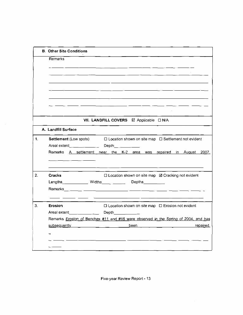
B. Other Site Conditions
Remarks
VII. LANDFILL COVERS 0 Applicable D N/A
A. Landfill Surface
1. Settlement (Low spots)
Areal extent
D Location shown on site map D Settlement not evident
Depth
Remarks A settlement near the K-2 area was repaired in August 2007.
Cracks
Lengths^
D Location shown on site map 0 Cracking not evident
Widths Depths
Remarks
Erosion
Areal extent
D Location shown on site map D Erosion not evident
Depth
Remarks Erosion of Benches #11 and #16 were observed in the Spring of 2004. and has
subsequently been repaired.
Five-year Review Report -13

Holes D Location shown on site map 0 Holes not evident
Areal extent Depth
Remarks
Vegetative Cover 0 Grass 0 Cover properly established 0 No signs of
stress
D Trees/Shrubs (indicate size and locations on a diagram)
Remarks
Alternative Cover (armored rock, concrete, etc.) 0 N/A
Remarks
7. Bulges D Location shown on site map 0 Bulges not evident
Areal extent Height
Remarks
Five-year Review Report -14
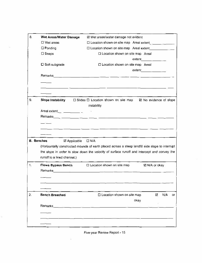
Wet Areas/Water Damage
D Wet areas
D Ponding
D Seeps
D Soft subgrade
Remarks
0 Wet areas/water damage not evident
D Location shown on site map Areal extent_
n Location shown on site map Areal extent
D Location shown on site map Areal
extent
D Location shown on site map Areal
extent
Slope Instability
Areal extent_
Remarks
D Slides D Location shown on site map
instability
0 No evidence of slope
B. Benches 0 Applicable D N/A
(Horizontally constructed mounds of earth placed across a steep landfill side slope to interrupt
the slope in order to slow down the velocity of surface runoff and intercept and convey the
runoff to a lined channel.)
Flows Bypass Bench
Remarks
n Location shown on site map 0 N/A or okay
Bench Breached
Remarks
D Location shown on site map
okay
0 N/A or
Five-year Review Report -15
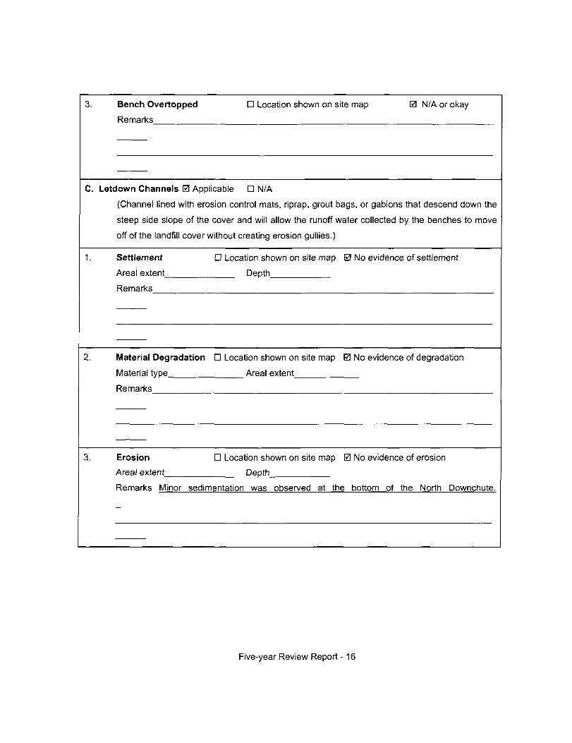
Bench Overtopped
Remarks
D Location shown on site map 0 N/A or okay
C. Letdown Channels 0 Applicable D N/A
(Channel lined with erosion control mats, riprap, grout bags, or gabions that descend down the
steep side slope of the cover and will allow the runoff water collected by the benches to move
off of the landfill cover without creating erosion gullies.)
1. Settlement
Areal extent_
Remarks
D Location shown on site map 0 No evidence of settlement
Depth
2. Material Degradation D Location shown on site map 0 No evidence of degradation
Material type Areal extent
Remarks
Erosion
Areal extent
D Location shown on site map 0 No evidence of erosion
Depth
Remarks Minor sedimentation was observed at the bottom of the North Downchute.
Five-year Review Report -16
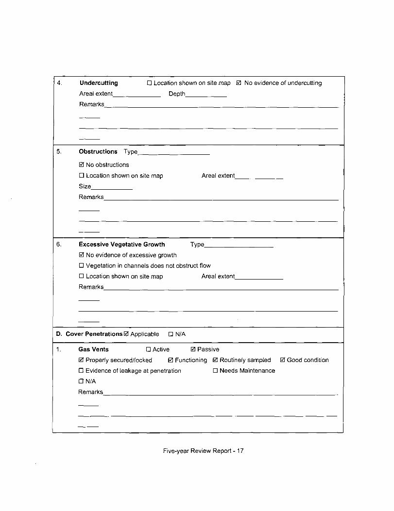
4. Undercutting
Areal extent
Remarks
D Location shown on site map 0 No evidence of undercutting
Depth
5. Obstructions Type
0 No obstructions
D Location shown on site map Areal extent_
Size
Remarks
Excessive Vegetative Growth Type
0 No evidence of excessive growth
D Vegetation in channels does not obstruct flow
D Location shown on site map Areal extent_
Remarks
D. Cover Penetrations 0 Applicable D N/A
1. Gas Vents D Active 0 Passive
0 Property secured/locked 0 Functioning 0 Routinely sampled 0 Good condition
D Evidence of leakage at penetration D Needs Maintenance
a N/A
Remarks
Five-year Review Report -17
2. Gas Monitoring Probes
D Property secured/locked D Functioning D Routinely sampled D Good condition
D Evidence of leakage at penetration D Needs Maintenance 0 N/A
Remarks
Monitoring Wells (within surface area of landfill)
0 Property secured/locked 0 Functioning 0 Routinely sampled 0 Good condition
D Evidence of leakage at penetration D Needs Maintenance D N/A
Remarks
Leachate Extraction Wells
0 Property secured/locked 0 Functioning 0 Routinely sampled 0 Good condition
D Evidence of leakage at penetration D Needs Maintenance D N/A
Remarks
Settlement Monuments 0 Located 0 Routinely surveyed D
N/A
Remarks
Five-year Review Report -18
E. Gas Collection and Treatment n Applicable 0 N/A
Gas Treatment Facilities
D Flaring D Thermal destruction D Collection for reuse
D Good condition D Needs Maintenance
Remarks
2. Gas Collection Wells, Manifolds and Piping
n Good condition D Needs Maintenance
Remarks
Gas Monitoring Facilities (e.g., gas monitoring of adjacent homes or buildings)
D Good condition • Needs Maintenance D N/A
Remarks
F. Cover Drainage Layer 0 Applicable D N/A
1. Outlet Pipes Inspected
Remarks
0 Functioning n N/A
Outlet Rock Inspected
Remarks
0 Functioning D N/A
Five-year Review Report - 19
G. Detention/Sedimentation Ponds D Applicable 0 N/A
Siltation Areal extent Depth D N/A
D Siltation not evident
Remarks
2. Erosion Areal extent Depth_
D Erosion not evident
Remarks
3. Outlet Works D Functioning D N/A
Remarks
Dam D Functioning D N/A
Remarks
Five-year Review Report - 20
H
1.
2.
Retaining Walls 0 Applicable D N/A
Deformations D Location shown on site map 0 Deformation not evident
Horizontal displacement Vertical displacement
Rotational displacement
Remarks
Degradation D Location shown on site map 0 Degradation not evident
Remarks
1. Perimeter Ditches/Off-Site Discharge 0 Applicable D N/A
1.
2.
Siltation D Location shown on site map 0 Siltation not evident
Areal extent Depth
Remarks
Vegetative Growth D Location shown on site map D N/A
0 Vegetation does not impede flow
Areal extent Type
Remarks
Five-year Review Report - 21
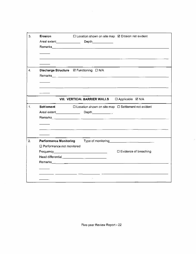
3.
4.
Erosion D Location shown on site map 0 Erosion not evident
Areal extent Depth
Remarks
Discharge Structure 0 Functioning D N/A
Remarks
VIM. VERTICAL BARRIER WALLS D Applicable 0 N/A
1.
2.
Settlement D Location shown on site map D Settlement not evident
Areal extent Depth
Remarks
Performance Monitoring Type of monitortnq
D Performance not monitored
Frequency D Evidence of breaching
Head differential
Remarks
Five-year Review Report - 22
C. Treatment System D Applicable 0 N/A
1. Treatment Train (Check components that apply)
D Metals removal D Oil/water separation
D Air stripping D Carbon adsorbers
D
Filters
D Bioremediation
n flocculent)_
D
Others
Additive (e.g., chelation agent.
D Good condition D Needs Maintenance
D Sampling ports property marked and functional
D Sampling/maintenance log displayed and up to date
DEquipment property identified
D Quantity of groundwater treated annually
D Quantity of surface water treated annually
Remarks
Electrical Enclosures and Panels (property rated and functional)
D N/A D Good condition D Needs Maintenance
Remarks
Five-year Review Report - 23
Tanks, Vaults, Storage Vessels
D N/A n Good condition
Remarks
0 Proper secondary containment D Needs
Maintenance
Discharge Structure and Appurtenances
D N/A D Good condition D Needs Maintenance
Remarks
5. Treatment Building(s)
D N/A D Good condition (esp. roof and doorways)
D Chemicals and equipment property stored
Remarks
D Needs repair
Monitoring Wells (pump and treatment remedy)
D Property secured/locked D Functioning D Routinely sampled D Good condition
• All required wells located D Needs Maintenance D N/A
Remarks
D. Monitoring Data
Monitoring Data 0 Is routinely submitted on time 0 Is of acceptable quality
Five-year Review Report - 24
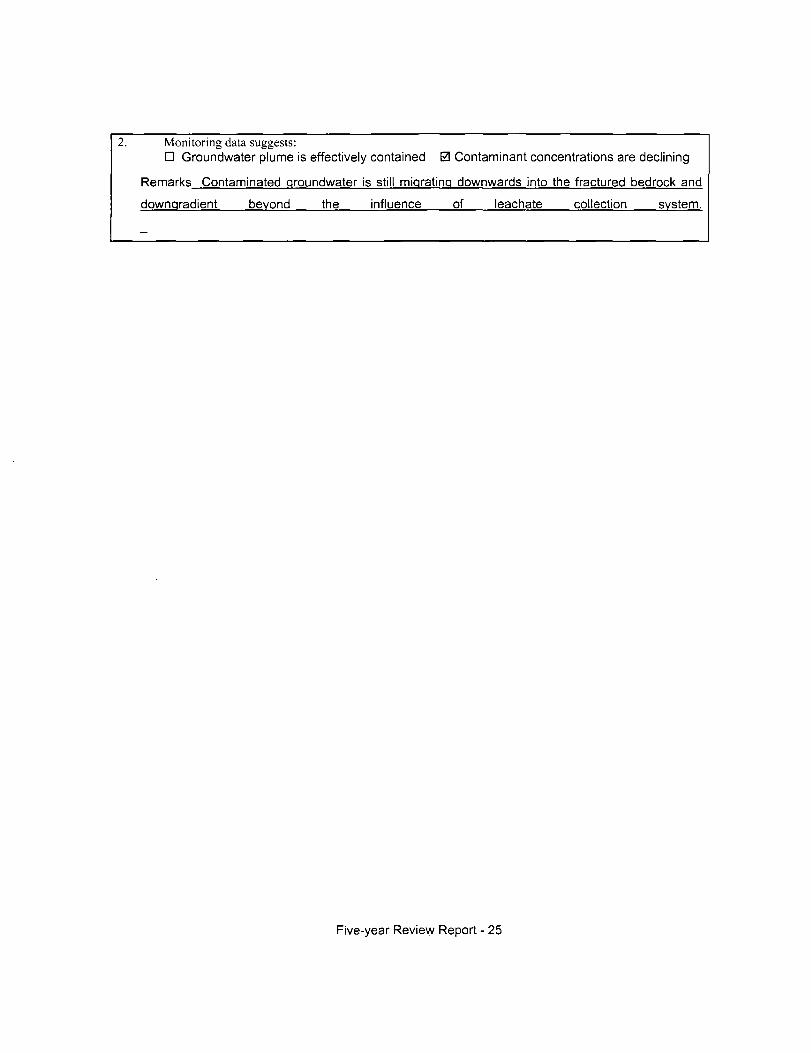
2. Monitoring data suggests: D Groundwater plume is effectively contained 0 Contaminant concentrations are declining
Remarks Contaminated groundwater is still migrating downwards into the fractured bedrock and
downgradient beyond the influence of leachate collection system.
Five-year Review Report - 25
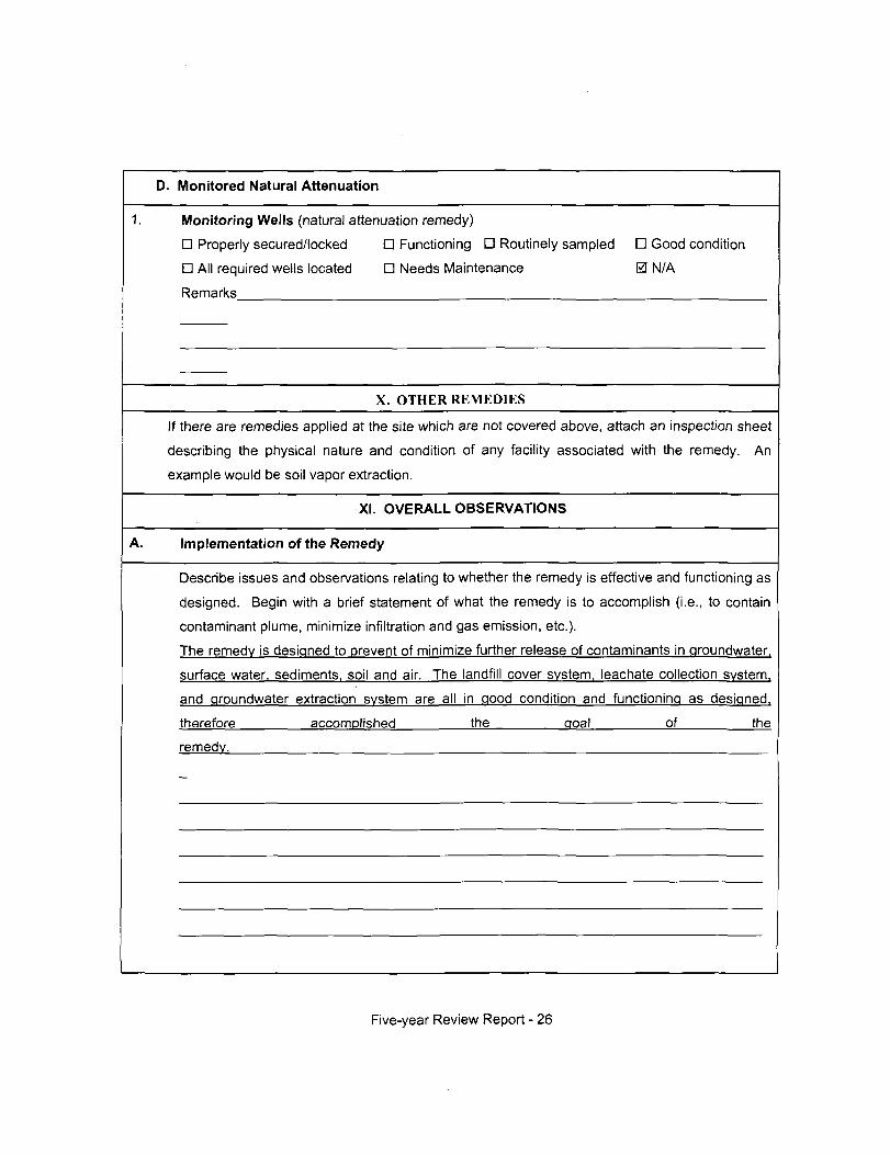
D. Monitored Natural Attenuation
1. Monitoring Wells (natural attenuation remedy)
D Property secured/locked D Functioning D Routinely sampled D Good condition
D All required wells located D Needs Maintenance 0 N/A
Remarks
X. OTHER REMEDIES
If there are remedies applied at the site which are not covered above, attach an inspection sheet
describing the physical nature and condition of any facility associated with the remedy. An
example would be soil vapor extraction.
XI. OVEFIALL OBSERVATIONS
Implementation of the Remedy
Describe issues and observations relating to whether the remedy is effective and functioning as
designed. Begin with a brief statement of what the remedy is to accomplish (i.e., to contain
contaminant plume, minimize infiltration and gas emission, etc.).
The remedy is designed to prevent of minimize further release of contaminants in groundwater,
surface water, sediments, soil and air. The landfill cover system, leachate collection svstem.
and groundwater extraction system are all in good condition and functioning as designed.
therefore accomplished the goal of the
remedy.
Five-year Review Report - 26
B. Adequacy of O&M
Describe issues and observations related to the implementation and scope of O&M
procedures. In particular, discuss their relationship to the current and long-term protectiveness
of the remedy.
No issues.
Five-year Review Report - 27
Early Indicators of Potential Remedy Problems
Describe issues and observations such as unexpected changes in the cost or scope of O&M or
a high frequency of unscheduled repairs that suggest that the protectiveness of the remedy
may be compromised in the future.
None.
D. Opportunities for Optimization
Describe possible opportunities for optimization in monitoring tasks or the operation of the
remedy.
None.
Five-year Review Report - 28
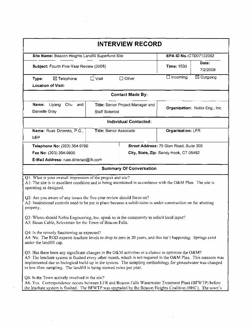
INTERVIEW RECORD
Site Name: Beacon Heights Landfill Superfund Site EPA ID No.:CTD07122062
Subject: Fourth Five-Year Review (2008) Time: 1530 Date:
7/2/2008
Type: H Telephone
Location of Visit:
D Visit n Other n Incoming S Outgoing
Contact Made By:
Name: Liyang Chu and
Danielle Gray
Title: Senior Project Manager and
Staff Scientist Organization: Nobis Eng., Inc.
Individual Contacted:
Name: Russ Dirienzo, P.G.,
LEP
Title: Senior Associate Organization: LFR
Telephone No: (203) 364-9700
Fax No: (203) 364-9800
E-Mail Address: [email protected]
Street Address: 75 Glen Road, Suite 305
City, State, Zip: Sandy Hook, CT 06482
Summary Of Conversation
Ql: What is your overall impression of the project anci site? Al : The site is in excellent condition and is being maintained in accordance with the O&M Plan. The site is operating as designed.
Q2: Are you aware of any issues the five-year review should focus on? A2: Institutional controls need to be put in place because a subdivision is under construction on the abutting property.
Q3: Whom should Nobis Engineering, Inc. speak to in the community to solicit local input? A3: Susan Cable, Selectman for the Town of Beacon Falls.
Q4: Is the remedy functioning as expected? A4: No. The ROD expects leachate levels to drop to zero in 20 years, and this isn't happening. Springs exist under the landfill cap.
Q5: Has there been any significant changes in the O&M activities or a chance to optimize the O&M? A5: The leachate system is flushed every other month, which is not required in the O&M Plan. This measure was implemented due to biological build-up in the system. The sampling methodology for groundwater was changed to low-flow sampling. The landfill is being mowed twice per year.
Q6: Is the Town actively involved in the site? A6: Yes. Correspondence occurs between LFR and Beacon Falls Wastewater Treatment Plant (BFWTP) before the leachate system is flushed. The BFWTP was upgraded by the Beacon Heights Coalition (BHC). The town's
Conservation Commission wants access to the site for bird watching. The Site provides a large fly over habitat for birds. Turkeys, coyote, and deer are seen on and around the landfill.
Q7: Do you feel that information related to the site is readily available? A7: Site reports are available at the local library.
Q8; Have there been any changes in the site or surrounding property in the last 5 years, or are changes planned? A8: A subdivision with 17 lots is proposed that will abut the Site to the North, East, and West.
Q9: Are you aware of any changes in the state ARARs, groundwater quality standards, etc., since 2003? A9: Volatilization criteria are currently being amended.
QIO: Are you aware of any pending or future water needs or any change in water usage in the area? AlO: Public water supply services the residents all around the site. Some residents (7 homes) have refused to be connected to the public water supply. All homes downgradient of the site are connected to the public water supply. The BHC has suggested that LFR verify the status of downgradient houses that might not be hooked up to the public water supply.
INTERVIEW RECORD
Site Name: Beacon Heights Landfill Superfund Site EPA ID No.: CTD07122062
Subject: Fourth Five-Year Review (2008) Time: 1530 Date: 7/9/2008
Type: M Telephone
Location of Visit:
n Visit n Other n Incoming K Outgoing
Contac t Made By:
Name: Danielle Gray Title: Staff Scientist Organization: Nobis Eng., Inc.
Individual Contacted:
Name: Sheila Gleason Title: Remedial Project Manager Organization: Connecticut
Department of Environmental
Protection
Telephone No: 860-424-3767
Fax No: Unknown
E-Mail Address: [email protected]
Street Address: 79 Elm Street
City, State, Zip: Hartford, CT 06106
Summary Of Conversa t ion
Ql: What is your overall impression of the project and site? Al: Ms. Gleason receives copies of the Annual Monitoring Reports for the Site. She has very little involvement with the Site.
Q2: Are you aware of any issues the five-year review should focus on? A2: Other than issues identified by the EPA, no.
Q3: Whom should Nobis Engineering, Inc. speak to in the community to solicit local input? A3: Ms. Gleason does not know anyone in the community that should be contacted.
Q4: Is the remedy functioning as expected? A4: Based on her review of the Annual Monitoring reports, yes.
Q5: Has there been any significant changes in the O&M activides or a chance to optimize the O&M? A5: Ms. Gleason does not have enough involvement with the site to know.
Q6: Is the Town actively involved in the site? A6: As far as she knows, no.
Q7: Do you feel that information related to the site is readily available? A7: Yes. Ms. Gleason receives calls from local residents about the site a few times per year.
Q8: Have there been any changes in the site or surrounding property in the last 5 years, or are changes planned? A8: A subdivision is being constructed next to the site.
Q9: Are you aware of any changes in the state ARARs, groundwater quality standards, etc., since 2003? A9: Not that Ms. Gleason is aware of.
QIC: Are you aware of any pending or fijture water needs or any change in water usage in the area? AID: No. The subdivision will be on the public water supply.
INTERVIEW RECORD
Site Name: Beacon Heights Landfill Superfund Site EPA ID No.: CTD07122062
Subject: Fourth Five-Year Review (2008) Time: 1045 Date:
7/10/2008
Type: M Telephone
Location of Visit:
D Visit D Other n Incoming ^ Outgoing
Contact Made By:
Name: Danielle Gray Title: Staff Scientist Organization: Nobis Eng.
Inc.
Individual Contacted:
Name:
Cable
Susan Ann Title: First Selectman Organization: Town
Beacon Falls
of
Telephone No: 203-729^340
Fax No: Unknown
E-Mail Address: Unknown
Street Address: Town Hall, 10 Maple Avenue
City, State, Zip: Beacon Falls, CT 06403
Summary Of Conversation
Ql: What is your overall impression of the project and site? Al: The clean up is going very well. The Site looks good and development is happening around the Site.
Q2: Are you aware of any issues the five-year review should focus on? A2: No.
Q3: Whom should Nobis Engineering, Inc. speak to in the community to solicit local input? A3: The Inlands Wetland Commission.
Q4: Is the remedy functioning as expected? A4: Yes. The amount of leachate from the Site being transported to the Beacon Falls Wastewater Treatment Plant was expected to decrease, but the amount of leachate has remained relatively consistent.
Q5: Has there been any significant changes in the O&M activities or a chance to optimize the O&M? A5: No.
Q6: Is the Town actively involved in the site? A6: No.
Q7: Do you feel that information related to the site is readily available? A7; Yes. Reports are kept at the Town Hall and available to anyone who would like to see them.
Q8: Have there been any changes in the site or surrounding property in the last 5 years, or are changes planned? A8: Construction of the subdivision is underway. Construction is complete on some houses in the area, and they are occupied.
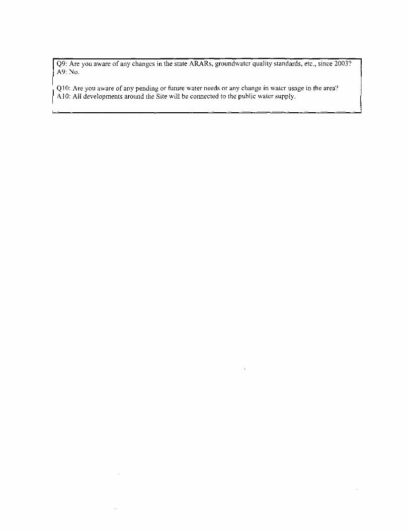
Q9: Are you aware of any changes in the state ARARs, groundwater quality standards, etc., since 2003? A9: No.
QIO: Are you aware of any pending or future water needs or any change in water usage in the area? AlO: All developments around the Site will be connected to the public water supply.
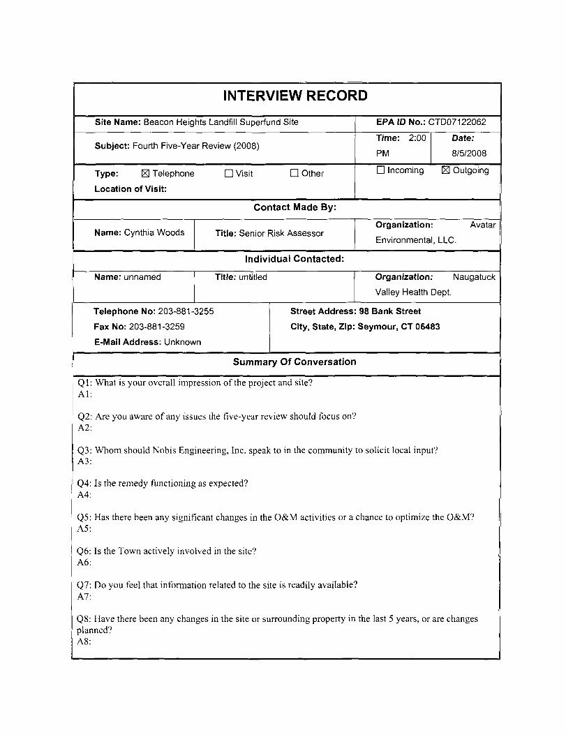
INTERVIEW RECORD
Site Name: Beacon Heights Landfill Superfund Site EPA ID No.: CTD07122062
Subject: Fourth Five-Year Review (2008) Time: 2:00
PM
Date:
8/5/2008
Type: S Telephone
Location of Visit:
n Visit n Other D Incoming K Outgoing
Contact Made By:
Name: Cynthia Woods Title: Senior Risk Assessor Organization: Avatar
Environmental, LLC.
Individual Contacted:
Name: unnamed Title: untitled Organization: Naugatuck
Valley Health Dept.
Telephone No: 203-881-3255
Fax No: 203-881-3259
E-Mail Address: Unknown
Street Address: 98 Bank Street
City, State, Zip: Seymour, CT 06483
Summary Of Conversation
Ql: What is your overall impression of the project and site? Al:
Q2: Are you aware of any issues the five-year review should focus on? A2:
Q3: Whom should Nobis Engineering, Inc. speak to in the community to solicit local input? A3:
Q4: Is the remedy functioning as expected? A4:
Q5: Has there been any significant changes in the O&M activities or a chance to optimize the O&M? A5:
Q6: Is the Town actively involved in the site? A6:
Q7: Do you feel that information related to the site is readily available? A7:
Q8: Have there been any changes in the site or surrounding property in the last 5 years, or are changes planned? A8:
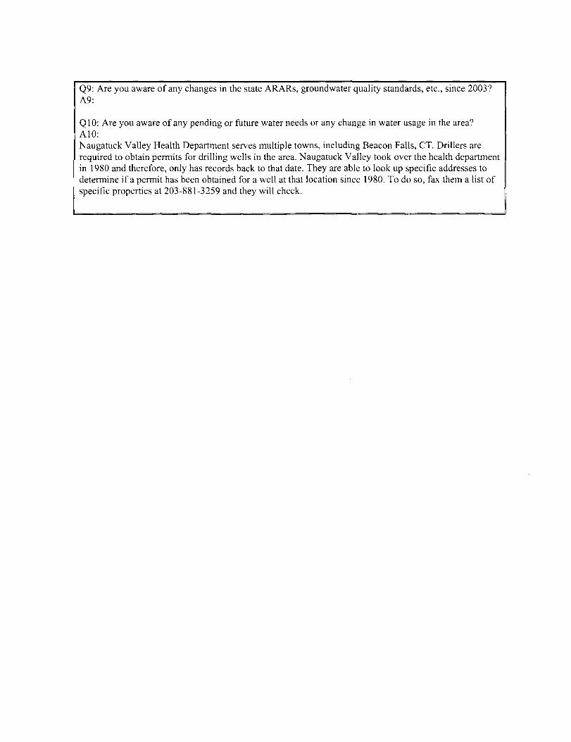
Q9: Are you aware of any changes in the state ARARs, groundwater quality standards, etc., since 2003? A9:
QIC: Are you aware of any pending or future water needs or any change in water usage in the area? AlO: Naugatuck Valley Health Department serves multiple towns, including Beacon Falls, CT. Drillers are required to obtain permits for drilling wells in the area. Naugatuck Valley took over the health department in 1980 and therefore, only has records back to that date. They are able to look up specific addresses to determine if a permit has been obtained for a well at that location since 1980. To do so, fax them a list of specific properties at 203-881-3259 and they will check.


![BEHP Suyun Vol.2, July 2015, №7 [1,2]; ISSN:2410-1788suyun.info/userfiles/bulletin/2015-7/Shulgan_2_29072015_7[1_2... · древних западно-тюркских групп](https://img.dokumen.tips/doc/110x75/5a98d8e27f8b9a30358d7bd6/behp-suyun-vol2-july-2015-7-12-issn2410-12-.jpg)