Embed Size (px)
Citation preview
DESIGN, DIMENSIONS AND MONITORINGNS AANNDANDAAA D MMMOONMONMMM NG
FISH PASSESPAAASSSSSSSEEEEEEEES PAAAA
Published by theFood and Agriculture Organization of the United Nations
in arrangement withDeutscher Verband für Wasserwirtschaft und Kulturbau e.V. (DVWK)
Rome, 2002
Fish passes – Design, dimensions and monitoring
This book was originally published byDeutscher Verband für Wasserwirtschaft und Kulturbau e.V., DVWK(German Association for Water Resources and Land Improvement)
as DVWK-Merkblatt 232/1996:Fischaufstiegsanlagen – Bemessung, Gestaltung, Funktionskontrolle.
The designations employed and the presentation of material inthis publication do not imply the expression of any
opinion whatsoever on the part of the Food and AgricultureOrganization of the United Nations concerning the legal status of
any country, territory, city or area or of its authorities, orconcerning the delimitation of its frontiers or boundaries.
The designations ‘developed’ and ‘developing’ economiesare intended for statistical convenience
and do not necessarily express a judgementabout the stage reached by a particular country, territory
or area in the development process.
The views expressed herein are those of the authorsand do not necessarily represent those of the
Food and Agriculture Organization of the United Nations.
All rights reserved. Reproduction and dissemination of material in thisinformation product for educational or other non-commercial purposes areauthorized without any prior written permission from the copyright holdersprovided the source is fully acknowledged. Reproduction of material in thisinformation product for resale or other commercial purposes is prohibitedwithout written permission of the copyright holders. Applications for suchpermission should be addressed to the Chief, Publishing Management
Service, Information Division, FAO, Viale delle Terme di Caracalla,00100 Rome, Italy or by e-mail to [email protected]
FAO ISBN: 92-5-104894-0DVWK ISBN: 3-89554-027-7
DVWK ISSN: 0722-7167
English version copyright 2002 by FAOGerman version copyright 1996 by DVWK

Preparation of this publication
This co-publication by FAO and DVWK (German Association For Water Resources and Land Improvement)is a translation of a book that was first published by DVWK in German in 1996.The FAO Fisheries Departmenthas decided to produce the English edition to make available the valuable information contained in thistechnical document on a world-wide scale as no comparable work was so far available, especially as regardsthe close-to-nature types of fish passes.
This document was translated into English by Mr. D. d’Enno, Translator, United Kingdom, and Mr. G. Marmulla,Fishery Resources Officer, FAO, Rome. It was edited by G. Marmulla and Dr. R. Welcomme, FAO Consultantand former staff member of FAO’s Fisheries Department.
The German edition “Fischaufstiegsanlagen – Bemessung, Gestaltung, Funktionskontrolle” was prepared bythe Technical Committee on “Fishways” of the DVWK and published in the DVWK “Guidelines for WaterManagement” that are the professional result of voluntary technical-scientific co-operative work, available foranyone to use. The German edition was financially supported by the German Federal Inter-State WorkingGroup on Water (LAWA).
The recommendations published in these Guidelines represent a standard for correct technical conduct andare therefore an important source of information for specialist work in normal conditions. However, theseGuidelines cannot cover all special cases in which further, or restricting, measures are required. Use of theseGuidelines does not absolve anyone from responsibility for their own actions. Everyone acts at his or her ownrisk.
Acknowledgments
We express our best thanks to Dr. Alex Haro, Ecologist, S.O. Conte Anadromous Fish Research Center,Turners Falls, USA, and Dipl.-Ing., Ulrich Dumont, Floecksmühle Consulting Engineers, Aachen, Germany,who kindly assisted with the revision of the translation. We also acknowledge with thanks the kind support byMr. D. Barion, DVWK, and Mr. W. Schaa, State Agency for Water and Waste Management – District ofCologne, Branch Office Bonn, as well as Drs B. Adam and U. Schwevers, Institute for Applied Ecology, Kirtorf-Wahlen (all Germany).
The most particular thanks are due to Mr. G. Ellis, Rome, who patiently prepared the layout in a veryprofessional manner.
iii
FAO/DVWK.Fish passes – Design, dimensions and monitoring.Rome, FAO. 2002. 119p.
Abstract
Key words: fish pass; fishway; fish ladder; technical fish passes; close-to-nature types; hydraulic calculation;upstream migration; free passage; river rehabilitation; restoration; longitudinal connectivity; monitoring
Many fish species undertake more or less extended migrations as part of their basic behaviour. Amongst thebest known examples in Europe are salmon (Salmo salar) and sturgeon (Acipenser sturio), which often swimseveral thousands of kilometres when returning from the sea to their spawning grounds in rivers. In additionto these long-distance migratory species other fish and invertebrates undertake more or less short-term orsmall-scale migrations from one part of the river to another at certain phases of their life cycles.
Fish passes are of increasing importance for the restoration of free passage for fish and other aquatic speciesin rivers as such devices are often the only way to make it possible for aquatic fauna to pass obstacles thatblock their up-river journey. The fish passes thus become key elements for the ecological improvement ofrunning waters. Their efficient functioning is a prerequisite for the restoration of free passage in rivers.However, studies of existing devices have shown that many of them do not function correctly. Therefore,various stakeholders, e.g. engineers, biologists and administrators, have declared great interest in generallyvalid design criteria and instructions that correspond to the present state-of-the-art of experience andknowledge.
The present Guidelines first refer to the underlying ecological basics and discuss the general requirementsthat must be understood for sensible application of the complex interdisciplinary matters. These generalconsiderations are followed by technical recommendations and advice for the design and evaluation of fishpasses as well as by proposals for choosing their hydraulic dimensions correctly and testing the functioning.Fishways can be constructed in a technically utilitarian way or in a manner meant to emulate nature. Bypasschannels and fish ramps are among the more natural solutions, while the more technical solutions includeconventional pool-type passes, slot passes, fish lifts, hydraulic fish locks and eel ladders. All these types aredealt with in this book. Furthermore, particular emphasis is laid on the importance of comprehensivemonitoring.
These Guidelines deal with mitigation of the upstream migration only as data on improvement of downstreampassage was scarce at the time of the preparation of the first edition, published in German in 1996. Therefore,the complex theme of downstream migration is only touched on but not developed in depth.
iv
Foreword by FAO
In many countries of the world inland capture fisheries, in their various facets, play an important role insecuring food availability and income and in improving livelihoods either through food or recreational fisheries.Since years, the Food and Agriculture Organization of the United Nations (FAO) does not relent to promotethe concept of sustainability in the use of resources and sustainable development continues to be a highlydesirable goal in all fisheries and aquaculture activities. However, to achieve this objective in capture fisheries,especially, not only improved fisheries management but also sound ecosystem management is needed.
Freshwater is becoming a more and more precious resource and there is increased competition for its use bythe various sectors, e.g. agriculture, fishery, hydropower production, navigation etc., of which fishery isgenerally not the most important one economically. The responsibility for the protection of the aquaticecosystem usually lies outside the fishery and in many cases, the fishery has to be managed within theconstraints imposed by the external sectors. Activities such as dam construction for water supply and powergeneration, channelization for navigation and flood control, land drainage and wetland reclamation foragricultural and urban use all have a profound impact on the aquatic ecosystem and thus on the natural fishpopulations. One of the worst effects of dams and weirs is the interruption of the longitudinal connectivity ofthe river which means that fish cannot migrate freely anymore. This does not only concern the long-distancemigratory species but all fish that depend on longitudinal movements during a certain phase of their life cycle.
The Fisheries Department’s Regular Programme and field-based activities are tailored to providemanagement advise on best practices and help implementing the Code of Conduct for Responsible Fisheriesand the relevant Technical Guidelines. In the framework of the Department’s Major Programme, the InlandWater Resources and Aquaculture Service (FIRI) implements, inter alia, an activity on prevention of habitatdegradation and rehabilitation of inland fisheries, including considerations regarding fish migration andmitigation measures. As normative work under this activity, FIRI gathers, reviews, analyzes and disseminatesinformation in relation to dams and weirs and their interactions with fish and fisheries and promotes therehabilitation of the aquatic environment as an appropriate tool for the management of inland waters.
In the attempt of making aquatic resources more sustainable, FIRI pays special attention to improved fishpassage and restoration of the free longitudinal connectivity as these are important issues on a worldwidescale that attract growing interest. This book “Fish passes – design, dimensions and monitoring” which hasoriginally been published in German by Deutscher Verband für Wasserwirtschaft und Kulturbau e.V., DVWK(German Association For Water Resources and Land Improvement) is an extremely valuable contribution tothe mitigation of obstructed fish passage. It first refers to the underlying ecological basics and discusses thegeneral requirements, that must be understood for the sensible application of the complex interdisciplinarymatters, before it gives technical recommendations and advice for the design of fish passes, the correctchoice of their hydraulic dimensions and the evaluation of their effectiveness. Based on knowledge andexperience from mainly Europe and North America, the book describes the various types of fish passes, withspecial emphasis on “close-to-nature” solutions. Monitoring is dealt with as a key element for success.
The FAO Fisheries Department decided to co-publish the English edition to make widely available thevaluable information contained in this technical document. This is the more important as no comparable bookexisted so far in the Anglophone literature, especially as regards the close-to-nature types of fish passes. It ishoped that this book contributes largely to increase the awareness of the need for unobstructed fish passageand to multiply the number of well-designed and well-dimensioned fish passes around the globe to restorelost migration routes.
Jiansan JIAChief, Inland Water Resources andAquaculture Service (FIRI)Fishery Resources DivisionFisheries Department, FAO
v

vii
Great efforts have been undertaken in Germany in the past decades to bring the water quality of surfacewaters back to an acceptable state, defined as “slightly to moderately loaded” according to the Germanbiological water quality classification. Improvements were mainly achieved through the construction of sewagetreatment plants for purifying domestic and industrial sewage. Today efforts in water protection managementare more and more directed towards the restoration of the natural ecosystem functions of the river channel,its banks and the former floodplains. Changes in channel morphology should therefore be reversed as far aspossible, and obstructions that cannot be overcome by migratory fish be eliminated.
In 1986, the responsible Ministers of the five riparian countries of the river Rhine, the third largest river inEurope, and the relevant Directorate of the European Commission set a political agenda for the restoration ofthe Rhine and agreed to undertake actions to enable the return of salmon and other migratory fish to theRhine and its tributaries by the year 2000. To achieve this objective, fish passes were, and still are, requiredin many places, but generally valid design criteria were lacking for the construction of fully functional fishways,particularly for solutions that look natural and blend well with the landscape. To satisfy this demand theGerman Association for Water Resources and Land Improvement, DVWK (Deutscher Verband fürWasserwirtschaft und Kulturbau e.V.), the professional, non-governmental and non-profit body representingGerman experts engaged in water and landscape management, prepared and published these Guidelines in1996. In the meantime the salmon has already been detected again in the river Rhine and some of itstributaries. What a progress!
An interdisciplinary working group of biologists and engineers compiled research results and experiencesfrom Germany and other countries that reflect the current state-of-the-art of technology in this field. With thepublication of these Guidelines in English, the DVWK hopes to contribute to making the experience andguidance on restoring the longitudinal connectivity of flowing surface waters available to hydro-engineers andfishery specialists in other countries. With this book we hope to make a contribution to the transfer ofknowledge across national boundaries, and will be pleased if it gives useful suggestions for the forward-looking management of waters in Europe and world-wide.
Bonn, October 2002Dr. Eiko Lübbe,Chairman of the DVWK’s Standing Committee on International Cooperation.
Foreword to the English edition by DVWK

ix
1 to the original German publication
Foreword1
Fish passes are of increasing importance for the restoration of free passage for fish and other aquatic speciesin rivers. Such devices are often the only way to make it possible for aquatic fauna to pass obstacles that blocktheir up-river journey. They thus become key elements for the ecological improvement of running waters.
The efficient functioning of fish passes is a prerequisite for the restoration of free passage in rivers. Studiesof existing devices have shown that many of them do not function correctly. Many specialists have thereforedeclared great interest in generally valid design criteria and instructions that correspond to the present state-of-the-art of experience and knowledge.
A specialized Technical Committee set up by the German Association for Water Resources and LandImprovement has determined the current state-of-the-art technology for construction and operation of fishpasses, through interdisciplinary co-operation between biologists and engineers. Research results andreports from other countries have been taken into account.
The present Guidelines first refer to the underlying ecological basics and discuss the general requirementsthat must be understood for sensible application of the complex interdisciplinary matters. These generalconsiderations are followed by technical recommendations and advice for the design and evaluation of fishpasses as well as by proposals for choosing their hydraulic dimensions correctly and testing the functioning.
In preparing these Guidelines it became clear that some questions, particularly those related to the designand integration of fish passes at dams used for hydroelectric power production, could not be answered tocomplete satisfaction. The reasons are, firstly that there is little reliable data on the functioning of fishways andthat the behaviour of fish in the vicinity of fish passes needs further study. Secondly, defining the dimensionsof close-to-nature constructions by applying the present hydraulic calculation models can only provide roughapproximations. There is thus still a considerable need for research that would fill such gaps in our knowledge.For the same reason, it is, unfortunately, not possible to respond immediately to the wish for recommendingstandards for fish guiding devices and downstream passage devices that many professionals concerned withthe subject have expressed.
The Technical Committee was composed of the following representatives of consulting firms, engineeringconsultants, energy supply companies, universities and specialized administrations:
ADAM, Beate Dr., Dipl.-Biol., Institut für angewandte Ökologie (Institute for Applied Ecology),Kirtorf-Wahlen
BOSSE, Rainer Dipl.-Ing., RWE Energie AG, Bereich Regenerative Stromerzeugung (KR)(Rhenish-Westphalian Electricity Board, Department for Regenerative ElectricPower Generation (KR)), Essen
DUMONT, Ulrich Dipl.-Ing., Ingenieurbüro Floecksmühle (Floecksmühle Consulting Engineers),Aachen
GEBLER, Rolf-Jürgen Dr.-Ing., Ingenieurbüro Wasserbau und Umwelt (Hydraulic Engineering andEnvironment Consulting Engineers), Walzbachtal
GEITNER, Verena Dipl.-Ing., Ingenieurbüro Prein-Geitner (Prein-Geitner Consulting Engineers),Hildesheim
HASS, Harro Dipl.-Biol., Fischereidirektor, Niedersächsisches Landesamt für Ökologie, DezernatBinnenfischerei (Lower Saxony Regional Authority for Ecology, Department forFreshwater Fishery), Hildesheim
KRÜGER, Frank Dr.-Ing., Landesumweltamt Brandenburg, Referat Gewässergestaltung, Wasserbauund Hochwasserschutz (Brandenburg Regional Environmental Authority,Department for River Design, Hydraulic Engineering and Flood Protection),Frankfurt/Oder
RAPP, Robert Dr.-Ing., Abteilungsdirektor, Bayerische Wasserkraftwerke AG BAWAG (BavarianHydroelectric Company BAWAG), Munich
x
SANZIN, Wolf-Dieter Dr., Dipl.-Biol., Regierungsdirektor, Bayerisches Landesamt für Wasserwirtschaft(Bavarian Regional Authority for Water Management), Munich
SCHAA, Werner Dipl.-Ing., Regierungsbaudirektor, Staatliches Umweltamt Köln, Außenstelle Bonn(State Agency for Water and Waste Management – District of Cologne, BranchOffice Bonn), Bonn, (President of this Technical Committee)
SCHWEVERS, Ulrich Dr., Dipl.-Biol., Institut für angewandte Ökologie (Institute for Applied Ecology),Kirtorf-Wahlen
STEINBERG, Ludwig Dipl.-Biol., Oberregierungsrat, Landesanstalt für Ökologie, Bodenordnung undForsten/Landesamt für Agrarordnung Nordrhein-Westfalen, Dezernat für Fischerei(North Rhine-Westphalian Agency for Ecology, Land and Forestry/North Rhine-Westphalian Office for Agricultural Development in Recklinghausen (LÖBF),Department for Fisheries at Kirchhundem-Albaum), Kirchhundem-Albaum (Vice-President of this Technical Committee).
Herewith the Technical Committee wishes to thank the representatives of fishery associations, angling clubs,the Society of German Fishery Administrators and Fishery Scientists, the dam operating companies andexperts from public authorities and administrative bodies who have supported the work of the TechnicalCommittee through special contributions and advice. All those who sent in constructive suggestions at thereviewing stage are also thanked.
Bonn, November 1995 Werner Schaa
xi
Contents
page1 Introduction . . . . . . . . . . . . . . . . . . . . . . . . . . . . . . . . . . . . . . . . . . . . . . . . . . . . . . . . . . . . . . . .1
2 Ecological principles . . . . . . . . . . . . . . . . . . . . . . . . . . . . . . . . . . . . . . . . . . . . . . . . . . . . . . . .3 2.1 Running water ecosystems . . . . . . . . . . . . . . . . . . . . . . . . . . . . . . . . . . . . . . . . . . . . . . . . . . . .3 2.1.1 Geology and climate . . . . . . . . . . . . . . . . . . . . . . . . . . . . . . . . . . . . . . . . . . . . . . . . . . . . . . . . . .3 2.1.2 Water velocity . . . . . . . . . . . . . . . . . . . . . . . . . . . . . . . . . . . . . . . . . . . . . . . . . . . . . . . . . . . . . . .3 2.1.3 Shear stress and substrate distribution . . . . . . . . . . . . . . . . . . . . . . . . . . . . . . . . . . . . . . . . . . .4 2.1.4 Temperature . . . . . . . . . . . . . . . . . . . . . . . . . . . . . . . . . . . . . . . . . . . . . . . . . . . . . . . . . . . . . . . .6 2.1.5 Oxygen . . . . . . . . . . . . . . . . . . . . . . . . . . . . . . . . . . . . . . . . . . . . . . . . . . . . . . . . . . . . . . . . . . . .6 2.2 River continuum . . . . . . . . . . . . . . . . . . . . . . . . . . . . . . . . . . . . . . . . . . . . . . . . . . . . . . . . . . . . .7 2.3 Biological zoning of running waters . . . . . . . . . . . . . . . . . . . . . . . . . . . . . . . . . . . . . . . . . . . . . .9 2.4 Potentially natural species composition . . . . . . . . . . . . . . . . . . . . . . . . . . . . . . . . . . . . . . . . . .13 2.5 Migration behaviour of aquatic organisms . . . . . . . . . . . . . . . . . . . . . . . . . . . . . . . . . . . . . . . .15 2.6 Hazards to aquatic fauna caused by dams and weirs . . . . . . . . . . . . . . . . . . . . . . . . . . . . . . .18
3 General requirements for fish passes . . . . . . . . . . . . . . . . . . . . . . . . . . . . . . . . . . . . . . . . .213.1 Optimal position for a fish pass . . . . . . . . . . . . . . . . . . . . . . . . . . . . . . . . . . . . . . . . . . . . . . . .22 3.2 Fish pass entrance and attraction flow . . . . . . . . . . . . . . . . . . . . . . . . . . . . . . . . . . . . . . . . . .24 3.3 Fish pass exit and exit conditions . . . . . . . . . . . . . . . . . . . . . . . . . . . . . . . . . . . . . . . . . . . . . .26 3.4 Discharge and current conditions in fish pass . . . . . . . . . . . . . . . . . . . . . . . . . . . . . . . . . . . .27 3.5 Lengths, slopes, resting pools . . . . . . . . . . . . . . . . . . . . . . . . . . . . . . . . . . . . . . . . . . . . . . . . .28 3.6 Design of the bottom . . . . . . . . . . . . . . . . . . . . . . . . . . . . . . . . . . . . . . . . . . . . . . . . . . . . . . . .29 3.7 Operating times . . . . . . . . . . . . . . . . . . . . . . . . . . . . . . . . . . . . . . . . . . . . . . . . . . . . . . . . . . . .29 3.8 Maintenance . . . . . . . . . . . . . . . . . . . . . . . . . . . . . . . . . . . . . . . . . . . . . . . . . . . . . . . . . . . . . . .30 3.9 Measures to avoid disturbances and to protect the fish pass . . . . . . . . . . . . . . . . . . . . . . . . .30 3.10 Integration into the landscape . . . . . . . . . . . . . . . . . . . . . . . . . . . . . . . . . . . . . . . . . . . . . . . . .30
4 Close-to-nature types of fish passes . . . . . . . . . . . . . . . . . . . . . . . . . . . . . . . . . . . . . . . . . .314.1 Bottom ramps and slopes . . . . . . . . . . . . . . . . . . . . . . . . . . . . . . . . . . . . . . . . . . . . . . . . . . . . .31 4.1.1 Functional principle . . . . . . . . . . . . . . . . . . . . . . . . . . . . . . . . . . . . . . . . . . . . . . . . . . . . . . . . . .31 4.1.2 Design and dimensions . . . . . . . . . . . . . . . . . . . . . . . . . . . . . . . . . . . . . . . . . . . . . . . . . . . . . .32 4.1.2.1 Construction styles . . . . . . . . . . . . . . . . . . . . . . . . . . . . . . . . . . . . . . . . . . . . . . . . . . . . . . . . . .32 4.1.2.2 Plan view . . . . . . . . . . . . . . . . . . . . . . . . . . . . . . . . . . . . . . . . . . . . . . . . . . . . . . . . . . . . . . . . .34 4.1.2.3 Longitudinal section . . . . . . . . . . . . . . . . . . . . . . . . . . . . . . . . . . . . . . . . . . . . . . . . . . . . . . . . .34 4.1.3 Remodelling of drops . . . . . . . . . . . . . . . . . . . . . . . . . . . . . . . . . . . . . . . . . . . . . . . . . . . . . . .35 4.1.4 Conversion of regulable weirs into dispersed or cascaded ramps . . . . . . . . . . . . . . . . . . . . .35 4.1.5 Overall assessment . . . . . . . . . . . . . . . . . . . . . . . . . . . . . . . . . . . . . . . . . . . . . . . . . . . . . . . . .36 4.1.6 Examples . . . . . . . . . . . . . . . . . . . . . . . . . . . . . . . . . . . . . . . . . . . . . . . . . . . . . . . . . . . . . . . . .37 4.2 Bypass channels . . . . . . . . . . . . . . . . . . . . . . . . . . . . . . . . . . . . . . . . . . . . . . . . . . . . . . . . . . .41 4.2.1 Principle of functioning . . . . . . . . . . . . . . . . . . . . . . . . . . . . . . . . . . . . . . . . . . . . . . . . . . . . . . .41 4.2.2 Design and dimensions . . . . . . . . . . . . . . . . . . . . . . . . . . . . . . . . . . . . . . . . . . . . . . . . . . . . . .41 4.2.2.1 Plan view . . . . . . . . . . . . . . . . . . . . . . . . . . . . . . . . . . . . . . . . . . . . . . . . . . . . . . . . . . . . . . . . .42 4.2.2.2 Longitudinal section . . . . . . . . . . . . . . . . . . . . . . . . . . . . . . . . . . . . . . . . . . . . . . . . . . . . . . . . .42 4.2.2.3 Channel cross-section . . . . . . . . . . . . . . . . . . . . . . . . . . . . . . . . . . . . . . . . . . . . . . . . . . . . . . .43 4.2.2.4 Big boulders and boulder sills . . . . . . . . . . . . . . . . . . . . . . . . . . . . . . . . . . . . . . . . . . . . . . . . .43 4.2.2.5 Design of the water inlet and outlet areas of the bypass channel . . . . . . . . . . . . . . . . . . . . . .44 4.2.2.6 Crossings . . . . . . . . . . . . . . . . . . . . . . . . . . . . . . . . . . . . . . . . . . . . . . . . . . . . . . . . . . . . . . . . .45 4.2.3 Overall assessment . . . . . . . . . . . . . . . . . . . . . . . . . . . . . . . . . . . . . . . . . . . . . . . . . . . . . . . . .45 4.2.4 Examples . . . . . . . . . . . . . . . . . . . . . . . . . . . . . . . . . . . . . . . . . . . . . . . . . . . . . . . . . . . . . . . . .47 4.3 Fish ramps . . . . . . . . . . . . . . . . . . . . . . . . . . . . . . . . . . . . . . . . . . . . . . . . . . . . . . . . . . . . . . . .50 4.3.1 Functional principle . . . . . . . . . . . . . . . . . . . . . . . . . . . . . . . . . . . . . . . . . . . . . . . . . . . . . . . . . .50 4.3.2 Design and dimensions . . . . . . . . . . . . . . . . . . . . . . . . . . . . . . . . . . . . . . . . . . . . . . . . . . . . . .50 4.3.2.1 Plan view . . . . . . . . . . . . . . . . . . . . . . . . . . . . . . . . . . . . . . . . . . . . . . . . . . . . . . . . . . . . . . . . .50 4.3.2.2 Longitudinal section . . . . . . . . . . . . . . . . . . . . . . . . . . . . . . . . . . . . . . . . . . . . . . . . . . . . . . . . .51 4.3.2.3 Body of the ramp . . . . . . . . . . . . . . . . . . . . . . . . . . . . . . . . . . . . . . . . . . . . . . . . . . . . . . . . . . .51
xii
4.3.2.4 Big boulders and boulder sills . . . . . . . . . . . . . . . . . . . . . . . . . . . . . . . . . . . . . . . . . . . . . . . . .52 4.3.2.5 Bank protection . . . . . . . . . . . . . . . . . . . . . . . . . . . . . . . . . . . . . . . . . . . . . . . . . . . . . . . . . . . . .52 4.3.2.6 Stabilized zone downstream of the fish ramp . . . . . . . . . . . . . . . . . . . . . . . . . . . . . . . . . . . . . .52 4.3.3 Special cases . . . . . . . . . . . . . . . . . . . . . . . . . . . . . . . . . . . . . . . . . . . . . . . . . . . . . . . . . . . . . .53 4.3.3.1 Rough-channel pool pass . . . . . . . . . . . . . . . . . . . . . . . . . . . . . . . . . . . . . . . . . . . . . . . . . . . .53 4.3.3.2 Pile pass . . . . . . . . . . . . . . . . . . . . . . . . . . . . . . . . . . . . . . . . . . . . . . . . . . . . . . . . . . . . . . . . . .53 4.3.4 Overall assessment . . . . . . . . . . . . . . . . . . . . . . . . . . . . . . . . . . . . . . . . . . . . . . . . . . . . . . . . .54 4.3.5 Examples . . . . . . . . . . . . . . . . . . . . . . . . . . . . . . . . . . . . . . . . . . . . . . . . . . . . . . . . . . . . . . . . .55 4.4 Hydraulic design . . . . . . . . . . . . . . . . . . . . . . . . . . . . . . . . . . . . . . . . . . . . . . . . . . . . . . . . . . . .61 4.4.1 Flow formulae . . . . . . . . . . . . . . . . . . . . . . . . . . . . . . . . . . . . . . . . . . . . . . . . . . . . . . . . . . . . . .61 4.4.2 Flow resistance of perturbation boulders . . . . . . . . . . . . . . . . . . . . . . . . . . . . . . . . . . . . . . . .61 4.4.3 Design calculation of boulder sills . . . . . . . . . . . . . . . . . . . . . . . . . . . . . . . . . . . . . . . . . . . . . .64 4.4.4 Critical discharge over bottom ramps and slopes . . . . . . . . . . . . . . . . . . . . . . . . . . . . . . . . . .67 4.4.5 Trial runs . . . . . . . . . . . . . . . . . . . . . . . . . . . . . . . . . . . . . . . . . . . . . . . . . . . . . . . . . . . . . . . . . .68
5 Technical fish passes . . . . . . . . . . . . . . . . . . . . . . . . . . . . . . . . . . . . . . . . . . . . . . . . . . . . . . .69 5.1 Pool pass . . . . . . . . . . . . . . . . . . . . . . . . . . . . . . . . . . . . . . . . . . . . . . . . . . . . . . . . . . . . . . . . .69 5.1.1 Functional principle . . . . . . . . . . . . . . . . . . . . . . . . . . . . . . . . . . . . . . . . . . . . . . . . . . . . . . . . . .69 5.1.2 Design and dimensions . . . . . . . . . . . . . . . . . . . . . . . . . . . . . . . . . . . . . . . . . . . . . . . . . . . . . .69 5.1.2.1 Plan view . . . . . . . . . . . . . . . . . . . . . . . . . . . . . . . . . . . . . . . . . . . . . . . . . . . . . . . . . . . . . . . . .69 5.1.2.2 Longitudinal section . . . . . . . . . . . . . . . . . . . . . . . . . . . . . . . . . . . . . . . . . . . . . . . . . . . . . . . . .70 5.1.2.3 Pool dimensions . . . . . . . . . . . . . . . . . . . . . . . . . . . . . . . . . . . . . . . . . . . . . . . . . . . . . . . . . . . .70 5.1.2.4 Cross-wall structures . . . . . . . . . . . . . . . . . . . . . . . . . . . . . . . . . . . . . . . . . . . . . . . . . . . . . . . .71 5.1.2.4.1 Conventional pool pass . . . . . . . . . . . . . . . . . . . . . . . . . . . . . . . . . . . . . . . . . . . . . . . . . . . . . .71 5.1.2.4.2 Rhomboid pass . . . . . . . . . . . . . . . . . . . . . . . . . . . . . . . . . . . . . . . . . . . . . . . . . . . . . . . . . . . . .72 5.1.2.4.3 Humped fish pass . . . . . . . . . . . . . . . . . . . . . . . . . . . . . . . . . . . . . . . . . . . . . . . . . . . . . . . . . . .73 5.1.3 Hydraulic design . . . . . . . . . . . . . . . . . . . . . . . . . . . . . . . . . . . . . . . . . . . . . . . . . . . . . . . . . . .73 5.1.4 Overall assessment . . . . . . . . . . . . . . . . . . . . . . . . . . . . . . . . . . . . . . . . . . . . . . . . . . . . . . . . .75 5.1.5 Examples . . . . . . . . . . . . . . . . . . . . . . . . . . . . . . . . . . . . . . . . . . . . . . . . . . . . . . . . . . . . . . . . .76 5.2 Slot passes . . . . . . . . . . . . . . . . . . . . . . . . . . . . . . . . . . . . . . . . . . . . . . . . . . . . . . . . . . . . . . .78 5.2.1 Principle of functioning . . . . . . . . . . . . . . . . . . . . . . . . . . . . . . . . . . . . . . . . . . . . . . . . . . . . . .78 5.2.2 Design and dimensions . . . . . . . . . . . . . . . . . . . . . . . . . . . . . . . . . . . . . . . . . . . . . . . . . . . . . .78 5.2.2.1 Top-view plan . . . . . . . . . . . . . . . . . . . . . . . . . . . . . . . . . . . . . . . . . . . . . . . . . . . . . . . . . . . . . .78 5.2.2.2 Longitudinal section . . . . . . . . . . . . . . . . . . . . . . . . . . . . . . . . . . . . . . . . . . . . . . . . . . . . . . . . .78 5.2.2.3 Pool dimensions . . . . . . . . . . . . . . . . . . . . . . . . . . . . . . . . . . . . . . . . . . . . . . . . . . . . . . . . . . . .78 5.2.2.4 Structural characteristics . . . . . . . . . . . . . . . . . . . . . . . . . . . . . . . . . . . . . . . . . . . . . . . . . . . . .79 5.2.2.5 Bottom substrate . . . . . . . . . . . . . . . . . . . . . . . . . . . . . . . . . . . . . . . . . . . . . . . . . . . . . . . . . . .80 5.2.3 Hydraulic calculation . . . . . . . . . . . . . . . . . . . . . . . . . . . . . . . . . . . . . . . . . . . . . . . . . . . . . . . .80 5.2.4 Overall assessment . . . . . . . . . . . . . . . . . . . . . . . . . . . . . . . . . . . . . . . . . . . . . . . . . . . . . . . . .84 5.2.5 Example . . . . . . . . . . . . . . . . . . . . . . . . . . . . . . . . . . . . . . . . . . . . . . . . . . . . . . . . . . . . . . . . . .86 5.3 Denil pass . . . . . . . . . . . . . . . . . . . . . . . . . . . . . . . . . . . . . . . . . . . . . . . . . . . . . . . . . . . . . . . . .87 5.3.1 Functional principle . . . . . . . . . . . . . . . . . . . . . . . . . . . . . . . . . . . . . . . . . . . . . . . . . . . . . . . . . .87 5.3.2 Design and dimensions . . . . . . . . . . . . . . . . . . . . . . . . . . . . . . . . . . . . . . . . . . . . . . . . . . . . . .88 5.3.2.1 Top-view plan . . . . . . . . . . . . . . . . . . . . . . . . . . . . . . . . . . . . . . . . . . . . . . . . . . . . . . . . . . . . . .88 5.3.2.2 Longitudinal section . . . . . . . . . . . . . . . . . . . . . . . . . . . . . . . . . . . . . . . . . . . . . . . . . . . . . . . . .88 5.3.2.3 Channel . . . . . . . . . . . . . . . . . . . . . . . . . . . . . . . . . . . . . . . . . . . . . . . . . . . . . . . . . . . . . . . . . .89 5.3.2.4 Cross-channel structures . . . . . . . . . . . . . . . . . . . . . . . . . . . . . . . . . . . . . . . . . . . . . . . . . . . . .89 5.3.2.5 Water inlet and water outlet of the pass . . . . . . . . . . . . . . . . . . . . . . . . . . . . . . . . . . . . . . . . . .89 5.3.3 Hydraulic calculations . . . . . . . . . . . . . . . . . . . . . . . . . . . . . . . . . . . . . . . . . . . . . . . . . . . . . . .90 5.3.4 Overall assessment . . . . . . . . . . . . . . . . . . . . . . . . . . . . . . . . . . . . . . . . . . . . . . . . . . . . . . . . . 925.3.5 Example . . . . . . . . . . . . . . . . . . . . . . . . . . . . . . . . . . . . . . . . . . . . . . . . . . . . . . . . . . . . . . . . . .93 5.4 Eel ladders . . . . . . . . . . . . . . . . . . . . . . . . . . . . . . . . . . . . . . . . . . . . . . . . . . . . . . . . . . . . . . . .95 5.4.1 Peculiarities of eel migration . . . . . . . . . . . . . . . . . . . . . . . . . . . . . . . . . . . . . . . . . . . . . . . . . . .95 5.4.2 Design . . . . . . . . . . . . . . . . . . . . . . . . . . . . . . . . . . . . . . . . . . . . . . . . . . . . . . . . . . . . . . . . . . . .95 5.4.3 Overall assessment . . . . . . . . . . . . . . . . . . . . . . . . . . . . . . . . . . . . . . . . . . . . . . . . . . . . . . . . .96 5.5 Fish lock . . . . . . . . . . . . . . . . . . . . . . . . . . . . . . . . . . . . . . . . . . . . . . . . . . . . . . . . . . . . . . . . . .96 5.5.1 Functional principle . . . . . . . . . . . . . . . . . . . . . . . . . . . . . . . . . . . . . . . . . . . . . . . . . . . . . . . . . .96

5.5.2 Design . . . . . . . . . . . . . . . . . . . . . . . . . . . . . . . . . . . . . . . . . . . . . . . . . . . . . . . . . . . . . . . . . . . .97 5.5.3 Overall assessment . . . . . . . . . . . . . . . . . . . . . . . . . . . . . . . . . . . . . . . . . . . . . . . . . . . . . . . . .97 5.5.4 Example . . . . . . . . . . . . . . . . . . . . . . . . . . . . . . . . . . . . . . . . . . . . . . . . . . . . . . . . . . . . . . . . . .98 5.6 Fish lift . . . . . . . . . . . . . . . . . . . . . . . . . . . . . . . . . . . . . . . . . . . . . . . . . . . . . . . . . . . . . . . . . .100 5.6.1 Functional principle . . . . . . . . . . . . . . . . . . . . . . . . . . . . . . . . . . . . . . . . . . . . . . . . . . . . . . . . .100 5.6.2 Structure . . . . . . . . . . . . . . . . . . . . . . . . . . . . . . . . . . . . . . . . . . . . . . . . . . . . . . . . . . . . . . . . .100 5.6.3 Overall assessment . . . . . . . . . . . . . . . . . . . . . . . . . . . . . . . . . . . . . . . . . . . . . . . . . . . . . . . .100 5.6.4 Example . . . . . . . . . . . . . . . . . . . . . . . . . . . . . . . . . . . . . . . . . . . . . . . . . . . . . . . . . . . . . . . . .101
6 Monitoring of fish passes . . . . . . . . . . . . . . . . . . . . . . . . . . . . . . . . . . . . . . . . . . . . . . . . . .103 6.1 Objective of monitoring . . . . . . . . . . . . . . . . . . . . . . . . . . . . . . . . . . . . . . . . . . . . . . . . . . . . .103 6.2 Methods . . . . . . . . . . . . . . . . . . . . . . . . . . . . . . . . . . . . . . . . . . . . . . . . . . . . . . . . . . . . . . . . .103 6.2.1 Fish traps . . . . . . . . . . . . . . . . . . . . . . . . . . . . . . . . . . . . . . . . . . . . . . . . . . . . . . . . . . . . . . . .104 6.2.2 Blocking method . . . . . . . . . . . . . . . . . . . . . . . . . . . . . . . . . . . . . . . . . . . . . . . . . . . . . . . . . . .104 6.2.3 Marking . . . . . . . . . . . . . . . . . . . . . . . . . . . . . . . . . . . . . . . . . . . . . . . . . . . . . . . . . . . . . . . . . .104 6.2.4 Electro-fishing . . . . . . . . . . . . . . . . . . . . . . . . . . . . . . . . . . . . . . . . . . . . . . . . . . . . . . . . . . . . .1066.2.5 Automatic counting equipment . . . . . . . . . . . . . . . . . . . . . . . . . . . . . . . . . . . . . . . . . . . . . . . .1066.3 Assessment of results . . . . . . . . . . . . . . . . . . . . . . . . . . . . . . . . . . . . . . . . . . . . . . . . . . . . . .106
7 Legal requirements . . . . . . . . . . . . . . . . . . . . . . . . . . . . . . . . . . . . . . . . . . . . . . . . . . . . . . .1097.1 New installations . . . . . . . . . . . . . . . . . . . . . . . . . . . . . . . . . . . . . . . . . . . . . . . . . . . . . . . . . .1097.2 Existing installations . . . . . . . . . . . . . . . . . . . . . . . . . . . . . . . . . . . . . . . . . . . . . . . . . . . . . . .109
8 References . . . . . . . . . . . . . . . . . . . . . . . . . . . . . . . . . . . . . . . . . . . . . . . . . . . . . . . . . . . . . .111
9 Table of symbols and signs . . . . . . . . . . . . . . . . . . . . . . . . . . . . . . . . . . . . . . . . . . . . . . . .115
10 Glossary . . . . . . . . . . . . . . . . . . . . . . . . . . . . . . . . . . . . . . . . . . . . . . . . . . . . . . . . . . . . . . . .117
Photo credit . . . . . . . . . . . . . . . . . . . . . . . . . . . . . . . . . . . . . . . . . . . . . . . . . . . . . . . . . . . . . .118
Appendix: Overview of the most frequently used construction types of fish passes . . . . . . . . . . . . . . . . . . . . . . . . . . . . . . . . . . . . . . . . . . . . .119
xiii

xv
List of Figures and Tables
Fig. 2.1: Adaptations of body forms of fish . . . . . . . . . . . . . . . . . . . . . . . . . . . . . . . . . . . . . . . . . . . . . . .3Fig. 2.2: Body posture of mayfly larvae . . . . . . . . . . . . . . . . . . . . . . . . . . . . . . . . . . . . . . . . . . . . . . . . . .4Fig. 2.3: Changes in flow characteristics in a river at different discharge conditions . . . . . . . . . . . . . . . .5Fig. 2.4: Substrate distribution depending on flow velocity . . . . . . . . . . . . . . . . . . . . . . . . . . . . . . . . . . .5Fig. 2.5: River Continuum Concept . . . . . . . . . . . . . . . . . . . . . . . . . . . . . . . . . . . . . . . . . . . . . . . . . . . . .8Fig. 2.6: Trout zone of the River Felda (Hesse) . . . . . . . . . . . . . . . . . . . . . . . . . . . . . . . . . . . . . . . . . . .10Fig. 2.7: Grayling zone of the River Ilz (Bavaria) . . . . . . . . . . . . . . . . . . . . . . . . . . . . . . . . . . . . . . . . . .11Fig. 2.8: Barbel zone of the River Lahn (Hesse) . . . . . . . . . . . . . . . . . . . . . . . . . . . . . . . . . . . . . . . . . .11Fig. 2.9: Bream zone of the River Oder (Brandenburg) . . . . . . . . . . . . . . . . . . . . . . . . . . . . . . . . . . . . .11Fig. 2.10: Determination of indicator fish zones . . . . . . . . . . . . . . . . . . . . . . . . . . . . . . . . . . . . . . . . . . . .14Fig. 2.11: Larvae of the caddis fly Anabolia nervosa . . . . . . . . . . . . . . . . . . . . . . . . . . . . . . . . . . . . . . . .15Fig. 2.12: Bullhead (Cottus gobio) . . . . . . . . . . . . . . . . . . . . . . . . . . . . . . . . . . . . . . . . . . . . . . . . . . . . . .16Fig. 2.13: Nase (Chondrostoma nasus) . . . . . . . . . . . . . . . . . . . . . . . . . . . . . . . . . . . . . . . . . . . . . . . . . .16Fig. 2.14: Salmon (Salmo salar) . . . . . . . . . . . . . . . . . . . . . . . . . . . . . . . . . . . . . . . . . . . . . . . . . . . . . . . .16Fig. 2.15: Huchen (Hucho hucho) . . . . . . . . . . . . . . . . . . . . . . . . . . . . . . . . . . . . . . . . . . . . . . . . . . . . . . .18Fig. 2.16: Life cycle of catadromous migratory fish . . . . . . . . . . . . . . . . . . . . . . . . . . . . . . . . . . . . . . . . .19Fig. 2.17: Life cycle of anadromous migratory fish . . . . . . . . . . . . . . . . . . . . . . . . . . . . . . . . . . . . . . . . .19Fig. 3.1: Impassable sudden drop . . . . . . . . . . . . . . . . . . . . . . . . . . . . . . . . . . . . . . . . . . . . . . . . . . . . .21Fig. 3.2: Culvert under a road . . . . . . . . . . . . . . . . . . . . . . . . . . . . . . . . . . . . . . . . . . . . . . . . . . . . . . . . .21Fig. 3.3: Aerial view of the Neef dam on the Moselle River . . . . . . . . . . . . . . . . . . . . . . . . . . . . . . . . . .22Fig. 3.4: Flow pattern in a river . . . . . . . . . . . . . . . . . . . . . . . . . . . . . . . . . . . . . . . . . . . . . . . . . . . . . . .23Fig. 3.5: Optimum position of a bypass channel and a technical fish pass . . . . . . . . . . . . . . . . . . . . .23Fig. 3.6: Location for the construction of a fish pass at oblique-angled obstacles . . . . . . . . . . . . . . . . .23Fig. 3.7: Position of fish passes at bypass hydroelectric power stations . . . . . . . . . . . . . . . . . . . . . . . .24Fig. 3.8: Fish pass with antechamber . . . . . . . . . . . . . . . . . . . . . . . . . . . . . . . . . . . . . . . . . . . . . . . . . . .25Fig. 3.9: Fish pass entrance . . . . . . . . . . . . . . . . . . . . . . . . . . . . . . . . . . . . . . . . . . . . . . . . . . . . . . . . . .25Fig. 3.10: Hydroelectric power station with collection gallery . . . . . . . . . . . . . . . . . . . . . . . . . . . . . . . . . .26Fig. 3.11: Cross-section through a collection gallery . . . . . . . . . . . . . . . . . . . . . . . . . . . . . . . . . . . . . . . .26Fig. 3.12: Different water inlets (fish pass exits) for varying headwater levels . . . . . . . . . . . . . . . . . . . .27Fig. 3.13: Bent fish pass with resting pools . . . . . . . . . . . . . . . . . . . . . . . . . . . . . . . . . . . . . . . . . . . . . . .29Fig. 3.14: Coarse bottom substrate . . . . . . . . . . . . . . . . . . . . . . . . . . . . . . . . . . . . . . . . . . . . . . . . . . . . .29Fig. 4.1: Definitions of types of natural-looking fish passes . . . . . . . . . . . . . . . . . . . . . . . . . . . . . . . . . .31Fig. 4.2: River stretch with close-to-nature features as an example to be followed
in the design of natural-looking bottom sills . . . . . . . . . . . . . . . . . . . . . . . . . . . . . . . . . . . . . . .32Fig. 4.3: Examples of construction types of bottom ramps and slopes . . . . . . . . . . . . . . . . . . . . . . . . .33Fig. 4.4: Bottom slope as rockfill construction . . . . . . . . . . . . . . . . . . . . . . . . . . . . . . . . . . . . . . . . . . . .33Fig. 4.5: Bottom step as boulder bar construction . . . . . . . . . . . . . . . . . . . . . . . . . . . . . . . . . . . . . . . . .34Fig. 4.6: Plan view of a curved bottom ramp . . . . . . . . . . . . . . . . . . . . . . . . . . . . . . . . . . . . . . . . . . . . .34Fig. 4.7: Conversion of an artificial drop into a rough bottom slope . . . . . . . . . . . . . . . . . . . . . . . . . . . .35Fig. 4.8: Conversion of a regulable weir into a supporting sill . . . . . . . . . . . . . . . . . . . . . . . . . . . . . . . .35Fig. 4.9: Grossweil/Loisach bottom ramp . . . . . . . . . . . . . . . . . . . . . . . . . . . . . . . . . . . . . . . . . . . . . . . .37Fig. 4.10: Bischofswerder plank dam before modification . . . . . . . . . . . . . . . . . . . . . . . . . . . . . . . . . . . .38Fig. 4.11: Bischofswerder supporting sill after modification . . . . . . . . . . . . . . . . . . . . . . . . . . . . . . . . . . .38Fig. 4.12: Longitudinal section of a bottom step in the Mangfall River . . . . . . . . . . . . . . . . . . . . . . . . . . .39Fig. 4.13: Bottom step in the Mangfall River . . . . . . . . . . . . . . . . . . . . . . . . . . . . . . . . . . . . . . . . . . . . . .39Fig. 4.14: Plan view showing the position of the Mühlenhagen/Goldbach bottom ramp . . . . . . . . . . . . .40Fig. 4.15: Mühlenhagen/Goldbach bottom ramp . . . . . . . . . . . . . . . . . . . . . . . . . . . . . . . . . . . . . . . . . . .40Fig. 4.16: Bypass channel . . . . . . . . . . . . . . . . . . . . . . . . . . . . . . . . . . . . . . . . . . . . . . . . . . . . . . . . . . . .41Fig. 4.17: Bypass channel at Lapnow Mill . . . . . . . . . . . . . . . . . . . . . . . . . . . . . . . . . . . . . . . . . . . . . . . .42Fig. 4.18: Examples for securing bottom and banks of bypass channels . . . . . . . . . . . . . . . . . . . . . . . .43Fig. 4.19: A bypass channel with perturbation boulders . . . . . . . . . . . . . . . . . . . . . . . . . . . . . . . . . . . . .44Fig. 4.20: Boulder sills for breaking the slope in a bypass channel . . . . . . . . . . . . . . . . . . . . . . . . . . . . .44Fig. 4.21: Control device at the water inlet of the bypass at Kinsau Lech dam . . . . . . . . . . . . . . . . . . .45Fig. 4.22: Bypass channel in the Varrel Bäke stream near the Varrel Estate . . . . . . . . . . . . . . . . . . . . . .47

xvi
Fig. 4.23: Sketch of position of Seifert’s Mill Dam . . . . . . . . . . . . . . . . . . . . . . . . . . . . . . . . . . . . . . . . . .48Fig. 4.24: Bypass channel at Seifert’s Mill . . . . . . . . . . . . . . . . . . . . . . . . . . . . . . . . . . . . . . . . . . . . . . . .48Fig. 4.25: Sketch of position of the Kinsau bypass channel . . . . . . . . . . . . . . . . . . . . . . . . . . . . . . . . . .49Fig. 4.26: Kinsau bypass channel . . . . . . . . . . . . . . . . . . . . . . . . . . . . . . . . . . . . . . . . . . . . . . . . . . . . . . .49Fig. 4.27: Positioning of fish ramps at dams . . . . . . . . . . . . . . . . . . . . . . . . . . . . . . . . . . . . . . . . . . . . . .50Fig. 4.28: Fish ramp at the Krewelin weir . . . . . . . . . . . . . . . . . . . . . . . . . . . . . . . . . . . . . . . . . . . . . . . . .51Fig. 4.29: Fish ramp at the Eitorf weir . . . . . . . . . . . . . . . . . . . . . . . . . . . . . . . . . . . . . . . . . . . . . . . . . . .51Fig. 4.30: Rough-channel pool pass . . . . . . . . . . . . . . . . . . . . . . . . . . . . . . . . . . . . . . . . . . . . . . . . . . . . .53Fig. 4.31: Rough-channel pool pass . . . . . . . . . . . . . . . . . . . . . . . . . . . . . . . . . . . . . . . . . . . . . . . . . . . . .53Fig. 4.32: Pile pass . . . . . . . . . . . . . . . . . . . . . . . . . . . . . . . . . . . . . . . . . . . . . . . . . . . . . . . . . . . . . . . . . .54Fig. 4.33: Eselsbrücke fish ramp . . . . . . . . . . . . . . . . . . . . . . . . . . . . . . . . . . . . . . . . . . . . . . . . . . . . . . .55Fig. 4.34: Dattenfeld fish ramp . . . . . . . . . . . . . . . . . . . . . . . . . . . . . . . . . . . . . . . . . . . . . . . . . . . . . . . . .56Fig. 4.35: Dattenfeld fish ramp . . . . . . . . . . . . . . . . . . . . . . . . . . . . . . . . . . . . . . . . . . . . . . . . . . . . . . . . .56Fig. 4.36: Delmenhorst fish ramp . . . . . . . . . . . . . . . . . . . . . . . . . . . . . . . . . . . . . . . . . . . . . . . . . . . . . . .57Fig. 4.37: Uhingen rough-channel pool pass . . . . . . . . . . . . . . . . . . . . . . . . . . . . . . . . . . . . . . . . . . . . . .58Fig. 4.38: Fish ramp at the Spillenburg weir . . . . . . . . . . . . . . . . . . . . . . . . . . . . . . . . . . . . . . . . . . . . . . .59Fig. 4.39: Fish ramp at the Spillenburg weir . . . . . . . . . . . . . . . . . . . . . . . . . . . . . . . . . . . . . . . . . . . . . . .59Fig. 4.40: Fish ramp at the Spillenburg weir . . . . . . . . . . . . . . . . . . . . . . . . . . . . . . . . . . . . . . . . . . . . . . .60Fig. 4.41: Fish ramp at the Spillenburg weir . . . . . . . . . . . . . . . . . . . . . . . . . . . . . . . . . . . . . . . . . . . . . . .60Fig. 4.42: Bypass channel . . . . . . . . . . . . . . . . . . . . . . . . . . . . . . . . . . . . . . . . . . . . . . . . . . . . . . . . . . . .62Fig. 4.43: Sketch to illustrate the example of calculation . . . . . . . . . . . . . . . . . . . . . . . . . . . . . . . . . . . . .63Fig. 4.44: Hydraulic design calculation of boulder sills . . . . . . . . . . . . . . . . . . . . . . . . . . . . . . . . . . . . . . .64Fig. 4.45: Fish stream at the Kinsau Lech dam . . . . . . . . . . . . . . . . . . . . . . . . . . . . . . . . . . . . . . . . . . .64Fig. 4.46: Drowned-flow reduction factor � . . . . . . . . . . . . . . . . . . . . . . . . . . . . . . . . . . . . . . . . . . . . . . . .65Fig. 4.47: Flow at a boulder sill . . . . . . . . . . . . . . . . . . . . . . . . . . . . . . . . . . . . . . . . . . . . . . . . . . . . . . . . .66Fig. 4.48: Sketch to illustrate the example of calculation . . . . . . . . . . . . . . . . . . . . . . . . . . . . . . . . . . . . .66Fig. 4.49: Test run at the Eitorf-Unkelmühle fish ramp . . . . . . . . . . . . . . . . . . . . . . . . . . . . . . . . . . . . . . .67Fig. 5.1: Conventional pool pass . . . . . . . . . . . . . . . . . . . . . . . . . . . . . . . . . . . . . . . . . . . . . . . . . . . . . .69Fig. 5.2: Pool passes . . . . . . . . . . . . . . . . . . . . . . . . . . . . . . . . . . . . . . . . . . . . . . . . . . . . . . . . . . . . . . .69Fig. 5.3: Pool pass . . . . . . . . . . . . . . . . . . . . . . . . . . . . . . . . . . . . . . . . . . . . . . . . . . . . . . . . . . . . . . . . .70Fig. 5.4: Pool pass . . . . . . . . . . . . . . . . . . . . . . . . . . . . . . . . . . . . . . . . . . . . . . . . . . . . . . . . . . . . . . . . .71Fig. 5.5: Pool-pass terminology . . . . . . . . . . . . . . . . . . . . . . . . . . . . . . . . . . . . . . . . . . . . . . . . . . . . . . .71Fig. 5.6: Cross-wall design of a rhomboid pass . . . . . . . . . . . . . . . . . . . . . . . . . . . . . . . . . . . . . . . . . . .72Fig. 5.7: Rhomboid pass of the Moselle weir at Lehmen . . . . . . . . . . . . . . . . . . . . . . . . . . . . . . . . . . . .73Fig. 5.8: Humped fish pass at the Geesthacht dam on the river Elbe . . . . . . . . . . . . . . . . . . . . . . . . . .73Fig. 5.9: Cross-section through the pools . . . . . . . . . . . . . . . . . . . . . . . . . . . . . . . . . . . . . . . . . . . . . . .75Fig. 5.10: Longitudinal section through pool pass . . . . . . . . . . . . . . . . . . . . . . . . . . . . . . . . . . . . . . . . . .75Fig. 5.11: The Coblenz/Moselle pool pass . . . . . . . . . . . . . . . . . . . . . . . . . . . . . . . . . . . . . . . . . . . . . . . .76Fig. 5.12: Pool pass at Dahl . . . . . . . . . . . . . . . . . . . . . . . . . . . . . . . . . . . . . . . . . . . . . . . . . . . . . . . . . . .77Fig. 5.13: Pool pass at Dahl . . . . . . . . . . . . . . . . . . . . . . . . . . . . . . . . . . . . . . . . . . . . . . . . . . . . . . . . . . .77Fig. 5.14: Slot pass with two slots . . . . . . . . . . . . . . . . . . . . . . . . . . . . . . . . . . . . . . . . . . . . . . . . . . . . . .78Fig. 5.15: Slot pass at the Bergerac weir . . . . . . . . . . . . . . . . . . . . . . . . . . . . . . . . . . . . . . . . . . . . . . . . .78Fig. 5.16: Dimensions and terminology for slot passes . . . . . . . . . . . . . . . . . . . . . . . . . . . . . . . . . . . . . .79Fig. 5.17: Flow velocity distribution in the slot . . . . . . . . . . . . . . . . . . . . . . . . . . . . . . . . . . . . . . . . . . . . .80Fig. 5.18: Longitudinal section through a slot pass . . . . . . . . . . . . . . . . . . . . . . . . . . . . . . . . . . . . . . . . .81Fig. 5.19: Detail of slot pass . . . . . . . . . . . . . . . . . . . . . . . . . . . . . . . . . . . . . . . . . . . . . . . . . . . . . . . . . . .81Fig. 5.20: Slot current . . . . . . . . . . . . . . . . . . . . . . . . . . . . . . . . . . . . . . . . . . . . . . . . . . . . . . . . . . . . . . . .82Fig. 5.21: Water discharge in the slot pass . . . . . . . . . . . . . . . . . . . . . . . . . . . . . . . . . . . . . . . . . . . . . . .82Fig. 5.22: Discharge coefficient for sharp-edged slot boundaries . . . . . . . . . . . . . . . . . . . . . . . . . . . . . .82Fig. 5.23: Sketch illustrating the example of calculation . . . . . . . . . . . . . . . . . . . . . . . . . . . . . . . . . . . . . .83Fig. 5.24: Cross-walls of a slot pass . . . . . . . . . . . . . . . . . . . . . . . . . . . . . . . . . . . . . . . . . . . . . . . . . . . . .84Fig. 5.25: Slot pass at the Spree dam of Neu Lübbenau . . . . . . . . . . . . . . . . . . . . . . . . . . . . . . . . . . . . .86Fig. 5.26: Denil pass . . . . . . . . . . . . . . . . . . . . . . . . . . . . . . . . . . . . . . . . . . . . . . . . . . . . . . . . . . . . . . . . .87Fig. 5.27: Baffles in a Denil pass . . . . . . . . . . . . . . . . . . . . . . . . . . . . . . . . . . . . . . . . . . . . . . . . . . . . . . .87Fig. 5.28: Characteristic velocity distribution in a Denil pass . . . . . . . . . . . . . . . . . . . . . . . . . . . . . . . . . .87Fig. 5.29: Denil pass . . . . . . . . . . . . . . . . . . . . . . . . . . . . . . . . . . . . . . . . . . . . . . . . . . . . . . . . . . . . . . . . .88Fig. 5.30: Denil pass . . . . . . . . . . . . . . . . . . . . . . . . . . . . . . . . . . . . . . . . . . . . . . . . . . . . . . . . . . . . . . . . .88
xvii
Fig. 5.31: Denil pass . . . . . . . . . . . . . . . . . . . . . . . . . . . . . . . . . . . . . . . . . . . . . . . . . . . . . . . . . . . . . . . . .90Fig. 5.32: Relation of h* = f(ho) . . . . . . . . . . . . . . . . . . . . . . . . . . . . . . . . . . . . . . . . . . . . . . . . . . . . . . . . .90Fig. 5.33: Dimensions of the baffles . . . . . . . . . . . . . . . . . . . . . . . . . . . . . . . . . . . . . . . . . . . . . . . . . . . . .91Fig. 5.34: Longitudinal section of a Denil pass . . . . . . . . . . . . . . . . . . . . . . . . . . . . . . . . . . . . . . . . . . . . .91Fig. 5.35: Sketch of the Denil pass at the Unkelmühle hydroelectric power station . . . . . . . . . . . . . . . .93Fig. 5.36: Lower Denil channel with resting pool . . . . . . . . . . . . . . . . . . . . . . . . . . . . . . . . . . . . . . . . . . .94Fig. 5.37: Lower Denil channel . . . . . . . . . . . . . . . . . . . . . . . . . . . . . . . . . . . . . . . . . . . . . . . . . . . . . . . . .94Fig. 5.38: Sea lamprey (Petromyzon marinus) . . . . . . . . . . . . . . . . . . . . . . . . . . . . . . . . . . . . . . . . . . . . .94Fig. 5.39: Eel (Anguilla anguilla) . . . . . . . . . . . . . . . . . . . . . . . . . . . . . . . . . . . . . . . . . . . . . . . . . . . . . . .95Fig. 5.40: Rhomboid pass with eel ladder . . . . . . . . . . . . . . . . . . . . . . . . . . . . . . . . . . . . . . . . . . . . . . . .95Fig. 5.41: Eel ladder . . . . . . . . . . . . . . . . . . . . . . . . . . . . . . . . . . . . . . . . . . . . . . . . . . . . . . . . . . . . . . . . .96Fig. 5.42: Principle of how a fish lock functions . . . . . . . . . . . . . . . . . . . . . . . . . . . . . . . . . . . . . . . . . . . .97Fig. 5.43: Fish lock at Schoden . . . . . . . . . . . . . . . . . . . . . . . . . . . . . . . . . . . . . . . . . . . . . . . . . . . . . . . .98Fig. 5.44: Fish lock at Schoden . . . . . . . . . . . . . . . . . . . . . . . . . . . . . . . . . . . . . . . . . . . . . . . . . . . . . . . .99Fig. 5.45: Principle of how a fish lift functions . . . . . . . . . . . . . . . . . . . . . . . . . . . . . . . . . . . . . . . . . . . .100Fig. 5.46: Tuilières fish lift . . . . . . . . . . . . . . . . . . . . . . . . . . . . . . . . . . . . . . . . . . . . . . . . . . . . . . . . . . . .101Fig. 5.47: Entrance to the Tuilières fish lift . . . . . . . . . . . . . . . . . . . . . . . . . . . . . . . . . . . . . . . . . . . . . . .101Fig. 6.1: Fish trapping for monitoring purposes . . . . . . . . . . . . . . . . . . . . . . . . . . . . . . . . . . . . . . . . . .105Fig. 6.2: Marked Salmon . . . . . . . . . . . . . . . . . . . . . . . . . . . . . . . . . . . . . . . . . . . . . . . . . . . . . . . . . . .105Fig. 6.3: Electro-fishing for monitoring purposes . . . . . . . . . . . . . . . . . . . . . . . . . . . . . . . . . . . . . . . . .105
Tab. 2.1: Distribution of selected fish species of the indicator fish zones of the water systems of the Rhine, Weser and Elbe . . . . . . . . . . . . . . . . . . . . . . . . . . . . . . . .12
Tab. 2.2: River zoning . . . . . . . . . . . . . . . . . . . . . . . . . . . . . . . . . . . . . . . . . . . . . . . . . . . . . . . . . . . . . . .13Tab. 2.3: Slope classification of the river zones . . . . . . . . . . . . . . . . . . . . . . . . . . . . . . . . . . . . . . . . . . .13Tab. 3.1: Average body lengths of adults of some larger fish species . . . . . . . . . . . . . . . . . . . . . . . . . .28Tab. 5.1: Recommended dimensions for pool passes . . . . . . . . . . . . . . . . . . . . . . . . . . . . . . . . . . . . . .72Tab. 5.2: Minimum dimensions for slot passes with only one slot . . . . . . . . . . . . . . . . . . . . . . . . . . . . .79Tab. 5.3: Water levels and flow velocities at high headwater level . . . . . . . . . . . . . . . . . . . . . . . . . . . . .84Tab. 5.4: Guide values for channel widths and channel slopes in Denil passes . . . . . . . . . . . . . . . . . . .89Tab. 5.5: Guide values for the design of baffles in Denil passes . . . . . . . . . . . . . . . . . . . . . . . . . . . . . .89

constructing fish passes does not eliminate thebasic ecological damage caused by the dams,such as loss of river habitat or loss of longitudinalconnectivity, this measure attenuates the negativeecological impact of these obstructions to a certainextent and thereby increases their ecologicalcompatibility. For instance, the success of theprogramme begun in the mid 1980s to reintroducesalmon and sea trout in rivers of North Rhine-Westphalia should not be attributed exclusively tothe improved water quality due to the constructionof sewage treatment plants but also to the re-linking of potential spawning waters (the Sieg riversystem) to the main river (Rhine) by building fishpasses at critical obstacles (STEINBERG &LUBIENIECKI, 1991). Moreover, this re-linking ofaquatic ecosystems is an important contribution toefforts to facilitate the recolonization of rivers byendangered fish species and, more generally, tospecies and habitat conservation. Today, therestoration of the longitudinal connectivity of riversis a declared sociopolitical goal. This can beachieved by either decommissioning (i.e. thedemolition) barriers that are no longer required, byreplacing them with bottom slopes or throughconstruction of fish passes.
Fish passes are structures that facilitate theupstream or downstream migration of aquaticorganisms over obstructions to migration such asdams and weirs. While the objective of re-linkingwaterbodies is by no means limited to benefitingfish but rather aims at suiting all aquatic organisms,such terms as “fish ladders”, “fishways”, “fishpasses” and “fish stairs” will be used throughoutthese Guidelines in the absence of a moreappropriate general term that would encompassother aquatic organisms as well as fish. Thisterminology is also to be seen against the historicalbackground since in the past emphasis was laid onhelping fish to ascend rivers. Today, the term“fishway” is used in a broader sense to refer notonly to the fish fauna but to all aquatic organismsthat perform migrations. It further broadens itsmeaning to also include downstream migration - anaspect which is becoming increasingly important.
Fish ladders can be constructed in a technicallyutilitarian way or in a manner meant to emulatenature. Bypass channels and fish ramps are amongthe more natural solutions, while the more technicalsolutions include conventional pool-type passesand slot passes. Apart from the conventional types,special forms such as eel ladders, fish lifts andhydraulic fish locks are also used. TheseGuidelines present the current state of knowledgeon fish passes for upstream migration only and giveadvice on, and instructions for, their construction,
1 Introduction
Many fish species undertake more or lessextended migrations as part of their basicbehaviour. Amongst the best known examples aresalmon (Salmo salar) and sturgeon (Acipensersturio), which often swim several thousands ofkilometres when returning from the sea to theirspawning grounds in rivers. In addition to theselong-distance migratory species other fish andinvertebrates undertake more or less short-term orsmall-scale migrations from one part of the river toanother at certain phases of their life cycles.
Weirs had already been installed during theMiddle Ages in many streams and rivers inEurope to exploit their water power potential.These historical features still constitute anessential component of our cultural landscape.Rivers continue to be subject to further wideranging and intensive anthropogenic uses as aresult of industrialisation and increasing humanpopulations.
Besides such purposes as flood control, navigationand production of drinking water, hydropowerproduction plays an important role in theconstruction of new dams today, especially underthe aspect of the increased promotion of the use ofrenewable energy. Hydro-electric energy istherefore vigorously promoted as a means ofreducing CO2 emission from fossil energy sources.The character and quality of river ecosystems aredeeply affected when obstacles such as dams andweirs are placed across a river. The construction ofdams and weirs results in the flooding of entiresections of rivers that are thus transformed intowater storage impoundments and lose their riverinecharacter. Moreover, these obstacles interrupt thelongitudinal connectivity of a river so thatunhindered passage for aquatic organisms is nolonger ensured. This, together with other factorssuch as water pollution, leads to a decrease in thepopulation size of some fish species (e.g. salmon,sturgeon, allis shad), sometimes to levels close toextinction.
The negative effects of man-made barriers such asdams and weirs on migratory fishes were knownearly on. For instance, in the thirteenth century theCount of Jülich delivered a writ for the Rur (tributaryof the Maas in North Rhine-Westphalia) orderingthat all weirs should be opened for salmonmigrations (TICHELBÄCKER, 1986). Certainlysuch radical solutions are no longer practical today,but present-day obstacles can be made passableby the construction of fish passes. Although
1
operation and maintenance as well as on testingtheir functioning.
Currently there is also a need by management forinformation on the design and construction ofbehavioural barriers for fish (e.g. screens of airbubbles, light, electric current, etc. to prevent fishfrom being sucked into turbines or waterabstraction points#) and devices to help fishdescend (i.e. bypass systems to ensuredownstream migration#). Since there is aconsiderable lack of information on these themesat present, the DVWK has initiated research in thisarea and launched an initiative to prepare otherspecific Guidelines in relation to these issues.Therefore, the theme of downstream migration willonly be touched on in the present booklet but notdeveloped in depth.
2
# explanation added by the editor
3
2 Ecological principles
2.1 Running water ecosystems
Running waters naturally interlink different eco-regions, and are of essential ecologicalsignificance. They are, therefore, rightly called the“vital lines of communication in nature”. Hardly anyother ecosystem exhibits such great structuraldiversity and, as a consequence, features such richand diverse colonization by different species ofplants and animals. But probably also no otherecosystem is used to the same extent for humanactivities or is as highly impacted by pollution orstructural alterations.
The character of an unimpaired running waterecosystem is determined naturally by a complexand extraordinarily complicated structure involvingnumerous abiotic (non-living) and biotic (living)factors. Thus a change in only one of theparameters provokes a chain of very differenteffects on the living communities of running waters(biocoenoses). At present we have little knowledgeof the mechanisms by which such effects areproduced.
The combination of different geophysical, climaticand other abiotic factors has a decisive influenceon the structure as well as on the quality of thedifferent habitats within a river. The followingtherefore describes some of these fundamentalparameters.
2.1.1 Geology and Climate
Different eco-regions, e.g. the lowlands near thecoasts, the highlands and the alpine region,differ fundamentally in their geological andclimatic properties, and therefore, notsurprisingly, the character of the running watersof such regions differs correspondingly. Thehydrological characteristics of rivers as well asthe hydrochemical properties of the water itselfare determined by such factors as altitude,precipitation and the composition of theoutcropping rocks. The slope of the terrain isalso an orographic factor and has a decisiveeffect on the character of other abiotic factors,e.g. water velocity and bottom substratecomposition as well as on the processes oferosion and sedimentation.
2.1.2 Water velocity
Water velocity is the most important determiningfactor in running waters ecologically. The fauna of
running waters live in constant danger of beingswept away by the current, consequently,permanent colonization of running waters is onlypossible for such organisms that have eitherdeveloped mechanisms to withstand the drift or arein a position to move against the current.
In adapting to the various flow characteristics inrunning waters, aquatic fauna have developeddifferent biological strategies for avoiding the lossof territory from downstream drift:
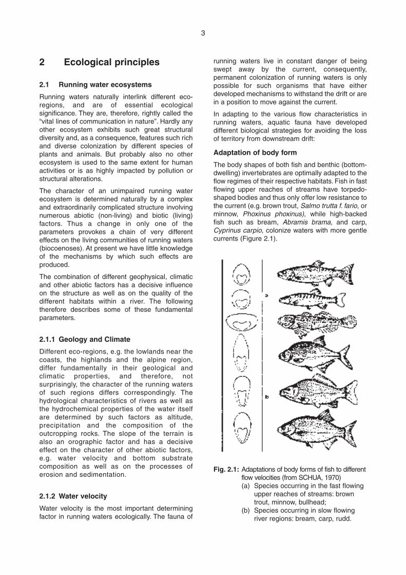
Adaptation of body form
The body shapes of both fish and benthic (bottom-dwelling) invertebrates are optimally adapted to theflow regimes of their respective habitats. Fish in fastflowing upper reaches of streams have torpedo-shaped bodies and thus only offer low resistance tothe current (e.g. brown trout, Salmo trutta f. fario, orminnow, Phoxinus phoxinus), while high-backedfish such as bream, Abramis brama, and carp,Cyprinus carpio, colonize waters with more gentlecurrents (Figure 2.1).
Fig. 2.1: Adaptations of body forms of fish to differentflow velocities (from SCHUA, 1970)(a) Species occurring in the fast flowing
upper reaches of streams: browntrout, minnow, bullhead;
(b) Species occurring in slow flowingriver regions: bream, carp, rudd.
4
primarily by drifting. For example, young bullheadsswim up to 2 km upstream after having beentransported downstream with the current as youngfry when their swimming ability was not yet welldeveloped (BLESS, 1990). The imagoes of someinsect species fly upstream to compensate for theloss of terrain that they had incurred as a result oflarval drift (PECHLANER, 1986). Similarcompensatory migrations are known withfreshwater hoppers (Gammaridae) (HUGHES,1970; MEIJERING, 1972).
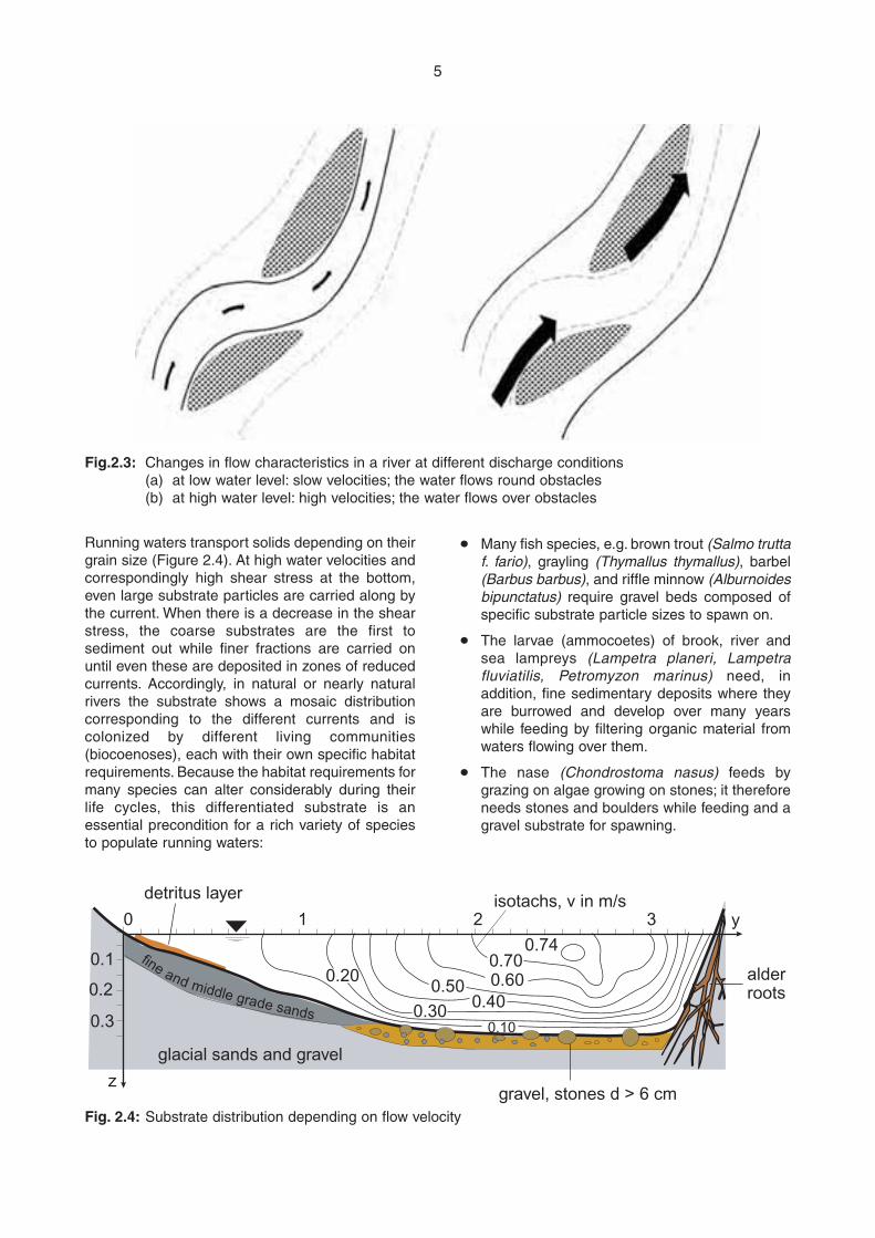
Slope is the dominant factor that determines watervelocity (and the current) of morphologicallyunimpaired rivers and hence the general structureof the river channel. Water velocity can also changeconsiderably under the influence of localdifferences in channel width. These dynamicchanges of the river structure are accompanied bythe formation of different current patterns, whichare at the basis of the multiform mosaic-likecharacter of aquatic habitats. Variations in flowregime also alter the living conditions in runningwaters. There are for example areas where gentlecurrents prevail at normal water level but which areexposed to high current velocity during times offlood (Figure 2.3). During the flood aquaticorganisms are swept downstream more easily andthe fauna must balance the loss of terrain bycompensatory movements after flooding abates.
2.1.3 Shear stress and substrate distribution
The energy of running water dynamically remodelsthe channel of natural watercourses by erosion andsedimentation. The shear stress of the watercauses solids to be transported (bed load) andshifted on a large scale. This leads to the formationof different bottom and bank structures as well asdiffering current patterns:
m In meandering and braided rivers, steep cutbanks form at the outer edge of a bend throughremoval of bottom and bank material by erosion,while flat bank deposits are formed at the inneredge by deposition of materials.
m Deposition of gravel, sand and silt locallyreduces the water depth, thus forming shallows.
m Removal of solid materials causes greater waterdepths (deep pools, holes).
m Sections with gentle current alternate with rapidcurrent sections (pool and riffle structures) overrelatively short distances.
m Dynamic shifts in the course of the river channelform bays, blind side arms and backwaters.
Adaptation of behaviour
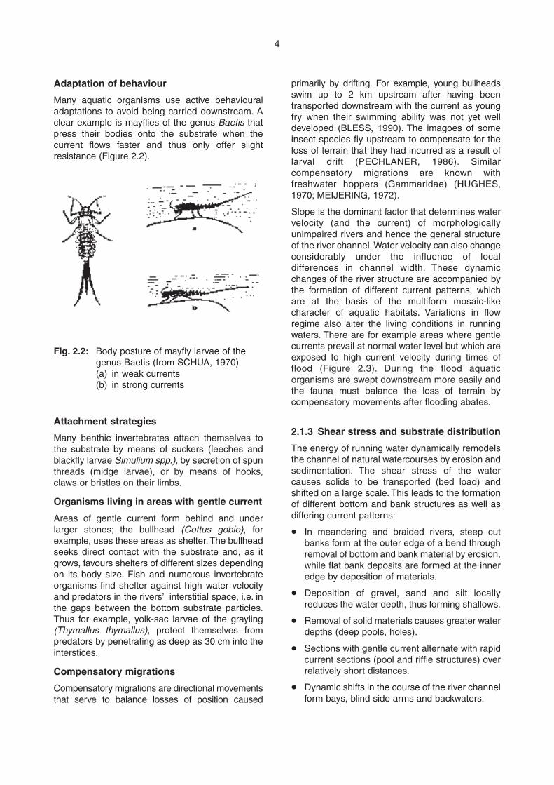
Many aquatic organisms use active behaviouraladaptations to avoid being carried downstream. Aclear example is mayflies of the genus Baetis thatpress their bodies onto the substrate when thecurrent flows faster and thus only offer slightresistance (Figure 2.2).
Attachment strategies
Many benthic invertebrates attach themselves tothe substrate by means of suckers (leeches andblackfly larvae Simulium spp.), by secretion of spunthreads (midge larvae), or by means of hooks,claws or bristles on their limbs.
Organisms living in areas with gentle current
Areas of gentle current form behind and underlarger stones; the bullhead (Cottus gobio), forexample, uses these areas as shelter. The bullheadseeks direct contact with the substrate and, as itgrows, favours shelters of different sizes dependingon its body size. Fish and numerous invertebrateorganisms find shelter against high water velocityand predators in the rivers’ interstitial space, i.e. inthe gaps between the bottom substrate particles.Thus for example, yolk-sac larvae of the grayling(Thymallus thymallus), protect themselves frompredators by penetrating as deep as 30 cm into theinterstices.
Compensatory migrations
Compensatory migrations are directional movementsthat serve to balance losses of position caused
Fig. 2.2: Body posture of mayfly larvae of thegenus Baetis (from SCHUA, 1970)(a) in weak currents(b) in strong currents
5
Running waters transport solids depending on theirgrain size (Figure 2.4). At high water velocities andcorrespondingly high shear stress at the bottom,even large substrate particles are carried along bythe current. When there is a decrease in the shearstress, the coarse substrates are the first tosediment out while finer fractions are carried onuntil even these are deposited in zones of reducedcurrents. Accordingly, in natural or nearly naturalrivers the substrate shows a mosaic distributioncorresponding to the different currents and iscolonized by different living communities(biocoenoses), each with their own specific habitatrequirements. Because the habitat requirements formany species can alter considerably during theirlife cycles, this differentiated substrate is anessential precondition for a rich variety of speciesto populate running waters:
m Many fish species, e.g. brown trout (Salmo truttaf. fario), grayling (Thymallus thymallus), barbel(Barbus barbus), and riffle minnow (Alburnoidesbipunctatus) require gravel beds composed ofspecific substrate particle sizes to spawn on.
m The larvae (ammocoetes) of brook, river andsea lampreys (Lampetra planeri, Lampetrafluviatilis, Petromyzon marinus) need, inaddition, fine sedimentary deposits where theyare burrowed and develop over many yearswhile feeding by filtering organic material fromwaters flowing over them.
m The nase (Chondrostoma nasus) feeds bygrazing on algae growing on stones; it thereforeneeds stones and boulders while feeding and agravel substrate for spawning.
fine and middle grade sands
gravel, stones d > 6 cm
alderroots
y32
0.740.700.600.50
0.400.30
0.20
0.10
glacial sands and gravel
1
z
0
0.3
0.2
0.1
detritus layer isotachs, v in m/s
Fig.2.3: Changes in flow characteristics in a river at different discharge conditions(a) at low water level: slow velocities; the water flows round obstacles (b) at high water level: high velocities; the water flows over obstacles
Fig. 2.4: Substrate distribution depending on flow velocity
6
frequently not due to toxic substances (cyanide,pesticides, etc.) but rather to a lack of oxygenarising from the oxygen-consuming breakdown oforganic matter such as sewage or liquid manure.The oxygen content of the water, which in turn isclosely linked to the water velocity and current,exerts a considerable influence on the colonizationof running waters by aquatic organisms:
m Invertebrates that are adapted to high oxygenlevels in the headwaters of streams, meet theirtotal oxygen demand by diffusion over the bodysurface. Due to the rapid current, an intensivesupply with oxygen-rich water is guaranteed tosatisfy breathing needs, so that differentstonefly larvae for example, have not developedany special organs (gills) for absorbing oxygen.
m Species such as, for example, mussels (bivalves),the larvae of mayflies (Ephemeroptera) andcaddis flies (Trichoptera) that live in riverstretches with more gentle currents have gillsas breathing organs that facilitate theexchange of oxygen.
m Some benthic organisms such as, for example,midge larvae (Chironomidae) and tube worms(Tubifex tubifex) have haemoglobin in their bodyfluids as a special adaptation to habitats withchronic oxygen deficiency. Haemoglobin has ahigh capacity to bind oxygen, so that thoseorganisms endowed with it are able to meettheir oxygen demand even in a low-oxygenenvironment.
m Also some fish species have developedadaptations to different oxygen levels in thewater. Species such as brown trout (Salmotrutta f. fario) and minnow (Phoxinus phoxinus)that live in the upper reaches of streams(rhithron), where the water remains cool even insummer, have at their disposal sufficient oxygenall year round if the waters are natural andunpolluted. Therefore, these species havecomparatively low-performance gills and thushave to rely on a good oxygen supply from thewater: brown trout cannot tolerate oxygenconcentrations significantly below 9 mg/l forlong periods.
m However, species of the lower reaches of slow-flowing rivers (potamon) are adapted tonaturally occurring oxygen deficits. Forinstance, carp (Cyprinus carpio) can survivein oxygen concentrations of 2 to 3 mg/l.Some indigenous species from loach family(Cobitidae), for example spined loach (Cobitistaenia), weather-fish or bougfish (Misgurnusfossilis) and stoneloach (Noemacheilus
2.1.4 Temperature
The temperature of running water is of specialimportance to the limnetic biocoenosis. Manyspecies are adapted to a narrow temperature rangefor their metabolic functions and normal behaviour.Such species can only tolerate a limited degree ofdeviation from their temperature optimum. Even aslight warming of running waters through thermalpollution (input of water warmed up in ponds,cooling water from thermal power stations, etc.) orwarming of impounded waters through intensesolar radiation can limit their colonization by suchtemperature sensitive organisms. Conversely, thereproduction of fish is linked to a minimumtemperature that differs for each species. Whilebrown trout (Salmo trutta f. fario) spawns attemperatures below 5ºC, the reproduction of thenase (Chondrostoma nasus) is only triggered at8ºC, and the reproduction of the minnow (Phoxinusphoxinus) starts at 11ºC. Species typical of thelower river reaches (potamon) such as carp(Cyprinus carpio) and tench (Tinca tinca) onlyspawn at temperatures well over 20ºC. Watertemperatures and temperature variations also playa fundamental role in the migratory behaviour offish (JONSSON, 1991). Thus the smolts of salmonand sea trout in the Norwegian river Imsa prefer tomigrate downstream at temperatures over 10ºC,whereas most adult eels swim down the river attemperatures between 9º and 12ºC. Increasingwater temperatures also trigger upstream migrationof fish. However, too high a water temperaturehinders upstream migration because, when thetemperature exceeds a species specific limit, themetabolism of the fish may be taxed and the fish’sphysical strength may be limited.
2.1.5 Oxygen
Dissolved oxygen plays a significant role in theaquatic environment. Uptake of oxygen throughthe surface of the water under turbulent flowconditions in running waters (i.e. the physicalintake of oxygen) is significant but oxygen is alsoproduced by planktonic and epiphytic algae aswell as higher aquatic plants, through the processof photosynthesis (biological oxygen supply). Thesolubility of oxygen is largely dependent on watertemperature as much less oxygen dissolves inwater at higher temperatures than at lowertemperatures. Organic pollution, which iseliminated by oxygen-consuming microbialdecomposition in the process of self-purificationof rivers, can reduce oxygen levels in the waterconsiderably. In extreme cases this can cause thedeath of aquatic organisms. Fish mortalities are

m In the upper reaches of a stream the oxygencontent is characterized by saturation orsupersaturation. Because of the strong turbulentflow, there is a permanent uptake ofatmospheric oxygen. The oxygen content of thewater in a river drops with the length of itscourse, not least because of the higher watertemperature and slower flow velocity. In thelower reaches, aquatic plants, and especiallyphytoplankton, increasingly influence theoxygen content of the water.
Special cases, e.g. the effects of discontinuousslope development, a rapid increase in dischargebecause of inflowing larger tributaries, or theenergy intake while flowing through lakes, are notconsidered in this generalized model.
The River Continuum Concept illustrates the factthat there is likewise the formation of acharacteristic biological gradient, corresponding tothe alteration of different abiotic factors in thecourse of a river. This gradient can also beunderstood in terms of the biological energy flow inthe river and is the expression of a set pattern ofinput, transport, use and storage of organic matterin the river and its biocoenoses. The biologicalgradient is recognisable as certain species or typesof organisms are replaced by others in acharacteristic sequence along the river course. Thebiocoenoses of a particular reach of a river or evenof the whole river system are thus typicallyinterlinked in a set pattern, and follow, according tothe River Continuum Theory, the common strategyof minimising energy losses within the wholesystem. Thus the biocoenoses of lower reachestake advantage of the incomplete energytransformation of organic material by the upstreambiocoenoses, whereby mainly the organic materialthat is transported downstream is further brokendown (Figure 2.5).
This theory is supported by the fact thatinvertebrates in different parts of the river (upper,middle and lower reaches) utilize different foodelements and exhibit different nutrition strategies.The fundamental bioenergetic influences along theriver continuum consist of both local influxes ofallochthonous materials including organic matterand light as well as the drift of organic material fromthe upper reaches and from tributaries discharginginto the middle and lower reaches:
m The upper reaches are strongly influenced byvegetation on the banks. On one hand this reducesautotrophic production in the river itself throughshading, but on the other provides the river with alarge amount of allochthonous dead organicmatter, particularly in the form of fallen leaves.
7
barbatulus) have the ability of intestinalbreathing as an adaptation to habitats withchronic oxygen deficiency. When the oxygencontent of the water is low, these species canswallow air from which oxygen is extracted intheir intestines by a special breathing organ.
2.2 River continuum
The “River Continuum Concept” by VANNOTE et al.(1980) describes the ecological function of riversas linear ecosystems and the effects ofinterruptions of their connectivity. This energy-flowmodel provides a theoretical basis for claiming theintegrity of the linear connectivity of river systemsand is based on the characteristic alteration ofabiotic factors in the course of a river as describedin section 2.1. Aquatic species show adaptations tothe specific living conditions prevailing in anyparticular river reach and form characteristicbiocoenoses that change in a natural successionalong the watercourse as the abiotic factors vary.An idealised model, based on the fundamentalrelations between the gradients of the physicalfactors and the biological mechanisms thatinfluence the composition of living communities inrivers, can be constructed according to thefollowing assumptions:
m The discharge of the river increases constantlyfrom source to mouth.
m The steepness of the slope usually decreaseswith increasing distance from the source.
m The velocity of the current is very high in theupper reaches and decreases steadily towardsthe estuary, where there is a regular tidalreversal of the direction of the current.
m The substrate is graded along the course of theriver in a characteristic manner determined bythe velocity of the current. While the substrate ofthe upper reaches mainly consists of boulders,pebbles and coarse gravel, fine gravel and sanddominate in the middle reaches, and theestuary area is characterized by fine sand, siltand clay substrate.
m The average annual temperature of well under10ºC in the upper reaches of temperate streamsis comparatively low but increases along thecourse of the river. Also the range oftemperature variation continually increasesalong the course of the river. While thetemperature near the source is usually quasi-constant throughout the year, it may varybetween 0ºC in winter and 20ºC in summer inthe lower reaches.
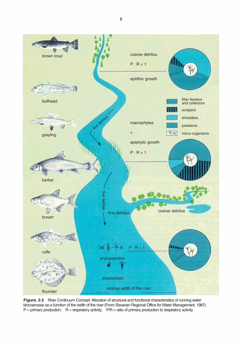
8
brown trout
bullhead
grayling
barbel
bream
ruffe
flounder
coarse detritus
P : R < 1
epilithic growth
macrophytes
+
epiphytic growth
P : R > 1
filter feeders and collectors
scrapers
shredders
predators
micro-organisms
relative width of the river
zooplankton
P : R < 1
coarse detritus
phytoplankton
fine detritus
fine
detrit
us
fine detritus
Figure. 2.5 River Continuum Concept: Alteration of structural and functional characteristics of running waterbiocoenoses as a function of the width of the river (From: Bavarian Regional Office for Water Management, 1987)P = primary production; R = respiratory activity; P/R = ratio of primary production to respiratory activity
9
m The significance of the influx from the terrestrialzones decreases with increasing river width. Atthe same time both the autotrophic primaryproduction in the water itself as well as thedownstream transport of organic material fromthe upper reaches increase significantly.
m The physiological differences betweenbiocoenoses of different river reaches arereflected in the ratio of the primary production(P) to the respiratory activity (R) of thebiocoenosis (P/R). In the upper reachesrespiratory activity dominates while in themiddle reaches primary production is moreimportant. In the lower reaches, however, theprimary production is strongly reduced throughincreased water turbidity and greater waterdepth. At the same time, a large amount of fineorganic material, which comes originally fromfallen leaves in the upper reaches, is importedby the flow, so that here again respiratoryactivity predominates over primary production.
The different morphological and physiologicalstrategies of aquatic organisms can be understoodas an expression of their adaptation to the basicfood elements that are present and the prevailingnutritional conditions in the different river stretches.The following feeder types can be distinguished:
m “Shredders”, that use coarse organic material(> 1 mm), such as fallen leaves, and that arereliant on the supporting activity of micro-organisms.
m “Collectors”, that filter small (50 mm – 1 mm)or very small (0.5 – 50 mm) particles from theflowing water or take them up from thesubstrate. Like the shredders, the collectors arealso reliant on the microbial organisms and theirmetabolic products, which they ingest togetherwith the food particles.
m “Scrapers”, that are specialized in grazing onthe algal growth on the substrate.
m “Predators”, that feed on other functional typesof feeders.
In accordance with the specific nutritionalconditions (P/R < 1), both shredders and collectorstogether dominate the invertebrate biocoenoses ofthe upper reaches. Scrapers are mainly to be foundin the middle reaches (P/R > 1). As the river widthincreases and as the food particle size decreasessignificantly, the collectors again gain importance inthe biocoenoses of larger rivers. The proportion ofpredators only changes slightly in the course of theriver, but the species composition differs. We thushave:
Upper reaches: shredders and collectors
Middle reaches: scrapers
Lower reaches: collectors
Fish communities also show a characteristicsequence along the course of the river. Cold-waterfish communities of the upper reaches, which arecomposed of few species, are successivelyreplaced by warm water communities with highspecies diversity. The species in the upper reachesmainly feed on invertebrates (are invertivores),while the fish communities of the middle reachesconsist of both invertivores and piscivores (eatingother fishes). Plankton-eating (planktivore) speciesare limited to the lower reaches of large rivers. Wethus have:
Upper reaches: invertivore fish
Middle reaches: invertivore and piscivore fish
Lower reaches: planktivore fish
The basic prerequisite for the functioning of thismodel is that the animal communities can alter andadapt to local conditions without problems inaccordance with the dynamics of the system. Forexample individual species should be free tosearch for suitable feeding grounds in accordancewith their life cycle and the seasonal conditions.This requires unhindered upstream anddownstream passage for organisms in the relevantriver stretches. Disturbances of the biologicalenergy influx, for example through lack of shrubson the banks, or disturbancies of the energy andmaterial flows due to damming, as well asdisturbances in the formation of biocoenoses, thatare typical of a certain ecosystem, undoubtedlyhave a negative influence on the colonization of thewhole river system. Interruptions of the rivercontinuum, and thus of the circulation of materialsin the river, lead to changes in the energy balance.
2.3 Biological zoning of running waters
Knowledge of the interactions between abiotic andbiotic factors in rivers, allows the demarcation ofthe habitats of typical biocoenoses from oneanother within the river continuum, thus permittingthe division of the river into distinct individualzones. This zoning has quite practical implications;for example it provides an essential basis for anecologically oriented fishery and allows thenegative effects of human interventions in a river tobe clearly demonstrated. For fishery purposes, thedifferent river stretches are traditionally classifiedby main indicator fish species that arecommercially significant and that characterise thefish composition of a particular section. Experience
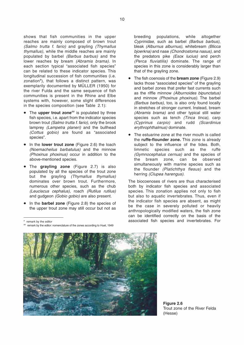
10
shows that fish communities in the upperreaches are mainly composed of brown trout(Salmo trutta f. fario) and grayling (Thymallusthymallus), while the middle reaches are mainlypopulated by barbel (Barbus barbus) and thelower reaches by bream (Abramis brama). Ineach section typical “associated fish species”can be related to these indicator species. Thislongitudinal succession of fish communities (i.e.zonation#), that follows a distinct pattern, wasexemplarily documented by MÜLLER (1950) forthe river Fulda and the same sequence of fishcommunities is present in the Rhine and Elbesystems with, however, some slight differencesin the species composition (see Table 2.1):
m The upper trout zone## is populated by threefish species, i.e. apart from the indicator speciesbrown trout (Salmo trutta f. fario), only the brooklamprey (Lampetra planeri) and the bullhead(Cottus gobio) are found as “associatedspecies”.
m In the lower trout zone (Figure 2.6) the loach(Noemacheilus barbatulus) and the minnow(Phoxinus phoxinus) occur in addition to theabove-mentioned species.
m The grayling zone (Figure 2.7) is alsopopulated by all the species of the trout zonebut the grayling (Thymallus thymallus)dominates over brown trout. Furthermore,numerous other species, such as the chub(Leuciscus cephalus), roach (Rutilus rutilus)and gudgeon (Gobio gobio) are also present.
m In the barbel zone (Figure 2.8) the species ofthe upper trout zone may still occur but not as
breeding populations, while altogetherCyprinidae, such as barbel (Barbus barbus),bleak (Alburnus alburnus), whitebream (Bliccabjoerkna) and nase (Chondrostoma nasus), andthe predators pike (Esox lucius) and perch(Perca fluviatilis) dominate. The range ofspecies in this zone is considerably larger thanthat of the grayling zone.
m The fish coenosis of the bream zone (Figure 2.9)lacks those “associated species” of the graylingand barbel zones that prefer fast currents suchas the riffle minnow (Alburnoides bipunctatus)and minnow (Phoxinus phoxinus). The barbel(Barbus barbus), too, is also only found locallyin stretches of stronger current. Instead, bream(Abramis brama) and other typical still waterspecies such as tench (Tinca tinca), carp(Cyprinus carpio) and rudd (Scardiniuserythrophthalmus) dominate.
m The estuarine zone at the river mouth is calledthe ruffe-flounder zone. This zone is alreadysubject to the influence of the tides. Both,limnetic species such as the ruffe(Gymnocephalus cernua) and the species ofthe bream zone, can be observedsimultaneously with marine species such asthe flounder (Platichthys flesus) and theherring (Clupea harengus).
The biocoenoses of rivers are thus characterisedboth by indicator fish species and associatedspecies. This zonation applies not only to fishbut also to aquatic invertebrates. Thus, even ifthe indicator fish species are absent, as mightbe the case in severely polluted or heavilyanthropologically modified waters, the fish zonecan be identified correctly on the basis of theassociated fish species and invertebrates. For
Figure 2.6Trout zone of the River Felda(Hesse)
# remark by the editor ## remark by the editor: nomenclature of the zones according to Huet, 1949
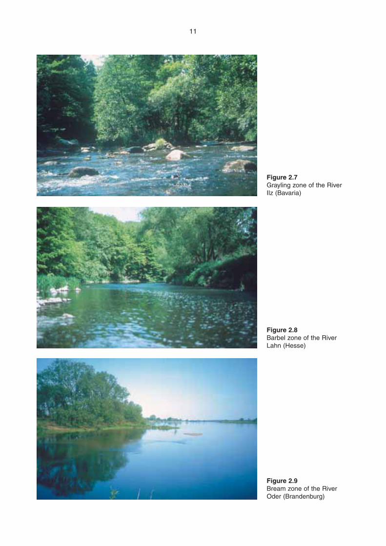
11
Figure 2.9Bream zone of the RiverOder (Brandenburg)
Figure 2.8Barbel zone of the RiverLahn (Hesse)
Figure 2.7Grayling zone of the RiverIlz (Bavaria)
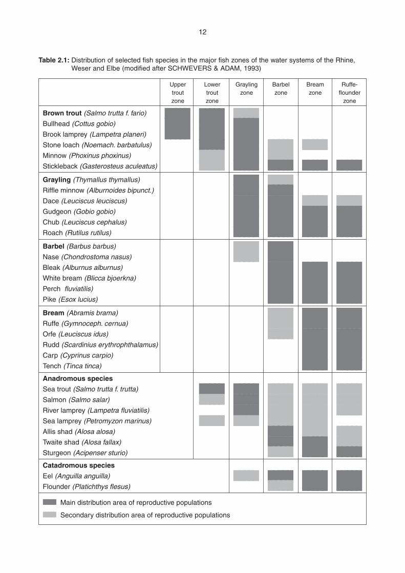
12
Upper Lower Grayling Barbel Bream Ruffe-trout trout zone zone zone flounderzone zone zone
Brown trout (Salmo trutta f. fario) ■■■■■ ■■■■■ ■■■■■Bullhead (Cottus gobio) ■■■■■ ■■■■■ ■■■■■Brook lamprey (Lampetra planeri) ■■■■■ ■■■■■ ■■■■■Stone loach (Noemach. barbatulus) ■■■■■ ■■■■■ ■■■■■ ■■■■■Minnow (Phoxinus phoxinus) ■■■■■ ■■■■■ ■■■■■Stickleback (Gasterosteus aculeatus) ■■■■■ ■■■■■ ■■■■■ ■■■■■ ■■■■■Grayling (Thymallus thymallus) ■■■■■ ■■■■■Riffle minnow (Alburnoides bipunct.) ■■■■■ ■■■■■Dace (Leuciscus leuciscus) ■■■■■ ■■■■■ ■■■■■ ■■■■■Gudgeon (Gobio gobio) ■■■■■ ■■■■■ ■■■■■ ■■■■■Chub (Leuciscus cephalus) ■■■■■ ■■■■■ ■■■■■ ■■■■■Roach (Rutilus rutilus) ■■■■■ ■■■■■ ■■■■■ ■■■■■Barbel (Barbus barbus) ■■■■■ ■■■■■Nase (Chondrostoma nasus) ■■■■■ ■■■■■Bleak (Alburnus alburnus) ■■■■■ ■■■■■ ■■■■■White bream (Blicca bjoerkna) ■■■■■ ■■■■■ ■■■■■Perch fluviatilis) ■■■■■ ■■■■■ ■■■■■Pike (Esox lucius) ■■■■■ ■■■■■ ■■■■■Bream (Abramis brama) ■■■■■ ■■■■■ ■■■■■Ruffe (Gymnoceph. cernua) ■■■■■ ■■■■■ ■■■■■Orfe (Leuciscus idus) ■■■■■ ■■■■■ ■■■■■Rudd (Scardinius erythrophthalamus) ■■■■■ ■■■■■Carp (Cyprinus carpio) ■■■■■ ■■■■■Tench (Tinca tinca) ■■■■■ ■■■■■Anadromous species
Sea trout (Salmo trutta f. trutta) ■■■■■ ■■■■■ ■■■■■ ■■■■■ ■■■■■Salmon (Salmo salar) ■■■■■ ■■■■■ ■■■■■ ■■■■■ ■■■■■River lamprey (Lampetra fluviatilis) ■■■■■ ■■■■■ ■■■■■ ■■■■■Sea lamprey (Petromyzon marinus) ■■■■■ ■■■■■ ■■■■■ ■■■■■Allis shad (Alosa alosa) ■■■■■ ■■■■■ ■■■■■Twaite shad (Alosa fallax) ■■■■■ ■■■■■ ■■■■■Sturgeon (Acipenser sturio) ■■■■■ ■■■■■ ■■■■■Catadromous species
Eel (Anguilla anguilla) ■■■■■ ■■■■■ ■■■■■ ■■■■■Flounder (Platichthys flesus) ■■■■■ ■■■■■ ■■■■■■■■■■ Main distribution area of reproductive populations
■■■■■ Secondary distribution area of reproductive populations
Table 2.1: Distribution of selected fish species in the major fish zones of the water systems of the Rhine,Weser and Elbe (modified after SCHWEVERS & ADAM, 1993)
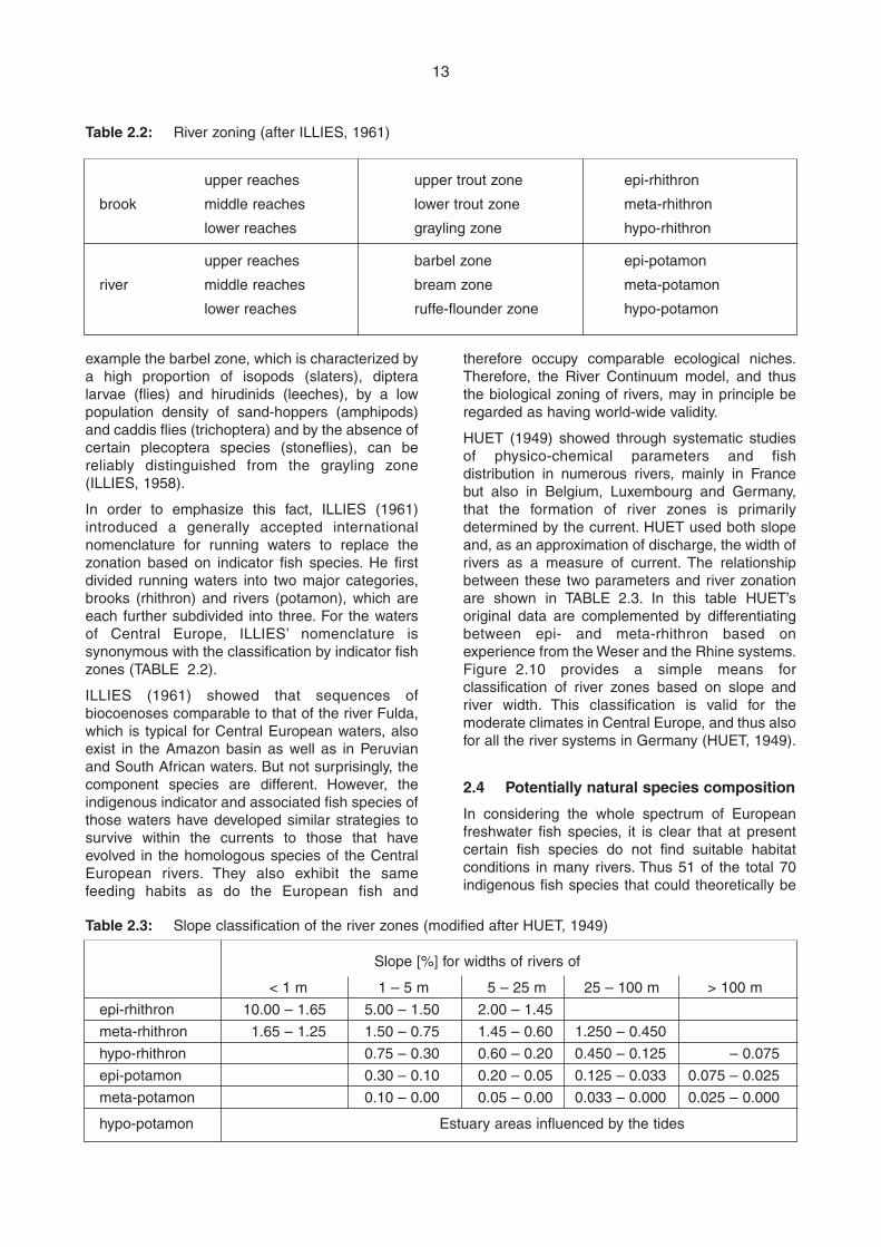
13
therefore occupy comparable ecological niches.Therefore, the River Continuum model, and thusthe biological zoning of rivers, may in principle beregarded as having world-wide validity.
HUET (1949) showed through systematic studiesof physico-chemical parameters and fishdistribution in numerous rivers, mainly in Francebut also in Belgium, Luxembourg and Germany,that the formation of river zones is primarilydetermined by the current. HUET used both slopeand, as an approximation of discharge, the width ofrivers as a measure of current. The relationshipbetween these two parameters and river zonationare shown in TABLE 2.3. In this table HUET’soriginal data are complemented by differentiatingbetween epi- and meta-rhithron based onexperience from the Weser and the Rhine systems.Figure 2.10 provides a simple means forclassification of river zones based on slope andriver width. This classification is valid for themoderate climates in Central Europe, and thus alsofor all the river systems in Germany (HUET, 1949).
2.4 Potentially natural species composition
In considering the whole spectrum of Europeanfreshwater fish species, it is clear that at presentcertain fish species do not find suitable habitatconditions in many rivers. Thus 51 of the total 70indigenous fish species that could theoretically be
example the barbel zone, which is characterized bya high proportion of isopods (slaters), dipteralarvae (flies) and hirudinids (leeches), by a lowpopulation density of sand-hoppers (amphipods)and caddis flies (trichoptera) and by the absence ofcertain plecoptera species (stoneflies), can bereliably distinguished from the grayling zone(ILLIES, 1958).
In order to emphasize this fact, ILLIES (1961)introduced a generally accepted internationalnomenclature for running waters to replace thezonation based on indicator fish species. He firstdivided running waters into two major categories,brooks (rhithron) and rivers (potamon), which areeach further subdivided into three. For the watersof Central Europe, ILLIES’ nomenclature issynonymous with the classification by indicator fishzones (TABLE 2.2).
ILLIES (1961) showed that sequences ofbiocoenoses comparable to that of the river Fulda,which is typical for Central European waters, alsoexist in the Amazon basin as well as in Peruvianand South African waters. But not surprisingly, thecomponent species are different. However, theindigenous indicator and associated fish species ofthose waters have developed similar strategies tosurvive within the currents to those that haveevolved in the homologous species of the CentralEuropean rivers. They also exhibit the samefeeding habits as do the European fish and
upper reaches upper trout zone epi-rhithron
brook middle reaches lower trout zone meta-rhithron
lower reaches grayling zone hypo-rhithron
upper reaches barbel zone epi-potamon
river middle reaches bream zone meta-potamon
lower reaches ruffe-flounder zone hypo-potamon
Slope [%] for widths of rivers of
< 1 m 1 – 5 m 5 – 25 m 25 – 100 m > 100 m
epi-rhithron 10.00 – 1.65 5.00 – 1.50 2.00 – 1.45
meta-rhithron 1.65 – 1.25 1.50 – 0.75 1.45 – 0.60 1.250 – 0.450
hypo-rhithron 0.75 – 0.30 0.60 – 0.20 0.450 – 0.125 – 0.075
epi-potamon 0.30 – 0.10 0.20 – 0.05 0.125 – 0.033 0.075 – 0.025
meta-potamon 0.10 – 0.00 0.05 – 0.00 0.033 – 0.000 0.025 – 0.000
hypo-potamon Estuary areas influenced by the tides
Table 2.3: Slope classification of the river zones (modified after HUET, 1949)
Table 2.2: River zoning (after ILLIES, 1961)
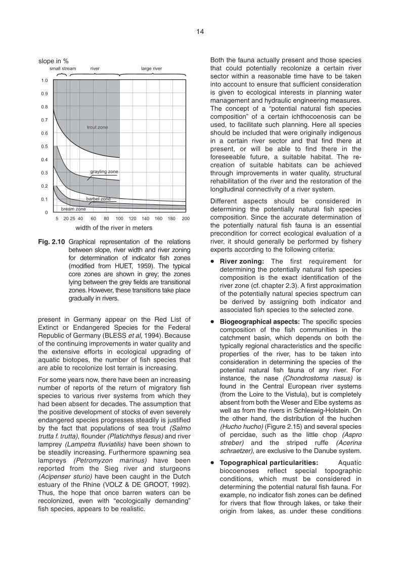
14
present in Germany appear on the Red List ofExtinct or Endangered Species for the FederalRepublic of Germany (BLESS et al, 1994). Becauseof the continuing improvements in water quality andthe extensive efforts in ecological upgrading ofaquatic biotopes, the number of fish species thatare able to recolonize lost terrain is increasing.
For some years now, there have been an increasingnumber of reports of the return of migratory fishspecies to various river systems from which theyhad been absent for decades. The assumption thatthe positive development of stocks of even severelyendangered species progresses steadily is justifiedby the fact that populations of sea trout (Salmotrutta f. trutta), flounder (Platichthys flesus) and riverlamprey (Lampetra fluviatilis) have been shown tobe steadily increasing. Furthermore spawning sealampreys (Petromyzon marinus) have beenreported from the Sieg river and sturgeons(Acipenser sturio) have been caught in the Dutchestuary of the Rhine (VOLZ & DE GROOT, 1992).Thus, the hope that once barren waters can berecolonized, even with “ecologically demanding”fish species, appears to be realistic.
Both the fauna actually present and those speciesthat could potentially recolonize a certain riversector within a reasonable time have to be takeninto account to ensure that sufficient considerationis given to ecological interests in planning watermanagement and hydraulic engineering measures.The concept of a “potential natural fish speciescomposition” of a certain ichthocoenosis can beused, to facilitate such planning. Here all speciesshould be included that were originally indigenousin a certain river sector and that find there atpresent, or will be able to find there in theforeseeable future, a suitable habitat. The re-creation of suitable habitats can be achievedthrough improvements in water quality, structuralrehabilitation of the river and the restoration of thelongitudinal connectivity of a river system.
Different aspects should be considered indetermining the potentially natural fish speciescomposition. Since the accurate determination ofthe potentially natural fish fauna is an essentialprecondition for correct ecological evaluation of ariver, it should generally be performed by fisheryexperts according to the following criteria:
m River zoning: The first requirement fordetermining the potentially natural fish speciescomposition is the exact identification of theriver zone (cf. chapter 2.3). A first approximationof the potentially natural species spectrum canbe derived by assigning both indicator andassociated fish species to the selected zone.
m Biogeographical aspects: The specific speciescomposition of the fish communities in thecatchment basin, which depends on both thetypically regional characteristics and the specificproperties of the river, has to be taken intoconsideration in determining the species of thepotential natural fish fauna of any river. Forinstance, the nase (Chondrostoma nasus) isfound in the Central European river systems(from the Loire to the Vistula), but is completelyabsent from both the Weser and Elbe systems aswell as from the rivers in Schleswig-Holstein. Onthe other hand, the distribution of the huchen(Hucho hucho) (Figure 2.15) and several speciesof percidae, such as the little chop (Asprostreber) and the striped ruffe (Acerinaschraetzer), are exclusive to the Danube system.
m Topographical particularities: Aquaticbiocoenoses reflect special topographicconditions, which must be considered indetermining the potential natural fish fauna. Forexample, no indicator fish zones can be definedfor rivers that flow through lakes, or take theirorigin from lakes, as under these conditions
slope in %
width of the river in meters
5 20 25 40 60 80 100 120 140 160 180 200
1.0
0.9
0.8
0.7
0.6
0.5
0.4
0.3
0.2
0.1
0
trout zonetrout zone
grayling zonegrayling zone
barbel zonebarbel zone
bream zonebream zone
small stream river large river
Fig. 2.10 Graphical representation of the relationsbetween slope, river width and river zoningfor determination of indicator fish zones(modified from HUET, 1959). The typicalcore zones are shown in grey; the zoneslying between the grey fields are transitionalzones. However, these transitions take placegradually in rivers.
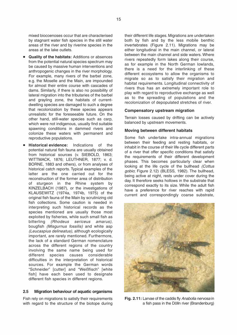
15
their different life stages. Migrations are undertakenboth by fish and by the less mobile benthicinvertebrates (Figure 2.11). Migrations may beeither longitudinal in the main channel, or lateralbetween the main channel and side waters. Whererivers repeatedly form lakes along their course,as for example in the North German lowlands,there is a need for the interlinking of thesedifferent ecosystems to allow the organisms tomigrate so as to satisfy their migration andhabitat requirements. Longitudinal connectivity ofrivers thus has an extremely important role toplay with regard to reproductive exchange as wellas to the spreading of populations and therecolonization of depopulated stretches of river.
Compensatory upstream migration
Terrain losses caused by drifting can be activelybalanced by upstream movements.
Moving between different habitats
Some fish undertake intra-annual migrationsbetween their feeding and resting habitats, orinhabit in the course of their life cycle different partsof a river that offer specific conditions that satisfythe requirements of their different developmentphases. This becomes particularly clear whenlooking at the life cycle of the bullhead (Cottusgobio; Figure 2.12) (BLESS, 1982). The bullhead,being active at night, rests under cover during theday. It therefore seeks hollows in the substrate thatcorrespond exactly to its size. While the adult fishhave a preference for river reaches with rapidcurrent and correspondingly coarse substrate,
mixed biocoenoses occur that are characterisedby stagnant water fish species in the still waterareas of the river and by riverine species in theareas at the lake outlets.
m Quality of the habitats: Additions or absencesfrom the potential natural species spectrum maybe caused by massive human interventions andanthropogenic changes in the river morphology.For example, many rivers of the barbel zone,e.g. the Moselle and the Main, are impoundedfor almost their entire course with cascades ofdams. Similarly, if there is also no possibility oflateral migration into the tributaries of the barbeland grayling zone, the habitats of current-dwelling species are damaged to such a degreethat recolonization by these species appearsunrealistic for the foreseeable future. On theother hand, still-water species such as carp,which were not indigenous, usually find suitablespawning conditions in dammed rivers andcolonize these waters with permanent andreproductive populations.
m Historical evidence: Indications of thepotential natural fish fauna are usually obtainedfrom historical sources (v. SIEBOLD, 1863;WITTMACK, 1876; LEUTHNER, 1877; v. d.BORNE, 1883 and others), or from analyses ofhistorical catch reports. Typical examples of thelatter are the one carried out for thereconstruction of the former area of distributionof sturgeon in the Rhine system byKINZELBACH (1987), or the investigations ofKLAUSEWITZ (1974a, 1974b, 1975) of theoriginal fish fauna of the Main by scrutinizing oldfish collections. Some caution is needed ininterpreting such historical records as thespecies mentioned are usually those mostexploited by fisheries, while such small fish asbitterling (Rhodeus sericeus amarus),bougfish (Misgurnus fossilis) and white asp(Leucaspius delineatus), although ecologicallyimportant, are rarely mentioned. Furthermore,the lack of a standard German nomenclatureacross the different regions of the countryinvolving the same name being used fordifferent species causes considerabledifficulties in the interpretation of historicalsources. For example the German words“Schneider” [cutter] and “Weißfisch” [whitefish] have each been used to designatedifferent fish species in different regions.
2.5 Migration behaviour of aquatic organisms
Fish rely on migrations to satisfy their requirementswith regard to the structure of the biotope during
Fig. 2.11: Larvae of the caddis fly Anabolia nervosa ina fish pass in the Dölln river (Brandenburg)
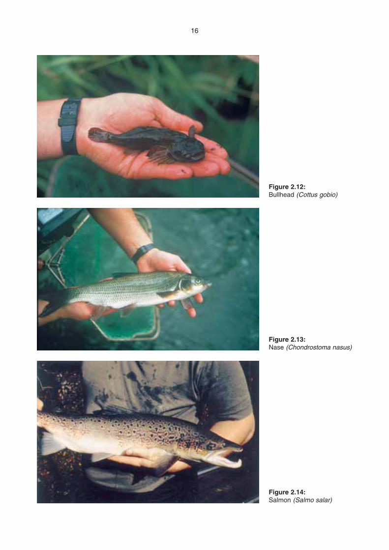
16
Figure 2.14:Salmon (Salmo salar)
Figure 2.13:Nase (Chondrostoma nasus)
Figure 2.12:Bullhead (Cottus gobio)
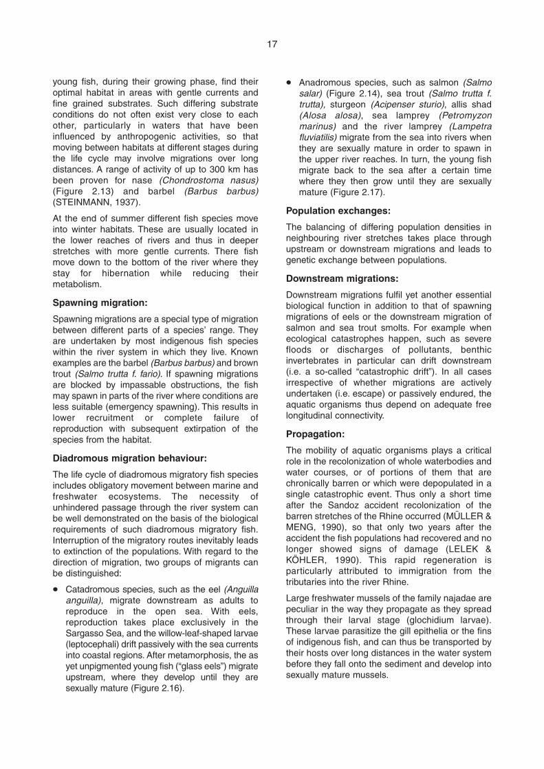
17
young fish, during their growing phase, find theiroptimal habitat in areas with gentle currents andfine grained substrates. Such differing substrateconditions do not often exist very close to eachother, particularly in waters that have beeninfluenced by anthropogenic activities, so thatmoving between habitats at different stages duringthe life cycle may involve migrations over longdistances. A range of activity of up to 300 km hasbeen proven for nase (Chondrostoma nasus)(Figure 2.13) and barbel (Barbus barbus)(STEINMANN, 1937).
At the end of summer different fish species moveinto winter habitats. These are usually located inthe lower reaches of rivers and thus in deeperstretches with more gentle currents. There fishmove down to the bottom of the river where theystay for hibernation while reducing theirmetabolism.
Spawning migration:
Spawning migrations are a special type of migrationbetween different parts of a species’ range. Theyare undertaken by most indigenous fish specieswithin the river system in which they live. Knownexamples are the barbel (Barbus barbus) and browntrout (Salmo trutta f. fario). If spawning migrationsare blocked by impassable obstructions, the fishmay spawn in parts of the river where conditions areless suitable (emergency spawning). This results inlower recruitment or complete failure ofreproduction with subsequent extirpation of thespecies from the habitat.
Diadromous migration behaviour:
The life cycle of diadromous migratory fish speciesincludes obligatory movement between marine andfreshwater ecosystems. The necessity ofunhindered passage through the river system canbe well demonstrated on the basis of the biologicalrequirements of such diadromous migratory fish.Interruption of the migratory routes inevitably leadsto extinction of the populations. With regard to thedirection of migration, two groups of migrants canbe distinguished:
m Catadromous species, such as the eel (Anguillaanguilla), migrate downstream as adults toreproduce in the open sea. With eels,reproduction takes place exclusively in theSargasso Sea, and the willow-leaf-shaped larvae(leptocephali) drift passively with the sea currentsinto coastal regions. After metamorphosis, the asyet unpigmented young fish (“glass eels”) migrateupstream, where they develop until they aresexually mature (Figure 2.16).
m Anadromous species, such as salmon (Salmosalar) (Figure 2.14), sea trout (Salmo trutta f.trutta), sturgeon (Acipenser sturio), allis shad(Alosa alosa), sea lamprey (Petromyzonmarinus) and the river lamprey (Lampetrafluviatilis) migrate from the sea into rivers whenthey are sexually mature in order to spawn inthe upper river reaches. In turn, the young fishmigrate back to the sea after a certain timewhere they then grow until they are sexuallymature (Figure 2.17).
Population exchanges:
The balancing of differing population densities inneighbouring river stretches takes place throughupstream or downstream migrations and leads togenetic exchange between populations.
Downstream migrations:
Downstream migrations fulfil yet another essentialbiological function in addition to that of spawningmigrations of eels or the downstream migration ofsalmon and sea trout smolts. For example whenecological catastrophes happen, such as severefloods or discharges of pollutants, benthicinvertebrates in particular can drift downstream(i.e. a so-called “catastrophic drift”). In all casesirrespective of whether migrations are activelyundertaken (i.e. escape) or passively endured, theaquatic organisms thus depend on adequate freelongitudinal connectivity.
Propagation:
The mobility of aquatic organisms plays a criticalrole in the recolonization of whole waterbodies andwater courses, or of portions of them that arechronically barren or which were depopulated in asingle catastrophic event. Thus only a short timeafter the Sandoz accident recolonization of thebarren stretches of the Rhine occurred (MÜLLER &MENG, 1990), so that only two years after theaccident the fish populations had recovered and nolonger showed signs of damage (LELEK &KÖHLER, 1990). This rapid regeneration isparticularly attributed to immigration from thetributaries into the river Rhine.
Large freshwater mussels of the family najadae arepeculiar in the way they propagate as they spreadthrough their larval stage (glochidium larvae).These larvae parasitize the gill epithelia or the finsof indigenous fish, and can thus be transported bytheir hosts over long distances in the water systembefore they fall onto the sediment and develop intosexually mature mussels.
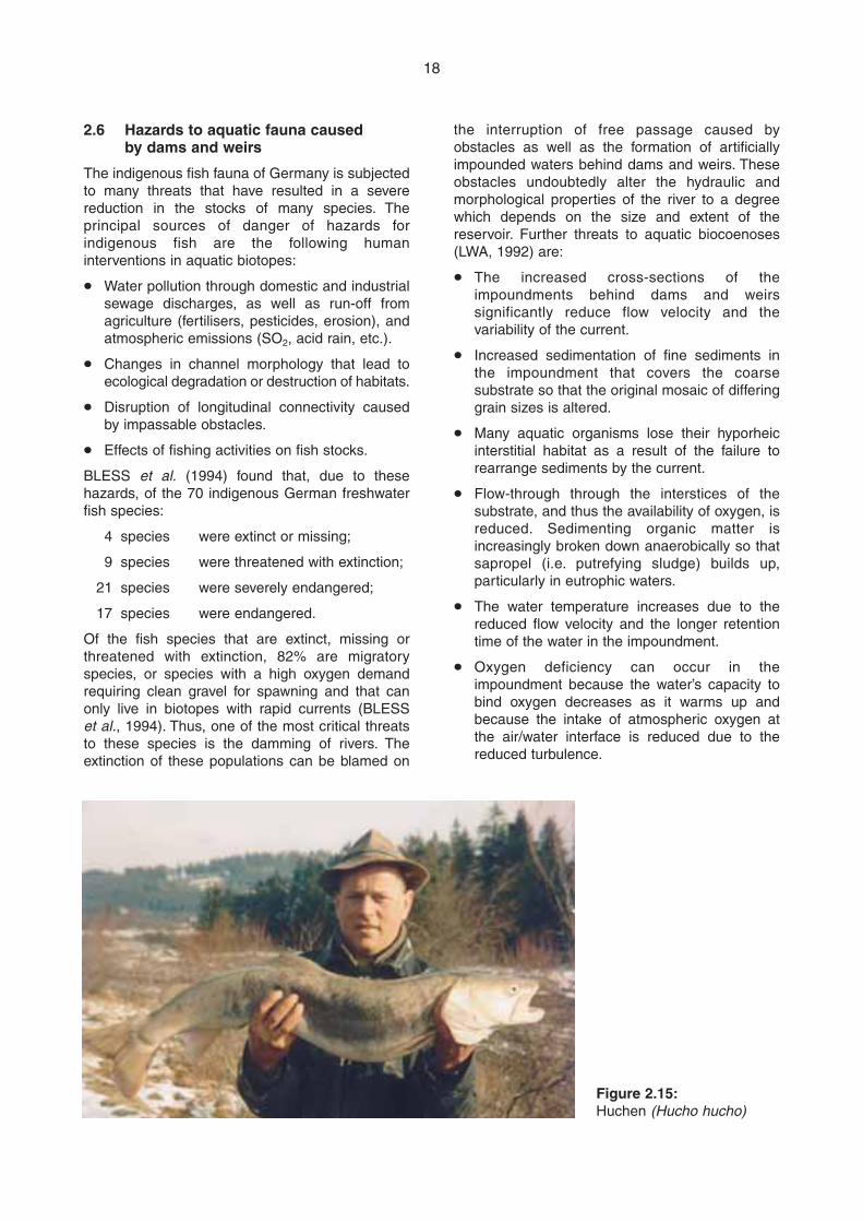
18
2.6 Hazards to aquatic fauna caused by dams and weirs
The indigenous fish fauna of Germany is subjectedto many threats that have resulted in a severereduction in the stocks of many species. Theprincipal sources of danger of hazards forindigenous fish are the following humaninterventions in aquatic biotopes:
m Water pollution through domestic and industrialsewage discharges, as well as run-off fromagriculture (fertilisers, pesticides, erosion), andatmospheric emissions (SO2, acid rain, etc.).
m Changes in channel morphology that lead toecological degradation or destruction of habitats.
m Disruption of longitudinal connectivity causedby impassable obstacles.
m Effects of fishing activities on fish stocks.
BLESS et al. (1994) found that, due to thesehazards, of the 70 indigenous German freshwaterfish species:
4 species were extinct or missing;
9 species were threatened with extinction;
21 species were severely endangered;
17 species were endangered.
Of the fish species that are extinct, missing orthreatened with extinction, 82% are migratoryspecies, or species with a high oxygen demandrequiring clean gravel for spawning and that canonly live in biotopes with rapid currents (BLESSet al., 1994). Thus, one of the most critical threatsto these species is the damming of rivers. Theextinction of these populations can be blamed on
the interruption of free passage caused byobstacles as well as the formation of artificiallyimpounded waters behind dams and weirs. Theseobstacles undoubtedly alter the hydraulic andmorphological properties of the river to a degreewhich depends on the size and extent of thereservoir. Further threats to aquatic biocoenoses(LWA, 1992) are:
m The increased cross-sections of theimpoundments behind dams and weirssignificantly reduce flow velocity and thevariability of the current.
m Increased sedimentation of fine sediments inthe impoundment that covers the coarsesubstrate so that the original mosaic of differinggrain sizes is altered.
m Many aquatic organisms lose their hyporheicinterstitial habitat as a result of the failure torearrange sediments by the current.
m Flow-through through the interstices of thesubstrate, and thus the availability of oxygen, isreduced. Sedimenting organic matter isincreasingly broken down anaerobically so thatsapropel (i.e. putrefying sludge) builds up,particularly in eutrophic waters.
m The water temperature increases due to thereduced flow velocity and the longer retentiontime of the water in the impoundment.
m Oxygen deficiency can occur in theimpoundment because the water’s capacity tobind oxygen decreases as it warms up andbecause the intake of atmospheric oxygen atthe air/water interface is reduced due to thereduced turbulence.
Figure 2.15:Huchen (Hucho hucho)
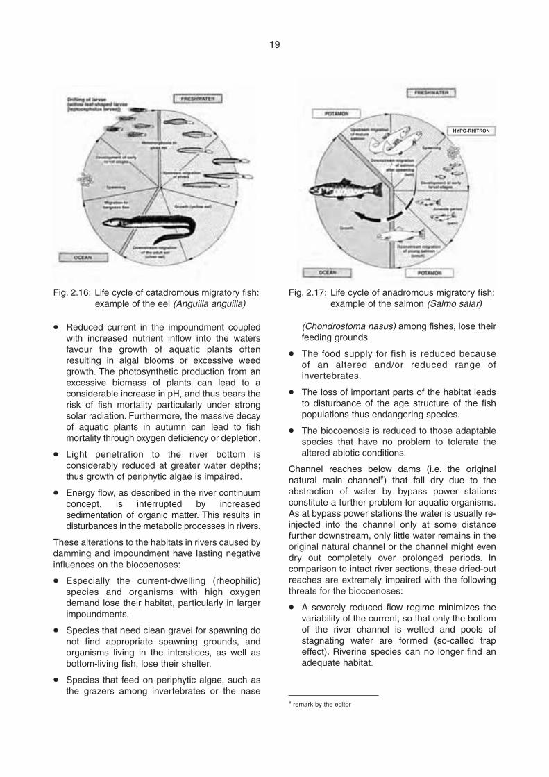
19
(Chondrostoma nasus) among fishes, lose theirfeeding grounds.
m The food supply for fish is reduced becauseof an altered and/or reduced range ofinvertebrates.
m The loss of important parts of the habitat leadsto disturbance of the age structure of the fishpopulations thus endangering species.
m The biocoenosis is reduced to those adaptablespecies that have no problem to tolerate thealtered abiotic conditions.
Channel reaches below dams (i.e. the originalnatural main channel#) that fall dry due to theabstraction of water by bypass power stationsconstitute a further problem for aquatic organisms.As at bypass power stations the water is usually re-injected into the channel only at some distancefurther downstream, only little water remains in theoriginal natural channel or the channel might evendry out completely over prolonged periods. Incomparison to intact river sections, these dried-outreaches are extremely impaired with the followingthreats for the biocoenoses:
m A severely reduced flow regime minimizes thevariability of the current, so that only the bottomof the river channel is wetted and pools ofstagnating water are formed (so-called trapeffect). Riverine species can no longer find anadequate habitat.
m Reduced current in the impoundment coupledwith increased nutrient inflow into the watersfavour the growth of aquatic plants oftenresulting in algal blooms or excessive weedgrowth. The photosynthetic production from anexcessive biomass of plants can lead to aconsiderable increase in pH, and thus bears therisk of fish mortality particularly under strongsolar radiation. Furthermore, the massive decayof aquatic plants in autumn can lead to fishmortality through oxygen deficiency or depletion.
m Light penetration to the river bottom isconsiderably reduced at greater water depths;thus growth of periphytic algae is impaired.
m Energy flow, as described in the river continuumconcept, is interrupted by increasedsedimentation of organic matter. This results indisturbances in the metabolic processes in rivers.
These alterations to the habitats in rivers caused bydamming and impoundment have lasting negativeinfluences on the biocoenoses:
m Especially the current-dwelling (rheophilic)species and organisms with high oxygendemand lose their habitat, particularly in largerimpoundments.
m Species that need clean gravel for spawning donot find appropriate spawning grounds, andorganisms living in the interstices, as well asbottom-living fish, lose their shelter.
m Species that feed on periphytic algae, such asthe grazers among invertebrates or the nase
HYPO-RHITRON
Fig. 2.16: Life cycle of catadromous migratory fish:example of the eel (Anguilla anguilla)
Fig. 2.17: Life cycle of anadromous migratory fish:example of the salmon (Salmo salar)
# remark by the editor
m The water in the impacted river reach (i.e. inthe original natural main channel#) is severelywarmed in summer, so that there is a dangerof the reach drying-out completely with aconsequent dehydration of the aquaticorganisms.
m Furthermore, the formation of ground ice(anchor ice) in winter can kill organisms.
m Other physical-chemical parameters also alterdue to the absence of the current, which is thenormal determinant in rivers. This causesfurther changes such as, for example, algalbloom and increased oxygen consumption.
m When the maximum turbine flow-throughcapacity of the hydroelectric power station is
exceeded, i.e. when more water is in the riverthan can pass through the turbines, the rapidlyincreased discharge into the original naturalmain channel that was then almost dry can leadto increased drifting of aquatic fauna.
Establishing minimum flow requirements for theimpaired channel stretch downstream of a damattempts to counter these problems (DVWK, 1995).There are different approaches and regionallydifferent processes for the setting of minimum flowswhich, however, are not further dealt with in theseGuidelines.
20
# remark by the editor
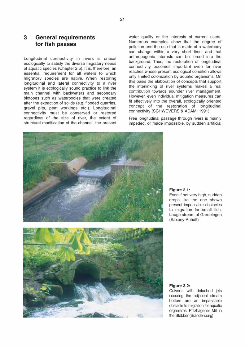
water quality or the interests of current users.Numerous examples show that the degree ofpollution and the use that is made of a waterbodycan change within a very short time, and thatanthropogenic interests can be forced into thebackground. Thus, the restoration of longitudinalconnectivity becomes important even for riverreaches whose present ecological condition allowsonly limited colonization by aquatic organisms. Onthis basis the elaboration of concepts that supportthe interlinking of river systems makes a realcontribution towards sounder river management.However, even individual mitigation measures canfit effectively into the overall, ecologically orientedconcept of the restoration of longitudinalconnectivity (SCHWEVERS & ADAM, 1991).
Free longitudinal passage through rivers is mainlyimpeded, or made impossible, by sudden artificial
3 General requirements for fish passes
Longitudinal connectivity in rivers is criticalecologically to satisfy the diverse migratory needsof aquatic species (Chapter 2.5). It is, therefore, anessential requirement for all waters to whichmigratory species are native. When restoringlongitudinal and lateral connectivity to a riversystem it is ecologically sound practice to link themain channel with backwaters and secondarybiotopes such as waterbodies that were createdafter the extraction of solids (e.g. flooded quarries,gravel pits, peat workings etc.). Longitudinalconnectivity must be conserved or restoredregardless of the size of river, the extent ofstructural modification of the channel, the present
21
Figure 3.1:Even if not very high, suddendrops like the one shownpresent impassable obstaclesto migration for small fish.Lauge stream at Gardelegen(Saxony-Anhalt)
Figure 3.2:Culverts with detached jetsscouring the adjacent streambottom are an impassableobstacle to migration for aquaticorganisms. Pritzhagener Mill inthe Stöbber (Brandenburg)
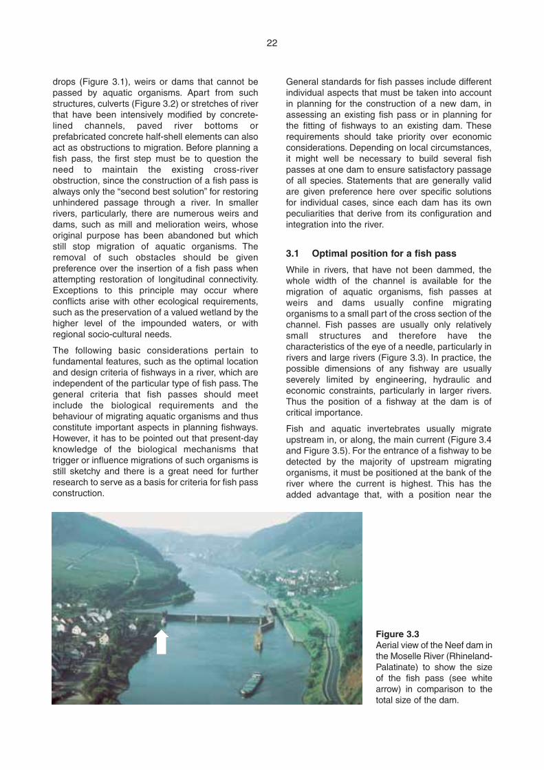
drops (Figure 3.1), weirs or dams that cannot bepassed by aquatic organisms. Apart from suchstructures, culverts (Figure 3.2) or stretches of riverthat have been intensively modified by concrete-lined channels, paved river bottoms orprefabricated concrete half-shell elements can alsoact as obstructions to migration. Before planning afish pass, the first step must be to question theneed to maintain the existing cross-riverobstruction, since the construction of a fish pass isalways only the “second best solution” for restoringunhindered passage through a river. In smallerrivers, particularly, there are numerous weirs anddams, such as mill and melioration weirs, whoseoriginal purpose has been abandoned but whichstill stop migration of aquatic organisms. Theremoval of such obstacles should be givenpreference over the insertion of a fish pass whenattempting restoration of longitudinal connectivity.Exceptions to this principle may occur whereconflicts arise with other ecological requirements,such as the preservation of a valued wetland by thehigher level of the impounded waters, or withregional socio-cultural needs.
The following basic considerations pertain tofundamental features, such as the optimal locationand design criteria of fishways in a river, which areindependent of the particular type of fish pass. Thegeneral criteria that fish passes should meetinclude the biological requirements and thebehaviour of migrating aquatic organisms and thusconstitute important aspects in planning fishways.However, it has to be pointed out that present-dayknowledge of the biological mechanisms thattrigger or influence migrations of such organisms isstill sketchy and there is a great need for furtherresearch to serve as a basis for criteria for fish passconstruction.
General standards for fish passes include differentindividual aspects that must be taken into accountin planning for the construction of a new dam, inassessing an existing fish pass or in planning forthe fitting of fishways to an existing dam. Theserequirements should take priority over economicconsiderations. Depending on local circumstances,it might well be necessary to build several fishpasses at one dam to ensure satisfactory passageof all species. Statements that are generally validare given preference here over specific solutionsfor individual cases, since each dam has its ownpeculiarities that derive from its configuration andintegration into the river.
3.1 Optimal position for a fish pass
While in rivers, that have not been dammed, thewhole width of the channel is available for themigration of aquatic organisms, fish passes atweirs and dams usually confine migratingorganisms to a small part of the cross section of thechannel. Fish passes are usually only relativelysmall structures and therefore have thecharacteristics of the eye of a needle, particularly inrivers and large rivers (Figure 3.3). In practice, thepossible dimensions of any fishway are usuallyseverely limited by engineering, hydraulic andeconomic constraints, particularly in larger rivers.Thus the position of a fishway at the dam is ofcritical importance.
Fish and aquatic invertebrates usually migrateupstream in, or along, the main current (Figure 3.4and Figure 3.5). For the entrance of a fishway to bedetected by the majority of upstream migratingorganisms, it must be positioned at the bank of theriver where the current is highest. This has theadded advantage that, with a position near the
22
Figure 3.3Aerial view of the Neef dam inthe Moselle River (Rhineland-Palatinate) to show the sizeof the fish pass (see whitearrow) in comparison to thetotal size of the dam.
➡
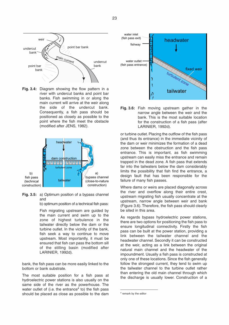
or turbine outlet. Placing the outflow of the fish pass(and thus its entrance) in the immediate vicinity ofthe dam or weir minimizes the formation of a deadzone between the obstruction and the fish passentrance. This is important, as fish swimmingupstream can easily miss the entrance and remaintrapped in the dead zone. A fish pass that extendsfar into the tailwaters below the dam considerablylimits the possibility that fish find the entrance, adesign fault that has been responsible for thefailure of many fish passes.
Where dams or weirs are placed diagonally acrossthe river and overflow along their entire crest,upstream migrating fish usually concentrate at theupstream, narrow angle between weir and bank(Figure 3.6). Therefore, the fish pass should clearlybe sited in this area.
As regards bypass hydroelectric power stations,there are two options for positioning the fish pass toensure longitudinal connectivity. Firstly the fishpass can be built at the power station, providing alink between the tailwater channel and theheadwater channel. Secondly it can be constructedat the weir, acting as a link between the originalnatural main channel and the headwater of theimpoundment. Usually a fish pass is constructed atonly one of these locations. Since the fish generallyfollow the strongest current, they tend to swim upthe tailwater channel to the turbine outlet ratherthan entering the old main channel through whichthe discharge is usually lower. Construction of a
bank, the fish pass can be more easily linked to thebottom or bank substrate.
The most suitable position for a fish pass athydroelectric power stations is also usually on thesame side of the river as the powerhouse. Thewater outlet of (i.e. the entrance# to) the fish passshould be placed as close as possible to the dam
23
weir
undercutbank
point bar bank
undercutbankpoint bar
bank
main current
Fig. 3.4: Diagram showing the flow pattern in ariver with undercut banks and point barbanks. Fish swimming in or along themain current will arrive at the weir alongthe side of the undercut bank.Consequently, a fish pass should bepositioned as closely as possible to thepoint where the fish meet the obstacle(modified after JENS, 1982).
headwater
tailwater
b) fish pass(technical
construction)
a) bypass channel(close-to-nature
construction)
dam construction
turbulent zone
Fig. 3.5: a) Optimum position of a bypass channeland b) optimum position of a technical fish pass:
Fish migrating upstream are guided bythe main current and swim up to thezone of highest turbulence in thetailwater directly below the dam or theturbine outlet. In the vicinity of the bank,fish seek a way to continue to moveupstream. Most importantly, it must beensured that fish can pass the bottom sillof the stilling basin (modified afterLARINIER, 1992d).
headwater
tailwater
fixed weir
fishway
water outlet(fish pass entrance)
water inlet(fish pass exit)
turbulent zone
Fig. 3.6: Fish moving upstream gather in thenarrow angle between the weir and thebank. This is the most suitable locationfor the construction of a fish pass (afterLARINIER, 1992d).
# remark by the editor
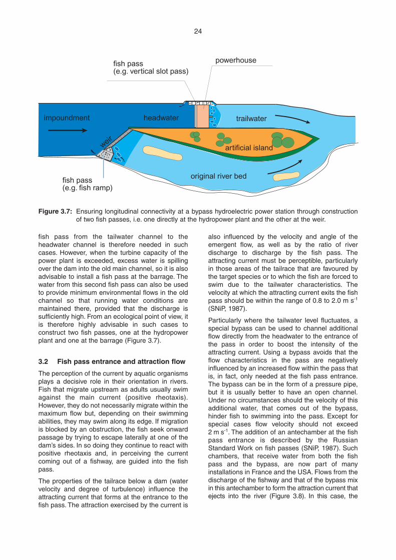
fish pass from the tailwater channel to theheadwater channel is therefore needed in suchcases. However, when the turbine capacity of thepower plant is exceeded, excess water is spillingover the dam into the old main channel, so it is alsoadvisable to install a fish pass at the barrage. Thewater from this second fish pass can also be usedto provide minimum environmental flows in the oldchannel so that running water conditions aremaintained there, provided that the discharge issufficiently high. From an ecological point of view, itis therefore highly advisable in such cases toconstruct two fish passes, one at the hydropowerplant and one at the barrage (Figure 3.7).
3.2 Fish pass entrance and attraction flow
The perception of the current by aquatic organismsplays a decisive role in their orientation in rivers.Fish that migrate upstream as adults usually swimagainst the main current (positive rheotaxis).However, they do not necessarily migrate within themaximum flow but, depending on their swimmingabilities, they may swim along its edge. If migrationis blocked by an obstruction, the fish seek onwardpassage by trying to escape laterally at one of thedam’s sides. In so doing they continue to react withpositive rheotaxis and, in perceiving the currentcoming out of a fishway, are guided into the fishpass.
The properties of the tailrace below a dam (watervelocity and degree of turbulence) influence theattracting current that forms at the entrance to thefish pass. The attraction exercised by the current is
also influenced by the velocity and angle of theemergent flow, as well as by the ratio of riverdischarge to discharge by the fish pass. Theattracting current must be perceptible, particularlyin those areas of the tailrace that are favoured bythe target species or to which the fish are forced toswim due to the tailwater characteristics. Thevelocity at which the attracting current exits the fishpass should be within the range of 0.8 to 2.0 m s-1
(SNiP, 1987).
Particularly where the tailwater level fluctuates, aspecial bypass can be used to channel additionalflow directly from the headwater to the entrance ofthe pass in order to boost the intensity of theattracting current. Using a bypass avoids that theflow characteristics in the pass are negativelyinfluenced by an increased flow within the pass thatis, in fact, only needed at the fish pass entrance.The bypass can be in the form of a pressure pipe,but it is usually better to have an open channel.Under no circumstances should the velocity of thisadditional water, that comes out of the bypass,hinder fish to swimming into the pass. Except forspecial cases flow velocity should not exceed2 m s-1. The addition of an antechamber at the fishpass entrance is described by the RussianStandard Work on fish passes (SNiP, 1987). Suchchambers, that receive water from both the fishpass and the bypass, are now part of manyinstallations in France and the USA. Flows from thedischarge of the fishway and that of the bypass mixin this antechamber to form the attraction current thatejects into the river (Figure 3.8). In this case, the
24
original river bedfish pass(e.g. fish ramp)
fish pass(e.g. vertical slot pass)
powerhouse
impoundment headwater
weir
trailwater
artificial island
Figure 3.7: Ensuring longitudinal connectivity at a bypass hydroelectric power station through constructionof two fish passes, i.e. one directly at the hydropower plant and the other at the weir.
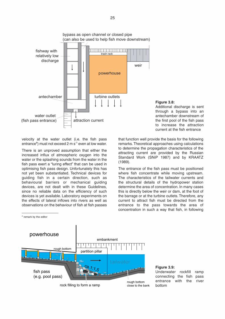
that function well provide the basis for the followingremarks. Theoretical approaches using calculationsto determine the propagation characteristics of theattracting current are provided by the RussianStandard Work (SNiP 1987) and by KRAATZ(1989).
The entrance of the fish pass must be positionedwhere fish concentrate while moving upstream.The characteristics of the tailwater currents andthe structural details of the hydropower stationdetermine the area of concentration. In many casesthis is directly below the weir or dam, at the foot ofthe barrage or at the turbine outlets. Therefore, anycurrent to attract fish must be directed from theentrance to the pass towards the area ofconcentration in such a way that fish, in following
velocity at the water outlet (i.e. the fish passentrance#) must not exceed 2 m s-1 even at low water.
There is an unproved assumption that either theincreased influx of atmospheric oxygen into thewater or the splashing sounds from the water in thefish pass exert a “luring effect” that can be used inoptimising fish pass design. Unfortunately this hasnot yet been substantiated. Technical devices forguiding fish in a certain direction, such asbehavioural barriers or mechanical guidingdevices, are not dealt with in these Guidelines,since no reliable data on the efficiency of suchdevices is yet available. Laboratory experiments onthe effects of lateral inflows into rivers as well asobservations on the behaviour of fish at fish passes
25
powerhouse
fishway withrelatively low
dischargeweir
trash rack
bypass as open channel or closed pipe(can also be used to help fish move downstream)
antechamber turbine outlets
attraction currentwater outlet
(fish pass entrance)
Figure 3.8:Additional discharge is sentthrough a bypass into anantechamber downstream ofthe first pool of the fish passto increase the attractioncurrent at the fish entrance
powerhouse
fish pass(e.g. pool pass)
rough bottom
rough bottomclose to the bank
tailwater
partition pillar
embankment
rock filling to form a ramp
ca.1:1,5 Figure 3.9:Underwater rockfill rampconnecting the fish passentrance with the riverbottom
# remark by the editor
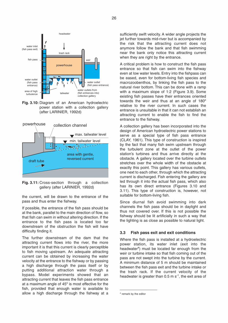
the current, will be drawn to the entrance of thepass and thus enter the fishway.
If possible, the entrance of the fish pass should beat the bank, parallel to the main direction of flow, sothat fish can swim in without altering direction. If theentrance to the fish pass is located too fardownstream of the obstruction the fish will havedifficulty finding it.
The further downstream of the dam that theattracting current flows into the river, the moreimportant it is that this current is clearly perceptibleto fish moving upstream. An adequate attractingcurrent can be obtained by increasing the watervelocity at the entrance to the fishway or by passinga high discharge through the pass itself or byputting additional attraction water through abypass. Model experiments showed that anattracting current that leaves the fish pass entranceat a maximum angle of 45º is most effective for thefish, provided that enough water is available toallow a high discharge through the fishway at a
sufficiently swift velocity. A wider angle projects thejet further towards mid-river but is accompanied bythe risk that the attracting current does notanymore follow the bank and that fish swimmingnear the bank only notice this attracting currentwhen they are right by the entrance.
A critical problem is how to construct the fish passentrance so that fish can swim into the fishwayeven at low water levels. Entry into the fishpass canbe eased, even for bottom-living fish species andmacrozoobenthos, by linking the fish pass to thenatural river bottom. This can be done with a rampwith a maximum slope of 1:2 (Figure 3.9). Someexisting fish passes have their entrances orientedtowards the weir and thus at an angle of 180ºrelative to the river current. In such cases theentrance is unsuitable in that it can not establish anattracting current to enable the fish to find theentrance to the fishway.
A collection gallery has been incorporated into thedesign of American hydroelectric power stations toserve as a special type of fish pass entrance(CLAY, 1961). This type of construction is inspiredby the fact that many fish swim upstream throughthe turbulent zone at the outlet of the powerstation’s turbines and thus arrive directly at theobstacle. A gallery located over the turbine outletsstretches over the whole width of the obstacle atexactly this point. This gallery has various outlets,one next to each other, through which the attractingcurrent is discharged. Fish entering the gallery areled through it into the actual fish pass, which alsohas its own direct entrance (Figures 3.10 and3.11). This type of construction is, however, notsuitable for bottom-living fish.
Since diurnal fish avoid swimming into darkchannels the fish pass should be in daylight andthus not covered over. If this is not possible thefishway should be lit artificially in such a way thatthe lighting is as close as possible to natural light.
3.3 Fish pass exit and exit conditions
Where the fish pass is installed at a hydroelectricpower station, its water inlet (exit into theheadwater#) must be located far enough from theweir or turbine intake so that fish coming out of thepass are not swept into the turbine by the current.A minimum distance of 5 m should be maintainedbetween the fish pass exit and the turbine intake orthe trash rack. If the current velocity of theheadwater is greater than 0.5 m s-1, the exit area of
26
headwater
water outlets from(fish entrances into)collection gallery
water outlet(fish pass entrance)
weir
powerhouse
fish pass
water outlet(fish pass entrance)
area of highturbulence
trash rack
water inlet(fish pass exit)
tailwater
powerhouse collection channel
max. tailwater level
min. tailwater level
draft tube
area with gentle,reversed current
Fig. 3.10: Diagram of an American hydroelectricpower station with a collection gallery(after LARINIER, 1992d)
Fig. 3.11: Cross-section through a collectiongallery (after LARINIER, 1992d)
# remark by the editor
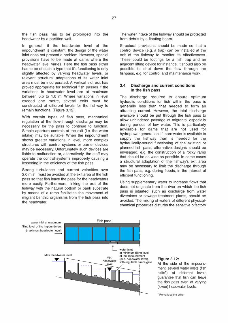
The water intake of the fishway should be protectedfrom debris by a floating beam.
Structural provisions should be made so that acontrol device (e.g. a trap) can be installed at theexit of the fishway to monitor its effectiveness.These could be footings for a fish trap and anadjacent lifting device for instance. It should also bepossible to shut down the flow through thefishpass, e.g. for control and maintenance work.
3.4 Discharge and current conditions in the fish pass
The discharge required to ensure optimumhydraulic conditions for fish within the pass isgenerally less than that needed to form anattracting current. However, the total dischargeavailable should be put through the fish pass toallow unhindered passage of migrants, especiallyduring periods of low water. This is particularlyadvisable for dams that are not used forhydropower generation. If more water is available tosupply the fishway than is needed for thehydraulically-sound functioning of the existing orplanned fish pass, alternative designs should beenvisaged, e.g. the construction of a rocky rampthat should be as wide as possible. In some casesa structural adaptation of the fishway’s exit areamay be necessary to limit the discharge throughthe fish pass, e.g. during floods, in the interest ofefficient functioning.
Using supplementary water to increase flows thatdoes not originate from the river on which the fishpass is situated, such as discharge from waterdiversions or sewage treatment plants, should beavoided. The mixing of waters of different physical-chemical properties disturbs the sensitive olfactory
the fish pass has to be prolonged into theheadwater by a partition wall.
In general, if the headwater level of theimpoundment is constant, the design of the waterinlet does not present a problem. However, specialprovisions have to be made at dams where theheadwater level varies. Here the fish pass eitherhas to be of such a type that it’s functioning is onlyslightly affected by varying headwater levels, orrelevant structural adaptations of its water inletarea must be incorporated. A vertical slot exit hasproved appropriate for technical fish passes if thevariations in headwater level are at maximumbetween 0.5 to 1.0 m. Where variations in levelexceed one metre, several exits must beconstructed at different levels for the fishway toremain functional (Figure 3.12).
With certain types of fish pass, mechanicalregulation of the flow-through discharge may benecessary for the pass to continue to function.Simple aperture controls at the exit (i.e. the waterintake) may be suitable. When the impoundmentshows greater variations in level, more complexstructures with control systems or barrier devicesmay be necessary. Unfortunately such devices areliable to malfunction or, alternatively, the staff mayoperate the control systems improperly causing alessening in the efficiency of the fish pass.
Strong turbulence and current velocities over2.0 m s-1 must be avoided at the exit area of the fishpass so that fish leave the pass for the headwatersmore easily. Furthermore, linking the exit of thefishway with the natural bottom or bank substrateby means of a ramp facilitates the movement ofmigrant benthic organisms from the fish pass intothe headwater.
27
Max. headwater level
Fish passwater inlet at maximum filling level of the impoundment
(maximum headwater level)
water inlet at minimum filling level of the impoundment (min. headwater level), with regulable sluice gate
Min.headwater
level
Figure 3.12:At the side of the impound-ment, several water inlets (fishexits#) at different levelsguarantee that fish can leavethe fish pass even at varying(lower) headwater levels.
# Remark by the editor
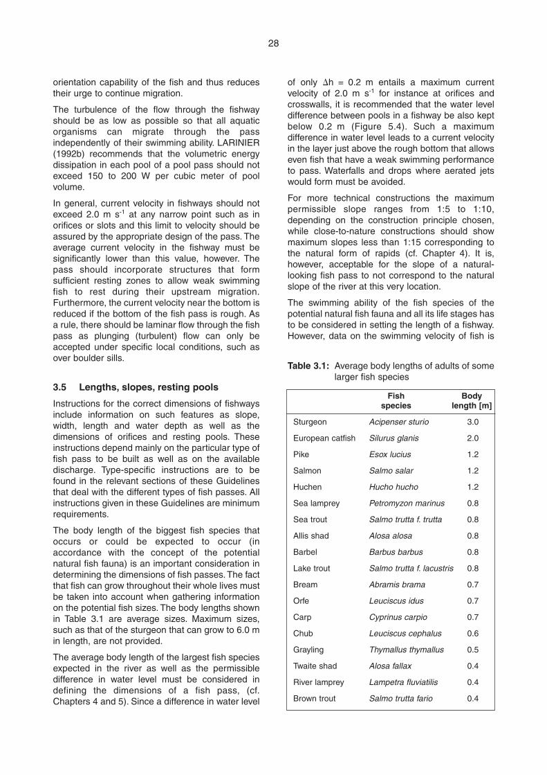
orientation capability of the fish and thus reducestheir urge to continue migration.
The turbulence of the flow through the fishwayshould be as low as possible so that all aquaticorganisms can migrate through the passindependently of their swimming ability. LARINIER(1992b) recommends that the volumetric energydissipation in each pool of a pool pass should notexceed 150 to 200 W per cubic meter of poolvolume.
In general, current velocity in fishways should notexceed 2.0 m s-1 at any narrow point such as inorifices or slots and this limit to velocity should beassured by the appropriate design of the pass. Theaverage current velocity in the fishway must besignificantly lower than this value, however. Thepass should incorporate structures that formsufficient resting zones to allow weak swimmingfish to rest during their upstream migration.Furthermore, the current velocity near the bottom isreduced if the bottom of the fish pass is rough. Asa rule, there should be laminar flow through the fishpass as plunging (turbulent) flow can only beaccepted under specific local conditions, such asover boulder sills.
3.5 Lengths, slopes, resting pools
Instructions for the correct dimensions of fishwaysinclude information on such features as slope,width, length and water depth as well as thedimensions of orifices and resting pools. Theseinstructions depend mainly on the particular type offish pass to be built as well as on the availabledischarge. Type-specific instructions are to befound in the relevant sections of these Guidelinesthat deal with the different types of fish passes. Allinstructions given in these Guidelines are minimumrequirements.
The body length of the biggest fish species thatoccurs or could be expected to occur (inaccordance with the concept of the potentialnatural fish fauna) is an important consideration indetermining the dimensions of fish passes. The factthat fish can grow throughout their whole lives mustbe taken into account when gathering informationon the potential fish sizes. The body lengths shownin Table 3.1 are average sizes. Maximum sizes,such as that of the sturgeon that can grow to 6.0 min length, are not provided.
The average body length of the largest fish speciesexpected in the river as well as the permissibledifference in water level must be considered indefining the dimensions of a fish pass, (cf.Chapters 4 and 5). Since a difference in water level
of only �h = 0.2 m entails a maximum currentvelocity of 2.0 m s-1 for instance at orifices andcrosswalls, it is recommended that the water leveldifference between pools in a fishway be also keptbelow 0.2 m (Figure 5.4). Such a maximumdifference in water level leads to a current velocityin the layer just above the rough bottom that allowseven fish that have a weak swimming performanceto pass. Waterfalls and drops where aerated jetswould form must be avoided.
For more technical constructions the maximumpermissible slope ranges from 1:5 to 1:10,depending on the construction principle chosen,while close-to-nature constructions should showmaximum slopes less than 1:15 corresponding tothe natural form of rapids (cf. Chapter 4). It is,however, acceptable for the slope of a natural-looking fish pass to not correspond to the naturalslope of the river at this very location.
The swimming ability of the fish species of thepotential natural fish fauna and all its life stages hasto be considered in setting the length of a fishway.However, data on the swimming velocity of fish is
28
Table 3.1: Average body lengths of adults of somelarger fish species
Fish Bodyspecies length [m]
Sturgeon Acipenser sturio 3.0
European catfish Silurus glanis 2.0
Pike Esox lucius 1.2
Salmon Salmo salar 1.2
Huchen Hucho hucho 1.2
Sea lamprey Petromyzon marinus 0.8
Sea trout Salmo trutta f. trutta 0.8
Allis shad Alosa alosa 0.8
Barbel Barbus barbus 0.8
Lake trout Salmo trutta f. lacustris 0.8
Bream Abramis brama 0.7
Orfe Leuciscus idus 0.7
Carp Cyprinus carpio 0.7
Chub Leuciscus cephalus 0.6
Grayling Thymallus thymallus 0.5
Twaite shad Alosa fallax 0.4
River lamprey Lampetra fluviatilis 0.4
Brown trout Salmo trutta fario 0.4
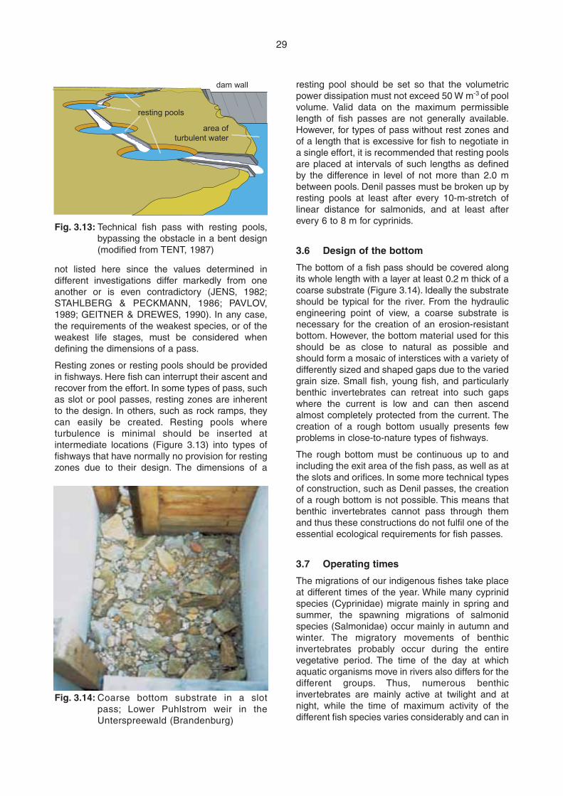
resting pool should be set so that the volumetricpower dissipation must not exceed 50 W m-3 of poolvolume. Valid data on the maximum permissiblelength of fish passes are not generally available.However, for types of pass without rest zones andof a length that is excessive for fish to negotiate ina single effort, it is recommended that resting poolsare placed at intervals of such lengths as definedby the difference in level of not more than 2.0 mbetween pools. Denil passes must be broken up byresting pools at least after every 10-m-stretch oflinear distance for salmonids, and at least afterevery 6 to 8 m for cyprinids.
3.6 Design of the bottom
The bottom of a fish pass should be covered alongits whole length with a layer at least 0.2 m thick of acoarse substrate (Figure 3.14). Ideally the substrateshould be typical for the river. From the hydraulicengineering point of view, a coarse substrate isnecessary for the creation of an erosion-resistantbottom. However, the bottom material used for thisshould be as close to natural as possible andshould form a mosaic of interstices with a variety ofdifferently sized and shaped gaps due to the variedgrain size. Small fish, young fish, and particularlybenthic invertebrates can retreat into such gapswhere the current is low and can then ascendalmost completely protected from the current. Thecreation of a rough bottom usually presents fewproblems in close-to-nature types of fishways.
The rough bottom must be continuous up to andincluding the exit area of the fish pass, as well as atthe slots and orifices. In some more technical typesof construction, such as Denil passes, the creationof a rough bottom is not possible. This means thatbenthic invertebrates cannot pass through themand thus these constructions do not fulfil one of theessential ecological requirements for fish passes.
3.7 Operating times
The migrations of our indigenous fishes take placeat different times of the year. While many cyprinidspecies (Cyprinidae) migrate mainly in spring andsummer, the spawning migrations of salmonidspecies (Salmonidae) occur mainly in autumn andwinter. The migratory movements of benthicinvertebrates probably occur during the entirevegetative period. The time of the day at whichaquatic organisms move in rivers also differs for thedifferent groups. Thus, numerous benthicinvertebrates are mainly active at twilight and atnight, while the time of maximum activity of thedifferent fish species varies considerably and can in
not listed here since the values determined indifferent investigations differ markedly from oneanother or is even contradictory (JENS, 1982;STAHLBERG & PECKMANN, 1986; PAVLOV,1989; GEITNER & DREWES, 1990). In any case,the requirements of the weakest species, or of theweakest life stages, must be considered whendefining the dimensions of a pass.
Resting zones or resting pools should be providedin fishways. Here fish can interrupt their ascent andrecover from the effort. In some types of pass, suchas slot or pool passes, resting zones are inherentto the design. In others, such as rock ramps, theycan easily be created. Resting pools whereturbulence is minimal should be inserted atintermediate locations (Figure 3.13) into types offishways that have normally no provision for restingzones due to their design. The dimensions of a
29
dam wall
resting pools
area ofturbulent water
Fig. 3.13: Technical fish pass with resting pools,bypassing the obstacle in a bent design(modified from TENT, 1987)
Fig. 3.14: Coarse bottom substrate in a slotpass; Lower Puhlstrom weir in theUnterspreewald (Brandenburg)
fact even alter during the year (MÜLLER, 1968).Because of this variability in the timing ofmigrations fish passes must operate throughout theyear. Limited operation can be tolerated only duringextreme low- and high water periods (i.e. for the 30lowest days and the 30 highest days in one year),since at such times fish usually show a decrease inmigratory activity.
Continuous 24-hour operation must be guaranteedsince, once they have entered the fishpass,invertebrates that are little mobile would be unable toescape even a short drying out of the pass andinevitably die if the pass is only operating periodically.
3.8 Maintenance
The need for regular maintenance must beconsidered from the start of planning a fish pass aspoor maintenance is the chief cause of functionalfailure in fishways. Obstruction of the exit of thepass (i.e. the water inlet) and of the orifices,damage to the fish pass structure or defective flowcontrol devices are not rare but can be overcomethrough regular maintenance. There must beunhindered and safe access to the pass so thatmaintenance can be assured. Close-to-naturetypes of construction such as rock ramps areeasier to maintain than highly technical structuresbecause obstruction with debris of the water inletarea or the boulder bars is rarely total and does notimmediately halt operations. Highly technicalstructures therefore require more frequentmaintenance. A maintenance schedule can bedrawn up or adjusted on the basis of operationalexperience of the type and frequency ofmalfunction of the fish pass in question.Maintenance must always be carried out afterfloods, however.
3.9 Measures to avoid disturbancesand to protect the fish pass
The competent authorities should establish zonesclosed to fishing above and below fishways in orderto protect migrating fish from any disturbance. Suchregulations can be made on the basis of thefisheries law of the administrative entity in whichthe fish pass is installed. Leisure activities such asswimming and boating should also be kept awayfrom the immediate neighbourhood of fish passes.Only in exceptional and well-justified cases, fishpasses can be built close to boating lanes, boatslips or shipping locks. Furthermore, access to fishpasses should be limited to maintenance workers,control personnel or scientists to carry out scientificstudies.
When viewing windows are built in fishways, as inmonitoring stations for observing migrations, one-way glass should be used and the observationchamber darkened.
The functioning of the fish pass must not beimpacted negatively if the barrage or any nearbystretches of water are altered, for example bydeepening the channel, raising the elevation of thedam, or by the construction of a hydropower station.
3.10 Integration into the landscape
Every effort should be made to integrate the fishpass into the landscape as harmoniously aspossible, although the correct functioning of thefishway must take priority over landscaping. Underthis aspect, particularly close-to-nature types ofconstruction link functional and landscapingconsiderations in the best possible way and mayalso play an important role as substitute biotopesfor rheophilic organisms.
Natural building materials or construction materialsthat are typical of the local conditions should beused in the construction of fishways in aconsequent manner. The wood used should not bechemically treated. Vegetation should be allowed toproliferate naturally as far as possible to createpossible cover for migratory fish and shade thefishway, although it might be necessary to initiallyplant suitably adapted local plants and shrubs toget the vegetation started.
30