Embed Size (px)
Citation preview


About Island PressIsland Press is the only nonprofit organization in the United States whoseprincipal purpose is the publication of books on environmental issues andnatural resource management. We provide solutions-oriented informationto professionals, public officials, business and community leaders, and con-cerned citizens who are shaping responses to environmental problems.
In 2002, Island Press celebrates its eighteenth anniversary as the leadingprovider of timely and practical books that take a multidisciplinary approachto critical environmental concerns. Our growing list of titles reflects ourcommitment to bringing the best of an expanding body of literature to theenvironmental community throughout North America and the world.
Support for Island Press is provided by The Bullitt Foundation, TheMary Flagler Cary Charitable Trust, The Nathan Cummings Foundation,Geraldine R. Dodge Foundation, Doris Duke Charitable Foundation, TheCharles Engelhard Foundation, The Ford Foundation, The George GundFoundation, The Vira I. Heinz Endowment, The William and Flora HewlettFoundation, W. Alton Jones Foundation, The Henry Luce Foundation, TheJohn D. and Catherine T. MacArthur Foundation, The Andrew W. MellonFoundation, The Charles Stewart Mott Foundation, The Curtis and EdithMunson Foundation, National Fish and Wildlife Foundation, The New-Land Foundation, Oak Foundation, The Overbrook Foundation, TheDavid and Lucile Packard Foundation, The Pew Charitable Trusts, Rocke-feller Brothers Fund, The Winslow Foundation, and other generous donors.

FIRE,NATIVE PEOPLES,
andTHE NATURAL
LANDSCAPE

FIRE,NATIVE PEOPLES,
and
THE NATURALLANDSCAPE
Edited by
Thomas R. Vale
Washington • Covelo • London

Copyright © 2002 Island Press
All rights reserved under International and Pan-American Copyright Con-ventions. No part of this book may be reproduced in any form or by anymeans without permission in writing from the publisher: Island Press,1718 Connecticut Avenue, N.W., Suite 300, Washington, DC 20009.
ISLAND PRESS is a trademark of The Center for Resource Economics.
No copyright claim is made in the work of Craig D. Allen, an employee ofthe federal government.
ISBN 1-55963-888-5 (cloth) — ISBN 1-55963-889-3 (paper)
Printed on recycled, acid-free paper
Library of Congress and British Cataloging-in-Publication Data available.
Manufactured in the United States of America09 08 07 06 05 04 03 02 8 7 6 5 4 3 2 1

Contents
List of Figures, Boxes, and Tables ix
Preface xiii
Chapter 1 The Pre-European Landscape of the UnitedStates: Pristine or Humanized? 1THOMAS R. VALE
Chapter 2 Indians and Fire in the Rocky Mountains: The Wilderness Hypothesis Renewed 41WILLIAM L. BAKER
Chapter 3 Prehistoric Human Impacts on Fire Regimes and Vegetation in the Northern IntermountainWest 77DUANE GRIFFIN
Chapter 4 Fire in the Pre-European Lowlands of the American Southwest 101KATHLEEN C. PARKER
Chapter 5 Lots of Lightning and Plenty of People: An Ecological History of Fire in the UplandSouthwest 143CRAIG D. ALLEN
vii

Chapter 6 Prehistoric Burning in the Pacific Northwest:Human versus Climatic Influences 195CATHY WHITLOCK AND MARGARET A. KNOX
Chapter 7 Fire in Sierra Nevada Forests: Evaluating the Ecological Impact of Burning by Native Americans 233ALBERT J. PARKER
Chapter 8 Pre-European Fire in California Chaparral 269JACOB BENDIX
Chapter 9 Reflections 295THOMAS R. VALE
List of Contributors 303
Index 305
viii Contents

Figures, Boxes, and Tables
Figures1.1. Three gradients along which landscapes may vary from unam-
biguously humanized to unarguably pristine 31.2. People vary in their perception of the degree of overlap in the
natural and human worlds 91.3. Human numbers in the cultural regions of North America at the
time of European contact (1492) 111.4. Tribal villages and camps of the Yurok of northwestern California
131.5. The agricultural landscape of the southwestern cultural region
161.6. Two examples of mapped agricultural landscapes 181.7. Rockpiles for agave cultivation and associated features in central
Arizona 201.8. Generalized pre-European fire regimes for various parts of North
America 291.9. National forests and average number of lightning fires per state
per year on national forest land in the eleven western states 302.1. Trends in fires in the Rocky Mountains 463.1. The floristic Great Basin and the Great Basin Cultural Area 793.2. Locales where human populations are known to have been con-
centrated in prehistoric times 813.3. Fire return intervals for regional Küchler vegetation types arrayed
along a generalized moisture gradient 87
ix

3.4. Locations of all fires on federal lands from 1986 through 1996listed in the National Fire Occurrence Database 90
3.5. Temporal distribution of fires and ignition sources in the studyarea, 1986–1996 91
3.6. Areas where human activities ignited more than half of all fires onfederal lands from 1986 through 1996 92
4.1. Map of the study area showing place-names mentioned and climate diagrams for selected locations within the southern inter-montane region 103
4.2. Map of the different types of lowland vegetation in the southernintermontane region 105
4.3. Representative vegetation 1064.4. The incidence of cloud-to-ground lightning strikes over the
Southwest 1084.5. Native cultures of the southwestern lowlands 1124.6. Estimated population shifts in the southwestern lowlands 1174.7. Shifts in settlement pattern along the Santa Cruz River 1184.8. Zones of land use around riverine Hohokam communities
1204.9. Changes in the distribution of agricultural peoples in the south-
ern intermontane region 1235.1. Location of the Jemez Mountains in New Mexico 1445.2. Lightning strikes in the Jemez Mountains, 1986 1475.3. Monthly patterns of lightning strikes, insolation, and precipitation
in the Jemez Mountains area 1485.4. Point locations of historic fires in the Jemez Mountains,
1909–1996 1515.5. Jemez Mountains, extent of fires in 1748 1555.6. Fire-scar chronology, Monument Canyon Research Natural Area
1565.7. Composite fire-scar chronologies from four sites, Jemez
Mountains 1566.1. Map of geographic regions referred to in text 1986.2. Inferred fire frequency and pollen percentages of selected taxa
from Little Lake in the Oregon Coast Range 2056.3. The location of David Douglas’s camps as he traveled through
the Willamette Valley in the fall of 1826 2096.4. Prehistoric and historic juniper expansion 2177.1. Map of California and surrounding region, emphasizing the Sierra
Nevada and locating places mentioned in the text 2347.2. Map of the Sierra Nevada, locating places mentioned in the text
235
x List of Figures, Boxes, and Tables

7.3. A generalized mosaic diagram of vegetation patterns in Californiauplands 238
7.4. Principal groups of Native American cultures inhabiting the SierraNevada 242
7.5. Charcoal accumulation/influx curves from Lake Moran sedimentsand a composite of eight meadow stratigraphies 248
8.1. Cultural boundaries, vegetation distribution, and core sites 2718.2. Change in flammability of a chaparral stand with time since previ-
ous fire 2849.1. Landscape characteristics on a continuum between the extreme
conditions of universally humanized and universally pristine 298
Boxes1.1. Characteristics that may tend to encourage individual observers to
see the pre-European North American landscape as “pristine” or“humanized” 6
1.2. The continuum of plant-people interactions 192.1. Indian tribes of the Rocky Mountains in the middle 1800s 472.2. Some reasons cited for burning by Indians in the Rocky Moun-
tains 522.3. Some themes in quotes from Rocky Mountain fire history studies
that address Indian fires 615.1. Varied perspectives on the cause of early fires in the Southwest
1615.2. John Wesley Powell provides a confessional description of a Col-
orado crown fire 1715.3. Selected historical references on fire causation in the western
United States 1725.4. Historic views of fire in the Southwest by the U.S. Bureau of Bio-
logical Survey 1758.1. Breakdown of chaparral burning patterns ascribed to native Cali-
fornians 277
Tables2.1. Number of fires attributed to Indians, Whites, and lightning 543.1. Great Basin food plants 846.1. Fire return intervals for the Pacific Northwest 1976.2. Location and distance traveled, vegetation, and fire observations
made by David Douglas during the 1826 journey through theWillamette Valley 208
List of Figures, Boxes, and Tables xi

7.1. Timeline of climatic change and aboriginal human occupancy inthe Sierra Nevada 239
7.2. Summary of fire return intervals in montane forests of Californiauplands 245
8.1. Occurrence of lightning fire in brush within California Depart-ment of Forestry jurisdictions 283
xii List of Figures, Boxes, and Tables

Preface
For nearly two centuries, the creation myth for the United States envi-sioned an initial condition of wild nature, of wilderness. Although chal-lenged by some, this view until recently remained the dominant view,uncritically and naively accepted by layperson and scholar alike. Over thelast two decades, however, a contrary vision has emerged. Driven byheightened appreciation for the activities of Native Americans as land-scape modifiers, the conventional wisdom now sees the country’s rootsnot in a state of nature, not a “pristine landscape,” but in a human-mod-ified world, a “humanized landscape.” As a reaction against the hyper-bole of the older view, the modern perspective has merit, but thespokespersons for a human-altered continent in pre-European NorthAmerica may carry their critique to excess: the older monolithic “mythof the pristine landscape” has been replaced by a new and equally mono-lithic “myth of the humanized landscape.”
This book attempts to demythologize the newer paradigm by assess-ing the role of Native Americans as modifiers of the landscapes in a majorportion of the North American continent—the western states—in hopesof establishing a middle ground between the polar positions representedby categorical beliefs in either “pristine” or “humanized” landscapes.Several factors prompt a focus on the American West for this assessment:(1) fires—always potentially linked to humans—were, and remain today,widespread in western ecosystems; (2) the likelihood of finding evidencefor a state of nature is greater in the West (to assess the eastern states andconclude that the region, or at least large parts of it, were modified byNative Americans [a likely conclusion] would not move the dialoguetoward a middle ground); (3) the presence of wild vegetation over large
xiii

areas of the West makes the assessment more immediately relevant to thepresent-day landscape; and (4) the importance of “wilderness” protec-tion in the West enhances the potential for policy contributions. More-over, the western states provide an arena wherein certain assumptionsabout Native American activity serve to simplify the issue: formal agri-culture was restricted to the extreme Southwest; population sizes weresmall, except in lowland California and in the agricultural Southwest;and construction of landforms such as mounds—so conspicuous in partsof the Midwest—seems less common in the West. The preeminenthuman impact—one that was potentially important in almost any part ofthe West and that could have altered the environment at the broad, land-scape scale—is that of burning, of fires set by Native Americans. It is thisimpact in the American West that is the focus of this volume.
Most specifically, then, this book asks the question: “For the Ameri-can West, were the fire regimes existent at the time of European contactbasically the product of natural factors—conditions of vegetation, attrib-utes of climatic episode, characteristics of short-term weather—or didignitions by Native Americans fundamentally change those regimes andthus the vegetations associated with them?” The book addresses thisquestion for major subregions of the West, each evaluated by a differentauthor: the Rocky Mountains, the forests of the Southwest, the south-ern deserts, the northern deserts, the Sierra Nevada, the California chap-arral, and the forests of the Cascades and Pacific Northwest. By focusingon one particular human impact, these regional evaluations will helpmove to a more centrist position the dialogue over the “naturalness” ofthe pre-European continent.
An introductory essay precedes the regional chapters, which make upthe heart of the book. This essay presents the ideals of the pristine ver-sus humanized landscapes, justifies the focus on the American West,assesses broadly the types of impacts by native peoples in the pre-Euro-pean West, establishes the centrality of fires as the most likely Indianimpact on the landscape, and poses the question (whether or not thepre-European fire regime was “natural”) subsequently addressed by eachauthor.
In the regional chapters that follow the introductory essay, theauthors attempt to answer the central question in the context of partic-ular parts of the West. The ability to provide such answers varies byregion and by the type of ecosystem within a region, and ambiguitiesinvolving data and meanings of data render definitive conclusionsuneven. The authors have been encouraged to make their assessments ascompletely and honestly as possible, taking their respective arguments inwhatever direction their data and judgments lead.
After the regional treatments, the book concludes with a summariz-
xiv Preface

ing statement that compares results from the various chapters and high-lights patterns both common to the West as a whole and distinctive tovarious parts of the western states. This summary relates the researchfindings to questions of policy involving the management of naturalareas (particularly on federal lands) and to questions of the “naturalness”of the pre-European western landscape.
The most general goal of this book is to change the character of thedebate over whether North America at the time of European contact waspristine or humanized. I yearn for the emergence of a middle groundthat recognizes the validity of both possibilities, of a landscape visionthat allows a state of nature as plausibly as a cultural artifact. Whether ornot we end up with such a rapprochement, of course, depends on whatthe various authors conclude. It is their judgment and their wisdom thatguide the final words.
Preface xv

FIRE,NATIVE PEOPLES,
andTHE NATURAL
LANDSCAPE

cc hh aa pp tt ee rr 11
THE PRE-EUROPEAN LANDSCAPE OF THE UNITED STATES:
PRISTINE OR HUMANIZED?
Thomas R. Vale
All peoples embrace creation myths—stories that tell whence they came.Commonly considered unique to premodern societies, such narratives oforigins are also told in contemporary nations. More specifically, theUnited States—for most of its existence—has envisioned its beginningsas wilderness, a state of nature, a natural landscape. American societyexpanded across the continent, extending its frontiers through a wildand primeval environment. Over the last couple of decades, however, acontrary creation myth has emerged, rising like a crescendo until it hasbecome conventional wisdom: the nation’s roots extend back not intowilderness but into a landscape inhabited by the First Americans, a placeboth psychologically a home and hearth, and physically an artifact ofhuman activities. According to the extreme version of this vision, thepre-European North American landscape—from the Atlantic to thePacific, from the Gulf of Mexico to the Arctic Ocean—unfolded assprawling villages and fields of corn, terraced agricultural plots anddiverted streams, meticulously tended trees and clear-cut forests, over-hunted elk and burned-over woodlands. The pristine landscape of an oldcreation myth has been replaced by the humanized landscape of a newernational narrative.
But the conflicting stories remain a source of contention. The debate
1

over the character of pre-Columbian America typically focuses on thepolar assertions that the continent was either a “natural landscape” or a“human-modified landscape.” The strongest characterizations of the for-mer, a pristine America, come from romantics of an earlier day or frompopular writers of contemporary times: “All the Western mountains arestill rich in wildness” (Muir 1901:2); “Until 1881 the valley of the Lit-tle Missouri . . . was absolutely unchanged in any respect from its origi-nal condition of primeval wildness” (Roosevelt 1897, quoted in Callicottand Nelson 1998:74); “The parks . . . are . . . America primeval, pre-served miraculously” (Anonymous 1991:11); the Americas were“ancient, primeval, undisturbed wilderness” (Bakeless 1961:201).
By contrast, the champions of an omnipresent humanized landscapeinclude both scholars and popular writers: “The Indian impact was nei-ther benign nor localized and ephemeral. . . . What they did was tochange their landscape nearly everywhere” (Denevan 1992:370); “theforest primeval had already been widely cleared, converted, and other-wise managed” (Pyne 1982:83); “the Indians . . . created that ‘wilder-ness’ we call the Great Plains” (Pollan 1991:221); “most of this conti-nent was owned, used, and modified by native peoples” (Kay 1994:381);“human influence is woven through even what to our eyes are the mostpristine landscapes” (Budiansky 1995:5); “the land that the early settlersfound in the West . . . was not made that way by God alone but partlyby man” (Chase 1987:97); “Wilderness is certainly the wrong word forwhat early America was. . . . it was a managed landscape” (Flores1997:6); “In the Western hemisphere, pre-Columbian people changedthe landscape nearly everywhere from the Arctic to Patagonia” (Stevens1993). In spite of the logic of an intermediate position—some areas werehumanized, some were not (Vale 1998, 2000)—the rhetoric oftenreverts to the polar positions.
Explaining the ExtremesSeveral considerations explain and help mediate the stances at theextremes. These factors, characterized as ambiguities, can be portrayedalong gradients that separate the polar opposites.
Intensity AmbiguityThe meanings of key concepts defy clarity: what do the words “human-ized” and “pristine” actually mean? Given a series of landscapes that varycontinuously between unambiguously “humanized” and unarguably“pristine,” such intermediate landscapes might be classified as belongingto one polar condition or the other (the human tendency to classify phe-nomena into dichotomies encourages such polarization of intermediate
2 T h o m a s R . Va l e

conditions), depending upon the criteria of “modification” and “natu-ralness” employed. An example of five landscapes from the Yosemiteregion of California illustrates the point (Figure 1.1). A Miwok villagesite in upper Yosemite Valley—dwellings walled with tree bark, acornsstored in elevated granaries, nearby stands of hazelnut (Corylus cornuta)pruned, bracken (Pteridium) on a river terrace dug for roots, broadea(Brodiaea) bulbs harvested, killed mule deer (Odocoileus hemionus)hanging for butchering, campfires burning collected dead tree limbs—presents a humanized landscape. But nonhuman processes play a role aswell: the regional and local climate; the nearby Merced River’s hydrol-ogy; the granitic bedrock; the landforms of glacier, river, and slope ero-sion; the soil development beneath the trees; and even the presence ofthose biological species whose abundance may be influenced by Miwokactivities. Away from the village, at the lower end of the valley, a greenmeadow—perhaps maintained by Indian burning—feels the footsteps of
T H E P R E - E U R O P EA N L A N D S CA P E O F T H E U N I T E D STAT E S 3
Figure 1.1. Three gradients along which landscapes may vary from unambiguouslyhumanized to unarguably pristine. a. Intensity scale: Intensity of landscape modifi-cation by humans and their activities, as exemplified by examples from theYosemite region of California. b. Spatial scale: Degree to which a local humanizingeffect extends spatially, as illustrated by examples from the Yellowstone region ofMontana and Wyoming. c. Temporal scale: Degree to which a one-time humaninfluence continues to be perceived in the landscape, as represented by a settlementin eastern Nevada.
a.
c.
b.

a group of Miwok gatherers who search for raspberries (Rubus) in thick-ets along the forest edge. High above the valley floor, on an expanse ofrolling granite that falls away into Tamarack Creek, a cluster of smoothand rounded bedrock holes indicates that the Miwok grind acorns here,although no person is visible at the moment. Surrounding the granitesurface, the mixed-conifer forest may or may not be influenced by Indianburning (lightning fires are common here). Up in the high country, inTuolumne Meadows, a group of Miwok walk beside the river as theytravel from the eastern side of the Sierra Nevada back toward YosemiteValley, but their activities may involve only an overnight campsite (per-haps not unlike that of a modern backpacker), charcoal from a nighttimewarming fire amid gathered rocks, or debris made up of obsidian or pinenuts (Pinus monophylla) left scattered about. On Dana Plateau, wellabove tree line and empty of people, nothing would suggest a human-ized landscape—the sky, the rock, the canyon, the trickle of water fromreceding snow banks, the alpine plants hugging cobbles and soil, theoccasional summering deer alert for mountain lion (Felis concolor)—allcreate a scene completely the product of natural processes. Takentogether, then, these landscapes form a gradient that reveals both anarray of major and minor human alternations of nature and a categoricalpresence or absence of people. Where to draw a line along the gradientto separate landscapes that are “humanized” from those that are “pris-tine” could be argued endlessly.
Space AmbiguityQuestions of spatial scale confound the issue: how far away from anunquestioned human impact should the landscape be considered“humanized”? An illustration of five landscapes from the Yellowstoneregion exemplifies the point (Figure 1.1). Along the Yellowstone Rivernear present-day Gardiner, a cluster of conical lodges, home to a groupof Flathead people, rests beside the rushing water of the YellowstoneRiver. Beyond the immediate living space of the settlement, a vegetationof brush and grass extends over the upland terrace from which thelodges and campfire smoke remain prominently conspicuous. From theeastern flank of Sepulcher Mountain, south of the village, the humanartifacts remain visible from many vantage points, although from othersthe swells of hills and ravines block the view. Still farther south, in theopen forest of Douglas fir (Pseudotsuga menziesii) that drapes over thesteep slopes above present-day Mammoth, only wisps of campfire smoketell of the village, and even those may be partially hidden behind indi-vidual trees. Much farther away, amid a forest of lodgepole pine (Pinuscontorta) on Yellowstone’s Central Plateau—little visited and appearing
4 T h o m a s R . Va l e

untouched by humans—the image of the Flathead lodges can be onlymental. Taken together, these sites form a gradient, from the middle ofa human settlement to a distant forest. The adjective “humanized”might be applied to only the intensely modified environment where theFlathead cook and sleep or to the entirety of the broader landscape—including the Central Plateau—of which the village is only a tiny spot.Or the point separating the “humanized” from the “natural” could beanywhere between these extremes.
Time AmbiguitySimilarly, a temporal scale of human disturbance that includes a gradientof recovery away from the disturbed condition identifies no universallyrecognized and categorical demarcation between “humanized” and“pristine.” How long after abandonment, for example, might a hypo-thetical Shoshone settlement (Figure 1.1), in what is today easternNevada, maintain its human imprint? Circular structures of brush servefor shelter when the site is occupied, but after abandonment (as mighthave happened following a season of hunting and gathering in the sur-rounding area), the forces of nature would gradually mute, even erase,the effects of people. The dead brush walls would collapse and decom-pose; rabbitbrush (Chrysothamnus) would establish on the former livingsite; sagebrush (Artemisia) and perennial grasses might subsequentlyincrease amid the rabbitbrush; and small juniper trees (Juniperus) couldgerminate, then mature into a woodland cover. Evidence of the formervillage might persist either in the vegetation (plant covers may longmaintain characteristics of major disturbance events) or in the soilsaltered by campfires or wastes. We can only arbitrarily decide, invokingdiffering criteria, if and when the humanized characteristics have beenreplaced by those of nature, thereby rendering the landscape “natural.”
Beyond the AmbiguitiesThe three gradients suggest no single way of defining the criticaladjectives of “humanized” and “pristine.” For purposes of landscapeprotection and management, however, a working definition emergesfrom a simple (albeit difficult-to-answer) question: For any particulararea of America (and anywhere else, for that matter), did (and do) thefundamental characteristics of vegetation, wildlife, landform, soil,hydrology, and climate result from natural, nonhuman processes, andwould these characteristics exist whether or not humans were (andare) present? (See Vale 1998.) In attempting responses to the query,different people might quarrel over the meaning of “fundamental” or
T H E P R E - E U R O P EA N L A N D S CA P E O F T H E U N I T E D STAT E S 5

choose to emphasize one part of the natural world over others.Nonetheless, such a question invites empirical study and assessmentthat leads toward appreciation of the presence or absence of humanimpacts, including those that are local and immediate as well as thosethat begin at specific loci and propagate through landscapes, à la theeffects of keystone species (Power et al. 1996). Most generally,attempts to answer the question, in detail and for particular places,should elevate the dialogue from its current domination by arm-wav-ing, careless generalizations.
Even this sort of empirical enlightenment, however, will not erasediffering interpretations. Disciplinary training, specialized interests,and individual predilections: each contributes to the myths andmetaphors with which we interpret the world (Botkin 1990) and eachinfluences where different people see the boundary between the twocategories of humanity and nature (Box 1.1). Anthropologicallyminded observers with biases toward human institutions and culturalbehaviors may want to push the point of demarcation that separates
6 T h o m a s R . Va l e
BOX 1.1. Characteristics that may tend to encourage individualobservers to see the pre-European North American landscapeas “pristine” or “humanized.”The two-part classification of characteristics is tentative and specula-tive: the array of characteristics in each group may lack internal con-sistency, and individuals who identify themselves as strong believers ineither the “pristine” or the “humanized” viewpoint may find appeal-ing particular characteristics in the opposing group. One pairing—equilibrium models linked to “natural” nature and nonequilibriummodels linked to “humanized” nature—should not be seen in isola-tion from other pairings in the table. The equilibrium view encour-ages a belief in pristine landscapes because the two are so intertwinedin historical thought (Bodkin 1990) and remain linked in much pop-ular imagery of “the balance of nature”; for example, Interior Secre-tary Bruce Babbitt extolled restoration projects as efforts to reestab-lish landscapes with “a presettlement equilibrium” (quoted by Kloor2000). By contrast, the nonequilibrium view is commonly invoked bythose who wish to incorporate humans into nature (Pickett andMcDonnell 1993), even to the point of dismissing attempts to pro-tect natural landscapes (Zimmerer 2000). Nonetheless, modernphysical geographical, ecological, and nature protectionist sentimentis dominated by nonequilibrium views, testimony to some of theother pairings in this table.

Advocates of the reality of pristine Advocates for the ubiquity of landscapes—their position is facili- humanized landscapes—their tated by . . . position is facilitated by . . .
Certain schooling in, or intellectual sympathy for, . . .
(1) Biology, physical geography, (1) Anthropology and the social and the natural sciences (particu- sciences generally, which stress larly natural history), which stress the human world; the “new” or the world of nature; the “old” “revisionist” history of the history of the American past American past
Certain ecosystem characteristics, such as . . .
(1) Generalized definitions of eco- (1) Specific details of ecosystems systems, in which human impacts as critical to ecosystem definition, are seen as minor modifications a procedure that emphasizes
human impacts(2) Broad landscape scale, in which (2) Local spatial scale, in which local-scale human impacts are human modifications of nature swamped by natural processes are more likely to be emphasized(3) Ecosystems reflect inter- (3) Ecosystems reflect historical actions of contemporary processes events—which persist into the and situations, and past events present—a perspective that damp out with time stresses past human modifications(4) Equilibrium models of ecosys- (4) Nonequilibrium models of tems and landscapes, in which the ecosystems and landscapes, in present can be understood by which historical events—including seeking knowledge of contem- human impacts—structure con-porary processes and situations temporary situations
Certain characterizations of native peoples, such as . . .
(1) Their fundamental difference, (1) Their fundamental similarity, prior to European contact, from prior to European contact, to con-contemporary Americans, either temporary Americans, either cul-culturally or technologically or both turally or technologically or both(2) Their fundamental similarity, (2) Their fundamental difference, today, to contemporary Ameri- today, from contemporary cans, in terms of environmental Americans, which prompts tradi-sensitivity tional modifications of nature as
a means for cultural survival
Certain characteristics of the people-nature dichotomy, such as . . .
(1) The reality and utility of the (1) The falsity and destructive-dichotomy, even while recog- ness of the dichotomy, which nizing a broad overlap (processes divides people from nature and effects in the two realms can (human impacts cannot be sep-be distinguished from one another) arated from natural processes)
continues

“humanized” from “pristine” toward the right side of the gradients onthe box (i.e., much or most of the pre-European continent was“humanized”). This view is encouraged by stressing certain biases orinterpretations associated with ecosystems (local spatial scale; detailedfeatures; historical persistence of impacts; nonequilibrium models thatstress constant and endless change in nature), with pre-EuropeanAmericans (as part of a universal humanity; as politically “dis-empow-ered”), with the human-nature dichotomy (the dichotomy as false anddestructive; nature as socially constructed), and with the need tomanipulate the natural world, even within protected landscape reserves(active management of nature is necessary).
By contrast, biologically inclined persons, particularly those con-cerned with protecting ecosystems against commodity resource develop-ment, might argue that the dividing point lies toward the left side of thecontinua (i.e., at least some of the pre-European landscape was basically“natural” and “pristine”). This perspective is prompted by contraryinterpretations associated with ecosystems (broad landscape scale; gener-alized ecosystem features; damping out of impacts with time; equilib-rium models that see systems adjusting to forcing functions, even if thosefunctions themselves change through time), with pre-European Ameri-cans (as distinct from contemporary Americans; as lacking a positiondeserving political privilege), with the human-nature dichotomy(dichotomy as real; nature as physical reality), and with the need tomanipulate nature (hands-off protection of nature is a legitimate policy).At the most fundamental level, the two positions vary in underlyingassumptions about the degree to which the natural and human worlds
8 T h o m a s R . Va l e
BOX 1.1. Continued(2) Nature and wilderness are cate- (2) Nature and wilderness are gories of reality independent of socially constructed categories, the human mind, and thus either which distort the real world of can be identified in the world an intertwining of nature and
people
A certain perspective on the need to manipulate nature, particularly . . .
(1) The legitimacy of hands-off (1) The need for manipulating protection as a policy, although nature as a universal policy for appreciating situations when active the management of nature management may be desirable preserves
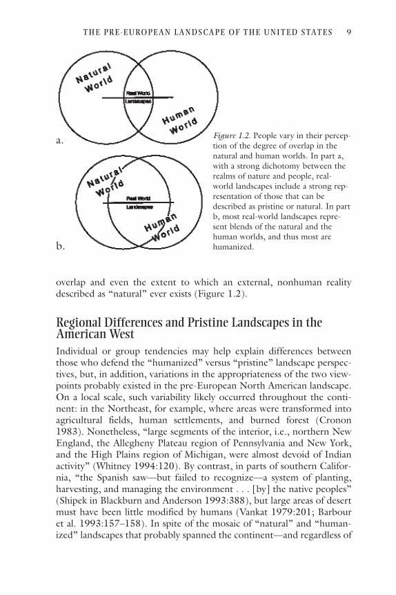
overlap and even the extent to which an external, nonhuman realitydescribed as “natural” ever exists (Figure 1.2).
Regional Differences and Pristine Landscapes in theAmerican WestIndividual or group tendencies may help explain differences betweenthose who defend the “humanized” versus “pristine” landscape perspec-tives, but, in addition, variations in the appropriateness of the two view-points probably existed in the pre-European North American landscape.On a local scale, such variability likely occurred throughout the conti-nent: in the Northeast, for example, where areas were transformed intoagricultural fields, human settlements, and burned forest (Cronon1983). Nonetheless, “large segments of the interior, i.e., northern NewEngland, the Allegheny Plateau region of Pennsylvania and New York,and the High Plains region of Michigan, were almost devoid of Indianactivity” (Whitney 1994:120). By contrast, in parts of southern Califor-nia, “the Spanish saw—but failed to recognize—a system of planting,harvesting, and managing the environment . . . [by] the native peoples”(Shipek in Blackburn and Anderson 1993:388), but large areas of desertmust have been little modified by humans (Vankat 1979:201; Barbouret al. 1993:157–158). In spite of the mosaic of “natural” and “human-ized” landscapes that probably spanned the continent—and regardless of
T H E P R E - E U R O P EA N L A N D S CA P E O F T H E U N I T E D STAT E S 9
Figure 1.2. People vary in their percep-tion of the degree of overlap in thenatural and human worlds. In part a,with a strong dichotomy between therealms of nature and people, real-world landscapes include a strong rep-resentation of those that can bedescribed as pristine or natural. In partb, most real-world landscapes repre-sent blends of the natural and thehuman worlds, and thus most arehumanized.
a.
b.

the focus on either local, nonkeystone versus broad, keystone humanimpacts—most generally, at the regional scale, the subcontinental area ofthe eastern forests and tallgrass prairies may be a likely candidate for astrongly “humanized” environment. On the other hand, the AmericanWest, including the short-grass plains and extending through the aridand semiarid brushlands to the forested mountains, may be a regionwhere, if anywhere, “pristine” landscapes likely occurred. Several lines ofevidence support this regional characterization.
Population SizeThe number of native people living in different parts of the West var-ied greatly, but much of the interior West supported small human pop-ulations. The numbers of people living in the Americas at the time ofEuropean contact has long been a question for scholarly debate. Themost recent and thorough treatment is provided by Denevan (1992),who updates his earlier effort (Denevan 1976) and remains convincedthat a large human population, some 53,904,000, lived in the hemi-sphere in the year 1492. (Such a large population supports Denevan’sview of a landscape modified “nearly everywhere” [Denevan1992:370], although Snow [1995] argues for smaller numbers.) One-third of that total inhabited present-day Mexico (more than 17 mil-lion) and another 20 percent (almost 12 million) called the Andeshome. North America, by comparison, was lightly populated, withonly 7 percent of the total, or 3,790,000. Denevan derived this NorthAmerican figure from a simple doubling of Ubelaker’s (1988) estimateof 1,894,350, which Denevan considers “very conservative” (Denevan1992:xx). (Estimating the size of pre-European populations is difficult:Indian populations were decimated by introduced European diseasesthat spread ahead of even the earliest record-keeping explorers.) Byextension, a twofold increase in each of Ubelaker’s regional estimatesfor ten areas of North America allows a portrait of human numbers indifferent parts of the continent (Figure 1.3): 355,000 in the far North;1,124,000 in the eastern forests; 378,000 in the prairies and plains(into the northern Rockies); 231,000 in the intermountain West;793,000 along the Pacific Coast; and 908,000 in the Southwest (thecultural region of which extends into northern Mexico). Expressed bydensities, human numbers were sparse in the Arctic, Subarctic,Plains/Prairies, and Great Basin, much higher in the eastern forestsand Southwest, but highest of all along the northwest coast and, espe-cially, lowland California. Although large numbers of native peoplelived in the West as a whole, then, much of the area of the West wasonly lighted inhabited.
10 T h o m a s R . Va l e

SettlementsThe areal extent of human-constructed forms, such as settlementdwellings, would have echoed population densities and thus occupiedlarger parts of the eastern landscape than of much of the West. Livingdwellings in the pre-European West varied from simple shelters of brush
T H E P R E - E U R O P EA N L A N D S CA P E O F T H E U N I T E D STAT E S 11
Figure 1.3. Human numbers in the cultural regions of North America at the timeof European contact (1492). The figures represent doublings of the populationestimates of Ubelaker (1988:291), consistent with the judgment of Denevan(1992:xx, 291). The geographic areas of the cultural regions, as reported by Ube-laker (1988:291) and expressed in thousands of square kilometers, include Arctic,2,378; Subarctic, 5,626; Northwest Coast, 326; California, 296; Southwest, 1,612;Great Basin, 900; Plateau, 509; Plains, 3,006; Northeast, 1,894; and Southeast,910. The total of 17.5 million square kilometers (6,739,839 square miles) is about5 percent lower than the figures reported for land area in the United States andCanada in the Statistical Abstract of the United States.

to elaborate houses walled with wooden planks (Thomas, Pendleton,and Cappannari 1986:268; Suttles and Lane 1990:491), from tinylodges to buffalo-robed tepees to tule-matted dwellings to adobe androck-cemented buildings (Spier 1978b:430; Wilson and Towne1978:388; Malinowski 1998a:253–254; Malinowski 1998b:215).Sometimes sheltering communal assemblies but more often single fam-ily groups, the houses were usually clustered in villages, although occa-sionally were scattered in loose and open settlements (Pilling 1978:139;Hackenberg 1983:165; Stewart 1983:57; Fowler and Liljeblad1986:443; deLaguna 1990:207).
Despite this diversity, the dwelling patterns shared a common charac-teristic: they provided crowded, even cramped, living spaces. For exam-ple, on the Rio Mimbres of New Mexico, Minnis (1985:52–53) identi-fied a house space of 5 to 10 square meters per person; in northernCalifornia, Shastan peoples built dwellings with 5 to 7 square meters perperson (Silver 1978:214); on the Great Plains, the Osage lived in housesthat enclosed 3 to 18 square meters per person (Malinowski1998b:322). Even less space per individual characterized many peoples:3 to 5 square meters for the Salish of Washington, the Pomo of north-ern California, the Yokut of south-central California, the Washoe ofwestern Nevada, the Ute of eastern Utah, and the Kalispel of northernIdaho (Bean and Theodoratus 1978:292; Spier 1978a:476; Callaway,Janetski, and Stewart 1986:348; D’Azevedo 1986:479–481; Hajda1990:509; Lahren 1998:288).
These numbers allow estimates of the percentage of pre-Europeanlandscape devoted to human living space. At the rate of 10 square metersper person (on the high end of most of the sources consulted above), the2.3 million people in cultural regions of the West (which extend northalong the Pacific Coast into Alaska and south into northern Mexico)would account for 23.1 million square meters or 23.1 square kilometersof dwellings, only 0.00034 percent of the total landscape area. In thesparsely inhabited Great Basin, the percentage shrinks to 0.00008 per-cent; in more populated California, it climbs to 0.0015. The regionalpercentage for the less populated West is smaller, although only margin-ally, than the 0.0004 percent attributed to the cultural regions in themore densely populated eastern forests.
Villages included more than everyday living space—sweat lodges, cer-emonial centers, assembly shelters, storage facilities, specializeddwellings, and enclosing palisades. Moreover, all such structures restedwithin larger, more generalized settlement areas. Still, this land useaccounted for only a tiny fraction of the total landscape (Figure 1.4),probably concentrated in small areas and surrounded by a series of cir-cular bands of decreasing human impact (Hammett 1992). Even the use
12 T h o m a s R . Va l e

of statistics for contemporary Western cities—which include not onlyhouses but also retail stores, manufacturing space, public buildings,roads, parking lots, sidewalks, parks, playgrounds, yards, landscapedproperty, and idle land—cannot change the picture. Western cities todaycommonly enclose 780 to 1,000 square meters (0.0003 to 0.0004square mile) per person: examples include Spokane, Washington; Port-land and Eugene, Oregon; Sacramento, Santa Rosa, and Concord, Cal-ifornia; Tucson, Arizona; Albuquerque, New Mexico; Denver, Col-orado; and Boise, Idaho (data from Statistical Abstract of the UnitedStates 1997:45–47). Older and more mature cities, such as San Fran-cisco, California (180 square meters or 0.00007 square mile), and Seat-tle, Washington (520 square meters or 0.0002 square mile), provide
T H E P R E - E U R O P EA N L A N D S CA P E O F T H E U N I T E D STAT E S 13
Figure 1.4. Tribal villages and camps of the Yurok of northwestern California(Pilling 1978:139). Settlements were concentrated along the Klamath River andthe immediate Pacific coast, leaving most of the landscape without such communi-ties. The size of the villages was modest—most had no more than seven or eighthouses (Pilling 1978:145)—which makes their spatial extent much smaller thandepicted by the cartographic circles on the map.

much less space per person, whereas newer, sprawling cities have more:Mesa, Arizona (1,800 square meters or 0.0007 square mile) and Scotts-dale, Arizona (5,180 square meters or 0.002 square mile), represent theother extreme. Using the figure of 780 to 1,000 square meters per per-son—a value that can only greatly exaggerate the true expanse of Indianvillages—the 2.31 million people in pre-European times would havegenerated a settlement area of 1,802 million to 2,310 million squaremeters (696 to 892 square miles), or only 0.03 to 0.04 percent of thetotal landscape in the western cultural regions.
Other types of construction—omitting for the moment those associ-ated with agriculture—must have been similarly restricted in spatialextent. Burial grounds, roads (even the celebrated road system radiatingfrom New Mexico’s Chaco Canyon [Trombold 1991] or those of Ari-zona’s Hohokam [Motsinger 1998]), locales for human wastes, refusedumps, water reservoirs (Wilshusen, Churchill, and Potter 1997)—evenin the aggregate, these occupied only small areas of landscape. Moreover,the high mobility of certain peoples, which would increase the area ofsettlement considerably, would nonetheless alter the total landscape inonly a minor way. The upshot is simple: the modest numbers of humansin pre-European times, living with much simpler technologies andlifestyles (compared with today’s) and demanding much less of the nat-ural world (relative to modern people), modified only a tiny fraction ofthe total landscape for their everyday living needs.
AgricultureAgriculture, widespread in the East, was restricted in the West to theSouthwest and parts of the Great Plains. The American Southwest sup-ported agricultural societies that were among the most sophisticated inpre-European North America (north of the Aztec cities of central Mex-ico), and crop plants appear long ago in archaeological sites. Corn (Zeamays) may have been first cultivated between 3,000 and 3,500 years ago,to be joined by squashes (Cucurbita), gourds (Lagenaria), and variousbeans (Phaseolus), among other plants (Cordell 1997:129, 135). Byabout 2,000 years ago, agriculture had spread through the Southwest,although not all peoples cultivated crop plants (Cordell 1997:148).
Recent reviews identify several patterns of landscape modificationassociated with pre-European southwestern agriculture (Doolittle 1992,2000; Fish and Fish 1994; Cordell 1997). First, uplands cleared of theirforest cover supported dry farming in areas where rainfall was sufficientfor crop plants; the mesas in southwestern Colorado serve as examples(Wyckoff 1977; Stiger 1979). Second, water control devices such as ter-races enhanced the agricultural utility of both intermittent stream beds
14 T h o m a s R . Va l e

and mountain slopes in some environments; the Point of Pines area ineastern Arizona serves as a classic study of such agriculture (Woodbury1961). Third, desert lowlands required more elaborate water manipula-tions, including stream diversions and canals; the Hohokam society ofcentral Arizona is an often-cited illustration (Masse 1981; Crown 1987).
A number of studies suggest the area of cropped field per person inpre-European societies of the Southwest. For systems without irrigationor only minimal water manipulation, Woodbury (1961), Matson, Lipe,and Haase (1988), and Williams (1993) use 1 hectare per person as thestandard, a value consistent with other studies (Vivian 1974; Tuggle andReid 1984; Orcutt 1986), including Hopi agriculturalists in historictimes (Bradfield 1971). By contrast, the greater productivity of irrigatedsystems reduces the field size per person: Minnis (1985)—working in theRio Mimbres region of New Mexico—increases the values reported forcontemporary pueblos by 50 percent (to allow for increased productionneeded in dry years) and derives 0.6 hectare per person. This numberexceeds the 0.17 to 0.43 hectare per person calculated by Fish and Fish(1992) for prehistoric Hohokam and historic Pima communities in thedesert of central Arizona.
These values may be applied to the estimated number of people liv-ing within the Southwest at the time of initial European contact toderive the maximum possible acreage in agricultural fields (Figure 1.5);such a calculation assumes that all pre-European people were engaged inagriculture, an assumption that will overestimate the magnitude of theagricultural landscape. Given a human population of 908,000 (a dou-bling of Ubelaker’s number for the region, as derived above), the area ofagricultural fields would be 908,000 hectares, assuming dryland farming(at 1 hectare per person), or 545,000 hectares for irrigated agriculture(at 0.6 hectare per person). The total seems large, but when comparedwith the 161,160,000 hectares within the cultural region (Ubelaker1988), the extent of the agricultural landscape shrinks considerably: ofthe total land area, only 0.56 percent (by the dryland farming calcula-tion) or 0.34 percent (by the irrigated farming estimation) might havelain in agricultural fields (and keep in mind the generous assumptionsabout the extent of agricultural activity among pre-European peoples).By comparison, the planted cropland in contemporary Arizona (1.1 per-cent of the state area) and New Mexico (1.6 percent) suggests slightlylarger but surprisingly similar magnitudes (data from Statistical Abstractof the United States 1997).
The sum of agricultural fields in use at one instant in time, however,probably underestimates the total landscape modified by agriculturalactivity. Dryland farming systems, unencumbered by constructed—andthus spatially anchored—water control devices, seem the most likely can-
T H E P R E - E U R O P EA N L A N D S CA P E O F T H E U N I T E D STAT E S 15

didates for such expanded impacts. At Mesa Verde, for example, Stiger(1979) suggested that native people shifted their agricultural fields in asort of swidden agriculture, an interpretation deemed “plausible but asyet unconfirmed” by Fish and Fish (1994). Matson, Lipe, and Hasse(1998), in a study at Cedar Mesa, Utah, calculate an acreage twentytimes the field area used at any one time to be necessary to support ashifting cultivation system. A similar order of magnitude is suggested byKohler and Matthews (1988) on Grass Mesa in southwestern Colorado,where their numbers indicate that about 19 hectares of land was “defor-ested” per person. Applying these figures to the total population in theSouthwest—a most reckless procedure because not all peoples were agri-
16 T h o m a s R . Va l e
Figure 1.5. The agricultural landscape of the southwestern cultural region. The twosquares represent the maximum total cropland within the region, given 1.0 hectareper person (the larger square, 59 miles on a side) and given 0.6 hectare per person(the smaller square, 46 miles on a side). Both calculated cropland areas are basedon generous assumptions, as discussed in the text.

culturalists, nor were all of those who did engage in agriculture drylandfarmers, nor were those who were dryland farmers necessarily shiftingcultivators—yields 11.2 percent of the total landscape area as modifiedby agriculture, ten times the area of contemporary cropland and, eventhough a most unlikely figure, still a relatively modest percentage.
In regions other than the Southwest, this type of calculation gener-ates a similar portrayal of small areas in agricultural fields. On the GreatPlains, Malinowski (1998b) suggests individual Hidatsa families farmed3–5 acres (p. 258)—1–2 hectares—whereas the Osage farmed about 1.5acres per person (p. 299)—about 0.6 hectare. If the entire human pop-ulation of 378,000 in the Plains cultural region farmed 0.6 hectare perindividual (an extravagant assumption, because most Native Americansin the region did not depend upon agriculture), the aggregated sumwould be 226,800 hectares, only 7.5 percent of the region’s total area.Even in the eastern forested region of North America the area in fieldsand fallow was small: Williams (1993:30–31) suggested as many as 28million acres was so modified in the thirty-one easternmost states—anumber that impressed him as large—but it represents less than 4 per-cent of the total area of those states.
Agricultural activity marks the landscape not only by cropland butalso, sometimes, by constructed landforms—the canals of the Hohokamserve as an obvious example. Low rock check dams across ravines thatcollect sediment and thus form small surfaces for planting, short rockwalls running along the contour on slopes that similarly create low ter-races (“linear borders” or “contour terraces”), rectangular fields on levelground that are edged by earth or rock borders (“bordered gardens”),fields with veneers of gravel mulch—all result in landforms that persistlong after agriculture has ended (Cordell 1997). But, as with agriculturalfields more generally, these forms occupy only tiny parts of the land-scape.
The manner of portraying archaeological sites in the anthropologicalliterature may contribute to an exaggerated sense of the spatial scale ofIndian agricultural impact. Typically in such studies, the maps of sitesfocus on the immediate environment in which artifacts and modifica-tions are located—a logical and appropriate custom for purposes of pre-senting the data (Figure 1.6). This local scale, however, cannot reveal thelandscape context for the impacts, which account for only small areas ofthe total environment.
The upshot of these various estimates and calculations is that notmuch of the pre-European landscape of the American Southwest or theGreat Plains was—in cropland or otherwise—modified by agriculturalactivity. Certain areas were deforested, modified, and even utterly trans-formed by human cultivators. The bulk of the region, however, was not.
T H E P R E - E U R O P EA N L A N D S CA P E O F T H E U N I T E D STAT E S 17

Vegetation Modification
Vegetation modifications other than formal agriculture may have beenmore prevalent in the East, but evidence of such activities is common inthe West. Doolittle (2000) compiles a comprehensive compendium ofspecific Indian manipulations of plants throughout North America, andthe results are dizzily rich in both number of instances and diversity ofactivities. Documented from firsthand accounts, ethnographies, andarchaeological evidence, Doolittle’s detailed listing is organized into cat-egories arrayed along a continuum between the poles of formal agricul-ture (in which crop plants require human action to reproduce) and sim-
18 T h o m a s R . Va l e
Figure 1.6. Two examples of mapped agricultural landscapes. a. Low rock walls thatform short terraces for nonirrigated cropland at Point of Pines in east-central Ari-zona (Woodbury 1961:19). b. Irrigation canals, other agricultural features, anddwelling sites at Casa Grande (Hohokam) in central Arizona (Crown 1987:149).In both examples, the local scale emphasizes the agricultural forms; a larger, land-scape scale would de-emphasize them.
a.
b.

ple gathering (in which wild plants yield products for people but areunaffected by them) (Box 1.2). Most closely resembling agriculture, thecategory of cultivation describes human planting of species that readilyand commonly reproduce in the wild. Activities labeled as encourage-ment include manipulations of naturally occurring plants (e.g., divertingwater from streams to wild stands of sedge), whereas, closer to gather-ing, those activities classified as protection involve management toenhance the persistence of particular natural plants (e.g., removingpotentially damaging dead branches from shrubs).
Within Doolittle’s work, instances of cultivation, encouragement,and protection span the continent, although the larger number from theWest, compared to the East, may reflect more the character of the datasources than the degree of proliferation of pre-European societies.Within the West, more than two-thirds of the documented examplesoccur in more densely populated California and the Southwest, againperhaps a consequence of the history of anthropological and archaeo-logical study (and preservation of certain types of evidence in dry envi-ronments) and not a result of regional differences in human activities.These instances from the American West contribute to the question ofthe degree to which the pre-European landscape was humanized.
CULTIVATION
The category of cultivation includes such activities as the spreading ofseeds of herbaceous species (e.g., Winter and Hogan 1986), but thetransplanting of woody plants constitutes perhaps the most obvious illus-tration. A celebrated example involves the prehistoric Hohokam of cen-tral Arizona, who constructed piles of cobbles (which increased the infil-
T H E P R E - E U R O P EA N L A N D S CA P E O F T H E U N I T E D STAT E S 19
BOX 1.2. The continuum of plant-people interactions. (Modi-fied from Doolittle 2000.)Agriculture Crop plants require human action for successful
reproductionCultivation Humans propagate wild plant species that repro-
duce in the wildEncouragement Humans manipulate individual plants that occur
naturally in the wildProtection Humans enhance some characteristics of individual
plants that occur naturally in the wildGathering Humans gather products from wild, naturally
occurring plants, but the plants are unaltered bythe gathering activity
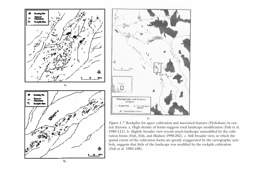
Figure 1.7. Rockpiles for agave cultivation and associated features (Hohokam) in cen-tral Arizona. a. High density of forms suggests total landscape modification (Fish et al.1985:112). b. Slightly broader view reveals much landscape unmodified by the culti-vation forms (Fish, Fish, and Madsen 1990:202). c. Still broader view, in which thespatial extent of the cultivation forms are greatly exaggerated by the cartographic sym-bols, suggests that little of the landscape was modified by the rockpile cultivation(Fish et al. 1985:108).
a.
b.
c.

tration of rainwater and/or runoff and thus enhanced available soilmoisture) in which they planted agave (Agave spp.), prized for their edi-ble fruits. The rockpiles, modest in size (1.5 meters in diameter and nomore than 75 centimeters high) but numerous (about 42,000 in a studyarea of 350 square kilometers north of Tucson), represent a humanmodification of both the vegetation cover (including local range exten-sions of the transplanted agaves) and the landform surface (Fish, Fish,and Madsen 1985, 1990, 1992; Fish, Fish, Miksicek, and Madsen1985). Interspersed with pits for roasting the fruits, as well as with lowterraces and check dams for field crops, the rockpiles contributed toimpressive agricultural/cultivation complexes (Figure 1.7). Nonetheless,as with formal agricultural fields, the percent of the landscape directlymodified by constructed rockpiles is small—they collectively cover only1.4 percent of the area in the “full-coverage” survey in the northernTucson Basin—and the acreage of the complexes mapped at a more gen-eral scale leave much landscape unmodified (Figure 1.7).
A second classic example of the transplanting of wild plants byNative Americans involves the spreading of fan palms (Washingtonia fil-ifera) across the warm deserts of southern California. Useful for bothfruits and fronds, the trees easily could have been dispersed to isolatedmoist canyons and perennial springs by people carrying seeds. The citedevidence is anecdotal (Patencio 1943; Bean and Saubel 1972) but per-suasively logical. Moreover, the introduction of the palms transformed(“humanized”) the desert oases more or less permanently, a point sug-gested for transplanted species generally at both local and regionalscales (Jennings 1966; Borher 1991). The moist locales that could sup-port palms constitute a tiny part of the southern California desert land-scape (virtually all of which remained unaltered by palm introductions),although these palm stands sometimes can be seen from great distances(extending, by one measure, the spatial extent of the humanization)and always are disproportionately valued by people, which may elevatethe importance of the palm transplants as elements of humanizednature.
A third, speculative but intriguing illustration of transplanting is sug-gested by Betancourt et al. (1993; see also Betancourt et al. 1991), whoproposes that Native Americans may have been responsible for thespreading of certain genetic characteristics of plants, notably good-mast-ing strains of pinyon pine (Pinus edulis) in New Mexico, by the collec-tion of, and returning home with, seeds from particularly productivetrees. Such genetic manipulations of food plants by subsistence folk is atime-honored research topic (Sauer 1952; Zimmerer 1996); as an exam-ple of the humanization of the natural world, it is more focused on detailand fine-grain than on landscape or ecosystem scale.
T H E P R E - E U R O P EA N L A N D S CA P E O F T H E U N I T E D STAT E S 21

ENCOURAGEMENT
The most frequent examples of encouragement, of promoting the healthof specific wild plants, involve burning top growth (e.g., Bohrer 1983,1992; Winter and Hogan 1986; McCarthy 1993), digging roots of herba-ceous species (e.g., Peri and Patterson 1993), or pruning stems of shrubs(e.g., Anderson 1993). Two particular instances, often cited, suggest stillother types of encouragement. First, Nichols and Smith (1965) docu-mented at Mesa Verde in southwestern Colorado the purposeful bendingover, and killing the top of, young Douglas fir to induce vigorous verticalgrowth of branches, which subsequently could be harvested for long,straight construction timbers. After initial branches were so cut, otherswould assume the terminal dominance and produce additional buildingmaterial, probably repeatedly. After using dendrochronological techniquesin one ravine, the authors suggest that such manipulations may well haveoccurred in many canyons in the Mesa Verde area. Second, the Paiute ofOwens Valley in eastern California diverted waters from streams issuingfrom the Sierra Nevada to flood-irrigate upland stands of wild hyacinth(Dichelostemma pulchella, a brodiaea) and yellow nutgrass (Cyperus escu-lentus, a sedge), both of which produce edible subterranean material(Stewart 1929; Lawton et al. 1976). An area with dam and ditches alongBishop Creek may have watered 6 to 8 square miles, and extrapolating thismagnitude to the ten other nearby streams that may have supported sucha system produces a total of about 80 square miles of irrigated land. Thistotal approaches 10 percent of the lowland area of the Owens Valley.
PROTECTION
Activities categorized as protection merge, on the one hand, with encour-agement and, on the other, with simple gathering. Several examples serveas illustrations. Clearing debris from the top growth of certain herbaceousplants or removing dead branches, leaf litter, or rocks to protect certainplants from being “crowded out” by other species may represent protection(Ortiz 1993). The realization that mature pinyon pine produce larger cropsof cones and seeds than smaller trees may have prompted Anasazi peoplesto protect older trees when seeking fuel wood or construction timber(Floyd and Kohler 1990). The effect of spiritual beliefs that preclude over-harvesting of acorns might also be classified as protection behavior amongCalifornia Indians (McCarthy 1993). Still another form of restraint, thePaiute people refraining from burning fire-sensitive pinyon woodlands inthe Great Basin—if prompted by the obvious importance of pine nuts as afood source—might be described as a protection activity (Burwell 1999).
OVERALL IMPACTS OF VEGETATION MODIFICATIONS
In sum, the landscape impacts of activities classified as cultivation mostclosely resemble those of formal agriculture: nature is intensely modified;
22 T h o m a s R . Va l e

the spatial extent of landscape modification is modest; and, dependingupon the specific impacts, the change may be ephemeral or persistentthrough time. Compared with agriculture and cultivation, encouragementand protection to a much lesser degree intrude upon, modify, or changethe pristine natural world: in the intensity of alternation, the spatial scaleof impact, and the temporal scale of persistence, encouragement and pro-tection activities change nature less than planting crop or wild plantspecies. For someone seeking human impacts in the pre-European land-scape, the above statement invites a response—namely, that subtler char-acter of encouragement and protection activities do not negate their real-ity, and, in fact, that very reality only confirms a humanized North Americain 1492. However, the small acreage modified intensively, the modest areaaltered in any way, and the often fleeting character of much of the alterna-tions may also suggest that much or most of the continent was essentiallyfree of the impacts of cultivation, encouragement, and protection at thetime of European contact.
Tree CuttingCutting trees for building material and fuel, with concurrent impacts onforest composition and structure, must have been more common in thedensely populated and humid East, although the impacts may have beenlonger-lasting in the drier West. The cutting and removal of trees in forestsand woodlands, itself an alteration of the natural scene, likely leaves animprint on the woody vegetation that persists even after the immediate evi-dence of the event fades, and the immense literature on historic loggingsupports this view (Vale 1982). In the pre-European landscape of NorthAmerica, native peoples’ use of wood resources—which might be seen asanalogous to selective silviculture in contemporary times—would have hadsimilar effects. In spite of the celebrated example of the Chaco CanyonAnasazi transporting construction timbers more than 75 kilometers(Betancourt, Dean, and Huyll 1986), wood-cutting impacts would havebeen greatest in the immediate vicinity of settlements, with decreasingimpacts away from the village sites (Whitney 1994; Steller 1995; evenSauer, 1947, seems to have this model in mind), perhaps not unlike thereduced availability of downed wood around contemporary campgroundsinhabited by firewood-collecting recreationists. The forest modificationscaused by wood-seeking Native Americans, then, would have created nota uniformly modified and humanized forest, but a mosaic with varyingdegrees of alternation.
In the West, native folks of the marginally arid Southwest may havedeforested pinyon-juniper woodlands in their cutting for material and fuel(as well as through agricultural activities). In Southwestern Colorado,Kohler (1992) cites several lines of evidence suggesting Anasazi deforesta-
T H E P R E - E U R O P EA N L A N D S CA P E O F T H E U N I T E D STAT E S 23

tion: the declines through time in the uses of pinyon and juniper as fuel (asevidenced by charcoal remains) and as food (pinyon seeds) and in thedelayed use of older trees for construction (trees that may have been pre-viously saved for their production of cones and seeds). In New Mexico,Minnis (1978, 1985) similarly argues that prehistoric peoples deforestedareas near settlements along the Rio Mimbres. Betancourt and Van Deven-der (1981), interpreting the record of packrat middens, and Samuels andBetancourt (1982), employing a simulation model of wood use, indicateAnasazi deforestation around Chaco Canyon. More generally throughoutthe landscape along the current international border, Bahre (1991) con-cluded that floodplains, with their concentration of human settlements,may have been deforested of riparian trees. These specific studies leadsome to observe that deforestation may have been universal, or at leastextremely widespread. Even Betancourt, whose published work seems toplace him away from the humanized landscape extreme, has stated that“New Mexico woodlands of a thousand years ago were part of a deeplyhumanized landscape, far from the pristine label commonly assigned topre-Columbian panoramas” (Betancourt et al. 1993).
Could pre-European humans have deforested the pinyon-juniperwoodland? Currently, such vegetation covers 27,547,000 hectares (68million acres; 106,000 square miles) (Klopatek et al. 1979), an area largerthan the state of Colorado. Even given the expansion of juniper wood-land in historic times, the total area in pre-European North America wasimmense. Ignoring the clearing for agriculture—which was locally, evenregionally, important—the consumption of wood necessary to achievewidespread deforestation would have had to be substantial. Specifically, ifeach acre supported 600 to 1,010 cubic feet of wood (Gottfried and Ffol-liott 1995, but their number may exceed stocking rates for pinyon-juniperstands over much of the West), the 68 million acres of pinyon-junipervegetation would have totaled 40–70 billion cubic feet of wood. To con-sume this biomass, native peoples would have had to exceed by two orthree times the current wood usage in the United States (including pulpand paper), admittedly for a single year (about 20 billion cubic feet,according to the USDA Forest Service 1990). Moreover, and again omit-ting clearing for agriculture, for the woodland to be simultaneouslycleared at one time, each of the approximately 700,000 people livingwithin the range of pinyon-juniper woodland at the time of Europeancontact would have had to consume 59,000 to 99,000 cubic feet ofwood. Even if distributed over a century of consumption, such a rateexceeds contemporary wood usage in the United States by as much as tentimes. In sum, it seems reckless to suggest more than a moderate posi-tion: the pinyon-juniper woodland was cleared in the vicinity of settle-ments, especially in the southwest, but much—most?—of the area of suchvegetation could not have been deforested.
24 T h o m a s R . Va l e

To be “deeply humanized,” however, the pinyon-juniper woodlandmay have been more modestly subjected to scattered wood cutting, nottotal deforestation. The spatial pattern of such impacts, resembling thoseof forest clearing specifically and human villages generally, probablyformed a gradient of decreasing alteration away from settlements. More-over, the question arises of how much cutting would be necessary toinvoke the label of “deeply humanized”: heavy cutting in the vicinity ofa large and permanent village; cutting several trees in an acre near a tem-porary settlement; cutting a dead tree near a seasonal camp; collectingdead and downed wood beside an overnight camp; or walking througha woodland, breaking off dead branches that then lie on the ground sur-face. The question prompts no easy and universal answer, but the gen-eralization that the pinyon-juniper woodland, in its large expanse, wasaltered by pre-European people, and thus not “pristine” (Cartledge andPropper 1993), seems hyperbole.
Hunting of Wild AnimalsIf pre-European humans acted as keystone predators, their associatedimpacts may have been no greater in the West than in the East. The con-cept of keystone biological species—those animals that disproportion-ately influence the structure and/or diversity of surrounding biotic com-munities—continues to enjoy attention and popularity in the ecologicalliterature (Mills, Soulé, and Doak 1993; Power et al. 1996; Knapp et al.1999). Some observers have suggested that humans may act as criticalkeystone species—an unassailable assertion for people living in the mod-ern world but a more provocative claim for those subsisting in huntingand gathering societies.
No one has been more outspoken in seeing pre-European peoples inNorth America as a keystone predator than Kay, particularly in his workon Yellowstone (Chaddle and Kay 1991; Kay and Chaddle 1992; Kayand Wagner 1994; Kay 1995b, 1997d). In this famous region, Kay sug-gests that excessive hunting by native peoples effectively eliminated elk(Cervus elaphus) from the northern part of the present park, an eradica-tion that reduced browsing pressure on such trees and shrubs as aspen(Populus tremuloides), willows (Salix spp.), serviceberry (Amelanchieralnifolia), and chokecherry (Prunus virginiana). In turn, animalsdependent upon robust stands of these plants, notably beaver (Castorcanadensis) but perhaps also white-tailed deer (Odocoileus virginianus),flourished. By contrast, with protection within the national park, elknumbers have exploded, leading to decreases in the browse species andcorresponding declines in related animals. The evidence for this dramaticchange in the contemporary Yellowstone ecosystem includes an absenceof elk remains in archaeological sites, few references to elk (or the pred-
T H E P R E - E U R O P EA N L A N D S CA P E O F T H E U N I T E D STAT E S 25

ators dependent on them, wolves [Canis lupus]—Kay 1995a) in thejournals of early Europeans, tall and healthy stands of browse species innineteenth-century photographs, vigorous growth of browse specieswithin contemporary grazing enclosures, and apparent abundance offruits in the lightly browsed shrubs in pre-European times (Kay 1994).
Other researchers offer a different interpretation of the Yellowstoneelk situation (Despain et al. 1986; Meagher and Houston 1998). Elknumbers were high in the pre-European landscape, according to thisviewpoint, and changes in vegetation represent responses more to cli-mate variability and fire suppression than to browsing pressure. Morespecifically, Yellowstone offers only marginal habitat for aspen, and thusto beaver, and declines in both species reflect climatic drying and reduc-tion in fire frequency. Moreover, heavy browsing by a large populationof elk is to be expected in this environment, leading to different inter-pretations of the related lines of evidence: elk remains exist in archaeo-logical sites; elk and wolf references abound in early written accounts;nineteenth-century photographs depict vegetation of a cooler and moremoist climate (and, in addition, reveal remarkable stability in the plantcover); and vigorous growth of unbrowsed trees and shrubs within graz-ing enclosures represents vegetation conditions developing in theabsence of large browsing animals, an unnatural condition for Yellow-stone.
Yellowstone and its elk may be the most studied and the most inflam-matory instance of possible “aboriginal overkill” (Kay 1994), but thecontrol of prey numbers by excessive human predation in pre-EuropeanNorth America has been argued for other landscapes. In Rocky Moun-tain National Park, today’s elk numbers may be much larger than thosein pre-European times, with cascading negative effects similar to thosedescribed for Yellowstone, and Indian hunting—not specifically identi-fied—might be invoked to explain the lower elk populations in the past(Hess 1993). Much the same story has been told for other parts of theRocky Mountains, notably in Canada, and including not only elk butalso moose (Alces alces) (Kay 1997a, 1997c). Moreover, Indian huntingon the Plains, according to some observers, reduced the number ofbison (Bison bison) far below the commonly cited 60 million animals thatmight have been supported by the forage resource (Kay cites West 1995and Shaw 1995 in this argument, but both actually tell more complexstories). In the eastern states, Neumann (1989, 1995) argues that Indi-ans, who competed with wild animal species for acorns and other mastfoods, excessively killed white-tailed deer, tree squirrels (Sciurus), turkey(Meleagris gallopavo), and raccoon (Procyon lotor), among other species.His most intriguing assertion is that the passenger pigeon (Ectopistesmigratorius)—one of the great icons of animal abundance in wild Amer-
26 T h o m a s R . Va l e

ica—was actually uncommon in pre-European times because of suchcompetition with native peoples: the birds’ numbers exploded only whendiseases greatly reduced the human population (Neumann 1985).
To the degree that the “aboriginal overkill” thesis is supported empir-ically—as some of Kay’s work argues effectively—the idea has appeal.The luster of the evidence, however, is too often tarnished by the rhet-oric of its presentation. First, although Kay qualifies his argument (i.e.,ungulates with environmental refuges such as dense forests or marshvegetation may have escaped the intense pre-European hunters; humansand other predators may have interacted to limit prey numbers), heclearly wants the mechanism to be a universal or at least the norm: saiddirectly, the extrapolation from the northern range of Yellowstone to theentire continent may weaken the argument, even for locales where theempiricism is persuasive. Second, the tone of the published work is oneof strident advocacy, rather than of reflective truth-seeking; a readermight even wonder about a social agenda in Kay’s science, indicated byhis assertion that the wilderness “myth” was “created, in part, to justifyappropriation of aboriginal lands and the genocide that befell native peo-ples” (Kay 1994:381) and by his recommendation that “we simply per-mit Native Americans to hunt bison in [Yellowstone]” (Kay 1997b).Finally, the seductiveness of simplicity and single causes, in this case“aboriginal overkill,” rests uneasily in the minds of those who find com-plexity and multiple causes in the natural world, including the effects ofungulate grazing and browsing on vegetation (Mladenoff and Stearns1993).
The overkill thesis elevates pre-European North American peoplesfrom “children of nature” to a more universal humanity, but it does soby invoking an unflattering story line of excessive resource exploitation.American Indians cannot be described as promoting “ecologicalintegrity” (Czech 1995:568), embracing “conservation . . . as part oftheir lifeway” (Gomez-Pompa and Kaus 1992:273), or living a “part-nership with nature that left the resource base intact” (Anderson1993:152). The overkill thesis says that Indians ruthlessly, wastefully,and unsustainably slaughtered the wildlife of the continent.
WildfireLightning commonly ignites wildfires in the West, less so in much of theEast, raising the possibility that the pre-European fire regime in theAmerican West was more a function of natural ignition and vegetationflammability than of Indian burning. Wildfires require both an ignitionsource—almost entirely from human activities or lightning strikes—andcombustible fuels. Combustibility, in turn, depends upon flammable bio-
T H E P R E - E U R O P EA N L A N D S CA P E O F T H E U N I T E D STAT E S 27

mass, often but not necessarily dead and dried leaves and/or twigs andbranches, in an atmospheric context of short-term dry weather, perhapsaugmented by longer-term drought. These requirements result in a neg-ative feedback mechanism, by which a fire that consumes the com-bustible fuels reduces the likelihood of a subsequent fire—at least untilthe fuels have reaccumulated. The time needed for the accumulation ofburnable fuels varies greatly, depending upon the vegetation structure;in an annual grassland, it may require but one growing season, whereasin some forests it may take several centuries. A vegetation type, then, canbe said to have a fire regime (in a time period of constant climate)—described by a return time or recurrence interval (for a fire to return toa given locale)—dictated by ignition frequency and available fuel.
Ignition frequency or available fuel: either one may limit burningand, thus, determine the fire regime. Those who champion Indian burn-ing as a humanizing influence on landscapes—and their numbers arelegion (e.g., Sauer 1950; Denevan 1992; Budiansky 1995; Delcourt etal. 1998)—implicitly stress the importance of the number of ignitions,i.e., native peoples set fires, and these ignitions determined fire regimes.By contrast, other researchers emphasize fuels (e.g., Vogl 1974:148;Despain 1990; Swetnam and Baisan 1996), arguing that ignition sourcesgenerally are common through time but what determines whether or nota particular ignition starts a fire is the condition of the vegetation.Whereas the fuel-limited view does not preclude Indian burning as a crit-ical component of fire regimes, it shifts the emphasis toward conditionsin the nonhuman world—fuels and weather—and thus appeals to thosewho argue for “natural” burning characteristics of environments. Anintermediate position might recognize the existence of both fuel-limitedand Indian-ignition-influenced fire regimes, a reality that would create amosaic of pristine and humanized conditions in the burned landscape(Baisan and Swetnam 1997).
Whether a product of human agency or natural processes, fire char-acterized the vegetation dynamics in the American West of pre-Europeantimes (Figure 1.8). Return times varied enormously—from more than a1,000 years on the Arctic tundra, to 400 years in moist coastal forests ofthe Pacific Coast, to 50 years in some midelevation mountain forests, to30 years in California chaparral, to several years in some grasslands. Theintensity of burns also varied, from light surface fires to stand-initiatingcrown fires. Burning structured many vegetation types in the easternstates, but fire and western systems were particularly intertwined. Theflammability of vegetation, the dryness of summer weather, the preva-lence of multiyear drought, the widespread occurrence of lightning with-out rain—all made (and continue to make) Western vegetation prone toburn (Figure 1.9).
28 T h o m a s R . Va l e

Figure 1.8. Generalized pre-European fire regimes for various areas of NorthAmerica (Vale 1982).

A Brief SummaryPre-European peoples humanized areas on the North American conti-nent, including parts of the American West. Although someone seekinghuman impacts could find them almost anywhere, even in the westernstates, a more restrained search—one that recognizes that minor humanimprints should not be seen as fundamentally modifying the naturalworld—would turn up humanized effects in a mosaic over the landscape.Evaluated by the three gradients of impact—modification intensity, spa-tial extent, and temporal persistence—the various humanizing activitiesaltered the natural world differently. Settlements, agricultural landforms,and agricultural fields represent major changes in the landscape,although at modest spatial scales. Of these three impacts, moreover,
30 T h o m a s R . Va l e
Figure 1.9. National forests and average number of lightning fires per state per yearon national forest land in the eleven western states (data from National Forests FireReports for 11 years between 1971 and 1986).

some dwellings and constructed landforms have persisted long after theywere no longer used (today we admire them in some of our NationalParks, for example). Nonagricultural plant manipulations illustrate moremodest alterations of nature, and at limited spatial and temporal scales(although not always—the planted palms in the southwestern desert per-sist indefinitely). Wood cutting seems similarly constrained in magnitude(but again, not always), variable in spatial scale, and rather ephemeral intemporal terms. The reduction in numbers of grazing ungulates byexcessive hunting not only represents an impact unto itself but alsopotentially caused vegetation change in more than minor ways and overlarge areas, although the temporal persistence of such modificationswithout continued ungulate killing may have been fleeting.
The most likely impact on the landscape—an impact that might besaid to alter the fundamental conditions of vegetation and ecosystems—is fire. Moreover, long-lived, fire-dependent trees may testify to a formerburning regime centuries after the cessation of conflagrations. Thesecharacteristics, then, render Indian burning—identified by generationsof anthropologically inclined geographers and other scientists as thehuman activity that has shaped landscapes for almost as long as peoplehave been around (Stewart 1956)—to be key to those contemporarychampions of the pre-European North American humanized landscape,probably because of fire’s prehistoric association with people, its appar-ent ubiquity, and its potential as a landscape-scale factor.
Even so, Indian burning cannot be assumed, a priori, to determinethe character of all environments on the continent. In fact, in the veryregion where fires were, and are, most important—the American West—questions remain as to what factor, fuels or ignitions, determined pre-European fire regimes. If the former, Indian burning may not have beenan important modifier of nature; if the latter, Indian burning could havealtered the landscape from what otherwise would have occurred.
Since it is both spatially extensive and temporally persistent, anthro-pogenic fire is the most likely candidate for major human modification ofnature in pre-European Western North America, and, as such, it is a keyto the pristine-versus-humanized landscape debate. But was Indian burn-ing critical to the appearance of the American West before the arrival ofColumbus? It is to this question that the essays in this book are directed.
Literature CitedAnderson, K. 1993. Native Californians as ancient and contemporary cultiva-
tors. Pp. 151–174 in Before the wilderness: Environmental management bynative Californians, ed. T. C. Blackburn and K. Anderson. Menlo Park, Calif.:Ballena.
T H E P R E - E U R O P EA N L A N D S CA P E O F T H E U N I T E D STAT E S 31

Anonymous. 1991. America’s crown jewels. Life 14 (6):10–28.Bahre, C. 1991. A legacy of change: Historic human impact on vegetation in the
Arizona borderlands. Tucson: University of Arizona Press.Baisan, C., and T. Swetnam. 1997. Interactions of fire regimes and land use in
the central Rio Grande Valley. Research paper RM-330. Fort Collins, Colo.:USDA Forest Service, Rocky Mountain Forest and Range Experiment Station.
Bakeless, J. 1961. The eyes of discovery: The pageant of North America as seen bythe first explorers. New York: Dover.
Barbour, M., B. Pavlik, F. Drysdale, and S. Lindstrom. 1993. California’schanging landscapes: Diversity and conversation of California vegetation. Sacra-mento: California Native Plant Society.
Bean, L., and S. Saubel. 1972. Temalpakh (from the Earth): Cahuilla Indianknowledge and usage of plants. Banning, Calif.: Malki Museum.
Bean, L., and D. Theodoratus. 1978. Western Pomo and northeastern Pomo.Pp. 289–305 in Handbook of North American Indians, vol. 8: California, ed.R. Heizer. Washington, D.C.: Smithsonian Institution.
Betancourt, J., J. Dean, and H. Hull. 1986. Prehistoric long-distance transportof construction beams, Chaco Canyon, New Mexico. American Antiquity51:370–375.
Betancourt, J., E. Pierson, K. Rylander, J. Fairchild-Parks, and J. Dean. 1993.Influence of history and climate on New Mexico piñon-juniper woodlands.Pp. 42–62 in Managing pinon-juniper ecosystems for sustainability and socialneeds, ed. E. Aldon and D. Snow. General technical report RM-236. FortCollins, Colo.: USDA Forest Service, Rocky Mountain Forest and RangeExperiment Station.
Betancourt, J., W. Schuster, J. Mitton, and R. Anderson. 1991. Fossil andgenetic history of a pinyon pine (Pinus edulis) isolate. Ecology 72:1685–1697.
Betancourt, J., and T. Van Devender. 1981. Holocene vegetation in ChacoCanyon, New Mexico. Science 214:656–658.
Blackburn, T., and K. Anderson. 1993. Introduction: Managing the domesti-cated environment. Pp. 15–26 in Before the wilderness: Environmental man-agement by native Californians, ed. T. Blackburn and K. Anderson. MenloPark, Calif.: Ballena.
Bohrer, V. 1983. New life from ashes: the tale of the burnt bush (Rhus trilo-bata). Desert Plants 5:122–124.
———. 1991. Recently recognized cultivated and encouraged plants among theHohokam. Kiva 56:227–235.
———. 1992. New life from ashes II: A tale of burnt brush. Desert Plants10:122–125.
Botkin, D. 1990. Discordant harmonies: A new ecology for the twenty-first cen-tury. New York: Oxford University Press.
Bradfield, M. 1971. The changing pattern of Hopi agriculture. Occasional paperno. 30. London: Royal Anthropological Institute of Great Britain and Ireland.
Budiansky, S. 1995. Nature’s keepers: The new science of nature management.New York: Free Press.
Burwell, T. 1999. Environmental history of the lower montane pinon (Pinusmonophylla) treeline, eastern California. Ph.D. diss., University of Wisconsin.
32 T h o m a s R . Va l e

Callaway, D., J. Janetski, and O. Stewart. 1986. Ute. Pp. 336–367 in Handbookof North American Indians, vol. 11: Great Basin, ed. W. D’Azevedo. Wash-ington, D.C.: Smithsonian Institution.
Callicott, B., and M. Nelson. 1998. The great new wilderness debate. Athens:University of Georgia Press.
Cartledge, T., and J. Propper. 1993. Pinon-juniper ecosystems through time:Information and insights from the past. Pp. 63–71 in Managing pinon-juniperecosystems for sustainability and social needs. General technical report RM-236.Fort Collins, Colo.: USDA Forest Service, Rocky Mountain Forest and RangeExperiment Station.
Chaddle, S., and C. Kay. 1991. Tall-willow communities on Yellowstone’snorthern range: A test of the “natural-regulation” paradigm. Pp. 231–262 inThe greater Yellowstone ecosystem: Redefining America’s wilderness heritage, ed.R. Keiter and M. Boyce. New Haven: Yale University Press.
Chase, A. 1987. Playing God in Yellowstone. San Diego: Harcourt BraceJovanovich.
Cordell, L. 1997. Archaeology of the Southwest. San Diego: Academic Press.Cronon, W. 1983. Changes in the land. New York: Hill and Wang.Crown, P. 1987. Classic Period Hohokam settlement and land use in the Casa
Grande Ruin area, Arizona. Journal of Field Archaeology 14:147–162.Czech, B. 1995. American Indians and wildlife conservation. Wildlife Society
Bulletin 23:568–573.D’Azevedo, W. 1986. Washoe. Pp. 466–498 in Handbook of North American
Indians, vol. 11: Great Basin, ed. W. D’Azevedo. Washington, D.C.: Smith-sonian Institution.
deLaguna, F. 1990. Tlingit. Pp. 203–228 in Handbook of North American Indi-ans, vol. 7: Northwest coast, ed. W. Suttler. Washington, D.C.: SmithsonianInstitution.
Delcourt, P., H. Delcourt, C. Ison, W. Sharp, and K. Gremillion. 1998. Prehis-toric human use of fire, the eastern agricultural complex, and Appalachian oak-chestnut forests: Paleoecology of Cliff Palace Pond, Kentucky. AmericanAntiquity 63:263–278.
Denevan, W., ed. 1976. The native population of the Americas in 1492. 1st ed.Madison: University of Wisconsin Press.
———, ed. 1992. The native population of the Americas in 1492, 2d ed. Madi-son: University of Wisconsin Press.
———. 1992. The pristine myth: The landscape of the Americas in 1492.Annals of the Association of American Geographers 82:369–385.
Despain, D. 1990. Yellowstone vegetation: Consequences of environment and his-tory in a natural setting. Boulder, Colo.: Roberts Rinehart.
Despain, D., D. Houston, M. Meagher, and P. Schullery. 1986. Wildlife in tran-sition: Man and nature on Yellowstone’s northern range. Boulder, Colo.:Roberts Rinehart.
Doolittle, W. 1992. Agriculture in North America on the eve of contact: Areassessment. Annals of the Association of American Geographers 82:386–401.
———. 2000. Cultivated landscapes of native North America. New York:Oxford University Press.
T H E P R E - E U R O P EA N L A N D S CA P E O F T H E U N I T E D STAT E S 33

Fish, S., and P. Fish. 1992. The Marana community in comparative context. Pp.97–105 in The Marana community in the Hohokam world, ed. S. Fish, P. Fish,and J. Madsen. Anthropological research paper no. 56. Tucson: University ofArizona Press.
———. 1994. Prehistoric desert farmers of the southwest. Annual Review ofAnthropology 23:83–108.
Fish, S., P. Fish, and J. Madsen. 1985. A preliminary analysis of Hohokam set-tlement and agriculture in the northern Tucson basin. Pp. 75–100 in Proceed-ings of the 1983 Hohokam symposium, part I, ed. A. Dittert and D. Dove. Occa-sional paper no. 2. Phoenix: Phoenix Chapter of the Arizona ArchaeologicalSociety.
———. 1990. Analyzing regional agriculture: A Hohokam example. Pp.189–218 in The archaeology of regions: A case for full-coverage survey, ed. S.Fish and S. Kowalewski. Washington, D.C.: Smithsonian Institution.
———. 1992. Evidence for large-scale agave cultivation in the Marana commu-nity. Pp. 73–87 in The Marana community in the Hohokam world, ed. S. Fish,P. Fish, and J. Madsen. Anthropological papers no. 56. Tucson: University ofArizona Press.
Fish, S., P. Fish, C. Miksicek, and J. Madsen. 1985. Prehistoric agave cultivationin southern Arizona. Desert Plants 7:107–113.
Flores, D. 1997. The west that was, and the west that can be. High CountryNews 29 (15):1, 6–7.
Floyd, M., and T. Kohler. 1990. Current productivity and prehistoric use ofPinon (Pinus edulis, Pinaceae) in the Dolores archaeological project area,southwestern Colorado. Economic Botany 44:141–156.
Fowler, C., and S. Liljeblad. 1986. Northern Paiute. Pp. 435–465 in Handbookof North American Indians, vol. 11: Great Basin, ed. W. D’Azevedo. Wash-ington, D.C.: Smithsonian Institution.
Gomez-Pompa, A., and A. Kaus. 1992. Taming the wilderness myth. BioScience42:271–279.
Gottfried, G., and P. Ffolliott. 1995. Stand dynamics on upper elevation pinon-juniper watersheds at Beaver Creek, Arizona. Pp. 38–45 in Desired future con-ditions for pinon-juniper ecosystems, ed. D. Shaw, E. Aldon, and C. LoSapio.General technical report RM-258. Fort Collins, Col.: USDA Forest Service,Rocky Mountain Forest and Range Experiment Station.
Hackenberg, R. 1983. Pima and Papago Ecological Adaptations. Pp. 161–177in Handbook of North American Indians, vol. 10: Southwest, ed. A. Ortiz.Washington, D.C.: Smithsonian Institution.
Hajda, Y. 1990. Southwestern coast Salish. Pp. 503–517 in Handbook of NorthAmerican Indians, vol. 7: Northwest coast, Washington, D.C.: SmithsonianInstitution.
Hammett, J. 1992. The shapes of adaptation: Historical ecology of anthro-pogenic landscapes in the southeastern United States. Landscape Ecology7:121–135.
Hess, K. 1993. Rocky times in Rocky Mountain National Park: An unnaturalhistory. Niwot: University Press of Colorado.
34 T h o m a s R . Va l e

Jennings, J. 1966. Glen Canyon: A summary. Anthropological papers no. 81.Salt Lake City: Department of Anthropology, University of Utah.
Kay, C. 1994. Aboriginal overkill: the role of native Americans in structuringwestern ecosystems. Human Nature 5:359–398.
———. 1995a. An alternative interpretation of the historical evidence relatingto the abundance of wolves in the Yellowstone ecosystem. Pp. 77–84 in Ecol-ogy and conservation of wolves in a changing world, ed. L. Carbyn, S. Fritts, andD. Seip. Edmonton: Canadian Circumpolar Institute, University of Alberta.
———. 1995b. Browsing by native ungulates: Effects on shrub and seed pro-duction in the greater Yellowstone ecosystem. Pp. 310–320 in Proceedings:Wildland shrub and arid land restoration symposium, ed. B. Roundy, E.McArthur, J. Haley, and D. Mann. General technical report INT-315. Ogden,Utah: USDA Forest Service, Intermountain Research Station.
———. 1997a. Aboriginal overkill and the biogeography of moose in westernNorth America. Alces 33:141–164.
———. 1997b. Bison myths, “natural regulation,” and native hunting: A solu-tion to the Yellowstone bison problem. On the Web athttp://www.webcom.com/gallatin/buffalo/kay.html.
———. 1997c. The condition and trend of aspen, Populus tremuloides, inKootenay and Yoho National Parks: Implications for ecological integrity.Canadian Field-Naturalist 111:607–616.
———. 1997d. Viewpoint: Ungulate herbivory, willows, and political ecologyin Yellowstone. Journal of Range Management 50:139–145.
Kay, C., and S. Chaddle. 1992. Reduction of willow seed production by ungu-late browsing in Yellowstone National Park. Pp. 92–99 in Proceedings: Sympo-sium on ecology and management of riparian shrub communities, ed. W. Clary,E. McArthur, D. Bedunah, and C. Wambolt, General technical report INT-289. Odgen, Utah: USDA Forest Service, Intermountain Research Station.
Kay, C., and F. Wagner. 1994. Historical condition of woody vegetation on Yel-lowstone’s northern range: A critical evaluation of the “natural regulation”paradigm. Pp. 151–169 in Plants and their environments: Proceedings of thefirst biennial scientific conference on the greater Yellowstone ecosystem, ed. D.Despain. Technical report NPS/NRYELL/NRTR-93/XX. Denver: NationalPark Service.
Kloor, K. 2000. Returning America’s forests to their “natural” roots. Science287:573–575.
Klopatek, J., R. Olson, C. Emerson, and J. Joness. 1979. Land-use conflictswith natural vegetation in the United States. Environmental Management6:191–199.
Knapp, A., J. Blair, J. Briggs, S. Collins, D. Hartnett, L. Johnson, and E. Towne.1999. The keystone role of bison in North American tallgrass prairie. Bio-Science 49:39–50.
Kohler, T. 1992. Prehistoric human impact on the environment in the uplandNorth American southwest. Population and Environment 13:255–267.
Kohler, T., and M. Matthews. 1988. Long-term Anasazi land use and forest reduc-tion: A case study from southwest Colorado. American Antiquity 53:537–564.
T H E P R E - E U R O P EA N L A N D S CA P E O F T H E U N I T E D STAT E S 35
Lahren, S. 1998. Kalispel. Pp. 283–296 in Handbook of North American Indi-ans, vol. 11: Great Basin, ed. W. D’Azevedo. Washington, D.C.: SmithsonianInstitution.
Lawton, H., P. Wilke, M. DeDecker, and W. Mason. 1976. Agriculture amongthe Paiute of Owen’s Valley. Journal of California Anthropology 3:13–50.
Malinowski, S., ed. 1998a. Gale encyclopedia of Native American tribes, vol. 2,Great Basin, Southwest, Middle America. Detroit: Gale.
———. 1998b. Gale encyclopedia of Native American tribes, vol. 3, Arctic, Sub-arctic, Great Plains, Plateau. Detroit: Gale.
Masse, W. 1981. Prehistoric irrigation systems in the Salt River Valley, Arizona.Science 214:408–415.
Matson, R., W. Lipe, and W. Hasse. 1988. Adaptational continuities and occu-pational discontinuities: The Cedar Mesa Anasazi. Journal of Field Archaeology15:245–264.
McCarthy, H. 1993. Managing oaks and the acorn crop. Pp. 213–228 in Beforethe wilderness: Environmental management by native Californians, ed. T.Blackburn and K. Anderson. Menlo Park, Calif.: Ballena.
Meagher, M., and D. Houston. 1998. Yellowstone and the biology of time: Pho-tographs across a century. Norman: University of Oklahoma Press.
Mills, L., M. Soulé, and D. Doak. 1993. The keystone-species concept in ecol-ogy and conservation. BioScience 43:219–224.
Minnis, P. 1978. Paleoethnobotanical indicators of prehistoric environmentaldisturbance: A case study. Pp. 347–366 in The nature and status of ethno-botany, ed. R. Ford, Ann Arbor: Museum of Anthropology, University ofMichigan.
———. 1985. Social adaptation to food stress: A prehistoric southwestern example.Chicago: University of Chicago Press.
Mladenoff, D., and F. Stearns. 1993. Eastern hemlock regeneration and deerbrowsing in the northern Great Lakes region: A re-examination and modelsimulation. Conservation Biology 7:889–900.
Motsinger, T. 1998. Hohokam roads at Snaketown, Arizona. Journal of FieldArchaeology 25:89–96.
Muir, J. 1901. Our national parks. Boston: Houghton, Mifflin. National ForestsFire Report. 1971–1986. Washington, D.C.: USDA Forest Service.
Neumann, T. 1985. Human-wildlife competition and the passenger pigeon:Population growth from system destabilization. Human Ecology 13:389–410.
———. 1989. Human-wildlife competition and prehistoric subsistence: The caseof the eastern United States. Journal of Middle Atlantic Archaeology 5:29–57.
———. 1995. The structure and dynamics of the prehistoric ecological systemsin the eastern woodlands: Ecological reality versus cultural myths. Journal ofMiddle Atlantic Archaeology 11:125–138.
Nichols, R., and D. Smith. 1965. Evidence of prehistoric cultivation of Douglas-fir trees at Mesa Verde. Pp. 57–64 in Contributions of the Wetherill Mesaarchaeological project, ed. H. Osborne, Memoirs of the Society for AmericanArchaeology, no. 19. Salt Lake City: Society for American Archaeology.
Orcutt, J. 1986. Climate, population, and resource supply in the MiddleCanyon area. Pp. 1051–1088 in Dolores archaeological program: Anasazi com-
36 T h o m a s R . Va l e

munities at Dolores: Middle Canyon area, ed. A. Kane and C. Robinson. Den-ver: Bureau of Reclamation.
Ortiz, B. 1993. Contemporary California basket-weavers and the environment.Pp. 195–211 in Before the wilderness: Environmental management by nativeCalifornians, ed. T. Blackburn and K. Anderson. Menlo Park, Calif.: Ballena.
Patencio, F. 1943. Stories and legends of the Palm Springs Indians. Palm Springs,Calif.: Palm Springs Desert Museum.
Peri, D., and S. Patterson. 1993. “The basket is in the roots, that’s where itbegins.” Pp. 175–193 in Before the wilderness: Environmental management bynative Californians, ed. T. Blackburn and K. Anderson. Menlo Park, Calif.:Ballena.
Pickett, S. T. A., and M. McDonnell. 1993. Humans as components of ecosys-tems: A synthesis. Pp. 310–316 in Humans as components of ecosystem, ed. M.McDonnell and S. T. A. Pickett. New York: Springer-Verlag.
Pilling, A. 1978. Yurok. Pp. 137–154 in Handbook of North American Indians,vol. 8: California, ed. R. Heizer. Washington, D.C.: Smithsonian Institution.
Pollan, M. 1991. Second nature: A gardener’s education. New York: Dell.Power, M., D. Tilman, J. Estes, B. Menge, W. Bond, L. Mills, G. Daily, J.
Castilla, J. Lubchenco, and R. Paine. 1996. Challenges in the quest for key-stones. BioScience 46:609–620.
Pyne, S. 1982. Fire in America: A cultural history of wildland and rural fire.Princeton: Princeton University Press.
Samuels, M., and J. Betancourt. 1982. Modeling the long-term effects of fuel-wood harvests on pinyon-juniper woodlands. Environmental Management6:505–515.
Sauer, C. 1947. Early relations of man to plants. Geographical Review 37:1–25.———. 1950. Grassland climax, fire, and man. Journal of Range Management
3:16–21.———. 1952. Agricultural origins and dispersals. Bowman Memorial Lectures,
Series 2. New York: American Geographical Society. Reprinted 1972 as Seeds,spades, hearths, and herds: The domestication of animals and foodstuffs. Cam-bridge: MIT Press.
Shaw, J. 1995. How many bison originally populated western rangelands?Rangelands 17:148–150.
Shipek, F. 1993. Kumeyaay plant husbandry: Fire, water, and erosion controlsystems. Pp. 379–400 in Before the wilderness: Environmental management bynative Californians, ed. T. Blackburn and K. Anderson. Menlo Park, Calif.:Ballena.
Silver, S. 1978. Shastan Peoples. Pp. 211–224 in Handbook of North AmericanIndians, vol. 8: California, ed. R. Heizer, Washington, D.C.: SmithsonianInstitution.
Snow, D. 1995. Microchronology and demographic evidence relating to the sizeof pre-Columbian North American Indian populations. Science268:1601–1604.
Spier, R. 1978a. Foothill Yokuts. Pp. 471–484 in Handbook of North AmericanIndians, vol. 8: California, ed. R. Heizer. Washington, D.C.: SmithsonianInstitution.
T H E P R E - E U R O P EA N L A N D S CA P E O F T H E U N I T E D STAT E S 37

———. 1978b. Monache. Pp. 426–436 in Handbook of North American Indi-ans, vol. 8: California, ed. R. Heizer. Washington, D.C.: Smithsonian Insti-tution.
Statistical abstract of the United States. 1997. Washington, D.C.: U.S. Govern-ment Printing Office.
Steller, T. 1995. Dakota impacts on original vegetation of Minnesota. Master’sthesis, Department of Geography, University of Wisconsin.
Stevens, W. 1993. An Eden in ancient America? Not really. New York Times,March 30.
Stewart, J. 1929. Irrigation without agriculture. Papers of the Michigan Academyof Science, Arts, and Letters 12:149–156.
Stewart, K. 1983. Mojave. Pp. 55–70 in Handbook of North American Indians,vol. 10: Southwest, ed. A. Ortiz. Washington, D.C.: Smithsonian Institution.
Stewart, O. 1956. Fire as the first great force employed by man. Pp. 115–133in Man’s role in changing the face of the Earth, ed. W. Thomas. Chicago: Uni-versity of Chicago Press.
Stiger, M. 1979. Mesa Verde subsistence patterns from Basketmaker to PuebloIII. Kiva 44:133–144.
Suttles, W., and B. Lane. 1990. “Southern Coast Salish.” Pp. 485–502 in Hand-book of North American Indians, vol. 7: Northwest coast, ed. W. Suttles. Wash-ington, D.C.: Smithsonian Institution.
Swetnam, T., and C. Baisan. 1996. Historical fire regime patterns in the south-western United States since A.D. 1700. Pp. 11–32 in Fire effects in southwest-ern forests, ed. C. Allen. General technical report RM-286. Fort Collins,Colo.: USDA Forest Service, Rocky Mountain Forest and Range ExperimentStation.
Thomas, D., L. Pendleton, and S. Cappannari. 1986. Western Shoshone. Pp.262–283 in Handbook of North American Indians, vol. 11: Great Basis, ed. W.D’Azevedo. Washington, D.C.: Smithsonian Institution.
Trombold, C., ed. 1991. Ancient road networks and settlement hierarchies in thenew world. Cambridge: Cambridge University Press.
Tuggle, H., and J. Reid. 1984. Fourteenth century Mogollon agriculture in theGrasshopper region of Arizona. Pp. 101–110 in Prehistoric agricultural strate-gies in the southwest, ed. S. Fish and P. Fish. Anthropological research paper no.33. Tempe: Arizona State University Press.
Ubelaker, D. 1988. North American Indian population size, A.D. 1500–1985.American Journal of Physical Anthropology 77:289–294.
United States Forest Service. 1990. An analysis of the timber situation in theUnited States, 1989–2040. General technical report RM-99. Fort Collins,Colo.: USDA Forest Service, Rocky Mountain Forest and Range ExperimentStation.
Vale, T. 1982. Plants and people: Vegetation change in North America. Washing-ton, D.C.: Association of American Geographers.
———. 1998. The myth of the humanized landscape: An example fromYosemite National Park. Natural Areas Journal 18:231–236.
———. 2000. Pre-Columbian North America: Pristine or humanized—or both?Ecological Restoration 18:2–3.
38 T h o m a s R . Va l e
Vankat, J. 1979. Natural vegetation of North America: An introduction. NewYork: John Wiley.
Vivian, R. 1974. Conservation and diversion: Water-control systems in theAnasazi southwest. Pp. 95–112 in Irrigation’s impact on society, ed. T. Down-ing and M. Gibson. Anthropological papers of the University of Arizona. Tuc-son: University of Arizona Press.
Vogl, R. 1974. Effects of fire on grasslands. Pp. 139–194 in Fire and ecosystem,ed. T. Kozlowski and C. Ahlgren. New York: Academic Press.
West, E. 1995. The way to the West: Essays on the Central Plains. Albuquerque:University of New Mexico Press.
Whitney, G. 1994. From coastal wilderness to fruited plain: A history of environ-mental change in temperate North America from 1500 to the present. Cam-bridge: Cambridge University Press.
Williams, M. 1993. An exceptionally powerful biotic factor. Pp. 24–39 inHumans as components of ecosystem, ed. M. McDonnell and S. Pickett. NewYork: Springer-Verlag.
Wilshusen, R., M. Churchill, and J. Potter. 1997. Prehistoric reservoirs andwater basins in the Mesa Verde region: Intensification of water collectionstrategies during the great Pueblo Period. American Antiquity 62:664–681.
Wilson, N., and A. Towne. 1978. Nisenan. Pp. 387–397 in Handbook of NorthAmerican Indians, vol. 8: California, ed. R. Heizer. Washington, D.C.:Smithsonian Institution.
Winter, J., and P. Hogan. 1986. Plant husbandry in the Great Basin and adja-cent northern Colorado Plateau. Pp. 117–44 in Anthropology of the desert West:Essays in honor of Jesse D. Jennings, ed. C. Condie and D. Fowler. Anthropo-logical papers no. 110. Salt Lake City: Department of Anthropology, Univer-sity of Utah.
Woodbury, R. 1961. Prehistoric agriculture at Point of Pines, Arizona. Memoirsof the Society for American Archaeology, no. 17. Salt Lake City: Society forAmerican Archaeology.
Wyckoff, D. 1977. Secondary forest succession following abandonment of MesaVerde. Kiva 42:215–231.
Zimmerer, K. 1996. Changing fortunes: Biodiversity and peasant livelihood in thePeruvian Andes. Berkeley: University of California Press.
———. 2000. The reworking of conservation geographies: Nonequilibriumlandscapes and nature-society hybrids. Annals of the Association of AmericanGeographers 90:356–369.
T H E P R E - E U R O P EA N L A N D S CA P E O F T H E U N I T E D STAT E S 39

cc hh aa pp tt ee rr 22
INDIANS AND FIRE IN THE ROCKYMOUNTAINS: THE WILDERNESS
HYPOTHESIS RENEWED
Will iam L. Baker
In some sectors, it is commonplace today to hear the generalization thatlandscapes throughout the world were modified by pre-Euro-Americanpeople, and wilderness relatively free of human influences did not exist.Proponents of this view often also suggest that wilderness is an artificial,modern construct, rather than a reality of the preindustrial world, which,they would argue, was nearly everywhere transformed by burning, agri-culture, and other aboriginal land uses. This generalization is not sup-ported by the available evidence about use of fire by Indians in the RockyMountains. First, ignitions by Indians may often have been ineffective,due to the rarity of suitable conditions for fire to spread following igni-tion. Ignitions by Indians were also probably numerically insignificantrelative to lightning ignitions. These constraints to significant Indianinfluence on fire regimes are lessened at lower elevations, particularly inthe northern Rockies. Second, before widespread Euro-American influ-ence, the Rockies were populated by only about 30,000 people, aboutthree-fourths of whom were living in what is now Montana. Finally,much of the purported evidence suggesting widespread Indian use of fireis from early accounts by Euro-American scientists, explorers, and set-tlers. These sources are shown here to be unreliable, as Euro-Americansat this time did not understand how frequently fires are ignited by light-
41

ning. More reliable Indian oral histories, the few reliable accounts fromEuro-Americans, and tree-ring studies all do suggest that Indians influ-enced the fire regime in low-elevation valleys and along travel routes inthe northern Rockies. Reliable evidence of burning by Indians is gener-ally absent throughout the rest of the Rocky Mountains. Given the frag-mentary nature of the evidence, it would be premature to draw sweep-ing conclusions about Indian use of fire, but the burden of proof mustshift to those who would counter the most likely hypothesis: Indianswere a small part of a large Rocky Mountain wilderness, with a fireregime in much of the mountains essentially free of human influence formillennia.
In virtually every pre-modern society there has been a partof its territory that was its wildest place, the least-visited,the most mysterious; and that area—on whatever scale—isthe working wilderness of that society. When contempo-rary Indians say “We had no wilderness,” they are speakingin terms of recent bureaucratic use of the word. In truththey all had areas which were their “wildest spaces.” (Sny-der 1998:38)
IntroductionInterpretation of the magnitude and extent of burning of Rocky Moun-tain forests and grasslands in the United States by Indians is constrainedby the fragmentary and uncertain nature of evidence from a brief win-dow of history. Yet, how we interpret Indian fires may be fundamentalto the direction and meaning of our land management practices. Someargue that nearly all American lands, including Rocky Mountain ecosys-tems, were significantly manipulated by Indians, and there was effec-tively no land free of human influences (e.g., Stewart 1954; Pyne 1982;Denevan 1992a; Schrader-Frechette and McCoy 1995). An implicationof this perspective is that we are morally free to manipulate the landscapeas we see fit; we may choose a desired future condition based on our likesand dislikes, as there is no moral imperative from the past (e.g.,Schrader-Frechette and McCoy 1995). Others, such as Snyder, arguethat there was always unmanaged country, wilderness free of Indianinfluences, even if Indians managed some parts of their environmentintensively (e.g., Vale 1998). Proponents of this perspective often sug-gest that the natural dynamics of pre-Euro-American landscapes shouldguide our land management (e.g., Swanson et al. 1994). Recently, theIndians themselves have joined the discussion, arguing that they have
42 W i l l i a m L . B a k e r

occupied the country since the beginning, but are not responsible formassive extinctions and land transformations attributed to them by non-native scientists and writers, who may have ulterior motives (Deloria1995).
Nonnative scientists, explorers, and early settlers are a primary sourceabout Indian influences on the land, and it is thus appropriate to considertheir motives and understanding before accepting the information theyprovide. Nonnatives were probably not disinterested and fully objectiveobservers of people whose land they coveted. However, a more surpris-ing shortcoming of these early observers, elaborated here, is their igno-rance of lightning fires. Other sources of information, such as fire historyand paleoecological studies, also have limitations. It is difficult, for exam-ple, to exclude alternative explanations (e.g., climatic change) for pastchanges in fire regimes thought to be related to burning by Indians.
Recent summaries, evaluating these and other sources of information,imply widespread Indian influence on vegetation in North America gen-erally and in the American West specifically, including the Rocky Moun-tains. The perspectives in these summaries may be categorized into fourgeneral models. First, the “pervasive significant model” sees burning byIndians as universal in areal extent and consistently significant as an influ-ence on vegetation. For example, Arno et al. (1997:19) conclude:“Recent ecological and anthropological evaluations suggest that aborig-inal burning was an important component of many historical fire regimesin western and central North America.” This perspective is echoed byBarrett (1994:73–74): “Indians . . . throughout western North America,frequently ignited fires inadvertently and by design.” Second, the “spa-tially varying model” portrays burning by Indians as everywhere impor-tant in modifying vegetation but as uneven spatially in the degree of thatmodification:
Clearly the most humanized landscapes of the Americasexisted in those highland regions where people were themost numerous. . . . Finally, there were the immense grass-lands, deserts, mountains, and forests elsewhere, with pop-ulations that were sparse or moderate, with landscapeimpacts that mostly were ephemeral or not obvious butnevertheless significant, as in Amazonia and the northeast-ern U.S. (Denevan 1992a:379)
Third, the “varying significance model” describes a spatial landscapemosaic, with vegetation conditions in some locales modified in impor-tant ways by Indian burning but in other places not so modified or notaffected at all. Arno (1980:465), for example, offered an earlier, more
I N D I A N S A N D F I R E I N T H E R O C K Y M O U N TA I N S 43

qualified synopsis, suggesting that Indian influences were not so perva-sive:
Evidently, in many forests of the western United States, thefire regime in operation for at least several centuries priorto European settlement included both lightning- andIndian-caused ignitions, some of the latter being purpose-ful burns. Conversely, in many forests, lightning alone mayhave been the principal ignition source.
Finally, the “enhancing model” argues that Indian burning may havehastened in time, or expanded in space, vegetation transformations pri-marily brought on by changing climate conditions. For example, Russell(1997:79–80) asserts:
It is unlikely that humans at the hunter-gatherer stagemodified vegetation from fire-resistant to fire-prone with-out a concomitant change to a climate more favorable topyrophytic vegetation. On the other hand, humans musthave hastened and expanded changes that were stimulatedby climatic change.
Questions about pre-Euro-American forests of the Rocky Mountainsarise from this characterization of perspectives. Which of these modelsseems most appropriate for the Rocky Mountain region? Might differ-ent parts of the Rocky Mountains conform to different models? Arethese models still supported if unreliable Euro-American historicalaccounts are excluded? It is these questions that are addressed in thischapter.
The effects of burning by Indians are controlled by the burnability ofthe native vegetation, the local climate, the population density of Indi-ans, and the cultural activities and development of the tribes (Russell1997). Thus it is important to consider the vegetation and climate con-tributions to fires in the Rocky Mountains, and the Indians themselves,before reviewing the historical and other evidence of actual burning byIndians.
Climate and Fires in the Rocky MountainsAt the extremes, fire regimes may be controlled by either fuel or fireweather. In dry chaparral and mixed conifer forests of Baja California,the fire regime is thought to be predominantly fuel driven, since igni-tions are abundant, but fire can seldom occur until sufficient fuelbuildup takes place (Minnich et al. 1993). In contrast, in the morehumid environment of subalpine forests in western Canada, fuel buildup
44 W i l l i a m L . B a k e r

is less important, since fires cannot spread until appropriate and rare fireweather arrives (Bessie and Johnson 1995). In fuel-controlled fireregimes, added ignitions by humans are comparatively unimportant,since there are already sufficient ignitions to keep pace with fuel buildup.In weather-controlled fire regimes, supplemental ignitions are probablyalso relatively unimportant, as ignited fires simply do not spread unlessweather conditions are appropriate. However, when weather is suitablefor fire spread, additional ignitions can be effective.
Some authors have suggested that lightning is seldom limiting to fireoccurrence in some environments (Swetnam and Baisan 1996; chapter5, this volume), but this is less clear for the Rockies. The Rockies haveabout 0.5 to 3.0 lightning strikes per square kilometer per year, whichis low relative to high lightning areas in the United States, such asFlorida and the Midwest (Orville 1994; Orville and Silver 1997). Light-ning increases with elevation and toward the south in the Rockies, sothe lower elevations, especially in the northern Rockies, may have light-ning-limited fire regimes (Baker, in press). The percentage of firesignited by lightning remains high in the Rocky Mountains (Figure 2.1)relative to more populated areas (Komarek 1967), in spite of the pop-ulation increase in the Rocky Mountain states since Euro-American set-tlement.
Several studies identify climate-fire relationships that suggest climateis the predominant factor controlling Rocky Mountain fire regimes,especially in the subalpine zone. In the subalpine zone of the RockyMountains, where lodgepole pine, Engelmann spruce, and subalpine firdominate, ignitions that lead to very small smoldering fires are frequent,but fires seldom spread far until high temperatures, drought, and oftenwindy weather conditions arrive (Kipfmueller 1997; Baker, in press).This suggests a more weather-controlled than fuel- or ignition-con-trolled fire regime, just as in similar environments in western Canada(Bessie and Johnson 1995). However, this weather control does not pre-vent human-caused ignitions from having significant impact during suit-able drought episodes (e.g., Peirce 1915). In northern Alberta, on theother hand, Indian informants said that they did not burn under droughtconditions and seldom burned in boreal forests at all (Lewis 1977).
In the montane zone, where ponderosa pine and Douglas fir domi-nate, climate control is also evident but less clear. One study in Idahosuggests a fire may ignite for each twenty-four to forty-two lightningstrikes in Douglas-fir and ponderosa pine forests (Meisner et al. 1994).In studies in Colorado and elsewhere in the northern Rockies, the num-ber of lightning-ignited fires per 400,000 ha is two to twenty-five timeshigher in the montane than the subalpine zone (Baker, in press). In a
I N D I A N S A N D F I R E I N T H E R O C K Y M O U N TA I N S 45

link with El Niño-Southern Oscillation, high precipitation 1–3 yearsprior to dry years may lead to abundant fine fuels and increased fires dur-ing dry years (Veblen et al. 2000). Certainly, in the montane zone, dryconditions that might allow fires to spread are more frequent than in thesubalpine. In similarly dry southwestern montane forests, Swetnam andBaisan (1996) argue that, with the exception of unusual places and timeperiods, the number of ignitions is not limiting, and the fire regime iscontrolled by fuels and climate. However, in the northern Rockies,where lightning incidence is about one-third that in the southern Rock-ies and Southwest (Orville 1994), fires in the montane zone may bemuch more lightning-limited. In summary, then, the montane zone maybe subdivided into distinctive regions: in the southern Rockies, ignitionsmay not be limiting (and supplemental ignitions by Indians less impor-
46 W i l l i a m L . B a k e r
Figure 2.1. Trends in fires in the Rocky Mountains. a. Total number of fires in thenorthern Rocky Mountains (Wellner 1970) between 1908 and 1939 and a lineartrend fit to these data. b. Percentage of total fires that are lightning-ignited fires,occurring in the northern Rocky Mountains (Wellner 1970) between 1908 and1939 (light line) and in the Rocky Mountain states (Barrows et al. 1976) between1946 and 1974 (dark line). The Rocky Mountain states are defined by Barrows etal. as Arizona, Colorado, Idaho, Kansas, Montana, Nebraska, Nevada, New Mex-ico, North Dakota, South Dakota, Utah, and Wyoming.

tant), but in the northern Rockies, ignitions might be limiting (and thusadditional ignitions by Indians more important).
The Indians and Their Recent HistoryIndians have occupied the Rocky Mountains, and their populations havefluctuated, since at least the end of the Pleistocene (Larson and Francis1997). Most relevant to the present discussion, however, are character-istics of these peoples in more recent centuries.
History since A.D. 1500Indian distribution and cultures in the Rocky Mountains shiftedmarkedly after A.D. 1500. Changes occurred with the introduction of thegun, the horse, and trade goods, as well as Christian missionaries anddevastating diseases (Walker and Sprague 1998). Together these led tochanges in Indian distribution and cultural practices that may have influ-enced Indian use of fire (e.g., Fisher et al. 1987). The oldest tree-ring-based fire histories date from about the sixteenth century (Barrett et al.1997), so the period since A.D. 1500 is an essential period in evaluatingIndian influences on Rocky Mountain fire regimes.
Indian inhabitants on the western side of the Rocky Mountains haveancient roots, but many of the Plains Indians arrived more recently,aided by the horse (Box 2.1). In the northern Rockies the Blackfeet,
I N D I A N S A N D F I R E I N T H E R O C K Y M O U N TA I N S 47
BOX 2.1. Indian Tribes of the Rocky Mountains in the middle1800s, from north to south (Waldman 1985; D’Azevedo1986; Walker 1998), by state and culture area (italics).
Western Montana (Plateau) Eastern Montana (Plains)Kootenai Blackfoot ConfederacyFlathead and Pend d’Oreille (Salish)
Western Wyoming-Eastern Idaho (Great Basin) Eastern Wyoming (Plains)Northern Shoshone and Bannock CrowEastern Shoshone ArapahoWestern Colorado (Great Basin) Eastern Colorado (Plains)Ute Arapaho
CheyenneJicarilla

Cheyenne, and Arapahos share northern origins, but the Blackfeet splitfrom these other tribes long ago. Unlike most other Plains Indians, theBlackfeet lived on the northwestern plains for centuries (Ewers 1958).Origins of the Kootenai are obscure, but they too have long lived in theirpresent location (Hungry Wolf and Hungry Wolf 1989; Brunton 1998).The Salish-speaking Flatheads and Pend d’Oreille have been in theirpresent location since at least the 1600s, although until about 1700 theyalso occupied mountain areas east of the Continental Divide in Montana(Malouf 1998). The western side of the Continental Divide from thepresent Montana-Wyoming border south to the New Mexico border haslong been dominated (probably since about A.D. 1100–1300) byShoshone, Bannock, and Utes who all share links to the Aztecs of Mex-ico (Janetski 1987; Cassells 1997). Navajos may have been present inpart of southwestern Colorado between about A.D. 1500 and 1756,when they were pushed south by the Utes (Cassells 1997). On the east-ern Plains in Colorado the earliest Indians (since about A.D. 1300 or ear-lier) were Jicarilla (Apaches) (Crum 1996; Cassells 1997).
Horse acquisition occurred in a wave from Spanish settlements inNew Mexico over the period from about 1650 to 1750, but the gun alsoplayed a significant role in tribal transformations. The Utes had horsesby the 1650s, the Shoshone by 1700–1720, the Flathead and Pendd’Oreille by about 1730, and the Blackfeet by the 1730s (Haines 1938;Shimkin 1986). This acquisition marked the beginning of the nomadicPlains culture, which transformed most tribes in the Rocky Mountainregion, but especially on the western Plains. The Crow Indians movedwest from the Missouri River into the southern Montana plains about1776 after the acquisition of the horse (Janetski 1987). The Sioux, fromthe eastern woodlands, moved west into the Black Hills–Bighorn Moun-tains region around 1765 (Fisher et al. 1987). The Apaches in easternColorado acquired horses early, but not guns, and by about 1730 armedComanches had forced the Apaches south out of Colorado (Crum1996). But the Comanches were also forced south and eventually out ofColorado by about 1830 by Arapahos and Cheyennes, who dominatedthe Plains of Colorado from about 1800 until the beginning of the reser-vations in the last half of the 1800s (Cassells 1997). The Arapaho, withancestral roots in the Great Lakes area, probably came south in the late1700s from the northern Plains in Canada, North Dakota, Montana,and Wyoming. The Cheyenne acquired the horse about 1760, thenmoved from their former territory on the Missouri River into the areafrom the Black Hills to the Bighorn Mountains of Wyoming, eventuallyspreading south into Colorado in the 1830s (Cassells 1997).
What are the ramifications of these cultural and distributional changesfor Indian use of fire? It is likely that Indian attitudes toward fire varied
48 W i l l i a m L . B a k e r

(Russell 1997), but while the Rocky Mountain tribes differed in their useof resources and their mobility, we have little evidence about how thesedifferences may have influenced their use of fire. What evidence is avail-able is indirect. For example, fire apparently was not a formal culturalelement of the Salish and Kootenais, and does not show up in their art(Barrett 1980b).
The most significant change, perhaps, was the acquisition of the horseand the rise of the Plains culture, but it remains speculative how theseaffected Indian use of fire. Barrett (1980b) cites one person’s belief that,before 1700, the Sheepeater Indians in central Idaho may have foughtfire on the winter game ranges, because they could not afford to losetheir forage resource. However, that possibility seems unlikely, given theIndians’ apparent inability to extinguish fires effectively in such steep,dry terrain (Personal Communication, S. Barrett, November 1998).While the Salish living east of the Continental Divide long were bisonhunters, and their hunting habits were possibly only modified by thearrival of the horse (Malouf 1998), the Kootenais, and perhaps also thewestern Salish, became more mobile and more often entered the Plainsfor bison after the arrival of the horse (Brunton 1998). Barrett and Arno(1982) speculated that burning by Indians might have increased afteracquisition of the horse, since Indians may have needed to clear moretravel corridors and manipulate forage, but these researchers could notdetect such an increase in their fire-history analysis. The arrival of theSioux in the Black Hills around 1770, along with their populationincrease and an increase in warfare, might explain an increase in fire fre-quency in that area, since the Sioux were displaced woodland peoplewho used fire in hunting (Fisher et al. 1987).
Population and DepopulationThe potential impact of burning by Indians is not only a matter of cul-ture and distribution, but also the size of the Indian population. Recentestimates of the total population of Indians in the United States orNorth America north of Mexico around A.D. 1500 vary from less than 2million to more than 5 million (Thornton 1987; Ubelaker 1988;Denevan 1992b). Perhaps the best estimate is based on accumulatingtribe-by-tribe data compiled by authors contributing to a handbook ofNorth American Indians (Sturtevant 1978–1998). This estimate is thatthe population of North America north of Mexico was about 1.9 millionin A.D. 1500 (Ubelaker 1988) (it is this number that Denevan [1992b]doubled to 3.8 million).
The decline in population near the Rockies began with Coronado andthe Spanish in 1540. The chief causes were diseases, alcoholism, removal
I N D I A N S A N D F I R E I N T H E R O C K Y M O U N TA I N S 49

and relocation, and genocide (Thornton 1987). The Pueblo populationof northern New Mexico had been reduced by about half by the time ofthe Pueblo Revolt of 1680 (Thornton 1987). Ubelaker (1988) estimatesthat depopulation did not affect the Great Basin and Plateau areas untilthe 1700s, but about half the Plains’ population was lost before 1600. Asignificant smallpox epidemic, on the Plains and into the mountains,which devastated the Nez Perce, Flathead, and Plains Kootenai, isknown from 1780 to 1781 (Boyd 1998). In 1801–1802 another small-pox epidemic spread along the Missouri River, devastating the Flathead,Pend d’Oreille, and Crow, and it spread into and destroyed more thanhalf of the Plains tribes (Thornton 1987; Boyd 1998). An epidemic in1836–1840 arrived via the Missouri River into the northern Plains,killing about two-thirds of the Blackfeet and thousands of Crow, and yetanother occurred in this area in 1869–1870 (Ewers 1958). The Koote-nai suffered significant outbreaks in 1855 and 1901 (Brunton 1998).The Ute were affected by outbreaks in 1861–1862 and 1883 (Thornton1987). The southern Cheyenne lost half their tribe in an 1849 choleraepidemic (Thornton 1987).
The only estimate of the total Indian population of the Rockies itselfnear European contact is Mooney’s (1928) estimate for A.D. 1845 of19,300 for the “Central Mountain Region.” However, there was signif-icant depopulation prior to 1845. Ubelaker’s (1988) estimates for A.D.1500 use the cultural areas in Sturtevant’s (1978–1998) handbook, inwhich the Rocky Mountains are part of the “Great Basin,” “Plateau” and“Plains” cultural areas. Ubelaker estimates the population in 1500 as37,500 in the Great Basin, 77,950 in the Plateau, and 189,100 in thePlains, for a total of 304,550, but only a small part of this population wasin the Rockies itself. In 1850, for example, for which Mooney’s (1928)estimate of the population of the Rockies is 19,300, Ubelaker estimatesthe total population for the three cultural areas as 175,533. For the threecultural areas, Ubelaker estimates the range of percent reductionsbetween 1500 to 1850, about the time of Mooney’s (1928) estimate of19,300 for the Rockies, as varying between 30 and 45 percent of the1500 population. Assuming the mean percent reduction of 39 percentalso occurred in the Rockies, then the population in the Rockies itself inA.D. 1500 may have been about 32,000. The Indian population of theRocky Mountain states in 1900 was still smaller: Montana, 11,343;Wyoming, 1,686; and Colorado, 1,437 (Thornton 1987). Assumingthat state proportions in 1500 were similar to those in A.D. 1900, about25,000 of the 32,000 were in Montana, with the remainder in Wyoming(3,700) and Colorado (3,300).
Thus, Indian populations were significantly declining in the RockyMountains at about the time that tribal distributions and cultural prac-
50 W i l l i a m L . B a k e r

tices were adjusting to the acquisition of the horse and gun. The num-ber of Indians is not necessarily directly related to the magnitude ofburning, but some previous work has implied that where Indians areabundant their impacts are also abundant (Denevan 1992a). Indianswere comparatively few in the Rocky Mountains relative to much of therest of North America. The greater population in Montana relative toWyoming and Colorado, if true, might suggest more influence of burn-ing by Indians there, but by the smallpox epidemic of 1801–1802 burn-ing by Indians may have been significantly diminished in any case.
Evidence of Burning by IndiansA variety of evidence is used to reconstruct the importance of burningby Indians. In this section, four different types of evidence are analyzed:accounts by early Euro-Americans, oral histories by Indians, ecologicalfire history data, and pollen/charcoal data.
Early Historical Accounts by Euro-AmericansOral histories and records of early explorers and settlers have been usedas evidence of burning by Indians. Often researchers identify or use alllocations at which early journals and records suggest burning by Indians(Moore 1972; Barrett 1980a, 1980b; Gruell 1985a, 1985b). The num-ber of journal references is suggestive of a general pattern, but there arereasons to question the validity of many of these records, as explainedbelow.
For the Rocky Mountains, there is evidence from early historicalaccounts by Euro-Americans and Indians themselves that Indiansburned intentionally for a variety of reasons and that Indian fires alsoaccidentally escaped (Box 2.2). In western Montana, 77 percent of inter-viewed Indian descendants and early settlers who claimed knowledge ofburning by Indians said Indians intentionally set fires (Barrett 1980a,1980b). The most commonly cited reasons were to improve hunting andhorse grazing, although accidental fires were also common (Barrett1980a, 1980b). Barrett’s (1980a, 1980b) results suggest that fire use bythe Salish and Kootenai Indians was largely informal, in part becausethey roamed a large area and had little reason to manage fires carefully.This contrasts with the observation that Indians were highly systematicusers of fire in northern Alberta’s boreal forest (Lewis 1985).
BIASED OBSERVERS
There are several reasons to question the reliability of early Euro-Amer-ican observations of burning by Indians. First, given the antagonism
I N D I A N S A N D F I R E I N T H E R O C K Y M O U N TA I N S 51

between Euro-American settlers and Indians, it is plausible that earlyEuro-American reports of burning by Indians could have been exagger-ated to paint the Indians as reckless savages and poor land stewards whodid not deserve to keep their land. Second, Euro-American reports mayalso have particularly noticed and inadvertently exaggerated burning byIndians because Euro-Americans generally feared and did not under-stand fire, whereas Indians apparently considered fires unremarkable(Barrett 1980b; Barrett and Arno 1982). These are merely plausiblequestions about the reliability of early accounts, and some are recog-
52 W i l l i a m L . B a k e r
BOX 2.2. Some reasons cited for burning by Indians in theRocky Mountains.Mentioned in the RockiesUnextinguished campfires Loope and Gruell 1973Other accidental fires Barrett 1980a, 1980b, 1981; Barrett
and Arno 1982Hunting
Attract game to new Barrett 1980a, 1980b, 1981; Barrett vegetation and Arno 1982; Arno 1976
Game drives Houston 1973; Barrett 1980a, 1980b, 1981; Barrett and Arno 1982; Fisher et al. 1987
Stimulate fruiting of Barrett 1980a, 1980b, 1981; Barrett desired plants and Arno 1982
Warfare Fisher et al. 1987; Barrett 1981Hostility toward Billings 1969; Gartner and Euro-Americans Thompson 1972; Houston 1973;
Loope and Gruell 1973; Honaker 1995
Facilitate travel Barrett 1980a, 1980b, 1981; Barrett and Arno 1982
Improve grazing for Barrett 1980a, 1980b, 1981, 1981; horses Barrett and Arno 1982
Protect forest from Barrett 1980a, 1980b, 1981; Barrett crown fires and Arno 1982
Clearing campsites of Barrett 1980a, 1980b, 1981; Barrett tall vegetation that could and Arno 1982conceal enemies
Communication Barrett 1980a, 1980b, 1981; Barrett and Arno 1982

nized as limitations by previous researchers (e.g., Barrett 1980a, 1980b;Gruell 1985a, 1980b).
IGNITIONS NOT OBSERVED
More significant than the observer bias, however, is the fact that seldomwas the act of ignition actually observed (Gruell 1985b). The mere pres-ence of Indians near fires that were burning is insufficient evidence thatthey ignited a fire, particularly since they may have been attracted to firesstarted by lightning (Choquette, Personal Communication, cited in Bar-rett 1980b) simply to hunt fleeing game or for other reasons. It is plau-sible that early Euro-Americans may not have been particularly inter-ested in distinguishing the causes of fires and simply made a casualattribution based on circumstantial evidence (i.e., here is a fire; Indiansare nearby; therefore, Indians set the fire).
Reliable first-hand accounts of ignition are typically a small percent-age of the total accounts. For example, in an analysis of fires in the cen-tral grassland, Moore (1972:112) says: “For the 149 fires attributed toIndians, however, only about twenty seem to be based on an equallysound [first-hand] foundation. . . . the informational problem concern-ing Indian fires was largely a reflection of the fact that whites were rarelypresent when Indians set fire to the grass.” Moore, however, analyzes all149 ignitions as though they were caused by Indians, simply becauseEuro-Americans attributed them to Indians, when an argument can bemade that only the reliable firsthand accounts should be used. If all 149fires are used, Indian fires are 35.6 percent (149/418) of the total num-ber of fires, but if only the 20 reliable accounts are used, Indian fires are4.8 percent (20/418), a very large difference in the potential role ofIndians as ignition agents, and undoubtedly in what would be revealedby an analysis of the 20, as opposed to 149, accounts.
IGNORANCE OF LIGHTNING FIRES
The largest problem, suggesting that early historical accounts by Euro-Americans are generally unreliable, is the surprising lack of mention oflightning fires, which implies that early Euro-Americans often failed tocorrectly identify the cause of fires. Gruell (1985a:102) says that “verylikely some lightning fires were inaccurately attributed to Indians.” Gru-ell (1985a, 1985b) analyzed 145 early Euro-American accounts of firesfrom 1776 to 1900 in the western U.S. (Table 2.1). Gruell finds that“with the exception of a report by Ayres . . . , I found no mention oflightning fires” (Gruell 1985b:69). Similarly, Moore (1972) reports thatof 418 records of fire in the central grassland only 1 was attributed tolightning (Table 2.1).
Many early Euro-American accounts, which fail to recognize light-
I N D I A N S A N D F I R E I N T H E R O C K Y M O U N TA I N S 53

ning as a major source of ignition, are from educated, scientific observersand government explorers (see list in Table 1 of Gruell 1985a) who weregenerally attentive to detail. For example, the failure of an astute scien-tific observer and government employee (Leiberg 1900) to report thefact that fires could be started by lightning, rather than Indians, wasnoted earlier by Habeck (1972:27):
Before the advent of whiteman, the main cause of forestburning is ascribed [by Leiberg] to Indians. EvidentlyLeiberg never witnessed forest fire ignitions caused bylightning; he fails to mention the possibility anywhere inhis report, although frequent mention of fire is providedthroughout his lengthy report. It is difficult to knowwhether Leiberg should be faulted for this serious omissionin his observations.
However, Leiberg was not alone among educated and informedobservers in failing to recognize the role of lightning. For example, an
54 W i l l i a m L . B a k e r
TABLE 2.1. Number of fires attributed to Indians, Whites, and lightning.Human-set fires are the total of Indian fires and White fires. Non-Indianfires could be either from Whites or lightning. Unknown means a causewas not identified. Numbers for Plummer (1912) and Barrows et al.(1976) are mean number of fires per year on public lands in the RockyMountain States, defined as Arizona, Colorado, Idaho, Kansas, Mon-tana, Nebraska, Nevada, New Mexico, North Dakota, South Dakota,Utah, and Wyoming. For Plummer (1912) the National Forests are theonly lands, whereas for Barrows et al. (1976) the lands considered arethose protected by private, state, and federal agencies. Hough (1882) isfor the whole United States.
Author Gruell Moore Hough Plummer Barrows et al.(1985a,b) (1972) (1882) (1912) (1976)
Period 1776–1900 1535–1890 1880 1907–1911 1946–1974
Causea. Indians 60 (41%) 149 (36%)b. Whites 96 (23%) 2,884 (91.4%) 3,321 (41.0%)c. Human-set 245 (59%) 464 (99%) 2,884 (91.4%) 3,321 (41.0%)
(a + b)d. Lightning 1 (< 1%) 1 (< 1%) 3 (1%) 273 (8.6%) 4,781 (59.0%)e. Non-Indian 7 (5%)f. Unknown 78 (54%) 172 (41%)g. Total 145 (100%) 418 (100%) 3,157 (100%) 8,102 (100%)

early U.S. Department of Agriculture Correspondent, who was asked toreport to Hough (1882) on the extent and causes of fires in the corre-spondent’s area, said:
We have no forests in this portion of the West [ColfaxCounty in northern New Mexico], excepting such timberthickets as occur in the mountains, and among these fireswill sometimes appear more or less every year. They havebeen formerly charged to the Indians, and are yet. They aremost apt to begin in the fall, and sometimes last for weeks.The Indians have been mostly removed to reservations,except a few stragglers who come back to hunt, but stillthese fires will rage and we cannot tell how they originate.(Hough 1882:199)
Indeed, all the correspondents reporting to Hough on fires in Dakota,Colorado, Montana, Idaho, Utah, Oregon, and Washington blame thesefires on hunters, campers, and Indians, with no mention of lightning(Hough 1882). In the United States as a whole, the total reports fromHough’s correspondents as to causes include 464 fires that are “thedirect or incidental act of man” and only 3 that are from “naturalcauses–lightning” (Hough 1882:206). Similarly, in 1901 C. S. Crandall,a forester with the U.S. Department of Agriculture, analyzed fires andtree regeneration in northern Colorado and reported on the causes offorest fires in this area:
Forest fires, with a few possible exceptions may be tracedto human sources. It is claimed that lightning sometimescauses fires, and while this may be true, there is reason tobelieve that such instances are exceedingly rare. . . . Con-sidering then that human agencies are the only causesdeserving attention, forest fires may be started either inten-tionally or accidentally through carelessness. (Crandall1901:12)
While it seems difficult for us to understand now, these accounts suggestthat even informed observers in the late 1800s and early 1900s did notknow how frequently fires could be started by lightning.
Moreover, this knowledge of the role of lightning appears to havegrown rather slowly, until about the 1920s. A few decades after Hough’sreport, there appears to have been increased understanding, but still sig-nificant underestimation, of lightning fires in western forests. In the firstsystematic survey of the lightning fires between 1907 and 1911 in theNational Forests of the western states (Plummer 1912), the number offires and the percentage of fires attributed to lightning are very low rel-
I N D I A N S A N D F I R E I N T H E R O C K Y M O U N TA I N S 55

ative to data from these same states for 1946–1974 (Barrows et al. 1976)(Table 2.1). The percentage of lightning-ignited fires in the RockyMountain states varied between about 40 and 85 percent between 1925and 1974 (Figure 2.1), and averages about 63 percent (Komarek 1967),whereas early Euro-American accounts suggest that lightning wasresponsible for 1 percent or less of fires (Table 2.1). The total numberof fires reported in the northern Rocky Mountains increased about 50percent from 1908 to 1939 (Figure 2.1a), perhaps reflecting increasingability to detect fires, but the percentage of these fires attributed to light-ning increased about 700 percent during the same period (Figure 2.1b),suggesting a large increase in knowledge of lightning fires.
Even in the mid-1980s the ability of lightning to ignite fires in grass-lands was still underestimated, suggesting that even today the impor-tance of lightning as an agent of ignition may not be appreciated bysome researchers evaluating the importance of ignitions by Indians. Forexample, Gruell (1985b:69), after citing several arguments about whylightning may have difficulty starting fires in grasslands, suggests that“presettlement lightning fires in grasslands were probably infrequent.”Similarly, Moore (1972:111) concluded that since early Euro-Americanaccounts rarely mentioned lightning as a cause of fires, then “it wouldseem that it was not generally regarded as important during the timeperiod considered.” Higgins (1984), however, reviewed recent evidenceof observed lightning-ignited fires in four locations in the northernPlains and concluded that “these data demonstrate that lightning is acommon cause of fires in northern mixed-grass prairie grasslands” (p.101). Komarek (1964) showed that there were three times as manylightning-ignited fires as human-set fires in eastern Wyoming grasslandsin 1960.
An alternative climatic explanation of the low percentage of light-ning-ignited fires in early Euro-American accounts can probably beexcluded. The Little Ice Age (LIA), from about 1350 to the mid-1800s,was likely cool and dry in the Rockies relative to current conditions(Petersen 1988, Fritz et al. 1994). Cooler, drier conditions may have ledto less lightning during the LIA. Temperature and lightning occurrenceare correlated, and a 30 percent increase in lightning-ignited fires in theRocky Mountains can be expected from a 4.2°C rise in temperature(Price and Rind 1994). Since it was only about 0.5°C cooler during theLIA (Houghton et al. 1990), only a small decline in lightning-ignitedfires might be expected from the cooler temperatures during the LIA.
Thus it appears that prior to the establishment of the National Forestsand the beginning of systematic data collection and careful observation,most Euro-American observers, including early settlers, scientists, gov-ernment explorers, and government researchers, generally did not appre-
56 W i l l i a m L . B a k e r

ciate the significance of lightning as a cause of forest fires. Some, perhapsmany, clearly did not understand how frequently lightning can cause for-est fires. The tendency to underestimate the importance of lightning instarting forest and grassland fires persisted into the early 1900s and evennearly to the present in the case of grassland fires. The consequence isthat early Euro-American accounts that attribute fires to Indians are gen-erally unreliable.
WHICH ACCOUNTS ARE RELIABLE?Two criteria can identify early Euro-American accounts that are reliableenough to use in assessing the extent of burning by Indians. First, toattribute particular ignitions to Indians, Indians should have been actu-ally observed, by disinterested parties with no clear motive for blamingthe Indians, in the act of actually setting the fire, or Indians themselvesshould have reported that they set the fire. Some might object that thisfirst criterion is too severe, as it makes reliable observations rare, but thisis exactly the point—reliable observations are rare. Barrett (1980a,1980b), Boyd (1986), Moore (1972), and others have some earlyaccounts that meet this criterion, but a large percentage of Euro-Amer-ican reports of burning by Indians used by these authors does not meetthis criterion. For example, 7 of Barrett’s (1981) 58 informants identi-fied locations where burning occurred; of these 7 only 2 reported thatIndians were actually seen lighting fires. In Moore’s (1972) study, 87percent of accounts that attribute fires to Indians do not meet this crite-rion. Second, given the failure of many early Euro-Americans to appre-ciate the extent to which lightning can cause forest fires, if the fire wasnot observed being set by Indians, it is essential to establish the credi-bility of an early observer. This can be done by presenting evidence thatthe observer was clearly aware that fires could be started by lightning,and that there are logical reasons for attributing the ignition to Indiansrather than lightning. For example, if an observer aware of lightning firesdetects a fire during a period that lacked lightning, if holdover fires(smoldering in duff) are unknown, and if Indians are observed in thearea, then they are likely to have been the ignition source, as the alter-native (lightning) can be effectively excluded. Using this second crite-rion will probably lead to the omission of most records where Indians arenot actually observed setting the fire, as few early Euro-Americansappear to have been aware that lightning-ignited fires are common.
These two criteria significantly diminish the number of accounts thatreliably indicate the magnitude and extent of burning by Indians inRocky Mountain forests, but they do not refute that Indians did burnthese forests and grasslands. Applying these two criteria may reduce thenumber of reliable cases so far as to suggest that burning by Indians was
I N D I A N S A N D F I R E I N T H E R O C K Y M O U N TA I N S 57

insignificant in the Rocky Mountains, but this conclusion is premature.The number of accounts by early Euro-American observers, whetherreliable or not, does not indicate the extent and magnitude of burningby Indians, although this inference is commonly made or implied (e.g.,Moore 1972; Barrett 1980a, 1980b: Figure 1; Gruell 1985a, 1985b).Early Euro-American observers were not intentionally seeking informa-tion about burning by Indians, were clearly uninformed about or notinterested in ignition causes, and did not sample the ignition phenome-non to the degree that any sound, much less statistical, inference can bedrawn about ignitions in the Rocky Mountains. While rather sweepingconclusions have been drawn in the past from this evidence by manyresearchers, few early historical accounts by Euro-Americans, whetherearly settlers, scientists, or government employees, can be reliably usedto evaluate the extent to which Indians caused or did not cause fires inwestern U.S. landscapes.
Indian Oral History Evidence of BurningTo understand, in general, the burning practices of Indians, oral histo-ries directly from Indians clearly provide more compelling information,superior to accounts by early explorers and settlers unaware of the roleof lightning and potentially predisposed against Indians (Lewis 1985;Deloria 1995). Of course, just as Whites may have reasons to blameIndians for igniting fires, Indians could exaggerate their burning tounderscore claims of traditional use. However, Indians may also be reti-cent toward and suspicious of non-Indian interviewers, and thus notprovide as much information as Euro-American informants (PersonalCommunication, S. Barrett, November 1998).
Unfortunately, there are few oral histories from Indians, and theyaddress only a few topics. Barrett (1980a) used a mixture of Indian andEuro-American sources, so it is not always possible to separate the Indianoral histories. Referring to the reports clearly attributed to Indians, hesays:
One Salish informant said her mother-in-law and othersburned lichens that hang from trees to reduce the threat ofwildfires spreading to the forest canopy. (p. 36)
A Kootenai informant claimed fire also was used to pro-tect medicine plants. His father was a shaman (“medicineman”) and told him small ground fires were set to burnunwanted vegetation and to fireproof the area from wild-fires. (p. 36)
One Salish informant said Indians sometimes clearedovergrown trails with fire. (p. 37)
58 W i l l i a m L . B a k e r

Romme et al. (1994:6), in discussing the San Juan Mountains in south-western Colorado, says: “Oral histories from elderly Ute people . . . indi-cates that the Utes set fires throughout the San Juan Mountain countryuntil about the 1920s, when white settlers forced them to stop.” Gart-ner and Thompson (1972:48) said:
While plains Indians apparently burned the grasslands forvarious reasons, it appears doubtful that they burned theBlack Hills forests. . . . Evidence suggesting that Indianstended to avoid the Black Hills was presented byDodge. . . . One Indian, interviewed through an inter-preter, stated that although he was 50 years old, and hadbeen around the Hills nearly every day of his life, “He hadnever before ventured inside.” He further stated that attimes squaws cut lodgepoles and bucks sometimes ven-tured into the Hills to hunt, “but that these stops are veryshort.” His reasons for Indians not entering the Black Hillswere: (1) “The Hills were ‘bad medicine,’ and the abodeof spirits,” (2) there was no reason to enter except forlodge-poles; game was scarce and “more difficult to killthan that on the plains,” (3) the thickets were “so densethat their ponies were lost if turned loose,” and flies so badthat they were “tormented and worried out if kept tiedup,” (4) frequent rains were not liked by Indians, and (5)“that it thunders and lightnings with terrible force, tearingtrees to pieces and setting fire to the woods.”
Adequate oral histories require a reasonable sample size (e.g., Barrett1980a, 1980b), rather than lone informants, as people may recall eventsand practices differently. Interviewers must also follow standard researchprotocols, or results may be anecdotal and biased (Personal Communi-cation, S. Barrett, November 1998). Sample size for oral histories isoften either not reported or is very small (e.g., Gartner and Thompson’s1972 quote from Dodge above) because isolated information wasobtained anecdotally and simply reported uncritically. Now, with thepassing of tribal elders born before Euro-American settlement, oral his-tories must rely upon second- or thirdhand recollections (i.e., offspring),and the opportunity for meaningful oral histories is all but gone. It istempting to accept even fragmentary evidence from isolated oral historyobservations, particularly when the explanations that are offered areplausible. However, sample size, interview techniques, and possible biasmust always be considered; inadequately sampled oral history explana-tions that appear plausible and compelling to one person may be right-
I N D I A N S A N D F I R E I N T H E R O C K Y M O U N TA I N S 59

fully challenged as insufficient by another. In the U.S. Rocky Mountains,only Barrett’s (1980a, 1980b, 1981) study contains a large sample.
Fire History Evidence of Burning by IndiansTree-ring-based fire history analyses are potentially free of many of theproblems accompanying accounts by early Euro-Americans. I examinedall published and a few unpublished fire histories for the Rocky Moun-tains. Quotes from those studies that mention burning by Indians, andcitations to the studies, are in Box 2.3, and conclusions may be summa-rized as follows. Fire history evidence, in some cases, suggests that earlyobservers erred in attributing fires to Indians. Fire history researchershave also suggested that, in some places, lightning is sufficient to explainthe observed frequency of fires; Indian ignitions are not needed. How-ever, fire frequency in areas of concentrated Indian use may exceed thatin more remote, seldom-used areas with similar vegetation. There issome evidence that fires set by Indians were most common in the springand fall. Ignitions by Indians may have been most common in lower-ele-vation valleys and hunting or travel zones, but heavily forested canyonsand the subalpine zone may have been less or not at all influenced byburning by Indians. Changes in fire frequency may indicate changes inburning by Indians. Several authors remark, however, that it is difficultto partition out the Indian contribution to burning.
Fire history studies rely upon several lines of reasoning to establishthe trends reported in Box 2.3 and summarized above. First, many firehistory authors begin their discussion of the contribution of Indians toburning by mentioning the long Indian occupancy (i.e., thousands ofyears) (e.g., Loope and Gruell 1973; Barrett 1994; Arno et al. 1997).This clearly establishes the presence of Indians over the length of timethat most post-Pleistocene Rocky Mountain forested landscapes havebeen in their present distribution (e.g., Whitlock 1993), but does notprovide any assessment of the magnitude of impacts by Indians duringthis time.
Second, the occurrence, abundance, and timing of fire can be com-pared to expected trends for lightning fires in particular settings or byusing spatial comparisons. For example, if fire frequencies are higherthan expected, based upon the environmental setting (Arno et al.1997), then supplemental ignitions by Indians have been suggested toexplain the difference. The simple presence of abundant burned area isnot evidence of burning by Indians unless the burned area exceeds theamount that could arise from lightning ignitions. Better control isobtained in Barrett’s (1980a, 1981) and Barrett and Arno’s (1982)comparison of fire frequencies in known areas of high Indian use with
60 W i l l i a m L . B a k e r

BOX 2.3. Some themes in quotes from Rocky Mountain firehistory studies that address Indian fires. I have included allquotes in a particular article where Indian influence or lack ofinfluence is mentioned, rather than selecting quotes. I omit-ted citations that were in the quoted material. Quotes relatedto the purposes of Indian burning are not included here, butare summarized in Table 2.2. Where similar quotes are foundin Barrett (1980a, 1980b) and Barrett and Arno (1982), Ihave included only the Barrett (1980a) quote.
Indians may have been blamed for an ignition, but lightningcould also have been the causeBillings 1969:195—southeastern Wyoming
“Hanna . . . states that the largest of these fires was set by theUte Indians during the Indian wars of the late 1860’s . . . mydendrochronologic evidence (from cross-sections of fire-scarredliving trees) indicates that these areas were burned earlier (c.1766, 1774, 1809) by smaller fires probably caused by light-ning.”
Romme et al. 1994:8—southwestern Colorado“1879 . . . was also the year of the famous Lime Creek burnnear Molas Pass. The Ute people traditionally have beenblamed for setting this fire, but, given the weather conditionsthat must have prevailed that summer, it could easily have beenstarted by lightning instead.”
Indian ignitions not needed to explain fire frequencies: light-ning and weather are sufficientLoope and Gruell 1973:434—Jackson Hole, northwestern Wyoming
“Aboriginal man probably started fires, intentionally or inad-vertently, but sufficient lightning fires have been ignited bylate-Summer storms to assure the existence of fire-influencedforests with periodic cyclic disturbances without human igni-tion.”
Arno and Davis 1980:23—northern Idaho“On most subunits the period 1750 to 1900 probably reflectsthe general lightning fire frequencies prior to settlement byEuropean man. The frequency of Indian-caused fires in theseforests is unknown, but evidently such fires were of minorimportance.”
continues

BOX 2.3. Continued
Indian ignitions needed to explain fire frequencies that arehigher than expectedArno 1976:7—Bitterroot National Forest, western Montana
“Fires occurred almost twice as frequently throughout theOnehorse area. . . . Several threads of evidence suggest anotherreason for the higher fire frequency at Onehorse. . . . Indianspreferred the main Bitterroot Valley grasslands adjacent to theOnehorse area.”
Arno 1980:462—northern Rockies“The north Bitterroot Valley data seem to represent unusuallyshort fire-free intervals for the northern Rockies, possiblybecause of frequent Indian-set fires in the adjacent lowlands.”
Arno et al. 1997:14—western Montana“Another anomaly in the relationship of fire frequencies to sitemoisture arises at site B-4 (table 1). This site had very frequentfires and is immediately adjacent to the Bitterroot Valley wherean earlier study suggests that Indian burning played a majorrole in increasing fire frequencies on the landscape. . . . Simi-larly, the historical fire regime of stand L-5 [Seeley Lake] mayhave had an important component of Indian burning for hun-dreds of years.”
Barrett 1994:74—northeastern Yellowstone National Park, north-western Wyoming
“Native Americans evidently supplemented the fire frequencyin YNP’s northern range.”
Romme et al. 1994:6—southwestern Colorado“The Turkey Springs area has been the site of human settle-ments, at least periodically, for several hundreds or even thou-sands of years. . . . The extremely short median fire intervals atthis site during the 1500s and 1600s may reflect a preponder-ance of human ignitions.”
Indian ignitions were most common outside the summer seasonor are more clearly attributable to Indians in these seasonsArno 1980:462—northern Rockies
“It seems likely that Indian-set fires in the drier forest typesoccurred in late spring or early fall—largely outside of thesevere mid-summer season.”
Higgins 1984:103—foothills of the Black Hills, South Dakota“Nearly all fires during the fall-winter period (October–March)reported in journals and letters from the Northern Great Plains

region since ca. 1750 were probably caused by sources otherthan lightning strikes, most likely man.”
Indian ignitions were most common in lower-elevation valleysand hunting/travel zonesArno 1976:7—Bitterroot Valley
“According to Dr. C. Malouf, University of Montana, Missoula. . . Indians preferred the main Bitterroot Valley grasslandsadjacent to the Onehorse area; therefore aboriginal burningprobably would have been more common here than on therather remote Tolan and West Fork study areas.”
Arno 1980:462—northern Rockies“The north Bitterroot Valley data seem to represent unusuallyshort fire-free intervals for the northern Rockies, possiblybecause of frequent Indian-set fires in the adjacent lowlands.”
Barrett 1980a:35—western Montana“Most Indian fires occurred in valley grasslands and lower-elevation forests dominated by ponderosa pine, Douglas-fir, orwestern larch.”
Barrett 1994:74—northeastern Yellowstone National Park, north-western Wyoming
“In fact, early records . . . verify that Native Americans, miners,and others contributed to ignition frequency in YNP [Yellow-stone National Park] until at least the turn of the 20th century,particularly in the hunting and travel zones of YNP’s northernvalleys.”
Indian ignitions occurred, but were less important in (1) heavilyforested canyons near lower-elevation valleys used by Indians, (2)the subalpine zone, and (3) large areas seldom used by IndiansMcCune 1983:215—Bitterroot canyons, southwestern Montana
“The Salish Indians used fire in the Bitterroot Valley beforeEuropean settlement . . . and it seems likely that some of thesefires burned into the canyons. However, their burning practicesmay not have greatly influenced the fire regime of the canyons,since the Salish used the open valleys more than the heavilytimbered canyons.”
Romme and Despain 1989:13—Yellowstone National Park, north-western Wyoming
“Archaeological studies completed to date . . . suggest thataboriginal populations on the high subalpine plateaus weresmall and transient, although people may have been more
continues

BOX 2.3. Continuednumerous at the lower elevations. This certainly suggests to usthat the pattern of fires seen in Figure 1 is unrelated to humanactivities in the area we studied.”
Arno 1985:83—western mountains“Indians occasionally traveled through these habitats, andsometimes lit fires for route clearing or other purposes. In areaswhere subalpine forests occur directly above the major valleys,Indian fires no doubt spread upslope into them. Overall, how-ever, it appears that lightning was the prevalent cause of fires inthese forests simply because of their remoteness.”
Change in fire frequency may reflect a change in the tribes occu-pying a region, warfare with other tribes, or simply increasedhuman useFisher et al. 1987:254—Devil’s Tower, northeastern Wyoming
“The sharp increase in fire frequency between 1770 and 1900was unexpected. This period coincided with a time duringwhich the Sioux took possession of the Black Hills from theCheyenne, Kiowa and Crow. The Sioux entered the Black Hillsarea about 1765 and by 1823 they controlled the area S of theMissouri from the Black Hills to the Bighorn Mountains. . . .These early plains Sioux were displaced woodland people. Theydid not have many horses and did not know how to use thosethey possessed effectively in warfare or hunting. . . . In theprairie-forest border area from which the Sioux had recentlymigrated fire was widely used to drive game. There are fewreports on the habits of the newly arrived Sioux in the BlackHills. We can only surmise that they continued to live in theforest as much as possible. They certainly would have quicklybegun to hunt the buffalo. Again we can only surmise that theyused the eastern woodland method of driving the animals intoa river or over a break into a gully by means of fire. If either orboth of these suppositions is true, it would help to account forthe increase in fire frequency. The warfare between tribes, andlater between the Sioux and Europeans, may have been enoughto account for the increase in fires. . . . Before the Sioux migra-tion, the northern plains away from the major rivers were spar-ingly used by the native people. The Sioux brought a popula-tion explosion to the area and dramatically increased use ofminor streams. . . . This increased human occupation of thearea may have also been a factor in the increased frequency offires.”

that of more remote sites, during the same time period. This spatialcomparison, with climate history similar in both areas, excludes the pos-sibility that climatic fluctuations can be the primary cause of theobserved differences, although it is difficult to show that climate is thesame in both areas. Moreover, Barrett argues against an alternativeexplanation—that the valley bottoms might have higher fire frequenciessimply because they receive more fires that spread into stands than dothe more isolated, remote sites he studied. The opposite argument hasalso been used: if lightning ignitions are sufficient to explain the fre-quency of fire or abundance of burned area, then burning by Indiansmay be interpreted to be insignificant (Loope and Gruell 1973). How-
I N D I A N S A N D F I R E I N T H E R O C K Y M O U N TA I N S 65
Partitioning out the Indian contribution to fire frequency isdifficultArno et al. 1997:19—western Montana
“Moreover trying to partition out and remove the effects ofaboriginal ignitions to define a conceptual ‘natural’ conditionwithout human influence would no doubt be a highly specula-tive endeavor.”
Houston 1973:1115—northern Yellowstone National Park,Wyoming
“It seems probable that aboriginal man contributed to the fre-quency of fires on the area, but a quantitative assessment ofthis contribution is not possible.”
Nelson and England 1977:45—eastern Montana“It is very difficult to reconstruct fire frequency accurately andeven more difficult to separate cultural from climatic causes offire.”
Taylor 1974:70–71—Yellowstone National Park, Wyoming“Undoubtedly, Indians set fires, but little direct evidence iscurrently available. The only published account of Indians set-ting fire was in 1886 when a small group from the LehmiReservation set two fires on the west border of the park. Therole Indians played in causing fires in the park is still in ques-tion.”
Loope and Gruell 1973:432—Jackson Hole, northwestern Wyoming“It is possible only to speculate on the importance of aborigi-nal populations in influencing the past fire frequency in theJackson Hole area.”

ever, fires set by Indians could still be at least minor contributors to fireregimes with abundant lightning, even if Indian-set fires were numeri-cally insignificant.
Third, temporal comparison of fire frequency in the pre-Euro-Amer-ican era, when lightning and Indians were both potential ignitionsources, with fire frequency in a modern period (e.g., 1931–1980),when records allow separation of lightning ignitions, is another way toevaluate the importance of Indian ignitions (Barrett 1980a, 1981; Bar-rett and Arno 1982). In this comparison in western Montana, the pre-Euro-American era had higher ignitions, suggesting that burning byIndians had supplemented lightning ignitions. However, the use of shortperiods (e.g., 50 years) to estimate mean fire frequency and the difficultyof estimating which fires might have burned if they had not been sup-pressed could both lead to poor estimates (Barrett 1980a; Barrett andArno 1982) that make this method less valuable than spatial compar-isons. Moreover, the possibility remains that the difference in fire fre-quency between the pre-Euro-American and modern period is related toclimatic differences. Using a similar temporal comparison approach, ifcontemporary lightning ignitions are confined to particular months, butpre-Euro-American ignitions occur outside these months, then theseatypical ignitions were interpreted to be from Indians or Euro-Americanexplorers (Higgins 1984). However, climatic shifts can also change theseasonality of fires (Grissino-Mayer 1995).
A fourth argument is based on the extent of Indian use of an area. IfIndians seldom used an area, then their contribution to that area’s firefrequency is assumed to have been less than in heavily traveled zones(Romme and Despain 1969; Arno 1985). This idea also underlies Bar-rett’s (1980a) use of “remote” areas for comparison with areas heavilyused by Indians. This argument assumes, however, that Indians do notset large fires on their occasional visits, and also that their effects are def-initely not pervasive, yet these conclusions are only suggested by oral his-tories and logical arguments (Box 2.3), rather than firmly established.Finally, a temporal shift in fire frequency that coincides with a change intribe, particularly if their cultural practices differ, might provide evidenceabout burning practices of Indians (e.g., Fisher et al. 1987).
Pollen/Charcoal Evidence of Burning by IndiansPaleoecological data, such as charcoal and pollen records, might also beused to identify past Indian influences on fires. A primary signal ofIndian-ignited fires in the charcoal/pollen record is a rise in charcoalthat corresponds with pollen indicators of human land use, such aspollen of weedy plant species typical of human environments (e.g., Rus-
66 W i l l i a m L . B a k e r

sell 1997). Rocky Mountain charcoal/pollen studies, however, do notgenerally identify such a signal. Instead, evidence of burning by Indianshas been inferred from a rise in charcoal that is unexpected, based on cli-matic conditions indicated by pollen (e.g., Hemphill 1983).
Some studies in the Rocky Mountains suggest a change in fire fre-quency—not accompanied by climate conditions thought to promotefire—that may suggest an influence by Indians. Mehringer et al.(1977:366) suggested that an increase in fires near Lost Trail Pass bogin western Montana over the last 2,000 years might be the result of acontribution from “changing patterns of aboriginal land-use andresource management.” Hemphill (1983) similarly identified a signifi-cant increase in charcoal, suggesting an unexpected increase in fire fre-quency, over the last 1,100 years at a bog about 200 km north ofMehringer et al.’s site. She suggested that the charcoal increase is notaccompanied by a change in pollen or macrofossils that indicates signif-icant climate change, and that a change in Indian culture or populationmay have led to increased burning. Petersen (1988) identified an unex-pectedly high charcoal influx during a period of increased Anasazi agri-cultural expansion in southwestern Colorado, which was also a wetterperiod that he suggests would be less favorable for fires. This charcoalpeak, he says, “may reflect aboriginal land use” (p. 101).
Other paleoecological studies in the region did not find this signal,perhaps because Indians did not burn these areas or their burning wasinsignificant relative to lightning fires. In Yellowstone National Park(Millspaugh and Whitlock 1995) and west-central Colorado (Fall 1997),there are no distinctive signals indicating burning by Indians. Moreover,there is a strong correlation between climate and fires in YellowstoneNational Park over the past 17,000 years (Millspaugh et al. 2000). Bar-rett (1994) also argued, using tree-ring-based fire history evidence, thatIndian fires were rare and unlikely in this area, so paleoecological resultsare consistent with fire history results in identifying this ecosystem as onewith little evidence of burning by Indians.
The most significant problem with inferences from charcoal andpollen relationships is that there is strong evidence that climate variationcan cause changes in fire regimes during periods when vegetation com-position remains unchanged. Large fires in the Rocky Mountains canand often do occur during extended wet periods; even brief (e.g., two-week) droughts during otherwise wet years can lead to very large fires(Barrett et al. 1997; Baker, in press). Wet periods followed 1 to 3 yearslater by drought may actually increase fires in ponderosa pine forests ofthe southern Rockies (Veblen et al. 2000). Certainly, brief droughtswould be unlikely to change pollen abundances. Even the significant cli-
I N D I A N S A N D F I R E I N T H E R O C K Y M O U N TA I N S 67

matically induced changes in fire regimes identified in Pinus ponderosaforests in New Mexico (Grissino-Mayer 1995) would be unlikely tochange pollen amounts as significantly as charcoal amounts. Thus, it ismore likely that past episodes or even extended periods of high charcoalinput, which lacked corresponding pollen changes indicative of climatechange, represent increases in the frequency of drought-related fireepisodes, rather than increases in burning by Indians. This idea is sup-ported by the strong correlation of fire and climate during the length ofthe Holocene in Yellowstone National Park, when pollen data suggestthere was little vegetation change (Millspaugh et al. 2000).
Plausibility and Alternative HypothesesStudies of fire history that attribute an influence to Indians often rely onplausibility, without examining and excluding plausible alternativehypotheses. Thus, Moore (1972) concludes that because almost no earlyEuro-Americans mentioned lightning as a source of ignition in the cen-tral grassland, it must have been insignificant. The alternative hypothesis,that early Euro-American accounts are not reliable sources of informationabout the cause of fires, cannot be excluded and seems more likely. Asanother example, Fisher et al. (1987) present a plausible Indian-basedexplanation for increased fire frequency in northeastern Wyoming (Box2.3). Yet an alternative hypothesis, that fire frequency variations are theresult of climatic fluctuations, is not examined or excluded. Similarly, Bar-rett and Arno (1982) tested the plausible idea that the acquisition of thehorse increased Indian mobility and the desire to burn more to cleartravel paths and provide forage for horses. Although their test suggestedthere was no increase in fire frequency after acquisition of the horse, thepossibility remains that there was a difference, but it was offset by achange in climate or by depopulation. I argued earlier that an equallyplausible interpretation of the paleoecological record of charcoal andpollen, interpreted as burning by Indians, is simply brief episodes ofdrought. Although some might argue that plausibility may be reasonablein this kind of scholarship, given the fragmentary nature of historicalanalysis, a similar standard of plausibility must be afforded alternativehypotheses and the evidence for and against these hypotheses.
Generalizing from the Evidence and the WildernessHypothesisReliable evidence of burning by Indians in the Rocky Mountains is muchless than reported previously, as earlier authors uncritically accepted mostearly Euro-American accounts of burning by Indians, and many studies
68 W i l l i a m L . B a k e r

did not consider and cannot exclude plausible alternative explanations offire frequency anomalies. A complete reassessment of the early accountsand oral history evidence cannot be completed here, since I lack theoriginal data. However, there are clearly sufficient remaining reliableaccounts and fire history evidence to support the reality that at leastsome Indians in the Rocky Mountains intentionally and accidentallyburned vegetation, at least in some dry ecosystems where their uses wereconcentrated, and that they had a variety of reasons for doing so. Someother ideas that have been suggested, but not confirmed by sufficientevidence, may be useful hypotheses to explore further, but their status ashypotheses rather than conclusions should be made explicit.
Reliable evidence available to evaluate the relevance of the four mod-els for the Rocky Mountains is thus probably not abundant, and an argu-ment could be made that there is insufficient evidence to draw any con-clusions beyond those mentioned above. However, what evidence isavailable clearly does not support the idea that Indians set fire to all ofthe Rocky Mountains (the “pervasive significant model” of Stewart1954). The idea of geographically varying but consistently significantburning by Indians (Denevan 1992a) is also not well supported by avail-able evidence, as there is evidence that Indians had little or no significanteffect on fire regimes in higher-elevation forests (e.g., Loope and Gruell1973) and probably even little effect in forested valleys directly adjoin-ing heavy-use areas (e.g., McCune 1983). The “enhancing model” ofRussell (1997) is also not well supported, as there is no evidence at thepresent time that burning by Indians actually enhanced changes thatwere climatically driven. The best supported model may be the “varyingsignificance model” (Whitney 1994), as there is evidence that ignitionsby Indians elevated fire frequencies in some heavy-use areas, but not inmost other areas.
What research approaches will be valuable in the future? Early Euro-American accounts may be worthy of reevaluation, but they are toobiased and unreliable to be of much value in clarifying the extent ofburning by Indians. More reliable oral histories from Indians are becom-ing infeasible with the passing of time (Lewis 1985). Tree-ring-based firehistory studies, such as the spatial comparisons of Barrett (1980a,1980b), offer evidence that is free of the potential biases inherent in oraland written accounts. However, tree-ring studies are too intensive toapply throughout the region in a way that would allow very completemapping of the spatial extent of burning by Indians, and tree-ring evi-dence contained in old, fire-scarred trees is declining. Certainly, furtherfire history work is warranted and may provide important evidence ifcarefully directed at specific questions and well-designed to control forpotential alternative hypotheses. The montane zone bordering the Plains
I N D I A N S A N D F I R E I N T H E R O C K Y M O U N TA I N S 69

and lower-elevation travel corridors are most in need of further study, aspast work suggests these zones have the most potential of yielding evi-dence of significant burning by Indians. However, application of theBarrett (1980a, 1981) approach of spatial comparisons will be difficulthere, as there is access for Indians with horses everywhere along the bor-der and into mountain canyons. Anthropological work to map the areasmost used by Indians would help greatly (Personal Communication, S.Barrett, November 1998). It is difficult to see how paleoecologicalresearch using pollen and charcoal can use temporal arguments (e.g.,Mehringer et al. 1977) to separate human- and lightning-ignited fires,since more likely alternative explanations based on climate-fire relation-ships (e.g., Millspaugh et al. 2000) cannot easily be excluded. Perhapsthese techniques can help identify human impacts in known heavy-usezones, using the spatial comparison approach of Barrett (1980a, 1980b,1981).
Shall we conclude that much of the Rocky Mountains outside heavy-use areas contained a fire regime free of significant Indian influences, awilder landscape than we have today in our designated wilderness areaswhere fires are still not free to burn? This is the conclusion that I woulddraw now, were I to generalize freely from limited evidence, as did pro-ponents of the idea that Indians burned extensively (e.g., Stewart 1954).But I have criticized this kind of generalization from limited evidence.
While a strong conclusion is premature, it is time for the burden ofproof to shift to those who would counter the hypothesis most sug-gested by the limited evidence. The hypothesis is that some 30,000 peo-ple, living in an enormous mountain range with a strong climate-influ-enced fire regime, could hardly be expected to have much influence onthe pattern of fires outside their heavy-use areas. Imagine them walkingalone or in small groups up into the mountains, during the centuries,possibly millennia, wandering on foot in terrain that is even now difficultfor the millions of us to fully access by automobile, roads, and trails, andwhere even today a large percentage of fires is started by lightning. Thehypothesis is that Indians were a small part of a large Rocky Mountainwilderness, with a fire regime, in much of the mountains, essentially freeof human influence for millennia.
AcknowledgmentsThis research was supported in part by the Global Change Programs ofthe National Park Service and U.S. Geological Survey, BiologicalResources Division, under Cooperative Agreement No. CA1268–1–9009. I appreciate reviews of an earlier draft by Stephen Barrett,Stephen Arno, Thomas T. Veblen, and Cathy Whitlock, but I did not
70 W i l l i a m L . B a k e r

heed all their suggestions, and responsibility for the interpretationremains with me.
Literature CitedArno, S. F. 1976. The historical role of fire on the Bitterroot National Forest.
Research paper INT-187. Ogden, Utah USDA Forest Service, IntermountainForest and Range Experiment Station.
———. 1980. Forest fire history in the northern Rockies. Journal of Forestry78:460–465.
———. 1985. Ecological effects and management implications of Indian fires.Pp. 81–86 in Proceedings—symposium and workshop on wilderness fire, Mis-soula, Montana: November 15–18, 1983, ed. J. E. Lotan, B. M. Kilgore, W.C. Fischer, and R. W. Mutch. General technical report INT-182. Ogden,Utah: USDA Forest Service, Intermountain Forest and Range ExperimentStation.
Arno, S. F., and D. H. Davis. 1980. Fire history of western redcedar/hemlockforests in northern Idaho. Pp. 21–26 in Proceedings of the Fire History Work-shop, ed. M. A. Stokes and J. H. Dieterich. General technical report RM-81.Fort Collins, Colo.: USDA Forest Service, Rocky Mountain Forest and RangeExperiment Station.
Arno, S. F., H. Y. Smith, and M. A. Krebs. 1997. Old growth ponderosa pine andwestern larch stand structures: Influences of pre-1900 fires and fire exclusion.Research paper INT-495. Ogden, Utah: USDA Forest Service, IntermountainResearch Station.
Baker, W. L. in press. Fires and climate in forested landscapes of the RockyMountains: In Fire and climatic change in temperate ecosystems of the westernAmericas, ed. T. T. Veblen, W. L. Baker, G. Montenegro, and T. W. Swetnam.New York: Springer-Verlag.
Barrett, S. W. 1980a. Indian fires in the pre-settlement forests of western Mon-tana. Pp. 35–41 in Proceedings of the Fire History Workshop, ed. M. A. Stokesand J. H. Dieterich. General technical report RM-81. Fort Collins, Colo.:USDA Forest Service, Rocky Mountain Forest and Range Experiment Station.
———. 1980b. Indians & fire. Western Wildlands 6:17–21.———. 1981. Relationship of Indian-caused fires to the ecology of western
Montana forests. Master’s thesis, University of Montana.———. 1994. Fire regimes on andesitic mountain terrain in northeastern Yel-
lowstone National Park, Wyoming. International Journal of Wildland Fire4:65–76.
Barrett, S. W., and S. F. Arno. 1982. Indian fires as an ecological influence inthe northern Rockies. Journal of Forestry 80:647–651.
———. 1999. Indian fires in the northern Rockies: Ethnohistory and ecology.Pp. 50–64 in Indians, fire, and the land in the Pacific Northwest, ed. R. Boyd.Portland: Oregon State University Press.
Barrett, S. W., S. F. Arno, and J. P. Menakis. 1997. Fire episodes in the inlandnorthwest (1540–1940) based on fire history data. General technical report
I N D I A N S A N D F I R E I N T H E R O C K Y M O U N TA I N S 71

INT-370. Ogden, Utah: USDA Forest Service, Intermountain Research Sta-tion.
Barrows, J. S., D. V. Sandberg, and J. D. Hart. 1976. Lightning fires in north-ern Rocky Mountain forests. Unpublished report to the U.S. Forest Service,Intermountain Forest and Range Experiment Station, Northern Forest FireLaboratory by the Department of Forest and Wood Science, Colorado StateUniversity. Fort Collins, Colo.
Bessie, W. C., and E. A. Johnson. 1995. The relative importance of fuels andweather on fire behavior in subalpine forests. Ecology 76:747–762.
Billings, W. D. 1969. Vegetational patterns near alpine timberline as affected byfire-snowdrift interactions. Vegetatio 19:192–207.
Boyd, R. 1986. Strategies of Indian burning in the Willamette Valley. CanadianJournal of Anthropology 5:65–86.
———. 1998. Demographic history until 1990. Pp. 467–483 in Handbook ofNorth American Indians, vol. 12: Plateau, ed. D. E. Walker, Jr. Washington,D.C.: Smithsonian Institution.
Brunton, B. B. 1998. Kootenai. Pp. 223–237 in Handbook of North AmericanIndians, vol. 12: Plateau, ed. D. E. Walker, Jr. Washington, D.C.: Smithson-ian Institution.
Cassells, E. S. 1997. The archaeology of Colorado. 2d ed. Boulder: JohnsonBooks.
Crandall, C. S. 1901. Natural reforestation and tree growth on the mountains ofnorthern Colorado. USDA Division of Forestry. Washington, D.C.: U.S. Gov-ernment Printing Office.
Crum, S. 1996. People of the red earth: American Indians of Colorado. Santa Fe:Ancient City Press.
D’Azevedo, W. L., ed. 1986. Handbook of North American Indians, vol. 11:Great Basin. Washington, D.C.: Smithsonian Institution.
Deloria, V., Jr. 1995. Red earth, white lies: Native Americans and the myth of sci-entific fact. New York: Scribner’s.
Denevan, W. M. 1992a. The pristine myth: the landscape of the Americas in1492. Annals of the Association of American Geographers 82:369–385.
———, ed. 1992b. The native population of the Americas in 1492. 2d ed. Madi-son: University of Wisconsin Press.
Ewers, J. C. 1958. The Blackfeet, raiders on the northwestern Plains. Norman:University of Oklahoma Press.
Fall, P. L. 1997. Fire history and composition of the subalpine forest of westernColorado during the Holocene. Journal of Biogeography 24:309–325.
Fisher, R. F., M. J. Jenkins, and W. F. Fisher. 1987. Fire and the prairie-forestmosaic of Devils Tower National Monument. American Midland Naturalist117:250–257.
Fritz, S. C., D. R. Engstrom, and B. J. Haskell. 1994. “Little Ice Age” aridityin the North American Great Plains: A high-resolution reconstruction of salin-ity fluctuations from Devils Lake, North Dakota, U.S.A. The Holocene4:69–73.
Gartner, F. R., and W. W. Thompson. 1972. Fire in the Black Hills forest-grassecotone. Proceedings of the Tall Timbers Fire Ecology Conference 12:37–68.
72 W i l l i a m L . B a k e r

Grissino-Mayer, H. D. 1995. Tree-ring reconstruction of climate and fire his-tory at El Malpais National Monument, New Mexico. Ph.D. diss., Universityof Arizona, Tucson.
Gruell, G. E. 1985a. Fire on the early western landscape: An annotated recordof wildland fires 1776–1900. Northwest Science 59:97–107.
———. 1985b. Indian fires in the interior west: A widespread influence. Pp.68–74 in Proceedings—Symposium and workshop on wilderness fire, Missoula,Montana: November 15–18, 1983, ed. J. E. Lotan, B. M. Kilgore, W. C. Fis-cher, and R. W. Mutch. General technical report INT-182. Ogden, Utah:USDA Forest Service, Intermountain Forest and Range Experiment Station.
Habeck, J. R. 1972. Fire ecology investigations in the Selway–Bitterroot Wilder-ness: Historical considerations and current observations. U.S. Forest Servicepublication R1-72-001. Missoula: University of Montana.
Haines, F. 1938. Northward spread of horses to the Plains Indians. AmericanAnthropologist 40:429–437.
Hemphill, M. L. 1983. Fire, vegetation, and people—charcoal and pollen analy-ses of Sheep Mountain bog, Montana: The last 2800 years. Master’s thesis,Washington State University, Pullman.
Higgins, K. F. 1984. Lightning fires in North Dakota grasslands and in pine-savanna lands of South Dakota and Montana. Journal of Range Management37:100–103.
Honaker, J. J. 1995. Fire history in the Tie Camp area of the Sierra MadreMountains, Wyoming. Master’s thesis, University of Wyoming, Laramie.
Hough, F. B. 1882. Report on forestry, submitted to Congress by the Commissionerof Agriculture. Washington, D.C.: U.S. Government Printing Office.
Houghton, J. T., G. J. Jenkins, and J. J. Ephraums. 1990. Climate change: TheIPCC scientific assessment. Cambridge: Cambridge University Press.
Houston, D. B. 1973. Wildfires in northern Yellowstone National Park. Ecology54:1111–1117.
Hungry Wolf, A., and B. Hungry Wolf. 1989. Indian tribes of the northern Rock-ies. Summertown, Tenn.: Book Publishing Company.
Janetski, J. C. 1987. The Indians of Yellowstone Park. Salt Lake City: BonnevilleBooks, University of Utah Press.
Kipfmueller, K. F. 1997. A fire history of a subalpine forest in southeasternWyoming. Master’s thesis, University of Wyoming, Laramie.
Komarek, E. V., Sr. 1964. The natural history of lightning. Proceedings of theTall Timbers Fire Ecology Conference 3:139–183.
———. 1967. The nature of lightning fires. Proceedings of the Tall Timbers FireEcology Conference 7:5–41.
Larson, M. L., and J. E. Francis. 1997. Changing perspectives of the Archaic onthe northwest plains and Rocky Mountains. Vermillion: University of SouthDakota Press.
Leiberg, J. B. 1900. The Bitterroot forest reserve. Pp. 317–410 in U.S. Depart-ment of Interior, Geological Survey, 20th Annual Report, part 5: Forest Reserves.Washington, D.C.
Lewis, H. T. 1977. Maskuta: the ecology of Indian fires in northern Alberta. TheWestern Canadian Journal of Anthropology 7:15–52.
I N D I A N S A N D F I R E I N T H E R O C K Y M O U N TA I N S 73

———. 1985. Why Indians burned: Specific versus general reasons. Pp. 75–80in Proceedings—Symposium and workshop on wilderness fire, Missoula, Mon-tana: November 15–18, 1983, ed. J. E. Lotan, B. M. Kilgore, W. C. Fischer,and R. W. Mutch. General technical report INT-182. Ogden, Utah: USDAForest Service, Intermountain Forest and Range Experiment Station.
Loope, L. L., and G. E. Gruell. 1973. The ecological role of fire in the JacksonHole area, northwestern Wyoming. Quaternary Research 3:425–443.
Malouf, C. I. 1998. Flathead and Pend d’Oreille. Pp. 297–312 in Handbook ofNorth American Indians, vol. 12: Plateau, ed. D. E. Walker, Jr. Washington,D.C.: Smithsonian Institution.
McCune, B. 1983. Fire frequency reduced two orders of magnitude in the Bit-terroot Canyons. Canadian Journal of Forest Research 13:212–218.
Mehringer, P. J., Jr., S. F. Arno, and K. L. Petersen. 1977. Postglacial history ofLost Trail Pass bog, Bitterroot Mountains, Montana. Arctic and AlpineResearch 9:345–368.
Meisner, B. N., R. A. Chase, M. H. McCutchan, R. Mees, J. W. Benoit, B. Ly,D. Albright, D. Strauss, and T. Ferryman. 1994. A lightning fire ignitionassessment model. Proceedings of the Conference on Fire and Forest Meteorology12:172–178.
Millspaugh, S. H., and C. Whitlock. 1995. A 750-year fire history based on lakesediment records in central Yellowstone National Park, USA. The Holocene5:283–292.
Millspaugh, S. H., C. Whitlock, and P. J. Bartlein. 2000. Variations in fire fre-quency and climate over the past 17,000 years in central Yellowstone NationalPark. Geology 28:211–214.
Minnich, R. A., E. R. Vizcaino, J. Sosa-Ramirez, and Yue-H. Chou. 1993.Lightning detection rates and wildland fire in the mountains of northern BajaCalifornia, Mexico. Atmósfera 6:235–253.
Mooney, J. 1928. The aboriginal population of America north of Mexico, ed.John R. Swanton. Smithsonian miscellaneous collections 80(7). Washington,D.C.: Smithsonian Institution.
Moore, C. T. 1972. Man and fire in the central North American grassland1535–1890: A documentary historical geography. Ph.D. diss., UCLA.
Nelson, J. G., and R. E. England. 1977. Some comments on the causes andeffects of fire in the northern grasslands area of Canada and the nearby UnitedStates, 1750–1900. Pp. 39–47 in Proceedings of the 1977 rangeland manage-ment and fire symposium, presented at the joint Rocky Mountain Fire Counciland Intermountain Fire Research Council meeting, November 1–3, 1977,Casper, Wyoming, ed. C. M. Bourassa and A. P. Brackebusch. Montana Forestand Conservation Experiment Station, Missoula: University of MontanaSchool of Forestry.
Orville, R. E. 1994. Cloud-to-ground lightning flash characteristics in the con-tiguous United States: 1989–1991. Journal of Geophysical Research99:10833–10841.
Orville, R. E., and A. C. Silver. 1997. Lightning ground flash density in the con-tiguous United States: 1992–95. Monthly Weather Review 125:631–638.
Patterson, W. A., III, and K. E. Sassaman. 1988. Indian fires in the prehistory
74 W i l l i a m L . B a k e r

of New England. Pp. 107–135 in Holocene human ecology in northeasternNorth America , ed. G. P. Nichols. New York: Plenum.
Peirce, E. S. 1915. The regeneration of denuded areas in the Bighorn Moun-tains by Douglas fir. Forestry Quarterly 13:301–307.
Petersen, K. L. 1988. Climate and the Dolores River Anasazi. University of Utahanthropological papers no. 113. Salt Lake City: University of Utah Press.
Plummer, F. G. 1912. Lightning in relation to forest fires. USDA Forest ServiceBulletin No. 111. Washington, D.C.: U.S. Government Printing Office.
Price, C., and D. Rind. 1994. The impact of a 2 × CO2 climate on lightning-caused fires. Journal of Climate 7:1484–1494.
Pyne, S. J. 1982. Fire in America: A cultural history of wildland and rural fire.Princeton: Princeton University Press.
———. 1998. Pyre on the mountain. Pp. 38–52 in Reopening the AmericanWest, ed. H. K. Rothman. Tucson: University of Arizona Press.
Qu, J., and P. N. Omi. 1994. Potential impacts of global climate changes onwildfire activity in the USA. Proceedings of the Conference on Fire and ForestMeteorology 12:85–92.
Romme, W. H., and D. G. Despain. 1989. The long history of fire in theGreater Yellowstone ecosystem. Western Wildlands 15:10–17.
Romme, W. H., L. Floyd-Hanna, D. Hanna, and H. Grissino-Mayer. 1994. Pre-settlement range of natural variation in disturbance history and stand structureof ponderosa pine and mixed conifer forests on the San Juan National For-est—Progress report for the first year’s work. Unpublished report to the SanJuan National Forest. Durango, Colo.: Fort Lewis College.
Russell, E. W. B. 1997. People and the land through time: Linking ecology and his-tory. New Haven: Yale University Press.
Schrader-Frechette, K. S., and E. D. McCoy. 1995. Natural landscapes, naturalcommunities, and natural ecosystems. Forest and Conservation History39:138–142.
Shimkin, D. B. 1986. The introduction of the horse. Pp. 517–524 In Handbookof North American Indians, vol. 11: Great Basin, ed. W. L. D’Azevedo. Wash-ington, D.C.: Smithsonian Institution.
Snyder, G. 1998. A note on Before the Wilderness. Wild Forest Review, Octo-ber/November 1990:38.
Stewart, O. C. 1954. Forest fires with a purpose. Southwestern Lore 20:42–45.Sturtevant, W. C. 1978–1998. Handbook of North American Indians. Washing-
ton, D.C.: Smithsonian Institution.Swanson, F. J., J. A. Jones, D. O. Wallin, and J. H. Cissel. 1994. Natural vari-
ability—Implications for ecosystem management. Pp. 80–94 in Eastside forestecosystem health assessment, vol. 2: Ecosystem management: Principles and appli-cations, ed. M. E. Jensen and P. S. Bourgeron. General technical report PNW-318. Portland, Ore.: USDA Forest Service, Pacific Northwest Research Sta-tion.
Swetnam, T. W., and C. H. Baisan. 1996. Historical fire regime patterns in thesouthwestern United States since A.D. 1700. Pp. 11–32 in Fire effects in south-western forests: Proceedings of the second La Mesa fire symposium, Los Alamos,New Mexico, March 29–31, 1994, ed. C. D. Allen. General technical report
I N D I A N S A N D F I R E I N T H E R O C K Y M O U N TA I N S 75

RM-286. Fort Collins, Colo.: USDA Forest Service, Rocky MountainResearch Station.
Taylor, D. L. 1974. Forest fires in Yellowstone National Park. Journal of ForestHistory 18:69–77.
Thornton, R. 1987. American Indian holocaust and survival: A population his-tory since 1492. Norman: University of Oklahoma Press.
Ubelaker, D. H. 1976. Prehistoric New World population size: Historical reviewand current appraisal of North American estimates. American Journal of Phys-ical Anthropology 45:661–666.
———. 1988. North American Indian population size, A.D. 1500 to 1985.American Journal of Physical Anthropology 77:289–294.
Vale, T. R. 1998. The myth of the humanized landscape: An example fromYosemite National Park. Natural Areas Journal 18:231–236.
Veblen, T. T., T. Kitzberger, and J. Donnegan. 2000. Climatic and human influ-ences on fire regimes in ponderosa pine forests in the Colorado Front Range.Ecological Applications 10:1178–1195.
Waldman, C. 1985. Atlas of the North American Indian. New York: Facts onFile Publications.
Walker, D. E., Jr., ed. 1998. Handbook of North American Indians, vol. 12:Plateau. Washington, D.C.: Smithsonian Institution.
Walker D. E., Jr., and R. Sprague. 1998. History until 1846. Pp. 138–148 inHandbook of North American Indians, vol. 12: Plateau, ed. D. E. Walker, Jr.Washington, D.C.: Smithsonian Institution.
Wellner, C. A. 1970. Fire history in the northern Rocky Mountains. Pp. 42–64in Role of fire in the intermountain West: Proceedings of a symposium. Missoula:Fire Research Council and University of Montana.
Whitlock, C. 1993. Postglacial vegetation and climate of Grand Teton andsouthern Yellowstone National Parks. Ecological Monographs 63:173–198.
Whitney, G. G. 1994. From coastal wilderness to fruited plain: A history of envi-ronmental change in temperate North America from 1500 to the present. Cam-bridge: Cambridge University Press.
76 W i l l i a m L . B a k e r

cc hh aa pp tt ee rr 33
PREHISTORIC HUMAN IMPACTS ON FIRE REGIMES ANDVEGETATION IN THE NORTHERN
INTERMOUNTAIN WEST
Duane Grif f in
When the first European explorers entered the vast interior region situ-ated between the Sierra Nevada and the Rocky Mountain cordilleras,they encountered sparse populations of Ute, Paiute, Shoshone, andWashoe hunter-foragers living much as their forebears had for the past4,500 years. Commercial trappers began exploiting the region in the1820s, and by 1900 the ecological and biogeographic reorganizations ofthe region were well under way. The native populations had been deci-mated by disease and removed to reservations to make way for ranchers,miners, loggers, and farmers. A century later, these and other distinc-tively modern practices had changed the landscapes of the intermountainWest in ways that would have been fundamentally impossible 200 yearsearlier.
What do these changes represent? Are they modifications of a pristineenvironment, or are they simply the latest alterations of a region whosehuman inhabitants have adapted it to suit their needs for over 10 mil-lennia? Did human activities, particularly modification of fire regimes,play a role in setting the structure and composition of vegetation in theintermountain West? If so, where and to what degree? Was the “Sage-
77

brush Ocean” that greeted the first White explorers and settlers (Vale1975a) the ecological norm for the region? Or was it the successionalreflection of altered patterns of burning brought about by demographiccollapse (e.g. Cook 1955), as Denevan (1992) has proposed for theAmericas as a whole?
These questions have important implications for understanding boththe past and the future ecology of the intermountain region, but answer-ing them with any degree of specificity and confidence is currentlyimpossible. Despite a rich tradition of anthropological, historical, eco-logical, and biogeographic research in the intermountain region, weknow almost nothing about its past fire regimes and prehistoric humanimpacts on its environments (Rhode 1999).
This chapter is directed at framing a series of hypotheses about therole of humans in prehistoric fire regimes and suggesting some ways thatthey can be tested. I begin by reviewing what we know about premod-ern populations and subsistence in the Great Basin and comparing thisinformation with our understanding of fire ecology in modern plantcommunities. The results of this exercise suggest that the aboriginalinhabitants of the region likely benefited from periodic fires in the pri-mary habitats they utilized. The next step is to ask if there were timesand places when and where anthropogenic burning would have beenboth necessary and sufficient to alter vegetation patterns. I use modernfire occurrence data as a basis for positing null hypotheses about humanimpacts on fire regimes and biota in the past. I conclude by suggestingapproaches to testing these hypotheses and identifying opportunities forfuture research in the intermountain West.
The RegionBroadly defined, the northern intermountain West includes the Colum-bia Plateau, the Wyoming Basin, the Colorado Plateau, and the GreatBasin (Fenneman 1931). Most of this area falls within the Great BasinCulture Area identified by d’Azevedo (1986). The area where thesephysiographic and cultural regions overlap north of the Mojave Desertcorresponds to the floristic Great Basin defined by Cronquist et al.(1972); see Figure 3.1.
The spatial distribution of vegetation communities in the intermoun-tain region reflects two primary climatic gradients that are modifiedlocally by topography (see Shreve 1942; Billings 1951; Holmgren 1972;Harper et al. 1978; Harper 1986; West 1988; Trimble 1989; Hidy andKlieforth 1990; Grayson 1993).� Average temperature and evaporationrates decrease regionally from southwest to northeast and locally with
78 D u a n e G r i f f i n

elevation. The cordilleras to the east and west block the flow of moistureinto the region, so precipitation everywhere is low. The eastern part ofthe region receives the bulk of its precipitation as rainfall produced bysummer intrusions of Gulf moisture. The west is dominated by wintermoisture from the Pacific that falls as rain in the south and snow in thenorth.
The broad-scale physiographic structure of the Great Basin is that ofa great arch. The Lahontan trough on the west side and the BonnevilleBasin in the east form the ends of the arch, while the high central plateauof central and eastern Nevada represents the peak. Superimposed on thisstructure are a multitude of generally north-south-oriented mountainranges and intervening basins. Few of these ranges reach elevationsgreater than 3,000 meters, and only three peaks extend above 3,500meters. On the northern end of the region, the fault-block mountains of
P R E H I STOR I C H U M A N I M PAC T S ON F I R E R E G I M E S 79
Figure 3.1. Major vegetation types in the floristic Great Basin (from Küchler1985). Pinyon and juniper woodland is shown in dark gray, and sagebrush shrub-land in light gray. White areas are barren desert, saltbrush-greasewood shrubland,and montane vegetation. Riparian forests and tule marshes constitute less than 1percent of the surface area. For regional vegetation descriptions, see Grayson(1993), Harper (1986), Harper et al. (1978), Holmgren (1972), Trimble (1989),and West (1988).

the physiographic Great Basin give way to the plains of the ColumbiaPlateau.
Forests in the intermountain West are rare and limited to high eleva-tions and the riparian strips that connect them with the extensive barrenplayas that occupy the floors of enclosed valleys. Between theseextremes, moderate elevations and cool winters favor the development ofthree primary plant communities that dominate most of the region: (1)shadscale (Atriplex) shrubland, (2) sagebrush (Artemisia) shrubland, (3)and pinyon-juniper (Pinus and Juniperus) woodland. These correspondto Küchler’s (1985) saltbush-greasewood (Atriplex-Sarcobatus), GreatBasin sagebrush and sagebrush steppe, and juniper-pinyon woodlandvegetation types (Figure 3.1).
Saltbush-greasewood shrubland reaches its greatest extent in low-lying basins (principally in the Lahontan, Bonneville, and Uinta basins),generally at elevations below ca. 1,000 meters. Sagebrush, especially bigsagebrush (Artemisia tridentata), replaces saltbush and greasewood asthe dominant shrub at elevations above ca. 1,000 meters (and extendingto elevations as high as 3,050 meters in some places). South of 41°N, inKüchler’s Great Basin sagebrush type, Artemisia plants rarely exceed 1meter in height, and total cover rarely exceeds 40 percent (Knapp 1997).As effective moisture increases, the stature of sagebrush increases but itsabundance decreases relative to perennial grasses and forbs, which moreor less codominate the sagebrush steppe communities north of 41°N.Cover in these communities typically exceeds 80 percent and approaches200 percent on mesic sites (Wright and Bailey 1982; West 1988). In theeastern part of the region, where summer precipitation is relatively abun-dant, perennial bunchgrasses may make up the bulk of both cover andphytomass (Küchler 1985; West 1988) and may have even dominatedmany landscapes prior to Euro-American settlement (Cottam 1961;Christensen and Johnson 1964; Hull and Hull 1974).
In the southeastern two-thirds of the region, temperature inversionscaused by nighttime radiative heat loss and cold-air drainage create aband of relatively warm temperature between ca. 1,500 and 2,000meters. These inversion layers enable pinyon-juniper woodland todevelop between the upper and lower limits of the sagebrush zone,effectively creating lower- and upper-elevation sagebrush communities(Billings 1951, 1954; Hidy and Klieforth 1990). Above ca. 2,800meters, the upper sagebrush communities generally give way to montanebrush, conifer and aspen woodlands, or, more rarely, conifer forests.These forests have depauperate tree floras (particularly in the westernpart of the region) with floristic affinities to the Rocky Mountains (Axel-rod 1976; Harper et al. 1978; Wells 1983).
80 D u a n e G r i f f i n

The Great Basin’s Aboriginal InhabitantsPrior to European contact with the New World, most of the northernintermountain West was home to Ute, Paiute, Shoshone, and Washoehunter-foragers. With the exception of the Washoe, whose territory wasrelatively small and centered on Lake Tahoe, these tribes spoke mutuallyintelligible dialects of Numic, a Uto-Aztecan language from which theyderive their collective name.
Leland (1986) estimates the population of the entire Great BasinCulture Area to have been around 40,000 (but perhaps as high as57,000) when the first Spanish explorers entered the eastern Great Basinin 1776. Using the 900,000 square km areal extent of the region givenin Vale, chapter 1, Leland’s lower estimate yields a human occupancyrate of one person per 23 square km. Even assuming a high estimate of75,000 people (Vale, chapter 1 of this volume), the mean occupancy ratefor the region as a whole was only one person per 12 square km, com-parable to sparsely inhabited parts of Alaska today. Populations were not,however, evenly distributed through the region. Locally, occupationrates are estimated to have been as high as one person per 6 square kmin the relatively rich riverine and marsh settings where resources werediverse, abundant, and reliable and as low as 90 square km for every per-son living in the Harsh Bonneville Basin (Grayson 1993) (Figure 3.2).
P R E H I STOR I C H U M A N I M PAC T S ON F I R E R E G I M E S 81
Figure 3.2. Locales wherehuman populations are knownto have been concentrated inprehistoric times (Grayson1993).

Based on his ethnographic work among the Owens Valley Paiute andthe Western Shoshone, Julian Steward (1938) proposed the basic tenetsof what has become the “standard model” of Great Basin subsistence.He argued that the overall scarcity and highly variable spatial and tem-poral distribution of resources in the Great Basin favored a generalizedsubsistence strategy that was spatially, socially, and ecologically flexibleand extensive (Steward 1938).
Steward’s model is broadly consistent with historical accounts ofGreat Basin peoples (e.g., Fowler 1982) and with archeological evidencefrom the period since ca. 4,500 B.P. (Thomas 1973). As such, we canassume that it provides a reasonable approximation of Great Basin life-ways during the late Holocene, especially since ca. 2,000 B.P., whenGreat Basin landscapes began to look much as they did at the time ofEuropean contact (Grayson 1993; Bettinger 1999).
Historic Subsistence PatternsGreat Basin subsistence patterns were strongly seasonal. During thewarm season, small, generally kin-based bands of people (“camp groups”in Fowler’s [1982] terminology) migrated between relatively rich, butscattered and ephemeral, resource patches collecting whatever foodswere abundant at each locale. Each group would travel long distances,traversing from low-elevation Atriplex shrublands to montane high-lands. Their particular route would have varied from year to yeardepending on resource abundances and the highly variable rainfall pat-terns characteristic of the region.
At various times throughout the year, several groups would jointogether to cooperatively hunt pronghorn (Antilocapra americana) ormountain sheep (Ovis canadensis), as well as small game such as sagegrouse (Centrocercus urophasianus), coots (Fulica americana), ducks(Anatidae), and rabbits and hares (Leporidae) (Fowler 1986; Grayson1993). These gatherings rarely lasted for more than a few days. Longer-term gatherings occurred each fall, when multiple family groups congre-gated in semipermanent winter villages.
Winter village sites depended on access to wood, water, and key sta-ples (roots and berries in the northern plains and pinyon pine [Pinusmonophylla] nuts elsewhere), together with other foods that had beencached during the warm season. The lower treeline in pinyon-juniperwoodlands and canyon mouths and riparian areas with abundant fishwere favored locations (Grayson 1993). Because the availability of thekey resources varied from year to year, so too did the location and sizeof the winter village. Where resources were especially abundant, the vil-lages might have had populations of 100 or more; in leaner years and less
82 D u a n e G r i f f i n

favorable environments, villages of 25 to 30 were more common(Grayson 1993).
In a few places on the margins of the Great Basin, resources wereabundant and reliable enough to support relatively dense concentrationsof people in permanent or semipermanent villages (Figure 3.2). OwensValley, California, had more than 30 permanent villages, some of whichmay have been home to as many as 200 people (Grayson 1993). Liketheir kinfolk living in more marginal areas, inhabitants of these well-watered locales also dispersed during the warm season to exploit periph-eral resource zones. In the case of Owens Valley and the Reese River Val-ley, they even established seasonally occupied residential villages in thealpine zone of the White Mountains and the Toquima range (Grayson1993).
Resource UseMost of what we know about aboriginal resource use and environmen-tal manipulation in the Great Basin comes from ethnographic researchthat Steward and his colleagues conducted between the 1920s and the1940s (Downs 1966) and from ethnobotanical fieldwork and archivalresearch conducted since the 1960s (Fowler 1986, 2000). Based on thisbody of research, Fowler (1986, 2000) has identified 470 plant and 178animal species that Great Basin peoples used. Given the late date andincomplete coverage of the early ethnographic work, she estimates thatthese values may underestimate the full Great Basin ethnoecologicalrepertoire by at least 300 species.
The relative importance of plant and animal foods in Great Basindiets varied considerably. Fowler (1986) estimates that plant resourcesconstituted as little as 20 percent of the diet in riverine and lake settingsto as much as 70 percent in the arid southwestern part of the region.Animal protein made up the rest of the diet. In addition to pronghornand mountain sheep, Great Basin peoples hunted mountain goats (Ore-amnos americanus), deer (Odocoileus heminonus and O. virginianus), elk(Cervus elaphus), and other large game where they were available. Prob-ably more important than big game species were small game animals andfish. Fowler (1986) lists 57 mammal species, 73 bird species, and 48species of fish that Numic peoples hunted. They also collected insects(sometimes using fire drives) and larvae (Fowler 1986, 2000; Grayson1993).
Among the 344 species of food plants that Fowler (1986) lists, themajority (216 species or 63 percent) are herbaceous terrestrial speciesbelonging to 11 families (Table 3.1). Pinyon pine was the most impor-tant tree species used. Great Basin foragers also harvested the fruits of
P R E H I STOR I C H U M A N I M PAC T S ON F I R E R E G I M E S 83
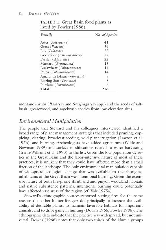
montane shrubs (Rosaceae and Saxifragaceae spp.) and the seeds of salt-bush, greasewood, and sagebrush species from low-elevation sites.
Environmental ManipulationThe people that Steward and his colleagues interviewed identified abroad range of plant management strategies that included pruning, cop-picing, clearing, broadcast seeding, wild plant irrigation (Lawton et al.1976), and burning. Archeologists have added agriculture (Wilde andNewman 1989) and surface modifications related to water harvesting(Irwin-Williams et al. 1990) to the list. Given the low population densi-ties in the Great Basin and the labor-intensive nature of most of thesepractices, it is unlikely that they could have affected more than a smallfraction of the landscape. The only environmental manipulation capableof widespread ecological change that was available to the aboriginalinhabitants of the Great Basin was intentional burning. Given the exten-sive nature of both fire-prone shrubland and pinyon woodland habitatsand native subsistence patterns, intentional burning could potentiallyhave affected vast areas of the region (cf. Vale 1975a).
Steward’s ethnographic sources reported setting fires for the samereasons that other hunter-foragers do: principally to increase the avail-ability of desirable plants, to maintain favorable habitats for importantanimals, and to drive game in hunting (Downs 1966; Fowler 1986). Theethnographic data indicate that the practice was widespread, but not uni-versal. Downs (1966) notes that only two-thirds of the Numic groups
84 D u a n e G r i f f i n
TABLE 3.1. Great Basin food plants aslisted by Fowler (1986).
Family No. of Species
Aster (Asteraceae) 41Grass (Poaceae) 39Lily (Lilaceae) 27Goosefoot (Chenopodaceae) 22Parsley (Apiaceae) 22Mustard (Brassicacea) 15Buckwheat (Polygonaceae) 14Phlox (Polemoniaceae) 14Amaranth (Amaranthaceae) 8Blazing Star (Losaceae) 8Purslane (Portulaceae) 6Total 216
interviewed in the 1930s reported using intentional burning as a man-agement strategy. The Washoe even specifically denied setting fires.
Two related problems arise when assessing the degree to which theethnographies reflect prehistoric practices. The first is the question ofaccuracy: how closely did ethnographic informants’ interview responsesreflect actual practice? The second is the question of representativeness:to what degree did the ethnographic data reflect practices used in otherplaces and, especially, at other times?
Both accuracy and representativeness are limited by the late date atwhich data collection began. By the time extensive ethnographic workbegan in the 1930s, most native populations in the Great Basin had beenmoved to reservations and were at their historic nadirs (Leland 1986).Reservation dwellers continued to hunt and collect wild plants (orremembered having done so), but many traditional practices had beenmodified, abandoned, and forgotten (Service 1962). Others—includingintentional burning—had been vilified by white culture, which may haveaffected responses to the ethnographers’ questions (Downs 1966). Assuch, it is impossible to determine what, exactly, the ethnographic datarepresent. On the one hand, they may record the ancient practice ofintentional burning as it was in the process of dying away. On the other,Great Basin people may have used intentional burning as an intensifica-tion strategy in response to changes in ecology, mobility, populationdensity, and even climate that occurred in the protohistoric and early his-toric periods.
Historical sources (e.g., Shinn 1980; Gruell 1985) suggest that inten-tional burning was not entirely a post-nineteenth-century practice.Indeed, the first written description of the region, the log of theDominguez-Escalante expedition, records the intentional firing of once-extensive grasslands (see Cottam 1961) as the party passed through theeastern Great Basin in the autumn of 1776 (Chavez and Warner 1976).Subsequent visitors recorded Indian-set fires as well. Gruell (1985) iden-tified early historical descriptions of forty-three fires in the Great Basin,twenty-six of which (60 percent) were reported as having been set inten-tionally.
As with the ethnographic record, questions of accuracy and represen-tativeness make it impossible to know what these descriptions representin terms of premodern fire regimes. As Baker (chapter 2 of this volume)notes, awareness of the commonness of lightning as an ignition source isa twentieth-century phenomenon, and most historical accounts of wild-land fire ignitions are likely to be biased. Furthermore, even if the his-torical record is accurate, it may reflect postcontact changes in aborigi-nal society and ecology. For example, unlike most historical fire reports,
P R E H I STOR I C H U M A N I M PAC T S ON F I R E R E G I M E S 85

the Dominguez-Escalante account appears to be based on the friars’direct observations and corroborated by their translator and guide. Thuswe can reasonably assume it to be an accurate and reliable account ofintentional burning by local Paiutes. It may not, however, be represen-tative. Dominguez and Escalante speculated that the local Paiute, seeingmounted riders approaching, assumed their expedition was a group ofComanches and fired the grasslands to deprive their party of forage(Chavez and Warner 1976).
This interpretation reflects the fact that the effects of European colo-nization preceded face-to-face contact between the colonists and inhab-itants of the Great Basin. Among the earliest impacts of contact were theintroduction of European diseases and adoption of the horse by the Ute,northern Paiute, northern Shoshone, and neighboring tribes to thenorth, south, and west of the region by 1700 (Arkush 1990). The firstdisease epidemics may have predated European incursions into theregion by more than a century (Grayson 1993), affecting the demo-graphic structure of Great Basin societies. Similarly, the presence of fleet,highly mobile, horse-mounted hunting and raiding parties affected manyaspects of life in the Great Basin, including the availability of game ani-mals and patterns of conflict. It is possible that the pressures thesechanges induced led the Paiute and other Great Basin peoples either toalter their ecological practices (increased dependence on grasslands andintensifying fire regimes to support or expand them) or to set fires as adefensive strategy.
Fowler (1986) suggests that Dominguez and Escalante witnessed theannual (or semiannual) practice of autumn burning rather than a proto-historic Paiute defensive tactic. She bases this interpretation on that factthat everything we know about aboriginal subsistence practices, vegeta-tion dynamics, and fire ecology in the intermountain West suggests thatGreat Basin peoples and their prehistoric forebears had very good rea-sons to set fires if they did not occur naturally.
Fire and SuccessionContemporary range management and fire control issues have guidedresearch on fire ecology in the northern intermountain West (e.g.,Wright and Bailey 1982; Britton and Clark 1985; Bunting 1985; Win-ward 1985; Whisenant 1990; Knapp 1997, 1998). Little empiricalresearch has been conducted on past fire regimes, especially in low-ele-vation and foothill communities in the Great Basin (Heyerdahl et al.1995; Miller 2000). Most of what we do know of fire history in sage-brush and pinyon-juniper ecosystems comes from studies focused onunderstanding the historic expansion of pinyon-juniper woodland (e.g.,
86 D u a n e G r i f f i n
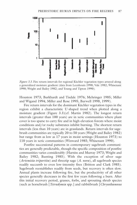
Houston 1973; Burkhardt and Tisdale 1976; Mehringer 1985; Millerand Wigand 1994; Miller and Rose 1995; Burwell 1998, 1999).
Fire return intervals for the dominant Küchler vegetation types in theregion exhibit a characteristic U-shaped trend when plotted along amoisture gradient (Figure 3.3)(cf. Martin 1982). The longest returnintervals (greater than 100 years) are in xeric communities where plantcover is too sparse to carry fire and in high-elevation forests where moistconditions and/or rocky substrates inhibit burning. The shortest returnintervals (less than 10 years) are in grasslands. Return intervals for sage-brush communities are typically 20 to 50 years (Wright and Bailey 1982)but range from as low as 17 years in moist settings (Houston 1973) to110 years in xeric communities (Winward 1985; Whisenant 1990).
Postfire successional patterns in contemporary sagebrush communi-ties are generally predictable, though the specific composition of postfirecommunities varies considerably (Harniss and Murray 1973; Wright andBailey 1982; Bunting 1985). With the exception of silver sage(Artemisia tripartita) and threetip sage (A. nova), all sagebrush speciesreadily succumb to even low-intensity fires (Britton and Clark 1985).Sagebrush reestablishes readily from seeds, but recovery is often slow.Annual plants increase following fire, but the productivity of all otherspecies generally decreases in the first few years following a burn. Afterthis initial recovery period, grasses, forbs, and sprouting shrub species(such as horsebrush [Tetradymia spp.] and rabbitbrush [Chrysothamnus
P R E H I STOR I C H U M A N I M PAC T S ON F I R E R E G I M E S 87
Figure 3.3. Fire return intervals for regional Küchler vegetation types arrayed alonga generalized moisture gradient (data from Leenhouts 1998; Vale 1982; Whisenant1990; Wright and Bailey 1982; and Young and Tipton 1990).

spp.]) show marked biomass and productivity increases that may persistfor up to 20 years. Sagebrush recovers slowly, reaching preburn levels ofbiomass and productivity after 30 to 50 years, with concomitantdecreases in grasses, forbs, and other shrub species. If no further burnsoccur, sagebrush communities (except those on the driest sites) tendeither to grow into dense thickets or to be invaded by trees (e.g., Vale1975b; Wright and Bailey 1982).
Above the sagebrush zone, higher effective moisture supports thegrowth of pinyon and juniper trees as well as greater fine-fuel produc-tivity. The likelihood of lightning ignitions also increases with elevation(Reap 1986). As a result, fire return intervals are generally shorter inpinyon and juniper woodlands than they are in the sagebrush communi-ties, at least in the absence of domestic livestock grazing (Wright andBailey 1982; Agee 1993).
Succession in the understory of pinyon and juniper woodland is sim-ilar to that in sagebrush communities. A flush of annual forbs (andresprouting shrubs, if present) appears in the first 3 years, followed byincreases in perennial grasses and forbs. Sagebrush and other non-sprouting shrubs begin to reestablish after 6 years and can, barring fur-ther fires, eventually develop into thickets and dominate sites until over-topped by trees (Wright and Bailey 1982). Small pinyon and junipertrees (less than 1.2 meters tall) are readily killed by fire, though maturetrees are rarely susceptible to ground fires unless fine-fuel accumulationsare exceptionally heavy (Bruner and Klebenow 1978; Wright and Bailey1982). Fire return intervals of 10 to 30 years—variable enough to ensurereproduction but short enough to suppress both seedling survival anddense shrubs—served to keep pinyon and juniper woodlands open andsavanna-like and limited to steep, rocky, and/or dissected terrain (Westet al. 1975; West 1984, 1988; Burwell 1998, 1999).
Prehistoric Human Impacts on Fire Regimes: HypothesesThe ecological and ethnographic generalizations described above sug-gest that frequent to intermediate disturbance rates in both shrub com-munities and pinyon woodlands would have supported the subsistencepatterns that Steward and other anthropologists have described.
In shrublands, patchy mosaics of early- and midsuccessional commu-nities would have supported a greater range of economically useful plantspecies (and the animals that fed upon them; Klebenow 1985; Nydeggerand Smith 1986) than senescent stands of sagebrush. In pinyon wood-lands, the ideal fire regime would presumably have allowed stands ofnut-bearing trees to develop and persist wherever suitable habitatsexisted while maintaining an herbaceous understory as well. Annual
88 D u a n e G r i f f i n

forbs such as sunflower (Helianthus annuus) and wild tobacco (Nico-tiana atenuata) thrive in the early- and midsuccessional pinyon pinecommunities, as do Great Basin wildrye (Elimus cinereus), Indian rice-grass (Oryzopsis hymenoides), and other useful perennial species (Wrightand Bailey 1982). Frequent, low-intensity fires would have ensured theavailability of these resources while killing off tree seedlings and shrubsand thus reduced the possibility of catastrophic fires.
That Great Basin peoples benefited from periodic fires does not, ofcourse, mean that they needed to set them. Fires will not burn unlessfuel loads are sufficient to support their spread. It is entirely possible thatnatural ignition sources were sufficient to maintain the types of land-scapes on which aboriginal hunter-foragers depended.
Some authors (e.g., Shinn 1980; Harper 1986) have assumed thatIndian burning was both widespread and ecologically significant. Others(e.g., West 1988) assume that native burning could not have beenimportant and contend that the vegetation of the intermountain regionwas pristine at the time of European contact. In fact, with the exceptionof a few studies from the northern sagebrush steppes (Burkhardt andTisdale 1976; Mehringer 1985; Wigand 1987; Miller and Wigand 1994;see Whitlock and Knox, chapter 6 of this volume), we know little aboutthe prehistoric distribution of fires in the region and almost nothingabout prehistoric environmental manipulation in the region (Rhode1999). Our knowledge of past ignition sources is similarly thin. Usingtree-ring evidence, Wadleigh and Jenkins (1996) suggested that thepaucity of fires in the montane forests of northern Utah before 1859indicates that fire regimes there had been ignition-limited prior to Mor-mon settlement of the area. However, it is not clear what this mightimply for prehistoric fire regimes in the lower-elevation shrublands andwoodlands, especially since their data only extend back to 1700, andthey did not consider the possibility of climate change as an alternativeexplanation for the change in fire frequency.
Modern fire regimes reflect the effects of dramatically altered bioticlandscapes (Knapp 1998) and thus are poor analogs for pre-Columbianconditions. But because the simplest hypothesis about past patterns isthat they are similar to those we see today, contemporary data providea basis for positing testable null hypotheses about past conditions. TheNational Fire Occurrence Database (Schmidt et al., forthcoming) is acompilation of all available records from federal and state land manage-ment agencies from 1986 through 1996. More than 14,500 firesoccurred on federal lands within the study area during this period (Fig-ure 3.4), and their spatial and temporal distributions provide anoverview of regional patterns of fire ignitions in the intermountainWest.
P R E H I STOR I C H U M A N I M PAC T S ON F I R E R E G I M E S 89

Fires were most common in the mountains surrounding the region,along the central arch of the Great Basin, and in the northern plains (cf.Knapp 1997). Lightning associated with thunderstorm activity betweenJune and September (Figure 3.5) ignited most fires (65 percent), thoughthere is little correlation between lightning-ignited fires and publishedmaps of cloud-to-ground lightning flash densities (Orville 1991; Orvilleand Silver 1997). Flash densities decrease from 1–3 flashes per square kmin Utah to 0–0.5 flash per square km in western Nevada and California.The relative proportion of “hot” lightning strikes (i.e., positive cloud-to-ground flashes with a continuing current) trends in the opposite direc-
90 D u a n e G r i f f i n
Figure 3.4. Locations of all fires on federal lands from 1986 through 1996 listed inthe National Fire Occurrence Database (Schmidt et al., forthcoming). State agencyrecords are less uniform than federal sources and are not included.

tion. These strikes, which are more likely to result in ignitions, are pro-portionally higher (3.1 percent to as high as 12.5 percent of lightningflashes) in the northwest and the lowest (1.6 to 3.1 percent) in thesoutheast. Neither pattern corresponds to the pattern of lightning-ignited fires in the region. This is consistent with Knapp’s (1997, 1998)findings that fuel conditions and topography seem to be the primarycontrols on both ignitions and area burned.
Anthropogenic ignitions account for 32 percent of all fires, butaccounted for most ignitions (80 percent) between October and April,and the annual number of fires attributed to people shows greater year-to-year constancy than lightning ignitions (Figure 3.5). The relativeimportance of anthropogenic ignitions is greatest in the northern half ofthe region, particularly near populated areas such as the Wasatch Frontand the Snake River Plains (Figure 3.6). Linear concentrations of igni-tions caused by people are evident along the Snake and Humboldt Riversand the highways that follow their courses.
P R E H I STOR I C H U M A N I M PAC T S ON F I R E R E G I M E S 91
Figure 3.5. Temporal distribution of fires and ignition sources in the study area,1986–1996 (by month and year).

These patterns suggest at least four hypotheses about aboriginalimpacts on prehistoric fire regimes. First, anthropogenic ignitions wereless important than lightning ignitions across most of the region, andfew fires occurred outside of sagebrush shrubland, pinyon-juniper wood-land, and montane forest communities. Second, anthropogenic burningwas locally most important in the northern part of the region, particu-larly in areas with high population densities, including transportationcorridors, waterways, and water bodies. Third, aboriginal fire practicesserved to keep year-to-year ignition frequencies more constant then theywould have been without human intervention. Finally, human alteration
92 D u a n e G r i f f i n
Figure 3.6. Areas where human activities ignited more than half of all fires on fed-eral lands from 1986 through 1996 (values calculated using a 40-km-radius filter).

in fire regimes ensured that more fires burned during the autumn, win-ter, and spring than would have occurred under natural conditions.
EvaluationThese four hypotheses are, at least in principle, testable. The first twomay be amenable to empirical investigation. The third and fourth canprobably only be addressed through some combination of empiricalwork and modeling. Conducting such tests, if it is to be done at all, willrequire a great deal of interdisciplinary collaboration. A reasonable firststep would be to collect and integrate existing information and knowl-edge that is currently scattered across various academic disciplines, gov-ernment agencies, and other institutions. The goal of this effort shouldbe to identify the gaps in our knowledge of both human and ecologicalprehistory at spatial scales, time frames, and levels of resolution appro-priate to the questions being addressed. Once identified, we can beginfilling in these gaps as needed.
The primary difficulty in evaluating human impacts on fire regimes inthe distant past is arriving at independent estimates of fire and lightningfrequencies. Such estimates have proven difficult to obtain using thestandard approaches to paleoecological reconstruction. Dendrochrono-logical methods allow tremendously detailed fire histories for some typesof forest communities. Analyses of microfossils, macrofossils, charcoal,and chemical clues from lake sediments, packrat middens, and caves pro-vide insight into past ecological communities and environmental condi-tions. But none of these methods can tell us anything about ignitionsources. It may, however, be possible to reconstruct past frequencies oflightning strikes and past fire regimes geomorphologically.
One of the key limitations to reconstructing fire histories in the inter-mountain West is simply the paucity of forests and trees available for fire-scar analysis. The periodic drying and alkaline chemistry of its playa lakessimilarly limit the effectiveness of pollen analysis, though charcoalrecords should be less affected and probably deserve greater attention.The most promising approach to reconstructing fire histories in theregion may be geomorphic. Fires are geomorphic as well as biologicalevents, and alluvial fan sediments should record those events (e.g.,Meyer and Wells 1997). It may, therefore, be possible to reconstruct pastfire frequencies and spatial distributions through careful stratigraphicwork.
Cloud-to-ground lightning strikes sometimes fuse silica particles insoils to form hollow glass tubes called fulgurites. Sponholz et al. (1993)used excavated fulgurites to reconstruct Holocene thunderstorm fre-quencies in the Sahara. It might be possible to adapt their approach to
P R E H I STOR I C H U M A N I M PAC T S ON F I R E R E G I M E S 93

Great Basin environments to reconstruct past lightning frequencies.Combined with archeological and paleoecological data, such reconstruc-tions might make it possible to identify patterns of fire, lightning activ-ity, and human activity that tell us a great deal about prehistoric rela-tionships between Great Basin peoples and the environments theyinhabited.
An assessment of these relationships is long overdue. In a recentreview of the rich relationship between Great Basin paleoecology andarcheology, David Rhode (1999) notes that anthropologists have gener-ally assumed that native environmental modifications have been minorand possibly recent. He comments (pp. 44–45):
The fact is that we have little idea how much native peoplesmanaged and shaped parts of the prehistoric environment.Obviously people have influenced many ecosystems inmany different and significant ways, they have not beenpassive recipients of whatever Nature dishes out. The pre-historic inhabitants of the Great Basin could have exerted,and probably did exert, very significant environmentaleffects at some times and in certain areas.
After listing several possible impacts (altered wildlife populations, thepossible role of humans in dispersing pinyon pine, and the use of fire),he concludes (p. 44) by saying that
Documenting whether people had important environmen-tal effects in the prehistoric Great Basin will not be an easytask; indeed, it may be very difficult. But if we were to tryand find out, we might learn an awful lot about how GreatBasin environments work, now and in the past, and wemight learn much more about the people who workedthose environments.
Just as the Great Basin was the last great blank space to be filled byAmerican cartographers, its late Holocene ecological history and bio-geography remain underexplored in comparison with other parts of thecontinent. The significance of this lacuna is not merely academic.
Visually, much of the modern northern intermountain West stillresembles the landscapes described in early accounts of the region (Vale1975a), but this superficial resemblance is deceiving (Rogers 1982).Plant macrofossils and pollen from packrat middens collected from Capi-tol Reef National Park, Utah, indicate that vegetation changes in the pasttwo centuries have been more severe than any in the past 5,400 years(Cole et al. 1997). The same is likely to be true for most, if not all, landsin the northern intermountain West. Livestock grazing, range conver-
94 D u a n e G r i f f i n

sions, mining, timber harvesting, fire suppression, hunting and gamemanagement, military testing and training, road building, urbanization,interbasin water transfers, atmospheric pollution and (possibly) carbondioxide fertilization, the introduction of exotic plant and animal speciesand the extinction or extirpation of native ones, and other modernhuman activities and impacts have altered the intermountain West’s bio-physical landscapes, fundamentally and probably irreversibly (D’Antonioand Vitousek 1992; Turner et al. 1993; Knapp 1996). However inten-sive native peoples’ landscape manipulations might have been, they fadeto insignificance in comparison.
More than 90 percent of the northern intermountain West is feder-ally managed land, and the future biological status of this vast area will,to a great degree, reflect the policy and management decisions made inthe next few decades. Better understanding of past human manipulationsin the northern intermountain West may allow us to understand betterits regional ecology as it continues to organize itself in the context ofbiophysical conditions and constraints that have never before existed.
AcknowledgmentsI would like to thank Kirsten Schmidt of the USDA Forest Service,Rocky Mountain Research Station, Fire Sciences Laboratory in Mis-soula, Montana, and Cindy Savoie of the Western Great Basin Coordi-nation Center in Reno, Nevada, for providing data. I would also like to thank Tom Vale and two reviewers for their comments on earlierdrafts of the manuscript, and Eric Olmanson and Anne Griffin for their help. This research was supported in part by the NSF Postdoctoral Fel-lowship in Science, Mathematics, and Engineering Education program(DGE–9714534).
Literature CitedAgee, J. K. 1993. Fire ecology of Pacific Northwest forests. Washington, D.C.:
Island Press.Arkush, B. S. 1990. The protohistoric period in the western Great Basin. Jour-
nal of California and Great Basin Anthropology 12:28–36.Axelrod, D. I. 1976. History of the coniferous forests, California and Nevada.
Berkeley: University of California Press.Bettinger, R. L. 1999. What happened in the Medithermal. Pp. 62–74 in Mod-
els for the millennium: Great Basin archeology today, ed. C. Beck. Salt LakeCity: University of Utah Press.
Billings, W. D. 1951. Vegetational zonation in the Great Basin of western NorthAmerica. Pp. 101–122 in Les bases écologiques de la régénération de la végétationdes zones arides. International Union of Biological Sciences, series B, no. 9.
P R E H I STOR I C H U M A N I M PAC T S ON F I R E R E G I M E S 95
———. 1954. Temperature inversions in the pinyon-juniper zone of a Nevadamountain range. Butler University Botanical Studies 11:112–118.
Blackburn, W. H., and P. Tueller. 1970. Pinyon and juniper invasion in blacksagebrush communities in east central Nevada. Ecology 51:841–848.
Britton, C. M., and R. G. Clark. 1985. Effects of fire on sagebrush and bitter-brush. Pp. 22–26 in Rangeland fire effects: A symposium, ed. K. Sanders andJ. Durham. Boise: USDI Bureau of Land Management, Idaho State Office.
Bruner, A. D., and D. A. Klebenow. 1978. A technique to burn pinyon-juniperwoodlands in Nevada. General technical report INT-219. Ogden, Utah:USDA Forest Service, Intermountain Forest and Range Experiment Station.
Bunting, S. C. 1985. Fire in sagebrush-grass ecosystems: Successional change.Pp. 7–11 in Rangeland fire effects: A symposium, ed. K. Sanders and J.Durham. Boise: USDI Bureau of Land Management, Idaho State Office.
Burkhardt, J. W., and E. W. Tisdale. 1976. Causes of juniper invasion in south-western Idaho. Ecology 76:472–484.
Burwell, T. 1998. Successional patterns of the lower montane treeline, easternCalifornia. Madroño 45:12–16.
———. 1999. Environmental history of the lower montane pinyon (Pinusmonophylla) treeline, eastern California. Ph.D. diss., University of Wisconsin.
Chavez, F. A., and T. J. Warner, eds. 1976. The Dominguez-Escalante journal:Their expedition through Colorado, Utah, Arizona and New Mexico in 1776.Provo, Utah: Brigham Young University Press.
Christensen, E., and H. Johnson. 1964. Presettlement vegetation and vegeta-tion change in three valleys in central Utah. Brigham Young University ScienceBulletin 4:5–16.
Cole, K. L., N. Henderson, and D. S. Shafer. 1997. Holocene vegetation andhistoric grazing impacts at Capitol Reef National Park reconstructed usingpackrat middens. Great Basin Naturalist 57:315–326.
Cook, S. F. 1955. The epidemic of 1830–1833 in California and Oregon. Uni-versity of California Publications in American Archeology and Ethnology43:303–326.
Cottam, W. P. 1961. Our renewable wild lands—A challenge. Salt Lake City:University of Utah Press.
Cronquist, A., A. H. Holmgren, N. H. Holmgren, and J. L. Reveal. 1972.Intermountain flora: Vascular plants of the intermountain West, U.S.A. NewYork: Hafner Publishing.
D’Antonio, C. M., and P. M. Vitousek. 1992. Biological invasions by exoticgrasses, the grass/fire cycle, and global change. Annual Review of Ecology andSystematics 23:63–87.
D’Azavedo, W., ed. 1986. Handbook of North American Indians, vol. 11: GreatBasin. Washington, D.C.: Smithsonian Institution.
Denevan, W. M. 1992. The pristine myth: The landscape of the Americas in1492. Annals of the Association of American Geographers 82:369–385.
Downs, J. F. 1966. The significance of environmental manipulation in Greatbasin cultural development. Pp. 39–55 in The current status of anthropologicalresearch in the Great Basin: 1964, ed. W. L. d’Azevedo et al. University ofNevada Desert Research Institute social sciences and humanities publication 1.
96 D u a n e G r i f f i n

Fenneman, N. M. 1931. Physiography of western United States. New York:McGraw-Hill.
Fowler, C. 1982. Food-named groups among Northern Paiute in North Amer-ica’s Great Basin: An ecological interpretation. Pp. 113–129 in Resource man-agers: North America and Australia hunter-gatherers, ed. N. M. Williams andE. S. Hahn. Boulder: Westview Press.
———. 1986. Subsistence. Pp. 64–97 in Handbook of North American Indians,vol. 11: Great Basin, ed. W. D’Azavedo. Washington, D.C.: SmithsonianInstitution.
———. 2000. We live by them: Native knowledge of biodiversity in the GreatBasin of western North America. Pp. 99–132 in Biodiversity and Native Amer-ica, ed. P. E. Minnis and W. J. Elisens. Norman: University of OklahomaPress.
Grayson, D. K. 1993. The desert’s past: A natural prehistory of the Great Basin.Washington, D.C.: Smithsonian Institution.
Gruell, G. E. 1985. Fire on the early western landscape: An annotated record ofwildland fires 1776–1900. Northwest Science 59:97–107.
Harniss, R. O., and R. B. Murray. 1973. Thirty years of vegetational change fol-lowing burning of sagebrush-grass range. Journal of Range Management26:320–325.
Harper, K. T. 1986. Historical environments. Pp. 51–63 in Handbook of NorthAmerican Indians, vol. 11: Great Basin, ed. W. D’Azavedo. Washington,D.C.: Smithsonian Institution.
Harper, K. T., D. L. Freeman, W. K. Ostler, and L. G. Klikoff. 1978. The floraof Great Basin mountain ranges: Diversity, sources, and dispersal ecology. Pp.81–104 in Intermountain biogeography: A symposium, ed. K. T. Harper and J.L. Reveal. Great Basin naturalist memoirs 2.
Heyerdahl, E. K., D. Berry, and J. K. Agee. 1995. Fire history database of theWestern United States. Interagency Agreement DW12934530. U.S. Environ-mental Protection Agency, USDA Forest Service, University of Washington.On the Web at http://www.fsl.orst.edu/lter/datafr.htm, July 1998.
Hidy, G. M., and H. E. Klieforth. 1990. Atmospheric processes affecting the cli-mate of the Great Basin. Pp. 17–45 in Plant biology of the basin and range, ed.C. B. Osmond, L. F. Pitelka, and G. M. Hidy. New York: Springer-Verlag.
Holmgren, N. H. 1972. Plant geography of the Intermountain region. Pp.77–161 in Intermountain flora: Vascular plants of the intermountain West,U.S.A., vol. 1, ed. A. Cronquist, A. H. Holmgren, N. H. Holmgren, and J.L. Reveal. New York: Hafner Publishing.
Houghton, J. G., C. M. Sakamoto, and R. O. Gifford. 1975. Nevada’s weatherand climate. Reno: Nevada Bureau of Mines and Geology (special publication2).
Houston, D. B. 1973. Wildfires in northern Yellowstone National Park. Ecology54:1111–1114.
Hull, A. C., Jr., and M. K. Hull. 1974. Presettlement vegetation of Cache Val-ley, Utah and Idaho. Journal of Range Management 27:27–29.
Irwin-Williams, C. C., C. B. Osmond, A. J. Dansie, and L. F. Pitelka. 1990.Man and plants in the Great Basin. Pp. 1–15 in Plant biology of the basin and
P R E H I STOR I C H U M A N I M PAC T S ON F I R E R E G I M E S 97

range, ed. C. B. Osmond, L. F. Pitelka, and G. M. Hidy. Berlin: Springer-Ver-lag.
Jennings, J., and E. Norbeck. 1955. Great Basin prehistory: A review. AmericanAntiquity 21:1–11.
Klebenow, D. A. 1985. Big game response to fire in sagebrush-grass rangelands.Pp. 53–57 in Rangeland fire effects: A symposium, ed. K. Sanders and J.Durham. Boise: USDI Bureau of Land Management, Idaho State Office.
Knapp, P. A. 1996. Cheatgrass (Bromus tectorum L) dominance in Great BasinDesert. Global Environmental Change 6:37–52.
———. 1997. Spatial characteristics of regional wildfire frequencies in inter-mountain West grass-dominated communities. Professional Geographer49:39–51.
———. 1998. Spatio-temporal patterns of large grassland fires in the inter-mountain West, U.S.A. Global Ecology and Biogeography Letters 7:259–272.
Küchler, A. W. 1985. Potential natural vegetation. National atlas of the UnitedStates of America (1:7,500,000 scale map). Reston, Va.: Department of theInterior, U.S. Geological Survey.
Lawton, H. W., P. J. Wilke, M. DeDedker, and W. M. Mason. 1976. Agricul-ture among the Paiute of Owens Valley. Journal of California Anthropology3:13–50.
Leenhouts, B. 1998. Assessment of biomass burning in the conterminousUnited States. Conservation Ecology 2. On the Web at http://www.consecol.org/vol2/iss1/art1.
Leland, J. 1986. Population. Pp. 608–619 in Handbook of North AmericanIndians, vol. 11: Great Basin, ed. W. D’Azavedo. Washington, D.C.: Smith-sonian Institution.
Lewis, H. T. 1981. Hunter-gatherers and problems for fire history. Pp. 115–119in Proceedings of the fire history workshop, ed. M. A. Stokes and J. H. Dieterich.General technical report RM-81. Fort Collins, Colo.: USDA Forest Service,Rocky Mountain Forest and Range Experiment Station.
Martin, R. E. 1982. Fire history and its role in succession. Pp. 92–99 in Forestsuccession and stand development in the northwest, ed. J. E. Means. Corvallis:Forest Research Laboratory, Oregon State University.
Mehringer, P. J., Jr. 1985. Late-Quaternary pollen records form the interiorPacific Northwest and Northern Great Basin of the United States. Pp.167–190 in Pollen records of late-Quaternary North American sediments, ed.V. M. Bryant, Jr., and R. G. Holloway. Dallas: American Association of Strati-graphic Palynologists.
Meyer, G. A., and S. G. Wells. 1997. Fire-related sedimentation events on allu-vial fans, Yellowstone National Park, USA. Journal of Sedimentary Research A:Sedimentary Petrology and Processes 67:776–791.
Miller, R. F. 2000. Fire history in the intermountain sagebrush steppe. Projectdescription, U.S. Geological Survey Forest and Rangeland Ecosystem ScienceCenter Project No. 70-88. On the Web at http://webdata.fsl.orst.edu, July 31,2000.
Miller, R. F., and J. A. Rose. 1995. Historic expansion of Juniperus occidentalis
98 D u a n e G r i f f i n

(western juniper) in southeastern Oregon. Great Basin Naturalist55(1):37–45.
Miller, R. G., and P. E. Wigand. 1994. Holocene changes in pinyon-juniperwoodlands: Response to climate, fire, and human activities in the U.S. GreatBasin. BioScience 44:465–474.
Muir, J. 1911. The mountains of California. New York: Century.Nydegger, N. C., and G. W. Smith. 1986. Prey populations in relation to
Artemisia vegetation types in southwestern Idaho. Pp. 152–156 in Proceed-ings—Symposium on the biology of Artemisia and Chrysothamnus, ed. E. D.McArthur, E. Durant, and B. L. Welch. General technical report INT-200.Ogden, Utah: USDA Forest Service, Intermountain Research Station.
Orville, R. E. 1991. Lightning ground flash density in the contiguous UnitedStates—1989. Monthly Weather Review 119:573–577.
———. 1994. Cloud-to-ground lightning flash characteristics in the contiguousUnited States: 1989–1991. Journal of Geophysical Research 99:10833–10841.
Orville, R. E., and A. C. Silver. 1997. Lightning ground flash density in the con-tiguous United States: 1992–95. Monthly Weather Review 125:631–638.
Reap, R. M. 1986. Evaluation of cloud-to-ground lightning data from the west-ern United States for 1983–84 summer seasons. Journal of Climate andApplied Meteorology 25:785–799.
Rhode, D. 1999. The role of paleoecology in the development of Great Basinarcheology, and vice versa. Pp. 29–49 in Models for the millennium: GreatBasin archeology today, ed. C. Beck. Salt Lake City: University of Utah Press.
Rogers, G. F. 1982. Then and now: A photographic history of vegetation changein the central Great Basin desert. Salt Lake City: University of Utah Press.
Schmidt, K. M., J. P. Menakis, C. C. Hardy, D. L. Bunnell, and N. Sampson.Forthcoming. Development of coarse-scale spatial data for wildland fire andfuel management. General technical report RMRS-CD-000. Ogden, Utah:USDA Forest Service, Rocky Mountain Research Station.
Service, E. R. 1962. Primitive social organization. New York: Random House.Shinn, D. E. 1980. Historical perspectives on range burning in the inland Pacific
Northwest. Journal of Range Management 33:415–423.Shreve, F. 1942. The desert vegetation of North America. Botanical Review
8:195–246.Sponholz, B. R. Baumhauer, and P. Felix-Henningsen. 1993. Fulgurites in the
southern central Sahara, Republic of Niger, and their paleoenvironmental sig-nificance. The Holocene 3:97–104.
Steward, J. H. 1938. Basin-Plateau aboriginal sociopolitical groups. Bureau ofAmerican Ethnology Bulletin 120.
Thomas, D. H. 1973. An empirical test for Steward’s model of Great Basin set-tlement patterns. American Antiquity 38(2):155–176.
Trimble, S. 1989. The sagebrush ocean: A natural history of the Great Basin.Reno: University of Nevada Press.
Turner, M. G., W. H. Romme, R. H. Gardner, R. V. O’Neill, and T. K. Kratz.1993. A revised concept of landscape equilibrium: Disturbance and stabilityon scaled landscapes. Landscape Ecology 8:213–227.
P R E H I STOR I C H U M A N I M PAC T S ON F I R E R E G I M E S 99

Vale, T. R. 1975a. Presettlement vegetation in sagebrush/grass area of the inter-mountain West. Journal of Range Management 28:32–36.
———. 1975b. Invasion of big sagebrush (Artemisia tridentata) by white fir(Abies concolor) on the southeastern slopes of the Warner Mountains, Califor-nia. Great Basin Naturalist 35:319–324.
———. 1982. Plants and people: Vegetation change in North America. Washing-ton, D.C.: Association of American Geographers.
———. 1998. The myth of the humanized landscape: An example fromYosemite National Park. Natural Areas Journal 18:231–236.
Wadleigh, L., and M. J. Jenkins. 1996. Fire frequency and the vegetative mosaicof a spruce-fir forest in northern Utah. Great Basin Naturalist 56:28–37.
Wigand, P. E. 1987. Diamond Pond, Harney County, Oregon—Vegetation his-tory and water-table in the eastern Oregon desert. Great Basin Naturalist47:427–458.
Wells, P. V. 1983. Paleobiogeography of montane islands in the Great Basinsince the last glaciopluvial. Ecological Monographs 53:341–382.
West, N. E. 1984. Successional patterns and productivity potentials of pinyon-juniper ecosystems. Pp. 1302–1332 in Developing strategies for rangelandmanagement, National Research Council/National Academy of Sciences,Boulder: Westview Press.
———. 1988. Intermountain deserts, shrub steppes, and woodlands. Pp.211–230 in North American terrestrial vegetation, ed. M. G. Barbour and W.D. Billings. Cambridge: Cambridge University Press.
West, N. E., K. H. Rhea, and T. I. Tausch. 1975. Basic synecological relation-ships in juniper-pinyon woodlands. Pp. 41–53 in The pinyon-juniper ecosystem:A symposium, ed. G. F. Gifford and F. E. Busby, Utah Agricultural ExperimentStation.
Whisenant, S. J. 1990. Changing fire frequencies on Idaho’s Snake River plains:Ecological and management implications. Pp. 4–10 in Proceedings—Sympo-sium on cheatgrass invasion, shrub die-off, and other aspects of shrub biology andmanagement, ed. E. D. McArthur, E. M. Romney, S. D. Smith, and P. T.Tueller, General technical report INT-276. Ogden, Utah: USDA Forest Ser-vice, Intermountain Research Station.
Wilde, J. D., and D. E. Newman. 1989. Late Archaic corn in the eastern GreatBasin. American Anthropologist 91:712–720.
Winward, A. H. 1985. Fire in the sagebrush-grass ecosystem—The ecologicalsetting. Pp. 2–6 in Rangeland fire effects: A symposium, ed. K. Sanders and J.Durham. Boise: USDI Bureau of Land Management, Idaho State Office.
Wright, H. A., and A. W. Bailey. 1982. Fire ecology, United States and southernCanada. New York: John Wiley.
Young, J. A., and F. Tipton. 1990. Invasion of cheatgrass into arid environmentsof the Lahontan basin. Pp. 37–40 in Proceedings—Symposium on cheatgrassinvasion, shrub die-off, and other aspects of shrub biology and management, ed.E. D. McArthur, E. M. Romney, S. D. Smith, and P. T. Tueller. General tech-nical report INT-256. Ogden, Utah: USDA Forest Service, IntermountainResearch Station.
100 D u a n e G r i f f i n

cc hh aa pp tt ee rr 44
FIRE IN THE PRE-EUROPEAN LOWLANDS OF
THE AMERICAN SOUTHWEST
Kathleen C. Parker
Historic accounts of Native American–ignited fires during the early Euro-pean settlement of the Southwest (Bahre 1985) have fostered claims thatpre-Columbian inhabitants of this region were masters at manipulatingtheir habitat through the use of fire (Dobyns 1981). Ethnographic stud-ies of modern aboriginal cultures that use fire to manage the environmenthave been extrapolated to faraway regions (Stewart 1956; Pyne 1982),including the prehistoric Southwest, thereby fueling these claims. Thischapter debates the validity of these arguments, with an emphasis onsouthern Arizona and New Mexico, where the pre-Columbian cultureshave been more thoroughly investigated than in northern Chihuahua andSonora (Spoerl and Ravesloot 1995). In lowland semiarid and arid partsof the intermountain region, where trees that record fires through scar-ring and wetlands that record fires in clear pollen/charcoal stratigraphiesare rare, there is little direct material evidence that indicates prehistoricfire regimes. Even where charred plant remains have been found in anarchaeological context, solid clues about the associated cultural practicesare scarce. Consequently, this chapter explores the aboriginal use of firein southern intermountain lowlands by first addressing several relatedindirect questions, then synthesizing the resulting lines of evidence. Thespecific questions addressed are: (1) What is the reference fire regime for
101

the lowlands of the Southwest—i.e., based on lightning ignitions alone,how frequently have the lowlands burned in the recent past? (2) Whatindigenous cultures inhabited the region before European contact; howdid their population levels fluctuate over time and space; and how did thelivelihoods of the different cultures vary, particularly with respect to theuse of fire? (3) How did past climates and vegetation differ from those oftoday in ways that would have led to long-term variation in the naturalfire regime? Finally, these are integrated to address the question: (4) Howdid the likely past frequency of aboriginal burning in this region compareto the frequency of lightning ignitions over time—i.e., when, where, andto what extent might human activities have altered the natural fireregime?
From available data that are relevant to these questions, several keypoints emerge. The southern intermountain lowlands have been charac-terized by a rich cultural history since humans first occupied this regionof the continent. Throughout the period of human occupancy, the useof fire has varied both spatially and temporally in this area as populationdensities, settlement patterns, and cultural practices have shifted with theevolution of the different cultural traditions. Once the modern climaticregime, with frequent summer thunderstorms, became established rela-tively early in the human settlement of the Southwest, any use of fire byindigenous peoples occurred against a backdrop of frequent lightningfires. For several millennia, fires ignited by lightning strikes during drysummer thunderstorms have been sufficiently frequent and extensive toaccount for the existence of vegetation shaped by fire where it has dom-inated the landscape. In certain places and during certain periods, burn-ing by native peoples may have significantly affected the vegetation at alocal scale by altering the seasonality or frequency of fire; these effectswere more likely in desert grasslands than in desertscrub because of theirmuch shorter natural fire return interval. Nonetheless, it is unlikely thatintentional burning by indigenous inhabitants profoundly altered thevegetation at a broad spatial scale.
The Physical Environment in Historic TimesEnvironmental systems display a variety of characteristics that vary inboth space and time. Two such characteristics, climate and vegetation,are particularly important influences on a third, the natural fire regime.
ClimateAlthough some regional variation in temperature and precipitationexists, the Southwest has four distinctive climatic periods throughout theyear (Burgess 1998). May and June are consistently hot, dry months,
102 K a t h l e e n C . P a r k e r

Figure 4.1. Map of the study area showing place-names mentioned and climate dia-grams for selected locations within the southern intermontane region: a. Sacaton,Arizona; b. Albuquerque, New Mexico; c. Jornada, New Mexico; d. Yuma, Ari-zona; e. El Oregano, Sonora; and f. Presidio, Texas. (Climatic data from NCDC’sGlobal Historical Climatology Network, version 1, dataset for El Oregano, andfrom NCDC’s TD 9641 Clim 81 1961–1990 Normals dataset for all other sta-tions, both available from http://www.worldclimate.com, visited May 5, 1999.)

with the highest water deficits of the year (Figure 4.1). The summermonsoon follows this dry period, when the influx of moist air from pri-marily the Gulf of California (Hales 1974) and increased convectiveactivity lead to the occurrence of spatially disparate, but locally intense,thunderstorms. The autumn is more unpredictable than the previoustwo periods; in most years conditions are dry, but occasional tropicalstorms make landfall to the south in Mexico and pass over the region,bringing enormous amounts of rainfall that can profoundly influence thevegetation of the region. In winter, cyclonic storms track through theregion and associated widespread frontal precipitation recharges soilmoisture. Overall, the region exhibits a bimodal precipitation regime,with a general decrease in both the summer and annual rainfall from eastto west (Figure 4.1). During El Niño–Southern Oscillation (ENSO)phenomena, the penetration of moist air into the Southwest during falland spring is enhanced, and rainfall tends to be higher than in non-ENSO years (Andrade and Sellers 1988; Swetnam and Betancourt1990).
VegetationThe southern intermountain lowlands include primarily desertscrub andsemidesert grassland. Together these vegetation types constitute over 70percent of the Southwest (Lowe and Brown 1982). Chaparral, wood-lands, and forests at higher elevations in the mountains and localizedwetlands are the main inclusions of other vegetation within the region.
The desertscrub of the Southwest has traditionally been divided intothe Sonoran and Chihuahuan Deserts on the basis of key components ofthe vegetation and their relationship to the environment (Figure 4.2;Shreve 1964). The Chihuahuan Desert (Figure 4.3a) extends from itsmain area of occurrence in northern Mexico into southeastern Arizona,southern New Mexico along the Rio Grande, and western Texas. Chi-huahuan desertscrub occurs primarily from 400 to 1,600 m in elevation;most of these areas receive 200 to 300 mm of rainfall per year, with astrong summer concentration. Creosotebush (Larrea tridentata) isdominant throughout the Chihuahuan Desert; the codominant speciesvary locally (Brown 1982a). On the plains, creosotebush occurs with tar-bush (Flourensia cernua) or whitethorn acacia (Acacia neovernicosa). Athigher elevations and on steeper slopes, succulents are more common,including lecheguilla (Agave lecheguilla) and several species of yucca(Yucca spp.), agave (Agave spp.), sotol (Dasylirion spp.), and beargrass(Nolina spp.; Brown 1982a). The Rio Grande and its tributaries drain tothe sea, but most other basins in the Chihuahuan Desert are internallydrained. Many of the basin floors support semidesert grasslands of
104 K a t h l e e n C . P a r k e r

tobosa (Hilaria mutica) or sacaton (Sporobolus wrightii, S. airoides),with occasional individuals of shrub species that are common in thegrasslands (e.g., mesquite, Prosopis glandulosa and P. juliflora). In con-trast to the Sonoran Desert, smaller stream courses lack physiognomi-cally distinctive riparian vegetation (Brown 1982a).
The northern Sonoran Desert includes both the open, floristicallysimple Lower Colorado River Valley and the more diverse, structurallycomplex Arizona Upland (Figures 4.3b and 4.3c); additional subdivi-sions occur farther south in Mexico (Shreve 1964). The Lower ColoradoRiver Valley, which includes terrain primarily below 600 m elevation, isthe most extensive subdivision of the Sonoran Desert. With annual pre-cipitation ranging from less than 50 mm to 240 mm, this subdivisionincludes some of the most arid parts of the Sonoran Desert (Turner andBrown 1982). Creosotebush and white bursage (Ambrosia dumosa)strongly dominate vast expanses of the Lower Colorado River Valley. Inlower landscape positions with finer soil, saltbush (Atriplex spp.) was his-
F I R E I N T H E P R E - E U R O P EA N L OW L A N D S O F T H E S O U T H WE ST 105
Figure 4.2. Map of the different types of lowland vegetation in the southern inter-montane region (from Brown and Lowe 1983).

torically more common, but the extent of this species has declined in val-ley bottoms that have been converted to cultivation. Small trees linewaterways in the Lower Colorado River Valley; these include westernhoney mesquite (Prosopis glandulosa var. torreyana), ironwood (Olneyatesota), blue paloverde (Cercidium floridum), and smoketree (Psoro-thamnus spinosa).
The Arizona Upland occurs east of the Lower Colorado River Valley,where elevations are typically higher (300–1,000 m) and rainfall isgreater (200–425 mm) and more strongly concentrated in the summermonsoon season (Turner and Brown 1982). Moisture is sufficientlyabundant to support a low woodland with intervening shrubs and suc-culents, making this subdivision the most diverse in the northern Sono-ran Desert. Creosotebush and triangle-leaf bursage (Ambrosia deltoidea)are dominant shrubs throughout the Arizona Upland; common associ-ates include foothill paloverde (Cercidium microphyllum), ironwood,saguaro (Carnegiea gigantea), and numerous other cactus species.Streams on valley floors and bajadas support diverse tree growth thatincludes whitethorn (Acacia constricta), catclaw acacia (A. greggii), blue
106 K a t h l e e n C . P a r k e r
Figure 4.3. Representative vegetation: a. Chihuahuan Desert, b. Lower ColoradoRiver Valley, and c. Arizona Upland (both within the Sonoran Desert), and d.semidesert grassland.

paloverde, mesquite, and desert willow (Chilopsis linearis; Turner andBrown 1982).
At a regional scale, the semidesert grasslands of the Southwest (Fig-ures 4.2 and 4.3d) occur farther east than the Sonoran Desert. At a land-scape scale, the distribution of semidesert grasslands is naturally frag-mented by controls imposed by elevation, topography, soil texture, andcarbonate-layer development (Burgess 1995). Grasslands typically occurat 900–1,525 m elevation, between desertscrub at lower elevations andevergreen woodland, chaparral, or plains grassland at higher elevations(Martin 1975). They also occupy basins, where grasses are especiallysuited to the shallow wetting zone characteristic of these fine-texturedsoils (McAuliffe 1995; McClaran 1995). Most grassland locationsreceive 250 to 450 mm of precipitation per year, with over half of thisoccurring from April through September (Brown 1982b). Semidesertgrasslands include a dynamic assemblage of grasses, subshrubs, shrubs,and stem succulents; the success of each changes temporally and spatiallywith variation in disturbance regime, edaphic conditions, or climate(Burgess 1995). The importance of different grass species varies region-ally, but most are summer-active species. Black grama (Bouteloua eri-opoda) dominates the semidesert grasslands throughout New Mexicoand western Texas, especially on gravelly upland soils (Dick-Peddie1993:107), whereas Rothrock grama (B. rothrockii) and curly mesquitegrass (Hilaria belangeri) are more widespread in Arizona (Humphrey1958; Martin 1975). Other common grasses include three-awns (Aris-tida spp.), other grama species (Bouteloua spp.), Arizona cottontop(Trichachne californica), and bush muhly (Muhlenbergia porteri) (Bahre1991). Sacaton and tobosa grasslands are more common on finer-tex-tured soils in swales and along waterways (Brown 1982b). Importantwoody components of the semidesert grassland include mesquite, Mor-mon tea (Ephedra trifurca), false mesquite (Calliandra eriophylla),ocotillo (Fouquieria splendens), snakeweed (Gutierrezia sarothrae), cre-osotebush, yucca, and beargrass.
The Historic Fire RegimeAlthough the greatest frequency of cloud-to-ground lightning strikes inthe United States occurs over peninsular Florida in a typical year (Orville1994; Orville and Silver 1997), the Southwest leads the country in theincidence of lightning-caused fires (Komarek 1967; Schroeder and Buck1970:168). Within Arizona, studies based on news accounts and ForestService records have reported that fewer fires (both lightning andhuman-set) occur in semidesert grasslands and desertscrub than in pon-
F I R E I N T H E P R E - E U R O P EA N L OW L A N D S O F T H E S O U T H WE ST 107

derosa pine (Pinus ponderosa) forests at higher elevations (Barrows1978; Baisan and Swetnam 1990; Bahre 1991—but see Kaib 1998).Most lightning fires in this region occur from May through August. Toburn, vegetation needs an ignition source, an accumulation of fine, dryfuel, and appropriate meteorological conditions; the peak fire frequencyin the southwestern grasslands and deserts occurs prior to the initiationof the summer monsoon when dry thunderstorms easily ignite any accu-mulated fine fuels cured by preceding spring drought (Wooton 1916;Bahre 1991). Gosz et al. (1995) found that although cloud-to-groundlightning strikes are more numerous over the uplands of New Mexico inthe initial stages of the monsoon, strikes typically extend to lower eleva-tions and across Arizona as the monsoon progresses (Figures 4.4a and
108 K a t h l e e n C . P a r k e r
Figure 4.4. The incidence of cloud-to-ground lightning strikes over the Southwest.a. and b. The extension of cloud-to-ground lightning strikes over New Mexico asthe monsoon develops from the week of July 1–7, 1989, through the week of July22–28 (from Gosz et al. 1995). c. The location of 533 cloud-to-ground lightningstrikes in a 40 square km area around Tucson from 0400 to 1100 MST on July 24,1990, with Tucson shown in black, elevations from 915–1,525 shown with lines,and elevations greater than 1,525 m shown in gray (from Holle and Bennett1997).
4.4b). Consequently, there is no absence of natural ignition sources atlower elevations during the height of the monsoon (Figure 4.4c). Nat-ural ignitions are rare in the winter; previous studies based on Forest Ser-vice records have attributed all cool-season fires to human ignition (Bar-rows 1978; Schmid and Rogers 1988). Although grasslands vary in theirrate of fuel accumulation depending on their composition and previousrainfall (Wright 1980; Cox et al. 1990), they generally accumulate suffi-cient biomass to carry a fire much more quickly than desertscrub and,consequently, have a greater fire frequency, or shorter fire return inter-val (Humphrey 1974).
Dramatic shifts in the composition and structure of semidesert grass-lands since the late 1800s, coupled with concurrent land-use changesand climatic fluctuations, have obfuscated attempts to determine thenatural fire regime prior to, or even immediately after, European settle-ment. The cover of shrubs and low trees has increased substantially incertain areas, often with a simultaneous decrease in the cover of grasses(Buffington and Herbel 1965; Gross and Dick-Peddie 1979; Hen-nessey et al. 1983). Scholars have attributed changes in vegetationstructure to several causes: grazing, which limits the accumulation offine fuels, disseminates seeds, and increases soil erosion (Buffington andHerbel 1965; York and Dick-Peddie 1969); fire suppression, whichinteracts with grazing to reduce the fire frequency further and allowwoody plants to become established (Griffiths 1910; Humphrey 1958;Wright 1990; Bahre 1991); climatic change or carbon dioxide fertiliza-tion, both of which shift the competitive balance from grasses (many C4plants) to shrubs and trees (mostly C3 plants) (Hastings and Turner1965; Neilson 1986; Idso 1992); and complex interactions amongthese processes (Archer 1989; Grover and Musick 1990; Schlesinger1990).
Range scientists generally agree that fire was more frequent prior tothe 1900s, which helped maintain the grasslands by controlling woodygrowth (McPherson 1995); however, there is still debate over what thatfrequency was. For many years, scientists had considered the fire returninterval before the late 1800s to be approximately 10 years in the semi-desert grasslands of Arizona (Griffiths 1910; Leopold 1924; Hastingsand Turner 1965; Wright 1980), although others felt that grasslands ofNew Mexico and Texas burned less frequently because of generallyslower fuel accumulation and the relative fire sensitivity of black grama,the dominant species in this area (Wright and Bailey 1982; Dick-Peddie1993). These estimates were surmised from historic newspaperaccounts and journals, charred stumps within grassland areas, and pur-ported responses of individual grass species to natural or prescribed fire.More recently, Kaib and others (Kaib et al. 1996, 1998; Kaib1998:61–62) have reported shorter fire return intervals (4–12 years,
F I R E I N T H E P R E - E U R O P EA N L OW L A N D S O F T H E S O U T H WE ST 109

depending on fire size) for semidesert grasslands in southeastern Ari-zona based on fire chronologies reconstructed from fire-scarred trees inadjacent canyons. This frequency is similar to the very short fire returnintervals that Swetnam and others have reported for ponderosa pineforests in numerous uplands of the southern intermountain region(Swetnam and Dieterich 1985; Grissino-Mayer and Swetnam 1995;Swetnam and Baisan 1996a, 1996b; Touchan et al. 1996), which oftenignited from fires that spread from the adjacent grasslands below(Caprio and Zwolinski 1995). Fires in the semidesert grasslands oftenburned large areas; Kaib (1998:62) reported a mean fire return intervalof 9 to 12 years for fires that extended beyond a single basin in south-eastern Arizona and burned hundreds to thousands of square kilome-ters. Historical accounts of grassland fires in this area (Dobyns1981:31) indicate that some fires burned for several days. The frequentoccurrence of large fires suggests that even a small number of naturalignitions is capable of burning vast tracts of semidesert grassland everyseveral years; such ignitions are likely common under typical summermonsoonal conditions.
Recent vegetation changes in desertscrub have been more subtle,and the historic incidence of lightning fires in this vegetation probablyreflects the natural fire regime more closely than in semidesert grass-lands. The occurrence of fire in desertscrub communities is limited byan insufficient accumulation of fine fuels in most years (Humphrey1963). When fires do occur, they are most common in years that followtwo wet winters. These conditions are often associated with ENSOevents in the Southwest (Grissino-Mayer and Swetnam 2000). Addedmoisture increases the productivity of annuals active during the preced-ing winters (Patten 1978), which leads to more rapid fuel accumulation(McLaughlin and Bowers 1982; Rogers and Vint 1987). Pockets ofgrass-dominated communities embedded within desertscrub (e.g.,tobosa grass swales) accumulate sufficient fuel to carry a fire morequickly, but their position within a less flammable matrix probablymakes them burn less frequently than semidesert grasslands (Humphrey1963).
Several studies have estimated fire frequencies and mean fire size indesertscrub by synthesizing historical fire records maintained by dif-ferent governmental agencies (Rogers and Steele 1980; Schmid andRogers 1988). Although these estimates have shortcomings thatreflect inconsistent criteria for inclusion of individual fires among dif-ferent agencies, they can be used to provide a first approximation ofthe historical fire regime in southwestern desertscrub environments.Typical fire size in desertscrub is much smaller than in semidesertgrasslands. Published estimates of mean fire size for the Sonoran
110 K a t h l e e n C . P a r k e r

Desert range from 25.7 ha/fire in the Tonto National Forest in theArizona Upland (including 1,611 fires from 1955 to 1983, Schmidand Rogers [1988]) to 174.4 ha/fire on Bureau of Land Manage-ment land in the Lower Colorado River Valley and Arizona Upland(210 fires from 1973 to 1979, Rogers and Steele [1980]). Based onfire records from a 29-year period for Tonto National Forest, Arizona,Schmid and Rogers (1988) estimated a fire return interval of 274years for desertscrub habitats in the Arizona Upland. The fire fre-quency for the Lower Colorado River Valley may be similar, despitethe less dense perennial shrub cover, because the winter annuals andother herbaceous plants are probably the most important determi-nants of fuel adequacy, and they can be quite prolific in these habitatsafter a sequence of rainy winters. Rogers and others (Schmid andRogers 1988; Wilson et al. 1996) have noted a slight rise in fire fre-quency over time, which they attributed to increased cover of flam-mable exotic annuals and greater rainfall near the end of their studyperiods. The fire return interval reported by Schmid and Rogers(1988) should be interpreted as a rough estimate, given the limiteddata on which it is based; nonetheless, it does indicate that the natu-ral fire return interval is far longer in desertscrub than in semidesertgrasslands. The fire intolerance of many desertscrub plant speciesoffers further testimony to the infrequency of fire in this type of veg-etation under a natural regime. Although some shrubs and treesresprout after fire (Ahlstrand 1982; Cave and Patten 1984), manywoody species experience reduced biomass or mortality after fire,including many cacti and other succulents (Wright 1980; Wilson et al.1996). For some, such as saguaro, the mortality rate from fire may be50 to 100 percent under certain conditions (Thomas 1991).
Pre-Columbian Cultures of the Southern IntermountainLowlandsThe southwestern lowlands have been a region of tremendous culturaldiversity since soon after humans initially settled the area (Nabhan1995). From the beginning of the Archaic period (ca. 7.5 ka) onward,several major cultural traditions have coexisted in this region (Figure 4.5;Cordell 1997). Even within what is generally viewed as a single tradition,there often was considerable geographic variability in pottery style, archi-tecture and settlement pattern, means of livelihood, and other culturalpractices (Doelle and Wallace 1991; McGuire 1991). This section exam-ines some of the dominant pre-Columbian cultural traditions of the aridand semiarid lowlands over time, as well as the changing environmentalbackdrop against which they existed.
F I R E I N T H E P R E - E U R O P EA N L OW L A N D S O F T H E S O U T H WE ST 111

Figure 4.5. Native culturesof the southwestern low-lands during the agricul-tural zenith (a) and mod-ern times (b) (Cordell1997).

Paleoindians (ca. 11.5–7.5 ka)Although there are many reports of earlier human occupation of NorthAmerica, the first undisputed Paleoindians inhabited parts of this conti-nent by ca. 11.5 ka. Within the southwestern lowlands, material evidenceindicates their presence in valleys of the San Pedro River, the Little Col-orado River, and the Rio Grande (Cordell 1997:98). No accurate popu-lation estimates exist for Paleoindians; the population probably grewthroughout the period, but the density remained much lower than dur-ing later periods in the Southwest. Modern hunters and gatherers usu-ally occur in groups of less than fifty, but Cordell (1997:97) cautionedthat they may not serve as valid ethnographic analogs for southwesternPaleoindians, as some evidence from Paleoindian kill sites is inconsistentwith hunting groups that small. Paleoindians were generally nomadicand collected a somewhat diverse diet of both plant and animal foods.There apparently was a trend towards decreasing size of game taken overthe period, due in part to the extinction of the Pleistocene megafauna inthe early Holocene. The size of game pursued varied geographically, aswell; Paleoindians in the eastern part of the region specialized more inlarge game, including bison, while hunters to the west tended to take agreater percentage of small animals (Cordell 1997:93). Although wehave very little information on their means of subsistence, it is reason-able, albeit speculative, to posit that Paleoindians used fire to drive largegame in their hunting (S. Fish 1996).
When Paleoindians inhabited the southern intermountain lowlands,the physical environment was very different from the way it is now.Humans who arrived in North America near the end of the Pleistoceneencountered a climate in the lowlands that was cooler and wetter, withprecipitation more concentrated in the winter, than today (Betancourt etal. 1993; Thompson et al. 1993). Summer temperatures and summerrainfall increased after the Pleistocene (Van Devender 1990a, 1990b;Davis and Shafer 1992; Anderson 1993). During the early Holocene (ca.11–8.9 ka), conditions were drier (on an annual basis) than they hadbeen previously, but wetter than in the present day (Thompson et al.1993). Mixed juniper (Juniperus spp.) and oak (Quercus spp.) wood-lands dominated throughout the northern Chihuahuan and SonoranDeserts; and desert riparian species were also present in some sites in theSonoran Desert (Van Devender 1990a, 1990b). Many packrat middensfrom this period and cores from lakes near the Mogollon Rim (whichbounds the Sonoran Desert on the north) offer evidence of abundantgrasses in the vegetation of the early Holocene.
By the mid-Paleoindian period (ca. 9 ka), the summer monsoon hadbecome well established as a consequence of the maximum summer
F I R E I N T H E P R E - E U R O P EA N L OW L A N D S O F T H E S O U T H WE ST 113

insolation and enhanced land/sea temperature contrasts that promotedonshore air flow during this period (Thompson et al. 1993). Whethermonsoon circulation and associated precipitation patterns were in placebefore this, as Spaulding and Graumlich (1986) suggested, is not clear(Thompson et al. 1993). By ca. 6 ka, late in the period of occupation ofthis region by Paleoindians, the monsoon had weakened. According topackrat data, the Chihuahuan semidesert grassland reached its maximumareal extent in the middle Holocene (ca. 8.9–4 ka) after the transitionfrom a winter-dominated precipitation regime, which favors woody C3plants, to a summer-rainfall regime, which favors C4 grasses (Neilson1986). At the same time, desertscrub became established at lower eleva-tions of the Sonoran and Chihuahuan Deserts (Van Devender 1990a,1990b). The grass cover in early to middle Holocene woodlands andgrasslands yielded an abundance of fine fuels; and, with increased sum-mer convective activity providing a consistent source of ignition, fre-quent lightning fires were probably an integral component of the land-scape—at least during the later Paleoindian occupation of this area.
The Archaic Period (ca. B.C. 7.5 ka through 200)The Archaic period marked the dawn of the agricultural era in the South-west. Populations grew throughout the Archaic period, and althoughthere was always some degree of mobility, those populations becameincreasingly sedentary (Wills and Huckell 1994). Early Archaic peopleswere hunters and gatherers. In the middle Archaic, however, as popula-tions grew and settled, the need to extract more food from the availableland coincided with the roots of agriculture in this region. By 3.5–3 ka,corn and squash were cultivated at many sites throughout the Chi-huahuan and Sonoran Deserts (P. Fish and S. Fish 1994), initially insmall gardens rather than large fields, which were more common later(Ford 1981). S. Fish (1996) suggested that preagriculturalists of themiddle Archaic were the most likely prehistoric southwestern group touse fire in landscape management. Ethnographic analyses indicate thatsuch a practice is common when populations are concentrating and sur-rendering mobility, land use is intensifying to support greater densities,and settlements are still sufficiently sparse to permit safe and efficientburning.
By the early Archaic period (ca. 6 ka), the climate approached mod-ern conditions, but with more frequent winter freezes and rainfall moreconcentrated in the summer (Thompson et al. 1993). The reducedseverity of winters in the late Holocene (ca. 4 ka) permitted more of thesubtropical floristic elements common in the hot deserts today tomigrate northward, thereby establishing modern vegetation patterns
114 K a t h l e e n C . P a r k e r
(Van Devender 1990a, 1990b; Betancourt et al. 1993). This changeoccurred earlier at lower elevations and gradually progressed to higher-elevation desert locations. There is some dendrochronological and paly-nological evidence for wetter conditions later in the Archaic period tothe north of the desert lowlands (Euler et al. 1979; Grissino-Mayer1996), but whether this occurred regionally is not clear. The hydrologicrecord indicates that ca. 4.5–4 ka, widespread aggradation occurred insome valleys of southeastern Arizona; this preceded human occupationof those valleys (Cordell 1997:115–17).
The Agricultural Zenith (ca. A.D. 1–200 through1250–1450)The Archaic period in the southern intermountain lowlands was fol-lowed by the expansion and sophistication of agriculture. As agriculturedeveloped throughout the region, populations grew. It was a time of cul-tural diversity, as many different cultural traditions, each with their owncharacteristics, existed contemporaneously (Figure 4.5). Some of thecore areas of different traditions were the Phoenix and Tucson Basins(the Hohokam), the Rio Grande Valley (the Mogollon), the MimbresRiver Valley (the Mimbres, which was part of the Mogollon tradition),and the Colorado River Valley (the Patayan). In these valleys, farmingwas closely tied to the use of supplemental water. More dispersed settle-ments dotted the lower Sonoran Desert in Arizona, Chihuahua, andSonora. The following discussion focuses on the Hohokam cultural tra-dition, for several reasons. First, probably more is known about theHohokam than any other southwestern lowland culture of this period (P.Fish and S. Fish 1994). Second, the Hohokam comprised more peopleand occupied more land than other lowland cultures (Dean et al. 1994).The Hohokam tradition occurred across the northern Sonoran Desert,except the driest western reaches. Settlements were located primarily invalleys and on lower bajadas below 1,065 m elevation (S. Fish and Nab-han 1991). Finally, the Hohokam’s diverse means of subsistence, certainaspects of which were shared by other contemporaneous cultures, serveto focus any discussion about the likelihood of widespread use of fire tomanage the landscape.
Regionally, the population of the Southwest grew from ca. A.D. 1 to1000, fluctuated until ca. A.D. 1200, then declined precipitously (Deanet al. 1994; Figure 4.6). The population decline for the Hohokam prob-ably occurred later than for other major southwestern cultures, includ-ing the Anasazi or the Mimbres. As the Hohokam population grewthroughout this period, the occupied area expanded, the populationbecame more aggregated, and land use intensified—all resulting in many
F I R E I N T H E P R E - E U R O P EA N L OW L A N D S O F T H E S O U T H WE ST 115

changes in culture and overall economic structure (Cordell et al. 1994).The Hohokam were unique among southwestern traditions in theirlong-term occupation of certain sites, even in habitats away from elabo-rate riverine irrigation systems (P. Fish and S. Fish 1994). Despite thestability of some Hohokam sites, the period was also characterized bypopulation flux. Local populations often abandoned an area that ceasedto meet their subsistence needs, given the environmental, demographic,and cultural constraints prevalent at the time, and moved to a new loca-tion (Doelle and Wallace 1991). For example, Waters (1988a, 1988b)described population shifts to nearby bajadas where dry farming andagave production were possible (S. Fish et al. 1985) after channel down-cutting along the Santa Cruz River disrupted floodwater farming in theriverine environment (Figure 4.7). At the height of their culture, theHohokam occupied 120,000 square km in the desert lowlands of centralArizona (S. Fish and P. Fish 1992), where they constructed one of themost extensive irrigation networks of aboriginal North America. TheSalt River Valley alone, which was one of the most densely populatedHohokam areas, had 12,100 to 24,200 ha of irrigated land (Nials et al.1989) dissected by 579 km of canals (Cordell 1997:269). Accurate pop-ulation estimates for the Hohokam are elusive; estimates range from25,000 to 80,000 (Haury 1976; Cordell et al. 1994; Dean et al. 1994;Figure 4.6). During the last century or so of a clearly defined Hohokamtradition, regionally integrated settlements encompassing more than 200ha and supporting 600–2000 people and smaller, more dispersed,mobile settlements with only 100 people simultaneously occupied thelandscape (Cordell et al. 1994).
During the same time period, the Mimbres culture developed in theMimbres River Valley in southwestern New Mexico (Minnis 1985). Likethe Hohokam, they employed stream-fed irrigation along the floodplain,but also occupied smaller sites on bajadas where only dry farming andcollection of wild foods were the primary means of subsistence. TheMimbres became more sedentary and experienced more rapid popula-tion growth than other Mogollon cultures in the northern Rio GrandeValley, although evidence of them as a distinct culture disappears fromthe archaeological record after A.D. 1150 (Minnis 1985). Mogollon pop-ulations along the northern Rio Grande never reached the size andsedentariness of Hohokam populations in the Phoenix Basin as a conse-quence of generally greater-magnitude floods along the Rio Grande andthe shorter growing season, which increased the risks associated withagriculture (Cordell 1997:301). There were still other cultures who con-temporaneously inhabited this region, but archaeological sites have beenless thoroughly excavated and we have less material evidence of their cul-
116 K a t h l e e n C . P a r k e r

Figure 4.6. Estimated population shifts in the southwestern lowlands. Dean et al.(1994) emphasized that they have little confidence in the absolute accuracy of theestimates; rather, they should be viewed as providing a general portrayal of tempo-ral fluctuations and spatial shifts in populations in a. A.D. 400, b. A.D. 800, c. A.D.1200, and d. A.D. 1500 (adapted from Dean et al. 1994).

Figure 4.7. Shifts in settlement pattern along the Santa Cruz River in southeasternArizona from A.D. 800 to A.D. 1450 in response to changes in the hydrologicregime and associated means of subsistence (adapted from Waters 1988a).

ture, particularly the ways in which they interacted with the environ-ment.
The Hohokam and other riverine agriculturalists altered their localenvironment in many ways that affected the distribution of plants andanimals. Overall, they constructed settlements with pithouses, ball-courts, and courtyards; introduced water to their fields, increasing plantbiomass; planted both native and cultivated crops; encouraged weedyspecies in their fields along with crops; altered their immediate habitat ina way that favored smaller game species; and removed wood for fuel(Szuter 1991; S. Fish and P. Fish 1992). How these effects were felt ina certain location varied greatly, however, as a consequence of both geo-graphic variation in population density and the tremendous spatial het-erogeneity in culture and livelihood even within the Hohokam tradition(Doyel 1991; Gasser and Kwiatkowski 1991a, 1991b). In some areas,Hohokam were intimately tied to irrigation farming; in others, theyrelied more heavily on floodwater and dry farming and the collection ofwild foods. Often these contrasts were apparent within the same com-munity.
Crown (1987) characterized Hohokam communities as consisting ofzones that differed in the intensity of land use and infrastructural invest-ment, and S. Fish (1996) evaluated the probability that populations usedfire as a management tool in each zone (Figure 4.8). The central area ofriverine communities included intensively used land that was irrigatedfor agriculture, with dwellings and other structures adjacent but typicallyseparated from fields by canals (Crown 1987). Even in smallerephemeral drainages, there were networks of ditches from streams tofields. Charred plant remains, including several weedy species associatedwith disturbed ground, have been found in this zone at many archaeo-logical sites1 (Bohrer et al. 1969; Miksicek 1983, 1984; Bohrer 1984; S.Fish 1984b). These have been interpreted as evidence of intentionalburning to clear fields and irrigation ditches (Miksicek 1983; Bohrer1991) and to encourage weedy species that were used for food (Bohrer1992). S. Fish (1996) agreed that some spot burning may have beenused to clear canals and ditches and dispose of trash, but argued thatwidespread use of fire in this zone was unlikely because it would haveposed too great a threat to dwellings, other structures, and valuable foodresources. In addition, fire would have threatened nearby firewoodsources, for which there was a substantial need in long-term settlements.
Upslope from residential areas, dry farming plots were located inclose proximity to dwellings; farther up the bajada and piedmont, theHohokam used floodwater farming (Crown 1987). Structures built inconjunction with these activities included short terraces, check damsacross shallow streams, rockpiles that reduced evaporative water losses
F I R E I N T H E P R E - E U R O P EA N L OW L A N D S O F T H E S O U T H WE ST 119

Figure 4.8. Zones of land use around riverine Hohokam communities, which probably dif-fered in the likelihood of the use of fire as a management tool (adapted from S. Fish and P. Fish 1992).

from the soil, and brush structures designed to divert floodwater to thefields and control erosion (Miksicek 1984; see Figures 1.7a and 1.9a).The use of fire, as in the intensively used riverine environment, wasimprobable in these zones as well (S. Fish 1996). Flammable structureswould have been damaged by fire; furthermore, bajadas and alluvial fanswere habitats where the Hohokam harvested wild cactus and plantednative agave, both of which are often killed by fire (Thomas 1991).Beyond this zone were more remote, higher-elevation areas where activ-ities were limited to hunting and gathering wild foods. S. Fish (1996)noted that many intensive gathering cultures use fire to encourage use-ful species in a small area, but she felt that widespread use of fire by theHohokam in these remote areas was unlikely. They would have had lit-tle time to burn these areas in addition to the other tasks necessary tomaintain the structures associated with their more intense land use. Aswas the case on lower slopes, higher elevations supported many fire-intolerant species that constituted valuable food and medicinal resources,which fire would have destroyed. Furthermore, fallow fields and fieldmargins provided areas to grow useful weedy species closer to theirdwellings (S. Fish 1996).
The Hohokam supplemented the food raised through farming byhunting small game. Most small animals were collected near their irri-gated land and dwellings. Women and children hunted most of the gamein the size range (Szuter 1991) and were not likely to have used fire inthe process. Men were more involved in hunting larger species, and S.Fish (1996) felt that the Hohokam probably did use fire to drive theselarger animals during hunting in more remote areas. Szuter (1991)found a decreasing use of large game (e.g., deer and sheep) by theHohokam over time, a trend similarly reported for the Mimbres (Minnis1985), which may have been associated with constraints placed on theavailability of game and related hunting practices by increasing popula-tion densities and land-use intensification.
After the Archaic period, our understanding of environmental fluctu-ations improves, although there are still many uncertainties about theregional synchroneity of certain precipitation anomalies and hydrologicperiods, as most high-resolution proxy climatic records (e.g., tree-ringchronologies) come from higher forested terrain embedded within thedesert or around its periphery (Dean et al. 1994). Existing evidence indi-cates that the Hohokam and other agriculturalists of the first millenniumA.D. inhabited a landscape with climates and vegetation similar to thoseof today; nonetheless, they experienced short- and long-term fluctua-tions in climatic and hydrologic regimes. Short-term variation in theexpression of the summer monsoon and ENSO events was likely part ofthat climatic fluctuation (Grissino-Mayer 1995); this, in turn, was prob-
F I R E I N T H E P R E - E U R O P EA N L OW L A N D S O F T H E S O U T H WE ST 121

ably associated with variation in the frequency and timing of lightning-caused fires (Swetnam and Betancourt 1998; Grissino-Mayer and Swet-nam 2000).
Several hydrologic reconstructions have been made for streams in theSalt River Valley, the Tucson Basin, and the Colorado Plateau, and eachshows periods of aggradation and degradation from ca. A.D. 500 throughthe time of widespread abandonment (A.D. 1250–1450). Despite theasynchrony of major hydrologic events among the three areas,2 severalpatterns are common across the region. First, very infrequent episodesof high discharge likely destroyed irrigation structures (Waters 1988a;Nials et al. 1989). Second, channel entrenchment along a certain reachdisrupted riverine agriculture by reducing the effectiveness of irrigationstructures built when channel beds were higher. In contrast, relativelystable periods after valley filling were favorable for riverine farming.Third, the numerous analyses of underlying causes of local and regionalabandonment have revealed complex links between population dynam-ics and environmental variation. Several authors have maintained thatpopulation growth and dislocation were closely tied to climatic andhydrologic fluctuations (Waters 1988a, 1988b; Nials et al. 1989; Doyel1991; Dean et al. 1994; Grissino-Mayer 1996), but the local manifesta-tion of such variation differed given the local environmental constraints,the cultural practices and carrying capacity of the local population, andthe regional interactions among settlements (P. Fish et al. 1994; S. Fishand P. Fish 1994).
Post-Abandonment/Pre-European Contact (ca. A.D.1250–1450 to 1536)From ca. A.D. 1200–1450, there was widespread dislocation of people inthe Southwest (Figure 4.9), which included both regional emigrationand movement from one community to another within the region(Cordell 1997:368). Although attempts have been made to link regionalabandonment with environmental fluctuation, strong evidence forregional synchroneity of abandonment coupled with environmentaldegradation is lacking (P. Fish et al. 1994; S. Fish and P. Fish 1994). TheHohokam core area in the Phoenix Basin experienced a populationdecline after 1450 and clear evidence of their existence is not apparent inthe archaeological record after this date (S. Fish and P. Fish 1992). Pop-ulation decline evidently occurred later in this area than in other areas ofthe Southwest (e.g., the Mimbres, other Mogollon peoples, theAnasazi). Some have noted that Hohokam abandonment followedhydrologic changes in the Salt River Valley during the mid-1300s, andsomewhat later in the Tucson Basin, which likely disrupted irrigation
122 K a t h l e e n C . P a r k e r

structures (Waters 1988a; Nials et al. 1989; Dean et al. 1994). However,there is considerable debate about the underlying causes of abandon-ment.
Between the time of widespread abandonment and the arrival ofEuropeans in the southwestern lowlands over a century later, native cul-tures present in the region today were evident. In some cases, theirancestral roots can be traced to earlier cultural traditions; in other cases,relationships between modern cultures and those of the past are unclear
F I R E I N T H E P R E - E U R O P EA N L OW L A N D S O F T H E S O U T H WE ST 123
Figure 4.9. Changes in the distribution of agricultural peoples in the southernintermontane region. a. A.D. 1275–1300, b. A.D. 1400–1425, and c. A.D.1600–1700 (adapted from P. Fish et al. 1994).

(Crosswhite 1981). The Navajo and Apache played a prominent role inearly interactions with European settlers in the Southwest. The historyof these Athapaskan-speaking peoples in the Southwest is poorly under-stood. They apparently immigrated from outside the region shortlybefore Spanish explorers entered the Southwest; dependable radiocar-bon dates link Navajo sites to the 1500s (Cordell 1997:217). Both cul-tures were significantly influenced by changes associated with Europeansettlement of the area; consequently, their livelihoods differed greatlyfrom those of previous inhabitants of the area. The Apache were lesssedentary than many other groups. In contrast to either their contem-poraries, the O’odham, or the Hohokam, the Apache inhabited theuplands more than the valleys. They supplemented their hunting andgathering with resources acquired through raiding and warfare (Kaib etal. 1996; Seklecki et al. 1996); in fact, a significant part of the livelihoodof the Apache (as well as the Navajo) centered on domesticated livestock.Historical accounts describe the frequent use of fire by the Apache todrive game, to improve game habitat, and to provide an advantage dur-ing conflicts (Dobyns 1981; Bahre 1985, 1991).
The O’odham lived in the northern Sonoran Desert during the pre-contact period and continue to reside there today. Their ancestry is notclear. Some have argued that they are descendants of the Hohokam,whereas others maintain that their ancestors were another culture thatcoexisted with the Hohokam in the Sonoran Desert (Crosswhite 1981;Cordell 1997:435). From west to east, along a gradient of increasingrainfall, the O’odham differed in their means of subsistence and variousrelated cultural characteristics. The westernmost O’odham (i.e., theHiach-eD O’odham, at one time called the Sand Papago but no longerextant as a distinct culture) were nomadic and eked out an existence inthe western, most arid reaches of the Sonoran Desert by using a broadarray of native plants and animals, including a number of marine speciesfrom the Gulf of California (Felger 1980; Crosswhite 1981). Theyobtained water from tinajas and the few perennial springs that occur inthe western Sonoran Desert. The O’odham who inhabited the interme-diate terrain farther east (i.e., the Tohono O’odham, formerly called thePapago) were more sedentary, moving primarily on a seasonal basis.During summer, they used rock structures and brush dams to divertrunoff during flash floods onto fields on lower slopes and flat areas togrow crops, interspersed with weeds and other encouraged native plants(Nabhan 1979; Fontana 1983). In winter, they lived in smaller familygroups in the uplands and consumed more wild foods, which accountedfor 80 percent of their diet on an annual basis (Castetter and Bell1942:57). In addition, the Tohono O’odham set up temporary “cactuscamps” on bajadas when saguaro were in fruit to harvest this wild
124 K a t h l e e n C . P a r k e r
resource, which constituted ca. 20 percent of their food supply (Cross-white 1981). At the eastern edge of the Sonoran Desert and extendinginto the grasslands beyond, the O’odham (i.e., the Akimel O’odham,formerly called the Pima) inhabited riverine environments that typicallyhad a reliable water source to raise crops (Hackenberg 1983). Like theother O’odham, they incorporated many native foods into their diet; butthey relied much more heavily on cultivated crops (50–60 percent oftheir diet; Castetter and Bell 1942:56) than their neighbors farther west.In historic times, they encouraged fencerows of native species betweenfields, which increased the diversity of small game species (Rea 1983)near their dwellings; but whether this practice predated the introductionof domesticated livestock is uncertain (Miksicek 1984).
The use of intentional burning by the O’odham before European con-tact likely varied geographically. The Hiach-eD O’odham and TohonoO’odham, who inhabited the western and central reaches of the north-ern Sonoran Desert, relied heavily on cacti and other fire-intolerant wildspecies. Any intentional fires they set were likely localized in habitatswith dense herbaceous cover, away from areas where fire-sensitive eth-nobotanical resources would have been damaged. The potential use offire by the Akimel O’odham, who inhabited riverine environments andgrasslands, is less certain. Ethnographic studies have described the use offire by the O’odham during historic times to clear fields and control croppests (Castetter and Bell 1942:125, 177), to limit woody encroachmentin grasslands (Dobyns 1981:39), and to drive game (Rea 1979). How-ever, Fontana (1983) discussed the pitfalls of using the modern O’od-ham as an ethnographic analog to inform us of their prehistoric culturalpractices. European contact was a dynamic period for the O’odham. Theupheavals associated with European settlement accompanied appreciablehydrologic and climatic fluctuation (Hackenberg 1983; Grissino-Mayer1996). The period was also marked by the intrusion of the Apache intothe eastern fringes of Akimel O’odham territory, which brought fre-quent raids and warfare. Although the Akimel O’odham clearly used irri-gation to grow wheat in riverine environments after its introduction, itis not clear whether they irrigated crops before European contact, at atime before Apache confrontations contracted the sphere of AkimelO’odham hunting and gathering around villages (Hackenberg 1983).Therefore, modern ethnographic studies that describe the use of fire toclear fields or irrigation ditches are of debatable relevance. As S. Fish(1996) noted for the Hohokam, the widespread use of fire to manageresources close to O’odham settlements was improbable in view of theflammable structures and other valuable resources located in the imme-diate vicinity. Only more remote locations were likely to have been inten-tionally burned. Of these, grasslands in localized low areas and near the
F I R E I N T H E P R E - E U R O P EA N L OW L A N D S O F T H E S O U T H WE ST 125

eastern limits of O’odham lands, which were relatively sparsely popu-lated (Fontana 1983), would have more dependably carried a fire thandesertscrub, the predominant type of vegetation throughout O’odhamcountry.
In 1536, the precontact era came to a close in the Southwest whenAlvar Nuñez Cabeza de Vaca encountered indigenous peoples in thelower Yaqui Valley (Cordell 1997:429). A party led by FranciscoVasquez de Coronado followed four years later, and a wave of Europeansettlement slowly moved over the area from south to north as missionswere established throughout the region over the next 150 years (Hast-ings and Turner 1965:28). Soon after contact, European diseases, newcrops, and domesticated animals were introduced; Spanish policiesbecame the rule of the land; and the original inhabitants of the regionwere profoundly affected.
DiscussionMany historic newspaper and journal reports of aboriginal conflagrationsin the southwestern lowlands involved the Apache after Europeansbegan to settle southeastern Arizona (Dobyns 1981; Bahre 1985, 1991).Dendrochronologic analyses have similarly attributed periods of unusu-ally frequent fire in several southwestern upland forests to wartimeincendiarism by the Apache, who inhabited those areas at the time, ortheir enemies (Morino 1996; Seklecki et al. 1996; Kaib 1998; Kaye andSwetnam 1999). S. Fish (1996) and others (Seklecki et al. 1996; Kaib1998) admonished that historic use of fire by the Apache fails to providea valid analog for fire-related practices of most pre-Columbian south-western cultures, for two reasons. First, most historic reports of fire useby the Apache came during periods of hostile relations with early Euro-pean settlers. Therefore, early news accounts of fires attributed to theApache were not necessarily free of bias (Kaye and Swetnam 1999), asthe tone in the following report from the Arizona Daily Star, May 21,1882, conveys:
Immense forest fires are still prevailing in some parts ofwestern New Mexico and southern Arizona. They arebelieved to have been set out by Indians. Next to the pleas-ures of killing, burning appears to be the favorite amuse-ment of the savages. (Bahre 1991:134)
Kaib (1998) found that during peaceful periods, news accounts of fireuse by the Apache declined dramatically. Ethnographic data indicate thatthe Apache used many fire-sensitive plants for food and fibers; thereforeKaib concluded that the Apache were cautious with their use of fire in
126 K a t h l e e n C . P a r k e r

order to protect their ethnobotanical resources, unless they were at war(Seklecki et al. 1996; Kaib 1998).
Second, our understanding of the Apache culture in this region isfrom the postcontact era, which undoubtedly reflects the dramaticallyaltered political, socioeconomic, and cultural atmosphere of the regionfor indigenous peoples. The livelihood of the Apache following contactdiffered greatly from that of more sedentary agriculturalists inhabitingthe region for centuries before their arrival. Yet many of the claims ofuniversal aboriginal burning (e.g., Stewart 1956; Pyne 1982, 1995),including authors who apply ethnographic data from distant portions ofthe globe to the Southwest, have failed to take these cultural differencesinto account. Nabhan (1995:91) discusses this problem of “cultural par-allax”:
Despite such diversity within and between North Americancultures, it is still quite common to read statements imply-ing a uniform “American Indian view of nature”—as if allthe diverse cultural relations with particular habitats on thecontinent can be swept under one all-encompassing rug.Whether one is prejudiced toward the notion of NativeAmericans as extirpators of species or assumes that mosthave been negligible or respectful harvesters, there is ashared assumption that all Native Americans have viewedand used the flora and fauna in the same ways. Thisassumption is both erroneous and counterproductive inthat it undermines any respect for the realities of culturaldiversity.
Dobyns at least considered ethnographic evidence for more southwest-ern native cultures than just the Apache; nonetheless, his commentsabout aboriginal burning exemplify cultural parallax in the Southwest:
The Western Apaches and Northern Pimans were repre-sentative of all Indoamerican tribes inhabiting the SonoranDesert in this frequent use of fire-drives. . . . Now the timehas arrived to point to the desert-wide distribution of thiscultural pattern. (1981:40)
Suppositions about the widespread use of fire by aboriginal peoplesof the Southwest have also been based on archeological evidence.Although fire was likely used in certain contexts (Miksicek 1983, 1984),some claims of the ubiquitous use of fire by native peoples have beenmore sweeping than the underlying data warrant (e.g., Bohrer 1983). S.Fish (1984a, 1984b) and Miksicek (1983, 1984) found charred plantremains and pollen assemblages indicative of human disturbance in agri-
F I R E I N T H E P R E - E U R O P EA N L OW L A N D S O F T H E S O U T H WE ST 127

cultural fields and other archaeological contexts along the Salt-GilaAqueduct in central Arizona. Their published descriptions led Bohrer(1991, 1992) to assert that the Hohokam were skilled pyrotechnicianswho used fire to manage weedy species and clear irrigation ditches:“Pollen and flotation evidence in the Queen Creek area suggests thatthey used fire as deliberately as irrigation in the deserts surrounding theirvillages,” and “[this evidence] combines with what we know of desertfire ecology to propose that large tracts of desert were burned to pro-mote the grasses and cool season herbs so important to Hohokam econ-omy” (Bohrer 1991:233). The original authors of those studies, how-ever, were more guarded in their interpretations. Miksicek (1984:55)noted that they had “some evidence that fire may have been used forfield clearing or field hunting,” as well as clearing irrigation ditches; buthe avoided claims that the Hohokam burned vast areas of the desert. S.Fish attributed the ubiquitous charred remains of weedy species at manysites she examined to more general manipulation of the environment bythe Hohokam: “Desirable plants were collected, undesirable competitorswere removed as time permitted, and mature plants were left to insureseeding” (1984a:126). She reported weed seeds and pollen in kitchengardens adjacent to dwellings and agave remains in fields—both placeswhere fire would have threatened valuable resources. The presence ofweedy species is not necessarily indicative of fire; they are also associatedwith various other types of disturbance, such as overbank flooding ofstreams or canals (Gasser and Kwiatkowski 1991a), disruption associatedwith valley filling or downcutting (Martin and Mehringer 1965), or soildisturbance associated with agriculture (Minnis 1985). S. Fish (1996)later addressed the question of intentional burning by the Hohokam andconcluded that it was unlikely that they used fire in the heart of their set-tlements near structures and fields containing crops, or in plant commu-nities where fire-susceptible, ethnobotanically valuable species werecommon.
In assessing whether the pre-European settlement vegetation was aproduct of native peoples manipulating their environment with fire, wemust consider not only the pattern of fire use by native cultures in theSouthwest during their occupancy of the region, but also whetherhuman-ignited fires altered the frequency of ignitions from lightningstrikes (Minnich et al. 1993; Swetnam and Baisan 1996a). If the naturalfire regime (in terms of frequency and seasonality) alone could accountfor the precontact vegetation patterns, we need not invoke human igni-tions to explain those patterns, regardless of aboriginal landscape-burn-ing practices (Vale 1998). Under typical monsoonal conditions, charac-terized by frequent convective thunderstorms, the Southwestexperiences a high incidence of cloud-to-ground lightning strikes (Gosz
128 K a t h l e e n C . P a r k e r

et al. 1995; Holle and Bennett 1997). Any aboriginal burning done dur-ing summer under a monsoonal regime would likely have had little effecton the frequency of fire (Bahre 1991; Swetnam and Baisan 1996a). Indesertscrub and some of the grasslands of New Mexico, where relativelyslow biomass accumulation limits the occurrence of fire (Schmid andRogers 1988; Dick-Peddie 1993), the frequency of lightning strikes farexceeds the frequency of fire. Even in the semidesert grasslands of Ari-zona, where the pre-1900 fire frequency was much greater (Kaib 1998),lightning strikes undoubtedly provided numerous opportunities for nat-ural ignition (although Minnich et al. [1993] noted that fire frequencyin grasslands that quickly accumulate sufficient biomass to burn tends tobe limited more by ignition sources than fuel buildup). The occurrenceof fires that burned hundreds to thousands of square kilometers insoutheastern Arizona grasslands every decade or so before 1900 (Kaib1998) indicates that large areas could have burned frequently with rela-tively few ignitions.
Perhaps the most likely period for human-enhanced fire frequencywas before the development of the summer monsoon in the Southwest,when natural sources of ignition would have been greatly reduced; how-ever, the duration of this period is not clear. Paleoenvironmental evi-dence indicates that the monsoon was well established by ca. 9 ka(Thompson et al. 1993), although there is some indication of an earlierexpression of monsoonal conditions in parts of the Southwest (Spauld-ing and Graumlich 1986). Before summer thunderstorms characterizedthis region, increased fire frequency through human ignitions could havecaused localized shifts in the composition of the herbaceous understoryin woodlands, favoring fire-tolerant grasses and forbs at the expense offire-sensitive species (Wright 1969; Cable 1972). Whether this effectwould have been regionally pervasive, however, is debatable, becauseearly Paleoindian populations were probably the smallest of any in thehistory of human occupancy in the Southwest. There is little likelihoodthat human-set fires were responsible for the extensive grass cover in theearly Holocene woodlands, as has been suggested previously (Sauer1950); the diversity of herbivores within the Pleistocene megafaunaattests to a long period of coevolution of grazing animals and grasses inNorth America before human immigration to the continent.
By the mid-Paleoindian period (i.e., early to middle Holocene), thesummer monsoonal regime was apparently well established in the low-lands (Van Devender 1990a, 1990b; Thompson et al. 1993), whichundoubtedly increased the frequency of natural fire ignitions. Even forArchaic preagriculturalists, which S. Fish (1996) identified as some ofthe more likely practitioners of prehistoric prescribed burning, anyhuman-set fires were occurring against a backdrop of frequent natural
F I R E I N T H E P R E - E U R O P EA N L OW L A N D S O F T H E S O U T H WE ST 129

ignitions, when fire occurrence was probably governed more by cycles offuel accumulation than ignition frequency. A possible exception to thismight have been short- to intermediate-term episodes of reduced mon-soonal strength (and associated changes in lightning ignitions), butmore research is needed to determine how monsoonal expression hasvaried temporally and what effect this had on fire frequency (e.g., weakermonsoon conditions could have increased fire frequency if dry thunder-storms that brought little fire-extinguishing rainfall were common). Thepotential effects of aboriginal burning on vegetation during periods ofreduced natural ignitions would be difficult to assess, in view of the com-plex direct and indirect influences of variation in monsoonal expres-sion—and associated changes in the lightning regime—on vegetationpatterns. For example, Neilson (1986) found that the populationdynamics of black grama, the modern dominant throughout the grass-lands of New Mexico, is closely tied to the balance between summer andwinter rainfall; and the species may indeed be out of equilibrium with themodern climate. During the Little Ice Age (ca. 1400–1800), thereduced winter but consistent summer rainfall provided more favorableconditions for establishment of black grama (a C4 summer-active plant)from seed; the increased frequency of wet winters since then has tippedthe competitive balance in favor of C3 plants, and black grama regener-ation has been primarily asexual (Neilson 1986). Prehistoric intermedi-ate-term fluctuations in rainfall seasonality may have been accompaniedby similar compositional shifts in the semidesert grasslands, therebychanging the mosaic of fuels that carry fire. Therefore, attempts to deter-mine effects of altered natural ignitions associated with monsoonal fluc-tuation on grasslands would have to isolate the direct influence ofchanges in precipitation seasonality on vegetation composition from theindirect effects (i.e., associated changes in the lightning regime).
Aboriginal use of fire under a monsoonal climate may have affectedthe fire regime in more subtle ways than altering the fire frequency.Interannual variation in the occurrence of fire in many southwesternponderosa pine forests from ca. 1600 until ca. 1900 shows a strong rela-tionship to antecedent climatic conditions, which govern the accumula-tion of fine fuel (Swetnam and Betancourt 1990; Swetnam and Baisan1996a, 1996b; Touchan et al. 1996). In some mountain ranges, how-ever, reconstructed fire chronologies apparently reflect the augmentationof climatically governed natural ignitions with aboriginal fires during thepostcontact period (Swetnam et al. 1992; Morino 1996; Swetnam andBaisan 1996a, 1996b; Baisan and Swetnam 1997; Kaib 1998; Kaye andSwetnam 1999). Some of these fires were set earlier in the spring, whennatural ignitions are less common (Seklecki et al. 1996; Kaye and Swet-nam 1999). Morino (1996) postulated that such fires might interrupt
130 K a t h l e e n C . P a r k e r

the climatically induced cycle of fuel accumulation by igniting the vege-tation at times when it would not normally burn, thereby potentiallyaffecting the subsequent occurrence of fire.
Whether such effects may have been felt in the lowlands is inconclu-sive. Most of the enhanced burning recorded in the uplands were con-flagrations set by warring Apache, whose incendiary habits were unpar-alleled among early agriculturalists. The settlement patterns of theHohokam and other riverine agriculturalists likely precluded more thana limited, controlled use of fire within the main area of settlement (S.Fish 1996). The need to protect fire-sensitive, valuable ethnobotanicalresources, as well as an inconsistent fuel accumulation in the desertscrub,probably restricted the use of fire in peripheral areas of Hohokam settle-ments or in terrain used by less sedentary peoples. Nonetheless, it is pos-sible (albeit speculative, in the absence of firm evidence) that some firesused to clear irrigation ditches or drive game were set at a time of theyear when fires would have been easier to control than during the drypremonsoon period. Experimental work has shown that the effect of fireon many individual grassland and desertscrub species varies seasonally(e.g., black grama: Reynolds and Bohning 1956; Cable 1972; Bock andBock 1978; Martin 1983); consequently, the use of fire during the coolseason might have induced subtle compositional changes reflecting theseinterspecific differences. As was probably the case in earlier periods, how-ever, it is unlikely that any human alterations of the natural fire regimewere pervasive throughout the precontact landscape or that they werethe dominant controls of vegetation patterns where they did occur.
ConclusionAt certain times and in some locations, various pre-Columbian cultures ofthe Southwest made use of fire to manage their resources; but the evi-dence certainly does not warrant the general conclusion that “Indoamer-ican hunting with fire basically determined the distribution of plantspecies Euroamericans encountered in the Sonoran Desert” (Dobyns1981:43). Early in their occupation of the area, human populations wereprobably too small and scattered—leaving large portions of the landscapetemporarily uninhabited—to have been a dominant force in shaping veg-etation patterns through the use of fire. Later, as their numbers grew andland use intensified, social constraints probably precluded indiscriminateburning of the landscape in many places, while an insufficient fuel accu-mulation limited fire in others. Throughout most of the human occu-pancy of the southern intermountain lowlands, monsoonal circulation hasprovided a nonlimiting source of ignitions during the early summer. Whatprescribed burning did occur before European settlement was not likely
F I R E I N T H E P R E - E U R O P EA N L OW L A N D S O F T H E S O U T H WE ST 131

to have enhanced the already high potential ignition frequency, althoughchanges in seasonality of burning may have produced localized changes invegetation composition. Clearly the tendency of prehistoric southwesternpeoples to burn their habitat varied among different cultures, and proba-bly both temporally and geographically within cultures, as well. In anyevent, an understanding of the Native American use of fire to manipulatethe pre-European landscape requires an appreciation of the diverse cul-tural history of the area. Hastings and Turner’s remarks (1965:22) aboutlandscape changes in the last century echo the cultural complexity of pre-vious human-vegetation relations: “What we have to consider, then, is . . .a fluid environment shifting with the centuries under the impact of a suc-cession of cultures, each differing somewhat from the preceding in itsrelation to the life around it.” Generalizations about aboriginal environ-mental manipulation that ignore this cultural richness and natural envi-ronmental variation fail to provide an accurate vision of the past.
Notes1. Miksicek (1983) noted that even in arid climates where decomposition is
relatively slow, prehistoric plant remains are not preserved and later recov-ered from open archaeological sites unless they are charred.
2. The Salt River heads in the Mogollon Highlands, whereas the streams in theTucson Basin head farther to the south at lower elevation. Therefore, hydro-logic conditions are often out of phase in the two basins, despite their rela-tively close proximity (Dean et al. 1994). Furthermore, within a singlestream system, the locus of aggradation or degradation shifts over time, andadjustments ripple through the drainage network (Waters 1988a).
Literature CitedAhlstrand, G. M. 1982. Response of Chihuahuan Desert mountain shrub vege-
tation to burning. Journal of Range Management 35:62–65.Anderson, R. S. 1993. A 35,000 year vegetation and climate history from Potato
Lake, Mogollon Rim, Arizona. Quaternary Research 40:351–359.Andrade, E. R., and W. D. Sellers. 1988. El Niño and its effect on precipitation
in Arizona and western New Mexico. Journal of Climatology 8:403–410.Archer, S. 1989. Have southern Texas savannas been converted to woodlands in
recent history? American Naturalist 134:545–561.Bahre, C. J. 1985. Wildfire in southeastern Arizona between 1859 and 1890.
Desert Plants 7:190–194.———. 1991. A legacy of change: Historic human impact on vegetation of the
Arizona borderlands. Tucson: University of Arizona Press.Baisan, C. H., and T. W. Swetnam. 1990. Fire history on a desert mountain
range: Rincon Mountain Wilderness, Arizona, U.S.A. Canadian Journal ofForest Research 20:1559–1569.
132 K a t h l e e n C . P a r k e r

Barrows, J. S. 1978. Lightning fires in southwestern forests. Final unpublishedreport to USDA Forest Service Rocky Mountain Forest and Range Experi-ment Station, Fort Collins, Colo., cooperative agreement 16-568-CA.
Betancourt, J. L., E. A. Pierson, K. A. Rylander, J. A. Fairchild-Parks, and J. S.Dean. 1993. Influence of history and climate on New Mexico piñon-juniperwoodlands. Pp. 42–62 in Managing piñon-juniper ecosystems for sustainabilityand social needs, tech. coord. E. F. Aldon and D. W. Shaw. General technicalreport RM-236. Fort Collins, Colo.: USDA Forest Service.
Bock, C. E., and J. H. Bock. 1978. Response of birds, small mammals, and veg-etation to burning sacaton grasslands in southeastern Arizona. Journal ofRange Management 31:296–300.
Bohrer, V. L. 1983. New life from ashes II: The tale of the burnt brush (Rhustrilobata). Desert Plants 5:122–124.
———. 1984. Domesticated and wild crops in the CAEP study area. Pp.183–259 in Prehistoric cultural development in central Arizona: Archaeology ofthe Upper New River Region, ed. P. M. Spoerl and G. J. Gumerman. SouthernIllinois University at Carbondale Center for Archaeological Investigationsoccasional paper no. 5. Carbondale: Southern Illinois University.
———. 1991. Recently recognized cultivated and encouraged plants among theHohokam. Kiva 56:227–235.
———. 1992. New life from ashes II: A tale of burnt brush. Desert Plants10:122–125.
Bohrer, V. L., H. C. Cutler, and J. D. Sauer. 1969. Carbonized plant remainsfrom two Hohokam sites, Az. BB:13:41 and Az. BB:13:50. Kiva 35:1–10.
Brown, D. E. 1982a. Chihuahuan desertscrub. Pp. 169–179 in Biotic commu-nities of the American Southwest—United States and Mexico, ed. D. E. Brown.Vol. 4 of Desert Plants. Tucson: University of Arizona.
———. 1982b. Semidesert grassland. Pp. 123–131 in Biotic communities of theAmerican Southwest—United States and Mexico, ed. D. E. Brown. Vol. 4 ofDesert Plants. Tucson: University of Arizona.
Brown, D. E., and C. H. Lowe. 1983. Biotic communities of the American South-west, rev. ed. (map). General technical report RM-78. Fort Collins, Colo.:USDA Forest Service.
Buffington, L. C., and C. H. Herbel. 1965. Vegetational changes on a semi-desert grassland range from 1858 to 1963. Ecological Monographs35:139–164.
Burgess, T. L. 1995. Desert grassland, mixed shrub savanna, shrub steppe, orsemidesert scrub: The dilemma of coexisting growth forms. Pp. 31–67 in Thedesert grassland, ed. M. P. McClaran and T. R. Van Devender. Tucson: Uni-versity of Arizona Press.
———. 1998. Norwestern Apacherian savannas: A description and review ofissues concerning human inhabitation. Pp. 3–10 in The future of arid grass-lands: Identifying issues, seeking solutions, ed. B. Tellman, D. M. Finch, C.Edminster, and R. Hamre. Proceedings RMRS-P-3. Fort Collins, Colo.:USDA Forest Service.
Cable, D. R. 1972. Fire effects on southwestern semidesert grass-shrub com-munities. Proceedings of the Tall Timbers Fire Ecology Conference 12:109–127.
F I R E I N T H E P R E - E U R O P EA N L OW L A N D S O F T H E S O U T H WE ST 133

Caprio, A. C., and M. J. Zwolinski. 1995. Fire and vegetation in a Madrean oakwoodland, Santa Catalina Mountains, southeastern Arizona. Pp. 389–398 inBiodiversity and management of the Madrean Archipelago: The sky islands ofsouthwestern United States and northwestern Mexico, tech. coord. L. F.DeBano, G. J. Gottfried, R. H. Hamre, C. B. Edminster, P. F. Ffolliott, andA. Ortega-Rubio. General technical report RM-264. Fort Collins, Colo.:USDA Forest Service.
Castetter, E. F., and W. H. Bell. 1942. Pima and Papago agriculture. Albu-querque: University of New Mexico Press.
Cave, G. H., and D. T. Patten. 1984. Short-term vegetation responses to fire inthe upper Sonoran Desert. Journal of Range Management 37:491–496.
Cordell, L. 1997. Archaeology of the Southwest, 2d ed. San Diego: AcademicPress.
Cordell, L. S., D. E. Doyel, and K. W. Kintigh. 1994. Processes of aggregationin the prehistoric Southwest. Pp. 109–133 in Themes in Southwest prehistory,ed. G. J. Gumerman. Santa Fe: School of American Research Press.
Cox, J. R., F. A. Ibarra-F, and M. H. Martin-R. 1990. Fire effects on grasses insemiarid deserts. Pp. 43–49 in Effects of fire management of southwestern nat-ural resources, tech. coord. J. S. Krammes. General technical report RM-191.Fort Collins, Colo.: USDA Forest Service.
Crosswhite, F. S. 1981. Desert plants, habitat and agriculture in relation to themajor pattern of cultural differentiation in the O’odham people of the Sono-ran Desert. Desert Plants 3:47–76.
Crown, P. L. 1987. Classic period Hohokam settlement and land use in the CasaGrande Ruins area, Arizona. Journal of Field Archaeology 14:147–162.
Davis, O. K., and D. S. Shafer. 1992. A Holocene climatic record for the Sono-ran Desert from pollen analysis of Montezuma Well, Arizona, USA. Palaeo-geography, Palaeoclimatology, Palaeoecology 92:107–119.
Dean, J. S., W. H. Doelle, and J. D. Orcutt. 1994. Adaptive stress, environment,and demography. Pp. 53–86 in Themes in Southwest prehistory, ed. G. J.Gumerman. Santa Fe: School of American Research Press.
Dick-Peddie, W. A. 1993. New Mexico vegetation: Past, present and future. Albu-querque: University of New Mexico Press.
Dobyns, A. F. 1981. From fire to flood. Anthropological paper 20. Socorro, N.Mex.: Ballena.
Doelle, W. H., and H. D. Wallace. 1991. The changing role of the Tucson Basinin the Hohokam regional system. Pp. 279–345 in Exploring the Hohokam: Pre-historic desert peoples of the American Southwest, ed. G. J. Gumerman. Albu-querque: University of New Mexico Press.
Doyel, D. E. 1991. Hohokam cultural evolution in the Phoenix Basin. Pp.231–278 in Exploring the Hohokam: Prehistoric desert peoples of the AmericanSouthwest, ed. G. J. Gumerman. Albuquerque: University of New MexicoPress.
Euler, R. C., G. J. Gumerman, T. N. V. Karlstrom, J. S. Dean, and R. H. Hevly.1979. The Colorado Plateau: Cultural dynamics and paleoenvironment. Sci-ence 205:1089–1101.
134 K a t h l e e n C . P a r k e r

Felger, R. S. 1980. Vegetation and flora of the Gran Desierto, Sonora, Mexico.Desert Plants 2:87–114.
Fish, P. R., and S. K. Fish. 1994. Southwest and Northwest: Recent research atthe juncture of the United States and Mexico. Journal of ArchaeologicalResearch 2:3–44.
Fish, P. R., S. K. Fish, G. J. Gumerman, and J. J. Reid. 1994. Toward an expla-nation for southwestern “abandonments.” Pp. 135–163 in Themes in Southwestprehistory, ed. G. J. Gumerman. Santa Fe: School of American Research Press.
Fish, S. K. 1984a. Agriculture and subsistence implications of the Salt-GilaAqueduct pollen analysis. Pp. 111–138 in Hohokam archaeology along the Salt-Gila Aqueduct, Central Arizona Project, vol. 7: Environment and subsistence,ed. L. S. Teague and P. L. Crown. Arizona State Museum, ArchaeologicalSeries 150. Tucson: University of Arizona.
———. 1984b. Appendix A: Pollen from agricultural features. Pp. 575–603 inHohokam archaeology along the Salt-Gila Aqueduct, Central Arizona Project,vol. 3: Specialized activity sites, ed. L. S. Teague and P. L. Crown. ArizonaState Museum archaeological series 150. Tucson: University of Arizona.
———. 1996. Modeling human impacts to the Borderlands environment froma fire ecology perspective. Pp. 125–134 in Effects of fire on Madrean Provinceecosystems: A symposium proceedings, March 11–15, 1996, Tucson, Arizona,tech. coord. P. F. Ffolliott, L. F. DeBano, M. B. Baker, G. J. Gottfried, G.Solis-Garza, C. B. Edminster, D. G. Neary, L. S. Allen, and R. H. Hamre.General technical report RM-289. Fort Collins, Colo.: USDA Forest Service.
Fish, S. K., and P. R. Fish. 1992. Prehistoric landscapes of the Sonoran DesertHohokam. Population and Environment 13:269–283.
———. 1994. Prehistoric desert farmers of the Southwest. Annual Review ofAnthropology 23:83–108.
Fish, S. K., and G. P. Nabhan. 1991. Desert as context: The Hohokam envi-ronment. Pp. 29–60 in Exploring the Hohokam: Prehistoric desert peoples of theAmerican Southwest, ed. G. J. Gumerman. Albuquerque: University of NewMexico Press.
Fish, S. K., P. R. Fish, C. Miksicek, and J. Madsen. 1985. Prehistoric agave cul-tivation in southern Arizona. Desert Plants 7:107–112, 100.
Fontana, B. L. 1983. Pima and Papago: Introduction. Pp. 125–136 in Hand-book of North American Indian, vol. 10: Southwest, ed. A. Ortiz. Washington,D.C.: Smithsonian Institution.
Ford, R. I. 1981. Gardening and farming before A.D. 1000: Patterns of prehis-toric cultivation north of Mexico. Journal of Ethnobiology 1:6–27.
Gasser, R. E., and S. M. Kwiatkowski. 1991a. Food for thought: Recognizingpatterns in Hohokam subsistence. Pp. 417–459 in Exploring the Hohokam:Prehistoric desert peoples of the American Southwest, ed. G. J. Gumerman. Albu-querque: University of New Mexico Press.
———. 1991b. Regional signatures of Hohokam plant use. Kiva 56:207–226.Gosz, J. R., D. I. Moore, G. A. Shore, and H. D. Grover. 1995. Lightning esti-
mates of precipitation location and quantity on the Sevilleta LTER, New Mex-ico. Ecological Applications 5:1141–1150.
F I R E I N T H E P R E - E U R O P EA N L OW L A N D S O F T H E S O U T H WE ST 135

Griffiths, D. 1910. A protected stock range in Arizona. USDA Bureau of PlantIndustry bulletin no. 177. Washington D.C.: U.S. Government Printing Office.
Grissino-Mayer, H. D. 1995. Tree-ring reconstructions of climate and fire his-tory at El Malpais National Monument, New Mexico. Ph.D. diss., Universityof Arizona, Tucson.
———. 1996. A 2129-year reconstruction of precipitation for northwesternNew Mexico, USA. Pp. 191–204 in Tree rings, environment, and humanity,ed. J. S. Dean, D. M. Meko, and T. W. Swetnam. Tucson, Ariz.: Radiocarbon.
Grissino-Mayer, H. D., and T. W. Swetnam. 1995. Effects of habitat diversity onfire regimes in El Malpais National Monument, New Mexico. Pp. 195–200 inProceedings of the symposium on fire in wilderness and park management, Mis-soula, Mont., March 30–April 1, 1993, ed. J. K. Brown, R. W. Mutch, C. W.Spoon, and R. H. Wakimoto. General technical report INT-320. OgdenUtah: USDA Forest Service.
———. 2000. Century-scale climate forcing of fire regimes in the AmericanSouthwest. The Holocene 10:213–220.
Gross, F. A., and W. A. Dick-Peddie. 1979. A map of primeval vegetation inNew Mexico. Southwestern Naturalist 24:115–122.
Grover, H. D., and H. B. Musick. 1990. Shrubland encroachment in southernNew Mexico, U.S.A.: An analysis of desertification processes in the AmericanSouthwest. Climatic Change 17:305–330.
Hackenberg, R. A. 1983. Pima and Papago ecological adaptations. Pp. 161–177in Handbook of North American Indians, vol. 10: Southwest, ed. A. Ortiz.Washington, D.C.: Smithsonian Institution.
Hales, J. E., Jr. 1974. Southwestern United States summer monsoon source—Gulf of Mexico or Pacific Ocean? Journal of Applied Meteorology 13:331–342.
Hastings, J. R., and R. M. Turner. 1965. The changing mile: An ecological studyof vegetation change with time in the lower mile of an arid and semiarid region.Tucson: University of Arizona Press.
Haury, E. W. 1976. The Hohokam, desert farmers and craftsmen: Excavations atSnaketown, 1964–1965. Tucson: University of Arizona Press.
Hennessy, J. T., R. P. Gibbens, J. M. Tromble, and M. Cardenas. 1983. Vege-tation changes from 1935 to 1980 in mesquite dunelands and former grass-lands of southern New Mexico. Journal of Range Management 36:370–374.
Holle, R. L. and S. P. Bennett. 1997. Lightning ground flashes associated withsummer 1990 flash floods and streamflow in Tucson, Arizona: An exploratorystudy. Monthly Weather Review 125:1526–1536.
Humphrey, R. R. 1958. The desert grassland—A history of vegetational changeand an analysis of causes. Arizona Agricultural Experiment Station bulletin299. Tucson: University of Arizona.
———. 1963. The role of fire in the desert and desert grassland areas of Ari-zona. Proceedings of the Tall Timbers Fire Ecology Conference 2:45–61.
———. 1974. Fire in deserts and desert grassland of North America. Pp.365–400 in Fire and ecosystems, ed. T. T. Kozlowski and C. E. Ahlgren. NewYork: Academic Press.
Idso, S. B. 1992. Shrubland expansion in the American Southwest. ClimaticChange 22:85–86.
136 K a t h l e e n C . P a r k e r

Kaib, J. M. 1998. Fire history in riparian canyon pine-oak forests and the inter-vening desert grasslands of the southwest borderlands: A dendroecological,historical, and cultural inquiry. Master’s thesis, University of Arizona, Tucson.
Kaib, M., C. H. Baisan, H. D. Grissino-Mayer, and T. W. Swetnam. 1996. Firehistory in the gallery pine-oak forests and adjacent grasslands of the Chiri-cahua Mountains of Arizona. Pp. 253–264 in Effects of fire on MadreanProvince ecosystems: A symposium proceedings, March 11–15, 1996, Tucson, Ari-zona, tech. coord. P. F. Ffolliott, L. F. DeBano, M. B. Baker, G. J. Gottfried,G. Solis-Garza, C. B. Edminster, D. G. Neary. L. S. Allen, and R. H. Hamre.General technical report RM-289. Fort Collins, Colo.: USDA Forest Service.
Kaib, M., C. H. Baisan, and T. W. Swetnam. 1998. Historical patterns of sur-face fire in canyon pine-oak forests, savannas, and intervening semiarid grass-lands of the Southwest borderlands. Pp. 101–106 in The future of arid grass-lands: Identifying issues, seeking solutions, ed. B. Tellman, D. M. Finch, C.Edminster, and R. Hamre. Proceedings RMRS-P-3. Fort Collins, Colo.:USDA Forest Service.
Kaye, M. W., and T. W. Swetnam. 1999. An assessment of fire, climate, andApache history in the Sacramento Mountains, New Mexico. Physical Geogra-phy 20:305–330.
Komarek, E. V. 1967. The nature of lightning fires. Proceedings of the Tall Tim-bers Fire Ecology Conference 7:5–41.
Leopold, A. 1924. Grass, brush, timber, and fire in southern Arizona. Journalof Forestry 22:1–10.
Lowe, C. H., and D. E. Brown. 1982. Introduction. Pp. 8–16 in Biotic com-munities of the American Southwest—United States and Mexico, ed. D. E.Brown. Vol. 4 of Desert Plants. Tucson: University of Arizona Press.
Martin, P. S., and P. J. Mehringer, Jr. 1965. Pleistocene pollen analysis and bio-geography of the Southwest. Pp. 433–451 in The Quaternary of the UnitedStates, ed. H. E. Wright, Jr., and D. G. Frey. Princeton: Princeton UniversityPress.
Martin, S. C. 1975. Ecology and management of southwestern semidesert grass-shrub ranges: The status of our knowledge. Research paper RM-156. FortCollins, Colo.: USDA Forest Service.
———. 1983. Responses of semidesert grasses and shrubs to fall burning. Jour-nal of Range Management 36:604–610.
McAuliffe. J. R. 1995. Landscape evolution, soil formation, and Arizona’sdesert grasslands. Pp. 100–129 in The desert grassland, ed. M. P. McClaranand T. R. Van Devender. Tucson: University of Arizona Press.
McClaran, M. P. 1995. Desert grasslands and grasses. Pp. 1–30 in The desertgrassland, ed. M. P. McClaran and T. R. Van Devender. Tucson: University ofArizona Press.
McGuire, R. H. 1991. On the outside looking in: The concept of periphery inHohokam archaeology. Pp. 347–382 in Exploring the Hohokam: Prehistoricdesert peoples of the American Southwest, ed. G. J. Gumerman. Albuquerque:University of New Mexico Press.
McLaughlin, S. P., and J. E. Bowers. 1982. Effects of wildfire on a SonoranDesert plant community. Ecology 63:246–248.
F I R E I N T H E P R E - E U R O P EA N L OW L A N D S O F T H E S O U T H WE ST 137

McPherson, G. R. 1995. The role of fire in the desert grasslands. Pp. 130–151in The desert grassland, ed. M. P. McClaran and T. R. Van Devender. Tucson:University of Arizona Press.
Miksicek, C. H. 1983. Appendix B: Plant remains from agricultural features. Pp.604–620 in Hohokam archaeology along the Salt-Gila Aqueduct, Central Ari-zona Project, vol. 3: Specialized activity sites, ed. L. S. Teague and P. L. Crown.Arizona State Museum Archaeological Series 150. Tucson: University of Ari-zona.
———. 1984. Historic desertification, prehistoric vegetation change, andHohokam subsistence in the Salt-Gila Basin. Pp. 53–80 in Hohokam archaeol-ogy along the Salt-Gila Aqueduct, Central Arizona Project, vol. 7: Environmentand subsistence, ed. L. S. Teague and P. L. Crown. Arizona State MuseumArchaeological Series 150. Tucson: University of Arizona.
Minnich, R. A., E. F. Vizcaíno, J. Sosa-Ramirez, and Y.-E. Chou. 1993. Light-ning detection rates and wildland fires in the mountains of northern Baja Cal-ifornia, Mexico. Atmósfera 6:235–253.
Minnis, P. E. 1985. Social adaptation to food stress: A prehistoric southwesternexample. Chicago: University of Chicago Press.
Morino, K. A. 1996. Reconstruction and interpretation of historical patterns offire occurrence in the Organ Mountains, New Mexico. Master’s thesis, Uni-versity of Arizona, Tucson.
Nabhan, G. P. 1979. The ecology of floodwater farming in arid southwesternNorth America. Agro-Ecosystems 5:245–255.
———. 1995. Cultural parallax in viewing North American habitats. Pp.87–101 in Reinventing nature? Responses to postmodern deconstruction, ed. M.E. Soulé and G. Lease. Washington, D.C.: Island Press.
Neilson, R. P. 1986. High-resolution climatic analysis and Southwest biogeog-raphy. Science 232:27–34.
Nials, F. L., D. A. Gregory, and D. A. Graybill. 1989. Salt River streamflow andHohokam irrigation systems. Pp. 59–76 in The 1982–1984 excavations at LasColinas: Environment and subsistence. Archaeological series no. 162, vol. 5.Tucson: Cultural Resource Management Division, Arizona State Museum,University of Arizona.
Orville, R. E. 1994. Cloud-to-ground lightning flash characteristics in the con-tiguous United States: 1989–1991. Journal of Geophysical Research99(D5):10833–10841.
Orville, R. E., and A. C. Silver. 1997. Lightning ground flash density in the con-tiguous United States: 1992–1995. Monthly Weather Review 125:631–638.
Patten, D. T. 1978. Productivity and production efficiency of an upper SonoranDesert ephemeral community. American Journal of Botany 65:891–895.
Pyne, S. J. 1982. Fire in America: A cultural history of wildland and rural fire.Princeton: Princeton University Press.
———. 1995. World fire: The culture of fire on earth. New York: Henry Holt.Rea, A. M. 1979. Hunting lexemic categories of the Pima Indians. Kiva
44:113–119.———. 1983. Once a river: Bird life and habitat changes on the Middle Gila.
Tucson: University of Arizona Press.
138 K a t h l e e n C . P a r k e r

Reynolds, H. G., and J. W. Bohning. 1956. Effects of burning on a desert grass-shrub range in southern Arizona. Ecology 37:769–777.
Rogers, G. F., and J. Steele. 1980. Sonoran desert fire ecology. Pp. 15–19 inProceedings of the Fire History Workshop, tech. coord. M. A. Stokes and J. H.Dieterich. General technical report RM-81. Fort Collins, Colo.: USDA For-est Service.
Rogers, G. F., and M. K. Vint. 1987. Winter precipitation and fire in the Sono-ran Desert. Journal of Arid Environments 13:47–52.
Sauer, C. O. 1950. Grassland climax, fire, and man. Journal of Range Manage-ment 3:16–21.
Schlesinger, W. H., J. F. Reynolds, G. L. Cunningham, L. F. Huenneke, W. M.Jarrell, R. A. Virginia, and W. G. Whitford. 1990. Biological feedbacks inglobal desertification. Science 247:1043–1048.
Schmid, M. K., and G. F. Rogers. 1988. Trends in fire occurrence in the Ari-zona Upland subdivision of the Sonoran Desert, 1955 to 1983. SouthwesternNaturalist 33:437–444.
Schroeder, M. J., and C. C. Buck. 1970. Fire weather: A guide for application ofmeteorological information to forest fire control operations. Agricultural hand-book 360. Washington, D.C.: USDA Forest Service.
Scurlock, D. 1998. From the rio to the sierra: An environmental history of themiddle Rio Grande Basin. General technical report RMRS-5. Fort Collins,Colo.: USDA Forest Service.
Seklecki, M. T., H. D. Grissino-Mayer, and T. W. Swetnam. 1996. Fire historyand the possible role of Apache-set fires in the Chiricahua Mountains of south-eastern Arizona. Pp. 238–246 in Effects of fire on Madrean Province ecosystems:A symposium proceedings, March 11–15, 1996, Tucson, Arizona, tech. coord. P.F. Ffolliott, L. F. DeBano, M. B. Baker, G. J. Gottfried, G. Solis-Garza, C. B.Edminster, D. G. Neary, L. S. Allen, and R. H. Hamre. General technicalreport RM-289. Fort Collins, Colo.: USDA Forest Service.
Shreve, F. 1964. Vegetation of the Sonoran Desert. Vol. 1, part 1 of Vegetationand flora of the Sonoran Desert, F. Shreve and I. L. Wiggins. Stanford: Stan-ford University Press.
Spaulding, W. G., and L. J. Graumlich. 1986. The last pluvial climatic episodesin the deserts of southwestern North America. Nature 320:441–444.
Spoerl, P. M., and J. C. Ravesloot. 1995. From Casas Grandes to Casa Grande:Prehistoric human impacts in the sky islands of southern Arizona and north-western Mexico. Pp. 492–501 in Biodiversity and management of the MadreanArchipelago: The sky islands of southwestern United States and northwesternMexico, tech. coord. L. F. DeBano, G. J. Gottfried, R. H. Hamre, C. B.Edminster, P. F. Ffolliott, and A. Ortega-Rubio. General technical report RM-264. Fort Collins, Colo.: USDA Forest Service.
Stewart, O. C. 1956. Fire as the first great force employed by man. Pp. 115–133in Man’s role in changing the face of the earth, ed. W. L. Thomas, Jr. Chicago:University of Chicago Press.
Swetnam, T. W., and C. H. Baisan. 1996a. Fire histories of montane forests inthe Madrean borderlands. Pp. 15–36 in Effects of fire on Madrean Provinceecosystems: A symposium proceedings, March 11–15, 1996, Tucson, Arizona,
F I R E I N T H E P R E - E U R O P EA N L OW L A N D S O F T H E S O U T H WE ST 139

tech. coord. P. F. Ffolliott, L. F. DeBano, M. B. Baker, G. J. Gottfried, G.Solis-Garza, C. B. Edminster, D. G. Neary, L. S. Allen, and R. H. Hamre.General technical report RM-289. Fort Collins, Colo.: USDA Forest Service.
———. 1996b. Historical fire regime patterns in the southwestern UnitedStates since A.D. 1700. Pp. 11–32 in Fire effects in southwestern forests: Pro-ceedings of the second La Mesa Fire symposium, March 29–31, 1994, Los Alamos,New Mexico, ed. C. D. Allen. General technical report RM-286. Fort Collins,Colo.: USDA Forest Service.
Swetnam, T. W., and J. L. Betancourt. 1990. Fire-southern oscillation relationsin the southwestern United States. Science 249:1017–1020.
———. 1998. Mesoscale disturbance and ecological response to decadal cli-matic variability in the American Southwest. Journal of Climate11:3128–3147.
Swetnam, T. W., and J. H. Dieterich. 1985. Fire history of ponderosa pineforests in the Gila Wilderness, New Mexico. Pp. 390–397 in Proceedings of thesymposium and workshop on wilderness fire, Nov. 15–18, 1983, Missoula, Mont.,ed. J. E. T. C. Lotan, B. M. Kilgore, W. C. Fischer, and R. W. Mutch. Gen-eral technical report INT-182. Ogden, Utah: USDA Forest Service.
Swetnam, T. W., C. H. Baisan, A. C. Caprio, and P. M. Brown. 1992. Fire his-tory in a Mexican oak-pine woodland and adjacent montane conifer galleryforest in southeastern Arizona. Pp. 165–173 in Ecology and management ofoak and associated woodlands: Perspectives in the southwestern United States andnorthern Mexico, tech. coord. P. F. Ffolliott, G. J. Gottfried, D. A. Bennett, V.M. Hernandez, A. Ortega-Rubio, and R. H. Hamre. General technical reportRM-218. Fort Collins, Colo.: USDA Forest Service.
Szuter, C. R. 1991. Hunting by Hohokam desert farmers. Kiva 56:277–291.Thomas, P. A. 1991. Response of succulents to fire: A review. International
Journal of Wildland Fire 1:11–22.Thompson, R. S., C. Whitlock, P. J. Bartlein, S. P. Harrison, and W. G. Spauld-
ing. 1993. Climatic changes in the western United States since 18,000 yr B.P.Pp. 468–513 in Global climates since the last glacial maximum, ed. H. E.Wright, Jr., J. E. Kutzback, T. Webb III, W. F. Ruddiman, F. A. Street-Per-rott, and P. J. Bartlein. Minneapolis: University of Minnesota Press.
Touchan, R., C. D. Allen, and T. W. Swetnam. 1996. Fire history and climaticpatterns in ponderosa pine and mixed-conifer forests of the Jemez Mountains,northern New Mexico. Pages 33–46 in Fire effects in southwestern forests: Pro-ceedings of the second La Mesa Fire symposium, March 29–31, 1994, Los Alamos,New Mexico, ed. C. D. Allen. General technical report RM-286. Fort Collins,Colo.: USDA Forest Service.
Turner, R. M., and D. E. Brown. 1982. Sonoran desertscrub. Pp. 181–221 inBiotic communities of the American Southwest—United States and Mexico, ed.D. E. Brown. Vol. 4 of Desert Plants. Tucson: University of Arizona Press.
Vale, T. R. 1998. The myth of the humanized landscape: An example fromYosemite National Park. Natural Areas Journal 18:231–236.
Van Devender, T. R.. 1990a. Late Quaternary vegetation and climate of the Chi-huahuan Desert, United States and Mexico. Pp. 104–133 in Packrat middens:
140 K a t h l e e n C . P a r k e r

The last 40,000 years of biotic change, ed. J. L. Betancourt, T. R. Van Deven-der, and P. S. Martin. Tucson: University of Arizona Press.
———. 1990b. Late Quaternary vegetation and climate of the Sonoran Desert,United States and Mexico. Pp. 134–165 in Packrat middens: The last 40,000years of biotic change, ed. J. L. Betancourt, T. R. Van Devender, and P. S. Mar-tin. Tucson: University of Arizona Press.
Van Devender, T. R., J. L. Betancourt, and M. Wimberly. 1984. Biogeographicimplications of a packrat midden sequence from the Sacramento Mountains,south-central New Mexico. Quaternary Research 22:344–360.
Vogl, R. J. 1974. Effects of fire on grasslands. Pp. 139–194 in Fire and ecosys-tems, ed. T. T. Kozlowski and C. E. Ahlgren. New York: Academic Press.
Waters, M. R. 1988a. Holocene alluvial geology and geoarchaeology of the SanXavier reach of the Santa Cruz River, Arizona. Geological Society of AmericaBulletin 100:479–491.
———. 1988b. The influence of late quaternary landscape processes onHohokam settlement patterning in southern Arizona. Pp. 79–130 inHohokam archaeology along phase B of the Tucson Aqueduct Central Arizonaproject. Archaeological series no. 178. Tucson: Cultural Resource Manage-ment Division, Arizona State Museum, University of Arizona.
Wills, W. H., and B. B. Huckell. 1994. Economic implications of changing land-use patterns in the late Archaic. Pp. 33–52 in Themes in Southwest prehistory,ed. G. J. Gumerman. Santa Fe: School of American Research Press.
Wilson, R. C., M. G. Narog, B. M. Corcoran, and A. L. Koonce. 1996. Postfiresaguaro injury in Arizona’s Sonoran Desert. Pp. 247–252 in Effects of fire onMadrean Province ecosystems: A symposium proceedings, March 11–15, 1996,Tucson, Arizona, tech. coord. P. F. Ffolliot, L. F. DeBano, M. B. Baker, G. J.Gottfried, G. Solis-Garza, C. B. Edminster, D. G. Neary, L. S. Allen, and R.H. Hamre. General technical report RM-289. Fort Collins, Colo.: USDAForest Service.
Wooton, E. O. 1916. Carrying capacity of grazing ranges in southern Arizona.USDA Bureau of Plant Industry bulletin no. 367. Washington, D.C.: U.S.Government Printing Office.
Wright, H. A. 1969. Effect of spring burning on tobosa grass. Journal of RangeManagement 22:425–427.
———. 1980. The role and use of fire in the semidesert grass-shrub type. Generaltechnical report INT-85:1–24. Ogden, Utah: USDA Forest Service.
———. 1990. Role of fire in the management of southwestern ecosystems. Pp.1–5 in Effects of fire management of southwestern natural resources, tech. coord.J. S. Krammes. General technical report RM-191. Fort Collins, Colo.: USDAForest Service.
Wright, H. A., and A. W. Bailey. 1982. Fire ecology: United States and southernCanada. New York: John Wiley.
York, J. C., and W. A. Dick-Peddie. 1969. Vegetation changes in southern NewMexico during the past hundred years. Pp. 157–166 in Arid lands in perspec-tive, ed. W. G. McGinnies and B. J. Goldman. Tucson: University of ArizonaPress.
F I R E I N T H E P R E - E U R O P EA N L OW L A N D S O F T H E S O U T H WE ST 141

cc hh aa pp tt ee rr 55
LOTS OF LIGHTNING AND PLENTY OF PEOPLE:
AN ECOLOGICAL HISTORY OF FIRE IN THE UPLAND SOUTHWEST
Craig D. Allen
Was the pre-European Southwest a region of wild landscapes, shapedprimarily by natural processes like lightning-ignited fire, or did peoplesubstantially mold these lands into regional-scale artifacts through theiruse of fire and other means? Perspectives on this question have variedmarkedly through time and between scholars, as evident from the quotesinterspersed through this chapter (see Box 5.1). As the American fron-tier closed around the turn of the nineteenth century, lightning wasrarely considered a primary cause of fire, with most fires in westernforests assumed to be human-ignited. Native Americans were thought tohave been the primary source of burning in the Southwest until Euro-Americans usurped that role after ca. 1850. Today, lightning-ignited fireis widely acknowledged to be an ancient and essential ecological processin the American Southwest (Pyne 1995a:282–283; Swetnam and Baisan1996a; Bogan et al. 1998), for millennia structuring landscapes fromlow-elevation desert grasslands to montane forests. However, becausethe Southwest has been home to people for more than 12,000 years,with large human populations for over 1,000 years (Plog et al. 1988),some scholars continue to assert the dominance of aboriginal burning in
143
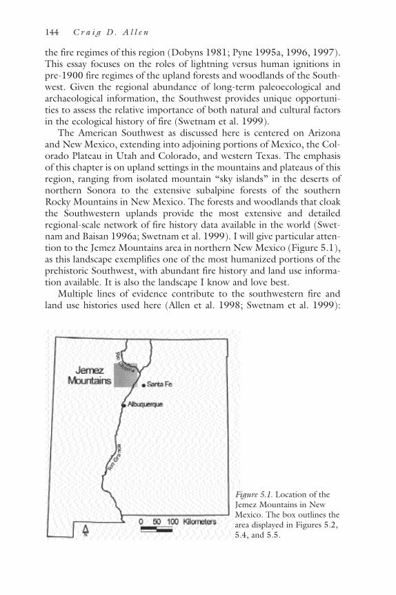
the fire regimes of this region (Dobyns 1981; Pyne 1995a, 1996, 1997).This essay focuses on the roles of lightning versus human ignitions inpre-1900 fire regimes of the upland forests and woodlands of the South-west. Given the regional abundance of long-term paleoecological andarchaeological information, the Southwest provides unique opportuni-ties to assess the relative importance of both natural and cultural factorsin the ecological history of fire (Swetnam et al. 1999).
The American Southwest as discussed here is centered on Arizonaand New Mexico, extending into adjoining portions of Mexico, the Col-orado Plateau in Utah and Colorado, and western Texas. The emphasisof this chapter is on upland settings in the mountains and plateaus of thisregion, ranging from isolated mountain “sky islands” in the deserts ofnorthern Sonora to the extensive subalpine forests of the southernRocky Mountains in New Mexico. The forests and woodlands that cloakthe Southwestern uplands provide the most extensive and detailedregional-scale network of fire history data available in the world (Swet-nam and Baisan 1996a; Swetnam et al. 1999). I will give particular atten-tion to the Jemez Mountains area in northern New Mexico (Figure 5.1),as this landscape exemplifies one of the most humanized portions of theprehistoric Southwest, with abundant fire history and land use informa-tion available. It is also the landscape I know and love best.
Multiple lines of evidence contribute to the southwestern fire andland use histories used here (Allen et al. 1998; Swetnam et al. 1999):
144 C r a i g D . A l l e n
Figure 5.1. Location of theJemez Mountains in NewMexico. The box outlines thearea displayed in Figures 5.2,5.4, and 5.5.

dendrochronological reconstructions of fire history, forest age struc-tures, and climate; charcoal from bogs and other sedimentary records;repeat photography; modern observations of lightning and fire activity;documentary archives; and a variety of data from archeological surveysand excavations. This review begins with a consideration of the naturalhistory of fire in the Southwest, then addresses the role of humans inmodifying the fire regimes of this region’s landscapes. I assert that fre-quent fire is an intrinsic, natural feature of the uplands of the Southwest,primarily driven by nonhuman factors such as climate, availability of sur-face fuels, and lightning ignitions. Modern claims of extensive aboriginalburning of southwestern landscapes are shown to be based upon broadovergeneralizations and uncritical extrapolations from a few historicalreports of localized fire use. Yet within the overall regional context ofgenerally natural fire regimes, people have significantly modified patternsof fire during particular times and in particular places. Since the ecolog-ical history of southwestern fire involves interactions among both natu-ral and cultural histories, generalizations about “pristine” versus“humanized” landscape conditions need to consider the particulars ofvariation in the relative effects of people through time and space.
The Natural History of Fire in the SouthwestFire belongs in the mountain Southwest, and unless thepeaks flatten, the monsoon evaporates, the seasons homog-enize, or the biota vanishes, those fires will continue. (Pyne1995a:295)
The paleoecology of the southwestern United States, including recordsof fire occurrence, is documented as well as for any region on Earth(Betancourt et al. 1990; Swetnam et al. 1999). Packrat middens (VanDevender and Spaulding 1979; Betancourt et al. 1990) and pollendeposits (R. S. Anderson 1993; Weng and Jackson 1999) show thatmodern climate/vegetation patterns basically developed in the South-west during the early Holocene, ca. 11,000 to 8,000 years ago. Sub-stantial fire activity apparently emerged in the Southwest during thattime, as evidenced by the contemporaneous and rapid spread of fire-adapted ponderosa pine forests across the region (Anderson 1989) andby the abundant charcoal deposits found in lake and bog sediments(Petersen 1988; Brunner-Jass 1999; Weng and Jackson 1999). Forexample, Weng and Jackson (1999) link increases in fire activity to theestablishment of ponderosa pine forests on the Kaibab Plateau betweenabout 10,000 and 11,000 years ago, while charcoal sediments fromAlamo Bog in the Jemez Mountains indicate essentially continuous fire
L O T S O F L I G H T N I N G A N D P L E N T Y O F P E O P L E 145

activity extending back to at least 8,000 years ago (Brunner-Jass 1999).Other evidence includes a regional network of dendrochronologicallydated fire-scar chronologies that documents the patterns of frequent andextensive fire which have characterized most southwestern forests over atleast the past 300 to 500 years (Swetnam and Baisan 1996a; Swetnam etal. 1999), while the fire suppression records of land management agen-cies provide a direct record of abundant fire activity during the twenti-eth century (Barrows 1978; Snyderman and Allen 1997; Rollins et al.1999). It is apparent that the uplands of the Southwest have experiencedwidespread and recurrent fires for thousands of years. Although fire-using people were present in the Southwest throughout this time period,the dominant view among fire ecologists is that most of the regional pat-terns of fire occurrence across the prehistoric and historic Southwest areadequately explained by natural factors (Swetnam and Baisan 1996a),including an abundance of lightning ignitions (Barrows 1978) andreceptive climate/fuel conditions (Swetnam and Betancourt 1998).
A key feature of the southwestern environment that naturally fostersthe occurrence of fire is a plentiful source of fire ignitions through highlevels of lightning activity (Barrows 1978; Orville and Silver 1997).Convectional thunderstorms that generate lightning occur frequently inthe Southwest, particularly during the summer monsoon season whenwarm temperatures and influxes of moist maritime air trigger near-dailycloud buildups over mountain areas. For example, 62 thunderstorm-days per year are observed in the Jemez Mountains at Los Alamos (U.S.DOE 1979), generating large numbers of lightning strikes. An auto-mated lightning detection system (Krider et al. 1980) recorded 165,117cloud-to-ground lightning strikes over a 775,554 ha area centered onthe Jemez Mountains during the period 1985–1994. The annual num-ber of recorded lightning strikes varied between 9,410 and 23,317 (seeFigure 5.2). Although lightning activity clearly peaks during the summermonsoon (Figure 5.3), strikes were recorded in every month. Particu-larly important for fire ignitions is the substantial lightning activity dur-ing the warm, dry, foresummer months of April through June (Figure5.3), when many lightning strikes occur from sporadic storms or cloudsgenerating only virga (rain that evaporates while falling and thus fails toreach the Earth’s surface). These strikes are the most significant sourcesof fire ignition because lightning is much more likely to start a spread-ing fire if it strikes dry fuels. Because lightning ignitions are so frequentand ubiquitous in the Southwest (Barrows 1978), climate and fuel con-ditions are the main drivers of fire regime dynamics in this region (Swet-nam and Betancourt 1990, 1998; Swetnam and Baisan 1996a).
Patterns of precipitation variability in the Southwest favor frequentand extensive fire activity. The generally dry climate of this interior conti-
146 C r a i g D . A l l e n

nental region permits fuels to burn readily much of the year, especiallyduring the warmer months of April through October (Barrows 1978).Dry seasons typically occur in the spring and fall between the winterperiod of cyclonic storms and the summer monsoon, with most precipi-tation received during the monsoon (Figure 5.3). The spring dry season
L O T S O F L I G H T N I N G A N D P L E N T Y O F P E O P L E 147
Figure 5.2. Lightning strikes in the Jemez Mountains, 1986. Map of 23,317 light-ning strikes recorded across 775,554 ha in the Jemez Mountains area during 1986by the national automated lightning detection system. The nominal resolution ofthe locational data is approximately 2 km. Surprisingly little difference in lightningstrike frequencies is evident across the 1,800-meter elevational gradient present inthis field of view, which is also the same in Figures 5.4 and 5.5.

(April through June) is particularly conducive to fire activity due to thecommon persistence of drought throughout much of this period, thelong and warm days of this high-sun period, and the occurrence of light-ning. While dry conditions are also common for multiweek periods in thefall, few natural ignitions occur at this time due to low levels of lightingactivity. Fall burning conditions are also constrained by the shorter daylengths, the cooler temperatures, and the interruption of dry spells bycyclonic storms. In addition, substantial variability in regional precipita-tion happens at annual and decadal time scales due to the El Niño–South-ern Oscillation phenomenon and other factors. This regionalized precip-itation variability tends to synchronize fire activity and other disturbancesacross the Southwest, with the highest levels of fire activity occurring afterdry winters (Swetnam and Betancourt 1990, 1998). Dendrochronologi-cal reconstructions of climate show that these patterns of substantial pre-cipitation variability, including severe and sustained droughts, have char-acterized the Southwest for at least the past 2,000 years (Dean andFunkhouser 1995; Meko et al. 1995; Grissino-Mayer 1996). Overall, theclimatic regime of recurrent dryness in the Southwest provides frequent
148 C r a i g D . A l l e n
Figure 5.3. Monthly patterns of lightning strikes, insolation, and precipitation inthe Jemez Mountains area. Lightning data from 165,117 cloud-to-ground strikesduring 1985–1994 over 775,554 ha centered on the Jemez Mountains (Figure5.2). Insolation and precipitation data for Los Alamos, New Mexico, from Bowen(1990).
and extended opportunities for the ignition and spread of fires. To thenorth, into southern Colorado and Utah, the distinctive climate of theSouthwest grades into a colder and more continental pattern dominatedby fall-to-spring moisture from cyclonic storms embedded in the polarfront jet stream, without pronounced spring drought and with less light-ning activity (as a result, fire occurrence begins to shift from spring tomidsummer, and natural fire frequencies decrease [Brown et al. 1999]).To the south, down the continental spine of the Sierra Madre Occidentalinto Durango (Mexico), key fire-enhancing features of the southwesternclimate remain evident, including the pattern of warm, dry spring condi-tions broken by the influx of lightning-yielding summer moisture fromthe tropics (Fulé and Covington 1999).
Fuel conditions in the Southwest also promote fire activity. Thebuildup of herbaceous and woody plant materials through plant growthand slow decay processes provides sufficient fuel periodically to supportspreading fires in most Southwestern ecosystems. However, fuel types(e.g., grass versus logs), quantities (tons/ha), flammabilities, and rates ofbuildup depend upon patterns of vegetation structure, productivity, andspecies composition—these vary considerably across the major topo-graphic, elevational, and ecological gradients that characterize south-western landscapes (cf. Bogan et al. 1998). General zonational patternscan be discerned (Merriam 1890; Brown 1982): low-elevation grass-lands grade upslope into woodlands of pinyon (Pinus edulis) and juniper(Juniperus) species, then into open ponderosa pine (Pinus ponderosa)forests, then become denser forests of mixed-conifer species (includingPseudotsuga menziessi and Abies concolor), ending with the high, cold,wet forests of spruce (Picea engelmanni) and corkbarkfir (Abies lasio-carpa var. arizonica), which in turn grade into subalpine and alpine veg-etation on the highest peaks. The high frequency of spreading surfacefires observed in the fire-scar record (Swetnam and Baisan 1996a) indi-cates that fine fuels (grasses and needle litter) have long been primaryfuels in many southwestern ecosystems. Prior to changes initiated by theheavy grazing of introduced sheep and cattle (Leopold 1924; Cooper1960; Baisan and Swetnam 1997; Bogan et al. 1998), herbaceous under-stories dominated by perennial grasses were present from valley grass-lands up through ponderosa pine forests and into many highland mixed-conifer forests. Herbaceous plants create fine-textured surface fuels thatdry out quickly (hours to days), particularly when exposed to sun andwind in open forest settings; as a result such fuels are often in suitablecondition to burn. Since fire-adapted perennial grasses and herbs regen-erate rapidly after fire, fuel quantities and continuities can often recoversufficiently to allow fire to recur in just a few years. Similarly, the needlelitter from long-needled ponderosa pine trees dries out quickly, containshighly flammable terpenoid compounds, and rebuilds a surface litter
L O T S O F L I G H T N I N G A N D P L E N T Y O F P E O P L E 149

cover within 3 to 7 years of removal as senescent needles drop from thetrees—all characteristics that support high-frequency surface fires.
The factors of ignition, climate, and fuels combine to create aregional pattern where fire frequencies are greatest at the middle eleva-tions along montane topographic gradients in the upper ponderosa pinezone (Swetnam and Baisan 1996a). Since high fire frequencies feed backto maintain relatively open forest structures that favor persistent herba-ceous ground cover and long-needled ponderosa pines, these conditionsgenerally co-occurred in the Southwest. At lower elevations (e.g.,pinyon-juniper woodlands) herbaceous productivity declines due to drierconditions, thereby reducing fuel continuities and increasing the timeneeded for fuels to recover between fires. In contrast, vegetation pro-ductivity is enhanced at higher elevations, but the cooler, moister climateis only suitable for burning during shorter time windows, resulting inless frequent and patchier fires, denser mixed-conifer and spruce-firforests, stifled herbaceous understories, and the dominance of slower-drying woody fuels (including the more compacted and less flammablelitter of these shorter-needled conifers).
Twentieth-century records of fire suppression efforts illustrate the fire-prone nature of southwestern ecosystems. During the period 1960–1975,80 percent of the fires on the national forests of Arizona and New Mex-ico were ignited by lightning, averaging 1,873 lightning fires per year(ranging from 1,184 to 2,841) for the highest rate of lightning fire igni-tion in the United States (Barrows 1978); for all protected private, state,and federal lands the regional average was 2,371 lightning fires per year.In southwestern national forests between 1940 and 1975, more than1,000 lightning fires occurred during all but two fire seasons, 1941 and1955; 187 lightning fires were ignited on the Gila National Forest alonein a 7-day period in 1974 (Barrows 1978:34). Area burned by lightning-caused wildfires peaks in June before the onset of the summer rains,although lightning ignitions are at a maximum in July (Barrows 1978).Southwestern fire activity is generally enhanced by drought (Barrows1978; Rollins et al. 1999), with higher levels of regionally synchronizedfire activity occurring in dry La Niña years (Swetnam and Betancourt1990, 1998). Fires would have repeatedly burned across widespread por-tions of the Southwest during the twentieth century if these numerouslightning-ignited fires had not been vigorously suppressed by fire-fightingactions. Fuel availability has become less of a limiting factor in recentdecades due to the landscape-wide buildups of woody fuels associatedwith a century of fire suppression (Covington et al. 1997; Bogan et al.1998). As a result the frequency and severity of wildfire activity (includ-ing lightning-ignited fires) has been escalating despite increasing humansuppression efforts, as the mean number of lightning fires per year in theSouthwest grew by more than 50 percent from 1940 to 1975 (Barrows
150 C r a i g D . A l l e n

1978); the mean annual acreage burned in the Southwest has increasedcontinuously since ca. 1960 (Swetnam and Betancourt 1998); and unnat-ural stand-replacing conflagrations like the 1977 La Mesa Fire (Allen1996a) and the 2000 Cerro Grande Fire are occurring more often inoverdense ponderosa pine forests (Covington and Moore 1994).
These regional patterns of twentieth-century fire activity are also appar-ent in the suppression records from the Jemez Mountains (Figure 5.4).The point locations of 4,487 wildfires recorded between 1909 and 1996
L O T S O F L I G H T N I N G A N D P L E N T Y O F P E O P L E 151
Figure 5.4. Point locations of historic fires in the Jemez Mountains, 1909–1996.Point locations of 4,487 historic wildfires in the Jemez Mountains, 1909–1996,compiled from the administrative records of land management agencies (Snyder-man and Allen 1997). The shaded analysis area covers 380,691 ha. The gridlikepattern results from a subset of the data that were recorded only to the nearest sec-tion corner. Person-caused fires cluster near major roadways, campgrounds, habita-tions, and other human use areas.

across a 380,691 ha area in the Jemez Mountains, compiled from an arrayof administrative records (Snyderman and Allen 1997), suggest a high fre-quency of lightning fires in the most flammable vegetation types. Light-ning caused 68 percent of the fires, with human ignitions clustered aboutroadways, campgrounds, habitations, and other human use areas. Areaburned is greatest in June, while July records the most lightning-fire igni-tions, consistent with local lightning occurrence and precipitation data(Figure 5.3). In contrast, area burned by management-ignited “pre-scribed” fires is greatest in the fall after the end of the summer monsoon,when conditions are often dry enough to sustain fire but controllability isgreater than in the spring. Note that this record of modern fire occurrencein the Jemez Mountains is certainly conservative and substantially under-estimates the actual occurrence of fire during this time period, as manysmall fires were likely never reported (especially prior to ca. 1945) and thedatabase is riddled with multiple large gaps where data are obviouslyincomplete or missing (Snyderman and Allen 1997). For example, it isvisually apparent that the greatest concentration of lightning fires isrecorded in the southeastern flank of the Jemez Mountains at BandelierNational Monument (Figure 5.4), where a more complete administrativerecord of fires since 1934 has survived (yet even the Bandelier record lacksany data for 9 years since 1941). The Bandelier fire record indicates a perha rate of lightning fire ignitions five times greater than the Jemez Moun-tains–wide data, reflecting the incompleteness of the overall Jemez record.Still, consistent patterns emerge from the large total number of fires inthese records. From 1934 to 1997, lightning caused 341 fires at Bandelier(86 percent of all wildfires), with ignitions peaking in July and higher lev-els of fire activity occurring in dry years (Foxx and Potter 1978). Light-ning ignited at least one fire per 2,134 ha per year during this period atBandelier, with the greatest frequency of fires occurring in ponderosa pineforests at mid-elevations. Many of these fires would have spread widely inthe absence of suppression efforts. The data from Bandelier, moreover, arenot unique: despite a variety of problems with the completeness of fire sup-pression records, high levels of lightning-ignited fire are clearly observedin the modern landscapes of the Southwest (Barrows 1978; Snydermanand Allen 1997).
The extensive regional network of fire-scar chronologies (Fulé andCovington 1996; Swetnam and Baisan 1996a, 1996b; Touchan et al.1996; Abolt 1997; Baisan and Swetnam 1997; Fulé et al. 1997; Allen etal. 1998; Kaib 1998; Kaufmann et al. 1998; Morino et al. 1998; Wolfand Mast 1998; Fulé et al. 2000; Swetnam et al. 2001) provides a pre-cisely dated, multicentury perspective on fire regimes in the Southwestthat is strikingly consistent with modern observations of lightning-caused wildfire activity. While substantial variability existed in pre-1900
152 C r a i g D . A l l e n

fire regimes (Swetnam and Baisan 1996a), high-frequency, low-intensitysurface fires were common in the Southwest, with the shortest intervalsbetween fires found in mid-elevation ponderosa pine forests. Extensivefire activity was often recorded in the same year across landscape andregional scales, indicating that fires spread widely in the absence of activehuman suppression and artificial fuelbreaks like livestock trails and roadnetworks (Allen et al. 1998; see also http://biology.usgs.gov/luhna/chap9.html). The absence of spreading fires in consecutive years fromstand-scale fire histories in the Southwest indicates that rates of fuelrecovery were one constraint on maximum fire frequencies. The land-scape context of topographic and fuel conditions could enhance orinhibit the spread of fire into particular stands (Swetnam and Baisan1996b).
Climate variability acted to synchronize regional fire activity, as majorfire years were clearly associated with drought conditions, while wet peri-ods recorded little fire activity (Swetnam and Betancourt 1990). Themost extensive fire activity in ponderosa pine forests occurred in dryyears that followed within 1 to 3 years of wet conditions; this pattern ofmajor fire years suggests the importance of both fuel production and fuelmoisture in these fire regimes, with antecedent wet conditions stimulat-ing the buildup of continuous fuels and subsequent drought conditionsenabling the fuels to burn widely. The common occurrence of persistentdrought conditions in the Southwest likely allowed some fires to burnfor months, potentially allowing even a few ignitions to cause extensivefire activity. The importance of climate in determining southwestern fireregimes is highlighted by evidence from fire-scar chronologies ofresponses to climate variations at annual, decadal, and centennial timescales (Swetnam and Baisan 1996a; Swetnam and Betancourt 1998;Grissino-Mayer and Swetnam 2000).
In most cases the seasonality of fire occurrence can be inferred by therelative position of a fire scar within the annual growth rings (Baisan andSwetnam 1990). The regional patterns of fire seasonality developed fromprehistoric fire scars and modern fire records are generally indistinguish-able (Swetnam et al. 2001), indicating that prehistoric fires occurredduring the same seasons as modern lightning-ignited fires—predomi-nantly in the spring and summer (Grissino-Mayer and Swetnam 2000).Unusual patterns of “excess” fall fires have been found in fire-scar histo-ries only for brief time periods at a few localities (e.g., Secklecki et al.1996).
Overall, regional fire-scar chronologies show that pre-1900 fireregimes in upland forests were characterized by frequent, widespreadfires that favored the open forest stand structures and abundant herba-ceous vegetation that have been well documented across the Southwest
L O T S O F L I G H T N I N G A N D P L E N T Y O F P E O P L E 153

by early photographs, historical writings, early land surveys, and den-drochronological reconstructions of stand conditions (Weaver 1951;Cooper 1960; Bahre 1991; Covington and Moore 1994; Fulé et al.1997; Allen et al. 1998; Kaufmann et al. 1998; Swetnam et al. 1999). Athigher elevations and in more mesic forests, surface fire regimes becamepatchier and increasingly mixed with more intense fires occurring atlonger return intervals (Grissino-Mayer et al. 1995; Touchan et al. 1996;Romme et al. 1999b), eventually grading into the (little-studied) stand-replacing fire regimes that apparently characterized subalpine spruce-firforests in the absence of spreading surface fires. Historic records, syn-chronous fire-scar dates from canyon forest stringers linked by semi-desert grasslands, and ecological inferences suggest a substantial role forfire prior to the late 1800s in some lowland ecosystems in the Southwest(e.g., Humphrey 1974; Bahre 1991; Archer 1994; Swetnam et al.2001). In contrast, ecosystems where fires were apparently scarce includedeserts and some subalpine and alpine communities.
The fire-scar record from the Jemez Mountains (Allen 1989; Allen etal. 1996; Touchan et al. 1996; Morino et al. 1998) is consistent withregional patterns. Dendrochronologically dated fire-scar collections havebeen made from forty-two localities in and adjoining the Jemez Moun-tains (Figure 5.5), with more than 4,000 pre-1900 fire-scar dates deter-mined from more than 600 sampled trees, snags, logs, and stumps. Firedates extend back to A.D. 1422. Sampled forest types and landscape set-tings range from low-elevation stands of ponderosa pine intermixed withsemiarid pinyon and juniper woodlands up to high-elevation montaneforests dominated by Engelmann spruce. The Jemez Mountains fire-scarchronologies show that high-frequency fire (with mean return intervalsof 6 to 15 years) characterized the pre-1900 fire regimes at most sites(Touchan et al. 1996), with maximum frequencies found in upper-ele-vation ponderosa pine stands (e.g., Figure 5.6). Fire activity commonlyoccurred over extensive areas (Figure 5.5; Allen et al. 1998); for exam-ple, watershed-wide fires occurred approximately every 16 years acrossthe 15-km-long Frijoles watershed in Bandelier (Allen 1989). Stand-level fire frequencies were affected by topographic features that wouldinhibit or enhance the spread of fires into the site from the larger sur-rounding landscape (e.g., reduced frequencies where rocky cliffs act asisolating barriers, versus greater frequencies on the upper portions of alarge smooth plateau slope), indicative of natural controls on fire regimes(Allen and Snyderman 1997). Years with extensive fire activity were tiedto dry conditions in all forest types, with lagged relationships to wetyears in ponderosa pine forests (Touchan et al. 1996). The fire-scar sea-sonality data show that most prehistoric fire scars in the Jemez Moun-tains formed during the dry spring and early summer months (about 94
154 C r a i g D . A l l e n

percent formed by July), and fall fires were rare (Allen 1989 and unpub-lished data; Touchan and Swetnam 1995). Abundant fire activity clearlywas a major determinant of ecosystem patterns and processes in the pre-1990 landscape of the Jemez Mountains (Allen 1989; Touchan et al.1996; Morino et al. 1998). As elsewhere in the Southwest, the surfacefire regimes collapsed by ca. 1900 at most sites in the Jemez area (Fig-
L O T S O F L I G H T N I N G A N D P L E N T Y O F P E O P L E 155
Figure 5.5. Jemez Mountains, extent of fires in 1748. Map of fire-scar sample sitelocations in the Jemez Mountains, showing the extent of widespread fires in 1748.Sites where at least 10 percent of the sampled trees recorded a fire in 1748 areshown as burned. Three clusters of sites in the northern Jemez Mountains area arelabeled: CON (Continental Divide), MEP (Mesa Prieta), and CPE (Cerro Peder-nal). Also marked is Monument Canyon (MCN) in the south.

ures 5.6 and 5.7), due to the effects of domestic grazing on fuel avail-ability and human suppression activities (described below in the sectiontitled Historic Human Effects on Southwestern Fire Regimes).
Overall, the patterns of lightning-ignited fire observed in the modern
156 C r a i g D . A l l e n
Figure 5.6. Fire-scar chronology, Monument Canyon Research Natural Area. Hori-zontal lines represent the life spans of individual trees, whereas fire-scar events areshown by short vertical bars. The longer vertical lines at the bottom of eachchronology indicate the years in which at least 10 percent of the recording trees(i.e., previously scarred trees) recorded a fire.
Figure 5.7. Composite fire-scar chronologies from four sites, Jemez Mountains.Each of the four labeled horizontal lines represents the composite fire chronologyfrom a different site (labels match Figure 5.5), and the vertical bars are the fire datesrecorded by at least 10 percent of the fire-scarred trees within that site. Fire fre-quency patterns before ca. 1600 are reduced by small sample sizes (cf. Figure 5.6).

landscapes of the Southwest are strikingly consistent with, and generallysufficient to explain, the prehistoric and historic fire regimes indicated bythe fire-scar record. This natural history of frequent lightning-ignitedfires in most upland ecosystems, modulated by climate and fuel condi-tions, provides the context against which potential human alteration ofsouthwestern fire regimes though time and space must be assessed.
The Cultural History of Fire in the SouthwestThe natural history of southwestern fires overlaps with a history ofhuman occupancy. The two worlds of nature and people interact to givea history of southwestern landscapes.
Prehistoric Human Effects on Southwestern Fire Regimes(11,000 B.C.–A.D. 1600)
That extraordinary fire load is not simply a product of nat-ural processes. For millennia humans have busily restruc-tured the geography and seasonality of Southwestern fire—sometimes complementing and sometimes countering thenatural order. Lightning had to compete not only with rainbut with aboriginal firesticks. Human inhabitants addedother sources of ignition in the service of hunting, raiding,foraging, and horticulture, and as an inadvertent by-prod-uct of a seasonal nomadism whose routes became trails ofsmoke from camp fires, signal fires, and escaped fires ofdiverse origins. (Pyne 1995a:284)
The American Southwest has a long record of occupation by humans(Cordell 1997), the fire-using species (Pyne 1995a), extending back tothe Clovis Paleoindian sites that document Native American presencehere for more than 11,000 years. These first known people of the South-west were apparently big-game hunters who likely moved frequently asthey pursued their primary food resources. Their small populations andmobile way of life likely caused few lasting changes to regional ecosys-tems, although it is possible that these early hunters contributed to theextinction of the “Pleistocene megafauna” through overhunting (Martinand Klein 1984), which indirectly had substantial ecological effects.Paleoindian use of fire to manipulate southwestern landscapes is possible(e.g., as a hunting method), but entirely speculative at this point. “It isdifficult to reconstruct the impact of early humans, whose firesticks coin-cided with the colossal climatic fluctuations that ended the last ice age”(Pyne 1995a:294).
L O T S O F L I G H T N I N G A N D P L E N T Y O F P E O P L E 157

With the development of foraging lifeways during the Archaic period(ca. 5500 to 500 B.C.), hunting and gathering by small, mobile groupsof people became the norm. The primary ecological effects of these peo-ple were likely localized, with frequent movements allowing any over-harvested resources to recover. Based upon cross-cultural surveys of fireuse by hunting and gathering societies in the western United States andthe rest of the world, Fish (1996) has suggested that Archaic peoples ofthe Southwest may have made substantial use of fire to modify vegeta-tion, although direct supporting evidence is absent.
By ca. 2000 B.C., cultigens from Mexico (e.g., maize) initially appearin the Southwest, beginning the slow transition toward sedentary agri-cultural societies with higher populations. With increasing reliance onagriculture, human populations and societal complexity increased, as didtheir ability to modify landscapes to support their growing resourcedemands. By ca. A.D. 800, substantial human populations had developedacross much of the Southwest; population growth in the ColoradoPlateau area accelerated (Euler 1988); and evidence of human effects onat least local environments can be discerned in various paleorecords(Plog et al. 1988), such as in the Dolores River Valley of southwesternColorado (Kohler and Mathews 1988). By ca. A.D. 1100, large popula-tions of sedentary agriculturalists were found across the Southwest,including the Hohokam irrigators of the Arizona desert river valleys, theMogollon of the Mogollon Rim uplands (e.g., Mimbres), and theAnasazi of the Colorado Plateau (e.g., the Chaco region and MesaVerde). Anasazi (ancestral Puebloan) occupations were focussed onpinyon-juniper ecosystems, which occur widely across the upland mesas,plateaus, and mountain footslopes of the Four Corners region. With thedecline of the Chacoan system in the 1100s and the general abandon-ment of the Colorado Plateau by the late 1200s, these ancestralPuebloan populations largely shifted toward the northern Rio Grandevalley, including the Jemez Mountains. Throughout the late prehistoricperiod (A.D. 1200–1600) the northern Rio Grande region was the cen-ter of large Puebloan populations; at the time of European settlement inA.D. 1598, the Pueblo world consisted of about 100,000 people associ-ated with about 100 communities (Schroeder 1992). While greatlyreduced over the next several centuries by diseases and other impacts ofthe Spanish Entrada, their descendants are the modern Puebloan peopleswho continue to live in this region (Hopi, Zuni, and the numerouspueblos of the northern Rio Grande watershed). Most of these contem-porary communities have been occupied since before European contact.In addition, unknown numbers of more nomadic peoples were presentin the Southwest by the 1400s, including the ancestors of the modernUtes, Paiutes, Navajos, and Apaches (Towner 1997).
158 C r a i g D . A l l e n

The Jemez Mountains contain much evidence of large Anasazi pop-ulations. For example, Bandelier National Monument (Figure 5.5) mayhave the highest density of cultural resource sites in the entire NationalPark Service system, with over 2,400 archeological sites recorded fromthe approximately 6,500 hectares inventoried to date (Powers andOrcutt 1999, unpublished data at Bandelier National Monument). Sitedensities are greatest in the pinyon-juniper and lower ponderosa pinezones. Intensive utilization of the Bandelier landscape by ancestralPuebloans occurred during the period A.D. 1150–1550, with estimatedpopulations of between 1,000 and 3,500 people across some 10,000 haduring the period A.D. 1225–1450 (Bracker 1996; Orcutt 1999). Simi-lar densities of late prehistoric archeological sites are found around muchof the Jemez country, including several dozen huge communal pueblos(1,000–3,000 rooms) in the Chama and Jemez River drainages (Elliott1993; Anschuetz 1998).
Human populations of this magnitude and extent could substantiallymodify their environment in many ways (Butzer 1990; Denevan 1992;Spoerl and Ravesloot 1995; Fish 1996), including through the use offire. Since southwestern agriculturalists like the Anasazi utilized about0.5 ha per person per year to raise staple foods (Kohler et al. 1996; Tri-erweiler 1990), large areas were farmed to raise staple foods, with abun-dant archeological evidence still visible today of agricultural terraces,cobble mulch gardens, and even irrigation infrastructure (Doolittle1992; Periman 1996; Anschuetz 1998). The broad extent of prehistoricagricultural influence in landscapes like the Pajarito Plateau (on the east-ern flank of the Jemez Mountains) is also indicated by the abundance of“field houses” found dispersed across potential agricultural areas, asthese small structures (one to ten rooms) were probably used seasonallyfor purposes that included tending crops. Wood scarcities likely devel-oped over extensive areas as the Anasazi and other farmers overharvestedpinyon-juniper woodlands to meet their substantial needs for clearedagricultural land, firewood for cooking and winter heating, and buildingmaterials. Evidence of deforestation has been detected from such areasas Mesa Verde (Wyckoff 1977) and Dolores in southwestern Colorado(Kohler and Matthews 1988), Chaco Canyon (Samuels and Betancourt1982; Betancourt et al. 1986), and Bandelier (Huber and Kohler 1993;Allen, in review). The shifting of agricultural field locations throughtime, and the frequent relocations of human populations at local andregional scales (Euler 1988), amplified the total area affected by thesecultural activities.
While significant land-altering activities surely occurred near humansettlements, anthropogenic effects at more expansive landscape andregional scales are less certain, particularly in mountain areas remote
L O T S O F L I G H T N I N G A N D P L E N T Y O F P E O P L E 159

from permanent habitations. We know that aboriginal southwesternerscertainly were capable of utilizing remote resources, such as transportingthousands of logs more than 75 km from mountain source areas to“great houses” in Chaco Canyon (Betancourt et al. 1986). Another indi-cation of extensive human influence is the evidence that populations oflarge mammals, particularly elk, may have been depleted over broadareas by prehistoric southwestern hunters (Lang and Harris 1984;Osborn 1993; Allen 1996b; cf. Kay 1994; Martin and Szuter 1999).
How might the various aboriginal peoples of the Southwest havemodified fire regimes in the late prehistoric period (ca. A.D.1200–1600)? Since prehistoric documentation of specific burning prac-tices does not exist, most of our perspectives about the effects of earlyIndian burning in the Southwest must be inferred from indirect lines ofevidence ranging from archeological and paleoecological information tohistoric accounts of aboriginal fire use (cf. Fish 1996; Kaib 1998).Although an extensive ethnographic literature describes cultural uses offire by Native Americans from many regions of North America (Hough1926; Stewart 1951, 1955, 1956, 1963; Day 1953; Lewis 1973, 1985;Sauer 1975; Barrett and Arno 1982; Boyd 1986; M. K. Anderson 1993,1996; Gottesfeld 1994; Clark and Royall 1995; Pyne 1997; Williams1997, 2000; Delcourt and Delcourt 1998; Bonnicksen 2000), relativelylittle information exists for the Southwest (but see the thorough reviewof fire use in Apacheria by Kaib [1998]). General reasons given forIndian burning in North America (Pyne 1997; Kaib 1998; Williams2000) include hunting, crop management, improvement of plantgrowth and yield, insect collection, pest management, fireproofing areas,warfare and signaling, clearing areas for travel, and felling trees. The sub-stantial Native American populations of the prehistoric Southwest mayhave used fire for all these purposes, (Dobyns 1981; Bahre 1991; Pyne1997), but a paucity of region-specific data renders speculative most ofour conclusions about the effects of aboriginal burning at landscapescales (areas at least several kilometers in extent).
Yet some scholars have painted a region-wide picture of substantialaboriginal burning effects by extrapolating broadly from a few historicalanecdotes and statements of questionable authority or accuracy (cf. For-man and Russell 1983). For example, influential overviews by Cooper(1960:138) and Pyne (1995a:284–285, 1987:519) extensively quoteHolsinger (1902) (see Box 5.1) as important evidence for widespreadIndian burning in the Southwest, even though the Holsinger article (1)cites no evidence for its assertions of Native Americans as primarysources of fire ignition; (2) clearly views fire as a negative influence thatdegraded forest cover and thereby worked against a utilitarian vision ofpreserving desired watershed conditions; (3) emphasized fire as unnatu-
160 C r a i g D . A l l e n

ral and thus preventable, displaying an obvious bias toward blaming allfires, past and present, on people, particularly Indians; and (4) primarily,though loosely, focuses on undocumented ancient burning practices ofsouthwestern Native Americans who left obvious architectural ruins(e.g., the Anasazi), rather than Apaches or other contemporary historictribes. Cooper (1960:138) indicates that “There is abundant evidencethat Indians were responsible for many fires,” but the sources that hecites convey largely hearsay claims of Indian burning in the Southwest.Pyne’s footnotes (1995a:359–360, 1997:615) indicate only a few otheranecdotal sources that hardly provide solid support for his assertions thatprehistoric Native American burning was important in the Southwest.The fact is that archaeological, anthropological, and historic sources con-
L O T S O F L I G H T N I N G A N D P L E N T Y O F P E O P L E 161
BOX 5.1. Varied perspectives on the cause of early fires in theSouthwest.“These prehistoric aborignes [sic] must have exerted a marked influ-ence upon the vegetation of the country. Their fires, and those of thehistoric races, unquestionably account for the open condition of theforests. . . . From Puget Sound to the Gulf of California these strangepeople rambled at will, but their abiding place was . . . in the south-west. The extensive ruins indicate that they inhabited the fringe, soto speak, of the forests which, like vanguards, were working their waydown from the mountain tops to the plains. The most potent andpowerful weapon in the hands of these aborigines was the firebrand.It was alike used to capture the deer, the elk, and the antelope, andalso to rout or vanquish the enemy. It cleared their mountain trail anddestroyed the cover in which their quarry took refuge. . . . How farthe occupancy of the prehistoric and historic tribes has retarded theprogress of foresting it is impossible to say, but it must have been nosmall factor. . . . Were it not for the long Indian occupancy and theravages of fire incident to their habitancy, vast territories now barrendesert wastes might be covered with a forest growth.” (Holsinger1902:23, 24)
“Given the high incidence of lightning-caused fires, reliably docu-mented by modern data, the relative importance of fires set by Indi-ans is probably moot.” (Bahre 1991:128)
“Under aboriginal rule, fine fuels blossomed, and the Southwestburned easily and often. Lightning and firestick competed to seewhich would burn a particular site or in what season.” (Pyne1995a:285)

tain little evidence for widespread anthropogenic alteration of prehistoricfire regimes in the Southwest.
For example, consider the use of fire for prehistoric agricultural pur-poses in the Southwest, where new plots were likely cleared and preparedusing fire (Wyckoff 1977). Indians also may have burned to enhance theproductivity of a variety of favored wild resources (M. K. Anderson1993, 1996), such as herbs with edible seeds in pinyon-juniper wood-lands (Sullivan 1992). These probable uses of fire represent the poten-tial for abundant wildfire starts to have occurred from human ignitions,given the dependence of large prehistoric human populations on agri-culture in this region, the shifting nature of their enterprises, and theprobability that some fires escaped from human control. Petersen(1988:101) suggests that high charcoal concentrations dating to aboutA.D. 900 in a bog at 3,060 m elevation in the La Plata Mountains ofsouthwestern Colorado are due to charcoal influx from Anasazi land uses(presumably agriculture-related fire in the adjoining valleys), althoughnatural forest fires might be a more plausible explanation. Fish (1996)suggests that prehistoric agriculturalists in southeastern Arizona wouldhave carefully controlled or avoided burning practices in their zones ofintensive settlement, agriculture, and fuelwood procurement in order toprotect residences, crops, and fuel supplies. These rationales to constrainthe application of fire are equally valid elsewhere in the Southwest.Localized burning by agriculturalists may have caused little change in thenatural fire regimes of extensive upland areas.
Similarly, the use of fire as a hunting strategy is commonly presentedas a potential means by which fire regimes could have been altered acrossbroad areas by aboriginal peoples (Stewart 1956), including prehistoricsouthwesterners (Holsinger 1902; Cooper 1960; Dobyns 1981).Cabeza de Vaca’s early description of Indian fire use from southeasternTexas in the 1520s is often quoted in support of this idea: “[They] firethe plains and forests within reach with brands, both to drive the mos-quitoes away and at the same time drive lizards and like things from theearth to eat. They also kill deer [antelope] by encircling fires; deprivedof pasturage, the animals are forced to seek it where the Indians may trapthem” (Cabeza de Vaca, in Covey 1993). The idea that western Indiansextensively used fire in hunting has been widely asserted by many influ-ential people, ranging from John Wesley Powell (1890, “Before thewhite man came the natives systematically burned over the forest landswith each recurrent year as one of their great hunting economies”) andAldo Leopold (1920, “As is well known to all old-timers, the Indianfired the forests with the deliberate intent of confusing and concentrat-ing the game so as to make hunting easier”) to Stephen Pyne (1987:74,“Of all Indian uses for fire, the most widespread was probably the most
162 C r a i g D . A l l e n

ancient: fire for hunting”). However, in the Southwest the idea of land-scape-scale hunting fires is based upon an insubstantial foundation ofminimal documentation. For example, although Pyne (1987:519)specifically propagates the view of extensive Apache fire use in the South-west for purposes that included hunting, an extremely thorough reviewof Apache fire use in the U.S./Mexico-borderlands portion of theSouthwest finds only evidence for localized fire use for small gamedrives, not widespread fire-drive hunting (Kaib 1998:140). While Kaib’sreview documents that historic-era Apaches certainly used fire for a vari-ety of other purposes (most significantly warfare), he emphasizes thatthey had good reasons and sufficient skills to control the spread of mostfires. Fish (1996) also downplays the idea of extensive burning by pre-historic southwestern hunters, as it would work against “attracting andconcentrating game in a precise, predictable location for hunters,”defeating the supposed aboriginal purpose. Primary evidence for land-scape-scale burning for hunting purposes is nearly nonexistent in theSouthwest, and supporting rationales are weak.
A lack of archeological or ethnographic evidence on aboriginal use offire is similarly apparent in the Jemez Mountains area, despite an overallwealth of archaeological information (e.g., Powers and Orcutt 1999)and the continuity of relatively intact native Puebloan cultural traditionssince prehistoric times (Henderson and Harrington 1914; Harrington1916; Robbins et al. 1916). For example, a detailed “Ethnographic Lit-erature Search and Consultation” to document traditional Indian uses ofthe cultural and natural resources of Bandelier National Monumentuncovered no information on fire use (Levine and Merlan 1997). Sur-prisingly little information is available on cultural uses of fire by ancestralPuebloan peoples (cf. Hough 1926).
Overall, the archeological and ethnographic evidence in the South-west supports the notion that human-set fires likely enhanced prehistoricfire frequencies in localized areas, as fire-using people were presentthroughout the region. However, there is little evidence of landscape-scale burning practices in the Southwest, as aboriginal peoples likelyemphasized “controlled rather than comprehensive [i.e., broadcast] usesof fire” (Fish 1996). There are severe limitations on our ability to reli-ably infer the prehistoric ecological effects of cultural fire use fromanthropological information sources alone in a region where the rate ofnatural fire occurrence is so high. Assertions that emphasize aboriginalburning as a major ecological process in the Southwest are largely basedupon overgeneralized amplifications of anecdotal information or biasedand unsubstantiated statements in historical writings.
However, another emerging source of evidence exists—the detailedtemporal and spatial records of past fire activity contained in den-
L O T S O F L I G H T N I N G A N D P L E N T Y O F P E O P L E 163

drochronologically dated fire-scar chronologies may provide indicationsof aboriginal burning during certain periods in particular southwesternlocalities. Although relatively few fire-scar chronologies have been devel-oped that overlap documented prehistoric human use areas in both timeand space, those that exist provide opportunities to test some hypothe-ses about prehistoric Indian burning, to see if a signal of human burningcan be distinguished. For example, Fish (1996) suggests that “culturalpractices could have accelerated vegetational responses by introducingfire in seasons of low natural ignition and by increasing frequencies tothe extent that fuel buildups allowed,” while Pyne (2000) asserts that“Anthropogenic (human-caused) fire comes with a different seasonalsignature and frequency than natural fire.” Clues of human influences onthe fire regime recorded in a fire-scar chronology might include periodswith unusual patterns of fire frequency, stand-level fire synchroneity, fireseasonality, or decreased correlation with climatic conditions (Baisan andSwetnam 1997; Swetnam et al. 2001), providing the potential for link-ages to documented patterns of human land use. For example, fire-scarchronologies from two sites in the mountains near Albuquerque displayearly periods (1500s to 1680) with frequent, patchy fires and inconsis-tent fire-climate relationships that indicate the possibility that localNative Americans were starting fires in these areas during this time(Baisan and Swetnam 1997). In the Jemez Mountains area, chronologiesfrom the three northernmost clusters of sites display patchy, frequentfires in the late 1500s and early 1600s that may reflect enhanced ignitionrates by protohistoric people (Figure 5.7). For example, the ContinentalDivide cluster of sites (Figure 5.5) shows high fire frequencies and lesssynchronous fire dates in the period prior to 1750 (Figure 5.7), and fire-climate relationships are weaker here than at any other site sampled sofar in the Jemez Mountains (Touchan et al. 1995; Allen et al., unpub-lished data). Perhaps these fire scars record excess ignitions by earlyNavajos around this area before their acquisition of substantial numbersof sheep disrupted surface fire frequencies in this dry ponderosapine/pinyon-juniper transition area (Touchan et al. 1995, 1996). Inthese cases the fire-scar record does provide limited evidence of possibleaboriginal alteration of southwestern fire regimes in the late prehistoricto early historic period.
Still, these unusual site histories belie the consistency of the generalpatterns found in fire-scar chronologies at all scales across the Southwest(Swetnam and Baisan 1996a; Swetnam et al. 1999). Climate relation-ships are strong and persistent at most fire-scar chronology sites.Although pre-1900 fire regimes were dynamic, most chronologies arelike Monument Canyon (Figure 5.6), showing no obvious fire frequencychanges across the late prehistoric to early historic divide despite the
164 C r a i g D . A l l e n

continued occupation of Jemez Puebloan peoples near this forestedhighland site until as late as ca. 1620, when the Spanish forcibly reset-tled them in the adjoining Jemez Valley (Elliott 1993). Similarly, earlyfire-scar chronologies from other areas near prehistoric or historicPuebloan communities (e.g., the Frijoles watershed in Bandelier, nearCochiti and San Ildefonso Pueblos, and Gallina Mesa near Santa Claraand San Juan Pueblos) also do not show higher fire frequencies in thelate prehistoric or early historic eras (Touchan et al. 1996; Allen et al.,unpublished data). Although fire-scar sample sizes are generally small forprehistoric time periods, in the Jemez Mountains alone there are cur-rently six fire-scar chronologies with earliest fire dates in the 1400s andsix more with initial dates between A.D. 1503 and 1601. If human burn-ing was an important ignition source, one would expect to see declinesin fire frequencies in the early historic period with decreased Puebloanuse of the mountains, but most fire chronologies in the Jemez Moun-tains show no sustained decline in fire frequencies from ca. 1600 to 1850(although perhaps increased use of the mountains by Navajo andApaches added a compensatory set of new aboriginal ignition sources).
The fire-scar record can be used to directly test some claims aboutIndian burning practices. For example, Lewis (1985:76) expansivelyasserts that “there are four general considerations used by hunter-gath-erers that distinguish their fire regimes from natural ones: the seasonal-ity of burning, the frequency with which fires are set, the intensity offires, and the selection of preferred sites. These . . . considerations areshown from North American Indians across a broad range of habitats. . .” (see also Bonnicksen et al. 1999:444). Overall, the extensive fire-scar record in the Southwest is strikingly consistent with modern pat-terns of lightning fire ignition, revealing few indications of early humanmodification to natural fire-regime patterns of seasonality, frequency,intensity, or locality. For example, Stevenson (1881) “stated that Indiansset fire to the timber on the mountain ranges of New Mexico each fall inorder to drive deer down into the canyons” (in Cooper 1960:138).However, this claim is not supported by the abundant fire-scar seasonal-ity data from New Mexico’s mountains, as fall fire scars were rarelyrecorded in the pre-1900 period, and the proportion of late-season firescars actually declines in the 1800s relative to preceding centuries (Allen1989:91–94; Grissino-Mayer 1995:199–201), likely due to a shift inregional climate (Grissino-Mayer and Swetnam 2000). Indeed, the fire-scar record across the Southwest shows that prehistoric fires generallyoccurred in the same April to July window as modern fires (Baisan andSwetnam 1990; Touchan and Swetnam 1995; Swetnam and Baisan1996a; Grissino-Mayer and Swetnam 2000; Swetnam et al. 2001).Given the suitability of fall conditions for human-ignited burning, the
L O T S O F L I G H T N I N G A N D P L E N T Y O F P E O P L E 165

near absence of fall fires in the fire-scar record suggests that aboriginalignitions were unimportant in the Southwest, or that for unknown rea-sons they restricted their burning to the same spring-to-early summerperiod as natural lightning ignitions.
Tree-ring fire reconstructions cannot directly determine the cause ofignition for recorded fires. So it is possible that prehistoric people setspring fires that spread widely when fuels and climatic conditionsallowed, leaving fire scars and ecological outcomes indistinguishablefrom the natural lightning fires that otherwise would have occurred.Thus, while the simplest explanation of the available data is that light-ning started essentially all extensive prehistoric fires in the uplands of theSouthwest, Indian-set fires could have been substituting for some natu-ral ignitions to varying degrees through time and space without alteringnatural fire regimes.
Overall, the notion of landscape-scale burning by prehistoric Indiansin the Southwest lacks archaeological and ethnographic support, and theregional network of fire-scar chronologies generally records patterns ofprehistoric fire that are consistent with natural control of fire regimes byclimate and fuels. Although long-term use by large populations of pre-historic Native Americans likely had substantial impacts on pinyon-juniper woodlands and lowland riverine environments in many areas, theavailable evidence indicates that Indians likely had minimal effects on thefire regimes of most upland ecosystems in the Southwest prior to Euro-pean contact.
Historic Human Effects on Southwestern Fire Regimes(Since A.D. 1600)
The character of Southwestern fire reflects the changingcharacter of its human occupation. (Pyne 1995a:294)
The region boasts an ideal formula for natural fires. Its dra-matic terrain and well-defined wet-dry cycles, both annularand secular, have long established it as an epicenter forlightning fires. But the real narrative of Southwest fire his-tory belongs to its human firebrands, who have co-existed,if not co-evolved, with the regional biota throughout theHolocene. Different waves of human colonization haveshaped distinctive fire regimes. (Pyne 1996)
The American Southwest has one of the longest histories of Europeanexploration and settlement of any part of the United States. Prehistoricand historic eras and land uses grade into one another here, with spo-
166 C r a i g D . A l l e n

radic Spanish exploration from the 1530s onward (e.g., Cabeza de Vaca,Coronado, Espejo), culminating in Oñate’s colonizing settlement at thefoot of the Jemez Mountains in 1598 and the establishment of Santa Fein 1610. For the purposes of this overview, A.D. 1600 will be used tomark the approximate divide between the prehistoric and historic eraswhen Euro-Americans began markedly reshaping the Southwest, eventhough their Old World diseases, livestock, and cultures likely started toaffect the region during the 1500s. Still, large portions of this regionremained outside Euro-American control (and written documentation)until the last half of the nineteenth century, and some prehistoric landuse patterns persisted among the diverse Indian lifeways of the historicSouthwest. For example, although the subjugated Puebloan farmerswere greatly reduced in numbers, concentrated in river valleys, andincorporated into the colonial Spanish economy of farming and livestockhusbandry, they also maintained much of their indigenous culture andundoubtedly continued to utilize adjoining upland areas for resourceprocurement (medicinal plants, game) and other traditional uses (Hen-derson and Harrington 1914; Harrington 1916; Robbins et al. 1916;Levine and Merlan 1997). At the other extreme, some nomadic peoples(e.g., Apaches and Utes) held onto their independence and many aspectsof their prehistoric hunter-gatherer-raider lifeways through the middle tolate 1800s, while enhancing their mobility with horses. Navajo huntersand farmers developed along a somewhat intermediate path, also main-taining their freedom through mobility and warfare, while adding sheephusbandry and raiding to their economies. There was also a blending ofland use practices here at the frontier of the Spanish Empire—by tradeand warfare among these groups, including commerce in captive slaves;by Spanish settlement of Europeanized Indians in peripheral genizarocommunities as buffers against warring tribes; and by intermarriagebetween Euro-Americans and Native Americans (Meinig 1971; deBuys1985; Scurlock 1998). The presence of such diverse cultures suggeststhat fire use likely varied markedly through time and space across the his-toric Southwest.
Given the 400-year duration of the historic period here, it is conceiv-able that intermingled Native American and Euro-American impacts onsouthwestern fire regimes have been going on long enough to appearnatural to many modern observers. However, assertions of landscape-scale burning by southwestern peoples during the historic era are subjectto the same criticisms as the prehistoric claims reviewed above. Overallthese claims are largely speculative due to the paucity of firm informa-tion on this topic found in archaeological, anthropological, and historicsources (with some exceptions reviewed here). Eyewitness accounts ofbroadcast burning by Indians are quite rare in the Southwest (Kaib
L O T S O F L I G H T N I N G A N D P L E N T Y O F P E O P L E 167

1998). In addition, the regional network of fire-scar chronologies showsrelatively consistent patterns of pre-1900 fire occurrence through timeand space, indicating that the fire regimes at most sampled sites were pri-marily driven by natural and synoptic climatic factors rather than by localand ephemeral cultural burning practices. However, unique local fire his-tories that differ markedly from regional patterns provide some indica-tions of probable human interactions with southwestern surface fireregimes during the historic period.
As noted above, some southwestern fire-scar chronologies (e.g., Fig-ure 5.7) hint that human ignitions were raising fire frequencies abovenatural levels during the transition between late prehistoric times and theearly historic era (Baisan and Swetnam 1997). Interestingly, the abruptend of the higher fire-frequency period at several sites in New Mexico isroughly coincident with the Pueblo Revolt of 1680 (Baisan and Swet-nam 1997; Figure 5.7). The 1600s were a tumultuous time in NewMexico, likely with lots of undocumented Indian use of upland areasaround the Spanish-dominated valley settlements, perhaps including useof fire. On the other hand, the 1600s and 1700s were generally a timeof relatively high frequency and less well synchronized fires across theSouthwest, and after ca. 1800 increased synchronization and lower fre-quencies are regionally evident, regardless of local Indian site histories(Grissino-Mayer and Swetnam 2000).
One of the strongest cases for extensive aboriginal burning in theSouthwest is associated with the use of fire during historic warfare peri-ods by Apachean peoples, or their enemies, in the U.S./Mexico border-lands region. Several recent fire-scar studies document enhanced fire fre-quencies or partially altered fire seasonalities, in concert with weakerfire/climate relationships, suggesting anthropogenic ignitions in partic-ular localities frequented by Apaches during documented times of raid-ing and warfare. At Fillmore Canyon in the Organ Mountains, Morino(1996) found high fire frequencies and weak correlations with climateduring the 1700s, a time of known Apache use and warfare in this area.Kaye and Swetnam (1999) interpret atypical occurrences of late-seasonfires, in concert with tree peel scars, as clues of probable Apache war-related fires near Dog Canyon in the Sacramento Mountains during thelate 1700s, although they note that alternative explanations exist. Seck-lecki et al. (1996) suggested that an unusually large proportion of latewinter or early spring fires, in concert with a high fire frequency duringthe period 1760–1786, may indicate Apache burning in a high-elevationportion of the Chiricahua Mountains during this brief time of local war-fare. Kaib (1998) more broadly reviews fire histories for several moun-tain ranges in Apacheria along the U.S./Mexico border, finding evi-dence for warfare-related burning in parts of the Chiricahua Mountains
168 C r a i g D . A l l e n

during two historical warfare periods (1748–1790 and 1831–1886).Kaib (1998) also found indications of Apache burning from the AnimasMountains and Sierra de los Ajos during the later warfare period(1831–1886). Kaib (1998:145) concludes: “Common and indiscrimi-nate burning practices that influenced extensive areas were associatedwith documented raiding and wartime periods.”
Although burning related to warfare between historic Apaches andtheir enemies has apparently left a fire history signal in some localities,the regional fire-scar record indicates that such burning had limitedoverall effect on southwestern fire regimes. Evidence of warfare fire usecited above is constrained to a narrow set of particular times and places.The anthropogenic signal noted at some fire history sites is often lackingfrom adjoining sites within the same mountain range, indicative of therestricted geographic scope of the possible human burning. The fire-scarand documentary evidences are primarily linked to brief periods of his-toric conflict between the Apaches and European settlers, both relativenewcomers to the Southwest.
The most vigorous and best documented claims for widespread abo-riginal use of fire in the Southwest are related to various Apache groupsin the historic period: “The Apaches worked to create and perpetuate agrassland environment. . . . The uses of broadcast fire by the Apacheswere those typical of grassland tribes” (Pyne 1997:519). While there ismore evidence of Apache burning practices than for other regionalIndian cultures (Hough 1926; Kaib 1998; Kaye and Swetnam 1999;Swetnam et al. 2001), assertions of widespread (“broadcast”) fire use areweakly supported overall. The extent of warfare burning was limited toparticular times and places, and there is little tangible support for theidea that Apaches or other historic southwestern Indians burned at land-scape scales for hunting purposes (as reviewed in the prehistory sectionabove). Kaib believes that the Chiricahua Apaches applied controlledfires on fine scales, particularly for hunting small game in localized grass-land settings (Kaib 1998 and personal communication). However,
Overall, the documentary and ethnoecological evidencesuggests that neither widespread nor local burning prac-tices were used to promote forest or grasslandresources. . . . Non-warfare burning practices were alsomore likely controlled spatially and limited in use becauseof (a) enemy detection, (b) inherent problems with firecontrol, (c) threats to life and property. And (d) becauseincreasing fire frequencies beyond the normal fire regimeswould probably have been detrimental to the majority ofimportant ethnobotanical resources including fuelwood.(Kaib 1998: 144–145)
L O T S O F L I G H T N I N G A N D P L E N T Y O F P E O P L E 169

Historic Euro-Americans and FireHow did historic Euro-Americans influence southwestern fire regimes?The best evidence for ecologically significant enhanced ignition ratescomes from the period of initial Anglo-American rule during the last halfof the 1800s, a time of Euro-American-set conflagrations elsewhere inthe United States (e.g., Veblen and Lorenz 1991:25; Agee 1993; Pyne1997). Some historical evidence suggests that large even-aged forests ofaspen, mixed conifer, and spruce-fir may have regenerated after crownfires dating to this period throughout the southern Rocky Mountainsand farther into the Southwest (Personal Communication, W. de Buys).Anglo settlement and exploitation of the Southwest in the last half of the1800s likely contributed to higher frequencies of large stand-replacingfires in high-elevation mixed-conifer and spruce-fir forests, where theavailability of ignitions during brief dry periods may have been a limitingfactor (Box 5.2). However, fire history and age structure studies in aspenand spruce-fir forests by Romme et al. (1996, 1999a, 1999b) do notshow anomalously high rates of disturbance for this period in the SanJuan Mountains of southwestern Colorado, and Baker (in review) hasfound frequent lightning ignitions (but infrequent weather-controlledfire spread) in Rocky Mountain spruce-fir forests farther north.
In an odd twist, Kay (1997) broadly asserts that western aspen is“doomed” due to the European suppression of earlier fire regimes thathe attributes to Indians (“The very presence of aspen, for instance, indi-cates that aboriginal burning was once widespread. . . . Unlike lightningfires, which tend to be infrequent, high-intensity infernos, native burn-ing produced a higher frequency of lower-intensity fires.”). However,Kay’s paradigm is historically and ecologically incorrect in the South-west, where lightning ignitions are frequent and aspen stands generallydevelop by resprouting from clonal rootstocks after high-intensity crownfires free them from the competition of more shade-tolerant conifers.
The apparent pulse of careless burning by early Euro-Americans inthe late nineteenth and early twentieth centuries notwithstanding, thereappears to have been a substantial bias among Anglo observers at thattime toward a belief in human ignition as the primary cause of fire in thewestern United States, including the Southwest (Box 5.3). Fire was gen-erally considered to be an unnatural agent of destruction that wastedtimber resources, degraded the ability of forests to regenerate and pro-tect essential watersheds, and threatened the ability of foresters to exertmanagement control over the newly created forest reserves. Human-caused fires were considered preventable, and pressure was building toprotect forests from purposeful underburning as well as wildfire confla-grations. Perhaps the late-1800s prejudice that Indians set many fires
170 C r a i g D . A l l e n

was also related to a “Manifest Destiny” mind-set that sought to justifyremoving some tribes from their native forest lands. These biasesaffected even many of the most perceptive and knowledgeable observersof the time (Box 5.4), from utilitarian conservationist Gifford Pinchot tothe aesthetic-minded preservationist John Muir (Pyne 1997).
Sheep grazing was one of the economic mainstays of the historicSouthwest (Denevan 1967; Baxter 1987). During the long period of
L O T S O F L I G H T N I N G A N D P L E N T Y O F P E O P L E 171
BOX 5.2. John Wesley Powell (1890:919) provides a confes-sional description of a Colorado crown fire in a plea to pro-tect western forests from human-set burns.“More than two decades ago I was camped in a forest of the RockyMountains. The night was arched with the gloom of snow-cloud: soI kindled a fire at the trunk of a great pine, and in the chill of theevening gazed at its welcome flame. Soon I saw it mount, climbingthe trunk, crawling out along the branches, igniting the rough bark,kindling the cones, and setting fire to the needles, until in a few min-utes the great forest pine was all one pyramid of flame, which illu-mined a temple in the wilderness domed by a starless night. Sparksand flakes of fire were borne by the wind to other trees, and the for-est was ablaze. On it spread, and the lingering storm came not toextinguish it. Gradually the crackling and roaring of the fire becameterrific. Limbs fell with a crash, trees tottered and were thrown pros-trate; the noise of falling timber was echoed from rocks and cliffs; andhere, there everywhere, rolling clouds of smoke were starred withburning cinders. On it swept for miles and scores of miles, from dayto day, until more timber was destroyed than has been used by thepeople of Colorado for the last ten years.
“I have witnessed more than a dozen fires in Colorado, each oneof which was like that described. Compared with the trees destroyedby fire, those used by man sink into insignificance. Some years ago Imapped the forests of Utah, and found that about one-half had beenthus consumed since the occupation of the country by civilized man.So the fires rage, now here now there, throughout the Rocky Moun-tains and through the Sierras and the Cascades. They are so frequentand of such vast proportions that the surveyors of the land whoextend the system of triangulation over the mountains often findtheir work impeded or wholly obstructed by clouds of smoke. A hazeof gloom envelops the mountain land and conceals from the eyeevery distant feature. Through it the rays of the sun can scarcely pen-etrate, and its dull red orb is powerless to illumine the landscape.”

172
BOX 5.3. Selected historical references on fire causation in thewestern United States (emphasis added to first quote).1897: “Fires are particularly destructive to the forests of westernNorth America. . . . Fires in western forests are started by careless orignorant hunters and campers, who often leave their camp fires burn-ing or, in utter wantonness, ignite coniferous trees to enjoy theexcitement of the conflagration. They can be occasionally traced tothe effects of lightning, which locally is held responsible formany forest fires, although in reality fires set in this way are veryrare, as lightning is usually accompanied or followed by copiousrains, which extinguish them before they can gain headway; and veryrarely they are produced by the rubbing together of adjacenttrees swayed by the wind. The right of way of every railroad cross-ing the Rocky Mountains and the other interior ranges of the conti-nent is marked by broad zones of devastation due to fires which havestarted from the camps of construction gangs or the sparks of loco-motives; and thousands of acres of timber are destroyed annually bythe spread of fires lighted by settlers to clear their farms.
“Prospectors in search of valuable minerals frequently set fires inwooded regions to uncover the rocks and facilitate their operations;and the shepherds who drive their flocks to pasture during the summermonths in the mountain forests . . . make fires in the autumn to clearthe ground and improve the growth of forage plants the following year.
“. . . Such conflagrations have occurred in the West since it was set-tled, and they will always menace the prosperity of that part of thecountry.” (National Academy of Sciences 1897:44)
1898: “It has often been claimed that many forest fires are due tolightning. Little credence was at first given to this. . . . It is possiblethat lightning fires may be much more frequent in the Cascades thanhas been supposed, and the subject is certainly one worthy of furtherinvestigation.” (Coville 1898:32, 33, Cascade Forest Reserve, Ore.)
1900: “The origin of the oldest fires is unknown. They are not evenaccredited, as in the White River region, to the Ute Indians. . . .While the general belief among settlers that most fires are due to care-less campers is true in the main, there are also other agencies. Theextensive coal mining carried on at various points in and near thereserve, with the constantly burning ‘slag piles,’ can not fail to be aprolific source of ignition. . . . Sheep men are charged with startingfires to improve the pasture. Hunters, cattlemen, sheep herders,sawmill operators, logging crews, ranchmen, settlers, and transienttravelers are the people responsible for fires originating in the reserve.Doubtless some are blameless, while others are guilty of neglectingcamp fires. . . . Circumstantial evidence, at least, points to these par-

173
ties as the most likely perpetrators, as recent fires of greater or lesserextent were found in close connection with their work. It is reason-able, therefore, to conclude that the greatest danger from fire lies inthe presence of these people.” (Sudworth 1900:228–231, BattlementMesa Forest Reserve, Colo. [today’s Grand Mesa National Forest])
1900: “Of all the reserves established by the federal government,the three under consideration have probably been the most damagedby fire. . . . Probably at least 75 per cent of the total area of thereserves clearly shows damage by fire, much of it within the last halfcentury or since the advent of white settlers in the region.” (Jackson1900:43, 44, Pike’s Peak, Plum Creek, and South Platte ForestReserves, Colo. [today’s Pike National Forest])
1900: “It (the large fire) was said to have originated from the burn-ing of a heap of brush by one of the early settlers; but other infor-mation placed the responsibility for the fire upon the Indians, whoprobably are charged with more than their share of such occur-rences.” (Jackson 1900:97, South Platte Forest Reserve, Colo.[today’s Pike National Forest])
1900: “Several cases of fires started by lightning were reported.”(Jackson 1900:77, Plum Creek Forest Reserve, Colo. [today’s PikeNational Forest])
1900: “The early fires which devastated a great part of the forest landare said to have taken place when the country was first explored,about half a century ago; and it is claimed that they were started byIndians, who thus attempted to drive out the game before themwhen they were compelled to leave this region for more distantreserves.” (Jackson 1900:69, Pike’s Peak Forest Reserve, Colo.[today’s Pike National Forest])
1900: “The fires which burned during Indian occupancy and soonafter the arrival of the present settlers in the region were far morewidespread and destructive than those of recent years. . . .
“The origin of fires in recent years may, in part, be ascribed to care-lessness of sheep herders, in part to sparks from the engines on theAtchison, Topeka and Santa Fe Railroad. The region is not goodhunting or camping ground and few fires originate from the campsof hunting parties. But by far the larger number of fires are due tolightning strokes, and this cause has, of course, always operated. Elec-tric storms are very numerous in this region during July andAugust. . . . While most of the thunder showers are accompanied byrain, some are not and when a tree is struck by lightning during astorm of this sort, a fire of more or less severity is sure to follow.”(Leiberg et al. 1904:266–268, San Francisco Mountains ForestReserve, Ariz. [today’s Coconino National Forest])
continues

174
BOX 5.3. Continued
1910: “It is probably unjust, however, to attribute all the fires toman. During two summers’ work nearly a dozen fires were notedwhich were due to lightning.” (Clements 1910:8, Estes Park, Colo.).
1912: “That lightning is one of the chief causes of forest fires is nowan established fact. Careful observations on the National Forests haveshown that there it ranks second only to sparks from locomotives asa source of conflagration. . . . Lightning may bring about a forest fireby igniting the tree itself, or the humus at its base. Most forest firescaused by lightning probably start in the humus.” (Plummer1912b:5, 36)
1912: “In order of their importance, the following are the chiefknown causes of fires on the National Forests: ([R])ailroads; light-ning; campers; brush burning; incendiary; sawmills. Lightning isresponsible for about 17.5 per cent of the fires.” (Plummer 1912a:9).
1955: “Almost all of the forests of California, Oregon, and Washing-ton have indicators, either in the scars on living trees or in the sub-climax nature of the types of trees, showing that fires set by Indianshave frequently run through them.
“Many foresters and plant ecologists have been reluctant to attrib-ute to the aborigines the amount of vegetation burning evident fromthe record in the trees. They seem to prefer a natural cause, lightning,rather than human cause for such widespread conflagrations. . . . In afew sections of the mountains, lightning starts dozens of fires eachyear, but over the major part of the west fires started by lightning areunknown. Thus, there are millions of acres of forest, brushland, andgrassland on which Indian fires were the factor determining whatkind of vegetation survived or dominated.” (Stewart 1955:6)
1978: “Lightning is the leading cause of fires in southwestern forests.On all protected private, state and federal lands in Arizona and NewMexico, nearly 80 percent of the forest, brush and range fires areignited by lightning. The Southwestern region leads all other regionsof the United States both in total number of lightning fires and in thearea burned by these fires. Lightning fires are an important factor inthe management of wildland resources in all of the western UnitedStates. . . . These fires are a natural element in wildland ecosystems.”(Barrows 1978:1)

BOX 5.4. Historic views of fire in the Southwest by the U.S.Bureau of Biological Survey.Vernon Bailey of the U.S. Bureau of Biological Survey spent major por-tions of at least nine field seasons between 1889 and 1908 conductingbiological inventories in the Southwest, including efforts to syntheti-cally describe these landscapes in the life-zone system developed by C.H. Merriam (1890). Bailey noticed the obvious signs of past fire occur-rence in many southwestern landscapes, and he consistently attributedthese to human causes, particularly to efforts to burn off forests to cre-ate better pastures during this era of peak livestock grazing intensities.In 1903, Bailey described extensive evidence of fire in the high eleva-tion forests of today’s Pecos Wilderness in the Sangre de Cristo Moun-tains, which he linked to the influence of people: “The forest (nowincluded in the Pecos River Forest Reservation) has been sadly thinnedby burning, fully three fourths of it having been burned over and alarge part of the coniferous forest replaced by poplars [aspen] or keptopen by repeated burning for grazing land” (Bailey 1903).
In 1904 Bailey spent over two weeks reconnoitering the “GallinasMountains” (actually, the northwest portion of the Jemez Mountains,including the San Pedro Parks plateau), noting: “Canadian Zone cov-ers the tops and upper slopes of the mountains and is marked by bothdense forests and extensive grassy parks. Its timber . . . has beenburned over as far as possible & replaced to a great extent by Populustremuloides.” (Bailey 1904a). On this trip Bailey provided a classicdescription of widespread fire-structured ponderosa pine forests:“Transition Zone is the most extensive in the mountains and includesthe most extensive and perfect yellow pine (Pinus ponderosa) forestthat I have ever seen. It covers the broad basal slopes of the range from8,000 to 9,700 feet on S.W. slopes or 7,000 to 9,000 on N.E. slopesand is generally an open park like forest with well spaced trees andclean grama turf beneath. The trees are large and symmetrical, often 5feet in diameter and 80 to 100 feet high with beautifully smoothtrunks. . . . Fire has left little havoc in this open forest” (Bailey 1904a).
Yet Bailey’s field notes for this same expedition show that he viewedfire to be a relatively recent anthropogenic intrusion rather than a long-term natural disturbance process in these mountain forests: “The tim-ber has been burnt off as far as possible, but fortunately the yellowpines stand burning pretty well and have not been injured much whilemuch of the higher spruce forest will not burn. This leaves much of theforest in good condition” (Bailey 1904b). In contrast, dendrochrono-logical fire histories developed in the past decade from this northernportion of the Jemez Mountains provide evidence of frequent surfacefires extending back into the late 1400s at Mesita del Cañoncito Seco,into the mid-1500s at three other sites, and back to ca. A.D. 1600 atfour additional sites (Touchan et al. 1996). These early fires precede theSpanish colonization and introduction of livestock into this region, andthus were not set by people to create grazing lands.

Spanish and Mexican rule there is very little documentation of fire use,although burning to improve pasturage for livestock seems likely givenSpanish traditions (Pyne 1997:137). By 1890 there were more than 5million sheep in New Mexico alone (Wooton 1908); shepherds, likeIndians, clearly became another favorite target of the late 1800s “estab-lishment,” which accused them of causing many uncontrolled resourceand social problems, including setting destructive fires (National Acad-emy of Sciences 1897). Third-generation shepherd Leandro Salazarrecalled his father telling of fires set by shepherds to enlarge pastures inthe northeastern Jemez Mountains in the late 1800s—fires that createdmeadows still present today (Allen 1984:131–132). But since one mightexpect shepherds to burn in fall as they retreated from the mountainstoward the valleys, to improve next year’s grazing without damage to thecurrent year’s potential, the absence of fall fires in fire-scar chronologiesfrom the Jemez Mountains (including from near the area described bySalazar) fails to support claims of shepherd ignitions. However, perhapsefforts to convert southwestern forests into grass would have beenfocused on the natural spring burning window, when higher fire intensi-ties can occur.
If shepherd burning had been important, pressure on the sheepindustry to improve its image and the imposition of severe penaltiesagainst even accidental ignition of wildland fires must have reduced thefrequency of human-set fires by ca. 1900 (Allen 1984:130–132). Con-sider this report by Coville (1898:34, 36), who was sent to inspect forshepherd impacts in the Cascade Forest Reserve in Oregon:
It has been alleged that sheep herders systematically set fireto the forest in order to burn off the timber so that agrowth of weeds and grass will spring up to furnish graz-ing in succeeding years. . . . It is clear that the extent of thepractice among sheepmen of systematically setting forestfires has been overestimated. It is interesting to note thatduring the progress of the season’s investigation, while nofires were found that could be traced by positive evidenceto sheepmen, camp fires were seen abandoned by travelers,by campers and by Indians, fires set by road builders andby lightning, and fires set for the purpose of creatingsmudges.
Similarly, there is no evidence that shepherds were more important thanmany other human causes of fire in the historic Southwest. Indeed, den-drochronological fire histories show precipitous declines in fire frequen-cies concurrent with the introduction of extensive sheep herds—not anincrease. Although early fire suppression records on the Santa Fe
176 C r a i g D . A l l e n

National Forest (1910–1920) occasionally noted “goatherders” and“brushburning” as causes of fire, Leandro Salazar told me that shepherdscertainly no longer set fires by 1922, when he began herding sheep inthe Jemez Mountains (Allen 1984:131).
Associated with the late-1800s emphasis on the human role in settingdestructive fires (cf. Agee 1993) was the downplaying of a natural rolefor lightning ignitions (Box 5.4). Although many people knew thatlightning started fires, they did not recognize the commonness of light-ning ignitions. The turn-of-the-twentieth-century references that arecited today as evidence for the importance of human ignitions in south-western fire regimes are tainted by the prevailing bias that people startedalmost all fires. However, evidence regarding the importance of light-ning-caused fires was eventually assembled, especially after the establish-ment of the U.S. Forest Service (in 1905), which quickly developed afirefighting organization that systematically collected data on fire causes(Plummer 1912a, 1912b). Improvements in fire-detection methodolo-gies during the 1930s and 1940s (Swetnam 1990) also increased theincidence of reported lightning fires by picking up many small lightning-strike ignitions in remote locations. Eventually, over the course of severaldecades, the discussion of fire as a natural disturbance process in theSouthwest began to emerge above the insistent utilitarian mantra of uni-versal fire control (Leopold 1937; Weaver 1951; Pyne 1997). The evo-lution of perspectives on fire causation, from emphasis on human igni-tions to recognition of lightning as a dominant source, is evident from areview of written accounts through time (Box 5.4). It is now apparentthat lightning is the leading cause of fires throughout the West, ignitingmore than 64 percent of all recorded fires (an average of 6,253 lightningfires per year) in western national forests from 1960 to 1975 (Barrows1978:5).
The relative importance of lightning fires in the pre-1900 Southwestis further confirmed by the observation that surface fire frequencies inponderosa pine and many mixed-conifer forests generally declined some-what by ca. 1840 (Grissino-Mayer and Swetnam 2000), decades beforethe onset of suppression, despite the turn-of-the-nineteenth-centuryperception that Anglo ignitions were the main cause of fires after ca.1850. This suggests that Euro-American ignitions were insignificant rel-ative to background levels of lightning-ignited surface fires in theseecosystems even during this “Wild West” period of fire use.
Further, cessation of spreading surface fires occurred at most south-western fire-scar sites between ca. 1880 and 1900 (Swetnam et al.1999), despite continued Euro-American fire sources and a general lackof organized suppression activities until ca. 1910 (Pyne 1997). Indeed,the greatest impacts of historic people on southwestern fire patterns have
L O T S O F L I G H T N I N G A N D P L E N T Y O F P E O P L E 177

involved suppression rather than ignition of fires. The region-wide col-lapse of surface-fire regimes by ca. 1900 (e.g., Figures 5.6 and 5.7) isclosely linked to major reductions in fuel quantities and continuities dueto intense overgrazing and trailing effects by livestock, especially sheepin the mountains. Livestock numbers soared in the uplands of the South-west with the pacification of the mobile raiding tribes (Apache, Navajo,and Ute) and the entry of railroads into the region by ca. 1880. The fire-suppressing effects of overgrazing were well recognized by some con-temporary observers (Leopold 1924)—consider this description byPowell (1890):
There is a practical method by which the forests can be pre-served. All of the forest areas that are not dense have somevalue for pasturage purposes. Grasses grow well in the opengrounds, and to some extent among the trees. If herds andflocks crop these grasses, and trample the leaves and conesinto the ground, and make many trails through the woods,they destroy the conditions most favorable to the spread offire.
Early interruptions in fire regimes, likely due to localized livestockgrazing by Indians or Hispanics, are evident in some fire-scar chronolo-gies from the Chuska Mountains (Savage and Swetnam 1990; Savage1991) and the Sandia and Manzano Mountains (Baisan and Swetnam1997). Fire-scar histories from the northern Jemez area (Figure 5.5)tend to show early gaps or interruptions in fire regimes that follow aninitial period of highest fire frequency (Figure 5.7). Grazing by Navajoand Puebloan peoples likely occurred at these sites, which include Con-tinental Divide and Cerro Pedernal (Touchan et al. 1995, 1996), andMesa Prieta along an old “Navajo Trail” (Figure 5.7; Allen and Riser,unpublished data). Some Indians adopted sheep husbandry early on(Puebloans in the 1600s and Navajo by ca. 1700 [Bailey 1980; Baxter1987:13, 25])—the Puebloans even kept sheep through the PuebloRevolt of 1680–1696 when many other aspects of Spanish culture wereviolently rejected (e.g., “During the April 1694 battle for the heightsabove Cochití, Spanish forces captured nine hundred sheep” [Baxter1987:13]). Old Spanish documents record non-Navajo sheep/goatnumbers in New Mexico of 112,000 in 1757, with 58 percent of thoseowned by Pueblo and Hopi Indians (Baxter 1987:42), and at least local-ized overgrazing of ranges noted in the 1730s and 1810s (Baxter1987:24, 92). As a result, it is hard to confidently attribute grazing sup-pression effects in fire-scar chronologies to Indian, Hispanic, or evenlater Anglo cultures without firm knowledge of local land use histories.
By the 1880s millions of sheep and cattle grazed across the Southwest
178 C r a i g D . A l l e n

(Wooton 1908; Bogan et al. 1998; Frederickson et al. 1998), and sur-face fire regimes collapsed in most places (Swetnam et al. 1999). In theJemez Mountains area, spreading surface fires cease earliest near theencircling river valleys and latest in the most interior portions (Allen,unpublished data), consistent with the spread of livestock from valleysettlements up into more remote and dangerous uplands. Fire cessationdates at particular sites correspond to the local initiation of intense live-stock grazing, not to the cessation of human ignitions associated withlocal declines in Indian activities. For example, fire activity (and thusignitions) continued for decades in many mountain ranges of theU.S./Mexico borderlands region after Apache removals, with subse-quent declines associated with either overgrazing impacts on fine fuels orthe start of active fire suppression (Swetnam et al. 2001). In contrast,relatively natural fire regimes persisted in the few areas of the Southwestwhere heavy livestock grazing and active fire suppression were excludedby topography or land use history, such as forested kipuka islands amidstforbidding lava-flow seas at El Malpais National Monument (Grissino-Mayer 1995), an inaccessible butte summit at Zion National Park(Madany and West 1983), isolated plateaus in the Grand Canyon (Fuléet al. 2000), portions of the rugged and remote Animas Mountains ofthe New Mexico bootheel (Swetnam et al. 2001), and the Sierra de losAjos and other isolated mountains in northern Mexico (Swetnam et al.2001). These unique local situations show that natural lightning igni-tions can sustain surface fire regimes even where human ignitions havebeen inconsequential, particularly where Indians and their potential fire-sticks are long gone.
Inadvertent disruption of fire regimes by livestock graded into activefire suppression across the American Southwest in the early 1900s (Pyne1997), with suppression methods becoming increasingly effectivethrough ca. 1950 (Swetnam 1990). The resultant fuel buildups havepromoted increased numbers of large and intense fires (Swetnam andBetancourt 1998), while the negative ecological effects of long-term firesuppression have become ever more apparent across the Southwest(Weaver 1951; Cooper 1960; Covington and Moore 1994; Bogan et al.1998). In recent decades a consensus has emerged among federal wild-land managers that the strategy of suppressing all fires has become coun-terproductive and that “wildland fire use” has many benefits(USDI/USDA 1995). Powell would likely grant himself a smile at thecurrent popularity of prescribed burning, taking it as confirmation of hisonce maverick position in support of “Pauite forestry” (Powell 1890;Pyne 1997). However, vigorous debate persists over the notion that firecan be used to restore more natural conditions in wilderness areas (Pyne1995b; Swetnam et al. 1999).
L O T S O F L I G H T N I N G A N D P L E N T Y O F P E O P L E 179
Conclusion: How Important Was Native AmericanBurning in Shaping the Upland Ecosystems of theSouthwest?
How can anyone dismiss anthropogenic fire as inconse-quential or indistinguishable from lightning fire? Biotas areadapted not just to fire but to fire regimes, and all theregimes of Holocene America have emerged within thecontext of anthropogenic burning or that negotiatedmatrix between lightning and humans. . . . Together light-ning and people made the elastic matrix that defined thefire regime. (Pyne 1995b:16, 21)
It is unnecessary in most cases to invoke human-set fires asan explanation or cause of fire regime patterns in theSouthwest. We contend that, even if humans had nevercrossed the land bridge from Asia to North America, his-torical fire regimes in most Southwestern forests would stillhave been similar in most respects to the fire regimes thatwe have documented. (Swetnam and Baisan 1996a:29)
It is possible to believe and appreciate the eloquent scholarship of Sauer(1975), Stewart (1956), and Pyne (1995a) regarding aboriginal modifi-cation of many landscapes through fire use without accepting the prem-ise that all landscapes are artifacts of ancient human burning practices.Indeed, it is appropriate to “dismiss anthropogenic fire as inconsequen-tial or indistinguishable from lightning fire” in most times and places inthe uplands of the American Southwest. Multiple lines of evidence fromthis region overwhelmingly suggest that in A.D. 1850, as in A.D. 1580,most mountain landscapes were “natural” and “wild” with regard to fireregimes and associated vegetation patterns. Evidence of landscape-scalefire use by aboriginal people in the Southwest is scanty to nonexistent,and most assertions of aboriginal burning are based upon anecdotalaccounts or sources subject to substantial historical bias. The high levelsof lightning-ignited fire observed today in the Southwest are easily suf-ficient to generate the frequent return intervals indicated for many for-est types by the fire-scar record, given pre-1900 landscapes where fireswould have spread widely in dry years through continuous and quick-regenerating fine fuels in the absence of active human suppression andartificial fuelbreaks. The strong consistencies between the multicenturyfire-scar record of prehistoric fire regimes and modern observations oflightning-caused wildfire activity suggest that pre-1900 fire regimes canlargely, if not wholly, be attributed to natural factors. Since ignitions aregenerally not a limiting factor in this region, the factors of climate and
180 C r a i g D . A l l e n

fuels are magnified as the primary drivers of southwestern fire regimes—it is unnecessary to invoke human agency. Mid-elevation wild lands inthe Southwest naturally included frequent fires, regardless of humanburning practices.
Proponents of aboriginal modification of North America through fireuse are generally well aware of the age-old importance of lightning firesin the American Southwest: “It is more difficult to interpret fire in theSouthwest, where lightning, not humans, normally supplies ignition”(Pyne 1995a:295). Yet some would cast a humanistic perspective acrossthe entire continent, transposing a global view of the dominance of land-scape-scale aboriginal burning to the Southwest, despite much contraryevidence and only meager support from a few historic documents aboutlocalized fire use.
Still, anthropogenic effects on fire regimes are discernable in particu-lar times and places in the southwestern uplands. Human-set fires likelyenhanced natural fire frequencies in local areas over the already high lev-els initiated by lightning. Yet, even during these limited time periodsonly a few localities show irregularities consistent with possible anthro-pogenic enhancement of fire frequencies, such as periods with unusuallyhigh fire frequencies, less within-stand synchrony of fire dates, weakerfire-climate relationships, aberrant patterns of fire seasonality, or drasticchanges in fire regime through time. As summarized by Swetnam et al.(2001) for the Apacheria Borderlands situation: “quantitative fire historystudies in the region . . . all conclude that, if Apaches or Europeans influ-enced pre-1900 fire regime patterns, these influences were probably verytime and place specific, and not generalizable across broader temporaland spatial scales.” Native American burning practices, by Apaches orother Indians, had little regional effect on pre-1900 fire regimes in theSouthwest. Overall, the most profound anthropogenic effects on south-western fire regimes are the pervasive but relatively modern impacts offire suppression.
Of course, it is possible that prehistoric Native Americans used firewidely in the Southwest, but little evidence has survived to our currentday due to the “fading record” problem (Swetnam et al. 1999). Thispresumption has likely contributed to the casually documented claimsabout the essential role of aboriginal burning in the Southwest and else-where (e.g., Bonnicksen et al. 1999:443; Krech 1999:113; Bonnicksen2000:355; Pyne 2000; Williams 2000). Yet even if we assume that sub-stantial, undocumented aboriginal fire use occurred, the potential eco-logical effects of prehistoric Indian burning in the Southwest are greatlydiminished by the intrinsic natural background of frequent lightningfires.
The role of people in southwestern fire regimes relates to a larger
L O T S O F L I G H T N I N G A N D P L E N T Y O F P E O P L E 181

question: Were the pre-European landscapes of the Southwest in the1500s pristine wildernesses or humanized culturescapes? The relativeeffects of people upon wild nature in the Southwest were contingentupon the particulars of time and place and culture, with spatial gradientsof impacts associated with the varying intensities of human occupationand use. For example, the extensive portions of the Pajarito Plateau onthe eastern flank of the Jemez Mountains that sustained large Anasazipopulations into the mid-1500s are likely still in recovery from prehis-toric land uses that cleared mesatops for agriculture and consumed largequantities of wood, suggested by the modern lack of old-growth pinyon-juniper woodland in the area. In general, prehistoric aboriginal impactsin the Southwest were greater at lower elevations, in woodland and val-ley settings where many people lived year-round (and where a den-drochronological record of human land uses is usually poorly preserveddue to centuries of human wood use). Still, despite a variety of earlyhuman land uses, most mountains in the Southwest retained a domi-nantly wilderness character until the advent of Anglo-American exploita-tion in the late nineteenth century, as evidenced by the persistence ofnatural fire regimes until this time.
While available evidence asserts the long-term primacy of lightning-ignited fires, we will never know for certain the varied roles of aborigi-nal Americans in the fire regimes of the prehistoric Southwest. However,precise determination of Indian burning effects is unnecessary to justifywildland fire programs in this region, for we can be sure that “lots oflightning” and frequent fire naturally characterize the mesas and moun-tains of the Southwest, even in the absence of burning by “plenty of peo-ple.”
AcknowledgmentsThis chapter draws heavily on long-term collaborations with Tom Swet-nam’s fire history research group at the University of Arizona Labora-tory of Tree-Ring Research, especially interactions with Tom, ChrisBaisan, Kiyomi Morino, Ramzi Touchan, Henri Grissino-Mayer, andTony Caprio. I thank Bill deBuys for historic reference materials andthoughtful discussions on this topic. James Riser, Dave Snyderman, andJohn Hogan of the USGS Jemez Mountains Field Station conductedessential fieldwork, tree-ring dating, and mapping of historic fires, whilemost figures were created by Kay Beeley. This research was supported bythe U.S. Geological Survey (Biological Resources Division), theNational Park Service (particularly Bandelier National Monument), andthe Santa Fe National Forest. For helpful review comments I thank TomO’Shea, Bill deBuys, Tom Swetnam, Tom Vale, and Mark Kaib. The
182 C r a i g D . A l l e n

views expressed here are those of the author and do not represent anofficial position of the USGS.
Literature CitedAbolt, R. A. P. 1997. Fire histories of upper elevation forests in the Gila Wilder-
ness, New Mexico Via fire scar and stand age structure analyses. M.S. thesis,University of Arizona, Tucson.
Agee, J. K. 1993. Fire ecology of Pacific Northwest forests. Washington, D.C.:Island Press.
Allen, C. D. 1984. Montane grasslands in the landscape of the Jemez Moun-tains, New Mexico. Master’s thesis, University of Wisconsin.
———. 1989. Changes in the landscape of the Jemez Mountains, New Mexico.Ph.D. diss., University of California, Berkeley.
———, tech. ed. 1996a. Fire effects in southwestern forests: Proceedings of the sec-ond La Mesa fire symposium. General technical report RM-286. Fort Collins,Colo.: USDA Forests Service.
———. 1996b. Elk response to the La Mesa fire and current status in the JemezMountains. Pp. 179–195 in Fire effects in southwestern forests: Proceedings of thesecond La Mesa fire symposium, ed. C. D. Allen. General technical report RM-286. Fort Collins, Colo.: USDA Forest Service.
———. 1998. Sensitivity of semiarid woodlands and forests to climate-induceddisturbances in the southwestern U.S. Unpublished proposal to USGS GlobalChange Research Program on file at USGS Jemez Mts. Field Station.
———. In review. Ecological patterns and environmental change in the Bande-lier landscape. Chapter 2 in Village formation on the Pajarito Plateau, NewMexico: The archaeology of Bandelier National Monument, ed. T. A. Kohler.Albuquerque: University of New Mexico Press.
Allen, C. D., J. L. Betancourt, and T. W. Swetnam. 1998. Landscape changes inthe southwestern United States: Techniques, long-term datasets, and trends.Pp. 71–84 in Perspectives on the land use history of North America: A contextfor understanding our changing environment, ed. T. D. Sisk. U.S. GeologicalSurvey, biological science report USGS/BRD/BSR-1998-0003.
Allen, C. D., and D. Snyderman. 1997. Spatial patterns of prehistoric and his-toric fires in the Jemez Mountains, New Mexico (abstract). Bulletin of theEcological Society of America 78:44.
Allen, C. D., R. Touchan, and T. W. Swetnam. 1996. Overview of fire history inthe Jemez Mountains, New Mexico. Pp. 35–36 in New Mexico Geological Societyguidebook, 47th field conference, Jemez Mtns. Region, ed. F. Goff, B. S. Kues, M.A. Rogers, L. D. McFadden, and J. N. Gardner. New Mexico Geological Society.
Anderson, M. K. 1993. The mountains smell like fire. Fremontia 21:15–20.———. 1996. Tending the wilderness. Restoration and Management Notes
14:154–166.Anderson, R. S. 1989. Development of the southwestern ponderosa pine
forests: What do we really know? Pp. 15–22 in General technical report RM-185. Fort Collins, Colo.: USDA Forest Service.
L O T S O F L I G H T N I N G A N D P L E N T Y O F P E O P L E 183

———. 1993. A 35,000 year vegetation and climate history from Potato Lake,Mogollon Rim, Arizona. Quaternary Research 40:351–359.
Anschuetz, K. F. 1998. Not waiting for the rain: Integrated systems of watermanagement by pre-Columbian Pueblo farmers in north-central New Mexico.Ph.D. diss., University of Michigan, Ann Arbor.
Archer, S. 1994. Woody plant encroachment into southwestern grassland andsavannas: Rates, patterns and proximate causes. Pp. 13–68 in Ecological impli-cations of livestock herbivory in the West, ed. M. Vavra, W. A. Laycock, and R.D. Pieper. Denver, Colo.: Society for Range Management.
Bahre, C. J. 1991. A legacy of change: Historic human impact on vegetation inthe Arizona borderlands. Tucson: University of Arizona Press.
Bailey, L. R. 1980. If you take my sheep: The evolution and conflicts of Navajopastoralism, 1630–1868. Pasadena: Westernlore Publications.
Bailey, V. O. 1903. Unpublished physiography report—Pecos River Mountains.Transcribed and annotated by William deBuys, on file at USGS Jemez Mts.Field Station, Los Alamos, N. Mex.
———. 1904a. Unpublished physiography report—Gallinas Mountains. Tran-scribed and annotated by William deBuys, on file at USGS Jemez Mts. FieldStation, Los Alamos, N. Mex.
———. 1904b. Unpublished field notes, Gallinas Mountains, October 4–20,1904. Transcribed and annotated by William deBuys, on file at USGS JemezMts. Field Station, Los Alamos, N. Mex.
Baisan, C. H., and T. W. Swetnam. 1990. Fire history on a desert mountainrange: Rincon Mountain Wilderness, Arizona, U.S.A. Canadian Journal ofForest Research 20:1559–1569.
———. 1997. Interactions of fire regimes and land use in the central Rio Grandevalley. Research paper RM-330. Fort Collins, Colo.: USDA Forest Service.
Baker, W. L. (In review.) Fires and climate in forested landscapes of the RockyMountains. In Fire and climatic change in the Americas, ed. T. W. Swetnam,G. Mongenegro, and T. T. Veblen.
Barrett, S. W., and S. F. Arno. 1982. Indians fires as an ecological influence inthe northern Rockies. Journal of Forestry 8:647–651.
Barrows, J. S. 1978. Lightning fires in southwestern forests. Final report toUSDA Forest Service Intermountain Forest and Range Experiment Station.Fort Collins, Colo.
Baxter, J. O. 1987. Las carnerada: Sheep trade in New Mexico, 1700–1860.Albuquerque: University of New Mexico Press.
Betancourt, J. L., J. S. Dean, and H. M. Hull. 1986. Prehistoric long-distancetransport of construction beams, Chaco Canyon, New Mexico. AmericanAntiquity 5:370–375.
Betancourt, J. L., and T. R. Van Devender. 1981. Holocene vegetation in ChacoCanyon, New Mexico. Science 214(6):656–658.
Betancourt, J. L., T. R. Van Devender, and P. S. Martin, eds. 1990. Packratmiddens: The last 40,000 years of biotic change. Tucson: University of ArizonaPress.
Bogan, M. A., C. D. Allen, E. H. Muldavin, S. P. Platania, J. N. Stuart, G. H.Farley, P. Melhop, and J. Belnap. 1998. Southwest. Pp. 543–592 in National
184 C r a i g D . A l l e n

status and trends report, ed. M. J. Mac, P. A. Opler, and P. D. Doran. Wash-ington, D.C.: U.S. Geological Survey.
Bonnicksen, T. M. 2000. America’s ancient forests. New York: John Wiley.Bonnicksen, T. M., M. K. Anderson, H. T. Lewis, C. E. Kay, and R. Knudson.
1999. Native American influences on the development of forest ecosystems.Pp. 439–470 in vol. 2 of Ecological stewardship: A common reference for ecosys-tem management, ed. R. C. Szaro, N. C. Johnson, W. T. Sexton, and A. J.Malk. Oxford: Elsevier Science Ltd.
Bowen, B. M. 1990. Los Alamos climatology. LA-11735-MS UC-902. LosAlamos: Los Alamos National Laboratory.
Boyd, R. 1986. Strategies of Indian burning in the Williamette Valley. CanadianJournal of Anthropology 5:65–96.
Bracker, S. B. 1996. How many people lived at Bandelier? Unpublished reporton file at Bandelier National Monument, N. Mex.
Brown, D. E., ed. 1982. Biotic communities of the American Southwest—United States and Mexico. Desert Plants 4(1–4):1–342.
Brown, P. M., M. R. Kaufmann, and W. D. Shepperd. 1999. Long-term land-scape patterns of past fire events in a montane ponderosa pine forest of cen-tral Colorado. Landscape Ecology 14:513–532.
Brunner-Jass, R. 1999. Fire occurrence and paleoecology at Alamo Bog andChihuahueños Bog, Jemez Mountains, New Mexico, USA. Master’s thesis,Northern Arizona University, Flagstaff.
Butzer, K. W. 1990. The Indian legacy in the American landscape. Pp. 27–50 inThe making of the American landscape, ed. M. P. Conzen London: Harper-Collins Academic.
Clark, J. C., and P. D. Royall. 1995. Transformation of a northern hardwoodforest by aboriginal (Iroquois) fire: Charcoal evidence from Crawford Lake,Ontario, Canada. The Holocene 5:1–9.
Clements, F. E. 1910. The life history of lodgepole burn forests. USDA Forest Ser-vice Bulletin 79. Washington, D.C.: U.S. Government Printing Office.
Cooper, C. F. 1960. Changes in vegetation, structure, and growth of south-western pine forests since white settlement. Ecological Monographs30(2):129–164.
Cordell, L. S. 1997. Archaeology of the Southwest. San Diego: Academic Press.Covey, C., ed. and trans. 1993. Cabeza de Vaca’s “Adventures in the unknown
interior of America.” Albuquerque: University of New Mexico Press.Coville, F. 1898. Forest growth and sheep grazing in the Cascade Mountains of
Oregon. USDA Division of Forestry bulletin no. 15. Washington, D.C.: U.S.Government Printing Office.
Covington, W. W., P. Z. Fulé, M. M. Moore, S. C. Hart, T. E. Kolb, J. N. Mast,S. S. Sackett, and M. R. Wagner. 1997. Restoring ecosystem health in pon-derosa pine forests of the Southwest. Journal of Forestry 95:23–29.
Covington, W. W., and M. M. Moore. 1994. Southwestern ponderosa pine for-est structure: Changes since Euro-American settlement. Journal of Forestry92:39–47.
Day, G. M. 1953. The Indian as an ecological factor in the northeastern forest.Ecology 34:329–346.
L O T S O F L I G H T N I N G A N D P L E N T Y O F P E O P L E 185

Dean, J. S. 1988. Dendrochronology and paleoenvironmental reconstructionon the Colorado Plateaus. Pp. 119–167 in The Anasazi in a changing envi-ronment, ed. G. J. Gummerman. Cambridge: Cambridge University Press.
Dean, J. S., and G. S. Funkhouser. 1995. Dendroclimatic reconstruction for thesouthern Colorado Plateau. Pp. 85–104 in Climate change in the four cornersand adjacent region: Implications for environmental restoration and land-useplanning, ed. W. J. Waugh. Grand Junction, Colo.: U.S. Department ofEnergy, Grand Junction Project Office.
DeBuys, W. 1985. Enchantment and exploitation: The life and hard times of aNew Mexico mountain range. Albuquerque: University of New Mexico Press.
Delcourt, H. R., and P. A. Delcourt. 1998. Pre-Columbian Native American useof fire on southern Appalachian landscapes. Conservation Biology11:1010–1014.
Denevan, W. M. 1967. Livestock numbers in nineteenth-century New Mexicoand the problem of gullying in the Southwest. Annals of the Association ofAmerican Geographers 57(4):691–703.
———. 1992. The pristine myth: The landscape of the Americas in 1492.Annals of the Association of American Geographers 82:369–385.
Dobyns, H. E. 1981. From fire to flood: Historic human destruction of SonoranDesert riverine oases. Ballena Press anthropology papers no. 20. Socorro, N.Mex.: Ballena.
Doolittle, W. E. 1992. Agriculture in North America on the eve of contact: Areassessment. Annals of the Association of American Geographers 82:386–401.
Elliott, M. L. 1993. Jémez. Santa Fe: Museum of New Mexico Press.Euler, R. C. 1988. Demography and cultural dynamics on the Colorado
Plateaus. Pp. 192–229 in The Anasazi in a changing environment, ed. G. J.Gummerman. New York: Cambridge University Press.
Fish, S. K. 1996. Modeling human impacts to the Borderlands environmentfrom a fire ecology perspective. Pp. 125–134 in Effects of fire on MadreanProvince ecosystems: A symposium proceedings, tech. coord. P. F. Ffolliott et al.General Technical Report RM-289. Fort Collins, Colo.: USDA Forest Ser-vice.
Forman, R. T. T., and E. W. B. Russell. 1983. Evaluation of historical data inecology. Bulletin of the Ecological Society of America 64:5–7.
Foxx, T. S., and L. D. Potter. 1978. Fire ecology at Bandelier National Monu-ment. Unpublished report on file at Bandelier National Monument.
Frederickson, E., K. M. Havstad, and R. Estelle. 1998. Perspectives on deserti-fication: Southwestern United States. Journal of Arid Environments39:191–207.
Fulé, P. Z., and W. W. Covington. 1996. Changing fire regimes in Mexican pineforests: Ecological and management implications. Journal of Forestry94:33–38.
———. 1999. Fire regime changes in La Michilía Biosphere Reserve, Durango,Mexico. Conservation Biology 13:640–652.
Fulé, P. Z., W. W. Covington, and M. M. Moore. 1997. Determining referenceconditions for ecosystem management of southwestern ponderosa pine. Eco-logical Applications 7:895–908.
186 C r a i g D . A l l e n

Fulé, P. Z., T. A. Heinlein, W. W. Covington, and M. M. Moore. 2000. Con-tinuing fire regimes in remote forests of Grand Canyon National Park. Pp.242–248 in Proceedings: Wilderness science in a time of change conference, vol.5: Wilderness ecosystems, threats, and management, May 23–27, 1999, Missoula,Mont., comp. D. N. Cole, S. F. McCool, W. T. Borrie, and F. O’Loughlin.Ogden, Utah: USDA Forest Service, Rocky Mountain Research Station, Pro-ceedings RMRS-P-15-VOL-5.
Gottesfeld, L. M. J. 1994. Aboriginal burning for vegetation management innorthwest British Columbia. Human Ecology 22:171–188.
Grissino-Mayer, H. D. 1995. Tree-ring reconstructions of climate and fire his-tory at El Malpais National Monument, New Mexico. Ph.D. diss., Universityof Arizona.
———. 1996. A 2129-year reconstruction of precipitation for northwesternNew Mexico, USA. Pp. 191–204 in Tree rings, environment and humanity,ed. J. S. Dean, D. M. Meko, and T. W. Swetnam. Tucson, Ariz.: Radiocar-bon.
Grissino-Mayer, H. D., C. H. Baisan, and T. W. Swetnam. 1995. Fire history inthe Pinaleño Mountains of southeastern Arizona: Effects of human-relateddisturbances. Pp. 399–407 in Biodiversity and management of the MadreanArchipelago: The sky islands of southwestern United States and northwesternMexico, tech. coord. L. F. DeBano et al. General technical report RM-264.Fort Collins, Colo.: USDA Forest Service.
Grissino-Mayer, H. D., and T. W. Swetnam. 2000. Century-scale climate forc-ing of fire regimes in the American Southwest. The Holocene 10(2):207–214.
Harrington, J. P. 1916. The ethnogeography of the Tewa Indians. The 29th annualreport of the Bureau of American Ethnology—1907–1908. Washington,D.C.: U.S. Government Printing Office.
Henderson, J., and J. P. Harrington. 1914. Ethnozoology of the Tewa Indians.Washington, D.C.: Smithsonian Institution, Bureau of American Ethnology.
Holsinger, S. J. 1902. The boundary line between the desert and the forest.American Forests 8:21–27.
Hough, W. 1926. Fire as an agent in human culture. Smithsonian Institution,U.S. National Museum bulletin 139. Washington, D.C.: U.S. GovernmentPrinting Office.
Huber, E. K., and T. A. Kohler. 1993. Pollen Analysis, Kiva, Area 1, Burnt MesaPueblo (LA 60372). Pp. 121–129 in Papers on the early classic period prehistoryof the Pajarito Plateau, New Mexico. Pullman: Department of Anthropology,Washington State University.
Humphrey, R. R. 1974. Fire in the deserts and desert grassland of North Amer-ica. Pp. 365–400 in Fire and Ecosystems, ed. T. T. Kozlowski and C. E.Ahlgren. New York: Academic Press.
Jackson, J. G. 1900. Pikes Peak, Plum Creek, and South Platte forest reserves.Pp. 39–116 in Twentieth annual report of the U.S. Geological Survey,1898–1899, part 5: Forest Reserves. Washington, D.C.: U.S. GovernmentPrinting Office.
Kaib, J. M. 1998. Fire history in the riparian canyon pine-oak forests and theintervening desert grasslands of the Southwest borderlands: A dendroecolog-
L O T S O F L I G H T N I N G A N D P L E N T Y O F P E O P L E 187

ical, historical, and cultural inquiry. Master’s thesis, University of Arizona,Tucson.
Kaufmann, M. R., L. S. Huckaby, C. M. Regan, and J. Popp. 1998. Forest ref-erence conditions for ecosystem management in the Sacramento Mountains, NewMexico. General technical report RMRS-19. Fort Collins, Colo.: USDA For-est Service.
Kay, C. E. 1994. Aboriginal overkill: The role of North Americans in structur-ing western ecosystems. Human Nature 5:359–398.
———. 1997. Is aspen doomed? Journal of Forestry 95:4–11.Kaye, M., and T. W. Swetnam. 1999. An assessment of fire, climate, and Apache
history in the Sacramento Mountains, New Mexico. Physical Geography20:305–330.
Kohler, T. A., and M. A. Matthews. 1988. Long-term Anasazi land use and for-est reduction: A case study from southwest Colorado. American Antiquity53(3):537–564.
Kohler, T. A., J. D. Orcutt, K. L. Petersen, and E. Blinman. 1986. Anasazispreadsheets: The cost of doing agricultural business in prehistoric Dolores.Pp. 525–538 in Dolores archaeological program: Final synthetic report, comp.D. A. Breternitz, C. K. Robinson, and G. T. Gross Denver: Bureau of Recla-mation.
Krech, S., III. 1999. The ecological Indian: Myth and history. New York: W. W.Norton.
Krider, E. P., R. C. Noggle, A. E. Pifer, and D. L. Vance. 1980. Lightning direc-tion-finding systems for forest fire detection. Bulletin of the American Meteo-rological Society 61:980–986.
Lang, R. W., and A. H. Harris. 1984. The faunal remains from Arroyo HondoPueblo, New Mexico: A study in short-term subsistence change. Santa Fe: Schoolof American Research Press.
Leiberg, J. B., T. F. Rixon, and A. Dodwell. 1904. Forest conditions in the SanFrancisco Mountains Forest Reserve, Arizona. U.S. Geological Survey Profes-sional Paper No. 22, Series H, Forestry, 7. Washington, D.C.: U.S. Govern-ment Printing Office.
Leopold, A. 1920. “Piute forestry” vs. forest fire protection. Southwestern Mag-azine 2(3):12–13.
———. 1924. Grass, brush, timber and fire in southern Arizona. Journal ofForestry 22:1–10.
———. 1937. Conservationist in Mexico. American Forests 43 (3):118–120,146.
Levine, F., and T. Merlan. 1997. Bandelier National Monument: Ethnographicliterature search and consultation. Unpublished report on file at BandelierNational Monument.
Lewis, H. T. 1973. Patterns of Indian burning in California: Ecology and eth-nohistory. Anthropological papers no. 1. Ramona, Calif.: Ballena.
———. 1985. Why Indians burned: Specific versus general reasons. Pp. 75–80in Proceedings—Symposium and workshop on wilderness fire, tech. coord. J. E.Lotan et al. General technical report INT-182. Ogden, Utah: USDA ForestService.
188 C r a i g D . A l l e n

Madany, M. H., and N. W. West. 1983. Livestock grazing–fire regime interac-tions within montane forests of Zion National Park. Ecology 64:661–667.
Martin, P. S., and R. G. Klein, eds. 1984. Quaternary extinctions: A prehistoricrevolution. Tucson: University of Arizona Press.
Martin, P. S., and C. R. Szuter. 1999. War zones and game sinks in Lewis andClark’s West. Conservation Biology 13:36–45.
Meinig, D. W. 1971. Southwest: Three peoples in geographical change1600–1970. New York: Oxford University Press.
Meko, D. M., C. W. Stockton, and W. R. Boggess. 1995. The tree-ring recordof severe sustained drought. Water Resource Bulletin 31:789–801.
Merriam, C. H. 1890. Results of a biological survey of the San Francisco Moun-tains region and desert of the Little Colorado in Arizona. North America faunano. 3. Washington, D.C.: USDA
Morino, K., C. H. Baisan, and T. W. Swetnam. 1998. Expanded fire regimestudies in the Jemez Mts., New Mexico. Unpublished report on file at USGSJemez Mts. Field Station.
Morino, K. A. 1996. Reconstruction and interpretation of historical patterns offire occurrence in the Organ Mountains, New Mexico. Master’s thesis, Uni-versity of Arizona, Tucson.
National Academy of Sciences. 1897. Report of the commission appointed by theNational Academy of Sciences upon a forest policy for the forested lands of theUnited States. 55th U.S. Cong., 2d sess., S. Doc. 57, pp. 28–73.
Orcutt, J. D. 1999. Demography, settlement, and agriculture. Pp. 219–308 inThe Bandelier archeological survey (vols. 1 and 2), ed. R. P. Powers and J. D.Orcutt. USDI National Park Service, Intermountain Cultural Resources Man-agement professional paper no. 57.
Orville, R. E., and A. C. Silver. 1997. Lightning ground flash density in the con-tiguous United States: 1992–1995. Monthly Weather Review 125:631–638.
Osborn, A. J. 1993. Snowblind in the desert Southwest: Moisture islands, ungu-late ecology, and alternative prehistoric overwintering strategies. Journal ofAnthropological Research 49(2):135–164.
Periman, R. D. 1996. The influence of prehistoric Anasazi cobble-mulch agri-cultural features on northern Rio Grande landscapes. Pp. 181–188 in Desiredfuture conditions for southwestern riparian ecosystems, tech. coord. D. Shaw andD. Finch. General technical report RM-272. Fort Collins, Colo.: USDA For-est Service.
Petersen, K. L. 1988. Climate and the Dolores River Anasazi. University of Utahanthropological papers no. 113. Salt Lake City: University of Utah Press.
Plog, F., G. J. Gummerman, R. C. Euler, J. S. Dean, R. H. Hevly, and T. N. V.Karlstrom. 1988. Anasazi adaptive strategies: The model, predictions, andresults. Pp. 230–277 in The Anasazi in a changing environment, ed. G. J.Gummerman. New York: Cambridge University Press.
Plummer, F. G. 1912a. Forest fires: Their causes, extent and effects, with a sum-mary of recorded destruction and loss. USDA Forest Service bulletin 117.Washington, D.C.: U.S. Government Printing Office.
———. 1912b. Lightning in relation to forest fires. USDA Forest Service bulletin111. Washington, D.C.: U.S. Government Printing Office.
L O T S O F L I G H T N I N G A N D P L E N T Y O F P E O P L E 189

Powell, J. W. 1890. The non-irrigable lands of the arid region. Century Maga-zine (April 1, 1890):915–922.
Powers, R. P., and J. D. Orcutt, eds. 1999. The Bandelier archeological survey(vols. 1 and 2). USDI National Park Service, Intermountain CulturalResources Management professional paper no. 57.
Pyne, S. J. 1995a. World fire: The culture of fire on earth. Seattle: University ofWashington Press.
———. 1995b. Vestal fires and virgin lands: A reburn. Pp. 15–21 in Proceedings:Symposium on fire in wilderness and park management, tech. coord. J. K.Brown et al. General technical report INT-320. Ogden, Utah: USDA ForestService.
———. 1996. Nouvelle Southwest. Pp. 10–16 in Conference on adaptive ecosys-tem restoration and management: Restoration of cordilleran conifer landscapesof North America, tech. coord. W. Covington and P. K. Wagner. General tech-nical report RM-278. Fort Collins, Colo.: USDA Forest Service.
———. 1997. Fire in America: A cultural history of wildland and rural fire.Seattle: University of Washington Press.
———. 2000. Where have all the fires gone? Fire Management Today 60:4–6.Robbins, W. W., J. P. Harrington, and B. Freire-Marreco. 1916. Ethnobotany of
the Tewa Indians. Washington, D.C.: Smithsonian Institution, Bureau ofAmerican Ethnology.
Rollins, M. G., T. W. Swetnam, and P. Morgan. 1999. Twentieth-century firepatterns in the Selway-Bitterroot Wilderness Area in Idaho/Montana and theGila/Aldo Leopold Wilderness Areas in New Mexico. Unpublished finalreport to Aldo Leopold Wilderness Research Institute, Missoula, Mont.
Romme, W. H., D. Hanna, L. Floyd-Hanna, and E. J. Bartlett. 1996. Fire his-tory and successional status in aspen forests of the San Juan National Forest:Final report. Unpublished report on file at USGS Jemez Mts. Field Station.
Romme, W. H., L. Floyd-Hanna, D. Hanna, and E. J. Bartlett. 1999a. Chapter5: Aspen forests. Landscape condition analysis for the south central highlandssection, southwestern Colorado and northwestern New Mexico. Unpublishedfinal report on file at USGS Jemez Mts. Field Station.
Romme, W. H., L. Floyd-Hanna, D. Hanna, J. S. Redders, K. McGarigal, andM. Crist. 1999b. Chapter 6: Spruce-fir forests. Landscape condition analysisfor the south central highlands section, southwestern Colorado and north-western New Mexico. Unpublished final report on file at USGS Jemez Mts.Field Station.
Samuels, M. L., and J. L. Betancourt. 1982. Modeling the long-term effects offuelwood harvests on pinyon-juniper woodlands. Environmental Management6:505–515.
Sauer, C. O. 1975. Man’s dominance by use of fire. Geoscience and Man 10:1–13.Savage, M. 1991. Structural dynamics of a southwestern pine forest under
chronic human disturbance. Annals of the Association of American Geographers81:271–289.
Savage, M., and T. W. Swetnam. 1990. Early and persistent fire decline in aNavajo ponderosa pine forest. Ecology 70(6):2374–2378.
Schroeder, A. H. 1992. Protohistoric Pueblo demographic changes. Pp. 29–35
190 C r a i g D . A l l e n

in Current research on the late prehistory and early history of New Mexico, ed. B.J. Viera New Mexico Archaeological Council special publication 1. Albu-querque, N. Mex.
Scurlock, D. 1998. From the rio to the sierra: An environmental history of themiddle Rio Grande Basin. General technical report RMRS-5. Fort Collins,Colo.: USDA Forest Service.
Secklecki, M. T., H. D. Grissino-Mayer, and T. W. Swetnam. 1996. Fire historyand the possible role of Apache-set fires in the Chiricahua Mountains of south-eastern Arizona. Pp. 238–246 in Effects of fire on Madrean Province ecosystems,tech. coord. P. F. Ffolliott et al. General technical report RM-289. FortCollins, Colo.: USDA Forest Service.
Snyderman, D., and C. D. Allen. 1997. Fire in the mountains: Analysis of his-torical fires for Bandelier National Monument, Santa Fe National Forest, andsurrounding areas, 1909–1996. Unpublished report on file at USGS JemezMts. Field Station.
Spoerl, P. M., and J. C. Ravesloot. 1995. From Casas Grandes to Casa Grande:Prehistoric human impacts in the sky islands of southern Arizona and north-western Mexico. Pp. 492–501 in Biodiversity and management of the MadreanArchipelago: The sky islands of southwestern United States and northwesternMexico, tech. coord. L. F. DeBano et al. General technical report RM-264.Fort Collins, Colo.: USDA Forest Service.
Stevenson, J. J. 1881. Report upon geological examinations in southern Col-orado and northern New Mexico, during years 1878 and 1879. U.S. Geo-graphic Survey west of 100th Meridian Vol. 3 (supp.).
Stewart, O. C. 1951. Burning and natural vegetation in the United States. Geo-graphical Review 41:317–320.
———. 1955. Forest and grass burning in the Mountain West. SouthwesternLore 21:5–9.
———. 1956. Fire as the first great force employed by man. Pp. 115–133 inMan’s role in changing the face of the earth, ed. W. L. Thomas, Jr. Chicago:University of Chicago Press.
———. 1963. Barriers to understanding the influence of use of fire by aborig-ines on vegetation. Proceedings of the Tall Timbers Fire Ecology Conference72:117–126.
Sudworth, G. B. 1900. Battlement Mesa Forest Reserve. Pp. 181–244 in Twen-tieth Annual Report of the U.S. Geological Survey, 1898-1899, part 5: ForestReserves. Washington D.C.: U.S. Government Printing Office.
Sullivan, A. P., III. 1992. Pinyon nuts and other wild resources in WesternAnasazi subsistence economies. Research in Economic Anthropology (supp.)6:195–239.
Swetnam, T. W. 1990. Fire history and climate in the southwestern UnitedStates. Pp. 6–17 in Effects of fire management of southwestern natural resources,tech. coord. J. S. Krammes. General technical report RM-191. Fort Collins,Colo.: USDA Forest Service.
Swetnam, T. W., C. D. Allen, and J. L. Betancourt. 1999. Applied historicalecology: Using the past to manage for the future. Ecological Applications9:1189–1206.
L O T S O F L I G H T N I N G A N D P L E N T Y O F P E O P L E 191

Swetnam, T. W., and C. H. Baisan. 1996a. Historical fire regime patterns in thesouthwestern United States since A.D. 1700. Pp. 11–32 in Fire effects in south-western forests: Proceedings of the second La Mesa fire symposium, tech. ed. C. D.Allen. General technical report RM-286. Fort Collins, Colo.: USDA ForestService.
———. 1996b. Histories of montane forests in the Madrean Borderlands. Pp.15–36 in Effects of fire on Madrean Province ecosystems, tech. coord. P. F. Ffol-liott et al., General technical report RM-289. Fort Collins, Colo.: USDA For-est Service.
Swetnam, T. W., C. H. Baisan, and J. M. Kaib. 2001. Forest fire histories of thesky islands of La Frontera. Pp. 95–119 chapter in Changing Plant Life of LaFrontera, ed. G. Webster and C. J. Bahre. Albuquerque: University of NewMexico Press.
Swetnam, T. W., and J. L. Betancourt. 1990. Fire–southern oscillation relationsin the southwestern United States. Science 249:1017–1020.
———. 1998. Mesoscale disturbance and ecological response to decadal cli-matic variability in the American Southwest Journal of Climate 11:3128–3147.
Touchan, R., C. D. Allen, and T. W. Swetnam. 1996. Fire history and climaticpatterns in ponderosa pine and mixed-conifer forests of the Jemez Mountains,northern New Mexico. Pp. 33–46 in Fire effects in southwestern forests: Pro-ceedings of the second La Mesa fire symposium, tech. ed. C. D. Allen. Generaltechnical report RM-286. Fort Collins, Colo.: USDA Forest Service.
Touchan, R., and T. W. Swetnam. 1992. Fire history of the Jemez Mountains:Fire scar chronologies from five locations. Unpublished report on file at Ban-delier National Monument, N. Mex.
———. 1995. Fire history in ponderosa pine and mixed-conifer forests of theJemez Mountains, Northern New Mexico. Unpublished report on file at Ban-delier National Monument, N. Mex.
Touchan, R., T. W. Swetnam, and H. D. Grissino-Mayer. 1995. Effects of live-stock grazing on pre-settlement fire regimes in New Mexico. Pp. 268–272 inProceedings: Symposium on fire in wilderness and park management, tech.coord. J. K. Brown et al. General technical report INT-320. Ogden, Utah:USDA Forest Service.
Towner, R. H. 1997. The dendrochronology of the Navajo Pueblitos of Diné-tah. Ph.D. diss., University of Arizona Press, Tucson.
Trierweiler, W. N. 1990. Prehistoric Tewa economy: Modeling subsistence pro-duction on the Pajarito Plateau. Pp. 1–296 in The evolution of North Ameri-can Indians, ed. D. H. Thomas. New York: Garland.
U.S. Department of Energy. 1979. Final environmental impact statement: LosAlamos scientific laboratory site, Los Alamos, New Mexico. DOI/EIS-0018.Springfield, Va.: National Technical Information Service.
U.S. Department of the Interior/U.S. Department of Agriculture. 1995. Fed-eral wildland fire management—Policy and program review. Boise, Idaho:National Interagency Fire Center.
Van Devender, T. R., and W. G. Spaulding. 1979. Development of vegetationand climate in the southwestern United States. Science 204:701–710.
192 C r a i g D . A l l e n
Veblen, T. T., and D. C. Lorenz. 1991. The Colorado front range: A century ofecological change. Salt Lake City: University of Utah Press.
Weaver, H. 1951. Fire as an ecological factor in southwestern ponderosa pineforests. Journal of Forestry 49(2):93–98.
Weng, C., and S. T. Jackson. 1999. Late Glacial and Holocene vegetation his-tory and paleoclimate of the Kaibab Plateau, Arizona. Palaeogeography,Palaeoclimatology, Palaeoecology 153:179–201.
Williams, G. W. 1997. American Indian use of fire in ecosystems: Thousands ofyears of managing landscapes. Unpublished paper presented at the annualmeeting of the Ecological Society of America in Albuquerque, N. Mex.,August 1997.
———. 2000. Introduction to aboriginal fire use in North America. Fire Man-agement Today 60:8–12..
Wolf, J. J., and J. N. Mast. 1998. Fire history of mixed-conifer forests on theNorth Rim, Grand Canyon National Park, Arizona. Physical Geography19:1–14.
Wooton, E. O. 1908. The range problem in New Mexico. Agriculture ExperimentStation Bulletin No. 66. Las Cruces: New Mexico College of Agriculture andMechanic Arts.
Wyckoff, D. G. 1977. Secondary forest succession following abandonment ofMesa Verde. Kiva 42(3-4):215–231.
L O T S O F L I G H T N I N G A N D P L E N T Y O F P E O P L E 193

cc hh aa pp tt ee rr 66
PREHISTORIC BURNING IN THEPACIFIC NORTHWEST: HUMAN VERSUS CLIMATIC INFLUENCES
Cathy Whit lock and Margaret A. Knox
When Europeans first arrived in the Pacific Northwest, the region wasoccupied by several indigenous cultural groups that were adapted indiverse ways to a wide range of environments. The archaeological recordindicates that these lifeways developed early in the Holocene in responseto the environmental complexity of the region, and that prehistoricactivities were probably not substantially different from those at the timeof European contact (Aikens 1993). Throughout the Holocene (the last11,000 years), changes in environment that occurred seasonally, annu-ally, and on longer time scales affected the availability and utilization ofresources, including the plants and animals that existed in the region,and these resources, in turn, influenced human land-use patterns. Butwhat of the reverse? To what extent did early peoples change the envi-ronment, not only through their possible role in faunal extinctions(sensu Martin 1984), but also through their alteration of the vegetationand significant ecological processes? Was the vegetation encountered byEuro-Americans a reflection of conditions determined by climate andnatural disturbance alone or was it highly modified by humans? Denevan(1992) and others (Pyne 1982, 2000; Chase 1987; Butzer 1990;Cronon 1995; Flores 1997; Williams 2000) argue that North Americawas widely disturbed by human activity prior to the time of Euro-Amer-
195

ican exploration. In their view, a desire for wilderness preservation hasled to denial of this human imprint and a false belief that landscapes atthe time of European contact were pristine (Denevan 1992). Othersmaintain that much of North America, especially in the western UnitedStates, was not significantly altered by prehistoric peoples, and the veg-etation at the time of European contact was more natural than human-ized (Vale, chapter 1 of this volume). In this chapter, we consider theevidence of human alteration in the Pacific Northwest, where paleoeco-logical, archeological, and historical data are available to describe therelations between humans and their environment.
The Pacific Northwest was apparently fairly populated at the time ofSpanish exploration in the 1770s, and estimates of population size alongthe Northwest coast from southeastern Alaska to northern Californiavary from 200,000 (Boyd 1990) to 102,000 (minimum estimate ofUbelaker 1988). Regardless of the exact number, population centerswere largest along the coast and western valleys, with about35,000–40,000 people on the Pacific slope of Oregon and Washingtonand about 16,000 in the Willamette Valley (Boyd 1990). Populationseast of the Cascade Range were smaller because resources were scarceand geographically isolated. Interior basins of the Pacific Northwest mayhave supported up to several hundred people in large salmon-fishingencampments, but less than a few dozen people in individual remote set-tlements (Aikens 1993).
Native Americans prior to European contact undoubtedly disturbedvegetation in the vicinity of permanent settlements and seasonal encamp-ments, and fishing, hunting, and gathering activities inevitably had someecological impact as well. The issue of most intense debate with respectto the “pristine myth,” however, is the scale of environmental alterationcaused by human use of fire. Did anthropogenic burning occur to theextent that it created new vegetation types? For example, were low-ele-vation savanna and woodland created by deliberate burning practices orwere they a consequence of climate, soils, and natural (i.e., nonanthro-pogenic) disturbances? To address these questions requires informationon the activities of Native Americans, and a means of separating theimpact of human-set fires on prehistoric vegetation from that caused bya natural disturbance regime.
Today, lightning fires in the Pacific Northwest start in summer andearly fall during convectional storms associated with interior high-pres-sure cells. Because of strong easterlies, fires often spread from east towest (Agee 1993). For example, the large Tillamook Fire of 1933, whichburned large tracts of the Coast Range, was started in the western edgeof the Willamette Valley and moved westward into the Coast Range(Oregon Department of Forestry 1970). The highest number of light-
196 C a t h y W h i t l o c k a n d M a r g a r e t A . K n o x

ning strikes today occurs at middle and high elevations in the CascadeRange, in the mountains of eastern Oregon and Washington, and theKlamath region, but, in Oregon, strikes are recorded in all counties(Oregon Department of Forestry 1997).
Modern estimates of fire return intervals for Oregon and Washingtonare based on forest-cover types and definitions drawn from the firstregional forest surveys of the region. On average, Oregon has more dryforests, which burn more frequently than those in Washington, where itis cooler and moister (Agee 1993). The mean fire frequency, based ontree-ring and documentary evidence, varies considerably among foresttypes (Table 6.1). Ponderosa pine forests burn almost every decade, andthe fires are generally of low severity, while subalpine and coastal forestsmay burn once in a millennium, and the fires tend to be stand-replacingevents.
Information on prehistoric vegetation comes from pollen and plantmacrofossil records collected from lakes and natural wetlands and fromplant assemblages preserved in packrat (Neotoma) middens. A networkof paleovegetation sites (Figure 6.1) is available from the Pacific North-west, and, despite some gaps in coverage, the climate and vegetation his-tory of the region is fairly well known for the last 20,000 years (seereviews by Heusser 1977, 1983; Baker 1983; Mehringer 1985; Barnoskyet al. 1987; Whitlock 1992; Thompson et al. 1993). The chronology forpaleoecological records comes from radiocarbon dating of organic sedi-ment or individual plant remains. Because radiocarbon years depart from
P R E H I STOR I C B U R N I N G I N T H E PAC I F I C N ORT H WE ST 197
TABLE 6.1. Fire return intervals for the Pacific Northwest based on den-drochronological methods for the last few centuries (from Agee 1993 andreferences therein).
Oregon WashingtonArea Area
Area burned Area in burned in type Fire per year type Fire per year
Forest Type (1,000 ha) cycle (yr) (1,000 ha) (1,000 ha) cycle (yr) (1,000 ha)
Cedar/spruce/ 292 400 0.7 1,291 937 1.4hemlock
Douglas fir 4,444 150 29.6 3,068 217 14.1Mixed conifer 399 30 13.3 504 50 10.1Lodgepole pine 757 80 9.4 211 110 1.9Woodland 1,001 25 40.0 12 25 0.5Subalpine 1,075 800 1.2 935 500 1.9Ponderosa pine 3,142 15 209.4 1,438 15 95.8Other 2,397 133 18.0 1,949 298 6.5
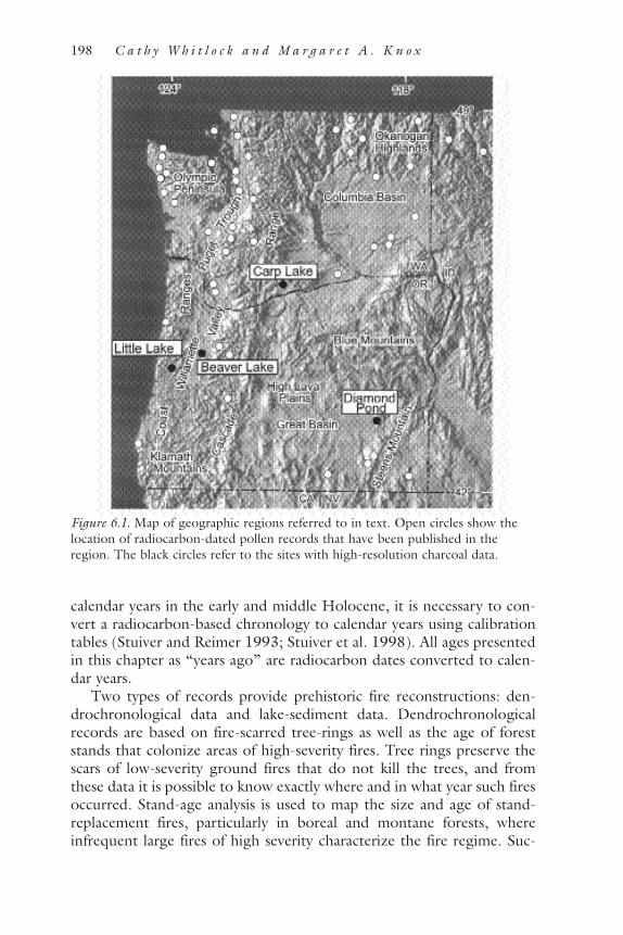
calendar years in the early and middle Holocene, it is necessary to con-vert a radiocarbon-based chronology to calendar years using calibrationtables (Stuiver and Reimer 1993; Stuiver et al. 1998). All ages presentedin this chapter as “years ago” are radiocarbon dates converted to calen-dar years.
Two types of records provide prehistoric fire reconstructions: den-drochronological data and lake-sediment data. Dendrochronologicalrecords are based on fire-scarred tree-rings as well as the age of foreststands that colonize areas of high-severity fires. Tree rings preserve thescars of low-severity ground fires that do not kill the trees, and fromthese data it is possible to know exactly where and in what year such firesoccurred. Stand-age analysis is used to map the size and age of stand-replacement fires, particularly in boreal and montane forests, whereinfrequent large fires of high severity characterize the fire regime. Suc-
198 C a t h y W h i t l o c k a n d M a r g a r e t A . K n o x
Figure 6.1. Map of geographic regions referred to in text. Open circles show thelocation of radiocarbon-dated pollen records that have been published in theregion. The black circles refer to the sites with high-resolution charcoal data.

cessively younger fires, however, erase the evidence of older fires instand-age analysis, and, as with fire-scar methods, the reconstructionperiod is as old as the oldest living trees. Few dendrochronological stud-ies extend beyond the last 500 years, and, in the Pacific Northwest, thelongest reliable chronologies span the last 600 years (Agee 1993).
Fire history on longer time scales is obtained from fire proxy pre-served in lake-sediment records (see Whitlock and Larsen, in press, fordiscussion of methods). Particles of charcoal, introduced to a lake dur-ing and shortly after a fire, provide information on past fires. Recentrefinements have been made in the study of past fires based on charcoalrecords from laminated and nonlaminated lake sediments (Patterson etal. 1987; Clark 1990; Millspaugh and Whitlock 1995; Clark and Royal1996; Long et al. 1998). By selecting a site carefully, constraining thesize of the charcoal particles examined, and discriminating between thelocal and extralocal components of the charcoal record, it is possible toreconstruct variations in local fire frequency with fair confidence. Theinterpretation of the charcoal data is based on calibration studies fol-lowing recent and historic fires (Whitlock and Millspaugh 1996; Clarket al. 1998; Ohlson and Tryterud 2000; Gardner and Whitlock, inreview). Charcoal particles more than 100 microns in size are tallied incontiguous 1-cm-long core intervals, and layers with abundant charcoal(charcoal peaks) are assumed to represent a fire “event.” An event isdefined as one or more fires occurring during the deposition of thatcore interval. Depending on the sedimentation rate, a fire event can bedated with decadal precision, although sometimes the peak spans a fewcentimeters of the core and thus is the equivalent of a few decades ofsediment deposition. High-resolution charcoal analysis is time-consum-ing, and only a few such records are currently available from the PacificNorthwest (Long et al. 1998; Pearl 1999; Mohr et al. 2000). Lessdetailed charcoal records have been described from the Puget Trough(Sugita and Tsukada 1982; Cwynar 1987) and Cascade Range (Dun-widdie 1986).
Climate and Vegetation Changes Since the Last Ice AgeIn the last 20,000 years, the Earth system has undergone a shift fromglacial conditions to the present interglacial period, the Holocene (thelast 11,000 years). These climatic changes profoundly affected ecosys-tems as species adjusted their ranges and abundance. Fire regimes werealso altered, and it is likely that fire was the proximal cause of many ofthe vegetation changes. The end of the glacial period is also the timewhen humans spread across North America. The archeological record inthe Pacific Northwest extends back about 11,000 years in the interior
P R E H I STOR I C B U R N I N G I N T H E PAC I F I C N ORT H WE ST 199

region (Aikens and Jenkins 1994) and 10,000 years along the coast (Sut-tles and Ames 1997).
Environmental changes occurring on millennial time scales were gov-erned by large-scale changes in the climate system that affected westernNorth America (Thompson et al. 1993). One control was the declininginfluence of North American ice sheets on the climate after 16,000 yearsago. The presence of an ice sheet prior to that time steepened the lati-tudinal temperature gradient south of its margin and shifted the jetstream south of its present position. The Pacific Northwest, as a result,was relatively cold and dry in full-glacial time, and the American South-west was more humid. As the ice sheets wasted, temperatures warmed,the jet stream shifted northward, and the climate of the Pacific North-west became warmer and wetter.
Another important control of climate relates to changes in the sea-sonal cycle of insolation caused by slow variations in the timing of peri-helion (when Earth is closest to the sun) and in the amount of tilt ofEarth’s axis (Kutzbach and Guetter 1986). Between about 14,000 and7,000 years ago, perihelion was in July and the tilt of Earth’s axis wasgreater than at present. As a result, summer insolation was 8.5 percentgreater and 10 percent less in winter in the Pacific Northwest during theearly Holocene (about 11,000–7,800 years ago). Greater-than-presentinsolation led directly to increased summer temperatures and drought.Indirectly, it gave rise to a strengthening of the eastern Pacific subtropi-cal high in the Pacific Northwest, which further intensified summerdrought. Paleoclimatic reconstructions suggest that annual precipitationwest of the Cascade Range was 40–50 percent less than today and annualtemperature was 1–3°C higher. In the Great Basin, increased insolationmay have led to stronger-than-present monsoonal circulation and thuswetter summers in the early Holocene. In the middle Holocene (some7,800–4,400 years ago), summer insolation was less than before and theeffects of drought and monsoonal precipitation were attenuated. Sum-mers became cooler and wetter across most of the Pacific Northwest,except in the Great Basin, where the climate became more arid (with theloss of summer precipitation). As the seasonal cycle of insolationapproached modern values in the late Holocene (the last 4,400 years),the entire region became cooler than before and the modern climateregime was established.
Paleoecological records indicate that these large-scale climate changeswere responsible for major reorganizations of vegetation in the last20,000 years. The summary of the vegetation history that follows isbased on Whitlock (1992, and references therein), as well as new pollenrecords from the Puget Trough (McLachlan and Brubaker 1995), Ore-gon Coast Range (Worona and Whitlock 1995; Grigg and Whitlock1998), Cascade Range (Sea and Whitlock 1995), and Willamette Valley
200 C a t h y W h i t l o c k a n d M a r g a r e t A . K n o x

(Pearl 1999). During the late-glacial period, when the Cordilleran icesheet and alpine glaciers were receding, the climate was cooler and wet-ter than today, but warmer than during full-glacial time. In the northernPuget Trough and Olympic Peninsula, lodgepole pine (Pinus contorta)forest, rather than tundra, colonized newly deglaciated substrates, sug-gesting that the climate was relatively warm by 16,000 years ago. Lodge-pole pine was joined by Sitka spruce (Picea sitchensis), Douglas fir(Pseudotsuga menziesii), and hemlock (Tsuga), forming a closed forest by13,000 years ago. A mixture of high- and low-elevation taxa that has nomodern counterpart appeared in the southern Puget Trough during thelate-glacial period, replacing earlier subalpine parkland communities. Asthe climate warmed, montane species were forced to higher elevations,and Douglas fir, red alder (Alnus rubra), and oak (Quercus) prevailed inthe lowlands. In the Oregon Coast Range, Douglas fir and red alderwere present as early as 16,000 years ago, supplanting forests of moun-tain hemlock (Tsuga mertensiana) and spruce. The southwesternColumbia Basin supported steppe and areas of spruce parkland as a resultof cool dry conditions in both full- and late-glacial time. Farther northin the Okanogan region, steppe or tundra with pine (presumably white-bark pine [Pinus albicaulis] and western white pine [P. monticola]), fir(Abies), and spruce were present.
During the early Holocene (some 11,000–7,800 years ago),drought- and disturbance-adapted species became widespread as a resultof summers that were warmer and drier than present. Douglas fir, redalder, and bracken (Pteridium aquilinum) were abundant within coastalforests, and these taxa along with prairie species were more extensive inthe Puget Trough and Willamette Valley. In the mountains, warmersummers shifted the position of upper treeline above its present position.East of the Cascade Range, cold steppe was replaced by temperatesteppe, and the forest/steppe ecotone lay above and north of its presentrange. In the Great Basin, cool and moist conditions allowed for theexpansion of sagebrush (Artemisia) and at higher elevations forincreased pine and juniper (Juniperus) (Mehringer 1985).
In the middle and late Holocene (7,800 years ago to present), lowersummer temperatures and greater effective moisture everywhere exceptin the Great Basin shifted the vegetation toward more mesophytic andfire-sensitive species. Forests became closed, and upper and lower tree-lines shifted to lower elevations. West of the Cascades, increased mois-ture in the middle Holocene allowed western red cedar (Thuja plicata),Oregon ash (Fraxinus latifolia), and big-leaf maple (Acer macrophyllum)to expand their ranges. Western hemlock (Tsuga heterophylla) and Sitkaspruce became more abundant in coastal rain forests in the last 4,400years. Prairies in the Puget Trough and Willamette Valley shrank in size,and oak and Douglas fir were less abundant than in the early Holocene.
P R E H I STOR I C B U R N I N G I N T H E PAC I F I C N ORT H WE ST 201

Western hemlock and western red cedar also expanded in the PugetTrough. In the Cascade Range, upper treeline shifted downslope to itspresent elevation.
In eastern Washington, steppe communities were replaced by pon-derosa pine parkland in the early and middle Holocene. This transitionoccurred quite early in the eastern Cascade Range (9,400 to 7,800 yearsago) and somewhat later in the Okanogan region (after 4,400 yearsago). In the last 4,000 years, low-elevation pine forests have beeninvaded by mesophytic conifers, including Douglas fir, fir, hemlock, andspruce, and along the Columbia Gorge by Oregon white oak. In theGreat Basin, the driest period occurred between 7,000 and 6,200 yearsago, when summer precipitation decreased but temperatures were higherthan at present. Between 6,200 and 1,950 years ago, the climate wascool and wet, allowing for the expansion of juniper woodland at low ele-vations. Generally moist conditions have occurred during the last 1,950years, with the exception of dry periods between 700 and 500 years ago(Wigand 1987).
This relation between past climate and vegetation in the PacificNorthwest provides a means of assessing the natural variations in fireoccurrence on long time scales. West of the Cascade Range, where theclimate is mesic, one would expect that periods of drier climate wouldhave higher-than-present fire frequencies, and consequently more fire-and drought-adapted taxa in the vegetation. Regardless of the source ofignition—humans or lightning—a dry climate would promote fires bydrying fuels. Conversely, when the climate was wet, the low availabilityof dry fuel would have reduced the possibility of fire spread no matterwhat the ignition opportunities. In arid regions east of the CascadeRange, the relation between climate and fire is more complex, becauseclimate variability, in addition to particular climate conditions, would bea factor. Fires would have occurred soon after wet periods or during ashort drought within an overall wet period, when grasses producedenough fine fuel to carry fire. Prolonged dry periods would have beenrelatively fire free, because of the lack of fuel productivity. Of course, thevegetation effects on fire go beyond fuel. For example, some forestecosystems favor species that have adaptations for maintaining a particu-lar fire regime, such as thick bark or serotinous cones. Anomalous fireregimes, not predicted or explained as a result of prevailing climate orvegetation conditions, would point to human agencies.
Fire, Climate, and Human Activity: Case StudiesThe prairie and savanna of the Willamette Valley, the juniper woodlandof the Great Basin, and the ponderosa pine forest of the eastern Cascades
202 C a t h y W h i t l o c k a n d M a r g a r e t A . K n o x

and Blue Mountains are regions where it has been proposed that indige-nous peoples regularly set fires (see Boyd 1999b). Likewise, the changesin vegetation that have occurred in the twentieth century have beenascribed to the elimination of native burning practices and the attendantexpansion of forest in the absence of fire. These assertions can be testedto some degree, because paleoecological data are available from theseregions to reconstruct the climate, vegetation, and fire history. Archaeo-logic and ethnographic records and historical journals provide an under-standing of indigenous cultures and the use of fire prior to and at thetime of Euro-American settlement. However, these materials are oftensketchy and subject to different interpretations.
The Willamette Valley of Western OregonChanges in the Willamette Valley since Euro-American settlement arewidely attributed to the elimination of fire and changes in land use activ-ity in the last 150 years. Comparison of the vegetation in the 1850s withthat of the present indicates that the density of tree and shrub cover hasincreased, and 88 percent of prairie and savanna has been lost (from688,604 ha to 83,476 ha; Hulse et al. 1998). The vegetation and fireregime at present contrasts greatly with the conditions that existed in thevalley in prehistoric times and which were witnessed by early Euro-American visitors. At the time of European contact, the Willamette Val-ley was occupied by a series of small independent groups within the Kala-puya language group (Zenk 1990). The prehistoric record extendshuman activities back about 8,000 years (Beckham et al. 1981), and it isthought that prehistoric and historic economies were based on a diverserange of wild foods, including river fish, roots, and seeds, as well as deer(Odocoileus spp.), elk (Cervus), small mammals, and wildfowl. Societieswere highly mobile, ranging seasonally to occupy riparian forest, savannaand woodland, and forest. People occupied open or simple structures insummer and permanent structures that housed several families in winter.Down river of the Willamette Falls, salmon (Oncorhyncus spp.) were alarge component of the economy, but above the falls and beyond exten-sive salmon runs, camas was an important food source (Boyd 1986).Hunting sites in the Cascades and Coast Range, attributed to valleygroups, attest to seasonal use of the forests (Aikens 1993).
PREHISTORIC RECORDS OF BURNING
Information on prehistoric fires comes from dendrochronologicalrecords as well as pollen and charcoal records from the Willamette Val-ley and adjacent mountains. Many of the oldest trees in the Cascades andCoast Range were established following one or more large fires in the
P R E H I STOR I C B U R N I N G I N T H E PAC I F I C N ORT H WE ST 203

1500s and early 1600s (Hemstrom and Franklin 1982; Morrison andSwanson 1990; Impara 1997; Weisberg 1998; Berkley 2000). Some firesoccurred in the early 1800s, when Kalapuya populations were decliningand before Euro-American settlement (Weisberg 1998; Morrison andSwanson 1990); therefore, natural ignitions seem to be the likely source.Data from the foothills of the Cascade Range and Coast Range suggestfires occurred along the valley margin in the middle and late 1700s priorto direct Euro-American influence (Berkley 2000). Fires are also widelyregistered in the middle and late 1800s and early 1900s, and these burnshave been ascribed to logging, mining, and road-building activities ofearly settlers (Burke 1979; Teensma 1987; Impara 1997; Berkley 2000).Some of the nineteenth-century fires were surprisingly large: the Silver-ton fire in 1865 affected 400,000 ha in the Cascades and Willamette Val-ley, and the Yaquina fire of 1853 burned 119,800 ha in the Coast Range.The Tillamook fire of 1933 covered 97,200 ha in the Willamette Valleyand Coast Range (Loy et al. 1976). Impara (1997) estimates that 50–70percent of the old-growth forest of the Coast Range was decimated byEuro-American burning. Settlement activities also led to localizedincreases in fire frequencies in the mixed-conifer forests of the southernCascades (Taylor 1993), Klamath Mountain region (Agee 1991), andSierra Nevada (Skinner and Chang 1996). Fire occurrence has decreasedin all these regions during the last 80 years as suppression efforts havebecome more effective.
A charcoal record of prehistoric fire activity from Little Lake in theCoast Range indicates that the mean fire return interval was 110 years inthe early Holocene, when Douglas fir, red alder, and oak were present(Long et al. 1998). By late Holocene time, the mean fire interval hadlengthened to 230 years, and fire-sensitive species like Sitka spruce andwestern hemlock were more common in the forest (Figure 6.2). Theselong-term trends in fire occurrence in the Coast Range agree with datafrom the Puget Trough and suggest a widespread response to Holoceneclimate changes.
Beaver Lake, located in an abandoned meander of the Willamette Val-ley, is another site where high-resolution charcoal analysis has beenundertaken (Pearl 1999). Land surveys in the 1850s show that the lakewas surrounded by willow and ash thicket, topographic depressions nearthe lake supported riparian forest and wet meadows, and nearby uplandvegetation was covered by woodland and savanna. The pollen data sug-gest that wet forest and meadows first appeared ca. 7,000 years ago as aresponse to cooling and increased moisture. Charcoal levels at BeaverLake were low until some 4,100 years ago, when they increased dramat-ically. The interval of highest charcoal occurred between 2,900 and 600years ago, after which charcoal levels were again low. Two aspects of this
204 C a t h y W h i t l o c k a n d M a r g a r e t A . K n o x

period of abundant charcoal are puzzling. First, the pollen record fromBeaver Lake does not indicate any changes in upland vegetation duringthe period of high charcoal. The fires may have been local and not rep-resentative of regional fire frequencies, or they may have occurred in thelate summer and fall and thus did not alter the composition of the veg-etation. Second, the fire period comes at a time when the climate wasshifting to cool, wet conditions in the late Holocene. This juxtapositionof high fire activity during a cool wet period may be evidence of delib-erate burning to maintain open vegetation, but it is not obvious why theKalapuya would have abandoned the effort about 600 years ago, when
P R E H I STOR I C B U R N I N G I N T H E PAC I F I C N ORT H WE ST 205
Figure 6.2. Inferred fire frequency and pollen percentages of selected taxa from Lit-tle Lake in the Oregon Coast Range (Long et al. 1998). Note the highest fire fre-quency occurs during periods when fire- and disturbance-adapted species are bestrepresented.

populations were supposed to have been at their largest (Boyd 1990).The decrease in fires 600 years ago at Beaver Lake may represent (1) anabandonment of the local area for unknown reasons; (2) a decrease inhuman populations due to disease, starvation, or other factors prior todirect European contact (Ramenofsky 1987; Ubelaker 1988); or (3) theonset of cooler, wetter conditions in the Little Ice Age and a decline inflammability (ca. A.D. 1650–1890; Graumlich and Brubaker 1986;Graumlich 1987). In summary, the Beaver Lake record suggests high fireincidence coincident with Kalapuya occupation, but provides no obviousexplanation for decreased burning in the last 600 years. Uncertainties inthe timing and interpretation of the record will only be resolved withadditional data.
Some have argued that natural ignitions in the valley were not fre-quent enough in prehistoric time to maintain the fire regime necessaryfor prairie and savanna (Morris 1936; Johannessen et al. 1971). Light-ning strikes are uncommon at present and generally do not occur insummer or early fall when fuels are driest. Moreover, fires in the valleytoday are actively fought and landscape fragmentation reduces their abil-ity to spread. It is difficult to assess the frequency of natural ignitions inthe past, because it would have varied as a component of the climate sys-tem. Lightning ignitions were probably more abundant in times ofstrong convectional activity, such as the early Holocene when monsoonalcirculation was enhanced, which is consistent with the charcoal evidenceof more fires in the early Holocene at several sites.
EURO-AMERICAN JOURNAL DESCRIPTIONS OF BURNING
Early ethnographers did not gather information on Kalapuya burningpractices, and the archaeological record provides few insights. The evi-dence for burning comes primarily from the accounts of early trappers,explorers, and settlers in the nineteenth century (see Knox 2000 formore detailed discussion of this literature). Contact with the Kalapuyawas relatively brief, beginning in 1812 and ending in 1856, when theyand other coastal peoples were moved to reservations (Beckham 1990).As early as 1812, Stuart (1995) mentions the decimation of native pop-ulations as a result of a smallpox outbreak at the confluence of theWillamette and Columbia Rivers. After 1831, malaria reduced the Kala-puya populations (Boyd 1975, 1986, 1990), and their numbers droppedfrom some 16,000 at the time of European contact to between 1,175(Boyd 1990) and 600 (Wilkes 1926) by 1841.
The earliest journals written between 1812 and 1825 (e.g., Douglas1959; Henry 1992; Seton 1993; Stuart 1995) do not mention native useof fire, either to control or maintain their ecosystem. Most of theaccounts were written during June, July, August, and September, and a
206 C a t h y W h i t l o c k a n d M a r g a r e t A . K n o x

few were written during winter and spring trips when evidence of firesmight have been less obvious. However, as the valley is generally snow-free, burned land would have been visible. Journals from 1826 to 1830contain some references to fire, but reports of native burning increaseafter 1840, with expanding Euro-American settlement of the valley.Journals written prior to 1831 (the first year of the malaria outbreak) areprobably the most accurate descriptions of Native American burningpractices prior to Euro-American settlement. This assertion is based onthe fact that hunters and trappers solicited the aid of native peoples, andtheir relation with the Kalapuya was frequently one of mutual respectand sharing. After 1840, settlers, and missionaries often describedindigenous people as ignorant, incompetent, and prone to thievery (e.g.,Minto 1900; Riggs 1900; O’Hara 1911). Settlers also altered the ecosys-tems upon which the Kalapuya depended by farming and by introducingnonnative animals. Pigs, for example, severely damaged camas fields earlyon (Palmer 1966), and cattle replaced wild game, which had all but dis-appeared by 1840. Native plant communities were lost as a result oflandscape fragmentation, agriculture, intense grazing by cattle andsheep, and the introduction of exotic plants (Hulse et al. 1998).
The most-cited description of the Willamette Valley prior to the1840s comes from David Douglas, a Scottish botanist who collectedplants for the Royal Horticultural Society. He traveled down theWillamette Valley from Fort Vancouver in 1825 and 1826, with mem-bers of the Hudson’s Bay Company. Douglas’s journals are exceptionalin their detailed descriptions of the landscape and vegetation, and hisperceptions of native peoples seem relatively unprejudiced. Douglasencountered burned areas, some of which were from quite small fires,whereas others were from large conflagrations affecting both his partyand the Kalapuya. A careful examination of the Douglas journals, takinghis entries in context and chronological sequence, and comparing themwith journals written by other members of his expedition, helps to dis-tinguish between prescribed burns set by the Kalapuya and larger,uncontrolled wildfires.
Douglas visited the north end of the valley in 1825, but he undoubt-edly spoke with trappers who had traveled farther south. The 1825 jour-nal has no mention of fires, nor does it provide first-person accounts offires. On an August trip, Douglas was about 25 miles above the falls onthe Willamette River in an area of riparian forest and wooded upland(Personal Communication, E. Alverson, 2001). He described a tobaccoplantation, which has been cited as one reason for burning by the Kala-puya (Boyd 1986, 1999a). The account suggests the use of fire inwooded areas, but not widespread burning, as Douglas comments onthe small acreage that is actually burned:
P R E H I STOR I C B U R N I N G I N T H E PAC I F I C N ORT H WE ST 207

8/19—Towards afternoon left in a small canoe with oneCanadian and two Indians . . . on a visit to the MultnomahRiver. . . . The beaver is now scarce; none alive came undermy notice. I was much gratified in viewing the desertedlodges and dams. . . . Collected the following plants . . . Nico-tiana pulverulenta. . . . I have seen only one plant before, inthe Hand of an Indian two months since at the Great Falls ofthe Columbia. . . . The natives cultivate it here and althoughI made diligent search for it, it never came under my noticeuntil now. They do not cultivate it near their camps or lodges,lest it should be taken for use before maturity. An open placein the wood is chosen where there is dead wood, which theyburn and sow the seed in the ashes. Fortunately I met withone of the little plantations and supplied myself with seedsand specimens without delay. (Douglas 1959:140–141)
The 1826 journey of Douglas can be reconstructed with respect togeography and vegetation with fair confidence (Table 6.2, Figure 6.3).The vegetation shown in Figure 6.3 is based on 1850 General LandOffice surveys prior to extensive land-use change (Hulse et al. 1998),and the vegetation distribution was probably similar to that encounteredby Douglas. From September 20 to 26, Douglas described the journeyfrom Fort Vancouver to meet Alexander McLeod, Chief Trapper for the
208 C a t h y W h i t l o c k a n d M a r g a r e t A . K n o x
TABLE 6.2. Location and distance traveled, vegetation, and fire observa-tions made by David Douglas during the 1826 journey through theWillamette Valley (see Figure 6.3 for vegetation and geographic location).
Location, Burned Date Distance traveled Vegetation circa 18501 ground noted2
September 20 Lower valley, 5 miles Closed forest: upland NoSeptember 21 Lower valley (at falls) Closed forest: upland NoSeptember 22–26 Lower valley, none Savanna NoSeptember 27 Lower valley, 5 miles Woodland and shrubland YesSeptember 28 Lower valley, ~7 miles Woodland and shrubland NoSeptember 29 Lower valley, 13 miles Prairie NoSeptember 30 Mid-valley, ~10 miles Savanna YesOctober 1 Mid-valley, 18 miles Savanna YesOctober 2 Mid-valley, 21 miles Savanna YesOctober 3 Mid-valley, 9 miles Prairie NoOctober 4 Upper valley, 24 miles Prairie YesOctober 5 Upper valley, 19 miles Savanna YesOctober 6 Coastal foothills, 16 miles Woodland and shrubland YesOctober 7 Coastal foothills, 7 miles Closed forest: upland NoOctober 8 Coastal foothills, 8 miles Closed forest: upland Yes1Based on 1850 Land Ordinance Survey (after Hulse et al. 1998).2From David Douglas’s 1826 journal entries (Douglas 1959).
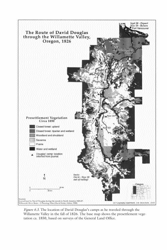
Figure 6.3. The location of David Douglas’s camps as he traveled through theWillamette Valley in the fall of 1826. The base map shows the presettlement vege-tation ca. 1850, based on surveys of the General Land Office.

Hudson Bay Company and leader of the expedition. McLeod’s encamp-ment was near or on the open grassland known as French Prairie. Dou-glas noted warm weather, heavy dews, and a search for some horses thatMcLeod had left above the falls on a previous trip; he did not mentionfire or burned ground. On September 27, Douglas was west of theWillamette River, between present-day Wilsonville and Newberg, in thesame woodland vegetation that had characterized the journey thus far.He detailed landscape conditions, including the effects of a recent fire:
9/27—Country undulating: soil rich, light with beautifulsolitary oaks and pines interspersed through it and musthave a fine effect, but being all burned and not a singleblade of grass except on the margins of rivulets to beseen. . . . Marched today five miles. (Douglas 1959:213)
The next day, the group turned south and probably crossed theNorth Yamhill River. The woodland opened and prairie was possibly evi-dent, but the vegetation did not change significantly. Douglas wrote:
9/28—Mr McLeod returned shortly after dusk last nightand brought with him one of the Indian guides from thecoast south of the country inhabited by the Killimuks. Allunfortunate in the chase, and although nine small deerwere seen in a group, yet by their keeping in the thicketsnear the small stream a few miles from our encampment,prevented the hunter from approaching them. Morningpleasant but chilly with heavy dew. Thermometer 41°.Started at eight o’clock, keeping a south-west course. . . .Camped on the south side of the Yamhill River, a smallstream about twenty-five yards wide; channel for thegreater part mud and sand. Two hundred yards belowwhere we forded are fine cascades 7 feet high. Countrymuch the same as yesterday; fine rich soil; oaks more abun-dant, and pines scarcer and more diminutive in growth. . . .Picked up a species of Donia . . . and . . . Phlox, both in richlight dry loam in open woods. . . . Hunters out in search ofdeer and not yet come home. I expect a fine fall, as seven-teen shots were heard in various directions in the woods.(Douglas 1959:213–214)
The September 28 entry notes similar country to that of the previousday, which is probably a reference to the topography and vegetation. Theburned area observed on September 27 was apparently small, becausethe group traveled only 5 miles and made no further mention of it. OnSeptember 29, they proceeded southwest, moving between woodland
210 C a t h y W h i t l o c k a n d M a r g a r e t A . K n o x

and savanna. Again, burned vegetation seemed absent and there is nomention of fire, even though the company traveled a fair distance, prob-ably reaching the Eola Hills:
9/29—Morning dull and cloudy . . . hunters returnedwith a very large fine doe. Started at nine and kept a south-west course, and camped not far from the point of a lowhill . . . Heavy rain for the remainder of the day and thegreater part of the night. Country not different from yes-terday. Traveled about thirteen miles. Nothing new cameunder my notice. (Douglas 1959:214)
On September 30, the company moved into open savanna. Theeffects of fire reappear in Douglas’s comments:
9/30—Cloudy until noon, after-part of the day clear andfine with a fanning westerly wind. In the morning driedsome of my things which got wet the preceding day.Started at nine and continued our route in a southerlydirection, on the opposite side of the hill from where wewere yesterday. Most parts of the country burned; only onlittle patches in the valleys and on the flats near the low hillsthat verdure to be seen. Some of the Natives tell me it isdone for the purpose of urging the deer to frequent certainparts to feed, which they leave unburned and of course areeasily killed. Others say that it is done in order that theymight better find honey and grasshoppers, which bothserve as articles of winter food. (Douglas 1959:214)
Douglas’s passages dated September 27, 28, and 30 are widely citedas evidence that the Kalapuya extensively burned the valley (Johannessenet al. 1971; Towle 1982; Boyd 1986, 1999a). However, the full entriesfor September 28 and September 29, with no mention of fire, are oftenoverlooked. It seems likely that the fires Douglas described on Septem-ber 27 and 30 were neither contiguous nor part of a single event.
On October 1 the company marched 18 miles and camped on a smallstream that entered the Willamette River; the stream could have beenRickreall Creek, Ash Creek, or the Luckiamute River. The distance anddescription correspond well with the terrain of the Eola Hills. Again,they encountered a burned landscape:
10/1—Heavy dew during the night; clear and pleasantduring the day, with a refreshing westerly wind . . . contin-ued our route. Had to make a circuitous turn east of south,south, and south-west to avoid two deep ravines that were
P R E H I STOR I C B U R N I N G I N T H E PAC I F I C N ORT H WE ST 211

impassable for the horses. Walked the greater part of theday, but found nothing new. On my way observed sometrees of Arbutus laurifolia, 15 inches to 2 feet in diameter,30 to 45 feet high, much higher than any I saw last year onthe Columbia; fruit nearly ripe; soil deep rich black loam,near springs, and on the gravelly bottom. Passed at noonsome Indians digging the roots of Phalangium Quamash inone of the low plains. Bulbs much larger than any I haveseen. . . . Camped at four on the banks of a small streamwhich falls into the Multnomah three miles to the east. . . .In the dusk I walked out with my gun. I had not gonemore than half a mile from the camp when I observed avery large waspnest, which had been attached to a tree,lying on the plain where the ground was perfectly bare andthe herbage burned, taken there by the bear (Douglas1959:214–215)
The following day Douglas recorded a possible source of ignition,lightning. Food for the horses was scarce:
10/2—Morning, heavy dew and chilly; clear and fine dur-ing the day; sheet lightning in the evening. . . . At noonpassed two deep gullies which gave much trouble, thebanks being thickly covered with brushwood, willow, dog-wood, and low alder. Course nearly due south, inclining tothe west. Country same as yesterday, rich, but not a vestigeof green herbage; all burned except in the deep ravines.Covered with Pterius aquilina, Solidago, and a strongspecies of Carduus. On the elevated grounds where the soilis a deep rich loam, 3 to 7 feet thick on a clay bottom, someof the oaks measure 18 to 24 feet in circumference, butrarely exceeding 30 feet of trunk in height. On the less fer-tile places, on a gravelly dry bottom, where the trees arescrubby and small, a curious species of Viscum, with ovateleaves, is found abundantly. . . . As no place could be foundsuitable for fodder for the horses, we had to travel till fouro’clock, when we camped at a low point of land near awoody rivulet. Marched twenty-one miles. My feet tonightare very painful and my toes cut with the burned stumps ofa strong species of Arundo and Spiraea tomentosa. (Dou-glas 1959:215)
A recent fire may explain this lack of fodder, but October is generallydry in this region and grass would have been scarce in any event. From
212 C a t h y W h i t l o c k a n d M a r g a r e t A . K n o x

October 4 to 6, the group was in the upper valley and beginning theirascent into the Umpqua Mountains. Douglas noted very warm weatherand burned ground:
10/4—The morning being cloudy and overcast, we didnot start so soon. As it cleared up about ten, the horseswere saddled and we proceeded on our route in a southerlydirection. Passed in the course of the day three smallstreams, which all fall into the Multnomah ten miles belowthis place. As no place could be found fit for camping wewere obliged to go until five o’clock, when we put up onthe south side of a muddy stream, banks covered with Frax-inus. No deer killed this day, although several were seen.Nothing particular occurred. Marched twenty-four miles;somewhat fatigued. (Douglas 1959:216)
From October 8 to 25, the company was out of the valley. Several ref-erences are made to tremendous storms and lightning, and the lack offood in the Umpqua region. The return trip from the upper valley toFort Vancouver took approximately 8 days. Douglas described the onsetof rain and lightning, and the lack of food in camp, but he made no fur-ther reference to fire:
10/8—Morning cool and pleasant; day clear and warm.Thermometer in the shade 82°; much sheet lightning inthe evening, wind westerly. . . . No deer killed and had thelast fragments cooked for supper, which gave us all but ascanty meal. . . . We are just living from hand to mouth. Allthe hunters observe that the animals are very scarce andthose shy in consequence of the country being burned.(Douglas 1959:217)
10/25—Last night was one of the most dreadful I everwitnessed. The rain, driven by wind, rendered it impossiblefor me to keep any fire . . . every ten or fifteen minutesimmense trees falling producing a crash as if the earth werecleaving asunder, which with the thunder peal on pealbefore the echo of the former died away, and the lightningin zigzag and forked flashes. . . . My poor horses wereunable to endure the violence of the storm without cravingof my protection, which they did by hanging their headsover me and neighing. (Douglas 1959:229)
While waiting for Douglas to arrive at French Prairie in September,
P R E H I STOR I C B U R N I N G I N T H E PAC I F I C N ORT H WE ST 213
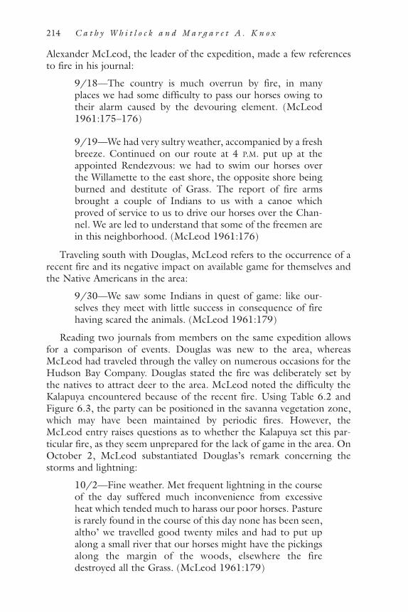
Alexander McLeod, the leader of the expedition, made a few referencesto fire in his journal:
9/18—The country is much overrun by fire, in manyplaces we had some difficulty to pass our horses owing totheir alarm caused by the devouring element. (McLeod1961:175–176)
9/19—We had very sultry weather, accompanied by a freshbreeze. Continued on our route at 4 P.M. put up at theappointed Rendezvous: we had to swim our horses overthe Willamette to the east shore, the opposite shore beingburned and destitute of Grass. The report of fire armsbrought a couple of Indians to us with a canoe whichproved of service to us to drive our horses over the Chan-nel. We are led to understand that some of the freemen arein this neighborhood. (McLeod 1961:176)
Traveling south with Douglas, McLeod refers to the occurrence of arecent fire and its negative impact on available game for themselves andthe Native Americans in the area:
9/30—We saw some Indians in quest of game: like our-selves they meet with little success in consequence of firehaving scared the animals. (McLeod 1961:179)
Reading two journals from members on the same expedition allowsfor a comparison of events. Douglas was new to the area, whereasMcLeod had traveled through the valley on numerous occasions for theHudson Bay Company. Douglas stated the fire was deliberately set bythe natives to attract deer to the area. McLeod noted the difficulty theKalapuya encountered because of the recent fire. Using Table 6.2 andFigure 6.3, the party can be positioned in the savanna vegetation zone,which may have been maintained by periodic fires. However, theMcLeod entry raises questions as to whether the Kalapuya set this par-ticular fire, as they seem unprepared for the lack of game in the area. OnOctober 2, McLeod substantiated Douglas’s remark concerning thestorms and lightning:
10/2—Fine weather. Met frequent lightning in the courseof the day suffered much inconvenience from excessiveheat which tended much to harass our poor horses. Pastureis rarely found in the course of this day none has been seen,altho’ we travelled good twenty miles and had to put upalong a small river that our horses might have the pickingsalong the margin of the woods, elsewhere the firedestroyed all the Grass. (McLeod 1961:179)
214 C a t h y W h i t l o c k a n d M a r g a r e t A . K n o x

From the journals of Douglas and McLeod, two types of fire emerge:small, possibly prescribed burns used in tobacco cultivation, and larger,unexpected conflagrations, possibly ignited by lightning, which depletedhunting resources for both Douglas’s party and the Kalapuya.
John Work (1923), an employee of the Hudson Bay Company, trav-eled from Fort Vancouver to the Umpqua River in 1834. When thecompany reached present-day Monroe, Work wrote the much-citedentries of July 1 and 2 in his journal describing the native peoples settingfire to the grassland:
7/1—Three other Indians passed us but made a very shortstay and appeared to be much afraid of something. Parts ofthe plain gravelly and soil poor, herbage getting dry andthe ground has an arid appearance; on the lower spots grassluxuriant. (Work 1923:264)
7/2—The Indians set fire to the dry grass on the neighbor-ing hill, but none of them came near us. The plain is also onfire on the opposite side of the Willamet. (Work 1923:264)
However, the next entry suggests that the fires served as a means ofprotection for the Kalapuya against the Umpqua:
7/3—Ten of them visited the camp and traded their beaver.These Indians are much alarmed lest they be attacked by theUmquahs . . . that nation have threatened to come to warupon them. . . . As we were coming on we found a party of32 men all armed and ready for war, supposing that a partyof Umquahs were coming upon them. (Work 1923:264)
And, on July 5 and 6, Work was approximately 40 miles above thefalls and still recounted the anticipation of conflict:
7/5—These people are preparing to go to war. (Work1923:266)
7/6—They are all armed and prepared for an attack. (Work1923:266)
Samuel Clarke confirmed the use of fire for protection when he inter-viewed residents of the Grand Ronde Reservation in the 1880s. Clarke(1905) wrote that burning was used to sight hostile war parties from adistance.
In summary, the reliability of journals as a source of information onindigenous burning practices depends on the time that they were writ-ten, the full context of the journal, and the perspectives of the writer andthe reader (Knox 2000). Also, by examining single entries from a jour-
P R E H I STOR I C B U R N I N G I N T H E PAC I F I C N ORT H WE ST 215

nal, a biased view of the history for a region may emerge. Only byresearching numerous journals, letters, and other papers does the com-plexity of Kalapuya history at the time of European contact begin toemerge. Early observations must be considered in light of the fact thatthe Kalapuya were decimated by infectious introduced diseases and theirway of life was threatened at the time of even the earliest journals. Onlya few of the journals mention the large numbers of Native Americansdying of disease, often by a sentence or single paragraph (e.g., Parker1840; Wilkes 1926), yet evidence of death must have been pervasive.The early journal accounts that describe fire do not present a picture ofbroadcast burning to maintain open conditions, although large fires arenoted in prairie and savanna areas. Only David Douglas and John Workassociate fires with the Kalapuya prior to the 1840s, and the extent ofburning from both accounts seems limited.
Juniper Woodland of Eastern OregonWestern juniper (Juniper occidentalis) grows at low and middle eleva-tions (760–1,400 m elevation) in the northern Great Basin and formsthe driest forest zone (less than 20 cm annual precipitation) in the PacificNorthwest (Franklin and Dyrness 1973). The fire regime within juniperwoodland is determined by the availability of fine fuels in the form ofgrass, which allows fire to spread. Ground fires remove litter and treeseedlings, enabling grass to resprout, but established juniper trees arefairly fire resistant and can live to be several hundred years old (Burnsand Honkala 1990). A fire interval of 30 to 40 years is sufficient to keepjuniper from invading sagebrush-grassland communities (Miller andRose 1995). In the absence of fire, juniper seedlings establish and thewoodland becomes more closed. Sagebrush (Artemisia tridentata) alsoreplaces perennial bunchgrasses, converting grassland to shrub steppe.Wet periods tend to promote the growth of grass and frequent fires,which in turn limit the ability of juniper and sagebrush to spread. Peo-ple of the northern Paiute language group occupied the Great Basin atthe time of European contact. Current research suggests that prehistoricand historic population densities were never high, and societies weremobile enough to take advantage of the scarce resources (Aikens andJenkins 1994). Historic accounts highlight the exploitation of mammals,fish, insects, and plants by small family groups during most of the yearand the yearly gathering of larger groups at root-processing camps,salmon fisheries, and seed gathering sites (Aikens 1993). Shinn (1980)suggests that fires were regularly set by native groups in historic time forpurposes of signaling, hunting, and collecting insects, and Euro-Ameri-cans describe burned expanses of prairie that were attributed to Native
216 C a t h y W h i t l o c k a n d M a r g a r e t A . K n o x

Americans. Trapper Peter Skene Ogden, for example, reported in 1826that the southern Blue Mountains were “overrun by fire” and blamedthe fires on native peoples (Langston 1995).
The relationship among fire, grass, and western juniper in prehistorictimes is suggested by pollen and charcoal records, particularly those fromDiamond Pond in southeastern Oregon, and from plant macrofossilscontained in ancient packrat middens (Figure 6.4; Mehringer andWigand 1990). These data indicate that the period of maximum aridity
P R E H I STOR I C B U R N I N G I N T H E PAC I F I C N ORT H WE ST 217
Figure 6.4. Prehistoric and historic juniper expansion. The record of juniper pollenabundance from Diamond Pond (Mehringer and Wigand 1990) shows that juniperpollen was abundant between 4,500 and 2,100 years ago, then present in lowamounts from 2,100 to 500 years ago. In the last 500 years, juniper pollen abun-dance has increased steadily, with the exception of a period of low percentages inthe early twentieth century. Growth records of western juniper from the last mil-lennium are available from Kaiser Pass, Calif. (Graumlich 1991), and Horse Ridge,Ore. (Holmes, Adams, and Fritts 1986). The index is high during high growthyears. Both records suggest a period of favorable growth since the 1930s, which isconsistent with its historic expansion.

occurred between some 7,800 and 4,400 years ago, which is late com-pared with the rest of the Pacific Northwest (as discussed previously).The archaeological record is sparse during the dry period, probablybecause populations were focused on wetland and lacustrine resources(Aikens 1983). Wet conditions returned during the Neopluvial period(about 4,400 to 2,000 years ago), and the renewed abundance of uplandresources may have allowed populations to become more widely distrib-uted (Aikens 1983).
Pollen and packrat-midden records from Diamond Pond and vicinitydescribe the vegetation response to a series of climate changes duringand since the Neopluvial period (Figure 6.4). With increased moistureafter 4,400 years ago, western juniper extended its elevational rangedownslope by 150 m, and grass was more abundant than sagebrush inthe basins (Wigand 1987; Mehringer and Wigand 1990; Miller andWigand 1994). Between about 2,000 and 1,000–800 years ago, the cli-mate became warmer and drier, and the lower limit of juniper retreatedupslope. In the last 1,000 years the climate has become wetter, allowingjuniper and grass to expand downslope again (although there was anotable dry period and range contraction from 700 to 500 years ago).The expansion of juniper in the last few centuries has been accompaniedby increased sagebrush, not grass, according to the pollen data. Thecombination of juniper and sagebrush implies greater winter precipita-tion than before and a reduction in summer precipitation (which wouldfavor sagebrush over grass). Miller and Wigand (1994) note that the “re-expansion of Great Basin woodlands was just getting underway whenEuropeans first entered the area.”
The Diamond Pond record contains little charcoal in sediments dat-ing between 6,200 and 3,700 years ago, which is consistent with a modelof few fires when juniper and grass levels were low and sagebrush wasabundant. Charcoal values increased in the record about 3,700 years agoand remained generally high until about 1,100 years ago. The increasein fire occurrence coincides with the shift in vegetation towards morejuniper and grass in the Neopluvial period. The most recent expansionof juniper woodland, beginning some 1,000 years ago, occurred duringa period of few fires.
Dendroclimatological records from eastern Oregon span the last 700years and indicate several periods of moist conditions that favoredjuniper growth, including an interval from A.D. 1650 to 1900 that coin-cides with the Little Ice Age. When the data are filtered to show onlyinterannual and decadal variations, the tree-ring data indicate rapidgrowth during the 1880s and 1890s, which were some of the wettestyears on record, and slow growth during the 1930s, which were amongthe driest (Figure 6.4) (Garfin and Hughes 1996). Increased precipita-
218 C a t h y W h i t l o c k a n d M a r g a r e t A . K n o x

tion and warm winters must be part of the explanation for the expansionof juniper and decrease in grass in the last 500 years. Decades since 1930are anomalous compared with other wet periods, however, because ofthe absence of fires.
Miller and Rose (1995) analyzed the stand ages of western junipercommunities and concluded that open stands were present on SteensMountain from the 1700s to the 1880s. The first increase in tree densi-ties occurred in the late 1800s, and a relatively steady rate of juniperestablishment was maintained until the 1950s. Juniper populationsincreased at a geometric rate after the 1960s. Miller and Rose (1995)speculate that climate change, reduced fire frequencies, and grazing inthe late 1800s were the primary factors for juniper expansion. They notethat the mild wet winters of the 1880s, following the Little Ice Age,probably promoted vigorous tree growth. The late nineteenth centurywas also a time of intensive livestock grazing (Burkhart and Tisdale1976), and the incipient decrease in native bunchgrass eliminated thefuel source that once allowed fire to spread across the landscape. Con-currently the increase in sagebrush provided more safe sites for juniperseedlings. Decreases in Paiute populations during the 1870s may alsohave been a factor, but their relocation to reservations precedes thegreatest expansion of juniper by nearly 90 years. It seems that Euro-American activities and climate change so obvious in this century aremore directly responsible for the changes in forest cover.
Ponderosa Pine Forests of the Eastern Cascade Range andBlue MountainsPonderosa pine forests form a vegetation zone from 1,450 to 2,000 melevation in the Oregon Cascades and 900 to 1,500 m elevation in theBlue Mountains (Franklin and Dyrness 1973). The zone lies betweenmixed communities of Douglas fir, grand fir, pine, and other mesic taxaat higher elevations and juniper woodland and sagebrush steppe at lowerelevations. Dendrochronological studies suggest that these forests his-torically experienced short fire return intervals on the order of decadesor less and that fires scarred but often did not kill mature trees (Agee1993). The extent of individual fires in ponderosa pine forest is not welldocumented in the Pacific Northwest, but many studies suggest thatthey were often small and scattered as a result of the discontinuous pat-tern of fuels (Bork 1985; Agee 1993; Heyerdahl 1997). In areas of fre-quent fires, the understory was regularly cleared of fuel, and thick-barked, fire-resistant pine trees remained. Where fires were infrequent,the buildup of understory fuels shifted the disturbance regime towardstand-replacement fires, and mesic fire-sensitive species—such as grand
P R E H I STOR I C B U R N I N G I N T H E PAC I F I C N ORT H WE ST 219

fir and Douglas fir and multiple-age stands of ponderosa pine—fill in theunderstory (Agee 1993). The resiliency of these forests is now of greatconcern to forest managers, because fire exclusion practices in the latetwentieth century have allowed fuels to build up and increase the likeli-hood of high-intensity burns. Rather than maintaining the forests withlow-intensity ground fires, the concern is that the current regime willprove lethal for this forest type.
The open structure of many ponderosa pine forests at the time ofEuro-American settlement has been attributed to the effects of frequentfire, and burning by Native Americans may have been one source. TheCascade forests were visited by native peoples from both the Plateau andthe Great Basin and also by Inland Valley and Klamath Lake people inhistoric times (Zucker 1983), and archaeological data extend humanoccupation to at least early Holocene time (Aikens 1993). Populationdensities were probably low and consisted of seasonal hunting and gath-ering groups. Burning may have been used to facilitate travel and hunt-ing and promote the production of grass and berries. Reports of NativeAmerican–set fires are mentioned in the journal accounts of early trap-pers, missionaries, and settlers traveling through and around the BlueMountains and Northern Rockies (see Gruell 1985; Langston 1995;Barrett and Arno 1999). Whether the observed fires were deliberately setas a means of opening the understory, caused by lightning ignitions, orrepresent fires escaped from adjacent grassland is not clear from mostdescriptions.
Tree-ring records confirm that fires in ponderosa pine forests havebeen controlled by variations in climate on interannual and decadal timescales. Forest ecologists have also described complex linkages betweenfire, insect outbreaks, and nutrient cycling in these forests (e.g., Mutchet al. 1993). For example, beetle-kill trees increase the likelihood ofsevere fire, and tree mortality, in turn, introduces nutrients to the soilsand allows for seed germination and seedling establishment. Heyerdahl(1997) examined 300 years of tree-ring data from the Blue Mountainsand discovered 65 separate fire years at her sites. Xeric forests, dominatedby ponderosa pine and juniper, burned more frequently than mesicforests of pine, Douglas fir, fir, and larch, but in extreme drought yearsboth forest types were affected. Xeric forests displayed considerable vari-ation in the size and severity of past fires, depending on local site condi-tions. The fire-history reconstructions showed strong correlationsbetween drought years and big fire years. The area burned on decadaltime scales for the last 300 years also tracked decadal precipitation well.These data are among the strongest and most significant fire-climaterelations shown for the Pacific Northwest. A decline in fire occurrence,beginning in the 1880s, was attributed primarily to the effects of graz-
220 C a t h y W h i t l o c k a n d M a r g a r e t A . K n o x

ing but also to variations in climate and insect outbreaks (Heyerdahl1997). A fire-history study in ponderosa pine forests in the eastern Cas-cade Range also found a decrease in fire occurrence, which was attrib-uted to grazing and suppression activities in the twentieth century (Bork1985).
Paleoecological records place the establishment of modern ponderosapine forest in the middle and late Holocene, following a period ofexpanded steppe. At Carp Lake near Goldendale, Washington, pollendata suggest that pine forests colonized the region about 7,700 years agoand persisted for the next 3,200 years. The climate became cooler andwetter some 4,400 years ago and allowed Douglas fir, fir, and westernhemlock to establish near Carp Lake (Whitlock and Bartlein 1997). Fireswere probably more frequent during early Holocene and middleHolocene periods, when the climate was drier than the late Holocene.Unfortunately, charcoal data are not yet available from Carp Lake orother sites in the ponderosa pine forest to allow for reconstruction of thefire history more precisely, but the linkages between vegetation changeand climate are well documented. Human impacts on forest compositionwould have to be discerned on top of those caused by climate.
Native American burning was likely responsible for the open standstructure in ponderosa pine forests in particular localities. Barrett andArno (1982, 1999) conducted interviews with thirty-one Salish andKootenai and twenty-seven descendents of early pioneers in northwest-ern Montana to gather information on human-set fires in ponderosapine forests during historic times. However, the value of these interviewsmight be questioned, because no information was provided on the back-ground of the interviewees (were they Salish, Kootenai, or others?), andany account as of 1980 is at least 120 years removed from the criticalperiod. Barrett and Arno (1999) also note that descendants of settlershad more detailed recollections of native burning practices than didnative descendants, which raises concerns about possible biases in thedata. Twenty-five of the interviewees had some recollection of deliberateburning, and seven could identify the geographic location of such activ-ities. Tree-ring records were analyzed to compare the fire history nearhistoric Native American settlements with that of comparable siteslocated in remote settings. In nine of ten comparisons the site heavilyused by people showed a higher fire frequency than the remote site; inthree of the comparisons the difference was statistically significant. Theresults suggest that Native Americans had an impact on the structure ofponderosa pine forest near densely populated areas, but the impact ofburning activities at a larger spatial scale remains unresolved. If the pur-pose of native-set fires was to influence game, to improve berry gather-ing and grazing (after the introduction of horses in the 1700s), and to
P R E H I STOR I C B U R N I N G I N T H E PAC I F I C N ORT H WE ST 221

facilitate travel, camping, and communication, such activities would havebeen geographically limited in scope. The influence of human-set fireson the character of ponderosa pine forest ecosystem at a regional scalehas yet to be demonstrated.
Final CommentsSome very large fires have occurred since Euro-American settlement.The worst fire year on record was 1910, when more than 2 million ha ofwestern national forest lands burned in the northern Rocky Mountainsand Pacific Northwest (Swetnam and Betancourt 1998). In the last 12years, these regions have once again experienced a number of large,stand-replacement fires. Fires in 1994 affected more than 11,460 ha ofOregon state forests (Oregon Department of Forestry 1997) and morethan 1.2 million ha in eleven western states (Maciliwain 1994). The firesof 2000 consumed more than 7 million acres (National Interagency FireCenter 2000). Many trees were killed by these events, and, as a conse-quence, forest management practices and fire policy have come underincreasing public scrutiny. The size of recent fires has been attributed tochanges in vegetation structure, the accumulation of fuel, and climateover the last 100 years. Changes in vegetation and accumulation of fuelhave been attributed to the elimination of Native American burningpractices (Barrett and Arno 1982; Pyne 1982), effective fire fightingpractices since World War II (Pyne 1982), and high tree mortality fromrecent infestations by mountain pine beetle and western spruce bud-worm (Mutch et al. 1993). The climate argument is based on the his-toric occurrence of severe fires in years of intense drought (Balling et al.1992). It has also been predicted that large fires will continue to occurin the future with global warming as a result of increased greenhousegases (Franklin et al. 1991; Romme and Turner 1991; Running andNemani 1991; Bartlein et al. 1997).
Discussions over the degree to which the prehistoric landscape waspristine or humanized filter into the debate of how best to respond tocurrent large fires. If humans altered ecosystems through their use offire, then a return to presettlement landscapes (i.e., those that existedprior to European contact) is not possible without instigating burningand fuel reduction through forest thinning. It’s not surprising thatassigning a large role to prehistoric peoples is a popular concept amongthose who advocate active management of wilderness and commoditylands today. The argument is that some forests are so altered by fireexclusion that fire alone may not restore them. Zyback (1995), forexample, suggests that human-set fires, in prehistoric times, altered everyacre of the Pacific Northwest, leaving no vegetation unaffected. The
222 C a t h y W h i t l o c k a n d M a r g a r e t A . K n o x

Northwest Forestry Association, which represents commercial timberinterests in the region, states that current forests are unnaturally denseand vulnerable to disease in the absence of fires. Restoring forest health,in their opinion as well as that of others, requires immediate thinningand salvage to emulate the effects of native peoples (Bonnicksen 1989;Wagner and Kay 1993). Others note that western forests are spatiallyvariable and have experienced a wide range of fire conditions in the pastand at present. A policy of thinning and prescribed burning may beappropriate in low-elevation ponderosa pine forests, but it is less justifi-able in areas that historically sustained large stand-replacing events.Given the economic consequences, it is clear that more is at stake in thisdebate than an academic interest in prehistoric fire regimes.
On the other hand, it is equally incorrect to portray the region asuntouched by human action prior to European contact. Historical andethnographic accounts suggest that Native Americans used fire in theWillamette Valley and at the lower forest-grassland border to open for-est and maintain prairie. The frequency and extent of such burning,however, is not clear. Paleoecological data from the Willamette Valley,northern Great Basin, and eastern Cascades and Blue Mountains suggestthat climate, vegetation, and fire regimes were closely interlinked in pre-historic times and climate has been a primary determinant of vegetationcomposition and disturbance regimes. The extent to which fire-regimevariability closely tracks independently derived records of climate vari-ability is a convincing measure of the importance of climate relative toother potential causes of fire-regime variability, known or unknown. Theprinciple of Occam’s razor suggests that it is not necessary to invokemore complicated arguments or hypotheses than climate variation toexplain the temporal patterns we observe in fire regimes.
As climate and climate variability have changed through time, so toohave the vegetation and conditions influencing fire occurrence. Wher-ever we have data, the record shows that fires were generally extensivewhen prevailing climate and vegetation fostered suitable fuel andweather conditions and an ignition source. Such periods include theearly Holocene in most regions, the late Holocene in the northern GreatBasin, the late 1500s, the 1850s, the 1930s, and the late 1980s to 1990s.The fire-history record, when viewed on millennial and centennial timescales, indicates no long-term cycle, because the fire regime has contin-ually changed with climate variations.
These climate-vegetation-fire linkages on short and long time scalesare the backdrop against which human perturbations must be assessed.Although we have a basic understanding of how fire frequency haschanged with climate and vegetation on Holocene time scales, thearchaeological and ethnographic records provide little information about
P R E H I STOR I C B U R N I N G I N T H E PAC I F I C N ORT H WE ST 223

the prehistoric use of fire. A relation between human population size andresource utilization seems obvious, but assessing the role of burningrequires information on the particular adaptations of the group, theiravailable technologies, and their population size and density, as well asthe characteristics of their environment. Without such information, adirect link between fire and humans will never be established.
The case studies described above show a decline in fire occurrencethat started between 1,000 and 500 years ago, which coincides withregional cooling and increased moisture at the end of the MedievalWarm period and beginning of the Little Ice Age. Similarly, increases infire occurred in the Willamette Valley, northern Great Basin, easternCascades, and Blue Mountains in the late nineteenth and twentieth cen-turies following the Little Ice Age. Certainly, the buildup of biomassduring the Little Ice Age may have set the stage for more intense fires ofrecent times, but these environmental changes pale in comparison to theadditive effects of Euro-American settlement. Logging, farming, graz-ing, mining, and fire elimination in the last century have altered vegeta-tion and fire regimes on a regional scale more than any other event ofthe last 11,000 years. In contrast, prehistoric peoples locally altered thelandscape, but there is no strong evidence that their activities creatednew vegetation types at a regional scale. Even in the Willamette Valley,where early settlers describe the burning activities of the Kalapuya, theseactivities alone do not explain the presence of prairie, savanna, and oakwoodland. Such biomes developed simultaneously in several parts of thePacific Northwest, as a result of warm dry conditions and frequent firesin the early Holocene, and became restricted in the middle and lateHolocene, when conditions were cooler and wetter. Native peoples mayhave acted as an ignition source for fires, but the ability of vegetation toburn was undoubtedly determined by fuel and weather conditions.
A greater myth than that of the pristine landscape is the assumptionthat the forests at the time of Euro-American exploration and settlementare representative of all of prehistory. On the contrary, what early Euro-peans described was only a snapshot of ecosystem change operating onmultiple temporal and spatial scales. It would not be possible to re-cre-ate the forests that existed 100, 500, or 1,000 years ago, even if we knewpast forest conditions perfectly, or the role of Native American activityprecisely. A “snapshot” approach to restoration is untenable because thecurrent set of climate conditions is unique on both centennial and mil-lennial time scales. The paleoecological record argues instead that natu-ral ecosystems are dynamic. They should be managed in ways that allowthe possibility of changes in species’ range and abundance and the occur-rence of large, stand-replacing fires in the face of climate change. Historysuggests that such changes are inevitable in the face of climate change.
224 C a t h y W h i t l o c k a n d M a r g a r e t A . K n o x

AcknowledgmentsHelpful reviews were provided by Ed Alverson, Bill Baker, Bob Gress-well, Sarah Shafer, Fred Swanson, and Tom Swetnam. We thank JohnChristy of the Nature Conservancy and Paula Minear of Oregon StateUniversity for allowing us to use the 1850 vegetation data for theWillamette Valley. Jim Meacham of InfoGraphics, University of Ore-gon, helped us construct Figure 6.3 from these data. The research wassupported by the National Science Foundation (SBR–9615961) andUSDA Forest Service (Cooperative Agreement PNW 98–5122–1–CA).
Literature CitedAikens, C. M. 1983. Environmental archaeology in the western United States.
Pp. 239–251 in Late Quaternary environments of the United States, vol. 2, ed.H. E. Wright, Jr. Minneapolis: University of Minnesota Press.
———. 1993. Archaeology of Oregon. U.S. Department of Interior, Bureau ofLand Management. BLM/OR/WA/ST-93/16+8100.
Aikens, C. M., and D. L. Jenkins, ed. 1994. Archaeological researches in theNorthern Great Basin: Fort Rock archaeology since Cressman. University ofOregon anthropological papers 50. Eugene: University of Oregon, Depart-ment of Anthropology and State Museum of Anthropology.
Agee, J. K. 1991. Fire history along an elevation gradient in the Siskiyou Moun-tains, Oregon. Northwest Science 65:188–199.
———. 1993. Fire ecology of Pacific Northwest forests. Washington, D.C.: IslandPress.
Baker, R. G. 1983. Holocene vegetational history of the western United States.Pp. 109–127 in Late-Quaternary environments of the United States, vol. 2, ed.H. E. Wright, Jr. Minneapolis: University of Minnesota Press.
Balling, R. C., Jr., G. A. Meyer, and S. G. Wells. 1992. Climate change in Yel-lowstone National Park: Is the drought related risk of wildfires increasing? Cli-matic Change 22:34–35.
Barnosky, C. W., P. M. Anderson, and P. J. Bartlein. 1987. The northwesternU.S. during deglaciation: Vegetational history and paleoclimatic implications.Pp. 289–321 in North America and adjacent oceans during the last deglacia-tion, ed. W. F. Ruddiman and H. E. Wright, Jr., The Geology of North Amer-ica, vol. K-3. Boulder: Geological Society of America.
Barrett, S. W., and S. F. Arno. 1982. Indian fires as an ecological influence inthe northern Rockies. Journal of Forestry 80:647–651.
———. 1999. Indian fires in the Northern Rockies; ethnohistory and ecology.Pp. 50–64 in Indians, fire, and the land in the Pacific Northwest, ed. R. Boyd.Corvallis: Oregon State University Press.
Bartlein, P. J., K. H. Anderson, P. M. Anderson, M. E. Edwards, C. J. Mock, R.S. Thompson, R. S. Webb, T. Webb III, and C. Whitlock. 1998. Paleoclimatesimulations for North America over the past 21,000 years: Features of the sim-
P R E H I STOR I C B U R N I N G I N T H E PAC I F I C N ORT H WE ST 225
ulated climate and comparisons with paleoenvironmental data. QuaternaryScience Reviews 17:549–585.
Beckham, S. D. 1990. History of western Oregon since 1846. Pp. 180–188 inHandbook of North American Indians, vol. 7: Northwest coast, ed. W. Suttles.Washington, D.C.: Smithsonian Institution.
Beckham, S. D., R. Minor, and K. A. Toepel. 1981. Prehistory and history ofBLM lands in west central Oregon: A cultural resources overview. University ofOregon anthropological papers 25. Eugene, Ore.
Berkley, E. 2000. Temporal and spatial variability of fire occurrence in westernOregon, A.D. 1200 to present. Master’s thesis, Department of Geography,University of Oregon, Eugene.
Bonnicksen, T. M. 1989. Fire gods and federal policy. American Forests95:14–16, 66–68.
Bork, J. 1985. Fire history in three vegetation types on the east side of the Ore-gon Cascades. Ph.D. diss., Oregon State University, Corvallis.
Boyd, R. 1975. Another look at the “fever and ague” of Western Oregon. Eth-nohistory 22:135–154.
———. 1986. Strategies of Indian burning in the Willamette Valley. CanadianJournal of Anthropology 5:67–86.
———. 1999a. Strategies of Indian burning in the Willamette Valley. Pp.94–138 in Indians, fire, and the land in the Pacific Northwest, ed. R. Boyd.Corvallis: Oregon State University Press.
———, ed. 1999b. Indians, fire, and the land in the Pacific Northwest. Corval-lis: Oregon State University Press.
Boyd, R. T. 1990. Demographic history, 1774–1874. Pp. 135–148 in Handbookof North American Indians, vol. 7: Northwest coast, ed. W. Suttles. Washing-ton, D.C.: Smithsonian Institution.
Burke, C. J. 1979. Historic fires in the central western Cascades, Oregon. Mas-ter’s thesis, Department of Forest Science, Oregon State University, Corvallis.
Burkhart, J. W., and E. W. Tisdale. 1976. Causes of juniper invasion in south-western Idaho. Ecology 76:482–484.
Burns, R. M., and B. H. Honkala. 1990. Silvics of North America, vol. 1:Conifers. USDA Forest Service, agricultural handbook 654.
Butzer, K. W. 1990. The Indian legacy in the American landscape. Pp. 27–50 inThe making of the American landscape, ed. M. P. Conzen. Boston: UnwinHyman.
Chase, A. 1987. Playing God in Yellowstone. San Diego: Harcourt, Brace,Jovanovich.
Clark, J. S. 1990. Fire and climate change during the last 750 years in north-western Minnesota. Ecological Monographs 60:135–159.
Clark, J. S., and P. D. Royall. 1996. Local and regional sediment charcoal evi-dence for fire regimes in presettlement northeastern North America. Journalof Ecology 84:67–80.
Clark, J. S., J. Lynch, B. Stocks, and J. Goldammer. 1998. Relationshipsbetween charcoal particles in air and sediments in west-central Siberia. TheHolocene 8:19–29.
Clarke, S. 1905. Pioneer Days of Oregon History 1:89–90.
226 C a t h y W h i t l o c k a n d M a r g a r e t A . K n o x

Cronon, W. 1995. The trouble with wilderness; or getting back to the wrongnature. Pp. 69–90 in Uncommon ground: Toward reinventing nature, ed. W.Cronon. New York: W. W. Norton.
Cwynar, L. C. 1987. Fire and the forest history of the North Cascade Range.Ecology 68:791–802.
Denevan, W. 1992. The pristine myth: The landscape of the Americas in 1492.Annals of the Association of American Geographers 82:369–385.
Douglas, D. 1959. Journal kept by David Douglas during his travels in NorthAmerica 1823–1827. New York: Antiquarian Press.
Dunwiddie, P. W. 1986. A 6000-year record of forest history on Mount Rainier,Washington. Ecology 67:58–68.
Flores, D. 1997. The West that was, and the West that can be. High CountryNews 29:6–7.
Franklin, J. F., and Dyrness, C. T. 1973. Natural vegetation of Oregon andWashington. General technical report PNW-8. Portland, Ore.: USDA ForestService, Pacific Northwest Research Station.
Franklin, J. F., F. J. Swanson, M. E. Harmon, D. A. Perry, T. A. Spies, V. H.Dale, A. McKee, W. K. Ferrell, J. E. Means, S. V. Gregory, J. D. Lattin, T. D.Schowalter, and D. Larson. 1991. Effects of global climate change on forestsin northwestern North America. The Northwest Environmental Journal7:233–254.
Fritts, H. C. 1976. Tree rings and climate. New York: Academic Press.Gardner, J. J., and C. Whitlock. In review. Charcoal accumulation following a
recent fire in the Cascade Range, northwestern USA, and its relevance for fire-history studies. The Holocene.
Garfin, G. M., and M. K. Hughes. 1996. Eastern Oregon divisional precipitationand Palmer Drought Severity Index from Tree-Rings. Final Report to USDAForest Service cooperative agreement PNW 90-174.
Graumlich, L. J. 1987. Precipitation variation in the Pacific Northwest(1675–1975) as reconstructed from tree rings. Annals of the Association ofAmerican Geographers 77:19–29.
———. 1991. Subalpine tree growth, climate, and increasing CO2 an assess-ment of recent growth trends. Ecology 72:1–11.
Graumlich, L. J., and L. B. Brubaker. 1986. Reconstruction of annual temper-ature (1590–1979) for Longmire, Washington, derived from tree rings. Qua-ternary Research 25:223–234.
Grigg, L. D., and C. Whitlock. 1998. Late-glacial climate and vegetationchanges in western Oregon. Quaternary Research 49:287–298.
Gruell, G. 1985. Fire on the early western landscape: An annotated record ofwildland fires, 1776–1900. Northwest Science 59:97–107.
Hemstrom, M. A., and J. F. Franklin. 1982. Fire and other disturbances of theforests in Mount Rainier National Park. Quaternary Research 18:32–51.
Henry, A. 1992. The journal of Alexander Henry the Younger 1799–1814, vol. 2,ed. B. M. Gough. Toronto: The Champlain Society.
———. 1977. Quaternary paleontology of the Pacific slope of Washington.Quaternary Research 8:282–306.
Heusser, C. J. 1983. Vegetation history of the northwestern United States,
P R E H I STOR I C B U R N I N G I N T H E PAC I F I C N ORT H WE ST 227

including Alaska. Pp. 239–258 in Late Quaternary environments of the UnitedStates, ed. S. C. Porter. Minneapolis: University of Minnesota Press.
Heyerdahl, E. K. 1997. Spatial and temporal variation in historical fire regimesof the Blue Mountains, Oregon, and Washington: The influence of climate.Ph.D. diss., University of Washington, Seattle.
Holmes, R. L., R. I. C. Adams, and H. C. Fritts. 1986. Tree-ring chronologies ofwestern North America: California, eastern Oregon, and northern Great Basin.Chronology series 6. Tucson: Laboratory of Tree-ring Research.
Hulse, D., A. Branscomb, J. G. Duclos, S. Gregory, S. Payne, D. Richey, H.Dearborn, L. Ashkenas, P. Minear, J. Christy, E. Alverson, D. Diethelm, andM. Richmond. 1998. Willamette River Basin: A planning atlas, ver. 1.0. Seat-tle: University of Washington Press.
Impara, P. C. 1997. Spatial and temporal patterns of fire in the forests of thecentral Oregon Coast Range. Ph.D. diss., Oregon State University, Corvallis.
Johannessen, C. L., W. A. Davenport, A. Millet, and S. McWilliams. 1971. Thevegetation of the Willamette Valley. Annals of the Association of American Geo-graphers 61:286–302.
Knox, M. A. 2000. Ecological change in the Willamette Valley at the time ofEuro-American Contact, ca. 1800–1850. Master’s thesis, Department ofGeography, University of Oregon, Eugene.
Kutzbach, J. E., and P. J. Guetter. 1986. The influence of changing orbital pat-terns and surface boundary conditions on climate simulations for the past18,000 years. Journal of Atmospheric Sciences 43:1726–1759.
Langston, N. 1995. Forest dreams, forest nightmares: The paradox of old growthin the inland West. Seattle: University of Washington Press.
Leopold, A. S., S. A. Cain, C. M. Cottam, I. N. Gabrielson, and T. L. Kimball.1963. Wildlife management in the national parks. Transactions of the NorthAmerican Wildlife Natural Resource Conference 28:28–45.
Long, C. A., C. Whitlock, P. J. Bartlein, and S. H. Millspaugh. 1998. A 9000-year fire history from the Oregon Coast Range based on a high-resolutioncharcoal study. Canadian Journal of Forest Research 28:774–787.
Loy, W. G., S. Allen, and C. P. Patton. 1976. Atlas of Oregon. Eugene: Univer-sity of Oregon Press.
Maciliwain, C. 1994. Western inferno provokes a lot of finger-pointing, but lit-tle action. Science 370:585.
Martin, P. S. 1984. Prehistoric overkill: The global model. Pp. 345–404 in Qua-ternary extinctions: A prehistoric revolution, ed. P. S. Martin and R. G. Klein.Tucson: University of Arizona Press.
McLachlan, J. S., and L. B. Brubaker. 1995. Local and regional vegetationchange on the northeastern Olympic Peninsula during the Holocene. Cana-dian Journal of Botany 73:1618–1627.
McLeod, A. R. 1961. Journal of a trapping expedition along the coast south ofthe Columbia in charge of A. R. McLeod C. T. Summer 1826. Pp. 141–217in Peter Skene Ogden’s Snake Country Journal 1826–27, ed. K. G. Davies. Lon-don: The Hudson’s Bay Record Society.
Mehringer, P. J., Jr. 1985. Late Quaternary pollen records from the PacificNorthwest and Northern Great Basin of the United States. Pp. 167–189 in
228 C a t h y W h i t l o c k a n d M a r g a r e t A . K n o x

Pollen records of late Quaternary North American sediments, ed. V. M. Bryant,Jr., and R. G. Holloway. Dallas: American Association of Stratigraphic Paly-nologists Foundation.
Mehringer, P. J., Jr., and P. E. Wigand. 1990. Comparison of late Holoceneenvironments from woodrat middens and pollen: Diamond Craters, Oregon.Pp. 294–325 in Packrat middens: The last 40,000 years of biotic change, ed. J.L. Betancourt, T. R. Van Devender, and P. S. Martin. Tucson: University ofArizona Press.
Miller, R. F., and J. A. Rose. 1995. Historic expansion of Juniperus occidentalis(western juniper) in southeastern Oregon. Great Basin Naturalist 55:37–45.
Miller, R. F., and P. E. Wigand. 1994. Holocene changes in semiarid pinyon-juniper woodlands. BioScience 44:465–474.
Millspaugh, S. H., and C. Whitlock. 1995. A 750-year fire history based on lakesediment records in central Yellowstone National Park. The Holocene3:283–292.
Minto, J. 1900. The number and condition of the native race in Oregon whenfirst seen by white men. Oregon Historical Quarterly 1:298–315.
Mohr, J. A., C. Whitlock, and C. J. Skinner. 2000. Postglacial vegetation andfire history, eastern Klamath Mountains, California. The Holocene10:587–601.
Morris, W. 1936. Forest fires in western Oregon and Washington. Oregon His-torical Quarterly 35:313–339.
Morrison, P., and F. J. Swanson. 1990. Fire history and pattern in a CascadeRange landscape. USDA Forest Service General technical report PW-254.
Mutch, R. W., S. F. Arno, J. K. Brown, C. E. Carlson, R. D. Ottmar, and J. L.Peterson. 1993. Forest health in the Blue Mountains: A management strategyfor fire-adapted ecosystems. In Forest health in the Blue Mountains: Science per-spectives, ed. T. L. Quigley. USDA Forest Service General technical reportPNW-295.
National Interagency Fire Center. 2000. On the Web at http://www.nifc.gov.O’Hara, E. 1911. Pioneer Catholic History of Oregon. Portland, Ore.: Glass and
Prudhomme.Ohlson, M., and E. Tryterud. 2000. Interpretation of the charcoal record in for-
est soils: Forest fires and their production and deposition of macroscopic char-coal. The Holocene 10:519–525.
Oregon Department of Forestry. 1970. Tillamook fires map [scale: 1:126,720].———. 1997. On the Web at http://www.odf.state.or.us/atlas/maps/light.gif.Palmer, J. 1966. Journal of travels over the Rocky Mountains. Ann Arbor: Uni-
versity Microfilms.Parker, S. 1840. Journal of an exploring tour beyond the Rocky Mountains. Ithaca,
N.Y.: Parker.Patterson, W. A., III, K. J. Edwards, and D. J. MacGuire. 1987. Microscopic
charcoal as a fossil indicator of fire. Quaternary Science Reviews 6:3–23.Pearl, C. A. 1999. Holocene environmental history of the Willamette Valley,
Oregon: Insights from an 11,000-year record from Beaver Lake. Master’s the-sis, Interdisciplinary Studies Program, University of Oregon, Eugene.
Pyne, S. 1982. Fire in America. Princeton: Princeton University Press.
P R E H I STOR I C B U R N I N G I N T H E PAC I F I C N ORT H WE ST 229

———. 2000. Where have all the fires gone? Fire Management Today 60:4–6.Ramenofsky, A. F. 1987. Vectors of death: The archaeology of European contact.
Albuquerque: University of New Mexico Press.Riggs, T. 1900. The upper Calapooia. Oregon Historical Quarterly 4:74–77.Romme, W. H., and M. G. Turner. 1991. Implications of global climate change
for biogeographic patterns in the Greater Yellowstone Ecosystem. Conserva-tion Biology 5:373–386.
Running, S. W., and R. R. Nemani. 1991. Regional hydrologic and carbon bal-ance response of forests resulting from potential climate change. ClimaticChange 19:349–368.
Sea, D. S., and C. Whitlock. 1995. Postglacial vegetation and climate of the Cas-cade Range, central Oregon. Quaternary Research 43:370–381.
Seton, A. 1993. Astorian adventure: The journal of Alfred Seton 1811–1815, ed.R. F. Jones. New York: Fordham University Press.
Shinn, D. A. 1980. Historical perspectives on range burning in the inland PacificNorthwest. Journal of Range Management 33:415–423.
Skinner, C. N., and C. Chang. 1996. Fire regimes, past and present. Pp.1041–1069 in Sierra Nevada Ecosystem Project: Final report to Congress, vol.2: Assessments and scientific basis for management options. Davis: University ofCalifornia, Davis, Centers for Water and Wildland Resources.
Stuart, R. 1995. The discovery of the Oregon Trail, ed. P. Rollins. Lincoln: Uni-versity of Nebraska Press.
Stuiver, M., and P. J. Reimer. 1993. Extended 14C data base and revised CALIB3.0 14C age calibration program. Radiocarbon 35:215–230.
Stuiver, M., P. J. Reimer, E. Bard, J. W. Beck, G. S. Burr, K. A. Hughen, B.Kromer, G. McCormac, J. Van der Plicht, and M. Spurk. 1998. INTCAL89radiocarbon age calibration, 24,000-0 cal BP. Radiocarbon 40:1041–1083.
Sugita, S., and M. Tsukada. 1982. The vegetation history in western NorthAmerica I. Mineral and Hall Lakes. Japanese Journal of Ecology 32:499–515.
Suttles, W., and Ames, K. 1997. Pre-European History. Pp. 255–274 in Therainforests of home: Profile of a North American bioregion, ed. P. K. Schoon-maker, B. von Hagen, and E. C. Wolf. Washington, D.C.: Island Press.
Swetnam, T. W., and J. L. Betancourt. 1998. Mesoscale disturbance and eco-logical response to decadal climatic variability in the American Southwest.Journal of Climate 11:3128–3147.
Taylor, A. H. 1993. Fire history and structure of red fir (Abies magnifica)forests, Swain Mountain Experimental Forest, Cascade Range, northeasternCalifornia. Canadian Journal of Forest Research 23:1672–1678.
Teensma, P. D. A. 1987. Fire history and fire regimes of the central western Cas-cades of Oregon. Ph.D. diss., University of Oregon, Eugene.
Thompson, R. S., C. Whitlock, P. J. Bartlein, S. Harrison, and W. G. Spaulding.1993. Climatic changes in the western United States since 18,000 yr B.P. Pp.468–513 in Global climates since the last glacial maximum, ed. H. E. Wright,Jr., J. E. Kutzbach, T. Webb III, W. F. Ruddiman, F. A. Street-Perrott, and P.J. Bartlein. Minneapolis: University of Minnesota Press.
Towle, J. C. 1982. Changing geography of the Willamette Valley woodlands.Oregon Historical Quarterly 83:66–87.
230 C a t h y W h i t l o c k a n d M a r g a r e t A . K n o x
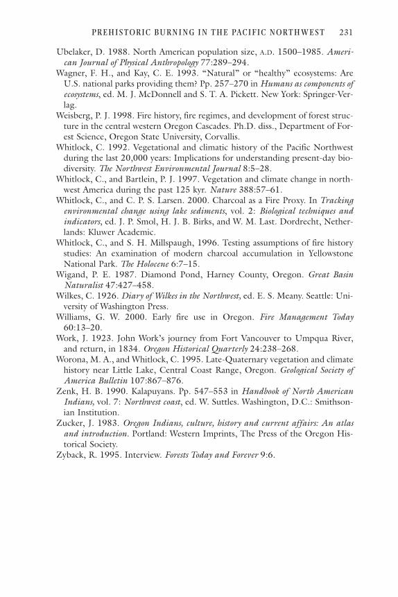
Ubelaker, D. 1988. North American population size, A.D. 1500–1985. Ameri-can Journal of Physical Anthropology 77:289–294.
Wagner, F. H., and Kay, C. E. 1993. “Natural” or “healthy” ecosystems: AreU.S. national parks providing them? Pp. 257–270 in Humans as components ofecosystems, ed. M. J. McDonnell and S. T. A. Pickett. New York: Springer-Ver-lag.
Weisberg, P. J. 1998. Fire history, fire regimes, and development of forest struc-ture in the central western Oregon Cascades. Ph.D. diss., Department of For-est Science, Oregon State University, Corvallis.
Whitlock, C. 1992. Vegetational and climatic history of the Pacific Northwestduring the last 20,000 years: Implications for understanding present-day bio-diversity. The Northwest Environmental Journal 8:5–28.
Whitlock, C., and Bartlein, P. J. 1997. Vegetation and climate change in north-west America during the past 125 kyr. Nature 388:57–61.
Whitlock, C., and C. P. S. Larsen. 2000. Charcoal as a Fire Proxy. In Trackingenvironmental change using lake sediments, vol. 2: Biological techniques andindicators, ed. J. P. Smol, H. J. B. Birks, and W. M. Last. Dordrecht, Nether-lands: Kluwer Academic.
Whitlock, C., and S. H. Millspaugh, 1996. Testing assumptions of fire historystudies: An examination of modern charcoal accumulation in YellowstoneNational Park. The Holocene 6:7–15.
Wigand, P. E. 1987. Diamond Pond, Harney County, Oregon. Great BasinNaturalist 47:427–458.
Wilkes, C. 1926. Diary of Wilkes in the Northwest, ed. E. S. Meany. Seattle: Uni-versity of Washington Press.
Williams, G. W. 2000. Early fire use in Oregon. Fire Management Today60:13–20.
Work, J. 1923. John Work’s journey from Fort Vancouver to Umpqua River,and return, in 1834. Oregon Historical Quarterly 24:238–268.
Worona, M. A., and Whitlock, C. 1995. Late-Quaternary vegetation and climatehistory near Little Lake, Central Coast Range, Oregon. Geological Society ofAmerica Bulletin 107:867–876.
Zenk, H. B. 1990. Kalapuyans. Pp. 547–553 in Handbook of North AmericanIndians, vol. 7: Northwest coast, ed. W. Suttles. Washington, D.C.: Smithson-ian Institution.
Zucker, J. 1983. Oregon Indians, culture, history and current affairs: An atlasand introduction. Portland: Western Imprints, The Press of the Oregon His-torical Society.
Zyback, R. 1995. Interview. Forests Today and Forever 9:6.
P R E H I STOR I C B U R N I N G I N T H E PAC I F I C N ORT H WE ST 231

cc hh aa pp tt ee rr 77
FIRE IN SIERRA NEVADA FORESTS: EVALUATING THE
ECOLOGICAL IMPACT OF BURNING BY NATIVE AMERICANS
Alber t J . Parker
Fire is universally recognized as a crucial agent that shapes vegetationpatterns, regulates biomass accumulation and nutrient cycling, andmediates landscape dynamics in the Sierra Nevada (Chang 1996; Figures7.1 and 7.2). McKelvey et al. (1996) concluded their overview of fire inthe Sierra Nevada by noting that under the prevailing climate, fire hasserved as a frequent, potent influence on Sierran ecosystems for millen-nia. The focus of this chapter is to contemplate the role of aboriginalhuman agency as a significant shaper and modifier of vegetation in theSierra Nevada through the use of fire. On this issue, controversy remains.The range of views that frame this controversy in California may beexemplified by two quotes:
The recent stability of vegetation across diverse ecologicalgradients in the San Bernardino Mountains before fire con-trol indicates that plant cover had equilibrated to fireregimes that extend far into the past, and man’s burningactivities had little impact on the ecology and biogeogra-phy of the chaparral and forest ecosystems. (Minnich1988:74)
233

Our rich natural heritage is also linked with the historicaluse and stewardship of vegetation by Native Americans.Through the introduction of time-tested horticulturaltechniques such as burning, tilling, weeding, and selectiveharvesting practices of different tribes, California’s ecosys-tems were profoundly shaped by human influence overthousands of years. (M. K. Anderson 1997:9)
The assertion that the landscape of the Sierra Nevada has beendomesticated or thoroughly remade by human action is a recent one, butits scholarly roots extend back to the 1950s and the works of Reynolds(1959) and Lewis (1973, republished in 1993). These authors
234 A l b e r t J . P a r k e r
Figure 7.1. Map of California and surrounding region, emphasizing the SierraNevada and locating places mentioned in the text.
attempted to construct ecological arguments that blended the relativelymeager contemporary physical and ethnographic evidence for aboriginalburning in the Sierra with then-emerging principles of fire ecology. Eachconcluded that indigenous humans have had an important influence, atleast locally, on lower- and middle-elevation forests on the western flankof the Sierra Nevada, although Lewis is careful not to overstate his point.He concludes a review chapter on Indian burning in California with aqualified observation:
It is undoubtedly the case that Indians did not set all oreven most of California to the torch in any given set ofyears. Despite a precontact population that is estimated tobe among the highest in North America, they probably
F I R E I N S I E R RA N E VA DA F OR E ST S 235
Figure 7.2. Map of the SierraNevada, locating places men-tioned in the text.

lacked sufficient numbers to burn all or even most of thevegetation on any regular and consistent basis, even hadthey so wanted. (Lewis 1993:114)
In evaluating the ecological impact of burning by aboriginal humanson Sierra Nevada landscapes, I will adopt the premise of Vale(1998:232): “A landscape may be labeled pristine, or natural . . . if thefundamental characteristics of vegetation, wildlife, soil, hydrology, andclimate are those that result from natural nonhuman processes, and ifthese conditions would exist whether or not humans were present” (my ital-ics for emphasis). The central issue is not whether humans were presentin the Sierra Nevada, or whether they used fire as a powerful tool in theirtechnologies of economic production. Both points are undoubtedly cor-rect. The key ecological issue is whether aboriginal burning producednovel vegetation compositions, forest structures, or physical environ-ments—whether it pushed the Sierra Nevada landscape outside thebounds of variability imposed by nonhuman forces (Landres et al.1999).
In musing on the role of indigenous peoples as shapers of Sierran veg-etation through the use of fire, the following sets of questions merit con-sideration:
• How does physical setting influence vegetation patterns and fire in theSierra Nevada? How have linkages among climate, vegetation, and fireregime varied during the late Quaternary in the Sierra?
• What is the history of human occupancy of the Sierra Nevada? Howlarge and stable were indigenous populations in the Sierra? What werethe principal cultural uses of fire?
• How well documented are precontact fire regimes and forest structuresin the Sierra Nevada? Were Sierran forests uniform expanses of openwoodlands, or were they characterized by considerable spatial hetero-geneity? Do spatial and temporal patterns of fire in the Sierra matchexpectations if they are constrained by physical setting? Are there mod-ern analogs that might provide clues to pre-European fire regimes inthe Sierra?
• Is lightning sufficiently common to account for the geography andreturn interval of fires in Sierran vegetation types, or is augmentationby human ignition sources necessary to account for observed patternsof fire behavior? Does ignition source matter in explaining the geogra-phy of fire?
• Have favored plant species or communities become more abundant(perhaps even been created) after human entry into the Sierra?
• Who are the principal voices in this debate? What are their scholarlyroots, intellectual affinities, or sociopolitical agendas?
236 A l b e r t J . P a r k e r

As I review the evidence bearing on these questions, I shall empha-size several key points that summarize my findings. The preponderanceof physical evidence of climatic variation and vegetation response in theSierra Nevada over the past 20,000 years suggests strong and consistentclimatic controls on both vegetation cover and fire regimes throughoutthis period. Although the exact details of vegetation structure are diffi-cult to reconstruct with certainty over large areas, it is likely that Sierranlandscapes embraced a high degree of spatial heterogeneity associatedwith complex topography and microclimate, related variation in vegeta-tion types and fuel loading patterns, and spatial variation in the physicalintensity of and biological response to disturbance events. Humans mayhave locally augmented this natural spatial heterogeneity, but it is notnecessary to invoke human agency to explain this feature of the Sierranlandscape. Tree-ring reconstructions from fire scars portray a fire regimein lower-elevation mixed-conifer forests dominated by frequent surfacefires, with occasional, more intense burns serving as an important eco-logical influence in the landscape. Lightning strike densities in the SierraNevada are sparse compared with much of the rest of the United States,but twentieth-century records of lightning-caused fires suggest a con-centration of natural ignitions in lower-elevation mixed-conifer forests,especially those dominated by ponderosa pine. Lightning incidenceappears to be sufficient in the Sierra Nevada to account for pre-Europeanfire frequencies, although aboriginal humans may have locally increasedfire incidence in settings with high concentrations of herbaceous fuels. Iconclude that aboriginal humans may have had significant influences onvegetation cover in some places (especially around permanent settle-ments or frequently used camp sites), but there is little evidence to sug-gest that they moved the vegetation mosaic of the Sierra Nevada to acondition outside of the natural realm of historical variability.
The Environmental SettingThe climate of the Sierra Nevada reflects the seasonal rhythms charac-teristic of Mediterranean-type environments. Precipitation is concen-trated in the cool winter season in association with frequent passage ofPacific cyclones along the polar front jet stream. This precipitation fallsprimarily as snow above 1,500–1,800 m. Summers are warm and dryunder the influence of the persistent Pacific subtropical anticyclone. Athigher elevations, summer drought is occasionally mitigated by oro-graphically reinforced thundershowers. Strong precipitation seasonalityimposes an annual pattern of fuel production in spring and early summerthat is followed by chronic, late-summer drought stress that predisposesvegetation to elevated fire risk in most years.
F I R E I N S I E R RA N E VA DA F OR E ST S 237

The vegetation that cloaks the Sierra Nevada varies in response toboth macroclimatic and microclimatic gradients. Vertical zonationensues from a gradient of decreased temperature and enhanced effectivemoisture with increasing elevation. Strong contrasts in moisture regimebetween the moister western and drier eastern slope are generated byrainshadow effects. Locally, the effects of topography, soils, and hydrol-ogy add complexity to this vegetation mosaic (Figure 7.3; see Barbour1988; Parker 1989).
At lower elevations on the western slope, foothills pine (Pinussabiniana) and blue oak (Quercus douglasii) savannas intermix withfoothills chaparral. These assemblages grade into mixed-conifer forestsin the lower montane zone, dominated by ponderosa pine (Pinus pon-derosa) on drier sites and white fir (Abies concolor) on mesic sites. Giantsequoia (Sequoiadendron giganteum) occurs locally in mixed-coniferforests of the central and southern Sierra. Upper montane forests aredominated by red fir (Abies magnifica) on mesic settings and Jeffreypine (Pinus jeffreyi) on drier sites. Subalpine forests are dominated bylodgepole pine (Pinus contorta var. murrayana) alone or mixed withmountain hemlock (Tsuga mertensiana) and various five-needled pines.Much of the Sierran crest is above tree line, especially farther southwhere elevations are highest.
The eastern flank of the Sierra supports a mixed woodland of sub-alpine species, including lodgepole pine, Jeffrey pine, and Sierra juniper(Juniperus occidentalis). At lower elevations are montane woodlands ofsingle-needle pinyon (Pinus monophylla) and Utah juniper (Juniperus
238 A l b e r t J . P a r k e r
Figure 7.3. A generalized mosaic diagram of vegetation patterns in Californiauplands (adapted from Vankat 1982 and Barbour 1988).

osteosperma), and finally, at the eastern base of the Sierra, sagebrush-dominated (Artemisia tridentata) Great Basin desert.
Paleoenvironmental reconstructions of conditions during the lateQuaternary in the Sierra Nevada portray a vegetation-environmentmosaic that is sensitive to climatic forcing. (For a thorough review ofSierran paleoenvironments, see Kinney [1996] and Woolfenden[1996].) Anderson and Smith (1994) summarized late Quaternarydynamics of pollen, charcoal, and meadow sediment stratigraphy in thecentral and southern Sierra Nevada. They emphasized strong vegeta-tion/climate/fire linkages throughout the Holocene.
From about 20,000 to 13,500 B.P., a mix of xerophytic sagebrush andpine pollen dominated lake sediments at midelevations on the westernslope in the central Sierra (Smith and Anderson 1992; see Table 7.1). Thispollen assemblage resembles modern conditions on the east slope of theSierra, at elevations 500–1,000 m higher. Smith and Anderson inferredcooler and drier climates than the present during this late glacial period.
From 13,500 to 10,000 B.P., warming fostered development of mixedforests of conifers that today span a broad elevational range (Table 7.1).
F I R E I N S I E R RA N E VA DA F OR E ST S 239
TABLE 7.1. Timeline of climatic change and aboriginal humanoccupancy in the Sierra Nevada (adapted from Moratto 1984;Kinney 1996; and Woolfenden 1996).
Yr. (B.P.) Paleoclimatic Record Cultural Record
200 Spanish settlement of California (1770s)Little Ice Age Postcontact disease spread reduced (A.D. 1450–1850) aboriginal population
400 European contact in California (1550s)Miwok cultural expansion into central Sierra (A.D. 1300–1400)
800 Medieval Warm Period Depopulation of Sierra, violence, (A.D. 1000–1300) restricted carrying capacity (A.D.
700–1300)1,600 Cool wet period
(A.D. 500–800)Neo-glacial episode First permanent settlements, acorn (3,500–1,500 B.P.) processing technologies elaborated 3,200
(3500–1300 B.P.)Resembled modern con-ditions (6,500–3,500 B.P.)6,400Very warm, dry (Altithermal) First evidence of humans, temporary (10,000–6,500 B.P.) camps (ca. 10,000 B.P.)
12,800 Wet, varied temperatures (13,700–10,400 B.P.)Cool, dry period (16,000–13,700 B.P.)
25,600

These forests lack a modern analog, but were relatively mesophytic com-pared with both antecedent and subsequent periods. From 10,000 to6,500 B.P., warmer and drier conditions predominated in the Sierra, asevidenced by Holocene maxima in both charcoal production and oakpollen, as well as a dearth of pollen from mesic tree species such as fir,hemlock, and sequoia in mid-elevation lake cores. This timing matchesthe Altithermal episode described for other locales in North America.Koehler and Anderson (1994) documented increased sediment deliveryto subalpine meadows during this period, which they attributed toincreased denudation rates with more open vegetation cover.
After ca. 6,000 B.P., forests closed and vegetation patterns began toresemble those characteristic of today (Table 7.1). Giant sequoia pollenconcentrations rise to modern levels only in the last 4,500 years (Ander-son and Smith 1994), suggesting that the modern distribution ofsequoia groves has emerged in that time. Anderson (1990) and Ander-son and Smith (1997) related these mid-Holocene vegetation changes tocontinental-scale adjustments in synoptic climatology. Prior to 6,000B.P., they suggested that the Sierra was drier due to a weaker Pacific polarfront jet stream, whereas after 6,000 B.P., Pacific cyclonic activitystrengthened. At about this same time, they suggested that ElNiño/Southern Oscillation cycles began to play a stronger role in shap-ing interannual wet/dry cycles in the Sierra Nevada.
By 4,000–3,500 B.P., the cooler and wetter Neoglacial period beganin the Sierra. The alpine tree line descended in response to these cooler,wetter conditions (Lloyd and Graumlich 1997). Wet meadow stratigra-phy shifted from mineral sediments to peat-rich biogenic soils (Andersonand Smith 1994), an indicator of wetter conditions and elevated watertables during this period.
For the last millennium, tree-ring records from foxtail pine (Pinusbalfouriana) near the tree line in the southern Sierra Nevada suggest anepisode somewhat warmer than the present from A.D. 1100–1375 (cor-responding to the Medieval Warm period) and a cooler interval fromA.D. 1450–1850 (associated with the Little Ice Age) (Graumlich 1993).Since 1850, Sierran climates have been warm and anomalously wet rela-tive to most of the last millennium.
In summary, several points of significance to the ecological impact ofaboriginal burning on Sierra Nevada vegetation are relevant. Climate hasbeen the preeminent force shaping vegetation distributional adjustmentsand fire regimes throughout the late Quaternary. Variation in climate hasbeen substantial in the late Quaternary, with relatively few periods ofmultimillennial stasis in the configuration of vegetation and fire regimes.What appear to be long intervals of stable climate (the mid-HoloceneAltithermal) most likely experienced the same smaller fluctuations evi-
240 A l b e r t J . P a r k e r

dent during the past millennium; the precision of environmental recon-structions declines as detailed lines of evidence, such as tree-ringchronologies, are lost with time. Against this backdrop of changingphysical environments and resources, charcoal stratigraphy (the bestremaining evidence of fire over this time period) reflects strong climaticcontrols on fire ecology in the Sierra. More detailed consideration of evi-dence regarding fire regimes in the Sierra Nevada follows after a sum-mary of human activities in the range.
Human Presence in the Sierra NevadaAt the time of Euro-American contact, indigenous peoples of the SierraNevada were organized into tribal bands that generally occupied eleva-tional transects of land, from the foothills to the High Sierra. This per-mitted access to a broad seasonal range of biotic resources. There werethirty to thirty-five small tribes, collectively representing nine languagegroups from three stocks (Moratto 1984). Prominent tribes in late Sier-ran prehistory included the Washoe (northern Sierra Nevada), WesternMono (southern Sierra Nevada), and Paiute (eastern slopes of the south-ern/central Sierra Nevada) with Great Basin affinities, and the Maidu(northern Sierra), Miwok (central Sierra), and Foothills Yokut (southernSierra) with California lowland affinities (Figure 7.4).
Technologies of food procurement were those of hunter/gatherers,augmented by protection, encouragement, and cultivation of wild plants(Anderson et al. 1997; see Vale, chapter 1 of this volume). In general,indigenous people were sustained by an abundance of harvested plantsand animals, including acorns, pine nuts, other plant foods, nativewildlife, and fish. Moratto (1984) describes the typical settlement pat-tern as one of permanent villages of dozens to hundreds of people, withhomes scattered in surrounding hinterlands as well. Permanent settle-ments were largely confined to lower elevations on the western slope(1,000–1,250 m), and larger villages were located along major streams.With rare exceptions, higher-elevation sites were only seasonally occu-pied. Population densities were substantially higher on the western slopeof the Sierra than on the more arid eastern slope.
Indigenous peoples of the Sierra Nevada used fire to enhance plantfood production (especially acorns), to maintain selected grasses andshrubs as a source for basket-making materials, to improve forage forgame animals, to aid in hunting game, and to reduce the hazard of severefire (Anderson and Moratto 1996; Chang 1996). Anderson (1993;Anderson 1997) cites interviews with living tribal elders in which theyconsistently observe that fuel reduction to help prevent severe fire was astrong rationale for burning, at least in the immediate vicinity of village
F I R E I N S I E R RA N E VA DA F OR E ST S 241

sites. Peri and Patterson (1993) provide strong ethnographic evidence ofthe importance of basket-making to material culture among Sierran Indi-ans, the fiber and other raw materials for which were often from shrubcomplexes likely maintained by fires. Clearly, fire was a significant toolused by indigenous cultures to promote their material well-being (Bar-bour et al. 1993). Nevertheless, direct physical evidence of burning byaboriginal people is scanty, so that the spatial extent and ecologicalimpacts of such burning remains unclear (Skinner and Chang 1996).
The first archeological evidence of human presence in the Sierra Nevadacomes from the northern Sierra and dates to ca. 9,500 B.P. (Moratto 1984;see Table 7.1). The earliest archeological sites appear to be campsites oftransient hunter/gatherers. Of course, it is plausible that humans couldhave been present in the Sierra prior to this (perhaps as early as11,000–12,000 B.P.), despite a lack of physical evidence to date. Archeo-
242 A l b e r t J . P a r k e r
Figure 7.4. Principal groups ofNative American culturesinhabiting the Sierra Nevada atthe time of European settle-ment in California (adaptedfrom Anderson and Moratto1996).

logical evidence of entry of humans into the central and southern Sierra isdelayed until ca. 6,000 to 5,000 B.P. Population levels apparently fluctuatedthroughout the Holocene, primarily in response to environmental con-straints and adoption/development of technological innovations. Andersonand Moratto (1996:194) identify three periods of “notably intense culturalactivity”: 7500–6000 B.C., 1000 B.C.–A.D. 700, and A.D. 1300–1800. Sup-porting material evidence from the first period is scanty, most of it comingfrom the northern Sierra in the form of temporary camps. Permanent set-tlements in the Sierra appear in the archeological record between 1500 B.C.and A.D. 1. This wave of occupation of the Sierra was apparently triggeredby environmental changes at the inception of the Neoglacial (cooler/wet-ter conditions) and may have corresponded with widespread adoption ofthe acorn as a principal food source (Moratto 1984).
The period from A.D. 800 to 1400 was one of substantially reducedhuman populations in the Sierra (Table 7.1) and, indeed, throughoutmuch of California (Moratto et al. 1978; Raab and Larson 1997). Thisperiod includes the Medieval Warm Period, which appears to be amongthe warmest, driest periods in the last 6,000 years. Moratto (1984) linksgeneral population decline, abandoned villages, and a high degree of vio-lence (based on forensic evidence) with the climatically rigorous condi-tions during this period.
With the entry of the Miwok and Mono cultures into the central/southern Sierra Nevada around A.D. 1400 came intensive use of the mor-tar and pestle for processing acorns and other foods. Moratto (1984)suggests that this period of population growth and cultural elaborationin the Sierra also coincided with the onset of improved environmentalconditions, in association with the shift to cooler/wetter conditions fol-lowing the Medieval Warm period and leading into the Little Ice Age.Hence the Sierran landscape at the time of Spanish occupation of Cali-fornia (around the mid-1700s) had been influenced by relatively largenumbers of technologically advanced indigenous peoples for approxi-mately 350 years. It is reasonable to assert (despite “the lack of” directphysical evidence in all but a few locales) that indigenous people in thisperiod may have produced substantial modification of environmentalsettings in areas near settlements or seasonal camps. But, as Parsons et al.(1986) have observed, it is an exaggeration to suggest that the humanpopulation of the Sierra Nevada has been sustained at a high level forthousands of years. Rather, the human population seems to have fluctu-ated in response to climatically induced changes in available food andwater supplies since the early to middle Holocene. This contradicts thepopular image of aboriginal humans that modified the landscape in orderto live in “a world of balance and plenty” (Anderson et al. 1997).
Native American population levels in the Sierra Nevada around 1830have been estimated at ca. 55,000 (Cook 1955; Moratto 1984), although
F I R E I N S I E R RA N E VA DA F OR E ST S 243

this is probably conservative because these estimates rely on records andobservations made following initial contact and following the epidemicwave of Eurasian diseases that killed a substantial percentage of indigenouspeople. Anderson and Moratto (1996) suggested that these figures shouldbe nearly doubled to 90,000–100,000, based on the ecological assump-tion that the range permits a much higher carrying capacity. Of course,carrying capacity fluctuates with environmental change, as evidenced bythe substantial depopulation evident for the period from A.D. 800 to 1400.
In the latter half of the nineteenth century, the Sierra Nevada wasaltered in dramatic ways by European settlers. The Gold Rush of 1849raised the stakes for land access in the Sierra Nevada, and indigenousgroups were soon displaced from native lands and the lifeways that sus-tained them. Miners and prospectors were soon followed by large herdsof sheep foraging in the summer range of the High Sierra. Sheep graz-ing played a major role in altering the Sierran vegetation structure(McKelvey and Johnston 1992). Between the 1860s and early 1900s,large numbers of sheep (estimates run into the millions in some years)were seasonally present in Sierran subalpine meadows and forests. Directremoval of biomass by foraging was significant; purposeful burning bysheepherders to improve meadow forage and open the understory ofsurrounding forests for better herd movement also shaped forest struc-ture. This may have contributed to the prevalence of early descriptionsof Sierran forests as open, parklike stands of trees. Overgrazing may alsohave facilitated range invasion by Eurasian exotics.
Logging was localized in the Sierra Nevada prior to 1900, occurringaround mines and towns as a source for lumber and fuelwood. With theopening of regional economic markets and development of the timberindustry in the twentieth century, logging activities have grown substan-tially (McKelvey and Johnston 1992). Today, local economies in theSierra Nevada are driven by logging interests on national forest lands andheavy recreational use in park lands. Except in designated wilderness andlarger national parks since about 1970, fires have been intentionally sup-pressed throughout the twentieth century in the Sierra. (Even innational parks, only certain fires in prescribed zones are permitted toburn naturally, and most of these are at higher elevations.) The result hasbeen a thickening of stand densities, an increase in understory fuel loads,and a conversion in species composition to more fire intolerant (andshade tolerant) taxa (Vankat and Major 1978) in fire-prone settings.Assigning causation to a single agent for these vegetation changes is dif-ficult, because reductions in indigenous population size and associatedlifeways, changes in grazing pressure and other Euro-American landuses, and changes in fire regimes are all overlain on substantial climatewarming since 1850 and increased precipitation during the past century(Graumlich 1993; Millar and Woolfenden 1999).
244 A l b e r t J . P a r k e r

Sierran Fire Regimes: Past and PresentFire plays a crucial role in structuring the Sierran vegetation mosaic as itresponds to the effects of biological and physical constraints. Kilgore(1973) observed that fire is inevitable in the Sierra Nevada, given the cli-matically dictated imbalance between biomass production (which can behigh in most spring and early-summer months) and decomposition(which is arrested by dry conditions during summer).
Tree-Ring and Fire-Scar Evidence of Fire HistoryTraditionally, most fire ecologists have recognized surface fires as thepredominant mode of Sierran wildfires, at least in the well-studied,lower-montane, mixed-conifer forests (Kilgore 1973). These burns weretypified by relatively low heat release and flame intensity. They consumedsurface herbaceous and small woody fuels, but generally did not killthick-barked adult trees, except perhaps in localized hot spots fed byinordinate fuel accumulations (Bonnicksen and Stone 1985). Fire-scarrecords indicate that fires recurred frequently, with a mean fire returninterval of about 8–15 years in mixed-conifer forests (Skinner and Chang1996). Generally, individual surface fires were assumed to remain smallin size (Kilgore and Taylor 1979).
Skinner and Chang (1996) summarized published fire histories fromthroughout the Sierra Nevada (Table 7.2; see their Table 38.1 for moredetail). Their findings generally reinforce the traditional wisdom of fre-quent, localized, surface fires, but they also emphasize that there is con-
F I R E I N S I E R RA N E VA DA F OR E ST S 245
TABLE 7.2. Summary of fire return intervals in montane forests ofCalifornia uplands (adapted from Table 38.1 in Skinner andChang 1996).
Range of Median fire fire return
Vegetation type return interval (yr) interval (yr)
Ponderosa pine/California black oak 6–9 2–23Ponderosa pine/mixed conifer 5–11 3–50Giant sequoia/mixed conifer 5–18 1–30White fir/mixed conifer 10–18 3–40Douglas fir/mixed conifer 14–16 3–60Red fir 11–20 5–70Jeffrey pine 13–29 4–150
Note: Data are based on various published sources from throughout the Sierra Nevada orecologically similar California uplands. Fire intervals were generally reconstructed withtree-ring counts from fire-scar collections in a small sampling area. Periods of record forstudies range from < 100 to 1,350 years, but are generally from 100 to 400 years.

siderable spatial and temporal heterogeneity in fire return intervalsthroughout Sierran forests.
In recent decades, alternative views have emerged that emphasize theimportance of occasional larger, more intense fires in mixed-coniferforests of California uplands. The executive summary of the SierraNevada Ecosystem Project (SNEP Science Team and Special Consultants1996) provided a box in its chapter on fire that acknowledged this sim-mering debate. Cast as observations by those who question the accuracyof the traditional fire regime, it noted that there is considerable spatialheterogeneity in fire-return intervals within mixed-conifer forests, sothat some areas might have remained open and parklike while otherswere closed forest.
Caprio and Swetnam (1995) addressed the issue of larger fires in theSierra by noting that early fire-scar reconstructions in the Sierra werebased on tree-ring counts without the benefit of cross-dating. As a con-sequence, the same fire, though recorded on several adjacent trees, wasoften attributed to a different year. They argued that this methodologi-cal shortcoming produced biased estimates of fire return intervals(shorter than actual values) and area burned by individual fires (smallerthan actual values). With accurately cross-dated fire scars, Caprio andSwetnam reported greater synchroneity in the historical record of firefrom mixed-conifer forests in Sequoia National Park, so that occasionalfires burned larger areas and fire return intervals were longer than tradi-tionally reported. Caprio and Swetnam linked larger, more intense fireswith distinct drought periods, and they found evidence that within a sin-gle drainage basin, large fires occasionally burned across the elevationalgradient from lower montane to subalpine settings.
The significance of occasionally intense, large fires in mixed-coniferforests was addressed by Stephenson et al. (1991), who discussed theregeneration and growth response of giant sequoia after intense fires. Ahigh percentage of giant sequoia cones are serotinous; seeds remain inclosed cones until the cones are exposed to sufficiently high tempera-tures to induce opening and allow seed dispersal. Stephenson et al.observed profuse sequoia regeneration in “hot spots,” areas of intensesurface burning sustained by localized concentrations of high fuel loads.Moreover, adult sequoia that survived these hot fires typically exhibiteda growth release triggered by reduced competition due to the thinningof surrounding stems. They concluded that maintenance of sequoia pop-ulations may require occasional fires of greater intensity. They, alongwith Swetnam (1993), identified several decades in the late thirteenthcentury (near the end of the Medieval Warm period) that exhibited ahigher frequency of intense fires throughout sequoia groves (and doubt-less the surrounding mixed-conifer forests of the central/southern Sierra
246 A l b e r t J . P a r k e r
Nevada) than before or after. As Stephenson et al. (1991:323) note, theoccurrence of fire may track closely the temporal variability in climate:“On the timescale of centuries, the fire regime itself may change inresponse to climatic change, making it difficult to pinpoint one particu-lar fire regime as ‘natural’ for a region.”
Swetnam (1993) reinforced this theme in a 1,500–2,000 year recordof fires dendrochronologically reconstructed from five giant sequoiagroves spanning a distance of ca. 200 km on the western slope in thecentral and southern Sierra. Over the long period of record, fire intervalsvaried from less than 5 to 30 years. Mean fire frequencies were lower(13–29 fires per century in a grove) during wetter/cooler periods (A.D.500–800) and higher (27–46 fires per century in a grove) duringdrier/warmer periods (A.D. 1000–1300). Swetnam found that fire yearsco-occurred among sequoia groves more often than would be expectedby chance. He linked fire behavior to interannual variability in precipita-tion (more widespread, synchronous fires in drought years) and to mul-tidecadal variability in temperature (which he attributed to alteration ofthe fuel mosaic). Swetnam’s work provides persuasive evidence of cli-matic control of fire behavior in Sierran mixed-conifer forests andemphasizes that fire regimes are nonstationary—they change in responseto secular climatic change. These findings provide significant historicalcontext for interpreting the role of humans in shaping fire regimes inCalifornia uplands. Over the last 1,500–2,000 years, the time periodwhen human populations would have most significantly altered Sierranfire regimes, the spatial and temporal patterns of burning appear to bestrongly responsive to climatic control. If fuel accumulations and mete-orological conditions were conducive, fires burned with little apparentalteration by human agency.
As might be expected, the nature of fire varies in scope and intensityamong Sierran vegetation types. In the foothills chaparral, more intensecrown fires that recurred at intervals of 20 to 30 years were typical, atleast prior to fire suppression efforts. In higher-elevation Sierran forests,estimates of fire return intervals prior to the twentieth century lengthento several decades (Skinner and Chang 1996; Potter 1998). In general,although fire regimes in subalpine forests are less well documented, it hasbeen assumed that fire intensities remained low, with surface fires beingpredominant. Fire return intervals were longer, presumably in responseto reduced production of fuels, increased effective precipitation that lim-its periods of critically low fuel moisture, and a higher incidence of rockoutcrops and riparian settings in the High Sierra that interrupt the con-nectivity of the fuel mosaic (Skinner and Chang 1996). Work by Taylorand Halpern (1991) and Chappell and Agee (1996) in red fir forests ofthe Cascade Range in northern California and southern Oregon suggests
F I R E I N S I E R RA N E VA DA F OR E ST S 247

that fires in compositionally similar Sierran upper montane forests wereof variable intensity, with light surface burns intermixed with areas ofmore severe crown fires. Fire history is poorly documented for subalpineforests in the Sierra Nevada, as well as throughout the vegetation typesfound on the eastern slope. It is generally assumed that subalpine forestsrarely burned and that pinyon-juniper woodlands on the eastern slopeexperienced surface fires when herbaceous fuels reached unusually denseaccumulations.
Charcoal Evidence of Holocene Fire HistoryReconstructions of charcoal profiles from meadow and lake sedimentsreveal a long history of fire that has been characterized by substantialtemporal variability. Edlund and Byrne (1991) reported on a 15,000-year record of fossil charcoal accumulation from Lake Moran in the cen-tral Sierra (Figure 7.5). Their stratigraphy showed minimal charcoal
248 A l b e r t J . P a r k e r
Figure 7.5. Charcoal accumulation/influx curves from Lake Moran sediments(Edlund and Byrne 1991) and a composite of eight meadow stratigraphies (Ander-son and Smith 1997). Units on horizontal axes are not comparable, but temporalvariation in the relative magnitude of charcoal accumulation/influx is evident.

accumulations during the early Holocene (12,500–10,000 B.P.), whichthey related to: moist climate; dense, closed forests; and possibly deeper,more persistent snowpacks. The ensuing mid-Holocene thermal maxi-mum (10,000–7,000 B.P.) was characterized by Edlund and Byrne aspossessing the Holocene peak in sedimentary charcoal influx. They pro-vided macrofossil evidence of forest conversion from more mesic five-needled pines and lodgepole pines to more xeric ponderosa pine at thistime. They reported a decline in charcoal accumulation to modern lev-els between 7,000 and 3,000 B.P., by which time modern mixed-coniferforests were established in the surrounding drainage.
Anderson and Smith (1997), like Edlund and Byrne, reported sedi-mentary charcoal records, although they drew their sample frommeadow sediments (rather than lake cores) and they restricted theirattention to charcoal particles larger than 100 micrometers in maximumdiameter (as opposed to particles larger than 10 micrometers for Edlundand Byrne). Like Edlund and Byrne, they argued for climatic control ofthe Sierran charcoal record throughout the Holocene. There are, how-ever, substantial differences in the temporal patterns reported and theassociated environmental interpretation. In keeping with Edlund andByrne, Anderson and Smith report a mid-Holocene peak in charcoalaccumulation, around 9,200–8,700 B.P. However, they suggested thatthis fairly brief interval of peak charcoal deposition was embedded withina longer period of relatively low charcoal production. Indeed, they sug-gested that the drier, more open vegetation cover of the early to middleHolocene produced lower woody biomass, so that fewer fuels were avail-able to burn and produce macroscopic charcoal. Anderson and Smithalso reported charcoal accumulation patterns opposite to that of Edlundand Byrne for the last 4,500 years. They found greater rates of charcoalaccumulation in Sierran meadow sediments during this period and sug-gested that the wetter climatic conditions promoted greater woody fuelproduction, which was converted to charcoal when fires burned throughthe landscape. Resolving these two contradictory reconstructions ofcharcoal stratigraphy in the Holocene may involve accounting for con-trasts in depositional environments and sizes of charcoal particles sam-pled (which affects the size of the source region for airborne charcoal).In any event, it is clear that fire was prominent in Sierran landscapesthroughout the late Quaternary, that charcoal production may predatehuman occupancy of the region, and that charcoal production varies inconcert with climatic fluctuations, although the details of this variationmay be debated.
The most striking paleoenvironmental evidence that supports the roleof humans in altering fire regimes, at least in areas of high settlementdensity, comes from Woski Pond in Yosemite Valley (Anderson and Car-
F I R E I N S I E R RA N E VA DA F OR E ST S 249

penter 1991). Yosemite Valley was heavily populated by aboriginal peo-ple, at least after entry of the Miwok culture into the region around A.D.1300–1400. Anderson and Carpenter recovered a 1,550-year record ofpollen, macrofossils, and charcoal from Woski Pond. They observed asubstantial spike in charcoal accumulation around A.D. 1300. Althoughthey link this event with the arrival of Miwok culture in Yosemite Valley,Anderson and Carpenter do not directly assign the ignition source tohumans. Indeed, the fires reported by Stephenson et al. (1991) andSwetnam in sequoia groves throughout the southern half of the SierraNevada in the late 1200s could have been caused by a climatic episodethat also resulted in the large pulse of charcoal observed in the sedimentsof Woski Pond. Rather than indigenous populations opening YosemiteValley vegetation with fire, it may well be that large, intense fires, fol-lowed by climatic amelioration over the next century, shifted the path-way of vegetation recovery to support meadows and savannas in the val-ley. This change in fire/vegetation/climate linkages might haveprovided the pulse of oak and herbaceous regeneration necessary to per-mit expansion of Miwok cultures into the central Sierra. After the char-coal peak around A.D. 1300, Anderson and Carpenter reported littlecharcoal accumulation to the present. They attributed this reduction incharcoal to the maintenance of more open, herbaceous-dominated veg-etation by cultural burning. (Herbs generate little macroscopic charcoalcompared with woody plants.) They convincingly argued that humanintervention was necessary to maintain open vegetation in Yosemite Val-ley, because the ensuing Little Ice Age would have favored denser woodyvegetation and higher production of macroscopic charcoal, if the vege-tation mosaic in the Valley were responding to climatic stimuli alone.
Reflections on Sierran Fire Regimes and Forest StructureStephenson (1999), in a review of the application of natural variabilityconcepts to vegetation management in the Sierra Nevada, observed thatwe have reasonably good evidence for fire regime reconstruction (at leastin lower-elevation forests on the western slope of the Sierra), but poorevidence for the reconstruction of specific vegetation structures. Mostwork that documents forest spatial pattern or demographic structure inthe Sierra is either restricted to small plots or is qualitative in nature (seeStephenson 1999 for a review of work that characterizes forest structurein sequoia groves).
Historically, the prevailing image of lower montane Sierran forests isthat of open parkland, as captured in the evocative prose of John Muir:
The inviting openness of the Sierra woods is one of theirmost distinguishing characteristics. The trees of all the
250 A l b e r t J . P a r k e r

species stand more or less apart in groves, or in small irreg-ular groups, enabling one to find a way nearly everywhere,along sunny colonnades and through openings that have asmooth, park-like surface. (Muir 1894:140–142)
Biswell (1967:60) reinforced this image of widespread open woodlandsmaintained by frequent surface fires, suggesting that forest cover andsurface fires reflected “nature’s balance,” that repetitive surface fires keptthe forest “almost immune from extensive crown fires.”
The executive summary of the Sierra Nevada Ecosystem Project(SNEP Science Team and Special Consultants 1996) coupled its discus-sion of the ecological importance of larger, more intense fires with obser-vations that challenged traditional views among ecologists regarding theprevalence of widespread open woodlands in the lower montane zone ofthe pre-European Sierran landscape. They cited the journal of J. Golds-borough Bruff—an 1850 immigrant who recorded in his journal the rel-ative occurrence of open, parklike stands versus dense, mixed-coniferforests on the western slope. He reported dense forests six times moreoften than open stands. It seems reasonable to conclude that spatial het-erogeneity of both fire regimes and forest structures in the pre-EuropeanSierra Nevada was pronounced, although the details, particularly of for-est structure, remain elusive. This fits well with the topographic, micro-climatic, edaphic, and geomorphic heterogeneity of the terrain. Suchenvironmental heterogeneity would foster dramatic local contrasts infuel characteristics (such as biomass production, fuel moisture content,or the ratio of dead-to-living fuels) that would perpetuate a heteroge-neous spatial pattern by its influence on fire behavior, irrespective ofignition source (Miller and Urban 1999a). Indeed, the spatial hetero-geneity that develops in association with localized variation in the phys-ical intensity of and biological response to a single disturbance event(such as a large fire or windstorm) is an emerging theme from recentwork on large natural disturbances (White and Pickett 1985; Turner etal. 1997).
Lewis (1993 [1973]) and Anderson (1997) have argued that thestructural heterogeneity of Sierran forests is a product of human-inducedclearing and tending—that there is too much localized complexity to bederived from natural agents. Although it is plausible that indigenoushumans may have locally altered forest structures and fostered increasedspatial heterogeneity in vegetation cover, it is hardly necessary to invokehuman agency through the use of fire as the creator and manager of thatheterogeneity. Lightning fires, coupled with windstorms, disease andpest infestations, occasional drought and large floods, and tectonicallytriggered mass movements, would maintain a structurally heterogeneous
F I R E I N S I E R RA N E VA DA F OR E ST S 251

landscape and vegetation cover, with or without human agency. By thisargument, I am not denying the possibility of locally important humaninfluences; but I am suggesting that the natural variability imposed byclimate change, the operation of disturbance regimes, and the landscape-scale complexity of physical gradients in the Sierra Nevada would be suf-ficiently broad to incorporate most indigenous human influence withinthe embrace of natural patterns.
The Sierra San Pedro Martir: A Possible Modern Analog?Because fire suppression has altered mixed-conifer forests in the SierraNevada, twentieth-century fire regimes are not reliable indicators of pre-European conditions. Minnich et al. (1993) and Minnich and Vizcaíno(1998) have argued that the extant mixed-conifer forests in the SierraSan Pedro Mártir of Baja California may provide a modern analog for theSierra Nevada, although this assertion is subject to debate. The mixed-conifer forests of the Sierra San Pedro Mártir are drier than those in theSierra Nevada. Moreover, although Minnich and his collaborators arguethat fire suppression is minimal in the uplands, there is a history of graz-ing and related land use changes in the latter half of the twentieth cen-tury concentrated in the lowlands surrounding the Sierra San PedroMártir that may have altered patterns of fire occurrence in recentdecades. Nevertheless, observations from the Sierra San Pedro Mártirprovide a useful perspective on the general nature of fire regimes in theSierra Nevada and emphasize the potential ecological importance oflarger fires in the landscape. Minnich et al. (2000) reconstructed fire his-tory for the period from the early 1920s to the late 1980s with a histor-ical sequence of air photos from the Sierra San Pedro Mártir. Theyreported that the majority of fires in this period were less than 5 ha inarea. (Remotely sensed imagery is subject to spatial resolution limits indiscerning small areal events, so small fires may be even more common,but undetected in this work.) They emphasized the ecological signifi-cance of larger fires in their data set, with 10 percent of detected firesconsuming more than 90 percent of the burned area. The three largestfires each burned more than 6,400 ha. Their reconstructions of burngeometry produced an estimated fire return interval of 52 years, with arange from 38 to 85 years, depending on vegetation type. This is sub-stantially longer than estimates derived from fire-scar reconstructions inpre-European mixed-conifer forests of the Sierra Nevada, although com-parisons are complicated by the differential spatial sensitivities of thetechniques used to record individual events. Minnich and his collabora-tors noted considerable heterogeneity of burn patterns within fireperimeters in mixed-conifer forests of the Sierra San Pedro Mártir, with
252 A l b e r t J . P a r k e r

estimates of 23–31 percent of burned areas experiencing intense surfacefires, and about 16 percent of the area within burn perimeters experi-encing greater than 90 percent canopy-tree mortality. Although somecaution in making a direct analogy between the modern Sierra San PedroMártir and the pre-European Sierra Nevada is warranted, these resultslend additional support to the importance of larger, more intense fires inshaping mixed-conifer forest dynamics in California uplands, and theyunderscore the spatial heterogeneity of burn intensity produced by indi-vidual fires.
Ignition Sources and Fire in the Sierra NevadaOne of the earliest arguments favoring the importance of burning byindigenous peoples was Reynolds’s (1959) assertion that lightning inci-dence was inadequate to account for the high frequency of fires evidentfrom fire-history reconstructions in lower-elevation Sierran forests. Thisassertion was not based on direct evidence, but rather the relativeuncommonness of thunderstorms in lowland California. Vankat (1977)has occasionally been cited to support this claim, but that is a clear mis-representation of his position. Although he quotes Reynolds’s thesis as asuggestion that lightning was an inadequate ignition source to accountfor fires at lower elevations in the Sierra, he prefaces this citation byobserving that “the ecological significance of this [aboriginal] burning isunclear, since lightning fires have always been frequent in the dry sum-mer environment of the Sierra Nevada” (Vankat 1977:19). Biswell(1989), in a chapter on lightning and human ignition sources for Cali-fornia wildfires, noted that lightning has been historically underesti-mated as an ignition source in California lowlands. He described directignition of grassy surface fuels by lightning and summarized a small dataset from the 1940s and 1950s that suggested relatively high lightning-fire incidence in California lowlands.
Within the past two decades, several works have illuminated thegeography of lightning and lightning-caused fires in California uplands.Vankat (1983) and van Wagtendonk (1986) produced spatial summariesof lightning-caused fires that occurred during the twentieth century. Theobservation period corresponds with an era of aggressive fire suppres-sion, so that numbers of fires and especially area burned may not beindicative of pre-European conditions in all vegetation types. Neverthe-less, the spatial patterns of ignitions identified are probably accurate.Vankat reported 848 lightning-caused fires from 1921 to 1982 inSequoia National Park (0.84 fires per 100 square km per year); van Wag-tendonk reported 2,023 such fires from 1930 to 1983 in YosemiteNational Park (1.22 fires per 100 square km per year). In both parks,
F I R E I N S I E R RA N E VA DA F OR E ST S 253

lightning-caused fires were predominantly located in the western half ofthe park, at lower to middle elevations. Both authors found spatial rela-tionships between fire and topography, with more fires on westerly expo-sures and ridge tops. Both identified the highest lightning-fire incidencein lower- to midelevation mixed-conifer forests, despite the fact thatlightning strikes are more common at higher elevations in the easternhalf of each park. In both cases, lightning fires were more frequent thanwould have been expected by chance in ponderosa pine–dominatedmixed-conifer forests. The twentieth-century record of lightning firesfrom these parks reveals that lightning-caused fires are potentially abun-dant. Some 80 to 85 percent of lightning-caused fires in both Sequoiaand Yosemite National Parks occurred from July to September. The highincidence of dry thunderstorms in this period corresponds with the mostpronounced seasonal soil-moisture deficits.
McKelvey and Busse (1996) provided a similar environmental analy-sis of patterns of lightning fires on national forest lands of the SierraNevada during the twentieth century. They found a strong and stableelevational gradient in the incidence of lightning fires, with fires far morecommon at lower elevations (peaking at 500–1000 m). Large fires werecommon in hot, dry years, although such conditions alone did notensure widespread lightning fire in the Sierra. They reported results of alogistic regression analysis that discriminates between burned andunburned terrain; lower elevation, steeper slopes, and drier settings wereassociated with lightning fires in Sierran national forests. Like Vankatand van Wagtendonk, they found a high occurrence of fires in ponderosapine forests, with actual burned area exceeding expectations based on arandom areal standard.
With the development of lightning detection networks, van Wagten-donk (1991) reported that lightning struck in the region of YosemiteNational Park approximately 2,000 times per year in the 6-year periodfrom 1985 to 1990 (65 strikes per 100 square km per year), althoughinterannual variability in lightning-strike frequencies was apparent.Lightning frequency was greatest along the Sierran crest in the easternportion of the park and least at lower elevations on the western marginof the park. Van Wagtendonk commented that despite the low lightningfrequency recorded at lower elevations, occasional lightning-caused fireshave burned substantial acreage; an August 1990 fire ignited at 1,200 mburned more than 8,000 ha.
Summaries of lightning-flash measurements from the National Light-ning Detection Network for the period from 1992 to 1998 (Orville andSilver 1997; Orville and Huffines 1999) confirm van Wagtendonk’slightning-strike density estimates of less than 100 strikes per 100 squarekm per year and substantiate the relatively low lightning-strike density
254 A l b e r t J . P a r k e r

over California, compared with much of the rest of the contiguousUnited States. Maps of median peak current for positive polarity light-ning strikes indicate high values over California, with amperage measuresamong the highest in the contiguous United States (at least for the 3-year period reported in Orville and Huffines [1999]). Whereas light-ning-strike density is low over California, the current carried by individ-ual strikes is high. Although I know of no direct evidence demonstratingthat peak-current delivery is correlated with ignition probability, thisrelationship is plausible and, if valid, suggests that lightning strikes maybe effective ignition agents over California. Clearly, this relationshipmerits testing.
Minnich et al. (1993) reported on lightning-strike densities andrelated them to lightning-caused fires in the Sierra Juarez and Sierra SanPedro Mártir of northern Baja California. In the Sierra Juarez, a lower-elevation range where convective thunderstorms are uncommon, theyreported about seventeen times more lightning strikes than lightningfires. In the higher Sierra San Pedro Mártir, lightning strikes occurredforty six times more often than lightning fires. Minnich et al. concludedthat both ranges were supersaturated with lightning strikes and that fireincidence was related more to fuel accumulation than to ignition source.
Minnich (1987) and Caprio and Swetnam (1995) both emphasizedthe importance of long-burning fires in California uplands. After an igni-tion event, fires may alternate between flaming combustion and glowingcombustion, depending on meteorological conditions. Fires banked inlarge-diameter fuels, such as logs, often smolder for weeks, only toreignite when meteorological conditions become favorable. Thus, a sin-gle lightning strike may account for an extended period of burning overa fairly large area. Minnich noted that, prior to the twentieth century,such fires were often not fully extinguished until the following winterwet season began. As a consequence of this banking behavior, Parsons(1981) observed that few ignitions are needed to burn large areas ofchaparral and oak woodland in the foothills of the Sierra Nevada.
Based on the geography of lightning fires and patterns of burning,there appears to be ample, although not abundant, lightning incidenceto account for the frequency and scale of fires (determined from firescars) throughout the mountainous uplands of California (Vale 1998).Claims regarding the inadequacy of lightning strikes to account for his-torical patterns of burning appear to be exaggerated, particularly inlower-elevation mixed-conifer forests dominated by ponderosa pine(where advocates of human agency have focused their claims).
This leaves open for debate a fundamental question regarding therole of cultural burning in modifying a landscape: To what extent doesignition source influence the geography of fire? The preponderance of
F I R E I N S I E R RA N E VA DA F OR E ST S 255

evidence from fire-prone ecosystems—such as the lodgepole pine forestsof the Yellowstone Plateau (Romme and Despain 1989), the chaparral ofthe coastal hills of California and Baja California (Minnich 1983), andthe mixed-conifer forests of the Sierra San Pedro Mártir (Minnich et al.2000)—suggests that fuel accumulation patterns are far more influentialthan ignition source in governing the timing and spatial extent of fires.Crown fires in the Yellowstone Plateau recur after protracted intervals offorest growth (perhaps 200–300 years), prior to which the fuel mosaicdoes not readily carry fire. Similarly, chaparral will reburn only after asufficient refractory period of 20–30 years, and mixed-conifer forestsexhibit a similar delay in fire recurrence related to development of therequisite fuel loading (ca. 50 years, according to Minnich et al. 2000).Once sufficient fuels exist, meteorological conditions often determinewhen fires occur, since the fuel’s moisture content must be relatively low.Assuming adequate concentration of dried fuels, fire is highly likely,regardless of ignition source.
Minnich et al. (1993) developed a conceptual model that contrastsfire regimes between vegetation types dominated by herbaceous versuswoody fuels. According to these authors, herbaceous fuels exhibit ashort refractory period—fuels return to preburn levels rapidly, so thatfires may recur frequently. In drier environments of the West, herbaceousfuel accumulation and fire risk are maximized following wet years. Firesin settings with an herbaceous fuel matrix burn in a spatially randommanner, without regard to past burn patterns. Miller and Urban(1999b), in a spatially explicit climate/vegetation/fire model of surfacefire regimes in the Sierra Nevada, derived similar outcomes in simula-tions for herbaceous fuel settings. They observed considerable spatialheterogeneity in patterns of fire effects in their simulations of herba-ceous-fuel-dominated systems. In contrast to herbaceous fuels, Minnichet al. (1993) characterized woody fuels as possessing long refractoryperiods; buildup of fuel accumulations capable of carrying a fire isdelayed. In woody-fuel-dominated systems, fire perimeters are oftennonoverlapping. Older patches with sufficient fuel burn to the edges ofsurrounding younger patches that lack adequate fuel to sustain a fire.Both chaparral and mixed-conifer forests conform to this spatially andtemporally self-limiting behavior, according to Minnich and Vizcaíno(1998). Christensen (1993:237) invoked similar logic in his review offire regimes and ecosystem dynamics when he observed: “On many land-scapes, fire frequency is less determined by ignition events [than] by fueland landscape conditions that determine fire spread.”
Applying these contrasts in fire-regime properties between herba-ceous- and woody-fuel-dominated settings, ignition source is probablyonly a potential influence on fire frequency where herbaceous fuels
256 A l b e r t J . P a r k e r

recharge rapidly. In the Sierra Nevada, vegetation in parts of the lowermontane zone, including oak savanna and foothills or ponderosa pinewoodland, possess sufficient herbaceous fuels to allow the possibility ofhuman-caused fires to increase the frequency of lightning ignitions. Evenhere, however, interannual climatic variability and topographic complex-ity would impose limits on patterns of accumulation, continuity, andflammability of herbaceous fuels.
Fire as a Landscape Element or Cultural Artifact?Parsons et al. (1986:22), in a review of fire management practices in theSierra Nevada, observed that Sierran plant communities “have evolvedwith periodic fire for tens of thousands of years.” Although some havesuggested that humans have promoted oak and grass species throughplanting and burning practices (Anderson 1997), Adam et al. (1989)documented fairly continuous and abundant concentrations of oak andgrass pollen in a 3-million-year-long core recovered from Tule Lake innortheastern California. Moreover, Adam and West (1983) used a ratioof oak and pine pollen abundance from Clear Lake (in the northerncoastal range) to provide a crude temperature index for northern Cali-fornia over the last 130,000 years. This link between oak abundance andtemperature characteristics underscores the responsiveness of oak speciesto climatic controls; oak pollen abundance was greater at the peak of theprevious interglacial than at any time during the Holocene, including theAltithermal. If humans have deliberately augmented the abundance ofoak species, it has been too recent or too localized to have been recordedin such reconstructions.
Anderson (1997:23) asserted a cultural origin for several vegetationtypes: “Ecosystem diversity was also enhanced through the maintenanceof ecosystems that would disappear in the absence of human influence,including coastal prairies, dry montane meadows, and mixed coniferforests where black oak and ponderosa pine predominate.” The evidenceon which this claim is based, however, is tenuous, at best. For pon-derosa-pine/black oak–dominated mixed-conifer forests, the proof ofher strong assertion rests on Kilgore and Taylor’s (1979) assumptionthat lightning was inadequate to account for fire frequencies in mixed-conifer forests (an assumption that appears to be unfounded) and thatblack oaks have been overtopped by more shade-tolerant conifers in thelast 100 years. The latter observation is virtually assured, given the mod-ern fire suppression policy. Allowing fires to burn in this zone wouldreturn frequent small and occasional large fires to the vegetation mosaic.California black oaks would probably respond favorably to occasionalintense fires, because they would benefit for several decades after burn-
F I R E I N S I E R RA N E VA DA F OR E ST S 257

ing by their habit of resprouting from root collars. Fire suppression is theculprit here, regardless of the ignition source. The logic behind Ander-son’s inclusion of ponderosa pine as an artifact of aboriginal manage-ment activities is unclear, given its long record in the regional flora(Edlund and Byrne 1991) and its propensity to experience lightning firesin the historical record (Vankat 1983; van Wagtendonk 1986).
Anderson’s assertion that dry montane meadows in the Sierra Nevadaare an artifact of cultural burning is equally dubious. Koehler and Ander-son (1994) noted that several authors uncritically proclaim that drymeadows first appeared in the Sierra around 3,000 B.P. They suggestedthat this is a misimpression promoted by the lack of radiometrically dat-able materials from meadow sediments prior to this time. These authorsidentified older dry meadow sediments in Nichols Meadow (11,500 to8,700 B.P.), based on pedogenesis in paleosols. They observed that manymodern dry meadows in the Sierra contain these old paleosols and henceextend back at least to the early Holocene. Indeed, Davis and Moratto(1988) observed the presence of dung spores in the basal Graminae zoneof Exchequer Meadow, dated at 13,500–10,700 B.P. They linked thisevidence of excrement with the presence of large grazing mammals inSierran dry meadows of that period. The origin of dry montane mead-ows more likely lies in a long history of pest infestations that defoliatetrees and create open treeless patches where grasses can gain a footholdin the vegetation mosaic. In the case of both ponderosa pine/black oakmixed-conifer forests and dry montane meadows, there is little if any evi-dence to support the contention that they (or any other vegetation typein the Sierra Nevada) are a human artifact dependent on cultural burn-ing for their very existence.
Nature, Culture, Evidence, and Academic RootsDiscord over the role of indigenous humans in shaping the landscape isfueled by contrasts in the academic roots and ideological affinities of theprincipal voices in this debate (see Vale, chapter 1 of this volume). Evi-dence that argues against a pervasive role for aboriginal humans in shap-ing the Sierra Nevada landscape comes primarily from physical and bio-logical scientists, foresters, and fire ecologists, who have addressed issuesof late Quaternary paleoenvironments, precontact fire regimes, and thegeography of lightning and lightning-caused fires. Their evidence is prin-cipally physical, and taken in aggregate, it provides a logically consistenthistory of climate/vegetation/fire linkages that have operated to struc-ture the Sierran landscape over the last 20,000 years, primarily withoutsignificant human alteration.
Evidence favoring the view that humans have domesticated the Sier-
258 A l b e r t J . P a r k e r

ran landscape comes primarily from human geographers and culturalanthropologists. After the early work of Reynolds and Lewis, M. KatAnderson has championed the role of indigenous humans as agents oflandscape change in the Sierra Nevada. Most of the evidence presentedto support this position is ethnographic, based on interviews of past andpresent living elders descended from Sierran tribal communities. Theseindividuals presumably retain an oral tradition of past lifeways; some stillpractice traditional arts, such as basket-weaving. Beyond these inter-views, there is virtually no physical evidence available to evaluate theassertion of pervasive human modification of the Sierran landscape priorto European contact. That indigenous peoples used fire as a tool toimprove their material economy is undeniable. It is the spatial extent andecological importance of that influence on which the debate hinges. Weare left to weigh the words of those with memories of a former timeagainst the incomplete physical evidence of past environments. Logicalinference is all that may be available to resolve this debate, and that logicwill always be subject to challenge.
Much of the work of Anderson and others who champion the imageof a Sierra domesticated by aboriginal humans is reasoned, cautious, andscholarly. Work on the ethnobotany of culturally significant taxa, such asdeergrass (Muhlenbergia rigens), is well designed, carefully executed, andconvincing in detail (Anderson 1996). Even in more strident voice, someof Anderson’s claims are tempered with appropriate caution, as whenAnderson and Moratto (1996) observe that human influence in theSierra Nevada varied in space and time, with some areas maintainedsolely by lightning fires, some areas reflecting a mix of lightning andhuman-caused fires, and some areas largely shaped by anthropogenicforces.
Blackburn and Anderson (1993) observe that many ecologists andphysical scientists are slow to embrace the anecdotal nature of ethno-graphic data and bemoan the lack of quantitative or experimental evi-dence that would address this shortcoming. This does not dissuade themfrom making a number of sweeping assertions that approach hyperbole.To what extent is Blackburn and Anderson’s belief in the broad scope ofaboriginal human influence in pre-European California rooted in a desireto preserve cultural diversity? Anderson (1997) pursues this line vigor-ously when she attempts to entangle cultural and biological diversity. Sheassumes that environmental well-being is linked to maintenance of bio-logical diversity, which, in turn, she assumes, is a product of culturaldiversity. By losing indigenous culture, we lose environmental health.But there is little empirical evidence to support either of these assump-tions in the Sierra Nevada, just a strong urge to atone for past sins ofaggression and transgression, both cultural and environmental. Ander-
F I R E I N S I E R RA N E VA DA F OR E ST S 259

son’s words are charged with a political agenda: put the Sierra back inthe hands of native peoples, who, in the image of the Noble Savage, wereexcellent stewards of the land. This resurrection of the Noble Savageimage is keenly expressed by Heizer and Elsasser (1980:59–60), whomAnderson quotes to introduce her chapter (Anderson 1993) on nativeCalifornians as ancient and contemporary cultivators:
The California Indians were highly accomplished practicalbotanists, perhaps as knowledgeable about subtle differ-ences in form, color, and behavior as some university pro-fessors who have spent their adult lives reading and makingfield observations. But they were also knowledgeable in adifferent way—a way directed at understanding nature insuch a manner as to use it without destroying it.
Anderson claims that we can learn much about sustainability by emulat-ing the ways of Sierran indigenous cultures. By making such claims, sheattempts to seize a moral high ground that unites a common sympathyfor environmental well-being and displaced indigenous cultures. Nostal-gia is a strong force in this politically charged linkage, but nostalgiashould not serve as the basis of a land management policy, nor should itbe used to advocate exacting restoration of a specific vegetation cover,when the heterogeneity, in both space and time, of vegetation and fireregimes in the Sierra Nevada is substantial and shows strong linkages tothe operation of broader natural forces, such as climatic change (Vale1987; Sprugel 1991). In short, nostalgia and political agendas are nosubstitute for valid evidence.
Concluding RemarksWhat were the relative roles of aboriginal humans and the physical envi-ronment in shaping Sierra Nevada vegetation? The majority of the evi-dence favors a strong role for physical environmental controls. In specificplaces and times, such as areas of intense human settlement in the cen-turies preceding European contact, humans most likely opened forestsand maintained preferred plants by judicious use of fire. Undoubtedly,there were localized tracts of land that were significantly altered byhuman settlement and cultural burning, such as Yosemite and HetchHetchy Valley. One might readily envision a geographic gradient ofinfluence: from intensive alternations in the immediate vicinity of largersettlements in the lowlands; to less intense but still significant sporadicinfluences in adjacent foothills and lower montane vegetation types, aswell as around frequently used summer camps in the High Sierra; todecreasing cultural influence on vegetation mosaics in higher-elevation
260 A l b e r t J . P a r k e r

forests, tundra, and east-slope environments. Despite these culturaleffects, pollen, charcoal, macrofossil, and tree-ring records converge toportray an extended environmental history of climatic control of fire andvegetation dynamics across the breadth of the Sierra Nevada. Fire is a vir-tual certainty in the Sierran environment, given its climatic rhythms offuel accumulation and drying. Postglacial climates have fluctuated sub-stantially, forcing concomitant changes in vegetation patterns and fireregimes at timescales ranging from decades to millennia. Against thisbackdrop, the effect of aboriginal human populations appears to havebeen limited by relatively small population sizes and by geographic con-straints on the distribution of larger settlements (primarily at lower ele-vations in the Sierra along major drainages).
Formerly, lightning was underestimated by some as an agent of igni-tion in lower-elevation Sierran environments. Direct evidence of light-ning fires in the past century indicates that lower-elevation mixed-coniferforests, especially those dominated by ponderosa pine, burned often.Traditional characterizations of frequent, light-burning, localized firesmay understate the importance of more ecologically significant largerfires, which occasionally burned with great intensity in Sierran mixed-conifer forests. The habit of fire, which may alternately rage for days andthen smolder for weeks in larger fuels, allows few ignition events toinduce complex patterns of burning. Ultimately, ignition source is prob-ably of less ecological importance to the operation of fire regimes of theSierra than are fuel-accumulation patterns and architecture, meteorolog-ical circumstances, topography, and spatial heterogeneity of vegetationcover. Within some parts of this naturally maintained matrix, areas ofhigher settlement density and repeated human use may have been mod-ified in significant ways by the actions of aboriginal people, especiallythrough their use of fire. But there is little physical evidence to suggestthat they moved the vegetation mosaic outside of the bounds of natu-rally occurring variability or that they manipulated vegetation cover overlarge areas of the Sierra Nevada.
What additional research would illuminate or embellish our under-standing of aboriginal human agents of change in the Sierran landscape?Reconstructions of opal phytolith concentrations in Sierran soils duringthe late Quaternary might provide insights into the prominence of grassesas important herbaceous fuels in selected Sierran ecosystems, such asmixed-conifer forests. Widespread and persistent presence of herbaceousfuels would admit the possibility of an increase in fire frequencies overthat likely from lightning-caused fires alone, although widespread herba-ceous fuel would facilitate the spread of all fires, regardless of ignitionsource. To date, I know of no published work on opal phytoliths in theSierra Nevada. Careful examination of fire scars to establish the seasonal-
F I R E I N S I E R RA N E VA DA F OR E ST S 261

ity of fires and how that seasonality might have changed over time couldprovide some evidence for aboriginal human influence, at least in settingswhere humans ignited brush prior to the peak of the lightning-fire seasonto control the intensity of fires. To date, investigations of fire seasonalityreveal a strong concentration of fires in the late summer, when lightning-caused burns are most common (Swetnam et al. 1992, 1998). With thedevelopment of an increasingly sophisticated lightning-detection net-work, the broad outlines of the geography of lightning strikes should fillin. Reconstructions of fire regimes that explore the contribution of larger,more intense fires in mixed-conifer forests would be most useful. Thisunderstanding, coupled with reconstruction of fire regimes in settingsother than mixed-conifer forests, would greatly increase understandingand management of Sierran vegetation resources. The gap-based simula-tion models of Sierran surface fire regimes developed by Miller and Urban(1999a, 1999b) promise another fruitful avenue of exploration of the nat-ural heterogeneity of postfire landscapes and may help identify the rangeof historical variability of vegetation structures in mixed-conifer forests ofthe Sierra Nevada. Finally, as Anderson (1997) observes, there is moreneed for interdisciplinary communication and joint study of Sierran envi-ronments, so that a comprehensive image of the environmental history ofthe Sierra Nevada may be forged by persuasive evidence, rather than stri-dent opinion.
Literature CitedAdam, D. P., and G. J. West. 1983. Temperature and precipitation estimates
through the last glacial cycle from Clear Lake, California, pollen data. Science219:168–170.
Adam, D. P., A. M. Sarna-Wojcicki, H. J. Rieck, J. P. Bradbury, W. E. Dean, andR. M. Forester. 1989. Tulelake, California: The last 3 million years. Palaeo-geography, Palaeoclimatology, Palaeoecology 72:89–103.
Anderson, K. 1993. Native Californians as ancient and contemporary cultiva-tors. Pp. 55–116 in Before the wilderness: Environmental management bynative Californians, ed. T. C. Blackburn and K. Anderson. Menlo Park, Calif.:Ballena.
Anderson, M. K. 1996. The ethnobotany of deergrass, Muhlenbergia rigens(Poaceae): Its uses and fire management by California Indian tribes. EconomicBotany 50:409–422.
———. 1997. California’s endangered peoples and endangered ecosystems.American Indian Culture and Research Journal 21:7–31.
Anderson, M. K., and M. J. Moratto. 1996. Native American land-use practicesand ecological impacts. Pp. 187–206 in Sierra Nevada Ecosystem Project: Finalreport to Congress, vol. 2: Assessments and scientific basis for managementoptions. Davis: University of California, Davis, Centers for Water and WildlandResources.
262 A l b e r t J . P a r k e r

Anderson, M. K., M. G. Barbour, and V. Whitworth. 1997. A world of balanceand plenty: Land, plants, animals, and humans in a pre-European California.California History 76:12–47.
Anderson, R. S. 1990. Holocene forest development and paleoclimates withinthe central Sierra Nevada, California. Journal of Ecology 78:470–489.
Anderson, R. S., and S. L. Carpenter. 1991. Vegetation change in Yosemite Val-ley, Yosemite National Park, California, during the protohistoric period.Madroño 38:1–13.
Anderson, R. S., and S. J. Smith. 1994. Paleoclimatic interpretations of meadowsediment and pollen stratigraphies from California. Geology 22:723–726.
———. 1997. The sedimentary record of fire in montane meadows, SierraNevada, California, USA: A preliminary analysis. Pp. 313–327 in Sedimentrecords of biomass burning and global change, ed. J. S. Clark, C. Cachier, J. G.Goldammer, and B. Stocks. Berlin: Springer-Verlag.
Barbour, M. G. 1988. California upland forests and woodlands. Pp. 131–164 inNorth American terrestrial vegetation, ed. M. G. Barbour and W. D. Billings.Cambridge: Cambridge University Press.
Barbour, M., B. Pavlik, F. Drysdale, and S. Lindstrom. 1993. California’schanging landscapes: Diversity and conservation of California vegetation. Sacra-mento: California Native Plant Society.
Biswell, H. H. 1967. Forest fire in perspective. Proceedings of the Tall TimbersEcology Conference 7:43–63.
———. 1989. Prescribed burning in California wildlands vegetation manage-ment. Berkeley: University of California Press.
Blackburn, T., and K. Anderson. 1993. Introduction: Managing the domesti-cated environment. Pp. 15–25 in Before the wilderness: Environmental man-agement by native Californians, ed. T. C. Blackburn and K. Anderson. MenloPark, Calif.: Ballena.
Bonnicksen, T. M., and E. C. Stone. 1985. Restoring naturalness to nationalparks. Environmental Management 9:479–486.
Caprio, A. C., and T. W. Swetnam. 1995. Historic fire regimes along an eleva-tional gradient on the west slope of the Sierra Nevada, California. Pp.173–179 in Proceedings: Symposium on fire in wilderness and park manage-ment, March 30–April 1, 1993, Missoula, Montana, ed. J. K. Brown, R. W.Mutch, C. W. Spoon, and R. H. Wakimoto. General technical report INT-320. Ogden, Utah: USDA Forest Service, Intermountain Research Station.
Chang, C. 1996. Ecosystem responses to fire and variations in fire regimes. Pp.1071–1099 in Sierra Nevada Ecosystem Project: Final report to Congress, vol.2: Assessments and scientific basis for management options. Davis: University ofCalifornia, Davis, Centers for Water and Wildland Resources.
Chappell, C. B., and J. K. Agee. 1996. Fire severity and tree seedling establish-ment in Abies magnifica forests, southern Cascades, Oregon. Ecological Appli-cations 6:628–640.
Christensen, N. L. 1993. Fire regimes and ecosystem dynamics. Pp. 233–244 inFire in the environment: The ecological, atmospheric, and climatic importance ofvegetation fires, ed. P. J. Crutzen and J. G. Goldammer. New York: JohnWiley.
F I R E I N S I E R RA N E VA DA F OR E ST S 263

Cook, S. F. 1955. The aboriginal population of the San Joaquin Valley, Califor-nia. University of California Anthropological Records 16:31–80.
Davis, O. K., and M. J. Moratto. 1988. Evidence for a warm dry early Holocenein the western Sierra Nevada of California: Pollen and plant macrofossil analy-sis of Dinkey and Exchequer Meadows. Madroño 35:132–149.
Edlund, E. G., and R. Byrne. 1991. Climate, fire, and late Quaternary vegeta-tion change in the central Sierra Nevada. Pp. 390–396 in Fire and the envi-ronment: Ecological and cultural perspectives, ed. S. S. Nodvin and T. A. Wal-drop. Asheville, N.C.: USDA Forest Service, Southeastern Forest ExperimentStation.
Graumlich, L. J. 1993. A 1000-year record of temperature and precipitation inthe Sierra Nevada. Quaternary Research 39:249–255.
Heizer, R. F., and A. B. Elsasser. 1980. The natural world of the California Indi-ans. California natural history guides no. 46. Berkeley: University of Califor-nia Press.
Kilgore, B. M. 1973. The ecological role of fire in Sierran conifer forests. Qua-ternary Research 3:496–513.
Kilgore, B. M., and D. Taylor. 1979. Fire history of a sequoia–mixed conifer for-est. Ecology 60:129–142.
Kinney, W. C. 1996. Conditions of rangelands before 1905. Pp. 31–45 in SierraNevada Ecosystem Project: Final report to Congress, vol. 2: Assessments and sci-entific basis for management options. Davis: University California, Davis, Cen-ters for Water and Wildland Resources.
Koehler, P. A., and R. S. Anderson. 1994. The paleoecology and stratigraphy ofNichols Meadow, Sierra National Forest, California, USA. Palaeogeography,Palaeoclimatology, Palaeoecology 112:1–17.
Landres, P. B., P. Morgan, and F. J. Swanson. 1999. Overview of the use of nat-ural variability concepts in managing ecological systems. Ecological Applica-tions 9:1179–1188.
Lewis, H. T. 1993. (Orig. pub. 1973.) Patterns of Indian burning in California:Ecology and ethnohistory. Pages 55–116 in Before the wilderness: Environ-mental management by native Californians, ed. T. C. Blackburn and K.Anderson. Menlo Park, Calif.: Ballena.
Lloyd, A. H., and L. J. Graumlich. 1997. Holocene dynamics of treeline forestsin the Sierra Nevada. Ecology 78:1199–1210.
McKelvey, K. S., and K. K. Busse. 1996. Twentieth-century fire patterns on for-est service lands. Pp. 1119–1153 in Sierra Nevada Ecosystem Project: Finalreport to Congress, vol. 2: Assessments and scientific basis for managementoptions. Davis: University of California, Davis, Centers for Water and WildlandResources.
McKelvey, K. S., and J. D. Johnston. 1992. Historical perspectives on forests ofthe Sierra Nevada and the Transverse Ranges of southern California: Forestconditions at the turn of the century. Pp. 225–246 in The California spottedowl: A technical assessment of its current status, ed. J. Verner, K. S. McKelvey,B. R. Noon, R. J. Gutierrez, G. I. Gould, Jr., and T. W. Beck. General tech-nical report PSW-133. Albany, Calif.: USDA Forest Service, Pacific SouthwestResearch Station.
264 A l b e r t J . P a r k e r

McKelvey, K. S., C. N. Skinner, C. Chang, D. C. Erman, S. J. Husari, D. J. Par-sons, J. W. van Wagtendonk, and C. P. Weatherspoon. 1996. An overview offire in the Sierra Nevada. Pp. 1033–1040 in Sierra Nevada Ecosystem Project:Final report to Congress, vol. 2: Assessments and scientific basis for managementoptions. Davis: University of California, Davis, Centers for Water and WildlandResources.
Millar, C. I., and W. B. Woolfenden. 1999. The role of climate change in inter-preting historical variability. Ecological Applications 9:1207–1216.
Miller, C., and D. L. Urban. 1999a. A model of surface fire, climate, and forestpattern in the Sierra Nevada, California. Ecological Modelling 114:113–135.
———. 1999b. Interactions between forest heterogeneity and surface fireregimes in the southern Sierra Nevada. Canadian Journal of Forest Research29:202–212.
Minnich, R. A. 1983. Fire mosaics in southern California and northern Baja Cal-ifornia. Science 219:1287–1294.
———. 1987. Fire behavior in southern California chaparral before fire control:The Mount Wilson burns at the turn of the century. Annals of the Associationof American Geographers 77:599–618.
———. 1988. The biogeography of fire in the San Bernadino Mountains of Cali-fornia. Berkeley: University of California Press.
Minnich, R. A., M. G. Barbour, J. H. Burk, and J. Sosa-Ramírez. 2000. Cali-fornia mixed-conifer forests under unmanaged fire regimes in the Sierra SanPedro Mártir, Baja California, Mexico. Journal of Biogeography 27:105–129.
Minnich, R. A., and E. F. Vizcaíno. 1998. Land of chamise and pines: Historicalaccounts and current status of northern Baja California’s vegetation. Universityof California Publications in Botany No. 80. Berkeley: University of Califor-nia Press.
Minnich, R. A., E. F. Vizcaíno, J. Sosa-Ramírez, and Y.-E. Chou. 1993. Light-ning detection rates and wildland fires in the mountains of northern Baja Cal-ifornia, Mexico. Atmósfera 6:235–253.
Moratto, M. J. 1984. The Sierra Nevada. Pp. 285–338 in California archeology,ed. M. J. Moratto. Orlando: Academic Press.
Moratto, M. J., T. F. King, and W. B. Woolfenden. 1978. Archeology and Cal-ifornia climate. Journal of California Anthropology 5:147–161.
Muir, J. 1894. The mountains of California. Berkeley, Calif.: Ten Speed Press.Orville, R. E., and G. R. Huffines. 1999. Lightning ground flash measurements
over the contiguous United States: 1995–1997. Monthly Weather Review127:2693–2703.
Orville, R. E., and A. C. Silver. 1997. Lightning ground flash density in the con-tiguous United States: 1992–1995. Monthly Weather Review 125:631–638.
Parker, A. J. 1989. Forest/environment relationships in Yosemite National Park,California. Vegetatio 82:41–54.
Parsons, D. J. 1981. The historic role of fire in the foothill communities ofSequoia National Park. Madroño 28:111–120.
Parsons, D. J., D. M. Graber, J. K. Agee, and J. W. Van Wagtendonk. 1986.Natural fire management in national parks. Environmental Management10:21–24.
F I R E I N S I E R RA N E VA DA F OR E ST S 265

Peri, D. W., and S. M. Patterson. 1993. (Orig. pub. 1976.) “The basket is in theroots, that’s where it begins.” Pp. 175–193 in Before the wilderness: Environ-mental management by native Californians, ed. T. C. Blackburn and K.Anderson. Menlo Park, Calif.: Ballena.
Potter, D. A. 1998. Forested communities of the upper montane in the central andsouthern Sierra Nevada. General technical report PSW-169. Albany, Calif.:USDA Forest Service, Pacific Southwest Research Station.
Raab, L. M., and D. O. Larson. 1997. Medieval climatic anomaly and punctu-ated cultural evolution in coastal southern California. American Antiquity62:319–336.
Reynolds, R. D. 1959. The effect upon the forest of natural fire and aboriginalburning in the Sierra Nevada. Master’s thesis, University of California, Berkeley.
Romme, W. H., and D. G. Despain. 1989. Historical perspectives on the Yel-lowstone fires of 1988. BioScience 39:695–699.
Skinner, C. N., and C. Chang. 1996. Fire regimes, past and present. Pp.1041–1069 in Sierra Nevada Ecosystem Project: Final report to Congress, vol.2: Assessments and scientific basis for management options. Davis: University ofCalifornia, Davis, Centers for Water and Wildland Resources.
Smith, S. J., and R. S. Anderson. 1992. Late Wisconsin paleoecologic recordfrom Swamp Lake, Yosemite National Park, California. Quaternary Research38:91–102.
SNEP Science Team and Special Consultants. 1996. Sierra Nevada EcosystemProject: Final report to Congress, vol. 1: Assessment summaries and manage-ment strategies. Davis: University of California, Davis, Centers for Water andWildland Resources.
Sprugel, D. G. 1991. Disturbance, equilibrium, and environmental variability:What is “natural” vegetation in a changing environment? Biological Conserva-tion 58:1–18.
Stephenson, N. L. 1999. Reference conditions for giant sequoia forest restora-tion: Structure, process, and precision. Ecological Applications 9:1253–1265.
Stephenson, N. L., D. J. Parsons, and T. W. Swetnam. 1991. Restoring naturalfire to the sequoia–mixed conifer forest: Should intense fire play a role? Pro-ceedings of the Tall Timbers Fire Ecology Conference 17:321–337.
Swetnam, T. W. 1993. Fire history and climate change in giant sequoia groves.Science 262:885–889.
Swetnam, T. W., C. H. Baisan, A. C. Caprio, R. R. Touchan, and P. M. Brown.1992. Tree-ring reconstruction of giant sequoia fire regimes. Final report toSequoia and Kings Canyon National Parks. Tucson: Laboratory of Tree-RingResearch, University of Arizona.
Swetnam, T. W., C. H. Baisan, K. Morino, and A. C. Caprio. 1998. Fire historyalong elevational transects in the Sierra Nevada, California. Final report toSierra Nevada Global Change Research Program, United States GeologicalSurvey, Biological Resources Division, Sequoia, Kings Canyon, and YosemiteNational Parks. Tucson: Laboratory of Tree-Ring Research, University of Ari-zona.
Taylor, A. H., and C. B. Halpern. 1991. The structure and dynamics of Abies
266 A l b e r t J . P a r k e r

magnifica forests in the southern Cascade Range, USA. Journal of VegetationScience 2:189–200.
Turner, M. G., V. H. Dale, and E. H. Everham. 1997. Fires, hurricanes, and vol-canoes: Comparing large disturbances. BioScience 47:758–768.
Vale, T. R. 1987. Vegetation change and park purposes in the high elevations ofYosemite National Park, California. Annals of the Association of American Geo-graphers 77:1–18.
———. 1998. The myth of the humanized landscape: An example fromYosemite National Park. Natural Areas Journal 18:231–236.
Vankat, J. L. 1977. Fire and man in Sequoia National Park. Annals of the Asso-ciation of American Geographers 67:17–27.
———. 1982. A gradient perspective on the vegetation of Sequoia NationalPark, California. Madroño 29:200–214.
———. 1983. General patterns of lightning ignitions in Sequoia National Park,California. Pp. 408–411 in Proceedings of the symposium and workshop onwilderness fire, ed. J. E. Lotan, B. M. Kilgore, W. C. Fischer, and R. W. Mutch.General technical report INT-182. Ogden, Utah: USDA Forest Service, Inter-mountain Research Station.
Vankat, J. L., and J. Major. 1978. Vegetation changes in Sequoia National Park,California. Journal of Biogeography 5:377–402.
van Wagtendonk, J. W. 1986. The role of fire in the Yosemite wilderness. Pp.2–9 in Proceedings of the national wilderness research conference: Currentresearch, ed. R. C. Lucas. General technical report INT-212. Ogden, Utah:USDA Forest Service, Intermountain Research Station.
———. 1991. Spatial analysis of lightning strikes in Yosemite National Park. Pp.605–611 in Proceedings of the eleventh conference on fire and forest meteorology,ed. P. Andrews and D. F. Potts. Bethesda, Md.: Society of American Foresters.
White, P. S., and S. T. A. Pickett. 1985. Natural disturbance and patch dynam-ics: An introduction. Pp. 3–13 in The ecology of natural disturbance and patchdynamics, ed. S. T. A. Pickett and P. S. White. Orlando: Academic Press.
Woolfenden, W. B. 1996. Quaternary vegetation history. Pp. 47–70 in SierraNevada Ecosystem Project: Final report to Congress, vol. 2: Assessments and sci-entific basis for management options. Davis: University of California, Davis,Centers for Water and Wildland Resources.
F I R E I N S I E R RA N E VA DA F OR E ST S 267

cc hh aa pp tt ee rr 88
PRE-EUROPEAN FIRE IN CALIFORNIA CHAPARRAL
Jacob Bendix
The vegetation of California offers richness in both structure and com-position, but no type is more intimately tied to fire than chaparral. Thisrelationship lends import to assertions that the burning activities ofnative peoples influenced the chaparral. However, several lines of evi-dence suggest that human impacts were marginal: ethnographic recordsare ambiguous; natural factors of lightning and vegetation flammabilityseem adequate to account for the known fire record; stratigraphic datasuggest no change in fire history through the time period of initial Euro-pean contact; and the richness of species composition implies spatial dif-ferences in fire return times, a pattern more consistent with varying envi-ronmental conditions that influence natural burning than regular humancontrols on ignitions. After a brief introduction, each of these four majorpoints will be discussed in detail.
Fire and ChaparralCalifornia’s chaparral is notable both for its flammability and for the adap-tations of its component species to recurring fire. As with other sclerophyl-lous shrublands found in the Mediterranean-climate regions of the world,both the composition of the vegetation community and the characteristicsof the individual species are known to be intimately related to fire (Keeley1987, 1991; Keeley and Keeley 1988; Moreno and Oechel 1991).
269

Given the linkages between chaparral and fire, any suggestion that thepre-European fire regime was controlled by people implies by extensionthat the chaparral was (and is) actually something of a human artifact.Such an argument has been made explicitly by anthropologist HenryLewis:
The strategy of fall and spring burnings involved a quitedifferent kind of “management” of the chaparral areas byboth the intensification and a dramatic shift from the sea-sonality of natural fires. This idea implies, of course, thatthe Indians played a fundamental role, not only in themaintenance of the chaparral belt, but that they were prob-ably active in the very evolution of California’s chaparral.(1973:59)
Others have responded with skepticism, asserting that the fire adapta-tions of chaparral are better explained by a natural fire regime:
There is no compelling evidence that the use of fire byIndians or any other primitive man had any effect in devel-oping the adaptations to fire exhibited by the vegetation inCalifornia. . . . [F]ires due to natural causes—chiefly light-ning—which have occurred since remote geologic time,have been a significant force in determining the character-istics and adaptations of our California chaparral. (Bur-cham 1974:117–118)
This chapter explores the possibility that native Californians activelyaltered the chaparral, managing it through their use of fire. Such explo-ration requires consideration of several interlocking questions: Howcommon was anthropogenic ignition? How did anthropogenic ignitiondiffer from natural ignition (i.e., lightning)? To what degree was the fre-quency and extent of fire determined by ignition, as opposed to fuel loadand weather conditions? How important was fire in determining speciescomposition and characteristics? And for each of these aspects, howmuch spatial variability was there within the overall area dominated bychaparral?
These questions are complicated somewhat by variance among schol-ars regarding the delineation of the area involved. California chaparralgrows on steep terrain between sea level and 2,000 meters. It is commonin the Coast and Transverse Ranges and in the western foothills of theSierra Nevada. Chaparral’s common occurrence in a mosaic with othervegetation types (Keeley and Keeley 1988) complicates the already com-plex task of delineating vegetation boundaries (Küchler 1973). The dis-tribution shown in Figure 8.1 is conservative; it is based on Küchler
270 J a c o b B e n d i x

(1977), but covers a lesser area than the map illustrating Hanes’s (1977)chapter on chaparral within that same volume. Lewis (1973) showedchaparral covering a still more expansive area, broadening the fringearound the Sacramento Valley and encompassing much of Southern Cal-ifornia, including virtually all what Küchler (1977) mapped as coastalsagebrush and southern oak forest. Because these maps simply reflect
P R E - E U R O P EA N F I R E I N CA L I F OR N I A C H A PA R RA L 271
Figure 8.1. Cultural boundaries, vegetation distribution, and core sites (culturaland vegetation boundaries are from Donley et al. 1979:8, 147; sediment core loca-tions are from Mensing 1993:31).

varying degrees of cartographic generalization, none is inherently more“correct” than the others; therefore, Figure 8.1 is presented as a generalguide rather than an definitive source.
Burning by Native CaliforniansThe idea that Native Californians altered the chaparral through their useof fire is scarcely a new one. A half century ago, anthropologist OmerStewart (1951) declared that the cessation of such burning had led tothe substantial expansion of chaparral and cited Storer (1932) in supportof this claim. Storer had, in fact, written about reduced burning, but inreference to fire suppression, with no mention of native burning.Because much of Stewart’s article generalized about North America, it isunclear which purposes he felt were served by fire in the chaparral,although he did make reference to fire used as a tool of warfare in Cali-fornia and to fire as a protection from snakes for “barefoot CaliforniaIndians” (Stewart 1951:320). Geographer Homer Aschmann (1959)also saw anthropogenic fire as a land-management tool with significantecological impacts: “Above all, the Indians would burn the landscape topromote the growth of desired grasses and herbs. . . . Did it cause thedegradation of a complex chaparral to the less useful chamise or coastalsage association or did it expand the oak-grassland parks?” (1959:48).
Henry Lewis and the Case for Anthropogenic Fire inNorthern CaliforniaWhereas Stewart and Aschmann had made largely undocumented asser-tions, Lewis (1973) provided a coherent compilation of ethnohistoricalevidence for native Californian burning in the northern and central partsof the state. This evidence was drawn from published records of inter-views with native informants in the early twentieth century. The inform-ants were discussing ancestral practices presumed to have been commonbefore European and Euro-American contact. It is worth reviewingLewis’s contribution in some detail, because he provided the first data-based argument for extensive anthropogenic fire, because he inspiredmuch of the interest and research on the topic (Blackburn and Anderson1993), and because in the ensuing decades his work has been cited asauthoritative on the topic (e.g., Aschmann 1977; Baumhoff 1978;Shipek 1989; Pyne et al. 1996).
Lewis (1973) began his description of the evidence for anthropogenicfire in the chaparral with extensive quotes from Harrington’s (1932)Karok informant, who said her people used to “burn up the brush at var-ious places, so that some good things will grow up” (Harrington
272 J a c o b B e n d i x

1932:63). She went on to make contradictory statements (as Lewisnoted) about the timing of the fires:
It is summer when they set fire to the brush, at the timewhen everything is dry, that is the time that is good to setfire, in the fall before it starts to rain. . . . they burn it anytime in the summer. (Harrington 1932:64–65)
Was this informant actually discussing chaparral? Although Lewis’s(1973) own map shows a substantial area of chaparral within the Karokterritory, Küchler mapped no chaparral there (Figure 8.1); Baumhoff(1963), whom Lewis cites elsewhere as a source for similar information,lists less than 1.5 percent (15.1 square miles) of Karok area as chaparral.As Lewis himself noted, the “good things” growing after fire were morecharacteristic of coniferous forests than chaparral; they were “huckle-berry bushes . . . hazel bushes . . . and the bear lilies” (Lewis 1973:51).None of the huckleberry species listed in Hickman (1993) is describedas growing in chaparral. Hazel, presumably Corylus cornuta, used by theKarok for basket-making (Bright 1978; Anderson 1999) grows in manyhabitats (Hickman 1993), although in treatments of California vegeta-tion it appears in descriptions of evergreen forest understory (Griffin1977a; Franklin 1988) and is absent from those of chaparral (Hanes1977; Keeley and Keeley 1988). Lewis took “bear lily” to be a referenceto Xerophyllum tenax, another species that he noted was associated withconiferous forests. This same informant also mentioned tanbark oak andmanzanita. Lewis described the former (Lithocarpus densiflorus) as being“effectively on the border” (1973:53) between chaparral and Douglasfir/redwood forests, but again it is generally described as occurring invarious forest types (Barbour 1988; Franklin 1988), and not in chapar-ral (Keeley and Keeley, 1988). Many manzanita species, on the otherhand, are indisputably characteristic of chaparral. Given the limitedextent of chaparral in Karok territory and that most of the plants men-tioned were actually atypical of chaparral, it is puzzling that Lewis usedthese quotes to establish chaparral burning.
The next native group discussed by Lewis were the Pomo, for whosecustoms he referenced Stewart (1943) and Kniffen (1939). According toLewis, “In discussing both redwood forest and chaparral areas of thenorthern Pomo, Stewart notes that ‘the brush was burned at intervals,making hunting much easier than at present’” (Lewis 1973:53–54). Butif one reads Stewart’s statement in its entirety, one gets a differentimpression:
The plants in the redwood forests yielded tan-oak acorns,iris fiber, and berries; the forest was also hunting territory.
P R E - E U R O P EA N F I R E I N CA L I F OR N I A C H A PA R RA L 273

The brush was burned at intervals, making hunting mucheasier that [sic] at present. Redwood bark was used forhouses. (Stewart 1943:34)
The entire paragraph seems to refer to redwood forest, and the clearingof brush within that forest. Nor is there mention of chaparral in the pre-ceding or following paragraphs, suggesting that the reference to burningwas more far-reaching. This pattern holds true for the remaining refer-ences to Pomo fire in Stewart’s (1943) monograph: “In Latcupda theclearings in the forests were kept free of brush by annual burning” (48)and “The usual openings in the trees, kept free from brush by burning,furnished them bulbs and grass seeds” (51). These statements all seemmore consistent with firing of forest understory than of chaparral.
The applicability of Kniffen’s statements about Pomo burning to thechaparral is also equivocal. In his statements (which Lewis quoted exten-sively) about Redwood Valley in the Russian River watershed, hedescribed chaparral as occupying middle to high elevations:
An association of live oak, black oak, and Oregon oakgraded with altitude into a chaparral composed mainly ofscrub oak, manzanita, buckbrush, and chamise, with fre-quent additions of madroña, Christmas berry, and the like.(Kniffen 1939:373)
But his reference to burning seems to describe lower elevation:
Acorn gathering lasted until late November. That the gath-ering might be easier, all the dry weeds and brush wereannually burned after the seed gathering was over, so thatthere remained no underbrush in the valley or on the lowerhillsides. (Kniffen 1939:378; italics added)
Although Lewis concluded that “the pattern of autumn burning in thechaparral areas was clearly stated” (1973:57), comparison of these state-ments suggests that fires were set in the oaks, below the chaparral.Indeed, the chaparral of the hillside was valued as well, making it unlikelythat the Pomo would deliberately extend fire up to elevations where itwould destroy a significant food resource: “The first of the importantcrops was the manzanita berry. . . . [T]he manzanitas of the hillsides, soconspicuous in the chaparral, were communal property” (Kniffen1939:378).
Similar questions arise for the Yurok and Tolowa, who, like theKarok, had equivocal contact with chaparral. Baumhoff (1963) classifiedmore than 6 percent of the territory for each group (45.4 and 60.5
274 J a c o b B e n d i x

square miles, respectively) as chaparral, but Küchler (1977) mapped thesame area as a mosaic of forest types, with no chaparral. Lewis (1973)quoted sources to the effect that both groups set fires to facilitate hunt-ing and that the Tolowa specifically burned brush to keep clearings openin which grass would thrive, attracting deer. Lewis acknowledged that itwas unclear whether either instance referred to chaparral, but thought ita reasonable assumption, since clearings in chaparral were known to beprimary game areas. There appears to be no means of either proving ordisproving these assumptions.
In the Sierran foothills, the Nisenan did clearly occupy an area inclu-sive of chaparral. Beals (1933) emphasized the importance of fall firedrives through brush in deer hunting, and Lewis’s assumption that thiswas chaparral is not unreasonable. Beals also described fire use in prepa-ration for tobacco planting: “Burn ground clear in winter, scatter seedsin ashes in spring” (1933:356). Lewis assumed that for burning to havebeen done in winter it must have been “Below the snowline and proba-bly within the chaparral belt” (1973:56). But the existence of such a“belt” is questionable: most of this area is actually ponderosa pine forestand blue oak foothill pine forest, albeit with an understory inclusive ofchaparral species and areas of interspersed chaparral (Küchler 1977). Ofcourse, in any given locale the regime of anthropogenic fire may havehelped to determine whether chaparral components like ceanothus andmanzanita were dominant species or understory shrubs, or were entirelyabsent. Similarly, Lewis cited a source indicating that the Miwok plantedtobacco in the spring on burnt ground; Lewis assumed this to be springburning in chaparral, but the informant he cites does not specify the veg-etation type, whether the burns were new or old, or whether the Miwokset the fires or exploited areas that had naturally burned.
Lewis also included grasshopper burning by the Wintu in his enu-meration of chaparral fires, based on Du Bois’s (1935) description. Butthe latter is quite specifically a reference to grassland, not chaparral:
The grassy area was encircled by people who sang anddanced as they whipped the grass and drove the grasshop-pers into a center ring. The grass within the narrowed cir-cle was then fired. (Du Bois 1935:14)
The Shasta used fire in hunting deer, but again Lewis’s application ofthe available information to chaparral was purely speculative. He quotesHolt:
. . . on the more open hills on the north side of the river,where the white oaks grew. When the oak leaves began tofall fires were set . . . in the late fall . . . they had the big
P R E - E U R O P EA N F I R E I N CA L I F OR N I A C H A PA R RA L 275

drive, encircling the deer with fire. (Holt, quoted in Lewis1973:55)
Lewis asserted that “‘the open hills on the north side of the river’ wouldalso be the areas of concentrated chaparral cover” (1973:55), but with-out any explanation as to why. He speculated that “white oak” was actu-ally a reference to Oregon oak (Quercus garryana), which does indeedsometimes occur in stands of chaparral although commonly in other veg-etation types (Griffin, 1977b). It is unclear why Holt’s informants wouldhave specified oaks if they were part of a dense scrubby mix; it seems atleast as likely that the vegetation referred to was oak woodland orsavanna (which would also have been an easier environment in which tocontrol fire behavior).
In the valley of the Pit River, Lewis cited Kniffen’s description of theMadesi subgroup of the Achumawi:
The heavy precipitation results in a dense and varied vege-tational cover. With the pine and fir of the hills are themanzanita, dogwood, yew, ash, maple and oak of the val-ley. What would have been a dense undergrowth was pre-vented by annual spring burnings following the retreatingsnow. (Kniffen 1929:314)
This is a difficult statement to interpret, as it refers to dense growth inone sentence and its absence in the next. But the reference to manzanitasuggests that some chaparral components were reduced by deliberateburning in a setting where they might otherwise have had at least someprominence.
In his summation regarding native Californian burning of the chap-arral, Lewis (1973) emphasized the seasonality he perceived in anthro-pogenic fire:
The patterns of fall, and, secondarily, spring burninginvolve, not simply an intensification of the natural patternof fires, since lightning fires occur during the summer andearly fall, but, rather, a pronounced departure from the sea-sonal distribution of natural fires. (Lewis 1973:58)
He went on to conclude that the overall pattern of anthropogenic fire inthe chaparral represented a “carefully managed environment of plantsand animals” (Lewis 1973:59).
This detailed review of Lewis’s argument is not intended to denigratehis work. In fact, he provided a compelling argument that native Cali-fornians did indeed set frequent fires in the northern part of the (future)state. The concern here is whether those fires were set in the chaparral.
276 J a c o b B e n d i x

In this regard, the foregoing discussion of his data suggests that he fellshort of proving his theory that the chaparral had been substantiallymanaged through the deliberate use of fire (Box 8.1).
Evidence for Anthropogenic Fire in Southern CaliforniaTimbrook et al. (1982) have collected extensive historical evidence offires in the coastal region near Santa Barbara; they argue that these weredeliberately set by the Chumash so as to increase and maintain the extentof grassland at the expense of chaparral and coastal sage. Several herba-ceous species (most notably chia, Salvia columbariae) served as sourcesof edible seeds; hence, maximizing grassland would presumably havebeen a means to guarantee food supplies (Timbrook 1986).
The evidence is drawn from the written accounts of early Spanishexplorers. Among the accounts most cited by Timbrook et al. and oth-ers (e.g., Stewart 1951; Aschmann 1959; Shipek 1989) are those of Fr.Juan Crespi, who accompanied the Portolá expeditions along the south-ern and central California coast in 1769 and 1770. Fr. Crespi’s diary isavailable in a published translation (Bolton [1927] 1971), but Timbrook
P R E - E U R O P EA N F I R E I N CA L I F OR N I A C H A PA R RA L 277
BOX 8.1. Breakdown of chaparral burning patterns ascribed to nativeCalifornians by Lewis (1973). Groups are included if published workshave identified them as burning chaparral; the final column gives thisauthor’s assessment of the likelihood that the fires were actually inchaparral, based on the evidence discussed in the text.
Applicability Tribe Purpose for burning Burning season to chaparral
Karok Promote favorable growth Summer or fall UncertainPomo Facilitate hunting and acorn Fall Unlikely
gatheringYurok Facilitate hunting Unstated UnlikelyTolowa Facilitate hunting Unstated UnlikelyNisenan Deer hunting drives and Fall and winter Uncertain
tobacco cultivationMiwok Tobacco cultivation Unstated UncertainWintu Grasshopper hunting Unstated Very unlikelyShasta Dear hunting Fall UncertainAchumawi Unstated Spring Likely

et al. (1982) rely on an unpublished translation which they considermore reliable; I use their version where possible.
Several of Crespi’s journal entries from 1769 mention fire, and somespecifically attribute it to the native population:
[Northwest of San Juan Capistrano, July 24] After travel-ing a short distance in it we came to two good villages,whose people were all very friendly. We greeted them inpassing, and they made us their speech, of which we under-stood nothing. We traveled through this valley for abouttwo leagues; it is of good land, but they had burned all thegrass. (Bolton [1927] 1971:137)
[West of Santa Barbara, August 20] We went over land thatwas all of it level, dark and friable, well covered with finegrasses, and very large clumps of very tall, broad grass,burnt in some spots and not in others. (Timbrook et al.1982:166)
[West of Goleta, August 21] . . . some low-rolling table-lands with very good dark friable soil and fine dry grasses;in many places it had all been burnt off. (Timbrook et al.1982:166)
[East of Gaviota, August 24] . . . tablelands that end inhigh bold cliffs near the sea, but are all very good dark fri-able soil, well covered with very fine grasses that nearlyeverywhere had been burnt off by the heathens. (Tim-brook et al. 1982:166)
[Between the Santa Ynez and Santa Maria rivers, August29] . . . fine soil and dry grass almost all of which had beenburned by the heathens. (Timbrook et al. 1982:167)
Timbrook et al. take these descriptions as evidence that areas now cov-ered by chaparral (e.g., near Gaviota) were maintained as a grassy, park-like landscape by frequent fire. Furthermore,
It is also clear that what Crespí saw was the result of fireswhich were set deliberately in grasslands by the Indians,rather than escaped campfires or lightning-caused fires,since he speaks of grass being “burnt off by the heathens.”(Timbrook et al. 1982:167)
This assertion sounds reasonable, but the evidence is not as definitive asthe statement makes it out to be. None of the Crespi journal entriesactually describes seeing natives set fires or even gives the source of his
278 J a c o b B e n d i x

belief that they set the fires. In at least one instance (the July 24 entry),the “information” cannot have come from the native people themselves,since he specifically notes his group’s inability to understand the nativelanguage. Because there are enough instances in American history ofWhites erroneously ascribing “negative” practices to Native Americans,one wishes that Crespi, or any of the other eighteenth-century diarists,had specified why they assumed “heathens” were responsible for thefires.
Other, similar, late-eighteenth-century diarists also provide evidencefor Timbrook et al. The journals of Fernándo Rivera y Moncada and JoséLonginos Martínez refer to burning by heathens (or “gentiles”) in muchthe same terms used by Crespi. They also cite proclamations from the1790s that prohibited “the burning of the fields, customary up to nowamong both Christian and gentile Indians” (Timbrook et al. 1982:171).It is unclear, however, to what extent the latter reflect “native” practices,given that there was by then extensive European contact.
Taken together, these historical sources leave little doubt that theSpanish found a landscape in which grass fires were common in thecoastal region near and north of Santa Barbara. Two corollary possibili-ties have been inferred but not proven: that the fires were set and “man-aged” by the Chumash and that they prevented the growth of chapar-ral—chaparral that has subsequently expanded during two centuries offire exclusion (Aschmann 1976; Timbrook et al. 1982).
Historical evidence for burning in southern California is not limitedto the Santa Barbara region (Bean and Lawton 1973). An early, oft-citedexample is a diary (of uncertain authorship) from the expedition headedby Juan Rodríguez Cabrillo and Bartolomé Ferrelo in 1542. In Octoberof that year, they described Santa Monica Bay:
On the following Sunday, the 8th of said month, they drewnear to the mainland in a large bay which they called Bayof Los Fumos, (Bay of Smokes), because of the manysmokes which they saw on [around] it. (Bolton1916:24–25)
Sixty years later, another diary of unknown authorship, from the expedi-tion lead by Sebastián Vizcaino, attributed fires near San Diego to thenative Californians:
The Indians made so many columns of smoke on the main-land that at night it looked like a procession and in the day-time the sky was overcast. (Bolton 1916:79–80)
More than two centuries later, Crespi also noted burns in the San Diegoarea:
P R E - E U R O P EA N F I R E I N CA L I F OR N I A C H A PA R RA L 279

We ascended a little hill and entered upon some mesas cov-ered with dry grass, in parts burned by the heathen for thepurpose of hunting hares and rabbits which live there inabundance. (Bolton [1927] 1971:132)
The problem remains, however, that none of these journals provides asource for the assumption that native Californians set the fires, let alonefor assumptions regarding their motives.
The emphasis on historical evidence in southern California hasderived in large part from the unavailability of the type of ethnographicsources used by Lewis in the north (Timbrook et al. 1982). In his 1973monograph, Lewis had said that he omitted the southern part of thestate because ethnographic evidence was lacking for “the major tribalgroups within the woodland-grass and chaparral belts of the central andsouthern coastal range—mainly the Costanoan, Salinan, and Chumash”(1973:14).
Ethnographic evidence, however, is not entirely absent. In a paperbased on interviews with an elderly Tipai informant, Spier (1923)reported:
A hot day is chosen for a rabbit hunt (inyaigEaRX). A groupfrom one locality, of indiscriminate gentile affiliation, sur-round and set fire to a patch of brush to drive the animalsout, hallooing the while.
Nets are set over the runways with cords which, passingthrough the meshes as draw strings, are entined in thebushes. When many are hunting together they drive therabbits into these purse nets; but when there are only few,they set fire to the brush to drive the rabbits. (Spier1923:337)
Nor is the evidence limited to a single source. Shipek (1989) describeddetails of deliberate burning by Kumeyaay [Tipai-Ipai] peoples, based oninterviews with multiple informants. Interestingly, the emphasis was onvegetation manipulation, rather than hunting. Shipek discussed twotypes of burning. One was burning of grasses in summer prior to broad-casting seeds of desired “grain-grasses.” She concluded that chaparralhad expanded into extensive areas of former grassland after Europeansforced a halt to such burning. The other was burning of chaparral as partof a detailed pattern of planting, maintaining, and harvesting ediblespecies:
Many shrubs, such as manzanita (Arctostaphylos sp.) andceanothus (Ceanothus sp.), provided food and wereplanted in numerous eco-niches, including steep slopes, as
280 J a c o b B e n d i x

were wild grapes (Vitis sp.) and various berries. Seeds ofagave (Agave sp.) and yucca (Yucca sp.), plants which pro-vided both food and fibre, were saved and tried in manylocations. The seed was planted immediately before burn-ing a slope, and germination was induced by the heat of thefire. . . . Regular burning of chaparral also improvedbrowse for deer, thus doing double duty by providing foodfor meat animals. (Shipek 1989:164)
Of all the available evidence, Shipek’s seems the most supportive of thenotion of active, sophisticated environmental management espoused byLewis. Not surprisingly, given its intensity, Shipek describes this kind ofmanagement as having been concentrated around homes and villages.
Overall, the ethnographic and historical evidence regarding nativeCalifornian burning of chaparral is mixed. In northern California, firewas apparently a much-used tool and was applied to facilitate both hunt-ing and gathering activities. There is some uncertainty over the relevantvegetation types, perhaps because large stands of chaparral are not com-mon as they are in southern California, and chaparral elements oftenintergrade with forest and woodland. Where chaparral occurs as a defin-itive unit, however, there is virtually no evidence that fire was applied toit (Box 8.1). In southern California, fires were apparently common ingrasslands on the coastal terraces; given the available evidence, conclu-sions that they were set by native Californians (primarily Chumash) andthat they reduced the extent of chaparral are purely inferential. Finally,there is specific ethnographic evidence that in southernmost Californiathe Tipai-Ipai did burn chaparral, but these fires were apparently limitedspatially to sites proximate to their homes.
Natural IgnitionFor Native Californian burning to have had a significant ecologicalimpact, two requirements need to have been met. The first, clearly, isthat they set fires. The second is that the fires be different from thosethat would have burned absent human action. The role of natural igni-tion is therefore as critical to the question as the role of humans. Realis-tically, the only widespread natural ignition source is lightning (Pyne1982; Pyne et al. 1996), so our attention turns to the availability oflightning ignition in the chaparral.
As a starting point, we know that cloud-to-ground lightning is rareon the West Coast—indeed, rarer than anywhere else in the contiguousUnited States (Orville 1991; Orville and Silver 1997). Of the lightningthat does occur, however, an unusually high proportion of it is positively
P R E - E U R O P EA N F I R E I N CA L I F OR N I A C H A PA R RA L 281

charged (Orville and Silver 1997); this is the type of lightning that someconsider most effective as an agent of ignition (Pyne et al. 1996).
Within California, lightning frequency generally increases with eleva-tion (e.g., Wells and McKinsey 1995), making it a relative rarity at themoderate elevations within which chaparral dominates. But in his north-eastern California analysis, Court (1960) has demonstrated that theoccurrence of lightning does not correlate well with the occurrence oflightning-caused fire. His analysis was focused on temporal distribution(lightning fires were not clustered in the months with the most light-ning), but the logic presumably applies to spatial variation as well: igni-tion in a given place within a given season depends not so much on thequantity of lightning strikes as on the polarity of the strikes and on thefuel conditions where the strikes occur. And although lightning may berare in the low to middle elevations where chaparral is found, it does stilloccur with some regularity (e.g., Wells and McKinsey 1995). As Bur-cham has noted:
Within those general areas where lightning does occur, it ishighly sporadic. It varies greatly in frequency and intensityfrom one year to another; in the time of year when it doesoccur; and in its distribution over an area. (1974:104)
Minnich (1987) provided a detailed argument that prior to Euro-Amer-ican fire suppression chaparral fires also resulted from lightning strikes athigher elevations: lightning ignited fires in higher-elevation forests,where they smoldered until weather and fuel conditions allowed them tospread downslope into chaparral.
If lightning frequency does not provide a reliable guide to the occur-rence of lightning fires, we must turn to actual fire records. Keeley(1982) analyzed the distribution of California wildfires in records fromthe U.S. Forest Service (USFS) for the decade of the 1970s. He cited 19percent of the lightning fires in that decade as having occurred in chap-arral. Many of California’s wildfires are not included in Keeley’s USFSdata, because they occur within lands under the jurisdiction of the Cali-fornia Department of Forestry and Fire Protection (CDF, formerly Cal-ifornia Division of Forestry). Table 8.1 shows records for those lands.The CDF records unfortunately do not specify the same detail of fueltype, so Table 8.1 shows the frequency of lightning fire in “brush” forthe 1990s. Not all the fires in that category were in chaparral (some werelikely in sagebrush and coastal sage), but it can be safely assumed that alarge proportion were.
It is clear from these data that while the majority of California’s light-ning fires are at higher elevations, a substantial number do occur in thechaparral. Certainly the raw numbers, if not the percentages, would be
282 J a c o b B e n d i x
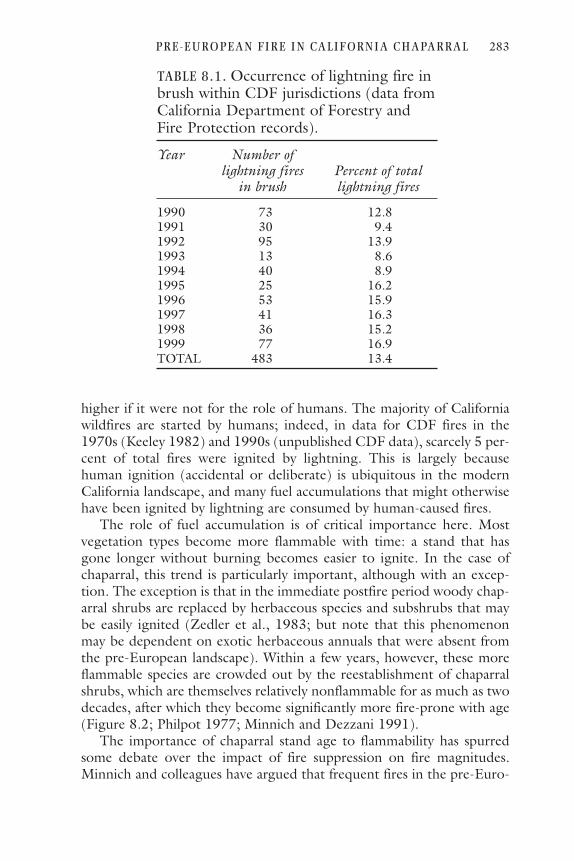
higher if it were not for the role of humans. The majority of Californiawildfires are started by humans; indeed, in data for CDF fires in the1970s (Keeley 1982) and 1990s (unpublished CDF data), scarcely 5 per-cent of total fires were ignited by lightning. This is largely becausehuman ignition (accidental or deliberate) is ubiquitous in the modernCalifornia landscape, and many fuel accumulations that might otherwisehave been ignited by lightning are consumed by human-caused fires.
The role of fuel accumulation is of critical importance here. Mostvegetation types become more flammable with time: a stand that hasgone longer without burning becomes easier to ignite. In the case ofchaparral, this trend is particularly important, although with an excep-tion. The exception is that in the immediate postfire period woody chap-arral shrubs are replaced by herbaceous species and subshrubs that maybe easily ignited (Zedler et al., 1983; but note that this phenomenonmay be dependent on exotic herbaceous annuals that were absent fromthe pre-European landscape). Within a few years, however, these moreflammable species are crowded out by the reestablishment of chaparralshrubs, which are themselves relatively nonflammable for as much as twodecades, after which they become significantly more fire-prone with age(Figure 8.2; Philpot 1977; Minnich and Dezzani 1991).
The importance of chaparral stand age to flammability has spurredsome debate over the impact of fire suppression on fire magnitudes.Minnich and colleagues have argued that frequent fires in the pre-Euro-
P R E - E U R O P EA N F I R E I N CA L I F OR N I A C H A PA R RA L 283
TABLE 8.1. Occurrence of lightning fire inbrush within CDF jurisdictions (data fromCalifornia Department of Forestry andFire Protection records).
Year Number of lightning fires Percent of total
in brush lightning fires
1990 73 12.81991 30 9.41992 95 13.91993 13 8.61994 40 8.91995 25 16.21996 53 15.91997 41 16.31998 36 15.21999 77 16.9TOTAL 483 13.4

pean era maintained a mosaic in which many patches were immature(hence nonflammable) chaparral that acted as natural firebreaks and lim-ited fire size; they assert that fire suppression has allowed the expansionof mature (highly flammable) stands and resulted in larger fires (Minnich1983, 1998; Minnich and Dezzani 1991; Minnich and Chou 1997).Keeley et al. (1999) have challenged that view, noting that the largestchaparral fires in California occur when desiccating downslope foehnwinds blow. They argue that under the influence of such winds, any veg-etation will burn, and the age of stands becomes irrelevant to fire spread.Of note, both these views stress factors other than ignition as being key.Minnich emphasized that fuel load was key, with lightning a sufficientcombustion source:
Over the several decades necessary for chaparral to mature,thunderstorms are sufficiently numerous for lightning tobe a ubiquitous source of combustion. Although nativeAmericans and early European settlers also set fires deliber-ately or accidentally, human acceleration of burning inchaparral is unlikely given its nonflammability during thefirst decades of succession. (1983:1292)
Keeley et al., while emphasizing weather rather than fuel load, agreed onthe adequacy of lightning:
Large catastrophic wildfires in brush-covered regions ofCalifornia are often driven by high winds. . . . Today, peo-ple ignite most of these fires; however, in their absence,lightning storms that typically occur just weeks before theautumn foëhn winds would have provided a natural sourceof ignition. (1999:1831)
In sum, specific studies of fire ecology, fire history, and fire behavior
284 J a c o b B e n d i x
Figure 8.2. Change in flammability of a chaparral stand with time since previous fire.

in California chaparral suggest that this vegetation would burn periodi-cally, even in the absence of a human role. There are disagreements onthe relative impacts of stand age and fire weather on the size of the fires,but both theory and data suggest that some scale of fire would burn agiven stand on timescales of decades to centuries.
Stratigraphic EvidenceIf native Californians were responsible for the fires that burned chapar-ral in the past, then the frequency of fire should have decreased with thearrival of Europeans, who forbad such burning (and in many instancesdecimated the native populations). Thus any record allowing a compar-ison of fire frequency before and after European arrival should help toclarify the importance of anthropogenic fire. The best (perhaps only)way to reconstruct fire frequency over centennial to millennial timescalesis by the analysis of charcoal preserved in radiocarbon-dated sedimentcores (Millspaugh et al. 2000). Similarly, if vegetation has changed inresponse to altered fire regimes, the changes should be apparent inpollen preserved within the same or similar sediments (Clark and Royall1996).
Unfortunately, there are few sedimentary records available that shedlight on the California chaparral. The best available information of thistype is from the Santa Barbara region. One site in that area (Santa Bar-bara Basin; see Figure 8.1) provides a charcoal record of nearby fires(Byrne et al. 1977; Mensing 1993; Mensing et al. 1999) and along withtwo other sites (Zaca Lake and Cleveland Pond) has also yielded pollendata reflecting vegetation change (Mensing 1993, 1998).
Mensing et al. (1999) analyzed charcoal in a core from Santa BarbaraBasin, representing 560 years of deposition from the coastal plain andwestern Transverse Ranges (which have extensive chaparral cover). Theyreported that large fires had occurred in all centuries of their record,with small fires also common. There was no significant change in theoccurrence of large fires between the pre-European period (when pre-sumably native Californian—locally Chumash—burning was prevalent)and the (Spanish) Mission and subsequent periods. Mensing et al. con-cluded that what variation they did see in charcoal concentrations andinferred fire frequency was better correlated with climatic variability(large fires coming just after transitions from fuel-growing wet periodsto fuel-drying droughts) than with human history.
The pollen record also seems to suggest that the ecological impactsof Chumash fires were limited in scale. Mensing (1998) reported onpollen trends in the Santa Barbara Basin core and in a core from ZacaLake that he calculated conservatively to extend at least two centuries
P R E - E U R O P EA N F I R E I N CA L I F OR N I A C H A PA R RA L 285

before Spanish settlement. His pollen record does not show the increaseof chaparral taxa (Rhamnaceae/Rosaceae) that should appear if the ces-sation of Native burning allowed chaparral expansion at the expense ofgrassland (cf. Dodge 1975; Timbrook et al. 1982). Indeed, at Santa Bar-bara Basin, chaparral pollen declined slightly in the last century. Simi-larly, a core farther east at Cleveland Pond reveals no increase of chapar-ral at or following the transition from unhindered native burning to theMission period (Mensing 1993). With regard to the pollen record fromall three sites, Mensing concluded:
In the case of Santa Barbara [i.e., the region], fires in thecoastal grassland were probably more frequent in theimmediate pre-European period as a result of burning byIndians. . . . However, there is no evidence that frequentlyset Indian fires substantially altered the boundary of chap-arral vegetation. Even if fires escaped into the chaparral, asthey must have sometimes, this caused no expansion ofcoastal sage scrub and grassland into chaparral areas.(1993:116)
Fire Regimes and Chaparral Fire EcologyUltimately, our concern is for the ecological impacts of anthropogenicfire, rather than with proving or disproving its occurrence. So the finalquestion is whether the characteristics of California chaparral can be ade-quately explained by a natural fire regime or instead depend on factorsthat would have been unique to anthropogenic fire.
A natural regime of lightning-caused fires would presumably havebeen characterized by a high degree of spatial and temporal variation inthe distribution of burns. Given the relative rarity of lightning in the Cal-ifornia chaparral, the ignition variable alone would have favored morefrequent fires near topographic prominences that would be likely light-ning targets, with longer fire intervals in the declivities less likely to bestruck. That picture is complicated by the impacts of fuel maturation(Minnich and Dezzani 1991), meteorological conditions (Keeley et al.1999), and climatic variation (Mensing et al. 1999) upon the occurrenceand size of fires. The net result would have been a heterogeneous,uneven-grained mosaic characterized by varied stand ages and sizes. Allstands would presumably burn eventually, but the length of timebetween fires would be variable, as would the size of the burns. Fireswould have been seasonally concentrated in the summer and autumn,when fuels were dry and thunderstorms likely; and large fires would havebeen limited to the latter season, when foehn winds were common.
286 J a c o b B e n d i x

By contrast, a landscape in which anthropogenic fire dominatedwould presumably have burned more consistently and frequently.Aschmann (1977) estimated a doubling of fire frequency, Shipekdescribed “regular burning of chaparral” (1989:164), and Timbrook etal. (1982) suggested that fires were set at the grassland/chaparral eco-tone at 1- to 3-year intervals. If, as most authors suggest, fires were usedwith great care to control their impacts, they were probably set in con-ditions that favored low-intensity fire to prevent their spreading beyondcontrol. The size of the fires is less clear. Lewis (1973) suggested thatanthropogenic fires would generally be small in area, a view implicitlysupported by Shipek’s (1989) descriptions of careful and precise fireusage. On the other hand, the fires must have been reasonably large tohave the significant ecological impacts claimed by many authors (e.g.,Stewart 1951; Lewis 1973; Dodge 1975). Descriptions of seasonality areinconstant for anthropogenic fires; every season has been mentioned inone account or another. Even within Lewis’s (1973) paper emphasizingspring and fall fires, his sources mention burning at every season of theyear (Box 8.1).
Fire ecology research over the past 25 years has revealed an enormousvariety of fire-related adaptations in California chaparral species. Woodytaxa range in reproductive strategy from “obligate-sprouters” (e.g., Cer-cocarpus betuloides) that only regenerate vegetatively to “obligate-seed-ers” (e.g., Arctostaphylos glauca) that reproduce only from seed; thereare also species capable of producing both resprouts and seedlings (e.g.,Adenostoma fasciculatum). Beyond this, some species’ seeds will germi-nate only when exposed to a fire-related stimulus (heat for some, charredwood for others), whereas others are unresponsive to fire cues butrequire the moist conditions following winter rains (Keeley 1991, 1992).There is also variation among both seeds and sprouts in the degree of fireintensity through which they can retain their viability (Odion and Davis2000).
This diversity of adaptations is, apparently, best explained by an envi-ronment in which fire is inevitable but unpredictable—that is, in the kindof landscape described above for a natural fire regime. Keeley (1977) andKeeley and Zedler (1978) have suggested that obligate-seeders in thechaparral evolved because occasional fire intervals greater than 100 yearsbestowed a competitive advantage as stands aged and individual shrubsdied. Under this scenario, seeds would remain to germinate when thestand eventually did burn, but there would be few live shrubs remainingto serve as a source of competing sprouts. Keeley and Zedler concluded“chaparral is adapted to both short and long fire-free periods. This isundoubtedly a reflection of the unpredictability of fire in the environment”(1978:159, italics added).
P R E - E U R O P EA N F I R E I N CA L I F OR N I A C H A PA R RA L 287

Zedler (1977) also argued that some chaparral species cannot surviveindefinitely in stands that burn at short intervals. He observed thatCupressus forbesii required 40 years to mature sufficiently to provideenough seed to ensure its representation in the postfire seed pool. Thusits continued presence (and occasional prominence) in the chaparralindicates that at least some chaparral stands must go several decadesbetween fires, and that it is not a newcomer to the chaparral indicatesthat this fire cycle must have been prevalent in the pre-European period.And although reproduction of sprouters has traditionally been thoughtto be favored by fire (e.g., Hanes and Jones 1967), Keeley (1992) hasmore recently suggested that some obligate sprouters may also requirelong fire-free intervals for successful reproduction.
The low intensity of “controlled” fires would also have militatedagainst the success of some chaparral species. Riggan et al. (1988)reported that low-intensity fire fails to trigger successful germination byobligate-seeding Ceanothus species and noted that because of resultantchanges in fuel composition repeated low-intensity fire could becomeself-perpetuating, permanently “degrading” the chaparral composition.The widespread occurrence of Ceanothus-dominated chaparral thus sug-gests an environment in which low-intensity anthropogenic fire, at leastthose consciously set, has been rare.
All these studies lend support to the notion of a multifaceted chapar-ral landscape that owes its diversity of species and species’ adaptations toa fire regime in which burns are quite irregular, temporally and spatially.Although virtually all species require fire, many of them actually needlong intervals between fires for conditions to develop that will allow forsuccessful postfire regeneration. As noted earlier, this accords mostclosely with the characteristics of a lightning-dependent fire regime.
ConclusionsWhat, then, can we conclude from the disparate types of evidence, andthe disparate conclusions, that have been published regarding native Cal-ifornian fire in the chaparral?
There is little doubt that native Californians did make extensive useof fire. There is, however, considerable doubt as to the extent of its useand impacts in the chaparral. In northern California, anthropogenic fireappears to have been far more common in other vegetation types; mostof the descriptions that have been cited as evidence of chaparral burningdo not hold up under scrutiny. In southern California, it seems equallyapparent that at least the margins of chaparral were affected by anthro-pogenic fire. Repeated (arguably anthropogenic) burning of grasslandsmust have meant at least some fire along the grassland/chaparral eco-
288 J a c o b B e n d i x

tone, and the Tipai-Ipai apparently did deliberately burn within thechaparral, albeit on a limited spatial scale. But again, there is no evidencethat the bulk of the chaparral landscape was subject to a human-modi-fied fire regime. There is no ethnographic evidence to support such aregime, the characteristics of the vegetation are better explained by alightning-dependent fire regime, and the limited stratigraphic evidenceavailable indicates that both fire frequency and the chaparral vegetationitself remained unchanged through the transition from the pre-Euro-pean to the colonial periods.
It would be reasonable to summarize the impact of native Californ-ian fire in the following terms: a variety of Native cultures made sophis-ticated use of fire, both to favor edible species and to facilitate (directlyor indirectly) hunting. The scale of fire use was so limited, however, thatthe bulk of the chaparral as we know it evolved under a natural, light-ning-dependent fire regime. Undoubtedly, anthropogenic fire did havesome ecological impacts, but those impacts were spatially limited to theimmediate surroundings of population centers and to the preexisting(i.e., quasinatural) ecotones. Because of the limited spatial extent ofanthropogenic burning, the overall chaparral environment wasunchanged by the cessation of native burning, as evidenced by the staticnature of the stratigraphic record.
This conclusion should not be seen as derogatory of the environ-mental management skills of native Californians. Rather, it recognizesthe sophistication of the pre-European population: they saw advantagesin manipulating their environment and had the skills to do so, but theychose to do it where it would be to their specific advantage, rather thanindiscriminately burning an entire landscape.
AcknowledgmentsI thank Becky Carlson of the Syracuse University Cartographic Labora-tory for preparation of Figure 8.1, Bonnie VonHoffmann for providingCDF fire records, and Tom Vale for numerous stimulating conversationsabout the issues discussed here.
Literature CitedAnderson, M. K. 1999. The fire, pruning, and coppice management of temper-
ate ecosystems for basketry material by California Indian tribes. Human Ecol-ogy 27(1):79–113.
Aschmann, H. 1959. The evolution of a wild landscape and its persistence insouthern California. Annals of the Association of American Geographers49(3):34–56.
———. 1976. Man’s impact on the Southern California flora. Pp. 40–48 in
P R E - E U R O P EA N F I R E I N CA L I F OR N I A C H A PA R RA L 289

Symposium proceedings: Plant communities of southern California, ed. J. Lat-ting. Berkeley, California, Native Plant Society special publication no. 2.
———. 1977. Aboriginal use of fire. Pp. 132–141 in Proceedings of the sympo-sium on the environmental consequences of fire and fuel management inMediterranean ecosystems, ed. H. A. Mooney and C. E. Conrad. General tech-nical report WO-3. Washington, D.C.: USDA Forest Service.
Barbour, M. G. 1988. California upland forests and woodlands. Pp. 132–164 inNorth American terrestrial vegetation, ed. M. G. Barbour and W. D. Billings.New York: Cambridge University Press.
Barbour, M. G., and J. Major. 1977. Terrestrial vegetation of California. NewYork: John Wiley.
Baumhoff, M. A. 1963. Ecological determinants of aboriginal California popu-lations. University of California Publications in American Archaeology andEthnology 49(2):155–236.
———. 1978. Environmental background. Pp. 16–24 in Handbook of NorthAmerican Indians, vol. 8: California, ed. R. F. Heizer. Washington, D.C.:Smithsonian Institution.
Beals, R. L. 1933. Ethnology of the Nisenan. University of California Publica-tions in American Archaeology and Ethnology 31:335–414.
Bean, J. L., and H. W. Lawton. 1973. Some explanations for the rise of culturalcomplexity in native California with comments on proto-agriculture and agri-culture. Pp. v–xlvii in Patterns of Indian burning in California: Ecology andethnohistory. Ramona, Calif.: Ballena.
Blackburn, T. C., and K. Anderson. 1993. Introduction: Managing the domes-ticated environment. Pp. 15–25 in Before the wilderness: Environmental man-agement by native Californians, ed. T. C. Blackburn and K. Anderson. MenloPark, Calif.: Ballena.
Bolton, H. E. 1916. Spanish exploration in the Southwest, 1542–1706. New York:Scribner’s.
———. [1927] 1971. Fray Juan Crespi, missionary explorer on the Pacific Coast,1769–1774. Reprint. New York: AMS Press.
Bright, W. 1978. Karok. Pp. 180–189 in Handbook of North American Indians,Vol. 8: California, ed. R. F. Heizer. Washington, D.C.: Smithsonian Institution.
Burcham, L. T. 1974. Fire and chaparral before European settlement. Pp.101–120 in Symposium on living with the chaparral proceedings, ed. M. Rosen-thal. San Francisco: Sierra Club.
Byrne, R., J. Michaelsen, and A. Soutar. 1977. Fossil charcoal as a measure ofwildfire frequency in southern California: A preliminary analysis. Pp. 361–367in Proceedings of the symposium on the environmental consequences of fire andfuel management in Mediterranean ecosystems, ed. H. A. Mooney and C. E.Conrad. General technical report WO-3. Washington, D.C.: USDA ForestService.
Clark, J. S., and P. D. Royall. 1996. Local and regional sediment charcoal evi-dence for fire regimes in presettlement northeastern North America. Journalof Ecology 84(3):365–382.
Court, A. 1960. Lightning fire incidence in northeastern California. Technical
290 J a c o b B e n d i x

paper No. 17. USDA Forest Service, Pacific Southwest Forest and RangeExperiment Station.
Dodge, J. M. 1975. Vegetation changes associated with land use and fire historyin San Diego County. Ph.D. thesis, University of California, Riverside.
Donley, M. W., S. Allan, P. Caro, and C. P. Patton. 1979. Atlas of California.Culver City, Calif.: Pacific Book Center.
Du Bois, C. 1935. Wintu ethnography. University of California Publications inAmerican Archaeology and Ethnology 36(1):1–148.
Franklin, J. F. 1988. Pacific Northwest forests. Pp. 104–130 in North Americanterrestrial vegetation, ed. M. G. Barbour and W. D. Billings. New York: Cam-bridge University Press.
Griffin, J. R. 1977a. Mixed evergreen forest. Pp. 359–381 in Terrestrial vegeta-tion of California, ed. M. G. Barbour and J. Major. New York: John Wiley.
———. 1977b. Oak woodland. Pp. 383–415 in Terrestrial vegetation of Cali-fornia, ed. M. G. Barbour and J. Major. New York: John Wiley.
Hanes, T. L. 1977. Chaparral. Pp. 417–469 in Terrestrial vegetation of Califor-nia, ed. M. G. Barbour and J. Major. New York: John Wiley.
Hanes, T. L., and H. W. Jones. 1967. Postfire chaparral succession in southernCalifornia. Ecology 48(2):259–264.
Harrington, J. P. 1932. Tobacco among the Karuk Indians of California. Smith-sonian Institution Bureau of American Ethnology bulletin 94. Washington,D.C.: U.S. Government Printing Office.
Hickman, J. C. 1993. The Jepson manual: Higher plants of California. Berkeley:University of California Press.
Keeley, J. E. 1977. Fire-dependent reproductive strategies in Arctostaphylos andCeonothus. Pp. 391–396 in Proceedings of the symposium on the environmentalconsequences of fire and fuel management in Mediterranean ecosystems, ed. H.A. Mooney and C. E. Conrad. General technical report WO-3. Washington,D.C.: USDA Forest Service.
———. 1982. Distribution of lightning- and man-caused wildfires in California.Pp. 431–437 in Proceedings of the symposium on dynamics and management ofMediterranean-type ecosystems, ed. C. E. Conrad and W. C. Oechel. Generaltechnical report PSW-58. Berkeley, Calif.: USDA Forest Service, PacificSouthwest Range and Experiment Station.
———. 1987. Role of fire in seed germination of woody taxa in CaliforniaChaparral. Ecology 68(2):434–443.
———. 1991. Seed germination and life history syndromes in the Californiachaparral. Botanical Review 57(2):81–116.
———. 1992. Recruitment of seedlings and vegetative sprouts in unburnedchaparral: Ecology 73(4):1194–1208.
Keeley, J. E., C. J. Fotheringham, and M. Morais. 1999. Reexamining fire sup-pression impacts on brushland fire regimes: Science 284:1829–1832.
Keeley, J. E., and S. C. Keeley. 1988. Chaparral. Pp. 165–207 in North Ameri-can terrestrial vegetation, ed. M. G. Barbour and W. D. Billings. New York:Cambridge University Press.
Keeley, J. E., and P. H. Zedler. 1978. Reproduction of chaparral shrubs after
P R E - E U R O P EA N F I R E I N CA L I F OR N I A C H A PA R RA L 291

fire: a comparison of sprouting and seeding strategies. The American MidlandNaturalist 99(1):142–161.
Kniffen, F. B. 1929. Achomawi geography. University of California Publicationsin American Archaeology and Ethnology 23(5):297–332.
———. 1939. Pomo geography. University of California Publications in Amer-ican Archaeology and Ethnology 36(6):353–400.
Küchler, A. W. 1973. Problems in classifying and mapping vegetation for eco-logical regionalization. Ecology 54(3):512–523.
———. 1977. The map of the natural vegetation of California. Pp. 909–938 inTerrestrial vegetation of California, ed. M. G. Barbour and J. Major. NewYork: John Wiley.
Lewis, H. T. 1973. Patterns of Indian burning in California: Ecology and eth-nohistory. Ramona, Calif.: Ballena.
Mensing, S. A. 1993. The impact of European settlement on oak woodlands andfire: Pollen and charcoal evidence from the transverse range, California. Ph.D.diss., University of California, Berkeley.
———. 1998. 560 years of vegetation change in the region of Santa Barbara,California. Madroño 45(1):1–11.
Mensing, S. A., J. Michaelsen, and R. Byrne. 1999. A 560-year record of SantaAna fires reconstructed from charcoal deposited in the Santa Barbara Basin,California. Quaternary Research 51(3):295–305.
Millspaugh, S. H., C. Whitlock, and P. J. Bartlein. 2000. Variations in fire fre-quency and climate over the past 17,000 years in central Yellowstone NationalPark. Geology 28:211–214.
Minnich, R. A. 1983. Fire mosaics in southern California and northern Baja Cal-ifornia. Science 219:1287–1294.
———. 1987. Fire behavior in southern California chaparral before fire control:The Mount Wilson burns at the turn of the century. Annals of the Associationof American Geographers 77(4):599–618.
———. 1998. Landscapes, land-use and fire policy: Where do large fires comefrom? Pp. 133–158 in Large forest fires, ed. J. M. Moreno. Leiden, Nether-lands: Backhuys.
Minnich, R. A., and Y. H. Chou. 1997. Wildland fire patch dynamics in thechaparral of southern California and northern Baja California. InternationalJournal of Wildland Fire 7(3):221–248.
Minnich, R. A., and R. J. Dezzani. 1991. Suppression, fire behavior, and firemagnitudes in California chaparral at the urban/wildland interface. Pp. 67–83in California watersheds at the urban interface: Proceedings of the third biennialwatershed conference, ed. J. J. DeVries and S. G. Conard. Riverside: Universityof California Water Resources Center report no. 75.
Moreno, J. M., and W. C. Oechel. 1991. Fire intensity effects on germinationof shrubs and herbs in southern California chaparral. Ecology 72:1993–2004.
Odion, D. C., and F. W. Davis. 2000. Fire, soil heating, and the formation ofvegetation patterns in chaparral. Ecological Monographs 70(1):149–169.
Orville, R. E. 1991. Lightning ground flash density in the contiguous UnitedStates—1989. Monthly Weather Review 119:573–577.
292 J a c o b B e n d i x
Orville, R. E., and A. C. Silver. 1997. Lightning ground flash density in the con-tiguous United States: 1992–95. Monthly Weather Review 125:631–638.
Philpot, C. W. 1977. Vegetative features as determinants of fire frequency andintensity. Pp. 12–16 in Proceedings of the symposium on the environmental con-sequences of fire and fuel management in Mediterranean ecosystems, ed. H. A.Mooney and C. E. Conrad. General technical report WO-3. Washington,D.C.: USDA Forest Service.
Pyne, S. J. 1982. Fire in America: A cultural history of wildland and rural fire.Princeton: Princeton University Press.
Pyne, S. J., P. L. Andrews, and R. D. Laven. 1996. Introduction to wildland fire.New York: John Wiley.
Riggan, P. J., S. Goode, P. M. Jacks, and R. N. Lockwood. 1988. Interaction offire and community development in chaparral of Southern California. Ecolog-ical Monographs 58(3):155–176.
Shipek, F. C. 1989. An example of intensive plant husbandry: The Kumeyaay ofsouthern California. Pp. 159–170 in Foraging and farming: The evolution ofplant exploitation, ed. D. R. Harris. London: Unwin Hyman.
Spier, L. 1923. Southern Diegueño customs. University of California Publica-tions in American Archaeology and Ethnology 20:297–358.
Stewart, O. C. 1943. Notes on Pomo ethnogeography. University of CaliforniaPublications in American Archaeology and Ethnology 40(2):29–62.
———. 1951. Burning and natural vegetation in the United States. Geographi-cal Review 41:317–320.
Storer, T. I. 1932. Factors influencing wildlife in California, past and present.Ecology 13(4):315–327.
Timbrook, J. 1986. Chia and the Chumash: A reconsideration of sage seeds insouthern California. Journal of California and Great Basin Anthropology8(1):50–64.
Timbrook, J., J. R. Johnson, and D. D. Earle. 1982. Vegetation burning by theChumash. Journal of California and Great Basin Anthropology 4(2):163–186.
Wells, M. L., and D. E. McKinsey. 1995. Lightning strikes and natural fireregimes in San Diego County, California. Pp. 193–194 in The Biswell sympo-sium: Fire issues and solutions in urban interface and wildland ecosystems, ed.D. R. Weise and R. E. Martin. General technical report PSW-158. Albany,Calif.: USDA Forest Service, Pacific Southwest Range and Experiment Sta-tion.
Zedler, P. H. 1977. Life history attributes of plants and the fire cycle: A casestudy in chaparral dominated by Cupressus forbesii. Pp. 451–458 in Proceedingsof the symposium on the environmental consequences of fire and fuel managementin Mediterranean ecosystems, ed. H. A. Mooney and C. E. Conrad. GeneralTechnical Report WO-3. Washington, D.C.: USDA Forest Service.
Zedler, P. H., C. R. Gautier, and G. S. McMaster. 1983. Vegetation change inresponse to extreme events: The effect of a short interval between fires in Cal-ifornia chaparral and coastal shrub. Ecology 64(4):809–818.
P R E - E U R O P EA N F I R E I N CA L I F OR N I A C H A PA R RA L 293

cc hh aa pp tt ee rr 99
REFLECTIONS
Thomas R. Vale
Truth can be elusive, sometimes even receding when it is approached.The question addressed by the contributors to this book—Did burningby Native Americans in pre-European times alter the fundamental char-acter of vegetation in the American West?—might seem, even after read-ing their essays, to defy a categorical answer. Qualifications, contextual-izations, hesitations—the authors analyzed their regions with caution, anopen honesty that could trouble those who seek absolute and definitivetruths. But even if the diogenean lamp fails to chase away all shadows ofdoubt, it does brighten the scene and enlighten our minds. The authorsin this book provide more than equivocation.
Both environmental and cultural variability in space and time renderdifficult many, but not all, generalizations about pre-European fireregimes or burning habits of Native Americans. All the authors recog-nize the importance of differences in fire histories among vegetationtypes and human groups in the American West. More specifically and asexamples, Baker postulates that the incidence of lightning could moreeasily limit the occurrence of natural fires in the northern Rocky Moun-tains than in the lightning-richer southern Rockies, where fuel may bemore limiting; Whitlock and Knox argue that fire history in the PacificNorthwest closely tracks climate history, with temporal variations in firefrequencies tied to distinctive climate episodes; Griffin suggests thatIndian ignitions may have augmented lightning ignitions in the shrub-lands of the northern intermountain West, although the postfire recov-ery of shrubs might have made the humanizing influence temporally
295

short-lived; A. Parker reports the importance of temporally occasionallarge fires in the ecology of mixed-conifer forests of the Sierra Nevada,where the conventional wisdom has stressed frequent ground fires; Ben-dix interprets the variability in the ecological response of chaparralspecies to fire as suggesting that the temporal persistence of the plantshas been made possible by a spatially varying pattern of burning; K.Parker concludes that human use of fire cannot be divorced from thetemporally and spatially varying cultural groups—each with differentburning behaviors—inhabiting the lowlands of the Southwest; and Allennotes the role of warfare between Apache and European peoples as astimulus to Indian-ignited fires in southwestern mountain forests, achange in Indian-burning that distinguishes historic time from that ofprehistory.
Collectively, then, the authors identify a confounding array of fire fac-tors: spatially varying lightning incidence and temporally varying climateconditions, temporal recovery of burned vegetation and spatial variabil-ity of fire characteristics, temporally varying cultural groups and spatiallydistinctive responses to European invaders. All these elements contributeto the richness of pre-European fire regimes and to the difficulty of iden-tifying single or simple patterns in those regimes. This complexity con-fuses the meaning of “snapshot” views of the past, constraining not onlythose who seek a simple pre-European wilderness condition—a state ofnature—but also those who hope for simple Native American behaviorsand impacts—a universally humanized landscape.
Good evidence for pre-European fire histories is spatially uneven inthe American West, but in regions where documentation is strongest,the importance of Indian burning as a vegetation factor at the landscapescale seems weakest. Consider the types of evidence invoked and assessedby the authors in this book: archival and anecdotal sources, reasoningbased on the fire ecology of vegetation types, reasoning based on Indiansubsistence patterns, fire history data from the past several centuries, andfire history data from deeper time. Both Griffin and K. Parker treat veg-etation types with a paucity of fire history data (i.e., the lack of fire-scarred trees renders difficult the reconstruction of fire history in theregions of their studies), and thus they depend, by necessity, upon moreinformal or less rigorous evidence. Griffin argues the possibility of anIndian impact on the fire regime of the shrubland of the northern inter-mountain West, where fire was moderately frequent but likely importantas a vegetation factor. K. Parker, on the other hand, deals with vegeta-tion in the southern intermountain West with such contrasting charac-teristics that even the informal evidence of fire behavior does not pointto an importance for Indian ignitions; the highly flammable desert grass-land burned frequently but occurs in a region with a documented high
296 T h o m a s R . Va l e

incidence of lightning ignitions, and the highly unburnable Sonorandesert shrubland lacks fuels to carry fires even with an abundance of“dry” lightning. Bendix, who seems to accept Indian ignitions as a pos-sible influence on parts of the vegetation of lowland California, nonethe-less concludes from both archival and inferential ecological data that thepattern of chaparral in the general landscape was, and is, a likely conse-quence of nonhuman factors. In western forests, where fire scars andother ecological data permit the construction of more complete and pre-cise fire histories, the various authors argue—even while accepting thelimitations of data and thus of understanding an uncertain past—thatlightning incidence and fuel characteristics seem to explain burningregimes. Both Baker on a timescale of centuries and Whitlock and Knoxon a timescale of millennia analyze, in part, forests burned by infrequentcrown fires, which strongly relate to both long-term climate and short-term weather episodes of drought (rather than revealing the greater reg-ularity generated by human ignitions in forests that are frequently flam-mable). Moreover, these authors find interpretive problems with archivaland anecdotal sources (which are usually employed at timescales ofdecades or a century or two); Baker, in particular, makes the insightfuland intriguing point that early human observers seemed ignorant oflightning as an ignition source for fire. A. Parker and Allen discuss forestswith frequent ground fires—regimes that create particularly rich ecolog-ical data (fire-scarred trees)—and with a high incidence of lightning igni-tions. Both authors find little evidence that Indian burning altered veg-etation at the landscape scale; this indication of a natural fire regimeseems particularly pervasive in the pine forests of the Southwest, where,arguably, fire history data are more detailed than anywhere else on thecontinent.
In vegetation regions not explicitly treated in this book, the samelinkage—good data and unlikely Indian impact, few data and possibleIndian impact—occasionally emerges. The Great Plains region, forexample, is sometimes grouped with other grasslands in North Americaas “manufactured . . . by the Indians” (Budiansky 1995:111) or “ofanthropogenic rather than climatic origin” (Denevan 1992:372),although the data from a variety of paleoecological studies clearly indi-cate otherwise: long before humans invaded the continent, “the glacial-age vegetation of the southern Great Plains was a grassland” (Hall andValastro 1995:237); “the Southern High Plains has been primarily agrassland . . . throughout most of the Quaternary” (Holliday1987:242); “widespread grass-dominated ecosystems . . . occur[red inNorth America in] the early to middle Miocene” (Jacobs et al.1999:590). In the forests of the Northeast, where appropriate ecologi-cal data are ambiguous, Budiansky (1995:108) asserts categorically that
R E F L E C T I ON S 297

“ ‘Old Growth’ was a rarity,” and Denevan (1992:371) suggests that“much of the forest [was] successional (fallow) growth and . . . grassyopenings,” but Whitney (1994:76) argues that it is equally misleading toenvision the pre-European forest as either an unbroken old-growth for-est or “an amalgamation of pioneer species recovering from one form ofdisturbance or another.” Finally, in lowland California outside of chap-arral stands, with its particularly dense native population, fire in pre-European times was probably widespread, but it is difficult to documentor assess the role of humans as initiators of burns. Most generally, betterdata will not necessarily lead arguments away from an important role forIndian burning, but they will likely guide us toward nuanced apprecia-tion of the spatial and temporal variability in that role.
The pre-European landscape in the American West was a mosaic:some areas were altered by the activities of native peoples, includingincreased burning, and some areas were molded by natural processes.With an expansion of Baker’s classification of humanized landscape per-ceptions (and simplifying the names of the types), a resulting seven-partscheme spans the range of possible landscape conditions in the otherwisedichotomous distinction between “humanized” and “pristine” (Figure9.1; compare with the four-part classification by Russell [1993]). At oneextreme, the intensely humanized landscape sees the modification bypeople as both ubiquitous and major. Located away from this human-ization pole but still involving human modifications are the visions of theunevenly humanized landscape, with a universal human imprint but a
298 T h o m a s R . Va l e
Figure 9.1. Landscape characteristics on a continuum between the extreme condi-tions of universally humanized and universally pristine. The five below the contin-uum line represent major categories, with the two above the line depicting modifi-cations of the major category with which each is paired.

spatial variability in the degree to which nature is so altered, and anamplified humanized landscape, in which a human role accentuates thecharacteristics of landscape driven by natural factors. The mosaic land-scape occupies a middle ground, with spatial variability in the humanmodification of nature; different areas reveal widely ranging degrees ofhumanization and at least some areas lack any such modifications. Thenatural landscape sees the fundamental structural and functional charac-teristics of vegetation specifically and landscapes generally as determinedby natural processes, even if human activity might modify some of thespecific features of that natural world. A modified natural landscape per-spective might concede the preeminence of natural process but elevatethe importance of human presence as the essential humanization charac-teristic of the inhabited wilderness landscape. Finally, at the other polarextreme, the untouched landscape finds neither a human function nor ahuman presence in a scene utterly devoid of people—this landscape isunambiguously pristine.
For the authors in this book, the mosaic landscape is clearly favored;only Griffin, for the sagebrush vegetation in the northern intermountainWest, seems partial toward a different perspective, the unevenly human-ized landscape. Moreover, the authors hardly argue for a sort of balancebetween humanized and nonhumanized components within the land-scape mosaic: at least for the effects of anthropogenic burning, theintensely humanized landscape seems localized amid a dominating natu-ral landscape. Does this conclusion imply that the perspective nowbranded as archaic, the romantic view of a pre-European pristine conti-nent, may be closer to the truth than its more fashionable antithesis?
The presence of native people, rather than their nature-modifyingimpacts, seems a more universal “humanization” of pre-European NorthAmerica. In the absence of a ubiquitous human-modification of the nat-ural world, pre-Columbian North America might be nonetheless charac-terized as “humanized” because the continent was “home” to millionsof Indians. In this sense, “humanization” recognizes that the landscapeof home embraces not only the places of everyday living and of resourceproduction but also the larger contextual places that may include localesof symbolic meaning—whether or not the natural characteristics of theseplaces are modified by human action. (A parallel to contemporary timessees the protected landscapes of nature preserves across the country asrooms in our modern “home.”) If both the intensely humanized land-scape and the untouched landscape seem naively inaccurate as models ofpast North American environments, and if the mosaic landscape capturesthe essential character of the physical landscape, the inhabited wildernesslandscape may describe the cultural meaning of that pre-Columbianlandscape of home.
R E F L E C T I ON S 299

Natural wildernesses, pristine landscapes, existed at the time of Euro-pean contact. The excesses of past convictions should not yield simply toexcesses of a newer faith: landscapes in a state of nature sprawled acrosslarge parts of North America when Columbus made his fateful landfall.Not occurring everywhere, surely, they did exist in places; they did existsomewhere. This conclusion will not strike many people as novel, but itwill be resisted by those for whom “wilderness” seems a politically incor-rect challenge to social justice or a strategically unwise ideal for conser-vation goals, or by those who argue that “nature” is merely a sociallyconstructed category, an artifact of the human mind and human lan-guage. For people involved in the policies that guide protected land-scapes—national parks, statutory wilderness, and other areas intendedfor nature preservation—the conclusion may offer some reassurance thattheir efforts have legitimacy, that “nature” does in fact exist. But eventhis recognition will not eliminate decision dilemmas. Perplexing ques-tions remain: Was the landscape of some particular locale at the time ofEuropean contact humanized, pristine, or some hybrid of both? If ahybrid, do the characteristics of nature or those of human impact loomas more important to contemporary sensibilities? If in a state of nature,was the landscape condition at that moment in time any more to be val-ued than those that preceded it in deep time or that might have occurredwith a different history of developmental events? Does hands-off preser-vation or hands-on restoration capture what society wants in its pro-tected landscapes? The reality of a Western wilderness does not, or atleast should not, mean that the 1492 state of nature is unambiguouslyand unquestionably to be desired as a sort of privileged condition. Butsuch considerations more reflect human value and human purpose thanlandscape realities: a western wilderness, an American wilderness—a nat-ural landscape—greeted the first Europeans.
Literature CitedBudiansky, S. 1995. Nature’s keepers: The new science of nature management.
New York: Free Press.Denevan, W. 1992. The pristine myth: The landscape of the Americas in 1492.
Annals of the Association of American Geographers 82:369–385.Hall, S. A., and S. Valastro, Jr. 1995. Grassland vegetation in the southern Great
Plains during the last glacial maximum. Quaternary Research 44:237–245.Holliday, V. T. 1987. A reexamination of late-Pleistocene boreal forest recon-
structions for the southern high plains. Quaternary Research 28:238–244.Jacobs, B., J. Kingston, and L. Jacobs. 1999. The origin of grass-dominated
ecosystems. Annals of the Missouri Botanical Garden 86:590–643.Russell, E. W. B. 1993. Discovery of the subtle. Pp. 81–90 in Humans as com-
300 T h o m a s R . Va l e

ponents of ecosystems, ed. M. McDonnell and S. Pickett. New York: Springer-Verlag.
Whitney, G. 1994. From coastal wilderness to fruited plain: A history of environ-mental change in temperate North America from 1500 to the present. Cam-bridge: Cambridge University Press.
R E F L E C T I ON S 301

Contributors
CRAIG D. ALLEN is a research scientist with the U. S. Geological Surveyat Bandelier National Monument in New Mexico. He studies extensivelythe fire histories of upland forests of the American Southwest, with spe-cial attention to both spatial and temporal variations in those histories.
WILLIAM L. BAKER is a professor of geography at the University ofWyoming in Laramie. His research evaluates the ecological dynamics ofRocky Mountain forests and their responses to human-induced environ-mental change, particularly in the context of landscape ecology.
JACOB BENDIX is an associate professor of geography at Syracuse Univer-sity in New York. His research spans biogeography and geomorphology,with a focus on the dynamics of riparian vegetation, in part in the moun-tains of southern California.
DUANE GRIFFIN is an assistant professor of geography at Bucknell Uni-versity in Lewisburg, Pennsylvania. His work, bridging the natural andsocial sciences, explains patterns of ecological diversity and exploreshuman interactions with that diversity, notably in the intermountainWest.
MARGARET A. KNOX is a graduate student in the Department of Geog-raphy at the University of Oregon in Eugene, Oregon. She works on theecological history of forests in the Pacific Northwest and the northernRocky Mountains, with particular focus on the use of pollen sequences.
303

ALBERT J. PARKER is a professor of geography at the University of Geor-gia in Athens, Georgia. He studies coniferous forests, including those inthe Sierra Nevada, with an eye to both species-environment relationshipsand disturbance ecologies.
KATHLEEN C. PARKER is a professor of geography at the University ofGeorgia in Athens, Georgia. Her ecological research evaluates thedynamics and environmental patterns of both vegetation, includingcolumnar cactus, and birds in the southern intermountain West.
THOMAS R. VALE is a professor of geography at the University of Wis-consin in Madison, Wisconsin. He focuses on human-related vegetationchange, national parks, and human assessment of landscapes, especiallyin the American West.
CATHY WHITLOCK is a professor of geography at the University of Ore-gon in Eugene, Oregon. Her research on the ecological history of forestvegetation spans a broad area of the Pacific Northwest and the RockyMountains, from Yellowstone country to the southern Cascades.
304 Contributors
Index
305
Abolt, R. A. P., 152Adam, D. P., 257Adams, R. I. C., 217Adrade, E. R., 104Agee, J. K., 88, 170, 177, 196, 197,
199, 204, 208, 219, 220, 247Agriculture in pre-European American
West, xiv, 14–18in upland Southwest, 159, 160, 162,
182Ahlstrand, G. M., 111Aikens, C. M., 195, 196, 200, 203,
216, 218, 220Allen, Craig D., 143–83, 296, 297Alverson, E., 207Ames, K., 200Amplified humanized landscape, 299Anasazi, 115, 122, 159, 161, 182Anderson, K., 9, 21, 257Anderson, M. K., 160, 162, 234, 241,
244, 251, 259, 260, 262, 273Anderson, R. S., 145, 239, 240, 248,
249–50, 258Anschuetz, K. F., 159Apaches, 48, 124, 126–27, 158, 161,
163, 165, 168–69, 178, 179,296
Arapahos, 48Archer, S., 109, 154Arkush, B. S., 86Arno, S. F., 43, 49, 52, 60, 61, 62, 63,
64, 65, 66, 68, 160, 220, 221,222
Aschmann, Homer, 272, 277, 287Axelrod, D. I., 80
Babbitt, Bruce, 6Bahre, C., 24, 101, 107, 108,
109, 124, 126, 129, 154, 160,161
Bailey, A. W., 80, 86, 87, 88, 89, 109,164
Bailey, Vernon, 175, 178Baisan, C., 28, 45, 46, 110, 128, 129,
130, 143, 144, 146, 149, 150,152, 153, 165, 168, 180
Bakeless, J., 2Baker, William L., 41–71, 85, 170,
197, 295, 297, 298Bandelier National Monument, 159Bannock tribe, 48Barbour, M., 9, 238, 242, 273Barnosky, C. W., 197Barrett, S. W., 43, 47, 49, 51, 52, 53,
57, 58, 59, 60, 61, 62, 63, 65,66, 67, 68, 69, 70, 160, 220,221, 222
Barrows, J. S., 46, 54, 56, 146, 147,150, 174, 177
Bartlein, P. J., 221, 222Basket-making, 241, 242Baumhoff, M. A., 272, 273, 274

Baxter, J. O., 171, 178Beals, R. L., 274Bean, J. L., 279Bean, L., 12, 21Beckham, S. D., 203, 206Bell, W. H., 124, 125Bendix, Jacob, 269–89, 296, 297Bennett, S. P., 108, 129Berkley, E., 204Bessie, W. C., 45Betancourt, J., 21, 23, 24, 104, 113,
115, 122, 130, 145, 146, 148,151, 153, 159, 160, 179, 222
Bettinger, R. L., 82Billings, W. D., 52, 61, 78, 80Biswell, H. H., 251Blackburn, T., 9, 259Blackfeet tribe, 47–48Blue Mountains, vegetation and fire
regime in prehistoric ponderosapine forests of the easternCascade region and, 219–22
Bock, C. E., 131Bock, J. H., 131Bogan, M. A., 143, 149, 150, 179Bohning, J. W., 131Bohrer, V. L., 119, 127, 128Bolton, H. E., 277, 278, 279–80Bonnicksen, T. M., 160, 165, 181,
223, 245Borher, V. L., 21Bork, J., 219, 221Botkin, D., 6Bowers, J. E., 110Boyd, R. T., 50, 57, 196, 203, 206,
207, 211Bracker, S. D., 159Bradfield, M., 15Bright, W., 273Britton, C. M., 86, 87Brown, D. E., 104, 105, 106, 107,
149Brown, P. M., 149Brubaker, L. B., 200, 206Bruff, J. Goldsborough, 251Bruner, A. D., 88Brunner-Jass, R., 145, 146Brunton, B. B., 48, 49, 50Buck, C. C., 107Budiansky, S., 28, 297–98Buffington, L. C., 109
306 Index
Bunting, S. C., 86, 87Burcham, L. T., 270, 282Burgess, T. L., 102, 107Burke, C. J., 204Burkhardt, J. W., 87, 89, 219Burns, R. M., 216Burwell, T., 22, 88Busse, K. K., 254Butzer, K. W., 159, 195Byrne, R., 248, 249, 258, 285
Cabeza de Vaca, Alvar Nuñez, 126,162, 167
Cable, D. R., 129, 131Cabrillo, Juan Rodríguez, 279California chaparral, pre-European fire
in, 269–89, 296, 297chaparral and fire, relationship of,
269–72conclusions, 288–89distribution of chaparral, 270–72fire regimes and chaparral fire
ecology, 286–88Henry Lewis’s evidence of, 272–77natural ignition, 281–85in Northern California, 272–77opposing views about, 270overview, 269in Southern California, 277–81stratigraphic evidence of, 285–86
California Department of Forestry andFire Protection (CDF), 282, 283
Callaway, D., 12Callicott, B., 2Cappannari, S., 12Caprio, A. C., 110, 246, 255Carpenter, S. L., 249–50Cartledge, T., 25Cascade Forest Reserve, 172Cassells, E. S., 48Casterrer, E. F., 124, 125Cave, G. H., 111Chaddle, S., 25Chang, C., 204, 233, 241, 242, 245,
247Chappell, C. B., 247Chase, A., 2, 195Chavez, F. A., 85, 86Cheyenne, 48Choquette, 53Chou, Y. H., 284

Index 307
Christensen, E., 80, 256Chumash people, 277, 279, 281, 285Churchill, M., 14Clark, J. C., 160Clark, J. S., 199, 285Clark, R. G., 86, 87Clarke, Samuel, 215Clements, F. E., 174Cole, K. L., 94Cook, S. F., 78, 243Cooper, C. F., 149, 154, 160, 161,
162, 165, 179Cordell, L., 14, 17, 111, 112n, 113,
115, 116, 122, 124, 126, 157Coronado, Francisco Vasquez de, 126,
167Cottam, W. P., 80, 85Court, A., 282Covey, C., 162Coville, F., 172, 176Covington, W. W., 149, 150, 151, 152,
154, 179Cox, J. R., 109Crandall, C. S., 55Crespi, Juan, 277–80Cronon, W., 9, 195Cronquist, A., 78Crosswhite, F. S., 124, 125Crown, P., 15, 18, 119Crow tribe, 48Crum, S., 48Cwynar, L. C., 199Czech, B., 27
D’Antonio, C. M., 95Davis, D. H., 61Davis, F. W., 287Davis, O. K., 113, 258Day, G. M., 160D’Azevedo, W., 12, 47, 78Dean, J., 23, 116, 117n, 121, 122,
123, 132Dean, J. S., 115, 148deBuys, W., 167, 170deLaguna, F., 12Delcourt, H. R., 160Delcourt, P., 28, 160Deloria, V., Jr., 43, 58Denevan, W., 2, 10, 28, 42, 43, 49,
69, 78, 159, 171, 195, 196, 297,298
Despain, D., 26, 28, 63, 66, 256Dezzani, R. J., 283, 284, 286Dick-Peddie, W. A., 107, 109, 129Dieterich, J. H., 110Doak, D., 25Dobyns, A. F., 101, 110, 124, 125,
126, 127, 131Dobyns, H. E., 144, 160, 162Dodge, J. M., 59, 286, 287Doelle, W. H., 111, 116Donley, M. W., 271Doolittle, W., 14, 18, 19, 159Douglas, David, 206–13, 216Downs, J. F., 83, 84, 85Doyel, D. E., 119, 122Du Bois, C., 274Dunwiddie, P. W., 199Dyrness, C. T., 216, 219
Edlund, E. G., 248, 248n, 249, 258
Elliott, M. L., 159, 165El Niño-Southern Oscillation (ENSO),
46, 104, 148Elsasser, A. B., 260Equilibrium models, 6Espejo, 167Euler, R. C., 115, 158, 159Ewers, J. C., 48, 50
Fall, P. L., 67Felger, R. S., 124Fenneman, N. M., 78Ffolliott, P., 24Fires in the American West
in California chaparral, see Californiachaparral, pre-European fire in
lightning as ignition source, seeLightning as ignition source offires
in northern intermountain region,see Northern intermountainWest, prehistoric human impactsof fire regimes and vegetation inthe
Pacific Northwest, see PacificNorthwest, prehistoric burningin the
as preeminent human impact, xiv, 31pristine vs. humanized landscape,
27–30

Fires in the American West (continued)in the Rocky Mountains, see Rocky
Mountains, Indians and fire inin Sierra Nevada forests, see Sierra
Nevada, ecological impact ofburning by Native Americans in
in Southwest lowlands, see Southwestlowlands, fire in the pre-European
in upland Southwest, see UplandSouthwest, ecological history offire in the
Fish, P., 14, 15, 16, 19, 20, 114, 115,116, 119, 120, 122, 123
Fish, S., 14, 15, 16, 19, 20, 114, 115,116, 119, 120, 122, 125, 126,127, 128, 129, 131, 158, 159,160, 162, 163, 164
Fisher, R. F., 47, 48, 49, 52, 64, 66,68
Flatheads, 48Flores, D., 2, 195Floyd, M., 22Fontana, B. L., 124, 125, 126Foothills Yokut, 241Ford, R. I., 114Forest Service, see U.S. Department of
Agriculture (USDA), ForestService
Forman, R. T. T., 160Fowler, C., 12, 82, 83, 84Foxx, T. S., 152Francis, J. E., 47Franklin, J. F., 204, 216, 219, 222,
273Frederickson, E., 179Fritts, H. C., 217Fritz, S. C., 56Fulé, P. Z., 149, 152, 154Funkhouse, G. S., 148
Gardner, J. J., 199Garfin, G. M., 218Gartner, F. R., 52, 59Gasser, R. E., 119, 128Gold Rush of 1849, 244Gomez-Pompa, A., 27Gosz, J. R., 108, 128–29Gottesfeld, L. M. J., 160Gottfried, G., 24Graumlich, L. J., 114, 129, 206, 217,
308 Index
240, 244Grayson, A. W., 79, 81, 86Grayson, D. K., 78, 82, 83Griffin, Duane, 77–95, 295, 296, 299Griffin, J. R., 273, 275Griffiths, D., 109Grigg, L. D., 200Grissino-Mayer, H. D., 66, 68, 110,
115, 121, 122, 125, 148, 153,154, 165, 168, 177, 179
Gross, F. A., 109Grover, H. D., 109Gruell, G. E., 51, 52, 53, 54, 56, 58,
60, 61, 65, 69, 85, 220Guetter, P. J., 200
Haase, W., 15Habeck, J. R., 54Hackenberg, R., 12, 125Haines, F., 48Hajda, Y., 12Hales, J. E., Jr., 104Hall, S. A., 297Halpern, C. B., 247Hammett, J., 12Hanes, T. L., 271, 273, 288Harniss, R. O., 87Harper, K. T., 78, 79, 80, 89Harrington, J. P., 163, 167, 272,
273Harris, A. H., 160Hasse, W., 16Hastings, J. R., 109, 126Haury, E. W., 116Heizer, R. F., 260Hemphill, M. L., 67Hemstrom, M. A., 204Henderson, J., 163, 167Hennessey, J. T., 109Henry, A., 206Herbel, C. H., 109Hess, K., 26Heusser, C. J., 197Heyerdahl, E. K., 86, 219, 220, 221Hickman, J. C., 273Hidy, G. M., 78, 80Higgins, K. F., 56, 62, 66Hogan, P., 19, 21Hohokam culture, 115–16, 119–23,
128, 131Holle, R. L., 108, 129

Index 309
Holmes, R. L., 217Holmgren, N. H., 78, 79Holsinger, S. J., 160–61, 162Honaker, J. J., 52Honkala, B. H., 216Hopi Indians, 178Hough, F. B., 55, 169Hough, W., 160, 163Houghton, J. T., 56Houston, D. B., 26, 52, 65, 87Huber, E. K., 159Huckell, B. B., 114Huffines, G. R., 254, 255Hughes, M. K., 218Hull, A. C., Jr., 80Hull, M. K., 80Hulse, D., 203, 207, 208Humanized pre-European landscape,
see Pre-European landscapeHumphrey, R. R., 107, 109, 110, 154Hungry Wolf, A., 48Hungry Wolf, B., 48Hunting, fire as strategy for, 162–63,
216, 241Hunting in pre-European American
West, 25–27Huyll, H., 23
Idso, S. B., 109Impara, P. C., 204Intensely humanized landscape, 298,
299Irwin-Williams, C. C., 84
Jackson, J. G., 173Jackson, S. T., 145Jacobs, B., 297Janetski, J., 12, 48Jemez Mountains, northern New
Mexico, 182fire history of, 144, 145–46, 147n,
148n, 151–52, 154–56, 163,165, 179
prehistoric populations, 159Spanish settlements in, 167
Jenkins, D. L., 216Jenkins, M. J., 89, 200Jennings, J., 21Johannessen, C. L., 206, 211Johnson, E. A., 45Johnson, H., 80
Johnston, J. D., 244Jones, H. W., 288Juniper woodland of eastern Oregon,
vegetation and fire regime ofprehistoric, 216–19
Kaib, M., 108, 109, 110, 124, 126,130, 152, 160, 163, 167, 168,169
Kalapuya populations, 203, 204, 206,207, 215
Karok people, 272–73, 277Kaufmann, M. R., 152, 154Kaus, A., 27Kay, C., 2, 25, 26, 27Kay, C. E., 160, 170, 223Kaye, M. W., 126, 130, 168Keeley, J. E., 269, 270, 273, 282, 283,
284, 286, 287, 288Keeley, S. C., 269, 270, 273Kilgore, B. M., 245, 257Kinney, W. C., 239Kipfmueler, K. F., 45Klebenow, D. A., 88Klein, R. G., 157Klieforth, H. E., 78, 80Kloor, K., 6Klopatek, J., 24Knapp, P. A., 25, 80, 86, 89, 90, 91,
95Kniffen, F. B., 273, 274, 275, 276Knox, Margaret A., 89, 195–224, 215,
295, 297Koehler, P. A., 240, 258Kohler, T., 16, 22, 23, 158, 159Komarek, E. V., Sr., 45, 56, 107Komme, W. H., 222Kootenai tribe, 48Krech, S., 181Krider, E. P., 146Küchler, A. W., 79, 80, 87, 270, 271,
273, 274Kumeyaay peoples, 280, 289Kutzbach, J. E., 200Kwiatkowsi, S. M., 119, 128
Lahren, S., 12Landres, P. B., 236Lane, B., 12Lang, R. W., 160Langston, N., 217, 220

Larsen, S. H., 199Larson, D. O., 243Larson, M. L., 47Lawton, H., 22, 279Lawton, H. W., 84Leenhouts, B., 87Leiberg, J. B., 54, 173Leland, J., 81, 85Leopold, Aldo, 109, 149, 162, 177,
178Levine, F., 163, 167Lewis, H. T., 45, 51, 58, 69, 160, 165,
234, 235–36, 251, 270–77, 280,287
Lightning as ignition source of fires,297
in California chaparral, 281–85, 286in northern intermountain region,
85, 93–94in Pacific Northwest, 196–97, 206,
214, 215in Rocky Mountains, 41, 45, 53–57,
60, 64, 66in Sierra Nevada forests, 237, 251,
253–57, 261, 262in Southwest lowlands, 102, 107–10,
128–29in upland Southwest, 143–57, 177,
180–81, 182Liljeblad, S., 12Lipe, W., 15, 16Lloyd, A. H., 240Logging, 244Long, C. A., 199, 204, 205Loope, L. L., 52, 60, 61, 65, 69Lorenz, D. C., 170Lowe, C. H., 104, 105Loy, W. G., 204
McAuliffe, J. R., 107McCarthy, H., 21, 22McClaran, M. P., 107McCoy, E. D., 42McCune, B., 63, 69McDonnell, M., 6McGuire, R. H., 111Maciliwain, C., 222McKelvey, K. S., 233, 244, 254McKinsey, D. E., 282McLachlan, J. S., 200McLaughlin, S. P., 110
310 Index
McLeod, Alexander, 208, 210, 214McPherson, G. R., 109Madany, M. H., 179Madesi subgroup of the Achumawi,
276, 277Madsen, J., 19, 20nMajor, J., 244Malinowski, S., 12, 17Malouf, C. I., 48, 49Martin, P. S., 157, 195Martin, R. E., 87, 107, 128, 131Martínez, José Longinos, 279Masse, W., 15Mast, J. N., 152Maston, R., 15Mathews, M. A., 158Matson, R., 16Matthews, M., 16, 159Meagher, M., 26Mehringer, P. J., Jr., 67, 70, 87, 89,
128, 197, 201, 217, 218Meinig, D. W., 167Meisner, B. N., 45Meko, D. M., 148Mensing, S. A., 271, 285–86Merlan, T., 163, 167Merriam, C. H., 149, 175Meyer, G. A., 93Miksicek, C., 19, 119, 125, 127, 128,
132Millar, C. I., 244Miller, C., 251, 256, 262Miller, R. F., 87, 89, 216, 218, 219Miller, R. G., 87Mills, L., 25Millspaugh, S. H., 67, 68, 70, 199,
285Mimbres, 115, 116–19, 122Minnich, R. A., 44, 129, 233, 252,
255, 256, 282, 283, 284, 286Minnis, P., 12, 15, 24, 116, 121,
128Minto, J., 207Miwok people, 275, 277Miwok tribe, 241, 243, 250Mohr, J. A., 199Mono tribe, 241, 243Mooney, J., 50Moore, C. T., 51, 53, 56, 57, 58, 68,
154, 179Moore, M. M., 151

Index 311
Moratto, M. J., 241, 242, 243, 244,258, 259
Moreno, J. M., 269Morino, K. A., 126, 130, 152, 154,
155, 168Morris, W., 206Morrison, P., 204Mosaic landscape, 299Motsinger, T., 14Muir, John, 2, 171, 250–51Murray, R. B., 87Musick, H. B., 109Mutch, R. W., 220, 222
Nabhan, G. P., 115, 124, 127National Academy of Sciences, 172National Fire Occurrence Database, 89,
90National Forests Fire Reports, 30Navajo, 48, 124, 167, 178NCDC Global Historical Climatology
Network, 102Neilson, R. P., 109, 114, 130Nelson, J. G., 65Nelson, M., 2Nemani, R. R., 222Neumann, T., 26, 27Newman, D. E., 84Nez Perce, 48Nials, F. L., 116, 122Nichols, R., 21Nisenan people, 275, 277Nonequilibrium models, 6Northern intermountain West,
prehistoric human impacts on fireregimes and vegetation in the,77–95, 295–96
aboriginal inhabitants, 81–86description of the region, 78–80environmental manipulation, 84–86fire and succession, 86–88historic subsistence patterns, 82–83resource use, 83–84
Northwest Forestry Association, 223Nydegger, N. C., 88
Odion, D. C., 287Oechel, W. C., 269Ogden, Peter Skene, 217O’Hara, E., 207Ohlson, M., 199
O’odham, 124–26Orcutt, J. D., 15, 159, 163Oregon Department of Forestry, 196,
197, 222Ortiz, B., 22Orville, R. E., 45, 46, 90, 107, 146,
254, 255, 281, 282Osborn, A. J., 160
Pacific Northwest, prehistoric burningin the, 195–224, 295
case studies, 202–22climate and vegetation changes since
the last Ice Age, 199–202Euro-American journal descriptions
of burning, 206–16final comments, 222–24juniper woodland of eastern Oregon,
216–19overview, 195–99Ponderosa pine forests of the eastern
Cascade region and BlueMountains, 219–22
populations at time of Spanishexploration, 196
prehistoric records of burning,203–6
sources of evidence, 197–99Willamette Valley of western Oregon,
203–16Paiutes, 158, 216, 219, 241Paleoindians, 113–14, 157Palmer, J., 207Parker, Albert J., 233–62, 296, 297Parker, Kathleen C., 101–32Parker, S., 216Parsons, D. J., 243, 255, 257Patayan, 115Patencio, F., 21Patten, D. T., 110, 111Patterson, S., 21, 242Patterson, W. A., 199Pearl, C. A., 199, 201, 204Peirce, E. S., 45Pend d’Oreille tribe, 48Pendleton, L., 12Peri, D. W., 21, 242Periman, R. D., 159Petersen, K. L., 56, 67, 162Philpot, C. W., 283Picker, S. T. A., 251

Pickett, S. T. A., 6Pilling, A., 12, 13nPinchot, Gifford, 171Plains Indians, 47, 48, 50Plog, F., 143, 158Plummer, F. G., 54, 55, 174, 177Pollan, M., 2Pomo people, 273, 274, 277Ponderosa pine forests of the eastern
Cascade region and BlueMountains, vegetation and fireregime in prehistoric, 219–22
Population size of native people livingin pre-European American West,10–11, 49
in Rocky Mountains, 49–51Potter, D. A., 247Potter, J., 14Potter, L. D., 152Powell, John Wesley, 162, 171, 178,
179Power, M., 6, 25Powers, R. P., 159, 163Pre-European landscape
agriculture, 14–18ambiguities behind the arguments,
2–5amplified humanized landscape, 299characteristic affecting individual
observers, 6–9as humanized or pristine, xiii, 1–31,
236, see also individualgeographic areas of the AmericanWest
hunting of wild animals, 25–27intensely humanized landscape, 298,
299middle ground between pristine and
humanized camps, xiii–xiv, 299mosaic landscape, 299population size, 10–11protective activities, 22regional differences and pristine
landscapes in the American West,9–31
settlements, 11–14summary, 30–31, 295–300tree cutting, 23–25unevenly humanized landscape,
298–99vegetation modifications, 18–23
312 Index
wild fire, 27–30Price, C., 56Pristine pre-European landscape, see
Pre-European landscapePropper, J., 25Puebloan peoples, 158, 159, 163, 165,
167, 178Pyne, Stephen, 2, 42, 101, 127, 143,
144, 145, 157, 160, 161,162–63, 164, 166, 169, 176,177, 179, 180, 181, 195, 222,272, 281, 282
Raab, L. M., 243Ramenofsky, A. F., 206Ravesloot, J. C., 101, 159Rea, A. M., 125Reap, R. M., 88Reid, J., 15Reimer, P. J., 198Reynolds, H. G., 131Reynolds, R. D., 234, 253Rhode, David, 78, 89, 94Riggan, P. J., 288Riggs, T., 207Rind, D., 56Rivera y Moncada, Fernándo, 279Robbins, W. W., 163, 167Rocky Mountains, Indians and fire in
the, 41–71, 295climate and, 44–47early historical accounts by Euro-
Americans, 51–58ecological fire history evidence,
60–66evidence of burnings by Indians,
51–68generalizing from the evidence and
the wilderness hypothesis, 68–70Indian oral history, 58–60overview, 41–44plausibility and alternative
hypotheses, 68pollen/charcoal evidence, 66–68recent history, 47–51
Rogers, G. F., 94, 109, 110, 111, 129Rollins, M. G., 146, 150Romme, W. H., 59, 61, 62, 63, 66,
154, 170, 256Roosevelt, Theodore, 2Rose, J. A., 87, 216, 219

Index 313
Royall, P. D., 160, 199, 285Running, S. W., 222Russell, E. W. B., 44, 49, 66–67, 69,
160, 298
Salazar, Leandro, 176, 177Salish tribe, 48, 58Samuels, M., 24, 159Saubel, S., 21, 23Sauer, C., 21, 23, 28, 129, 160,
180Savage, M., 178Schlesinger, W. H., 109Schmid, M. K., 109, 110, 111, 129Schmidt, K. M., 89, 90Schrader-Frechette, K., 42Schroeder, A. H., 107, 158Scurlock, D., 167Sea, D. S., 200Secklecki, M. T., 124, 126, 127, 153,
168Sellers, W. R., 104Service, E. R., 85Seton, A., 206Settlements in pre-European American
West, 11–14Shafer, D. S., 113Shasta people, 275, 277Shaw, J., 26Sheep grazing, 171, 176–77, 178, 244Shimkin, D. B., 48Shinn, D. A., 216Shinn, D. E., 85, 89Shipek, F. C., 9, 272, 277, 280–81,
287Shoshone tribe, 48Shreve, F., 78, 104Sierra Nevada, ecological impact of
burning by Native Americans in,233–62, 296
academic roots of participants indebate over, 258–60
charcoal evidence of Holocene firehistory, 248–50
climate and vegetation, 237–41conclusions, 237, 260–61fire as landscape element or cultural
artifact, 257–58fire regimes, past and present,
245–53forest structure and, 250–52
ignition sources, 253–57indigenous peoples, 241–44questions to be considered, 236Sierra San Pedro Martír as possible
modern analog, 252–53tree-ring and fire scar evidence,
245–48Sierra Nevada Ecosystem Project, 246,
251Sierra San Pedro Martír, 252–53Silver, A. C., 45, 90, 107, 146, 254,
281, 282Silver, S., 12Sioux, 48, 64Skinner, C. N., 204, 242, 245, 247Smith, D., 21Smith, G. W., 88Smith, S. J., 239, 240, 248n, 249Snow, D., 10Snyder, G., 42Snyderman, D., 146, 151, 152, 154Soulé, M., 25Southwest lowlands, fire in the pre-
European, 101–32, 296, 298agricultural zenith, 115–22Archaic period, 114–15conclusion, 131–32discussion, 126–31key points emerging from data on,
102maps, 112Paleoindians, 113–14physical environment in historic
times, 102–11post-abandonment/pre-European
contact, 122–26pre-Columbian cultures, 111–26
Southwest uplands, see UplandSouthwest, ecological history offire in the
Spaulding, W. G., 114, 129, 145Spier, L., 280Spier, R., 12Spoerl, P. M., 101, 159Sponholz, B. R., 93Sprague, R., 47Sprugel, D. G., 260Statistical Abstract of the United States,
11n, 13, 15Steele, J., 110, 111Stellar, T., 23

Stephenson, N. L., 246, 247, 250Stevens, W., 2Stevenson, J. J., 165Steward, Julian, 82, 84, 88Stewart, J., 22, 31Stewart, K., 12Stewart, O. C., 12, 42, 69, 70, 101,
127, 160, 162, 174, 180, 272,273–74, 277, 287
Stiger, M., 14, 16Stone, E. C., 245Storer, T. I., 272Stuart, R., 206Stuiver, M., 198Sturtevant, W. C., 49, 50Sugita, S., 199Sullivan, A. P., 162Suttles, W., 12, 200Swanson, F. J., 43, 204Swetnam, T., 28, 45, 46, 104, 108, 110,
122, 126, 128, 129, 130, 143,144, 145, 146, 148, 149, 150,151, 152, 153, 154, 155, 164,165, 168, 169, 177, 178, 179,180, 222, 246, 247, 255, 262
Szuter, C. R., 119, 121
Taylor, A. H., 204, 247Taylor, D., 245, 257Taylor, D. L., 65Teensma, P. D. A., 204Theodoratus, D., 12Thomas, D., 12, 82Thomas, P. A., 111Thompson, R. S., 113, 114, 129Thompson, R. S., 197, 200Thompson, W. W., 52, 59Thornton, R., 49, 50Timbrook, J., 277–78, 279, 280, 286,
287Tipai-Ipai peoples, 280, 289Tipton, F., 87Tisdale, E. W., 87, 89, 219Tolowa people, 274, 277Touchan, R., 110, 152, 154, 155, 164,
165, 175, 178Towle, J. C., 211Towne, A., 12Towner, R. H., 158Tree cutting in pre-European American
West, 23–25
314 Index
Trierweiler, W. N., 159Trimble, S., 78, 79Trombold, C., 14Tryterud, E., 199Tsukada, M., 199Tuggle, H., 15Turner, M. G., 95, 106, 222, 251Turner, R. M., 109, 126, 132
Ubelaker, D., 10, 11n, 15, 49, 50,196, 206
Unevenly humanized landscape,298–99
U.S. Bureau of Biological Survey, 175U.S. Department of Agriculture
(USDA), 179Forest Service, 24, 177, 282
U.S. Department of Energy, 146U.S. Department of the Interior, 179Upland Southwest, ecological history
of fire in the, 143–83climate, 146–49, 153conclusions, 180–82cultural history, 157–79fire scar chronologies, 152–54fuel conditions, 149–50high levels of lightning activity, 146historic Euro-Americans and fire,
170–79historic human effects on Southwest
fire regimes (since A.D. 1600),166–69
lines of evidence, 144–46natural history of fire in the region,
145–57overview, 143–44prehistoric human effects, 157–66the region, 144twentieth-century records of fire
suppression, 150–52Urban, D. L., 251, 256, 262Utes, 48, 59, 61, 158, 178
Valastro, S., Jr., 297Vale, Thomas, 1–31, 42, 78, 81, 84,
87, 88, 94, 128, 196, 234, 241,255, 258, 260, 295–300
Van Devender, T., 24, 113, 114, 115,129, 145
Vankat, J., 9, 238, 244, 253, 258van Wagtendonk, J. W., 253, 254, 258

Index 315
Veblen, T. T., 46, 67, 170Vint, M. K., 110Vitousek, P. M., 95Vivian, R., 15Vizcaíno, E. F., 252, 256Vizcaino, Sebastían, 279Vogl, R., 28
Wadleigh, L., 89Wagner, F., 25, 223Waldman, C., 47Walker, D. E., Jr., 47Wallace, H. D., 111, 116Warner, T. J., 85, 86Washoe tribe, 241Waters, M. R., 116, 118n, 122, 123,
132Weaver, H., 154, 177, 179Weisberg, P. J., 204Wellner, C. A., 46Wells, M. L., 282Wells, P. V., 80Wells, S. G., 93Weng, C., 145West, E., 26West, G. J., 257West, N. E., 78, 79, 80, 86, 88, 89West, N. W., 179Western Mono tribe, 241Whisenant, S. J., 86, 87White, P. S., 251Whitlock, Cathy, 67, 89, 195–224,
295, 297Whitney, G., 9, 23, 69, 298Wigand, P. E., 87, 89, 202, 217, 218Wilde, J. D., 84Wilkes, C., 206, 216
Willamette Valley of western Oregon,vegetation and fire regime inprehistoric times, 203–16
Euro-American journal descriptionsof burning, 206–16
prehistoric records of burning,203–6
Williams, G. W., 160, 181, 195Williams, M., 15, 17Wills, W. H., 114Wilshusen, R., 14Wilson, N., 12Wilson, R. C., 111Winter, J., 19, 21Wintu people, 275, 277Winward, A. H., 86, 87Wolf, J. J., 152Woodbury, R., 15, 18Woolfenden, W. B., 239, 244Wooton, E. O., 108, 176, 179Work, John, 215, 216Worona, M. A., 200Wright, H. A., 80, 86, 87, 88, 89, 109,
111, 129Wyckoff, D., 14, 159, 162
York, J. C., 109Young, J. A., 87Yurok people, 274, 277
Zedler, P. H., 283, 287, 288Zenk, H. B., 203Zimmerer, K., 6, 21Zucker, J., 220Zwolinski, M. J., 110Zyback, R., 222

Island Press Board of DirectorsHENRY REATH, Chair
President, Collectors Reprints, Inc.
VICTOR M. SHER, Vice ChairMiller Sher & Sawyer
DANE A. NICHOLS, SecretaryChair, The Natural Step
DRUMMOND PIKE, TreasurerPresident, The Tides Foundation
ROBERT E. BAENSCH
Director, Center of Publishing, New York University
MABEL H. CABOT
President, MHC & Associates
DAVID C. COLE
Owner, Sunnyside Farms
CATHERINE M. CONOVER
CAROLYN PEACHEY
Campbell, Peachey & Associates
WILL ROGERS
President, Trust for Public Land
CHARLES C. SAVITT
President, Center for Resource Economics/Island Press
SUSAN E. SECHLER
Senior Advisor on Biotechnology Policy, The Rockefeller Foundation
PETER R. STEIN
Managing Partner, The Lyme Timber Company
RICHARD TRUDELL
Executive Director, American Indian Resources Institute
DIANA WALL
Director and Professor, Natural Resource Ecology Laboratory, Colorado State University
WREN WIRTH
President, The Winslow Foundation