Embed Size (px)
Citation preview

FINAL SCOPE FOR THE MODIFICATION OF THE
CATALUM SPDES PERMIT
ENVIRONMENTAL IMPACT STATEMENT
Lead Agency:
New York State Department of Environmental Conservation
Applicant:
New York City Department of Environmental Protection
March 2017

Draft Final Scope
Modification of the Catalum SPDES Permit 1 March 2017
DRAFT FINAL SCOPE FOR THE MODIFICATION OF THE CATALUM SPDES PERMIT ENVIRONMENTAL IMPACT STATEMENT
TABLE OF CONTENTS
1.0 OVERVIEW ................................................................................................................. 5
1.1 PROJECT IDENTIFICATION ................................................................................................ 6 1.2 PROJECT BACKGROUND ................................................................................................... 9 1.3 WATER SUPPLY SYSTEM OPERATION ............................................................................ 10
1.3.1 Operations Support Tool Modeling .......................................................................... 14 1.4 REGULATORY BACKGROUND ......................................................................................... 15 1.5 CATALUM SPDES PERMIT ............................................................................................. 17 1.6 THE PROPOSED ACTION ................................................................................................. 18 1.7 PURPOSE AND NEED FOR THE PROPOSED ACTION .......................................................... 34 1.8 LOCAL, STATE AND FEDERAL PERMITS AND APPROVALS .............................................. 35 1.9 PRIOR STUDIES .............................................................................................................. 36
2.0 SCOPE OF THE ENVIRONMENTAL IMPACT STATEMENT ........................ 40
2.1 ENVIRONMENTAL REVIEW ............................................................................................. 40 2.2 DESCRIPTION OF THE PROPOSED ACTION ....................................................................... 42 2.3 SUMMARY OF PROPOSED METHODOLOGIES FOR ENVIRONMENTAL ANALYSES ............. 43
2.3.1 Ashokan Reservoir and Ashokan Release Channel/Lower Esopus Creek ................ 43 2.3.2 Kensico Reservoir ..................................................................................................... 64
2.4 CUMULATIVE IMPACTS .................................................................................................. 77 2.5 ALTERNATIVES ANALYSIS ............................................................................................. 77
2.5.1 The No Action Alternative ......................................................................................... 77 2.5.2 Ashokan Reservoir Alternatives ................................................................................ 79 2.5.3 Alternatives along the Catskill Aqueduct .................................................................. 82 2.5.4 Alternatives at Kensico Reservoir ............................................................................. 82
2.6 MITIGATION ................................................................................................................... 84 2.7 GROWTH INDUCEMENT .................................................................................................. 84 2.8 UNAVOIDABLE IMPACTS AND IRRETRIEVABLE AND IRREVERSIBLE COMMITMENT OF
RESOURCES ................................................................................................................... 84
Draft Final Scope
Modification of the Catalum SPDES Permit 2 March 2017
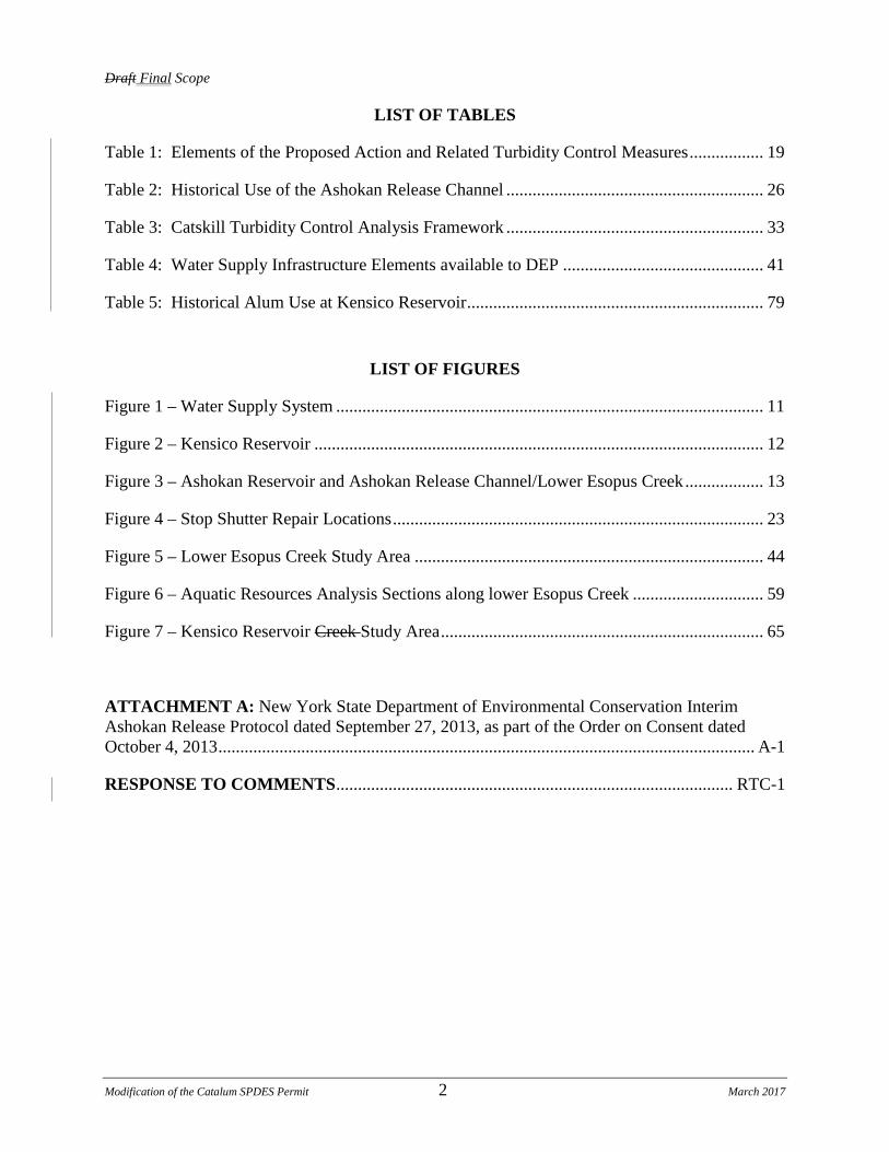
LIST OF TABLES
Table 1: Elements of the Proposed Action and Related Turbidity Control Measures ................. 19
Table 2: Historical Use of the Ashokan Release Channel ........................................................... 26
Table 3: Catskill Turbidity Control Analysis Framework ........................................................... 33
Table 4: Water Supply Infrastructure Elements available to DEP .............................................. 41
Table 5: Historical Alum Use at Kensico Reservoir .................................................................... 79
LIST OF FIGURES
Figure 1 – Water Supply System .................................................................................................. 11
Figure 2 – Kensico Reservoir ....................................................................................................... 12
Figure 3 – Ashokan Reservoir and Ashokan Release Channel/Lower Esopus Creek .................. 13
Figure 4 – Stop Shutter Repair Locations ..................................................................................... 23
Figure 5 – Lower Esopus Creek Study Area ................................................................................ 44
Figure 6 – Aquatic Resources Analysis Sections along lower Esopus Creek .............................. 59
Figure 7 – Kensico Reservoir Creek Study Area .......................................................................... 65
ATTACHMENT A: New York State Department of Environmental Conservation Interim Ashokan Release Protocol dated September 27, 2013, as part of the Order on Consent dated October 4, 2013 ........................................................................................................................... A-1
RESPONSE TO COMMENTS ........................................................................................... RTC-1

Draft Final Scope
Modification of the Catalum SPDES Permit 3 March 2017
LIST OF ABBREVIATIONS
AFC Ashokan Field Campus alum Aluminum sulfate ARC Ashokan Release Channel ARWG Ashokan Release Working Group ATS Avian Transect Survey BANCS Bank Assessment for Non-point source Consequences of Sediment BEHI Bank Erosion Hazard Index assessments BOD Biological Oxygen Demand Cat/Del Catskill-Delaware Water Supply System Catalum SPDES Catskill Influent Chamber SPDES Permit CATIC Catskill Influent Chamber CEA Critical Environment Areas CEQR City Environmental Quality Review CP Commissioner Policy CSSO Conditional Seasonal Storage Objective CWA Clean Water Act CZMA Coastal Zone Management Act dbh Diameter at Breast Height (for trees) DEIS Draft Environmental Impact Statement DEL 17 Delaware Shaft 17 DEP New York City Department of Environmental Protection DO Dissolved Oxygen EBP Environmental Benefits Projects ECC Esopus Creek Corridor EIS Environmental Impact Statement EJ Environmental Justice EPT Ephemeroptera, Plecoptera, and Trichoptera FAD Filtration Avoidance Determination FEIS Final Environmental Impact Statement FMP Forest Management Plan GHG Greenhouse Gas GIS Geographic Information System GPS Global Positioning System H&H Hydrologic and Hydraulic HEC-HMS Hydrologic Engineering Center-Hydrologic Modeling System HEC-RAS Hydrologic Engineering Center-River Analysis System HEFS Hydrological Ensemble Forecasting System IESWTR Interim Enhanced Surface Water Treatment Rule IFIM Instream Flow Incremental Methodology IHA Indicators of Hydrologic Alteration IPCC Intergovernmental Panel on Climate Change IRP Interim Ashokan Release Protocol LAP Land Acquisition Program lbs Pounds
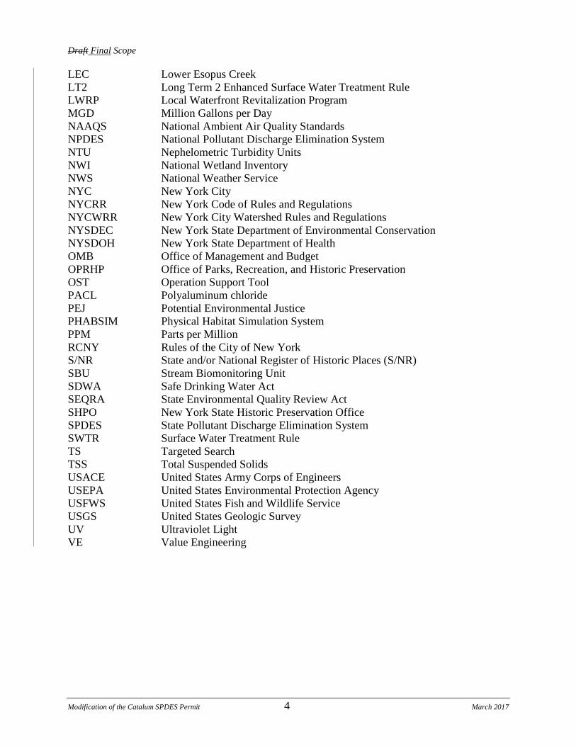
Draft Final Scope
Modification of the Catalum SPDES Permit 4 March 2017
LEC Lower Esopus Creek LT2 Long Term 2 Enhanced Surface Water Treatment Rule LWRP Local Waterfront Revitalization Program MGD Million Gallons per Day NAAQS National Ambient Air Quality Standards NPDES National Pollutant Discharge Elimination System NTU Nephelometric Turbidity Units NWI National Wetland Inventory NWS National Weather Service NYC New York City NYCRR New York Code of Rules and Regulations NYCWRR New York City Watershed Rules and Regulations NYSDEC New York State Department of Environmental Conservation NYSDOH New York State Department of Health OMB Office of Management and Budget OPRHP Office of Parks, Recreation, and Historic Preservation OST Operation Support Tool PACL Polyaluminum chloride PEJ Potential Environmental Justice PHABSIM Physical Habitat Simulation System PPM Parts per Million RCNY Rules of the City of New York S/NR State and/or National Register of Historic Places (S/NR) SBU Stream Biomonitoring Unit SDWA Safe Drinking Water Act SEQRA State Environmental Quality Review Act SHPO New York State Historic Preservation Office SPDES State Pollutant Discharge Elimination System SWTR Surface Water Treatment Rule TS Targeted Search TSS Total Suspended Solids USACE United States Army Corps of Engineers USEPA United States Environmental Protection Agency USFWS United States Fish and Wildlife Service USGS United States Geologic Survey UV Ultraviolet Light VE Value Engineering

Draft Final Scope
Modification of the Catalum SPDES Permit 5 March 2017
1.0 OVERVIEW
The New York City (City) Water Supply System is one of the largest surface water storage and supply complexes in the world, with watersheds covering 1,972 square miles. It is the primary drinking water source for approximately half the population of New York State, including over eight million residents of the City and an additional one million residents of upstate counties. The City’s water supply from this system is of very high quality and generally meets all applicable federal and state standards. Comprised of three separate but interconnected water supplies, the cascading arrangement and detention times of the reservoirs allow pollutants to settle out as water flows through the system. The source waters are generally of high quality because of the relatively pristine landscape, and many pollutants are prevented from entering the reservoirs at all through the New York City Department of Environmental Protection’s (DEP’s) implementation of extensive watershed protection initiatives. The water supply, therefore, requires little treatment.
While natural conditions and DEP’s watershed protection programs generally ensure the excellence of the City’s water supply, DEP must also manage episodic water quality events associated with turbidity,1 typically produced by storm events, as well as bacterial and algal problems that sometimes occur in the system. To manage these events and protect water quality, DEP has the ability to apply water treatment chemicals to the water leaving Ashokan Reservoir upstate reservoirs and in via the Catskill Aqueduct aqueducts. Treating water quality disruptions upstream when necessary, close to the source of the problem, helps prevent migration of contaminants further downstream and potentially into the distribution system. Aluminum sulfate (alum) and sodium hydroxide are used for turbidity control. In the past, water leaving the upstream reservoirs has also been occasionally treated with chlorine for isolated instances of elevated levels of bacteria and algae. Downstream of the watershed, at Kensico Reservoir and Hillview Reservoir, prior to entering the distribution system, the water supply is treated continuously with chlorine for disinfection, fluoride for fluoridation, sodium hydroxide for pH control, and orthophosphate to control leaching of lead and copper from residential plumbing systems. Water leaving Kensico Reservoir is also disinfected through the City’s Catskill-Delaware (Cat/Del) Water Ultraviolet Light (UV) Disinfection Facility (Cat/Del UV Facility).
Episodic turbidity is more prevalent in the City’s Catskill System, comprised of Schoharie and Ashokan Reservoirs, which have watersheds characterized by a natural landscape with steep slopes, clay-rich soils, and erodible stream beds. Storm events within the Catskill System have the potential to disturb the clay-rich stream banks and channels in the Schoharie and Ashokan watersheds. Unlike the Catskill System, the Delaware System watershed has a moderately sloped
1 Turbidity is an optical property of water influenced by the presence of higher concentrations of suspended particles that make water opaque or cloudy. This matter normally consists largely of suspended clay, silt, organic and inorganic material and microscopic organisms. Turbidity is of concern primarily due to its potential impact on public health by making disinfection less effective, as the cloudiness could interfere with chlorine and ultraviolet-light disinfection, and potential contaminants may adhere to, or be encapsulated by the suspended particles.
Draft Final Scope
Modification of the Catalum SPDES Permit 6 March 2017
landscape, has more sand and gravel deposits with less clay, and its streams are less erosive due to their characteristic geomorphology. In addition, the cascading configuration of the Delaware System reservoirs tends to further ameliorate turbidity levels as the water travels through the system to Kensico Reservoir (the increased travel time allows for particles that may cause turbidity to settle out). Accordingly, the Delaware System is not prone to the same turbidity events as the Catskill System.
In the Catskill System, water is supplied to Ashokan Reservoir from Schoharie Reservoir via the Shandaken Tunnel and upper Esopus Creek. Ashokan Reservoir is divided into two basins: west and east, which feed the Catskill Aqueduct and ultimately Kensico Reservoir in Westchester County. Kensico Reservoir receives water from both the Catskill and Delaware Systems and is the terminal raw water reservoir for these systems. From here, water is treated and flows downstream to the City’s distribution system (see Section 1.3).
The dual basins of Ashokan Reservoir help to settle out the suspended particles in the water as it flows in sequence through each basin. Water from the upper Esopus Creek enters Ashokan’s Reservoir’s west basin where particles can settle out before entering Ashokan Reservoir’s east basin through spillage over or transfer through the dividing weir. The two-basin design of the reservoir typically allows for sufficient detention and settling time to address turbid runoff. This two-basin design is critical to protecting downstream drinking water quality because it allows drinking water to be delivered to the Catskill Aqueduct from either basin, depending on water quality. However, in most instances, water of higher quality is obtained from the east basin.
1.1 Project Identification
In June 2012, DEP requested a modification to the New York State Department of Environmental Conservation (NYSDEC) Catskill Influent Chamber State Pollutant Discharge Elimination System (SPDES) Permit (Catalum SPDES Permit), to incorporate measures to control turbidity in water diverted from Ashokan Reservoir and to postpone dredging of alum floc2 at Kensico Reservoir until completion of certain infrastructure projects (Proposed Action). The turbidity control measures include the use of the Ashokan Release Channel in accordance with the September 27, 2013 Interim Ashokan Release Protocol (IRP) as part of the October 4, 2013 Order on Consent.
The proposed permit modification is subject to environmental review under the State Environmental Quality Review Act (SEQRA). The October 4, 2013 Order on Consent includes specific requirements and timeframes for carrying out this SEQRA review, including the preparation of an Environmental Impact Statement (EIS). Theis Environmental Impact Statement (EIS) will evaluate the potential for significant adverse environmental impacts to occur from
2 Floc or flocculent is a soft, loosely combined mass formed in a fluid through precipitation or aggregation of suspended particles. In this case, it is the combination of aluminum hydroxide solids plus entrained solids.
Draft Final Scope
Modification of the Catalum SPDES Permit 7 March 2017
implementation of the turbidity control measures proposed to be incorporated into the Catalum SPDES Permit (Turbidity Control Measures), as well as from the postponement of dredging.
Implementation of the turbidity control measures analyzed in this EIS would allow DEP to continue to provide reliable, clean, and safe drinking water while reducing reliance on chemical treatment of the water supply, specifically the use of alum, during episodic turbidity events. DEP uses a number of measures, including ongoing implementation of existing watershed protection programs and a number of operational techniques to manage turbidity. In addition, the use of certain engineering/infrastructure projects further described in Section 1.6currently under design and/or construction would also help to control turbidity events. As outlined below, some of these elements do not require environmental review, because either they are part of routine operations or theyhave previously undergone environmental review, therefore additional SEQRA review for these elements is not required. Use of these elements will be included as part of the modeling assumptions in this review;t . The remaining elements will be the subject of analysis in this EIS (see Section 1.6 for further details). In addition, all of these measures and elements will be considered together to determine whether there is a potential for significant adverse cumulative impacts. The cumulative review will include those elements that have not undergone environmental review together with DEP’s existing water supply system operations, and the operation of the additional engineering and infrastructure projects.
The elements that do not require further environmental review are listed below and are further described in Section 1.6:
1. Selective diversion and withdrawal from DEP’s reservoirs;2. Existing watershed management programs;3. Drawdown of Ashokan Reservoir’s west basin;4. Use of the Operations Support Tool (OST) for reservoir management;5. Improvements to stop shutters along the Catskill Aqueduct;6. Use of the Catskill and Delaware Interconnection at Shaft 4; and7. Use of the Croton Water Filtration Plant.
The elements that are the subject of this EIS are:
1. Use of the Ashokan Release Channel3 under the Interim Ashokan Release Protocol (IRP)dated September 27, 20134;
3 The Ashokan Release Channel is a concrete-lined channel from Ashokan Reservoir that releases water to the lower Esopus Creek which ultimately flows to the Hudson River.
4 The Interim Ashokan Release Protocol (see Attachment A) included in the Order on Consent dated October 4, 2013 provides for community releases (those that would provide environmental, recreational, and economic benefits to the lower Esopus Creek and surrounding community); discharge mitigation releases that would enhance flood mitigation; and operational releases intended primarily to protect water quality (and which also further the potential for flood mitigation).

Draft Final Scope
Modification of the Catalum SPDES Permit 8 March 2017
2. Dredging of alum deposits in Kensico Reservoir resulting from use of alum at Kensico Reservoir; and
3. Delay of dredging of alum deposits in Kensico Reservoir to a future year (2024).
This EIS will also evaluate alternatives to the Proposed Action including a No Action Future without the Proposed Action Alternative, which is the continued use of alum at historic levels to control turbidity at Kensico Reservoir without the turbidity control benefits of DEP’s turbidity control measuresuse of the Ashokan Release Channel. This EIS will also evaluate alternatives related to operation of the Catskill Aqueduct, including options to discharge water from the Catskill Aqueduct prior to its reaching the Kensico Reservoir, reasonable structural alternatives to operation of the Ashokan Release Channel, and reasonable alternatives for operation of the Kensico Reservoir. This EIS will also identify measures to mitigate or minimize the potential for any identified significant adverse impacts of the Proposed Action, as required. The EIS will also compare the environmental impacts of the use of alum and subsequent floc deposition in Kensico Reservoir versus impacts to lower Esopus Creek due to implementation of DEP’s turbidity control measures and other identified alternatives.
This EIS will also evaluate the potential for significant adverse impacts from the proposed modification of the existing Catalum SPDES Permit to incorporate the Interim Ashokan Release Protocol for the use of the Ashokan Release Channel. The Protocol may be refined by DEP and NYSDEC based on experience with operating under the Interim Ashokan Release Protocol or as a result of these EIS analyses.
The Catalum SPDES Permit (Number NY0264652) was administratively renewed without modifications in July 2011. This EIS will support a future modification of the Catalum SPDES Permit. As required by the Order on Consent, NYSDEC iswill be the Lead Agency for this EIS. DEP will work with NYSDEC to prepare this EIS consistent with the requirements of SEQRA, as set forth in 6 NYCRR Part 617 authorized by Article 8 of the Environmental Conservation Law, and the City Environmental Quality Review (CEQR) process, as set forth in 62 RCNY Chapter 5 and Executive Order 91 of 1977 and its amendments, as applicable, and additional requirements and timeframes established in the Order on Consent. Public Scoping will be is the first step in the process to prepare an EIS under SEQRA. Scoping provides an early opportunity for the public and other agencies to be involved in the EIS process. It will provides the opportunity for the public to identify those issues warranting consideration in the EIS, and to facilitate public and agency comment on the methodologies proposed to be used to assess the potential effect of the project. Public scoping will also allows the public to comment on the range of reasonable alternatives that have the potential to meet the purpose and need of the Proposed Action. The Draft Scope was issued on April 9, 2014. Public meetings were held on May 12, 2014 at the Ulster County Community College, Stone Ridge, New York and May 14, 2014 at the Mount Pleasant Town Hall, Valhalla, New York. Both meetings included an afternoon and evening session. The original comment period was set to end on July 8, 2014, but was extended in response to requests made
Draft Final Scope
Modification of the Catalum SPDES Permit 9 March 2017
through the public comment process and closed on August 29, 2014. Theis Draft Scope has been updated prepared to describe the Proposed Action, and address comments received during scoping. This Final Scope presents the proposed framework for the EIS analysis, and discusses the procedures to be followed in the preparation of the EIS.
1.2 Project Background
DEP, on behalf of the City, operates a system of 19 reservoirs and three controlled lakes that provide more than one billion gallons of drinking water per day to over eight million residents of the City, and approximately 125 million gallons per day (MGD) for one million residents in Westchester, Putnam, Ulster, and Orange Counties. The City’s source water is impounded in watersheds in the upstate Catskill, Delaware, and Croton Systems, and flows by gravity through three aqueducts into balancing reservoirs, and ultimately through the City’s distribution system (see Section 1.3 for more detail). Management of the City’s water supply system is a dynamic, interdependent, and interactive process, with many individual watersheds, reservoirs, aqueducts, and facilities that are monitored, operated, and controlled to meet federal and state regulatory requirements, and other criteria. A key feature of the system is its operational flexibility, which allows DEP to selectively divert water from different reservoirs to meet water quality criteria and water supply needs.
This flexibility is important since geologic conditions in the Catskill watershed can cause episodic changes to water quality as a consequence of events, such as extreme storms, which can erode the naturally occurring silt and clay deposits present in the watershed’s relatively steep slopes, stream banks, and channels. Such events result in elevated turbidity levels in the water of the Catskill System, and occasionally in the diversions to Kensico Reservoir where it combines with water from the Delaware System. Under normal conditions, water from the Catskill and Delaware Systems is treated by DEP to meet drinking water quality standards as it leaves Kensico Reservoir and at Hillview Reservoir prior to entering the distribution system. For the upstream watersheds, current watershed management programs and operational practices are typically adequate to maintain compliance with federal and state requirements; however, under unusual circumstances, such as episodic turbidity resulting from high flow events, water treatment chemicals are needed. To manage these events and protect water quality, DEP has the ability to apply water treatment chemicals - alum and sodium hydroxide for turbidity control - in the Catskill Aqueduct prior to the water flowing into Kensico Reservoir. The New York State Department of Health (NYSDOH) regulates the use of these chemicals, and NYSDEC regulates associated flows into the water bodies receiving these chemicals under the SPDES permit program.
In contrast to the Catskill and Delaware Systems, the quality of water provided by the Croton watershed does not meet regulatory criteria for filtration avoidance under the Surface Water Treatment Rule (SWTR), or its amendments. Therefore, the City is constructeding a water filtration plant (which was subject to a separate environmental review) that is in startup and testing

Draft Final Scope
Modification of the Catalum SPDES Permit 10 March 2017
mode and anticipated to be, which went on line by the end in the spring of 2015 (Croton Water Filtration Plant). Once completed, fFiltered Croton water will be is now available along with the City’s Catskill/Delaware systems to meet water supply demand. The Croton Water Filtration Plant will helps to reduce reliance on the Catskill and Delaware supplies and enhances the flexibility of the entire water supply system to respond to water quality events.
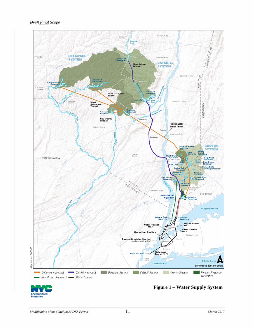
1.3 Water Supply System Operation
As mentioned above, the City’s water is supplied from three large surface water systems; the Catskill System, the Delaware System, and the Croton System (see Figure 1). Historically, approximately 40% of the City’s average demand is provided by the Catskill System, 50% by the Delaware System, and 10% by the Croton System. During drought conditions, the Croton System yield is sufficient to meet roughly up to 30% of the City’s demand. Water from both the Catskill and Delaware systems is normally routed through Kensico Reservoir before being conveyed through the Delaware Aqueduct to the Cat/Del UV Facility, Delaware and Catskill aqueducts to Hillview Reservoir and, via City tunnels, to the water distribution system. Water from the Croton System is conveyed to the City via the New Croton Aqueduct to Jerome Park Reservoir.
Kensico Reservoir is a key component of the City’s multiple barrier water treatment process, providing residence time for particles from the Catskill and Delaware water to settle out prior to withdrawal for water supply (see Figure 2). Water from the Catskill and Delaware aqueducts enters Kensico Reservoir from Ashokan Reservoir at the Catskill Influent Chamber (CATIC), and from the Rondout and West Branch reservoirs at Delaware Shaft 17 (DEL 17).
Catskill System water from Ashokan Reservoir can also be released from the system via the Ashokan Release Channel and/or can also enter the lower Esopus Creek as a result of spillage over the east basin spillway into the 1.4 mile spillway channel. Water from the Ashokan Release Channel converges with the water from the east basin spillway channel at a point referred to as the spillway confluence, and from there flows to the lower Esopus Creek and ultimately the Hudson River, 29.3 miles downstream (see Figure 3).
Draft Final Scope
Modification of the Catalum SPDES Permit 11 March 2017
Figure 1 – Water Supply System

Draft Final Scope
Modification of the Catalum SPDES Permit 12 March 2017
Figure 2 – Kensico Reservoir

Draft Final Scope
Modification of the Catalum SPDES Permit 13 March 2017
Figure 3 – Ashokan Reservoir and Ashokan Release
Channel/Lower Esopus Creek

Draft Final Scope
Modification of the Catalum SPDES Permit 14 March 2017
1.3.1 Operations Support Tool Modeling
Given the size and complexity of the water supply system, operating scenarios used to manage the system must be well coordinated, tested, and updated regularly. DEP evaluates operating scenarios using their Operations Support Tool (OST).5 The City’s OST is a computer-based model that provides computational and predictive support for water supply operations and planning to facilitate DEP’s management of the system, response to changing hydrologic conditions and understanding of the potential system response to planned and unplanned events, such as infrastructure improvements or storms and droughts, respectively. OST simulates the amount of water available in the City’s reservoir system at any given time by accounting for dozens of variables such as weather forecasts, current demand for water, and daily changes to the operation of the water supply system.6 OST has been in use since 2012 and has been instrumental in managing the complex interplay between multiple, often competing objectives for the water supply system, including water supply reliability, drinking water quality, environmental and recreational releases, hydropower generation, and peak flow attenuation for downstream communities. OST incorporates the following data sources into the decision-making process:
• Weather and environmental data: OST uses near real-time data from a number of sources, including multiple gauges that measure reservoir water levels and stream flow, devices that measure the water content of snowpack throughout the watersheds, and rain gauges, as well as weather forecasts from the National Oceanic and Atmospheric Administration’s National Weather Service. These data help DEP forecast the amount of water expected to enter the reservoir system, also known as runoff or “inflow” to the reservoirs, over a given period of time.
• Historical inflows: Historical hydrologic data (inflows) are used in OST as a predictive tool. Natural inflows to the reservoirs were developed from the historical hydrologic record from 1928 to 2012. These inflows represent the flow of water into and throughout the system from associated historical weather conditions. Historical stream flows were developed using United States Geological Survey (USGS) gauge data and historical DEP operations data. Given that the data represent an 80-plus year period of record, the historical data includes inflow characteristics for a range of conditions from extreme storms to the drought of record. Therefore, the historical inflows to the water supply system included within OST, and used to model system response to certain events, represent the potential range of likely inflow conditions that the water supply system could experience, and their
5 New York City’s Operations Support Tool White Paper that further describes OST is available here at: http://www.nyc.gov/html/dep/html/drinking_water/forecasting_reservoir_levels_ost.shtml.
6 Daily changes to system operations include those necessary to meet regulatory release requirements, support infrastructure repair, ensure system balance, and manage water quality, among others.

Draft Final Scope
Modification of the Catalum SPDES Permit 15 March 2017
likelihood of occurrence over a given timeframe (i.e., 10 years, 30 years). This is critical for modeling various operating scenarios.
• Reservoir operating rules: Physical infrastructure constraints of the water supply system, such as tunnel hydraulic capacities and available reservoir storage, are included within OST. OST also includes rules for diversions of water to system tunnels and aqueducts necessary to meet drinking water demand and rules for stream releases (in addition to spills, these are collectively referred to as outflows). Outflows include those identified in the FFMP for: Delaware System reservoirs; the Interim Ashokan Release Protocol for Ashokan Reservoir; required releases from Croton System reservoirs; SPDES permit requirements; and other regulations for established system operating rules. This collection of operating rules serves as a foundation for OST. These constraints ensure that OST does not suggest operational scenarios that are outside the scope of existing regulations or the capacity of the City’s water supply system.
• In-city and upstate demand: OST also incorporates the seasonal drinking water demand patterns for the City and more than 70 communities upstate that draw water from the City’s water supply system.
OST combines this information (weather and environmental data; historical inflows; operating rules, including outflows; and drinking water supply demand) to model reservoir water quality and elevations as well as outflows to downstream waterbodies under a given operating scenario. This advanced modeling allows DEP to test a range of potential operational changes in a virtual setting – and understand their outcomes – so that operating decisions are made with the best available information. OST also takes into account how ongoing construction projects might affect the water supply, which allows DEP to make operational changes in advance of extreme weather events to “balance” the system while meeting applicable regulatory requirements.
1.4 Regulatory Background
The two major federal statutes that apply to the City’s Water Supply System operation are the federal Safe Drinking Water Act (SDWA) and the Clean Water Act (CWA). While the SDWA primarily regulates the quality of drinking water that is delivered to the consumers, the CWA focuses on maintaining the quality of surface water resources for designated uses. As per the CWA, discharges of pollutants to waters of the United States (U.S.) require permits under the National Pollutant Discharge Elimination System (NPDES) program, implemented in New York State under the SPDES program.
In 1989, the United States Environmental Protection Agency (USEPA) promulgated the Surface Water Treatment Rule (SWTR) pursuant to the SDWA. The USEPA amended the SWTR on December 16, 1998, with the Interim Enhanced Surface Water Treatment Rule (IESWTR) and again on January 5, 2006 with the Long Term 2 Enhanced Surface Water Treatment Rule (LT2).
Draft Final Scope
Modification of the Catalum SPDES Permit 16 March 2017
The SWTR, IESWTR, and LT2 requires filtration of all surface water supplies unless the water supplier meets certain water quality, disinfection, and control criteria that would allow the water supplier to obtain a waiver of the filtration requirement from the USEPA or delegated state agency. Beginning in 1993, under a series of successive Filtration Avoidance Determinations (FADs), the USEPA has determined that the City’s Catskill and Delaware supplies satisfy the requirements for unfiltered surface water systems. The most recent FAD, issued in 2007 and revised in 2014 (Revised 2007 FAD) by NYSDOH establishes requirements for continued watershed protection efforts through 2017. DEP and NYSDOH are currently in negotiations for the 2017 FAD. A core requirement for filtration avoidance is a watershed control program that can identify, monitor, and control activities in the watershed that may have an adverse effect on source water quality. DEP’s watershed control program includes measures to control turbidity in its Catskill Water Supply System; those measures that are proposed to be incorporated into the modified Catalum SPDES Permit are described in more detail below.
The 2007 FAD required DEP’s development and submittal of Phase III of the Catskill Turbidity Control Study, an engineering analysis of potential turbidity reduction measures, including interim measures that are both feasible and cost effective for the Ashokan Reservoir. The potential measures included: (1) an in-reservoir baffle for the Ashokan Reservoir’s east basin; (2) a new release structure from the Ashokan Reservoir’s west basin; (3) a new intake structure for the east basin; (4) raising the dividing weir, thereby increasing storage capacity of the west basin; and (5) modified system operations. Subsequent to submittal of the Phase III report, DEP was requiredto develop a plan with appropriate interim milestones for implementation of the selected turbidityreduction measures. The 2007 FAD also required that DEP implement those selected turbidityreduction measures, as detailed in Section 2.3.11 of its 2006 Long-Term Watershed ProtectionProgram, and the milestones therein.
As described above in Section 1.3.1, the City relies extensively on modeling, such as OST, to assess the efficacy of turbidity control measures and the impacts of weather events on water quality. The City also relies on OST to inform decisions regarding management of its water supply system to provide adequate water quality and quantity. As the City continues to use and enhance OST, the 2007 FAD (revised May 2014) included a provision that the City fund an expert review of the effectiveness of the City’s use of OST. The City and NYSDOH have requested that the National Academy of Sciences (formerly known as the National Research Council) convene a panel of modeling experts to conduct this review. In particular, the following tasks were noted in the revised FAD:
1) The OST Expert Panel, which will be convened to review the City’s use of OST for watersupply operations, will be tasked to review the City’s plan for use of OST in evaluating the proposed modifications to the Catalum SPDES Permit as well as the alternatives to be considered in the environmental review of those proposed modifications; and

Draft Final Scope
Modification of the Catalum SPDES Permit 17 March 2017
2) The City must meet with regulators and the Watershed Inspector General to discuss thefindings of the Expert Panel, and the conclusions of the DEIS and the FEIS, and how these findings and conclusions might impact City’s Catskill turbidity control measures, and alternatives to achieve turbidity control goals, if necessary.
1.5 Catalum SPDES Permit
Following a series of several heavy rainfall events in upstate New York in 2005 and 2006, and the subsequent emergency repair operations at Schoharie Reservoir that necessitated the emergency release of abnormally high volume of water to upper Esopus Creek, highly turbid water entered Kensico Reservoir, and NYSDEC issued emergency authorizations allowing DEP to add alum to the water in the Catskill Aqueduct to control turbidity (see Section 2.5.1). Following the expiration of these emergency authorizations, DEP applied for, and after environmental review, NYSDEC issued SPDES Permit Number NY0264652 on January 1, 2007 for a period of five (5) years through December 31, 2011 to allow alum treatment for the diversions through the Catskill Aqueduct into Kensico Reservoir. In 2011, the Catalum SPDES Permit was administratively extended through December 31, 2016. This permit allows DEP to apply alum in the Catskill Aqueduct when NYSDOH concurs, based on DEP input, that a potential public health hazard associated with the diversions of turbid water from Kensico Reservoir is imminent.
The Catalum SPDES Permit provides effluent limits and also contains a compliance schedule that requires DEP to meet specific milestones related to alum addition at Kensico Reservoir and turbidity control in the Catskill System. These include:
• Preparation of a report that analyzes alternatives to minimize the area of floc depositionresulting from addition of alum and sodium hydroxide, identifies a chosen alternative, anddescribes how and when the chosen alternative would be implemented;
• Preparation of a bathymetric/benthic report for the purpose of establishing a scientific basisfor the quantity of alum floc deposits that must be removed from the receiving water tomeet the narrative water quality standard for suspended, colloidal and settleable solids inthe Kensico Reservoir;
• Preparation of an engineering report describing the information gathered during theremoval of alum floc deposits and for the purpose of guiding future dredging activities;
• Development of a program to reduce the amount and duration of alum use by evaluatingand implementing structural, operational, and erosion control measures to reduce turbidityin waters flowing into the Catskill Aqueduct and to protect the water supply, fishery, andrecreational uses within both the Ashokan Reservoir basin and Kensico Reservoir;
• Identification and implementation of any short- and long-term structural measures that willachieve the above goals; and
Draft Final Scope
Modification of the Catalum SPDES Permit 18 March 2017
• Submittal of a report detailing the short and long term structural modifications evaluatedin the Phase III Catskill Turbidity Control Study and implementation of approved structuralalternatives.
As part of its ongoing program review, and to meet Catalum SPDES requirements, DEP has explored these and a number of additional engineering and operational alternatives to the addition of alum at CATIC at historic levels.
1.6 The Proposed Action
The existing five-year Catalum SPDES Permit for alum addition in the Catskill Aqueduct upstream of Kensico Reservoir was administratively renewed and expires in December 2016. DEP seeks to modify the Catalum SPDES Permit to incorporate measures to control turbidity in water diverted from Ashokan Reservoir and to postpone dredging of alum floc at Kensico Reservoir until the completion of certain infrastructure projects. This EIS will describe the benefits to the water supply and assess the potential for significant adverse impacts from operation of the Ashokan Release Channel under the Interim Ashokan Release Protocol dated September 27, 2013 and from the postponement of dredging of alum floc at Kensico Reservoir. The EIS will also take into account implementation of DEP’s turbidity control measures as a whole. Feasible recommended mitigative measures for alum use, as well as for use of the Ashokan Release Channel, if mitigation is determined necessary in the EIS, will be incorporated into a modified Catalum SPDES Permit.
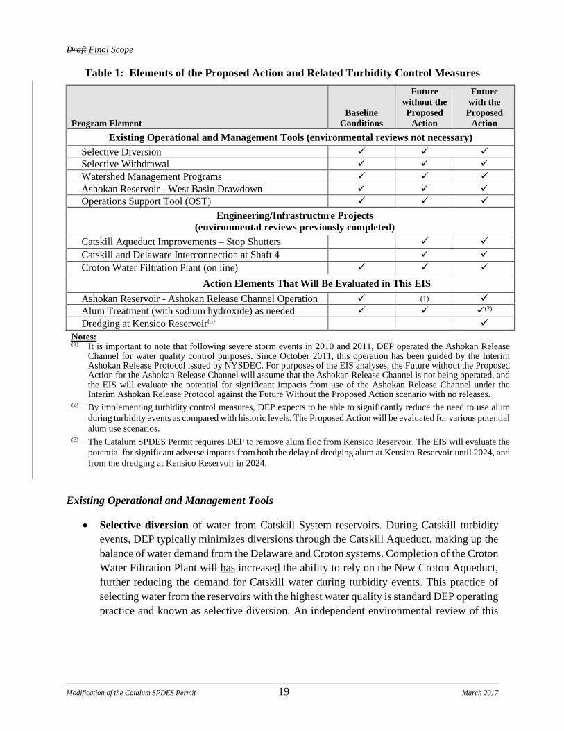
DEP’s turbidity control measures are intended to minimize the need for chemical addition through the use of operational, engineering, and other non-treatment measures, while also minimizing the potential for significant adverse impacts to the environment. As indicated in Table 1, DEP has already implemented certain such measures; while others are under design and/or construction, and are planned to be operational in over the next few years. Many of these elements either do not require environmental review, or have also already undergone separate environmental reviews because of their independent utility and will be implemented by DEP by 20189. While these measures are not the focus of this EIS, their implementation would be considered as part of the operating assumptions for this environmental review. Table 1 identifies the elements of the proposed modification of the Catalum SPDES Permit and other measures DEP can employ to address turbidity entering Kensico Reservoir, and is followed by a more in-depth discussion of each and status of applicable environmental reviews.
The EIS will assess potential impacts from implementation of the IRP by applying the comprehensive analytical capabilities of modeling tools (e.g., OST). The EIS will also identify additional alternatives that make better use of the flexibility of DEP’s water supply infrastructure to manage episodic turbidity while balancing multiple objectives (i.e., water supply, water quality, flood mitigation, and community releases) within the Ashokan Reservoir, lower Esopus Creek and Kensico Reservoir portions of the water supply system.
Draft Final Scope
Modification of the Catalum SPDES Permit 19 March 2017
Table 1: Elements of the Proposed Action and Related Turbidity Control Measures
Program Element Baseline
Conditions
Future without the Proposed
Action
Future with the
Proposed Action
Existing Operational and Management Tools (environmental reviews not necessary) Selective Diversion Selective Withdrawal Watershed Management Programs Ashokan Reservoir - West Basin Drawdown Operations Support Tool (OST)
Engineering/Infrastructure Projects (environmental reviews previously completed)
Catskill Aqueduct Improvements – Stop Shutters Catskill and Delaware Interconnection at Shaft 4 Croton Water Filtration Plant (on line)
Action Elements That Will Be Evaluated in This EIS Ashokan Reservoir - Ashokan Release Channel Operation (1) Alum Treatment (with sodium hydroxide) as needed (2)
Dredging at Kensico Reservoir(3) Notes: (1) It is important to note that following severe storm events in 2010 and 2011, DEP operated the Ashokan Release
Channel for water quality control purposes. Since October 2011, this operation has been guided by the InterimAshokan Release Protocol issued by NYSDEC. For purposes of the EIS analyses, the Future without the ProposedAction for the Ashokan Release Channel will assume that the Ashokan Release Channel is not being operated, andthe EIS will evaluate the potential for significant impacts from use of the Ashokan Release Channel under theInterim Ashokan Release Protocol against the Future Without the Proposed Action scenario with no releases.
(2) By implementing turbidity control measures, DEP expects to be able to significantly reduce the need to use alumduring turbidity events as compared with historic levels. The Proposed Action will be evaluated for various potentialalum use scenarios.
(3) The Catalum SPDES Permit requires DEP to remove alum floc from Kensico Reservoir. The EIS will evaluate thepotential for significant adverse impacts from both the delay of dredging alum at Kensico Reservoir until 2024, andfrom the dredging at Kensico Reservoir in 2024.
Existing Operational and Management Tools
• Selective diversion of water from Catskill System reservoirs. During Catskill turbidityevents, DEP typically minimizes diversions through the Catskill Aqueduct, making up thebalance of water demand from the Delaware and Croton systems. Completion of the CrotonWater Filtration Plant will has increased the ability to rely on the New Croton Aqueduct,further reducing the demand for Catskill water during turbidity events. This practice ofselecting water from the reservoirs with the highest water quality is standard DEP operatingpractice and known as selective diversion. An independent environmental review of this
Draft Final Scope
Modification of the Catalum SPDES Permit 20 March 2017
in-system operational DEP procedure is not warranted, as this activity qualifies as a Type II Action in accordance with 6 NYCRR § 617.5(c)(20).7
• Selective withdrawal of water from various levels within the reservoirs. In addition to theoperational flexibility provided by differences in water quality between reservoirs, somereservoir gatehouses are equipped with stop shutters located at varying elevations withineach reservoir, allowing DEP to draw water preferentially from the depth containing waterof the highest quality. DEP’s standard operation practice of selective withdrawal isimplemented within the Ashokan Reservoir to prevent turbid water resulting from episodicevents from being carried through the system. An independent environmental review ofthis in-system operational DEP procedure is not warranted, as this activity qualifies as aType II Action in accordance with 6 NYCRR § 617.5(c)(20).
• DEP’s Watershed Management Program includes adoption of best managementpractices for a wide range of watershed activities, implementation of Watershed Rules andRegulations to protect the watershed from certain potential sources of contamination, acomprehensive Land Acquisition Program (LAP) to preserve environmentally sensitivelands in the watershed, and a Stream Management Program that provides technical andfinancial assistance to communities for stream management planning and implementationto help prevent the worsening of natural geologic conditions in the watershed. DEP’s 2010Forest Management Plan (FMP) is also being implemented and provides a broad-based setof forest management activities that could be undertaken on currently owned or futureacquired City water supply lands to manage, improve, and regenerate the forests, andfurther protect water quality in the watershed. Collectively, these programs help to preventactivities that could exacerbate turbidity levels of water entering the water supply system.Independent environmental reviews of individual watershed/stream management projectsare undertaken as required (e.g. environmental reviews of DEP’s LAP to support a permitrenewal, and the FMP, which is a comprehensive resource management plan). Since theseprojects have been implemented by DEP under the FAD, have independent utility, andwere previously evaluated in environmental reviews on a project-specific basis as required,further review in this EIS is not warranted.
7 A Type II action under 6 NYCRR § 617.5(c) (20) is routine or continuing agency administration and management, not including new programs or major reordering of priorities that may affect the environment.

Draft Final Scope
Modification of the Catalum SPDES Permit 21 March 2017
• Diversion management at Ashokan Reservoir to transfer water from the reservoir’s west basin to the east basin via the dividing weir (west basin drawdown). The two-basin design of Ashokan Reservoir allows DEP to operate the west basin of the Ashokan Reservoir as a settling basin, while the east basin is used for diversions to the Catskill Aqueduct (see Figure 3). Alternatively, the Catskill Aqueduct may take diversions from the west basin whenever water quality is acceptable. The extent of the turbidity events in the Catskill System can be reduced through management of the existing facilities at Ashokan Reservoir using two methods. First, during or in anticipation of storm events, DEP can divert water from the west basin to the Catskill Aqueduct in order to develop or maintain a void in the west basin to capture and settle any influx of turbid water associated with the event. This void allows the west basin to absorb some or all of the inflow during a storm event, thereby reducing the transfer of turbid water across the dividing weir to the east basin. Second, during storm events where turbid waters entering the west basin are likely to spill into the east basin, the dividing weir gates are sometimes opened in advance to minimize spill over the dividing weir. Both of these methods reduce turbidity levels entering the Catskill Aqueduct and eventually Kensico Reservoir, thus reducing the need for alum addition. An independent environmental review of this in-system operational DEP procedure is not warranted, as this activity qualifies as a Type II Action in accordance with 6 NYCRR § 617.5(c)(20).
• Operations Support Tool (OST) is a computer-based, near-real-time management tool to allow for improved management of DEP’s reservoir diversions (see Section 1.3.1). OST was the recommended alternative of the 2008 Phase III Implementation Plan for the Catskill Turbidity Control Study, described in Section 1.9 below. OST allows DEP to optimize operations while balancing water supply, water quality, and environmental objectives. OST integrates DEP’s monitored water quality and measured water quantity data with modeling tools to provide timely and robust guidance to operations staff, improve DEP’s ability to implement and refine the rules used to manage the water supply system, and minimize the need for alum application. OST models the quantity of water in the water supply system and quality of the water in the reservoirs to predict short-term and long-term turbidity levels within each reservoir of the Catskill System. This allows DEP to simulate operation of the system in a “look-ahead” mode and test the predicted effects of today’s decisions on the range of water quality and reservoir storage levels in the coming weeks or months. At Ashokan Reservoir, this capability is used to support refinement and implementation of long-term operating rules, as well as modifications to short-term operations. At Kensico Reservoir, OST could further improve DEP’s current ability to forecast diversion turbidity levels and minimize the need for alum application without compromising water quality. An independent environmental review of this in-house DEP management tool is not warranted, as this activity qualifies as a Type II Action in accordance with 6 NYCRR § 617.5(c)(20).
Draft Final Scope
Modification of the Catalum SPDES Permit 22 March 2017
Engineering/Infrastructure Projects under Design and/or Construction
• Improvements to Catskill Aqueduct stop shutters would will provide DEP with greater flexibility in diversion management from Ashokan Reservoir. Stop shutters are physical barriers installed at locations along the Catskill Aqueduct to impound flow at six (6) locations (Harlem Railroad, Hunter Brook, and Washington Square Siphon Chambers; and Croton Lake, Moodna, and Wallkill Downtakes) along the aqueduct’s length between Ashokan and Kensico reservoirs under certain conditions (see Figure 4). Proposed The work would consists of improvements to grooves, if required, and provision of lighter materials and possible use of dedicated crane equipment for quicker installation of the stop shutters. Due to hydraulic considerations, DEP maintains the Catskill Aqueduct operating depth at a level sufficient to supply the 14 15 outside communities that are served by the Catskill Aqueduct. (Those communities have their own separate treatment process, and use approximately 15 MGD of Catskill water.) At low flow rates, supply to these outside communities can only be maintained by installing (and later removing) stop shutters at some or all of the six (6) stop shutter locations. This is a time-consuming and labor-intensive procedure that requires shutdown of the Catskill Aqueduct and is implemented only under extreme conditions. It is not currently feasible for DEP to readily reduce diversions from the Catskill System in response to elevated turbidity conditions while still maintaining supply to these 14 15 communities. Design Construction of improvements to stop shutter facilities along the Catskill Aqueduct between Ashokan and Kensico Reservoirs is underway and will provide DEP with improved ability to reduce diversions from the Catskill System during turbidity events. Ability to readily cut back flows in the Catskill Aqueduct and operate it at the minimum flowrate needed to satisfy outside demand would will reduce turbidity levels entering Kensico Reservoir, and reduce the need for alum application. Since these improvements consist of replacing and/or rehabilitating existing structures in kind on the same site, this activity qualifies as a Type II Action in accordance with 6 NYCRR § 617.5(c)(1),8 so an independent environmental review is not warranted.
• Installation of an Interconnection of the Catskill and Delaware Aqueducts near Shaft 4 of the Delaware Aqueduct in Gardiner, New York would will allow greater flexibility of the use of the Delaware System during Catskill turbidity events. DEP plans to is implementing a connection between the Catskill Aqueduct and the Delaware System’s Rondout-West Branch Tunnel at Shaft 4 in Gardiner, NY where the aqueducts currently cross, but are separated by a vertical distance of nearly 600 feet and are not connected. The
8 A Type II action under 6 NYCRR § 617.5(c)(1) is maintenance or repair involving no substantial changes in an existing structure or facility.

Draft Final Scope
Modification of the Catalum SPDES Permit 23 March 2017
Figure 4 – Stop Shutter Repair Locations

Draft Final Scope
Modification of the Catalum SPDES Permit 24 March 2017
proposed Shaft 4 Interconnection has independent utility and would will allow DEP to move water from the Delaware Aqueduct via the Shaft 4 Interconnection into the Catskill Aqueduct to supply water to users in the City and certain downstream communities. During turbidity events, the Shaft 4 Interconnection would will allow water from the Delaware System to be diverted to the Catskill Aqueduct, thereby allowing reduction or elimination of diversions from the Catskill System. The existing Shaft 4 facility is an approximately 4,500 square-foot, partially buried valve chamber located on property owned by DEP. The proposed facility is being designed with will includes a new subsurface flow and pressure control structure to allow the transfer of between 50 MGD and 365 MGD of pressurized water from the Delaware Aqueduct into the unpressurized Catskill Aqueduct, by installing through installation of new valves and flow control devices. In addition, the Shaft 4 Interconnection would will ensure continuity of water provision to select downstream Catskill System communities by the Delaware System, both with and without the installation of stop shutters, in the event that the Catskill System is unavailable due to elevated turbidity events or other repair needs. The planned facility is also expected to allow modest increases in the maximum diversion rate out of Rondout Reservoir, thus further reducing the amount of Catskill water that may be required during elevated turbidity conditions. In 2010, DEP issued a separate Negative Declaration for environmental impacts for the Shaft 4 Interconnection.
• In addition to these specific turbidity control elements, the Croton Water Filtration Plant will be able to can treat and deliver up to 290 MGD to the City’s distribution system and was brought on line in spring 2015. This will substantially reduce reliance on the amount of water needed from the Catskill System during turbidity events, and will enhances the flexibility of the system to respond to water quality events. DEP expects that implementation of the Proposed Action, in conjunction with filtered Croton water that will be used to supplement the City’s Catskill/Delaware System, will result in reduced need for alum addition in the future. In summer 2004, DEP issued its Notice of Completion of a Final EIS (FEIS) and findings statement for the Croton Water Filtration Plant.
Subjects of the EIS Analyses
As discussed above, the turbidity control measures that are currently being implemented or under construction would be analyzed as part of the operating assumptions for this environmental review, which would focus on the following components:
• Release management at Ashokan Reservoir to release up to a combined 1,000 MGD of water from the reservoir to the lower Esopus Creek via the Ashokan Release Channel (Ashokan Release Channel operation) and through uncontrolled spills over the east basin spillway, as per the Interim Ashokan Release Protocol. During, or in anticipation of storm events, water can be released to create a void in Ashokan Reservoir’s

Draft Final Scope
Modification of the Catalum SPDES Permit 25 March 2017
west basin for storage of turbid inflows. Releases flow from the Ashokan Release Channel to lower Esopus Creek and converge with the east basin spillway channel about 3,500 feet downstream of the Olive Bridge Dam. The combined flows ultimately discharge into the Hudson River at Saugerties.
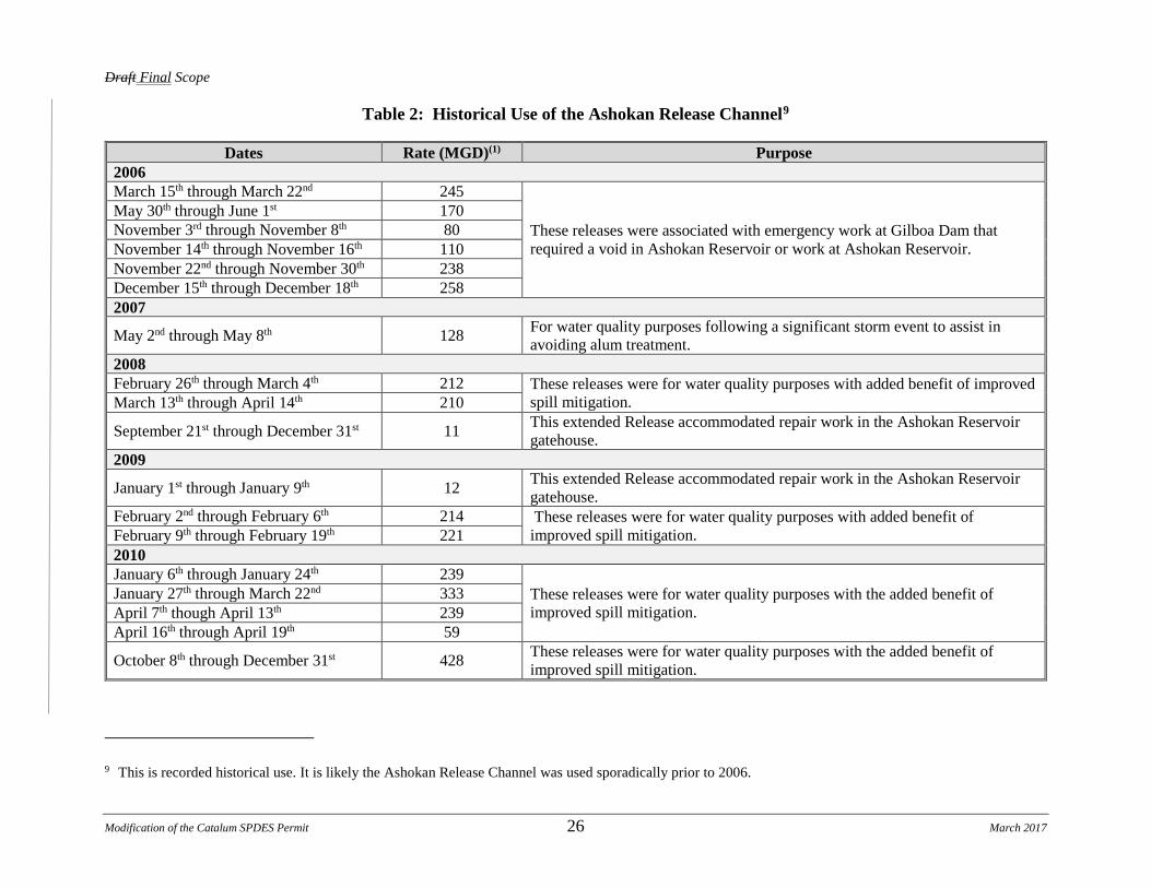
In March 2006, DEP began operating the Ashokan Release Channel more regularly. The Ashokan Release Channel was activated on several occasions between March 2006 and the present time at durations of several days to several months (see Table 2). In 2006, approximately 450 MGD was released for a few days during testing of a berm installed by DEP at the Ashokan Field Campus. The Ashokan Release Channel was also used in 2006 during an emergency project associated with maintenance and repair of the Gilboa Dam at Schoharie Reservoir (located upstream of Ashokan Reservoir). After 2006, DEP began to utilize the Ashokan Release Channel for turbidity control. From 2006 to October 2010, the Ashokan Release Channel flows occasionally exceeded 300 MGD (310 MGD max). Prior to February 2011, the release was limited to approximately 600 MGD because only two of the four 48-inch valves used for this purpose were operational. When the original four valves were replaced, release capacity to the Ashokan Release Channel increased to approximately 1,200 MGD. However, through its ongoing efforts with the Ashokan Release Working Group (ARWG) described below, and as restricted in the Interim Ashokan Release Protocol, DEP has committed to releasing no more than 600 MGD into the Esopus Creek through the Ashokan Release Channel. In addition, under the Interim Ashokan Release Protocol, the combined discharge from the spillway and Ashokan Release Channel cannot exceed 1,000 MGD, and when the volume of water spilling over the east basin spillway is greater than 1,000 MGD, the Ashokan Release Channel would not be activated. These limits are set based on flood stage elevations downstream.
In October 2010, as a result of several large storm events that increased the turbidity of water entering Ashokan Reservoir’s west basin, DEP began releasing water through the Ashokan Release Channel (releases) incrementally to a maximum release rate of 600 MGD. This was done to minimize the amount of turbid water entering into the Ashokan Reservoir’s east basin, and ultimately prevent this turbid water from being diverted to Kensico Reservoir. This release was continued through February 1, 2011 (Table 2). DEP continued to release intermittently through the spring of 2011. In late summer 2011, DEP operated the release channel in response to Hurricane Irene and Tropical Strom Lee, and other smaller storm events. On October 18, 2011, DEP began conducting releases based on an initial version of the IRP, which included community releases, a Conditional Seasonal Storage Objective, and rules for spill mitigation and turbidity management. Aside from occasional interruptions due to repairs, releases have continued to follow the Interim Ashokan Release Protocol, which was updated on September 27, 2013 as part of the October 4, 2013 Order on Consent.
Draft Final Scope
Modification of the Catalum SPDES Permit 26 March 2017
Table 2: Historical Use of the Ashokan Release Channel9
Dates Rate (MGD)(1) Purpose 2006 March 15th through March 22nd 245
These releases were associated with emergency work at Gilboa Dam that required a void in Ashokan Reservoir or work at Ashokan Reservoir.
May 30th through June 1st 170 November 3rd through November 8th 80 November 14th through November 16th 110 November 22nd through November 30th 238 December 15th through December 18th 258 2007 May 2nd through May 8th 128 For water quality purposes following a significant storm event to assist in
avoiding alum treatment. 2008 February 26th through March 4th 212 These releases were for water quality purposes with added benefit of improved
spill mitigation. March 13th through April 14th 210 September 21st through December 31st 11 This extended Release accommodated repair work in the Ashokan Reservoir
gatehouse. 2009 January 1st through January 9th 12 This extended Release accommodated repair work in the Ashokan Reservoir
gatehouse. February 2nd through February 6th 214 These releases were for water quality purposes with added benefit of
improved spill mitigation. February 9th through February 19th 221 2010 January 6th through January 24th 239
These releases were for water quality purposes with the added benefit of improved spill mitigation.
January 27th through March 22nd 333 April 7th though April 13th 239 April 16th through April 19th 59 October 8th through December 31st 428 These releases were for water quality purposes with the added benefit of
improved spill mitigation.
9 This is recorded historical use. It is likely the Ashokan Release Channel was used sporadically prior to 2006.

Draft Final Scope
Modification of the Catalum SPDES Permit 27 March 2017
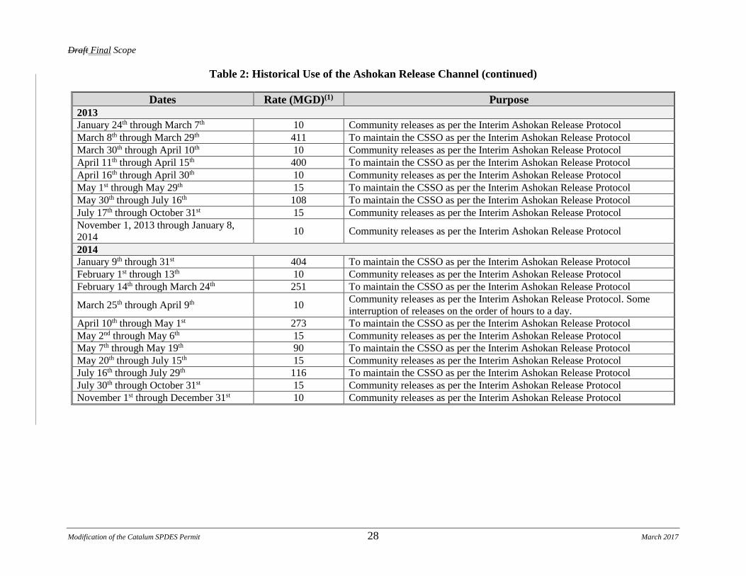
Table 2: Historical Use of the Ashokan Release Channel (continued)
Dates Rate (MGD)(1) Purpose 2011 January 1st through February 1st 545 Turbidity control and downstream community benefits due to several large
storm events March 9th and March 10th 192 Provide a void in anticipation of a large storm event March 14th through March 16th 165 Provide a void in anticipation of a large storm event March 22nd through March 30th 313 Provide a void in anticipation of a large storm event April 1st through April 7th 352 Provide a void in anticipation of a large storm event August 13th through August 24th 15 Community Release August 25th through August 27th 484 Provide a void in anticipation of Hurricane Irene
September 2nd through September 6th 438 Provide a void in advance of future storms; stopped when flood stage was reached at Mt. Marion gauge from rainfall associated with Tropical Storm Lee
September 12th through September 28th 514 Provide a void as a result of several large storms in the area and protect the East Basin at Ashokan from spillage of turbid water, typical flow was 600 MGD
October 5th through October 14th 426 Provide a void as a result of several large storms in the area and protect the East Basin at Ashokan from spillage of turbid water, typical flow was 600 MGD
October 18th through December 31st 555 Implementation of the Interim Ashokan Release Protocol under the Conditional Seasonal Storage Objective (CSSO); the typical flow during this period was 600 MGD
2012 January 1st through March 23rd 342 To maintain the CSSO as per the Interim Ashokan Release Protocol March 24th through May 1st 10 Community Releases as per the Interim Ashokan Release Protocol. Some
interruption for minor repairs at Ashokan Reservoir (hours to a day) May 1st through October 19th 15 Community releases as per the Interim Ashokan Release Protocol October 19th through October 28th 514 To maintain the CSSO as per the Interim Ashokan Release Protocol November 10th through November 30th 10 Community releases as per the Interim Ashokan Release Protocol December 1, 2012 through January 23, 2013 430 To maintain the CSSO as per the Interim Ashokan Release Protocol
Draft Final Scope
Modification of the Catalum SPDES Permit 28 March 2017
Table 2: Historical Use of the Ashokan Release Channel (continued)
Dates Rate (MGD)(1) Purpose 2013 January 24th through March 7th 10 Community releases as per the Interim Ashokan Release Protocol March 8th through March 29th 411 To maintain the CSSO as per the Interim Ashokan Release Protocol March 30th through April 10th 10 Community releases as per the Interim Ashokan Release Protocol April 11th through April 15th 400 To maintain the CSSO as per the Interim Ashokan Release Protocol April 16th through April 30th 10 Community releases as per the Interim Ashokan Release Protocol May 1st through May 29th 15 To maintain the CSSO as per the Interim Ashokan Release Protocol May 30th through July 16th 108 To maintain the CSSO as per the Interim Ashokan Release Protocol July 17th through October 31st 15 Community releases as per the Interim Ashokan Release Protocol November 1, 2013 through January 8, 2014 10 Community releases as per the Interim Ashokan Release Protocol
2014 January 9th through 31st 404 To maintain the CSSO as per the Interim Ashokan Release Protocol February 1st through 13th 10 Community releases as per the Interim Ashokan Release Protocol February 14th through March 24th 251 To maintain the CSSO as per the Interim Ashokan Release Protocol
March 25th through April 9th 10 Community releases as per the Interim Ashokan Release Protocol. Some interruption of releases on the order of hours to a day.
April 10th through May 1st 273 To maintain the CSSO as per the Interim Ashokan Release Protocol May 2nd through May 6th 15 Community releases as per the Interim Ashokan Release Protocol May 7th through May 19th 90 To maintain the CSSO as per the Interim Ashokan Release Protocol May 20th through July 15th 15 Community releases as per the Interim Ashokan Release Protocol July 16th through July 29th 116 To maintain the CSSO as per the Interim Ashokan Release Protocol July 30th through October 31st 15 Community releases as per the Interim Ashokan Release Protocol November 1st through December 31st 10 Community releases as per the Interim Ashokan Release Protocol
Draft Final Scope
Modification of the Catalum SPDES Permit 29 March 2017
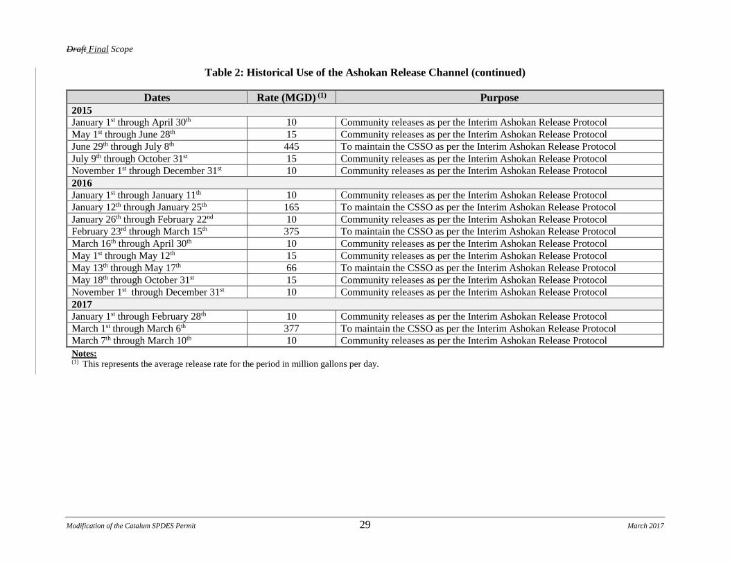
Table 2: Historical Use of the Ashokan Release Channel (continued)
Dates Rate (MGD) (1) Purpose 2015 January 1st through April 30th 10 Community releases as per the Interim Ashokan Release Protocol May 1st through June 28th 15 Community releases as per the Interim Ashokan Release Protocol June 29th through July 8th 445 To maintain the CSSO as per the Interim Ashokan Release Protocol July 9th through October 31st 15 Community releases as per the Interim Ashokan Release Protocol November 1st through December 31st 10 Community releases as per the Interim Ashokan Release Protocol 2016 January 1st through January 11th 10 Community releases as per the Interim Ashokan Release Protocol January 12th through January 25th 165 To maintain the CSSO as per the Interim Ashokan Release Protocol January 26th through February 22nd 10 Community releases as per the Interim Ashokan Release Protocol February 23rd through March 15th 375 To maintain the CSSO as per the Interim Ashokan Release Protocol March 16th through April 30th 10 Community releases as per the Interim Ashokan Release Protocol May 1st through May 12th 15 Community releases as per the Interim Ashokan Release Protocol May 13th through May 17th 66 To maintain the CSSO as per the Interim Ashokan Release Protocol May 18th through October 31st 15 Community releases as per the Interim Ashokan Release Protocol November 1st through December 31st 10 Community releases as per the Interim Ashokan Release Protocol 2017 January 1st through February 28th 10 Community releases as per the Interim Ashokan Release Protocol March 1st through March 6th 377 To maintain the CSSO as per the Interim Ashokan Release Protocol March 7th through March 10th 10 Community releases as per the Interim Ashokan Release Protocol Notes: (1) This represents the average release rate for the period in million gallons per day.
Draft Final Scope
Modification of the Catalum SPDES Permit 30 March 2017
To better understand concerns associated with use of the Ashokan Release Channel and predict the potential for impacts associated with future releases, the Ashokan Release Working Group (ARWG) was established on December 17, 2010. The ARWG consists of representatives from Ulster County, local municipalities, DEP, state and federal regulatory agencies, landowners, environmental groups, and other stakeholders.10
One of the goals of the ARWG was to assist with the development, implementation, and review of an assessment of the potential for ecological, physical, and economic impacts resulting from the releases occurring between October 2010 and February 2011. Two significant, large storm events in August and September of 2011, Hurricane Irene and the remnants of Tropical Storm Lee, caused sudden and significant increases in stream flow and turbidity levels, and contributed to changes in the conditions of the Esopus Creek. In addition, input from the tributaries that were also affected by these storm events and entered the Esopus Creek below the Olive Bridge Dam (e.g. Tongore Creek), and from the Sawkill and Plattekill subwatersheds below the spillway confluence also contributed to changes in the conditions of the Esopus Creek. Following these storms, DEP used the Ashokan Release Channel to protect water quality in Ashokan Reservoir to aid in reducing the level of turbidity in the water entering the Catskill Aqueduct and Kensico Reservoir, and responded to requests from downstream municipalities and Ulster County to create a void in the Reservoir for potential flood attenuation. Due to these historic rain events, in addition to the use of the Ashokan Release Channel, DEP applied alum to treat the remaining turbid water at the Pleasantville Alum Plant just upstream of Kensico Reservoir. As a result, the studies that had been originally planned to for an evaluate ion to study the effects of the October 2010 to February 2011 releases will now be incorporated into this environmental review to assist in evaluation of the proposed use of the Ashokan Release Channel under the Interim Ashokan Release Protocol. Information gathered during the study, undertaken in coordination with ARWG, will be used to provide information for this EIS.
In addition, the NYSDEC issued the Interim Ashokan Release Protocol for use of the Ashokan Release Channel, dated September 27, 2013 (Interim Ashokan Release Protocol). As stated previously, this Interim Ashokan Release Protocol provides for community, discharge mitigation, and operational releases “…to enhance benefits to the community, improve flood attenuation, and provide better water quality” (See Attachment A). The goal
10 The Ashokan Release Working Group consists of representatives from the Ashokan Foundation, City of Kingston, County of Ulster, Esopus Creek Conservancy, Federated Sportsman of Ulster County, Lower Esopus Watershed Partnership, New York City Department of Environmental Protection, New York Public Interest Research Group, New York State Department of Environmental Conservation, New York State Department of Health, RCAP Solutions, Riverkeeper, Towns of Hurley, Marbletown, Olive, Saugerties and Ulster, United States Environmental Protection Agency and the Village of Saugerties.
Draft Final Scope
Modification of the Catalum SPDES Permit 31 March 2017
is to use the releases as an additional opportunity to provide benefits to downstream communities to the greatest extent practicable without compromising DEP’s water supply system operations. These additional benefits were identified by the ARWG, who requested community releases to benefit the environment and recreational use of the lower Esopus Creek, and discharge mitigation to further alleviate downstream flooding, where possible, and create a void in Ashokan Reservoir’s west basin for attenuating large storm events in the upper portions of the watershed. Therefore, the Interim Ashokan Release Protocol establishes community releases, or year round minimum releases, for summer and winter, and sets a Conditional Seasonal Storage Objective (CSSO)11 rule curve that specifies water elevation goals within Ashokan Reservoir for every month of the year. Generally, this curve will establish a seasonally variable void in Ashokan Reservoir that balances water supply best practices with the likelihood of increased flood attenuation. In addition, the Interim Ashokan Release Protocol enables operational releases for turbidity control to be conducted should they be necessary. The use of the Ashokan Release Channel in accordance with the Interim Ashokan Release Protocol is a part of the Proposed Action, and DEP modeling has projected that use of the Ashokan Release Channel in this manner has the potential to allow DEP to reduce alum application at Kensico Reservoir under most scenarios. An assessment of the potential for significant adverse impacts from operation of the release channel under the Interim Ashokan Release Protocol will be included in this EIS.
As a result of Hurricane Irene and Tropical Storm Lee, geomorphic conditions of the lower Esopus Creek have changed (e.g. increased erosion of the streambank at locations along the creek), and the assessment for the lower Esopus Creek will focus on a reasonable worst case scenario - the potential for significant adverse impacts associated with releases in general, assuming a baseline Future without the Proposed Action alternative condition of pre-release conditions (e.g. no use of the Ashokan Release Channel).
• Alum Treatment in accordance with the Catalum SPDES Permit. Implementation of the Proposed Action suggests that DEP will be able to significantly reduce the need to use alum during turbidity events compared to historic levels. The Proposed Action will be evaluated for various potential alum use scenarios.
11 A CSSO is a reservoir management technique that enhances flood mitigation by maintaining a void within a reservoir in accordance with time of year, drought conditions, weather and storm predictions and availability of connected supply sources.

Draft Final Scope
Modification of the Catalum SPDES Permit 32 March 2017
• While not a turbidity control measure, part of the Proposed Action includes Delay ofdredging at Kensico Reservoir in accordance with the Catalum SPDES Permit. DEP iscurrently working with NYSDEC to define the areal extent of alum floc in KensicoReservoir associated with the use of alum since 2005, and to develop a dredging programto remove these floc deposits. To support this effort, DEP has conducted bathymetricstudies, obtained sediment cores, collected benthic data, and prepared model simulationsto characterize the potential areal extent and depth of historical floc deposits. It is expectedthat dredging of these and any future alum floc deposits will commence in 2024. In 2007,DEP issued a lead agency letter and Part I of the Environmental Assessment Form for theproposed dredging at Kensico Reservoir; however, the proposed environmental review wassuspended, and material previously gathered would be utilized as part of this study. Basedon information currently available to DEP, an assessment of the potential for significantadverse impacts from delaying dredging of alum deposits at Kensico Reservoir to 2024 andfrom dredging the alum deposits in 2024 will be included in this EIS. If details of theproposed dredging program are modified prior to commencement of dredging activity in2024 (e.g. quantities of dredged materials, dredging plan, need and design/operationalinformation for a dewatering facility, if required), a supplemental environmental reviewwill be conducted in the future, if required.
Analysis Framework
As noted above, a number of DEP’s turbidity control measures either do not require, or have already undergone a separate, independent environmental review. However, these elements would be incorporated into the operating assumptions for analyses for this EIS since their usage contributes to the need for use of the release channel and the quantities of alum floc to be dredged in 2024. In particular, the DEIS will evaluate the potential for significant adverse impacts of the Proposed Action in 2019, when DEP projects that will increase operational flexibility and reduce the potential need for alum addition – the Shaft 4 Interconnection, the Catskill Aqueduct Stop Shutter Improvements, and the Croton Water Filtration Plant – are all anticipated to be on line. The DEIS will also evaluate the potential for significant adverse impacts in 2024, when the Rondout-West Branch Tunnel is anticipated to be repaired and dredging of alum at Kensico Reservoir is planned. In addition, the potential effects of delaying dredging until 2024 will be evaluated. However, the hydraulic and hydrologic modeling for the DEIS, further described in Section 2.3.1, will consider a wide range of precipitation and climate events that could occur at any point, or in any year. Therefore, the DEIS will evaluate the long-term potential for incremental impacts from the Proposed Action and not be limited to these two analysis years. These assumptions are laid out in Table 1 and a summary of the framework for analysis of Catskill turbidity is presented in Table 3.
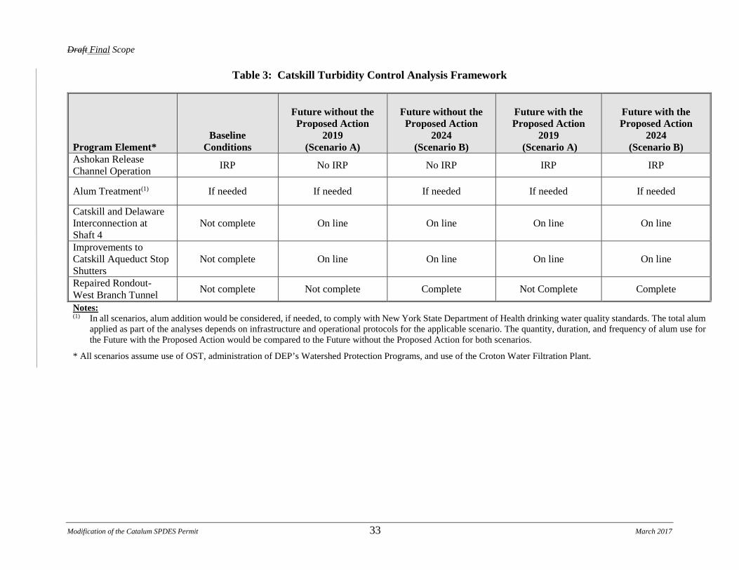
Draft Final Scope
Modification of the Catalum SPDES Permit 33 March 2017
Table 3: Catskill Turbidity Control Analysis Framework
Program Element* Baseline
Conditions
Future without the Proposed Action
2019 (Scenario A)
Future without the Proposed Action
2024 (Scenario B)
Future with the Proposed Action
2019 (Scenario A)
Future with the Proposed Action
2024(Scenario B)
Ashokan Release Channel Operation IRP No IRP No IRP IRP IRP
Alum Treatment(1) If needed If needed If needed If needed If needed
Catskill and Delaware Interconnection at Shaft 4
Not complete On line On line On line On line
Improvements to Catskill Aqueduct Stop Shutters
Not complete On line On line On line On line
Repaired Rondout-West Branch Tunnel Not complete Not complete Complete Not Complete Complete
Notes: (1) In all scenarios, alum addition would be considered, if needed, to comply with New York State Department of Health drinking water quality standards. The total alum
applied as part of the analyses depends on infrastructure and operational protocols for the applicable scenario. The quantity, duration, and frequency of alum use for the Future with the Proposed Action would be compared to the Future without the Proposed Action for both scenarios.
* All scenarios assume use of OST, administration of DEP’s Watershed Protection Programs, and use of the Croton Water Filtration Plant.

Draft Final Scope
Modification of the Catalum SPDES Permit 34 March 2017
The Proposed Action will be evaluated against the baseline conditions, each of which prioritizes operation of one of the major components of the Water Supply System that affect turbidity: use of the Ashokan Release Channel, alum addition at Kensico Reservoir, and use of the east basin spillway. When each of these major components is prioritized, the incremental use of the remaining components and the resulting flow in the Catskill Aqueduct varies, as noted in Table 3. For example, baseline conditions assumes no use of the Ashokan Release Channel with flow over the east basin spillway, the Catskill Aqueduct is on line, and the potential need to add alum at historical levels. Under Scenario 1, when the Ashokan Release Channel is operated in accordance with the Interim Ashokan Release Protocol, flow over the east basin spillway is reduced, the Catskill Aqueduct may be operated at a reduced flow, and alum use at Kensico Reservoir is expected to be low. The potential for significant adverse impacts of the incremental changes between baseline conditions and this operating scenario (identified in the “Comparison to Baseline” column), and Scenarios 2 and 3 the will be analyzed for each of the components and presented in the EIS.
As part of the development of the DEIS, the City will evaluate the IRP and the Interim Monitoring Plan and propose to NYSDEC whether it is necessary and appropriate to continue and/or modify either one. The City’s proposed DEIS will include a Revised Operating Protocol if the City proposes to continue to release water through the Ashokan Reservoir Release Channel and determines revisions to the IRP are appropriate, and a plan for monitoring of the Ashokan Release Channel releases. The City’s draft of the DEIS will propose whether any future monitoring plan should include any or all of the following elements: temperature, turbidity, total suspended solids, biomonitoring, physical geomorphic factors, and flow data. Any future monitoring plan may identify monitoring locations, including biological monitoring locations to the extent such monitoring locations are determined to be appropriate, which may include any or all of the following: the Esopus Creek above the Ashokan Reservoir, within the Ashokan Reservoir, the Release Channel discharge, and at appropriate sites downstream between the Release Channel discharge and the Hudson River. The potential siting for these monitoring locations will take into consideration recommendations from the lower Esopus Creek Biological Stream Assessment dated February 1, 2015 and comply with terms of the October 4, 2013 Order on Consent. The City will also work with NYSDEC to hold at least two public meetings to solicit comment on the City’s proposed Operating Protocol and Monitoring Plan and these meetings may be held at the same time as the public hearings on the DEIS.
1.7 Purpose and Need for the Proposed Action
The proposed modification of the Catalum SPDES Permit would allow DEP to continue to provide reliable, clean, and safe drinking water, while potentially reducing reliance on alum treatment during episodic turbidity events. The practice of applying chemicals to drinking water supplies is long standing, well accepted, and practiced widely throughout the United States. The primary objective of DEP in applying alum (and sodium hydroxide) is to judiciously protect public health and meet drinking water standards. DEP will continue to balance water supply requirements with the need to minimize the potential for impacts of these chemicals on aquatic organisms.
Draft Final Scope
Modification of the Catalum SPDES Permit 35 March 2017
If DEP continues its ongoing turbidity control measures as described previously, modeling has suggested that DEP will be able to significantly reduce, or potentially eliminate, its reliance on alum during turbidity events.
The proposed modification of the Catalum SPDES Permit also includes the postponement of dredging alum floc at Kensico Reservoir until after DEP completes the construction of the Rondout-West Branch Bypass Tunnel and its connection to the Delaware Aqueduct. During the connection period, the Delaware Aqueduct will be shut down, and DEP would be more heavily reliant upon the water in the Catskill System to meet its daily demand. More reliance on the water in the Catskill System increases the likelihood that the City will need to add alum to reduce turbidity in the Kensico Reservoir while the final connection project is completed. Per the Order on Consent dated October 4, 2013, NYSDEC and the City therefore agreed that the dredging design should not commence until this infrastructure project is complete.
1.8 Local, State and Federal Permits and Approvals
The approvals required to implement the Proposed Action would include the modification of the existing Catalum SPDES Permit. Implementation of the Proposed Action would also require additional discretionary actions and approvals from federal, state and local agencies. All anticipated permits will be identified in the EIS. These actions and approvals may include:
Federal
• Joint United States Army Corps of Engineers (USACE)/NYSDEC Permit application for dredging at Kensico Reservoir; and
• USACE Nationwide/Individual Wetland Permit for the for a potential dewatering facility at Kensico Reservoir for dredging
State (NYSDEC)
• Modification of the existing Catalum SPDES Permit;
• State Pollution Discharge Elimination System (SPDES) General Permit for Construction Activities (Erosion & Sediment Control for construction) for a potential dewatering facility at Kensico Reservoir for dredging;
• State Pollution Discharge Elimination System (SPDES) for Discharge Activities for a potential dewatering facility at Kensico Reservoir for dredging;
• Protection of Waters Permit for a potential dewatering facility at Kensico Reservoir for dredging;

Draft Final Scope
Modification of the Catalum SPDES Permit 36 March 2017
• Potential Air Permit for a potential dewatering facility at Kensico Reservoir for dredging
Local
Local permits and approvals may be required for new construction, such as site plan approvals, and building permits in the affected areas, possibly including:
• Potential Westchester County and Mt. Pleasant, NY site plan approvals for a potential dewatering facility at Kensico Reservoir
1.9 Prior Studies
As part of its ongoing program review and to meet requirements of the 2007 FAD, the following studies of the Catskill System have been completed to examine engineering and operational modifications to address turbidity. The results of these studies will be used in the EIS, where applicable, to describe and evaluate the Proposed Action and its alternatives.
• Phase I Catskill Turbidity Control Study, December 2004
The goal of this study was to review historical water quality and physical data for Schoharie Reservoir and the Shandaken Tunnel diversions, review state and federal regulatory programs affecting these water supply system facilities, and provide a screening-level evaluation of the feasibility and effectiveness of six alternatives for potentially improving water quality in the Catskill System. The alternatives considered were: (1) construction of a multi-level intake in Schoharie Reservoir; (2) placement of an in-reservoir turbidity curtain; (3) placement of an in-reservoir baffle; (4) modifications to Schoharie Reservoir’s operating policy; (5) construction of engineered treatment (coagulation, flocculation, and settling) facilities; and (6) turbidity removal options downstream at Ashokan Reservoir. The multi-level intake, baffle, modified operations, and Ashokan Reservoir options were selected for further study. Other options were eliminated due to feasibility and effectiveness.
• Phase II Final Report Catskill Turbidity Control Study, September 2006
The goal of the Phase II study was to identify and evaluate feasible, effective, and cost-effective measures for reliably improving turbidity and temperature control in diversions from Schoharie Reservoir to Esopus Creek. The study included conceptual design and performance evaluation for three alternatives (Schoharie multi-level intake, Schoharie baffle, and modification of Schoharie operating rules) identified in the Phase I study as having reasonable potential to improve turbidity and temperature control in Schoharie Reservoir diversions.

Draft Final Scope
Modification of the Catalum SPDES Permit 37 March 2017
• Phase II Implementation Plan, December 2006
The goal of this implementation plan was to present DEP’s final recommendations andguidelines for further development and implementation of turbidity and temperaturecontrol measures at Schoharie Reservoir. The plan was based on the analyses presented inthe Phase II Final Report. The plan recommends implementation of modified operatingrules at Schoharie supported by the development of an Operations Support Tool (OST).Additional supporting analysis was submitted in July 2009.
• Phase III Final Report Catskill Turbidity Control Study, December 2007
The goal of this study was to identify and evaluate feasible, effective, and cost-effectivemeasures for reliably reducing peak turbidity levels entering Kensico Reservoir from theCatskill Aqueduct, thereby reducing the frequency and duration of alum application events.The Phase III study focused on Ashokan Reservoir and provides a comprehensive analysisof engineering and structural alternatives at the Ashokan Reservoir that may reduceturbidity levels entering the Catskill Aqueduct. The alternatives considered were:(1) construction of a new west basin outlet structure; (2) installation of dividing weir crestgates; (3) east basin diversion wall and channel improvements; (4) Upper Gate ChamberModifications; (5) construction of a new east basin multi-level intake; and(6) improvements to the Catskill Aqueduct in combination with modified operations.
Phase III Value Engineering Report, April 2008
A value engineering (VE) study was conducted on behalf of DEP and the City of New York Office of Management and Budget (OMB) to review and evaluate the Catskill Turbidity Control Study Phase III Final Report. A group of 13 engineers, modelers, and cost estimators convened from January 28 to February 1, 2008 to review the Phase III Report and provide suggestions on the proposed alternatives, recommend additional alternatives, and reconcile cost estimates. The outcome of the VE evaluation was incorporated into the Phase III Implementation Plan. Official responses to VE comments were provided in the Conceptual Design Value Engineering Responses Report dated October 2008.
• Phase III Implementation Plan, July 2008
DEP submitted a Draft Phase III Implementation Plan for the Catskill Turbidity ControlStudy to the USEPA, NYSDOH, and NYSDEC. The 2008 Phase III Implementation Planpresented DEP’s proposed plan for implementing operational and structural measures thatwill would improve turbidity control in the Catskill System by reducing turbidity levelsentering Kensico Reservoir, and is based on engineering analyses conducted during PhaseIII of the Catskill Turbidity Control Study. The implementation plan makes two major

Draft Final Scope
Modification of the Catalum SPDES Permit 38 March 2017
recommendations: (1) modifications to the operating rules at Ashokan Reservoir (supported by OST) by (a) drawing down the west basin during low turbidity periods and (b) operating the Ashokan Release Channel to redirect turbid water; and (2) improvementsto the Catskill Aqueduct including its interconnection to the Delaware Aqueduct at Shaft 4of the Delaware Aqueduct, and improving stop shutters in the Catskill Aqueduct, allowingfor the reduction of flow within the Catskill Aqueduct during periods of elevated turbidity.
• Turbidity Control Alternatives Analysis, February 2011
The Turbidity Control Alternatives Analysis report provides a summary of systemmodeling and analyses conducted in order to assess the performance of the turbidity controlalternatives recommended in the Phase III Implementation plan, specifically:
− Operation of the Ashokan Release Channel
− Routine deployment of Catskill Aqueduct stop shutters
− Operation of the proposed Shaft 4 Interconnection.
The modeling work in this report used a state-of-the-art linked water system/water qualitymodel (OASIS and CE-QUAL-W2-W2)12 over an extended (61-year) simulation period toevaluate the alternatives individually and in various combinations. The performance ofeach alternative was evaluated based on simulated daily turbidity levels in diversions fromAshokan and Kensico Reservoirs, the frequency and duration of alum treatment events,and the mass of alum used during treatment events. The modeling results indicated thatthese alternatives could significantly reduce the expected frequency and duration of alumtreatment.
The following additional studies were conducted specifically to meet requirements described previously for the Catalum SPDES Permit
• Feasibility of Minimizing the Area of Alum Floc Deposition in Kensico ReservoirTechnical Report, October 2007
The goal of this study was to develop a mixing zone analysis that identifies the spatial andtemporal pattern of floc deposition in Kensico Reservoir, a discussion of how the variousalternatives for minimization of floc deposition would be implemented, the area and depthof floc that would result from each alternative, identification of the chosen alternative, andan implementation schedule for the chosen alternative.
12 The OASIS and CE-QUAL-W2 linked water system/water quality model used for this study was integrated into the OST model currently used by DEP.
Draft Final Scope
Modification of the Catalum SPDES Permit 39 March 2017
• Evaluation of Turbidity Reduction Potential through Watershed Management in the Ashokan Basin, July 2008
The goal of this evaluation was to analyze the potential effectiveness of enhancing existing Ashokan Basin Watershed management and protection programs as measures for reducing elevated turbidity in the Ashokan Reservoir.
• Impacts of Dredging the Estimated Area of Alum Floc Deposition in Kensico Reservoir, September 2008
The goal of this study was to define the location and quantity of the alum floc in Kensico Reservoir; quantify the impact of the alum floc on Kensico Reservoir’s ecology; identify the cost, schedule, and potential for environmental impacts of dredging the alum floc; and provide a summary of impact comparisons. The potential for alum floc and dredging impacts was focused on, but not limited to, the benthic community.
In addition, DEP has evaluated the benefit of many watershed protection programs for bacteriological and algal control as part of the FAD. DEP has also, in association with emergency work at Gilboa Dam that necessitated use of the Ashokan Release Channel to accept flows from Ashokan Reservoir, conducted studies of natural resources along lower Esopus Creek downstream of the Ashokan Release Channel and upstream of the spillway confluence. The natural resource studies included a benthic and fish survey at representative sites upstream and just downstream of the spillway confluence with the east basin spillway channel in September 2009. In the summer of 2006 and the spring and summer of 2009, natural resource and stream geomorphology surveys were conducted in lower Esopus Creek from the Ashokan Release Channel discharge to Mill Pond Dam at the Ashokan Center. These included surveys of vegetation, wetlands, and aquatic and terrestrial resources at locations along both sides of lower Esopus Creek. In the spring of 2009, field surveys were conducted along Esopus Creek to identify herptiles (amphibians and reptiles), birds, bats, and other mammals. Additional field surveys were conducted in the spring of 2010, and wetlands were again visually analyzed in the summer of 2011. Color photographs of selected specimens were taken to document the species presence in the study area. Prior to the field survey, existing data (NYS Atlas, the most up to date range maps, and other published sources) were consulted to determine a potential list of species in the study area.
Prior Environmental Reviews
DEP has conducted several previous environmental reviews on design, construction, and operation of a number of Catskill turbidity control measures, as described previously. In addition, on September 30, 1997, DEP issued a Draft Environmental Impact Statement (DEIS) for the Treatment of New York City’s Delaware, Catskill, and Croton Reservoir Systems for the Control of Bacteria, Turbidity, Algae, and Zebra Mussels. That DEIS presented a detailed analysis of the potential for impacts of bacteriological, turbidity, algae, and zebra mussel control programs

Draft Final Scope
Modification of the Catalum SPDES Permit 40 March 2017
throughout the Water Supply System. However, as DEP continued to evaluate its original program, implement its Watershed Protection Program, and work with USEPA and NYSDEC, the Final EIS (FEIS) was not issued. The DEIS evaluated copper sulfate application at three reservoirs of the Delaware System (Cannonsville, Pepacton, and Rondout), as well as at Ashokan Reservoir of the Catskill System. While facilities exist at these locations for copper sulfate application, copper sulfate was only added periodically at some of the reservoirs until the mid-1990s, and has not been applied since 1996. While use of copper sulfate was evaluated previously, it is not part of the Proposed Action, as DEP has no current plans to use copper sulfate.
2.0 SCOPE OF THE ENVIRONMENTAL IMPACT STATEMENT
2.1 Environmental Review
This A Draft Scope has been was prepared to facilitate participation in the environmental review of the Proposed Action, offering an opportunity for the public and interested agencies to provide comment. After receiving and considering comments on this the Draft Scope, NYSDEC, as Lead Agency, will has prepared and issued a this Final Scope of Work. Then Now DEP, working cooperatively with the NYSDEC, will prepare the DEIS in accordance with the State Environmental Quality Review Act (SEQRA) and implementing regulations set forth in 6 NYCRR Part 617. And As DEP is a New York City agency, the DEIS will also conform with the City Environmental Quality Review (CEQR) process as set forth in 62 RCNY Chapter 5 and Executive Order 91 of 1977 and its amendments. The DEIS will additionally follow requirements and timeframes set forth in the October 4, 2013 Order on Consent.
The DEIS described in this Draft Final Scope will examine the full range of potential environmental impacts related to both short-term construction activities and long-term operational changes that may result from implementation of the Proposed Action. As shown in Table 3, Tthe DEIS will evaluate the potential for significant adverse impacts of the Proposed Action in 20189, when two DEP projects that will increase operational flexibility and reduce the potential need for alum addition – the Shaft 4 Interconnection, and the Catskill Aqueduct Stop Shutter Improvements, and the Croton Water Filtration Plant – that will reduce the potential need for alum addition will be on line are all anticipated to be on line. The DEIS will also evaluate the potential for significant adverse impacts and in 2024, when the Rondout-West Branch Tunnel is anticipated to be repaired theand dredging of alum at the Kensico Reservoir is planned and the Rondout West Branch Tunnel is anticipated to be repaired. In addition, the potential effects of delaying dredging until 2024 wouldwill be evaluated. The 2019 and 2024 time periods represent separate baseline infrastructure scenarios based on the water supply infrastructure available to DEP in those years (Table 4). The analyses would consist of long-term assessments based on a range of hydrologic conditions. The DEIS will also address alternatives, including the No Action Future without the Proposed Action alternative (comprised of continuing use of alum at historic levels at CATIC), and propose mitigation strategies for any identified significant adverse impacts, to the extent practicable.
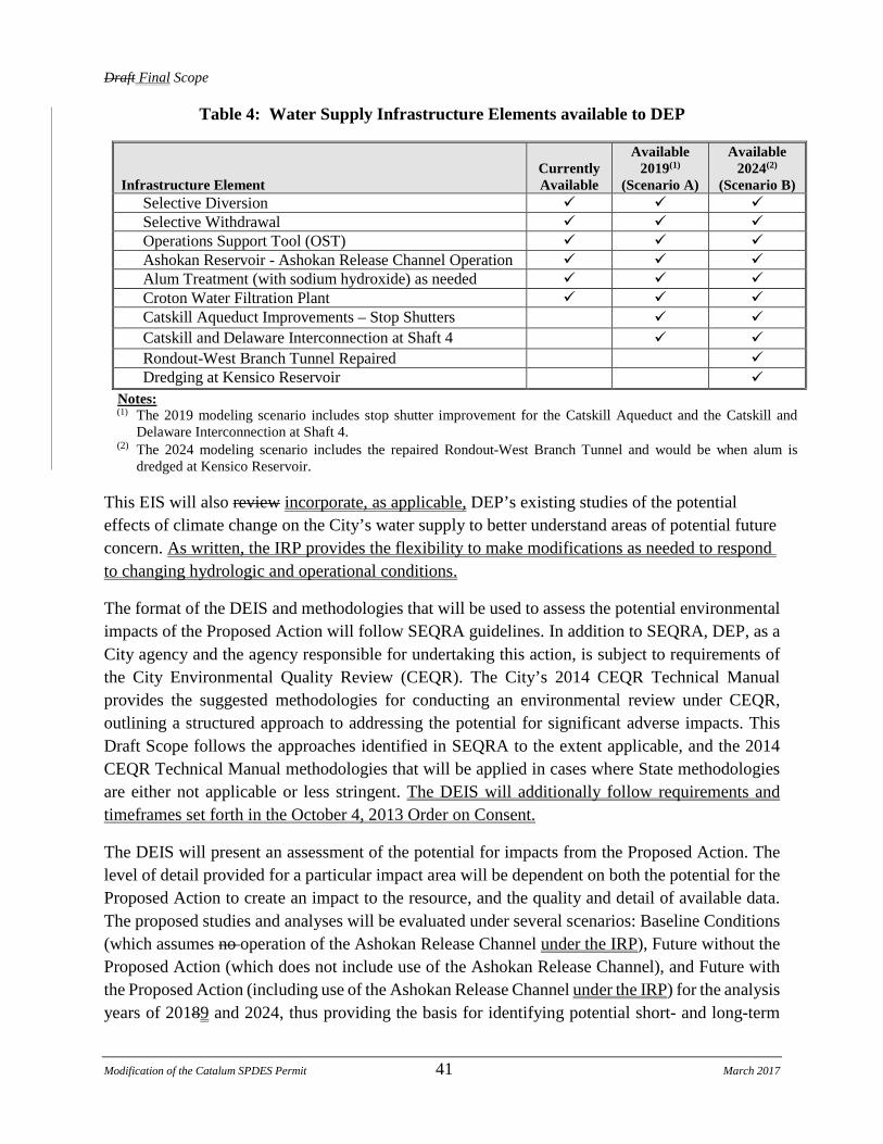
Draft Final Scope
Modification of the Catalum SPDES Permit 41 March 2017
Table 4: Water Supply Infrastructure Elements available to DEP
Infrastructure Element
Currently Available
Available 2019(1)
(Scenario A)
Available 2024(2)
(Scenario B) Selective Diversion Selective Withdrawal Operations Support Tool (OST) Ashokan Reservoir - Ashokan Release Channel Operation Alum Treatment (with sodium hydroxide) as needed Croton Water Filtration Plant Catskill Aqueduct Improvements – Stop Shutters Catskill and Delaware Interconnection at Shaft 4 Rondout-West Branch Tunnel Repaired Dredging at Kensico Reservoir
Notes: (1) The 2019 modeling scenario includes stop shutter improvement for the Catskill Aqueduct and the Catskill and
Delaware Interconnection at Shaft 4. (2) The 2024 modeling scenario includes the repaired Rondout-West Branch Tunnel and would be when alum is
dredged at Kensico Reservoir.
This EIS will also review incorporate, as applicable, DEP’s existing studies of the potential effects of climate change on the City’s water supply to better understand areas of potential future concern. As written, the IRP provides the flexibility to make modifications as needed to respond to changing hydrologic and operational conditions.
The format of the DEIS and methodologies that will be used to assess the potential environmental impacts of the Proposed Action will follow SEQRA guidelines. In addition to SEQRA, DEP, as a City agency and the agency responsible for undertaking this action, is subject to requirements of the City Environmental Quality Review (CEQR). The City’s 2014 CEQR Technical Manual provides the suggested methodologies for conducting an environmental review under CEQR, outlining a structured approach to addressing the potential for significant adverse impacts. This Draft Scope follows the approaches identified in SEQRA to the extent applicable, and the 2014 CEQR Technical Manual methodologies that will be applied in cases where State methodologies are either not applicable or less stringent. The DEIS will additionally follow requirements and timeframes set forth in the October 4, 2013 Order on Consent.
The DEIS will present an assessment of the potential for impacts from the Proposed Action. The level of detail provided for a particular impact area will be dependent on both the potential for the Proposed Action to create an impact to the resource, and the quality and detail of available data. The proposed studies and analyses will be evaluated under several scenarios: Baseline Conditions (which assumes no operation of the Ashokan Release Channel under the IRP), Future without the Proposed Action (which does not include use of the Ashokan Release Channel), and Future with the Proposed Action (including use of the Ashokan Release Channel under the IRP) for the analysis years of 20189 and 2024, thus providing the basis for identifying potential short- and long-term
Draft Final Scope
Modification of the Catalum SPDES Permit 42 March 2017
impacts. The long-term analysis will consist of the evaluation of the potential for incremental impacts from the Proposed Action and not be limited to those two years. The two Future with the Proposed Action analysis years enable the assessment of use of the IRP considering the infrastructure available during these two representative time periods under a range of hydrological conditions. The study areas and assessment methodologies proposed to determine the potential for impacts associated with the Proposed Action are described below.
2.2 Description of the Proposed Action
This section of the EIS will provide:
• A detailed description of the Proposed Action – modification of the Catalum SPDES Permit
• History of turbidity control in the Catskill System
• A description of the regulatory framework for DEP’s operation of the Catskill System (e.g., Federal Safe Drinking Water Act (SDWA) and Filtration Avoidance Determination requirements, NYSDEC SPDES permits, and NYSDEC dredging permits).
• A statement of the Purpose and Need for the Proposed Action, and
• A description of the alternatives considered.
Major components of the Proposed Action consist of: (1) continuing existing practices; and (2) implementing additional operational and physical improvements to DEP’s Water Supply System. See Section 1.6 for a further description of the Proposed Action. As DEP’s operation of the Water Supply System is dynamic, elements of the Proposed Action may be used in various combinations and at varying levels. For example, some turbidity control mechanisms may be implemented independently of each other as a result of modeling or other investigations that will inform DEP’s decisions about which turbidity control elements to use under a specific set of conditions. Also, the Interim Ashokan Release Protocol for use of the Ashokan Release Channel contains provisions for use of the Ashokan Release Channel at different flows under certain conditions, including community releases that are dependent on season and drought conditions (interim rates that currently range from 0 to 15 MGD); turbidity control (up to 1,000 MGD maximum flow from a combination of the Ashokan Release Channel and spill over the east basin); and operation of the Ashokan Reservoir under a Conditional Seasonal Storage Objective (CSSO). See Attachment A for details of the Interim Ashokan Release Protocol.
Given the dynamic operation of the Water Supply System, the EIS will present the potential for significant adverse impacts from the Proposed Action for several scenarios, all of which could be possible during what would be considered reasonable worst case scenario (RWCS) weather events, and other natural occurrences that affect the City’s Water Supply System on a regular basis. It will also compare use of the Ashokan Release Channel at flows indicated under the Interim Ashokan
Draft Final Scope
Modification of the Catalum SPDES Permit 43 March 2017
Release Protocol to those typically observed in the lower Esopus Creek from storm events that result in spillage over the east basin spillway of Ashokan Reservoir.
2.3 Summary of Proposed Methodologies for Environmental Analyses
This section will summarize the methodologies to be used to evaluate the potential for significant adverse environmental impacts of the Proposed Action. In this section, the Baseline Conditions, Future without the Proposed Action, and Future with the Proposed Action scenarios will be defined for the two primary study areas that have the potential for significant adverse impacts: (1) Ashokan Reservoir and the Ashokan Release Channel/lower Esopus Creek; and (2) Kensico Reservoir.
2.3.1 Ashokan Reservoir and Ashokan Release Channel/Lower Esopus Creek
The study area associated with Ashokan Release Channel flows will be the vertical and horizontal area along the length of lower Esopus Creek from the Ashokan Reservoir to the confluence of lower Esopus Creek with the Hudson River (an approximately 30-mile reach of stream) (see Figure 5). The entire lower Esopus Creek and Esopus Estuary are within the project study area. This area has the potential to be inundated for a prolonged period, as compared to a typical hydrologic spill event over the east basin spillway. The increment would be defined as the vertical and horizontal area along the lower Esopus Creek between that which would typically be inundated during natural flows including spills over the east basin spillway and the area that would be inundated under the implementation of the Interim Ashokan Release Protocol. This would include those areas that would be inundated for a greater period of time under the Interim Ashokan Release Protocol as compared to a natural spill event. The potential for positive and negative significant impacts associated with all release levels provided under the Interim Ashokan Release Protocol will be evaluated for each impact category as described in the following sections.
2.3.1.1 Land Use, Zoning, and Public Policy
Elements of the Proposed Action that have the potential to affect land use and zoning (e.g. flood zone, area proposed for rezoning) within the lower Esopus Creek study area will be assessed. The analysis will also consider consistency of the Proposed Action with, and its potential for adverse effects on, applicable public policies within the study area. The land use, zoning, and public policy assessment will include a description of Baseline Conditions, and conditions in the Future without the Proposed Action and the Future with the Proposed Action scenarios.
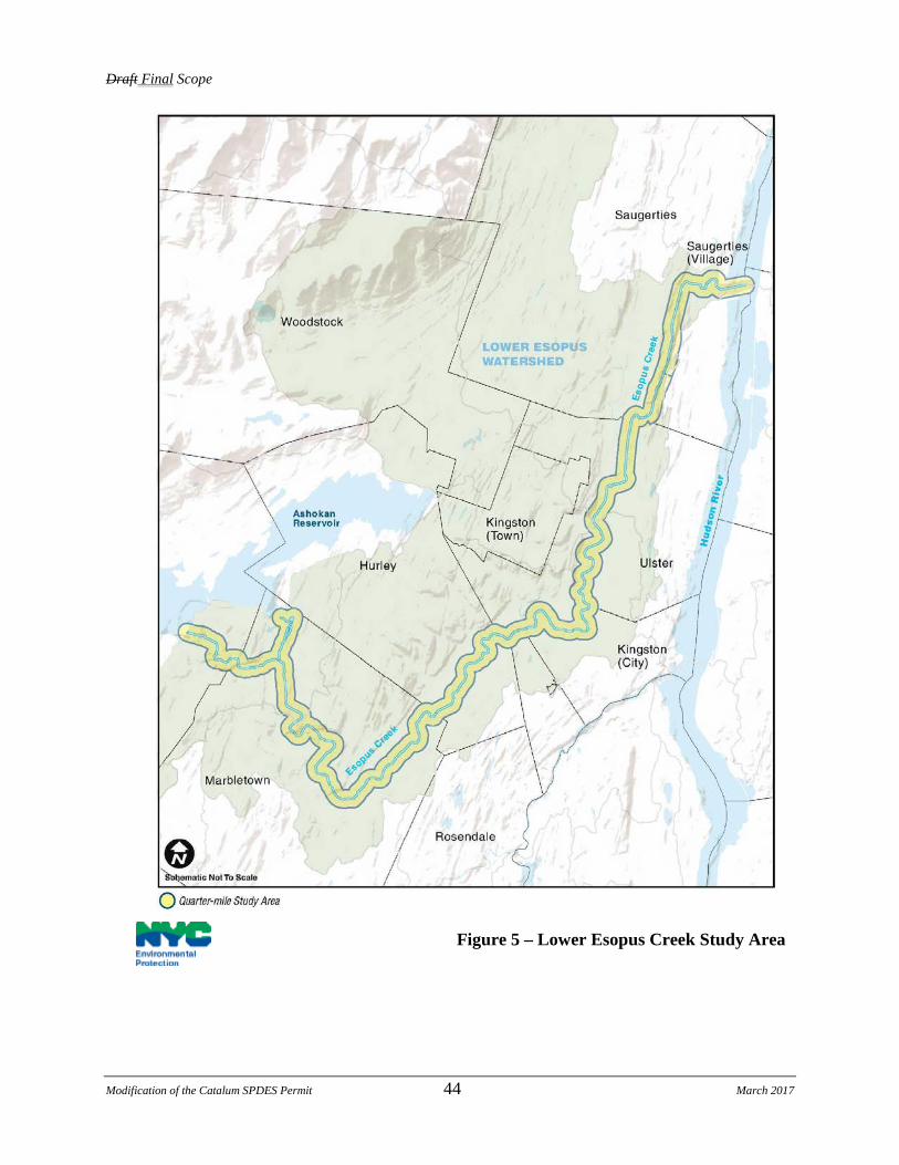
Draft Final Scope
Modification of the Catalum SPDES Permit 44 March 2017
Figure 5 – Lower Esopus Creek Study Area
Draft Final Scope
Modification of the Catalum SPDES Permit 45 March 2017
Baseline Conditions
The Baseline Conditions assessment will consist of the following steps:
• Map and describe existing land uses, zoning, and recent trends in the study area;
• Identify and describe predominant land use and zoning patterns in the study area based onexisting information included in geographic information systems (GIS) for the area, andcompiled field surveys, municipal plans, and other studies, as relevant and available; and
• Describe relevant public policies that apply to the study area including the Coastal ZoneManagement Act (CZMA) of 1972 (16 USC §§1451-1464; the New York State CoastalZone Management Program, including the location of any Significant Coastal Fish andWildlife Habitats; any Local Waterfront Revitalization Programs (LWRP) within oradjacent to the study area; and local plans, such as those associated with projects like newdevelopment or recreational programs and floodplain ordinances, if applicable.
Future without the Proposed Action
The Future without the Proposed Action analysis will identify future development projects in the lower Esopus Creek study area that could affect land use and zoning patterns and trends by 20189 and 2024. The analysis will identify specific development projects, plans for public improvements, and pending zoning actions or other public policy actions within the study area as they relate to the Proposed Action. Based on these changes, future land use and zoning conditions in the Future without the Proposed Action will be assessed and described.
Future with the Proposed Action
This component of the Land Use, Zoning, and Public Policy analysis will assess and describe the compatibility of the Proposed Action and its potential for significant adverse impacts on land use and open space, and relevant trends in the study area. The assessment will also include consistency of the Proposed Action with recognized public policies in the study area, such as waterfront or zoning plans along the lower Esopus Creek.
2.3.1.2 Socioeconomic Conditions
Socioeconomic impacts can occur when a proposed action directly or indirectly displaces economic activities in an area. To the extent that elements of the Proposed Action have the potential to affect socioeconomic conditions within the lower Esopus Creek study area, the potential for impacts will be assessed.
Draft Final Scope
Modification of the Catalum SPDES Permit 46 March 2017
Baseline Conditions
This portion of the Socioeconomic Conditions analysis will identify and describe existing socioeconomic conditions in the study area using available data from local and state agencies and other sources, such as the local chambers of commerce. This section will present data on recreational activities and related industries and tourism near lower Esopus Creek that may be impacted by the Proposed Action. Existing conditions will be assessed and documented using data from: (1) published sources such as the Census Bureau’s American Community Survey and Local Employment Dynamics, the Labor Department’s Quarterly Census of Employment and Wages, the Department of Agriculture’s National Agricultural Statistics, and data from the State’s Office of Real Property Services; (2) purchased data on businesses in the study area; and (3) past and any future surveys of businesses and households in the study area.
Future without the Proposed Action
This analysis will identify future changes in the study area that could affect socioeconomic conditions by 20189 and 2024 (e.g. potential changes to the recreational use of the lower Esopus Creek). Based on these changes, the socioeconomic conditions of the Future without the Proposed Action will be described.
Future with the Proposed Action
This component of the Socioeconomic Conditions analysis will assess and identify the potential for impacts to socioeconomic conditions from the Proposed Action. This will include an assessment of the effects on tourism and fish-related business, agriculture, and local business operations as a result of the Proposed Action through public surveys, interviews, and the use of the IMPLAN input-output modeling system to assess indirect and induced impact of any specifically-identified direct changes in income or employment that are projected as a result of releases to lower Esopus Creek.13 This assessment would include analyses of potential impact on economic output, employment, earnings, and local taxes in communities near lower Esopus Creek, as applicable.
2.3.1.3 Community Facilities and Services
It is not anticipated the Proposed Action would impact community facilities and services, such as schools, libraries, hospitals, and police and fire departments within the lower Esopus Creek study area. If, during the analysis, it is determined that such facilities and services could be affected, the
13 IMPLAN is an econometric modeling system that is widely used to estimate the impact of changes in income to, spending by or employment in a given industry within a given geographic area (for example, in this case, Ulster County). The current version, IMPLAN 3.0, was released in November 2009. The assessment would use the most recent annual data available at the time of the analysis.

Draft Final Scope
Modification of the Catalum SPDES Permit 47 March 2017
EIS will identify and estimate the existing demand and any additional demand on community facilities or services that may be generated by the Proposed Action.
2.3.1.4 Open Space and Recreation
Elements of the Proposed Action that have the potential to affect open space and recreation within the lower Esopus Creek study area will be assessed. The open space and recreation assessment will include a description of Baseline Conditions, and conditions in the Future without the Proposed Action and the Future with the Proposed Action scenarios.
Baseline Conditions
The Baseline Conditions assessment will consist of the following steps:
• Map and describe existing open spaces and recreation areas and recent trends in the study area;
• Identify and describe predominant open space patterns and recreational activities in the study area (e.g. fishing, boating, bathing beaches and marinas) based on existing information included in GIS for the area and compiled field surveys; and
• Describe relevant public policies that apply to the study area, including the Coastal Zone Management Act (CZMA) of 1972 (16 USC U.S.C. §§1451-1464 and local plans, if applicable.
Future without the Proposed Action
The Future without the Proposed Action analysis will identify future development projects in the study area that could affect open space and recreational activity patterns and trends by 20189 and 2024. The analysis will identify specific development projects, plans for public improvements, and pending actions within the study area as they relate to the Proposed Action. Based on these changes, future open space and recreational conditions in the Future without the Proposed Action will be assessed and described.
Future with the Proposed Action
This component of the Open Space and Recreation analysis will assess and describe the compatibility of the Proposed Action on open space and recreation, relevant trends in the study area, and the consistency of the Proposed Action with recognized plans. The analysis will include an estimate of the number of recreational user-days per year for each activity that could be lost or seriously limited as a result of operation of the Ashokan Release Channel under the IRP. The open space analysis will describe any impacts to fishing, boating, or other recreational activities during use of the Ashokan Release Channel under the Interim Protocol.
Draft Final Scope
Modification of the Catalum SPDES Permit 48 March 2017
2.3.1.5 Critical Environmental Areas
Critical Environment Areas (CEAs) are specific geographic areas designated by local agencies and NYSDEC. There are numerous criteria that must be met to have an area designated as a CEA, including the following:
• A benefit or threat to human health;
• A natural setting (fish and wildlife habitat, forest and vegetation, open space and areas ofimportant aesthetic or scenic quality);
• Agricultural, social, cultural, historic, archeological, recreation, or educational value; or
• An inherent ecological, geological, or hydrological sensitivity to change that may beadversely affected by any change.
There are no CEAs within the lower Esopus Creek study area. Therefore, a CEA assessment is not required.
2.3.1.6 Historic and Cultural Resources
Historic and cultural resources are districts, buildings, structures, sites, and objects of historical, aesthetic, cultural, and archaeological importance. Historic resources include:
• Properties listed on, or formally determined to be eligible for inclusion in, the State and/orNational Register of Historic Places (S/NR);
• Properties contained within a district listed on, or formally determined to be eligible for,the S/NR;
• Properties recommended by the New York State Board of Historic Preservation or NationalHistoric Landmarks; and
• Properties not identified by one of the programs listed above, but that meet eligibilityrequirements.
Typically, existing databases and correspondence from the State Historic Preservation Office (SHPO) of the New York State Office of Parks, Recreation, and Historic Preservation (OPRHP), local plans, and information from the Land Use, Zoning, and Public Policy analysis will be used to identify potential historic and cultural resources.
An area known as the Ashokan Field Campus (AFC) is located between the Ashokan Release Channel at Ashokan Reservoir and the confluence with the east basin spillway channel. In May of
Draft Final Scope
Modification of the Catalum SPDES Permit 49 March 2017
1999, a Phase 1 Cultural Resource Investigation Report14 was issued for the SUNY Ashokan Campus as part of a separate DEP project (the proposed relocation of a site driveway across Esopus Creek). Findings in the May 1999 Phase 1 report concluded that the locality of the project area is of regional historic significance. There is also a covered bridge located just downstream of the main AFC campus that is designated by SHPO as a historic structure. As part of ongoing work at the AFC, it is anticipated that the abutments for the covered bridge will be repaired to ensure its integrity and increase its useful lifespan. Steps will be taken, through coordination with SHPO to ensure that the historic aspects of the bridge are not compromised by this work. Any work and mitigation efforts will be evaluated under the separate project and summarized in this EIS.
With respect to archaeological resources, there is would be no new ground disturbance in the lower Esopus Creek study area, with the exception of the AFC between the Ashokan Release Channel and confluence with the Ashokan Reservoir east basin spillway channel. During their ownership of the property, AFC personnel have identified and documented two findings of significance on and in the vicinity of the campus. After consulting the OPHRP site files, both of these findings were recorded with the state, and a test pit examination was conducted that determined no further testing for the project area surrounding the AFC was recommended.
To evaluate the potential for incremental impact along lower Esopus Creek, the historic and cultural resource analysis will include review of SHPO’s online resource mapper and consultation with SHPO to identify areas where sensitive resources are located. These locations will be closely reviewed against information collected from the Water Resources and Water Quality Assessment and Stream Channel Geomorphology assessment (Sections 2.3.1.18 and 2.3.1.9, respectively) to determine whether identified resources are co-located with areas of inundation or erosion and sedimentation that may occur as a result of operation of the Release Channel under the IRP. Where these areas coincide, with historical and cultural resources, Phase I Cultural Resource Surveys will be conducted, as necessary.In the event that excavation is required in a potentially sensitive cultural resource area along other reaches of the Creek, a Phase I survey will be conducted. Depending on the results of the Phase I survey and consultation with SHPO, additional studies would be undertaken as necessary.
2.3.1.7 Aesthetic (Visual) Resources
Visual resources are important public view corridors, vistas, and natural or built features. It is not anticipated that the Proposed Action will result in construction of above grade structures; however, if there is a potential for visual impacts within the lower Esopus study area, they will be assessed
14 NYCDEP, Archaeological Reconnaissance for the Proposed Relocation of a Driveway across Esopus Creek at the SUNY New Paltz Ashokan Field Campus, Town of Olive, Ulster County – A Stage 1 Cultural Resource Investigation Report, May 18, 1999.
Draft Final Scope
Modification of the Catalum SPDES Permit 50 March 2017
in the EIS. At the lower Esopus Creek, visual changes to the water from turbidity or erosion identified as part of the other assessments will be discussed.
If a visual resources assessment is required, a field reconnaissance will be conducted to determine whether existing or proposed elements of the Proposed Action will be visible along sensitive view corridors. If there is a view corridor that may be impacted, representative sites from within this visually sensitive area will be selected for visual simulations. This information will be used to determine whether changes resulting from the Proposed Action would create a substantial change in the views from affected resources as compared to the Future without the Proposed Action conditions.
2.3.1.8 Water Resources and Water Quality
For purposes of the lower Esopus Creek assessment in the EIS, water resources will include surface water (rivers, streams, and ponds) and groundwater. As part of the water resource analysis, water quality will be evaluated. Water quality refers to the physical, chemical, and biological characteristics of water. As the Proposed Action involves management of water resources and has the primary goal of providing drinking water that is safe and meets applicable standards, the Proposed Action has the potential to affect water resources and water quality. The Proposed Action includes modified operations at Ashokan Reservoir and improvements to the Catskill Aqueduct to reduce the frequency of downstream turbidity events at Kensico Reservoir. The EIS will summarize these modifications in the context of the potential for impacts to downstream hydrology and water quality in the lower Esopus Creek from the release of water from the Ashokan Release Channel and the transfer of turbidity water to Kensico Reservoir (see Section 2.3.2 for Kensico Reservoir).
Baseline Conditions
Water Quality
The Proposed Action, particularly the operation of the Ashokan Release Channel, has the potential to cause hydrologic and water quality impacts to the lower Esopus Creek below the Ashokan Reservoir extending to the confluence of lower Esopus Creek with the Hudson River, 30 miles downstream. As part of the Baseline Conditions analysis, a summary of available water quality data collected during various periods from the Ashokan Release Channel and sites along the lower Esopus Creek will be presented.15 In addition, other methods employed for turbidity control in
15 Since implementation of the Interim Release Protocol, DEP has collected weekly turbidity information at three sites on the lower Esopus when the Release Channel is operational. If Ashokan is spilling, DEP adds a sample from below the spillway and one from below the spillway confluence. In addition, as of October 2013, DEP began collecting samples at the Sawkill and Plattekill just upstream of their confluence with lower Esopus Creek.
Draft Final Scope
Modification of the Catalum SPDES Permit 51 March 2017
Ashokan Reservoir, the Ashokan Release Channel, and lower Esopus Creek will be identified, mapped, and described.
Flow
In order to determine baseline flow conditions within lower Esopus Creek associated with both releases under the Interim Ashokan Release Protocol and flows over the east basin spillway, information gathered from DEP flow records at Ashokan Reservoir and the United States Geologic Survey (USGS) stream gage at Mt. Marion from 1970 to the present will be analyzed, and a flood frequency analysis will be performed. Statistical analyses will be conducted for various seasons both with and without Ashokan Reservoir releases. The results of the statistical analyses, along with a comparison of spill and release data will be presented to determine the frequency of high-flow events under various Ashokan Reservoir operational scenarios and different Catskill Aqueduct flow diversion scenarios. This information will be used to develop typical seasonal flow and potential flood conditions for the lower Esopus Creek for comparison to flows associated with release operations under the Interim Ashokan Release Protocol.
Future without the Proposed Action
The Future without the Proposed Action will assume no operation of the Ashokan Release Channel. The analysis will include a description of anticipated changes to water resources and the water quality of the lower Esopus Creek in the future (20189 and 2024) without the Proposed Action. These include changes to the study area that will be implemented in these years (e.g. future development projects along lower Esopus Creek, plans for public improvements, and other public policy actions within the Ashokan Reservoir and lower Esopus study area that could affect these water sources).
Future with the Proposed Action
Water Quality
The water quality assessment under the Future with the Proposed Action will evaluate water quality changes associated with operation of the Ashokan Release Channel at up to 600 MGD to meet operational objectives or to follow a Conditional Seasonal Storage Objective (CSSO), as outlined in the Interim Ashokan Release Protocol. The water quality analysis will focus primarily on in-stream turbidity and suspended solids measurements collected by DEP since January 2011. These data will be evaluated using a regression analysis to help identify, where possible due to the complexities of stream sediment processes, potential correlation between turbidity in the lower Esopus Creek and the quality and quantity of the water being discharged from either the east basin spillway or Ashokan Release Channel at specific water quality monitoring locations along the Creek. Turbidity and Total Suspended Solids data at specific water quality monitoring stations would also be plotted using a regression analysis. Data will be grouped and analyzed according to
Modification of the Catalum SPDES Permit 52 March 2017
Draft Final Scope
characteristics (e.g., similar flow conditions) and summary statistics or graphical representations will be presented. Other water quality parameters related to the operation of the Ashokan Release Channel will be analyzed in a similar manner where available and comparable (e.g., dissolved oxygen (DO), pH, and temperature). The length of turbid events predicted to occur under the IRP would also be compared with the typical duration and levels of natural turbidity to evaluate potential changes resulting from use of the Release Channel.
Flow
The flow assessment under the Future with the Proposed Action will involve review and analysis of total flow entering the lower Esopus Creek from the Ashokan Reservoir spillway and/or the Ashokan Release Channel. Flow analyses will be based on the long term historic hydrologic record in OST. The historical hydrologic data includes inflow characteristics for a range of conditions from extreme storms to the drought of record. Therefore, the historical inflows to the water supply system included within OST represent the potential range of likely inflow conditions that the water supply system could experience. It The analyses will include an assessment of how releases compare to flows observed in the lower Esopus, superimposing flows from the reservoir against those typically observed at the stream gage at Mt. Marion in the absence of reservoir releases under both storm and non-storm events. In addition to the variation in and distribution of flows, the typical duration over which various flows are observed both with and without Ashokan Release Channel operation will be analyzed and presented. Additional analyses will be conducted using HEC-RAS (Hydrologic Engineering Center-River Analysis System (HEC-RAS)), a hydraulic model for natural and constructed channels, to establish approximate potential water surface elevations within lower Esopus Creek with total releases from Ashokan Reservoir up to 600 MGD, and to estimate the approximate extent of any potentially inundated area along lower Esopus Creek associated with operation of the Ashokan Release Channel under different flow conditions. Existing stream discharge and stage data, where available, along with observed high water marks and topographic surveys, will be used to calibrate the model. In some areas, to support model development for the analysis, stage measurements will be collected during future Ashokan Release Channel discharges for model calibration.
The HEC-RAS model will be used to develop water surface elevations and velocity rating curves for specified sections along lower Esopus Creek. Existing aerial survey data, supplemented by existing field surveys, will be used in conjunction with HEC-RAS modeling results to delineate the extents of the inundated area for Ashokan Release Channel discharges up to 600 MGD, as compared to storm flows without releases (where the water would spill uncontrolled over the east basin spillway and enter the lower Esopus Creek).
The hydraulic model will be used in conjunction with field assessments conducted as part of other assessments to estimate the bankfull flow rate within lower Esopus Creek from the Ashokan Release Channel to the spillway confluence and downstream to the Hudson River. Bankfull

Draft Final Scope
Modification of the Catalum SPDES Permit 53 March 2017
indicators16 will be identified in the field, and the hydraulic model will subsequently be used to determine if flows resulting from the releases will reach water surface elevations associated with these indicators. A Hydrologic Engineering Center-Hydrologic Modeling System (HEC-HMS) model, a hydrologic model to simulate the precipitation and runoff flows from various storm events in a watershed, will be used to support the hydraulic modeling effort by approximating peak storm discharges through the lower Esopus Creek. Drainage areas for the various sub-watersheds will be delineated based upon USGS topography (streamstats) or best available topography. The hydrologic analysis will consider base Ashokan Release Channel discharges up to 600 MGD, including flows specified under the Interim Ashokan Release Protocol, as well as flows resulting from stormsflows up to the 500-year event. 100-year event.
2.3.1.9 Natural Resources
For purposes of the lower Esopus Creek assessment in the EIS, natural resources include: (a) aquatic resources; (b) stream channel geomorphological characteristics; (c) wetland resources;and (d) wildlife. Aquatic resources include all organisms that live in water, and in particular,benthic organisms, invertebrates, and vertebrate (fish) species and submerged aquatic vegetation.Stream channel geomorphology is the channel alignment and bank structure within lower EsopusCreek. Wetlands resources within the study area are palustrine (all freshwater non-tidal wetlandsdominated by trees, shrubs, perennial emergent vegetation, and emergent mosses and lichens),including ponds that are within the zone of inundation associated with the Releases. Wildlifeincludes birds, mammals, reptiles, and amphibians, including threatened or endangered species, aswell as those of special concern.
Baseline Conditions
Baseline Conditions for natural resources along lower Esopus Creek are available for areas upstream of the spillway confluence, as described below. As described earlier, in the summer of 2006, the spring and summer of 2009, and the spring of 2010, natural resource surveys were conducted in lower Esopus Creek from the Ashokan Release Channel discharge to Mill Pond Dam. These included surveys of vegetation, wetlands, aquatic and terrestrial resources, and stream geomorphology at locations along the lower Esopus Creek. These surveys, existing local policies relevant to the protection of natural resources in the area and data on historical discharges to the Ashokan Release Channel from Ashokan Reservoir will be summarized in the EIS to describe Baseline Conditions in the lower Esopus study area.
16 Bankfull indicators are field identifiers that show the approximate location of the water surface elevation during bankfull flow (the maximum amount of water a channel can carry without overflowing). These types of indicators are generally the edge of the channel where woody vegetation, such as alder, begins.

Draft Final Scope
Modification of the Catalum SPDES Permit 54 March 2017
For areas downstream of the spillway confluence to the Hudson River, Baseline Conditions will be described to the greatest extent practicable from field analyses, surveys, and results of landowner surveys and interviews conducted in 2011. In addition, any existing studies, data, and published reports will be utilized. Since the releases are ongoing and have been since the end of August 2011, Baseline Conditions will be determined using various methods based on the particular resources described in the following sections.
a. Aquatic (Fish, and Benthic and Submerged Aquatic Vegetation) Resources
At six sites, primarily upstream of and near the spillway confluence, fish survey data from the lower Esopus Creek were obtained in September 2009. Benthic macroinvertebrates were surveyed at the same six representative sites. Station location, survey time/date, and water quality parameters (pH, dissolved oxygen, conductivity, turbidity and temperature) were recorded at each sampling location. Fish were captured at the six sampling locations along lower Esopus Creek by electrofishing using a small float-mounted electrofisher, and through the use of a small seine, where appropriate. All fish captured were measured; identified; examined for physical condition, abnormalities, wounds, and external parasites; and returned live to the water.
For fish populations at the confluence of the lower Esopus Creek and the Hudson River, specifically those listed as threatened or endangered, electrofishing records associated with studies by DEP and the NYSDEC will be used in conjunction with other study information and available literature to describe the presence of these populations in the vicinity of the Hudson River confluence, spawning seasons, and preferred habitat.
The confluence of Esopus Creek and the Hudson River is a tidally influenced zone with beds of submerged aquatic vegetation in shallow water areas. The submerged aquatic vegetation beds are dominated by water celery (Vallisneria americana). A desktop review of previously completed studies by National Marine Fisheries Service and NYSDEC and a previously conducted 2007 survey of SAV at this location will be reviewed to identify the baseline condition and extent of the submerged aquatic vegetation at the Esopus Estuary.
b. Stream Channel Geomorphology
The baseline channel-forming flows will be estimated in the lower Esopus Creek based on a flood frequency analysis of the east basin spillway volumes, estimated flows generated from within the watershed of the lower Esopus Creek below the east basin spillway using flow modeling, and flood frequency analysis of the Mt. Marion stream gage discharge record. Flow modeling will be applied and used for comparisons with the other methods in suggesting the extent of Ashokan Reservoir and east basin spillway influence on overall stream discharge. Historical aerial photography will be used to identify historical stream channel alignment and migration zones to characterize baseline migration rates and associated hydrologic conditions. The historical aerial photo analysis methodology will minimally include digitizing the center line of the lower Esopus Creek from the
Draft Final Scope
Modification of the Catalum SPDES Permit 55 March 2017
Ashokan Reservoir to the Hudson River using available orthorectified (geometrically corrected) aerial photographs. Geometrically corrected aerial imagery for the Esopus Creek exists for 1994, 2001, 2004, and 2009, allowing for 15 years of time series assessment. This georeferenced imagery will allow for overlay analysis in GIS to compare channel alignments over shorter time steps. The digitized centerlines for each time period will be overlaid to determine historical channel migration zones, and to estimate average annual migration rates between time steps in terms of feet per year at outside sections of creek bends.
c. Wetlands
In July 2006, 18 wetlands were identified and delineated along lower Esopus Creek between the area of the Ashokan Release Channel and Mill Pond Dam. In 2010, an additional 29 wetlands were identified between Mill Pond Dam and the spillway Confluence. All work was completed in accordance with the U.S. Army Corps of Engineers Wetlands Delineation Manual (Environmental Laboratory, 1987) and the U.S. Army Corps of Engineers Interim Regional Supplement: Northcentral and Northeast Region (U.S. Army Corps of Engineers, 2012).17
Between the Ashokan Release Channel and spillway confluence, field surveys, existing information, and mapping will be used to describe existing wetlands. The USGS 7.5-minute quadrangle map (Ashokan, NY), U.S. Fish and Wildlife Service (USFWS) National Wetland Inventory (NWI) mapping, NYSDEC freshwater wetland mapping, the Ulster County NY Soil Survey, aerial photography, and the July 2006 freshwater wetlands survey will be reviewed and described.
For areas downstream of the spillway confluence, a desktop review of existing information and mapping will be performed following DEP Riparian Corridor Land Cover Mapping Protocol. Existing data sources will include U.S. Fish and Wildlife Service, National Wetland Inventory mapping, NYSDEC freshwater wetland mapping and aerial imagery from 2009, the Ulster County NY Soil Survey, county or municipal wetland mapping, if available, and aerial mapping using video from spring 2010 DEP fly-overs conducted to assess the condition of the Creek. In addition, there is Google Earth imagery from October 7, 2011, about five weeks after Hurricane Irene. This information will be compared to similar imagery from April 2010 to identify any large-scale changes in the Creek during these time periods.
d. Wildlife
In the spring of 2009, field surveys were conducted along Esopus Creek upstream of Mill Pond Dam to identify herptiles (amphibians and reptiles), birds, bats, and other mammals. Surveys were performed under a New York State Fish and Wildlife License (No. 652) and were performed
17 Note that the regional supplement used was published in 2009 and revised in January 2012.

Draft Final Scope
Modification of the Catalum SPDES Permit 56 March 2017
ethically (ASMACUC 1998) using widely-accepted methodologies. Herptiles were inventoried by nine methods: time-constrained searches, pitfall tarps, turtle traps, incidental observation, nighttime call surveys, timed dip-net sweeps, funnel traps, egg-mass surveys, and PVC artificial habitats. Birds were identified using Avian Transect Survey (AST), Targeted Search (TS), and incidental observations. Bats were inventoried using mist-net surveys, and all other mammals were identified using live trapping, pitfall trapping, track and scat identification, incidental observation, and spotlight survey. Color photographs of selected specimens were taken to document the species presence in the study area. Prior to the field survey, existing data (NYS Atlas, the most up to date range maps, and other published sources) were consulted to determine a potential list of species in the study area (NYSDEC 2007). Information on protected species was also obtained and will be summarized in the EIS.
Downstream of Mill Pond Dam, a desktop survey will be conducted, including coordination with the Department of Environmental Conservation (NYSDEC) New York Natural Heritage Program and the United States Fish and Wildlife Service (New York Field Office) regarding the potential for impacts to avian and herptile species, including all state or federally-listed species, in order to describe Baseline Conditions.
Future without the Proposed Action
Discussion of anticipated changes to natural resources in the lower Esopus study area for the Future without the Proposed Action in 20189 and 2024 will be provided based on potential future activities in the Creek that could affect the natural resources community in lower Esopus Creek. These include changes associated with work at the Ashokan Field Campus (AFC), future development projects along lower Esopus Creek, plans for public improvements, and other public policy actions such as changed zoning or land use designations within the Ashokan Reservoir and lower Esopus study area that could affect these natural resources. In the Future without the Proposed Action, the EIS analysis will assume continued Baseline Conditions (no use of the Ashokan Release Channel).
Future with the Proposed Action
For natural resources along lower Esopus Creek, the HEC-RAS model described in Section 2.3.1.18 (Water Resources and Water Quality) will be used to identify areas of inundation from use of a the Ashokan Release Channel up to 600 MGD. The potential for impacts from the Proposed Action on natural resources will be determined by identifying the: (1) existing characteristics and how these may change from increased inundation, increased duration of inundation, and turbidity levels; (2) potential for impacts of the Proposed Action on natural resources from inundation and turbidity levels; and (3) recovery potential for representative species. The studies that will be carried out for each natural resource to identify the positive and negative impacts of releases under the Interim Ashokan Release Protocol are described in greater details in the following sections.

Draft Final Scope
Modification of the Catalum SPDES Permit 57 March 2017
a. Aquatic (Fish, and Benthic and Submerged Aquatic Vegetation) Resources
Factors that could contribute to impaired fish and benthic macroinvertebrate community assessments can vary since, in every system, many such factors exist - both known and unknown - often interacting with each other in a complex manner. The DEIS will include a review ofpublished literature on the interaction of fish health and water quality and incorporate applicablecurrent research findings into the aquatic resources evaluations. To estimate the potential forimpacts, the six sites sampled upstream of and just below the spillway Confluence in 2009 will beresampled. In addition, sampling will be conducted at four NYSDEC-established stations locatedalong lower Esopus Creek, downstream of the spillway confluence. All sampling will be conductedin accordance with NYSDEC-approved protocols.
The data obtained in the fish and macroinvertebrate sampling efforts will be compiled, and metrics recommended for use in data analysis by the USEPA (1999) and/or used by the NYSDEC’s Stream Biomonitoring Unit (NYSDEC SBU 2009) will be computed. These metrics summarize particular aspects of community structure. For fish, these metrics include the total number of individuals, total number of species, total number of native species, total number of pioneering species, and total number of intolerant species. In the case of macroinvertebrates, the metrics are total taxa richness, EPT richness (the number of mayfly (Ephemeroptera), stonefly (Plecoptera), and caddisfly (Trichoptera) taxa - the most sensitive macroinvertebrate groups), Hilsenhoff Biotic Index (a measure of organic pollution), and Percent Model Affinity (a measure of the degree of similarity to what the SBU considers a model NYS stream community). NYSDEC’s SBU protocols will be used to derive a Biological Assessment Profile score from the four metrics, and to use that score to make an assessment of the overall health of the benthic community. In addition, the SBU’s Impact Source Determination protocol, used to identify the source of impacts to stream communities, will be followed. Part of the data analysis will include application of information on the effects of turbidity on fish and benthic macroinvertebrates that is obtained in literature search. Secondly, information on fish stocking in lower Esopus Creek obtained from the Federated Sportsmen of Ulster County will be used in analysis of the fish data.
Finally, for federally- or state-listed threatened or endangered fish populations at the confluence of the lower Esopus Creek and the Hudson River, a literature review will be performed to identify the types and nature of the potential for impacts, if any, on these populations under the Interim Ashokan Release Protocol.
The assessment of potential impacts to fish communities in lower Esopus Creek is not limited to specific species at specific locations. Rather, the assessment will consider potential impacts to fisheries in six reaches of the Creek to capture the changing nature of habitat along the full 30-mile study area. These include: Ashokan Release Channel to the Spillway Confluence, the Spillway Confluence to Hurley Mountain Road, Hurley Mountain Road to Leggs Mill Road, Leggs Mill

Modification of the Catalum SPDES Permit 58 March 2017
Draft Final Scope
Road to the confluence with Plattekill Creek (Glenerie Falls), Glenerie Falls to the Cantine Dam in Saugetries, and Cantine Dam to the Hudson River (see Figure 6).
If warranted based on hydrologic assessments of lower Esopus Creek, the Instream Flow Incremental Methodology (or other similar, appropriate habitat assessment methodology) may be used to evaluate changes in the amount of estimated usable habitat for various species or groups of species as flow changes in the creek. The Instream Flow Incremental Methodology (IFIM) integrates hydrologic modeling with empirical habitat versus flow functions to determine available habitat at reference reaches along the creek and can be used to support development of a model using the USGS Physical Habitat Simulation System (PHABSIM).
A site survey of submerged aquatic vegetation beds will be conducted for the Esopus Estuary. Using a boat and underwater equipment, plots will be established and a diver will confirm submerged aquatic vegetation community edges. Submerged aquatic vegetation species will be identified and the submerged aquatic vegetation communities described. These surveys will be conducted in the summer fieldwork season to accurately identify submerged aquatic vegetation. Results of the survey will be compared to prior studies to identify changes in the submerged aquatic vegetation beds.
b. Stream Channel Geomorphology
Using the results of the aerial photography analysis, previous site visits, (including those conducted with ARWG in 2011), documented reports of actively eroding stream banks, and the 2010 and 2011 helicopter-based reconnaissance video and photos, several sites will be selected for an initial baseline stream channel geomorphic survey assessment: (1) to identify current channel cross-sectional morphology and bank and streambed composition, and (2) for future evaluation of changes in channel morphology and composition from stream bank and/or bed erosion and deposition. These assessments will include up to (10) stream channel cross-section topographic surveys monumented with capped rebar for repeated surveys; stream Bank Erosion Hazard Index assessments (BEHI), the use of monumented surveys, bank pins, and qualitative assessments (e.g. Pfankuch,1975) to monitor bank erosion; and where appropriate, stream bed and bank sediment characterization. The number and locations of these assessment sites will depend on the channel migration analysis and an initial field reconnaissance. Each cross-section monument will be surveyed into an established benchmark, and a cross-sectional survey will be performed so that a time series assessment of changes in channel morphology can be assembled.
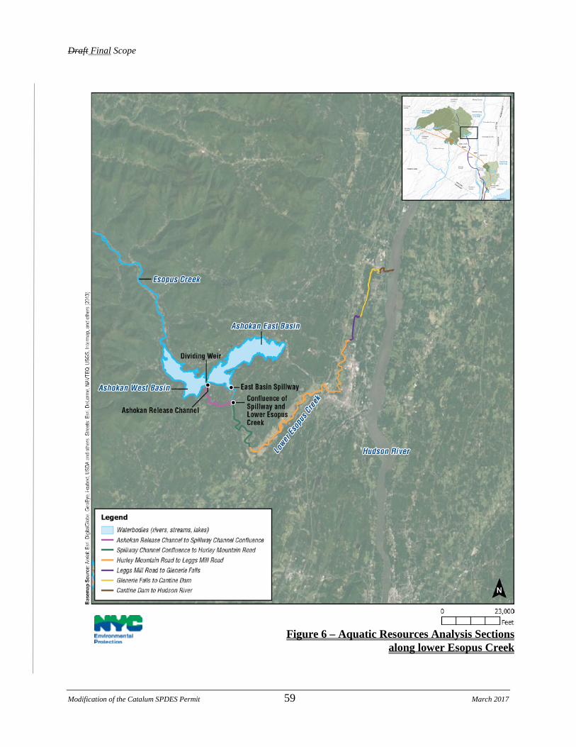
Draft Final Scope
Modification of the Catalum SPDES Permit 59 March 2017
Figure 6 – Aquatic Resources Analysis Sections along lower Esopus Creek
Modification of the Catalum SPDES Permit 60 March 2017
Draft Final Scope
Each monitored stream channel cross section will also receive an evaluation of bank characteristics and flow distribution in the channel to predict the potential risk for bank erosion from the releases under the Interim Ashokan Release Protocol against assumed baseline conditions under the Future without the Proposed Action. This approach will apply Rosgen’s BANCS (Bank Assessment for Non-point source Consequences of Sediment) model to assess the potential for stream bank erosion and predict possible stream bank erosion (Rosgen, 2006). Alternative or additional assessments may be adopted as needed to address specific concerns or limitations of the BANCS model, such as that of Pfankuch (1975).
Due to the concern that Ashokan Reservoir releases can lead to excess sediment deposition, locations of potential deposition will be identified based on the hydraulic modeling analysis that may identify stream segments that are particularly prone to deposition of fine sediment and sand entrained from lower Esopus Creek eroding banks, and the potential for significant adverse impacts resulting from potential deposition will be evaluated. Final cross section selection will also be based on the ability to obtain permissions from property owners.
c. Wetlands
Based on the hydrologic mapping conducted along the entire reach of the lower Esopus Creek (see Section 2.3.1.8 above), the anticipated inundation areas under the Interim Ashokan Release Protocol will be investigated for wetlands using current federal delineation methods. The analysis of the potential for impacts related of the Proposed Action will compare newly collected data to existing data along the lower Esopus Creek. Upstream of the spillway confluence, baseline conditions were established during the 2006, 2009, and 2010 studies, and all 47 wetlands in this location will be revisited to look for changes in wetland extent or characteristics that could potentially be related to operation of the Ashokan Release Channel. Downstream of the spillway confluence, a photographic survey was conducted prior to the fall 2011 storm events to document vegetative communities, stresses, and erosion that will be used to describe baseline conditions. From this, additional wetlands will be selected, as described below, in order to identify potential impacts that may occur from operation of the Ashokan Release Channel under the Interim Ashokan Release Protocol. Since a significant amount of data is not available downstream of the spillway confluence, this portion of the analysis will be qualitative. The qualitative assessment will include analysis of two wetlands outside the zone of influence for comparison to sites that will potentially be inundated. The 47 wetland areas identified upstream of the spillway confluence and up to ten (10) sample sites within areas of inundation downstream of this point (including two sites meant to serve as controls) will be delineated in order to verify potential impacts. Upstream, the re-delineation will be limited to areas of observed changes to boundaries or vegetative composition. Global Positioning System (GPS) data from previous studies will be used to determine if boundaries have changed. Downstream, the 10 selected sample sites will be photographed and delineated. As with prior studies, all wetland surveys will be completed during the growing season and would be in accordance with methods outlined by the U.S. Army Corps of Engineers. Wetland
Draft Final Scope
Modification of the Catalum SPDES Permit 61 March 2017
data and boundary points will be marked and located using a GPS. The GPS data will be transferred onto relevant site mapping using the U.S. State Plane 1983, New York East coordinate system. The Regional Supplement Data Forms will be used to document detailed vegetation, hydrology, and soils data at a specific location established within the wetland complex for comparison. Wetland function and value assessments will be performed at each re-delineated wetland using the methods outlined in The Highway Methodology Workbook Supplement, Wetland Functions and Values: A Descriptive Approach, USACE New England Division (NEDEP-360-1-30a 1995).18
As with the wetlands downstream of the spillway confluence, floodplain forests will be initially identified using aerial imagery. This will establish Baseline Conditions prior to the fall storm events for comparison. From this, and based on the zone of inundation associated with operation of the Ashokan Release Channel under the Interim Ashokan Release Protocol identified in the Hydrologic and Hydraulic Assessment (Section 2.3.1.18), selected forested floodplain areas between the Ashokan Release Channel and spillway confluence will be sampled using transects of 500-foot intervals. Due to the steep terrain that exists along the portion of the lower Esopus Creek upstream of the spillway confluence, floodplain forests are not located in this area, and surveys will be located downstream of this point. Up to ten (10) transects are planned based on the results of the inundation models, including two sites meant to serve as controls. The transects will would be established perpendicular to the stream and will be flagged and mapped with a GPS. The transect data will include the tree species, diameter (dbh), location along the transect, condition, any observed stresses, and streambank stability. Combined with the limits of inundation, this work will identify potential impacts to the floodplain forest that will be described based on the species present and their tolerance to inundation.
d. Wildlife
To evaluate the potential for, and extent of any predicted impacts to herptiles, avifauna, bats, and other mammals, findings of the hydraulic analysis (see Section 2.3.1.8) and Wetland studies (this section, analysis c) will be considered. If it is determined that releases under the Proposed Action do not exceed normal flood events and typical water quality for the lower Esopus Creek, herptile, avian, bat, and other mammal studies may not be required. Unless the aforementioned studies indicate that detailed studies for endangered/threatened and other wildlife impacts are appropriate, the wildlife studies would be limited to general observations made during the wetland analysis. These observations would be included in the Highway Method assessment. If either the
18 An assessment methodology of the U.S. Army Corps of Engineers, New England referred to as ‘The Highway methodology Workbook Supplement, Wetland Functions and Values: A Descriptive Approach” that involves performing a functions and values assessment at each wetland community provides a review of the thirteen (13) functions and values that are considered by the USACE Regulatory Branch for any Section 404 wetland permit. The wetland evaluation should be qualitative description of the physical characteristics along with a determination of the principal functions and values exhibited by the wetland system.
Draft Final Scope
Modification of the Catalum SPDES Permit 62 March 2017
hydraulic or wetland studies identify probable impacts to these resources, herptile and avian surveys would be conducted along areas susceptible to higher water surface elevations or locations of impacted habitat, and would be completed in consultation with the U.S. Fish and Wildlife Service and NYSDEC according to standard threatened and endangered species protocols.
2.3.1.10 Hazardous Materials
Hazardous materials are solids, liquids, and gases that can harm people, other living organisms, property, or the environment. To the extent that elements of the Proposed Action require new construction, cause soil disturbance, or result in generation, storage, or transportation of hazardous materials, the potential for impacts from the Proposed Action on hazardous materials will be assessed. There is not expected to be new in-ground disturbance within the lower Esopus Creek study area with the exception of the area associated with the AFC. There are hazardous materials (lead paint and asbestos-containing materials) thought to be present on site at the AFC. A separate hazardous materials assessment is being conducted in association with other work at that site. The results of the study, including the methods in which the materials will be properly handled and disposed, will be summarized in this EIS.
Although it is not anticipated there would be additional ground disturbance associated with the Proposed Action, there may be erosion that could disturb hazardous materials if they exist along the banks and floodplain of lower Esopus Creek. Should the other studies conducted as part of this assessment, most specifically the hydraulic and hydrologic (Section 2.3.1.18) and geomorphic studies (Section 2.3.1.19) show the potential for streambank erosion, these locations would be evaluated for the presence of hazardous materials in accordance with applicable American Society Testing Materials and NYSDEC protocols.
2.3.1.11 Infrastructure and Energy
The operation of the Proposed Action is not expected to have a potential effect on water consumption or sewage generation rates or electrical demand within the lower Esopus Creek study area. This EIS would will analyze any potential impacts to municipal water and wastewater systems, as well as properly constructed and maintained19 and private wastewater systems. To the extent that there is a change associated with the Proposed Action, including an increase in DEP’s ability to provide high quality drinking water, it will be evaluated in the EIS.
19 Per NYSDOH Wastewater Treatment Standards for Individual Household Systems and NYCRR Part 5, Subpart 5-1 Standards for Water Wells - Appendix 5B.
Draft Final Scope
Modification of the Catalum SPDES Permit 63 March 2017
2.3.1.12 Solid Waste
Solid waste impacts are analyzed based on quantities produced in the lower Esopus Creek study area and demand for services. The Proposed Action is not expected to have an effect on solid waste services. To the extent that there is a change associated with the Proposed Action, it will be evaluated in the EIS.
2.3.1.13 Transportation
Any vehicle trips anticipated to be associated with operation of Ashokan Release Channel will be below traffic screening thresholds and not warrant further analysis. The Proposed Action is not expected to generate additional parking demand or substantially increase, decrease, or otherwise change pedestrian traffic flows or transit riders in the study area. Therefore, the Proposed Action is not expected to have an effect on parking, pedestrians, or transit services, or warrant accident analyses in the lower Esopus Creek study area. If further analysis is required, the change in traffic (delay and level of service) at key locations will be evaluated and described, and the potential for impacts to occur will be based on a comparison to the Future without the Proposed Action.
2.3.1.14 Air Quality
It is anticipated that there will be no new stationary or mobile air emission sources associated with operation of the Ashokan Release Channel and very few vehicle trips. Therefore, any air sources associated with the operation of the Ashokan Release Channel will be below air quality screening thresholds and not warrant further analysis. In the event the Proposed Action could potentially impact air quality, an analysis of each source of emissions will be conducted. For stationary sources, a screening-level analysis followed, if necessary, by detailed dispersion analyses to evaluate compliance with applicable air quality standards will be conducted. The same will be done for mobile sources, if applicable. Estimated short-term and annual pollutant concentrations will be added to appropriate background levels, and total pollutant concentrations will be compared with the National Ambient Air Quality Standards (NAAQS). The change in air quality for criteria pollutants at property boundary receptors (for stationary sources) and sidewalk receptors (for mobile sources) will also be analyzed, where applicable.
2.3.1.15 Greenhouse Gas Emissions
Greenhouse gases (GHGs) are gases in the atmosphere that can absorb and then emit radiation. There are numerous primary GHGs, which include: water vapor, carbon dioxide, methane, nitrous oxide, and ozone. Historically, the burning of fossil fuels (gasoline, fuel oil, coal, and natural gas) has contributed to an overall increase in the amount of carbon dioxide in the atmosphere. The emissions of carbon are directly associated with the amount of energy consumption. Given the importance of global climate change impacts and SEQRA and CEQR’s mandate to address adverse environmental impacts, it is suggested to include a discussion of GHG emissions in certain
Draft Final Scope
Modification of the Catalum SPDES Permit 64 March 2017
instances. However, given the nature of the Proposed Action, operation of the Ashokan Release Channel would not result in sources of GHG emissions requiring quantitative assessment.
2.3.1.16 Noise
It is anticipated that there will be no new stationary or mobile noise emission sources associated with operation of the Ashokan Release Channel and very few vehicle trips. Therefore, any noise sources associated with the operation of the Ashokan Release Channel will be below noise screening thresholds, and not warrant further analysis.
2.3.1.17 Public Health
The Proposed Action includes operation of the Ashokan Release Channel to reduce the need for chemical addition to control episodic turbidity events, and does not warrant examination of the potential for impacts to public health. If appropriate, the potential for adverse public health effects will be identified from other impact analyses prepared for the EIS and summarized.
2.3.1.18 Construction Analysis
There are no construction activities anticipated with use of the Ashokan Release Channel. Therefore, a construction analysis is not warranted.
2.3.1.19 Environmental Justice
The NYSDEC issued Commissioner Policy 29 (CP 29) – Environmental Justice and Permitting (EJ Policy) on March 19, 2003. The EJ Policy sets forth guidelines for evaluation of disproportionate adverse environmental impacts on minority or low-income populations. Maps of the lower Esopus Creek study area were prepared to identify any Potential Environmental Justice (PEJ) areas (minority and low-income communities) based on NYSDEC criteria. As there are no PEJ areas within the lower Esopus Creek study area, an EJ assessment is not warranted.
2.3.2 Kensico Reservoir
The study area for Kensico Reservoir will include a one quarter mile study area around the Catskill Influent Chamber (CATIC) site and a potential location for a dewatering facility near West Lake Drive, as well as a 400-ft radius on either side of a temporary pipeline that would be installed between the CATIC site and the West Lake Drive site (see Figure 7). Several studies were undertaken by DEP related to the potential amount of alum floc in Kensico Reservoir, the potential dredging and dewatering system that would be required to remove that amount of alum floc, and the potential effects of dredging the reservoir near CATIC. The EIS will use results from these studies to assess the potential for significant adverse effects of the Proposed Action. For purposes of the EIS analysis, it is assumed that alum floc removal is anticipated to begin in 2024. The assessment of proposed dredging included in the EIS will be based on information available to DEP at this time.

Draft Final Scope
Modification of the Catalum SPDES Permit 65 March 2017
Figure 7 – Kensico Reservoir Creek Study Area
Draft Final Scope
Modification of the Catalum SPDES Permit 66 March 2017
If there are substantial changes in the future, (e.g. the amount of material that will be removed, the type and duration of dredging activities), an additional environmental review of the proposed dredging will be undertaken.
2.3.2.1 Land Use, Zoning, and Public Policy
While not expected, elements of the Proposed Action that have the potential to affect land use and zoning within the Kensico Reservoir study area will be assessed. The analysis will also consider consistency of the Proposed Action with, and its potential for adverse effects on, applicable public policies within the study area. The land use, zoning, and public policy assessment will include a description of Baseline Conditions, and conditions in the Future without the Proposed Action and the Future with the Proposed Action scenarios.
Baseline Conditions
The Baseline Conditions assessment will consist of the following steps:
• Map and describe existing land uses, zoning, and recent trends in the study area;
• Identify and describe predominant land use and zoning patterns in the study area based on existing information included in GIS for the area and compiled field surveys; and
• Describe relevant public policies that apply to each study area including Coastal Zone Management Act (CZMA) of 1972 (16 USC U.S.C. §§1451-1464), the New York City Watershed Rules and Regulations (NYC WR&R), and local plans if applicable.
Future without the Proposed Action
The Future without the Proposed Action analysis will identify future development projects in the study area that could affect land use and zoning patterns and trends by 20189 and 2024. The analysis will identify specific development projects, plans for public improvements, and pending zoning actions or other public policy actions within the study area as they relate to the Proposed Action. Based on these changes, future land use and zoning conditions in the Future without the Proposed Action will be assessed and described.
Future with the Proposed Action
This component of the Land Use, Zoning, and Public Policy analysis will assess and describe the compatibility of the Proposed Action with land use and open space and relevant trends in the study area, and the consistency of the Proposed Action with recognized public policies, such as zoning.
Draft Final Scope
Modification of the Catalum SPDES Permit 67 March 2017
2.3.2.2 Socioeconomic Conditions
Socioeconomic impacts can occur when a proposed action directly or indirectly displaces economic activities in an area. It is not expected that the Proposed Action would have the potential to affect socioeconomic conditions within the Kensico Reservoir study area. To the extent that elements of the Proposed Action have the potential to affect socioeconomic conditions within the Kensico Reservoir study area, the potential for impacts will be assessed by identifying and describing existing socioeconomic conditions in the study area using available data from local and state agencies and other sources, such as the local chambers of commerce; analyzing future changes in the study area that could affect socioeconomic conditions by 20189 and 2024; and analyzing the potential for impacts on economic output, employment, earnings, and local taxes in communities near Kensico Reservoir, as applicable.
2.3.2.3 Community Facilities and Services
It is not anticipated the Proposed Action would impact community facilities and services in the Kensico Reservoir study area. If, during the analysis, it is determined that such facilities and services could be affected, the EIS will identify and estimate the existing demand and any additional demand on community facilities or services that may be generated by the Proposed Action.
2.3.2.4 Open Space and Recreation
It is not expected that the Proposed Action would have the potential to affect open space and recreation within the Kensico Reservoir study area. To the extent that elements of the Proposed Action have the potential to affect open space and recreation, the potential for impacts will be assessed by identifying and describing: existing open spaces and recreation areas, and recent trends and relevant public policies that apply to open space in the study area; any future development projects in the study area that could affect open space and recreational activity patterns and trends by 20189 and 2024; the compatibility of the Proposed Action on open space and recreation and relevant trends in the study area; and the consistency of the Proposed Action with recognized plans, including any impacts to fishing, boating, or other recreational activities during dredging activities at Kensico Reservoir, or other operations (e.g. dewatering plant).
2.3.2.5 Critical Environmental Areas (CEAs)
There are CEAs in the Kensico Reservoir Study Area. Elements of the Proposed Action that have the potential to affect CEAs within the Kensico Reservoir study area will be assessed. The CEA assessment will include a description of Baseline Conditions, and conditions in the Future without the Proposed Action and the Future with the Proposed Action scenarios.

Draft Final Scope
Modification of the Catalum SPDES Permit 68 March 2017
Baseline Conditions
The Baseline Conditions assessment will consist of the following steps:
• Map and describe existing CEAs in the study area; and
• Identify and describe predominant criteria that resulted in the CEA designation.
Future without the Proposed Action
The Future without the Proposed Action analysis will identify future development projects in the study area that could affect CEAs by 20189 and 2024. The analysis will identify specific development projects, plans for public improvements, and pending actions within the study area as they relate to the Proposed Action. Based on these changes, any future planned CEA designations in the Future without the Proposed Action will be assessed and described.
Future with the Proposed Action
This component of the CEA analysis will assess and describe the compatibility of the Proposed Action on CEAs. The analysis will describe any impacts to CEAs during dredging activities, or other operations (e.g. dewatering plant).
2.3.2.6 Historic and Cultural Resources
This analysis will assess and describe the compatibility of the Proposed Action with historical and cultural resources in the Kensico Reservoir study area. It will also identify the potential for impacts to these resources from dredging and from construction and operation of the potential dewatering facility. Existing databases and correspondence from the State Historic Preservation Office (SHPO) of the New York State Office of Parks, Recreation, and Historic Preservation (OPRHP), local plans, and information from the Land Use, Zoning, and Public Policy analysis will be used to identify potential historic and cultural resources.
It is not expected that the Proposed Action would have the potential to affect cultural resources within the Kensico Reservoir study area. However, in the event that excavation is required in a potentially sensitive cultural resource area, a Phase I survey will be conducted. A Phase I archaeological survey involves background investigation, site inspection, and limited subsurface investigations to determine if a site has possible historical and archaeological potential, with Phase IA focusing on the background investigation through a document search and Phase IB focusing on site investigation. If the Phase I investigation identifies areas where the Proposed Action could have a potential impact, future phases of examination will be identified and completed.
Draft Final Scope
Modification of the Catalum SPDES Permit 69 March 2017
2.3.2.7 Aesthetic (Visual) Resources
Visual resources are important public view corridors, vistas, and natural or built features. One element of the Proposed Action, the Kensico Reservoir dredging and dewatering facility will result in use and construction of above grade structures in the Kensico Reservoir study area. A field reconnaissance will be conducted to determine whether these proposed elements of the Proposed Action will be visible along sensitive view corridors. If there is a view corridor that may be impacted, representative sites from within this visually sensitive area will be selected for visual simulations. This information will be used to determine whether changes resulting from the Proposed Action would create a substantial change in the views from affected resources as compared to the Future without the Proposed Action conditions.
2.3.2.8 Water Resources and Water Quality
For the Kensico Reservoir assessment in this EIS, water resources include surface waters, wetlands, and floodplains. The Kensico Reservoir is designated Class AA and currently meets its designated use as an unfiltered drinking water supply. In 2006, technical investigations were performed to determine the approximate location and depth of the alum floc depositions in Kensico Reservoir. These investigations were summarized in a report submitted in October 2007 that included a bathymetric survey, a sub-bottom sonar survey, sediment sampling, current velocity measurements, computational fluid dynamics modeling, and benthic investigations. Follow up geophysical investigations were conducted in 2014 that included sediment grab samples and vibracore sampling, physical and chemical analyses of sediment, and bathymetry. An evaluation of the benthic community in the area of alum floc deposition was also conducted in 2014. The EIS will provide a summary of these investigations and the potential for impacts to Kensico Reservoir. The Proposed Action also includes dredging at Kensico Reservoir. The EIS will present the estimated quantity of alum that will be dredged and the potential for impacts to water quality in Kensico Reservoir.
Baseline Conditions
As part of the Baseline Conditions analysis, water quality, particularly turbidity, in the Catskill System (Schoharie Reservoir, Esopus Creek, Ashokan Reservoir, and Kensico Reservoir) will be described. The causes of turbidity, including geological conditions, and the history of turbidity events and alum addition will be discussed. In Kensico Reservoir, the areas of alum floc deposition will be identified and described.
Future without the Proposed Action
The EIS will include a discussion of anticipated changes to water resources and water quality in the Future without the Proposed Action in 20189 and in 2024 that will include actions within the Kensico Reservoir study area that could affect water sources or water quality. The historical
Draft Final Scope
Modification of the Catalum SPDES Permit 70 March 2017
turbidity events record will be used to determine future reasonable worst case conditions, including recent longer term turbidity events. However, it will also include use of the Croton Water Filtration Plant that, once on line, will allow DEP to minimize use of the Catskill System during these turbidity events.
In the Future without the Proposed Action, the EIS water resources and water quality analysis will assume that the Proposed Action would not be implemented, the existing Catalum SPDES Permit for alum addition at CATIC would not be modified to allow for releases into the Lower Esopus under a revised Interim Ashokan Release Protocol. Thus, the Future without the Proposed Action would assume alum addition at Kensico Reservoir. In addition, the Future without the Proposed Action for Kensico Reservoir will also assume that dredging to remove the existing alum deposits has not yet been completed.
Future with the Proposed Action - Kensico Reservoir
The EIS will analyze the Proposed Action to determine the extent to which alum and other chemical additions at Kensico Reservoir can be minimized. In particular, Ashokan Reservoir management (West Basin drawdown and Ashokan Release Channel Operation) and Catskill Aqueduct improvements (Shaft 4 Interconnection and Stop Shutter Improvements) are expected to reduce the turbidity level in water entering Kensico Reservoir and the need for alum treatments.
A number of operational scenarios will be evaluated to determine the effects of different turbidity control measures on turbidity levels, alum use, and effects of dredging. The model will be run under scenarios with and without the use of the Ashokan Release Channel, and with Shaft 4 interconnection and/or installing stop shutters in the Catskill Aqueduct to determine the effects of different operational scenarios on turbidity entering Kensico Reservoir. A modeling program called OASIS-W2OST and simulates system operation decisions made by water managers, as well as in-reservoir water quality and turbidity transport, using defined system operation rules/preferences and the historical hydrologic record as an indicator of potential future hydrologic conditions. The OST OASIS-W2 model will be used to predict the potential for impacts of the Proposed Action on turbidity and alum use. Daily turbidity levels and alum dosages to Kensico Reservoir will be estimated for Kensico Reservoir using the OST OASIS-W2 model. In addition, a sub-model extension to OST OASIS-W2 will estimate the potential depth and areal deposition of alum floc in Kensico Reservoir at CATIC from future alum addition. For selected turbidity events, OST OASIS-W2 deposition analysis will be supported by high-resolution deposition modeling using the Kensico Reservoir three dimensional model developed for DEP, which estimates turbidity transport and deposition in the Kensico Reservoir by solving fluid dynamics equations in three dimensions.
In addition, the EIS will summarize results of laboratory tests on water samples obtained from Kensico Reservoir to characterize the fate of alum under various conditions (i.e. pH, temperature, and dissolved oxygen). These results will be used in conjunction with model output to describe the

Draft Final Scope
Modification of the Catalum SPDES Permit 71 March 2017
potential of the Proposed Action’s effects on water quality, and to describe the potential of the Proposed Action’s effects on natural resources within the reservoir (see Section 2.3.2.9). The assessment of alum use at Kensico Reservoir will address two types of potential impact on the water quality at Kensico Reservoir: (1) the physical effects of turbidity, alum floc, and dredging, and (2) the potential for changes in water quality from potentially suspended aluminum on particles in the water column and any from potential temporary increase in turbidity from dredging.
The area of alum floc will be described under future conditions. Previous alum floc modeling conducted by DEP assumed higher flow rates of Catskill water to Kensico Reservoir. With the Croton Water Filtration Plant on line, the Shaft 4 Interconnection, and more frequent use of installing stop shutters in the Catskill Aqueduct, these flows can be minimized as well as the use of alum and the area and amount of floc deposition.
2.3.2.9 Natural Resources
For the Kensico Reservoir assessment, natural resources include vegetation, wildlife, and benthic and aquatic resources. Vegetation includes trees, shrubs, and herbaceous plants, and wildlife includes threatened or endangered species. Aquatic resources include fish.
The Proposed Action has the potential to affect alum treatment and resultant alum deposition in Kensico Reservoir, which has the potential to impact aquatic resources within Kensico Reservoir. Numerous species of aquatic macrophytes, invertebrates, and vertebrate species reside in, and may be transported between, the streams and reservoirs that comprise the City’s water supply system. Therefore, it is not possible to directly evaluate the risks to every species in the reservoirs and streams. However, the EIS analysis will assess the potential for impacts from the Proposed Action on species that are considered to represent critical components of trophic levels (position in a food web) and trophic functions within Kensico Reservoir.
Potential effects of the Proposed Action on the benthic community would be related to degradation of physical habitat from the accumulation of alum floc over the substrate or disturbance from dredging. Physical effects would be dependent upon the frequency and duration of alum use and the thickness of the alum deposit; and, for dredging, upon the duration of dredging activities, time of year, type of dredging equipment used, dredge operating parameters, and the rate of recolonization of the dredged area. Potential effects on fish can also be caused by exposure to aluminum, and can be species and life stage specific, and affect food web relationships, feeding, and growth.

Draft Final Scope
Modification of the Catalum SPDES Permit 72 March 2017
Baseline Conditions
Vegetation and Wildlife
The Baseline Conditions assessment will summarize existing vegetation and wildlife in the study area based on 2007 studies, updated to reflect any recent changes to vegetation and wildlife in the study area.
Benthic Resources
Benthic samples were collected near the CATIC in November 1997 (after the 1996 alum addition), and in April and July 2007 (after the 2006 alum addition), and in 2014 (after the 2011-2012 alum addition). Sampling was conducted from Pleasantville Cove, south to the end of Big Peninsula, and west to the cove containing the Catskill Upper Effluent Chamber. Sample locations were selected based on substrate type, Kensico Reservoir depth and flow patterns, and in locations inside and outside the floc depositional area. In addition to the benthic samples, in 2007 and 2014, water quality measurements (i.e. dissolved oxygen, pH, conductivity, and temperature) were obtained for both surface and near-bottom waters at each sampling station. Sediment was also analyzed for total aluminum and percent moisture, percent organic carbon, percent solids, and grain size at sixteen stations not previously sampled for these variables. In addition, bathymetric studies were conducted in Kensico Reservoir to define the depth of sediment and estimated depth and areal extent of historical alum deposition.
Benthic samples were also collected near DEL 17 in August 2009 to document the existing baseline conditions in a Kensico Reservoir area where alum has not been applied. Seventeen (17) samples were collected near the outlet at Shaft 17, in Webers Cove, Dark Hollow, and Rye Lake. At each sample location, two benthic grab samples and one sediment sample (for grain size analysis) were collected. Water quality parameters (pH, dissolved oxygen, conductivity, and temperature) were recorded.
Results of the sampling will be summarized in the EIS and used in conjunction with modeling conducted for the EIS to describe the existing benthic conditions in the Kensico Reservoir inside and outside the alum floc deposition area.
Kensico Reservoir Fish
In August 2006, DEP conducted a hydroacoustic survey of fish distribution in the Kensico Reservoir, while NYSDEC conducted a gill netting survey to study species composition and relative abundance of fish. A hydroacoustic survey is a general term for the application of sound in water to detect the presence, relative abundance, distribution, and size of fish. A gill net survey is the collection of fish using a vertical panel of mesh netting (gill net) to capture a diversity of fish species. The net is deployed in a straight line, either along the bottom of a lake or floating at

Draft Final Scope
Modification of the Catalum SPDES Permit 73 March 2017
the surface, and forms a curtain that fish become entangled in. For the Kensico Reservoir, results from the hydroacoustic survey and the gill net data, and additional available NYSDEC data (e.g. biological surveys) will be evaluated and used, to the extent practicable, to characterize the existing open water (pelagic) fish community in the Kensico Reservoir.
Future without the Proposed Action
The EIS will include a description of anticipated changes to vegetation and wildlife in the Kensico Reservoir Study Area, and to the aquatic community in Kensico Reservoir at CATIC that could affect these resources in the Future without the Proposed Action in 20189 and 2024. In the Future without the Proposed Action, the EIS benthic analysis will assume that the Proposed Action would not be implemented and the existing Catalum SPDES Permit for alum addition would not be modified for use of the Ashokan Release Channel under a revised Interim Ashokan Release Protocol. Thus, the future without the Proposed Action for Kensico Reservoir will assume that dredging to remove the alum deposits has not yet occurred.
Future with the Proposed Action
Vegetation and Wildlife
While not expected, the Future with the Proposed Action assessment will describe the potential for impacts to vegetation and wildlife in the Kensico Reservoir study area from dredging.
Benthic
Benthic invertebrates experience a direct habitat effect in the area of alum deposition, which will provide the basis for the assessment. Modeling results will be used to predict the potential depth and areal extent of alum distribution near CATIC compared to that in the Future without the Proposed Action. The assessment of physical effects will emphasize the potential for effects on habitat and benthic invertebrate species compared from alum deposits, and from dredging near CATIC. The assessment will address the physical effects of dredging alum floc on benthic invertebrates, and the recovery potential for species. Results of this analysis will be included in the EIS.
Fish
As described in Section 2.3.2.8, modeling results that provide the estimated concentrations of aluminum in the water column under selected alum addition scenarios and water quality parameters (pH, conductivity, dissolved oxygen) will be used to assess the potential for impacts on two (2) basic fish groups: open water pelagic species (trout and alewife) and shoreline species (bass and other panfish). These two fish groups are found throughout the Kensico Reservoir, include the major species pursued by anglers, and are also the ecologically important species in the fish community. For both fish groups, spatial relationships by life stage will be compared with
Draft Final Scope
Modification of the Catalum SPDES Permit 74 March 2017
the concentration of aluminum and the distribution of alum turbidity and alum deposits, and include expected movement patterns of these species. For both fish groups, their food web relationships will be discussed in terms of effects on life stage food resources and the ability of these species to utilize alternative prey at various life stages. Finally, life stage specific toxicities will be presented using available literature, including that described in the 1996 EIS and Gensemer and Playle (1999) The potential physical effects of dredging on these fish groups will be evaluated. Results of these analyses will be included in the EIS.
2.3.2.10 Hazardous Materials
To the extent that elements of the Proposed Action require new construction; cause soil disturbance; or result in generation, storage, or transportation of hazardous materials; the potential for impacts from the Proposed Action on hazardous materials will be assessed. Chemicals used in chemical treatment such as alum, sodium hydroxide, sodium hypochlorite, and sodium metabisulfite in the Kensico Reservoir study area will be described in the EIS, including how these chemicals will be stored and transported.
Dredged material associated with the dredging of alum deposits at Kensico Reservoir will require testing and characterization for proper management in accordance with NYSDEC requirements. A description of dredging activities, control measures to limit the potential for impacts due to dredging, and planned testing and management of dredged materials will be described in the EIS.
2.3.2.11 Infrastructure and Energy
The operation of the Proposed Action is not expected to have a potential effect on water consumption or sewage generation rates, public water supply, or electrical demand in the Kensico Reservoir Study area, though there may be an increase during dredging and dewatering activities. To the extent that there is a change associated with the Proposed Action, including an increase in DEP’s ability to provide high quality drinking water, it will be evaluated in the EIS
2.3.2.12 Solid Waste
Solid waste impacts are analyzed based on quantities produced in the study area and demand for services. The Proposed Action is not expected to have an effect on solid waste services. Dredge spoils are not classified as solid waste under current regulations. However, management of the dredged material and any minor changes associated with additional solid waste generation from employees associated with the operations will be evaluated in the EIS.
2.3.2.13 Transportation
It is likely that vehicle trips associated with operation of the Proposed Action will be below traffic screening thresholds and not warrant further analysis – including anticipated vehicular trips associated with dredging and dewatering activities. The Proposed Action is not expected to
Draft Final Scope
Modification of the Catalum SPDES Permit 75 March 2017
generate additional parking demand or substantially increase, decrease, or otherwise change pedestrian traffic flows or transit riders in the study area. Therefore, the Proposed Action is not expected to have an effect on parking, pedestrians or transit services, or warrant accident analyses. If further analysis is required, the change in traffic (delay and level of service) at key locations will be evaluated and described, and the potential for impacts to occur will be based on a comparison to the Future without the Proposed Action.
2.3.2.14 Air Quality
The proposed dredging at Kensico Reservoir may include a temporary emergency generator, or hook-up for a portable generator, which would only be used during short-term conditions including emergencies and maintenance testing. Dredging and associated dewatering activities may include air emission generating equipment. As the generators and any air emission generating equipment would be used infrequently or on a limited basis during dredging, they would not be expected to result in significant air emissions. Therefore, no significant adverse air quality impacts from these operations on the surrounding community are expected.
It is anticipated that there will be no other new stationary sources associated with the Proposed Action and very few vehicle trips, and that an air sources associated with the operation of the Proposed Action will be below air quality screening thresholds and not warrant further analysis. In the event the Proposed Action could potentially impact air quality, an analysis of each source of emissions will be conducted. For stationary sources, a screening-level analysis followed, if necessary, by detailed dispersion analyses to evaluate compliance with applicable air quality standards will be conducted. The same will be done for mobile sources, if applicable. Estimated short-term and annual pollutant concentrations will be added to appropriate background levels, and total pollutant concentrations will be compared with the NAAQS, where applicable. The change in air quality for criteria pollutants at property boundary receptors (for stationary sources) and sidewalk receptors (for mobile sources) will also be analyzed, where applicable.
2.3.2.15 Greenhouse Gas Emissions
Dredging or dewatering activities or construction of a dewatering facility in the Kensico Reservoir study area would not result in sources of GHG emissions requiring quantitative assessment.
2.3.2.16 Noise
It is likely that vehicle trips and any stationary noise emission sources associated with the operation of the Proposed Action will be below noise screening thresholds, and not warrant further analysis. Kensico Reservoir dredging activities may include the use of an emergency generator. Dredging and any dewatering activities may include noise emission generating equipment. Since the emergency generators and any noise emission generating would be used infrequently and for a limited duration, and given the distance to nearby sensitive uses, dredging and dewatering at

Draft Final Scope
Modification of the Catalum SPDES Permit 76 March 2017
Kensico Reservoir would not be expected to result in any significant stationary noise impacts. Therefore, no further analysis is warranted. In the event the Proposed Action could potentially impact noise conditions, the types and locations of additional noise sources that would be introduced will be described. Based on these new sources, changes in noise levels because of the Proposed Action will be predicted.
2.3.2.17 Public Health
The Proposed Action is expected to reduce the need for chemical addition to control episodic events and not warrant examination of the potential for impacts to public health in the Kensico Reservoir study area. If appropriate, the potential for adverse public health effects will be identified from other impact analyses prepared for the EIS and summarized.
2.3.2.18 Construction Analysis
A dewatering facility for dredging at Kensico Reservoir may require some short-term construction activity. Construction activities required for the Proposed Action are expected to be short term (less than 2 years) and temporary, and are not expected to result in significant adverse impacts. However, should an analysis of these construction activities be warranted, the methodologies discussed below will be used to determine the potential for impacts.
If required, a detailed description of the proposed construction program will be provided in the EIS, including a timeline showing the major proposed activities. This timeline will outline a description of likely activities and corresponding location through each stage of construction, including potential storage areas, potential staging and parking areas, truck routes, sequencing, and techniques to minimize impacts during construction. Potential construction period issues that would be evaluated include: possible impacts to natural resources; traffic and parking; air quality conditions from a possible temporary generator; increases in noise levels; sediment and erosion control in the immediate area of the project site; and impacts on water supply service. Unlike the potential for impacts from the operation of a project which are permanent, potential impacts from construction are temporary. Where there is the potential for significant adverse impacts during construction, the determination of the significance of impacts from construction activities would be based on an assessment of the predicted intensity, duration, geographic extent, and the number of people who would be affected by the predicted impacts. Where potentially significant adverse impacts are identified for each of the technical areas, mitigation measures would be explored and, if feasible, mitigation for any impacts would be presented.
2.3.2.19 Environmental Justice
Maps of the Kensico Reservoir study area were prepared to identify any Potential Environmental Justice (PEJ) areas (minority and low-income communities) based on NYSDEC criteria. There are no PEJ areas within the Kensico Reservoir study area; therefore, an EJ assessment is not warranted.

Draft Final Scope
Modification of the Catalum SPDES Permit 77 March 2017
2.4 Cumulative Impacts
The EIS will provide an assessment of the potential cumulative impacts from the Proposed Action on the Water Supply System, lower Esopus Creek, and Kensico Reservoir. The cumulative assessment will be based on the combination of the proposed operational practices in the Catskill and Delaware Systems that are part of the Proposed Action, including any overlapping or cumulative effects of multiple study areas used in the analyses, and previous environmental reviews, as applicable.
2.5 Alternatives Analysis
The purpose of an alternatives analysis in an EIS is to examine reasonable alternatives to the Proposed Action that achieve the goals and objectives of the Proposed Action and reduce, mitigate, or eliminate potential impacts resulting from the Proposed Action. In addition to evaluating impacts of the Proposed Action, the EIS will consider alternatives that may avoid or minimize those potential impacts.
DEP has rigorouslyanalyzed a range of measures in its Catskill Turbidity Control Study, which has resulted in DEP’s operations of the Catskill System. The EIS will consider a range of alternatives to the Proposed Action, including the No Action alternative and reasonable operational alternatives, summarized below. The EIS will also include an analysis of combinations of the feasible structural and operational alternatives.
A description and evaluation of each Alternative will be provided at a level of detail sufficient to permit a comparative assessment of each alternative discussed.
2.5.1 The No Action Alternative
DEP currently has the ability to apply alum to its Catskill System to control turbidity events and ensure the safe operation of its water supply system, and also as required to meet federal and state regulatory turbidity limits for unfiltered surface water supplies - less than five nephelometric turbidity units (NTUs)20 at the Kensico Reservoir Catskill Lower Effluent Chamber and Delaware Shaft 18. The existing control measures are effective in managing turbidity from the Catskill System to Kensico Reservoir. However, during extreme storm events, such events can result in water with high turbidity levels being transferred from Ashokan Reservoir to Kensico Reservoir via the Catskill Aqueduct, resulting in the need for alum treatment. Alum controls turbidity by coagulating suspended particulate matter so it can more readily settle out of the water column. The use of sodium hydroxide in conjunction with the use of alum during Catskill Aqueduct turbidity events has been found to improve the efficacy of controlling turbidity levels in the aqueduct
20 NTUs are used to measure turbidity levels, and are a measure of the scattering of light as it passes through the water.
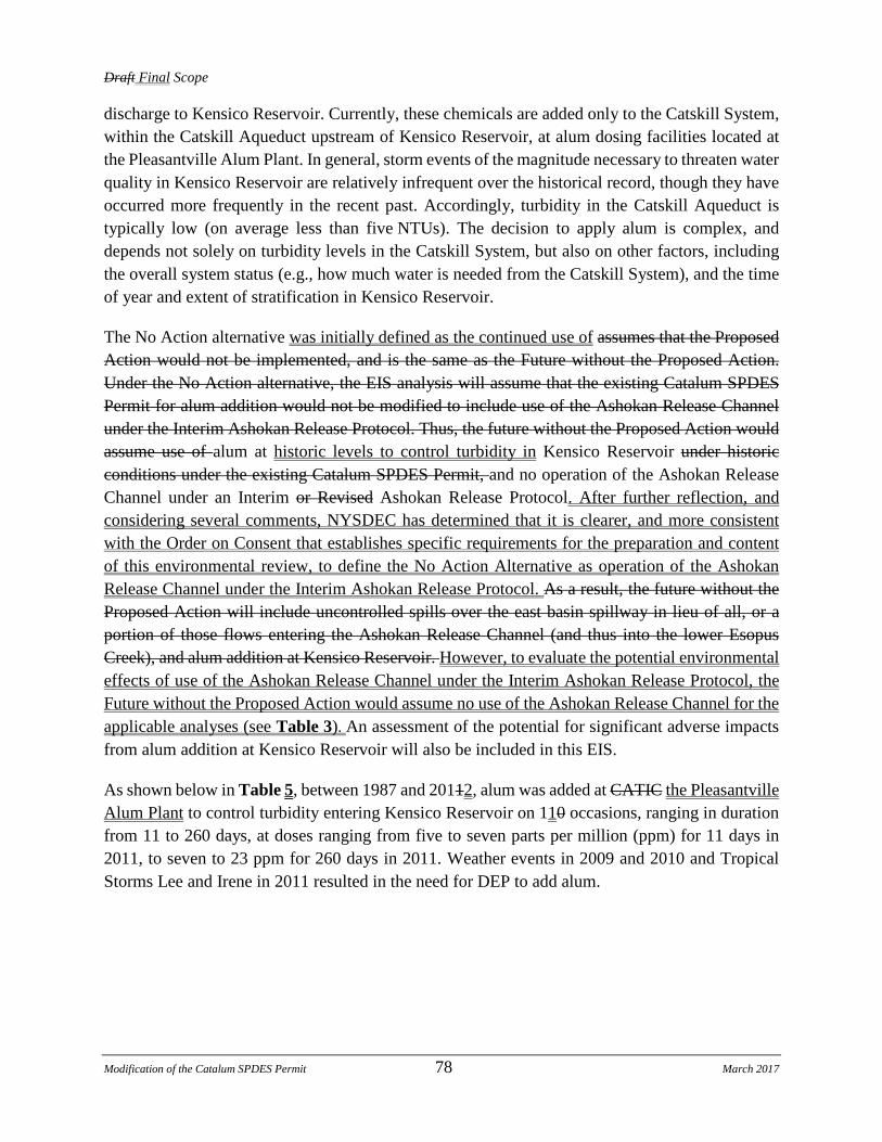
Draft Final Scope
Modification of the Catalum SPDES Permit 78 March 2017
discharge to Kensico Reservoir. Currently, these chemicals are added only to the Catskill System, within the Catskill Aqueduct upstream of Kensico Reservoir, at alum dosing facilities located at the Pleasantville Alum Plant. In general, storm events of the magnitude necessary to threaten water quality in Kensico Reservoir are relatively infrequent over the historical record, though they have occurred more frequently in the recent past. Accordingly, turbidity in the Catskill Aqueduct is typically low (on average less than five NTUs). The decision to apply alum is complex, and depends not solely on turbidity levels in the Catskill System, but also on other factors, including the overall system status (e.g., how much water is needed from the Catskill System), and the time of year and extent of stratification in Kensico Reservoir.
The No Action alternative was initially defined as the continued use of assumes that the Proposed Action would not be implemented, and is the same as the Future without the Proposed Action. Under the No Action alternative, the EIS analysis will assume that the existing Catalum SPDES Permit for alum addition would not be modified to include use of the Ashokan Release Channel under the Interim Ashokan Release Protocol. Thus, the future without the Proposed Action would assume use of alum at historic levels to control turbidity in Kensico Reservoir under historic conditions under the existing Catalum SPDES Permit, and no operation of the Ashokan Release Channel under an Interim or Revised Ashokan Release Protocol. After further reflection, and considering several comments, NYSDEC has determined that it is clearer, and more consistent with the Order on Consent that establishes specific requirements for the preparation and content of this environmental review, to define the No Action Alternative as operation of the Ashokan Release Channel under the Interim Ashokan Release Protocol. As a result, the future without the Proposed Action will include uncontrolled spills over the east basin spillway in lieu of all, or a portion of those flows entering the Ashokan Release Channel (and thus into the lower Esopus Creek), and alum addition at Kensico Reservoir. However, to evaluate the potential environmental effects of use of the Ashokan Release Channel under the Interim Ashokan Release Protocol, the Future without the Proposed Action would assume no use of the Ashokan Release Channel for the applicable analyses (see Table 3). An assessment of the potential for significant adverse impacts from alum addition at Kensico Reservoir will also be included in this EIS.
As shown below in Table 5, between 1987 and 20112, alum was added at CATIC the Pleasantville Alum Plant to control turbidity entering Kensico Reservoir on 110 occasions, ranging in duration from 11 to 260 days, at doses ranging from five to seven parts per million (ppm) for 11 days in 2011, to seven to 23 ppm for 260 days in 2011. Weather events in 2009 and 2010 and Tropical Storms Lee and Irene in 2011 resulted in the need for DEP to add alum.
Draft Final Scope
Modification of the Catalum SPDES Permit 79 March 2017
Table 5: Historical Alum Use at Kensico Reservoir1
Start Date Alum Treatment
Days Total Alum Used by
Event (lbs) Total Alum Used by
Year (lbs) 2/21/1981 72 3,060,960 3,060,960 4/9/1984 44 1,241,680 1,241,680 4/6/1987 43 921,680 921,680 1/22/1996 151 2,477,954 2,477,954 1/14/1997 15 237,046 237,046 1/10/2001 23 482,226 482,226 4/5/2005 76 1,740,393
4,065,218 10/13/2005(2) 40
7,383,144 11/30/2005(2) 31 1/1/2006(2) 99
5,058,319 5/15/2006(2) 10 6/27/2006(2) 36 1/31/2011 11 208,462
4,777,739 3/2/2011 79 1,238,790 8/29/2011(3) 124
5,950,055 1/1/2012(3) 136 2,619,568 Notes: (1) The 10-year average annual alum use is 1,245,562 pounds. (2) These are considered one event, 216 days of alum treatment from 10/13/05 through 8/2/06. (3) These are considered one event, 260 days of treatment from 8/29/11 through 5/15/12.
2.5.2 Ashokan Reservoir Alternatives
Phase III of the Catskill Turbidity Control Study completed in December 2007 focused on alternatives at Ashokan Reservoir that could reduce turbidity levels entering Kensico Reservoir. Six potential turbidity control alternatives were evaluated in the “Phase III Final Report - Catskill Turbidity Control Study” dated December 31, 2007. Alternative 6 (Catskill Aqueduct Improvements and Modified Operations) was predicted to have substantial reductions in turbidity levels and resultant alum addition and is part of the Proposed Action. The other five alternatives are described below and will be included and summarized in the EIS alternatives analyses.
1) Ashokan Reservoir Alternative 1 – West Basin Outlet
This alternative would involve construction of a new outlet structure in the west basin, consisting of a gated weir discharging to Esopus Creek downstream of the Olive Bridge

Draft Final Scope
Modification of the Catalum SPDES Permit 80 March 2017
Dam. The west basin outlet would be operated as a preventative measure, used to create a void in the west basin pending high flow, high turbidity forecasted conditions. Conceptual designs were evaluated for single weir and multi-level outlet structures, with capacities of 2,000, 4,000, and 6,000 MGD.
2) Ashokan Reservoir Alternative 2 – Dividing Weir Crest Gates
The Phase III study evaluated options for temporarily increasing storage in the west basin. This would involve installation of inflatable gates to allow turbid inflows to be stored for a longer period of time before being transferred to the east basin and carried downstream.
3) Ashokan Reservoir Alternative 3 – East Basin Diversion Wall and Channel Improvements
Improvements to the east basin diversion wall would involve extending the height and length of the diversion wall that directs flow from the west basin into the east basin to help prevent turbid water that overtops the dividing weir from “short-circuiting” towards the east basin Upper Gate Chamber intake. The analysis includes consideration of three alternative wall lengths as well as potential improvements to the adjacent east basin spillway channel.
4) Ashokan Reservoir Alternative 4 – Upper Gate Chamber Modifications
Improvements at the Upper Gate Chamber would be implemented mainly to provide enhanced multi-level withdrawal capability. This capability currently exists in a limited capacity. The improvements would allow for greater flexibility in choosing optimal elevations and would allow for greater ease of operation.
5) Ashokan Reservoir Alternative 5 – East Basin Intake
Alternative 5 would include construction of a new intake towards the center of the east Basin to provide an alternative withdrawal location potentially less susceptible to elevated turbidity conditions. Evaluated designs included a single level intake as well as a multi-level intake.
In addition to the alternatives previously evaluated as part of Phase III of the Catskill Turbidity Control Study, the following additional alternatives would be evaluated as part of the EIS. Some of the following alternatives have been evaluated previously, for example as part of the Value Engineering review of the Catskill Turbidity Control Study, while others have not been formally evaluated.

Draft Final Scope
Modification of the Catalum SPDES Permit 81 March 2017
6) Ashokan Reservoir Alternative 6 – Changed Release Channel Operation
This alternative will evaluate potential effects of different operation scenarios under the Interim Ashokan Release Protocol that may increase community release flows downstream of Ashokan Reservoir and/or increase the capacity of and flows through the Ashokan Release Channel.
Modification to the IRP scenarios that will be analyzed in the EIS will include, but not be limited to, the following:
• Evaluate a range of Community Releases under normal hydrologic conditions,
• Evaluate changes to the Combined Seasonal Storage Objective (CSSO),
• Evaluate Release Rates up to 1,200 MGD for Spill Mitigation Releases,
• Evaluate Release Rates up to 1,200 MGD for Operational Releases and
• Evaluate the feasibility of blending releases from Ashokan east and west basins, taking into consideration potential impacts to the public water supply system.
All scenarios evaluated in this alternative would analyze the potential significant adverse impacts and/or potential benefits of these scenarios on both DEP’s water supply and the lower Esopus Creek as described in Section 2.3.1. The resulting analyses will be used to inform a Revised Operating Protocol to be issued with the DEIS.
7) Ashokan Reservoir Alternative 7 – Bypass of Low Turbidity Upper Esopus Creek Water directly to the Ashokan East Basin
Alternative 7 would include construction of a bypass tunnel or other structural improvement to enable routing Ashokan reservoir inflow from the upper Esopus Creek directly to the East Basin.
8) Ashokan Reservoir Alternative 8 – Bypass of Upper Esopus directly to the lower Esopus Creek
Alternative 8 would include construction of a bypass tunnel or other structural improvement to enable routing Ashokan reservoir inflow from the upper Esopus Creek around or through the reservoir, discharging to the lower Esopus Creek below the reservoir.

Draft Final Scope
Modification of the Catalum SPDES Permit 82 March 2017
2.5.3 Alternatives along the Catskill Aqueduct
In addition to alternatives at Ashokan Reservoir, the following alternatives for operation of the Catskill Aqueduct that include options to discharge water from the Catskill Aqueduct prior to its reaching the Kensico Reservoir will be evaluated in the EIS.
1) Catskill Aqueduct Alternative 1 – Use of the Hudson River Drainage Chamber
This alternative would involve reconstruction and modifications to the existing Moodna/Hudson River Tunnel drainage chamber to allow for discharges of turbid water from the Catskill Aqueduct directly into the Hudson River on the east side of the Hudson River near the borders of Putnam and Dutchess Counties. The existing Moodna/Hudson River Tunnel drainage chamber was designed to drain water from the Catskill Aqueduct for purposes of inspecting the Catskill Aqueduct, and has never been used. Modification to the drainage chamber to accommodate up to 600 MGD of flow from the Catskill Aqueduct will be evaluated.
2) Catskill Aqueduct Alternative 2 – Use of the Croton Lake Siphon
This alternative would involve use of the blow-off at the downtake shaft of the Croton Lake Siphon to allow for discharges of turbid water from the Catskill Aqueduct directly into the New Croton Reservoir.
3) Catskill Aqueduct Alternative 3 – Use of the Rondout Pressure Tunnel
This alternative would involve modification of the Rondout Pressure Tunnel Siphon Drain in order to allow for discharges of turbid water from the Catskill Aqueduct to Rondout Creek that leads to the Hudson River after its confluence with the Wallkill River.
4) Catskill Aqueduct Alternative 4 – Use of the Wallkill Pressure Tunnel Siphon Drain or the Wallkill Blow-off Chamber
This alternative would involve use of either the Wallkill Pressure Tunnel Siphon Drain, with modification, or the Wallkill Blow-off Chamber to allow for discharges of turbid water from the Catskill Aqueduct to the Wallkill River that leads to the Hudson River after its confluence with Rondout Creek.
2.5.4 Alternatives at Kensico Reservoir
The existing Catalum SPDES Permit includes a condition that required DEP to develop a report to analyze alternatives that minimize the area of floc deposition resulting from the addition of alum and sodium hydroxide at the CATIC. These alternatives were evaluated in the technical report “Feasibility of Minimizing the Area of Alum Floc Deposition in Kensico Reservoir” dated
Draft Final Scope
Modification of the Catalum SPDES Permit 83 March 2017
October 2007. To analyze the present deposition patterns and the potential benefits of structural alternatives, a computational fluid dynamics computer model of Kensico Reservoir near the CATIC was developed and six alternatives were analyzed. These alternatives are described below and will be included in the EIS alternatives analyses.
1) Kensico Reservoir Alternative 1 – Perforated Target Baffle
This alternative would involve installation of a perforated vertical baffle wall to dissipate the energy of water as it enters the CATIC cove and make the flow leaving the cove uniform, thereby reducing the area of floc deposition.
2) Kensico Reservoir Alternative 2 – Sedimentation Basin
This alternative would involve installation of two baffles on the east bank and one baffle on the west bank of the cove to interrupt the high velocity current and increase particle residence time in the area near the CATIC inlet.
3) Kensico Reservoir Alternative 3 – Perforated Baffle Wall
This alternative would involve installation of a perforated baffle wall perpendicular to the general flow direction. The purpose of this influent control alternative is to make the flow uniform before it leaves the cove as opposed to allowing the more narrow higher velocity current to project the alum floc into the open area.
4) Kensico Reservoir Alternative 4 – Submerged Weir
This alternative would involve use of a submerged weir to act as a baffle to make flow uniform, and to trap large particles that settle quickly. The submerged weir creates more uniform flow from the cove into the open area of Kensico Reservoir.
5) Kensico Reservoir Alternative 5 – Boom and Silt Curtains
This alternative would involve use of an oil boom and two silt curtains to create a large settling basin. The boom would float on the water surface and be 4 feet deep, allowing water to pass underneath. The silt curtains would be full-depth and assumed impermeable. The oil boom would partially break the high velocity current along the east bank of the CATIC Cove, creating a more uniform outgoing flow pattern from the cove. In this manner, the boom and silt curtains would form a large and enclosed settling basin.
6) Kensico Reservoir Alternative 6 – Large Settling Basin
This alternative represents a combination of concepts evaluated in Kensico Reservoir Alternatives 3 and 4. For this alternative, a perforated wall would be placed upstream to
Draft Final Scope
Modification of the Catalum SPDES Permit 84 March 2017
homogenize inflow, and an effluent weir would be placed in the open area of the cove to control outflow, making the cove and part of the open area a large settling basin. The arrangement would be designed to mimic a formal water treatment plant settling basin.
2.6 Mitigation
Where potential significant adverse impacts are identified in the EIS analyses, reasonable and practicable measures that have the potential to avoid, mitigate, or minimize these impacts will be identified. A summary of these findings and a timeframe for implementation, if available, will be presented in the EIS. Where impacts cannot be mitigated, they will be identified as unavoidable significant adverse impacts.
2.7 Growth Inducement
The Proposed Action is not anticipated to alter regional growth patterns, impact residential settlement patterns, or affect growth in employment centers. Growth inducement aspects of the proposed actions need to be addressed “where applicable and significant.” Growth inducement impacts are not anticipated, and, if any, will be treated in the context of land use impacts.
2.8 Unavoidable Impacts and Irretrievable and Irreversible Commitment of Resources
The proposed project may result in adverse impacts that are unavoidable. These unavoidable impacts will be specifically documented in the EIS. The EIS will also disclose the commitment of resources that the project may require which are irretrievable and adverse effects that are irreversible.

Draft Final Scope
Modification of the Catalum SPDES Permit A-1 March 2017
ATTACHMENT A
New York State Department of Environmental Conservation Interim Ashokan Release
Protocol dated September 27, 2013, as part of the Order on Consent dated October 4, 2013
New York State Department of Environmental Conservation/ New York City Department of Environmental Protection (DEC/DEP)
Interim Release Protocol (IRP) for the Ashokan Reservoir September 27, 2013
Introduction: DEC and DEP have agreed to implement a revised Interim Release Protocol (IRP) for the Ashokan Reservoir to enhance benefits to the community, improve flood attenuation, and provide better water quality on an interim basis and recognize that it may be modified or terminated as additional modeling and impact assessments are performed and as additional information becomes available.
The IRP is considered interim as it may be revised as a result of lessons learned during its implementation, or through a modification to SPDES permit #3-9903-00023/00006: SPDES No.: NY-0264652 issued by the DEC after an appropriate public process.
1. Community Release Protocol:
a. Purpose: to provide environmental, recreational and economic benefits to the lower Esopus Creek in a manner that will not adversely impact water supply.
b. Minimum Flow: DEP will make releases from the Ashokan Reservoir through the Ashokan Reservoir Release Channel at the rates prescribed in the following table.
Release Criteria 1 Summer (May 1 – Oct 31)
Winter (Nov 1 – Apr 30)
Normal Hydrologic Condition 15 MGD 10 MGD Turbidity >30NTU 10 MGD 4 MGD Turbidity >100 NTU 0 MGD 0 MGD Drought Warning Condition 10 MGD 4 MGD Turbidity >100 NTU 0 MGD 0 MGD Drought Condition 0 0
Note 1: Hydrologic Condition is based on the combined storage in the Cannonsville, Pepacton and Neversink Reservoirs.
c. Turbidity: When substantial contrast in turbidity exists with varying depths in the West
Basin of the Ashokan Reservoir, DEP will make reasonable efforts to make releases from the elevation with the least turbidity.
Draft Final Scope
Modification of the Catalum SPDES Permit A-2 March 2017
d. Action Stage Shutdown: The community release shall be shutdown when the USGS gage on the Esopus Creek at Mount Marion (Lower Esopus) is within 1 foot of the "Action Stage" (18') and is forecasted to reach "Action Stage", as predicted on the National Weather Service’s (NWS’s) Advanced Hydrologic Prediction Service web page.
2. Spill Mitigation Release Protocol:
a. Purpose: In order to enhance flood mitigation provided by the Ashokan Reservoir, DEP will utilize the established Conditional Seasonal Storage Objective (CSSO) rule curve depicted in Figure 1. Consistent with good practices for water supply reservoirs, and in order to ensure that sufficient resources are available during an extended dry period to support water supply needs, it is essential to ensure that the Ashokan Reservoir is filled on or around June 1st every year. To accomplish this, the CSSO must be limited and ramped. For the duration of the IRP DEP shall endeavor, to the maximum extent possible without impacting water supply reliability, to maintain reservoir levels at the CSSO, thus creating a high probability of maintaining a ten (10) percent void space from October 14 through March 15 to help mitigate flooding events. In determining the releases needed to maintain the CSSO, DEP will consider the following parameters in the evaluation: forecasted inflows over the next seven (7) days including inflow from snow water equivalent as forecast by the National Weather Service’s (NWS) Hydrological Ensemble Forecasting System (HEFS), anticipated diversions over the next seven (7) days, and the current usable reservoir storage. Based on any projected seven (7) day storage surplus, DEP will calculate total release volumes to progress toward the CSSO and allocate those volumes over the upcoming seven 7-day period. In making releases, DEP will consider reasonable requests from Ulster County for a release modification related to a downstream agricultural or recreational concern, within the limitations of the release works for the Ashokan Reservoir Release Channel and subject to DEC concurrence. Spill Mitigation releases are designed to help mitigate the effects of potential for flooding immediately below the Ashokan Reservoir to the lower Esopus Creek communities.
b. Maximum Flow: The maximum flow from the Release Channel shall not exceed 600 MGD. DEP will throttle releases as necessary so the combined flow for Ashokan spill and Ashokan Reservoir Release Channel discharge does not exceed 1,000 MGD. In addition, DEP will shutdown the Release Channel when the USGS gage on the Esopus Creek at Mount Marion (Lower Esopus) is within 1 foot of the "Action Stage" (18') and is forecasted to reach "Action Stage", as predicted on the NWS’s Advanced Hydrologic Prediction Service web page. DEP shall endeavor to achieve the CSSO in a manner that minimizes the need for maximum flow, large volume releases.
c. Turbidity: When substantial contrast in turbidity exists with varying depths in the West Basin of the Ashokan Reservoir, DEP will make reasonable efforts to make releases from the elevation with the least turbidity. The frequency of intake changes shall be limited to no more than once per week.
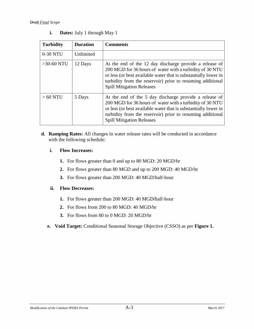
Draft Final Scope
Modification of the Catalum SPDES Permit A-3 March 2017
i. Dates: July 1 through May 1
Turbidity Duration Comments
0-30 NTU Unlimited
>30-60 NTU 12 Days At the end of the 12 day discharge provide a release of 200 MGD for 36 hours of water with a turbidity of 30 NTU or less (or best available water that is substantially lower in turbidity from the reservoir) prior to resuming additional Spill Mitigation Releases
> 60 NTU 5 Days At the end of the 5 day discharge provide a release of 200 MGD for 36 hours of water with a turbidity of 30 NTU or less (or best available water that is substantially lower in turbidity from the reservoir) prior to resuming additional Spill Mitigation Releases
d. Ramping Rates: All changes in water release rates will be conducted in accordance
with the following schedule:
i. Flow Increases:
1. For flows greater than 0 and up to 80 MGD: 20 MGD/hr 2. For flows greater than 80 MGD and up to 200 MGD: 40 MGD/hr 3. For flows greater than 200 MGD: 40 MGD/half-hour
ii. Flow Decreases:
1. For flows greater than 200 MGD: 40 MGD/half-hour 2. For flows from 200 to 80 MGD: 40 MGD/hr 3. For flows from 80 to 0 MGD: 20 MGD/hr
e. Void Target: Conditional Seasonal Storage Objective (CSSO) as per Figure 1.

Draft Final Scope
Modification of the Catalum SPDES Permit A-4 March 2017
3. Operational Release Protocol:
a. Purpose: to prevent or mitigate the spilling of more turbid west basin waters into the east basin of the Ashokan Reservoir in order to protect water quality and enhance the flood mitigation benefit that the reservoir already provides to the lower Esopus Creek communities.
b. Maximum Flow: The release will be throttled as necessary so the combined flow for Ashokan spill and Ashokan Reservoir Release Channel discharge does not exceed 1,000 MGD. In addition, shutdown when the USGS gage on the Esopus Creek at Mount Marion (Lower Esopus) is within 1 foot of the "Action Stage" (18') and is forecasted to reach "Action Stage", as predicted on the NWS’s Advanced Hydrologic Prediction Service web page.
Because the Lower Esopus Creek is used for various recreational and agricultural purposes, it may be necessary, at times, to limit the flow rate to be protective of those uses. Therefore, for the period from June 1 through October 1, the maximum flow rate through the release channel for operational releases shall be limited to no more than 300 MGD unless a larger release rate is necessary to prevent overspill of poor quality water from the West Basin into the East Basin of the Ashokan Reservoir.
c. Void Target: to be determined based on current and predicted hydrologic conditions to protect water quality and ensure reservoir refill.
Figure 1 Ashokan Reservoir Storage
50
60
70
80
90
100
110
6/1 7/1 8/1 9/1 10/1
11/1
12/1 1/1 2/1 3/1 4/1 5/1 6/1
Date
Ash
okan
Res
ervo
ir U
sabl
e St
orag
e [%
]
Note: The CSSO is in effect from July 1st through May 1st
Conditional Seasonal Storage Objective (CSSO)

Draft Final Scope
Modification of the Catalum SPDES Permit A-5 March 2017
d. Ramping Rates: All changes in water release rates will be conducted in accordance with the following schedule:
i. Flow Increases:
1. For flows greater than 0 and up to 80 MGD: 20 MGD/hour 2. For flows greater than 80 MGD and up to 200 MGD: 40 MGD/hr 3. For flow greater than 200 MGD: 40 MGD/half-hour
ii. Flow Decreases:
1. For flows greater than 200 MGD: 40 MGD/half-hour 2. For flows from 200 to 80 MGD: 40 MGD/hour 3. For flows from 80 to 0 MGD: 20 MGD/hour
e. Turbidity: When substantial contrast in turbidity exists with varying depths in the West Basin of the Ashokan Reservoir, DEP will make reasonable efforts to make releases from the elevation with the least turbidity. The frequency of intake changes shall be limited to no more than once per week.
i. November 1 through April 30:
Turbidity Duration Comments 0-30 NTU Unlimited >30-60 NTU 12 Days At the end of the 12 day discharge provide a release of
200 MGD for 36 hours with water of a turbidity of 30 NTU or less (or the best available water that is substantially lower in turbidity from the reservoir) prior to resuming additional Operational Releases
>60-100 NTU 5 Days At the end of the 5 day discharge provide a release of 200 MGD for with 36 hours of water of a turbidity of 30 NTU or less (or the best available water that is substantially lower in turbidity from the reservoir) prior to resuming additional Operational Releases
>100 NTU (see Note 1) Note 1: The discharge of water with turbidity >100 NTU shall be allowed only on those days where the Esopus Creek, flowing in to the Ashokan Reservoir, has turbidity >100 NTU. If releases are being made and the turbidity of the Esopus Creek flowing into the Ashokan reservoir drops below 100 NTU, DEP shall commence ramping down the releases rate on the next day and shall cease the release as soon as practicable (considering ramping rate requirements contained herein) after the turbidity in the creek fell below such threshold. DEP shall conduct daily turbidity monitoring for the period during which such releases are being made.
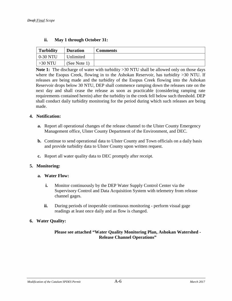
Draft Final Scope
Modification of the Catalum SPDES Permit A-6 March 2017
ii. May 1 through October 31:
Turbidity Duration Comments 0-30 NTU Unlimited >30 NTU (See Note 1)
Note 1: The discharge of water with turbidity >30 NTU shall be allowed only on those days where the Esopus Creek, flowing in to the Ashokan Reservoir, has turbidity >30 NTU. If releases are being made and the turbidity of the Esopus Creek flowing into the Ashokan Reservoir drops below 30 NTU, DEP shall commence ramping down the releases rate on the next day and shall cease the release as soon as practicable (considering ramping rate requirements contained herein) after the turbidity in the creek fell below such threshold. DEP shall conduct daily turbidity monitoring for the period during which such releases are being made.
4. Notification:
a. Report all operational changes of the release channel to the Ulster County Emergency Management office, Ulster County Department of the Environment, and DEC.
b. Continue to send operational data to Ulster County and Town officials on a daily basis and provide turbidity data to Ulster County upon written request.
c. Report all water quality data to DEC promptly after receipt.
5. Monitoring:
a. Water Flow:
i. Monitor continuously by the DEP Water Supply Control Center via the Supervisory Control and Data Acquisition System with telemetry from release channel gages.
ii. During periods of inoperable continuous monitoring - perform visual gage readings at least once daily and as flow is changed.
6. Water Quality:
Please see attached “Water Quality Monitoring Plan, Ashokan Watershed - Release Channel Operations”
Draft Final Scope
Modification of the Catalum SPDES Permit A-7 March 2017
7. Exceptions:
DEP may operate at variance with this Interim Protocol if any of the following conditions are met:
a. DEP, with concurrence by DEC, determines that additional resources are reasonably necessary for reservoir balancing, for refill of the Ashokan Reservoir, for proper water supply management, or in the case of drought watch, warnings or emergencies.
b. DEC in accordance with DEC’s existing legal authority directs an emergency action or DEP takes an emergency action.
c. DEC, or DEP with concurrence by DEC, determines that releases must be changed or interrupted as necessary for inspection, maintenance, testing and repairs (including Delaware Aqueduct repairs).
d. DEP, with concurrence by DEC, responds to a spill mitigation request (release or request not to release) from Ulster County provided the request will not adversely impact water supply.
e. DEP responds to a spill mitigation request (release or request not to release) from DEC provided the request will not adversely impact water supply.
8. Utilization of the Shandaken Tunnel:
During Spill Mitigation Releases and after reservoir storage has been reduced to meet the CSSO objectives, the use of the Shandaken Tunnel to provide water to the Ashokan Reservoir will be minimized in keeping with the existing Shandaken SPDES Permit and consistent with proper water supply management. In particular from May 1st through February 1st, for determinations in accordance with footnote 2.J. in the Shandaken Tunnel SPDES permit, the unfilled storage capacity within the Ashokan Reservoir will be calculated from the CSSO curve rather than the spillway elevation for the period.
9. Future Revisions to the IRP
DEC and NYCDEP may agree to modify the IRP as additional modeling and impact assessments are performed and as a result of monitoring and other lessons learned during its implementation, informed by input from the stakeholders.
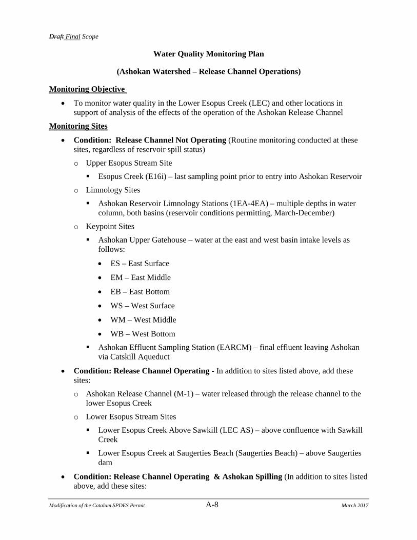
Draft Final Scope
Modification of the Catalum SPDES Permit A-8 March 2017
Water Quality Monitoring Plan
(Ashokan Watershed – Release Channel Operations)
Monitoring Objective
• To monitor water quality in the Lower Esopus Creek (LEC) and other locations in support of analysis of the effects of the operation of the Ashokan Release Channel
Monitoring Sites
• Condition: Release Channel Not Operating (Routine monitoring conducted at these sites, regardless of reservoir spill status) o Upper Esopus Stream Site Esopus Creek (E16i) – last sampling point prior to entry into Ashokan Reservoir
o Limnology Sites Ashokan Reservoir Limnology Stations (1EA-4EA) – multiple depths in water
column, both basins (reservoir conditions permitting, March-December) o Keypoint Sites Ashokan Upper Gatehouse – water at the east and west basin intake levels as
follows:
• ES – East Surface
• EM – East Middle
• EB – East Bottom
• WS – West Surface
• WM – West Middle
• WB – West Bottom Ashokan Effluent Sampling Station (EARCM) – final effluent leaving Ashokan
via Catskill Aqueduct
• Condition: Release Channel Operating - In addition to sites listed above, add these sites: o Ashokan Release Channel (M-1) – water released through the release channel to the
lower Esopus Creek o Lower Esopus Stream Sites Lower Esopus Creek Above Sawkill (LEC AS) – above confluence with Sawkill
Creek Lower Esopus Creek at Saugerties Beach (Saugerties Beach) – above Saugerties
dam
• Condition: Release Channel Operating & Ashokan Spilling (In addition to sites listed above, add these sites:
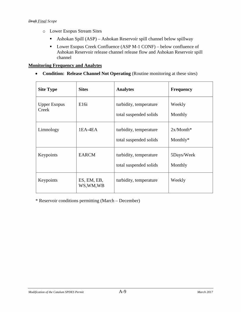
Draft Final Scope
Modification of the Catalum SPDES Permit A-9 March 2017
o Lower Esopus Stream Sites Ashokan Spill (ASP) – Ashokan Reservoir spill channel below spillway Lower Esopus Creek Confluence (ASP M-1 CONF) – below confluence of
Ashokan Reservoir release channel release flow and Ashokan Reservoir spill channel
Monitoring Frequency and Analytes
• Condition: Release Channel Not Operating (Routine monitoring at these sites)
Site Type Sites Analytes Frequency
Upper Esopus Creek
E16i turbidity, temperature
total suspended solids
Weekly
Monthly
Limnology 1EA-4EA turbidity, temperature
total suspended solids
2x/Month*
Monthly*
Keypoints EARCM turbidity, temperature
total suspended solids
5Days/Week
Monthly
Keypoints ES, EM, EB, WS,WM,WB
turbidity, temperature Weekly
* Reservoir conditions permitting (March – December)
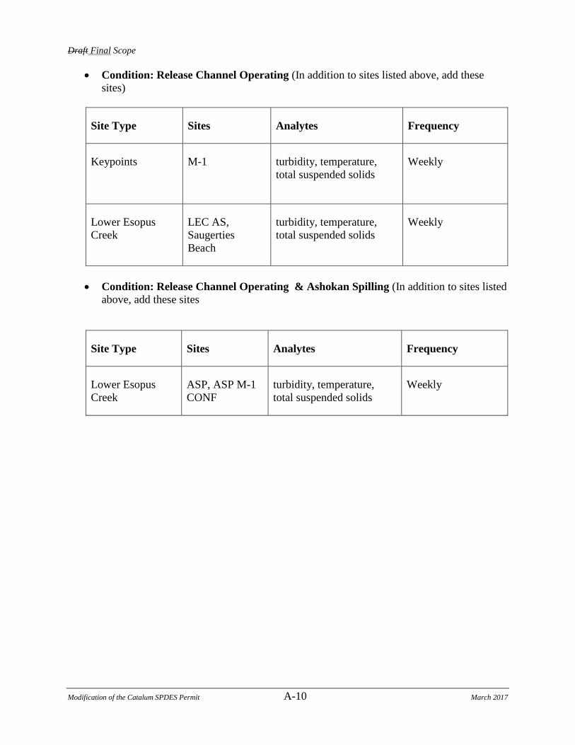
Draft Final Scope
Modification of the Catalum SPDES Permit A-10 March 2017
• Condition: Release Channel Operating (In addition to sites listed above, add these sites)
Site Type Sites Analytes Frequency
Keypoints M-1 turbidity, temperature, total suspended solids
Weekly
Lower Esopus Creek
LEC AS, Saugerties Beach
turbidity, temperature, total suspended solids
Weekly
• Condition: Release Channel Operating & Ashokan Spilling (In addition to sites listed
above, add these sites
Site Type Sites Analytes Frequency
Lower Esopus Creek
ASP, ASP M-1 CONF
turbidity, temperature, total suspended solids
Weekly
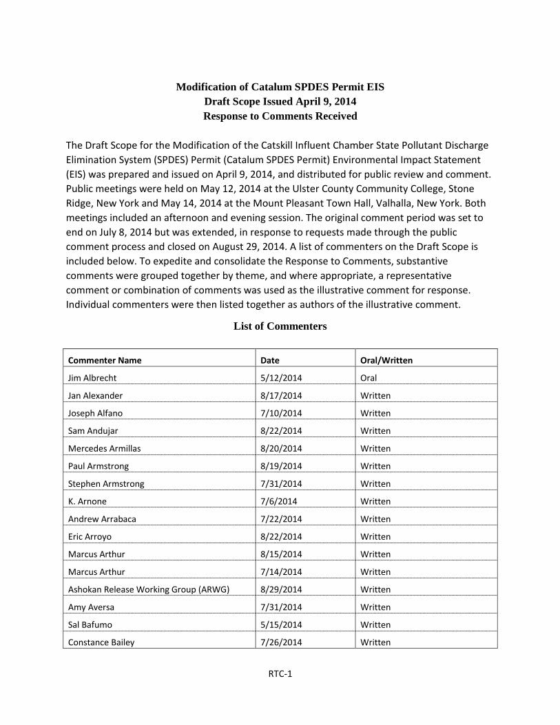
RTC-1
Modification of Catalum SPDES Permit EIS
Draft Scope Issued April 9, 2014 Response to Comments Received
The Draft Scope for the Modification of the Catskill Influent Chamber State Pollutant Discharge Elimination System (SPDES) Permit (Catalum SPDES Permit) Environmental Impact Statement (EIS) was prepared and issued on April 9, 2014, and distributed for public review and comment. Public meetings were held on May 12, 2014 at the Ulster County Community College, Stone Ridge, New York and May 14, 2014 at the Mount Pleasant Town Hall, Valhalla, New York. Both meetings included an afternoon and evening session. The original comment period was set to end on July 8, 2014 but was extended, in response to requests made through the public comment process and closed on August 29, 2014. A list of commenters on the Draft Scope is included below. To expedite and consolidate the Response to Comments, substantive comments were grouped together by theme, and where appropriate, a representative comment or combination of comments was used as the illustrative comment for response. Individual commenters were then listed together as authors of the illustrative comment.
List of Commenters
Commenter Name Date Oral/Written
Jim Albrecht 5/12/2014 Oral
Jan Alexander 8/17/2014 Written
Joseph Alfano 7/10/2014 Written
Sam Andujar 8/22/2014 Written
Mercedes Armillas 8/20/2014 Written
Paul Armstrong 8/19/2014 Written
Stephen Armstrong 7/31/2014 Written
K. Arnone 7/6/2014 Written
Andrew Arrabaca 7/22/2014 Written
Eric Arroyo 8/22/2014 Written
Marcus Arthur 8/15/2014 Written
Marcus Arthur 7/14/2014 Written
Ashokan Release Working Group (ARWG) 8/29/2014 Written
Amy Aversa 7/31/2014 Written
Sal Bafumo 5/15/2014 Written
Constance Bailey 7/26/2014 Written

RTC-2
Commenter Name Date Oral/Written
Candace Balmer 5/12/2014 Oral
Janelle Barabash 8/20/2014 Written
Daniel Barclay 8/19/2014 Written
Katherine Barnhart 8/19/2014 Written
Enzo Barrios 8/19/2014 Written
Alice Bartholomew 7/10/2014 Written
Jordan Barton 8/23/2014 Written
Sarah Barton-King 8/19/2014 Written
Elizabeth Bassett 8/19/2014 Written
Laura Bassi 7/23/2014 Written
Rita Battaglia 8/20/2014 Written
Donna Bauer 8/19/2014 Written
Joan-Marie Bauman 7/11/2014 Written
David Beard 8/22/2014 Written
Deborah Beck 8/21/2014 Written
Michelle Beck 8/22/2014 Written Philip Bein, Office of the Watershed Inspector General 8/27/2014 Written Carl Belfigilo, Ulster County Legislator, Town of Esopus 5/12/2014 Oral
Nicholas Bellomo 8/19/2014 Written
Gary Bellows 5/12/2014 Oral Vernon Benjamin, Town of Saugerties, on behalf of Supervisor Greg Helsmoortel 9/5/2014 Written Vernon Benjamin, Town of Saugerties, on behalf of Supervisor Greg Helsmoortel 5/12/2014 Oral
Kim Benson 6/24/2014 Written
Rachel Berg 8/24/2014 Written
Laura Bernstein 8/19/2014 Written
Billie Biederman 8/19/2014 Written
Fred Binkley 8/19/2014 Written
Jacqueline Birnbaum 8/24/2014 Written
Janice Blaire 8/20/2014 Written
Ann Bleefeld 8/19/2014 Written
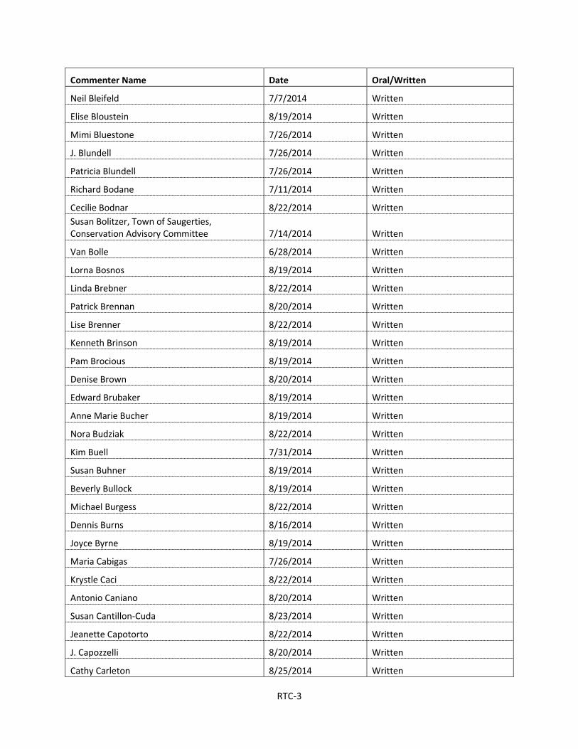
RTC-3
Commenter Name Date Oral/Written
Neil Bleifeld 7/7/2014 Written
Elise Bloustein 8/19/2014 Written
Mimi Bluestone 7/26/2014 Written
J. Blundell 7/26/2014 Written
Patricia Blundell 7/26/2014 Written
Richard Bodane 7/11/2014 Written
Cecilie Bodnar 8/22/2014 Written Susan Bolitzer, Town of Saugerties, Conservation Advisory Committee 7/14/2014 Written
Van Bolle 6/28/2014 Written
Lorna Bosnos 8/19/2014 Written
Linda Brebner 8/22/2014 Written
Patrick Brennan 8/20/2014 Written
Lise Brenner 8/22/2014 Written
Kenneth Brinson 8/19/2014 Written
Pam Brocious 8/19/2014 Written
Denise Brown 8/20/2014 Written
Edward Brubaker 8/19/2014 Written
Anne Marie Bucher 8/19/2014 Written
Nora Budziak 8/22/2014 Written
Kim Buell 7/31/2014 Written
Susan Buhner 8/19/2014 Written
Beverly Bullock 8/19/2014 Written
Michael Burgess 8/22/2014 Written
Dennis Burns 8/16/2014 Written
Joyce Byrne 8/19/2014 Written
Maria Cabigas 7/26/2014 Written
Krystle Caci 8/22/2014 Written
Antonio Caniano 8/20/2014 Written
Susan Cantillon-Cuda 8/23/2014 Written
Jeanette Capotorto 8/22/2014 Written
J. Capozzelli 8/20/2014 Written
Cathy Carleton 8/25/2014 Written
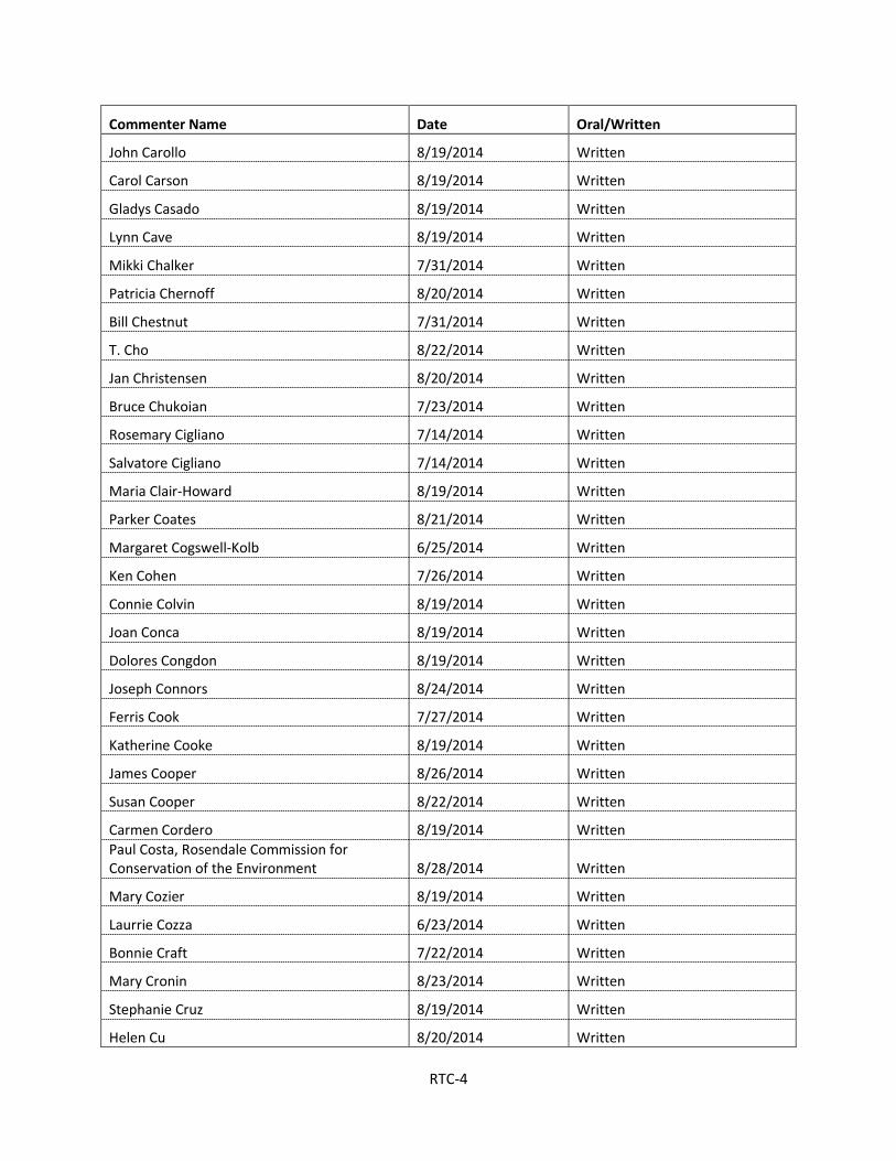
RTC-4
Commenter Name Date Oral/Written
John Carollo 8/19/2014 Written
Carol Carson 8/19/2014 Written
Gladys Casado 8/19/2014 Written
Lynn Cave 8/19/2014 Written
Mikki Chalker 7/31/2014 Written
Patricia Chernoff 8/20/2014 Written
Bill Chestnut 7/31/2014 Written
T. Cho 8/22/2014 Written
Jan Christensen 8/20/2014 Written
Bruce Chukoian 7/23/2014 Written
Rosemary Cigliano 7/14/2014 Written
Salvatore Cigliano 7/14/2014 Written
Maria Clair-Howard 8/19/2014 Written
Parker Coates 8/21/2014 Written
Margaret Cogswell-Kolb 6/25/2014 Written
Ken Cohen 7/26/2014 Written
Connie Colvin 8/19/2014 Written
Joan Conca 8/19/2014 Written
Dolores Congdon 8/19/2014 Written
Joseph Connors 8/24/2014 Written
Ferris Cook 7/27/2014 Written
Katherine Cooke 8/19/2014 Written
James Cooper 8/26/2014 Written
Susan Cooper 8/22/2014 Written
Carmen Cordero 8/19/2014 Written Paul Costa, Rosendale Commission for Conservation of the Environment 8/28/2014 Written
Mary Cozier 8/19/2014 Written
Laurrie Cozza 6/23/2014 Written
Bonnie Craft 7/22/2014 Written
Mary Cronin 8/23/2014 Written
Stephanie Cruz 8/19/2014 Written
Helen Cu 8/20/2014 Written
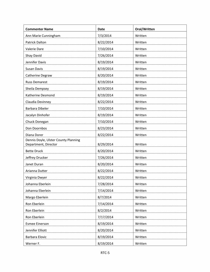
RTC-5
Commenter Name Date Oral/Written
Ann Marie Cunningham 7/3/2014 Written
Patrick Dalton 8/22/2014 Written
Valerie Dare 7/10/2014 Written
Shay David 7/26/2014 Written
Jennifer Davis 8/19/2014 Written
Susan Davis 8/19/2014 Written
Catherine Degraw 8/20/2014 Written
Russ Demarest 8/19/2014 Written
Sheila Dempsey 8/19/2014 Written
Katherine Desmond 8/19/2014 Written
Claudia Devinney 8/22/2014 Written
Barbara Dibeler 7/10/2014 Written
Jacalyn Dinhofer 8/19/2014 Written
Chuck Donegan 7/10/2014 Written
Don Doornbos 8/23/2014 Written
Diana Dorer 8/22/2014 Written Dennis Doyle, Ulster County Planning Department, Director 8/29/2014 Written
Bette Druck 8/20/2014 Written
Jeffrey Drucker 7/26/2014 Written
Janet Duran 8/20/2014 Written
Arianna Dutter 8/22/2014 Written
Virginia Dwyer 8/22/2014 Written
Johanna Eberlein 7/28/2014 Written
Johanna Eberlein 7/14/2014 Written
Margo Eberlein 8/7/2014 Written
Ron Eberlein 7/14/2014 Written
Ron Eberlein 8/2/2014 Written
Ron Eberlein 7/17/2014 Written
Esmee Einerson 8/19/2014 Written
Jennifer Elliott 8/20/2014 Written
Barbara Elovic 8/19/2014 Written
Werner F. 8/19/2014 Written
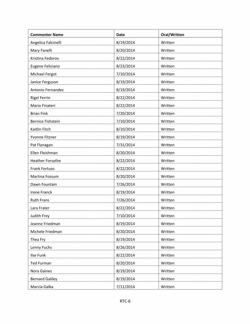
RTC-6
Commenter Name Date Oral/Written
Angelica Falcinelli 8/19/2014 Written
Mary Fanelli 8/20/2014 Written
Kristina Fedorov 8/22/2014 Written
Eugene Feliciano 8/23/2014 Written
Michael Fergot 7/10/2014 Written
Janice Ferguson 8/19/2014 Written
Antonio Fernandez 8/19/2014 Written
Rigel Ferrin 8/22/2014 Written
Mario Finateri 8/22/2014 Written
Brian Fink 7/20/2014 Written
Bernice Fishstein 7/10/2014 Written
Kaitlin Fitch 8/10/2014 Written
Yvonne Fitzner 8/19/2014 Written
Pat Flanagan 7/31/2014 Written
Ellen Fleishman 8/20/2014 Written
Heather Forsythe 8/22/2014 Written
Frank Fortuso 8/22/2014 Written
Martina Fossum 8/20/2014 Written
Dawn Fountain 7/26/2014 Written
Irene Franck 8/19/2014 Written
Ruth Frans 7/26/2014 Written
Lara Frater 8/22/2014 Written
Judith Frey 7/10/2014 Written
Jeanne Friedman 8/19/2014 Written
Michele Friedman 8/20/2014 Written
Thea Fry 8/19/2014 Written
Lenny Fuchs 8/26/2014 Written
Ilse Funk 8/22/2014 Written
Ted Furman 8/20/2014 Written
Nora Gaines 8/19/2014 Written
Bernard Galiley 8/19/2014 Written
Marcia Galka 7/11/2014 Written
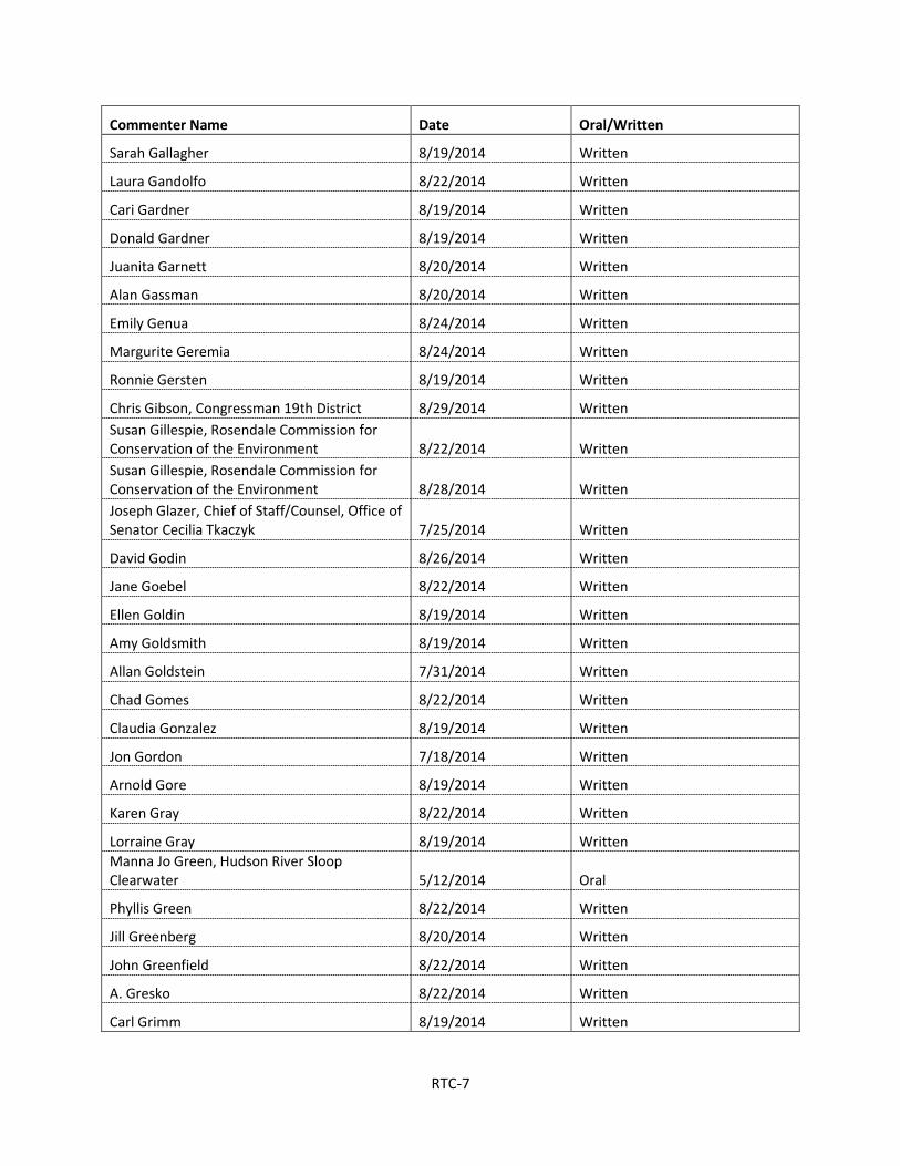
RTC-7
Commenter Name Date Oral/Written
Sarah Gallagher 8/19/2014 Written
Laura Gandolfo 8/22/2014 Written
Cari Gardner 8/19/2014 Written
Donald Gardner 8/19/2014 Written
Juanita Garnett 8/20/2014 Written
Alan Gassman 8/20/2014 Written
Emily Genua 8/24/2014 Written
Margurite Geremia 8/24/2014 Written
Ronnie Gersten 8/19/2014 Written
Chris Gibson, Congressman 19th District 8/29/2014 Written Susan Gillespie, Rosendale Commission for Conservation of the Environment 8/22/2014 Written Susan Gillespie, Rosendale Commission for Conservation of the Environment 8/28/2014 Written Joseph Glazer, Chief of Staff/Counsel, Office of Senator Cecilia Tkaczyk 7/25/2014 Written
David Godin 8/26/2014 Written
Jane Goebel 8/22/2014 Written
Ellen Goldin 8/19/2014 Written
Amy Goldsmith 8/19/2014 Written
Allan Goldstein 7/31/2014 Written
Chad Gomes 8/22/2014 Written
Claudia Gonzalez 8/19/2014 Written
Jon Gordon 7/18/2014 Written
Arnold Gore 8/19/2014 Written
Karen Gray 8/22/2014 Written
Lorraine Gray 8/19/2014 Written Manna Jo Green, Hudson River Sloop Clearwater 5/12/2014 Oral
Phyllis Green 8/22/2014 Written
Jill Greenberg 8/20/2014 Written
John Greenfield 8/22/2014 Written
A. Gresko 8/22/2014 Written
Carl Grimm 8/19/2014 Written
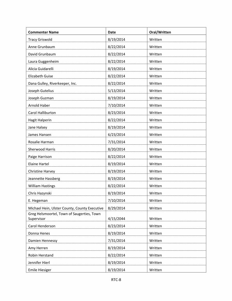
RTC-8
Commenter Name Date Oral/Written
Tracy Griswold 8/19/2014 Written
Anne Grunbaum 8/22/2014 Written
David Grunbaum 8/22/2014 Written
Laura Guggenheim 8/22/2014 Written
Alicia Guidarelli 8/19/2014 Written
Elizabeth Guise 8/22/2014 Written
Dana Gulley, Riverkeeper, Inc. 8/22/2014 Written
Joseph Gutelius 5/13/2014 Written
Joseph Guzman 8/19/2014 Written
Arnold Haber 7/10/2014 Written
Carol Halliburton 8/23/2014 Written
Hagit Halperin 8/22/2014 Written
Jane Halsey 8/19/2014 Written
James Hansen 6/23/2014 Written
Rosalie Harman 7/31/2014 Written
Sherwood Harris 8/20/2014 Written
Paige Harrison 8/22/2014 Written
Elaine Hartel 8/19/2014 Written
Christine Harvey 8/19/2014 Written
Jeannette Hassberg 8/19/2014 Written
William Hastings 8/22/2014 Written
Chris Hazynski 8/19/2014 Written
E. Hegeman 7/10/2014 Written
Michael Hein, Ulster County, County Executive 8/29/2014 Written Greg Helsmoortel, Town of Saugerties, Town Supervisor 4/15/2044 Written
Carol Henderson 8/23/2014 Written
Donna Henes 8/19/2014 Written
Damien Hennessy 7/31/2014 Written
Amy Herren 8/19/2014 Written
Robin Herstand 8/22/2014 Written
Jennifer Hierl 8/19/2014 Written
Emile Hiesiger 8/19/2014 Written
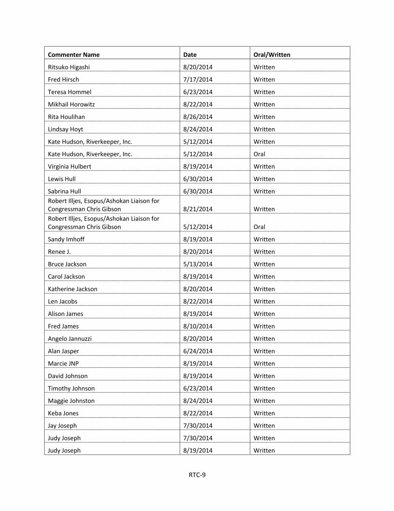
RTC-9
Commenter Name Date Oral/Written
Ritsuko Higashi 8/20/2014 Written
Fred Hirsch 7/17/2014 Written
Teresa Hommel 6/23/2014 Written
Mikhail Horowitz 8/22/2014 Written
Rita Houlihan 8/26/2014 Written
Lindsay Hoyt 8/24/2014 Written
Kate Hudson, Riverkeeper, Inc. 5/12/2014 Written
Kate Hudson, Riverkeeper, Inc. 5/12/2014 Oral
Virginia Hulbert 8/19/2014 Written
Lewis Hull 6/30/2014 Written
Sabrina Hull 6/30/2014 Written Robert Illjes, Esopus/Ashokan Liaison for Congressman Chris Gibson 8/21/2014 Written Robert Illjes, Esopus/Ashokan Liaison for Congressman Chris Gibson 5/12/2014 Oral
Sandy Imhoff 8/19/2014 Written
Renee J. 8/20/2014 Written
Bruce Jackson 5/13/2014 Written
Carol Jackson 8/19/2014 Written
Katherine Jackson 8/20/2014 Written
Len Jacobs 8/22/2014 Written
Alison James 8/19/2014 Written
Fred James 8/10/2014 Written
Angelo Jannuzzi 8/20/2014 Written
Alan Jasper 6/24/2014 Written
Marcie JNP 8/19/2014 Written
David Johnson 8/19/2014 Written
Timothy Johnson 6/23/2014 Written
Maggie Johnston 8/24/2014 Written
Keba Jones 8/22/2014 Written
Jay Joseph 7/30/2014 Written
Judy Joseph 7/30/2014 Written
Judy Joseph 8/19/2014 Written

RTC-10
Commenter Name Date Oral/Written
Ray Joseph 7/30/2014 Written
Rhonda Joseph 7/30/2014 Written
Elaine Jurumbo 8/19/2014 Written
Leslie Just 8/22/2014 Written
Nina Kane 8/26/2014 Written
Edith Kantrowitz 8/20/2014 Written
Sandra Kaplan 8/19/2014 Written
Andrew Karas 8/19/2014 Written
Ellie Karr 7/31/2014 Written
Lora Katen 8/19/2014 Written
Corey Kaup 8/19/2014 Written
Thomas Keane 8/1/2014 Written
Elizabeth Kelley 8/20/2014 Written
Arlene Kelly 8/22/2014 Written
Dennis Kelly 8/19/2014 Written
Catherine Kennedy 8/10/2014 Written
Devon Kennedy 8/22/2014 Written
James Kenny 8/19/2014 Written
Michele Kent 8/10/2014 Written
Bernard Kessler 8/19/2014 Written
Donald Kimmel 8/22/2014 Written
Erik Kiviat, Hudsonia, Ltd. 8/28/2014 Written
Laura Klein 8/19/2014 Written
D. Klocek 7/7/2014 Written
Stephanie Kob 7/10/2014 Written
H. Kolman 8/19/2014 Written
George Kormendi 7/10/2014 Written
Steven Kostis 8/20/2014 Written
Lucy Koteen 8/20/2014 Written Naja Kraus, Rosendale Commission for Conservation of the Environment, Chair 8/28/2014 Written
Philip Kunzler 8/19/2014 Written
Richard Kurz 8/22/2014 Written
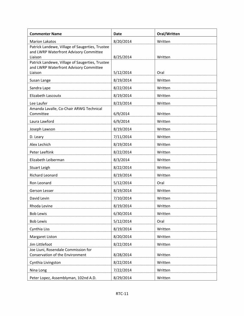
RTC-11
Commenter Name Date Oral/Written
Marion Lakatos 8/20/2014 Written Patrick Landewe, Village of Saugerties, Trustee and LWRP Waterfront Advisory Committee Liaison 8/25/2014 Written Patrick Landewe, Village of Saugerties, Trustee and LWRP Waterfront Advisory Committee Liaison 5/12/2014 Oral
Susan Lange 8/19/2014 Written
Sandra Lape 8/22/2014 Written
Elizabeth Lascoutx 8/19/2014 Written
Lee Laufer 8/23/2014 Written Amanda Lavalle, Co-Chair ARWG Technical Committee 6/9/2014 Written
Laura Lawford 6/9/2014 Written
Joseph Lawson 8/19/2014 Written
D. Leary 7/11/2014 Written
Alex Lechich 8/19/2014 Written
Peter Leeftink 8/22/2014 Written
Elizabeth Leiberman 8/3/2014 Written
Stuart Leigh 8/22/2014 Written
Richard Leonard 8/19/2014 Written
Ron Leonard 5/12/2014 Oral
Gerson Lesser 8/19/2014 Written
David Levin 7/10/2014 Written
Rhoda Levine 8/19/2014 Written
Bob Lewis 6/30/2014 Written
Bob Lewis 5/12/2014 Oral
Cynthia Liss 8/19/2014 Written
Margaret Liston 8/20/2014 Written
Jim Littlefoot 8/22/2014 Written Joe Liuni, Rosendale Commission for Conservation of the Environment 8/28/2014 Written
Cynthia Livingston 8/22/2014 Written
Nina Long 7/22/2014 Written
Peter Lopez, Assemblyman, 102nd A.D. 8/29/2014 Written

RTC-12
Commenter Name Date Oral/Written
David Lowe 7/31/2014 Written
Joshua Luke 7/26/2014 Written
Virginia Luppino 8/3/2014 Written
Sara Lupson 8/19/2014 Written
Linda Lusskin 8/19/2014 Written
Sally Lyon 8/22/2014 Written
Michael Macelhiney 8/19/2014 Written
Peter Madison 8/19/2014 Written
Sandra Main 8/22/2014 Written
Cave Man 8/19/2014 Written
Anita Maldonado 7/10/2014 Written
Richard Mangini 8/19/2014 Written
Mark Mansfield 8/26/2014 Written
Mady Marantz 8/19/2014 Written
Dietrich Marianne 8/19/2014 Written
Darian Mark 8/19/2014 Written
Emily Maroney 8/20/2014 Written
Brenda Martin 8/19/2014 Written
J. Massetti 8/19/2014 Written
Nancy Mathisen 8/22/2014 Written
Stephen Matlak 8/19/2014 Written Joan Leary Matthews, U.S. Environmental Protection Agency 8/19/2014 Written
Alexander Mayer 8/19/2014 Written
Robin Mayerat 6/23/2014 Written
James Mccarthy 8/22/2014 Written
Michael McCoy 8/19/2014 Written
Maria Mcgrath 8/20/2014 Written Mary McNamara, Esopus Creek Conservancy, Lower Esopus Watershed Partnership 8/30/2014 Written Mary McNamara, Esopus Creek Conservancy, Lower Esopus Watershed Partnership 5/12/2014 Oral Mary McNamara, Esopus Creek Conservancy, Lower Esopus Watershed Partnership 5/14/2014 Oral

RTC-13
Commenter Name Date Oral/Written
Anne Mehlinger 8/22/2014 Written
Martin Melkonian 8/22/2014 Written
Jonathan Memmert 8/23/2014 Written
Ruth Mendes 8/20/2014 Written
Karen Menduni 8/21/2014 Written
Susan Messerschmitt 8/22/2014 Written
Robert Meyer 8/19/2014 Written
Mitchell Miller 8/19/2014 Written
Debora Modra 8/22/2014 Written
Joan Monasten 7/25/2014 Written
Thomas Monkell 8/22/2014 Written
Thomas Mooney 8/19/2014 Written
Mayelly Moreno 8/24/2014 Written
John Morrow 5/12/2014 Oral
Laurie Moschetto 8/19/2014 Written
Caroline Mullen 8/22/2014 Written
Carlotta Mummolo 7/30/2014 Written
Michael Murphy 7/10/2014 Written
Theresa Murphy 8/20/2014 Written
Steve Mustacchi 8/19/2014 Written Kelly Meyers, Esopus Creek Conservancy, Esopus Bend Nature Preserve, ARWG, NY Rising Hudson Valley Regional Committee 8/30/2014 Written
Barbara Nelson 8/19/2014 Written
Anh Nguyet La 8/20/2014 Written
Gary Nickerson 7/11/2014 Written
Dorothy Nusbaum 8/19/2014 Written
Marilyn Nusbaum 8/19/2014 Written
Sherri O'Connor 8/23/2014 Written
Dawn O'Donnell 7/10/2014 Written
Mary ODonnell 7/14/2014 Written
Elizabeth O'Mara 8/22/2014 Written
Kevin O'Neill 8/19/2014 Written

RTC-14
Commenter Name Date Oral/Written
Jean-Marc Oppenhiem 8/18/2014 Written
Richard Ottinger 8/19/2014 Written
Phyllis Ottomanelli 8/19/2014 Written
Regina Packard 8/22/2014 Written
Joseph Palmieri 8/22/2014 Written
Drew Panko 8/19/2014 Written
Laura Pantazis 8/20/2014 Written
Philip Papaelias 8/20/2014 Written
Denice Park 8/19/2014 Written
Nancy Pavay 7/1/2014 Written
Beverly Peake 8/19/2014 Written
Pippa Pearthree 8/19/2014 Written
Mary Perillo 8/19/2014 Written
George Picchioni 8/19/2014 Written
Karen Pike-Roberts 8/22/2014 Written
Giogio Pironi 8/1/2014 Written
Jennifer Plishka 8/23/2014 Written
Marcy Pociit 7/14/2014 Written
Meredith Priestley 8/22/2014 Written
Richard Procida 8/19/2014 Written
Clifford Provost 8/23/2014 Written Chris Pryslopski, Town Council of Town of Rosendale 8/28/2014 Written Chris Pryzlopsky, Rosendale Commission for Conservation of the Environment, Town Liaison 8/28/2014 Written
Robert Puca 8/21/2014 Written James Quigley, Coalition of Lower Esopus Watershed Communities 8/29/2014 Written James Quigley, Town of Ulster, Town Supervisor 5/12/2014 Oral
Joseph Quirk 6/22/2014 Written
Stefanie Racks 8/19/2014 Written
Laura Raforth 8/22/2014 Written
Edward Rengers 8/22/2014 Written

RTC-15
Commenter Name Date Oral/Written
Marilyn Rhodes 8/19/2014 Written
Denise Rickles 8/19/2014 Written
Javier Rivera 7/31/2014 Written
Javier Rivera 8/19/2014 Written
Robert Rivera 8/19/2014 Written
Riverkeeper, Inc. 8/28/2014 Written
Daniel Robinson 8/19/2014 Written
Joy Robinson 8/19/2014 Written
Angela Rodriguez 8/20/2014 Written
Sylvia Rodriguez 8/22/2014 Written
Ron Leonard 5/12/2014 Oral
Heriberto Rosario 8/19/2014 Written
Herbert Rosenblum 8/22/2014 Written
Sandra Rosenblum 8/22/2014 Written
Suzie Ross 8/26/2014 Written
Joseph Rosta 7/10/2014 Written
M. A. Rothberg 7/14/2014 Written
Naomi Rothberg 7/14/2014 Written
Marsha Rubenstein 8/22/2014 Written
Matthew Rubinoff 8/22/2014 Written
Jake Rubinsky 7/10/2014 Written
Ira Russack 8/19/2014 Written
Maureen Ryan 8/19/2014 Written
Megan Ryan 8/21/2014 Written
Chris Saia 8/19/2014 Written
Emma Lou Sailors 7/11/2014 Written
Nancy Sambataro 7/31/2014 Written
Tatiana Sangare 8/19/2014 Written
Benjamin Sauter 8/22/2014 Written
Melissa Savadove 8/19/2014 Written Brian Sawchuck, Saugerties Conservation Advisory Commission 7/5/2014 Written
Marietta Scaltrito 8/22/2014 Written

RTC-16
Commenter Name Date Oral/Written
Bonnie Schapira 8/20/2014 Written
August Scheer 8/19/2014 Written
Ronan Schmidt 8/22/2014 Written
James Schmitt 7/7/2014 Written
Joanne Schmitt 7/16/2014 Written
Terri Schneider 8/22/2014 Written
Tricia Schultz 8/19/2014 Written
Elaine Sciolino 8/22/2014 Written
Nancy Sconza 8/22/2014 Written
Brenda Scott 6/28/2014 Written
Margaret Seely 7/10/2014 Written
Jennifer Segal 8/20/2014 Written
Phyllis Segura 8/22/2014 Written
Gabby Sekuterski 7/31/2014 Written
Aimee Sember 7/1/2014 Written
Eric Serxner 8/20/2014 Written
Jamin Sewell 8/19/2014 Written
Elizabeth Shafer 8/22/2014 Written Charles Silver, Office of the Watershed Inspector General 8/27/2014 Written
Chuck Silver 7/5/2014 Written
Dara Silverman 8/19/2014 Written
Elaine Sloan 8/22/2014 Written
Lynn Slonaker 8/19/2014 Written
Anita Smith 8/19/2014 Written
Barry Smith 6/27/2014 Written
Mark Smith 8/22/2014 Written
Mary Lou Smith 7/31/2014 Written
Pat Smith 8/22/2014 Written
Robert Smith 7/31/2014 Written
W. Smith 8/23/2014 Written
Bruce Snow 5/12/2014 Oral
Karen Solomon 8/22/2014 Written

RTC-17
Commenter Name Date Oral/Written
Bob Sorensen 8/19/2014 Written
Frances Sorensen 8/19/2014 Written
Elaine Sperbeck 7/31/2014 Written
Jack Spiegelman 8/19/2014 Written
Joel Spiegelman 7/31/2014 Written
Craig Stallone 7/10/2014 Written
Victor Stamboulian 8/21/2014 Written
Renee Stein 7/31/2014 Written
Frank Stella 8/22/2014 Written
Kate Stigdon 8/19/2014 Written
Michael Sturm 8/25/2014 Written
Gail Sullivan 8/19/2014 Written
Terry Sullivan 8/19/2014 Written
Carolyn Summers 8/20/2014 Written
Judith Susser 8/19/2014 Written Philip Sweeney, NYC Water Supply Protection Team, Team Leader 8/21/2014 Written
Peter Sweeny 6/23/2014 Written
Michael Szeto 8/19/2014 Written
Juli Szhaefer 7/14/2014 Written
Vicki Taggart 8/20/2014 Written
Eric Talbott 8/22/2014 Written
John Terrell 7/26/2014 Written
Ancy Thomas 8/22/2014 Written
Melne Thomas 8/22/2014 Written
Leeanna Thornton 7/14/2014 Written
Cecilia Tkaczyk, State Senator 46th S.D. 7/24/2014 Written
Cecilia Tkaczyk, State Senator 46th S.D. 5/12/2014 Oral
Max Tran 8/20/2014 Written
Thomas Trengove 7/31/2014 Written
Betty Trentlyon 8/20/2014 Written
David Tucker 7/10/2014 Written
Khadijah Turner 6/30/2014 Written
RTC-18
Commenter Name Date Oral/Written
Wendy Valdez 8/19/2014 Written
Michael Van Riper 8/22/2014 Written Paul Vanblarcum, Sheriff, Chief Law Enforcement Office in Ulster County 8/27/2014 Written
Betty Vanwicklen 7/31/2014 Written
Joseph Varon 7/22/2014 Written
Francisco Velez 8/22/2014 Written
Gabriel Vera 8/23/2014 Written
Josefina Vidal 8/19/2014 Written
Harry Vincent 8/22/2014 Written
Nick Vivian 8/20/2014 Written
Hilary Von Waldenfels 8/22/2014 Written
Katelyn Wallach 8/19/2014 Written
Brigid Walsh 6/23/2014 Written
Jeanne Walsh, Town of Rosendale, Supervisor 8/28/2014 Written
Michael Walsh 8/20/2014 Written
Lanny Walter 8/19/2014 Written
Darryl Warner 8/19/2014 Written
Rich Warner 8/22/2014 Written Michael Warren, Town of Marbletown, Supervisor 8/20/2014 Written
Roxanne Warren 8/19/2014 Written
Russell Warren 8/22/2014 Written
Chris Washington 7/10/2014 Written
Aynslie Wasserbach 8/22/2014 Written
Sharon Weiner 8/19/2014 Written
William Welkowitz 8/19/2014 Written
Karena Wells 8/19/2014 Written
Joseph Westfall 7/31/2014 Written
Mike Weyand 8/19/2014 Written
Kenn White 8/22/2014 Written
Yohanna Willheim 8/19/2014 Written
Amy Williams 6/30/2014 Written
RTC-19
Commenter Name Date Oral/Written
Sue Willis 7/31/2014 Written
Alex Wilson 8/19/2014 Written
Phoebe Wilson 8/22/2014 Written
Rose Marie Wilson 8/22/2014 Written
Amy Winter 8/19/2014 Written
Andrew Wittenborn 8/19/2014 Written
Kathleen Wittenborn 8/19/2014 Written
Melissa Wohlgemuth 8/1/2014 Written
Thomas Wolfe 8/21/2014 Written
Janet Yacht 8/22/2014 Written
Roger Yetzer 8/21/2014 Written
Rosanne Yetzer 8/21/2014 Written
Bailey Young 8/22/2014 Written
A. Zabski 8/19/2014 Written
Samia Zaman 8/22/2014 Written
Faith Zuckerman 8/21/2014 Written

RTC-20
Comments and Responses
# Commenter(s) Comment Topic Response
1 ARWG, Kate Hudson, Riverkeeper, Joseph Glazer, Vernon Benjamin, Fred Hirsch, Joseph Quirk, Multiple Commenters (Standardized letter)
Typically, under State Environmental Quality Review Act (SEQRA), an EIS would be conducted prior to approval of a permit that authorizes pollutant discharges such as those occurring through the Ashokan Reservoir Interim Ashokan Release Protocol (IRP). In this case, however, high flow releases of turbid waters through the Ashokan Release Channel (ARC) to the lower Esopus have been occurring since 2006 as approved by New York State Department of Health (NYSDOH), U.S Environmental Protection Agency (USEPA) and New York State Department of Environmental Conservation (NYSDEC) under the 2007 Filtration Avoidance Determination (FAD) in November of 2010. Because of the unusual situation that characterizes this environmental review, that the action requested has already been approved and implemented, we cannot act like this is not the case and this is a normal environmental review where we would only look forward to examining the potential for adverse environmental impacts. We are placed in the strange position of having to conduct a post-hoc environmental review. This has implications at every stage of the SEQRA analysis and requires a certain flexibility in determining how this analysis should be shaped to accommodate these unusual circumstances. Not the least of these is that adverse environmental impacts have already occurred, in the past, as a result of implementation of the releases as a turbidity control mechanism, and these past impacts must be considered and evaluated, as well as potential future impacts. Specifically, the Draft Environmental Impact Statement (DEIS) should
EIS Process The development of the EIS is governed primarily by terms of the Order on Consent issued by NYSDEC in this matter on October 4, 2013. The Order clarifies the intended objective of the EIS is to address both the potential modifications of the Catalum State Pollutant Discharge Elimination System (SPDES) Permit and the IRP. In particular, Item 25 of the Order on Consent states:
“To resolve the City’s violations of the Catalum SPDES permit…and to provide data for an environmental assessment of the potential impact from releases occurring in accordance with the IRP, the City agrees to adhere to the IRP and Interim Monitoring Plan attached to this Order on Consent as Appendix “B,” undertake an environmental review in accordance with the SEQRA that will, among other things, comprehensively assess the potential impacts from releases, analyze and respond to public comment on the IRP, and propose in an application for modification of the Catalum SPDES permit a Revised Operating Protocol to be based on the public comment and the environmental review…”
The Order required implementation of the IRP as described in Appendix B. This requirement is not subject to SEQRA [§617.5(29)] as it derives from anadministrative enforcement action, a Type IIaction under SEQRA.
The Order nonetheless required an environmental assessment of the IRP "in accordance with SEQRA" as part of an application for modification of the Catalum SPDES permit, which is an action subject to SEQRA, which provides, "(a) No agency involved in an action may undertake, fund or approve the action until it has complied with the provisions of SEQRA." [§617.3 General rules].
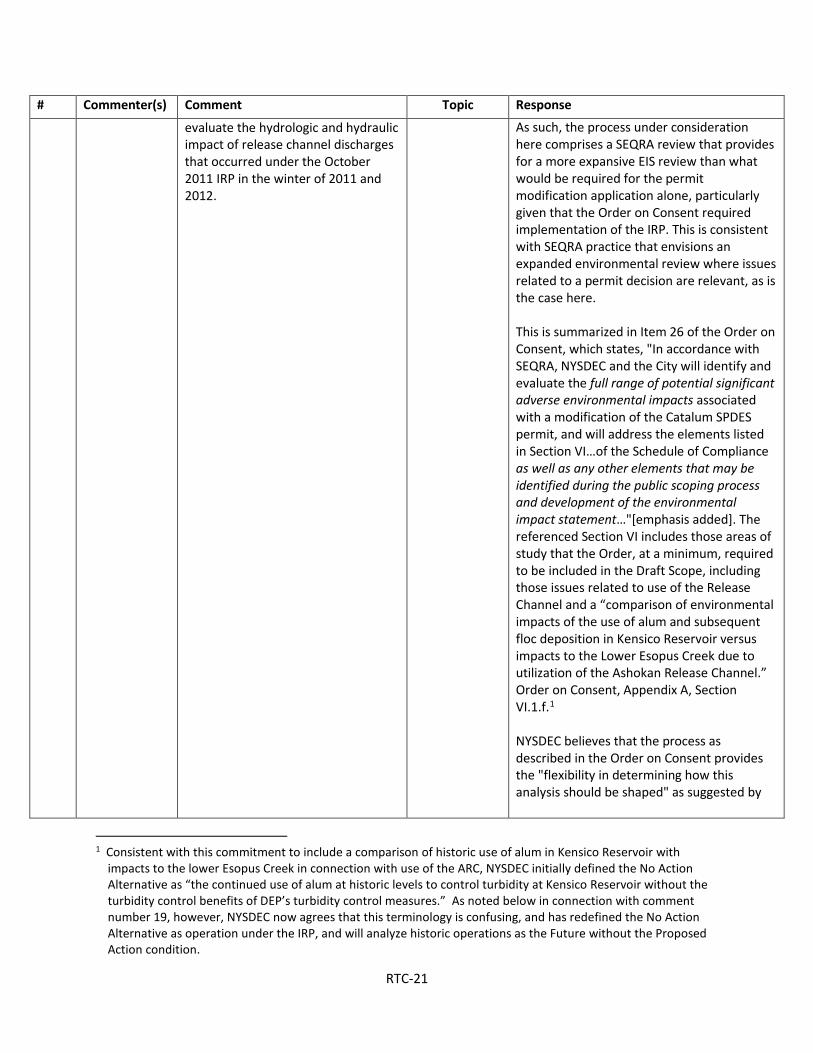
RTC-21
# Commenter(s) Comment Topic Response
evaluate the hydrologic and hydraulic impact of release channel discharges that occurred under the October 2011 IRP in the winter of 2011 and 2012.
As such, the process under consideration here comprises a SEQRA review that provides for a more expansive EIS review than what would be required for the permit modification application alone, particularly given that the Order on Consent required implementation of the IRP. This is consistent with SEQRA practice that envisions an expanded environmental review where issues related to a permit decision are relevant, as is the case here.
This is summarized in Item 26 of the Order on Consent, which states, "In accordance with SEQRA, NYSDEC and the City will identify and evaluate the full range of potential significant adverse environmental impacts associated with a modification of the Catalum SPDES permit, and will address the elements listed in Section VI…of the Schedule of Compliance as well as any other elements that may be identified during the public scoping process and development of the environmental impact statement…"[emphasis added]. The referenced Section VI includes those areas of study that the Order, at a minimum, required to be included in the Draft Scope, including those issues related to use of the Release Channel and a “comparison of environmental impacts of the use of alum and subsequent floc deposition in Kensico Reservoir versus impacts to the Lower Esopus Creek due to utilization of the Ashokan Release Channel.” Order on Consent, Appendix A, Section VI.1.f.1
NYSDEC believes that the process as described in the Order on Consent provides the "flexibility in determining how this analysis should be shaped" as suggested by
1 Consistent with this commitment to include a comparison of historic use of alum in Kensico Reservoir with impacts to the lower Esopus Creek in connection with use of the ARC, NYSDEC initially defined the No Action Alternative as “the continued use of alum at historic levels to control turbidity at Kensico Reservoir without the turbidity control benefits of DEP’s turbidity control measures.” As noted below in connection with comment number 19, however, NYSDEC now agrees that this terminology is confusing, and has redefined the No Action Alternative as operation under the IRP, and will analyze historic operations as the Future without the Proposed Action condition.
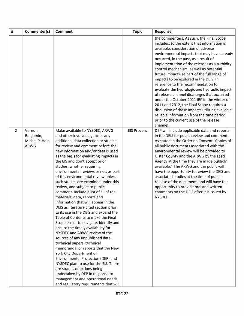
RTC-22
# Commenter(s) Comment Topic Response
the commenters. As such, the Final Scope includes, to the extent that information is available, consideration of adverse environmental impacts that may have already occurred, in the past, as a result of implementation of the releases as a turbidity control mechanism, as well as potential future impacts, as part of the full range of impacts to be explored in the DEIS. In reference to the recommendation to evaluate the hydrologic and hydraulic impact of release channel discharges that occurred under the October 2011 IRP in the winter of 2011 and 2012, the Final Scope requires a discussion of these impacts utilizing available reliable information from the time period prior to the current use of the release channel.
2 Vernon Benjamin, Michel P. Hein, ARWG
Make available to NYSDEC, ARWG and other involved agencies any additional data collection or studies for review and comment before the new information and/or data is used as the basis for evaluating impacts in the EIS and don’t accept prior studies, whether requiring environmental reviews or not, as part of this environmental review unless such studies are examined under this review, and subject to public comment. Include a list of all of the materials, data, reports and information that will appear in the DEIS as literature cited section prior to its use in the DEIS and expand the Table of Contents to make the Final Scope easier to navigate. Identify and ensure the timely availability for NYSDEC and ARWG review of the sources of any unpublished data, technical papers, technical memoranda, or reports that the New York City Department of Environmental Protection (DEP) and NYSDEC plan to use for the EIS. There are studies or actions being undertaken by DEP in response to management and operational needs and regulatory requirements that will
EIS Process DEP will include applicable data and reports in the DEIS for public review and comment. As stated in the Order on Consent “Copies of all public documents associated with the environmental review will be provided to Ulster County and the ARWG by the Lead Agency at the time they are made publicly available.” The ARWG and the public will have the opportunity to review the DEIS and associated studies at the time of public release of the document, and will have the opportunity to provide oral and written comments on the DEIS after it is issued by NYSDEC.
RTC-23
# Commenter(s) Comment Topic Response
affect the lower Esopus turbidity discharge issue, but will not be factored into the Scope requirements or are factored in without the benefit of public review and comment.
3 Michael P. Hein
The Scope would benefit by a requirement to summarize the Operations Support Tool (OST) runs within the EIS and include the technical details as an appendix to enable review. Finally, linking the OST to the OASIS model for the lower Esopus would also improve scenario analysis for this EIS and have long term benefits for any releases included in the final decisions and should be required. In addition, the assumptions used in the OST regarding the analysis of alternatives must be made transparent.
EIS Process OASIS, which is the modeling backbone of the OST, is a system model for analyzing operations decisions for water supply systems. OST models spills and releases from Ashokan Reservoir based on regulations, policies, and protocols across the New York City (NYC) water supply system. Esopus Creek below Ashokan Reservoir is an uncontrolled system. A hydraulic modeling platform (e.g., Hydrologic Engineering Center-River Analysis System [HEC-RAS]) will be used to model conditions along the Creek. Output from OST with respect to flows (e.g. spills and releases) from the reservoir can be fed into the hydraulic model to assess water surface elevation and flow velocities in the Creek. Additional detail on the OST and HEC-RAS model will be included as part of the DEIS. The assumptions and analyses used in any modeling runs for the DEIS would be disclosed in the DEIS.
4 ARWG, Cecilia Tkaczyk
Require DEP to prepare a Revised Draft Scope and make it available for public review before issuing the Final Scope. The comments that are provided by the public should be posted on a website somewhere or be made available.
EIS Process Submission of a revised Draft Scope is not part of the SEQRA process. All updates to the document are captured within this Final Scope and responses to comments are provided here. The SEQRA process will be followed with regard to public comments on the DEIS and other submittals that are subject to public review. Public comments will be available for review as part of the Final Scope and as a result, will be publically accessible.
5 Michael P. Hein, Philip Bein, Charles Silver, Kate Hudson, ARWG, Joseph Quirk, Vernon Benjamin, Riverkeeper, Multiple Commenters
The timing of the environmental review raises additional questions about regulatory conflicts with the interim review of the FAD, the five-year update of which was issued in May 2014 with the provision that an Expert Panel be convened whose findings shall coincide with this review, but not in time to serve as a comment on the Draft Scope. The work of the OST Expert Panel to be administered by the National
EIS Process It is the intention that the findings from the OST Expert Panel convened under the FAD would be considered as part of this environmental review. Specific text in Section 1.4 of the Draft Scope has been added referencing the OST Expert Panel. As discussed in the Scope, alternatives would be evaluated with respect to their potential impacts to lower Esopus Creek. All OST modeling analyses will be conducted using the most up-to-date version of the model and

RTC-24
# Commenter(s) Comment Topic Response
(Standardized letter)
Research Council must be included in the environmental review. The Final Scope should explicitly state that the Expert Panel’s conclusions and recommendations regarding use of the OST to evaluate impacts and alternatives will be considered to ensure evaluation in the DEIS. In the context of evaluating the impacts associated with use of the release channel, it is necessary for the DEIS to consider the modeling and operating assumptions that drive that use. The impacts of the actions that the OST and Conditional Seasonal Storage Objective (CSSO)2 require and/or support must be on the table. Evaluation of all alternatives in the DEIS must be subject to a new evaluation, rather than based on previous reviews that DEP has conducted that did not factor in the goal of avoiding or mitigating impacts to the lower Esopus, using OST modeling recommended by the FAD Expert Panel.
will not solely rely on results from past analyses.
6 ARWG The ARWG represents a diversity of interests and is more than just a stakeholder in the State's environmental review process. Under the 2013 Order on Consent, the ARWG was provided unique status by the State of New York, by requiring DEP to continue to work closely with the ARWG throughout the State environmental review and EIS process.
EIS Process NYSDEC and DEP have appreciated the input from the ARWG, and will continue to receive feedback through the formal SEQRA public process. DEP will continue its commitment to the ARWG as defined in the Order on Consent, which includes:
• Participation in the ARWG• Providing $80,000 in Environmental
Benefits Project (EBP) funds for aTechnical Review Consultant
• Providing copies of submittalsrequired by the Order on Consent,except environmental reviewdocuments, as described inAppendix A of the Order onConsent.
2 A CSSO is a reservoir management technique that enhances flood mitigation by maintaining a void within a reservoir in accordance with time of year, drought conditions, weather and storm predictions and availability of connected supply sources.
RTC-25
# Commenter(s) Comment Topic Response
7 ARWG The appropriate and established venue for considering the system-wide impacts of the Catskill Water System is through the FAD.
EIS Process This environmental review is focused on the modification of the Catalum SPDES permit. This comment was raised during the public comment period of the Midterm Revisions of the 2007 FAD, where it was stated that the IRP could be revised where improved protocols were indicated by the modification to the Catalum SPDES permit. As stated in the Response to Comments for the Midterm Revisions of the 2007 FAD, “Operating rules for the Ashokan Release Channel are defined by the Interim Release Protocol (IRP), which has been developed by the NYSDEC and is included in the NYSDEC’s Consent Order on the City (NYSDEC Case No.: D007-0001-11). The IRP defines three categories of use for the Release Channel: 1) flood mitigation; 2) environmental, recreation, and economicbenefits; and 3) drinking water qualityprotection. This protocol has been designedto balance the uses of the Release Channelwith the potential impacts that turbidity andflow associated with releases may have onthe lower Esopus Creek. The IRP includesrequirements for monitoring and reporting toensure that NYSDEC and Ulster County andTown officials are informed of operationalchanges and can assess the City’s compliancewith the provisions of the IRP. The IRP issubject to revision if improved protocols areidentified as the IRP is implemented, or asindicated by the Environmental ImpactStatement that is being prepared inconnection with the City’s request to modifytheir Catalum SPDES permit.”
8 Greg Helsmoortel
I feel that there should be a stronger presence by USEPA in the Scoping and Environmental Impact Statement review that the NYSDEC is leading. I have an expert on staff who is assisting the town in this matter at a rate well below his true value, but the prospect of paying for that service over a two year regulatory process is daunting for me, my town board, and the taxpayers of Saugerties. It isn't fair, and it is unfortunate that this all appears to be dictated by DEP interests. By
EIS Process USEPA has been provided the Draft Scope and has elected to provide comments.

RTC-26
# Commenter(s) Comment Topic Response
bringing USEPA to the table, you can provide another layer of expertise that will help to level the playing field.
9 Kate Hudson The Final Scope should specifically set forth all of the statutory and regulatory requirements applicable to the proposed action and its environmental review. As lead agency for the review of the proposed action, NYSDEC is responsible for ensuring that the environmental impact statement takes a “hard look” at all the relevant areas of environmental concern, and make a “‘reasoned elaboration’ of the basis for its determination.” Jackson v. N.Y. State Urban Dev. Corp., 67 N.Y.2d 400, 417 (1986) (quoting Aldrich v. Pattison, 107 A.D.2d 258, 265 (2d Dep’t 1985)). Inthe circumstances of this particularproposed action, NYSDEC also has anumber of additional legal duties.NYSDEC’s other regulatoryresponsibilities include ensuring thatdischarges which would result fromthe proposed action comply with theClean Water Act, State water qualitystandards and reservoir release lawsand regulations, as well as with therequirements of the State CoastalZone Management Program.
EIS Process This DEIS will be conducted in accordance with all applicable regulatory requirements.
10 Marcus Arthur I urge you to require DEP consider and comply with State designations and resulting restrictions in the scoping for the DEIS. They cannot be exempted for State regulations that protect our local communities', or be allowed to ignore affected communities' wellbeing.
EIS Process 6 NYCRR §617.8(f)(2) requires a final written scope to include ‘the potentially significant adverse impacts identified, …, including an identification of those particular aspect(s) of the environmental setting that may be impacted.” The Scope includes the list of the environmental categories that have the potential to be significantly adversely impacted within Section 2.3, Summary of Proposed Methodologies for Environmental Analysis. Along lower Esopus Creek these include Land Use, Zoning and Public Policy, Socioeconomic conditions, Infrastructure, Open Space and Recreation, Aesthetic and Visual Resources, Historic and Cultural Resources, Water Resources and Water
RTC-27
# Commenter(s) Comment Topic Response
Quality, Natural Resources, and Public Health. For Kensico Reservoir, these include Land Use, Zoning and Public Policy, Socioeconomic Conditions, Critical Environmental Areas, Historic and Cultural Resources, Aesthetic and Visual Resources, Water Resources and Water Quality, Natural Resources, Hazardous Materials, Traffic and Air Quality. These categories were selected for study based on review of the project by experts within each category, input received from the ARWG, and the public surveys conducted as part of the ARWG’s efforts.
11 Marcy Pociit NYSDEC needs to do its job and protect those of us who are being impacted by the DEP’s cheap way out of dealing the sediment. NYC needs to accept that our water is not cheap and they need to do what it takes to do the job right.
EIS Process See response to comment 10.
12 Cecilia Tkaczyk, Greg Helsmoortel
One of my concerns is that the ARWG has the appropriate resources to hire consultants sufficient to help them assess the impact and to follow the study as it goes through the process. I ask that you also try and influence the process to provide funding for the true level of support expertise that is needed.
EIS Process As part of the October 4, 2013, Order on Consent, the City of New York is providing up to $80,000 to fund a Technical Review Consultant for the ARWG to assist the group in participating in the public process under SEQRA. In addition, NYSDEC and DEP meet regularly with the ARWG to discuss relevant issues relating to the Ashokan Reservoir and the lower Esopus Creek.
13 Kate Hudson We urge NYSDEC to prepare the Final Scope herein, based on consideration of all the comments received, rather than delegate that extremely important task to the project sponsor. We would also strongly recommend that NYSDEC continue to monitor and where appropriate, be actively involved in reviewing interim documents, study plans, modeling and data collection while the DEIS is under preparation, as well as ensuring oversight opportunities for other interested or involved agencies, including NYSDOH, USEPA and the FAD-convened Expert Panel.
EIS Process NYSDEC has considered all comments received on the Draft Scope in preparation of the Final Scope. While NYSDEC has consulted with DEP for technical accuracy, as it does with any applicant, the Final Scope is solely the product of NYSDEC as Lead Agency. NYSDEC expects that as the DEIS is under preparation, the agency will review interim reports as they are provided to ensure that the DEIS can be presented for public review in a timely manner when complete. NYSDEC recognizes that during this timeframe, other ongoing related studies and activities may provide insight into the agency's review.
RTC-28
# Commenter(s) Comment Topic Response
14 Kate Hudson, ARWG
The Draft Scope fails to comply with SEQRA’s requirement that the scope identify all potential significant adverse impacts to be addressed in the DEIS. Not only does the Draft Scope fail to contain a section that complies with SEQRA’s requirement that the Final Scope identify all potential significant impacts to be addressed in the DEIS, the discussion of impacts that is imbedded in the methodology section of the scope either only cursorily describes or omits key potential impacts that have been raised by impacted communities and other stakeholders and require examination. 6 NYCRR §617.8(f)(2).
EIS Scope See response to comment 10.
15 ARWG, Joseph Quirk, Kate Hudson, Mary McNamara, Philip Bein, Charles Silver, Riverkeeper, Multiple Commenters (Standardized letter), Susan H. Gillespie
NYSDEC should not limit the scope of the environmental review to consider only impacts associated with use of the ARC under the IRP dated September 27, 2013 and only in the years 2018 and 2024. Instead, the DEIS should be required to evaluate impacts associated with turbid releases to the lower Esopus Creek at the point in time that releases could be authorized by the permit modification (likely 2016). It's extremely important that the impacts associated with use of the release channel be evaluated both before and after DEP structural projects are complete including the Catskill-Delaware Interconnection. Not doing so violates the principle of SEQRA that what must be examined in the DEIS is the impacts of the action if approved and implemented at the time that action takes effect.
EIS Scope To clarify, the build years presented in the Draft Scope (2018 and 2024) were not intended to imply that only 2 years of analysis would be considered. Instead, 2019 (originally planned for 2018) and 2024 represent different modeling assumptions with respect to the completion of known, planned DEP infrastructure upgrades and repairs. As stated in Section 2.1 Environmental Review in the Scope, “The DEIS will evaluate the potential for significant adverse impacts of the Proposed Action in 2019, when DEP projects that will increase operational flexibility and reduce the potential need for alum [aluminum sulfate] addition – the Shaft 4 Interconnection, the Catskill Aqueduct Stop Shutter Improvements, and the Croton Water Filtration Plant – are all anticipated to be on line.” The DEIS will also evaluate the potential for significant adverse impacts in 2024, when the Rondout West Branch Tunnel is anticipated to be repaired and dredging of alum at Kensico Reservoir is planned.
The hydraulic and hydrologic modeling for the DEIS, will consider a wide range of precipitation and climate events that could occur at any point, or in any year, under the IRP. Therefore, the analysis will consist of the

RTC-29
# Commenter(s) Comment Topic Response
long-term evaluation of the potential for incremental impacts from the Proposed Action and not be limited to those two years (see Section 1.6).
16 ARWG, Vernon Benjamin
Analyze future impacts in terms of both the continued effects of long-term operation of the Ashokan Reservoir, as well as potential impacts associated with climate change and its predicted effect on weather patterns and rainfall over a period of time in which those effects and their increase are reasonably predictable, at least until 2050.
EIS Scope The modeling in the DEIS will use extensive historic records that capture the range of fluctuations that could be experienced in the future to evaluate a range of potential climate effects. In addition, the Proposed Action is the Modification of the Catalum SPDES permit. This permit must be renewed periodically. Conditions may change over each permit renewal cycle and will be taken into consideration in future permit modifications. As written, the IRP provides the flexibility to make modifications as needed to respond to these types of long-term changes. Text was also added to Section 2.1 indicating that the environmental review will also incorporate DEP’s existing studies of the potential effects of climate change on the City’s water supply to better understand areas of potential future concern.
17 ARWG, Kelly Meyers, Vernon Benjamin, Kate Hudson
Include the following in the study area: • The Esopus Estuary, where the
Esopus Creek meets the HudsonRiver. The Esopus Estuary hasbeen designated by New YorkState as a Significant Fish andWildlife Habitat and Scenic Areaof Statewide Significance.
• All areas of the 30+ miles of thelower Esopus Creek and theEsopus Estuary that could beimpacted both directly andindirectly by releases and spillsfrom the reservoir, including 0.6miles of the Little Beaverkill,which receives discharges fromthe ARC and flows into the lowerEsopus.
The creek bed and aquatic communities, the aquatic and terrestrial interface, as well as the riparian and floodplain areas that have the potential to be inundated under the full range of historic and
EIS Scope As discussed in Section 2.3.1 of the Scope, the entire lower Esopus Creek and Esopus Estuary are included in the project study area. This includes portions of the Little Beaverkill, upstream of the confluence with the Ashokan Reservoir spillway channel, with a particular focus on the areas surrounding the Ashokan Field Campus. Clarifying text has been added to the Scope. In this area of the Creek, the analysis will benefit from review of data collected prior to use of the ARC under the IRP, particularly as it relates to wetlands, data, and hydrologic and hydraulic modeling cross sections.
RTC-30
# Commenter(s) Comment Topic Response
expected flows from both the ARC and the spillway.
18 Riverkeeper, Vernon Benjamin, ARWG, Joseph Glazer, Kate Hudson, Kelly Meyers, Susan Gillespie, Multiple Commenters (Standardized letter)
Broadly define the Prosed Action according to the definition which intermittently appears in the Draft Scope: the incorporation of turbidity control measures in the Catalum permit, including but not limited to, the IRP, and including existing practices and additional operation and physical improvements to DEP’s water supply system. DEP has worked to narrow the environmental review to the impacts of the current release channel. DEP attempts to justify eliminating these other items from environmental review based on a Type II SEQR exemption for “routine or continuing agency administration and management.” What would be a more accurate description of the current proposed action: use of the ARC to draw down the West Basin as directed by the OST and the CSSO, as well as by the IRP, as the turbidity control mechanism selected by DEP based on the Catskill Turbidity Control Study (the implementation of which was approved by NYSDOH without environmental review in November of 2010). In addition, NYSDEC must broaden the examination of cumulative impacts required in the Final Scope to include more than just the proposed operational practices that are part of the Proposed Action. Further, the Town of Saugerties vigorously objects to the list of eight “tools” and “projects” that DEP claims will not be reviewed under the current EIS and insists that all items are on the table in this SEQRA review. Although nine of the eleven items listed arguably fall within the Permit modification requirement concerning turbidity control, only one of them, the ARC Operation, is listed as relevant to this review. The scope
EIS Scope The Proposed Action is modification of the Catalum SPDES Permit. As required in the Order on Consent dated October 4, 2013, the City is required to provide NYSDEC a draft for an EIS that would comprehensively assess the potential for incremental impacts from the City’s proposed modification to the Catalum SPDES Permit. Per Section 1.6 of the Scope, this definition ensures “(t)he EIS will describe the benefits to the water supply and assess the potential for significant adverse impacts from operation of the ARC under the Interim Protocol dated September 27, 2013, and from the postponement of dredging of alum floc at Kensico Reservoir. The EIS will also take into account implementation of DEP’s turbidity control measures as a whole for Ashokan Reservoir.” As further discussed in Section 1.6., “As indicated in Table 1, DEP has already implemented certain measures; while others are planned to be operational over the next few years. Many of these elements either do not require environmental review, or have also already undergone separate environmental reviews because of their independent utility and will be implemented by DEP by 2019.” Table 4 has been added to Section 2.1 to indicate infrastructure available for each timeframe assessed in the DEIS. While these measures are not the focus of this EIS, use of these elements will be included as part of the modeling assumptions in this review. Further, as noted in Section 1.1, “In addition, all of these measures will be considered together to determine whether there is a potential for significant adverse cumulative impacts.”

RTC-31
# Commenter(s) Comment Topic Response
should be broadened to more fully consider the impacts to the lower Esopus associated with the proposed modifications to the Catalum permit. The scope must be expanded not only to include additional topics for impact evaluation but also to expand the study area itself. There are already more than enough gaps in the oversight of these releases to require a broad review and a highly specific SPDES permit, if a permit is to be granted at all. Also, ensure the proposed action is defined consistently in the Draft Scope. For example the analysis should include system-wide operations and capital projects, such as operation of the Shandaken Tunnel and all of DEP’s Catskill turbidity control measures, including the Shaft 4 Interconnect, to cause adverse impacts by increasing turbidity and flows from the Ashokan Reservoir to the lower Esopus Creek.
19 ARWG, Michael P Hein, Kate Hudson, Mary McNamara, Riverkeeper, Patrick Landewe, Vernon Benjamin
NYSDEC should reject DEP’s current framing of the no action alternative as no use of the release channel. It should be instead framed as no use of the release channel for turbidity control purposes, i.e., for releases of large volumes of high turbidity water. Community releases should not be taken off the table in the context of the no action alternative, as those releases are not for turbidity control purposes.
Ulster County urges that the No Action Alternative be defined so as to preclude the ability to use the Shaft 4 Interconnect as a means of reduction in alum use at Kensico Reservoir. The impact of using the Shaft 4 Interconnect and the corresponding operational changes to the use of the Catskill Aqueduct on the flood frequency associated with the lower Esopus has not been studied and
EIS Scope The No Action Alternative was initially defined as the continued use of alum at historic levels to control turbidity at Kensico Reservoir without the turbidity control benefits of DEP’s turbidity control measures. After further review, and considering several comments, NYSDEC has determined that it is clearer, and more consistent with the Order on Consent that establishes specific requirements for the preparation and content of this environmental review, to define the No Action Alternative as operation under the IRP. Consistent with the requirement in the Order on Consent that the scope of the environmental review include “comparison of environmental impacts of the use of alum and subsequent floc deposition in Kensico Reservoir versus impacts to the Lower Esopus Creek due to utilization of the ARC,” Order on Consent, Appendix A, Section VI.1.f. The final scope will include historic alum use as another alternative to be analyzed, but not as the No Action Alternative. In addition, in order to
RTC-32
# Commenter(s) Comment Topic Response
likely would be dramatic. It is this narrowing of scope and the failure to address the consequences of prior actions that goes to the heart of my concern that the NYC DEP is focused on a predetermined outcome.
Clarify the definition of the No Action Alternative and use it consistently throughout. Modify the IRP to require that DEP make releases to the ARC of the West Basin water with the least turbidity, replacing the current language which provides only that DEP make “reasonable efforts” to make releases with the least turbidity.
evaluate the potential environmental effects of use of the Release Channel, the Future without the Proposed Action will assume no use of the Release Channel for the applicable analyses.
20 Kelly Meyers, Bob Lewis, ARWG, Kate Hudson
The EIS must recognize that the current condition of the lower Esopus and its riparian corridor does not represent baseline conditions that existed in the stream for nearly a hundred years prior to 2006 when the ARC discharges began. The DEIS should endeavor, as difficult as that may be, to identify/ recreate that baseline.
EIS Scope Data were not collected along the Creek prior to the use of the Release Channel under the IRP; therefore, the stream conditions cannot be accurately recreated. Combined with historic storm events – a series of three large storms in fall 2010 and Hurricane Irene and Tropical Storm Lee in 2011 – differentiating changes within the Creek between the release channel use and the storms will be impossible. For purposes of the DEIS analyses, the Future without the Proposed Action will assume that the ARC is not operating, and the DEIS will evaluate the potential for significant adverse impacts and potential benefits from use of the ARC under the IRP. Therefore, the focus of the analysis would be a comparison of the use of the Release Channel under the IRP (Future with the Proposed Action) with not using the Release Channel (Future without the Proposed Action). To the extent reliable information from time periods prior to use of the Release Channel is available, it will be used to inform potential changes that may occur within the Creek as a result of implementation of the IRP under the Catalum SPDES permit modification.
21 Candace Balmer
We really just want to see that we can prevent the damaging conditions that we've already experienced, that the City and NYSDEC take full advantage of the operational
EIS Scope The DEIS will incorporate the full analytical capabilities of modeling tools (e.g. OST) to assess impacts from implementation of the IRP and identify additional alternatives that may better utilize the flexibility of DEP’s
RTC-33
# Commenter(s) Comment Topic Response
flexibility built in by the modeling that they're doing, by the operational support tool, by the flexibility of the reservoir system itself, and that they reexamine the underlying assumptions relative to alum use, to the fullness requirements and impacts between 2014 and 2018, and also relative to increasing community releases.
water supply infrastructure to balance the multiple objectives of water supply, water quality, flood mitigation, and community releases within the Ashokan Reservoir, lower Esopus Creek, and Kensico Reservoir portions of the water supply system.
See additional text in Scope Section 1.6, The Proposed Action.
22 Vernon Benjamin
A full study of sediment build-up and levels of the West and East Basins of Ashokan Reservoir should be undertaken, and that the dredging of sediment build-ups be examined as flood attenuation and turbidity overload reduction models.
EIS Scope DEP is currently performing additional bathymetric assessments at Ashokan Reservoir and will look into potential sediment buildup.
23 Vernon Benjamin, Bruce Snow, James Quigley, Michael Warren, Greg Helsmoortel, ARWG, Joseph Glazer, Carl Belfigilo
Collateral damage resulting from any and all operation of the New York City water system that have adversely impacted the lower Esopus Creek, its communities, environments, habitats, stream banks, forests or woodlands, land uses, agriculture, historic and cultural resources, and life forms must be examined, described, quantified and mitigated through a program created by DEP in coordination and with the approval of NYSDEC, NYSDOH, and the local communities, financed by DEP, and instituted and managed by the local communities.
There are any number of parallels to the 2007 FAD issued by USEPA for the Catskill communities that would appear to apply in this case. The FAD contains thirteen (13) types of protection and remediation programs, while only one (Stream Management Program) is proposed for the lower Esopus Creek basin.
EIS Scope Where potential significant adverse impacts are identified in the DEIS, DEP will seek to avoid or minimize such potential incremental impacts by incorporating mitigation measures that are determined to be practicable. The City’s FADs are issued by the NYSDOH, in consultation with the USEPA, to meet the requirements of the Surface Water Treatment Rule, Subpart H of 40 CFR, § 141, and the Long Term 2 Enhanced Surface Water Treatment Rule, Subpart W of 40 CFR, § 141, so that the City can continue to operate an unfiltered public water supply system. While NYSDEC participates actively, NYSDOH is the primary agency associated with the FAD development and implementation.
The FAD applies to the surface water sources that supply the New York City public water supply system. The lower Esopus Creek is not one of these sources; therefore, the FAD requirements do not extend to the lower Esopus Creek.
24 ARWG Turbid discharges from reservoir to the lower Esopus ultimately enter the Hudson River at Saugerties, which has, in the past, resulted in a substantial visible contrast to natural conditions.
EIS Scope The DEIS will include an assessment of aesthetic (visual) resources, as indicted in Section 2.3.1.7 of the Scope.
RTC-34
# Commenter(s) Comment Topic Response
25 Multiple Commenters (Standardized letter), Kate Hudson
Examine the impacts associated with all operational practices that are connected with, direct and/or facilitate the discharges to the lower Esopus Creek through the ARC, including selective diversion and withdrawal from Ashokan Reservoir, West Basin drawdown, and use of the OST and the CSSO to direct these operational practices; reductions in Catskill diversions will mean that there is a tremendous amount of excessively turbid water left in the Ashokan Reservoir. That water must either be released through the release channel, over the spillway or, if DEP chooses not to take either of those actions, its reservoir operational choices will expose downstream communities to significantly increased flooding.
EIS Scope As discussed in Section 1.6., “As indicated in Table 1, DEP has already implemented certain measures; while others are planned to be operational over the next few years. Many of these elements either do not require environmental review, or have also already undergone separate environmental reviews because of their independent utility and will be implemented by DEP by 2019.” While these measures are not the focus of this EIS, use of these elements will be included as part of the modeling assumptions in this review. Table 4 has been added to Section 2.1 to indicate infrastructure available for each timeframe assessed in the DEIS. In addition, as noted in Section 1.1, “all of these measures will be considered together to determine whether there is a potential for significant adverse cumulative impacts.”
All of the operational elements and infrastructure that make up the water supply system will be included in the modeling of impacts to the lower Esopus Creek. Clarifying text has been added to Section 1.6.
26 ARWG, Michael P. Hein, Vernon Benjamin
The Final Scope should require that if the Shaft 4 Interconnect is permitted to be used under the No Action Alternative that the SEQRA findings associated with its use are invalid absent an examination of how the operational changes to the Ashokan Reservoir would impact the flood frequency on the lower Esopus. Evaluate impacts, from both turbidity and flooding perspectives, of the Delaware and Catskill system interconnect (Shaft 4 Interconnect), during times when turbidity in the Ashokan Reservoir is high.
EIS Scope The use of the Shaft 4 Interconnection will be incorporated into the modeling assumptions for this DEIS. As stated in section 2.1 of the Scope, “The DEIS will evaluate the potential for significant adverse impacts of the Proposed Action in 2019, when DEP projects that will increase operational flexibility and reduce the potential need for alum addition – the Shaft 4 Interconnection, the Catskill Aqueduct Stop Shutter Improvements, and the Croton Water Filtration Plant – are all anticipated to be on line.”
27 ARWG, Sal Bafumo
Evaluate impacts from operating decisions with respect to releases from the Schoharie Reservoir via the Shandaken Tunnel.
EIS Scope Operating decisions regarding the use of the Shandaken Tunnel are not part of the Proposed Action; however, the OST model includes all Reservoir inputs, including flows from the Shandaken Tunnel.
28 Kelly Meyers The full range of past and expected flows from the ARC and the Ashokan Reservoir spillway to the lower
EIS Scope The DEIS analyses will look at a range of potential future flow conditions. Clarifying text has been added to Sections 1.6 and 2.3.1 of the Scope.
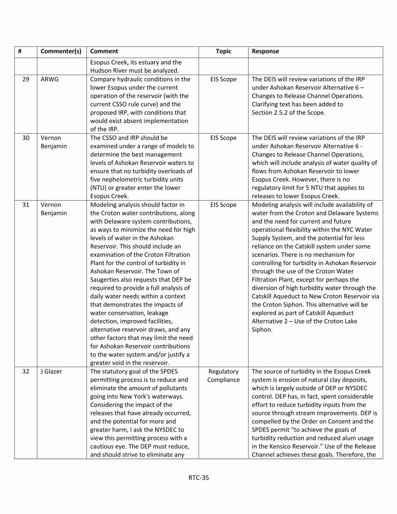
RTC-35
# Commenter(s) Comment Topic Response
Esopus Creek, its estuary and the Hudson River must be analyzed.
29 ARWG Compare hydraulic conditions in the lower Esopus under the current operation of the reservoir (with the current CSSO rule curve) and the proposed IRP, with conditions that would exist absent implementation of the IRP.
EIS Scope The DEIS will review variations of the IRP under Ashokan Reservoir Alternative 6 – Changes to Release Channel Operations. Clarifying text has been added to Section 2.5.2 of the Scope.
30 Vernon Benjamin
The CSSO and IRP should be examined under a range of models to determine the best management levels of Ashokan Reservoir waters to ensure that no turbidity overloads of five nephelometric turbidity units (NTU) or greater enter the lower Esopus Creek.
EIS Scope The DEIS will review variations of the IRP under Ashokan Reservoir Alternative 6 - Changes to Release Channel Operations, which will include analysis of water quality of flows from Ashokan Reservoir to lower Esopus Creek. However, there is no regulatory limit for 5 NTU that applies to releases to lower Esopus Creek.
31 Vernon Benjamin
Modeling analysis should factor in the Croton water contributions, along with Delaware system contributions, as ways to minimize the need for high levels of water in the Ashokan Reservoir. This should include an examination of the Croton Filtration Plant for the control of turbidity in Ashokan Reservoir. The Town of Saugerties also requests that DEP be required to provide a full analysis of daily water needs within a context that demonstrates the impacts of water conservation, leakage detection, improved facilities, alternative reservoir draws, and any other factors that may limit the need for Ashokan Reservoir contributions to the water system and/or justify a greater void in the reservoir.
EIS Scope Modeling analysis will include availability of water from the Croton and Delaware Systems and the need for current and future operational flexibility within the NYC Water Supply System, and the potential for less reliance on the Catskill system under some scenarios. There is no mechanism for controlling for turbidity in Ashokan Reservoir through the use of the Croton Water Filtration Plant, except for perhaps the diversion of high turbidity water through the Catskill Aqueduct to New Croton Reservoir via the Croton Siphon. This alternative will be explored as part of Catskill Aqueduct Alternative 2 – Use of the Croton Lake Siphon.
32 J Glazer The statutory goal of the SPDES permitting process is to reduce and eliminate the amount of pollutants going into New York's waterways. Considering the impact of the releases that have already occurred, and the potential for more and greater harm, I ask the NYSDEC to view this permitting process with a cautious eye. The DEP must reduce, and should strive to eliminate any
Regulatory Compliance
The source of turbidity in the Esopus Creek system is erosion of natural clay deposits, which is largely outside of DEP or NYSDEC control. DEP has, in fact, spent considerable effort to reduce turbidity inputs from the source through stream improvements. DEP is compelled by the Order on Consent and the SPDES permit “to achieve the goals of turbidity reduction and reduced alum usage in the Kensico Reservoir.” Use of the Release Channel achieves these goals. Therefore, the
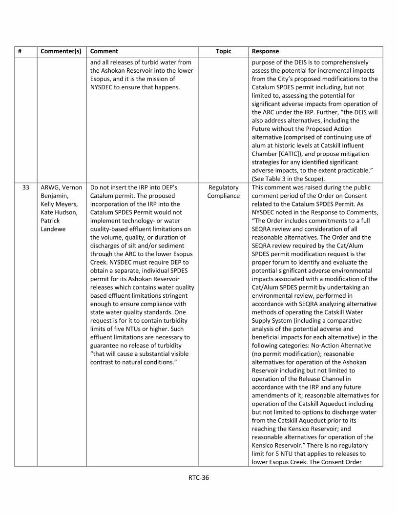
RTC-36
# Commenter(s) Comment Topic Response
and all releases of turbid water from the Ashokan Reservoir into the lower Esopus, and it is the mission of NYSDEC to ensure that happens.
purpose of the DEIS is to comprehensively assess the potential for incremental impacts from the City’s proposed modifications to the Catalum SPDES permit including, but not limited to, assessing the potential for significant adverse impacts from operation of the ARC under the IRP. Further, “the DEIS will also address alternatives, including the Future without the Proposed Action alternative (comprised of continuing use of alum at historic levels at Catskill Influent Chamber [CATIC]), and propose mitigation strategies for any identified significant adverse impacts, to the extent practicable.” (See Table 3 in the Scope).
33 ARWG, Vernon Benjamin, Kelly Meyers, Kate Hudson, Patrick Landewe
Do not insert the IRP into DEP’s Catalum permit. The proposed incorporation of the IRP into the Catalum SPDES Permit would not implement technology- or water quality-based effluent limitations on the volume, quality, or duration of discharges of silt and/or sediment through the ARC to the lower Esopus Creek. NYSDEC must require DEP to obtain a separate, individual SPDES permit for its Ashokan Reservoir releases which contains water quality based effluent limitations stringent enough to ensure compliance with state water quality standards. One request is for it to contain turbidity limits of five NTUs or higher. Such effluent limitations are necessary to guarantee no release of turbidity “that will cause a substantial visible contrast to natural conditions.”
Regulatory Compliance
This comment was raised during the public comment period of the Order on Consent related to the Catalum SPDES Permit. As NYSDEC noted in the Response to Comments, “The Order includes commitments to a full SEQRA review and consideration of all reasonable alternatives. The Order and the SEQRA review required by the Cat/Alum SPDES permit modification request is the proper forum to identify and evaluate the potential significant adverse environmental impacts associated with a modification of the Cat/Alum SPDES permit by undertaking an environmental review, performed in accordance with SEQRA analyzing alternative methods of operating the Catskill Water Supply System (including a comparative analysis of the potential adverse and beneficial impacts for each alternative) in the following categories: No-Action Alternative (no permit modification); reasonable alternatives for operation of the Ashokan Reservoir including but not limited to operation of the Release Channel in accordance with the IRP and any future amendments of it; reasonable alternatives for operation of the Catskill Aqueduct including but not limited to options to discharge water from the Catskill Aqueduct prior to its reaching the Kensico Reservoir; and reasonable alternatives for operation of the Kensico Reservoir.” There is no regulatory limit for 5 NTU that applies to releases to lower Esopus Creek. The Consent Order
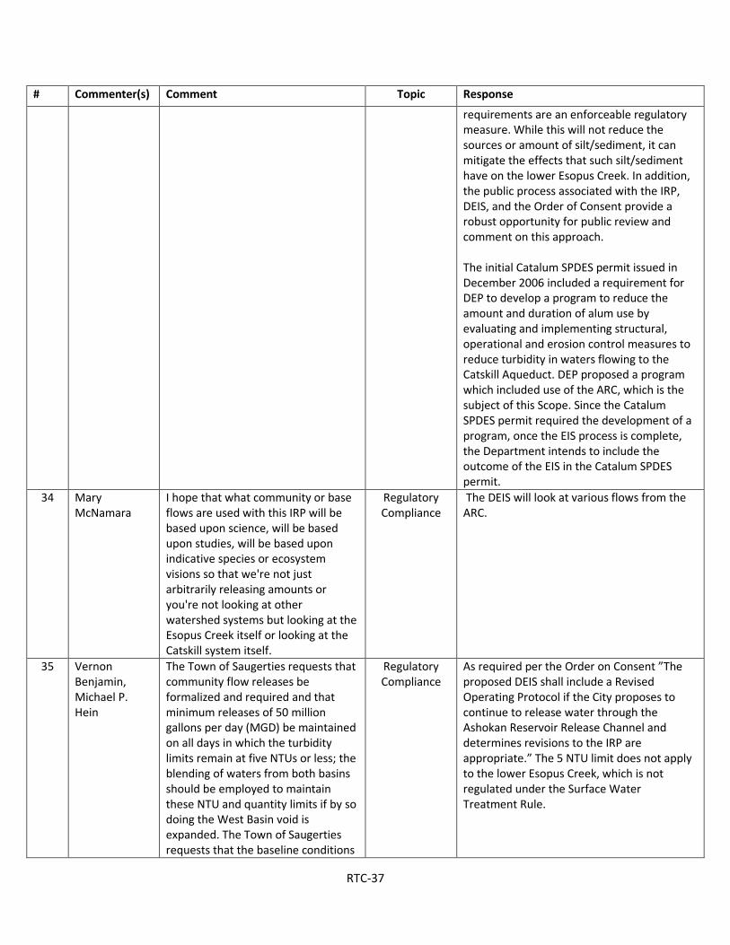
RTC-37
# Commenter(s) Comment Topic Response
requirements are an enforceable regulatory measure. While this will not reduce the sources or amount of silt/sediment, it can mitigate the effects that such silt/sediment have on the lower Esopus Creek. In addition, the public process associated with the IRP, DEIS, and the Order of Consent provide a robust opportunity for public review and comment on this approach. The initial Catalum SPDES permit issued in December 2006 included a requirement for DEP to develop a program to reduce the amount and duration of alum use by evaluating and implementing structural, operational and erosion control measures to reduce turbidity in waters flowing to the Catskill Aqueduct. DEP proposed a program which included use of the ARC, which is the subject of this Scope. Since the Catalum SPDES permit required the development of a program, once the EIS process is complete, the Department intends to include the outcome of the EIS in the Catalum SPDES permit.
34 Mary McNamara
I hope that what community or base flows are used with this IRP will be based upon science, will be based upon studies, will be based upon indicative species or ecosystem visions so that we're not just arbitrarily releasing amounts or you're not looking at other watershed systems but looking at the Esopus Creek itself or looking at the Catskill system itself.
Regulatory Compliance
The DEIS will look at various flows from the ARC.
35 Vernon Benjamin, Michael P. Hein
The Town of Saugerties requests that community flow releases be formalized and required and that minimum releases of 50 million gallons per day (MGD) be maintained on all days in which the turbidity limits remain at five NTUs or less; the blending of waters from both basins should be employed to maintain these NTU and quantity limits if by so doing the West Basin void is expanded. The Town of Saugerties requests that the baseline conditions
Regulatory Compliance
As required per the Order on Consent ”The proposed DEIS shall include a Revised Operating Protocol if the City proposes to continue to release water through the Ashokan Reservoir Release Channel and determines revisions to the IRP are appropriate.” The 5 NTU limit does not apply to the lower Esopus Creek, which is not regulated under the Surface Water Treatment Rule.
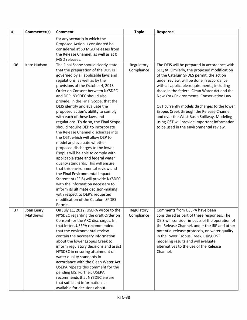
RTC-38
# Commenter(s) Comment Topic Response
for any scenario in which the Proposed Action is considered be considered at 50 MGD releases from the Release Channel, as well as at 0 MGD releases.
36 Kate Hudson The Final Scope should clearly state that the preparation of the DEIS is governed by all applicable laws and regulations, as well as by the provisions of the October 4, 2013 Order on Consent between NYSDEC and DEP. NYSDEC should also provide, in the Final Scope, that the DEIS identify and evaluate the proposed action’s ability to comply with each of these laws and regulations. To do so, the Final Scope should require DEP to incorporate the Release Channel discharges into the OST, which will allow DEP to model and evaluate whether proposed discharges to the lower Esopus will be able to comply with applicable state and federal water quality standards. This will ensure that this environmental review and the Final Environmental Impact Statement (FEIS) will provide NYSDEC with the information necessary to inform its ultimate decision-making with respect to DEP’s requested modification of the Catalum SPDES Permit.
Regulatory Compliance
The DEIS will be prepared in accordance with SEQRA. Similarly, the proposed modification of the Catalum SPDES permit, the action under review, will be done in accordance with all applicable requirements, including those in the federal Clean Water Act and the New York Environmental Conservation Law.
OST currently models discharges to the lower Esopus Creek through the Release Channel and over the West Basin Spillway. Modeling using OST will provide important information to be used in the environmental review.
37 Joan Leary Matthews
On July 11, 2012, USEPA wrote to the NYSDEC regarding the draft Order on Consent for the ARC discharges. In that letter, USEPA recommended that the environmental review contain the necessary information about the lower Esopus Creek to inform regulatory decisions and assist NYSDEC in ensuring attainment of water quality standards in accordance with the Clean Water Act. USEPA repeats this comment for the pending EIS. Further, USEPA recommends that NYSDEC ensure that sufficient information is available for decisions about
Regulatory Compliance
Comments from USEPA have been considered as part of these responses. The DEIS will consider impacts of the operation of the Release Channel, under the IRP and other potential release protocols, on water quality in the lower Esopus Creek, using OST modeling results and will evaluate alternatives to the use of the Release Channel.
RTC-39
# Commenter(s) Comment Topic Response
attainment of water quality standards for Kensico Reservoir, as well as the lower Esopus Creek. While the draft scope does describe the proposed method of comparing the "length of turbid events" for different alternatives, the document does not specifically commit to evaluating whether water quality standards can be attained.
38 Joan Leary Matthews, Kate Hudson, Philip Bein, Charles Silver, Michael Warren, ARWG
NYSDEC has adopted narrative criteria for turbidity and for suspended, colloidal and settleable solids (6 NYCRR Part 703.2). The narrative criterion for turbidity states, "no increase that will cause a substantial visible contrast to natural conditions." The narrative criterion for suspended, colloidal and settleable solids states, "none from sewage, industrial wastes, or other wastes that will cause deposition or impair waters for their best uses." Both of these narrative criteria are applicable to all classifications of waters in New York State, including the above-referenced waters. Exceedances of these criteria may result in negative impacts to public health and the environment. Therefore, as noted above, NYSDEC should specifically address, in the EIS, whether or not the alternatives being studied will ensure that water quality standards can be attained. We would urge NYSDEC to consider the 303(d) listing of the lower Esopus Creek and its obligations under the Clean Water Act that was the impetus to take action to address the underlying cause of that impairment, particularly developing this EIS and the alternatives analysis. Given this listing, the selection of an alternative that results in an unavoidable adverse impact may not be legally acceptable. For example, the 303(d) listing of the lower Esopus by the
Regulatory Compliance
This environmental review is separate and distinct from the regulatory processes associated with the lower Esopus Creek’s inclusion on the 303(d) list of impaired waters under the federal Clean Water Act. As noted above, the DEIS will consider impacts of the operation of the Release Channel, under the IRP and other potential release protocols, on water quality in the lower Esopus Creek. The IRP incorporates several measures to minimize turbidity impacts to the lower Esopus Creek. For example, when substantial contrast in turbidity exists with varying depths of the West Basin of the Ashokan Reservoir, DEP will make reasonable efforts to make releases from the elevation with the least turbidity. The IRP places caps on the number of days releases can occur depending on the turbidity levels of the releases, and establishes ramping rates for the releases. Discharges of water above certain turbidity thresholds would only be allowed on days where the Esopus Creek, flowing into Ashokan Reservoir, is also above that threshold. Daily turbidity monitoring during the period of releases would also be conducted. See also response to comment 32.

RTC-40
# Commenter(s) Comment Topic Response
USEPA as a result of turbid releases from the Ashokan Reservoir could have future implications for wastewater plant operations and permitting requirements. NYSDEC must ensure that any future releases to the lower Esopus Creek will comply with State water quality standards for turbidity. NYSDEC cannot authorize the discharge of a pollutant of concern into an already impaired waterbody, the lower Esopus Creek. Just as NYSDEC cannot approve an action that would allow water quality violations to continue, neither may it authorize, for the first time, the discharge of a pollutant of concern into an already-impaired waterbody. USEPA has already found that the Ashokan Reservoir releases have violated the State water quality standard for turbidity set forth in 6 NYCRR 702.3.6 The proposed incorporation of the IRP into the Catalum SPDES Permit would authorize the continuation of these violations. The IRP purports to allow DEP releases as long as DEP complies with the conditions of the Protocol; however, none of those conditions requires DEP to comply with the narrative water quality standard for turbidity. As stated by USEPA in its January 2013 Response to Comments on the Proposed Listing, “the State did not demonstrate that this protocol constitutes a required control measure expected to result in attainment of water quality standards in the lower Esopus Creek.” Moreover, the Draft Scope does not set elimination of impairments of the Creek as one of the benchmarks for the environmental review. Watershed Inspector General recommends such a benchmark.
RTC-41
# Commenter(s) Comment Topic Response
39 Vernon Benjamin
NYSDEC should require the issuance of a 6 NYCRR Part 608 permit to account for and mitigate these consequences of turbidity overloads on the lower Esopus Creek.
Regulatory Compliance
6 NYCRR § 608 gives NYSDEC the authority to regulate entities disturbing protected streams, constructing dams, installing docks or moorings, excavating within the banks of a creek and/or the placing of fill in a creek. This permit would not apply to the Proposed Action.
40 ARWG, Kelly Meyers
Resource monitoring is both necessary and appropriate in order to ensure that any regulatory action(s) supported by the findings of the EIS do not result in additional or unintended environmental impacts that were not anticipated or correctly estimated or predicted through the environmental review process. The Final Scope should require monitoring programs to be developed in consultation with regulators, stakeholders and all involved agencies to both inform the environmental analysis conducted as part of the EIS process, and to track changes in resource conditions in the lower Esopus under the IRP, which has been implemented in advance of the SEQRA EIS process while the DEIS is being prepared. Include specific provisions and recommendations for monitoring lower Esopus Creek resources over the period of any permitted activity to ensure that actual environmental impacts are not greater than anticipated. Include long term monitoring of resources that have the potential to continue to be impacted by the action undertaken by the regulatory agency.
Regulatory Compliance
As stated in the October 4, 2013 Order on Consent, the City’s proposed DEIS shall include a Revised Operating Protocol if the City proposes to continue to release water through the Ashokan Reservoir Release Channel and determines revisions to the IRP are appropriate, and a plan for monitoring of the ARC releases. The DEIS, Revised Operating Protocol, and Monitoring Plan as required by the Order on Consent will be subject to public review. Clarifying text has been added to Section 1.6 of the Scope.
In addition, and as described in the Scope, DEP is/will be collecting data related to socioeconomic conditions, water quality and flow, aquatic resources, wetlands and floodplain forests, and stream geomorphology along the length of the Creek.
41 ARWG, Vernon Benjamin, Candace Balmer
Since the reservoir elevation is determined by the CSSO which serves as the reservoir rule curve, and dictates target reservoir elevations, operation of the reservoir in conformance with the current CSSO is a factor that can also significantly influence discharges to the lower Esopus under the IRP, and therefore must be evaluated as part of the EIS. The CSSO and IRP should be revised
Alternatives As described in Section 2.5 of the Scope, the DEIS will review variations of the IRP under Ashokan Reservoir Alternative 6 – Changes to Release Channel Operations. Clarifying text has been added to Section 2.5.2 of the Scope.

RTC-42
# Commenter(s) Comment Topic Response
and flood attenuation modeled through the maintenance of Ashokan Reservoir water levels at 90, 80, and 70%, so as to determine the best voids to be used in ensuring that turbidity overloads do not occur in the lower Esopus Creek.
42 Vernon Benjamin
Since, as acknowledged by DEP (p. 10), filtration avoidance “can identify, monitor, and control activities in the watershed that may have an adverse effect on source water quality,” it should be required that filtration of turbidity loads of five NTUs or greater be considered due to its potential impact on municipal water systems along the lower Esopus Creek that contain “ground water under direct influence of surface water,” or that filtration avoidance measures be required to prevent turbidity loads of five NTUs or greater. The Town of Saugerties believes that municipalities whose water systems fall into this category should be held harmless of any and all costs associated with the testing, discovery and remediation of contaminants in their ground waters that may contain evidence of high turbidity loads associated with the discharges of the Ashokan Reservoir, and that it should be a condition of this Permit modification that such costs be borne by DEP.
Alternatives There is no regulatory limit for 5 NTU that applies to releases to lower Esopus Creek. There are no municipal water systems along the lower Esopus Creek that contain “ground water under direct influence of surface water” that are unfiltered.
Preliminary review of soils data by DEP indicates the Esopus Creek is dominated by granular material (silt, till, sand, etc.) that would retain fine sediment as water infiltrated into the soil. Additionally, the general flow of groundwater in the region is from higher elevations to lower elevations (toward the Creek), due to the presence of confining layers. However, an assessment may be conducted if there is evidence that wells are located in close proximity to the Creek that may be affected by Releases under the IRP.
43 Vernon Benjamin, Joseph Quirk, Amy Williams, Thomas Keane, John Morrow, Jay Joseph, Fred Hirsch, Carl Belfigilo, Bob Lewis
A range of alternatives must be proposed to address this problem, other than discharging turbid water into Esopus Creek, since it is not addressed in the ones provided. The turbid releases need to be prevented and/or significantly reduced.
Alternatives See the alternatives described in Section 2.5 of the Scope.
44 Riverkeeper, Kate Hudson, Patrick Landewe,
It is strongly recommended that the reduction in alum use not be treated as a given, but rather be subject to evaluation in the context of
Alternatives DEP is compelled by the Order on Consent and the SPDES permit “to achieve the goals of turbidity reduction and reduced alum usage in the Kensico Reservoir.” Use of the Release
RTC-43
# Commenter(s) Comment Topic Response
ARWG, Vernon Benjamin, Greg Helsmoortel
considering operational alternatives. Rework the basic framework of the EIS as outlined in the Draft Scope such that it no longer establishes this environmental review as a trade-off between using the ARC to discharge turbidity to the lower Esopus versus continued use of alum at Kensico Reservoir. Do not pit the viability and health of 30+ miles of stream that is not part of the NYC Water System against the cost of alum treatment and floc dredging in a reservoir that is part of the NYC Water System. The Town of Saugerties requests that the prevention of turbid waters from entering the Kensico Reservoir not be allowed as a reason for discharging turbid waters into the lower Esopus Creek.
Evaluation of continued, tightly controlled alum use should be one of the alternatives identified by the Final Scope. Paired with other structural and operational alternatives at the Ashokan Reservoir, as well as structural modifications at Kensico Reservoir, its use and resulting deposition could be significantly limited, while providing substantial benefits to the lower Esopus Creek and communities and maintaining drinking water quality for New York City residents. For instance, structural modifications to the discharge area of the Catskill Aqueduct in the Kensico Reservoir could be made to contain alum floc and allow regular alum use for turbidity control. Given climate forecasts greater frequency of turbid events, the goal of reducing alum use at the Kensico Reservoir seems short-sighted, taking away operational flexibility of the water supply system when it is needed more than ever to respond to extreme storm events.
Channel achieves these goals. Therefore, the purpose of the DEIS is to comprehensively assess the potential for incremental impacts from the City’s proposed modifications to the Catalum SPDES permit including, but not limited to, assessing the potential for significant adverse impacts from operation of the ARC under the IRP. Further, “the DEIS will also address alternatives, including the Future without the Proposed Action alternative (comprised of continuing use of alum at historic levels at CATIC), and propose mitigation strategies for any identified significant adverse impacts, to the extent practicable.” The DEIS will also include an evaluation of combination of viable alternatives including pairing the use of alum, as needed, with other operational alternatives at Ashokan Reservoir (See Table 3 in the Scope).
RTC-44
# Commenter(s) Comment Topic Response
45 Vernon Benjamin, Josepha Gutelius
If these waters are to continue to be released in this manner, the appropriate regulatory solution is a filtration plant, constructed wetlands, alum addition at the source, or other means to separate the turbidity from the water. DEP’s fear of the cost of filtration may be the reason for its characterization of turbidity management as “control measures,” but in practice, that management has not controlled much at all.
Alternatives This DEIS will evaluate several turbidity control measures and alternatives. The construction of a filtration plant is not part of the scope. For alum to be effective as an exclusive means of controlling turbidity it must be added to the source water, allowed to mix for an appropriate time, and then the treated water must be captured and held temporarily in a reservoir to allow for settling. Construction of high rate sedimentation basins for controlling the turbidity from the Shandaken Tunnel Outlet entering Ashokan Reservoir was evaluated as an alternative under the Catskill Turbidity Control Phase I Study, but these were rejected due to difficulty with intermittent operation and solids handling, and anticipated permitting and environmental issues and these same issues would be expected in this instance. In addition, applying alum at Ashokan Reservoir is not efficient, as it would require the addition of much more alum than what must be applied at Kensico Reservoir, since the flow to be treated and associated turbidity levels are often higher. This significantly higher volume of alum needed would result in vast floc deposition at Ashokan Reservoir. Alum application at Ashokan Reservoir does not take advantage of the design of the Catskill System and simply relocates the problem to Ashokan Reservoir.
46 Kelly Meyers, ARWG
The EIS must describe the objectives and proposed methodology for measuring and evaluating the success of any proposed mitigation measures. Expand the mitigation section to include a discussion of the expected continuing impacts of the proposed action, even after adoption of specific mitigation measures.
Mitigation Where potential significant adverse impacts are identified in the DEIS, DEP will seek to avoid or minimize such potential incremental impacts by incorporating mitigation measures that are determined to be practicable.
47 Patrick Landewe, ARWG, Candace Balmer, Kate Hudson
Reduced demand for Catskill water to avoid alum use could increase storage levels in the reservoir above historic norms and, in turn, affect the risk of spills from the reservoir into the lower Esopus. The Saugerties waterfront developed over the past century with the upstream presence
Changes to CSSO
The IRP includes a CSSO that – in conjunction with the use of weather forecasts – helps DEP to create voids in Ashokan Reservoir based on time of year, anticipated inflow, and projected demands. This helps to reduce the number and intensity of spill events and provides a void for capturing turbid water so it is not released downstream. However, even

RTC-45
# Commenter(s) Comment Topic Response
of the Ashokan Reservoir operating under the normal historic regime. Until the past decade, the reservoir typically had a void during flood events, and the reservoir captured the additional flow. Even though DEP contends that selective diversion of water from the Catskill System is not subject to environmental review, the reduced demand for Catskill water should be part of the EIS cumulative review when various DEP measures will be considered together to determine whether there is a potential for significant adverse cumulative impacts.
when full and spilling, Ashokan Reservoir, as with all reservoirs, attenuates flooding from natural inflows. The modeling for this DEIS will include demand projections and DEP rules for selective diversion using future infrastructure projects and will be compared to the Future without the Proposed Action alternative. However, adjustment of diversions from Ashokan Reservoir is at DEP’s discretion and not subject to environmental review.
48 Patrick Landewe, ARWG, Robert Illjes
The EIS should also reexamine the CSSO as it relates to seasonal flood risk. The current CSSO graph adopted under the IRP does not adequately account for late summer tropical storms and hurricanes, which pose flood risk especially when the reservoir is full or nearly full. In addition, if when the IRP was written calling for 100% capacity in June and consumption was reduced by some 45 percent, why can't the reservoir be lowered to a greater extent?
Changes to CSSO
Ashokan Reservoir is not a flood control reservoir. The primary purpose of the reservoir is to provide water for use by the City. However, downstream flood control benefits are a normal feature of reservoirs, as they attenuate peak flows even when full and spilling. That being said, as part of the CSSO, DEP has used near-term forecasts and special operations over the past few years to withdraw or release water from the Reservoir in advance of major storm events to try to further enhance the flood mitigation benefits of the reservoir. Because the CSSO takes into account forecasted inflows, the reservoir could be drawn down well below the CSSO curve in anticipation of a large storm, such as a hurricane. While overall NYC demand has decreased over the past two decades, water supply planning takes into consideration the need to meet future demand based on potential population growth and reserves for drought or other water supply emergency. The DEIS will evaluate potential changes to the CSSO as part of Ashokan Alternative 6, variations of the IRP. The analysis will identify any potential risks to the water supply at various increased voids as compared to any potential increased spill mitigation. Clarifying text has been added to Section 2.5.2 of the Scope.
49 Bruce Jackson, ARWG, Rosanne and
Consider alternate CSSO targets that minimize spill events and consider rules to maximize flow through the
Changes to CSSO
For the DEIS, changes to the CSSO would be analyzed as part of the Alternatives Analysis as discussed in Section 2.5.2
RTC-46
# Commenter(s) Comment Topic Response
Roger Yetzer, Vernon Benjamin, Kate Hudson, Gary Bellows, Mary McNamara, Margo Eberlein, Patrick Landewe, James E. Quigley, Michael Warren, John Morrow, Candace Balmer, Kelly Myers, Ronald Eberlein, Johanna H. Eberlein, Robert Illjes, Chris Gibson, Joseph Quirk, Paul Vanblarcum, Multiple Commenters (Standardized Letter)
Catskill Aqueduct as an alternative to CSSO. Analyze an alternate CSSO with min at 70, 80, or 85%, max at 90%.
50 Bruce Jackson, ARWG, Rosanne and Roger Yetzer, Kate Hudson, Gary Bellows, Mary McNamara, Margo Eberlein, Patrick Landewe, James E. Quigley, Michael Warren, John Morrow, Candace Balmer, Kelly
Evaluate slower/steadier release rates using weather/hydrologic history/forecasts instead of CSSO target and incorporate both a recognition of storm cycles in the Northeast in modeling conducted relative to a CSSO and non-seasonal extreme events and hurricane season in designing the CSSO.
Changes to CSSO
The CSSO was developed based on modeling of the NYC water supply system. CSSO releases are forecast-based. Releases are made in advance of storms to prevent spills from occurring. The amount/duration of releases is a complex calculation that takes into account current demands, near-term and long-term weather forecasts, recent inflows, and watershed snowpack.
DEP has made every effort to incorporate state-of-the-art weather forecasts into its modeling for determining release decisions. However, there is a practical limit to the length of time that forecasts can project ahead. Some storms build up slowly, while other develop rapidly, leaving DEP with little time for operations to manage sudden inflows. Additional release rules adjust the
RTC-47
# Commenter(s) Comment Topic Response
Myers, Ronald Eberlein, Johanna H. Eberlein, Robert Illjes, Chris Gibson, Paul Vanblarcum
ramping rates (i.e. the speed with which releases change from day to day) to prevent sudden changes in flows downstream.
51 ARWG, Kelly Myers
Expand the evaluation of potential water surface elevation and inundation areas for flow releases beyond 600 MGD. Evaluate impacts associated with both controlled flow releases through the release channel and spill events.
Changes to CSSO
As discussed in Section 2.3.1.8, the hydrologic analysis will consider base ARC discharges up to 600 MGD, including flows specified under the IRP, as well as flows resulting from storms up to the 500-year event. The alternatives to the IRP will also consider flows up to the maximum release capacity of 1,200 MGD. The DEIS will assess impacts from both releases and spills on the lower Esopus Creek under the IRP, the Future without the Proposed Action alternative and other alternatives considered.
52 M. McNamara,MichaelWarren,PatrickLandewe,ARWG, JamesE. Quigley,Kelly Myers,Gary Bellows,Riverkeeper
Full consideration of proposed Ashokan Reservoir Alternative 6-Changed Release Channel Operations, requires that OST and CSSO, which drive release channel operation decision-making be on the table as a part of the alternatives analysis.
Alternative 6 – Changes to the
IRP
The CSSO is part of the IRP as described in the DEIS as a component of the Proposed Action. OST is tool used to evaluate the effectiveness of the alternatives described in Section 2.5.
53 ARWG, Kate Hudson, Kelly Myers
The EIS should evaluate alternative operational flows, including both Operational Release flows and Spill Mitigation flows, that will minimize both the amount of turbidity discharged into the lower Esopus, ensuring that all discharges meet water quality standards, and the volume, velocity and duration of releases to avoid increased turbidity in the lower Esopus as a result of bank erosion and channel scour.
Alternative 6 – Changes to the
IRP
A range of flows will be assessed as part of Alternative 6 to identify whether a better alternative to the IRP exists that meets DEP’s requirements for water supply and quality and also minimizes downstream impacts to the lower Esopus Creek.
However, naturally occurring turbidity in Esopus Creek is due to the presence of clay deposits along the banks and streambed. Ashokan Reservoir cannot be expected to prevent all turbid water originating upstream of the reservoir from flowing downstream.
The DEIS will evaluate the relative impacts to the lower Esopus Creek from implementation of the IRP, including bank erosion and channel scour from the releases, as compared to the Future without the
RTC-48
# Commenter(s) Comment Topic Response
Proposed Action alternative and other potential alternatives as detailed in the Scope. The objective is to select the options that best meet the needs of DEP’s water supply, while being protective of lower Esopus Creek.
54 Susan H. Gillespie, Fred Hirsch, J. Capozzelli, Kate Hudson, Mary McNamara, Joseph Glazer, ARWG, Joseph Quirk, Brian Sawchuck, Multiple Commenters (Standardized Letter)
The EIS should evaluate alternatives to mitigate and/or minimize turbid releases to Esopus Creek, including consideration of firm turbidity caps, quantity, and duration limits on all releases. The use of IRP threshold turbidity values (30 NTU and 100 NTU) with respect to the discharge of these turbid waters to the lower Esopus should be evaluated and scientifically defended.
Alternative 6 – Changes to the
IRP
Studies conducted as part of the DEIS will evaluate the potential impact of both flows and water quality on resource conditions in the Creek. Naturally occurring turbidity in Esopus Creek is due to the presence of clay deposits along the banks and streambed. Ashokan Reservoir cannot be expected to prevent all turbid water originating upstream of the reservoir from flowing downstream. However, the IRP includes specific water quality requirements limiting turbidity levels for community, spill mitigation, and operational releases in order to be protective of downstream water quality in the event of high turbidity inflow into Ashokan Reservoir. These turbidity levels, and the high-flow cut off based on the Mt. Marion gauge, are designed to be more protective of water quality than uncontrolled spills. The DEIS will evaluate the relative impacts to the lower Esopus Creek from implementation of the IRP as compared to the Future without the Proposed Action alternative and other potential alternatives as detailed in the Scope. The objective is to select the options that best meet the needs of DEP’s water supply, while being protective of lower Esopus Creek.
55 Mary McNamara, Michael Warren, Michael Hein, Patrick Landewe, ARWG, James E. Quigley, Kelly Myers, Gary Bellows, Riverkeeper, Joseph Glazer,
Minimum flows for baseline conditions and alternatives analysis should be based on actual studies/historical data recorded in lower Esopus Creek. Within Alternative 6, there also needs to be more study on low-flow releases to provide releases that enhance stream function, as well as deliver base flows that help draw down the West Basin when there is a high amount of precipitation. Base community releases on water quality and aquatic habitat needs actual
Community Releases
The purpose of the DEIS is to evaluate impacts of the IRP as part of the Modification of the Catalum SPDES permit, which includes CSSO and community releases. In addition, Ashokan Alternative 6 will evaluate a range of community releases as discussed in Section 2.5 and will look at implications both to water supply and the health of the lower Esopus Creek.

RTC-49
# Commenter(s) Comment Topic Response
Paul Vanblarcum
studies/historical data recorded in lower Esopus Creek, as well as an assessment of recreational use needs for the stream. It is requested that DEP attempt community releases greater than 15-20 MGD, up to 50-60 MGD. Combine changes inreleases with alternative CSSOtargets and that combined wouldoptimize downstream flows for waterquality and aquatic habitat, andminimize the risk for downstreamflooding and bank erosion, protectpublic safety and reduce privateproperty damage.
56 Kate Hudson NYSDEC should evaluate alternatives to current operational practices, including selective diversion and withdrawal, West Basin drawdown and releases from the Shandaken Tunnel, among others, that will reduce impacts and increase benefits to the lower Esopus Creek.
Discharge Mitigation Releases
As discussed in Section 1.6 of the Scope, “As indicated in Table 1, DEP has already implemented certain measures; while others are planned to be operational over the next few years. Many of these elements either do not require environmental review, or have also already undergone separate environmental reviews because of their independent utility and will be implemented by DEP by 2019.” While these measures are not the focus of this EIS, use of these elements will be included as part of the modeling assumptions in this review. As noted in Section 1.1 of the Scope, “In addition, all of these measures will be considered together to determine whether there is a potential for significant adverse cumulative impacts and potential benefits.” All turbidity control measures are being considered alone and in combination to determine the best operating procedure for the lower Esopus Creek and DEP water supply.
57 ARWG, Rosanne and Roger Yetzer, Joseph Quirk, Kate Hudson, Patrick Landewe, Multiple Commenters (Standardized Letter)
The EIS should consider including use of East Basin and blended East and West Basin releases through the Release Channel to the lower Esopus Creek.
Discharge Mitigation Releases
As discussed in Section 2.5.2 of the Scope, blended releases will be evaluated to the extent practicable with consideration given to the impacts to the public water supply system.

RTC-50
# Commenter(s) Comment Topic Response
58 Mary McNamara
Flushing flows must be part of the scope of the EIS. Flushing does not mitigate nor transport the deposits of fine clays with clearer water releases. Flushing has not been adequately studied nor monitored regarding suspended fine clays that have deposited in the slower moving reaches of the lower Esopus Creek and estuary. Any mitigation from operational releases must be monitored and had peer review to assess what if any mitigation is provided. I strongly recommend that flushing is not considered a mitigating factor to heavy concentrated, extended dense sediment releases. I don't believe it's been properly studied.
Flushing The IRP currently includes flushing requirements, based on turbidity levels of 30 to 60 NTU and 60 to 100 NTU for both discharge mitigation and operational releases. A component of the Proposed Action is use of the IRP, which includes flushing flows; therefore, these flows will be analyzed in the DEIS. Modifications to the IRP will be also be reviewed in the DEIS, specifically within Alternative 6, as it relates to both flow, duration, sedimentation, and water quality.
59 ARWG, Patrick Landewe, Greg Helsmoortel, Vernon Benjamin, Michael Hein, Mary McNamara
The alternatives proposed in the Draft Scope are all discussed from the perspective that any viable alternative must be capable of reducing or significantly eliminating the need to add alum to treat turbid waters in the Catskill Aqueduct. The ARWG disagrees with this premise. Thus far, the City has externalized the cost of turbidity control onto the lower Esopus Creek through prolonged turbid releases. The DEP needs to be compelled by the SEQR process to mitigate downstream impacts and explore alternatives that offer greater flexibility to handle extreme storm events. With the overarching goal of developing up-to-date solutions that meets both the needs of the City and the concerns of downstream communities, the Village of Saugerties urges the NYSDEC to rigorously examine downstream impacts of the Catskill Turbidity Control program as well as thoroughly explore alternatives that will equip the DEP to better operate the Ashokan Reservoir for multi-objective optimization. To that end, the interests of the Village of
General DEP is compelled by the Order on Consent and the SPDES permit “to achieve the goals of turbidity reduction and reduced alum usage in the Kensico Reservoir.” Therefore, the purpose of the DEIS is to “assess the potential for significant adverse impacts from operation of the ARC under the Interim Ashokan Release Protocol.” Further, “the DEIS will also address alternatives, including the Future without the Proposed Action alternative (comprised of continuing use of alum at historic levels at CATIC), and propose mitigation strategies for any identified significant adverse impacts, to the extent practicable.” The use of alum in combination with feasible structural and operational alternatives will also be evaluated as part of this DEIS.

RTC-51
# Commenter(s) Comment Topic Response
Saugerties should not be comprised in a trade-off with the City’s aims of alum reduction and turbidity control. Reservoir operations should be optimized to meet multiple goals while avoiding tradeoffs. A long and involved regulatory process is currently underway to minimize these discharges, yet there is clearly a lack of commitment to eliminating the turbid water discharges altogether in the event of another major storm event. It is no longer an act of God, but an act of man, and man should be held accountable.
60 ARWG, Kelly Myers, Riverkeeper, Kate Hudson
Ashokan Reservoir Alternative 1, the West Basin Outlet, should be deleted from the scope as an alternative to be considered in the DEIS because use of that outlet would result in the potential for a substantial increase in the amount of West Basin water discharged to the lower Esopus Creek to staggering levels (up to an additional 6 billion gallons per day over the up to 1 billion gallons that is currently allowed to be discharged through the release channel under the IRP). Discharges at such volumes would only result in substantially greater impacts to the Creek than we have already seen.
Additional details
requested: Operations
protocols for all alternatives
The potential impacts and benefits to the lower Esopus Creek from use of this alternative will be evaluated and disclosed in the DEIS.
61 ARWG, Kelly Myers, Riverkeeper, Kate Hudson
Include the combined turbidity reduction ability of non-discharge alternatives with the turbidity-reduction capabilities of strategies already being constructed and implemented. For example, pair Alternatives 2 and 4, Dividing Weir Crest Gates and Upper Gate Chamber Modifications, respectively, with an explicit and detailed operating protocol that would address when and what water volumes and levels of turbidity would be released to the lower Esopus Creek from both the ARC and the spillway under these alternatives.
Additional details
requested: Operations
protocols for all alternatives
The assessment will use reports, data, modeling tools, cost-estimates, and regulatory analyses to determine if an alternative has a high potential for being feasible, effective, and economical for managing turbidity while minimizing the potential for impacts to lower Esopus Creek and Kensico Reservoir. As discussed in Section 2.5, the EIS will also include an analysis of combinations of the feasible structural and operational alternatives.
RTC-52
# Commenter(s) Comment Topic Response
62 Kelly Myers, ARWG, Kate Hudson
ARWG would support inclusion of Catskill Alternatives 1 through 4 if they were paired with an operational protocol. For example, Alternative 1 could be combined with alternative operational protocols requiring water discharged from the Drainage Chamber to the Hudson River to meet specific turbidity threshold conditions. Diversion of East and West Basin blended water, combined with travel and settling time in the Catskill Aqueduct, could ensure the discharge of water to the Hudson River from the Drainage Chamber that does not violate water quality standards.
Additional details
requested: Operations
protocols for all alternatives
Modeling of alternatives will look at pairing structural and operational controls and assess benefits and potential incremental impacts to NYC water supply as well as other receiving water bodies. The assessment will use existing reports, data, modeling tools, cost-estimates, and regulatory analyses to determine if an alternative has a high potential for being feasible, effective, and economical for managing turbidity while minimizing the potential for impacts to lower Esopus Creek and Kensico Reservoir. As discussed in Section 2.5, the DEIS will include an analysis of combinations of the feasible structural and operational alternatives.
63 Kelly Myers, ARWG, Kate Hudson
Evaluate structural alternatives including but not limited to Ashokan Alternatives 2, 4 and 8 and Catskill Alternative 1 such as increasing the height of dividing weir gates as an alternative to CSSO.
Additional details
requested: Operations
protocols for all alternatives
The CSSO has direct benefits for downstream communities since it provides the opportunity to create storage voids in the reservoir for the capture of large storm events. While structural modifications could provide additional benefits, it is not anticipated they would replace operation of Ashokan Reservoir under the CSSO now that it has been established.
64 ARWG, Kelly Myers
Provide more detail to Alternative 7 and additionally pair alternative 7 with an operational alternative that takes advantage of the reduction in West Basin, potentially turbid water and the increase in East Basin cleaner water, by maximizing the release of higher quality East Basin and blended East and West Basin waters to the lower Esopus Creek through the ARC.
Additional details
requested: Operations
protocols for all alternatives
Additional details for each alternative will be provided in the DEIS. The assessment will use existing reports, data, modeling tools, cost-estimates, and regulatory analyses to determine if an alternative has a high potential for being feasible, effective, and economical for managing turbidity. As discussed in Section 2.5.2 of the Scope, blended releases will be evaluated to the extent practicable with consideration given to the impacts to the public water supply system As discussed in Section 2.5, the EIS will also include an analysis of combinations of the feasible structural and operational alternatives.
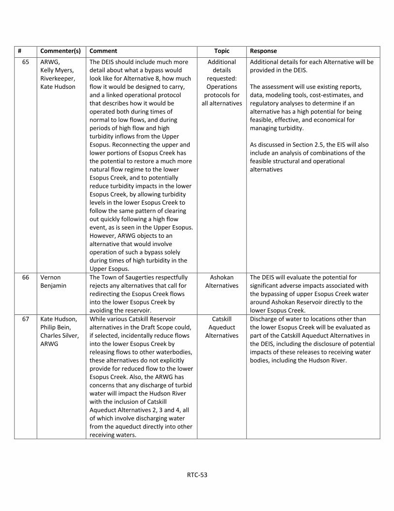
RTC-53
# Commenter(s) Comment Topic Response
65 ARWG, Kelly Myers, Riverkeeper, Kate Hudson
The DEIS should include much more detail about what a bypass would look like for Alternative 8, how much flow it would be designed to carry, and a linked operational protocol that describes how it would be operated both during times of normal to low flows, and during periods of high flow and high turbidity inflows from the Upper Esopus. Reconnecting the upper and lower portions of Esopus Creek has the potential to restore a much more natural flow regime to the lower Esopus Creek, and to potentially reduce turbidity impacts in the lower Esopus Creek, by allowing turbidity levels in the lower Esopus Creek to follow the same pattern of clearing out quickly following a high flow event, as is seen in the Upper Esopus. However, ARWG objects to an alternative that would involve operation of such a bypass solely during times of high turbidity in the Upper Esopus.
Additional details
requested: Operations
protocols for all alternatives
Additional details for each Alternative will be provided in the DEIS. The assessment will use existing reports, data, modeling tools, cost-estimates, and regulatory analyses to determine if an alternative has a high potential for being feasible, effective, and economical for managing turbidity. As discussed in Section 2.5, the EIS will also include an analysis of combinations of the feasible structural and operational alternatives
66 Vernon Benjamin
The Town of Saugerties respectfully rejects any alternatives that call for redirecting the Esopus Creek flows into the lower Esopus Creek by avoiding the reservoir.
Ashokan Alternatives
The DEIS will evaluate the potential for significant adverse impacts associated with the bypassing of upper Esopus Creek water around Ashokan Reservoir directly to the lower Esopus Creek.
67 Kate Hudson, Philip Bein, Charles Silver, ARWG
While various Catskill Reservoir alternatives in the Draft Scope could, if selected, incidentally reduce flows into the lower Esopus Creek by releasing flows to other waterbodies, these alternatives do not explicitly provide for reduced flow to the lower Esopus Creek. Also, the ARWG has concerns that any discharge of turbid water will impact the Hudson River with the inclusion of Catskill Aqueduct Alternatives 2, 3 and 4, all of which involve discharging water from the aqueduct directly into other receiving waters.
Catskill Aqueduct
Alternatives
Discharge of water to locations other than the lower Esopus Creek will be evaluated as part of the Catskill Aqueduct Alternatives in the DEIS, including the disclosure of potential impacts of these releases to receiving water bodies, including the Hudson River.

RTC-54
# Commenter(s) Comment Topic Response
68 Jeanne L. Walsh, Naja Kraus, Chris Pryzlopski, Paul Costa, Susan Gillespie, Joe Liuni
I have watched the negative impact that past releases have made to the Esopus in our surrounding Towns and I am extremely concerned about future deterioration of this waterway. The Town of Rosendale would like to go on record as opposing the release option into the Rondout Creek and the Wallkill River. I specifically reject all proposals put forward in the DEP's recent study of turbidity in the Catskills for release of turbid water into the Rondout or Wallkill rivers. These are both important waterways in our town and we do not want to see them negatively impacted in a similar fashion as the damage that has been done to the Esopus. I do hope to see the DEP find ways to improve the damage that has been done to the Esopus but not by releasing into the Rondout and Wallkill. Please consider the health of our water, our economy and our view, which would be negatively impacted with any plan to release into our Rondout Creek and Wallkill River.
“We (the Rosendale Commission for Conservation of the Environment) recognize that excessive turbidity in the aqueduct is an issue that needs to be minimized in order to allow water treatment plants to function properly, including our own High Falls Water District. We recommend choosing one or more of the many alternative options offered that do not involve releasing turbid water into the Rondout or Wallkill. The tremendous volumes of turbid water cited in the report would negatively impact our economy, stream health, and quality of life. The problem should be addressed before it comes to the aqueduct in order to prevent the kind of problems encountered in the lower Esopus.”
Catskill Aqueduct
Alternatives
It is the intent of the Alternatives Analysis to disclose any potential for impact that would occur to other waterways associated with the Catskill Aqueduct Alternatives, including the release of water into the Rondout or Wallkill rivers.

RTC-55
# Commenter(s) Comment Topic Response
69 Mary McNamara
There's several different creeks that have been mentioned, the Wallkill Creek, the Rondout Creek and then also the Hudson River. We were never informed that these waterbodies would be part of your alternative analysis, I would hope that you would at least actively, not passively but actively reach out to all of the different municipal official other groups who represent those water bodies to make sure that they know that their creek and their river is on your docket for an alternative analysis.
Catskill Aqueduct
Alternatives
At the time the Draft Scope was issued for public review, NYSDEC provided notice to involved and interested state and federal agencies, officials in Orange, Putnam, Ulster, and Westchester Counties, as well as 55 towns, villages and cities along the potentially affected areas. Notice of Final Scope will be provided to all of these parties.
70 Riverkeeper, Kelly Myers, Joseph Glazer, Ronald Eberlein, Johanna H. Eberlein, Vernon Benjamin, Kate Hudson, Joseph Quirk, Multiple Commenters (Standardized Letter)
Consider other scenarios and combinations of alternatives in both study areas (lower Esopus Creek, Kensico Reservoir) besides ARC releases and alum application. More specifically, outline all reasonable alternatives to the current release plans and proposals including alternatives to discharge, current turbidity reduction measures that DEP has utilized previously, and adjusting reservoir capacity protocols. Consideration should be given towards channeling this turbid water in a different manner than how it's channeled today, and possibly towards economic benefits for the Valley and the City as well.
Additional Alternatives
The Scope includes a range of alternatives which will be evaluated, alone and in combination with each other as now clarified in Section 2.5. Turbidity is a natural condition in the Esopus Creek watershed. DEP has spent decades studying the problem and developing options for managing turbidity in the Catskill System. The alternatives presented in the Scope represent a range of reasonable options that will be analyzed in the DEIS.
71 Susan H. Gillespie, Vernon Benjamin, ARWG, Greg Helsmoortel, Joseph Glazer
The EIS should include alternatives for treating or handling turbid Catskill Aqueduct water prior to entering Kensico Reservoir that looks not only at cost but operational and physical changes to the reservoir system that would keep turbidity low BEFORE it reaches the aqueducts. We urge you to require the DEP to pursue other methods, even those costly to NYC. Do not dismiss alternatives not directly related to the use of the IRP and CSSO, and the OASIS/OST modeling assumptions for the CSSO. Do not accept the all-or-nothing
Additional Alternatives
The Scope includes a range of alternatives which will be evaluated, alone and in combination with each other as now clarified in Section 2.5. Construction of sedimentation basins for controlling the turbidity entering Ashokan Reservoir was evaluated as an alternative under the Catskill Turbidity Control Phase I Study. They were rejected due to difficulty with intermittent operation and solids handling, and anticipated permitting and environmental issues. Applying alum at Ashokan Reservoir is not efficient, as it would require the addition of more alum at Ashokan Reservoir than at Kensico Reservoir because it eliminates the benefit of Catskill system design that allows
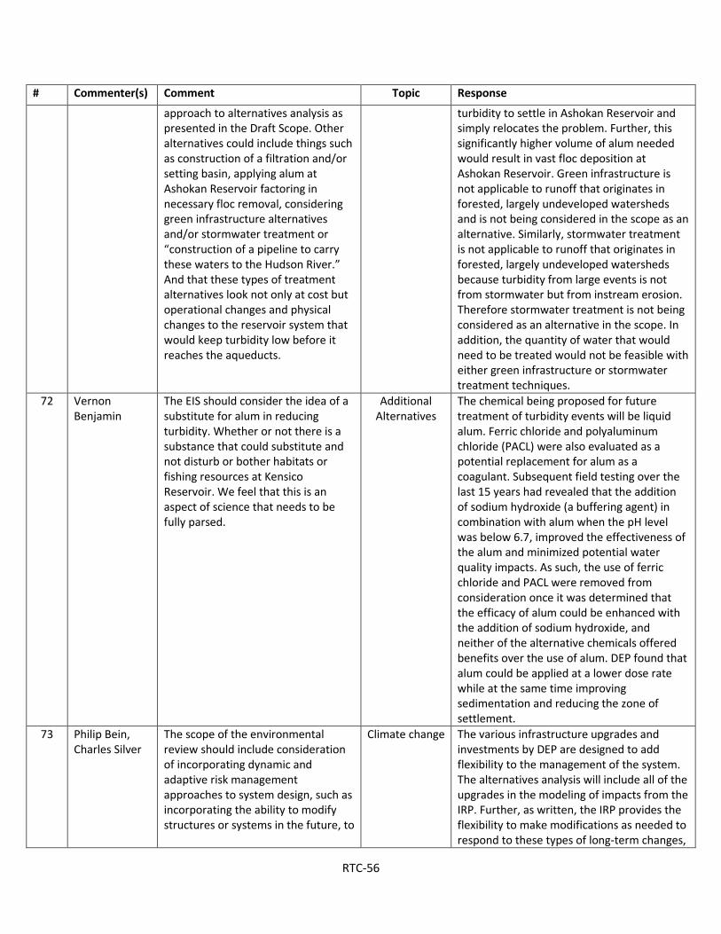
RTC-56
# Commenter(s) Comment Topic Response
approach to alternatives analysis as presented in the Draft Scope. Other alternatives could include things such as construction of a filtration and/or setting basin, applying alum at Ashokan Reservoir factoring in necessary floc removal, considering green infrastructure alternatives and/or stormwater treatment or “construction of a pipeline to carry these waters to the Hudson River.” And that these types of treatment alternatives look not only at cost but operational changes and physical changes to the reservoir system that would keep turbidity low before it reaches the aqueducts.
turbidity to settle in Ashokan Reservoir and simply relocates the problem. Further, this significantly higher volume of alum needed would result in vast floc deposition at Ashokan Reservoir. Green infrastructure is not applicable to runoff that originates in forested, largely undeveloped watersheds and is not being considered in the scope as an alternative. Similarly, stormwater treatment is not applicable to runoff that originates in forested, largely undeveloped watersheds because turbidity from large events is not from stormwater but from instream erosion. Therefore stormwater treatment is not being considered as an alternative in the scope. In addition, the quantity of water that would need to be treated would not be feasible with either green infrastructure or stormwater treatment techniques.
72 Vernon Benjamin
The EIS should consider the idea of a substitute for alum in reducing turbidity. Whether or not there is a substance that could substitute and not disturb or bother habitats or fishing resources at Kensico Reservoir. We feel that this is an aspect of science that needs to be fully parsed.
Additional Alternatives
The chemical being proposed for future treatment of turbidity events will be liquid alum. Ferric chloride and polyaluminum chloride (PACL) were also evaluated as a potential replacement for alum as a coagulant. Subsequent field testing over the last 15 years had revealed that the addition of sodium hydroxide (a buffering agent) in combination with alum when the pH level was below 6.7, improved the effectiveness of the alum and minimized potential water quality impacts. As such, the use of ferric chloride and PACL were removed from consideration once it was determined that the efficacy of alum could be enhanced with the addition of sodium hydroxide, and neither of the alternative chemicals offered benefits over the use of alum. DEP found that alum could be applied at a lower dose rate while at the same time improving sedimentation and reducing the zone of settlement.
73 Philip Bein, Charles Silver
The scope of the environmental review should include consideration of incorporating dynamic and adaptive risk management approaches to system design, such as incorporating the ability to modify structures or systems in the future, to
Climate change The various infrastructure upgrades and investments by DEP are designed to add flexibility to the management of the system. The alternatives analysis will include all of the upgrades in the modeling of impacts from the IRP. Further, as written, the IRP provides the flexibility to make modifications as needed to respond to these types of long-term changes,

RTC-57
# Commenter(s) Comment Topic Response
address the uncertainties associated with climate change.
such as those anticipated from a changing climate. This DEIS will review DEP’s existing studies of the potential effects of climate change on the City’s water supply to better understand areas of potential future concern. The OST Expert Panel convened under the FAD will also review DEP’s existing studies of potential effects of climate change on the City’s water supply to help identify and enhance understanding of areas of potential future concern.
74 Michael Hein, Vernon Benjamin, Mary McNamara, Patrick Landewe, Chris Gibson, Philip Bein, Charles Silver, Greg Helsmoortel, Bob Lewis, Jim Albrecht
I believe that in the past, when a cost benefit analysis was done for the alternatives that were reviewed, that the cost benefit analysis was taking a very short term look at what is a cost effective choice. I would strongly encourage that cost benefit analysis take a very long-term look because of the chronic issues of climate pattern changes that are all over the place.
A 10-15% increase in precipitation is anticipated by mid-century and weather patterns today differ from when the reservoir was originally built. This has been echoed by Gov. Cuomo. More frequent storms will only create more turbidity and flood risk to Esopus Creek watershed. We've hit the hundred year flood plain a couple times, like ten times in ten years. Whatever the number is, it's happened quite often. The Final Scope should require a separate analysis of the impacts of climate change including studies produced by others.
The OST modeling should be based on different climate change scenarios, as indeed they have already been done. Inclusion of additional years of data that were not available for the Phase III Catskill Turbidity Control Study, which does not include data past 2008 thereby missing the most recent turbidity episodes including Hurricane Irene
Climate change analysis
As stated in Section 2.1 of the Scope, “This EIS will also incorporate, as applicable, DEP’s existing studies of the potential effects of climate change on the City’s water supply to better understand areas of potential future concern.” The OST Expert Panel convened under the FAD will also review DEP’s existing studies of potential effects of climate change on the City’s water supply to help identify and enhance understanding of areas of potential future concern. The OST model data have been expanded to include information through 2012, capturing Hurricane Irene and Tropical Storm Lee. The DEIS will not look specifically at future climate projections but instead, utilize modeling that uses extensive historic records that likely capture fluctuations that could be experienced in the future to evaluate a range of potential climate effects. The Proposed Action is Modification of the Catalum SPDES permit. This permit must be renewed periodically. Conditions may change over each permit renewal cycle and will be taken into consideration in future permit modifications. As written, the IRP provides the flexibility to make modifications as needed to respond to these types of long-term changes, such as those anticipated from a changing climate.
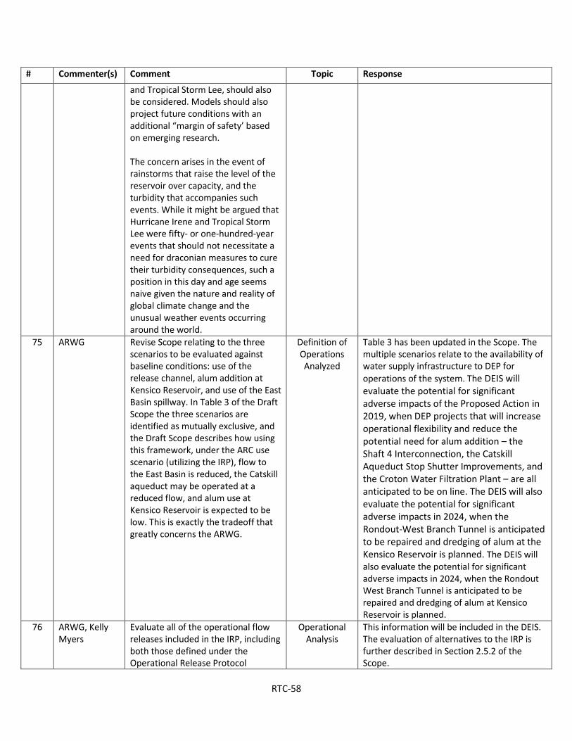
RTC-58
# Commenter(s) Comment Topic Response
and Tropical Storm Lee, should also be considered. Models should also project future conditions with an additional “margin of safety’ based on emerging research.
The concern arises in the event of rainstorms that raise the level of the reservoir over capacity, and the turbidity that accompanies such events. While it might be argued that Hurricane Irene and Tropical Storm Lee were fifty- or one-hundred-year events that should not necessitate a need for draconian measures to cure their turbidity consequences, such a position in this day and age seems naive given the nature and reality of global climate change and the unusual weather events occurring around the world.
75 ARWG Revise Scope relating to the three scenarios to be evaluated against baseline conditions: use of the release channel, alum addition at Kensico Reservoir, and use of the East Basin spillway. In Table 3 of the Draft Scope the three scenarios are identified as mutually exclusive, and the Draft Scope describes how using this framework, under the ARC use scenario (utilizing the IRP), flow to the East Basin is reduced, the Catskill aqueduct may be operated at a reduced flow, and alum use at Kensico Reservoir is expected to be low. This is exactly the tradeoff that greatly concerns the ARWG.
Definition of Operations Analyzed
Table 3 has been updated in the Scope. The multiple scenarios relate to the availability of water supply infrastructure to DEP for operations of the system. The DEIS will evaluate the potential for significant adverse impacts of the Proposed Action in 2019, when DEP projects that will increase operational flexibility and reduce the potential need for alum addition – the Shaft 4 Interconnection, the Catskill Aqueduct Stop Shutter Improvements, and the Croton Water Filtration Plant – are all anticipated to be on line. The DEIS will also evaluate the potential for significant adverse impacts in 2024, when the Rondout-West Branch Tunnel is anticipated to be repaired and dredging of alum at the Kensico Reservoir is planned. The DEIS will also evaluate the potential for significant adverse impacts in 2024, when the Rondout West Branch Tunnel is anticipated to be repaired and dredging of alum at Kensico Reservoir is planned.
76 ARWG, Kelly Myers
Evaluate all of the operational flow releases included in the IRP, including both those defined under the Operational Release Protocol
Operational Analysis
This information will be included in the DEIS. The evaluation of alternatives to the IRP is further described in Section 2.5.2 of the Scope.
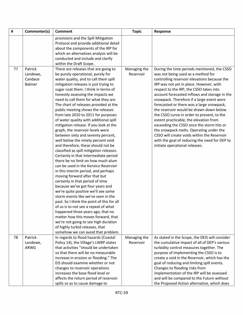
RTC-59
# Commenter(s) Comment Topic Response
provisions and the Spill Mitigation Protocol and provide additional detail about the components of the IRP for which an alternatives analysis will be conducted and include and clarify within the Draft Scope.
77 Patrick Landewe, Candace Balmer
There are releases that are going to be purely operational, purely for water quality, and to call them spill mitigation releases is just trying to sugar coat them. I think in terms of honestly assessing the impacts we need to call them for what they are. The chart of releases provided at the public meeting shows the releases from late 2010 to 2011 for purposes of water quality with additional spill mitigation release. If you look at the graph, the reservoir levels were between sixty and seventy percent, well below the ninety percent void and therefore, these should not be classified as spill mitigation releases. Certainly in that intermediate period there be no limit on how much alum can be used in the Kensico Reservoir in this interim period, and perhaps moving forward after that but certainly in that period of time because we've got four years and we're quite positive we'll see some storm events like we've seen in the past. So I think the point of this for all of us is to not see a repeat of what happened three years ago, that no matter how this moves forward, that we're not going to see high duration of highly turbid releases, that somehow we can avoid that problem.
Managing the Reservoir
During the time periods mentioned, the CSSO was not being used as a method for controlling reservoir elevations because the IRP was not yet in place. However, with respect to the IRP, the CSSO takes into account forecasted inflows and storage in the snowpack. Therefore if a large event were forecasted or there was a large snowpack, the reservoir would be drawn down below the CSSO curve in order to prevent, to the extent practicable, the elevation from exceeding the CSSO once the storm hits or the snowpack melts. Operating under the CSSO will create voids within the Reservoir with the goal of reducing the need for DEP to initiate operational releases.
78 Patrick Landewe, ARWG
In regards to flood hazards (Coastal Policy 14), the Village’s LWRP states that activities “should be undertaken so that there will be no measurable increase in erosion or flooding.” The EIS should examine whether or not changes to reservoir operations increases the base flood level or affects the return period of reservoir spills so as to cause damage to
Managing the Reservoir
As stated in the Scope, the DEIS will consider the cumulative impact of all of DEP’s various turbidity control measures together. The purpose of implementing the CSSO is to create a void in the Reservoir, which has the goal of reducing and limiting spill events. Changes to flooding risks from implementation of the IRP will be assessed and will be compared to the Future without the Proposed Action alternative, which does
RTC-60
# Commenter(s) Comment Topic Response
otherwise flood free areas. For example, the EIS analysis should include modeling of reservoir levels under this scenario, a comparison with historical levels, and calculations of how this affects the return period of reservoir spills. For consistency determination, the EIS analysis should answer the question: will changes to reservoir operations for turbidity control increase downstream flood risk? In order to make a consistency determination about flood hazards, NYSDEC will need to have data about the relative risk of reservoir spillage of the actions being considered.
not consider implementation of the IRP. As stated in Section 2.3.1.8 of the Scope, the DEIS will establish approximate potential water surface elevations within lower Esopus Creek with total release from Ashokan Reservoir up to 600 MGD and to estimate the approximate extent of any potentially inundated area along lower Esopus Creek associated with operation of the ARC under different flow conditions. In addition, a hydrologic model will be developed to approximate peak storm discharges through lower Esopus Creek and consider base releases up to 600 MGD as well as flows resulting from storms up to the 500-year event. It should be noted that even when full and spilling, peak flows through the reservoir are naturally attenuated, providing a flood control benefit to communities and property owners downstream.
79 Mary McNamara, Joseph Glazer, ARWG, Michael Hein, Kelly Myers, Patrick Landewe, Erik Kiviat
Data collection at this time is inadequate. Data must be collected for all reaches of Esopus Creek, the estuary, and riparian zones pertaining to water quality and water flow modeling. All desk audits, reviews, and literature searches should be replaced with required data collection and studies. Accurate assessment of impacts will be impossible or incomplete without this data collection and baseline modeling. Provide detailed information on modeling tools, parameters, inputs and outputs in Draft Scope and what criteria will be used to determine which resource impacts are significant. The company and individuals who will be performing the surveys should be identified and their qualifications presented.
Using data to inform
decision making
As indicated in the Scope, all studies that are proposed as desktop studies would be supplemented with field work in the event that the proposed hydrologic and hydraulic (H&H) analysis (Section 2.3.1.8) or stream geomorphic assessment (Section 2.3.1.9) show potential for flooding and erosion above those levels typically experienced within the Creek. Based on stream geomorphology results, as-needed field studies will be completed as informed by H&H analysis. In addition, and as described in the Scope, DEP is/will be collecting data related to socioeconomic conditions, water quality and flow, aquatic resources, wetlands and floodplain forests, and stream geomorphology along the length of the Creek. This includes review of information provided by landowners along and users of the Creek collected through outreach efforts of the ARWG. All work will be performed by qualified individuals with the required technical expertise.
The team of professionals that will prepare the DEIS and supporting analyses will include experts in a number of different fields, each with credentials specific to their area of expertise. These fields include hydrology,

RTC-61
# Commenter(s) Comment Topic Response
modeling, biology, wetlands, fisheries, economics, and geomorphology. Technical leads for each of these areas will possess skills relevant to the analysis and have worked on a number of prior environmental assessment projects. Examples of qualifications include masters or doctoral level education, professional engineering licensure, and certifications in ecology, wildlife biology, and wetlands science. DEP will seek out recognized experts in their respective fields that also possess detailed local knowledge of the NYC water supply system, natural resources of Ulster County, and the New York State regulatory landscape.
80 Michael Hein In 2011, the City working with the ARWG conducted site visits on over 60 properties along the lower Esopus Creek that claimed damages related to the releases. Many of these property owners sought redress from the City of New York only to be denied. No report, analysis or other acknowledgement of these site visits was ever produced. The Final Scope should require the information collected on these sites to be analyzed, the sites themselves to be revisited, and consideration given to these sites as the location for erosion analysis, cross sections, etc. Furthermore the economic study should be specific as to any economic impact associated with these sites.
Using data to inform
decision making
Data collected by DEP from the 2011 site visits along lower Esopus Creek have been used to guide data collection and analysis along the Creek. Where possible, and where site permission has been obtained, cross sections and data collection sites have focused on areas where the greatest number of individuals expressed concern over the releases and more specifically, where data collected during the site visits indicated that the Creek may be susceptible to incremental changes as a result of operation of the ARC under the IRP. Data and information collected from the site visits has also been provided to the technical experts conducting the socioeconomic assessment. Clarifying text has been added to Section 2.3.1.9.
81 ARWG, Kelly Myers, Vernon Benjamin, Michael Hein, Kelly Myers, Margo Eberlein, Philip Bein, Charles Silver
Compare expected turbidity under the IRP to NYS water quality standards and 303(d) listing of lower Esopus. The EIS should demonstrate proposed action will comply with standards, or consider alternatives that will reduce operation of the ARC to reduce the flow of water into the lower Esopus Creek during high turbidity conditions to attain water quality standards for turbidity for that waterbody. Assess potential for visual impairment resulting from increased magnitude, frequency and duration of higher flows, that create
Water Quality Modeling
This environmental review is separate and distinct from the regulatory processes associated with the lower Esopus Creek’s inclusion on the 303(d) list of impaired waters under the federal Clean Water Act. Naturally occurring turbidity in Esopus Creek is due to the presence of clay deposits along the banks and streambed. Ashokan Reservoir cannot be expected to prevent all turbid water originating upstream of the reservoir from flowing downstream. The DEIS will describe the benefits to the water supply and assess the potential for significant adverse impacts from operation of the ARC under the
RTC-62
# Commenter(s) Comment Topic Response
bank erosion and channel scour, that contribute to increased turbidity throughout the full 32.5 miles of stream from the Ashokan Reservoir through the Esopus Estuary. Assess effects of water clarity on the overall aesthetic quality of the stream. Include in the assessment a comparison of the visual contrast in turbidity in uppermost reaches of the lower Esopus under IRP operational flow releases with the turbidity in these same stretches of stream under no release conditions. Reservoir releases must be assessed to determine whether they would be likely to impair a scenic resource.
IRP. The IRP includes specific water quality requirements limiting turbidity levels for community, spill mitigation, and operational releases in order to be protective of downstream water quality in the event of high turbidity inflow into Ashokan Reservoir. These turbidity levels and the high-flow cut off based on the Mt. Marion gauge, are designed to be more protective of water quality and the pollutant of concern than uncontrolled spills, and will be evaluated in the DEIS.
82 ARWG, Kelly Myers, Kelly Myers, Joseph Glazer, John Morrow, Vernon Benjamin
Develop and calibrate a water quality model (QUAL2E) for lower Esopus Creek and use model to:
• Predict resulting water quality conditions including an evaluation and quantification of expected concentrations of turbidity over the full range of flow releases under the IRP, proposed operation of Ashokan Reservoir, and any alternative operations with reasonable accuracy
• Simulate water temperature, dissolved oxygen (DO), biochemical oxygen demand (BOD), nutrient concentrations (nitrogen and phosphorus), and algae (typically measured as concentrations of chlorophyll-a) to characterize pollutant concentration or flow as a function of distance downstream, to assess predicted impacts or changes to water quality associated with the proposed IRP or NYSDEC must collect the necessary water quality data.
Water Quality Modeling
The analyses included in the DEIS will model water quality conditions including expected concentrations of turbidity over the full range of flow releases under the IRP, variations of the IRP, proposed operation of Ashokan Reservoir, and any alternative operations. As part of the data collection for the DEIS, turbidity, total suspended solids (TSS), pH, DO, specific conductance, and temperature data are being collected at 5 locations along the creek below Ashokan Reservoir. These parameters are being sampled across a wide range of flow conditions; however, flow measurements are not available at each sampling location. Model simulations of flows and turbidity levels released to lower Esopus Creek from the Release Channel and the East Basin Spillway will be determined using OST and included in the DEIS. The DEIS will include assessment of the impacts, as well as the estimated potential duration of turbidity events in the Creek as noted in Section 2.3.1.8 of the Scope. In addition, as described in Section 1.6 of the Scope, turbidity inputs from other tributaries that enter the Esopus Creek below the Olive Bridge Dam (e.g. Tongore Creek) and from the Sawkill and Plattekill subwatersheds

RTC-63
# Commenter(s) Comment Topic Response
Compare the impact and duration of high turbidity tributary events to ARC releases.
below the spillway confluence also contribute to changes in the conditions of the lower Esopus Creek and will be analyzed in the DEIS.
With respect to the other parameters (BOD, nutrients, and algae), both Ashokan Reservoir and Schoharie Reservoirs are oligotrophic to mesotrophic (low to normal productivity) (Bott et al. 2006; DEP 2012 Watershed Water Quality Annual Report). While turbidity varies substantially, nutrients such as phosphorous do not. The actions by DEP do not add any additional pollutants to Ashokan Reservoir or Esopus Creek. Therefore, operation of the reservoir will not substantially change these parameters, so they are not being monitored as part of the DEIS.
83 Sal Bafumo, Bruce Jackson, Greg Helsmoortel
Up until 1994, I never once observed sediment like what the DEP has recently been dealing with, even after record rainfalls and early spring thaws. Although I appreciate the efforts underway now, to fix the damage and put in place safeguards that may help to prevent future heavy sediment in the creek, I am disappointed by the apparent lack of attention to the source of the sediment. There should be more investigation into the source of the problem and a fix for it, in tandem with the new safeguards regarding future discharges. It would seem logical, for instance, that if the turbidity at the source cannot be eliminated, programs to reduce turbidity from the Sawkill, the Plattekill, and other tributaries of the lower Esopus should be in the mix, thereby reducing the impact if not the actual footprint of the manmade source. Why are there no programs for riparian buffer protection, wetlands protection, sand and salt storage improvements, forestry protection, stormwater management (future and current), and waterfowl protection. Local populations in the
Water Quality The source of turbidity in the upper Esopus Creek system, and very likely the lower Esopus Creek, is erosion of natural clay deposits and not anthropogenic inputs. DEP has invested in a variety of stream management projects in the watershed, but has determined based on extensive data that they aren’t effective in controlling turbidity for high intensity storm events. In addition, there are two main tributaries to the lower Esopus Creek, the Sawkill and Plattekill, and DEP began a monitoring program at the confluence of these tributaries and lower Esopus Creek in October 2013 to better understand their contributions to turbidity in lower Esopus Creek. With respect to stream management planning and projects in the lower Esopus Creek, pursuant to the Order on Consent, DEP has provided $200,000 to Ulster County to develop a stream management plan for the lower Esopus Creek, separate from this DEIS, as an EBP. In addition, also as an EBP pursuant to the Order on Consent, DEP has provided $2,000,000 to the Hudson River Foundation to implement a local funding program for implementation of recommendations from the Lower Esopus Stream Management Plan once that Plan is completed.
RTC-64
# Commenter(s) Comment Topic Response
lower Esopus locale have also increased in recent decades which may indirectly affect the turbidity issue.
For a summary of funding opportunities available to implement nonpoint projects, please go to the NYSDEC website at: http://www.dec.ny.gov/chemical/94150.html For funding opportunities for riparian buffers, please go to the NYSDEC website at: http://www.dec.ny.gov/chemical/106345.html
84 Vernon Benjamin
You might even say that the higher the organic compound the more persistent the fecal indicators are likely to be. There are some scientists under the notion that air associated with bacteria water also has higher fecal indicators. So the dumping -- it's not simply an issue about the health and recreation of the water body itself but may have human implications as well.
Water Quality The source of turbidity in the upper Esopus Creek system, and very likely the lower Esopus Creek, is erosion of natural clay deposits and not anthropogenic inputs. The DEIS will evaluate the relative impacts to the lower Esopus Creek from implementation of the IRP and variations of the IRP, including bank erosion and channel scour from the releases, as compared to the Future without the Proposed Action and other potential alternatives as detailed in the Scope.
85 ARWG Include a detailed evaluation and assessment of turbidity conditions in the lower Esopus Creek based on existing data collected at the Ashokan Reservoir, in the ARC, and in the stream downstream of the reservoir. Include a comparison of turbidity conditions prior to 2006 when DEP first begun using the ARC, and since 2008 when DEP started using the ARC to discharge turbidity.
Water Quality As part of the data collection for the DEIS, turbidity and TSS data are being collected by DEP at 5 locations along the creek below Ashokan Reservoir and at the two tributaries, Sawkill and Plattekill. In addition, DEP is contracting with the United States Geologic Survey (USGS) to measure turbidity, TSS, and flow at two locations—Lomontville and Mt. Marion—on the lower Esopus Creek. Turbidity and TSS data are being sampled across a wide range of flow conditions; however, flow measurements are not available at each sampling location. Model simulations of flows and turbidity levels released to lower Esopus Creek from the Release Channel and the East Basin Spillway will be determined using OST and included in the DEIS. The DEIS will include assessment of the impacts, as well as the estimated potential duration of turbidity events in the Creek, as noted in Section 2.3.1.8 of the Scope. Turbidity data for the lower Esopus Creek was not routinely collected by DEP prior to 2011. Where historical data and information exists, this data will be used to help evaluate the
RTC-65
# Commenter(s) Comment Topic Response
potential for incremental impact to lower Esopus Creek.
86 Michael Hein Understanding stream channel geomorphology requires a rigorous look at historical records yet the Draft Scope proposes only to look at existing geometrically corrected photographs going back to 1994. Many additional years of photographic records, although not geometrically corrected, exist as far back as 1955. To fully understand the stream channel this longer record should be included. The data is essential to understanding historical channel migration zones as compared to more recent time steps included in the Scope.
Stream Geo Analysis
The DEIS will include review of geometrically corrected aerial imagery for the Esopus Creek for 1994, 2001, 2004, and 2009, allowing for 15 years of time series assessment. As mentioned, aerials prior to 1994 are not geometrically corrected and cannot be compared accurately versus more recent photos. However, aerial photographs dated prior to 1994 would be reviewed for general trend observations, if applicable. Thus, overlay comparisons with pictures taken before 1994 are not recommended. While georectified images are not without some level of error, differences in uncorrected images cannot be compared quantitatively due to the effects of distortion from curvature of the earth, camera differences, and local topography.
87 Josepha Gutelius, John Morrow, Mary McNamara, ARWG, Kelly Myers, Vernon Benjamin, Joseph Glazer, Bob Lewis, Faith Zuckerman, Ronald Eberlein, Johanna Eberlein, Marcy Pollitt, Robert Illjes, Chuck Silver, Bruce Snow, Jim Albrecht
Multiple commenters noted sandbars and new islands from debris and sedimentation have recently formed in the creek. These issues were described as limiting creek access/passage for recreational boating, or making flooding and high tides worse. Muck and debris coats the banks and floodplain following flood events, impacting use of the shoreline.
Geology As stated in Section 2.3.1.9 of the Scope, the DEIS will include a review of the potential for sediment deposition within certain stream segments as part of the stream geomorphology assessment. At any susceptible segments identified through the 2011 landowner surveys and interviews, and subsequent fieldwork and surveys, the potential for significant adverse impacts resulting from this potential deposition will be evaluated. The HEC-RAS modeling results will be used in conjunction with the stream geomorphology assessment to evaluate erosion and sedimentation impacts to the lower Esopus Creek. Based on stream geomorphology results, targeted field studies will be completed as informed by H&H analysis.
88 Josepha Gutelius, John Morrow, Mary McNamara, ARWG, Kelly Myers, Vernon Benjamin, Joseph Glazer,
The following is a combination of multiple commenters’ personal appraisals on the effects of erosion in the creek: Multiple commenters noted the visible effects of erosion along the creek and its banks. The velocity of
Erosion As stated in Section 2.3.1.9 of the Scope, the DEIS will include the use of bank pins, Bank Erosion Hazard Index assessments, monumented cross sections and qualitative analyses to evaluate the potential changes in stream channel geometry from stream bank and/or bed erosion and deposition. The HEC-RAS modeling results will be used in
RTC-66
# Commenter(s) Comment Topic Response
Bob Lewis, Ronald Eberlein, Johanna Eberlein, Marcy Pollitt, Robert Illjes, Chuck Silver, Bruce Snow
flows was indicated as a concern and what it does to the shoreline along the way. Commenters noted there are exposed tree roots and other indicators of erosion areas, including in proximity to the nature preserve. There is concern that vegetation can’t withstand the flows, resulting in more debris and erosion in the creek.
conjunction with the stream geomorphology assessment to evaluate erosion and sedimentation impacts to the Creek. In addition, data and information collected from the 2011 site visits along lower Esopus Creek have been used to identify areas that may be susceptible to incremental change as a result of operation of the Release Channel under the IRP. Where access permissions were given by property owners, locations of geomorphic evaluation have been selected to coincide with these areas of higher activity within the Creek. Note that regardless of the analysis method, it may not be possible to differentiate between any changes to the Creek as a result of releases versus changes to the Creek as a result of spills. Further, it may not be possible to differentiate between geomorphological changes caused by near term releases and spills and the residual effects of stream bank destabilization that occurred due to prior flooding from Hurricane Irene and other recent extreme events. However, both the flow and stream geomorphology assessments will attempt to characterize the types and durations of flows that may cause changes within the Creek and compare those to the velocity and duration of releases under the IRP to identify the potential for the releases to cause significant adverse impacts, including from bank saturation and failure during extended releases. The geomorphology assessment will include an evaluation of erosion potential as described in Section 2.3.1.9 of the Scope.
89 Mary McNamara, ARWG, Kelly Myers, Vernon Benjamin, Joseph Glazer, Bob Lewis, John Morrow, Faith Zuckerman, Marcy Pollitt, Robert Illjes, Chuck Silver, Bruce Snow
Evaluate sediment movement in the lower Esopus Creek based on a rigorous and appropriate modeling tool capable of simulating sediment fate and transport over time, under the proposed operation of the Ashokan Reservoir and IRP. Provide detail on how the EIS will examine the fate of the suspended sediment and how that will be used to assess water quality impacts. Identify and characterize sediment sources, including bank erosion/channel scour due to IRP high flow releases, and
Sediment and Erosion
As stated in Section 2.3.1.9 of the Scope, the DEIS will include the use of bank pins, Bank Erosion Hazard Index assessments, monumented cross sections and qualitative analyses to evaluate the potential changes in stream channel geometry from stream bank and/or bed erosion and deposition. The HEC-RAS modeling results will be used in conjunction with the stream geomorphology assessment to evaluate erosion and sedimentation impacts to the Creek. Based on stream geomorphology results, targeted field studies will be completed as informed by H&H analysis.
RTC-67
# Commenter(s) Comment Topic Response
areas of aggradation through a combination of sediment rating curve, sediment transport modeling, and physical sediment characterization such as fingerprinting. Use the model to estimate sediment load reaching the estuary that is attributed to ARC releases under normal operating conditions, IRP, or CSSO conditions. Field verify the model and modeling results at representative sites.
Due to the concern that Ashokan Reservoir releases can lead to excess sediment deposition, locations of potential deposition will be identified based on the hydraulic modeling analysis and comments received which indicated potential deposition sites. Stream segments that are identified by DEP as potentially prone to deposition of fine sediment and sand entrained from lower Esopus Creek eroding banks will be evaluated for significant adverse impacts.
90 ARWG, Kelly Myers
Use sediment and turbidity gage data to quantify and develop sediment stage/discharge relationships and inform sediment transport models. Conduct field monitoring of sediment to see what’s mobilizing during high discharges and storm events.
Sediment and Erosion
As part of the DEIS analyses, turbidity and TSS data are being collected by DEP at five (5) locations along the creek below Ashokan Reservoir. Turbidity and TSS data are being sampled by DEP across a wide range of flow conditions. DEP has spent considerable effort analyzing turbidity and flow relationships in the section of Esopus Creek above Ashokan Reservoir. Due to intra-event and inter-event variability of turbidity mobilization, DEP cannot commit to developing a sediment stage/discharge relationship with the data available for lower Esopus Creek. Turbidity and sediment mobilization is not consistently correlated with flow rate, therefore a long record of high-resolution continuous monitoring of coupled flow/turbidity data across a wide range of flow events is needed to accurately develop such a relationship and account for event variability. However, DEP will analyze the data collected to determine correlations and feasibility of a turbidity regression as stated in Section 2.3.1.8 of the Scope.
91 ARWG Compare characteristics of sediment taken from aggraded areas, to characteristics of sediment from upper and lower Esopus. Conduct sediment studies, including fingerprinting, to characterize the multiple sources of the sediment in the creek.
Sediment DEP is collecting data on stream sediment to better characterize its potential for erosion using multiple techniques (bar samples, pebble counts, etc.). As stated in Section 2.3.1.9 of the Scope, alternative or additional assessments may be adopted as needed to address specific concerns or limitations from the geomorphological assessment.
92 Carl Belfigilo No release channel releases are going to equal uncontrolled East Basin spillway flow, and I kind of wonder years ago what was the spillway used
H&H Analysis The Ashokan Reservoir East Basin Spillway is an uncontrolled passage of water from the East Basin to the lower Esopus Creek. Implementation of the CSSO under the IRP is

RTC-68
# Commenter(s) Comment Topic Response
for, because I don't see any water coming out of there anymore. If water was to come out there it would be clean water, it wouldn't be the turbidity that gets released from the West Basin.
designed to reduce the number, size, and duration of uncontrolled releases. Water has passed over the Spillway several times since 2010, including in the fall after the 2010 storm events, in the spring and fall of 2011, and in the summer of 2013. It is important to note that water that spills from the spillway could have elevated turbidity, depending on the intensity of the storm event.
93 ARWG Include an application of The Nature Conservancy’s Indicators of Hydrologic Alteration (IHA) method as part of the instream flow assessment. Apply IHA to the lower Esopus Creek to evaluate the changes in stream hydrology that have occurred as a result of the DEP’s operation of the Ashokan Reservoir and under the IRP. Compare the range of variation of the hydrological regime simulated under natural conditions (pre-Ashokan Reservoir) with the variation resulting from the operation of the Ashokan Reservoir as proposed. Often, the 25th and 75th percentile values of each of the 33 hydrologic parameters are selected as the lower and upper thresholds within which streamflow management targets could be set, and we recommend a similar approach for the lower Esopus Creek.
H&H Analysis Indicators of Hydrologic Alteration are a series of metrics developed by the Nature Conservancy to facilitate comparison of flow conditions to better understand the hydrologic impacts of human activities, or for those trying to develop environmental flow recommendations. IHA, however, does NOT determine environmental flow needs or provide flow recommendations. Per the Nature Conservancy, “Determining environmental flow needs is an interdisciplinary process, and integrates information about the hydrology, morphology, biology, and other aspects of a water body. First, you need to gain an understanding of which flow components are important for keeping your ecosystem healthy. IHA helps you understand how much those flows have been altered.” IHA metrics will be used for comparing the flows in the lower Esopus Creek under the IRP with the Future without the Proposed Action or other alternatives. Pre-Ashokan Reservoir flows will not be evaluated in the DEIS, as the presence of the Ashokan Reservoir is part of the existing condition for the action being considered.
94 ARWG, Mary McNamara, Kate Hudson, Kelly Myers, Joseph Glazer, Bruce Snow, Bruce Jackson, Rosanne and Roger Yetzer, Gary Bellows, Patrick Landewe, James Quigley,
Appropriately assess flow effects through development of several flow modeling tools, including a model or models capable of providing sound simulations of both hydrologic and hydraulic conditions in the lower Esopus Creek. The Hydrologic Engineering Center-Hydrologic Modeling System (HEC-HMS) model will be useful in considering the flows being released from Ashokan Reservoir, via either the ARC or the spillway. Include development of
H&H Modeling Flow effects will be appropriately assessed through development of several flow modeling tools. A HEC-RAS model is being developed for the Creek for evaluating flow depths, flow velocities, and areas of inundation from reservoir operations alternatives at Ashokan Reservoir as part of the DEIS as stated in Section 2.3.1.8 of the Scope. As described in Section 2.3.1.8 of the Scope, the Hydrologic Engineering Center-Hydrologic Modeling System (HEC-HMS), a hydrologic model to simulate the precipitation and runoff flows from various

RTC-69
# Commenter(s) Comment Topic Response
Michael Warren, John Morrow, Candace Balmer, Robert Illjes, Chris Gibson, Joseph Quirk
detailed Stage/Discharge relationships for the stream along its full length and particularly at critical cross sections where specific resources such as homes and buildings, agricultural facilities, or recreation sites like the Marbletown beach, could be impacted and an expanded version of the OASIS model, which is capable of simulating flow releases from Ashokan Reservoir via the Release Channel and/or spillway, and spillway under a variety of hydrologic and meteorological conditions and link it with the HEC-RAS model, such that both models are used for assessing the anticipated flows (magnitude, frequency and duration) and the resulting hydraulic and hydrologic conditions in the lower Esopus Creek. Modify the OASIS model to allow for the establishment of flow targets or constraints in the lower Esopus Creek, at or below the spillway confluence. Modify existing DEP modeling tools for the Upper Esopus Creek Watershed to allow simulation of flows in the lower Esopus Creek. Focus on areas of the stream valley that would be expected to see more frequent or longer duration periods of inundation under the IRP.
storm events in a watershed model is being developed for multiple subwatersheds in the Creek to model hydrologic inputs from the multiple tributaries. Data from the Ashokan Reservoir simulations will be used in conjunction with the HEC-RAS model to understand changes and impacts to the Creek from releases and spills. The OST (which includes the OASIS model) does not need to be updated, as it currently models releases and spills from Ashokan Reservoir to the lower Esopus Creek. In addition, OST already allows for flow targets or constraints to be set on releases from the Release Channel based on conditions in lower Esopus Creek (e.g., Mt. Marion Gauge rule). Additional flow targets and constraints can be added to OST, based on feasibility and effectiveness. Release Channel releases are not anticipated to exacerbate downstream flooding conditions, as there is a cap on releases directly related to flood stage at Mt. Marion gauge. Modeled stage/discharge relationships can be developed at locations where reliable flow and elevation data have been collected. There is not sufficient data to develop stage/discharge relationships along the full length of the Creek without many years of gauged flow measurements across a wide range of flow conditions, which does not currently exist. The SPDES permit will be periodically revisited and can be updated with new information over time. However, the HEC-RAS model analyses for the DEIS will include water surface elevation for comparison between the IRP, Future without the Proposed Action Alternative, and other alternatives considered.
95 Mary McNamara, ARWG, Vernon Benjamin
I would submit that it is important to have inundation mapping to guide the spill mitigation releases and to guide the percent of void operations to make sure that the conversation between the community and the operations of these different releases, as outlined in Attachment A, have something that is guiding them. We recommend the inundation maps
H&H Modeling The DEIS includes calculating areas of increased inundation as described in Section 2.3.1.8 of the Scope. The hydrologic analysis will consider base ARC discharges up to 600 MGD, including flows specified under the IRP, as well as flows resulting from storms up to the 500-year event. The Mt. Marion gauge rule would require the Release Channel to shut down well below flows that result from a 500-year event.
RTC-70
# Commenter(s) Comment Topic Response
show USGS 7.5 minute projections for entire Lower Esopus Valley and that contour intervals be broken down into 2-foot increments. Inundation mapping should show the entire Lower Esopus Valley under varying flow release scenarios from the ARC and spillway up to 1,000 MGD. Maps should show expected inundated areas during simulated 5, 10, 25, 50, 100, and 500 year storm events. Scenarios should also include stream flows, spill and inflow conditions under the CSSO and IRP.
USGS 7.5-minute projections do not provide the necessary precision to perform inundation mapping under the range of flows being considered. The DEIS analyses will use a combination of surveyed topography at select stream cross sections, supplemented by Lidar data.
The DEIS will assess impacts from both releases and spills on the lower Esopus Creek under the IRP (the Future with the Proposed Action), the Future without the Proposed Action alternative and other alternatives considered. Additional flow comparisons include releases up to the maximum release capacity of 1,200 MGD as part of the alternatives analysis. Inundation mapping is not anticipated for these flow comparisons, unless an alternative has a high likelihood of being adopted as the preferred alternative.
96 ARWG Expand the OASIS model to include stream segments for major lower Esopus Creek tributaries and hydrologic inputs for those tributaries to allow careful consideration of the combined effects of flow magnitude, frequency, and duration in the lower Esopus Creek.
H&H Modeling OASIS, which is the modeling backbone of the OST, is a system model for analyzing operations decisions for water supply systems. OST models spills and releases from Ashokan Reservoir based on regulations, policies, and protocols across the NYC water supply system. Esopus Creek below Ashokan Reservoir is an uncontrolled system. Thus, neither OST nor OASIS are the appropriate tools to model conditions along the stream.
HEC-RAS and HEC-HMS are the appropriate tools for modeling flow downstream of Ashokan Reservoir. A HEC-RAS model is being developed for the Creek for evaluating flow depths, flow velocities, and areas of inundation from reservoir operations alternatives at Ashokan Reservoir as part of the DEIS, as stated in Section 2.3.1.8 of the Scope. A HEC-HMS model is being developed for subwatersheds in the Creek to model hydrologic inputs from multiple tributaries.
The output from OST would be daily releases and spills from Ashokan Reservoir, which would be routed as an input through HEC-RAS to model conditions in the creek. HEC-HMS model output would be uncontrolled
RTC-71
# Commenter(s) Comment Topic Response
runoff or base flow from contributing areas downstream of the reservoir and would also be inputs to the HEC-RAS model.
97 ARWG, Michael Hein
Develop a “detailed” HEC-RAS hydraulic simulation model for the entire lower Esopus Creek from the confluence with the Little Beaverkill to the spillway confluence; Develop a “generalized hydraulic model” for the lower Esopus Creek downstream of the spillway confluence; and Develop “localized detailed” HEC-RAS models for certain areas with potential erosion hazards, below the spillway confluence. Provide more details on the HEC-RAS model. We disagree with DEP’s contention that a full, detailed hydraulic model for the LEC from the spillway confluence to the Hudson is not warranted on the basis that channel forming flows are expected to be substantially higher than proposed discharges from the ARC.
H&H Modeling A HEC-RAS model is being developed for the Creek for evaluating flow depths, flow velocities, and areas of inundation from reservoir operations alternatives at Ashokan Reservoir as part of the DEIS, as stated in Section 2.3.1.8 of the Scope. This includes a detailed model upstream of the Spillway confluence, and a generalized model (with a selection of localized detailed models) downstream of the Spillway confluence to the Hudson River. Once the results of the more generalized model are prepared and analyzed, the potential need for collection of additional detail to supplement the HEC-RAS model will be identified. The generalized model provides the same information as a detailed model, but with less precision due to the spacing of the cross sections. Where more precision is needed at certain locations, it will be captured in the detailed models. The locations for the localized detailed modeling would include areas of topographical or cross sectional area changes or structures that are not captured in the generalized model. Additional field data collection would include, but not be limited to, selection of cross section locations for the localized detailed modeling, depending on the ability to obtain permissions from property owners.
98 ARWG Include the development and comparison of flow duration curves for all three USGS gauging sites, based on historic and/or simulated flows in the lower Esopus Creek, under both the pre-IRP and post-IRP implementation conditions.
H&H Modeling Flow duration curves will be developed for Esopus Creek USGS gauge sites at Mt. Marion, Coldbrook, and Allaben. Lomontville is a new gauge and does not have a long enough period of record (min >10 years) for developing a flow/duration curve.
99 ARWG Evaluate turbidity impacts to private wells from groundwater recharge from turbid discharges.
Infrastructure Preliminary review of soils data by DEP indicate the Esopus Creek is dominated by granular material (silt, till, sand, etc.) that would retain fine sediment as water infiltrated into the soil. Additionally, the general flow of groundwater in the region is from higher elevations to lower elevations (toward the creek), due to the presence of
RTC-72
# Commenter(s) Comment Topic Response
confining layers. An assessment may be conducted if there is evidence that wells are located in close proximity to the Creek that may be affected by Releases under the IRP
100 Kelly Myers There are many older cottages built at creek's edge - that have become full time homes. These homes have no local sewer hook-up, and rely on shallow septic systems, which leach into the Creek at an even higher rate when they are subjected to higher saturation due to DEP's long-term high volume releases. My neighbors have had septic system failures as a result of the long-term high volume releases made by DEP. This septic runs downhill and ends up in the Creek. Many people will not swim in the creek when DEP is releasing as they are afraid of e-coli poisoning.
Infrastructure The H&H analysis will develop inundation levels under various flow conditions The DEIS will evaluate whether inundation levels extend beyond the floodplain compared to historical conditions. For those areas, impacts to local infrastructure, including properly constructed and maintained septic systems, will be evaluated as part of the environmental assessment. Clarifying text has been added to Section 2.3.1.11 of the Scope.
101 Carl Belfglio These releases exit the lower Esopus at Saugerties and right past my home and water supply in Port Ewen, and then on to Esopus. I’m not satisfied until an approach is proposed that the turbid release is stopped. Instead of putting money for walking trails, I think we need to put money in our most important natural resource, and that’s our water supply, and the water supply that’s getting thrown into the Hudson River at Saugerties.
Infrastructure As part of the infrastructure and energy analysis described in Section 2.3.1.11 of the Scope, the potential for operation of the Release Channel under the IRP to cause changes or incremental impacts to water supplies, sewers and wells along the Creek will be evaluated, and results of these studies will be included in the DEIS.
102 ARWG, Kelly Myers, Vernon Benjamin
Identify and inventory acres of existing residential, commercial, agricultural and industrial land uses along the Creek. Pay particular attention to any municipal, industrial, or commercial facilities that utilize lower Esopus Creek waters for their operation, or that could be directly impacted by lower Esopus Creek flows or flooding. Focus on areas of the stream valley that would be expected to see more frequent or longer duration periods of inundation under the IRP.
Land Use Information will be gathered by DEP through the ARWG, Geographic Information System (GIS) surveys, and the socioeconomic analysis to identify users who rely on water from the Creek. These users will be surveyed to identify how changes in flow and water quality impact their needs. Information collected on any potential for incremental impact as a result of the H&H (Section 2.3.1.8) or Stream Geomorphic (Section 2.3.1.9) assessments will be coordinated with the socioeconomic analysis, as needed, to be included in the assessment.
RTC-73
103 ARWG, Kelly Myers, Bruce Snow, Mary McNamara, Patrick Landewe, Vernon Benjamin
Examine and evaluate the macroinvertebrate community to determine whether the community is representative of a healthy and moderately diverse community that would be expected to occur in Class B waters. Evaluate impacts of IRP on aquatic macroinvertebrates, recognized as excellent indicators of water quality conditions in streams. Assess the impacts to the macroinvertebrate community associated with the increased magnitude, frequency, and duration of high flows under the IRP. Include mapping of benthic and fish surveys and the aquatic-terrestrial continuum.
Fish and Benthic
Community
Benthic and macroinvertebrate data have been collected upstream of the Spillway Confluence since 2009. In 2011, five additional sites were added downstream of the Spillway Confluence. Data on these communities have been collected every year since 2011. An additional monitoring site was added in 2013 just downstream of the Spillway Confluence. The data collected by DEP will be presented in the DEIS, and will be used to evaluate the benthic communities within lower Esopus Creek. The DEP sample locations downstream of the Spillway Confluence were selected to coincide with sites NYSDEC uses for their surveys. Available NYSDEC survey data collected in 1993 and 1996 will also be included in the assessment presented in the DEIS. The potential for incremental impacts on and benefits to these communities with operation of the IRP will be presented in the DEIS. The NYSDEC Stream Biomonitoring Unit conducted a biological assessment of water quality at three locations on the lower Esopus Creek downstream of the Ashokan Reservoir in the area of Olivebridge, New York, March 31, 2011. The sustained use of the ARC after heavy rainfall during the fall of 2010 led to prolonged releases of turbid water to the lower Esopus Creek. The survey was initiated at the request of NYSDEC Central Office staff to assess impacts to aquatic life resulting from these turbid water releases. The results and conclusions of the report are noted below: “1. Water quality conditions range from non- to slightly impacted in the lower Esopus Creek, indicating aquatic life is fully supported. However, typical of large impoundments (e.g. lakes, reservoirs ) the Ashokan Reservoir acts as a major barrier limiting macroinvertebrate colonization of the Lower Esopus Creek immediately downstream of the reservoir but upstream of the confluence with the reservoir Release Channel. The presence of the reservoir cuts off the Lower Esopus Creek from Upper Esopus Creek invertebrate recruitment, both
RTC-74
# Commenter(s) Comment Topic Response
through aerial colonization and in-stream drift. 2. Habitat assessment at the location immediately downstream of the confluence with the Release Channel indicated altered habitat due to changes in velocity/depth regimes, sediment deposition, and channel flow status. 3. Continued use of the release channel should require routine biological monitoring to ensure any impacts on aquatic life are identified early to allow effective remediation. Detailed characterization of substrates to measure the deposition and source of sediments in this reach of the Lower Esopus Creek over time is also recommended.” For a complete copy of the report go to: http://www.dec.ny.gov/lands/77832.html
104 ARWG, Patrick Landewe
Evaluate existing freshwater mussel population in the entire 32.5 miles of the lower Esopus, to establish a baseline condition for evaluating the potential for changes to that community over time, as a result of the changes in both low and high flows anticipated under the IRP. Evaluate effects of increased turbidity and resulting sedimentation on freshwater mussels’ habitat throughout the lower Esopus and the Esopus Creek Estuary. Survey current populations of freshwater mussels in the lower Esopus by reach.
Fish and Benthic
Community
Benthic organisms have been sampled at 10 sites along the Creek, between the Release Channel and confluence with the Hudson River. The benthic sampling includes collection of information on freshwater mussels if they are encountered. The sampling results will be reviewed along with published literature and data collected as part of other studies in order to evaluate the potential for incremental impact from the flows and turbidity that are anticipated to occur under the IRP to affect these species. As stated, the sample locations selected downstream of the Spillway Confluence were selected to coincide with sites NYSDEC uses for its surveys. NYSDEC also has data at some of these locations from surveys conducted in 1993 and 1996, which will be included in the assessment presented in the DEIS.
105 ARWG, Kelly Myers, Bruce Snow, Mary McNamara, Ron Eberlein, Patrick Landewe
Evaluate the impacts on fisheries and aquatic habitat from increased sediment load and sediment movement within the stream and estuary associated with the IRP: - Demonstrate that trout habitat can be continuously maintained within the upper portions of the lower Esopus Creek; - Determine alternatives to the
Fish and Benthic
Community
The purpose of the DEIS is to analyze the modification of the Catalum SPDES permit, which includes analysis of the use of the IRP. It will also include analysis of potential alternatives to the IRP and associated potential for incremental impact. Study and characterization of fisheries will be based on available fish data collected from Esopus Creek, literature review, and the results of hydraulic modeling and water quality data

RTC-75
# Commenter(s) Comment Topic Response
proposed IRP that would support the maintenance of a self-sustaining trout fishery in the lower Esopus between the Ashokan Reservoir and the City of Kingston; - Use the recommended HEC-RAS sediment modeling tool to evaluate expected rates and patterns of sediment deposition, in relation to fish habitats for all flow levels that may occur under the IRP; - Evaluate and discuss potential impacts to fish habitat from increased sediment load and modified sedimentation patterns; - Determine impacts on fish edibility; - Evaluate impact on herring species, short nose sturgeon, large mouth bass, and trout (especially in H-171 from Tannery Brook in the City of Kingston to Tributary 41); - Establish and determine impacts/potential impacts (including emigration and mortality) on the turbidity tolerance of organisms including fish, wildlife, and aquatic vegetation. - Identify sensitive time periods for habitat disturbance. For example spawning periods.
collection. To the extent possible, the potential for incremental impacts to fisheries will be evaluated and described in the DEIS. Sedimentation in the creek will be assessed as described in Section 2.3.1.9 of the Scope. The impacts of turbidity and sedimentation on fish populations will be assessed based on literature reviews and fish surveys. Fish edibility (or palatability) will not be assessed in the DEIS because there is no contaminant transport from Ashokan Reservoir, a public water supply reservoir. However NYSDEC has committed to testing some fish from the lower Esopus, as they have done periodically over the years, to see if contaminant levels in fish flesh have changed since last tested. The DEIS will assess impacts to fish communities in the lower Esopus Creek and is not limited to specific species at specific locations. Rather, the assessment will consider potential impacts to fisheries in 6 segments of the Creek to capture the changing nature of habitat along the full 30-mile study area. These include: Ashokan Release Channel to the Spillway Confluence, the Spillway Confluence to Hurley Mountain Road, Hurley Mountain Road to Leggs Mill Road, Leggs Mill Road to the confluence with the Plattekill (Glenerie Falls), Glenerie Falls to the Cantine Dam (Saugerties) and Cantine Dam to the Hudson River. Clarifying text has been added to Section 2.3.1.9. Sensitive time periods for fisheries, such as spawning, will be taken into account in the DEIS analysis.
106 ARWG, Kelly Myers
Systematically evaluate the flow vs fish habitat relationship, utilizing the Instream Flow Incremental Methodology (IFIM), along the entire stream reach. Use the IFIM and resulting flow versus habitat relationships to evaluate the following: - Effects of changes in flow
Methodology DEP is monitoring potential effects to the lower Esopus Creek fish and macroinvertebrate communities by sampling them over the past several years while the Release Channel was (is) in operation. By doing so, the effects of any Release-induced habitat changes on the fish and macroinvertebrate communities will be assessed directly, to the extent possible.

RTC-76
# Commenter(s) Comment Topic Response
magnitude, frequency and duration on fish habitat; - Potential alternative flow release regimes for the lower Esopus that would maximize habitat for important fish species and other aquatic species that can be used as indicators of habitat diversity; - Potential impacts to aquatic life for Ephemeroptera, Plecoptera, and Trichoptera (EPT), macroinvertebrate community and other important aquatic community components. The IFIM should include habitat mapping of the entire 32.5 miles of lower Esopus Creek, with PHABSIM modeling and resulting habitat vs flow relationships developed for specific reaches selected as “representative reaches” to represent the major aquatic habitat types found in the lower Esopus.
IFIM, or more generically, hydraulic habitat modeling, was designed to evaluate habitat effects from changes in hydrology, whether hourly, daily, weekly, monthly, or annually. Language considering the use of IFIM or other similar appropriate model in the EIS has been added to Section 2.3.1.9 of the Draft Scope.
107 Greg Helsmoortel
Consider using the national ecosystem restoration program developed by the United States Corps of Engineers for evaluating turbidity impacts on the depth and temperature of the water.
Methodology United States Corps of Engineer’s national ecosystem restoration framework is a concept to more closely align Corps projects with the natural services provided by water resources. It is not a specific methodology; however, the objectives of the DEIS are in alignment with the national ecosystem restoration principals.
108 ARWG Estimate or determine the impacts that have already resulted from the many years of no flow releases in the stream by comparing data collected from aquatic communities found in other similar Catskill stream systems that have not been impacted by controlled flow regimes or other significant water quality degradation.
Fish and Benthic
Community
The purpose of the DEIS is to comprehensively assess the potential incremental impacts from the City’s proposed modifications to the Catalum SPDES permit including, but not limited to, assessing the potential for significant adverse impacts from operation of the ARC under the IRP. The DEIS will focus on potential future impacts. While historical hydrological and hydraulic conditions will be considered, stream impacts from the presence of Ashokan Reservoir and prior release policies are not within the scope of the DEIS. The DEIS includes review of existing studies of similar waterbodies and natural resources in the region.
RTC-77
# Commenter(s) Comment Topic Response
109 Mary McNamara, Joseph Glazer, ARWG, Kelly Myers
Data must be collected for all reaches of Esopus Creek, the estuary, and riparian zones pertaining to water quality and water flow modeling.
Methodology Data are being collected along the Creek, from the ARC to the Hudson River, and will be compared to water quality and flow data also collected along the full length of the Creek.
110 Patrick Landewe, ARWG
It will be interesting in the coming years as water celery recovers to note how the Esopus Estuary might recover differently than in other areas. It might be an indication perhaps that the releases that came on the heels of those storms had additional impact above and beyond the storms.
H&H Modeling Submerged aquatic vegetation surveys will be conducted for the DEIS. Where it exists, historical information on vegetation will be reviewed. Additional data will be collected through a submerged aquatic vegetation survey to better characterize the water celery population within the estuary for lower Esopus Creek. Clarifying text has been added to Section 2.3.1.9. However, teasing out past changes within the Creek caused by the storms or the use of the Release Channel will be impossible. Further, as per the Order on Consent, DEP will develop a monitoring plan as part of the DEIS, which may include biomonitoring. The details of the monitoring plan have not yet been determined and will be presented in the DEIS. The Monitoring Plan will be subject to public review.
111 ARWG, Kelly Myers, Erik Kiviat, Harry Vincent, Vernon Benjamin
Include an assessment of the potential existence of Rare, Threatened and Endangered species in the area, based on available habitats and as well as historic records of Rare, Threatened and Endangered species occurrences within the adjacent regions. Use field surveys to assist in verifying the occurrence or absence of Rare, Threatened and Endangered species that are considered most likely to occur in the lower Esopus stream valley, based on habitat preferences and records of previous occurrences within Ulster County or surrounding counties. Utilize all existing databases, including those of the New York Natural Heritage Program. Surveys should address all vertebrates, as well as mollusks, odonates, vascular plants, and bryophytes. Surveys should include turtles, Great Blue Heron, Hawks and
Wildlife and Plants, Rare, Threatened
and Endangered
Species
A description of the presence and an assessment of potential for incremental impact to rare, threatened and endangered species along the Creek, including plants, will be presented in the DEIS. Information on the potential presence of these species will be gathered from relevant state, federal and local databases in addition to targeted field surveys as deemed necessary. This information will be compared to the results of the HEC-RAS modeling and, where potential for incremental impact from inundation or flow velocity exist, field surveys will be conducted in accordance with accepted methodologies to attempt to confirm the presence of certain species and better characterize potential habitat along the Creek and whether it could be impacted as a result of conditions anticipated to be experienced under the IRP. The DEIS includes review of existing studies of similar waterbodies and natural resources in the region.

RTC-78
# Commenter(s) Comment Topic Response
Bald Eagles, etc. Surveys should sample from the stream channel at least up to the limits of the “100-year” floodplain. Surveys should follow USEPA recommended techniques such as snorkeling and, where necessary, SCUBA. Include an analysis of changes in the stream flow regime (the modified magnitude, frequency and duration of flows). The lower reaches of the Sawkill and Plattekill and the two major tributaries of lower Esopus Creek may be useful as reference reaches and should also be surveyed.
112 Erik Kiviat, ARWG, Kelly Myers
Fully evaluate the potential impacts to Rare, Threatened and Endangered species and habitat as a result of: - Increased turbidity and the associated sediment load being discharged to the stream from the Ashokan Reservoir; - Sediment mobilized in the creek itself from channel scour or streambank erosion due to high flow releases from the Ashokan Reservoir; Particular attention should be paid to the impacts on these species • Goldenclub (Orontium
aquaticum; State Threatened), • River birch (Betula nigra; New
York Natural Heritage Program S3),
• Wood turtle (New York Species of Greatest Conservation Need),
• Long-tailed salamander (New York Species of Greatest Conservation Need), and
other rare, vulnerable, or declining species, including at a minimum those animal Species of Greatest Conservation Need, and the vascular plants and mosses ranked as S1, S2, or S3 by the New York Natural Heritage Program. Some regionally-rare species should also be assessed.
Wildlife, Rare, Threatened
and Endangered
Species
The potential for turbidity or water quality changes experienced under the IRP to affect habitat or species - particularly rare, threatened and endangered species - will be evaluated through a combination of database searches, field surveys and literature searches on turbidity tolerance and will be presented in the DEIS. This evaluation will also identify and discuss the presence of State Special Concern and Species of Greatest Conservation Need.
RTC-79
# Commenter(s) Comment Topic Response
113 Mary McNamara, Kelly Myers, Chuck Silver
The EIS must also assess the growth of invasive aquatic plants such as water chestnuts that are impacted by stream flows, deposition of sediment and water quality.
Wildlife, Rare, Threatened
and Endangered
Species
The presence of invasive species will be included in the assessments in the DEIS. Further, as per the Order on Consent, DEP will develop a monitoring plan, as part of the DEIS, which may include biomonitoring. The details of the monitoring plan have not yet been determined and will be presented in the DEIS.
114 ARWG, Mary McNamara, Kelly Myers, Marcy Pollitt, Vernon Benjamin
Provide detail on how the EIS will evaluate the impacts on lower Esopus wetlands and wildlife habitats, including: - Impacts of changes in river flows or reservoir elevations on wetlands, riparian habitats, and other critical habitat types and quantify the effects of any proposed mitigation or compensation using a technique such as the USFWS Habitat Evaluation Procedures; - Development of a detailed, GIS-based map of all wetlands within the lower Esopus Creek study area, along the full 30+ mile length of the stream, mapped from recent aerial photography, shot at an appropriate scale, during “leaf-off” conditions, and ground-truthed to assure accuracy; - Full evaluation of the functions and values of the existing wetlands in the lower Esopus study area, including but not limited to wetlands that are likely to experience greater inundation depth and duration along the full 30+ miles. - Quantitative evaluation of changes in hydraulic and hydrologic conditions, including the potential for increased soil erosion and sediment deposition, as well as modifications to the wetland vegetative make-up and functions; - Surveys quantifying the acreages of each wetland type found within the lower Esopus study area, classifying based on a recognized wetland classification system such as Cowardin (1979) or USFWS (1998);
Wetlands Wetlands surveys upstream of the Spillway Confluence have been performed since 2009. In addition, wetlands and floodplain forest surveys downstream of the Spillway Confluence have been performed at multiple sample sites twice since 2011. These sites include two reference wetlands along the Creek, but outside of the anticipated area of inundation associated with IRP flows. These were initially selected to be representative of the types of wetlands that may have the potential for incremental impact from the IRP - specifically from high flow velocities and extended periods of increased inundation/saturation. Function and value assessments have been completed for the wetlands upstream of the Spillway Confluence near the AFC and for the 10 downstream sample sites. A Cowardin classification has been assigned to all wetlands studied to date. This information, along with collected water quality data and HEC-RAS modeling results, will be used to map and describe surveyed wetlands along the Creek and evaluate the potential for incremental impact from flow and turbidity conditions reasonably anticipated to occur as a result of operation of the Release Channel under the IRP. In addition, if modeling shows that there are additional sites that may have a high potential for incremental impact, these wetlands will also be surveyed.

RTC-80
# Commenter(s) Comment Topic Response
- Map in sufficient detail to indicateall wetland areas, including riparianwetlands, of greater than 0.5 acres insize.
115 Bruce Jackson Dynamic ecosystems are not going to behave today in the same manner as in decades past especially with the recent weather events the area has experienced.
Natural Resources
Studies
As stated in Section 2.1 of the Scope, “This EIS will also incorporate, as applicable, DEP’s existing studies of the potential effects of climate change on the City’s water supply to better understand areas of potential future concern.” Clarifying text has been added to Section 2.1 of the Scope. The OST Expert Panel convened under the FAD will also review DEP’s existing studies of potential effects of climate change on the City’s water supply to help identify and enhance understanding of areas of potential future concern.
116 Patrick Landewe
The EIS must answer the questions: how will the DEP’s Turbidity Control Program impact the Village of Saugerties's interests in the natural resource value and recreational use of the creek? Will it cause shoreline damage to waterfront properties in the Village? Will it increase dangerous water levels and flows along the Village waterfront?
Coastal Zone/LWRP
Through its various assessments, the DEIS will evaluate, to the extent possible, if the operation of the Release Channel under the IRP may have the potential to inundate property and create flow changes that may alter the Creek. The socioeconomic analysis will evaluate these concerns in relation to business and recreation. Where possible, this analysis will take into account impacts on major recreational and business sites along the Creek, and will aggregate the results at the local (town/ village/city) and regional levels. The results of these analyses will be provided in the DEIS.
117 ARWG, Patrick Landewe
Conduct a coastal consistency determination under the State's Coastal and Inland Waterways Program for the lower Esopus as a State-designated Inland Waterway and for the Saugerties Village Local Waterfront Revitalization Program, which specifically promotes economic development.
Coastal Zone/LWRP
A Coastal Assessment Form was completed as part of the EAF for the Catalum SPDES permit modification application. This form was attached to the Draft Scope. Results of the assessment will be included and presented in the DEIS.
118 Vernon Benjamin
The Town of Saugerties requests that the contraventions of the Esopus Creek created by these (turbidity) overloads be considered a violation of the Town of Saugerties Zoning law, as amended, in this review.
Land Use As stated in Section 2.3.1.1 of the Scope, the DEIS will assess whether the operation of the Release Channel under the IRP has the potential to affect land use and zoning along the full length of the Creek. Results of the analysis will be included in the DEIS.

RTC-81
# Commenter(s) Comment Topic Response
119 ARWG, Candace Balmer, Mary McNamara, Vernon Benjamin, Multiple commenters (Standardized Letter), Catherine Kennedy, Peter D. Lopez, Kelly Myers, Michael Warren
Many letters expressed a general concern that the IRP had degraded the Esopus Creek following major storm events of 2010, 2011, and 2012, and that DEP is sacrificing the economy, health, and environment of the Esopus Creek to maintain high quality drinking water for NYC. Socioeconomic value of the Esopus Creek Corridor (ECC), tidal creek and the entire estuary is the focus and location for a very strong base of economic vitality and quality of life for Saugerties, both Village and Town, and throughout the entire lower Esopus Creek watershed region. Certainly we've seen how this environmental impact process is going to evaluate the economic impacts and which will be able to really capture the impacts in the community is really important to us. We hope that there's a lot of attention paid to seriously documenting the kinds of economic impacts. “Socioeconomic” should be defined to include all activities, actions, processes and conditions, planned as well as instituted, that may affect the welfare and quality-of-life conditions under which people live in and/or are affected by the lower Esopus Creek. Existing information for lower Esopus Creek socioeconomic conditions is lacking and insufficient. Collect up-to-date information, in a systematic and standardized format, that can be used to establish the baseline socioeconomic condition of the lower Esopus Creek study area.
Socio-economic
The socioeconomic impact analysis described in Section 2.3.1.2 will begin with a broad exploration of the multiple ways in which operation of the Release Channel under the IRP could affect the lower Esopus Creek in ways that have an impact on socioeconomic conditions in and near the study area. From among this range of potential impacts, the analysis will seek to identify specific changes in the lower Esopus Creek and in the area bordering the Creek that could be caused by operation of the Release Channel under the IRP. It will assess, to the extent possible, the impact of these potential incremental changes on business operations, revenues and costs, employment and earnings, household income, and losses due to property damage. Existing conditions will be assessed and documented using data from: 1) Published sources such as the Census Bureau’s American Community Survey and Local Employment Dynamics, the Labor Department’s Quarterly Census of Employment and Wages, the Department of Agriculture’s National Agricultural Statistics, and data from the State’s Office of Real Property Services; 2) Purchased data on businesses in the study area; and 3) Surveys of businesses and households in the study area.
120 Ronald Eberlein, Johanna H. Eberlein, Margo Eberlein, Carl Belfigilo, Patrick
The creek has many uses, recreational, economic, and scenic and drinking water. The overall health of the Creek and Estuary as representative of quality-of-life resources that draw people to the communities as permanent, tax-paying residents and business
Socio-economic
The socioeconomic impact analysis will seek to collect detailed information from residential and agricultural property owners, businesses, and public agencies about increased costs, lost income and other effects as a result of operation of the Release Channel under the IRP, to the extent possible. Such effects could include changes in the
RTC-82
# Commenter(s) Comment Topic Response
Landewe, Vernon Benjamin, Michael Warren
operators; The precautionary principal of multi-use is that no single use should be destructive or exclusive of the other uses. At times, the "many competing water uses" phrase has been used. However, the serious significance of these releases is not fully recognized. And the problem only seems to be getting worse. Tourism and recreation have been negatively affected. Swimming, kayaking and other boating, especially in the Saugerties area have been almost eliminated. Farmers are no longer able to irrigate their crops with Esopus water. Businesses have been affected. Far fewer boats come in from the Hudson river for servicing at local marinas. We want to be able to enjoy our creek and we want to be able to live not in fear of our creek or it flooding, as well as for New York City to enjoy a clean supply of drinking water.
usability of fords or the usability of lower Esopus Creek water for irrigation, inundation of agricultural land, changes in swimming and boating conditions, etc. However, separating the individual impacts of the different flow conditions in the creek (e.g., Release Channel flows, reservoir spills, stormwater flows, agricultural runoff, or natural flows) and their individual effect on the broader economic environment, may not be possible.
121 ARWG, Michael Hein, Vernon Benjamin
A comprehensive input-output model must be developed that takes into account socioeconomic conditions before and after flood events, including historical events, as well as conditions affected by turbidity overflow events that do not cause flooding. Revise Scope to include additional details about the intended use of IMPLAN and how DEP would collect the input data necessary for the model. Provide much more detail on how the IMPLAN model would be constructed and utilized as well as how it will accurately establish the economic ties between the communities and the lower Esopus Creek. Consider other qualitative models, in addition to IMPLAN and assess economic impacts not typically included in an IMPLAN model such as: economic impacts to agriculture, recreation, tourism, and real estate values. Find the appropriate methodology to capture business
Socio-economic
IMPLAN will be used to trace the indirect effects of changes in business and household income and spending attributable to the Proposed Action. The IMPLAN model can (and in this case would) account for such changes across the full range of relevant industries, including agriculture, commercial recreation, lodging, restaurants, etc., as well as the household sector. IMPLAN will be used to analyze the indirect and induced impact of these changes at two geographic levels, in a set of ZIP Codes that corresponds roughly to communities along the lower Esopus Creek, and in all of Ulster County. It is important to note that the accuracy of this analysis will depend heavily on the completeness and quality of the data used as inputs – that is, information on changes in income and costs directly attributable to the effects of the Proposed Action on lower Esopus Creek. Information will be obtained through surveys of property owners and through interviews with potentially affected businesses in the study area, using historic
RTC-83
# Commenter(s) Comment Topic Response
owner sentiment and outlook along the creek including hotels, marinas, agricultural operations, etc. through the use of surveys, comparable circumstances, and other methods.
data and information, including information from before DEP began to operate the Release Channel pursuant to the IRP in October 2011, as a proxy for characterizing changes that could occur under the IRP. IMPLAN will not account for changes in property values (except to the extent these are reflected in changes in rental income), and it will not account for changes in aesthetic values (except to the extent that these are reflected in changes in business income).
122 ARWG, Marcy Pollitt, Chuck Silver, Bruce Snow, Fred Hirsch, Carl Belfigilo, Bob Lewis, Kelly Myers
Examine anticipated changes in property values and real estate taxes as a result of potential increase in the magnitude, frequency, and duration of flows as a result of Ashokan Reservoir operations and IRP implementation, using, for example, a willingness to pay survey that allows for an estimation of real estate value differences under differing scenarios. Evaluate the real estate tax implications associated with decreased property values that may result from flooding or other impacts that are directly related to the operation of the Ashokan Reservoir under the current CSSO and IRP.
Socio-economic
Information on the potential for changes in property values will be obtained by DEP from several sources, including Office of Real Property Services. Using data on sales of properties along the Creek and elsewhere in the local area, supplemented by interviews with local brokers, DEP will seek to determine how proximity to (or views of) the Creek affect property values; and whether there have in recent years been changes in the value properties along the Creek relative to properties elsewhere in the local area. In addition to comparing changes in the value of properties along the Creek to changes in the value of properties elsewhere in the affected towns, DEP will compare changes in value along the lower Esopus Creek to changes in the value of properties located along other, comparable streams in the region. This analysis will then be used to project how creekside property values might in the future be affected by changes in the lower Esopus Creek attributable to releases under the IRP. Note that it will be difficult to separate changes attributable to operation of the Release Channel under the IRP from the effects of broader real estate market trends. The proposed analysis will seek to overcome this difficulty by comparing changes in the study area to changes in comparable areas not potentially affected by operation of the Release Channel under the IRP. The results of this analysis will be used to generate estimates of any changes in real

RTC-84
# Commenter(s) Comment Topic Response
property tax revenues that may be attributable to operation of the Release Channel under the IRP.
123 Patrick Landewe, Vernon Benjamin, ARWG, Jim Albrecht, Marcus Arthur, Jan Alexander, Kelly Myers
Since the DEP’s turbidity control program has the potential to impact the visual appeal of the Esopus Creek through turbid releases, the EIS should examine the anticipated frequency and duration of turbid releases. Since views of the water are an important component of the scenic area, and the Esopus Creek is a unifying feature, any visible degradation of water quality impairs the scenic beauty. Specifically, the draft scope fails to mention the Ulster North Scenic Area of Statewide Significance that recognizes the aesthetic value of the Saugerties waterfront by name. I look at the tons of stuff going into my lake to the point where it looks like chocolate milk. We didn’t spend all this money buying property on a nice beautiful lake to have it turned into chocolate milk. Evaluate the overall visual quality of the stream during the range of flows that would be expected to occur under the proposed operation of the Ashokan Reservoir and IRP. Assess impacts on quality-of-life resulting from impaired visual water quality. In terms of socioeconomic impacts, if an area develops a reputation for having unclean water, then people will avoid the area. Visual appeal of the water is often the most important factor considered when people choose a location for recreation. Visual appeal implies freedom from visible materials that will settle to form objectionable deposits, objectionable color, or turbidity. Moreover, safety hazards are associated with turbid water. Ideally, water at recreation areas should be clear enough for users to estimate depth and to see subsurface
Socio-economic
The Scope states (Section 2.3.1.7), "if there is a potential for visual impacts within the lower Esopus Creek study area, they will be assessed in the EIS." The Scope does not limit the assessment because of the lack of above-grade construction. The visual impact analysis will be coordinated with the socioeconomic assessment. The socioeconomic analysis will identify areas along the Creek that are considered to have particular scenic value, including the Ulster North Scenic Area of Statewide Significance. The assessment of the operation of the Release Channel under the IRP will include an assessment of the potential for visible degradation of water quality and waterside views in these areas. It will also consider turbidity inputs from the two main tributaries to the lower Esopus Creek, the Sawkill and Plattekill. DEP will seek to learn through surveys and interviews how potential changes in the visual character of the Creek might affect users’ views of its attractiveness, and the likelihood that they would visit the area in the future.
RTC-85
# Commenter(s) Comment Topic Response
hazards easily. Aside from the safety factor, clear water fosters enjoyment of the aquatic environment. The less turbid the water, the more desirable the recreation area. The local economic base depends on the aesthetic quality of recreational water areas, and degradation of the visual appeal through prolonged turbid releases could lead to loss of income from tourism. Prolonged turbid releases could jeopardize the reputation of the Saugerties waterfront as a clean, attractive recreation area for boating, fishing, swimming, and other water-based activities. Turbidity could also impact water-enhanced uses such as scenic waterside lodging and restaurants. The impacts of turbidity may have socioeconomic effects that extend beyond the actual incidence of turbidity. Prolonged turbid releases discourages and degrades water-dependent and water-enhanced uses of the waterfront, to the detriment of tourism, with impacts to the local economy that extend beyond the duration of turbid releases. These types of socioeconomic impacts should be quantified and analyzed. Specifically the operation of and impacts upon the Saugerties Lighthouse, the Diamond Mills, and other major entities that rely upon tourism and natural and aesthetic resources for their success.
124 ARWG, Kelly Myers, Joseph Quirk, Michael Warren, Multiple commenters (Standardized Letter), Brian Sawchuck
Evaluate potential agricultural and agricultural-economic impacts in the lower Esopus valley including: - Loss of agricultural land to stream bank erosion; - Prolonged flooding and standing water in agricultural fields; - Impacts to irrigation equipment (i.e. risk of loss to flood); - Impacts to agricultural land access via creek fords; - Usability of the stream for irrigation
Socio-economic
The socioeconomic analysis will seek to obtain information relevant to these impacts through surveys of agricultural land owners and interviews with farm operators. Modeling of flow conditions under the IRP will then be used to determine the possible range of impacts on productive capacity (such as loss of currently-farmed acreage to flooding or erosion), potential for incremental impact to equipment, impact on fords and other effects. These will then be translated into estimates of potential losses
RTC-86
# Commenter(s) Comment Topic Response
under the full range of flow conditions that would occur under the IRP; - Quantification/identification of agricultural acreage within estimated inundation zone; - Economic evaluation of potential changes in crop production and value.
in crop values and income, and potential increases in operating costs. The potential for direct changes in farm income and costs will then be used as inputs in the IMPLAN analysis. Agriculture is also part of the character of the community. The analysis will therefore seek to assess in more qualitative terms the potential impact of the Proposed Action on the sustainability of farming along the lower Esopus Creek.
125 ARWG To support the agricultural assessment, assess hydraulic conditions at each ford, and assess the usability of the ford by vehicles and equipment, over the full range of flow conditions, including both ARC and spillway flows, that could be produced under the IRP.
Socio-economic
DEP will work with farmers to identify the location of fords and use this information within the generalized downstream HEC-RAS model, prepared as part of the H&H analysis (Section 2.3.1.8) to identify potential impacts to these fords under the various flow rates anticipated under the IRP. This information will then be coordinated with the socioeconomic agricultural assessment.
126 ARWG, Vernon Benjamin
Survey lower Esopus valley businesses that specifically target tourists. Such businesses would include, for example: hotels, inns and B&B’s; fishing, boating and other recreation products and services; restaurants, gift shops, arts supplies, and convenience stores; and municipal or regional tourist information centers. Include other businesses along the lower ECC or ones that derive benefits from the corridor. Evaluate the potential economic impacts to the Esopus valley communities that could occur from a potential loss in tourism.
Socio-economic
Businesses in the study area that serve tourists will be among those surveyed and/or interviewed. The IMPLAN model will be used to estimate how any direct impacts on these businesses would indirectly affect other local businesses.
127 Vernon Benjamin, Mary McNamara
Additional socioeconomic analyses should be conducted to address: --Aquifers and aquifer recharge areas that contribute to public and private water supplies; --The loss of natural resources as forces that drive economic growth; --Any other areas of special concern or impacts to communities because of their social, economic, or quality-of-life values. -- For the ECC, specifically, we have partnered with local clubs for year
Socio-economic
As stated in Section 2.3.1.2 of the Scope, the socioeconomic impact analysis will include a qualitative discussion of the impact of potential operation of the Release Channel under the IRP on the quality of life of local residents, based on a survey of local property owners, and the quality of experience for participants in educational programs, based on interviews with representatives of local organizations. Any potential impacts to groundwater wells, where the potential for incremental impact is identified in other analyses, will be coordinated with the

RTC-87
# Commenter(s) Comment Topic Response
round programs at the preserves. ECC has provided enhanced educational opportunities for public and private schools. Local colleges come to the preserves and the Esopus waterways for various programs. Located in or near a very urbanized community these resources are especially appreciated. However, these activities are dependent upon a predictable percentage of water quality and natural instream flow for recreational benefits.
socioeconomic analysis for inclusion in the assessment.
128 Patrick Landewe
The impacts of turbid releases may exacerbate economic setbacks of flood events. Turbid flows are associated with extreme storm events, so it is highly likely that Village waterfront residents and businesses will already be struggling to recover from flooding when faced with prolonged turbid releases from the reservoir, as was the case after Hurricane Irene. The analysis of the socioeconomic impacts of turbid releases should take into consideration a scenario of post-flood socioeconomic conditions. Loss of tourism due to turbid releases may impede the economic recovery of flood-impacted business. Prolonged turbid releases may also worsen the psychological trauma of flooding for waterfront residents. For consistency determination, the EIS analysis should answer the question: will turbid reservoir releases impede flood recovery?
Socio-economic
The socioeconomic impact analysis will examine the potential for the cumulative impact of flood and release events due to incremental changes resulting from operation of the Release Channel under the IRP.
129 Robert Illjes, Ronald Eberlein, Johanna H. Eberlein, Rhonda Joseph, Mary Pollitt, Josepha Gutelius, Joseph Glazer,
NYSDEC received multiple comments on personal loss due to flooding in the Esopus Creek. The DEIS must finally address the flooding and property damage concerns that have been repeatedly vocalized by those below the reservoir.
Socio-economic
Comments collected through the DEIS process and existing survey results from the 2011 landowner survey will be used to guide the socioeconomic analysis to the greatest extent practicable. However, past impacts will not be analyzed within the DEIS. Flooding attenuation provided by Ashokan Reservoir will be considered in the DEIS.
RTC-88
# Commenter(s) Comment Topic Response
Fred Hirsch, Kelly Myers, Michael Hein
130 ARWG Include provisions to evaluate and discuss the feasibility of implementing a flow prediction and notification system as part of any proposed operation of the Ashokan Reservoir or ARC considered in the EIS, in recognition of the importance of the short-term and long-term predictability of the flow regime to the downstream agricultural community.
Recreation The National Weather Service maintains the Advanced Hydrologic Prediction Service, which is a stream forecast at the Mt. Marion gauge and East Basin of Ashokan Reservoir that DEP uses to inform operational decisions for the Ashokan Reservoir. DEP notifies town officials and members of the ARWG of any changes in release rates. In addition, the DEP website provides information on releases through the ARC. Spills over the East Basin Spillway are largely associated with storm events and their magnitude and duration cannot be predicted. These spill events are also reported on the DEP website.
131 ARWG, Kelly Myers, Patrick Landewe, Marcus Arthur, Michael Warren, Brian Sawchuck, Lanny Walter, Multiple Commenters (Standardized Letter)
Provide significantly more detail on how the recreational impact assessment will be conducted, and what data will be used or collected to support the analyses, including for municipally-owned and operated facilities. Analyze, evaluate, and quantify the impacts to recreational activities on the lower Esopus Creek and the Esopus Creek Estuary, including: - Flow effects on the usability and safety of recreation sites for their intended purposed. At a minimum such facilities should be evaluated for their usability and safety for flows up to the proposed maximum ARC release flow of 1,000 MGD; - The percent reduction in time (lost days) that these facilities would remain useable, from a safety and an aesthetic perspective, under the range of flow conditions under the proposed IRP (Future with the Proposed Action), and compare those conditions to the usability of the same facilities under the Future without the Proposed Action Alternative; - Estimate recreational users’ willingness to pay (via survey) to assist in comparing and quantifying
Recreation Estimates of the number of days per year under each scenario when swimming, boating and fishing might be seriously impaired or effectively precluded, and when during the year those days might occur, will provide a starting point for the analysis of recreational impacts. These estimates will be derived from analyses of flow effects at various ARC release levels, and discussions with managers of major recreational sites along the Creek. Using estimates of the number of daily users of the Creek in each of these categories – to be obtained from managers of major recreation sites, on-site surveys and a survey of local residents – the socioeconomic analysis will then estimate the number of user-days per year for each activity that could be lost or seriously limited as a result of operation of the Release Channel under the IRP. Estimates of local spending by each category of users will be developed through a combination of user surveys and data from other studies of spending by recreational users. Potential impacts on scenic, natural, and other aesthetic resources will be discussed, but no attempt will be made to quantify the effects of changes in these resources on the

RTC-89
# Commenter(s) Comment Topic Response
potential impacts to recreational use under both with and without the IRP; - Evaluate user preference (via survey) with respect to the value of the recreation experience and the potential for IRP releases to affect recreational use of the lower Esopus Creek; - Conduct Interviews with professionals and other involved in the planning and delivery of recreation activities; - Evaluate the economic benefit (via surveys or expenditures) of recreation activities and potential for economic impacts to local communities and the region associated with potential loss of recreational opportunity and use of the lower Esopus Creek; and - Potential for significant impacts to the overall setting, from a visual resource perspective. For example, a specific part of this study should focus on the Fording Place in Hurley, which was frequently the subject of Hudson River School art treatments and which has changed dramatically as a result of sediment accumulation and other geomorphological modifications. For these, particular emphasis should be placed on sensitive time periods when downstream impacts would be most severe, such as tourist recreation season (May-October), fish spawning/nursing (April-August), and peak hurricane activity (August & September).
local economy (except to the extent that they translate into more specific changes in visitor traffic and spending). Additional text has been added to Section 2.3.1.4 Open Space and Recreation in response to this comment.
132 ARWG, Vernon Benjamin, Kelly Myers, Michael Warren
Conduct a baseline assessment of recreational facilities and recreational uses. Include a complete inventory of every existing public, municipal, commercial, or private recreational facility or access site along the lower Esopus Creek, including the Little Beaverkill downstream of the Release Channel, and the Esopus Creek Estuary.
Recreation The socioeconomic impact assessment will seek to obtain baseline information on all public and commercial recreational sites within the study area. This information will be collected in several ways:
• Obtaining information (where available) from local public agencies, organizations such as the ECC and the AFC, and commercial recreational businesses;

RTC-90
# Commenter(s) Comment Topic Response
Include both improved and unimproved recreation sites, including but not limited to improved recreation sites such as public parks, designated swim beaches, picnic areas, piers, docks, boat launches, marinas, hiking trails, fishing piers and campsites, as well as unimproved recreation use sites including shoreline/bank fishing areas, informal shoreline swimming sites , informal boat launches or put-ins for canoes and kayaks, informal trails used for hiking, horseback riding, dirt bikes, ATV’s and other recreational uses. Incorporate all sites identified in the LEWP-developed, NYSDEC-funded Recreation Map of lower Esopus Creek. Collect data that allow a credible and well supported estimate of the number of recreation users that utilize the lower Esopus Creek on an annual, seasonal and monthly basis within in each of the primary recreation use type categories (e.g., swimmers, boaters, anglers, etc.). Use IMPLAN to quantify economic impacts associated with adverse impacts to recreation uses, which will require the collection of recreational use data that includes information on how much recreationists spend during a typical recreation visit or use of the lower Esopus Creek. --Recreational uses that draw people to the area, including fishing, swimming, boating, and aesthetic enjoyment of the lower Esopus Creek and Esopus Estuary. Specific comments were received concerning recreational use at Tongore Park, Town of Marbletown Recreational Beach, and Saugerties Beach, among others.
• A survey of area residents; and • On-site surveys at the most
significant recreational locations along the Creek, as identified by Lower Esopus Watershed Partnership.
Through the surveys cited above, information will also be collected on spending by visitors to recreational sites in the area. IMPLAN will be used to analyze the impact of recreational visitor spending on the local area. Interviews with representatives of the agencies, organizations and businesses responsible for major recreational sites will be used to gain insights into how changes in or along the Creek can affect use of their sites. The results of these interviews will be used to inform survey questions aimed at gauging users’ reactions to potential changes resulting from releases under the IRP. The survey of residential property owners will also request information regarding any effects of past releases on private recreational facilities to guide the socioeconomic analysis to the greatest extent practicable. However, past impacts will not be analyzed within the DEIS.
133 Rhonda Joseph, Bruce Snow, Jan Alexander, Jay Jospeh, Jean-
As a shop keeper, I am embarrassed and distressed by the muddy, murky Saugerties "beach". I have stopped directing visitors there. Tourism and business is already down, without
Recreation
Surveys and interviews will provide an opportunity for local business owners, residents, property owners, and government officials to express concerns, such as those presented in this comment.
RTC-91
# Commenter(s) Comment Topic Response
Marc Oppenhiem, Marcy Pollitt
visitors suspecting biohazards at the "beach". I'm disgusted by trying to explain to them "what's wrong with the water.” As a resident, I am deeply saddened by the loss of a healthy and enjoyable exercise activity for myself and many other low income residents. In addition, it's not enjoyable to go out and boat, water ski and swim in turbulent water.
134 ARWG Utilize a water quality modeling study for the lower Esopus Creek, for example the IFIM study of the lower Esopus Creek, and an assessment of recreational use and flow needs, to determine the alternative minimum flow component to be evaluated in the EIS. Use the IFIM method to evaluate and quantify the effects of flows on recreation uses in the lower Esopus Creek. Expand the IFIM study to include an evaluation of the suitability of conditions for wading anglers, recreational boaters (both paddlers and powerboaters), and for swimming, over the range of IRP discharges from the ARC being considered.
Recreation Estimates of the number of days per year when under each scenario swimming, boating and fishing might be significantly impaired or effectively precluded, and when during the year those days might occur, will provide a starting point for the analysis of recreational impacts. Using estimates of the number of daily users of the Creek in each of these categories, the socioeconomic analysis will estimate the number of user-days per year for each activity that could be lost or limited. IFIM is not necessary for assessing recreational impacts. With the OST and the HEC-RAS modeling, DEP will estimate the number of days that recreation would be poor due to high flows, depth, water quality, or velocities in the creek.
135 Vernon Benjamin
The Town of Saugerties requests that any studies, reports, estimations or surveys undertaken under the authority and financing of the DEP on Open Space effects of turbidity overloads on the lower Esopus Creek be done thoroughly with regards to all of the communities of this corridor, and independently of any DEP influence and be repeated every five years to ensure that continued operation of the Ashokan Reservoir does not again damage these resources.
Recreation The studies conducted and their conclusions will be presented in the DEIS and available for public review and comments.
136 Michael Warren
The need to save downstream property owners harmless from the damages caused by the management of the Reservoir levels and to compensate property owners for the losses incurred from the extended
Recreation As stated in Section 2.3.1.4 of the Scope, elements of the Proposed Action that have the potential to affect open space and recreation within the lower Esopus Creek study area will be assessed.

RTC-92
# Commenter(s) Comment Topic Response
releases of turbid waters in the past. The Town Beach of 50+ years which has been decimated by the large releases needs to be restored or an alternative pool paid for by the DEP.
137 Joseph Quirk, Vernon Benjamin
Impacts on Community Facilities should be examined independently of DEP’s interests and involvement, and at the Department’s expense and with the cooperation and involvement of local communities, non-profit organizations, and residents to fully explore, quantify and understand these impacts.
Community facilities
The DEIS includes an assessment of community facilities. This assessment will involve GIS analysis, internet searches, and information gathering from each municipality located along the Creek in order to identify potential community facilities that could be incrementally impacted. Following this data gathering effort, the individual community facilities will be contacted, as needed, to further assess the potential for incremental impact from operation of the Release Channel under the IRP.
138 ARWG The Draft Scope takes far too narrow view of potential impacts to visual resources when it suggests that since the proposed action will not result in the construction of any above grade structures, there is no potential for visual impacts to the lower Esopus Creek as a result of the proposed IRP. ARWG adamantly disagrees with this unsupported conclusion. Describe methodology for assessing visual impacts on community enjoyment, artist economy, recreational use, tourism and overall quality of life. At minimum, conduct a visual inventory of existing stream conditions by photo-documenting the visual quality of the stream and streambank at all major road crossings, and public access points. The photo-documentation should focus on the areas of shoreline erosion, sedimentation and other visual indicators of the recent changes in the appearance of the stream which are likely the result of releases through the ARC. Canvass lower Esopus Creek community for pre-2008 photographs of the lower Esopus Creek at some of the same public access sites, and compare the
Visual The Scope states (Section 2.3.1.7) "if there is a potential for visual impacts within the lower Esopus Creek study area, they will be assessed in the DEIS." The Scope does not limit the assessment because of the lack of above-grade construction. The visual impact analysis will be coordinated with the socioeconomic assessment. Note that photographs taken after 2008 may be useful. However, the Release Channel was only used intermittently and at lower release rates between 2008 and fall 2010. For any photographs taken after the fall of 2010, it would be difficult to discern whether the causes of changes in the visual character of the Creek were the result of the major storm events in fall 2010 or release flows from 2008 to 2010. This would also be true for photographs taken after late summer 2011, which would show the potential changes from Hurricane Irene/Tropical Storm Lee and use of the Release Channel.
RTC-93
# Commenter(s) Comment Topic Response
observed visual condition of the stream then, to the condition today.
139 ARWG, Kelly Myers, Vernon Benjamin
ARWG adamantly disagrees with Draft Scope statement that new ground disturbance is not an anticipated impact, and that, as such, a Phase I cultural survey would be conducted only if excavation is required. Include a Phase I survey of both historic and pre-historic sites in all areas that have the potential to be inundated under the proposed operation of the Ashokan Reservoir (the combined effects of the CSSO and IRP). Include a Phase I survey of both historic and pre-historic sites in all portions of the lower Esopus Creek shoreline that have the potential to experience increased shoreline erosion under the IRP. Identify areas to be surveyed for cultural resources by means of the detailed hydraulic models which, as previously noted by the ARWG, are a critical component of the work that needs to be done in support of the EIS. Identify need for and conduct Phase I and Phase II survey work in close consultation with the New York State Historic Preservation Office (SHPO), as well as any interested Tribes. Subject sites that have already been identified as significant or potentially significant to a Phase II survey. Include sites that may not yet have been identified, but which are significant, and which have the potential to be impacted.
Phase I/II Surveys
There is no excavation associated with operation of the Release Channel under the IRP. In order to evaluate the potential for incremental impact, the historic and cultural resource analysis will include review of the SHPO online resource mapper and consultation with SHPO in order to identify areas where sensitive resources are located. These locations will be closely reviewed against information collected from the H&H and Stream Geomorphic Assessments (Sections 2.3.1.8 and 2.3.1.9, respectively) to determine whether identified resources are co-located with areas of inundation or erosion and sedimentation that may occur as a result of operation of the Release Channel under the IRP. In areas where these things coincide, Phase I Cultural Resource Surveys would be conducted, as necessary. Clarifying text added to Section 2.3.1.6 of the Scope.
RTC-94
# Commenter(s) Comment Topic Response
140 Michael Hein, Marcy Pollitt, Katherine Cooke, Rhonda Joseph, Vernon Benjamin, Joseph Quirk, Jan Alexander, Jean-Marc Oppenhiem, Multiple Commenters (Standardized Letter)
The Draft Scope indicates that “if appropriate, the potential for adverse public health effects will be identified from other impact analyses prepared for the EIS and summarized.” I am aware that individual wells along the lower Esopus Creek experienced turbidity during the releases (as per responses to the impact assessment questionnaires of 2011). The Town of Ulster’s Public Water Supply lies adjacent to the creek and increased flows may affect this well field. The Town of Esopus water treatment plant on the Hudson River experienced high turbidity loads during releases that sediment fingerprinting showed came from the Catskills. In addition, Ulster County has reviewed the available gage records along the lower Esopus Creek and it is apparent that large volumes of water in the lower Esopus Creek recharge to the groundwater between the release channel and the Lomontville gage. It can then be assumed that during time of high volume turbid discharges, large volumes of turbid water are recharging the surficial aquifer in the area and potentially influencing private and public groundwater withdrawals. In addition, recreational users of the lower Esopus Creek may also be impacted from exposure to pathogens contained in the turbid water. The NYSDEC should determine that public health is appropriate and require a full analysis of it as part of the EIS.
Public Health Impacts to water supply facilities will be assessed as described in Section 2.3.1.11 of the Scope, "This EIS will analyze any potential impacts to municipal water and wastewater systems, as well as properly constructed and maintained private systems." If this analysis identifies potential public health-related impacts, they will be assessed as well. Preliminary review of soils data by DEP indicates that the Esopus Creek is dominated by granular material (silt, till, sand, etc.) that would retain fine sediment as water infiltrated into the soil. Additionally, the general flow of groundwater in the region is from higher elevations to lower elevations (toward the Creek), due to the presence of confining layers. Direct movement of Esopus Creek flows into the groundwater would most likely be the result of the presence of bedrock fractures in the streambed.
141 ARWG, Vernon Benjamin
The discussion is, therefore, disingenuous, and even when acknowledging that turbidity poses a public health concern, DEP limits the health concern “primarily” to its quality of “making disinfection less effective, as the cloudiness could interfere with chlorine and ultraviolet-light disinfection,” neither
Public Health As stated in Section 2.3.1.17 of the Scope, if appropriate, the potential for adverse public health effects will be identified from other impact analyses prepared for the DEIS and summarized. The H&H analysis will develop inundation levels under various flow conditions. The DEIS will evaluate whether inundation levels
RTC-95
# Commenter(s) Comment Topic Response
of which are applications relevant to the lower Esopus Creek. This DEP overview flatly does not acknowledge—indeed, does not even address the idea—that the turbidity added to the lower Esopus Creek is a collateral damage of the operation of the Ashokan Reservoir. Expand the evaluation of potential water surface elevation and inundation areas for flow releases beyond 600 MGD. You might even say that the higher the organic compound the more persistent the fecal indicators are likely to be. There are some scientists under the notion that air associated with bacteria water also has higher fecal indicators. So the dumping -- it's not simply an issue about the health and recreation of the water body itself but may have human implications as well.
extend beyond the floodplain. For those areas, impacts to local infrastructure, including septic systems, will be evaluated as part of the environmental assessment. The DEIS will also evaluate the relative impacts to the lower Esopus Creek from implementation of the IRP, including bank erosion and channel scour from the releases, as compared to the Future without the Proposed Action alternative and other potential alternatives as detailed in the Scope.
142 Kelly Myers The Lower Esopus Watershed deserves the same care, respect, conservation and stewardship as all the other water bodies subject to the Clean Water Act, SEQRA, and all the other water bodies under the purview of NYSDEC regulations.
General Per the 2013 Consent Order, DEP and NYSDEC are undertaking an environmental review in accordance with SEQRA that will, among other things, comprehensively assess the potential impacts from releases, analyze and respond to public comment on the IRP, and propose in an application for modification of the Catalum SPDES permit a Revised Operating Protocol to be based on the public comment and the environmental review.
143 Chuck Silver How is it fair the NYC can avoid billions by not constructing and managing a filtration plant, and are allowed to release "turbid" water in spite of the obvious damage they are causing downstream?
General The purpose of this DEIS is to evaluate the potential for incremental impacts to lower Esopus Creek as a result of the IRP as part of the review of the Proposed Action – modification of the Catalum SPDES Permit.
144 Vernon Benjamin
The Town of Saugerties requests that the lower Esopus Creek be more fully identified as a separate and distinct water body from the Esopus Creek and that the Release Channel and Spillway and any discharges thereof be considered a part of the lower Esopus Creek.
General The lower Esopus Creek is part of the Esopus Creek System. As discussed in Section 2.3.1 of the Scope, the entire lower Esopus Creek and Esopus Estuary are included in the project study area. This includes portions of the Little Beaverkill, upstream of the confluence with the Ashokan Reservoir spillway channel, with a particular focus on the areas surrounding the Ashokan Field Campus. Clarifying text has been added to the Scope.
RTC-96
# Commenter(s) Comment Topic Response
145 Greg Helsmoortel
Although the water that is discharged through the Release (formerly "Waste") Channel of the reservoir is not bound for consumers in New York City or elsewhere, those discharges are the direct result of the operations of the reservoir and should be regulated accordingly.
General Releases are regulated under the IRP.
146 Robert Illjes I think that one of the most important things that nobody ever talks about is when they built the reservoir what did they design it to do? How many people was it supposed to accommodate? How was it going to be managed? Nobody talks about that now. I think that's a key element. If you have a reservoir system that can't be managed, you can't maintain it at a hundred percent.
General As stated in Section 1.0 of the Scope, “the dual basins of Ashokan Reservoir help to settle out the suspended particles in the water as it flows in sequence through each basin. Water from the upper Esopus Creek enters Ashokan Reservoir’s West Basin where particles can settle out before entering Ashokan Reservoir’s East Basin through spillage over or transfer through the dividing weir. The two-basin design of the reservoir typically allows for sufficient detention and settling time to address turbid runoff. This two-basin design is critical to protecting downstream drinking water quality because it allows drinking water to be delivered to the Catskill Aqueduct from either basin, depending on water quality.”
147 Ronald Eberlein, Johanna H. Eberlein, Margo Eberlein, Amy Williams and Fred Hirsch, Bob Lewis
Let’s be realistic. The Esopus Creek is being slowly polluted and destroyed, and many of its uses are no longer possible. This serious problem must be acknowledged and calls for aggressive action. Solutions must be found to prevent further releases from the waste channel and to stop further overflows of the Ashokan Reservoir. Turbidity, sediment and siltation are the major water quality concern in the lower Esopus Creek associated with discharges from the reservoir through the release channel.
General The purpose of this DEIS is to evaluate the potential for incremental impacts to lower Esopus Creek as a result of the IRP as part of the review of the Proposed Action – modification of the Catalum SPDES Permit.
148 Chuck Silver I live in Saugerties, NY, on the Esopus Creek, very close to where it discharges into the Hudson River. I am sure you are well aware of the issues that have plagued this area in recent years. We have seen months at a time of very muddy (think chocolate milk) water, and two major floods. By my measure, the larger
General With respect to turbidity, it is a naturally-occurring issue in Esopus Creek due to the presence of clay deposits along the Creek’s banks and streambed. Ashokan Reservoir cannot prevent all turbid water originating upstream of Ashokan Reservoir from flowing downstream. However, the IRP includes specific turbidity levels for community, spill mitigation, and operational releases to be

RTC-97
# Commenter(s) Comment Topic Response
flood exceeded the 100-year flood by 8-9 inches.
protective of downstream water quality in the event of high turbidity inflow to Ashokan Reservoir. These turbidity levels, along with flushing and the high-flow cut off based on the Mt. Marion gauge, are designed to be more protective of water quality than uncontrolled spills. The EIS will evaluate the relative impacts to the Esopus Creek from implementation of the IRP as compared to the Future without the Proposed Action alternative and other potential alternatives as detailed in the Scope. The objective is to select the options that best meet the needs of DEP’s water supply while protecting lower Esopus Creek.
149 Greg Helsmoortel
Perhaps the reasoning behind the concerns that I raise lies in the erosion of attention to environmental details in favor of non-environmental concerns that appears to have occurred on the regulatory level over the past few decades.
General The EIS will be in compliance with State designations and resulting restrictions as the DEIS will be prepared in accordance with SEQRA/CEQR and any restrictions thereof. Similarly, the proposed modification of the Catalum SPDES permit, the action under review, will be done in accordance with all applicable requirements, including those in the federal Clean Water Act and the New York Environmental Conservation Law.
150 Greg Helsmoortel
Perhaps I am overstating it, but it appears that the pressures of other causes, needs, and interests have eroded the abilities of agencies to deal as forthrightly with these issues as they have in the past. It took a lawsuit for the state to order the elimination of the alum problem to protect a fishing habitat, yet the solution may now allow for collateral damages to other fishing habitats—and isn't that reflective of a relaxed regulatory aspect? We think this is wrong and contrary to proper environmental protection thinking.
General As required in the Order on Consent dated October 4, 2013, the City was required to provide NYSDEC a draft for an EIS that would comprehensively assess the potential for incremental impacts from the City’s proposed modification to the Catalum SPDES Permit. Per Section 1.6 of the Scope, this definition ensures “(t)he EIS will describe the benefits to the water supply and assess the potential for significant adverse impacts from operation of the ARC under the Interim Protocol dated September 27, 2013, and from the postponement of dredging of alum floc at Kensico Reservoir. The EIS will also take into account implementation of DEP’s turbidity control measures as a whole for Ashokan Reservoir.” Therefore, the EIS will analyze and disclose any potential for incremental impact that may occur along lower Esopus Creek or at Kensico Reservoir that may result from application of alum at Kensico Reservoir and operation of the Release Channel under the IRP, allowing for a

RTC-98
# Commenter(s) Comment Topic Response
comparison of impacts between each component.
151 Josepha Gutelius
We in Saugerties have been patiently waiting for the NYSDEC to do more than service the needs of NYC. Our pristine shorelines have been seriously corrupted, and yet year after year the NYSDEC favors NYC's needs and has allowed the Esopus to be corrupted by massive releases of turbid water.
General The purpose of the DEIS is to comprehensively assess the potential for incremental impacts from the City’s proposed modifications to the Catalum SPDES permit including, but not limited to, assessing the potential for significant adverse impacts from operation of the ARC under the IRP. Further, the DEIS will also address alternatives, including Future without the Proposed Action alternative (comprised of continuing use of alum at historic levels at DEP’s Pleasantville Alum Plant), and propose mitigation strategies for any identified significant adverse impacts, to the extent practicable.
152 Chris Gibson Many of these residents live in Ulster County, and they are looking for all levels of government to work together to solve the many issues within the Ashokan Reservoir and Esopus Creek watershed, along with the entire Watershed region.
General DEP and NYSDEC will work cooperatively to ensure that the final environmental analyses are technically sound and supportive of a Catalum SPDES Permit Modification that is protective of the environment and the public in all regulatory jurisdictions; federal, State, and local communities.
153 Rosanne and Roger Yetzer
We also question who will control the study. As with any study, controlling the input variables will determine the outcome. Who will control the timing and volume of discharge? If the DEP (New York City) is in control, it is possible they will be able to skew the results to their benefit.
General The Lead Agency for the environmental review is the NYSDEC.
154 Cecilia Tkaczyk I also want to make sure that the NYSDEC has the resources it needs to work on this issue, like you have the appropriate staff in place to monitor the study, and that there is a way to resolve issues as they come up throughout the study.
General NYSDEC will assign appropriate staff to monitor and review the EIS process and will be engaged with DEP throughout development of the EIS.
155 Ron Leonard Common sense, by that I mean in 2006 when we had major flooding occur because I believe, at least my study documented, that the City really didn't manage the reservoir properly in terms of accounting for the release of snowbank, snow releases, melt releases, and it really caused a significant problem for our community. We can look at lessons
General The cause of the 2006 flooding was higher than normal inflows into Ashokan Reservoir in the spring of 2006. At the time a CSSO was not in place for Ashokan Reservoir. However, DEP diverted on average 580 MGD from Ashokan Reservoir to Kensico Reservoir, nearly the maximum for the Catskill Aqueduct, and released water through the ARC to mitigate flooding. Through DEP’s efforts, attenuation of flows by the reservoir
RTC-99
# Commenter(s) Comment Topic Response
that we've learned from the past and do better in terms of this entire process, use our dollars much more effectively, not just treat spot problems but treat the entire system, and not just look at end results which is remediation of alum and use of chemicals in terms of treating a problem, but why is the problem occurring from the very beginning and what can we do about the issue that's involved, which is restoring the environment.
resulted in the maximum daily flow being reduced by nearly 30%. As a result of this and other extreme events, DEP worked to initiate the infrastructure and operational changes needed to enable more flexible management of Ashokan Reservoir inflows. Informed by flow and water quality modeling of the entire NYC water supply system, DEP initiated repairs to the ARC and developed the CSSO storage target and other formal operating procedures to better manage high flows. These modifications eventually became the IRP, as DEP continued to revise the operations of Ashokan Reservoir to better manage the system. With respect to turbidity, it is a naturally-occurring issue in Esopus Creek due to the presence of clay deposits along the banks and streambed. Ashokan Reservoir cannot be expected to prevent all turbid water originating upstream of the reservoir from flowing downstream. However, the IRP includes specific water quality requirements limiting turbidity levels for community, spill mitigation, and operational releases in order to be protective of downstream water quality in the event of high turbidity inflow into Ashokan Reservoir. These turbidity limits, along with flushing and the high-flow cut off based on the Mt. Marion gauge, are designed to be more protective of water quality than uncontrolled spills. The DEIS will evaluate the relative impacts to the Esopus Creek from implementation of the IRP as compared to the Future without the Proposed Action alternative and other potential alternatives as detailed in the Scope. The objective is to select the options that best meet the needs of DEP’s water supply, while protecting the lower Esopus Creek.
156 Mary McNamara
Regarding the IRP, I hope someday that "I" stands for iterative release protocol, that we continue to learn from what works and what doesn't work from the release protocol, and
General The IRP includes a mechanism for changing as conditions and information change. As stated in the IRP, “The IRP is considered interim as it may be revised as a result of lessons learned during its implementation, or through a

RTC-100
# Commenter(s) Comment Topic Response
that the mitigation that we're talking about is looking backwards as well as forwards, that for the life of the history of the Ashokan Reservoir there was no release protocol. There was no release until 2010, and there was no summertime base flow release until the beginning of July 29, 2011. Therefore, there was a lot of impact to the stream corridor, artificial, unnatural impact, as well as what's been happening over the last few years.
modification to SPDES Permit # 3-9903-0023/00006: SPDES No. NY-0264652 issued by NYSDEC after an appropriate public process.”
157 ARWG Document modeling efforts needed to evaluate potential impacts to Lower Esopus Creek resources from the IRP in detailed modeling reports.
General Detailed modeling reports will be provided as part of the EIS.
158 ARWG, Kelly Myers
Describe the extent and quality of the information needed for the preparer to adequately address all of the potential impacts to be evaluated, “including an identification of relevant existing information, and required new information, including the required methodology(ies) for obtaining new information.” 6 NYCRR §617.8(f)(3). Establish a process for consideration of the resource study and data needs that the ARWG has demonstrated are necessary for the environmental analysis of potential impacts associated with the proposed modification of the Catalum permit to include the IRP. If recent and relevant data or scientific studies on which a sound environmental impacts assessment can be based are not available for the lower Esopus Creek, the DEP and/or NYSDEC must collect the necessary information or conduct the necessary studies. Require DEP to develop and submit to NYSDEC for review, a study plan for each of the major resource studies that are needed to support the EIS, including, but not limited to, the studies and evaluations recommended by the ARWG.
General All relevant and available studies and information will be used to prepare the DEIS and will be disclosed within or appended to the DEIS.
RTC-101
# Commenter(s) Comment Topic Response
159 Ronald Eberlein, Johanna H. Eberlein
We understand the need for releases for flood control. At times, the “many competing water uses” phrase has been used. However, the serious significance of these releases is not fully recognized. And the problem only seems to be getting worse.
General Releases are necessary to control the storage volume in Ashokan Reservoir to create a void necessary to capture and attenuate large inflow events, thus reducing spills downstream. The EIS will analyze the potential for impacts to lower Esopus Creek as required by the October 2013 Consent Order.
160 Michael Hein The Final Scope would also benefit from revised format that follows the environmental information generally seen as part of a stream management plan. Utilizing this format would highlight the baseline data and studies needed to examine the various alternatives both structural and operational. It would also greatly assist the development of a stream management plan as called for in the Consent Order.
General The Scope format is designed to comply with the requirements of NYCRR Part 617, which dictates the information that must be presented within Draft Scoping documents along with DEIS analyses. The purpose of the Scope is to outline the analyses that will be conducted to evaluate the Proposed Action – modification of the Catalum SPDES Permit – in the DEIS.
161 Vernon Benjamin
The Town of Saugerties requests that the second bullet under “Baseline Conditions” be expanded to include “town, village and other municipal studies, as well as related studies conducted by outside agencies and such privately commissioned studies and reports as may become available” in addition to GIS information and field surveys and to include that the Proposed Action will be reviewed to ensure it complies with the Town of Saugerties Comprehensive Plan, particularly Goal 8.
General
The analysis, as written in Section 2.3.1.1, would describe and analyze municipal plans, applicable studies and information as it is relevant and available, however, clarifying text was added to Section 2.3.1.1. Additionally, the studies conducted and their conclusions will be presented in the DEIS and available for public review and comments.
162 ARWG Establish comprehensive and potentially long-term monitoring programs for the entire 32.5 miles of the lower Esopus Creek for water quality, sediment, macroinvertebrates, wetlands, and recreation uses/ facilities. Design monitoring programs to monitor and track the impacts of high flow turbid discharges (spills or releases) that account for capture spatial and temporal variability. Design and plan monitoring programs
General Section 1.6 is revised to clarify that monitoring programs will comply with the terms of the Consent Order and will take into consideration recommendations from the lower Esopus Creek Biological Stream Assessment dated February 1, 2015. As stated in the October 4, 2013, Order on Consent, the City’s proposed EIS shall include a plan for monitoring of the ARC releases. The Monitoring Plan will be subject to public review. In addition, any monitoring that is identified to mitigate or evaluate changes to Esopus Creek will be disclosed within the DEIS.

RTC-102
# Commenter(s) Comment Topic Response
in consultation with NYSDEC, ARWG, USEPA, the Nature Conservancy, US Fish and Wildlife Service, US Geological Survey, the US Army Corps of Engineers, Ulster County, Local Municipalities, and other agencies/NGOs that have a role or interest in the long-term management of the lower Esopus Creek and estuary.
163 Ferris Cook I would like to know how I can know when there is water release happening so that I am not surprised when in my kayak on the lower Esopus Creek in Marbletown? A phone number reachable on weekends too, or real time website.
General DEP maintains a website that provides flow rates for releases into lower Esopus Creek from Ashokan Reservoir (http://www.nyc.gov/html/dep/html/drinking_water/release_channel_levels.shtml). In addition, the releases are staged to ramp up in order to avoid large and sudden changes in flow downstream. Spill events from the Reservoir’s East Basin Spillway are typically the result of storms and, while attenuated by the Reservoir, are largely unpredictable.
164 Vernon Benjamin
The NYSDEC has a program which began with the Corp of Engineers to clean up tributaries along the way. Saugerties has committed $500,000 of the $3,000,000 New York rising money to help in that program. So we're doing our part. The City should do its part as well.
General With respect to stream management planning and projects in the lower Esopus Creek, pursuant to the Order on Consent, DEP has provided $200,000 to Ulster County to develop a stream management plan for the lower Esopus Creek, separate from this DEIS, as an EBP. In addition, also as an EBP pursuant to the Order on Consent, DEP has provided $2,000,000 to the Hudson River Foundation to implement a local funding program for implementation of recommendations from the lower Esopus Creek Stream Management Plan once that Plan is completed. To the extent that this environmental review identifies significant adverse impacts that can be mitigated through implementation of recommendations in the lower Esopus Creek Stream Management Plan, the City’s contributions toward such implementation as an EBP under the Order on Consent will be considered mitigation under the terms of the Order.
165 Patrick Landewe, Candace Balmer
I did notice, because I'm subscribed to the DEP e-mail announcements, that there was a recent water rate increase, if I'm correct, for repairs. That to me echoed what this is really
General Rates for water and sewer services are determined by the New York City Water Board whose mission is to establish rates for and distribute the collected revenues of the Water and Sewer System of the City of New
RTC-103
# Commenter(s) Comment Topic Response
about. It's about how much it's going to cost people for their water and how much the DEP is willing to spend to properly handle the turbidity. In fact, NYC is paying less than one percent of the median household income for water services right off the bat. So we want that kept in mind, that while we all recognize that the City is an economic engine for the State, nevertheless we don’t want to be unfairly bearing the economic burden of the decisions that are made on behalf of the City.
York, proactively considering the optimal level to achieve efficient financing of the System’s infrastructure and sustainable provision of high-quality service at a fair price to its customers. While the EIS will evaluate the relative impacts to lower Esopus Creek from implementation of the IRP, as compared to the Future without the Proposed Action alternative and other potential alternatives as detailed in the Scope, the objective is to select the option that best meets the needs of DEP’s water supply system while being protective of lower Esopus Creek. As such, it is necessary to evaluate whether alternatives are both feasible and cost-effective.
166 Jim Albrecht I have done a little research, there’s something called a rain tax. Rain that is falling on your roof, falls off your roof onto the ground, onto the sidewalk, off your lawn into the storm sewers, and you’re now taxed because that water has to be purified because rainwater is not pure enough to go into the lake.
General Generally, the purpose of a rain tax is to reduce waterway pollution due to stormwater runoff from impervious surfaces. Analysis of a stormwater fee along the Creek is not within the scope of this environmental review.
167 Manna Jo Greene
I ask you to pay very careful attention to the needs of particularly the lower Esopus Creek communities and the ecology of the Hudson River.
General See response to comment 10.
168 Patrick Landewe
I realize of course that not all releases are going to be poor quality and that we’ve enjoyed a period of relatively good quality releases.
General The DEIS will compare the frequency and magnitude of turbid releases to lower Esopus Creek from implantation of the IRP as compared to the Future without the Proposed Action alternative and other potential alternatives as detailed in the Scope.
169 Carl Belfiglio All these determinations that I’ve read, the FAD, the consent order and the interim protocol, and the highly technical terms used in these documents in my opinion are engineered to confuse the reader and this way we won’t know what they’re really about.
General The intent of the Scope is to present the SEQRA process, describe the components of the Proposed Action that will be analyzed within the DEIS, and to identify the studies and analyses that will be used to evaluate the Proposed Action in language that is clear and understandable for all readers. It is the intent of this response to comments to answer questions on the Scope, including clarification of statements or ideas that may not have been clear within the Scope. An additional

RTC-104
# Commenter(s) Comment Topic Response
opportunity for comment and questions will occur during the public review period for the DEIS and clarifications or remaining uncertainties can be discussed and addressed at that time.
170 ARWG Request for time extension for the Response to Comments on Draft Scope for a period of 45 days.
General Several requests were made to NYSDEC to extend the deadline for submission of comments on the Draft Scope. NYSDEC granted this request and extended the deadline for receipt of comments on the Draft Scope from July 8, 2014, to August 29, 2014.
171 Vernon Benjamin
Several requests were received for specific text changes to the Draft Scope.
General While specific text changes requested are not listed in their entirety within the response to comments, the substance of each of these requests is addressed within the comments and responses included with this response to comments. Any text that is changed from the Draft Scope is identified in the Final Scope.
172 Robert J. Lewis (Bob Lewis)
I would like to suggest that the State of New York redirect the $511 million in funds for clean water from the construction of the New Tappan Zee Bridge to the development of a channel/tunnel to take the turbid water directly from the Ashokan Reservoir to the Hudson River, thereby totally bypassing the lower Esopus Creek.
General The alternatives analysis will analyze alternate projects for reducing water in Esopus Creek, including bypass options.
173 Robert J. Lewis (Bob Lewis)
The State of New York must develop a solution to remedy the Federal Government’s “Impaired Waterway” status on the lower Esopus Creek and this funding might just enable NYC to develop a solution so they would truly be the Department of Environmental Protection.
General This environmental review is separate and distinct from the regulatory processes associated with the lower Esopus Creek’s inclusion on the 303(d) list of impaired waters under the Federal Clean Water Act. The DEIS will evaluate the potential for incremental impact from the City’s proposed modification to the Catalum SPDES permit, address alternatives and propose mitigation strategies for any identified significant adverse impacts, to the extent practicable.