Embed Size (px)
Citation preview
FINAL Former Frankford Arsenal Area I Soils PROPOSED PLAN January 2015
U.S. Army Corps of Engineers Baltimore District
Baltimore, Maryland

This page intentionally left blank

FFA Area I Soils FINAL Proposed Plan
January 2015 U.S. Army Corps of Engineers iii
TABLE OF CONTENTS PAGE SECTION 1.0 INTRODUCTION.......................................................................................................... 1-1
1.1 Purpose of Proposed Plan .................................................................................... 1-1
1.2 Public Participation .............................................................................................. 1-1
2.0 SITE BACKGROUND .................................................................................................. 2-1
2.1 Site Description .................................................................................................... 2-1
2.2 Site History .......................................................................................................... 2-1
2.3 Previous Removal Actions for Former Frankford Arsenal Area I Soils .............. 2-1
2.3.1 Area I Interim Removal Action, 2009-2010 ............................................ 2-2
2.3.2 Area I Interim Removal Action, May-June 2012 .................................... 2-4
2.3.3 Area I Interim Removal Action, October 2012 to January 2013 ............. 2-5
2.3.4 Area I Interim Removal Action, February 2013 ...................................... 2-6
2.3.5 Area I Interim Removal Action, May 2013 to June 2013 ........................ 2-6
2.3.6 Area I Interim Removal Action, August 2013 ......................................... 2-7
3.0 SITE CHARACTERISTICS......................................................................................... 3-1
4.0 SCOPE AND ROLE ...................................................................................................... 4-1
5.0 SUMMARY OF SITE RISKS....................................................................................... 5-1
5.1 Identification of COPCs ....................................................................................... 5-1
5.2 Summary of Human Health Risk Assessment ..................................................... 5-1
6.0 PROPOSED DECISION ............................................................................................... 6-1
7.0 COMMUNITY PARTICIPATION .............................................................................. 7-1
8.0 REFERENCES ............................................................................................................... 8-1
LIST OF FIGURES
Figure 1: Former Frankford Arsenal Site Location Map Figure 2: Former Frankford Arsenal Layout Map
Figure 3: Former Frankford Arsenal Area I and Area III Property Changes Figure 4: Historical Timeline of Events Figure 5: Location and Dimensions of Compound Area and AOCs 3-8
Figure 6 Metals Soil Concentration Exceeding Cleanup Levels, 2013 Figure 7: PCB Soil Concentration Exceeding Cleanup Level, 2013 Figure 8: SVOC/VOC Soil Concentration Exceeding Cleanup Levels 2013
FFA Area I Soils FINAL Proposed Plan
January 2015 U.S. Army Corps of Engineers iv
LIST OF TABLES Table 1: Previous Investigations Summary Table 2: Cleanup Levels for Former Frankford Arsenal Area I Soils
Table 3: Area of Interest/Area of Concern Summary
Table 4: Summary of Constituents of Potential Concern
Table 5: Results of Chemical Risk Assessments

FFA Area I Soils FINAL Proposed Plan
January 2015 U.S. Army Corps of Engineers v
ACRONYMS AND ABBREVIATIONSAOC Area of Concern COPCs Contaminants of Potential
Concern EE/CA Engineering Evaluation/Cost
Analysis µg/kg microgram per kilogram mg/kg milligram per kilogram PCB polychlorinated biphenyl PCE perchloroethyene SVOC semi-volatile organic
compound TCE trichloroethene VOC volatile organic compound
FFA Area I Soils FINAL Proposed Plan
January 2015 U.S. Army Corps of Engineers vi
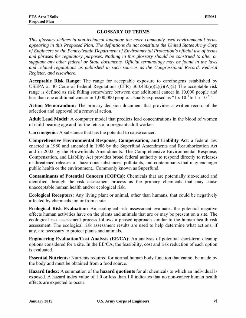
GLOSSARY OF TERMS This glossary defines in non-technical language the more commonly used environmental terms appearing in this Proposed Plan. The definitions do not constitute the United States Army Corp of Engineers or the Pennsylvania Department of Environmental Protection’s official use of terms and phrases for regulatory purposes. Nothing in this glossary should be construed to alter or supplant any other federal or State documents. Official terminology may be found in the laws and related regulations as published in such sources as the Congressional Record, Federal Register, and elsewhere. Acceptable Risk Range: The range for acceptable exposure to carcinogens established by USEPA at 40 Code of Federal Regulations (CFR) 300.430(e)(2)(i)(A)(2) The acceptable risk range is defined as risk falling somewhere between one additional cancer in 10,000 people and less than one additional cancer in 1,000,000 people. Usually expressed as “1 x 10⁻⁴ to 1 x 10⁻⁶”.
Action Memorandum: The primary decision document that provides a written record of the selection and approval of a removal action. Adult Lead Model: A computer model that predicts lead concentrations in the blood of women of child-bearing age and for the fetus of a pregnant adult worker.
Carcinogenic: A substance that has the potential to cause cancer. Comprehensive Environmental Response, Compensation, and Liability Act: a federal law enacted in 1980 and amended in 1986 by the Superfund Amendments and Reauthorization Act and in 2002 by the Brownfields Amendments. The Comprehensive Environmental Response, Compensation, and Liability Act provides broad federal authority to respond directly to releases or threatened releases of hazardous substances, pollutants, and contaminants that may endanger public health or the environment.. Commonly known as Superfund.
Contaminants of Potential Concern (COPCs): Chemicals that are potentially site-related and identified through the risk assessment process as the primary chemicals that may cause unacceptable human health and/or ecological risk. Ecological Receptors: Any living plant or animal, other than humans, that could be negatively affected by chemicals ion or from a site. Ecological Risk Evaluation: An ecological risk assessment evaluates the potential negative effects human activities have on the plants and animals that are or may be present on a site. The ecological risk assessment process follows a phased approach similar to the human health risk assessment. The ecological risk assessment results are used to help determine what actions, if any, are necessary to protect plants and animals. Engineering Evaluation/Cost Analysis (EE/CA): An analysis of potential short-term cleanup options considered for a site. In the EE/CA, the feasibility, cost and risk reduction of each option is evaluated.
Essential Nutrients: Nutrients required for normal human body function that cannot be made by the body and must be obtained from a food source. Hazard Index: A summation of the hazard quotients for all chemicals to which an individual is exposed. A hazard index value of 1.0 or less than 1.0 indicates that no non-cancer human health effects are expected to occur.

FFA Area I Soils FINAL Proposed Plan
January 2015 U.S. Army Corps of Engineers vii
Hazard Quotient: The ratio of the concentration of a chemical detected at a site to the concentration of the chemical at which no negative non-cancer effects are expected. Hazardous Waste: Hazardous waste is waste that is dangerous or potentially harmful to our health or the environment.
Human Health Risk Assessment: A human health risk assessment is the process used to estimate the nature and potential for negative health effects in humans who may be exposed to chemicals in the environment, now or in the future.
Incremental Lifetime Cancer Risks: The estimated increased risk of cancer occurring over an assumed average life span of 70 years:
Non-carcinogen: a substance that does not cause cancer but may cause other negative health effects on humans and other animals.
Non-hazardous Waste: Waste that is not classified as hazardous waste.
Polychlorinated Biphenyl (PCB): PCBs belong to a broad family of man-made organic chemicals known as chlorinated hydrocarbons. Most commercial PCB mixtures are known in the United States by their industrial trade names. The most common trade name is Aroclor.
Radionuclide: An unstable form of a chemical element that radioactively decays, resulting in the release of nuclear radiation. Also called a radioisotope. Radionuclides may occur naturally, but can also be artificially produced. Reasonable Maximum Exposure: The exposure scenario that portrays the highest level of human exposure that could reasonably be expected to occur at a site. Removal Action: Short-term response actions taken to address releases or threatened releases requiring a prompt response. Generally used to address localized risks such as abandoned drums containing hazardous substances and contaminated surface soils posing immediate risks to human health or the environment.
Risk-based Screening Levels: chemical concentrations in soil or water which are at a level that is protective of human health and the environment. Semivolatile Organic Compounds (SVOC): Organic chemical compounds whose chemical composition allows them to slowly evaporate at or above room temperature. Semivolatile organic compounds include chemicals such as phenols and polynuclear aromatic hydrocarbons.
Volatile Organic Compounds (VOC): Organic chemical compounds whose composition allows them to evaporate at or below room temperature. Volatile organic compounds include both man-made and naturally occurring chemicals such as benzene and trichloroethene (TCE).
Water Table: The depth at which shallow groundwater is found below the ground surface.
Weight of Evidence Screen: If a chemical was only detected in less than 5% of the samples, it is not used for the risk assessment.

FFA Area I Soils FINAL Proposed Plan
January 2015 U.S. Army Corps of Engineers viii
This page intentionally left blank

FFA Area I Soils FINAL Proposed Plan
January 2015 U.S. Army Corps of Engineers 1-1
1.0 INTRODUCTION The United States Army Corps of Engineers – Baltimore District is conducting environmental studies at the Former Frankford Arsenal in Philadelphia, Pennsylvania under the Formerly Used Defense Sites program. Cleanup activities must comply with the Defense Environmental Restoration Program Comprehensive Environmental Response, Compensation, and Liability Act; and the National Oil and Hazardous Substances Pollution Contingency Plan.
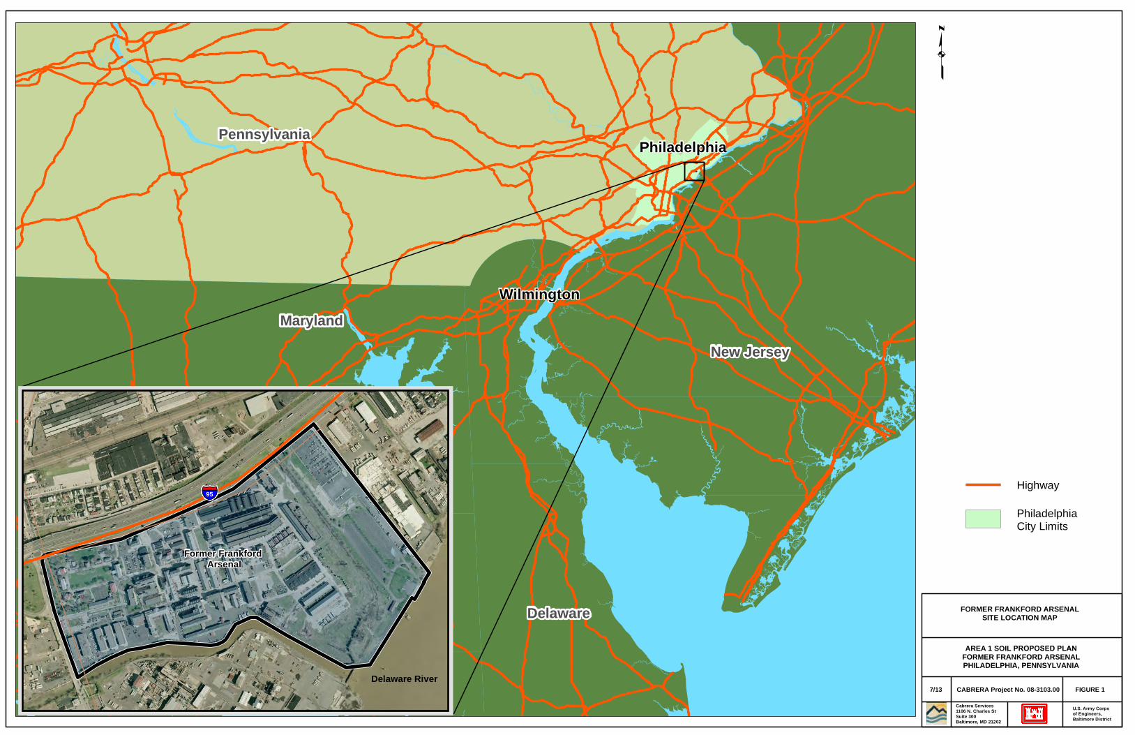
The Former Frankford Arsenal is a 109.4-acre facility located in northeast Philadelphia (Figure 1) consisting of some 109 acres and 53 existing buildings, plus 159 locations where buildings formerly existed. Area I, which is the focus of this Proposed Plan, consists of 46 acres primarily used as a commercial business park. Area I occupies the eastern half of the Former Frankford Arsenal between Baird Street and Sanger Street. Separate investigations are being conducted for the western half of the FFA (designated as Area II), the land owned by the Commonwealth of Pennsylvania Fish and Boat Commission and Dietz and Watson (designated as Area III), and groundwater at the Former Frankford Arsenal (designated as Area IV). The layout of the Former Frankford Arsenal showing Areas I, II, and III is depicted on Figure 2.
Between the time that the Final Area I Soil Remedial Investigation/Risk Assessment Report (Cabrera, 2014) was approved and this Proposed Plan was developed, the ownership at the Former Frankford Arsenal has changed. This change in ownership did not alter any of the land use assumptions for the property. In 2014, Dietz and Watson expanded to take a portion of Area I and the former Pennsylvania Fish and Boat Commission property. The remaining Pennsylvania Fish and Boat Commission boat launch property was purchased by the City of Philadelphia. The western portion of Area I was purchased by the Philadelphia Industrial Development Corp. The current property boundaries are displayed in Figure 3.
1.1 Purpose of Proposed Plan This Proposed Plan has been developed to 1) inform the public of the United States Army Corps of Engineers preferred soils remedy for the Former Frankford Arsenal Area I soils and 2) to solicit public comments pertaining to the preferred remedy. This Proposed Plan was prepared using guidance provided in the Guide to Preparing Superfund Proposed Plans, Records of Decision, and Other Remedy Selection Decision Documents (USEPA, 1999). Additional cleanup under the Comprehensive Environmental Response, Compensation, and Liability Act is not necessary for the Former Frankford Arsenal Area I soils. Interim removal actions previously conducted for the FFA Area I soils have proved to be protective of human health and the environment and have eliminated the need to conduct additional remedial action. Therefore, the United States Army Corps of Engineers proposes No Further Action as the proposed decision for the Area I soils. Soil contamination present below the water table will be addressed as part of a separate Groundwater Remedial Investigation.
1.2 Public Participation United States Army Corps of Engineers is the lead agency for this Comprehensive Environmental Response, Compensation, and Liability Act response action. The Pennsylvania Department of Environmental Protection is the lead regulatory agency for the Former Frankford Arsenal and provides oversight and regulatory support.
FFA Area I Soils FINAL Proposed Plan
January 2015 U.S. Army Corps of Engineers 1-2
The United States Army Corps of Engineers is requesting public input on its proposed decision for the Former Frankford Arsenal Area I soils. After the public comment period has ended, the United States Army Corps of Engineers will review and provide responses to significant public comments formally documented in a Responsiveness Summery. The United States Army Corps of Engineers will then make a final decision for the Former Frankford Arsenal Area I soils in the Record of Decision. Additional information on the public comment period is presented in Section 7 of this plan.
The Proposed Plan is being issued by the United States Army Corps of Engineers as part of its public participation responsibilities under section 300.430(f)(2) of the National Oil and Hazardous Substances Pollution Contingency Plan and fulfills the public participation requirements of Comprehensive Environmental Response, Compensation, and Liability Act Section 117(a). The Pennsylvania Department of Environmental Protection was part of the development of the Proposed Plan and concurs with the recommended decision presented.
This Proposed Plan summarizes information for Area I that is described in additional detail in the following documents:
• Final Area I Soil Remedial Investigation/Risk Assessment Report (Cabrera, 2014) • Final Interim Removal Action Completion Report, Containerized Hazardous, Toxic and
Radioactive Waste for the Interim Removal Action) (Cabrera, 2013) • Supplemental Site Investigation, Former Frankford Arsenal (Cabrera, 2007) • Engineering Evaluation/Cost Analysis Report Area I. Former Frankford Arsenal,
Philadelphia, Pennsylvania. Prepared for US Army Corps of Engineers, Baltimore District (Cabrera, 2009)
• Action Memorandum for Area I, Former Frankford Arsenal, Philadelphia, Pennsylvania. Prepared for US Army Corps of Engineers, Baltimore District (Cabrera, 2009)
The reports listed above, as well as other site-related documents, are available in the Administrative Record, located at the Tacony Branch of the Free Library of Philadelphia, 6742 Torresdale Avenue, Philadelphia, Pennsylvania 19135-2416. The public is encouraged to review the Proposed Plan to gain a more comprehensive understanding of activities that have been conducted at the Site.

FFA Area I Soils FINAL Proposed Plan
January 2015 U.S. Army Corps of Engineers 2-1
2.0 SITE BACKGROUND
This Proposed Plan addresses only the Area I soils. The United States Army Corp of Engineers will address remedial action decisions for Areas II through IV once the respective remedial investigations and associated risk assessments have been prepared. Background information regarding Area I is presented in the Remedial Investigation/Risk Assessment (Cabrera, 2014) and other supporting documents. A summary of site history and previous removal actions undertaken for Area I is provided in the following subsections.
2.1 Site Description
The Former Frankford Arsenal is a 109.4-acre facility located in northeast Philadelphia (Figure 1). The Former Frankford Arsenal is located in an urban, mixed-use area of northeast Philadelphia. The facility is bounded to the north by Tacony Street and Interstate 95 (I-95); by the Dietz and Watson industrial properties to the east; by Frankford Creek and the Delaware River to the south; and to the west by Bridge Street and several industrial properties. The facility currently consists of 53 remaining buildings of various sizes, age, and condition, as shown in Figure 2.
Area I encompasses 46 acres and consists of that part of the Former Frankford Arsenal occupying the eastern half of the facility between Baird Street and Sanger Street. Since being decommissioned from military use, Area I is now primarily used as a commercial business park. The present and future land uses for Area I have been determined to be industrial/commercial.
2.2 Site History The Former Frankford Arsenal was commissioned in 1816 for military use. Previously, the area was farmland and undeveloped wetlands. Between 1816 and the decommissioning in 1977, the facility was used for a variety of military activities as its mission was adjusted to fit the military’s changing needs. Activities at the Former Frankford Arsenal during its years of operation included military ordnance production, testing and storage, and munitions research. Figure 4 provides a historical timeline of site-related events for the period between 1816 and 2013.
In 1976, the Former Frankford Arsenal was declared excess by the U.S. Army. On 30 September 1977, the Arsenal was closed. Later, a number of cleanups were conducted at the Arsenal by the Army Toxic and Hazardous Materials Agency prior to transferring the property to the General Services Administration for subsequent disposition. Decontamination efforts were primarily focused on the removal of munitions and radiological wastes. Some chemical-waste cleanup was also conducted to allow for the commercial redevelopment of the Site.
2.3 Previous Removal Actions for Former Frankford Arsenal Area I Soils Three historical site assessments and 15 separate environmental investigations were conducted in Area I and are summarized in Table 1. Additional details on these investigations are presented in the Remedial Investigation/Risk Assessment (Cabrera, 2014). During these investigations, various hazardous materials were discovered and removed. Based on surveys conducted for radionuclides inside and outside of buildings and sewers, radionuclide contamination was removed from building surfaces and sewers and uranium-contaminated soil was excavated from

FFA Area I Soils FINAL Proposed Plan
January 2015 U.S. Army Corps of Engineers 2-2
several locations. Solid-shot cannon balls were discovered below the ground and removed. Heavy-metal and explosives residues were removed from buildings and sewers. Above-ground storage tanks were removed and underground storage tanks and associated contaminated soils were also removed. Lead batteries and polychlorinated biphenyls (PCB)-containing transformers present in Area I were removed.
An Engineering Evaluation/Cost Analysis (EE/CA) was conducted in 2009 to evaluate various removal action alternatives to address the contamination detected during the previous sampling in 2008 (Table 1) (Cabrera, 2009a). A baseline human health risk assessment conducted to support the EE/CA determined that chemical contamination present in the soil would pose an unacceptable risk to site workers. Arsenic, copper and PCB-1260 were identified as the chemicals presenting the greatest potential risks to site workers.
An Action Memorandum (Cabrera, 2009b) was prepared to document the selected alternative chosen from those presented in the EE/CA. Excavation with Off-site Disposal was chosen as the Non Time Critical Removal Action for Area I. In addition, the Action Memorandum provided cleanup levels to be used during the removal action. These cleanup levels are presented in Table 2.
For the interim removal actions conducted during 2009, the arsenic cleanup level of 53 milligrams per kilogram (mg/kg) in surface soil/150 mg/kg in subsurface soil was used. After 2009, the Pennsylvania Department of Environmental Protection changed the arsenic cleanup level to 29 mg/kg for both surface and subsurface soil. For the interim removal actions conducted between 2012 and 2013, the arsenic cleanup level of 29 mg/kg was used.
Six Interim Removal Actions were conducted in Area I between September 2009 and August 2013. The purpose of the Interim Removal Actions was to remove certain soil contamination and underground storage tanks remaining from historical activities to allow for redevelopment of Area I. The results of these final soil removal activities have been used to determine current site conditions. Table 3 presents a summary of each area, associated buildings and site constituents, as well as the final status for each. Details on each Interim Removal Action are presented in both the Remedial Investigation/Risk Assessment (Cabrera, 2014), and the Completion Report (Cabrera, 2013). Summaries of each Interim Removal Action and final site conditions are presented below.
2.3.1 Area I Interim Removal Action, 2009-2010 As part of this removal action, contaminated soil was removed from 10 locations: Building 44/47 Tank Pit; Building 141 through 143; the Compound Area; Building 149; and Areas of Concern (AOCs) 3 through 8. The location and dimensions of the Compound Area and AOCs 3-8 are shown on Figure 5. Four underground storage tanks that had previously been closed in place were also removed and disposed of off-site.
Building 44/47 Tank Pit After removal 296 cubic yards of soil at Building 44/47 Tank Pit, fifteen soil samples (nine bottom [floor] and six side [wall] samples) were collected from the excavation and analyzed for PCBs and metals. One floor sample (TP44-SO-11; 1,810 mg/kg) exceeded the cleanup level for lead of 450 mg/kg. Two floor samples (TP44-SO-07; 5.5 mg/kg and TP44-SO-08; 7.6 mg/kg) exceeded the PCB cleanup level of 1.0 mg/kg. These metals and PCB samples were collected at a depth of 15 feet below the ground, which is below the water table. Therefore, no further excavation was possible. This contamination will be addressed in a separate Groundwater
FFA Area I Soils FINAL Proposed Plan
January 2015 U.S. Army Corps of Engineers 2-3
Remedial Investigation. The locations of the remaining metals and PCB contamination are presented in Figures 6 (metals) and 7 (PCBs).
Building 141 through 143 For Building 141 through 143 AOC 11, a total of 399 cubic yards of soil was excavated and disposed of offsite. Fifteen floor soil samples were collected from 1.0 foot below the ground for metals analysis. All metals concentrations were below the cleanup levels. .
Compound Area After removal of the contaminated soil at the Compound Area excavation, 16 soil samples collected at 1.5 feet below the ground (eight floor and eight wall samples) were analyzed for metals. All metals concentrations were below the cleanup levels. A total of eight cubic yards of soil was excavated and disposed of offsite.
Building 149 For the Building 149 (AOC 7) excavation, a total of 49 cubic yards of soil was excavated and disposed of offsite. Eight soil samples were collected at 1.5 feet below the ground (five floor and three wall samples) and analyzed for metals. All metals concentrations were below the cleanup levels.
AOCs 3 through 8 After removal of the soil in AOC 3, 12 samples were collected at depths between six and 12 feet below the ground (seven floor samples and five wall samples). These samples were analyzed for volatile organic compounds (VOCs), semi-volatile organic compounds (SVOC) and metals. All chemical concentrations were below their respective cleanup levels. A total of 1,095 cubic yards of soil was excavated and disposed of offsite.
A total of 96 cubic yards of soil was excavated from AOC 4 and disposed of offsite. Eight samples were collected for PCBs and metals analysis at depth of two feet below the ground (six floor samples and two wall samples). All chemical concentrations were below their respective cleanup levels. For AOC 5, a total of 153 cubic yards of soil was excavated and disposed of offsite. Due to the risk of making the building foundation unstable, the remaining soil contamination next to the foundation was not removed. As shown on Figure 6, metals concentrations for two floor samples in AOC 5 exceeded the cleanup level for lead (450 mg/kg), mercury (10 mg/kg) and chromium (190 mg/kg). Sample AOC5-SO-03 (4 feet below the ground) contained lead at a concentration of 770 mg/kg and mercury at a concentration of 18.7 mg/kg. Chromium (235 mg/kg) was detected at a depth of six feet below the ground in sample AOC5-SO-07. After removal of the soil from AOC 6, eight samples were collected for PCBs and metals analysis at depths between two and eight feet below the ground (five floor samples and three wall samples). All chemical concentrations were below their respective cleanup levels. A total of 99 cubic yards of soil was excavated and disposed of offsite.
For AOC 7, a total of 97 cubic yards of soil was excavated and disposed of offsite. Eight samples were collected for VOC, SVOC and metals analysis at a depth of two feet below the ground. All chemical concentrations were below their respective cleanup levels.
After removal of the soil from AOC 8, seven samples were collected for PCBs and metals analysis at depths between two and four feet below the ground. Two sample locations (AOC8-SO-02; 609 mg/kg and AOC8-SO-03c; 518 mg/kg) exceeded the cleanup level for lead at a

FFA Area I Soils FINAL Proposed Plan
January 2015 U.S. Army Corps of Engineers 2-4
depth of 3.0 feet below the ground, as shown on Figure 6. All the other chemical concentrations were below the cleanup levels. Due to the risk of making the building foundation unstable, the remaining soil contamination next to the foundation could not be removed and was left in place. A total of 81 cubic yards of soil was excavated and disposed of offsite.
Following the soil sampling, the excavations for each area were filled in with clean soil obtained from off-site. In total, 726 cubic yards of PCB-contaminated soil and 1,648 cubic yards of hazardous and non-hazardous waste soil were excavated and transported to licensed landfills.
2.3.2 Area I Interim Removal Action, May-June 2012 The Interim Removal Action conducted between May 2012 and June 2012 addressed soil contamination beneath former Buildings 47, 58, 231, and 128. This soil contamination was not accessible at the time the 2009 Interim Removal Action was conducted.
Building 47 After removal of the soil from Building 47 AOCs 1 and 2, 114 floor soil samples were collected for VOC analysis. As shown on Figure 8, eight of the soil samples exceeded the cleanup level for VOCs (500 mg/kg) at depths of 1.0 to 4.0 feet below the ground. These contaminated soil areas were addressed later during the Interim Removal Action that began in October 2012. The remaining 106 soil samples were below the cleanup level. A total of 1,323 cubic yards of soil was removed and disposed of offsite.
Building 58
A total of 90 cubic yards of soil was excavated from Building 58 (AOC 14) and disposed of offsite. After removal of the soil, thirty-four soil samples were collected from the floor of the (AOC 14 excavation and analyzed for PCBs, metals and/or VOCs. The 10 VOC samples were collected from a depth of 5-10 feet below the ground. The six metals samples were collected from a depth of 3 feet below the ground and the 18 PCB samples were collected from a depth of 1.0 foot below the ground.
The concentrations of VOCs and metals were below their respective cleanup levels. Five PCB samples were above the cleanup level. The locations of these samples were addressed later during the Interim Removal Action that began in October 2012. These sample locations are shown on Figure 7.
Building 128 Transformer Pad
After removal of the soil from the Building 128 Transformer Pad, four floor soil samples were collected from a depth of 1.0 foot below the ground and analyzed for PCBs. All PCB concentrations were below the cleanup level. A total of 14 cubic yards of soil was excavated and disposed of offsite.
Building 231
For Building 231 (AOC 12), a total of 57 cubic yards of soil was excavated and disposed of offsite. After removal of the soil, eight floor soil samples were collected between three and five feet below the ground and analyzed for VOCs, PCBs and metals. All VOCs and SVOCs were either reported as not detected or at concentrations below the cleanup level. No PCBs were detected in the samples. Four samples contained antimony, lead, and/or mercury at

FFA Area I Soils FINAL Proposed Plan
January 2015 U.S. Army Corps of Engineers 2-5
concentrations above the cleanup levels. These contaminated soil areas were later addressed during the Interim Removal Action that began in October 2012.
In total, 1,484 cubic yards of hazardous and non-hazardous waste soil were excavated and transported to licensed landfills during the May-June 2012 Interim Removal Action .
2.3.3 Area I Interim Removal Action, October 2012 to January 2013 The Interim Removal Action conducted between October 2012 and January 2013 addressed the soil contamination that remained in place within the footprint of Building 47, Building 58, and Building 231 after completion of the May to June 2012 Interim Removal Action. In addition to addressing this soil contamination, an oil-water separator adjacent to Building 47 was removed and contaminated soil beneath the structure was excavated. Three underground storage tanks at Building 48 were also removed.
Building 47 After removal of the soil, seventeen floor soil samples were collected from the excavation at depths of three to six feet below the ground. The samples were analyzed for VOCs. All VOC concentrations were below the cleanup level. A total of 93 cubic yards of soil was excavated and disposed of offsite.
Building 47 Oil-Water Separator Once the oil-water separator structure and surrounding soils were removed, soil sampling was conducted for each wall and the floor of the excavation. Forty soil samples were collected (20 floor and 20 wall samples) and analyzed for VOCs and PCBs. No VOCs or PCBs were detected in the samples. A total of 1051 cubic yards of soil and debris was excavated and disposed of offsite.
Building 58
A total of 248 cubic yards of soil was excavated and disposed of offsite. After removal of the soil, thirteen floor soil samples were collected from the excavation at seven to eight feet below the ground. The samples were analyzed for PCBs and metals. One sample exceeded the cleanup level for arsenic (58-CS-48-P-8; 32.8 mg/kg). Two samples (58-CS-47-P-8; 4-4 mg/kg and 58-CS-38-P-8; 1.4 mg/kg) exceeded the PCB cleanup level (Figures 6 and 7). These PCB and arsenic sample locations were 8.0 feet below the ground, which is below the water table and no further excavation was possible. This contamination will be addressed in a separate Groundwater Remedial Investigation. The remaining soil sample locations did not exceed the cleanup levels.
Building 231
After removal of the soil, twenty-four floor soil samples were collected from the Building 231 excavation at 7.0 feet below the ground. All samples were located 7 feet below the ground, which is below the water table. Seven of the samples exceeded the cleanup level for either lead or mercury. Lead concentrations ranged from 887 mg/kg to 1,060 mg/kg, while mercury concentrations ranged from 11.1 mg/kg to 34.9 mg/kg (Figure 6). Because the lead and mercury contamination is below the water table, no further excavation was performed. This contamination will be addressed in a separate Groundwater Remedial Investigation. A total of 503 cubic yards of soil was excavated and disposed of offsite.
FFA Area I Soils FINAL Proposed Plan
January 2015 U.S. Army Corps of Engineers 2-6
Building 48 Underground Storage Tanks
Three underground storage tanks were removed from the Building 48 area and disposed of off-site. Any liquids remaining in the underground storage tanks were removed before the underground storage tank was taken out of the ground. If necessary, the underground storage tank was then cut into smaller pieces for disposal.
After removal of the tanks, six floor soil samples were collected from each excavation at a depth of 1.0 foot below the ground for a total of 18 samples. All soil samples were below the cleanup levels for VOCs and SVOCs. A total of 245 cubic yards of soil was excavated and disposed of offsite.
During removal of the Building 48 underground storage tanks, an unknown underground storage tank was discovered. Because no contamination was found in the tank, further responsibility for the tank was transferred to the property owner.
In total, 88 cubic yards of PCB-contaminated soil and 2,051 cubic yards of hazardous and non-hazardous waste soil were excavated and transported to licensed landfills during the October 2012-January 2013 Interim Removal Action.
2.3.4 Area I Interim Removal Action, February 2013 The Interim Removal Action conducted in February 2013 included the removal of a leaking sump discovered in the Building 58 area. After removal of the sump and the excavation of contaminated soil; 18 soil samples were collected (eleven wall samples and seven floor samples). Fifteen of the 18 samples exceeded the cleanup level for TCE while 10 samples exceeded the PCB cleanup level. This remaining contamination was later addressed during the Interim Removal Action that began in May 2013. The remaining three wall samples were below the cleanup level.
2.3.5 Area I Interim Removal Action, May 2013 to June 2013 The Interim Removal Action conducted between May and June 2013 addressed the TCE and PCB soil contamination remaining at Building 58 after the February 2013 Interim Removal Action. This contamination had been caused by the leaking sump. After excavating the contaminated soil, soil samples were collected from the walls and floor of the excavation. Seven of 29 floor samples exceeded the cleanup level for VOCs, SVOCs and PCBs (Figures 7 and 8, respectively). PCB concentrations ranged from 1.1 mg/kg to 3.9 mg/kg while TCE concentrations ranged from 4,400 micrograms per kilogram (µg/kg) to 145,000 µg/kg. Sample location 58EM-CS-17-P12 also contained perchloroethyene (PCE) at a concentration of 805 µg/kg and methylene chloride at a concentration of 1,390 µg/kg.
No further excavation was performed because all sample locations were 12 feet below the ground, which is beneath the water table. Two of the 26 wall locations exceeded the cleanup level for TCE (west wall) and PCBs (east wall). This TCE and PCB contamination will be addressed in a separate Groundwater Remedial Investigation. The west wall TCE contamination was later addressed during the Interim Removal Action that began in August 2013. In total, 1,188 cubic yards of contaminated soil were excavated and transported to licensed landfills during the May and June 2013 Interim Removal Action.
FFA Area I Soils FINAL Proposed Plan
January 2015 U.S. Army Corps of Engineers 2-7
2.3.6 Area I Interim Removal Action, August 2013 The August 2013 removal action was a continuation of the May/June 2013 excavation activities at Building 58 because the June 2013 samples showed TCE and PCB concentrations above cleanup levels. The area where the May/June 2013 samples exceeded the TCE cleanup level was excavated. Contaminated soil west of this area was also excavated. Ten soil samples were collected; four from the floor and six from the walls of the excavation. The soil samples from the floor of the excavation were collected from 12 feet below the ground, which is below the water table. All the soil samples were below the respective cleanup levels for VOCs, SVOCs and PCBs. A total of 136 cubic yards of contaminated soil was removed and transported off-site.

FFA Area I Soils FINAL Proposed Plan
January 2015 U.S. Army Corps of Engineers 2-8
This page intentionally left blank
FFA Area I Soils FINAL Proposed Plan
January 2015 U.S. Army Corps of Engineers 3-1
3.0 SITE CHARACTERISTICS Soil contamination remaining in Area I is located beneath the water table. Arsenic contamination is present in surface soil at the Compound Area, Building 238 and AOCs 6 and 9. This contamination is present because, when contaminated soil was removed in 2009, the arsenic cleanup level was 53 mg/kg. The arsenic cleanup level was updated after 2009 and is currently 29 mg/kg. As presented in Section 5.0, remaining arsenic concentrations above 29 mg/kg in shallow soil do not pose unacceptable risks to human health or the environment. In addition, current and future site physical features reduce the potential for humans and animals to be exposed to arsenic in the shallow soil. The current land use for Area I is commercial/industrial and is expected to remain as such in the future. Most all of the areas with arsenic concentrations above 29 mg/kg are planned to be parking lots, paved areas, and maintained landscaping.
This proposed plan only addresses soil above the water table. Soil contamination remains below the water table in several areas, as noted below:
• AOC 10; two to seven feet below ground surface (arsenic, TCE, benzene) • AOC 13; 9.5 to 10 feet below ground surface (arsenic) • AOI 15; 6 feet below ground surface (TCE) • AOC 16; two to nine feet below ground surface (TCE) • Building 44/47 Tank Pit Area; 14-15 feet below ground surface (lead) • Building 58 footprint AOC 14; eight feet below ground surface (arsenic, PCBs) • Building 58 leaking sump; 12 feet below ground surface (TCE,PCBs) • Building 231 footprint AOC 12; seven feet below ground surface (lead/mercury)
The deeper soil contamination listed above will be addressed during a separate Groundwater Remedial Investigation.

FFA Area I Soils FINAL Proposed Plan
January 2015 U.S. Army Corps of Engineers 3-2
This page intentionally left blank

FFA Area I Soils FINAL Proposed Plan
January 2015 U.S. Army Corps of Engineers 4-1
4.0 SCOPE AND ROLE
To manage cleanup efficiently, the work at the Former Frankford Arsenal has been broken up into four areas. The United States Army Corps of Engineers has completed a remedial investigation, as well as a series of interim removal actions, for soil in the eastern half (Area I) of the Former Frankfort Arsenal. Separate investigations are being conducted for the western half of the Former Frankfort Arsenal (designated Area II), the land owned by the Commonwealth of Pennsylvania Fish and Boat Commission launch and Dietz and Watson (designated as Area III), and groundwater at the Former Frankfort Arsenal (designated as Area IV). This Proposed Plan deals only with Area I soils above the water table. The No Further Action determination is intended to be the final remedy for Area I soils above the water table, and does not include or affect any other area at the Former Frankford Arsenal. The remedial investigation and interim removal actions conduced at Area I, combined with the investigations and actions to be completed at Areas II, III, and IV of the Former Frankfort Arsenal, provide the overall remediation strategy in support of commercial/industrial use of the property.

FFA Area I Soils FINAL Proposed Plan
January 2015 U.S. Army Corps of Engineers 4-2
This page intentionally left blank

FFA Area I Soils FINAL Proposed Plan
January 2015 U.S. Army Corps of Engineers 5-1
5.0 SUMMARY OF SITE RISKS
A human health risk assessment and ecological risk evaluation were performed for the Area I soil and is presented in Appendix G of the Remedial Investigation/Risk Assessment (Cabrera, 2014). The risk assessments were performed to determine the potential risks to humans and ecological receptors from exposure to chemical contamination in soil at Area I.. Following United States Environmental Protection Agency guidance, the human health risk assessment was performed in four steps: identification of contaminants of potential concern (COPCs); exposure assessment; toxicity assessment; and risk characterization.
5.1 Identification of COPCs
COPCs are those site-related chemicals that have gone through an extensive screening process. This screening process involved three steps – elimination of essential nutrients, weight of evidence screen, and comparison to risk-based screening levels. The chemicals that are left after the last screening step are identified COPCs and used in the human health risk assessment. The soil COPCs identified for the Area I soil above the water table are presented in Table 4.
5.2 Summary of Human Health Risk Assessment
Four reasonable maximum exposure receptors were identified based upon the current industrial land use at Area I:
• Industrial/commercial worker, • Construction worker, • Utility worker, and • Maintenance worker
These receptors were assumed to come into contact with Area I soils while working at the Former Frankford Arsenal. The industrial/commercial worker scenario was considered as the only likely potential future reasonable maximum exposure scenario. The intent of the reasonable maximum exposure scenario is to focus the human health risk assessment on a conservative exposure scenario that represents the maximum exposure that is reasonably expected to occur (USEPA, 1989a, b). Three exposure pathways – accidental eating of soil, touching the soil, and breathing in VOC vapors – were considered for each reasonable maximum exposure scenario. It was assumed that all receptors may be exposed to both surface soil and subsurface soil.
Potential carcinogenic and non-carcinogenic risks were determined for each reasonable maximum exposure receptor. For carcinogens, incremental lifetime cancer risks were calculated. For non-carcinogenic chemicals, a hazard index was calculated for each pathway. The resulting incremental lifetime cancer risks were compared to the range specified in the National Oil and Hazardous Substances Pollution Contingency Plan (USEPA, 1990) of 1 x 10⁻⁶ to 1 x 10⁻⁴, or one in one million to one in 10,000 persons developing cancer. Risks between 1 x 10⁻⁶ and 1 x 10⁻⁴ are generally referred to as the “acceptable risk range.” A Hazard Index greater than one has been defined as the level of concern for potential non-carcinogenic risks(USEPA, 1989a).
The carcinogenic and non-carcinogenic risks for both current and future receptor scenarios are presented in Table 5. The carcinogenic risks for the industrial/commercial worker, construction

FFA Area I Soils FINAL Proposed Plan
January 2015 U.S. Army Corps of Engineers 5-2
worker, and maintenance worker were all within or less than the acceptable risk range for cancer of 1 x 10⁻⁶ to 1 x 10⁻⁴. The carcinogenic risk ranged from 1 x 10⁻⁵ for the industrial worker to 2 x 10⁻⁷ for the utility worker. The noncancer hazard indices did not exceed the limit of one for any receptor. Hazard indices ranged from 0.5 for the construction worker to 0.02 for both the utility and maintenance worker.
The United States Environmental Protection Agency Adult Lead Model was used to predict lead concentrations in blood if the four Area I receptors were to touch or accidentally eat lead-contaminated soil. The current comparison value established by the United States Environmental Protection Agency lead concentrations in blood is 10 micrograms per decaliter in the fetus of a pregnant adult. None of the Model results were above the 10 micrograms per decaliter value. These results indicate that no potential negative human health effects are likely to occur as a result of exposure to lead in soils at Area I.
Ecological Evaluation
An ecological risk evaluation was performed for Area I soils to determine if chemicals in Area I soils would have a negative effect on ecological receptors (such as animals) that may be present in Area I. There are neither protected or endangered animals that use Area I nor freshwater wetlands on or in the vicinity of Area 1. Based on visual observations of plants and animals around Area I, it was concluded that wildlife in Area I would be mainly industrial-tolerant animals such as cottontail rabbits, skunks, rats, and pigeons. The Site currently has, and is expected in the future to continue to have, physical features such as parking lots, paved areas, and maintained landscaping that would severely reduce the ability for animals to come into contact with Area 1 soil. As a result, there are no suitable places in Area I for animals to live and no animals are known to be currently present in Area I. Because of the expected future use of Area I for commercial/industrial purposes, animals are not expected to be present in Area I in the future. Therefore, no additional ecological evaluation was conducted for soils at Area I.

FFA Area I Soils FINAL Proposed Plan
January 2015 U.S. Army Corps of Engineers 6-1
6.0 PROPOSED DECISION
Based upon the results of the human health risk assessment and ecological risk evaluation, it was determined that there are no unacceptable risks to humans and animals for the Area I soils above the water table. Because there is no unacceptable risk to Area I soils, United States Army Corp of Engineers proposed decision for the Former Frankford Arsenal Area I Soils is No Further Action. The interim removal actions conducted for the Area I soils above the water table have reduced potential risks to humans and animals to acceptable levels. Soil contamination that remains below the water table does not pose an unacceptable risk from exposure to soil and will be addressed as part of the Groundwater Remedial Investigation.
FFA Area I Soils FINAL Proposed Plan
January 2015 U.S. Army Corps of Engineers 6-2
This page intentionally left blank

FFA Area I Soils FINAL Proposed Plan
January 2015 U.S. Army Corps of Engineers 7-1
7.0 COMMUNITY PARTICIPATION
The United States Army Corp of Engineers encourages input from the public regarding this Proposed Plan. Written comments on the Proposed Plan will be accepted during the public comment period. The public comment period for the FFA Area I Soils Proposed Plan offers the public an opportunity to provide input to the process of selecting the proposed decision for the Area I soils. The public comment period will extend from February 5, 2015 to March 9, 2015. Upon a timely request made prior to the end of the comment period, the comment period may be extended for an additional 30 days.
United States Army Corp of Engineers will hold a public meeting during the public comment period at the Tacony Branch of the Free Library of Philadelphia, 6742 Torresdale Avenue, Philadelphia, Pennsylvania 19135-2416 on February 18, 2015 to present the proposed decision as described in this Proposed Plan, elaborate further on the reasons for recommending the proposed decision, and receive public comments. The United States Army Corp of Engineers will accept comments at the public meeting on February 18, 2015 or written comments will be accepted at any time during the comment period, and should be mailed to:
U.S. Army Corps of Engineers, Baltimore District Attn: Ms. Andrea Takash Room 11400 10 South Howard Street Baltimore, Maryland 21201
Comments may also be emailed to: [email protected] no later than March 9, 2015.
The United States Army Corp of Engineers will evaluate comments submitted during the comment period, with responses to significant public comments formally documented in a Responsiveness Summary. After considering all comments in consultation with the Pennsylvania Department of Environmental Protection, the United States Army Corp of Engineers will issue its decision for the Area I soils remedy in a Record of Decision. The Record of Decision will include the Responsiveness Summary and will be incorporated in the Administrative Record for the Former Frankford Arsenal Site. The Administrative Record will be available for review at the Tacony Branch of the Free Library of Philadelphia, 6742 Torresdale Avenue, Philadelphia, Pennsylvania 19135-2416.

FFA Area I Soils FINAL Proposed Plan
January 2015 U.S. Army Corps of Engineers 7-2
This page intentionally left blank
FFA Area I Soils FINAL Proposed Plan
January 2015 U.S. Army Corps of Engineers 8-1
8.0 REFERENCES
Cabrera, 2009a. Engineering Evaluation/Cost Analysis Report Area I. Former Frankford Arsenal, Philadelphia, Pennsylvania. Prepared for US Army Corps of Engineers, Baltimore District.
Cabrera, 2009b. Final Action Memorandum, Area I Former Frankford Arsenal, Philadelphia, Pennsylvania. FUDS Site ID: C03PA004201. Prepared for US Army Corps of Engineers, Baltimore District.
Cabrera, 2013. Interim Removal Action Completion Report Containerized (CON) / Hazardous, Toxic, and Radioactive Waste (HTRW) for the Interim Removal Action. Former Frankford Arsenal, Philadelphia, Pennsylvania. Prepared for US Army Corps of Engineers, Baltimore District.
Cabrera, 2014. Final Area I Soil Remedial Investigation/Risk Assessment Report. Former Frankford Arsenal, Philadelphia, Pennsylvania. Prepared for US Army Corps of Engineers, Baltimore District.
USC, 1980. 42 USC §9601, et. seq, Comprehensive Environmental Response, Compensation, and Liability Act 1980.
US Environmental Protection Agency (USEPA), 1989a. Risk Assessment Guidance for Superfund, Volume I, Human Health Evaluation Manual (Part A), EPA 540/1-89/002, December, 1989, PB90-155581.
USEPA, 1989b. Risk Assessment Guidance for Superfund, Volume II: Environmental Evaluation Manual. EPA/540/1-89-001. US Environmental Protection Agency.
USEPA, 1990, National Oil and Hazardous Substances Pollution Contingency Plan, Final Rule, FR Vol. 55, No. 46, March 8, 1990, available from US Government Printing Office, Washington, D.C.

FFA Area I Soils FINAL Proposed Plan
January 2015 U.S. Army Corps of Engineers 8-2
This page intentionally left blank
FFA Area I Soils FINAL Proposed Plan
January 2015 U.S. Army Corps of Engineers Figures
FIGURES

FFA Area I Soils FINAL Proposed Plan
January 2015 U.S. Army Corps of Engineers Figures
This page intentionally left blank
Wilmington
PhiladelphiaPennsylvania
MarylandNew Jersey
Delaware
q
Former Frankford Arsenal
AREA 1 SOIL PROPOSED PLAN FORMER FRANKFORD ARSENAL PHILADELPHIA, PENNSYLVANIA
FORMER FRANKFORD ARSENALSITE LOCATION MAP
Highway
PhiladelphiaCity Limits
Delaware River
CABRERA Project No. 08-3103.00 FIGURE 1
U.S. Army Corpsof Engineers,Baltimore District
7/13
Cabrera Services1106 N. Charles StSuite 300Baltimore, MD 21202
§̈¦95
Former Frankford Arsenal
Delaware River
CABRERA Project No. 08-3103.00 FIGURE 2
Area I
Area II
Walbach Street
Eakin Street
Hanger Road
Craig Road
Worth Road
Benet Road
Ripley Street
Baird Street
Mellon Street
Phillips StreetKirk Street
Wal
l Roa
d
Craig Road
Worth Road
Flager Road
Ramsay Road
Montgom
ery Street
Rees Street
Wilson Street
Thomas Street
Munroe Road
Wheeler Road
Laidley Road
Bricker R
oad
Hanger Road
Area III
PA Fish & Boat Commission
Dietz & Watson
Tacony Street
Simonds Abrasive Company
Interstate 95 (Elevated)
Bridge Street
Rohm & Haas Chemical Company
Frankford Creek
Dela
ware
Rive
r
58
55
48
47
521
215
250
52
150
65
64
44
46
501
45
324
316
224
308
303
111
12
40
307
504
301
2628
120
122
219228
510
74
208
211
209
201
235
210
220
112
38
202
42
222
116108/109
23
505
41
39
1
128
518
119
15
110
212
230
4
305
5
231
1114
2/3
6
35
106
57
149
121
223
123
322
251
107
515
106
124
252
237
213/214
126125
68
503
507
50
504
206
513
216/217
12718
128
312239
238
311
130
29
207
227
30
502
519
7/8
520
406
37
302101
440
240
415
33
329
151
9/10
256
19
25
340
232
141
337
143
142
341
319
39A
131
509
511
229
405
403
242
404
402
137
320
59
133
13
334
301A
141A
142A
311A
306129
22
148 245246247
248
244
38A
243
416
203
214A
229
27
310
16
512
63
419418
417
57
315
69
304
70
21
60
410
427
259
429 439
218
202A
263
435
227A
61
434
431
249
132
430
148A
523522
242
227B
244A
400 424423
426425
72
325
339
43413
412
24
414
225
422
321
117
34
56
417A
240
103
20
309
516
246A
240
147
242
247A
67
113
261
71
204
239A
265
318
138
35
U.S. Army Corpsof Engineers,Baltimore District
LegendBuildings
Existing FFA Building
Demolished FFA Building
Outside FFA Area
Phase Area DesignationsArea I (FFA Hankin)
Area II (FFA Hankin)
Area III
Other Property Boundaries
Original Frankford Arsenal Boundary
Waterbodies
AREA I SOIL PROPOSED PLANFORMER FRANKFORD ARSENALPHILADELPHIA, PENNSYLVANIA
p
0 300 600
Scale (feet)
FORMER FRANKFORD ARSENALLAYOUT MAP
7/13
Cabrera Services1106 N Charles StSuite 300Baltimore, MD 21201

CABRERA Project No. 08-3103.00 FIGURE 3
PIDC
Walbach Street
Eakin Street
Hanger Road
Craig Road
Worth Road
Benet Road
Ripley Street
Baird Street
Mellon Street
Phillips Street
Kirk Street
Wal
l Roa
d
Craig Road
Worth Road
Flager Road
Ramsay Road
Montgom
ery Street
Rees Street
Wilson Street
Thomas Street
Munroe Road
Wheeler Road
Laidley Road
Bricker R
oad
Hanger Road
City of Philadelphia
FRANKFORD CREEK
DELA
WAR
E RI
VER
Dietz & Watson
58
55
48
47
521
215
250
52
150
65
64
44
46
501
45
324
316
308
303
111
12
40
504
301
2628
120
219228
510
74
208
211
209
201
235
210
220
112
38
42
116108/109
23 41
1
518
119
15
212
230
4
305
11
2/3
106
57
224
149
307
122121
223
202
123
222
505
322
251
39
128
107110
515
106
124
252
5231
237
213/214
126
14
125
68
6
503
507
35
50
504
206
513
216/217
12718
128
312239
238
311
130
29
207
227
30
502
519
7/8
520
406
37
302101
440
240
415
33
329
151
9/10
256
1925
340
232
141
337
143
142
341
319
39A
131
509
511
229
405
403
242
404
402
137
59
133
13
334
301A
141A
142A
311A
306129
22
148 245246247
244
38A
243
416
203
214A
229
27
310
16
512
63
419418
417
57
315
69
304
70
21
60
410
427
259
429 439
218
202A
435
227A
61
434
431
249
132
430
148A
523522
242
227B
244A
400 424423
426425
72
325
339
43413
412
24
414
225
422
321
117
34
56
240
103309
516
246A
240
147
242
67
113
261
71
427A
204
239A
265
318
138
35
U.S. Army Corpsof Engineers,Baltimore District
Area I Boundary
Property BoundaryCity of Philadelphia
Dietz & Watson
PIDC
BuildingsExisting FFA Building
Demolished FFA Building
Outside FFA Area
Waterbodies
AREA I SOIL PROPOSED PLANFORMER FRANKFORD ARSENALPHILADELPHIA, PENNSYLVANIA
p
0 400 800
Scale (feet)
FORMER FRANKFORD ARSENALAREA I AND AREA III PROPERTY CHANGES
12/2014
Cabrera Services1106 N Charles StSuite 300Baltimore, MD 21201
!( !( !( !( !( !( !( !( !( !( !( !( !( !(
GSA conveys 87.73 acres to the PhiladelphiaAuthority for Industrial Development (PAID).PAID subsequently transfers the site to Arsenal Associates site known as Arsenal Business Center (ABC).
Rockwell submits the final report for FFA decontamination cleanup program
Ecology & Environment performs a Preliminary Assessmentfor EPARockwell International
contracted for clean-up and decontamination of arsenal
Battelle preparesdetailed surveyand alternative assessment of FFA
Arsenal Closedand InstallationAssessment of FFA prepared by the ArmyUSATHAMA
FFA Declared Excess
Aquisition ofadditional land forFFA Parcel 6
Aquisition ofadditional land forFFA Parcel 5
Aquisition ofadditional land forFFA Parcel 4
Aquisition ofadditional land for FFA Parcel 3
Aquisition ofadditional land forFFA Parcel 2
Initial acquisitionof land for FFAParcel 1
GSA conveys 21.63 acres to Pennsylvania Fish & Boat Commission
Historical and Archeological Survey and Mitigation Report for 23 buildings - John Milner and Associates
1983
1982
1981
1980
1979
1978
1977
1976
1951
1943
1917
1849
1837
1816
Legend!( Actions performed by DOD/Government
!( Actions performed by PADEP/EPA
!( Actions performed by Owner
HISTORICAL TIMELINE OF EVENTS1816 - 1983
HISTORICAL TIMELINE(1816 - 1983)
CABRERA Project No. 08-3103.00 FIGURE 4
U.S. Army Corpsof Engineers,Baltimore District
AREA I SOIL PROPOSED PLAN FORMER FRANKFORD ARSENAL PHILADELPHIA, PENNSYLVANIA
7/13
Cabrera Services103 E. Mount Royal Ave.Baltimore, MD 21202

!(!(!(!(!(!(!(!(!( !(!( !(!(!(!( !(!( !( !( !( !(
Consulting Services Inc.completes Phase 1 ESA
INPR addendumidentifies OE project. Design for CON/HTRW project for USACE (ASTremoval). ASR completed by St. Louis District.
Property Solutions Phase 1(Areas I & II)
Langan Lead Paint Screening Reportand Demolition DebrisCharacterization Studyfor Area 1
NUS Corp.completes non-samplingreconnaissance report for EPA
PADEP requestsDOD investigateFFA
Initial INPR forFFA identifies eligible BD/DR,CON/HTRWprojects
Soil sampled forAST removal(CON/HTRW)
Radian InternationalBD/DR projectfor USACE (Area III)
CON/HTRW project for USTs (Area III) and ASTs (Area I)
Cabrera RadiologicalHistorical Site Assessment
2nd INPR addendumidentifies HTRWproject and additional CON/HTRW project
Cabrera RadiologicalScoping Survey
HNC District OEEE/CA
Langan completesAct 2 RemedialInvestigation
Orbis completesPhase 1 ESA
Cabrera conducts SSI tosupport Langan work
USACE RI(Area 1)
USACE CON/HTRWTanks, Batteries, and Wells
Cabrera completes Area ISoil Remedial Investigation
Interim Removal Action(Area I)
Cabrera completes EE/CA andAction Memorandum in supportof NTCRA in Area I
2009
2010
2012
2013
Cabrera completesSoil Removal Actionat 10 AOCs
Cabrera completesSoil Removal Actionat six AOCs
Cabrera completesSoil Removal Actionat remaining AOCs
Cabrera completesNTCRA at Area I
19902005
2003
2002
2001
1998
19971994
1988 2000
1989 1999
19961994
1993
2007
2008
Legend!( Actions performed by DOD/Government
!( Actions performed by PADEP/EPA
!( Actions performed by Owner
HISTORICAL TIMELINE OF EVENTS1984 - 2013
HISTORICAL TIMELINE(1984 - 2013)
CABRERA Project No. 08-3103.00 FIGURE 4
U.S. Army Corpsof Engineers,Baltimore District
AREA I SOIL PROPOSED PLAN FORMER FRANKFORD ARSENAL PHILADELPHIA, PENNSYLVANIA
7/13
Cabrera Services103 E. Mount Royal Ave.Baltimore, MD 21202
CABRERA Project No. 08-3103.00 FIGURE 5
Area II
Walbach Street
Eakin Street
Hanger Road
Craig Road
Worth Road
Benet Road
Ripley Street
Baird Street
Mellon Street
Phillips Street
Kirk Street
Wal
l Roa
d
Craig Road
Worth Road
Flager Road
Ramsay Road
Montgom
ery Street
Rees Street
Wilson Street
Thomas Street
Munroe Road
Wheeler Road
Laidley Road
Bricker R
oad
Hanger RoadFRANKFORD CREEK
DELA
WAR
E RI
VER
Compound Area14 m2
AOC 892 m2
AOC 7189 m2
AOC 5117 m2
AOC 6145 m2
AOC 4178 m2AOC 3
606 m2
Area I
Area III
Simonds Abrasive Company
Interstate 95 (Elevated)
Dietz & Watson
Rohm & Haas Chemical Company
58
55
48
47
521
215
250
52
150
65
64
44
46
501
45
324
316
308
303
111
12
40
504
301
2628
120
219228
510
74
208
211
209
201
210
220
112
38
42
116108/109
23 41
1
518
119
15
212
4
305
11
2/3
106
57
224
149
307
122121
235
223
202
123
222
505
322
251
39
128
107110
230
515
106
124
252
5231
237
213/214
14
125
68
6
503
507
35
50
504
206
513
216/217
18
312239
238
311
130
29
207
227
30
502
519
7/8
520
406
37
302101
440
240
415
33
329
151
9/10
256
1925
340
232
141
337
143
142
341
319
39A
131
509
511
229
405
403
242
404
402
137
59
13
334
301A
141A
142A
311A
306
22
148 245246247
244
38A
243
416
203
214A
229
27
310
16
512
63
419418
417
57
315
69
304
70
21
60
410
427
259
429 439
218
202A
435
227A
61
434
431
249
132
430
523522
242
227B
244A
426425
72
325
339
4324
225
422
321
34
56
240
103309
516
246A
240
242
67
113
261
71
427A
204
239A
265
318
35
U.S. Army Corpsof Engineers,Baltimore District
LegendArea of Concern (AOC)
Phase Area DesignationsArea I
Area II
Area III
BuildingsExisting FFA Building
Demolished FFA Building
Outside FFA Area
Waterbodies
AREA I SOIL PROPOSED PLANFORMER FRANKFORD ARSENALPHILADELPHIA, PENNSYLVANIA
p
0 400 800
Scale (feet)
LOCATION AND DIMENSIONS OFCOMPOUND AREA AND AOCs 3-8
12/2014
Cabrera Services1106 N Charles StSuite 300Baltimore, MD 21201
CABRERA Project No. 08-3103.00 FIGURE 6
!(!(
!(
!(
!(
!(
!(
!(
!(
!(!(!(!(!(
!(!(
!(
!(
!(
!(
!(
!(!(!(!(!(!(!(!(!(!(!(!(!(!(!(!(!(!(
!(!(!(!(!(!(!(!(!(!(!(!(
!(!(!(!(!(!(!(!(!(!(!(!(
!(W
albach Street
Eakin Street
Hanger Road
Craig Road
Worth Road
Benet Road
Ripley Street
Baird Street
Mellon Street
Phillips Street
Kirk Street
Wal
l Roa
d
Montgom
ery Street
Wilson Street
Thomas Street
Munroe Road
Wheeler Road
Laidley Road
Bricker R
oad
FRANKFORD CREEK
Simonds Abrasive Company
Interstate 95 (Elevated)
Dietz & Watson
Rohm & Haas Chemical Company
TP44-SO-1114 - 15 ftLead 1810 mk/kg
AOC8-SO-022 - 3 ftLead 609 mg/kg
AOC8-SO-03c2 - 3 ftArsenic 55.7 mg/kgLead 518 mk/kg
AOC5-SO-033 - 4 ftLead 770 mg/kgMercury 18.7 mg/kg
58-CS-48-P-87 - 8 ftArsenic 32.8 mg/kg
231-CS-16-P76 -7 ftLead 978 mg/kg
231-CS-12-P76 - 7 ftMercury 34.9 mg/kg
231-CS-11-P76 - 7 ftMercury 30.5 mg/kg
231-CS-13-P76 - 7 ftLead 887 mg/kgMercury 11.1 mg/kg
231-CS-18-P76 - 7 ftMercury 20.2 mg/kg
231-CS-5-P76 - 7 ftMercury 18.1 mg/kg
231-CS-6-P76 - 7 ftLead 1060 mg/kg
AOC5-SO-075 - 6 ftArsenic 34 mg/kgChromium 235 mg/kg
238-SS-10 ftArsenic 32 mg/kg
AOC8-SO-07d2 - 3 ftArsenic 30.9 mg/kg
301-STP-56.5 - 7.5 ftArsenic 63 mg/kg
AOC6-SO-061 - 2 ftArsenic 45.4 mg/kg
AOC6-SO-041 - 2 ftArsenic 72.5 mg/kg
STP-11A6 - 7 ftArsenic 34 mg/kgChromium 210 mg/kgLead 786 mg/kg
STP-10A8 - 9 ftArsenic 30 mg/kgChromium 227 mg/kgLead 544 mg/kg
B149-SO-011 - 2 ftArsenic 48 mg/kg
CMP1-SO-031 - 2 ftArsenic 31.6 mg/kg
B143-SO-140 - 1 ftArsenic 43.1 mg/kg
B142A-SO-100 - 1 ftArsenic 29 mg/kg
S131-TP-259.5 - 10 ftArsenic 60 mg/kgChromium 284 mg/kg
AC09-SB02-B-P-010 -1 ftArsenic 45 mg/kg
58
55
48
47
521
215
250
52
150
65
64
44
4645
324
316
224
501
149
308
111
40
307
301
26
28
120
122
219
510
121
211
235
220
112
38
123
42
222
116
108/109
23
251
41
39
128
107
518
119
110
212
213/214
68
503515
35
57
128
312
302303
228
223
322
124
305
252
231
237
126125
507
50
513
216/217
127
238
311
130
29
227
30
520
406
37
502
415
33
329
256
340
141
337
143
142
341
319
39A
131
509
405
403
242
404
402
137
320
133
334
440
141A
142A
311A
306
129
245246
247248
244
38A
243
416
504
214A
310
512
63
419418
417
57
315
69
70
60
410
427
429
218
263
435
61
434
431
430
244A
400 424
423
426
425
72
325
210
439
339
43
413
412
118
24
414
225
422
321
117
34
56
417A
20
309
516
147
242
247A
67
71
427A
49
242A
265
318
35
U.S. Army Corpsof Engineers,Baltimore District
Legend!( Soil Sample (Exceeds Cleanup)
Area I Boundary
BuildingsExisting FFA Building
Demolished FFA Building
Outside FFA Area
Waterbodies
AREA I SOIL PROPOSED PLANFORMER FRANKFORD ARSENALPHILADELPHIA, PENNSYLVANIA
p
0 200 400
Scale (feet)
METALS SOIL CONCENTRATIONEXCEEDING CLEANUP LEVELS, 2013
12/2014
Cabrera Services1106 N Charles StSuite 300Baltimore, MD 21201
Sample IDDepth Interval (Feet)Soil Concentration (mg/kg)
mg/kg = milligrams per kilogram

CABRERA Project No. 08-3103.00 FIGURE 7
!(!(
!(!(!(
!(
!(!(
!(
!(
Walbach Street
Eakin Street
Hanger Road
Craig Road
Worth Road
Benet Road
Ripley Street
Baird Street
Mellon Street
Phillips Street
Kirk Street
Wal
l Roa
d
Montgom
ery Street
Rees Street
Wilson Street
Thomas Street
Munroe Road
Wheeler Road
Laidley Road
Bricker R
oad
Hanger Road FRANKFORD CREEK
Simonds Abrasive Company
Interstate 95 (Elevated)
Dietz & Watson
Rohm & Haas Chemical Company
TP44-SO-0815 ftAroclor-1248 7.6 mg/kg
58-CS-47-P-88 ftAroclor-1260 4.4 mg/kg
AC09-SB02-B-P-011 ftAroclor-1260 3.01 mg/kg
TP44-SO-0715 ftAroclor-1248 5.50 mg/kg
58-CS-38-P-88 ftAroclor-1248 1.4 mg/kg
58EM-CS-17P-1212 ftAroclor-1260 3.6 mg/kg
58EM-CS-26P-1212 ftPCBs 1.1 mg/kg
58EM-CS-E05CompositeAroclor-1254 3.9 mg/kg
58EM-CS-12P-1212 ftAroclor-1254 1.2 mg/kg
58EM-CS-18P-1212 ftAroclor-1260 1.2 mg/kg
58
55
48
47
521
215
250
150
65
64
44
4645
324
316
501
224
308
303
111
40
307
301
26
28
120
122
219228
510
121
211
235
210
220
112
38
123
42
222
116
108/109
23
251
41
39
128
107
518
119
15
110
212
230
305231
213/214
126125
515503
35
57
106
128
312239
302
52
149
223322
124
252
237
68
507
50
513
216/217
127
238
311
130
29
227
30
520
502
406
37
240
415
33
329
256
340
232
141
337
11
341
319
39A
131
509
229
405
403
242
209
404
402
320
59
133
334
301A
311A
306129
504
148 245246
247248
244
38A
243
416
214A
229
310
512
63
419418
417
57
315
304
70
60
427
259
429
218
263
435
227A
61
434
249
132
430
148A
242
227B
244A
400 424
423
426
425
325
339
43
413
412
118
24
414
225
422
321
117
34
56
417A
240
431
20
309
516
246A
240
242241
67
261
71
264
427A
49
12
242A
239A
136
265
318
138
511 523
35
U.S. Army Corpsof Engineers,Baltimore District
Legend!( Soil Sample (Exceeds Cleanup)
Area I Boundary
BuildingsExisting FFA Building
Demolished FFA Building
Outside FFA Area
Waterbodies
AREA I SOIL PROPOSED PLANFORMER FRANKFORD ARSENALPHILADELPHIA, PENNSYLVANIA
p
0 200 400
Scale (feet)
PCB SOIL CONCENTRATIONEXCEEDING CLEANUP LEVELS, 2013
12/2014
Cabrera Services1106 N Charles StSuite 300Baltimore, MD 21201
Sample IDDepth Interval (Feet)Soil Concentration (mg/kg)
mg/kg = milligrams per kilogram

CABRERA Project No. 08-3103.00 FIGURE 8
!(!(
!(
!(
!(
!(
!(!(
!(!(!( W
albach Street
Eakin Street
Hanger Road
Craig Road
Worth Road
Benet Road
Ripley Street
Baird Street
Mellon Street
Phillips Street
Kirk Street
Wal
l Roa
d
Montgom
ery Street
Wilson Street
Thomas Street
Munroe Road
Wheeler Road
Laidley Road
Bricker R
oad
FRANKFORD CREEK
Simonds Abrasive Company
Interstate 95 (Elevated)
Dietz & Watson
Rohm & Haas Chemical Company
S46-TP-228.5 ftTCE 640 µg/kg
58EM-CS-19P-1212 ftTCE 4,400 µg/kg
046-SB-0161 ftTCE 3,180 µg/kg
125-SS-1010 ftPCE 1,200 µg/kg
FillSB-36 ft2,4-DNT 8,500 µg/kgTCE 710 µg/kg
126-SS-1010 ftPCE 1,200 µg/kg
W19-MW-0032 ftBenzene 3,930 µg/kgCarbon Tetrachloride 795 µg/kg
58EM-CS-17P-1212 ftTCE 145,000 µg/kgPCE 805 µg/kg
AC10SB084 ftTCE 2,800 µg/kg
AC10SB105 ftTCE 1,200 µg/kg
58EM-CS-18P-1212 ftTCE 4,510 µg/kg
58
55
48
47
521
215
250
52
150
65
64
44
46
324
316
224
501
149
308
303
111
307
301
28
120 122
219228
510
121
235
220
112
38
222
116
108/109
251128
518
119
110
230
305231
68
503515
213/214
57
212
128
312239
302
45
40
223
123
42
322
252
237
126
125
507
35
50
513
216/217
127
238
311
130
29
227
30
520
37
502
440
240
415
33
329
151
256
232
141
337
23
143
341
319
39A
131
509
229
405
403
242
404
402
137
320
59
133
334
301A
142A
311A
306
26
129
148 245246
247248
244243
416
504
214A
229
310
512
63
419418
417
57
315
69
304
70
60
427
259
429 439
218
263
435
227A
61
434
431
249
132
430
148A
242
227B
244A
400 424
423
426
425
72
325
43
413
412
118
414
225
422
321
117
34
56
417A
240
309
516
246A
240
242241
247A
67
261
71
264
427A
49
242A
239A
136
265
318
138
U.S. Army Corpsof Engineers,Baltimore District
Legend!( Soil Sample (Exceeds Cleanup)
Area I Boundary
BuildingsExisting FFA Building
Demolished FFA Building
Outside FFA Area
Waterbodies
AREA I SOIL PROPOSED PLANFORMER FRANKFORD ARSENALPHILADELPHIA, PENNSYLVANIA
p
0 200 400
Scale (feet)
SVOC/VOC SOIL CONCENTRATIONEXCEEDING CLEANUP LEVELS, 2013
12/2014
Cabrera Services1106 N Charles StSuite 300Baltimore, MD 21201
Sample IDDepth Interval (Feet)Soil Concentration (ug/kg)
ug/kg = micrograms per kilogram

FFA Area I Soils FINAL Proposed Plan
January 2015 U. S. Army Corps of Engineers Tables
TABLES

FFA Area I Soils FINAL Proposed Plan
January 2015 U. S. Army Corps of Engineers Tables
This page intentionally left blank

FFA Area I Soils FINAL Proposed Plan
January 2015 U. S. Army Corps of Engineers Tables
Table 1: Former Frankford Arsenal Area I Previous Investigations Summary
Site Investigation Date Results
Inventory and Hazmat Removal, U.S. Army 1973 to 1976
The Army inventoried and removed hazardous materials from the FFA, including commercial quantities of acids, bases, solvents, paints, and laboratory reagents. Approximately one ton of mercury and six tons of depleted uranium were removed, as well as other radionuclides in smaller quantities.
Installation Assessment, USATHAMA, 1977
A records and historical data search was conducted to assess possible contamination and contaminant migration beyond the installation boundaries. Several areas on the installation were determined to be potentially contaminated with explosives, pyrotechnics, propellants or propellant wastes and unexploded ordnance. There were two disposal areas at FFA: a sanitary disposal area operated during the civil war period, and a demolition debris disposal area in the southeast portion of Area I.
Detailed Survey and Alternatives Assessment for FFA, Battelle
1978
A survey was conducted that included the property, buildings, vents, sewers, sumps, surface water, sediments, groundwater, soil, ambient air and biota. The results confirmed low levels of heavy metal residues, explosive residues, and radiological contamination. The survey results constituted the basis for the facility decontamination conducted by Rockwell for USATHAMA in 1980/1981..
Historic and Archeological Survey, John Milner Associates, Inc. 1979
The 1978 Battelle survey assessed the future use of site buildings and other facilities to determine whether future plans could be combined with national preservation objectives. In addition to documenting the historic evolution of the facility, the report discusses the archeological, architectural, and industrial significance of the installation, and the preservation guidelines to be used in future planning and development.
Frankford Arsenal Decontamination/Cleanup Report, Rockwell
1981
The survey concluded that numerous buildings and sumps, sewers, and vents were contaminated with low levels of heavy metal, explosive, and radiological residues and required cleanup. The FFA decontamination was conducted using Army-approved standard operating procedures; and post-cleanup data indicated that the approved release criteria for the identified contaminants were satisfied.

FFA Area I Soils FINAL Proposed Plan
January 2015 U. S. Army Corps of Engineers Tables
Table 1: Former Frankford Arsenal Area I Previous Investigations Summary (Continued)
Site Investigation Date Results Remedial Action Decision Document, USATHAMA
1988
A Decision Document was prepared providing a description of the selected remedy based upon the decontamination/cleanup work documented in the Battelle and Rockwell reports.
Phase 1 Site Assessment, Property Solutions, Inc. 1996
Information reviewed included historical ownership records, aerial photographs, and U.S. Geological Survey (USGS) topographic maps. The review was supplemented by a historical records search, site visit, and interviews of current and former employees. PSI concluded that there were 15 areas of potential environmental concern including spray painting areas, ASTs, USTs, PCB-containing equipment, asbestos-containing materials, potential lead-based paints in many buildings, bulk storage of chemicals, hazardous materials and other raw materials storage, visual staining of floors and drains in buildings, and waste piles of demolition debris and other wastes.
Site Inspection and Evaluation, USEPA 1996
General environmental conditions at the FFA were evaluated, and potential issues of non-compliance at the facility were identified. The inspection identified non-compliance issues related to the discharge of wastewater to the sewers from Buildings 124 and 238. Some drains from these buildings discharge to Frankford Creek. One of the drains was diverted to the sanitary sewer system to correct the problem. Compliance issues were also related to potential PCB contamination, including storage drums containing PCBs and a PCB cleanup effort that was conducted at Buildings 128, 149, 150 and 250 by the property owner.
Phase 1 Environmental Site Assessment (ESA), Langan Environmental & Engineering Services
1999
The ESA consisted of groundwater-monitoring well installation, groundwater sampling, surface soil sampling, subsurface soil investigation (soil borings and test pits), and sump, pit, and drain sampling in existing buildings. The soil investigation included the collection of 42 soil samples from 48 soil borings; the collection of 17 soil samples from 42 test pits; and the collection of 48 surface soil samples. The results showed the presence of inorganic and organic contamination in both soil and groundwater at the Site exceeding the PADEP non-residential cleanup standards for soil and groundwater; arsenic and lead, VOCs (TCE and carbon tetrachloride), SVOCs (naphthalene), and PCBs.

FFA Area I Soils FINAL Proposed Plan
January 2015 U. S. Army Corps of Engineers Tables
Table 1: Former Frankford Arsenal Area I Previous Investigations Summary (Continued)
Site Investigation Date Results
Radiological Historical Site Assessment, Cabrera Services
2001
106 buildings were evaluated to determine if they were potentially affected by radiological operations. Fifty-six of the buildings were determined to be impacted, indicating that radiological surveys would have been necessary to ensure that the buildings had been properly released. Of the 56 buildings, 14 had survey documentation showing verification and release granted by the NRC. Verification of final release surveys could not be located for the remaining 42 buildings as 19 of these buildings had been demolished and 23 remained. The radionuclide COPCs were identified as depleted uranium, radium, tritium, cesium-137 and cobalt-60.
Radiological Scoping Survey, Cabrera Services 2003
A radiological scoping survey was performed to determine if residual concentrations of the radionuclide COPCs in buildings and land areas supported the prior license termination action to release the Site for unrestricted use. Eight areas of “High Priority,” four areas of “Medium Priority,” and 29 areas of “Low Priority” were identified. The survey determined that there were no radionuclide COPCs present above the screening level and concluded that there was no residual radioactive contamination at concentrations of concern. NRC concurred and released FFA for unrestricted use (with respect to radioactivity) in 2003.
Engineering Evaluation/Cost Analysis for MEC, USA Environmental
2005
DoD commissioned an EE/CA to investigate and characterize the presence of MEC, evaluate associated risk, if any, and develop appropriate measures to mitigate such risk. The EE/CA concluded that buried munitions were a potential hazard; however, their presence was considered to be unlikely. The report recommended institutional controls to protect workers during future intrusive investigations and/or development activities.
Draft Act 2 Remedial Investigation Report, Langan Environmental & Engineering Services
2005
The investigation involved the installation and sampling of soil borings and groundwater monitoring wells. The presence of PCBs in the area adjacent to Building 128 was confirmed. The RI incorporated the results of the 1999 Phase 1 ESA. The combined data evaluation identified several areas of soil contaminated with heavy metals, VOCs, SVOCs, PCBs, and radionuclides. The report also identified limited areas of groundwater contamination and concluded that groundwater contamination was contained onsite.

FFA Area I Soils FINAL Proposed Plan
January 2015 U. S. Army Corps of Engineers Tables
Table 1: Former Frankford Arsenal Area I Previous Investigations Summary (Continued)
Site Investigation Date Results
Supplemental Site Investigation, Cabrera Services 2007
An SSI was performed to verify the nature and extent of contamination within Area I at locations identified during previous investigations. Thirty-five soil borings, 24 temporary and 14 permanent groundwater monitoring wells were installed, and eight test pits were excavated. Constituents that exceeded the screening values included lead and VOCs (benzene; carbon tetrachloride; PCE; and TCE). No concentrations of SVOCs, PCBs, or explosives exceeded the screening limits. Based on the results evaluated from the 1995 through 2007 investigations, 16 AOIs were identified as potential source areas of soil and groundwater contamination. These AOIs were further investigated in the 2008 Area I Data Gap Investigation.
Area I Data Gap Investigation, Cabrera Services 2008
The objective was to determine the lateral and vertical extent of soil contamination at the 16 AOIs. Thirtysoil borings were advanced and approximately 90 soil samples were collected for metals, VOCs, SVOCs, PCBs, and radionuclides. Based on the results, 11 AOIs were designated Areas of Concern (AOCs) as source areas for soil contamination.
Project Close-Out Report, EA Engineering 2008
EA Engineering, Technology, and Science performed the removal of USTs and batteries, as well as the abandonment of groundwater monitoring wells. Additionally, EA focused on the determination of the presence or absence of soil and groundwater contamination associated surrounding the removal areas. Of 10 USTs investigated; seven were found at four locations: Building 128, Buildings 44/47, Building 48, and Buildings 55/58. Sixteen groundwater monitoring wells were scheduled for abandonment; however, only eight wells could be located. Each well was tremie grouted and the surface casing cut to the ground surface
Area I Groundwater Monitoring and Sampling 2007–2009
Five groundwater-monitoring events were conducted at Area I between 2007 and 2009. Twenty-six 26 monitoring wells and seven piezometers were sampled for VOCs, SVOCs, metals, PCBs, explosives and radiological parameters. Sample results were compared to the PA Act 2 MSCs. VOCs, SVOCs, antimony, lead, thallium, and zinc were reported to exceed their respective MSCs.
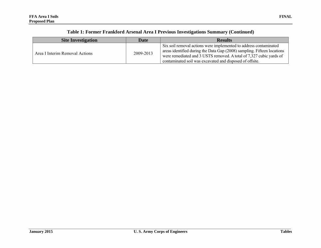
FFA Area I Soils FINAL Proposed Plan
January 2015 U. S. Army Corps of Engineers Tables
Table 1: Former Frankford Arsenal Area I Previous Investigations Summary (Continued)
Site Investigation Date Results
Area I Interim Removal Actions 2009-2013
Six soil removal actions were implemented to address contaminated areas identified during the Data Gap (2008) sampling. Fifteen locations were remediated and 3 USTS removed. A total of 7,327 cubic yards of contaminated soil was excavated and disposed of offsite.
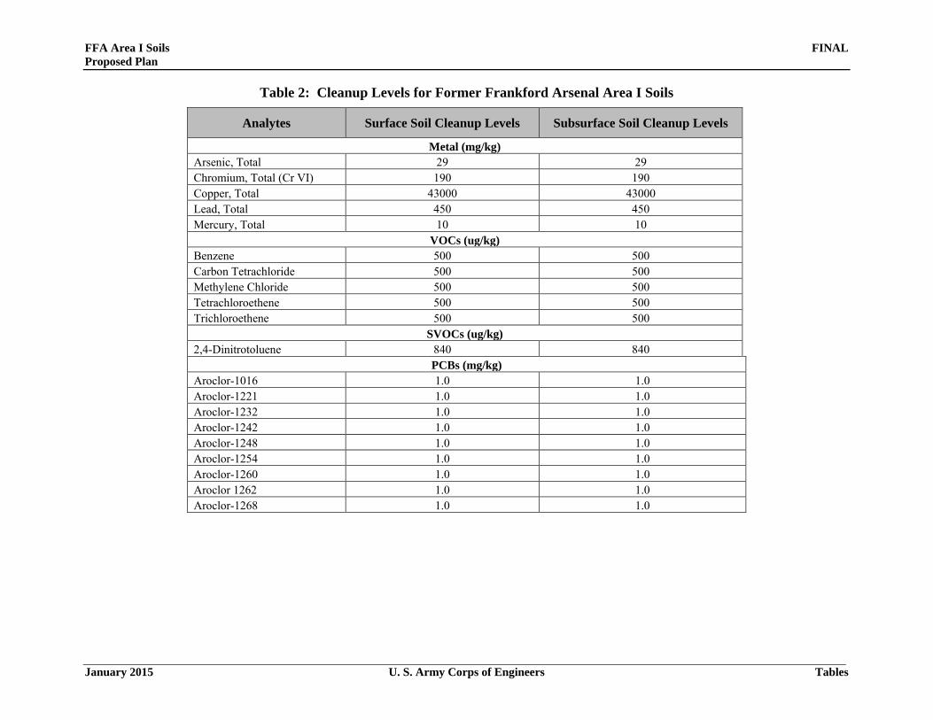
FFA Area I Soils FINAL Proposed Plan
January 2015 U. S. Army Corps of Engineers Tables
Table 2: Cleanup Levels for Former Frankford Arsenal Area I Soils
Analytes Surface Soil Cleanup Levels Subsurface Soil Cleanup Levels
Metal (mg/kg) Arsenic, Total 29 29 Chromium, Total (Cr VI) 190 190 Copper, Total 43000 43000 Lead, Total 450 450 Mercury, Total 10 10
VOCs (ug/kg) Benzene 500 500 Carbon Tetrachloride 500 500 Methylene Chloride 500 500 Tetrachloroethene 500 500 Trichloroethene 500 500
SVOCs (ug/kg) 2,4-Dinitrotoluene 840 840
PCBs (mg/kg) Aroclor-1016 1.0 1.0 Aroclor-1221 1.0 1.0 Aroclor-1232 1.0 1.0 Aroclor-1242 1.0 1.0 Aroclor-1248 1.0 1.0 Aroclor-1254 1.0 1.0 Aroclor-1260 1.0 1.0 Aroclor 1262 1.0 1.0 Aroclor-1268 1.0 1.0
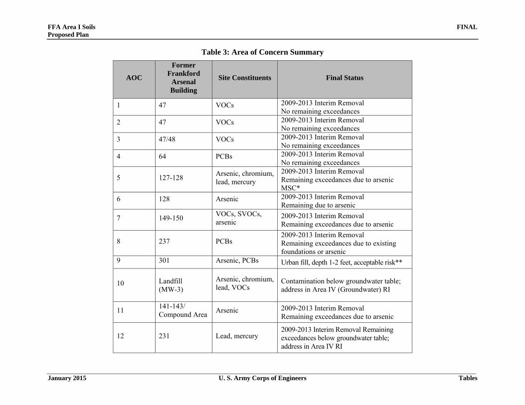
FFA Area I Soils FINAL Proposed Plan
January 2015 U. S. Army Corps of Engineers Tables
Table 3: Area of Concern Summary
AOC
Former Frankford
Arsenal Building
Site Constituents Final Status
1 47 VOCs 2009-2013 Interim Removal No remaining exceedances
2 47 VOCs 2009-2013 Interim Removal No remaining exceedances
3 47/48 VOCs 2009-2013 Interim Removal No remaining exceedances
4 64 PCBs 2009-2013 Interim Removal No remaining exceedances
5 127-128 Arsenic, chromium, lead, mercury
2009-2013 Interim Removal Remaining exceedances due to arsenic MSC*
6 128 Arsenic 2009-2013 Interim Removal Remaining due to arsenic
7 149-150 VOCs, SVOCs, arsenic
2009-2013 Interim Removal Remaining exceedances due to arsenic
8 237 PCBs 2009-2013 Interim Removal Remaining exceedances due to existing foundations or arsenic
9 301 Arsenic, PCBs Urban fill, depth 1-2 feet, acceptable risk**
10 Landfill (MW-3)
Arsenic, chromium, lead, VOCs
Contamination below groundwater table; address in Area IV (Groundwater) RI
11 141-143/ Compound Area Arsenic 2009-2013 Interim Removal
Remaining exceedances due to arsenic
12 231 Lead, mercury 2009-2013 Interim Removal Remaining exceedances below groundwater table; address in Area IV RI

FFA Area I Soils FINAL Proposed Plan
January 2015 U. S. Army Corps of Engineers Tables
Table 3: Area of Concern Summary (Continued)
AOC
Former Frankford
Arsenal Building
Site Constituents Final Status
13 125-126 PCE Remaining exceedances below groundwater table; address under Area IV RI
14 55-58 Arsenic, PCB, VOCs
Remaining exceedances below groundwater table; address under Area IV RI
15 324 Arsenic, chromium, lead
Remaining exceedances below groundwater table; address under Area IV RI
16 46 TCE Remaining exceedances below groundwater table; address under Area IV RI
58 Leaking Sump (discovered during building demolition)
PCBs, SVOCs, VOCs
2009-2013 Interim Removal Remaining exceedances below groundwater table; address under Area IV RI
Building 47 Oil/Water Separator (discovered during building demolition)
PCBs, VOCs 2009-2013 Interim Removal No remaining exceedances
Building 48 USTs (discovered during building demolition)
SVOCs,VOCs
2009-2013 Interim Removal No remaining exceedances

FFA Area I Soils FINAL Proposed Plan
January 2015 U. S. Army Corps of Engineers Tables
Table 3: Area of Concern Summary (Continued)
AOC
Former Frankford Arsenal Building
Site Constituents Final Status
Building 44/47 Tank Pit (2008 CON/HTRW UST removal)
lead ,PCBs
2009-2013 Interim Removal Remaining exceedances below groundwater table; address in Area IV RI
Building 128 transformer pad
PCBs
2009-2013 Interim Removal No remaining exceedances
* In 2011, the PADEP MSC for arsenic was reduced to 29 mg/kg surface/subsurface from 53mg/kg surface/150 mg/kg subsurface **Based upon initial risk assessment performed with 2008 Data Gap samples.
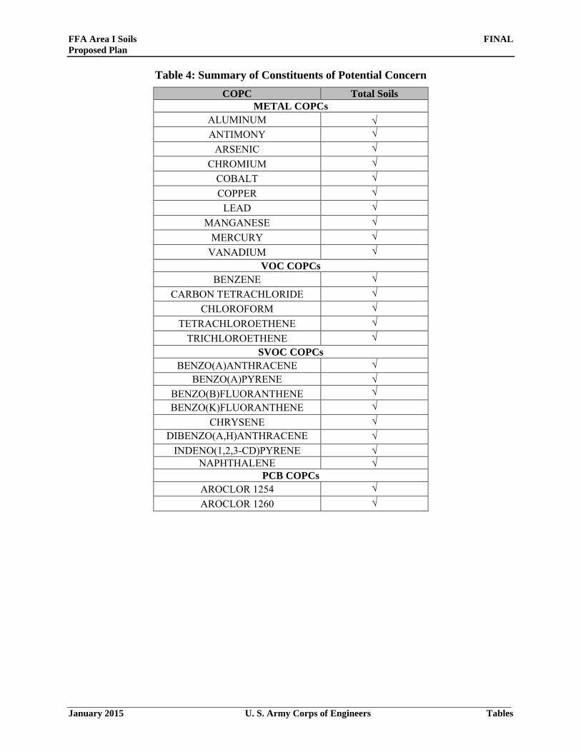
FFA Area I Soils FINAL Proposed Plan
January 2015 U. S. Army Corps of Engineers Tables
Table 4: Summary of Constituents of Potential Concern COPC Total Soils
METAL COPCs ALUMINUM √ ANTIMONY √
ARSENIC √ CHROMIUM √
COBALT √ COPPER √
LEAD √ MANGANESE √
MERCURY √ VANADIUM √
VOC COPCs BENZENE √
CARBON TETRACHLORIDE √ CHLOROFORM √
TETRACHLOROETHENE √ TRICHLOROETHENE √
SVOC COPCs BENZO(A)ANTHRACENE √
BENZO(A)PYRENE √ BENZO(B)FLUORANTHENE √ BENZO(K)FLUORANTHENE √
CHRYSENE √ DIBENZO(A,H)ANTHRACENE √
INDENO(1,2,3-CD)PYRENE √ NAPHTHALENE √
PCB COPCs AROCLOR 1254 √ AROCLOR 1260 √

FFA Area I Soils FINAL Proposed Plan
January 2015 U. S. Army Corps of Engineers Tables
Table 5: Results of Chemical Risk Assessments
Receptor Medium Exposure Pathway
Carcinogenic Risk
Hazard Indices
Industrial Worker
Surface and
Subsurface Soil
Ingestion 1E-05 0.07 Inhalation 2E-07 0.002
Dermal Contact 4E-06 0.009 Total 1E-05 0.08
Construction Worker
Surface and
Subsurface Soil
Ingestion 3E-06 0.5 Inhalation 6E-09 0.008
Dermal Contact 4E-07 0.03 Total 3E-06 0.5
Maintenance Worker
Surface and
Subsurface Soil
Ingestion 2E-06 0.01 Inhalation 2E-08 0.0002
Dermal Contact 7E-07 0.002 Total 3E-06 0.02
Utility Worker
Surface and
Subsurface Soil
Ingestion 1E-07 0.02 Inhalation 2E-10 0.00007
Dermal Contact 5E-08 0.003 Total 2E-07 0.02

FFA Area I Soils FINAL Proposed Plan
January 2015 U. S. Army Corps of Engineers Tables
This page intentionally left blank