Embed Size (px)
Citation preview

Conceptual Solutions Report
Published: August 2016
Prepared by: AECOM on behalf of
Ohio-Kentucky-Indiana Regional Council of Governments
720 E. Pete Rose Way, Suite 420
Cincinnati, OH 45202
i
Table of Contents List of Figures ............................................................................................................................................. ii
List of Tables .............................................................................................................................................. ii
Glossary of Terms ..................................................................................................................................... iii
INTRODUCTION ........................................................................................................................................... 1
PURPOSE AND NEED ................................................................................................................................. 2
EXISTING CONDITIONS .............................................................................................................................. 2
STUDY AREA ........................................................................................................................................... 3
DATA COLLECTION SUMMARY REPORT ............................................................................................. 5
RED FLAG SUMMARY AND ENVIRONMENTAL OVERVIEW ............................................................... 6
ROADWAY INFORMATION ..................................................................................................................... 7
North Dearborn Road .......................................................................................................................... 10
Whites Hill Road .................................................................................................................................. 10
CONCEPTUAL SOLUTIONS ...................................................................................................................... 11
DESIGN CRITERIA ................................................................................................................................. 15
MAINTENANCE ITEMS .......................................................................................................................... 17
EXISTING ROADS .................................................................................................................................. 19
CONCEPT 1 - IMPROVE EXISTING ROADS .................................................................................... 19
NEW CONSTRUCTION .......................................................................................................................... 20
CONCEPT 2 - WHITES HILL ROAD CONNECTOR .......................................................................... 21
CONCEPT 3 - CARR ROAD CONNECTOR ...................................................................................... 23
CONCEPT 4 - STATE LINE ROAD CONNECTOR ............................................................................ 25
EVALUATION OF CONCEPTS .................................................................................................................. 27

ii
List of Figures
Figure 1: Study Area ....................................................................................................................... 4
Figure 2: Concept 1 - Improve Existing Roads ............................................................................... 9
Figure 3: Changes in Travel Patterns ........................................................................................... 13
Figure 4: Changes in Travel Time ................................................................................................. 14
Figure 5: New Construction Proposed Typical Section ................................................................ 21
Figure 6: Concept 2 - Whites Hill Road Connector ...................................................................... 22
Figure 7: Proposed Carr Road Typical Section ............................................................................. 23
Figure 8: Concept 3 - Carr Road Connector ................................................................................. 24
Figure 9: Concept 4 - State Line Road Connector ........................................................................ 26
List of Tables
Table 1: Forecasted Change of Interchange Trips ....................................................................... 11
Table 2: Change in Vehicle Miles and Hours Traveled ................................................................. 12
Table 3: INDOT 3R (Existing Roads) Design Criteria LPA Rural Collector ..................................... 16
Table 4: INDOT Design Criteria New Construction LPA Rural Collector ...................................... 16
Table 5: Comparison of Concepts ................................................................................................ 27
Table 6: Evaluation Matrix ........................................................................................................... 29
Table 7: Comparison of Concepts 1 and 2 ................................................................................... 30

iii
Glossary of Terms
AM/PM Peak Period – The part of the day during which traffic congestion on roads is highest.
Normally, this happens twice a day—once in the morning and once in the evening, the times
when the most people commute. For this study, peak periods were determined to be the
following times based on traffic counts performed for this study: 7:00am to 9:00am and 4:00pm
to 6:00pm.
Average Daily Traffic (ADT) – The total volume of traffic passing a point or segment of a highway
facility in both directions divided by the number of days in the year.1
Design speed – A speed used to design the horizontal and vertical alignments of a roadway. 1
Functional classification –The process by which streets and highways are grouped into classes,
or systems, according to the character of traffic service that they are intended to provide. There
are three highway functional classifications: arterial, collector, and local roads. All streets and
highways are grouped into one of these classes, depending on the character of the traffic.
Horizontal curvature (HC) – A transition between two tangent roadway sections. The minimum
radius for a horizontal curve varies depending on the design speed.
Indiana Department of Transportation (INDOT).
Level of Service (LOS) – A quantitative stratification of a performance measure or measures that
represent quality of service, measured on an A-F scale, with LOS Are presenting the best
operating conditions from the traveler’s perspective and LOS F the worst. 1
(Local Project Agency) (LPA) The local project agency is typically a local government (city,
township or county) which oversees and manages federal aid transportation projects on behalf
of INDOT. LPA’s typically own and maintain the transportation infrastructure under their
jurisdiction. INDOT maintains standards and certification for LPAs to manage transportation
projects with Federal Funding.
Minimum radius – A limiting value of curvature for a given design speed, determined from the
maximum rate of super-elevation and the maximum friction factor selected for design. 3
Sight distance – The length of the roadway ahead that is visible to the driver. The selected design
speed of a roadway establishes the minimum sight distance that should be used in design.3
Stopping Sight Distance (SSD) – The sum of two distances: (1) the distance traversed by the
vehicle from the instant the driver sights an object necessitating a stop to the instant the brakes
are applied, and (2) the distance needed to stop the vehicle from the instant brake application
begins. 3 Truck – AASHTO vehicle classifications 4-13.
Sufficiency Rating – A measure developed by the FHWA which is an indicator of a bridge’s
sufficiency to remain in service. Sufficiency ratings are determined on a scale from 100 which
represents an entirely sufficient bridge, to 0 which represents an entirely insufficient or deficient
iv
bridge. The sufficiency rating is calculated using a formula which accounts for structural
adequacy and safety; serviceability and functional obsolescence; and essentiality for public use.
Super-elevation- The transverse slope or bank of a roadway in a curve to counter act the outward
centripetal force of a vehicle, keeping it stable on the pavement and for passengers to maintain
comfort.
Vertical curvature (VC) – A transition between two sloped roadway sections. The required
Stopping Sight Distance for a vertical curve varies depending on the design speed.
Volume to capacity (v/c) ratio – The ratio of flow rate to capacity for a system element.
1 AASHTO Highway Capacity Manual 2010
2 Federal Highway Administration (http://www.fhwa.dot.gov/environment/publications/flexibility/ch03.cfm)
3 American Association of State Highway and Transportation Officials (AASHTO), A Policy on Geometric Design of
Highways and Streets 2011 (6th Edition)

1
INTRODUCTION
There is no direct route linking the Interstate 74 Harrison/Brookville Road Interchange (Exit 169)
to the Bright area located approximately 3 miles to the south. Due to topography and the
Whitewater River, connectivity between Bright and Interstate 74 is challenging. The most direct
route from the Harrison/Brookville Road Interchange to Bright is a circuitous 5.5 mile long route
utilizing US 52, SR 46, Whites Hill and North Dearborn roads. The County routes (North Dearborn
and Whites Hill Roads) do not meet current geometric design criteria for local rural collectors
established by the Indiana Department of Transportation (INDOT).
Whites Hill Road and SR 46 is the only connection from Dearborn County south of the Whitewater
River to Interstate 74 between State Street along the Ohio State border in the City of Harrison
and State Route 1 to the west.
The Ohio Kentucky Indiana Regional Council of Government’s (OKI) Regional Transportation Plan
has included a potential new connector roadway linking Bright to Interstate 74 since 2012,
however planning and design for a potential connector had not been initiated. In 2015, with local
funding and support from Dearborn County, OKI began the Bright 74 study to investigate options
for improvements to existing roadways, potential new roadways, and/or a combination of both.
The Study’s goal is to improve safety, access and other travel needs between the Bright area and
Interstate 74.
OKI has established an Advisory Committee to assist the Study Team. The Advisory Committee
consists of Dearborn County OKI Board Members and other key stakeholders who represent 20
diverse and well-established governmental agencies, local businesses, emergency service
providers and civic-based organizations in the area. Members represent large groups of people
with whom they work and correspond regularly and from whom they receive feedback. The
Advisory Committee members’ broad reach and representation throughout the Study Area and
region provides information and guidance as a working group to the OKI Bright 74 Study Team.
Advisory Committee responsibilities include the following:
• Provide study updates and disseminate information to community/organizational/agency
members to encourage an exchange of information
• Share community/organization/agency members’ questions, concerns and general feedback
• Assist with public involvement and outreach efforts, as appropriate
A total of five advisory committee meetings are planned during the Study with four Advisory
Committee meetings having been conducted to date. Three public information sessions are
planned to share existing conditions and potential solutions with the public at large. Two public
information sessions have been held to date with the third anticipated in September 2016. The
Conceptual Solutions described in this report were presented to the public at the second
information session held on June 22, 2016.

2
The initial phase of this Study included collection of readily available information for existing
demographic, environmental, roadway, and safety and traffic conditions. This information was
shared with the Advisory Committee leading to the development of the Study’s purpose
statement and goals and then presented to the public at June 22, 2016 public information
session.
PURPOSE AND NEED
The Study Team in coordination with the Advisory Committee has established the following
purpose and need for the Study.
“Provide improved travel between the Bright area and Interstate 74 that meets INDOT’s design
criteria, reduces travel time, and enhances connectivity and traffic safety while preserving the
rural quality.”
The following major goals were identified during the initial phase of the Study:
• Preserve rural quality of the area
• Minimize environmental impacts
• Improve travel safety
• Enhance roadway connectivity and economic vitality
Using the information gathered during the data collection phase, the Study Team has developed
four concepts to improve travel between Bright and Interstate 74. Concept 1 is the rehabilitation
and reconstruction of portions of North Dearborn and Whites Hill Roads to meet current design
criteria to the extent possible. Three other Concepts have been developed which include
construction of new connector roadways linking North Dearborn Road with SR 46 or Old US 52
providing access to Interstate 74. All four concepts incorporate enhanced maintenance to
existing roadways that make up the Bright to I-74 travel routes. Potential modifications to the
existing Interstate 74 mainline or the Harrison/Brookville Road Interchange are not included in
the scope of this Study.
EXISTING CONDITIONS
The following is a summary of existing conditions documented during the initial phase of the
Study. Based on available information, there are not significant congestion or operational issues
in the Study Area. Travel time from Bright to the Harrison/Brookville Road Interchange during
typical conditions is 8 to 10 minutes. Significant land use change and growth in traffic volumes
are not anticipated during the 20 year planning horizon. Based on available information, crash
rates are near statewide averages. The existing roads do have geometric design deficiencies as
noted below. Based upon the information, several segments of these roadways do not meet
current INDOT rehabilitation, restoration, and resurfacing or “3R” design criteria (see INDOT

3
Design Manual Chapter 55) for grades, horizontal and vertical curvature, lane and shoulder width,
and roadside conditions.
STUDY AREA
The Study Area comprises 19 square miles within Harrison and Logan Townships in northeastern
Dearborn County. Bright is a census defined place, but is not an incorporated municipality. The
topography is rolling with State Line Road, the commercial spine of Bright, running north-south
in the center of the Study Area following a ridge line that falls off to the east, west and north.
The Whitewater River runs along the north and east sides of the Study Area separating Bright
and unincorporated areas to the south from Interstate 74. Connections to the east and west are
provided by North Dearborn and Jamison Roads. The Brookville Subdivision of the Indiana and
Ohio Railway runs generally parallel to Old US 52 north of the Whitewater River. This short line
railroad previously connected Brookville in Franklin County, Indiana with the general railroad
network, but is currently not active west of the Whitewater Mill in West Harrison.
Access to the I-74 Harrison/Brookville Road Interchange from the Bright area is primarily via
North Dearborn Road, Whites Hill Road, SR 46 and US 52 and is the focus for this Study. Remaining
roads in the Study Area are generally local roads. Interstate 74 is accessible west of the Study
Area from the interchange at State Route 1. Interstate 74 is accessible east of the Study Area in
Hamilton County, Ohio from interchanges at New Haven Road, Dry Fork Road and via I-275 at
Kilby Road.

4
Figure 1: Study Area

5
DATA COLLECTION SUMMARY REPORT
Phase One of the Study included the development of a Data Collection Summary Report for the
Study Area. This report includes mapping, traffic, crashes and other roadway-related
information. Readily available data was collected within the Study Area to identify transportation
needs or potential areas of concern to be addressed by this Study. Field data collection is not
included in the scope of the Study. A summary of findings follows. For additional information
please refer to the Bright 74 Study Data Collection Summary Report.
• Bright is a census defined place with approximately 2,000 households and a total
population of approximately 5,000. Bright has approximately 2,600 employed residents.
Population has remained steady over the past decade.
• The population of the Study Area is relatively homogenous with small minority
populations. There is minimal potential for disproportionate impacts to Environmental
Justice populations within the Study Area.
• Growth in population and employment is forecast to be moderate over the next 20 years
with total period growth between 10 percent and 20 percent.
• Future land use is generally planned to be consistent with current uses including planned
commercial and industrial development between the Whitewater River and Old US 52.
• State Line Road is the most heavily traveled road within the Study Area (excluding
Interstate 74). There are no significant congestion issues within the Study Area for routes
connecting with Interstate 74. There are some congested roadway segments in the City
of Harrison providing access to Interstate 74 at New Haven Road.
• The majority of the population in Bright resides in the southern portion of the Study Area
south of Jamison Road.
• Study Area residents utilize several existing routes to access Interstate 74. The majority
of interstate travel is to and from Hamilton County. The most heavily used interchange is
Kilby Road and Interstate 275 in Hamilton County.
• There were approximately 120 injury crashes and a total of 515 crashes in the Study Area
from 2009 to 2013 excluding Interstate 74. Crash rates for the Study Area are generally
similar to statewide averages.
• There are some geographic concentrations of crashes especially along Jamison Road and
near the westbound ramps of US 52 and Interstate 74.
• There are portions of the existing County roads within the Study Area that do not meet
current INDOT design criteria for an LPA Rural Collector. Common deficiencies include
shoulder width, vertical and horizontal curvature, and roadside conditions.
• Dearborn County contracts with the City of Harrison to provide fire protection and EMS
services to the northern portion of the Study Area. Depending on the availability of

6
equipment and staff, emergency response times can vary and may not fully meet National
Fire Protection Association (NFPA) guidance.
RED FLAG SUMMARY AND ENVIRONMENTAL OVERVIEW
Phase One of the Study also included the development of a Red Flag Summary and Environmental
Overview Report for the Study Area with a focus on potential corridors for roadway
improvements. The Red Flag Summary was conducted within the Study Area to identify potential
areas of environmental concern. Field Environmental Investigations are not included in the scope
of this Study. Likewise, NEPA documentation, permitting and federal, state or local agency
coordination is not included in the scope of services. These tasks may be initiated on a project
specific basis in future phases of project development after this Study is concluded.
The Red Flag Summary and Environmental Review utilized readily available information to
identify existing conditions of affected environment, human environment, cultural and historic
resources, natural environment, air quality, noise, hazardous materials, Section 4(f) and Section
6(f), geology, permits and agency coordination.
The following potential issues and red flags were noted in the Study Area from the environmental
resources review. These resources have been mapped and concepts to improve travel between
Bright and Interstate 74 have been developed to avoid or minimize impacts to identified
resources to the extent possible.
• The Study Area is split between a growing suburban residential and industrial land uses within
a longstanding rural setting.
• The Study Area includes areas of Prime Farmland in the Whitewater River floodplain. These
resources will be impacted by Concept 3 Carr Connector and Concept 4 State Line Connector
• Several cemeteries are located within the Study Area; however, they are generally small
features and are scattered. Avoidance should be achievable. Concept 2 will require work
adjacent to the Carr Road cemetery located at the north eastern quadrant of the intersection
of Carr and North Dearborn Roads.
• There were no sites, features or districts currently listed as National Historic Landmarks or
included on the National Register of Historic Places within the Study Area. However, many
historical features have been identified throughout the Study Area and additional cultural
resource investigations should be conducted as improvement recommendations resulting
from the Bright 74 Study advance. Development of conceptual solutions has been performed
to avoid impacts to historical features.
• The Study Area includes many water resources, including wetlands, streams, rivers, and
ponds. Resources also include the floodplain for the Whitewater River. It is likely that some
water resources will be impacted by each of the four concepts. Development of concepts has
been undertaken to minimize the impact to water resources where possible, however some
stream and floodplain impacts are likely unavoidable.

7
• The Whitewater River is classified as outstanding state resources water and as an impaired
stream.
• Many wetlands are identified within the Study Area. Transportation improvements that
impact wetlands will require permitting and potential mitigation.
• Threatened and endangered species are listed within Dearborn County by the Indiana
Department of Natural Resources and the U.S. Fish and Wildlife Service. No significant habitat
has been identified in the Study Area.
• Multiple water wells were identified within the Study Area, some of which were identified as
significant withdrawal wells. However, the concepts developed to date will not impact the
identified well locations.
• Sensitive noise receptors are located within the Study Area. To the extent possible the
concepts have been located away from existing sensitive noise receptors and concepts for
new connectors are anticipated to reduce traffic volumes on existing roadways in the Study
Area.
• Multiple hazardous materials concerns were identified within the southern portion of the
Study Area. The concepts developed to date will not impact these sites.
• One Section 4(f) feature (Bright Meadows Community Park) was identified within the Study
Area. The concepts developed to date will not impact the park.
ROADWAY INFORMATION
Information on existing roadways has been provided primarily by the Dearborn County Engineer.
Most functionally classified roadways within the Study Area are County maintained routes with
the exception of SR 46, US 52 and Interstate 74 which are maintained by INDOT. Other than
Interstate 74, no routes in the Study Area are on the National Highway System (NHS).
The scope of work does not include a detailed inventory or field inspection of all existing
roadways within the Study Area. The focus of this Study is access between Bright and Interstate
74, therefore a summary of existing conditions was developed for the following roadways which
provide the most direct route between Bright and the Interstate 74 Harrison/Brookville Road
Interchange.
• North Dearborn Road (CR 26) from State Line Road to Whites Hill Road
• Whites Hill Road (CR 203) from North Dearborn Road to SR 46
• SR 46 from Whites Hill Road to US 52
• US 52 from SR 46 to Interstate 74

8
The County routes are functionally classified as Rural Major Collectors according to the 2015
INDOT functional classification map of Dearborn County. Based upon the information collected
to date, several segments of these roadways do not meet current INDOT rehabilitation,
restoration, and resurfacing or “3R” design criteria (see INDOT Design Manual Chapter 55) for
grades, horizontal and vertical curvature, lane and shoulder width, and roadside conditions.
Archival roadway design plans for SR 46, I-74 and a portion of Whites Hill Road have been
provided to the Study Team for information. Design plans for much of the existing roadway
network in the Study Area are not available. Existing conditions generally do not allow for the
passing of vehicles. Weather conditions and the presence of slow or impassible vehicles can have
a detrimental impact on travel time, which can vary widely.
Pavement is generally in fair to good condition. There are some minor areas of pavement cracking
or base failure in isolated locations generally attributable to side slope or base drainage
conditions.
The preferred paved shoulder width is four to six feet with a minimum of two feet. In nearly all
areas, the existing shoulders fail to meet these criteria. Widening shoulders is desirable where
possible to do so. There are existing overhead electric and subsurface communication lines on
either side of Whites Hill Road and some areas along North Dearborn Road which are a constraint
to significant widening without relocation of the existing poles which could be costly. AECOM
performed a limited review of existing topography and alignment data for the aforementioned
roadway segments based on Indiana map topographic data and aerial photography, OKI and
County GIS datasets, and online street level mapping such as Google Street View™.

9
Figure 2: Concept 1 - Improve Existing Roads

10
The horizontal curvature of the existing roadway segments is substandard at the following
locations and potential straightening of the curves are recommended as part of an overall 3R
improvement shown in Figure 2: Concept 1 - Improve Existing Roads.
North Dearborn Road
There are three areas located along North Dearborn Road with restrictive horizontal curvature
representing approximately 35 percent of the alignment between State Line Road and Whites
Hill Road. Generally the vertical profile of North Dearborn Road does not have restrictive grades.
However there are five substandard vertical curves based on available elevation data. See the
Data Collection Summary Report for additional information. Please see Figure 2 for the locations
of proposed geometric improvements along North Dearborn Road to address the restrictive
horizontal curvature.
Whites Hill Road
On Whites Hill Road two areas have been identified with substandard horizontal curvature. From
south to north the first area is located between the existing electrical substation and Gaynor
Rider Road. The radii in this area may be sufficient however the embankment on the east side of
the roadway may inhibit sight distance. At Gaynor Ridge Road, the intersection could be re-
aligned to reduce the existing sharp skew angle. South of Price Lane for approximately 2,000 feet
there are two curves that have restrictive horizontal curvature which could be reconstructed with
increased radii along with a longer tangent length in between. This section leads into a portion
of the roadway which was straightened and walls added on the upslope and down slope sides
during 2005-2006. The area from Price Lane to north of I-74 has a 20 mph advisory speed due to
horizontal curvature.
AECOM evaluated the grades and vertical profile along Whites Hill Road based on available
Indiana Map data. There are sixteen substandard vertical curves between North Dearborn Road
and SR 46 that may have sight distance issues. This represents approximately 30 percent of the
alignment between North Dearborn Road and SR 46.
Additionally the general grade exceeds nine percent and for much of the length exceeds 11
percent. This steep sustained grade combined with horizontal curvature can be challenging for
heavy vehicles and has a posted 20 mph advisory speed. The steep grades can be difficult to climb
during inclement weather. In general, access to the Bright Area by semi-truck can be challenging
due to steep grades, substandard horizontal curvature and lack of shoulders on the existing
County road network. See Figure 2 for the locations of the geometric improvements along Whites
Hill Road.
There are no significant bridge structures on the roads linking the Bright Area to Interstate 74
with the exception of SR 46 over the Whitewater River. The bridge is in fair condition and
structurally sound, but is considered functionally obsolete due to substandard shoulders and
roadside barriers. The bridges current sufficiency rating is 59 of 100. While not an immediate
need, the bridge is a candidate for replacement at the end of the 20 year study horizon.

11
CONCEPTUAL SOLUTIONS
Four conceptual solutions have been developed to improve travel between Bright and the
Interstate 74 Harrison/Brookville Road Interchange. One concept improves existing portions of
North Dearborn and Whites Hill Roads and three concepts provide an alternate route via a new
roadway connector linking North Dearborn Road to SR 46 or Old US 52. These concepts have
been developed based on available roadway, environmental red flag data and countywide
basemapping collected as part of this Study.
Based on available information, there are no significant congestion or operational issues on the
existing roadway network. The conceptual solutions are not intended to specifically address
existing operational problems, but are focused on reduced travel time, improved accessibility,
safety and travel time reliability.
The concepts have been developed to allow for an estimation of travel time and forecasts of
subsequent changes the distribution of traffic volumes using a subarea travel demand model
developed for this Study. The Study’s travel demand model was run for each of the new roadways
to estimate the traffic volumes on the new routes and changes to distribution on the existing
roadways. While improvements to the existing roads in Concept 1 are intended to eliminate most
restrictive geometry, the overall travel time and distribution of traffic volumes is not anticipated
to change significantly. The new routes will attract daily traffic ranging from 1,500 to 2,500. This
shift in traffic will reduce traffic volumes on North Dearborn and Whites Hill Roads as well as
some other routes in the Study Area. Concepts 2, 3 and 4 do increase the utilization of the
Harrison/Brookville Road Interchange as shown in Table 1.
Table 1: Forecasted Change of Interchange Trips
Study Area Trips by
Interchange
Concept 1 -
Improve
Existing
Roads
Concept 2 -
Whites Hill
Road
Connector
Concept 3 -
Carr Road
Connector
Concept 4 -
State Line
Road
Connector
I-74 @ SR 1 356 366 310 310
I-74 @ Harrison/Brookville
Road
684 897 1,886 1,923
I-74 @ New Haven Rd. 943 1,091 1,204 1,251
I-74 @ Dry Fork Rd. 1,485 1,437 1,052 1,047
I-275 @ Kilby Rd. 1,082 1,082 1,081 1,080
12
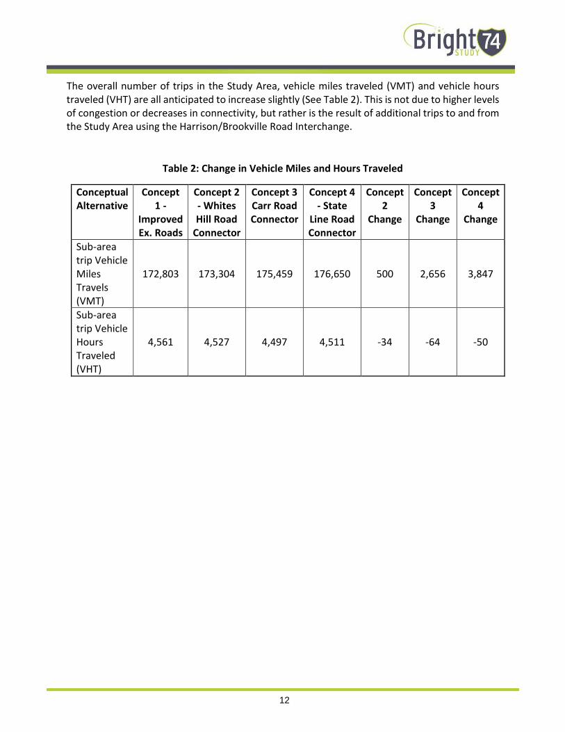
The overall number of trips in the Study Area, vehicle miles traveled (VMT) and vehicle hours
traveled (VHT) are all anticipated to increase slightly (See Table 2). This is not due to higher levels
of congestion or decreases in connectivity, but rather is the result of additional trips to and from
the Study Area using the Harrison/Brookville Road Interchange.
Table 2: Change in Vehicle Miles and Hours Traveled
Conceptual
Alternative
Concept
1 -
Improved
Ex. Roads
Concept 2
- Whites
Hill Road
Connector
Concept 3
Carr Road
Connector
Concept 4
- State
Line Road
Connector
Concept
2
Change
Concept
3
Change
Concept
4
Change
Sub-area
trip Vehicle
Miles
Travels
(VMT)
172,803 173,304 175,459 176,650 500 2,656 3,847
Sub-area
trip Vehicle
Hours
Traveled
(VHT)
4,561 4,527 4,497 4,511 -34 -64 -50

13
Figure 3: Changes in Travel Patterns
The new off-alignment conceptual solutions (Concepts 2, 3 and 4) reduce travel time from the
Bright area to the Harrison/Brookville Road Interchange ranging from three to six minutes.
Concept 4 - State Line Road Connector results in the greatest reduction in travel time and
provides an overall time savings traveling to the east compared with existing routes using the
New Haven Road interchange in Harrison. Travel time from the heart of Bright to the
Harrison/Brookville Road Interchange is reduced most significantly by Concepts 3 and 4.

14
Figure 4: Changes in Travel Time
See Figure 3 for the forecast change in traffic volume and Figure 4 for the change in travel times
within the Study Area.
Property and environmental impacts for each of the concepts have been estimated based on the
conceptual geometry and construction limits described in more detail later in this report.

15
DESIGN CRITERIA
The geometric design criteria used to develop the conceptual solutions (both new and existing
roads) are based on the current INDOT Design Manual for a LPA rural collector. Concept 1 –
Improve Existing Roads assumes a Resurfacing, Restoration, and Rehabilitation or “3R”
improvement of the existing North Dearborn and Whites Hill Roads. The applicable geometric
design criteria is provided in the INDOT Design Manual in Chapter 55 and summarized on Figure
55-3C (see Table 3 below). For new alignments (Concepts 2, 3 and 4) the applicable criteria is
provided in INDOT Design Manual in Chapter 53 and summarized on Figure 53-4 (see Table 4 on
next page). All concepts have assumed an ADT between 1,000 and 3,000 vehicles per day.
Table 3: INDOT 3R (Existing Roads) Design Criteria LPA Rural Collector
16
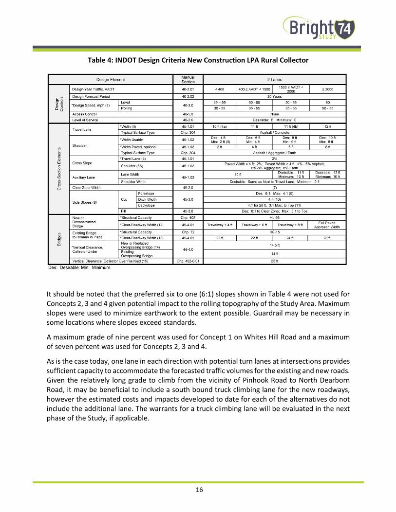
Table 4: INDOT Design Criteria New Construction LPA Rural Collector
It should be noted that the preferred six to one (6:1) slopes shown in Table 4 were not used for
Concepts 2, 3 and 4 given potential impact to the rolling topography of the Study Area. Maximum
slopes were used to minimize earthwork to the extent possible. Guardrail may be necessary in
some locations where slopes exceed standards.
A maximum grade of nine percent was used for Concept 1 on Whites Hill Road and a maximum
of seven percent was used for Concepts 2, 3 and 4.
As is the case today, one lane in each direction with potential turn lanes at intersections provides
sufficient capacity to accommodate the forecasted traffic volumes for the existing and new roads.
Given the relatively long grade to climb from the vicinity of Pinhook Road to North Dearborn
Road, it may be beneficial to include a south bound truck climbing lane for the new roadways,
however the estimated costs and impacts developed to date for each of the alternatives do not
include the additional lane. The warrants for a truck climbing lane will be evaluated in the next
phase of the Study, if applicable.

17
MAINTENANCE ITEMS
Based on available information, there are several items which could improve safety, operations
and driver experience on North Dearborn and Whites Hill Roads that can be implemented at a
relatively low cost. These maintenance items can also be classified at a “Partial 3R” improvement
and are defined in Chapter 56 of the INDOT Design Manual.
The location and limits of specific maintenance items will need to be identified during a detailed
field survey of existing conditions. The Field Survey will result in the establishment of a strip map
showing all existing details including, but not limited to, intersecting roads, drives, and, pipe
structures, headwalls, curbs, manholes, survey monuments, guardrail, pavement markers, bridge
piers, mailboxes and utility poles signs, raised pavement markers, areas of grading, patching,
milling, utilities in the area, or other specialty items. All items shown in the field survey should
have a station and offset reference. The detailed field survey is beyond the scope of this Study.
In general, pavement conditions along existing North Dearborn, Whites Hill, SR 46 and US 52 are
in good to fair condition with no significant base failures noted. There are locations where the
shoulders do show signs of stress and may require base repair or subgrade stabilization.
The following maintenance items could be implemented on a corridor wide basis following more
detailed inventory of site specific conditions. These items can be implemented in phases or
separate projects as funding permits and could be combined with other County routes inside or
outside of the Study Area.
• Widen for shoulders where possible. Most roadway segments along North Dearborn and
Whites Hill Roads have little or no shoulder. Based on INDOT 3R design criteria the preferable
usable shoulder width should be six feet with a two foot paved width minimum. At a
minimum, any two lane rural road with the traffic volumes in the Study Area should have a
one foot shoulder. Existing obstructions and roadside conditions would require regrading and
potential utility relocations to provide a consistent six foot useable shoulder, however it
appears that providing a two foot paved shoulder should be feasible in most locations with
minimal grading. The ability to widen for adequate shoulders varies by location and will be
evaluated in more detail in the final phase of the Study.
• Remove Roadside Obstructions (trees, poles, fences etc.). Similar to the existing shoulders
there are some locations where obstacles are located within the obstruction free zone. The
obstruction-free zone is defined as the roadside area next to the travel way which should be
free from hazards or obstructions. Each obstacle within the obstruction-free-zone limits
should be removed, made breakaway or shielded with guardrail. The obstruction-free-zone
width for an LPA rural collector is eight feet. It may not be feasible to remove all obstructions
(particularly existing overhead utilities) depending on costs associated with the relocation.
• Add mailbox turnouts. As noted previously, mailboxes are generally located within the
obstruction-free-zone. Depending on the construction, mailbox supports can pose a hazard
to errant vehicles. Each new mailbox installation should be placed in accordance with the
INDOT Standard Drawings, INDOT Standard Specifications, and Section 51-11.0. If additional

18
spacing is required for mailbox placement, mailbox turnouts can be provided to allow for mail
carrier and resident access. Mailbox turnouts also provide additional clearance to avoid mail
carriers during delivery.
• Repair, Replace or add guardrail as needed. There are several locations where existing
guardrail may not meet current INDOT design criteria at the northern end of White Hill Road,
however it may not be feasible to provide an adequate clear zone. It is recommended that a
comprehensive inventory of existing guardrail be done to determine if it is accordance with
the current safety performance and design criteria provided in the INDOT Design Manual
Chapter 49 and the INDOT Standard Drawings. It may be necessary to acquire right of way
from the abutting property owners to install the required guardrail. The minimum guardrail
offset distance is four feet from the edge of the travel way.
• Improve signage. It is recommended that a comprehensive inventory and conditions
assessment be developed for the existing regulatory signage on North Dearborn and Whites
Hill Roads. Reflectivity for some signs appears to be substandard. A sign should be used only
where it is warranted by the Indiana Manual on Uniform Traffic Control Devices (IMUTCD)
criteria, accident history or field studies. A sign should provide information for a regulation,
a hazard which is not self-evident, or a highway route, direction, destination, or point of
interest.
To improve wayfinding and accessibility, the installation of Interstate 74 directional signs at
critical intersections (State Line and North Dearborn Roads, North Dearborn and Whites Hill
Roads, Gaynor Ridge and Whites Hill Roads, and Whites Hill Road at SR 46) should be
considered given that these routes carry an appreciable percentage of interstate bound
traffic. Likewise, guide signs for Bright could be installed at the same intersections in the
opposite directions to guide travelers from the Interstate.
• Address drainage or slippage. Based on visual observation and comments from stakeholders
and the public, there are areas that have experienced roadside slippage or drainage issues.
Most commonly, roadside side slopes and ditches have experienced either erosion or
deposition of debris and materials leading to inadequate capacity to convey runoff during
rain events. The resulting slippage or wet weather flows across roadways or into adjacent
property and can present hazards to motorists resulting in potential damage to private
property. As noted previously, some culverts or ditches can result in obstructions or roadside
hazards. Site specific drainage inventories or hydraulic analysis has not been conducted as
part of this Study. It is recommended that an inventory of existing culverts and roadside
ditches be done to evaluate the need for ditching, culvert repairs or other maintenance to
improve drainage and roadside safety.

19
EXISTING ROADS
It is assumed that all maintenance items listed above would be performed on the existing roads
in addition to the geometric improvements included in Concept 1 described below. The overall
distance from the intersection of State Line and North Dearborn Roads to the Harrison/Brookville
Road Interstate ramps is approximately 5.5 miles. Concept 1 is subject to refinement during the
next phase of the Study which will develop preliminary alternatives. Improvements to existing SR
46 and US 52 are the responsibility of INDOT. In general the state maintained roads meet current
design criteria. This study did not evaluate changes to existing interstate access.
CONCEPT 1 - IMPROVE EXISTING ROADS
This concept includes a “complete 3R” project to correct existing geometric deficiencies generally
along the existing alignment of North Dearborn Road between State Line Road and Whites Hill
Road as well as Whites Hill Road from its intersection with North Dearborn Road to its terminus
at SR 46. The proposed improvements include straightening horizontal curves in selected
locations, flattening or lengthening of substandard vertical curves and intersection realignment
as noted below. See Figure2 for locations of proposed straightening of the existing curves and
intersection improvements. Site specific limits for flattening or lengthening substandard vertical
curves were not illustrated during development of conceptual solutions, but will be developed
during the next phase of the Study.
From east to west along North Dearborn Road the following improvements were identified.
• Straighten the reverse curves located between State Line Road and Carr Road including minor
realignment of the intersection of Carr Road and North Dearborn Road. These curves
currently have an advisory speed of 25 mph and have limited sight distance especially from
some adjacent driveway locations.
• Straighten the horizontal curve in the vicinity of the intersection of Henderson Road and
Bright Leaf Road including realignment of the intersection to eliminate the offset of the two
side road approaches. Some pavement stress was noted in this area. Complete pavement
reconstruction may be beneficial within the limits of the reconstructed curve.
• Straighten the horizontal curve located east of the intersection of Kling Lane.
• Although not shown on Figure 2, Concept 1 would also straighten the reverse horizontal
curves and flatten vertical curves located approximately 1500 feet east of the intersection of
North Dearborn and Dole Roads.
From south to north along Whites Hill Road the following improvements have been included in
Concept 1.
• Straighten horizontal curve located approximately 1000 feet south of the intersection of
Gaynor Ridge Road and Whites Hill Road. Realign Gaynor Ridge Road to reduce the skew at
its intersection with Whites Hill Road.

20
• Realign an approximately 2,000 foot long section of Whites Hill Road south of Price Lane to
eliminate reverse curves and flatten grades to a nine percent maximum. The realigned
roadway will be located west of the existing alignment. The proposed alignment and profile
will be refined during the next phase of the Study to avoid an electrical transmission line and
incorporate revised access to adjacent property in this area as well as to coordinate with
potential phasing of Concept 2 - Whites Hill Connector more fully described below, if the
concept is advanced for further Study consideration.
NEW CONSTRUCTION
Three concepts have been developed on new alignments which would link North Dearborn Road
to SR 46 (Whites Hill Road Connector) or old US 52 (Carr Road and State Line Road Connectors).
As noted previously, the geographic design criteria from INDOT Design Manual Chapter 53 (Table
4) were used with an assumed ADT of 2,500. At this time, stop controlled intersections are
assumed at either end of the new connectors.
The new connectors are assumed to be limited access facilities (with the exception of existing
Carr Road for the Carr Road Connector) between the Whitewater River and North Dearborn
Road. There are no provisions to accommodate intersecting roadways or driveway connections.
Where an individual parcel would be landlocked without alternative access an entrance will be
provided. Land use is assumed to remain largely undeveloped agricultural or natural. No
significant trip generators are assumed to access directly to the new roadways south of the
Whitewater River.
Concepts (2, 3 and 4) assume a 55 mph design speed with two 12 foot lanes and eight foot
shoulders (See Table 4 and Figure 5). A maximum grade of seven percent with a minimum three
to one (3:1) side slopes were used to estimate earthwork and construction limits using a digital
terrain model of the existing surface created from 2012 Indiana Map LIDAR data.
Pavement depth, composition, super-elevation or roadway drainage were not evaluated during
this phase of the Study. Major bridge crossings of Pinhook Road and the Whitewater River have
been identified however the location, length and size of smaller bridge structures or culverts have
not been identified at this time. No retaining walls have been proposed outside of the major
bridge locations at this time, but could be considered during the final phase of the Study if
concepts are advanced for further Study consideration in order to limit earth work, or minimize
environmental or property impacts.

21
Figure 5: New Construction Proposed Typical Section
While it may be beneficial to include a climbing lane in the southbound direction for trucks, a
climbing lane has not been included in estimated costs and impacts for the conceptual solutions
to date. No separate bicycle or pedestrian facilities are proposed. If necessary, pedestrians can
utilize the proposed roadway shoulders.
Specific elements for each of the three concepts are described in the following sections.
CONCEPT 2 - WHITES HILL ROAD CONNECTOR
This concept would provide an alternative route linking north Dearborn Road to Whites Hill Road
from the east. The route would start at a new intersection with North Dearborn Road
approximately 4,300 feet east of the exiting intersection of Whites Hill Road and would tie into
existing White Hill Road approximately 2500 feet south of the intersection of Whites Hill Road
and SR 46 (See Figure 6). The total length of new construction would be approximately 2.6 miles.
The new connector would reduce the overall distance from State Line Road to the
Brookville/West Harrison Interchange by approximately 0.7 miles and reduce travel time by
approximately two minutes. The forecasted ADT is 1,500.
This concept is less costly and has less environmental impacts when compared with the Carr Road
and State Line Road Connectors (Concepts 3 and 4) since it uses existing SR 46 to cross the
Whitewater River negating the need for a major new bridge structure and impacts to the
floodplain. The existing Interstate 74 overpass is also maintained.
While less costly compared with the other two connectors, this concept will still require
significant earthwork and will need to avoid the existing aerial electrical transmission lines
running generally parallel to but east of Whites Hill Road. Refinements to the proposed
alternative can be made during the next phase of the Study.

22
Figure 6: Concept 2 - Whites Hill Road Connector

23
CONCEPT 3 - CARR ROAD CONNECTOR
This alternative makes use of existing Carr Road for its connection with North Dearborn Road.
The concept would slightly widen and reconstruct Carr Road with an urban cross section including
curb, gutter and sidewalks (see Figure 7).
Figure 7: Proposed Carr Road Typical Section
From a stop controlled intersection at Carr Road and Pine Ridge Lane the connector would turn
to the northwest following a new alignment to a terminus near the intersection of Moore Lane
and Old US 52 (see Figure 8). The overall length of new construction would be approximately 3.6
miles including a proposed bridge spanning over Pinhook Road and the Whitewater River. The
new connector would reduce the overall distance from State Line Road to the Brookville/West
Harrison Interchange by approximately 1.6 miles and reduce travel time by approximately four
minutes. The design speed on existing Carr Road would be 35 mph and 55 mph on the new
connector.
This concept could provide new roadway access to commercially zoned property located
between the Whitewater River and Old US 52. The alignment north of the Whitewater River can
be refined to avoid floodplain and other environmental impacts and to accommodate potential
future industrial/commercial development in the area as needed.
Earthwork is somewhat less that the Whites Hill Road Connector or State Line Road Connector
Concepts 2 and 4). It is not anticipated that residential relocations will be necessary, however a
frontage strip may be necessary along the portion of existing Carr Road. This concept does
require a major new bridge crossing of the Whitewater River. Specific bridge type, pier locations
etc. have not been developed during this phase of work. Costs for the bridge crossing will be
significant and are based on a square foot basis at this time. The conceptual limits of the bridge
have been set to provide a waterway opening similar to that in the current Dearborn County
FEMA Flood Insurance Study.

24
Figure 8: Concept 3 - Carr Road Connector

25
CONCEPT 4 - STATE LINE ROAD CONNECTOR
The State Line Road Connector would begin at the existing intersection of State Line and North
Dearborn Roads and proceed north through largely undeveloped property with two new grade
separations over Pinhook Road and the Whitewater River. North of the River, the new connector
would end at a new intersection on Old US 52 located approximately 2,700 east of the existing
intersection with Moore Lane (see Figure 9). This concept would function as an extension of State
Line Road and would result in the most significant travel time savings compared with existing
conditions. The overall length of new construction would be approximately 3.6 miles. The new
connector would reduce the overall distance from State Line Road to the Brookville/West
Harrison Interchange by approximately 1.7 miles and reduce travel time by approximately 4.5
minutes. The forecasted ADT is approximately 2,700.
It is assumed that the existing at-grade railroad crossing of the Indiana and Ohio Railroad on
Moore Lane would be relocated to the new State Line Road Connector. An extension of Moore
Lane to the east would be required if it is necessary to consolidate the grade crossings to one
location. The elevation of the existing track at the new location is approximately three feet above
Old US 52. To maintain the existing track profile in this area, it may be necessary to raise the
profile of Old US 52 in the vicinity of the new intersection. Formal comment from the Genesee
and Wyoming Railroad regarding the disposition of the grade crossings is pending at this time.
Concept 4 includes two new bridge crossings at Pinhook Road and the Whitewater River. It is
assumed at this time that the roadway between the bridges would be on earthen embankment.
It should be noted that this area does lie within the FEMA floodplain of the Whitewater River,
however it is assumed that the waterway openings provided by the two bridges would be
sufficient to pass the regulatory flood volume without a rise in the base flood elevation where
the connector would cross the River. Hydraulic analysis will be required to confirm the impacts
to the floodplain if this concept is advanced for further evaluation. Specific bridge type, pier
locations etc. have not been developed during this phase of work. Costs for the bridge crossings
will be significant and are based on a square foot basis at this time. Earthwork is somewhat less
than Concept 2 - Whites Hill Road Connector, but more than the Concept 3 - Carr Road Connector.
The conceptual limits of the bridge have been set to provide a waterway opening area similar to
the current Dearborn County FEMA Flood Insurance Study.

26
Figure 9: Concept 4 - State Line Road Connector

27
EVALUATION OF CONCEPTS
A comparison table of the estimated travel times, travel time savings, environmental and
property impacts, and range of estimated construction costs were presented at the Public Open
House and on the OKI Bright I-74 Study website (www.Bright74.oki.org) on June 22. See Table 5
for a comparison of the conceptual solutions. This table was developed to assist the Study’s
Advisory Committee and general public with completing a survey to assess how each of the
concepts met the purpose and need and secondary goals of the Study.
Table 5: Comparison of Concepts
Category Units
Concept 1:
Improve Existing
Roads
Concept 2:
Whites Hill
Road
Connector
Concept 3:
Carr Road
Connector
Concept 4:
State Line
Road
Connector
Total Route Length* Miles 5.5 4.8 3.9 3.8
Length of New Roadway Miles 0.75 2.56 3.64 3.56
Earthwork Area Acre 15 55 59 65
Parcels Effected Each 89 20 54 26
Wetlands/Ponds Impacted Each 2 0 5 4
Stream Crossings Each 1 21 21 18
Construction in
Flood Plain Linear Feet 0 0 1,700 1,800
Average Daily Traffic Number of
Vehicles Varies 1,500 2,200 2,700
Travel Time Minutes 8.9 6.6 4.8 4.4
Earth Cut Cubic Yards 75,000 840,000 380,000 500,000
Earth Fill Cubic Yards 15,000 1,070,000 800,000 1,210,000
Bridge Area Square Feet 0 0 53,000 48,000
Estimated Costs (2016 dollar value) $ Millions $10-20M $20-30M $35-55M $30-50M
* All routes (existing plus new roadway) are measured from the intersection of State Line Road and North Dearborn Road to I-74
over Old US 52

28
The purpose and need of the Study is a follows:
Provide improved travel between the Bright area and Interstate 74 that meets INDOT’s design
criteria, reduces travel time, and enhances connectivity and traffic safety while preserving the
rural quality.
A survey provided in person at the Public Open House on June 22, 2016 and online June 22-July
22, 2016 through OKI’s Study website (www.Bright74.oki.org) provided an opportunity to give
specific comments on each of the concepts. Additionally the survey gauged the relative
importance of and how well each of the concepts met four major goals of the study.
• Preserve rural quality of the area (80 percent of respondents felt this is important)
• Minimize environmental impacts (74 percent felt this was important)
• Improve travel safety (40 percent felt this was important)
• Enhance roadway connectivity and economic vitality (16 percent felt this was important)
From the survey responses, is it clear that the primary goal of the improvements should be to
preserve the rural quality and minimize environmental impacts with improving safety a
secondary goal. The majority of respondents feel that enhancing roadway connectivity and
economic vitality are unimportant.
The survey results gauging each alternative indicated that approximately 80 percent of
respondents felt that Concept 1 - Improving Existing Roads met or somewhat met the goals of
preserving rural quality and minimizing environmental impacts followed by approximately 40
percent for Concept 2 - Whites Hill Road Connector. Less than 25 percent felt that neither
Concept 3 - Carr Road Connector nor Concept 4 - State Line Road Connector met these goals.
Stakeholder and members of the Advisory Committee also have noted concerns with the relative
significant estimated construction costs and environmental impacts associated with Concepts 3
and 4.
While Concept 3 - Carr Road Connector and Concept 4 - State Line Road Connector provide the
most significant travel time savings and are forecast to attract the most new trips, the relative
total time savings of five minutes or less was found to be inconsequential when compared with
the lower relative cost and impacts of Concepts 1 and 2.
The Study Team developed an evaluation matrix with a composite scoring system to
quantitatively compare the concepts to screen them for future evaluation during the final phase
of the Study. The matrix (see Table 6) uses the four goals of the Study with a score of 1 for
low/negative (red), 2 for neutral (yellow) and 3 for high/positive (green) assigned to sub factors
for each of the goals. The subtotals for each goal were then factors according the degree of
importance taken from the public survey. The scores were tallied to arrive at an overall composite

29
score. Concept 1 – Improve Existing Roads received the highest score followed next by Concept
2.
Table 6: Evaluation Matrix
Based on this evaluation using data and public input, Concepts 3 and 4 will not be evaluated
further during the course of this Study. The Study Team then performed further refinement and
evaluation of Concept 1 - Improve Existing Roads and Concept 2 Whites Hill Connector.
The initial development of these concepts was focused on the horizontal alignment for each with
a basic vertical profile developed for Concept 2. While identifying the location of deficient vertical
curves on North Dearborn and Whites Hill Roads, Concept 1 as presented at the second open
house did not identify the work limits necessary to adjust the profiles to eliminate the
substandard vertical curves.
Similarly, the right of way impacts were not previously evaluated on a parcel by parcel basis for
Concept 1 since the vertical profile for the roadways was not finalized. Dearborn County provided
property information for parcels west of Whites Hill Road which were located outside the Study
Area but would be impacted by the proposed improvements to Whites Hill Road as part of
Concept 1.

30
The Study Team developed refined alignments, profiles and construction limits for both concepts
using the same topographic basemapping, red flag environmental data and INDOT design criteria
developed during Phase One of the Study. Using the additional geometric information for the
respective roadways allowed for the development of updated and more detailed information on
earthwork, right of way impacts, utility impacts, culverts and stream impacts. The estimated
construction costs were revised for each Concept 1 and 2 based on the updated information.
The impacts and estimated construction costs associated with Concept 2 - Whites Hill Road
Connector, while comparable with those provided at the second public meeting, are significantly
higher than those for Concept 1 as shown in Table 7. Given the disparity in impacts and costs
between Concepts 1 and 2 and the relatively minimal differences in travel time savings, safety
and forested changes in traffic, and the lack of public support for new roadway the Study Team
concluded that only Concept 1 Improve Existing Roads would be carried forward as part of the
study recommendations.
Additional refinement of Concept 1 including potential phasing will be evaluated during the final
phase of the Study.
Table 7: Comparison of Concepts 1 and 2
Total route length (existing plus new roadway) are measured from the intersection of State
Line Road and North Dearborn Road to I-74 over Old US 52

Conceptual Solutions Report
Published: August 2016
Prepared by: AECOM on behalf of
Ohio-Kentucky-Indiana Regional Council of Governments
720 E. Pete Rose Way, Suite 420
Cincinnati, OH 45202

i
Table of Contents List of Figures ............................................................................................................................................. ii
List of Tables .............................................................................................................................................. ii
Glossary of Terms ..................................................................................................................................... iii
INTRODUCTION ........................................................................................................................................... 1
PURPOSE AND NEED ................................................................................................................................. 2
EXISTING CONDITIONS .............................................................................................................................. 2
STUDY AREA ........................................................................................................................................... 3
DATA COLLECTION SUMMARY REPORT ............................................................................................. 5
RED FLAG SUMMARY AND ENVIRONMENTAL OVERVIEW ............................................................... 6
ROADWAY INFORMATION ..................................................................................................................... 7
North Dearborn Road .......................................................................................................................... 10
Whites Hill Road .................................................................................................................................. 10
CONCEPTUAL SOLUTIONS ...................................................................................................................... 11
DESIGN CRITERIA ................................................................................................................................. 15
MAINTENANCE ITEMS .......................................................................................................................... 17
EXISTING ROADS .................................................................................................................................. 19
CONCEPT 1 - IMPROVE EXISTING ROADS .................................................................................... 19
NEW CONSTRUCTION .......................................................................................................................... 20
CONCEPT 2 - WHITES HILL ROAD CONNECTOR .......................................................................... 21
CONCEPT 3 - CARR ROAD CONNECTOR ...................................................................................... 23
CONCEPT 4 - STATE LINE ROAD CONNECTOR ............................................................................ 25
EVALUATION OF CONCEPTS .................................................................................................................. 27

ii
List of Figures
Figure 1: Study Area ....................................................................................................................... 4
Figure 2: Concept 1 - Improve Existing Roads ............................................................................... 9
Figure 3: Changes in Travel Patterns ........................................................................................... 13
Figure 4: Changes in Travel Time ................................................................................................. 14
Figure 5: New Construction Proposed Typical Section ................................................................ 21
Figure 6: Concept 2 - Whites Hill Road Connector ...................................................................... 22
Figure 7: Proposed Carr Road Typical Section ............................................................................. 23
Figure 8: Concept 3 - Carr Road Connector ................................................................................. 24
Figure 9: Concept 4 - State Line Road Connector ........................................................................ 26
List of Tables
Table 1: Forecasted Change of Interchange Trips ....................................................................... 11
Table 2: Change in Vehicle Miles and Hours Traveled ................................................................. 12
Table 3: INDOT 3R (Existing Roads) Design Criteria LPA Rural Collector ..................................... 16
Table 4: INDOT Design Criteria New Construction LPA Rural Collector ...................................... 16
Table 5: Comparison of Concepts ................................................................................................ 27
Table 6: Evaluation Matrix ........................................................................................................... 29
Table 7: Comparison of Concepts 1 and 2 ................................................................................... 30

iii
Glossary of Terms
AM/PM Peak Period – The part of the day during which traffic congestion on roads is highest.
Normally, this happens twice a day—once in the morning and once in the evening, the times
when the most people commute. For this study, peak periods were determined to be the
following times based on traffic counts performed for this study: 7:00am to 9:00am and 4:00pm
to 6:00pm.
Average Daily Traffic (ADT) – The total volume of traffic passing a point or segment of a highway
facility in both directions divided by the number of days in the year.1
Design speed – A speed used to design the horizontal and vertical alignments of a roadway. 1
Functional classification –The process by which streets and highways are grouped into classes,
or systems, according to the character of traffic service that they are intended to provide. There
are three highway functional classifications: arterial, collector, and local roads. All streets and
highways are grouped into one of these classes, depending on the character of the traffic.
Horizontal curvature (HC) – A transition between two tangent roadway sections. The minimum
radius for a horizontal curve varies depending on the design speed.
Indiana Department of Transportation (INDOT).
Level of Service (LOS) – A quantitative stratification of a performance measure or measures that
represent quality of service, measured on an A-F scale, with LOS Are presenting the best
operating conditions from the traveler’s perspective and LOS F the worst. 1
(Local Project Agency) (LPA) The local project agency is typically a local government (city,
township or county) which oversees and manages federal aid transportation projects on behalf
of INDOT. LPA’s typically own and maintain the transportation infrastructure under their
jurisdiction. INDOT maintains standards and certification for LPAs to manage transportation
projects with Federal Funding.
Minimum radius – A limiting value of curvature for a given design speed, determined from the
maximum rate of super-elevation and the maximum friction factor selected for design. 3
Sight distance – The length of the roadway ahead that is visible to the driver. The selected design
speed of a roadway establishes the minimum sight distance that should be used in design.3
Stopping Sight Distance (SSD) – The sum of two distances: (1) the distance traversed by the
vehicle from the instant the driver sights an object necessitating a stop to the instant the brakes
are applied, and (2) the distance needed to stop the vehicle from the instant brake application
begins. 3 Truck – AASHTO vehicle classifications 4-13.
Sufficiency Rating – A measure developed by the FHWA which is an indicator of a bridge’s
sufficiency to remain in service. Sufficiency ratings are determined on a scale from 100 which
represents an entirely sufficient bridge, to 0 which represents an entirely insufficient or deficient

iv
bridge. The sufficiency rating is calculated using a formula which accounts for structural
adequacy and safety; serviceability and functional obsolescence; and essentiality for public use.
Super-elevation- The transverse slope or bank of a roadway in a curve to counter act the outward
centripetal force of a vehicle, keeping it stable on the pavement and for passengers to maintain
comfort.
Vertical curvature (VC) – A transition between two sloped roadway sections. The required
Stopping Sight Distance for a vertical curve varies depending on the design speed.
Volume to capacity (v/c) ratio – The ratio of flow rate to capacity for a system element.
1 AASHTO Highway Capacity Manual 2010
2 Federal Highway Administration (http://www.fhwa.dot.gov/environment/publications/flexibility/ch03.cfm)
3 American Association of State Highway and Transportation Officials (AASHTO), A Policy on Geometric Design of
Highways and Streets 2011 (6th Edition)

1
INTRODUCTION
There is no direct route linking the Interstate 74 Harrison/Brookville Road Interchange (Exit 169)
to the Bright area located approximately 3 miles to the south. Due to topography and the
Whitewater River, connectivity between Bright and Interstate 74 is challenging. The most direct
route from the Harrison/Brookville Road Interchange to Bright is a circuitous 5.5 mile long route
utilizing US 52, SR 46, Whites Hill and North Dearborn roads. The County routes (North Dearborn
and Whites Hill Roads) do not meet current geometric design criteria for local rural collectors
established by the Indiana Department of Transportation (INDOT).
Whites Hill Road and SR 46 is the only connection from Dearborn County south of the Whitewater
River to Interstate 74 between State Street along the Ohio State border in the City of Harrison
and State Route 1 to the west.
The Ohio Kentucky Indiana Regional Council of Government’s (OKI) Regional Transportation Plan
has included a potential new connector roadway linking Bright to Interstate 74 since 2012,
however planning and design for a potential connector had not been initiated. In 2015, with local
funding and support from Dearborn County, OKI began the Bright 74 study to investigate options
for improvements to existing roadways, potential new roadways, and/or a combination of both.
The Study’s goal is to improve safety, access and other travel needs between the Bright area and
Interstate 74.
OKI has established an Advisory Committee to assist the Study Team. The Advisory Committee
consists of Dearborn County OKI Board Members and other key stakeholders who represent 20
diverse and well-established governmental agencies, local businesses, emergency service
providers and civic-based organizations in the area. Members represent large groups of people
with whom they work and correspond regularly and from whom they receive feedback. The
Advisory Committee members’ broad reach and representation throughout the Study Area and
region provides information and guidance as a working group to the OKI Bright 74 Study Team.
Advisory Committee responsibilities include the following:
• Provide study updates and disseminate information to community/organizational/agency
members to encourage an exchange of information
• Share community/organization/agency members’ questions, concerns and general feedback
• Assist with public involvement and outreach efforts, as appropriate
A total of five advisory committee meetings are planned during the Study with four Advisory
Committee meetings having been conducted to date. Three public information sessions are
planned to share existing conditions and potential solutions with the public at large. Two public
information sessions have been held to date with the third anticipated in September 2016. The
Conceptual Solutions described in this report were presented to the public at the second
information session held on June 22, 2016.

2
The initial phase of this Study included collection of readily available information for existing
demographic, environmental, roadway, and safety and traffic conditions. This information was
shared with the Advisory Committee leading to the development of the Study’s purpose
statement and goals and then presented to the public at June 22, 2016 public information
session.
PURPOSE AND NEED
The Study Team in coordination with the Advisory Committee has established the following
purpose and need for the Study.
“Provide improved travel between the Bright area and Interstate 74 that meets INDOT’s design
criteria, reduces travel time, and enhances connectivity and traffic safety while preserving the
rural quality.”
The following major goals were identified during the initial phase of the Study:
• Preserve rural quality of the area
• Minimize environmental impacts
• Improve travel safety
• Enhance roadway connectivity and economic vitality
Using the information gathered during the data collection phase, the Study Team has developed
four concepts to improve travel between Bright and Interstate 74. Concept 1 is the rehabilitation
and reconstruction of portions of North Dearborn and Whites Hill Roads to meet current design
criteria to the extent possible. Three other Concepts have been developed which include
construction of new connector roadways linking North Dearborn Road with SR 46 or Old US 52
providing access to Interstate 74. All four concepts incorporate enhanced maintenance to
existing roadways that make up the Bright to I-74 travel routes. Potential modifications to the
existing Interstate 74 mainline or the Harrison/Brookville Road Interchange are not included in
the scope of this Study.
EXISTING CONDITIONS
The following is a summary of existing conditions documented during the initial phase of the
Study. Based on available information, there are not significant congestion or operational issues
in the Study Area. Travel time from Bright to the Harrison/Brookville Road Interchange during
typical conditions is 8 to 10 minutes. Significant land use change and growth in traffic volumes
are not anticipated during the 20 year planning horizon. Based on available information, crash
rates are near statewide averages. The existing roads do have geometric design deficiencies as
noted below. Based upon the information, several segments of these roadways do not meet
current INDOT rehabilitation, restoration, and resurfacing or “3R” design criteria (see INDOT

3
Design Manual Chapter 55) for grades, horizontal and vertical curvature, lane and shoulder width,
and roadside conditions.
STUDY AREA
The Study Area comprises 19 square miles within Harrison and Logan Townships in northeastern
Dearborn County. Bright is a census defined place, but is not an incorporated municipality. The
topography is rolling with State Line Road, the commercial spine of Bright, running north-south
in the center of the Study Area following a ridge line that falls off to the east, west and north.
The Whitewater River runs along the north and east sides of the Study Area separating Bright
and unincorporated areas to the south from Interstate 74. Connections to the east and west are
provided by North Dearborn and Jamison Roads. The Brookville Subdivision of the Indiana and
Ohio Railway runs generally parallel to Old US 52 north of the Whitewater River. This short line
railroad previously connected Brookville in Franklin County, Indiana with the general railroad
network, but is currently not active west of the Whitewater Mill in West Harrison.
Access to the I-74 Harrison/Brookville Road Interchange from the Bright area is primarily via
North Dearborn Road, Whites Hill Road, SR 46 and US 52 and is the focus for this Study. Remaining
roads in the Study Area are generally local roads. Interstate 74 is accessible west of the Study
Area from the interchange at State Route 1. Interstate 74 is accessible east of the Study Area in
Hamilton County, Ohio from interchanges at New Haven Road, Dry Fork Road and via I-275 at
Kilby Road.

4
Figure 1: Study Area

5
DATA COLLECTION SUMMARY REPORT
Phase One of the Study included the development of a Data Collection Summary Report for the
Study Area. This report includes mapping, traffic, crashes and other roadway-related
information. Readily available data was collected within the Study Area to identify transportation
needs or potential areas of concern to be addressed by this Study. Field data collection is not
included in the scope of the Study. A summary of findings follows. For additional information
please refer to the Bright 74 Study Data Collection Summary Report.
• Bright is a census defined place with approximately 2,000 households and a total
population of approximately 5,000. Bright has approximately 2,600 employed residents.
Population has remained steady over the past decade.
• The population of the Study Area is relatively homogenous with small minority
populations. There is minimal potential for disproportionate impacts to Environmental
Justice populations within the Study Area.
• Growth in population and employment is forecast to be moderate over the next 20 years
with total period growth between 10 percent and 20 percent.
• Future land use is generally planned to be consistent with current uses including planned
commercial and industrial development between the Whitewater River and Old US 52.
• State Line Road is the most heavily traveled road within the Study Area (excluding
Interstate 74). There are no significant congestion issues within the Study Area for routes
connecting with Interstate 74. There are some congested roadway segments in the City
of Harrison providing access to Interstate 74 at New Haven Road.
• The majority of the population in Bright resides in the southern portion of the Study Area
south of Jamison Road.
• Study Area residents utilize several existing routes to access Interstate 74. The majority
of interstate travel is to and from Hamilton County. The most heavily used interchange is
Kilby Road and Interstate 275 in Hamilton County.
• There were approximately 120 injury crashes and a total of 515 crashes in the Study Area
from 2009 to 2013 excluding Interstate 74. Crash rates for the Study Area are generally
similar to statewide averages.
• There are some geographic concentrations of crashes especially along Jamison Road and
near the westbound ramps of US 52 and Interstate 74.
• There are portions of the existing County roads within the Study Area that do not meet
current INDOT design criteria for an LPA Rural Collector. Common deficiencies include
shoulder width, vertical and horizontal curvature, and roadside conditions.
• Dearborn County contracts with the City of Harrison to provide fire protection and EMS
services to the northern portion of the Study Area. Depending on the availability of

6
equipment and staff, emergency response times can vary and may not fully meet National
Fire Protection Association (NFPA) guidance.
RED FLAG SUMMARY AND ENVIRONMENTAL OVERVIEW
Phase One of the Study also included the development of a Red Flag Summary and Environmental
Overview Report for the Study Area with a focus on potential corridors for roadway
improvements. The Red Flag Summary was conducted within the Study Area to identify potential
areas of environmental concern. Field Environmental Investigations are not included in the scope
of this Study. Likewise, NEPA documentation, permitting and federal, state or local agency
coordination is not included in the scope of services. These tasks may be initiated on a project
specific basis in future phases of project development after this Study is concluded.
The Red Flag Summary and Environmental Review utilized readily available information to
identify existing conditions of affected environment, human environment, cultural and historic
resources, natural environment, air quality, noise, hazardous materials, Section 4(f) and Section
6(f), geology, permits and agency coordination.
The following potential issues and red flags were noted in the Study Area from the environmental
resources review. These resources have been mapped and concepts to improve travel between
Bright and Interstate 74 have been developed to avoid or minimize impacts to identified
resources to the extent possible.
• The Study Area is split between a growing suburban residential and industrial land uses within
a longstanding rural setting.
• The Study Area includes areas of Prime Farmland in the Whitewater River floodplain. These
resources will be impacted by Concept 3 Carr Connector and Concept 4 State Line Connector
• Several cemeteries are located within the Study Area; however, they are generally small
features and are scattered. Avoidance should be achievable. Concept 2 will require work
adjacent to the Carr Road cemetery located at the north eastern quadrant of the intersection
of Carr and North Dearborn Roads.
• There were no sites, features or districts currently listed as National Historic Landmarks or
included on the National Register of Historic Places within the Study Area. However, many
historical features have been identified throughout the Study Area and additional cultural
resource investigations should be conducted as improvement recommendations resulting
from the Bright 74 Study advance. Development of conceptual solutions has been performed
to avoid impacts to historical features.
• The Study Area includes many water resources, including wetlands, streams, rivers, and
ponds. Resources also include the floodplain for the Whitewater River. It is likely that some
water resources will be impacted by each of the four concepts. Development of concepts has
been undertaken to minimize the impact to water resources where possible, however some
stream and floodplain impacts are likely unavoidable.

7
• The Whitewater River is classified as outstanding state resources water and as an impaired
stream.
• Many wetlands are identified within the Study Area. Transportation improvements that
impact wetlands will require permitting and potential mitigation.
• Threatened and endangered species are listed within Dearborn County by the Indiana
Department of Natural Resources and the U.S. Fish and Wildlife Service. No significant habitat
has been identified in the Study Area.
• Multiple water wells were identified within the Study Area, some of which were identified as
significant withdrawal wells. However, the concepts developed to date will not impact the
identified well locations.
• Sensitive noise receptors are located within the Study Area. To the extent possible the
concepts have been located away from existing sensitive noise receptors and concepts for
new connectors are anticipated to reduce traffic volumes on existing roadways in the Study
Area.
• Multiple hazardous materials concerns were identified within the southern portion of the
Study Area. The concepts developed to date will not impact these sites.
• One Section 4(f) feature (Bright Meadows Community Park) was identified within the Study
Area. The concepts developed to date will not impact the park.
ROADWAY INFORMATION
Information on existing roadways has been provided primarily by the Dearborn County Engineer.
Most functionally classified roadways within the Study Area are County maintained routes with
the exception of SR 46, US 52 and Interstate 74 which are maintained by INDOT. Other than
Interstate 74, no routes in the Study Area are on the National Highway System (NHS).
The scope of work does not include a detailed inventory or field inspection of all existing
roadways within the Study Area. The focus of this Study is access between Bright and Interstate
74, therefore a summary of existing conditions was developed for the following roadways which
provide the most direct route between Bright and the Interstate 74 Harrison/Brookville Road
Interchange.
• North Dearborn Road (CR 26) from State Line Road to Whites Hill Road
• Whites Hill Road (CR 203) from North Dearborn Road to SR 46
• SR 46 from Whites Hill Road to US 52
• US 52 from SR 46 to Interstate 74

8
The County routes are functionally classified as Rural Major Collectors according to the 2015
INDOT functional classification map of Dearborn County. Based upon the information collected
to date, several segments of these roadways do not meet current INDOT rehabilitation,
restoration, and resurfacing or “3R” design criteria (see INDOT Design Manual Chapter 55) for
grades, horizontal and vertical curvature, lane and shoulder width, and roadside conditions.
Archival roadway design plans for SR 46, I-74 and a portion of Whites Hill Road have been
provided to the Study Team for information. Design plans for much of the existing roadway
network in the Study Area are not available. Existing conditions generally do not allow for the
passing of vehicles. Weather conditions and the presence of slow or impassible vehicles can have
a detrimental impact on travel time, which can vary widely.
Pavement is generally in fair to good condition. There are some minor areas of pavement cracking
or base failure in isolated locations generally attributable to side slope or base drainage
conditions.
The preferred paved shoulder width is four to six feet with a minimum of two feet. In nearly all
areas, the existing shoulders fail to meet these criteria. Widening shoulders is desirable where
possible to do so. There are existing overhead electric and subsurface communication lines on
either side of Whites Hill Road and some areas along North Dearborn Road which are a constraint
to significant widening without relocation of the existing poles which could be costly. AECOM
performed a limited review of existing topography and alignment data for the aforementioned
roadway segments based on Indiana map topographic data and aerial photography, OKI and
County GIS datasets, and online street level mapping such as Google Street View™.

9
Figure 2: Concept 1 - Improve Existing Roads

10
The horizontal curvature of the existing roadway segments is substandard at the following
locations and potential straightening of the curves are recommended as part of an overall 3R
improvement shown in Figure 2: Concept 1 - Improve Existing Roads.
North Dearborn Road
There are three areas located along North Dearborn Road with restrictive horizontal curvature
representing approximately 35 percent of the alignment between State Line Road and Whites
Hill Road. Generally the vertical profile of North Dearborn Road does not have restrictive grades.
However there are five substandard vertical curves based on available elevation data. See the
Data Collection Summary Report for additional information. Please see Figure 2 for the locations
of proposed geometric improvements along North Dearborn Road to address the restrictive
horizontal curvature.
Whites Hill Road
On Whites Hill Road two areas have been identified with substandard horizontal curvature. From
south to north the first area is located between the existing electrical substation and Gaynor
Rider Road. The radii in this area may be sufficient however the embankment on the east side of
the roadway may inhibit sight distance. At Gaynor Ridge Road, the intersection could be re-
aligned to reduce the existing sharp skew angle. South of Price Lane for approximately 2,000 feet
there are two curves that have restrictive horizontal curvature which could be reconstructed with
increased radii along with a longer tangent length in between. This section leads into a portion
of the roadway which was straightened and walls added on the upslope and down slope sides
during 2005-2006. The area from Price Lane to north of I-74 has a 20 mph advisory speed due to
horizontal curvature.
AECOM evaluated the grades and vertical profile along Whites Hill Road based on available
Indiana Map data. There are sixteen substandard vertical curves between North Dearborn Road
and SR 46 that may have sight distance issues. This represents approximately 30 percent of the
alignment between North Dearborn Road and SR 46.
Additionally the general grade exceeds nine percent and for much of the length exceeds 11
percent. This steep sustained grade combined with horizontal curvature can be challenging for
heavy vehicles and has a posted 20 mph advisory speed. The steep grades can be difficult to climb
during inclement weather. In general, access to the Bright Area by semi-truck can be challenging
due to steep grades, substandard horizontal curvature and lack of shoulders on the existing
County road network. See Figure 2 for the locations of the geometric improvements along Whites
Hill Road.
There are no significant bridge structures on the roads linking the Bright Area to Interstate 74
with the exception of SR 46 over the Whitewater River. The bridge is in fair condition and
structurally sound, but is considered functionally obsolete due to substandard shoulders and
roadside barriers. The bridges current sufficiency rating is 59 of 100. While not an immediate
need, the bridge is a candidate for replacement at the end of the 20 year study horizon.

11
CONCEPTUAL SOLUTIONS
Four conceptual solutions have been developed to improve travel between Bright and the
Interstate 74 Harrison/Brookville Road Interchange. One concept improves existing portions of
North Dearborn and Whites Hill Roads and three concepts provide an alternate route via a new
roadway connector linking North Dearborn Road to SR 46 or Old US 52. These concepts have
been developed based on available roadway, environmental red flag data and countywide
basemapping collected as part of this Study.
Based on available information, there are no significant congestion or operational issues on the
existing roadway network. The conceptual solutions are not intended to specifically address
existing operational problems, but are focused on reduced travel time, improved accessibility,
safety and travel time reliability.
The concepts have been developed to allow for an estimation of travel time and forecasts of
subsequent changes the distribution of traffic volumes using a subarea travel demand model
developed for this Study. The Study’s travel demand model was run for each of the new roadways
to estimate the traffic volumes on the new routes and changes to distribution on the existing
roadways. While improvements to the existing roads in Concept 1 are intended to eliminate most
restrictive geometry, the overall travel time and distribution of traffic volumes is not anticipated
to change significantly. The new routes will attract daily traffic ranging from 1,500 to 2,500. This
shift in traffic will reduce traffic volumes on North Dearborn and Whites Hill Roads as well as
some other routes in the Study Area. Concepts 2, 3 and 4 do increase the utilization of the
Harrison/Brookville Road Interchange as shown in Table 1.
Table 1: Forecasted Change of Interchange Trips
Study Area Trips by
Interchange
Concept 1 -
Improve
Existing
Roads
Concept 2 -
Whites Hill
Road
Connector
Concept 3 -
Carr Road
Connector
Concept 4 -
State Line
Road
Connector
I-74 @ SR 1 356 366 310 310
I-74 @ Harrison/Brookville
Road
684 897 1,886 1,923
I-74 @ New Haven Rd. 943 1,091 1,204 1,251
I-74 @ Dry Fork Rd. 1,485 1,437 1,052 1,047
I-275 @ Kilby Rd. 1,082 1,082 1,081 1,080

12
The overall number of trips in the Study Area, vehicle miles traveled (VMT) and vehicle hours
traveled (VHT) are all anticipated to increase slightly (See Table 2). This is not due to higher levels
of congestion or decreases in connectivity, but rather is the result of additional trips to and from
the Study Area using the Harrison/Brookville Road Interchange.
Table 2: Change in Vehicle Miles and Hours Traveled
Conceptual
Alternative
Concept
1 -
Improved
Ex. Roads
Concept 2
- Whites
Hill Road
Connector
Concept 3
Carr Road
Connector
Concept 4
- State
Line Road
Connector
Concept
2
Change
Concept
3
Change
Concept
4
Change
Sub-area
trip Vehicle
Miles
Travels
(VMT)
172,803 173,304 175,459 176,650 500 2,656 3,847
Sub-area
trip Vehicle
Hours
Traveled
(VHT)
4,561 4,527 4,497 4,511 -34 -64 -50
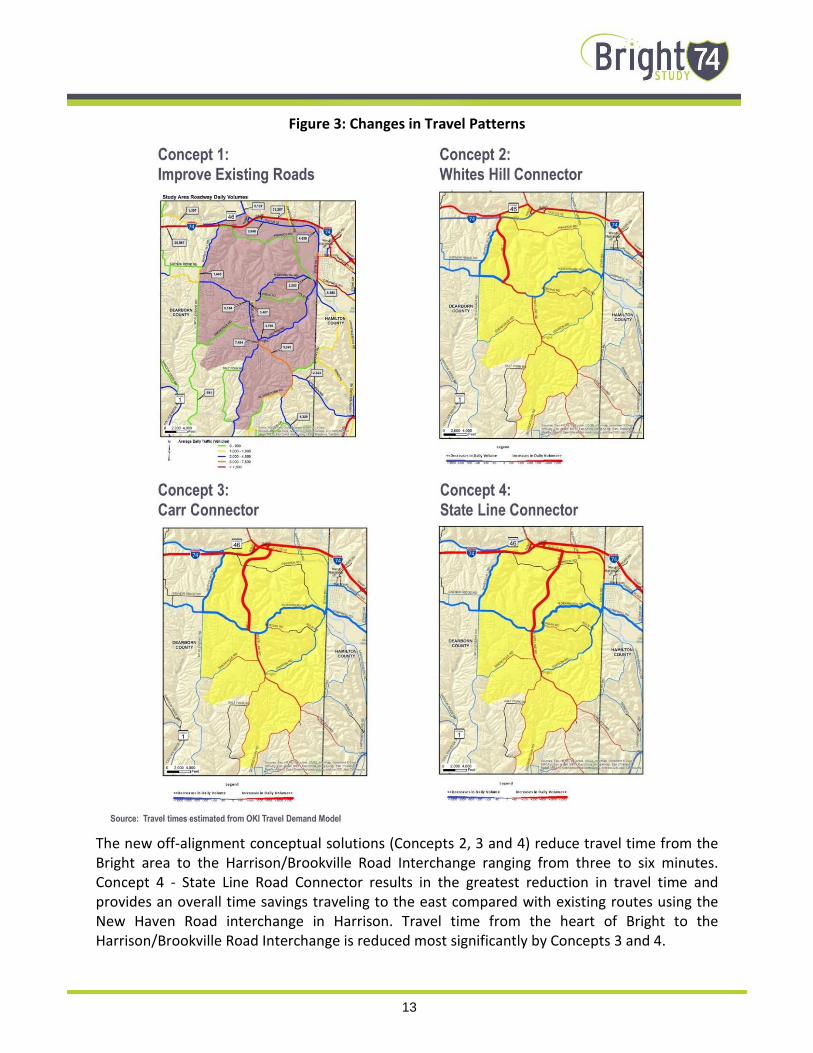
13
Figure 3: Changes in Travel Patterns
The new off-alignment conceptual solutions (Concepts 2, 3 and 4) reduce travel time from the
Bright area to the Harrison/Brookville Road Interchange ranging from three to six minutes.
Concept 4 - State Line Road Connector results in the greatest reduction in travel time and
provides an overall time savings traveling to the east compared with existing routes using the
New Haven Road interchange in Harrison. Travel time from the heart of Bright to the
Harrison/Brookville Road Interchange is reduced most significantly by Concepts 3 and 4.

14
Figure 4: Changes in Travel Time
See Figure 3 for the forecast change in traffic volume and Figure 4 for the change in travel times
within the Study Area.
Property and environmental impacts for each of the concepts have been estimated based on the
conceptual geometry and construction limits described in more detail later in this report.

15
DESIGN CRITERIA
The geometric design criteria used to develop the conceptual solutions (both new and existing
roads) are based on the current INDOT Design Manual for a LPA rural collector. Concept 1 –
Improve Existing Roads assumes a Resurfacing, Restoration, and Rehabilitation or “3R”
improvement of the existing North Dearborn and Whites Hill Roads. The applicable geometric
design criteria is provided in the INDOT Design Manual in Chapter 55 and summarized on Figure
55-3C (see Table 3 below). For new alignments (Concepts 2, 3 and 4) the applicable criteria is
provided in INDOT Design Manual in Chapter 53 and summarized on Figure 53-4 (see Table 4 on
next page). All concepts have assumed an ADT between 1,000 and 3,000 vehicles per day.
Table 3: INDOT 3R (Existing Roads) Design Criteria LPA Rural Collector

16
Table 4: INDOT Design Criteria New Construction LPA Rural Collector
It should be noted that the preferred six to one (6:1) slopes shown in Table 4 were not used for
Concepts 2, 3 and 4 given potential impact to the rolling topography of the Study Area. Maximum
slopes were used to minimize earthwork to the extent possible. Guardrail may be necessary in
some locations where slopes exceed standards.
A maximum grade of nine percent was used for Concept 1 on Whites Hill Road and a maximum
of seven percent was used for Concepts 2, 3 and 4.
As is the case today, one lane in each direction with potential turn lanes at intersections provides
sufficient capacity to accommodate the forecasted traffic volumes for the existing and new roads.
Given the relatively long grade to climb from the vicinity of Pinhook Road to North Dearborn
Road, it may be beneficial to include a south bound truck climbing lane for the new roadways,
however the estimated costs and impacts developed to date for each of the alternatives do not
include the additional lane. The warrants for a truck climbing lane will be evaluated in the next
phase of the Study, if applicable.

17
MAINTENANCE ITEMS
Based on available information, there are several items which could improve safety, operations
and driver experience on North Dearborn and Whites Hill Roads that can be implemented at a
relatively low cost. These maintenance items can also be classified at a “Partial 3R” improvement
and are defined in Chapter 56 of the INDOT Design Manual.
The location and limits of specific maintenance items will need to be identified during a detailed
field survey of existing conditions. The Field Survey will result in the establishment of a strip map
showing all existing details including, but not limited to, intersecting roads, drives, and, pipe
structures, headwalls, curbs, manholes, survey monuments, guardrail, pavement markers, bridge
piers, mailboxes and utility poles signs, raised pavement markers, areas of grading, patching,
milling, utilities in the area, or other specialty items. All items shown in the field survey should
have a station and offset reference. The detailed field survey is beyond the scope of this Study.
In general, pavement conditions along existing North Dearborn, Whites Hill, SR 46 and US 52 are
in good to fair condition with no significant base failures noted. There are locations where the
shoulders do show signs of stress and may require base repair or subgrade stabilization.
The following maintenance items could be implemented on a corridor wide basis following more
detailed inventory of site specific conditions. These items can be implemented in phases or
separate projects as funding permits and could be combined with other County routes inside or
outside of the Study Area.
• Widen for shoulders where possible. Most roadway segments along North Dearborn and
Whites Hill Roads have little or no shoulder. Based on INDOT 3R design criteria the preferable
usable shoulder width should be six feet with a two foot paved width minimum. At a
minimum, any two lane rural road with the traffic volumes in the Study Area should have a
one foot shoulder. Existing obstructions and roadside conditions would require regrading and
potential utility relocations to provide a consistent six foot useable shoulder, however it
appears that providing a two foot paved shoulder should be feasible in most locations with
minimal grading. The ability to widen for adequate shoulders varies by location and will be
evaluated in more detail in the final phase of the Study.
• Remove Roadside Obstructions (trees, poles, fences etc.). Similar to the existing shoulders
there are some locations where obstacles are located within the obstruction free zone. The
obstruction-free zone is defined as the roadside area next to the travel way which should be
free from hazards or obstructions. Each obstacle within the obstruction-free-zone limits
should be removed, made breakaway or shielded with guardrail. The obstruction-free-zone
width for an LPA rural collector is eight feet. It may not be feasible to remove all obstructions
(particularly existing overhead utilities) depending on costs associated with the relocation.
• Add mailbox turnouts. As noted previously, mailboxes are generally located within the
obstruction-free-zone. Depending on the construction, mailbox supports can pose a hazard
to errant vehicles. Each new mailbox installation should be placed in accordance with the
INDOT Standard Drawings, INDOT Standard Specifications, and Section 51-11.0. If additional

18
spacing is required for mailbox placement, mailbox turnouts can be provided to allow for mail
carrier and resident access. Mailbox turnouts also provide additional clearance to avoid mail
carriers during delivery.
• Repair, Replace or add guardrail as needed. There are several locations where existing
guardrail may not meet current INDOT design criteria at the northern end of White Hill Road,
however it may not be feasible to provide an adequate clear zone. It is recommended that a
comprehensive inventory of existing guardrail be done to determine if it is accordance with
the current safety performance and design criteria provided in the INDOT Design Manual
Chapter 49 and the INDOT Standard Drawings. It may be necessary to acquire right of way
from the abutting property owners to install the required guardrail. The minimum guardrail
offset distance is four feet from the edge of the travel way.
• Improve signage. It is recommended that a comprehensive inventory and conditions
assessment be developed for the existing regulatory signage on North Dearborn and Whites
Hill Roads. Reflectivity for some signs appears to be substandard. A sign should be used only
where it is warranted by the Indiana Manual on Uniform Traffic Control Devices (IMUTCD)
criteria, accident history or field studies. A sign should provide information for a regulation,
a hazard which is not self-evident, or a highway route, direction, destination, or point of
interest.
To improve wayfinding and accessibility, the installation of Interstate 74 directional signs at
critical intersections (State Line and North Dearborn Roads, North Dearborn and Whites Hill
Roads, Gaynor Ridge and Whites Hill Roads, and Whites Hill Road at SR 46) should be
considered given that these routes carry an appreciable percentage of interstate bound
traffic. Likewise, guide signs for Bright could be installed at the same intersections in the
opposite directions to guide travelers from the Interstate.
• Address drainage or slippage. Based on visual observation and comments from stakeholders
and the public, there are areas that have experienced roadside slippage or drainage issues.
Most commonly, roadside side slopes and ditches have experienced either erosion or
deposition of debris and materials leading to inadequate capacity to convey runoff during
rain events. The resulting slippage or wet weather flows across roadways or into adjacent
property and can present hazards to motorists resulting in potential damage to private
property. As noted previously, some culverts or ditches can result in obstructions or roadside
hazards. Site specific drainage inventories or hydraulic analysis has not been conducted as
part of this Study. It is recommended that an inventory of existing culverts and roadside
ditches be done to evaluate the need for ditching, culvert repairs or other maintenance to
improve drainage and roadside safety.

19
EXISTING ROADS
It is assumed that all maintenance items listed above would be performed on the existing roads
in addition to the geometric improvements included in Concept 1 described below. The overall
distance from the intersection of State Line and North Dearborn Roads to the Harrison/Brookville
Road Interstate ramps is approximately 5.5 miles. Concept 1 is subject to refinement during the
next phase of the Study which will develop preliminary alternatives. Improvements to existing SR
46 and US 52 are the responsibility of INDOT. In general the state maintained roads meet current
design criteria. This study did not evaluate changes to existing interstate access.
CONCEPT 1 - IMPROVE EXISTING ROADS
This concept includes a “complete 3R” project to correct existing geometric deficiencies generally
along the existing alignment of North Dearborn Road between State Line Road and Whites Hill
Road as well as Whites Hill Road from its intersection with North Dearborn Road to its terminus
at SR 46. The proposed improvements include straightening horizontal curves in selected
locations, flattening or lengthening of substandard vertical curves and intersection realignment
as noted below. See Figure2 for locations of proposed straightening of the existing curves and
intersection improvements. Site specific limits for flattening or lengthening substandard vertical
curves were not illustrated during development of conceptual solutions, but will be developed
during the next phase of the Study.
From east to west along North Dearborn Road the following improvements were identified.
• Straighten the reverse curves located between State Line Road and Carr Road including minor
realignment of the intersection of Carr Road and North Dearborn Road. These curves
currently have an advisory speed of 25 mph and have limited sight distance especially from
some adjacent driveway locations.
• Straighten the horizontal curve in the vicinity of the intersection of Henderson Road and
Bright Leaf Road including realignment of the intersection to eliminate the offset of the two
side road approaches. Some pavement stress was noted in this area. Complete pavement
reconstruction may be beneficial within the limits of the reconstructed curve.
• Straighten the horizontal curve located east of the intersection of Kling Lane.
• Although not shown on Figure 2, Concept 1 would also straighten the reverse horizontal
curves and flatten vertical curves located approximately 1500 feet east of the intersection of
North Dearborn and Dole Roads.
From south to north along Whites Hill Road the following improvements have been included in
Concept 1.
• Straighten horizontal curve located approximately 1000 feet south of the intersection of
Gaynor Ridge Road and Whites Hill Road. Realign Gaynor Ridge Road to reduce the skew at
its intersection with Whites Hill Road.

20
• Realign an approximately 2,000 foot long section of Whites Hill Road south of Price Lane to
eliminate reverse curves and flatten grades to a nine percent maximum. The realigned
roadway will be located west of the existing alignment. The proposed alignment and profile
will be refined during the next phase of the Study to avoid an electrical transmission line and
incorporate revised access to adjacent property in this area as well as to coordinate with
potential phasing of Concept 2 - Whites Hill Connector more fully described below, if the
concept is advanced for further Study consideration.
NEW CONSTRUCTION
Three concepts have been developed on new alignments which would link North Dearborn Road
to SR 46 (Whites Hill Road Connector) or old US 52 (Carr Road and State Line Road Connectors).
As noted previously, the geographic design criteria from INDOT Design Manual Chapter 53 (Table
4) were used with an assumed ADT of 2,500. At this time, stop controlled intersections are
assumed at either end of the new connectors.
The new connectors are assumed to be limited access facilities (with the exception of existing
Carr Road for the Carr Road Connector) between the Whitewater River and North Dearborn
Road. There are no provisions to accommodate intersecting roadways or driveway connections.
Where an individual parcel would be landlocked without alternative access an entrance will be
provided. Land use is assumed to remain largely undeveloped agricultural or natural. No
significant trip generators are assumed to access directly to the new roadways south of the
Whitewater River.
Concepts (2, 3 and 4) assume a 55 mph design speed with two 12 foot lanes and eight foot
shoulders (See Table 4 and Figure 5). A maximum grade of seven percent with a minimum three
to one (3:1) side slopes were used to estimate earthwork and construction limits using a digital
terrain model of the existing surface created from 2012 Indiana Map LIDAR data.
Pavement depth, composition, super-elevation or roadway drainage were not evaluated during
this phase of the Study. Major bridge crossings of Pinhook Road and the Whitewater River have
been identified however the location, length and size of smaller bridge structures or culverts have
not been identified at this time. No retaining walls have been proposed outside of the major
bridge locations at this time, but could be considered during the final phase of the Study if
concepts are advanced for further Study consideration in order to limit earth work, or minimize
environmental or property impacts.

21
Figure 5: New Construction Proposed Typical Section
While it may be beneficial to include a climbing lane in the southbound direction for trucks, a
climbing lane has not been included in estimated costs and impacts for the conceptual solutions
to date. No separate bicycle or pedestrian facilities are proposed. If necessary, pedestrians can
utilize the proposed roadway shoulders.
Specific elements for each of the three concepts are described in the following sections.
CONCEPT 2 - WHITES HILL ROAD CONNECTOR
This concept would provide an alternative route linking north Dearborn Road to Whites Hill Road
from the east. The route would start at a new intersection with North Dearborn Road
approximately 4,300 feet east of the exiting intersection of Whites Hill Road and would tie into
existing White Hill Road approximately 2500 feet south of the intersection of Whites Hill Road
and SR 46 (See Figure 6). The total length of new construction would be approximately 2.6 miles.
The new connector would reduce the overall distance from State Line Road to the
Brookville/West Harrison Interchange by approximately 0.7 miles and reduce travel time by
approximately two minutes. The forecasted ADT is 1,500.
This concept is less costly and has less environmental impacts when compared with the Carr Road
and State Line Road Connectors (Concepts 3 and 4) since it uses existing SR 46 to cross the
Whitewater River negating the need for a major new bridge structure and impacts to the
floodplain. The existing Interstate 74 overpass is also maintained.
While less costly compared with the other two connectors, this concept will still require
significant earthwork and will need to avoid the existing aerial electrical transmission lines
running generally parallel to but east of Whites Hill Road. Refinements to the proposed
alternative can be made during the next phase of the Study.

22
Figure 6: Concept 2 - Whites Hill Road Connector

23
CONCEPT 3 - CARR ROAD CONNECTOR
This alternative makes use of existing Carr Road for its connection with North Dearborn Road.
The concept would slightly widen and reconstruct Carr Road with an urban cross section including
curb, gutter and sidewalks (see Figure 7).
Figure 7: Proposed Carr Road Typical Section
From a stop controlled intersection at Carr Road and Pine Ridge Lane the connector would turn
to the northwest following a new alignment to a terminus near the intersection of Moore Lane
and Old US 52 (see Figure 8). The overall length of new construction would be approximately 3.6
miles including a proposed bridge spanning over Pinhook Road and the Whitewater River. The
new connector would reduce the overall distance from State Line Road to the Brookville/West
Harrison Interchange by approximately 1.6 miles and reduce travel time by approximately four
minutes. The design speed on existing Carr Road would be 35 mph and 55 mph on the new
connector.
This concept could provide new roadway access to commercially zoned property located
between the Whitewater River and Old US 52. The alignment north of the Whitewater River can
be refined to avoid floodplain and other environmental impacts and to accommodate potential
future industrial/commercial development in the area as needed.
Earthwork is somewhat less that the Whites Hill Road Connector or State Line Road Connector
Concepts 2 and 4). It is not anticipated that residential relocations will be necessary, however a
frontage strip may be necessary along the portion of existing Carr Road. This concept does
require a major new bridge crossing of the Whitewater River. Specific bridge type, pier locations
etc. have not been developed during this phase of work. Costs for the bridge crossing will be
significant and are based on a square foot basis at this time. The conceptual limits of the bridge
have been set to provide a waterway opening similar to that in the current Dearborn County
FEMA Flood Insurance Study.

24
Figure 8: Concept 3 - Carr Road Connector

25
CONCEPT 4 - STATE LINE ROAD CONNECTOR
The State Line Road Connector would begin at the existing intersection of State Line and North
Dearborn Roads and proceed north through largely undeveloped property with two new grade
separations over Pinhook Road and the Whitewater River. North of the River, the new connector
would end at a new intersection on Old US 52 located approximately 2,700 east of the existing
intersection with Moore Lane (see Figure 9). This concept would function as an extension of State
Line Road and would result in the most significant travel time savings compared with existing
conditions. The overall length of new construction would be approximately 3.6 miles. The new
connector would reduce the overall distance from State Line Road to the Brookville/West
Harrison Interchange by approximately 1.7 miles and reduce travel time by approximately 4.5
minutes. The forecasted ADT is approximately 2,700.
It is assumed that the existing at-grade railroad crossing of the Indiana and Ohio Railroad on
Moore Lane would be relocated to the new State Line Road Connector. An extension of Moore
Lane to the east would be required if it is necessary to consolidate the grade crossings to one
location. The elevation of the existing track at the new location is approximately three feet above
Old US 52. To maintain the existing track profile in this area, it may be necessary to raise the
profile of Old US 52 in the vicinity of the new intersection. Formal comment from the Genesee
and Wyoming Railroad regarding the disposition of the grade crossings is pending at this time.
Concept 4 includes two new bridge crossings at Pinhook Road and the Whitewater River. It is
assumed at this time that the roadway between the bridges would be on earthen embankment.
It should be noted that this area does lie within the FEMA floodplain of the Whitewater River,
however it is assumed that the waterway openings provided by the two bridges would be
sufficient to pass the regulatory flood volume without a rise in the base flood elevation where
the connector would cross the River. Hydraulic analysis will be required to confirm the impacts
to the floodplain if this concept is advanced for further evaluation. Specific bridge type, pier
locations etc. have not been developed during this phase of work. Costs for the bridge crossings
will be significant and are based on a square foot basis at this time. Earthwork is somewhat less
than Concept 2 - Whites Hill Road Connector, but more than the Concept 3 - Carr Road Connector.
The conceptual limits of the bridge have been set to provide a waterway opening area similar to
the current Dearborn County FEMA Flood Insurance Study.

26
Figure 9: Concept 4 - State Line Road Connector

27
EVALUATION OF CONCEPTS
A comparison table of the estimated travel times, travel time savings, environmental and
property impacts, and range of estimated construction costs were presented at the Public Open
House and on the OKI Bright I-74 Study website (www.Bright74.oki.org) on June 22. See Table 5
for a comparison of the conceptual solutions. This table was developed to assist the Study’s
Advisory Committee and general public with completing a survey to assess how each of the
concepts met the purpose and need and secondary goals of the Study.
Table 5: Comparison of Concepts
Category Units
Concept 1:
Improve Existing
Roads
Concept 2:
Whites Hill
Road
Connector
Concept 3:
Carr Road
Connector
Concept 4:
State Line
Road
Connector
Total Route Length* Miles 5.5 4.8 3.9 3.8
Length of New Roadway Miles 0.75 2.56 3.64 3.56
Earthwork Area Acre 15 55 59 65
Parcels Effected Each 89 20 54 26
Wetlands/Ponds Impacted Each 2 0 5 4
Stream Crossings Each 1 21 21 18
Construction in
Flood Plain Linear Feet 0 0 1,700 1,800
Average Daily Traffic Number of
Vehicles Varies 1,500 2,200 2,700
Travel Time Minutes 8.9 6.6 4.8 4.4
Earth Cut Cubic Yards 75,000 840,000 380,000 500,000
Earth Fill Cubic Yards 15,000 1,070,000 800,000 1,210,000
Bridge Area Square Feet 0 0 53,000 48,000
Estimated Costs (2016 dollar value) $ Millions $10-20M $20-30M $35-55M $30-50M
* All routes (existing plus new roadway) are measured from the intersection of State Line Road and North Dearborn Road to I-74
over Old US 52

28
The purpose and need of the Study is a follows:
Provide improved travel between the Bright area and Interstate 74 that meets INDOT’s design
criteria, reduces travel time, and enhances connectivity and traffic safety while preserving the
rural quality.
A survey provided in person at the Public Open House on June 22, 2016 and online June 22-July
22, 2016 through OKI’s Study website (www.Bright74.oki.org) provided an opportunity to give
specific comments on each of the concepts. Additionally the survey gauged the relative
importance of and how well each of the concepts met four major goals of the study.
• Preserve rural quality of the area (80 percent of respondents felt this is important)
• Minimize environmental impacts (74 percent felt this was important)
• Improve travel safety (40 percent felt this was important)
• Enhance roadway connectivity and economic vitality (16 percent felt this was important)
From the survey responses, is it clear that the primary goal of the improvements should be to
preserve the rural quality and minimize environmental impacts with improving safety a
secondary goal. The majority of respondents feel that enhancing roadway connectivity and
economic vitality are unimportant.
The survey results gauging each alternative indicated that approximately 80 percent of
respondents felt that Concept 1 - Improving Existing Roads met or somewhat met the goals of
preserving rural quality and minimizing environmental impacts followed by approximately 40
percent for Concept 2 - Whites Hill Road Connector. Less than 25 percent felt that neither
Concept 3 - Carr Road Connector nor Concept 4 - State Line Road Connector met these goals.
Stakeholder and members of the Advisory Committee also have noted concerns with the relative
significant estimated construction costs and environmental impacts associated with Concepts 3
and 4.
While Concept 3 - Carr Road Connector and Concept 4 - State Line Road Connector provide the
most significant travel time savings and are forecast to attract the most new trips, the relative
total time savings of five minutes or less was found to be inconsequential when compared with
the lower relative cost and impacts of Concepts 1 and 2.
The Study Team developed an evaluation matrix with a composite scoring system to
quantitatively compare the concepts to screen them for future evaluation during the final phase
of the Study. The matrix (see Table 6) uses the four goals of the Study with a score of 1 for
low/negative (red), 2 for neutral (yellow) and 3 for high/positive (green) assigned to sub factors
for each of the goals. The subtotals for each goal were then factors according the degree of
importance taken from the public survey. The scores were tallied to arrive at an overall composite

29
score. Concept 1 – Improve Existing Roads received the highest score followed next by Concept
2.
Table 6: Evaluation Matrix
Based on this evaluation using data and public input, Concepts 3 and 4 will not be evaluated
further during the course of this Study. The Study Team then performed further refinement and
evaluation of Concept 1 - Improve Existing Roads and Concept 2 Whites Hill Connector.
The initial development of these concepts was focused on the horizontal alignment for each with
a basic vertical profile developed for Concept 2. While identifying the location of deficient vertical
curves on North Dearborn and Whites Hill Roads, Concept 1 as presented at the second open
house did not identify the work limits necessary to adjust the profiles to eliminate the
substandard vertical curves.
Similarly, the right of way impacts were not previously evaluated on a parcel by parcel basis for
Concept 1 since the vertical profile for the roadways was not finalized. Dearborn County provided
property information for parcels west of Whites Hill Road which were located outside the Study
Area but would be impacted by the proposed improvements to Whites Hill Road as part of
Concept 1.

30
The Study Team developed refined alignments, profiles and construction limits for both concepts
using the same topographic basemapping, red flag environmental data and INDOT design criteria
developed during Phase One of the Study. Using the additional geometric information for the
respective roadways allowed for the development of updated and more detailed information on
earthwork, right of way impacts, utility impacts, culverts and stream impacts. The estimated
construction costs were revised for each Concept 1 and 2 based on the updated information.
The impacts and estimated construction costs associated with Concept 2 - Whites Hill Road
Connector, while comparable with those provided at the second public meeting, are significantly
higher than those for Concept 1 as shown in Table 7. Given the disparity in impacts and costs
between Concepts 1 and 2 and the relatively minimal differences in travel time savings, safety
and forested changes in traffic, and the lack of public support for new roadway the Study Team
concluded that only Concept 1 Improve Existing Roads would be carried forward as part of the
study recommendations.
Additional refinement of Concept 1 including potential phasing will be evaluated during the final
phase of the Study.
Table 7: Comparison of Concepts 1 and 2
Total route length (existing plus new roadway) are measured from the intersection of State
Line Road and North Dearborn Road to I-74 over Old US 52