Embed Size (px)
Citation preview

Final ENVIRONMENTAL ASSESSMENT FOR
EQUIPMENT REMOVAL AT OVER-THE-HORIZON BACKSCATTER RADAR – WEST COAST FACILITIES
U.S. Air Force Air Combat Command
July 2005

ACRONYMS AND ABBREVIATIONS
ACC Air Combat Command ACHP Advisory Council on Historic Preservation AFB Air Force Base AFH Air Force Handbook AFI Air Force Instruction AFOSH Air Force Occupational Safety and Health AICUZ Air Installation Compatible Use Zone Air Force United States Air Force AMP Allotment Management Plan AQCR Air Quality Control Region AUM animal unit month BLM U.S. Bureau of Land Management BMPs Best Management Practices CAA Clean Air Act CEQ Council on Environmental Quality CERCLA Comprehensive Environmental Response,
Compensation, and Liability Act CFR Code of Federal Regulations CNDDB California Natural Diversity Database CO carbon monoxide CRMP Cultural Resource Management Plan CWA Clean Water Act dB decibel dBA A-weighted decibel DNL Day-Night Average Sound Level DoD Department of Defense DRMO Defense Reutilization and Marketing
Office DRMS Defense Reutilization and Marketing
Service EA environmental assessment EIAP environmental impact analysis process EIS Environmental Impact Statement EO Executive Order EPCRA Emergency Planning and Community
Right-to-Know Act ERP Environmental Restoration Program ESA Endangered Species Act FONSI Finding of No Significant Impact FY Fiscal Year IICEP Interagency and Intergovernmental
Coordination for Environmental Planning
MOA Memorandum of Agreement MSL mean sea level NAAQS National Ambient Air Quality Standards NEI National Emissions Inventory NEPA National Environmental Policy Act NHPA National Historic Preservation Act NO2 nitrogen dioxide NOx nitrogen oxide NORAD North American Aerospace Defense
Command NPDES National Pollutant Discharge Elimination
System NRHP National Register of Historic Places NRIS National Register Information System O3 ozone OSHA Occupational Safety and Health
Administration OTH-B Over-the-Horizon Backscatter Radar P.L. Public Law Pb lead PCB polychlorinated biphenyl PM10 particulate matter equal to or less than 10
micrometers in diameter PM2.5 particulate matter equal to or less than 2.5
micrometers in diameter ppm parts per million RCRA Resource Conservation and Recovery Act RMP Resource Management Plan ROI region of influence SAFO Secretary of the Air Force Order SHPO State Historic Preservation Office SIP State Implementation Plan SO2 sulfur dioxide SR State Route SWPPP Storm Water Pollution Prevention Plan U.S. United States USACE United States Army Corps of Engineers USC United States Code USEPA United States Environmental Protection
Agency USFS United States Forest Service USFWS United States Fish and Wildlife Service VOC volatile organic compound


THIS PAGE INTENTIONALLY LEFT BLANK

Final
ENVIRONMENTAL ASSESSMENT FOR EQUIPMENT REMOVAL AT OVER-THE-HORIZON
BACKSCATTER RADAR – WEST COAST FACILITIES
U.S. Air Force Air Combat Command
July 2005


Final EA Equipment Removal at OTH-B West Coast Radar Site Table of Contents i
TABLE OF CONTENTS
EXECUTIVE SUMMARY.................................................................................................................... ES-1
1.0 PURPOSE AND NEED FOR ACTION......................................................................................1-1
1.1 Introduction ........................................................................................................................1-1
1.2 Background .........................................................................................................................1-1
1.3 Purpose and Need..............................................................................................................1-2
2.0 DESCRIPTION OF THE PROPOSED ACTION AND ALTERNATIVES.............................2-1
2.1 Proposed Action .................................................................................................................2-1
2.2 Alternative One ..................................................................................................................2-5 2.3 No Action Alternative .......................................................................................................2-5 2.4 Environmental Impact Analysis Process (EIAP) ...........................................................2-6
2.4.1 Public and Agency Involvement.........................................................................2-6 2.4.2 Regulatory Compliance........................................................................................2-6 2.4.3 Permit Requirements ............................................................................................2-6
2.5 Comparison of Alternatives..............................................................................................2-7
3.0 AFFECTED ENVIRONMENT ....................................................................................................3-1
3.1 Air Quality ..........................................................................................................................3-2 3.2 Cultural Resources .............................................................................................................3-4
3.2.1 Identified Cultural Resources..............................................................................3-4
3.3 Biological Resources ..........................................................................................................3-5 3.4 Grazing ..............................................................................................................................3-11 3.5 Geology and Soils.............................................................................................................3-12
4.0 ENVIRONMENTAL CONSEQUENCES ..................................................................................4-1
4.1 Air Quality ..........................................................................................................................4-1 4.1.1 Proposed Action....................................................................................................4-1 4.1.2 Alternative One .....................................................................................................4-4 4.1.3 No Action Alternative ..........................................................................................4-7
4.2 Cultural Resources .............................................................................................................4-7 4.2.1 Proposed Action....................................................................................................4-7 4.2.2 Alternative One .....................................................................................................4-9 4.2.3 No Action Alternative ........................................................................................4-10

Final EA Equipment Removal at OTH-B West Coast Radar Site ii Table of Contents
4.3 Biological Resources ........................................................................................................4-10 4.3.1 Proposed Action..................................................................................................4-10 4.3.2 Alternative One ...................................................................................................4-14 4.3.3 No Action Alternative ........................................................................................4-16
4.4 Grazing ..............................................................................................................................4-16 4.4.1 Proposed Action..................................................................................................4-16 4.4.2 Alternative One ...................................................................................................4-17 4.4.3 No Action Alternative ........................................................................................4-18
4.5 Geology and Soils.............................................................................................................4-18 4.5.1 Proposed Action..................................................................................................4-18 4.5.2 Alternative One ...................................................................................................4-19 4.5.3 No Action Alternative ........................................................................................4-20
5.0 CUMULATIVE EFFECTS AND IRREVERSIBLE AND IRRETRIEVABLE COMMITMENT OF RESOURCES.............................................................................................5-1
5.1 Cumulative Effects.............................................................................................................5-1 5.1.1 Definition of Cumulative Effects ........................................................................5-1 5.1.2 Past, Present, and Reasonably Foreseeable Actions.........................................5-2 5.1.3 Analysis of Cumulative Impacts.........................................................................5-3
5.2 Irreversible and Irretrievable Commitment of Resources............................................5-3
6.0 REFERENCES ...............................................................................................................................6-1
7.0 LIST OF PREPARERS ..................................................................................................................7-1
APPENDICES
Appendix A PHOTOGRAPHS, MAPS, AND FIGURES
Appendix B INTERAGENCY AND INTERGOVERNMENTAL COORDINATION FOR ENVIRONMENTAL PLANNING (IICEP) AND COMMENT LETTERS
Appendix C SUPPORTING INFORMATION FOR AIR QUALITY
Appendix D LISTS OF PLANTS AND ANIMALS IN STUDY AREAS
Final EA Equipment Removal at OTH-B West Coast Radar Site Table of Contents iii
LIST OF FIGURES 1-1 OTH-B West Coast Radar System ........................................................................................1-3 2-1 Christmas Valley, OR OTH-B Transmit Site.......................................................................2-2 2-2 Tulelake, CA OTH-B Receive Site ........................................................................................2-3
LIST OF TABLES 2-1 Environmental Related Regulatory Requirements ............................................................2-7 2-2 Summary of Potential Environmental Impacts of Proposed Action
and Alternatives......................................................................................................................2-8 3-1 Baseline Emissions Inventory for Modoc County, California ..........................................3-3 3-2 Baseline Emissions Inventory for Lake County, Oregon ..................................................3-3 4-1 Estimated Project Emissions by Activity for the Transmitter Site
in Lake County, Oregon ........................................................................................................4-2 4-2 Estimated Project Emissions by Activity for the Transmitter Site
in Lake County, Oregon ........................................................................................................4-2 4-3 Estimated Project Emissions by Activity for the Receiver Site
in Modoc County, California ................................................................................................4-3 4-4 Estimated Project Emissions by Activity for the Receiver Site
in Modoc County, California ................................................................................................4-4 4-5 Estimated Project Emissions by Activity for the Transmitter Site
in Lake County, Oregon ........................................................................................................4-4 4-6 Estimated Project Emissions by Activity for the Transmitter Site
in Lake County, Oregon ........................................................................................................4-5 4-7 Estimated Project Emissions by Activity for the Receiver Site
in Modoc County, California ................................................................................................4-6 4-8 Estimated Project Emissions by Activity for the Receiver Site
in Modoc County, California ................................................................................................4-6

Final EA Equipment Removal at OTH-B West Coast Radar Site iv Table of Contents
THIS PAGE INTENTIONALLY LEFT BLANK.

Final EA Equipment Removal at OTH-B West Coast Radar Site Executive Summary ES-1
EXECUTIVE SUMMARY This Environmental Assessment (EA) describes the potential environmental consequences resulting from a proposal to remove radar equipment and fences from the Over-the-Horizon Backscatter (OTH-B) West Coast Radar sites in Christmas Valley, Oregon and Tulelake, California.
ENVIRONMENTAL IMPACT ANALYSIS PROCESS
This EA has been prepared by the United States Air Force (Air Force), Air Combat Command (ACC) in accordance with the requirements of the National Environmental Policy Act (NEPA) of 1969, (42 United States Code [USC] 4321-4347), Council on Environmental Quality (CEQ) Regulations for Implementing the Procedural Provisions of NEPA (40 Code of Federal Regulations [CFR] §§ 1500-1508), and 32 CFR Part 989, et seq., Environmental Impact Analysis Process (formerly known as Air Force Instruction [AFI] 32-7061).
PURPOSE AND NEED FOR ACTION
The purpose of this action is to remove external radar equipment from the OTH-B West Coast Radar sites in Christmas Valley, Oregon, and Tulelake, California, that is no longer needed and maintain the remaining facilities in caretaker status. Contractors working with the Defense Reutilization and Marketing Office/Defense Reutilization and Marketing Service (DRMO/ DRMS) are available to remove the radar equipment at a substantial cost savings to the Government. Prices for scrap metal are currently at a high level and immediate action would provide a substantial return to the Government for components that have outlived their useful life.
PROPOSED ACTION AND ALTERNATIVES
The Proposed Action consists of the disassembly of a total of 549 metal antenna structures, 717 acres of metal ground screen, and 115,764 linear feet of wood fence and posts from the Tulelake, California and Christmas Valley, Oregon radar sites. At the radar transmitter site in Christmas Valley, Oregon, 45 miles of 3- to 6-inch diameter copper wave-guide tube and balun domes would also be removed. Existing access roads, water systems, electrical lines and buildings would not be disturbed at either radar site.
Under Alternative One, the Air Force would remove only the items directly related to the operation of the radar system, which includes 45 miles of copper wave-guide tube and balun domes, 717 acres of ground screens, and 549 metal antenna structures. The 115,764 linear feet of wood perimeter fence and posts would remain in place.
Under the No Action Alternative both radar sites would continue to remain in caretaker status.

Final EA Equipment Removal at OTH-B West Coast Radar Site ES-2 Executive Summary
SUMMARY OF ENVIRONMENTAL CONSEQUENCES
This EA provides an analysis of the potential environmental consequences from the activities associated with the Proposed Action and the Alternatives. Five resource categories, identified in the following text, received a thorough evaluation to identify potential environmental consequences. Several resources were not evaluated in this EA because it was determined that implementation of the Proposed Action or Alternatives is unlikely to affect them. These resources include Airspace, Land Use, Water Resources, Safety and Occupational Health, Hazardous Materials and Waste Management, and Socioeconomics and Environmental Justice. As indicated in Chapter 4.0, the radar equipment removal would not result in significant impacts to any of these resource areas.
Air Quality: Equipment removal-related air emissions would be generated with the implementation of the Proposed Action or Alternative One at both OTH-B sites and within the region with the hauling of equipment from both OTH-B sites and from other earth-disturbing activities. These emissions would be less than 1 percent of emissions in the Air Quality Control Region (AQCR) for both Christmas Valley, Oregon and Tulelake, California. Lake County, Oregon is a moderately non-attainment area for PM10 ; however, either the Proposed Action or Alternative One would not contribute PM10-related emission above United States Environmental Protection Agency (USEPA) established de minimis levels for PM10. Therefore, a formal air quality conformity determination is not required.
Cultural Resources: Equipment removal activities are not expected to impact archaeological or traditional resources under the Proposed Action or Alternative One. If resources are inadvertently discovered during equipment removal, all work would halt at that location, the ACC Cultural Resource Manager would be notified, and proper procedures for the discovery of unanticipated resources would be completed prior to work resuming. Consultation with the State Historic Preservation Offices (SHPO), in compliance with Section 106 of the National Historic Preservation Act (NHPA) (16 U.S.C. §470 et seq.) with its implementing regulations (36 CFR. Parts 60, 63, and 800) is being initiated by the Air Force and will be concluded prior to the commitment of any resources prejudicing the selection of alternatives.
Biological Resources: Equipment removal activities under the Proposed Action or Alternative One would have no significant adverse effects to individual species or native plants or animals since the only plant or animal species likely to be displaced are individuals of common and locally abundant species. No impacts are anticipated to wetlands because there are no wetlands within the project footprints. No threatened, endangered, or special species or communities would be adversely affected by the Proposed Action or Alternative One. Incidentally occurring listed, proposed, or candidate species are not likely to be adversely affected because no critical habitat exists on either of the Christmas Valley, Oregon and Tulelake, California sites. No significant adverse environmental consequences are anticipated from the equipment removal activities.

Final EA Equipment Removal at OTH-B West Coast Radar Site Executive Summary ES-3
Grazing: Equipment removal activities are not expected to have significant adverse effects to grazing activities with the implementation of the Proposed Action and Alternative One at the Tulelake, California and Christmas Valley, Oregon radar sites. Removal of the wooden perimeter fence, under the Proposed Action, would adversely impact the grazing permittees as the fence currently serve as the grazing allotment boundary fence at the Tulelake, California site. At the Christmas Valley site, fence removal would allow cattle from adjoining property to graze on the site. Replacement of the fence would not be the responsibility of the Air Force; however the Air Force will work with the United States Forest Service and their grazing permittee(s) to coordinate the timing of the fence removal in order to limit the amount of disturbance to grazing operations.
Geology and Soils: Fence and equipment removal activities under the Proposed Action or Alternative One would have no significant adverse impact with respect to geology and soils in the vicinity of the project sites. Fence and equipment removal would expose and disturb on-site soils, resulting in temporary exposure to wind and water erosion. Potential erosion induced sedimentation of local water resources at the Christmas Valley, Oregon site would be minimal due to a lack of drainages or creeks in the vicinity of the site, which is located in a dry lake bed. However, potential erosion induced sedimentation of local drainages, creeks, and regional lakes may occur at the Tulelake site. However, in accordance with National Pollutant Discharge Elimination System (NPDES) permit regulations, all activities would be completed in accordance with a Storm Water Pollution Prevention Plan (SWPPP), which would include incorporation of standard construction practices, such as construction of silt fences and temporary stormwater debris basins. Potential short-term wind erosion would be minimized through water application during and immediately following dismantling activities. In addition, revegetation and weed control upon completion of equipment dismantling would prevent long-term wind- and water-induced soil erosion. Therefore, no significant impacts would occur.

Final EA Equipment Removal at OTH-B West Coast Radar Site ES-4 Executive Summary
THIS PAGE INTENTIONALLY LEFT BLANK
Final EA Equipment Removal at OTH-B West Coast Radar Site 1.0 Purpose and Need 1-1
1.0 PURPOSE AND NEED FOR ACTION
1.1 INTRODUCTION
The United States Air Force (Air Force) proposes to remove equipment from the Over-the-Horizon Backscatter (OTH-B) West Coast Radar system in order to take advantage of favorable conditions in the labor and scrap metal markets. This environmental assessment (EA) has been prepared to analyze the potential environmental consequences associated with the Proposed Action and Alternatives in accordance with the requirements of the National Environmental Policy Act (NEPA) of 1969 (42 United States Code [USC] 4321 et seq.). This document was prepared in accordance with regulations established by the Council on Environmental Quality (CEQ) (40 Code of Federal Regulations [CFR] 1500-1508) and 32 CFR Part 989, et seq., Environmental Impact Analysis Process (formerly known as Air Force Instruction [AFI] 32-7061.
Section 1.2 provides background information that briefly describes the OTH-B West Coast Radar System. The purpose and need for the Proposed Action are described in Section 1.3. A detailed description of the Proposed Action and the Alternatives is provided in Chapter 2.0. Chapter 3.0 describes the existing conditions of various environmental resources that could be affected if the proposal were implemented. Chapter 4.0 describes how those resources would be affected by implementation of the Proposed Action or the Alternatives. Chapter 5.0 addresses the cumulative effects of the Proposed Action, as well as other recent past, current, and future actions that may be implemented in the region of influence (ROI) for the Proposed Action.
1.2 BACKGROUND
The OTH-B radar system was developed in the early 1970s to provide all-altitude, long-range surveillance of aerial approaches to the United States. Two OTH-B radar systems were constructed, one system each on the West and East Coasts. Each system included transmitter, receiver, and operations sites. OTH-B radar systems used the ionosphere to refract outgoing radar waves and return signals, enabling the system to detect and track targets that would otherwise be hidden by the curvature of the earth, at ranges of up to 1,800 nautical miles. Processed data was communicated from the receiver location to the operations site for correlation with known aircraft positions. The OTH-B radar system was built by General Electric (GE) beginning in 1986. The Air Force accepted control of the system in December 1990. In 1991 just months after being put into place, the West Coast site reduced its activities to caretaker status.
The OTH-B West Coast Radar system currently includes sites located in California and Oregon as shown in Figure 1-1. The receiver site, located near Tulelake, California, is leased from the U.S. Forest Service (USFS), Doublehead Ranger District, and is in the Rimrock Lake area. The facility consists of three sectors of antennae situated on approximately 2,800 acres. Each sector supports an antenna array 8,000 feet long comprised of a line of 134 steel towers 65 feet high and about 60

Final EA Equipment Removal at OTH-B West Coast Radar Site 1-2 1.0 Purpose and Need
feet apart with a 65 foot-high back screen (see Appendix A – Photograph 1). The antenna array consists of a set of elements, the tower and stay, and a ground screen (see Appendix A – Figure A-1). The ground screen extends out approximately 700 feet in front of the arrays, entirely above the ground surface, along their entire length. It is estimated the ground screen covers approximately 462 acres (154 acres per array). The receiver also has 8-foot-high wooden security fencing in front of the antenna arrays and some buildings (approximately 19,280 feet per array, 57,480 feet total)
The transmitter site located near Christmas Valley, Oregon, occupies land that is managed by the Air Force and has been withdrawn from public use by the U.S. Bureau of Land Management (BLM). The site is locally referred to as Buffalo Flats. The facility’s three sectors of antennae, oriented 60 degrees from each other, require approximately 1,200 acres. The three antenna systems consist of a back screen made of 8-inch-square corrosion-resistant wire mesh. The back screen is supported by 49 steel towers, 65 feet high, spaced along a 5,000 foot axis supported by 49 concrete foot pads (see Appendix A – Photograph 2). The steel tower includes the support, top and bottom truss and dielectric support structure as shown in Appendix A- Figure A-1. Located directly behind the back screen are a series of copper tube wave-guides that run the length of the back screen. The copper wave-guide tubes extend to the antenna towers and include the balun domes. The antenna towers vary in height from approximately 45 to 135 feet and are approximately 3,640 feet long. In front of each back screen and antenna array is a ground screen of galvanized metal mesh that extends approximately 750 feet in front of each back screen and covers approximately 255 acres (85 acres per array).
An eight-foot-high wooden security fence is located approximately 100 feet in front of the ground screen encloses the entire site and some facilities (approximately 19,280 feet per antenna system or 58,284 feet total).
1.3 PURPOSE AND NEED
The Air Force proposes to remove external radar equipment and fences from the OTH-B West Coast Radar System that is no longer needed at this location and maintain the remaining facilities in caretaker status. Contractors working with the Defense Reutilization and Marketing Office/Defense Reutilization and Marketing Service (DRMO/DRMS) are available to process the radar components for reuse or scrap at a substantial cost savings to the government. Various DoD agencies have expressed an interest in system components and also prices for scrap metal are currently at a high level and immediate action would provide a substantial return to the Government for radar equipment and fences. These components would include the existing radar screens, wave guides, balun domes, ground screens, and wood security fences at the transmitter site in Christmas Valley, Oregon and the receiver site in Tulelake, California.
The North American Aerospace Defense Command (NORAD) indicated that the Government has no operational requirement for the existing FPS-118 OTH-B Radar System in a letter dated 13 June 2002 (Air Force, 2002). The system was placed in caretaker status in 1991 and has been maintained in that condition since then. Therefore, spending resources on the radar system in caretaker status is an ineffective and inefficient use of Government resources.
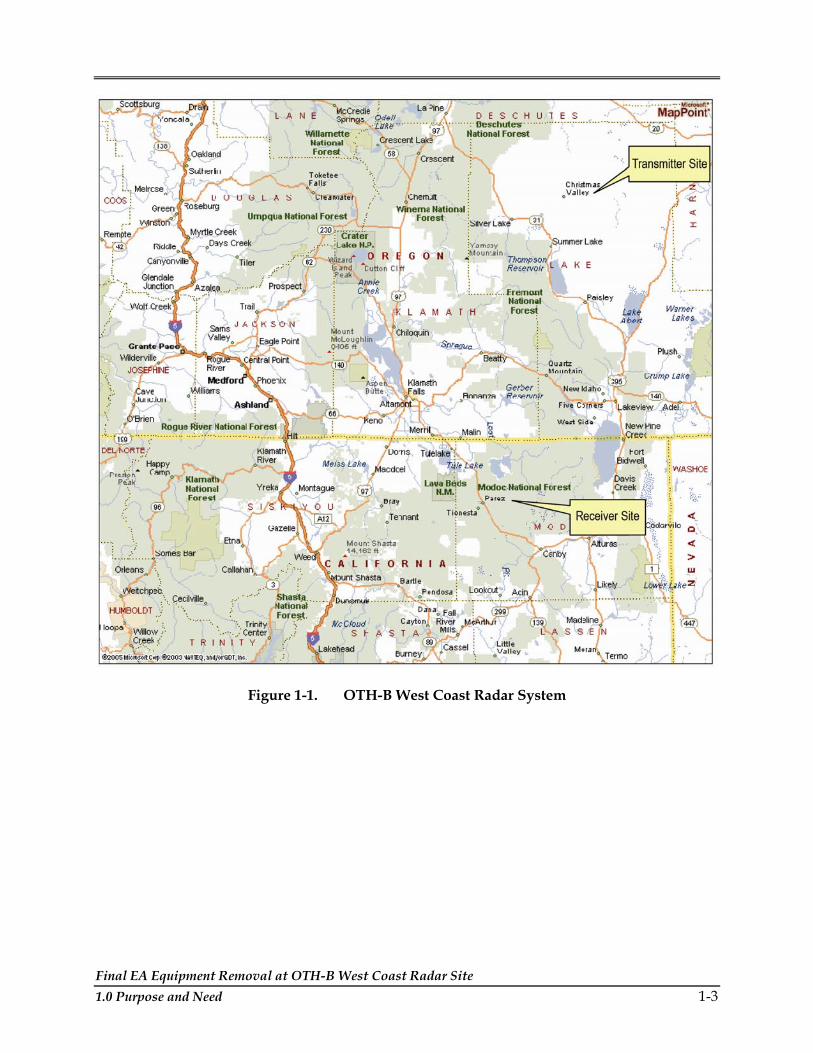
Final EA Equipment Removal at OTH-B West Coast Radar Site 1.0 Purpose and Need 1-3
Figure 1-1. OTH-B West Coast Radar System

Final EA Equipment Removal at OTH-B West Coast Radar Site 1-4 1.0 Purpose and Need
THIS PAGE INTENTIONALLY LEFT BLANK.

Final EA Equipment Removal at OTH-B West Coast Radar Site 2.0 Description of the Proposed Action and Alternatives 2-1
2.0 DESCRIPTION OF THE PROPOSED ACTION AND ALTERNATIVES
2.1 PROPOSED ACTION
The Proposed Action consists of disassembly of a total of 549 metal antenna structures, 717 acres of metal ground screen and 115,764 linear feet of wood fence and posts from the Christmas Valley, Oregon (see Figure 2-1) and Tulelake, California (see Figure 2-2) sites. At the transmitter site in Christmas Valley, Oregon, 45 miles of 3- to 6-inch diameter copper wave-guide tubes and balun domes would also be removed. Existing access roads, water systems, electrical lines owned by the local power companies and buildings would not be disturbed at either radar site. The Proposed Action would involve dismantling and removal of facility equipment, in accordance with applicable federal and state regulatory and safety requirements, to ensure proper handling and disposition of the equipment. Equipment from the facilities would be reused or recycled to the greatest extent practicable. The equipment removal would involve minimal ground disturbance and any areas that may be disturbed would be restored to prevent any long-term soil erosion. It is estimated that 618 tractor trailer loads, 293 loads from the transmitter site in Christmas Valley, Oregon, and 325 loads from the receiver site in Tulelake, California, would be generated with the removal of the equipment. Equipment removal is anticipated to take up to six months to complete.
EQUIPMENT REMOVAL OPTION ONE
With the implementation of this option, equipment removal of the antenna structures would occur in a manner such that the antenna structures could be re-assembled and reused by other DoD agencies if required; ground screen and fence and fence poles would be removed as identified below, and the fence post holes would be filled. It is estimated that approximately 15 personnel would be directly employed by the DRMO/DRMS contractor.
Antenna Removal. Contractor personnel using power wrenches would unbolt the segments from each other as the segments come down, including unbolting the last segments of the antenna from the 134 foundations. A mobile crane would be used for lifting the segments of the antenna onto the flatbed trucks. It is estimated that there would be 80 standard 40,000-lb, 18-wheel, flatbed, tractor-trailer truck loads for both the transmitter and receiver sites.
Fence Removal. The wood fence and wood posts would be pulled from the ground using a 20-ton excavator. This equipment would also be used to load the fence and fence posts on flatbed trucks. The wood fence and wood posts would be recycled through a certified scrap contractor hired by the DRMO/DRMS. It is estimated that there would be 145 standard 40,000 lb, 18-wheel, flatbed, tractor-trailer truck loads of fence and fence posts removed from each site. Holes left by the fence post removal would be filled by the contractor from an existing stockpile of on-site surplus native soil at Tulelake, California and from a local borrow pit for the

Final EA Equipment Removal at OTH-B West Coast Radar Site 2-2 2.0 Description of the Proposed Action and Alternatives
Figure 2-1 Christmas Valley, OR OTH-B Transmit Site

Final EA Equipment Removal at OTH-B West Coast Radar Site 2.0 Description of the Proposed Action and Alternatives 2-3
Figure 2-2 Tulelake, CA OTH-B Receive Site

Final EA Equipment Removal at OTH-B West Coast Radar Site 2-4 2.0 Description of the Proposed Action and Alternatives
Christmas Valley, Oregon site. It is estimated that approximately 120 cubic yards or eight 15-cubic yards truckloads would be needed.
Ground Screen Removal. A front-end loader will lift the metal ground screen up off of the ground as it is pushed into a roll by contractor personnel for placement upon trucks. The front-end loader has metal teeth protruding out from the edge of the bucket on the front-end loader that will pass under the wire for lifting purposes. The metal ground screen will be cut by hand with bolt cutters into 6-feet-wide sections in preparation for rolling. The metal ground screen will be recycled through a certified scrap contractor hired by the DRMO/DRMS. There would be 68 trucks from the transmitter site and 100 trucks from the receiver site. The trucks would be the standard 40 000 lb, 18-wheel, flatbed, semi tractor-trailer vehicles.
EQUIPMENT REMOVAL OPTION TWO
Implementation of the Proposed Action under this option would be accomplished by pulling the antenna structures to the ground and cutting them into pieces for transport to a recycler. Ground screen and fence and fence poles would be removed as identified below. It is estimated that approximately 12 personnel would be directly employed by the DRMO/DRMS contractor. Equipment proposed for use would include two hydraulic excavators with shears, two forklifts, one front end loader, one crane, one baler, and one fence puller. It is estimated that approximately 110 36-foot end dump tractor trailer loads would be generated with the removal of the equipment. Equipment removal is anticipated to take up to six months to complete.
Antenna Removal. An excavator would be used to pull down sections of the antenna structure. The antenna structures would then be cut with mechanical shears mounted on the excavator prior to loading onto tractor-trailers.
Fence Removal. The wood fence and wood posts would be pulled from the ground using post pulling that would pneumatically break the concrete and lift the post. This equipment would be used to load the fence and fence posts on flatbed trucks. The wood fence and wood posts would be recycled through a certified scrap contractor hired by the DRMO/DRMS. Holes left by the fence post removal would be filled in from stockpiled soils or from a nearby borrow pit.
Ground Screen Removal. Contractor personnel would cut the screen with a shear and use a tractor to roll the ground screen up off of the ground for placement upon trucks. The metal ground screen will be recycled through a certified scrap contractor hired by the DRMO/DRMS. There will be six end-dump 36-foot tractor-trailer trucks from each site.
Standard Construction Practices. To support the activities identified under either option the equipment removal contractor would establish an equipment and staging area at the transmitter and receiver sites for the storage of equipment prior to loading onto tractor trailers. This area would be within the existing gravel-covered parking areas adjacent to the existing operations and storage facilities at the transmitter and receiver sites. The contractor would bring to each site a portable diesel above-ground storage tank equipped with secondary

Final EA Equipment Removal at OTH-B West Coast Radar Site 2.0 Description of the Proposed Action and Alternatives 2-5
containment. The contractor would develop a Safety and Occupational Health Plan for the activities and maintain spill kits for the clean-up of accidental fuel and hydraulic fluid spills. Any solid waste generated during this process would be disposed of in a locally contractor-supplied dumpster located at each site. From the transmitter site in Christmas Valley, OR the solid waste would be taken by contractor to one of three transfer stations in Lake County or directly to landfills either in Lake County or Deschutes County. Solid wastes generated at the receiver site in Tulelake, CA would be taken by contractor to the landfill in Alturas CA. These landfills have adequate space to handle the minimal amount of waste anticipated to be generated from this action (personal communication Donnaway 2005; personal communication DuMilieo).
The Air Force, through its on-site contractor caretaker, would revegetate or otherwise treat any soil disturbances to prevent soil from eroding into adjacent native habitats. Revegetation would include reseeding with a BLM or USFS -approved seed mixture. The Air Force would also continue periodic maintenance, including vegetation removal, of the areas formerly occupied by any non-paved access roads and the ground screen until such time as restoration can be completed or long-term management responsibility of the site is established. With the implementation of the Proposed Action these areas would be avoided, and if equipment removal activities occur during the wet season, silt fencing shall be installed between vernal pools and construction areas to ensure that there are no impacts to vernal pools from soil erosion or runoff from construction sites.
Tractor trailers used to support this activity would travel on the existing graveled roads to the local highway system and use established truck routes through local towns. There are 9 miles of gravel roads at the transmitter site near Christmas Valley, Oregon and 11 miles at the receiver site near Tulelake, California. If necessary, the contractor would treat the gravel roads for dust control.
2.2 ALTERNATIVE ONE
Under this Alternative the Air Force would remove only the items directly related to the operation of the radar system, including 45 miles of copper wave-guide tubes and balun domes, 717 acres of ground screens, and 549 metal antenna structures. The wood perimeter fence and posts would remain in place. This Alternative would have the same equipment removal options as identified above for the Proposed Action and include the standard construction practices identified under Section 2.1.
2.3 NO ACTION ALTERNATIVE
Under the No Action Alternative, the Air Force would not remove this equipment at this time and the facilities would continue to be operated in caretaker status.
Final EA Equipment Removal at OTH-B West Coast Radar Site 2-6 2.0 Description of the Proposed Action and Alternatives
2.4 ENVIRONMENTAL IMPACT ANALYSIS PROCESS (EIAP)
The EIAP includes the review of all information pertinent to the Proposed Action and reasonable Alternatives and provides a full and fair discussion of potential consequences to the natural and human environment. The process includes involvement with the public and agencies to identify possible consequences of an action, as well as the focusing of analysis on environmental resources potentially affected by the Proposed Action and Alternatives.
2.4.1 Public and Agency Involvement
Executive Order (EO) 12372, Intergovernmental Review of Federal Programs, requires inter-governmental notifications prior to making a detailed statement of environmental impacts. Through the process of Interagency and Intergovernmental Coordination for Environmental Planning (IICEP), the proponent must notify concerned federal, state, and local agencies and allow them sufficient time to evaluate potential environmental impacts of a Proposed Action. Letters to relevant federal, state and local agencies were sent in March 2005 requesting their input on this proposal. An example IICEP letter and the mailing list is included in Appendix B to this EA.
The Air Force prepared and published newspaper advertisements in the Klamath Falls Herald and News on May 8, 2005 and in the Modoc County Record on May 12, 2005, announcing the availability of the Draft EA for a 30-day public review in local libraries and on the internet at www.cevp.com. Copies of the Draft EA were distributed to the California State Clearinghouse agency as the Single Point of Contact for federal facilities to allow for review by the appropriate state and local agencies and to the Oregon Department of Environmental Quality. Comments received on the Draft EA are included in Appendix B and the text of the Final EA has been modified in response to the comments. These modifications have not lead to any substantial changes to the EA; however the Air Force will fill all fence post holes associated with the fence removal.
2.4.2 Regulatory Compliance
This document was prepared in accordance with the requirements of the NEPA of 1969,, CEQ Regulations for Implementing the Procedural Provisions of NEPA, and 32 CFR 989, et seq., Environmental Impact Analysis Process (formerly known as Air Force Instruction [AFI] 32-7061). The intent of NEPA is to protect, restore, and enhance the environment through well-informed federal decisions.
Implementation of the Proposed Action or the Alternatives requires coordination with several regulatory agencies. Compliance with the Endangered Species Act (ESA) involves communication with the Department of the Interior (delegated to the U.S. Fish and Wildlife Service [USFWS]) in cases where a federal action could affect the listed threatened or endangered species, species proposed for listing, or species that could be candidates for listing. Coordination with the appropriate USFWS agencies, as well as their state counterparts,
Final EA Equipment Removal at OTH-B West Coast Radar Site 2.0 Description of the Proposed Action and Alternatives 2-7
informing them of the Proposed Action and the Alternatives and requesting data regarding applicable protected species is underway.
The preservation of cultural resources falls under the purview of the State Historic Preservation Office (SHPO), as mandated by the National Historic Preservation Act (NHPA) (16 U.S.C. §470 et seq.) and it’s implementing regulations. A Section 106 consultation package is being prepared by the Air Force for submittal to the California and Oregon SHPOs informing them of the Proposed Action and Alternatives.
2.4.3 Permit Requirements
This EA has been prepared in compliance with NEPA; other federal statutes, such as the Clean Air Act (CAA) and the Clean Water Act (CWA); Executive Orders (EOs), and applicable state statutes and regulations. Table 2-1 summarizes applicable federal, state, and local permits necessary for implementation of the Proposed Action or the Alternatives. In addition to this EA being prepared for the decision maker and the interested public, it is also a tool for Air Force personnel to ensure compliance with all regulatory requirements from proposal through project implementation.
Table 2-1. Environmental Related Regulatory Requirements
Type of Permit or Regulatory Requirement Requirement Agency
Endangered Species Act
Required to consult on impacts of project implementation on federally listed or proposed threatened and endangered species
U.S. Fish and Wildlife Service
Clean Water Act National Pollutant Discharge Elimination System – General Storm Water Permit
California State Regional Water Quality Control Board, North Coast Region
National Historic Preservation Act Section 106
Consultation with State Historic Preservation Offices
California and Oregon State Historic Preservation Offices
2.5 COMPARISON OF ALTERNATIVES
Table 2-2 summarizes the potential environmental impacts of the Proposed Action, Alternative One, and the No Action Alternative, based on the detailed impact analyses presented in Chapter 4.0. In no instance would the potential environmental consequences be significant with the implementation of the Proposed Action or Alternatives. Under the No Action Alternative, no changes would be made to the existing structures and the sites would remain in caretaker status.

Final EA Equipment Removal at OTH-B West Coast Radar Site 2-8 2.0 Description of the Proposed Action and Alternatives
Table 2-2. Summary of Potential Environmental Impacts of Proposed Action and Alternatives
Resource Proposed
Action (Option One)
Proposed Action
(Option Two)
Alternative One (Option One)
Alternative One (Option Two)
No Action Alternative
Air Quality — — — — 0
Cultural Resources — — — — 0
Biological Resources - Vegetation - Wildlife
— +
— +
— —
— —
0 0
Grazing
- Transmitter Site - Receiver Site
— —
— —
0 0
0 0
0 0
Geology and Soils — — — — 0 — Adverse, but not significant impact + Positive, beneficial impact 0 No change

Final EA Equipment Removal at OTH-B West Coast Radar Site 3.0 Affected Environment 3-1
3.0 AFFECTED ENVIRONMENT
This chapter describes relevant existing environmental conditions at the OTH-B transmitter site near Christmas Valley, Oregon and the receiver site located near Tulelake, California for resources potentially affected by the Proposed Action, Alternative One and No Action Alternative described in Chapter 2.0. In compliance with guidelines contained in the NEPA, CEQ regulations, and the requirements of the NEPA of 1969 (42 USC 4321-4347), CEQ Regulations for Implementing the Procedural Provisions of NEPA (40 CFR §§ 1500-1508), and 32 CFR Part 989, et seq., Environmental Impact Analysis Process (formerly known as Air Force Instruction [AFI] 32-7061), the description of the existing environment focuses on those environmental resources potentially subject to impacts. These resources and conditions are: Air Quality, Cultural Resources; Biological Resources, Grazing and Geology and Soils. The expected geographic scope of potential impacts, known as the region of influence (ROI), is defined for each resource analyzed.
RESOURCES ELIMINATED FROM DETAILED CONSIDERATION
Several resources were not evaluated in this EA because it was determined that implementation of the Proposed Action or Alternatives is unlikely to affect them. These resources include Airspace, Land Use, Water Resources, Safety and Occupational Health, Hazardous Materials and Waste Management, and Socioeconomics and Environmental Justice. A brief explanation of the reasons why each resource has been eliminated from further consideration in this EA is provided below.
Airspace. The Proposed Action and the Alternatives do not involve aircraft or airspace modifications.
Land Use. The mission at the site will remain in caretaker status therefore land use would not change.
Water Resources. The Proposed Action would not increase water requirements nor affect the existing on-site wells; therefore there will be no significant impact on water resources. Neither the transmitter site nor receiver site is located in a 100-year floodplain.
Safety and Occupational Health. Implementation of the Proposed Action or Alternative One would not create any unique or unusual safety issues during process of equipment removal. ACC requires as part of each contract that the National Fire Protection Association, Life Safety Code be followed and that the contractor provides barricades, traffic control signs and construction safety signs that conform to the Manual of Uniform Traffic Control Devices for Streets and Highways and the U.S. Army Corps of Engineers safety and health requirements Manual EM 385-1-1.
Hazardous Materials and Waste Management – There would be no unique hazardous materials involved in the Proposed Action or Alternative One and no hazardous waste

Final EA Equipment Removal at OTH-B West Coast Radar Site 3-2 3.0 Affected Environment
generated by this action. Amounts of solid wastes not recycled under this action are anticipated to be inconsequential amounts that would be managed under the current disposal contracts.
Socioeconomics and Environmental Justice. The sites will remain in caretaker status after the Proposed Action or the Alternatives are implemented therefore there will be no significant impact on socioeconomics.
Environmental justice addresses the disproportionately high and adverse human health or environmental effects on minority and low-income populations. Determination of disproportionately high and adverse human health effects are established by identifying the impact on the natural or physical environment and influence on minority and low-income populations. Because the Proposed Action and the Alternatives take place within the boundaries of existing military facilities, and minority or low-income populations would not be significantly affected by implementation of the Proposed Action, environmental justice was eliminated from further analysis.
3.1 AIR QUALITY
Identifying the affected area for an air quality assessment requires knowledge of sources of air emissions, pollutant types, emission rates and release parameters, proximity to other emissions sources and local conditions. Refer to Appendix C, Air Quality, for review of air quality and associated methodologies used for emissions calculations.
Definition of the Resource
Air quality is determined by the type and amount of pollutants emitted into the atmosphere, the size and topography of the air basin and the prevailing meteorological conditions. The levels of pollutants are generally expressed on a concentration basis in units of part per million (ppm) or micrograms per cubic meter (µg/m³). For this air quality analysis, the ROI centers on Tulelake, located in Modoc County, California, and Christmas Valley in Lake County, Oregon. These ROI have been chosen since the proposed activities will occur specifically in these two counties.
The baseline standards for pollutant concentrations are the National Ambient Air Quality Standards (NAAQS) and state air quality standards. These standards represent the maximum allowable atmospheric concentration that may occur and still protect public health and welfare. Further discussion of the NAAQS and state air quality standards are included in Appendix C.
The emissions sources analyzed for the Proposed Action and Alternatives include heavy construction machinery, semi-tractor trailer rigs, dust (particulate matter) from unpaved roads, and emissions associated with vehicle exhaust from contracted employee’s personal vehicles. Since these emissions will occur as an isolated event over a large area the emissions may be classified and analyzed as an area source, which can then be compared to the appropriate county’s emissions.

Final EA Equipment Removal at OTH-B West Coast Radar Site 3.0 Affected Environment 3-3
For analysis purposes the emissions from the Proposed Action and Alternatives will be compared to the respective county emissions obtained from the U.S. Environmental Protection Agency’s 1999 National Emissions Inventory (NEI), which are presented in Tables 3-1 and 3-2. The county data includes emissions data from point sources, area sources, and mobile sources. Point sources are stationary sources that can be identified by name and location. Area sources are point sources whose emissions are too small to track individually, such as a home or small office building or a diffuse stationary source, such as wildfires or agricultural tilling. Mobile sources are any kind of vehicle or equipment with gasoline or diesel engine, an aircraft, or a ship. Two types of mobile sources are considered on-road and non-road. On-road consists of vehicles such as cars, light trucks, heavy trucks, buses, engines, and motorcycles. Non-road sources are aircraft, locomotives, diesel and gasoline boats and ships, personal watercraft, lawn and garden equipment, agricultural and construction equipment, and recreational vehicles (USEPA, 2005).
Table 3-1. Baseline Emissions Inventory for Modoc County, California
Emissions (tons/year) Source Type
CO NOX PM10 SO2 VOC
Point Source 0 0 0 0 0
Non-Road Source 841 1,097 46 90 110
On Road 5,738 422 10 5 493
Area 7,838 338 8,786 545 987 Modoc County Total 14,417 1,857 8,842 639 1,591
Source: USEPA, 1999
Table 3-2. Baseline Emissions Inventory for Lake County, Oregon
Emissions (tons/year) Source Type
CO NOX PM10 SO2 VOC
Point Source 0 0 0 0 0
Non-Road Source 3,378 279 83 30 1,152
On Road 9,086 1,083 24 27 887
Area 19,624 709 4,276 217 2,576 Lake County Total 32,088 2,071 4,383 275 4,616 Source: USEPA, 1999
Air emissions associated with equipment removal activities are the main issues generated by the Proposed Action and Alternatives, which will be the focus of the air analysis in Chapter 4. For the analysis of the Proposed Action and Alternatives a threshold on an individual pollutant-by-pollutant basis has been established and is presented in Appendix C, Tables C-2 and C-3. The individual pollutant emissions from the project would not exceed 10 percent of the total Modoc or Lake County emissions for each corresponding pollutant as represented in the USEPA 1999 NEI (Air Force, n.d.).
Final EA Equipment Removal at OTH-B West Coast Radar Site 3-4 3.0 Affected Environment
3.2 CULTURAL RESOURCES
Cultural resources are defined as any prehistoric or historic district, site, building, structure, or object considered important to a culture, subculture, or community for scientific, traditional, or religious reasons. They can be divided into three categories: archaeological; architectural/ engineering; and traditional.
Archaeological resources are locations where prehistoric or historic activity measurably altered the earth, or produced deposits of physical remains. Architectural/engineering resources include standing buildings, dams, canals, bridges, and other structures of historic significance. Architectural/engineering resources generally must be more than 50 years old to be considered for inclusion in the National Register of Historic Places (NRHP). However, more recent structures, such as Cold War era resources, may warrant protection if they manifest “exceptional significance” or the potential to gain significance in the future. Traditional resources are resources associated with cultural practices and beliefs of a living community that are rooted in its history and are important in maintaining the continuing cultural identity of the community.
The ROI for cultural resources is the area within which the Proposed Action has the potential to affect existing or potentially occurring archaeological, architectural/engineering, or traditional resources. For the Proposed Action and Alternatives, the ROI is defined as the Tulelake Receiver Site in California and the Christmas Valley Transmitter Site in Oregon.
3.2.1 Identified Cultural Resources
TRANSMITTER SITE – CHRISTMAS VALLEY, OREGON
The Christmas Valley Transmitter Site occupies land that is managed by the Air Force and has been withdrawn from public use by the of the Bureau of Land Management (BLM) Lakeview Resource Area. The area is commonly referred to as Buffalo Flat. A portion of the Buffalo Flat transmitter site area was surveyed for cultural resources prior to the construction of the installation (Air Force, 1983). The survey located 20 Native American sites as well as hundreds of isolated Native American artifacts, yielding a site density of approximately one site every 42 acres. Diagnostic artifacts suggest that the area was first occupied between 7,500 to 10,000 years before present. The site density is likely a representative sample of the entire Buffalo Flat area (Air Force, 1983). At the time of the environmental assessment for the construction of the OTH-B facilities, cultural resource concerns were addressed and cleared for both the construction activities and the associated land use withdrawal. As a result, an extensive mitigation plan was not required (Air Force, 1991).
A search of the National Register Information System (NRIS) for Lake County, Oregon located 16 properties listed on the National Register of Historic Places (NRHP). None are within or adjacent to the project area (NRIS, 2005).

Final EA Equipment Removal at OTH-B West Coast Radar Site 3.0 Affected Environment 3-5
Traditional resources have not been identified within the Oregon OTH-B radar project area.
RECEIVER SITE – TULELAKE, CALIFORNIA
The Tulelake Receiver Site is located in the Rimrock Lake area, on the Doublehead Ranger District of the Modoc National Forest, Siskiyou County, California. The USFS considers this area to have a high sensitivity for the presence of cultural resources. In compliance with procedures outlined in Section 106 of the National Historic Preservation Act (NHPA), the project area was surveyed prior to facility construction. The survey was preformed by Basin Research in 1985 and 1986 (Air Force, 1987), examining 5,430 acres. The work identified a total of 133 Native American sites, 59 Native American isolates/localities, one historic grave, and two historic isolate/localities. Diagnostic artifacts located by the survey place the earliest occupation of the area at approximately 7,000 years before present, but the work of others in adjacent areas suggests people may have been in the region as early as 10,000 years before present (Air Force, 1987).
In June of 1987, a Memorandum of Agreement (MOA) was signed between the Air Force, USFS, and the California State Historic Preservation Office (SHPO) that stipulated mitigation measures, including additional archaeological survey. In compliance with the MOA, the Modoc National Forest has conducted five additional surveys, locating 75 archaeological sites on 1,855 acres (personal communication, Gates 2005).
A search of NRIS for Siskiyou County, California located 17 properties listed on the NRHP. None are within or adjacent to the project area (NRIS, 2005).
Traditional resources have not been identified within the California OTH-B radar project area.
TRANSMITTER AND RECEIVER SITES – COLD WAR CONTEXT OF INSTALLATIONS
In general, architectural/engineering resources need to be at least 50 years old to be considered for inclusion on the NRHP. Constructed between 1986 and 1989, the OTH-B Radar facilities in both Oregon and California are less than 50 years old, but they were completed toward the end of the National Park Service-defined Cold War era (1945-1989). As such, they could be eligible to the NRHP under special considerations afforded to Cold War era architectural and engineering resources. While the installations were operational for a period of only three months (November 1990-January 1991) before being placed in caretaker status, they are unique and represent important technological developments, and could merit listing on the NRHP (Air Force, 1991).
3.3 BIOLOGICAL RESOURCES
The biological resources section incorporates living, native or naturalized, plant and animal species and the habitats within which they occur. For purposes of the impact analysis, biological resources are divided into three major categories: (1) terrestrial communities,

Final EA Equipment Removal at OTH-B West Coast Radar Site 3-6 3.0 Affected Environment
(2) wetland and freshwater aquatic communities, and (3) threatened, endangered, and special status species/communities. The OTH-B radar receiver and transmitter facilities were installed beginning in 1986. The receiver site is located near Tulelake, California in the vicinity of Rimrock Lake. The transmitter site is located near Christmas Valley, Oregon.
Several existing documents were used to prepare this report and are incorporated by reference. The 1983 Draft Environmental Impact Statement (EIS) described the biological resources that would be affected by construction of the transmitter and receiver sites and identified appropriate mitigation measures for addressing those impacts (Air Force, 1983). An EA prepared in 1991 to address reduced operations at the sites described the conditions at both sites following construction (Air Force, 1991). In 1991, mitigation to address impacts to vernal pools and dry lake habitats at the Tulelake receiver site was implemented. This was followed by several years of monitoring including annual monitoring reports and a Final Monitoring Report prepared in 1996 (Air Force, 1996). The California Natural Diversity Database (CNDDB) was reviewed for the Tulelake receiver site (Rimrock Lake and Lone Pine Butte USGS Quad Reports) in California (California Department of Fish and Game [CDFG], 2004a). The Oregon Natural Heritage Information Center website (Hhttp://oregonstate.edu/ornhic/ H) was also reviewed. In addition, reconnaissance-level surveys of the Tulelake receiver site and Christmas Valley transmitter site were conducted in October 2004. Refer to Appendix D for a list of the plant and animal species observed at the OTH-B Radar receiver and transmitter sites and copies of species lists from USFWS offices for Lake County, Oregon and Modoc County, California.
The ROI for biological resources includes the area currently occupied by the antenna arrays, the ground screen, and the surrounding fencing. Access to the structures would be limited to existing paved and gravel roads, including roads immediately adjacent to the perimeter fences, which would remain in place under the Proposed Action. The Air Force would retain caretaker status over the sites until such time as restoration can be completed and/or the land turned over to the landowner/management agency.
Transmitter Site – Christmas Valley, Oregon
TERRESTRIAL COMMUNITIES
The Christmas Valley site is located in Lake County, Oregon. The area is classified as High Lava Plain and the terrain generally consists of lava flows and dry lake beds. The region consists of rolling rangeland at an altitude of 4,350 to 4,680 feet, although the topography is flat in the vicinity of the transmitter site. The area receives little precipitation and is subject to extreme temperatures, with cold winters and hot summers. There are no active lakes or streams in the project area (Air Force, 1983).
The vegetation in the vicinity of the Christmas Valley transmitter site is a treeless, shrub-dominated plain or shrub steppe. The most common vegetation type is big sagebrush scrub dominated by big sagebrush (Artemisia tridentata) and greasewood (Sarcobatus vermiculatus). Other less common shrubs include spiny hopsage (Grayia spinosa), green and grey rabbitbrush

Final EA Equipment Removal at OTH-B West Coast Radar Site 3.0 Affected Environment 3-7
(Chrysothamnus vicidiflorus, C. nauseosus), winterfat (Krascheninnikovia lanata), and horsebrush (Tetradymia sp.). Herbaceous species are sparse and include native species such as Thurber's needle-grass (Nassella thurberianum), creeping wild rye (Leymus triticoides), bottlebrush squirreltail (Elymus elymoides), Idaho fescue (Festuca idahoensis), and peppergrass (Lepidium densiflorum), and non-native cheat grass (Bromus tectorum) and bluebunch wheat grass (Agropyron spicatum). Grey and green rabbitbrush are the dominant plants in areas that have been subject to past disturbance. Other plants found in the rabbitbrush dominated community include big sagebrush, cheat grass, tansy-mustard (Descurainia sp), and Great Basin wildrye (Leymus cinereus) (Air Force, 1983).
The transmitter radar structures, support facilities, and perimeter fence occupy about 2,800 acres total over three enclaves. Within the fenced area surrounding the radar structures, the vegetation was removed from about 25 acres for structures and the vegetation cleared from approximately 250 acres. The cleared area was graded and a base material (cinder) placed on the surface to accommodate the ground screen. The additional acreage included within the perimeter fence was left in natural condition and remains an undisturbed native shrub-dominated community. The area that supports the ground screen and radar structures is maintained as an open herbaceous vegetation community. The maintenance primarily includes herbicide application once a year, which would continue while the Air Force has caretaker status of the property or until disturbed areas are revegetated.
The area provides limited support for wildlife species. No unusual wildlife features were identified at this site in the 1983 EIS. Bird species that frequent the area include Brewer's sparrow, sage sparrow, horned lark, common raven, sage thrasher, northern shrike, red-tailed hawk, American kestrel, and northern harrier. Due to the lack of open water or wetlands in the immediate vicinity of the project site, waterfowl do not frequent the area except in migratory flights over the site (Air Force, 1991). Sage grouse are typically found in the big sagebrush habitat type throughout the region, but the habitat in the vicinity of the transmitter site was not identified as suitable habitat for winter or year-round use for this species (Air Force, 1983).
No important muledeer migration routes were identified in the project area although mule deer tracks were observed on the site during a site visit in 2004. Pronghorn antelope that winter in agricultural lands in the project vicinity may move through the area in fall and spring, but no migration routes were identified in the project area and no winter use by pronghorn was identified. The three antennae arrays were arranged with space between them to minimize restrictions in the movement of muledeer and pronghorn antelope. Large carnivores such as black bear and mountain lion were not identified in the project area. Typical mammal species include those that commonly occur in Oregon shrub-steppe habitats such as coyote, bobcat, badger, black-tailed jack rabbit, and small rodents (Air Force, 1983).
While few reptile species are expected to occur in the project area, the most likely include the sagebrush lizard, gopher snake and western rattlesnake (Air Force, 1983). No permanent or

Final EA Equipment Removal at OTH-B West Coast Radar Site 3-8 3.0 Affected Environment
long-term water resources are present; therefore, no amphibians or fish species are found in the project area.
WETLAND AND FRESHWATER AQUATIC COMMUNITIES
There are no streams or other watercourses in the area. The only water sources present in the project vicinity are small depressions that hold water for brief periods after snow melt or heavy rains. However, no wetlands were identified in the area and these areas likely do not hold water for sufficient time to support wetland vegetation or habitat.
THREATENED, ENDANGERED, AND SPECIAL STATUS SPECIES/COMMUNITIES
There are no federally-listed plant species reported from or expected to occur at the project site. The 1983 Draft EIS for the project stated that surveys for rare plant species were planned for 1983 prior to construction. It is assumed that these surveys were conducted because the 1991 EA stated that there were no rare plants identified as a concern for this area. Sensitive plant surveys were not conducted for this action, but none are expected because the project would be limited to currently disturbed and maintained areas.
Sand dunes, which are known to support valuable vegetation and wildlife habitats, are present to the north of the Christmas Valley transmitter site, but these areas were avoided during the original installation and would not be affected by the Proposed Action.
There were no sensitive wildlife species identified in the 1991 EA or the 1983 draft EIS for this site.
Receiver Site – Tulelake, California
TERRESTRIAL COMMUNITIES
The Tulelake receiver site is located in Modoc County, California. It is approximately 10 miles south of Clear Lake Reservoir on the Modoc Plateau within the Modoc National Forest. The region is characterized by hot summers, cold winters, and low precipitation, most of which falls as snow. No permanent streams or water courses are present in the project area, although surface water may remain for several months in numerous vernal pools and dry lakes that are present in the project vicinity (Air Force, 1983).
The predominant vegetation type in the vicinity of the Tulelake receiver site, including the Modoc Plateau, is western juniper forest. Western juniper is believed to be increasing in numbers and in geographic range due to factors including fire suppression and climate change. Western juniper forest is found throughout the project vicinity except in areas that have been cleared or that have high clay or wet areas. Within the areas in the immediate vicinity of the receiver facilities, the vegetation primarily consists of big sagebrush scrub with scattered western juniper (Juniperus occidentalis) that forms an open canopy. This area appears to be transitional between sagebrush scrub and the western juniper forest. Other species present in
Final EA Equipment Removal at OTH-B West Coast Radar Site 3.0 Affected Environment 3-9
the juniper/big sagebrush community include bitter-brush (Purshia tridentata), low sagebrush (Artemisia arbuscula), rabbitbrush, Idahoe fescue, and bottlebrush squirreltail. Low sagebrush is present in areas with clay soils overlaying hardpan. Other species associated with low sagebrush include bluebunch wheatgrass, bluegrass (Poa secunda), and several species of buckwheat (Eriogonum spp.) (Air Force, 1983).
The receiver structures and fencing occupy approximately 1,200 acres at three separate enclaves. Within the fenced area surrounding the radar structures, approximately 25 acres of vegetation was removed during the original construction and 250 acres cleared for placement of the ground screen total for all three sites. Within the fenced area, the surface covered by the ground screen is currently maintained as an open herbaceous vegetation community. Because the maintenance primarily includes herbicide application twice a year (as opposed to mowing) there is no damage to the ground screen. Herbicide application of this area would continue while the Air Force has caretaker status of the property or until the disturbed areas are revegetated. Although the area is periodically sprayed, occasional small juniper and other shrubs were observed in the area growing over the ground screen during the site visit in October 2004. However, it is not likely these would be allowed to survive to full growth.
The area supports numerous wildlife typical of the Modoc Plateau, including mule deer, pronghorn antelope, black bear, mountain lions, coyote, bobcat, badger, and weasel. Small mammals include black-tailed jackrabbits, Nuttall's cottontail rabbits, woodrats, chipmunk, northern pocket gopher, and deer mice. Bird species found in the project vicinity include red-tailed hawk, American kestrel, golden eagle, sage grouse, Brewer's sparrow, Loggerhead shrike, mourning dove, common raven, scrub jay, Pinyon jay, northern flicker, American robin, western bluebirds, yellow-rumped warbler, and cedar waxwing. The most abundant reptile is sagebrush lizard, although gopher snake and western rattlesnake are present (Air Force, 1983).
An extensive mitigation plan was prepared by the Air Force in 1987 and included habitat improvements, vegetation reclamation, vernal pool creation, and studies of numerous vegetation, wetland, wildlife and game issues. The Air Force entered into a memorandum of understanding with the USFS in June 1987 to formerly address the mitigations, which were administered by the USFS (Air Force, 1991).
WETLAND AND FRESHWATER AQUATIC COMMUNITIES
There are no streams or watercourses in the area, but there are several vernal pools including created and restored vernal pool areas outside of and adjacent to fences associated with the radar structures. The plant species found in the vernal pools are uniquely adapted to the water regime and include dowingia (Dowingia spp.), owl's clover (Castelleja campestris), wooly heads (Psilocarphus sp.), popcorn-flower (Plagiobothrys sp.), Mathias' button celery (Eryngium mathiasae) and tarweed (Madia sp.). In addition, small dry meadows are present in the project area in the northern part of the site. Species associated with this habitat include navarretia (Navarretia spp.), annual hairgrass (Deschampsia dantonioides), brodiaea (Brodiaea spp.), and non-native bird’s foot trefoil (Lotus corniculatus).
Final EA Equipment Removal at OTH-B West Coast Radar Site 3-10 3.0 Affected Environment
Freshwater aquatic habitat provides important resources to many wildlife species and is especially critical in the typically dry conditions found in the project vicinity. Wetlands provide not only drinking water for wildlife but also cover, refuge, and foraging opportunities for species common to the area and described above.
In 1991, the Air Force implemented a mitigation plan to create a total of 41 pools totaling 5.5 acres to replace 26 vernal pools lost by the construction of the Tulelake receiver site. In addition, four sites totaling 1.09 acres were restored or enhanced for a total mitigation of 6.64 acres (which exceeded the mitigation requirement of 4.5 acres). Based on the results of 5 years monitoring, the created and restored successfully met or exceeded the goals set forth in the mitigation plan. In addition to replacing impacted plant communities, the created and restored vernal pools are utilized by wildlife and birds that are attracted to the source of freshwater and food. The created pools support several species of crustaceans common to vernal pools including copepods, cladocerans, fairy shrimp (Brachinecta dissimilis) and tadpole shrimp (Lepidurus couesii) (Air Force, 1996). The two species of shrimp are not among those listed as rare, threatened or endangered (CDFG, 2004).
THREATENED, ENDANGERED, AND SPECIAL STATUS SPECIES/COMMUNITIES
No federal or state-listed rare, threatened or endangered plant species have been reported from or are expected to occur in the Tulelake receiver site. No other rare, threatened or endangered plant species were identified for the receiver site during the EIS process prior to construction. However, one plant species is found in the project area that is currently included in the California Native Plant Society's Inventory of Rare and Endangered Plants of California (CNPS, 2001). Profuse flowered pogogyne (Pogogyne floribunda) is a CNPS List 1B (rare and endangered in California and elsewhere) species reported from the project vicinity (Air Force, 1996). This is an annual herb in the mint family that is associated with vernal pools, including the vernal pools at the receiver site. In addition, the northern basalt vernal pools that occur in the project area are considered a sensitive habitat type by the CDFG (CDFG, 2004).
One other plant species, Mathias' button celery (Eryngium mathiasiae), had been identified as a sensitive plant species potentially occurring in the project area in the 1983 EIS. This species is found at the receiver site in associated with the vernal pools; however, it is no longer identified as a sensitive species by the CNPS as it is considered too common (CNPS, 2001).
The sage grouse is a game species of special concern on the Modoc Plateau. This species is primarily dependant on big sagebrush habitat for feeding, cover and brood-rearing. Areas of low, sparse vegetation are used for breeding displays and strutting grounds. The species was identified as likely to occur in the area of the receiver site although habitat use was expected to be light due the scarcity of big sagebrush habitat. No strutting grounds were identified in the project site, although they were known to be present 1.5 miles to the northwest, north and northeast of the receiver site (Air Force, 1983). It is not known if the sage grouse uses any of the areas currently occupied by the receiver site.
Final EA Equipment Removal at OTH-B West Coast Radar Site 3.0 Affected Environment 3-11
Bald eagles, a federally-listed endangered species, pass through the area on their way to Clear Lake Reservoir, an importing wintering habitat for this species (Air Force, 1983). This species is unlikely to be present on the project site on a regular basis.
3.4 GRAZING
The ROI for each site includes the area currently occupied by the antenna structures, the ground screen, and the surrounding wooden fencing. Existing access roads, water systems, electrical lines and buildings would not be disturbed at either radar site.
Transmitter Site – Christmas Valley, Oregon
The transmitter site occupies land which is managed by the Air Force and has been withdrawn from public use by the U.S. Bureau of Land Management (BLM). The site was formerly part of a large grazing allotment (#10103) (personal communication Rasmussen 2005). The facility’s three antennas and related structures require approximately 1,200 acres. The transmitter site is locally referred to as Buffalo Flats and is located within the Lakeview Resource Area managed by the BLM office in Lakeview, Oregon. The area is part of a BLM grazing allotment used by the JR Simplot Trust (formally ZX Ranch (personal communication Rasmussen 2005), but the OTH-B wooden perimeter fencing does not serve as a part of the allotment boundary fencing. The existing Allotment Management Plan (AMP) provides guidance on livestock grazing such as authorized number of livestock, season of use, selected grazing strategy, and range improvement plan. The grazing productivity of the study area is about 32 acres/animal unit month (AUM) (Air Force, 1983). The Lakeview Resource Management Plan (RMP) 2002 provides a set of comprehensive, long-range decisions concerning the use and management of resources administered by the BLM.
Receiver Site – Tulelake, California
The receiver site is leased from the U.S. Forest Service (USFS), Doublehead Ranger District, and is located within the Modoc National Forest in the Clear Lake Management Area. The facility consists of three antennas and related structures situated on approximately 2,800 acres. The Air Force prepared a mitigation plan which set forth wildlife and livestock compensation measures to replace lost forage and restrictions on timing of construction due to lambing (Air Force 1987). The site is currently situated in Carr C and H grazing allotments. The Carr C and H AMP provides guidance on the authorized number of livestock, season of use, selected grazing strategy, range improvement plan, and all other management objectives identified as a result of the Environmental Assessment and Decision Notice 1996 (USFS, 2005).
A two-unit system is employed with the four pastures comprising the Dalton Unit and seven pastures in the Boles Unit. An average of 8,090 head months is available for livestock use of the 4-year grazing cycle. Management requirements are in place to prevent soil compaction, damage to vegetation, and protection of riparian areas. Routine maintenance of range (wire and wooden) fences are the responsibility of the grazing permittee (USFS, 2005).

Final EA Equipment Removal at OTH-B West Coast Radar Site 3-12 3.0 Affected Environment
3.5 GEOLOGY AND SOILS
This section includes topography, geology, and soils. Geologic resources of an area typically consist of surface and subsurface materials and their inherent properties. The term “soils” refers to unconsolidated materials formed from the underlying bedrock or other parent material. Soils play a critical role in both the natural and human environment. Soil drainage, texture, strength, shrink-swell potential, and erodibility all determine the suitability of ground to support man-made structures and facilities.
These resources may have scientific, historical, economic, and recreational value. The ROI for geology and soils includes the area immediately underlying the transmitter site located near Christmas Valley, Oregon and the receiver site located near Tulelake, California.
Transmitter Site – Christmas Valley, Oregon
GEOLOGY
The transmitter site in Christmas Valley, Oregon is located in the relatively flat, dry bed of a large late Pleistocene lake, within the Fort Rock Basin. Noted for its north-trending fault block mountains that enclose large basins, the Basin and Range Province in Oregon stretches from the Cascade Mountain Range in the west to the Owyhee Uplands in the east. The development of rock units in the basin covers the Pliocene, Pleistocene, and Recent epochs. The oldest exposed rock unit is the Picture Rock Basalt, a thick sequence of basaltic lava flows and interbedded pyroclastic materials (i.e., volcanic materials that were ejected in a volcanic eruption). Much of the basin floor is underlain at shallow depths by the Fort Rock Formation, which is comprised of four rock types. Listed in descending order of abundance, these rock types are pyroclastics, diatomite (i.e., volcanic clay), basaltic agglomerate, and basaltic lava. The pyroclastic rocks typify the Fort Rock Formation, which occurs as bedded and massive non-bedded layers. Diatomite and ashy diatomite occur among the southern edges of the basin in the Seven Mile Ridge/Table Rock Butte areas and are exposed in dry washes. The basalt occurs as flows or agglomerates in layers about 5 to 15 feet thick. The flows of this unit generally display columnar jointing and are vesicular at the top.
No faults are recorded or visible within the project area boundaries; however, many northwest trending faults are present in the surrounding hills. Several miles to the north and east are large areas of dune sand composed of ash pumice and rock forming minerals, resulting from alluvium and surface wind-blown deposits. The project area is located at an elevation of approximately 4,300 feet above mean sea level.
SOILS
The Christmas Valley is dominated by the Flagstaff soil series, which consist of poorly drained silt loam over silty clay loam, sodic soils, and underlying hardpans. Formed in silty lake sediments, these soils occur on 0 to 1 percent slopes in the project area. Typically, the surface
Final EA Equipment Removal at OTH-B West Coast Radar Site 3.0 Affected Environment 3-13
layer consists of a silt loam, approximately 3 inches thick, with underlying subsoil of silty clay loam, approximately 11 inches thick. A weakly to strongly cemented hardpan occurs at a depth of about 14 inches. The swell-shrink potential is low to moderate and permeability is low, resulting in periodic shallow spring flooding. The flat terrain results in very slow runoff and a low water erosion hazard. No streams (perennial or ephemeral) traverse the project site, nor are surface drainage patterns apparent within several miles.
A small portion of the project area is covered by the Bonnick soil series, consisting of excessively drained soils formed in gravelly, sandy sediments weathered from volcanic rocks. Typically, the surface layer consists of loamy sand, about 7 inches thick, whereas the subsoil consists of gravelly loamy sand, approximately 13 inches thick. Soils beneath that depth consist of gravelly loamy sand and gravelly coarse sand, to depths over 40 inches. A hardpan layer is present below a depth of 40 inches.
Wind erodibility, or the potential for soil blowing, is affected by the soil texture, organic matter, calcium carbonate content, mineralogy, and moisture content. The erodibility of these soils by wind is moderate. The type of ground cover plays an important role in controlling the incidence of fugitive dust. Winds generally are of constant, mild velocities originating from the south-southwest. While some gusting does occur during the spring and summer months, most of the region remains relatively dust-free due to the thick growth of low sagebrush.
Receiver Site – Tulelake, California
GEOLOGY
The receiver site in Tulelake, California is located on the Modoc Plateau, a raised tableland, located in northern California. The Modoc Plateau extends east to Goose Lake, north to the Oregon border, and west to the Cascade Range. This plateau was formed during the Miocene period, as a result of basalt flows originating from long fissures. Because the lava flowed from long fissures rather than individual vents, a plateau characterized by thick basaltic flows and tuff beds (i.e., beds of pyroclastic materials) was formed. These flows cover hundreds of square miles, to depths up to several hundred feet. Vesicular basalt is common at the ground surface. Small cinder cones, which produced basalt and rhyolite, emanate from north-south trending faults that traverse the Modoc Plateau; however, no known faults traverse the project area. The topography across the site is generally flat to gently sloping to the west, with some undulating topography. Elevations in the project area range from approximately 4,400 to 4,500 feet above mean sea level. Double Head Mountain, one of the more prominent landmarks in the Modoc National Forest, is located approximately 4 miles north of the project area.
SOILS
The dominant soil group in the project area is the Deven-Pass Canyon families complex. Less abundant soils include the Supan-Pass Canyon families and the Pass Canyon-Los Gatos families complexes. The basalt of the Modoc Plateau is overlain by the shallow Deven-Pass Canyon

Final EA Equipment Removal at OTH-B West Coast Radar Site 3-14 3.0 Affected Environment
family soils, which are generally less than 20 inches deep. The 2- to 4-inch thick surface layer consists of a cobbly loam, with a granular structure. The subsoil, which extends to a depth of 12 to 16 inches, consists of cobbly clay loam and clay, and has an angular blocky structure. Underlying this subsoil is basalt bedrock. Water permeability is low and runoff potential is moderate.
The deeper Supan-Pass Canyon soils, which are 20 to 40 inches deep, have few surface rock fragments, relative to other areas in the Modoc National Forest. The Pass Canyon soils are shallow (12 inches deep) and consist of cobbly loam and clay loam, with a granular and platy structure. The Los Gatos soils are deeper (39 inches) loam and clay loam and have a granular and blocky structure.

Final EA Equipment Removal at OTH-B West Coast Radar Site 4.0 Environmental Consequences 4-1
4.0 ENVIRONMENTAL CONSEQUENCES
Chapter 4.0 presents the environmental consequences of the Proposed Action and the Alternatives for each of the resource areas discussed in Chapter 3.0. To define the consequences, this chapter evaluates the project elements described in Chapter 2.0 against the affected environment provided in Chapter 3.0. Cumulative effects of the Proposed Action with other foreseeable future actions are presented in Chapter 5.0.
4.1 AIR QUALITY
The ROI was defined as the counties where the transmitter and receiver will be disassembled, Lake County, Oregon and Modoc County, California respectively. For the analysis of the Proposed Action and Alternatives, a threshold on an individual pollutant-by-pollutant basis has been established. The individual pollutant emissions from the project would not exceed 10 percent of the total Modoc or Lake County emissions for each corresponding pollutant as represented in the USEPA 1999 NEI (Air Force, n.d.). The air analysis focuses on the emissions associated with the disassembly of the metal antenna structures, metal ground screens, and wood fences. Details of assumptions, calculations and methodology are included in Appendix C, Air Quality.
Demolition of structures involves two primary sources of emissions: dismantling of the structure and site removal of debris. Emissions calculations from mechanical dismemberment, debris loading, and on-site truck traffic to remove debris have been individually developed. The individual calculations for these three events have been summed to develop a recommended PM10 emissions factor based on the acres disturbed.
4.1.1 Proposed Action
4.1.1.1 TRANSMITTER SITE
Equipment Removal Option One
Table 4-1 provides a detailed breakdown of the project’s construction emissions on the basis of activities projected under the Proposed Action at the transmitter site in Lake County, Oregon.
The proposed activities for Option 1 did not exceed the criterion established. The highest pollutant percentage is PM10, which is 0.011 percent for Lake County. Although Lake County, Oregon is a moderately non-attainment area for PM10, the calculated PM10 emissions do not exceed 10 percent of the counties total PM10 emissions, nor do they exceed de minimis levels of 100 tons per year (Appendix C Table C-2); therefore a conformity analysis is not required (Air Force, n.d.).

Final EA Equipment Removal at OTH-B West Coast Radar Site 4-2 4.0 Environmental Consequences
Table 4-1. Estimated Project Emissions by Activity for the Transmitter Site in Lake County, Oregon
Emissions (tons/yr)* Source Type
CO NOX PM10 SOX VOC
Crane 0.00240 0.00589 0.00082 0.00053 0.00074 Excavator 0.00297 0.00615 0.00082 0.00053 0.00040 Tractor/Loader/Backhoe 0.00389 0.00578 0.00060 0.00049 0.00080 Unpaved Road Emissions -- -- 0.299 -- -- Vehicle Emissions 1.07178 0.17971 0.18326 0.00969 0.13342
Proposed Action Emissions Totals 1.08104 0.19752 0.4845 0.01124 0.13536 Lake County Total 32,088 2,071 4,383 275 4,616
Percentage of County Total 0.003% 0.010% 0.011% 0.004% 0.003% Source: USEPA, 1991 as cited in U.S. Air Force, 2004
Equipment Removal Option Two
Table 4-2 provides a detailed breakdown of the project’s construction emissions on the basis of activities projected under the Proposed Action at the transmitter site in Lake County, Oregon.
Table 4-2. Estimated Project Emissions by Activity for the Transmitter Site in Lake County, Oregon
Emissions (tons/yr)* Source Type
CO NOX PM10 SOX VOC
Crane 0.00240 0.00589 0.00082 0.00053 0.00074
Excavator 0.00595 0.01230 0.00165 0.00106 0.00080
Forklift 0.00698 0.01602 0.00183 0.00106 0.00229
Tractor/Loader/Backhoe 0.00389 0.00578 0.00060 0.00049 0.00080
Other Construction Equipment 0.00526 0.00630 0.00082 0.00053 0.00080
Light Duty Gasoline Powered Trucks 0.02986 0.00206 0.00209 0.00011 0.00263 Unpaved Roads Emissions -- -- 0.068 -- -- Vehicle Emissions 0.85054 0.13881 0.14193 0.00739 0.10508
Proposed Action Emissions Totals 0.89962 0.18085 0.21682 0.01065 0.11235 Lake County Total 32,088 2,071 4,383 275 4,616
Percentage of County Total 0.003% 0.009% 0.005% 0.004% 0.002% Source: USEPA, 1991 as cited in U.S. Air Force, 2004
The proposed activities for Option 2 did not exceed the criterion established. The highest pollutant percentage is NOx, which is 0.009 percent for Lake County. The calculated emissions from this activity will not exceed 10 percent of the county’s total NOx emissions (Air Force, n.d.),
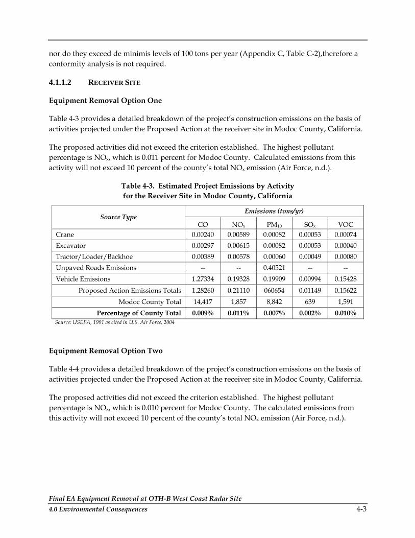
Final EA Equipment Removal at OTH-B West Coast Radar Site 4.0 Environmental Consequences 4-3
nor do they exceed de minimis levels of 100 tons per year (Appendix C, Table C-2),therefore a conformity analysis is not required.
4.1.1.2 RECEIVER SITE
Equipment Removal Option One
Table 4-3 provides a detailed breakdown of the project’s construction emissions on the basis of activities projected under the Proposed Action at the receiver site in Modoc County, California.
The proposed activities did not exceed the criterion established. The highest pollutant percentage is NOx, which is 0.011 percent for Modoc County. Calculated emissions from this activity will not exceed 10 percent of the county’s total NOx emission (Air Force, n.d.).
Table 4-3. Estimated Project Emissions by Activity for the Receiver Site in Modoc County, California
Emissions (tons/yr) Source Type
CO NOX PM10 SOX VOC Crane 0.00240 0.00589 0.00082 0.00053 0.00074 Excavator 0.00297 0.00615 0.00082 0.00053 0.00040 Tractor/Loader/Backhoe 0.00389 0.00578 0.00060 0.00049 0.00080 Unpaved Roads Emissions -- -- 0.40521 -- -- Vehicle Emissions 1.27334 0.19328 0.19909 0.00994 0.15428
Proposed Action Emissions Totals 1.28260 0.21110 060654 0.01149 0.15622 Modoc County Total 14,417 1,857 8,842 639 1,591
Percentage of County Total 0.009% 0.011% 0.007% 0.002% 0.010% Source: USEPA, 1991 as cited in U.S. Air Force, 2004
Equipment Removal Option Two
Table 4-4 provides a detailed breakdown of the project’s construction emissions on the basis of activities projected under the Proposed Action at the receiver site in Modoc County, California.
The proposed activities did not exceed the criterion established. The highest pollutant percentage is NOx, which is 0.010 percent for Modoc County. The calculated emissions from this activity will not exceed 10 percent of the county’s total NOx emission (Air Force, n.d.).
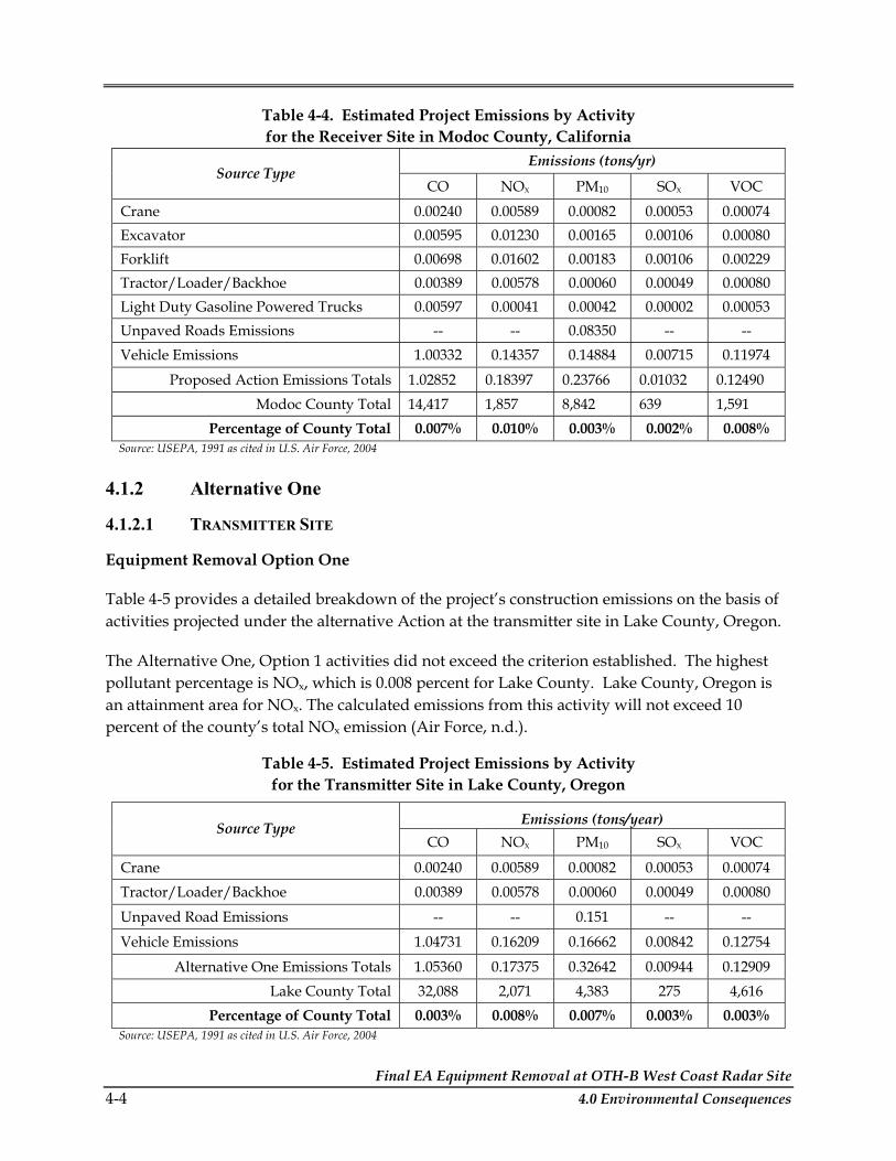
Final EA Equipment Removal at OTH-B West Coast Radar Site 4-4 4.0 Environmental Consequences
Table 4-4. Estimated Project Emissions by Activity for the Receiver Site in Modoc County, California
Emissions (tons/yr) Source Type
CO NOX PM10 SOX VOC
Crane 0.00240 0.00589 0.00082 0.00053 0.00074 Excavator 0.00595 0.01230 0.00165 0.00106 0.00080 Forklift 0.00698 0.01602 0.00183 0.00106 0.00229 Tractor/Loader/Backhoe 0.00389 0.00578 0.00060 0.00049 0.00080 Light Duty Gasoline Powered Trucks 0.00597 0.00041 0.00042 0.00002 0.00053 Unpaved Roads Emissions -- -- 0.08350 -- -- Vehicle Emissions 1.00332 0.14357 0.14884 0.00715 0.11974
Proposed Action Emissions Totals 1.02852 0.18397 0.23766 0.01032 0.12490 Modoc County Total 14,417 1,857 8,842 639 1,591
Percentage of County Total 0.007% 0.010% 0.003% 0.002% 0.008% Source: USEPA, 1991 as cited in U.S. Air Force, 2004
4.1.2 Alternative One
4.1.2.1 TRANSMITTER SITE
Equipment Removal Option One
Table 4-5 provides a detailed breakdown of the project’s construction emissions on the basis of activities projected under the alternative Action at the transmitter site in Lake County, Oregon.
The Alternative One, Option 1 activities did not exceed the criterion established. The highest pollutant percentage is NOx, which is 0.008 percent for Lake County. Lake County, Oregon is an attainment area for NOx. The calculated emissions from this activity will not exceed 10 percent of the county’s total NOx emission (Air Force, n.d.).
Table 4-5. Estimated Project Emissions by Activity for the Transmitter Site in Lake County, Oregon
Emissions (tons/year) Source Type CO NOX PM10 SOX VOC
Crane 0.00240 0.00589 0.00082 0.00053 0.00074 Tractor/Loader/Backhoe 0.00389 0.00578 0.00060 0.00049 0.00080
Unpaved Road Emissions -- -- 0.151 -- --
Vehicle Emissions 1.04731 0.16209 0.16662 0.00842 0.12754
Alternative One Emissions Totals 1.05360 0.17375 0.32642 0.00944 0.12909 Lake County Total 32,088 2,071 4,383 275 4,616
Percentage of County Total 0.003% 0.008% 0.007% 0.003% 0.003% Source: USEPA, 1991 as cited in U.S. Air Force, 2004

Final EA Equipment Removal at OTH-B West Coast Radar Site 4.0 Environmental Consequences 4-5
Equipment Removal Option Two
Table 4-6 provides a detailed breakdown of the project’s construction emissions on the basis of activities projected under the alternative Action at the transmitter site in Lake County, Oregon.
The Alternative One, Option 2 activities did not exceed the criterion established. The highest pollutant percentage is NOx, which is 0.009 percent for Lake County. The calculated emission does not exceed 10 percent of the county’s emissions for NOx (Air Force, n.d.).
Table 4-6. Estimated Project Emissions by Activity for the Transmitter Site in Lake County, Oregon
Emissions (tons/year) Source Type
CO NOX PM10 SOX VOC
Crane 0.00240 0.00589 0.00082 0.00053 0.00074 Excavator 0.00595 0.01230 0.00165 0.00106 0.00080 Forklift 0.00698 0.01602 0.00183 0.00106 0.00229 Tractor/Loader/Backhoe 0.00389 0.00578 0.00060 0.00049 0.00080
Unpaved Road Emissions -- -- 0.0683 -- --
Vehicle Emissions 0.85054 0.13881 0.14193 0.00739 0.10508
Alternative One Emissions Totals 0.86976 0.17879 0.21513 0.01054 0.10971
Lake County Total 32,088 2,071 4,383 275 4,616
Percentage of County Total 0.003% 0.009% 0.005% 0.004% 0.002% Source: USEPA, 1991 as cited in U.S. Air Force, 2004
4.1.2.2 RECEIVER SITE
Equipment Removal Option One
Table 4-7 provides a detailed breakdown of the project’s construction emissions on the basis of activities projected under the alternative Action at the receiver site in Modoc County, California.
The Alternative One, Option 1 activities did not exceed the criterion established. The highest pollutant percentage is NOx, which is 0.010 percent for Modoc County. The calculated emissions from this activity will not exceed 10 percent of the county’s total NOx emission (Air Force, n.d.).

Final EA Equipment Removal at OTH-B West Coast Radar Site 4-6 4.0 Environmental Consequences
Table 4-7. Estimated Project Emissions by Activity for the Receiver Site in Modoc County, California
Emissions (tons/yr) Source Type
CO NOX PM10 SOX VOC
Crane 0.00240 0.00589 0.00082 0.00053 0.00074 Tractor/Loader/Backhoe 0.00389 0.00578 0.00060 0.00049 0.00080 Unpaved Roads Emissions -- -- 0.22442 -- -- Vehicle Emissions 1.24903 0.17578 0.18256 0.00868 0.14844
Alternative One Emissions Totals 1.25532 0.18745 0.4084 0.00969 0.14999 Modoc County Total 14,417 1,857 8,842 639 1,591
Percentage of County Total 0.009% 0.010% 0.005% 0.002% 0.009% Source: USEPA, 1991 as cited in U.S. Air Force, 2004
Equipment Removal Option Two
Table 4-8 provides a detailed breakdown of the project’s construction emissions on the basis of activities projected under the alternative Action at the receiver site in Modoc County, California.
The Alternative One, Option 2 activities did not exceed the criterion established. The highest pollutant percentage is NOx, which is 0.010 percent for Modoc County. The calculated emissions from this activity will not exceed 10 percent of the county’s total NOx emission (Air Force, n.d.).
Table 4-8. Estimated Project Emissions by Activity for the Receiver Site in Modoc County, California
Emissions (tons/yr) Source Type
CO NOX PM10 SOX VOC
Crane 0.00240 0.00589 0.00082 0.00053 0.00074 Excavator 0.00595 0.01230 0.00165 0.00106 0.00080 Forklift 0.00698 0.01602 0.00183 0.00106 0.00229 Tractor/Loader/Backhoe 0.00389 0.00578 0.00060 0.00049 0.00080 Unpaved Roads Emissions -- -- 0.08350 -- -- Vehicle Emissions 1.00332 0.14357 0.14884 0.00715 0.11974
Alternative One Emissions Totals 1.02254 0.18356 0.23724 0.01030 0.12437 Modoc County Total 14,417 1,857 8,842 639 1,591
Percentage of County Total 0.007% 0.010% 0.003% 0.002% 0.008% Source: USEPA, 1991 as cited in U.S. Air Force, 2004

Final EA Equipment Removal at OTH-B West Coast Radar Site 4.0 Environmental Consequences 4-7
4.1.3 No Action Alternative
Under the No Action Alternative, the Air Force would not remove this equipment at this time and the facilities would continue to be operated in caretaker status. Impacts to air quality would not change.
4.2 CULTURAL RESOURCES
A number of federal regulations and guidelines have been established for the management of cultural resources. Section 106 of the National Historic Preservation Act (NHPA), as amended, requires federal agencies to take into account the effects of their undertakings on historic properties. Historic properties are cultural resources that are listed in, or eligible for listing in, the National Register of Historic Places (NRHP). Eligibility evaluation is the process by which resources are assessed relative to NRHP significance criteria for scientific or historic research, for the general public, and for traditional cultural groups. Under federal law, impacts to cultural resources may be considered adverse if the resources have been determined eligible for listing in the NRHP or have significance for Native American groups.
Analysis of potential impacts to cultural resources considers both direct and indirect impacts. Direct impacts may occur by physically altering, damaging, or destroying all or part of a resource; altering characteristics of the surrounding environment that contribute to the resource’s significance; introducing visual or audible elements that are out of character with the property or alter its setting; or neglecting the resource to the extent that it deteriorates or is destroyed. Direct impacts are assessed by identifying the types and locations of proposed activity and determining the exact location of cultural resources that could be affected. Indirect impacts result primarily from the effects of project-induced population increases.
In compliance with Section 106 of the NHPA, prior to implementation of either the Proposed Action or Alternative One, Air Force would determine the National Register eligibility of the OTH-B facilities at Christmas Valley, Oregon and Tulelake, California. To this end, the Air Force is initiating consultation with the Oregon and California SHPOs and with the federal land management agencies that have jurisdiction over each location.
4.2.1 Proposed Action
4.2.1.1 TRANSMITTER SITE
Equipment Removal Option One
Archaeological resources are not expected to be impacted by Equipment Removal Option 1 of the Proposed Action. This option involves the removal of 147 metal antenna structures, 255 acres of metal ground screen, 45 miles of copper wave-guide tube, and 58,824 linear feet of wood fence and posts from the Transmitter site near Christmas Valley, Oregon. The removal will include the above ground components of the structures as well as the associated below-

Final EA Equipment Removal at OTH-B West Coast Radar Site 4-8 4.0 Environmental Consequences
grade footings. This removal option would dismantle the antenna structure in such a way that components could be reassembled and reused at a different location. This would involve using a crane to support and load sections on flatbed trailers as they are unbolted and detached. All holes would be filled using fill from an on-site stockpile of native soil. The activities of the removal would occur in the same areas disturbed by the construction of the facilities in late 1980s. Equipment used for the removal such as semi tractor trailers, excavators, cranes, and loaders, would be confined to existing roadways and areas of previous disturbance. Additional details of the Proposed Action can be found in Section 2.1.
If the transmitter facilities are determined to be eligible for the NRHP, impacts to architectural and engineering resources could occur under Equipment Removal Option 1 of the Proposed Action.
Impacts to traditional resources are not expected under Equipment Removal Option 1 of the Proposed Action. The Air Force has initiated contact with the nearby tribes in Oregon to identify any potential concerns associated with the Proposed Action.
In the event of inadvertent discoveries of cultural resources during any project-related activities, all activities at that location would be halted until the find is evaluated by a qualified professional archaeologist.
Equipment Removal Option Two
This option differs from Option 1 only in the method for removal of the antenna structures. Instead of being disassembled for possible reuse, the structures would be dropped to the ground and cut into pieces appropriate to loading on flatbed semi trailers. Like Option 1, disturbances associated with the removal of the antenna structure, ground screen, and perimeter fence would be confined to existing roadways and areas disturbed by the construction of the facility in the late 1980s.
As with Equipment Removal Option 1, archaeological and traditional resources are not expected to be impacted by Equipment Removal Option 2 of the Proposed Action. Impacts to architectural/engineering resources could occur under Option 2, if the transmitter site is determined to be eligible for the NRHP.
4.2.1.2 RECEIVER SITE
Equipment Removal Option One
Archaeological resources are not expected to be impacted by Equipment Removal Option 1 of the Proposed Action. This option involves the removal of 402 metal antenna structures, 462 acres of metal ground screen, and 57,480 linear feet of wood fence and posts from the Receiver site near Tulelake, California. The removal will include the above ground components of the structures as well as the associated below-grade footings. This removal option would carefully dismantle the antenna structure in such a way that components could be reassembled and

Final EA Equipment Removal at OTH-B West Coast Radar Site 4.0 Environmental Consequences 4-9
reused at a different location. This would involve using a crane to support and load sections on flatbed trailers as they are unbolted and detached. All holes would be filled using fill from an on-site stockpile of native soil. The activities of the removal would occur in the same areas disturbed by the construction of the facilities in late 1980s. Equipment used for the removal such as semi tractor trailers, excavators, cranes, and loaders, would be confined to existing roadways and areas of previous disturbance.
If the facilities are determined to be eligible to the NRHP, impacts to architectural and engineering resources could occur under Equipment Removal Option 1 of the Proposed Action.
Impacts to traditional resources are not expected under Equipment Removal Option 1 of the Proposed Action. The Air Force has initiated contact with the nearby tribes in California to identify any potential concerns associated with the Proposed Action.
In the event of inadvertent discoveries of cultural resources during any project-related activities, all activities at that location would be halted until the find is evaluated by a qualified professional archaeologist, in compliance with federal regulations.
Equipment Removal Option Two
This option differs from Option 1 only in the method for removal of the antenna structures. Instead of being disassembled for possible reuse, the structures would be dropped to the ground and cut into pieces appropriate to loading on flatbed semi trailers. Like Option 1, disturbances associated with the removal of the antenna structure, ground screen, and perimeter fence would be confined to existing roadways and areas disturbed by the construction of the facility in the late 1980s.
Also like Equipment Removal Option 1, archaeological and traditional resources are not expected to be impacted by Equipment Removal Option 2 of the Proposed Action. Impacts to architectural/engineering resources could occur under Option 2, if the receiver site is determined to be eligible for the NRHP.
4.2.2 Alternative One
4.2.2.1 TRANSMITTER SITE
Equipment Removal Option One
Alternative One, Option 1 is the same as Equipment Removal Option 1 of the Proposed Action with the exception of the treatment of the perimeter fence. Instead of being removed, the perimeter fence would be left in place. Impacts would be the same as those expected under Equipment Removal Option 1 of the Proposed Action.

Final EA Equipment Removal at OTH-B West Coast Radar Site 4-10 4.0 Environmental Consequences
Equipment Removal Option Two
Alternative One, Option 2 is the same as Equipment Removal Option 2 of the Proposed Action with the exception of the treatment of the perimeter fence. Instead of being removed, the perimeter fence would be left in place. Impacts would be the same as those expected under Equipment Removal Option 2 of the Proposed Action.
4.2.2.2 RECEIVER SITE
Equipment Removal Option One
Alternative One, Option 1 is the same as Equipment Removal Option 1 of the Proposed Action with the exception of the treatment of the perimeter fence. Instead of being removed, the perimeter fence would be left in place. Impacts would be the same as those expected under Equipment Removal Option 1 of the Proposed Action.
Equipment Removal Option Two
Alternative One, Option 2 is the same as Equipment Removal Option 2 of the Proposed Action with the exception of the treatment of the perimeter fence. Instead of being removed, the perimeter fence would be left in place. Impacts would be the same as those expected under Equipment Removal Option 2 of the Proposed Action.
4.2.3 No Action Alternative
Under the No Action Alternative, the OTH-B Radar facilities would not be demolished. No impacts to archaeological, architectural/engineering, or traditional resources would be expected. The facilities would remain in a caretaker status and resources would continue to be managed in compliance with federal law and Air Force regulations.
4.3 BIOLOGICAL RESOURCES
4.3.1 Proposed Action
4.3.1.1 TRANSMITTER SITE
Equipment Removal Option One
Terrestrial Communities. Construction and operation of the radar transmitter structures, support facilities and perimeter fencing were determined to have no significant adverse impact on natural vegetation or wildlife resources (Air Force, 1983). The current project includes only removal of a portion of the existing facilities; the antenna structures, ground screen and fence (including fence poles). The remaining facilities, including buildings, paved and gravel roads, and base material for the ground screen, will remain in place and the transmitter facility will remain in caretaker status, which includes continued vegetation management in disturbed areas

Final EA Equipment Removal at OTH-B West Coast Radar Site 4.0 Environmental Consequences 4-11
until revegetation occurs. Removal of the remaining facilities, roads, and ground screen base material, and final recontouring and revegetation of the transmitter site is not addressed in this EA but will be subject to future assessment.
Equipment Removal Option 1 would remove the antenna in a manner that it could be reassembled. The ground screen would be removed by cutting, rolling and lifting the material on to trucks. The fence and fence posts would be removed and post holes filled in with soil from a nearby borrow pit and using a front-end loader. For the antenna and ground screen removal, all personnel and equipment would remain within the existing disturbed areas, including paved and gravel roads and the ground screen area. For the fence removal, both sides of the existing fence are maintained clear of vegetation, including the portion of the fence that encompasses natural habitat, and fence removal would remain within the existing cleared area, according to the project description. There would be no removal of native vegetation associated with the proposed project and therefore no impacts on natural vegetation.
Removal of the antenna structures and ground screen will impact herbaceous dominated vegetation that has become established over the ground screen area. However, this area is routinely subject to periodic vegetation removal; therefore the vegetation removal associated with the proposed project would be equivalent to the routine maintenance of the site. There would be no significant long-term adverse impacts to natural vegetation from the proposed Equipment Removal Option 1.
Equipment removal, including removal and filling of fence post holes with soil from a nearby borrow pit, may result in disturbance to ground surface that can indirectly impact adjacent natural habitats through soil erosion. In addition, disturbed areas may become vegetated with non-native plant species, including invasive plants, which have the potential to spread into and degrade adjacent native habitats.
As stated in the project description, the Air Force would retain caretaker status over the sites until such time as removal of the remaining structures, recontouring and revegetation to pre-installation conditions can be completed (Air Force, 1983). Under the current conditions, existing disturbed areas are periodically treated to prevent vegetation establishment and growth. This activity also prevents the establishment and growth of non-native invasive plant species. The USAF through the on-site contractor will continue the vegetation management until revegetation occurs. In addition, any areas disturbed during equipment and fence removal will be revegetated or otherwise treated to prevent soil from eroding into adjacent native habitats. These protection measures reduce the likelihood of soil erosion or establishment of non-native plant species to degrade nearby native habitat, and therefore potential impacts on natural vegetations would be less than significant.
The removal of the antenna structures and perimeter fence is not likely to have significant adverse affects on common wildlife species. Impacts will be temporary and similar to impacts resulting from existing vegetation management efforts currently in effect. In addition, wildlife use of the transmitter site appears to be somewhat limited due to the existing conditions. The
Final EA Equipment Removal at OTH-B West Coast Radar Site 4-12 4.0 Environmental Consequences
loss of antennae and fencing would eliminate potential perch sites for raptors and smaller birds; however, the overall effect of facilities removal would be beneficial to most avian species due to the elimination of potential air collisions. In addition, the removal of fencing and antennae would result in a beneficial impact to sage grouse and to many larger wildlife species (such as mule deer, black bear, and coyote which have large home ranges) by increasing the larger species’ ability to migrate through the area and to sage grouse by increasing the potential for their preferred, open habitat.
Wetland and Freshwater Aquatic Communities. There are no wetland or aquatic communities at the Christmas Valley transmitter site, and therefore there are no adverse impacts to this resource.
Threatened, Endangered, and Special Status Species/Communities. No federal or state-listed rare, threatened or endangered plant species are found or expected to occur within the Christmas Valley transmitter site and therefore, there would be no adverse impacts to this resource.
Wildlife species listed, proposed for listing, or candidates for listing as threatened and endangered in accordance with the ESA of 1973 (87 Stat. 884, as amended; 16 USC 1531 et seq.) are not anticipated to be adversely affected by the Proposed Action. State-protected species would also not be adversely affected by the Proposed Action at this location because their habitat would not be altered and because changes in activities at transmitter site are not expected to be biologically significant. No special wildlife species or sensitive habitats are expected to be impacted.
Equipment Removal Option Two
Under this option, the antenna structures would be pulled to the ground and cut into pieces for recycling. The fence and fence post removal and ground screen removal would be the same as for the proposed project. All activities would be restricted to the existing disturbed areas including paved and dirt roads, the ground screen area, and cleared areas along the fences. With regard to biological resources, the affects of the proposed project would be the same as for Option 1.
4.3.1.2 RECEIVER SITE
Equipment Removal Option One
Terrestrial Communities. As with the transmitter site, construction and operation of the radar receiver site at Tulelake including structures, support facilities and perimeter fencing were determined to have no significant adverse impact on natural vegetation or wildlife resources (Air Force, 1983). The current project includes the removal of only a portion of the existing facilities; the antenna structures, ground screen and fence (including fence posts). The remaining facilities, including buildings, paved and gravel roads, and base material for the

Final EA Equipment Removal at OTH-B West Coast Radar Site 4.0 Environmental Consequences 4-13
ground screen, will remain in place and the transmitter facility will remain in caretaker status. Removal of the remaining facilities, roads, and ground screen base material, and final recontouring and revegetation of the transmitter site is not addressed in this EA but will be subject to future assessment.
Equipment Removal Option 1 would be the same as the transmitter site as described above. For the antenna and ground screen removal, all personnel and equipment would remain within the existing disturbed areas, including paved and gravel roads and the ground screen area. At this location, the fence surrounds the ground screen area and is therefore, subject to periodic vegetation management to prevent establishment of large shrubs and trees, although scattered small shrubs do occur on the ground screen. Outside the fence, there is a perimeter road and a narrow area between the road and the fence which is also maintained. Fence removal activities would remain within the fenced area, on the perimeter roads, or within the area between the perimeter roads and the fences. There would be no removal of native vegetation associated with the proposed project and therefore, no impacts on natural vegetation.
Removal of the antenna structures and ground screen will impact the herbaceous dominated vegetation and scattered shrubs that have established over the ground screen area. However, this area is routinely subject to periodic vegetation removal and the vegetation removal associated with the proposed project would be equivalent to the routine maintenance. Therefore, there would be no significant long-term adverse impacts to natural vegetation from the proposed Equipment Removal Option 1.
Similar to the transmitter site, equipment removal activities that result in ground disturbance have the potential to result in the degradation of natural communities over time due to soil erosion or spread of invasive plant species. However, the Air Force through the on-site contractor will continue the vegetation management until restoration occurs. Any areas disturbed during equipment and fence removal will be revegetated or otherwise treated to prevent soil from eroding into adjacent native habitats. These protection measures reduce the likelihood of soil erosion or establishment of non-native plant species to degrade nearby native habitat, and therefore potential impacts of natural vegetation would be less than significant.
The removal of the antenna structures and perimeter fence at the Tulelake receiver site is not likely to have significant adverse affects on common wildlife species. Impacts will be temporary and similar to impacts resulting from existing vegetation management efforts currently in effect. In addition, wildlife use of the receiver site appears to be somewhat limited due to the existing conditions. The loss of antennae and fencing would eliminate potential perch sites for raptors and smaller birds; however, the overall effect of facilities removal would be beneficial to most avian species due to the elimination of potential air collisions. In addition, the removal of fencing and antennae would result in a beneficial impact to sage grouse and to many larger wildlife species (such as mule deer, black bear, and coyote which have large home ranges) by increasing the larger species’ ability to migrate through the area and to sage grouse by increasing the potential for their preferred, open habitat.

Final EA Equipment Removal at OTH-B West Coast Radar Site 4-14 4.0 Environmental Consequences
Wetland and Freshwater Aquatic Communities. At the Tulelake Receiver site, several natural and created vernal pools are present immediately adjacent to project facilities, primarily the perimeter roads outside of fences. Removal of the radar structures and fencing has the potential to indirectly affect these resources if personnel or equipment extend beyond the existing disturbed areas. Vernal pools and dry lake habitats may be degraded by soil erosion or runoff from construction sites, especially if work occurs during rain. The contractor is required to have a Storm Water Pollution Prevention Plan (SWPPP), which would include incorporation of standard construction practices such as construction of silt fences which will ensure that there are no impacts to vernal pools from soil erosion or runoff from construction sites. By protecting sensitive wetland resources during construction and implementation of measures to prevent soil erosion or non-native plant establishment, potential impacts on vernal pools and dry lake beds would be less than significant.
In addition, ground disturbances resulting from fence and ground screen removal could result in soil erosion or establishment and spread of non-native invasive plant species which could affect wetland habitat. Standard construction practices to prevent degradation of habitat from soil erosion and invasive plant species would also protect vernal pools and drylake habitats.
Threatened, Endangered, and Special Status Species/Communities. No federal or state-listed rare, threatened or endangered plant species are found or expected to occur within the Tulelake Receiver site. One non-listed sensitive plant species is found in association with vernal pools. Measures to protect vernal pool habitats (described above) would also protect this species.
Wildlife species listed, proposed for listing, or candidates for listing as threatened and endangered in accordance with the ESA of 1973 (87 Stat. 884, as amended; 16 USC 1531 et seq.) are not anticipated to be adversely affected by the Proposed Action. State-protected species would also not be adversely affected by the Proposed Action at the receiver site because their habitat would not be altered and because changes in activities at the receiver and transmitter sites are not expected to be biologically significant. No special wildlife species or sensitive habitats are expected to be impacted.
Equipment Removal Option Two
Under this option, the activities would be restricted to the existing disturbed areas and the affects of the proposed project on biological resources would be the same as for Option 1.
4.3.2 Alternative One
4.3.2.1 TRANSMITTER SITE
Equipment Removal Option One
Under this Alternative, only the radar structures and ground screen would be removed; the perimeter fence would remain in place. Alternative One, Option 1 would be the same as for the

Final EA Equipment Removal at OTH-B West Coast Radar Site 4.0 Environmental Consequences 4-15
Proposed Action with the antenna structures disassembled in a manner that could be reused except that there would be a reduction in the beneficial impacts of removing fences which would increase wildlife species’ ability to migrate through the area. Impacts to biological resources would be the same as those associated with the removal of the antenna and ground screen described for the Proposed Action. The impacts include the potential for ground disturbance and exposed soils to erode or promote the spread of invasive plant species, although these impacts would be reduced by not removing the fence and fence posts. Under Alternative One, Option 1, the Air Force would continue caretaker status of the facility and would be responsible for the prevention of soil erosion and spread of invasive plant species through continued vegetation management and restoration efforts. With these practices, potential impacts to natural vegetation would be less than significant.
With regard to wildlife, potential impacts would be the same as identified for the Proposed Action, except that beneficial impacts would be reduced if the fences, which may be restricting wildlife migration in the area, remain in place.
Equipment Removal Option Two
As for Alternative One, Option 1, only the radar structures and ground screen would be removed; the perimeter fence would remain in place. However, the antenna structures would be pulled down and sectioned for recycling. With regard to biological resources, under this option, the activities would be restricted to the existing disturbed areas and the affects of the Proposed Action would be the same as for Option 1.
4.3.2.2 RECEIVER SITE
Equipment Removal Option One
Equipment Removal Option 1 would be the same as for the Proposed Action with the antenna structures disassembled in a manner that could be reused and the fence remaining in place. At the receiver site, this action would restrict all project activities within the existing enclaves. As for the proposed project, potential impacts to natural vegetation would be less than significant. The effects on biological resources would be the same as for the Proposed Action although reduced since the fences would remain in place. Beneficial impacts to wildlife would be reduced if the fences, which may be restricting wildlife migration in the area, remain in place. Potential impacts on vernal pool and dry lake habitats would also be reduced as there would be less equipment and personnel working in the vicinity of these sensitive resources.
Equipment Removal Option Two
Under this option, the activities would be restricted to the existing disturbed areas and the affects of the proposed project on biological resources would be the same as for Option 1.
Final EA Equipment Removal at OTH-B West Coast Radar Site 4-16 4.0 Environmental Consequences
4.3.3 No Action Alternative
Under the No Action Alternative, there would be no environmental consequences to this resource. However, potential beneficial impacts to wildlife species would be reduced if the facilities, radars, and fences, which may be restricting wildlife migration in the area, remain in place.
4.4 GRAZING
4.4.1 Proposed Action
4.4.1.1 TRANSMITTER SITE
Equipment Removal Option One
The current proposal includes the removal of the existing facilities including the antenna structures, ground screen, and fence and fence poles. The remaining facilities would remain in place and in caretaker status. The removal of fencing may result in temporary ground disturbance; however, areas will be revegetated in accordance with the BLM Lakeview Resource Management Plan. All holes would be filled using fill from a nearby borrow pit. While fencing and equipment removal will not have a significant impact on grazing operations or on forage value (personal communication, Ramasco 2005), cattle from the surrounding allotment could wander freely over the site.
Equipment Removal Option Two
This option differs from Option 1 only in the method for removal of the antenna structures. Instead of being disassembled for possible reuse, the structures would be dropped to the ground and cut into pieces appropriate to loading on flatbed semi-trailers. The fencing and equipment removal will not have a significant impact on grazing operations or on forage value (personal communication, Ramasco 2005).
4.4.1.2 RECEIVER SITE
Equipment Removal Option One
The current proposal includes the removal of the antenna structures, ground screen, and fence and fence poles. The remaining facilities will remain in place and in caretaker status. The removal of fencing may result in temporary ground disturbance; however, areas would be revegetated in accordance with the USFS requirements. All holes would be filled using fill from an on-site stockpile of native soil. The fencing removal would adversely impact the grazing permittees as the fences currently serve as allotment boundary fencing. Without the fence the permittees and USFS will be unable to manage the area in compliance with the AMP unless the fencing is replaced. Replacement of the fence would not be the responsibility of the Air Force;

Final EA Equipment Removal at OTH-B West Coast Radar Site 4.0 Environmental Consequences 4-17
however, the Air Force will work with the USFS and their grazing permittee(s) to coordinate the timing of the fence removal in order to limit the amount of disturbance to grazing operations.
Equipment Removal Option Two
This option differs from Option 1 only in the method for removal of the antenna structures. Instead of being disassembled for possible reuse, the structures would be dropped to the ground and cut into pieces appropriate to loading on flatbed semi-trailers. As noted under Option 1, fencing removal would adversely impact the grazing permittee(s) as the fences currently serve as allotment boundary fencing. Replacement of the fence would not be the responsibility of the Air Force; however, the Air Force will work with the USFS and their grazing permittee(s) to coordinate the timing of the fence removal in order to limit the amount of disturbance to grazing operations.
4.4.2 Alternative One
4.4.2.1 TRANSMITTER SITE
Equipment Removal Option One
Alternative One, Option 1 is the same as Equipment Removal Option 1 of the Proposed Action with the exception of the treatment of the perimeter fence. Instead of being removed, the perimeter fence would be left in place. The equipment removal will have no significant impact on grazing operations or on forage value (personal communication, Ramasco 2005).
Equipment Removal Option Two
Alternative One, Option Two is the same as Equipment Removal Option 2 of the Proposed Action with the exception of the treatment of the perimeter fence. Instead of being removed, the perimeter fence would be left in place. The equipment removal will have no significant impact on grazing operations or on forage value (personal communication, Ramasco 2005).
4.4.2.2 RECEIVER SITE
Equipment Removal Option One
Alternative One, Option 1 is the same as Equipment Removal Option 1 of the Proposed Action with the exception of the treatment of the perimeter fence. Instead of being removed, the perimeter fence would be left in place and there would be no impacts to grazing.
Equipment Removal Option Two
Alternative One, Option 2 is the same as Equipment Removal Option 2 of the Proposed Action with the exception of the treatment of the perimeter fence. Instead of being removed, the

Final EA Equipment Removal at OTH-B West Coast Radar Site 4-18 4.0 Environmental Consequences
perimeter fence would be left in place. The allotment boundary fencing would remain in place and there would be no impacts to grazing under this Alternative.
4.4.3 No Action Alternative
Under the No Action Alternative, the OTH-B radar facilities would not be demolished. No impacts to livestock grazing would be expected. The facilities would remain in a caretaker status and resources would continue to be managed in compliance with federal law and Air Force regulations.
4.5 GEOLOGY AND SOILS
4.5.1 Proposed Action
4.5.1.1 TRANSMITTER SITE
Equipment Removal Option One
The Proposed Action would have no impact with respect to the geology of the project area, such as alteration of the topography or disturbance of unique geologic features, as the project site is located within a relatively flat ancient dry lake bed. Similarly, regional faults would have no impact on the Proposed Action. However, fence and equipment removal would expose and disturb on-site soils, resulting in temporary exposure to wind and water erosion. Although the permeability is low and periodic shallow spring flooding occurs at the Christmas Valley site, the topography is generally flat, resulting in very slow runoff and a low water erosion hazard. In addition, no perennial or ephemeral creeks traverse the project site, nor are surface drainage patterns apparent within several miles. Therefore, potential erosion induced sedimentation of local water resources would be minimal and no significant impacts would occur.
Equipment Removal Option Two
Impacts would be similar to those described for Equipment Removal Option 1.
4.5.1.2 RECEIVER SITE
Equipment Removal Option One
Similar to the Christmas Valley site, the Proposed Action would have no impact with respect to the geology of the project area, such as alteration of the topography or disturbance of unique geologic features, as the project site is located on relatively flat to gently sloping topography. Similarly, regional faults would have no impact on the Proposed Action. However, fence and equipment removal would expose and disturb on-site soils, resulting in temporary exposure to wind and water erosion. Water permeability through on-site soils is low and the runoff potential is moderate, potentially resulting is erosion induced sedimentation of local drainages, creeks, and regional lakes.

Final EA Equipment Removal at OTH-B West Coast Radar Site 4.0 Environmental Consequences 4-19
However, in accordance with NPDES permit regulations, all activities would be completed in accordance with a SWPPP, which would include incorporation of standard construction practices, such as construction of silt fences and temporary stormwater debris basins. Potential short-term wind erosion during and immediately following equipment dismantling and fence removal activities would be minimized by water truck applications, as necessary. In addition, revegetation upon completion of equipment dismantling would prevent long-term wind- and water-induced soil erosion. Therefore, fence and equipment removal activities would have no significant adverse impact with respect to geology and soils in the vicinity of the project site.
Equipment Removal Option Two
Impacts would be similar to those described for Equipment Removal Option 1.
4.5.2 Alternative One
4.5.2.1 TRANSMITTER SITE
Equipment Removal Option One
Alternative One, Option 1 impacts would be similar but less than those described for the Proposed Action. Leaving the fences in-place will reduce soil disturbances and associated potential erosion-induced sedimentation of local water resources. Impacts would similarly be less than significant.
Equipment Removal Option Two
Alternative One, Option 2 impacts would be similar to those described for Equipment Removal Option 1.
4.5.2.2 RECEIVER SITE
Equipment Removal Option One
Alternative One, Option 1 impacts would be similar but less than those described for the Proposed Action. Leaving the fences in-place will reduce soil disturbances and associated potential erosion-induced sedimentation of local water resources. Impacts would similarly be less than significant.
Equipment Removal Option Two
Alternative One, Option 2 impacts would be similar to those described for Equipment Removal Option 1.

Final EA Equipment Removal at OTH-B West Coast Radar Site 4-20 4.0 Environmental Consequences
4.5.3 No Action Alternative
No impacts to geology and soils would be expected, as disturbance of soils and potential erosion induced sedimentation of local drainages, creeks, and regional lakes would not occur.
Final EA Equipment Removal at OTH-B West Coast Radar Site 5.0 Cumulative Effects and Irreversible and Irretrievable Commitment of Resources 5-1
5.0 CUMULATIVE EFFECTS AND IRREVERSIBLE AND IRRETRIEVABLE COMMITMENT OF RESOURCES
5.1 CUMULATIVE EFFECTS
This section provides (1) a definition of cumulative effects, (2) a description of past, present, and reasonably foreseeable actions relevant to cumulative effects, and (3) an evaluation of cumulative effects potentially resulting from these interactions.
5.1.1 Definition of Cumulative Effects
CEQ regulations stipulate that the cumulative effects analysis within an EA should consider the potential environmental impacts resulting from “the incremental impacts of the action when added to other past, present, and reasonably foreseeable future actions regardless of what agency or person undertakes such other actions” (40 CFR 1508.7). Recent CEQ guidance in Considering Cumulative Effects affirms this requirement, stating that the first steps in assessing cumulative effects involve defining the scope of the other actions and their interrelationship with the Proposed Action. The scope must consider geographic and temporal overlaps among the Proposed Action and other actions. It must also evaluate the nature of interactions among these actions.
Cumulative effects are most likely to arise when a relationship or synergism exists between a Proposed Action and other actions expected to occur in a similar location or during a similar time period. Actions overlapping with, or in close proximity to, the Proposed Action would be expected to have more potential for a relationship than actions that may be geographically separated. Similarly, actions that coincide, even partially, in time would tend to offer a higher potential for cumulative effects.
To identify cumulative effects, this EA addresses three questions:
1. Does a relationship exist such that elements of the Proposed Action might interact with elements of past, present, or reasonably foreseeable actions?
2. If one or more of the elements of the Proposed Action and another action could be expected to interact, would the Proposed Action affect or be affected by impacts of the other action?
3. If such a relationship exists, does an assessment reveal any potentially significant impacts not identified when the Proposed Action is considered alone?
In this EA, an effort has been made to identify all actions that are being considered and that are in the planning phase at this time. To the extent that details regarding such actions exist and

Final EA Equipment Removal at OTH-B West Coast Radar Site 5-2 5.0 Cumulative Effects and Irreversible and Irretrievable Commitment of Resources
the actions have a potential to interact with the Proposed Action and the No Action Alternative in this EA, these actions are included in this cumulative analysis. This approach enables decisionmakers to have the most current information available so that they can evaluate the environmental consequences of the Proposed Action and the No Action Alternative.
5.1.2 Past, Present, and Reasonably Foreseeable Actions
This EA applies a stepped approach to provide decisionmakers with not only the cumulative effects of the Proposed Action, Alternative One, and the No Action Alternative, but also the incremental contribution of past, present, and reasonably foreseeable actions.
PAST AND PRESENT ACTIONS RELEVANT TO THE PROPOSED ACTION AND NO ACTION ALTERNATIVE
The OTH-B Radar system was constructed on both the East and West Coasts of the United States in the 1980s. The construction and operation of the OTH-B West Coast sites at Christmas Valley, Oregon and Tulelake, California was evaluated in an environmental impact statement (EIS) completed in 1984. The sites were accepted by the Air Force in November 1990, after a test and evaluation phase which was completed in October 1990. The sites were operated on a 24-hour basis, from November 1990 to January 1991 under a contract with General Electric Government Services Division. Following a January 1991 decision to reduce operations, caretaker status was achieved by the end of September 1991. This action was evaluated in an environmental assessment in completed in September 1991 (Air Force, 1991).
The North American Aerospace Defense Command (NORAD) identified in a 13 June 2002 memorandum that the government no longer had an operational requirement for the existing FPS-118 Over-The-Horizon Backscatter (OTH-B) radar system. The Air Force initiated actions to evaluate the closure of the OTH-B East Coast sites in FY 2003 and published an environmental assessment/environmental baseline survey in October 2003 documenting the effects of the termination of caretaker operations, the removal of all equipment, and the transfer of OTH-B properties at Moscow, Columbia Falls, and Bangor Air National Guard Base, Maine (Air Force, 2003). In 2005 the Air Force issued a Categorical Exclusion for the removal of computers and equipment from inside of the buildings at of the OTH-B West Coast sites at Christmas Valley, Oregon and Tulelake, California (Air Force, 2005).
REASONABLY FORESEEABLE FUTURE ACTIONS
In response to the NORAD 2002 memorandum, the Air Force will be evaluating the environmental consequences of the terminating the leases for the OTH-B West Coast sites and restoring the sites to their original condition as called for in the lease agreements with the Bureau of Reclamation (Transmitter Site—Christmas Valley, Oregon) and the United States Forest Service (Receiver Site—Tulelake, California). There are no known actions proposed within the study area that would interact with the Proposed Action.
Final EA Equipment Removal at OTH-B West Coast Radar Site 5.0 Cumulative Effects and Irreversible and Irretrievable Commitment of Resources 5-3
5.1.3 Analysis of Cumulative Impacts
The following analysis examines how the impacts of these other actions might be affected by the Proposed Action and whether such a relationship would result in potentially significant impacts not identified when the Proposed Action, Alternative One, and the No Action Alternative are considered alone.
Implementation of the Proposed Action or the Alternatives is independent of the decision to restore and dispose of the transmitter and receiver radar sites currently leased from the Bureau of Land Management and the United States Forest Service. The equipment removal addressed in this EA does not preclude any alternatives for addressing restoration and disposition of the radar sites. With the notification from NORAD in 2002 that there is no longer any operational requirement for the OTH-B radar system, the Air Force has determined that there is no need to maintain the radar equipment at the OTH-B West Coast sites. There are no known actions proposed within the study area that would interact with the Proposed Action and lead to significant environmental consequences when considered along with the equipment removal at either of the radar sites.
5.2 IRREVERSIBLE AND IRRETRIEVABLE COMMITMENT OF RESOURCES
NEPA requires that environmental analysis include identification of “. . . any irreversible and irretrievable commitments of resources which would be involved in the Proposed Action and the No Action Alternative should it be implemented.” Irreversible and irretrievable resource commitments are related to the use of nonrenewable resources and the effects that the uses of these resources have on future generations. Irreversible effects primarily result from the use or destruction of a specific resource (e.g., energy and minerals) that cannot be replaced within a reasonable time frame. Irretrievable resource commitments involve the loss in value of an affected resource that cannot be restored as a result of the action (e.g., extinction of a threatened or endangered species or the demolition of a historic building).
The Proposed Action and Alternative One would require the use of fossil fuels in construction vehicles; these non-renewable resources would be irretrievably lost however the effect is minor and not significant.

Final EA Equipment Removal at OTH-B West Coast Radar Site 5-4 5.0 Cumulative Effects and Irreversible and Irretrievable Commitment of Resources
THIS PAGE INTENTIONALLY LEFT BLANK.

Final EA Equipment Removal at OTH-B West Coast Radar Site 6.0 References 6-1
6.0 REFERENCES
Bureau of Land Management (BLM). 2005. Personal Communication. Teresa Ramasco, Range Specialist. Lakeview Resource Area. Oregon.
California Department of Fish and Game (GDFG). 2004a. California Natural Diversity Database. RareFind. Full Reports for Rimrock Lake and Lone Pine Butte Quads. May.
_____ . 2004b. Wildlife and Habitat Data Analysis Branch, California Natural Diversity Database. Special Animals List. August. Hhttp://dfg.ca.gov/whdab/pdfs/spanimals.pdf H
California Native Plant Society (CNPS). 2001. Inventory of Rare and Endangered Plants of California. (sixth edition). Rare Plant Scientific Advisory Committee, David P. Tibor, Convening Editor. California Native Plant Society. Sacramento, CA. x = 388pp.
Hickman, J.C. (ed.). 1993. The Jepson Manual: Higher Plants of California. Berkeley: University of California Press.
Jagelski, K. and J. O’Brien. 1994. Calculation Methods for Criteria Air Pollution Emission Inventories. U.S. Air Force, Armstrong Laboratory, AL/OE-TR-1994-0049, Brooks AFB.
Reed, P. B. Jr. 1988. National List of Plant Species that Occur in Wetlands. U. S. Fish and Wildlife Service Biological Report 88 (26.8).
Roxlau, R.B., K. Lewis, and K.J. Roxlau. 1997. A Systematic Study of Air Combat Command Cold War Material Culture. Volume II-14. A Baseline Inventory of Cold War Material Culture at Langley Air Force Base. Prepared for HQ ACC, Langley AFB, Virginia.
United States Air Force (Air Force). 1983. Construction and Operation of the West Coast Over-the-Horizon Backscatter Radar System Draft Environmental Impact Statement. Air Force Systems Command, Electronic Systems Division. Hanscom Air Force Base, Massachusetts.
_____ . 1987. Mitigation Plan for the West Coast OTH-B Radar Receive Facility. Air Force Systems Command, Electronic Systems Division. June 1, 1987.
_____ . 1991. Final Environmental Assessment of Placement of the West Coast Over-the-Horizon Backscatter Radar System into Limited Operations Status. HQ/Tactical Air Command/DEV. Langley Air Force Base, Virginia. September 24, 1991.
_____ . 1996. Final Report on Mitigation for Vernal Pool Habitats. Over-the-Horizon Backscatter West Coast Radar System Receive Site, Tulelake Air Force Station. Prepared for US Air Combat Command. Langley Air Force Base, Virginia. August.
_____ . 1999. Air Emissions Inventory Guidance Document for Stationary Sources at Air Force Installations (AFIERA). IERA-RS-BR-SR-1999-0001. May 1999.

Final EA Equipment Removal at OTH-B West Coast Radar Site 6-2 6.0 References
_____ . 2002. Letter from Major General Eric A. Findley, NORAD Director of Operations, Peterson AFB, CO to Major General Carrol H. Chandler, Director of Airspace Operation at Air Combat Command, Langley AFB, VA. 13 June.
_____ . No Date. Clean Air Act Compliance Guidance. Air Force Center for Environmental Excellence. Hhttp://www.afcee.brooks.af.mil/eq/air/caatoolbox/ html/federal/compdet/genconform.htmlH. Accessed on 18 March 2005
United States Environmental Protection Agency (USEPA), 1991 as cited in U.S. Air Force, 2004. Mobile Source Emission Inventory. for Eglin AFB, FL 30 April 2004, Pages 5, 7, 12, and 14
_____ . 1999. U.S. Environmental Protection Agency1999 National Emissions Inventory Microsoft Access Database. Accessed March 2005.
_____ . 2004a. “Final Rule to Implement the 8-Hour Ozone National Ambient Air Quality Standard – Phase I.” April 15, 2004. Downloaded from the USEPA website on 5/14/2004. Hhttp://www.epa.gov/ozonedesignations/finalrule.pdf H.
_____ . 2005. Transportation and Air Quality., Hhttp://www.epa.gov/otaq/ H. 10 February 2005, Accessed 18 March 2005.
United States Forest Service (USFS). 1996. Decision Notice and Finding of No Significant Impact. Boles, Dalton, Perez, and Mammoth Allotments, Allotment Management Plan. Doublehead Ranger District. Modoc National Forest, California.
_____ . 2005. Allotment Management Plan. Carr C and H Allotment. Doublehead Ranger District. Modoc National Forest, California.

Final EA Equipment Removal at OTH-B West Coast Radar Site 7.0 List of Preparers 7-1
7.0 LIST OF PREPARERS
Mike Jones, ACC/CEPP Project Manager B.A. Environmental Studies, Randolph-Macon College, Ashland Virginia 2002 Years of Experience: 4
David M. Dischner, Project Manager B.A., Urban Affairs, Virginia Polytechnic Institute and State University, Blacksburg, 1974 Hazardous Materials Management Certificate, University of California, Riverside, 1988 Years of Experience: 31
Lauren M. Brown, Biological Resources Analyst B. S., Ecology and Systematic Biology, California Polytechnic State University, San Luis Obispo, 1991 Years of Experience: 13
Tyrone Corn, Staff Archeologist B.S., Anthropology, University of Idaho, 1997 Years of Experience: 9
Claudia Laughlin, Graphics Years of Experience: 9
Edward Mullen, Senior Wildlife Biologist M.A., Biological Sciences, University of California, Santa Barbara, 1990 B.S., Biology, Loyola Marymount University, 1987 Years of Experience: 14
Perry W. Russell, Senior Geologist M.S., Geological Sciences, California State University, Northridge, 1988 B.A., Geological Sciences, University of California, Santa Barbara, 1984 Years of Experience: 19
Alysia Szutenbach, Air Quality B.S. Chemical Engineering, Colorado State University, Fort Collins, 2002 Years of Experience: 2
Robert E. Van Tassel, Program Manager M.A., Economics, University of California, Santa Barbara, 1972 B.A., Economics, University of California, Santa Barbara, 1970 Years of Experience: 32

Final EA Equipment Removal at OTH-B West Coast Radar Site 7-2 7.0 List of Preparers
THIS PAGE INTENTIONALLY LEFT BLANK.

APPENDIX A PHOTOGRAPHS, MAPS, AND FIGURES


Final EA Equipment Removal at OTH-B West Coast Radar Site Appendix A A-1

Final EA Equipment Removal at OTH-B West Coast Radar Site A-2 Appendix A
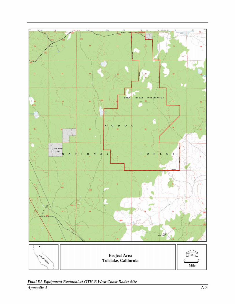
Final EA Equipment Removal at OTH-B West Coast Radar Site Appendix A A-3

Final EA Equipment Removal at OTH-B West Coast Radar Site A-4 Appendix A

Final EA Equipment Removal at OTH-B West Coast Radar Site Appendix A A-5

Final EA Equipment Removal at OTH-B West Coast Radar Site A-6 Appendix A
THIS PAGE INTENTIONALLY LEFT BLANK

APPENDIX B INTERAGENCY AND INTERGOVERNMENTAL
COORDINATION FOR ENVIRONMENTAL PLANNING (IICEP) AND COMMENT LETTERS


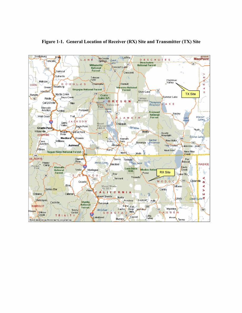


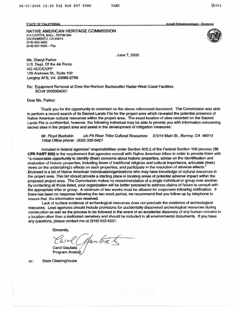


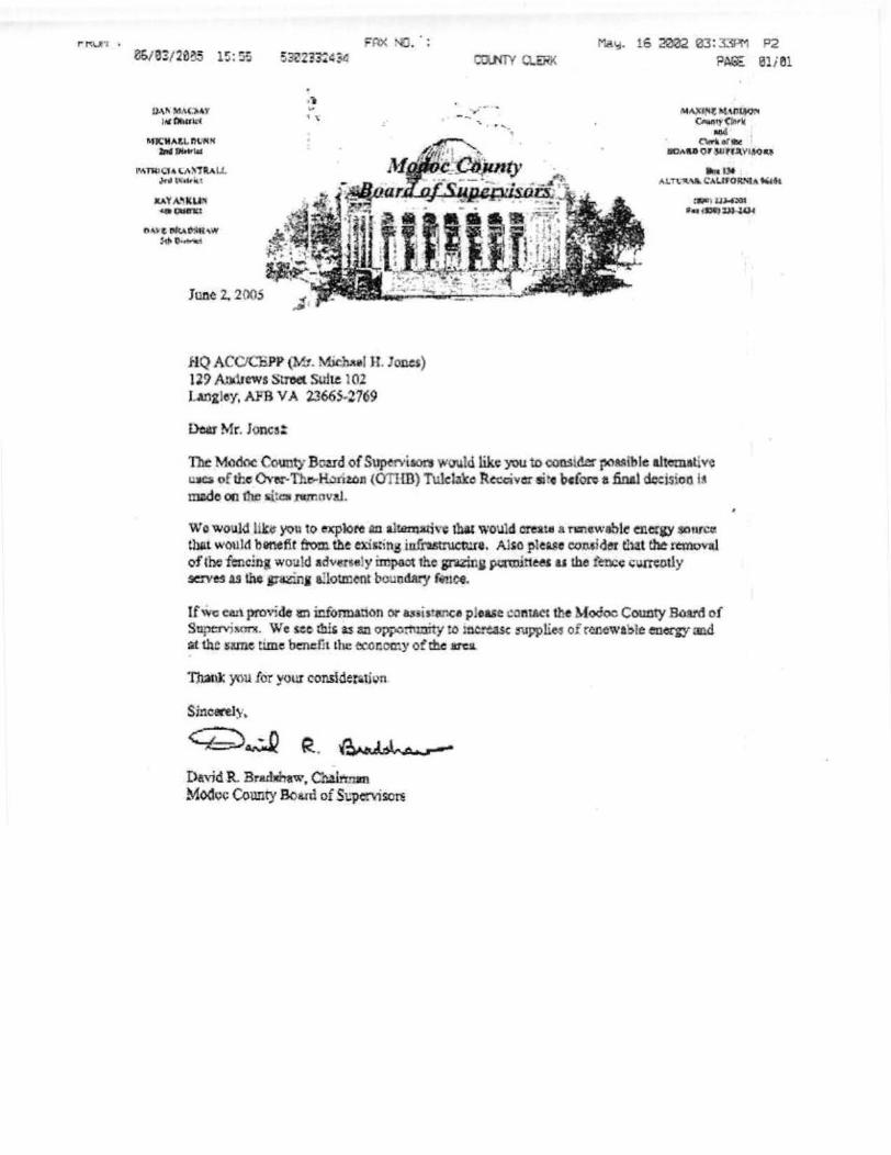


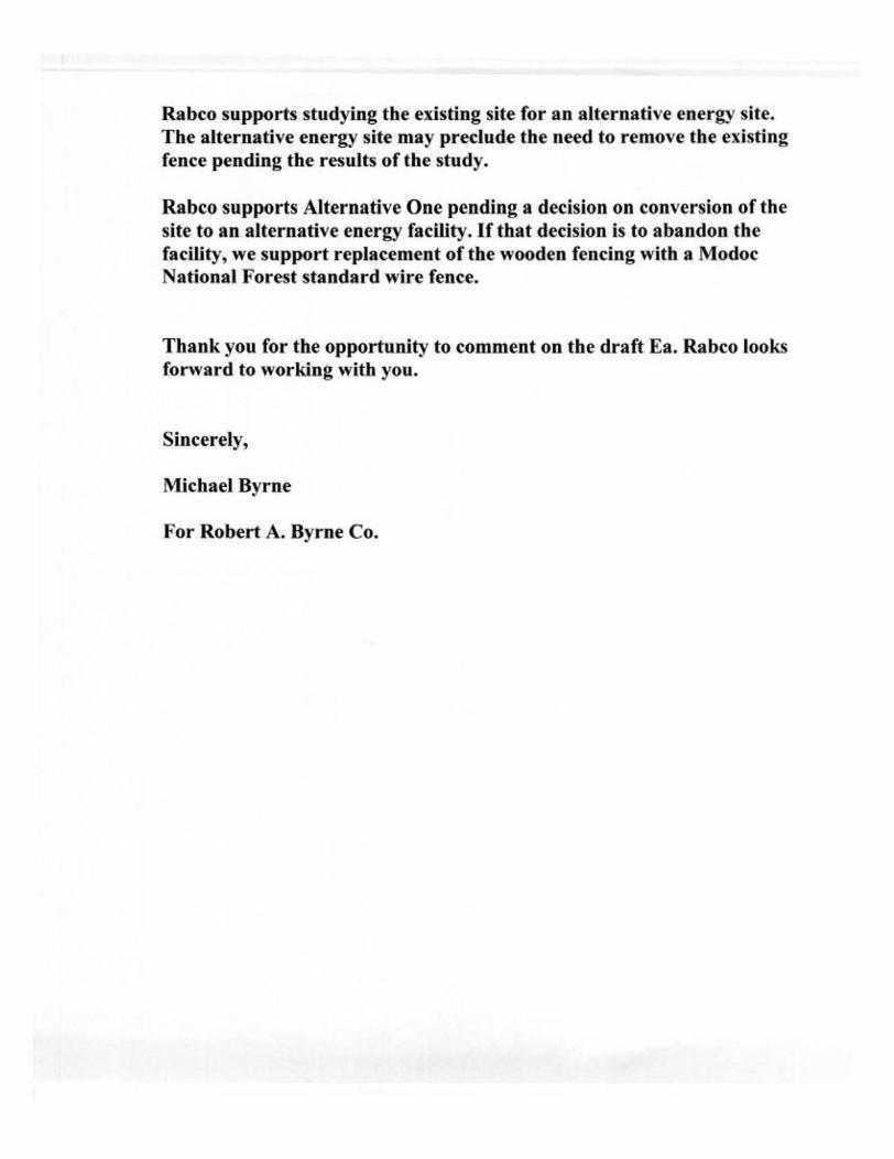


APPENDIX C
SUPPORTING INFORMATION FOR AIR QUALITY


Final EA Equipment Removal at OTH-B West Coast Radar Site Appendix C C-1
AIR QUALITY
This appendix presents an overview of the Clean Air Act (CAA) and the State of California and Oregon air quality programs. The appendix also discusses emission factor development and calculations including assumptions employed in the air quality analyses presented in the Air Quality sections of Chapter 3 and 4.
Air Quality Program Overview
In order to protect public health and welfare, the USEPA has developed numerical concentration-based standards or NAAQS for six “criteria” pollutants (based on health related criteria) under the provisions of the Clean Air Act Amendments of 1970. There are two kinds of NAAQS: Primary and Secondary standards. Primary standards prescribe the maximum permissible concentration in the ambient air to protect public health including the health of “sensitive” populations such as asthmatics, children, and the elderly. Secondary standards prescribe the maximum concentration or level of air quality required to protect public welfare including protection against decreased visibility, damage to animals, crops, vegetation, and buildings (Government Printing Office, n.d.).
The CAA gives states the authority to establish air quality rules and regulations. These rules and regulations must be equivalent to, or more stringent than, the Federal program. The receiver (RX) site is under the jurisdiction of the California Air Resources Board (CARB) and the Modoc County Air Pollution Control District (MCAPCD). The transmitter (TX) site is under the jurisdiction of the Oregon Department of Environmental Quality (ODEQ), Eastern Division.
Oregon has adopted the NAAQS except for sulfur dioxide (SO2). USEPA has set the annual and 24-hour standards for SO2 at 0.03 parts per million (ppm) (80 micrograms per cubic meter [µg/m3]) and 0.14 ppm (365 µg/m3) respectively. Oregon has adopted the more stringent annual and 24-hour standards of 0.02 ppm (60 µg/m3) and 0.1 ppm (260 µg/m3) respectively. In addition, Oregon has implemented a 0.050 ppm exceedance level as the SO2 3-hour standard. California has implemented more stringent standards for all the criteria pollutants. The Federal, California, and Oregon States ambient air quality standards are presented in Table C-1.
Based on measured ambient air pollutant concentrations, the USEPA designates areas of the United States as having air quality better than (attainment), worse than (nonattainment) the NAAQS, and unclassifiable. Those that cannot be classified on the basis of available information as meeting or not meeting the NAAQS for a particular pollutant are “unclassifiable” and are treated as attainment until proven otherwise. Attainment areas can be further classified as “maintenance” areas. These “attainment” maintenance areas are those areas previously classified as nonattainment that have successfully reduced air pollutant concentrations below the standard. Maintenance areas are under special guidance plans and must operate under some of the nonattainment area plans to ensure compliance with the NAAQS. Modoc County, California is a Federal attainment area but is a non-attainment area by

Final EA Equipment Removal at OTH-B West Coast Radar Site C-2 Appendix C
the state’s standards (Haas, 18 March 2005). Lake County, Oregon is a moderate nonattainment area for PM10 (USEPA, 2004).
Table C-1. Summary of National and State Ambient Air Quality Standards
Pollutant Averaging Time California
ppm2, 4 Federal
ppm1, 2, 3, 4 Oregon ppm2, 4
1 Hour 0.09 0.126 0.12 Ozone (O3) 8 Hour -- 0.087 --
24 Hour 50 ug/m³ 150 ug/m³ 5, 8 150 ug/m³ Particulate Matter (PM10) Annual Arithmetic
Mean 20 ug/m³ 50 ug/m³ 50 ug/m³
24 Hour No Separate State Standard 65 ug/m³ 9
-- Fine Particulate Matter (PM2.5) Annual Arithmetic Mean 12 ug/m³ 15 ug/m³ --
8 Hour 9 9 9 1 Hour 20 35 35 Carbon Monoxide (CO)
8 Hour (Lake Tahoe) 6 -- --
Annual Arithmetic Mean -- 0.053 0.053 Nitrogen Dioxide (NO2)
1 Hour 0.25 -- -- Annual Arithmetic
Mean -- 0.03 0.02
24 Hour 0.04 0.14 0.1 3 Hour -- -- 0.05
Sulfur Dioxide (SO2)
1 Hour 0.25 -- --
30 Day Average -- -- -- Lead Calendar Quarter -- 1.5 ug/m³ 1.5 ug/m³
Source: California Air Resource Board (CARB), July 2003., and Barnack, 2005 1. National standards (other than ozone, particulate matter, and those based on annual averages or annual arithmetic mean)
are not to be exceeded more than once a year. 2. Concentration expressed in equivalent units based upon a reference temperature of 25°C and a reference pressure of 760
mm of mercury; ppm refers to parts per million by volume. 3. National Primary Standards: The levels of air quality necessary, with an adequate margin of safety to protect the public
health. 4. ppm = parts per million 5. µg/m3 = micrograms per cubic meter 6. The ozone one-hour standard still applies to areas that were designated nonattainment when the ozone eight-hour
standard was adopted in July 1997. The 1-hour ozone standard is attained when the expected 7. The 8-hour ozone standard is attained when the 3-year average of the annual fourth-highest daily maximum 8-hour
average is not greater than 0.08 ppm. 8. The PM10 24-hour standard is attained when 99 percent of the daily concentrations, averaged over three years, are equal to
or less than the standard. 9. The PM2.5 24-hour standard is attained when 98 percent of the daily concentrations, averaged over three years, are equal
to or less than the standard.
General conformity analysis is required if the action’s direct and indirect emissions have a potential to emit one or more of the six criteria pollutants at or above emission rates shown in

Final EA Equipment Removal at OTH-B West Coast Radar Site Appendix C C-3
Table C-2 or Table C-3; or the action’s direct and indirect emissions of any criteria pollutant represent 10% of a non-attainment or maintenance area’s total emissions inventory for that pollutant. The analysis for this action found the emissions to be less than 10 percent for all the criteria pollutants thus conformity analysis is not required.
Table C-2. Emission Rates for Criteria Pollutants in Nonattainment Areas*
Pollutant Emission Rate (tpy)
OZONE (VOCS OR NOX)
Serious Nonattainment areas 50
Severe nonattainment areas 25
Extreme nonattainment areas 10
Other ozone nonattainment areas outside an ozone transport region
100
MARGINAL AND MODERATE NONATTAINMENT AREAS INSIDE AN OZONE TRANSPORT REGION
VOC 50
NOx 100
CO: All nonattainment areas 100
SO2 or NO2: All nonattainment areas 100
PM10
Moderate nonattainment areas 100
Serious nonattainment areas 70
Pb: All nonattainment areas 25 Source: U.S. Air Force, No Date *de minimis threshold levels for conformity applicability analysis.
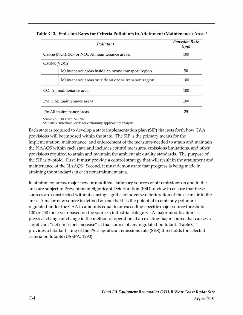
Final EA Equipment Removal at OTH-B West Coast Radar Site C-4 Appendix C
Table C-3. Emission Rates for Criteria Pollutants in Attainment (Maintenance) Areas*
Pollutant Emission Rate (tpy)
Ozone (NOx), SO2 or NO2: All maintenance areas: 100
OZONE (VOC)
Maintenance areas inside an ozone transport region 50
Maintenance areas outside an ozone transport region 100
CO: All maintenance areas 100
PM10: All maintenance areas 100
Pb: All maintenance areas 25 Source: U.S. Air Force, No Date *de minimis threshold levels for conformity applicability analysis.
Each state is required to develop a state implementation plan (SIP) that sets forth how CAA provisions will be imposed within the state. The SIP is the primary means for the implementation, maintenance, and enforcement of the measures needed to attain and maintain the NAAQS within each state and includes control measures, emissions limitations, and other provisions required to attain and maintain the ambient air quality standards. The purpose of the SIP is twofold. First, it must provide a control strategy that will result in the attainment and maintenance of the NAAQS. Second, it must demonstrate that progress is being made in attaining the standards in each nonattainment area.
In attainment areas, major new or modified stationary sources of air emissions on and in the area are subject to Prevention of Significant Deterioration (PSD) review to ensure that these sources are constructed without causing significant adverse deterioration of the clean air in the area. A major new source is defined as one that has the potential to emit any pollutant regulated under the CAA in amounts equal to or exceeding specific major source thresholds: 100 or 250 tons/year based on the source’s industrial category. A major modification is a physical change or change in the method of operation at an existing major source that causes a significant “net emissions increase” at that source of any regulated pollutant. Table C-4 provides a tabular listing of the PSD significant emissions rate (SER) thresholds for selected criteria pollutants (USEPA, 1990).
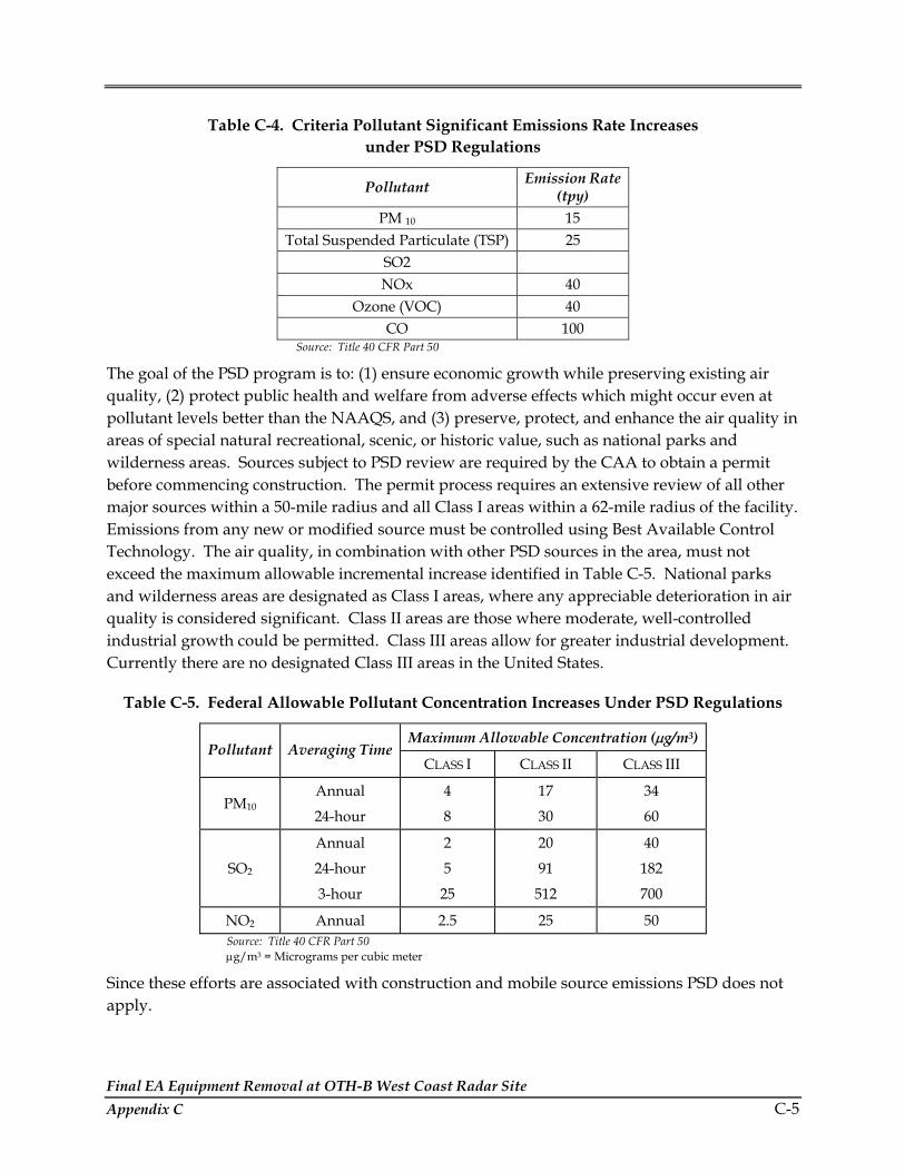
Final EA Equipment Removal at OTH-B West Coast Radar Site Appendix C C-5
Table C-4. Criteria Pollutant Significant Emissions Rate Increases under PSD Regulations
Pollutant Emission Rate (tpy)
PM 10 15 Total Suspended Particulate (TSP) 25
SO2 NOx 40
Ozone (VOC) 40 CO 100
Source: Title 40 CFR Part 50
The goal of the PSD program is to: (1) ensure economic growth while preserving existing air quality, (2) protect public health and welfare from adverse effects which might occur even at pollutant levels better than the NAAQS, and (3) preserve, protect, and enhance the air quality in areas of special natural recreational, scenic, or historic value, such as national parks and wilderness areas. Sources subject to PSD review are required by the CAA to obtain a permit before commencing construction. The permit process requires an extensive review of all other major sources within a 50-mile radius and all Class I areas within a 62-mile radius of the facility. Emissions from any new or modified source must be controlled using Best Available Control Technology. The air quality, in combination with other PSD sources in the area, must not exceed the maximum allowable incremental increase identified in Table C-5. National parks and wilderness areas are designated as Class I areas, where any appreciable deterioration in air quality is considered significant. Class II areas are those where moderate, well-controlled industrial growth could be permitted. Class III areas allow for greater industrial development. Currently there are no designated Class III areas in the United States.
Table C-5. Federal Allowable Pollutant Concentration Increases Under PSD Regulations
Maximum Allowable Concentration (µg/m3) Pollutant Averaging Time
CLASS I CLASS II CLASS III
PM10 Annual
24-hour
4
8
17
30
34
60
SO2
Annual
24-hour
3-hour
2
5
25
20
91
512
40
182
700
NO2 Annual 2.5 25 50 Source: Title 40 CFR Part 50 µg/m3 = Micrograms per cubic meter
Since these efforts are associated with construction and mobile source emissions PSD does not apply.

Final EA Equipment Removal at OTH-B West Coast Radar Site C-6 Appendix C
Oregon and California have statewide air quality-monitoring network that are operated by the state environmental programs (Oregon Department of Environmental Quality (ODEQ), 2003 and CARB, 2005). The air quality is monitored for carbon monoxide, lead, nitrogen dioxide, ozone, particulate matter, and sulfur dioxide. The monitors tend to be concentrated in areas with the largest population densities. Not all pollutants are monitored in all areas. The air quality monitoring network is used to identify areas where the ambient air quality standards are being violated and plans are needed to reduce pollutant concentration levels to be in attainment with the standards, also included are areas where the ambient standards are being met but plans are necessary to ensure maintenance of acceptable levels of air quality in the face of anticipated population or industrial growth.
Oregon has monitors in the major cities and multiple communities in Eastern Oregon where data is posted to the DEQ twice daily (http://www.deq.state.or.us/aq/api/index.asp). California has an Air Monitoring Network Plan to coordinate National, State, and Local monitoring data acquisition and can be found on the California Air Quality Data website (http://www.arb.ca.gov/aqd/aqdpage.htm). Lake County, Oregon and Modoc County, California are rural areas and do not have monitoring sites within the county.
Project Air Emission Calculations
Construction Equipment Emissions on Site
Emission factors for various construction machinery was obtained from the Mobile Source Emissions Inventory (USEPA, 1991 as sited in U.S. Air Force, 2004). It was assumed that the equipment would be used for six months (130 days) total or three months each site (65 days) 8 hours each day. The number of each type of equipment necessary varies based on the action selected; specifics are outlined in Chapter 2. The types of equipment necessary for the activity includes:
• semi-tractor trailers (for debris removal)
• excavators
• fork lifts
• front end loader
• crane
• other construction equipment
To calculate emissions the following method was applied using as an example the values associated with CO emissions for 1 crane.
CO Emissions = (# pieces of equipmt)*(days used)*(hours/day)*(Emission factor g/hr) = (1)*(65 days/yr)*(8 hrs/day)*(4.20 g/hr) = 2,184 g/yr
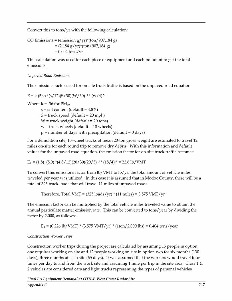
Final EA Equipment Removal at OTH-B West Coast Radar Site Appendix C C-7
Convert this to tons/yr with the following calculation:
CO Emissions = (emission g/yr)*(ton/907,184 g) = (2,184 g/yr)*(ton/907,184 g) = 0.002 tons/yr
This calculation was used for each piece of equipment and each pollutant to get the total emissions.
Unpaved Road Emissions
The emissions factor used for on-site truck traffic is based on the unpaved road equation:
E = k (5.9) *(s/12)(S/30)(W/30) .7 * (w/4).5
Where k = .36 for PM10 s = silt content (default = 4.8%)
S = truck speed (default = 20 mph) W = truck weight (default = 20 tons)
w = truck wheels (default = 18 wheels) p = number of days with precipitation (default = 0 days)
For a demolition site, 18-wheel trucks of mean 20-ton gross weight are estimated to travel 12 miles on-site for each round trip to remove dry debris. With this information and default values for the unpaved road equation, the emission factor for on-site truck traffic becomes:
ET = (1.8) (5.9) *(4.8/12)(20/30)(20/3) .7 * (18/4).5 = 22.6 lb/VMT
To convert this emissions factor from lb/VMT to lb/yr, the total amount of vehicle miles traveled per year was utilized. In this case it is assumed that in Modoc County, there will be a total of 325 truck loads that will travel 11 miles of unpaved roads.
Therefore, Total VMT = (325 loads/yr) * (11 miles) = 3,575 VMT/yr
The emission factor can be multiplied by the total vehicle miles traveled value to obtain the annual particulate matter emission rate. This can be converted to tons/year by dividing the factor by 2,000, as follows:
ET = (0.226 lb/VMT) * (3,575 VMT/yr) * (1ton/2,000 lbs) = 0.404 tons/year
Construction Worker Trips
Construction worker trips during the project are calculated by assuming 15 people in option one requires working on site and 12 people working on site in option two for six months (130 days); three months at each site (65 days). It was assumed that the workers would travel four times per day to and from the work site and assuming 1 mile per trip in the site area. Class 1 & 2 vehicles are considered cars and light trucks representing the types of personal vehicles
Final EA Equipment Removal at OTH-B West Coast Radar Site C-8 Appendix C
driven by the employees. The emissions generated from these time and distance variables were calculated by the following methodology:
Total Miles/Year = (# cars) * (# days/yr) * (trips/day) * (miles/trip) = (12)*(65 days/yr)*(4 trips/day)*(1mile/trip) = 3,120 miles/yr
Using each of the pollutant emission factors (grams/mile) for the appropriate type of vehicle the emissions are calculated and converted to tons/yr. To illustrate this the calculation is completed using the CO emission factor for a class 1 & 2 vehicle (25 g/mi).
CO emission in tons/yr = (total miles/yr)*(CO Emission Factor g/mi)*( ton/907,184 g) = (3,120 mi/yr)*(25 g/mi)*(ton/907,184 g) = 0.0859 tons/yr of CO
Transporting Construction Equipment from One Site to the Other
All equipment and heavy trucks will be used at both the receiver and transmitter sites. The calculation is based on several assumptions:
• Distance between sites is 150 miles. Estimated miles in Modoc County are assumed to be 60 miles, and Lake County 90 miles.
• A total of 117 class 3 & 4 vehicles would be traveling to the other site. Class 3 & 4 vehicles are defined as tractor trailer rigs, heavy duty trucks, buses or dump trucks, specific to this activity these consist of:
- semi-tractor trailers - excavators - fork lifts - front end loader - crane - ‘other construction equipment’
Each of the criteria pollutant emissions can be calculated for each of the counties using this information in the following calculation. The example will be for transport in Modoc County for CO emissions using CO emission factor for Class 3 & 4 vehicles (5 grams/mile) (U.S. Air Force, 2004):
CO Emissions = (# trucks)*(miles/yr traveled in county)*(CO emission factor g/mi) = (117)*(60 mi/yr)*(5 g/mi) = 35,100 g/yr
Convert the emissions into tons/year by dividing by 907,184:
CO Emissions = (emission g/yr)*(1 ton/907184 g) = (35,100 g/yr)*(1 ton/907184 g) = 0.038 tons/yr

Final EA Equipment Removal at OTH-B West Coast Radar Site Appendix C C-9
National Emissions Inventory
The National Emissions Inventory (NEI) is operated under USEPA’s Emission Factor and Inventory Group, which prepares the national database of air emissions information with input from numerous State and local air agencies, from tribes, as well as from industry. The database contains information on stationary and mobile sources that emit criteria air pollutants and hazardous air pollutants (HAPs). The database includes estimates of annual emissions, by source, of air pollutants in each area of the country, on an annual basis. The NEI includes emission estimates for all 50 States, the District of Columbia, Puerto Rico, and the Virgin Islands. Emission estimates for individual point or major sources (facilities), as well as county level estimates for area, mobile and other sources, are available currently for years 1996 and 1999 for criteria pollutants, and HAPs.
Criteria air pollutants are those for which USEPA has set health-based standards. Four of the six criteria pollutants are included in the NEI database:
• Carbon Monoxide (CO) • Nitrogen Oxides (NOx) • Sulfur Dioxide (SO2) • Particulate Matter (PM10 and PM2.5)
The NEI also includes emissions of Volatile Organic Compounds (VOCs), which are ozone precursors, emitted from motor vehicle fuel distribution and chemical manufacturing, as well as other solvent uses. VOCs react with nitrogen oxides in the atmosphere to form ozone. The NEI database defines three classes of criteria air pollutant sources:
Point sources—stationary sources of emissions, such as an electric power plant, that can be identified by name and location. A "major" source emits a threshold amount (or more) of at least one criteria pollutant, and must be inventoried and reported. Many states also inventory and report stationary sources that emit amounts below the thresholds for each pollutant.
Area sources—small point sources such as a home or office building, or a diffuse stationary source, such as wildfires or agricultural tilling. These sources do not individually produce sufficient emissions to qualify as point sources. Dry cleaners are one example, i.e., a single dry cleaner within an inventory area typically will not qualify as a point source, but collectively the emissions from all of the dry cleaning facilities in the inventory area may be significant and therefore must be included in the inventory.
Mobile sources— any kind of vehicle or equipment with a gasoline or diesel engine; airplane; or ship.
The main sources of criteria pollutant emissions data for the NEI are:
For electric generating units—USEPA’s Emission Tracking System / Continuous Emissions Monitoring Data (ETS/CEM) and Department of Energy fuel use data.

Final EA Equipment Removal at OTH-B West Coast Radar Site C-10 Appendix C
For other large stationary sources—state data and older inventories where state data was not submitted.
For on-road mobile sources—the Federal Highway Administration’s (FHWA’s) estimate of vehicle miles traveled and emission factors from USEPA’s MOBILE Model.
For non-road mobile sources—USEPA’s NONROAD Model.
For stationary area sources—state data, USEPA-developed estimates for some sources, and older inventories where state or USEPA data was not submitted.
State and local environmental agencies supply most of the point source data. USEPA’s Clean Air Market program supplies emissions data for electric power plants.
References:
California Air Resource Board (CARB), October 2003., 2004 Area Designations for State Ambient Air Quality Standards PM10., Hhttp://www.arb.ca.gov/desig/adm/adm.htmH., October 2003., Accessed 17 March 2005
CARB, July 2003., Ambient Air Quality Standards., Hhttp://www.arb.ca.gov/aqs/aqs.htmH., 9 July 2003., Accessed 10 March 2005
CARB, 2005., State and Local Air Monitoring Network Plan., 6 Jan. 2005., Hhttp://www.arb.ca.gov/aqd/namslams/namslams.htmH
Government Printing Office, no date. Code of Federal Regulations, Code of Federal Regulations, Title 40, Part 50 (40 CFR 50), Hwww.access.gpo.gov/nara/cfr/cfr-retrieve.html#page1 H
Haas, 18 March 2005. Phone conversation between Kate Haas, Inspector for Modoc County Air Pollution Control District, and SAIC regarding OTH-B project emissions and county regulations, attainment, and permitting. 18 March 2005
Oregon Department of Environmental Quality (ODEQ), 2003., Oregon Air Quality Data Summaries., Air Quality Division. Hhttp://www.deq.state.or.us/aq/forms/2003ar/2003AQAnnualR.pdfH
U.S. Air Force, 2004. Mobile Source Emission Inventory. for Eglin AFB, FL 30 April 2004, Pages 5, 7, 12, and 14
USEPA, 1990. Draft New Source Review Workshop Manual: Prevention of Significant Deterioration and Nonattainment Permitting, Office of Air Quality Planning and Standards, October.
Final EA Equipment Removal at OTH-B West Coast Radar Site Appendix C C-11
USEPA, 1991 as cited in U.S. Air Force, 2004. Mobile Source Emission Inventory. for Eglin AFB, FL 30 April 2004, Pages 5, 7, 12, and 14
USEPA, 2004. Green Book: Particulate Matter Nonattainment State/Area/County. Hhttp://www.epa.gov/air/aoqps/greenbk/pncs.htmlH., November 29, 2004., Accessed 17 March 2005

Final EA Equipment Removal at OTH-B West Coast Radar Site C-12 Appendix C
THIS PAGE INTENTIONALLY LEFT BLANK.

APPENDIX D LISTS OF PLANTS AND ANIMALS IN STUDY AREAS


Final EA Equipment Removal at OTH-B West Coast Radar Site Appendix D D-1
Table D-1. Scientific and Common Names of Plants Found in the Proposed Transmit and Receive Study Areas
Scientific Name Common Name Notes
Trees
Juniperus occidentalis Western juniper
Pinus ponderosa Ponderosa pine
Shrubs
Amelanchier alnifolia Serviceberry WIS-FACU
Arctostaphylos patula Greenleaf manzanita
Artemisia arbuscula Low sagebrush
Artemisia cana Silver sagebrush WIS-FACW
Artemisia tridentata Big sagebrush
Atriplex sp. Saltbush
Ceanothus prostratus Squaw carpet (Mahala mat)
Ceanothus velutinus Tobacco bush
Cercocarpus ledifolius Curl-leaf mountain mahogany
Chrysothamnus nauseosus Grey (Rubber ) rabbitbrush
Chrysothamnus viscidiflorus Green (Yellow) rabbitbrush
Krascheninnikovia (= Eurotia) lanata Winterfat
Grayia spinosa Spiny hopsage
Purshia tridentata Bitterbrush (Antelope bush)
Sarcobatus vericulatus Greasewood WIS-FACU
Tetradymia sp. Horsebrush
Herbs
Achnatherum (=Oryzopsis) hymenoides Indian ricegrass
Achnatherum (=Stipa) thurberiana Thurber’s needlegrass
*Agropogon spicatum Bluebunch wheatgrass WIS-FACU
*Agropyron desertorum (=A. cristatum) Crested wheatgrass
Allium tolmiei WIS-UPL
Alopecurus saccatus (= A. howellii) Pacific foxtail WIS-OBL
Antennaria argentea Pussy toes
Astragalus spp. Locoweed
Blepharippapus scaber WIS-UPL
Epilobium (=Boisduvalia) densiflorum Dense-flowered spike primrose WIS-FACW
Brodiaea spp. Brodiaea
*Bromus tectorum Cheatgrass
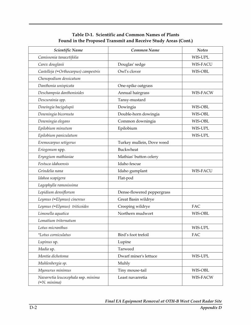
Final EA Equipment Removal at OTH-B West Coast Radar Site D-2 Appendix D
Table D-1. Scientific and Common Names of Plants Found in the Proposed Transmit and Receive Study Areas (Cont.)
Scientific Name Common Name Notes
Camissonia tanacetifolia WIS-UPL
Carex douglasii Douglas' sedge WIS-FACU
Castelleja (=Orthocarpus) campestris Owl’s clover WIS-OBL
Chenopodium dessicatum
Danthonia unispicata One-spike oatgrass
Deschampsia danthonioides Annual hairgrass WIS-FACW
Descurainia spp. Tansy-mustard
Dowingia bacigalupii Dowingia WIS-OBL
Downingia bicornuta Double-horn dowingia WIS-OBL
Downingia elegans Common downingia WIS-OBL
Epilobium minutum Epilobium WIS-UPL
Epilobium paniculatum WIS-UPL
Eremocarpus setigerus Turkey mullein, Dove weed
Eriogonum spp. Buckwheat
Eryngium mathiasiae Mathias' button celery
Festuca idahoensis Idaho fescue
Grindelia nana Idaho gumplant WIS-FACU
Idahoa scapigera Flat-pod
Lagophylla ramosissima
Lepidium densiflorum Dense-flowered peppergrass
Leymus (=Elymus) cinereus Great Basin wildrye
Leymus (=Elymus) triticoides Creeping wildrye FAC
Limosella aquatica Northern mudwort WIS-OBL
Lomatium triternatum
Lotus micranthus WIS-UPL
*Lotus corniculatus Bird’s foot trefoil FAC
Lupinus sp. Lupine
Madia sp. Tarweed
Montia dichotoma Dwarf miner's lettuce WIS-UPL
Muhlenbergia sp. Muhly
Myosurus minimus Tiny mouse-tail WIS-OBL
Navarretia leucocephala ssp. minima (=N. minima)
Least navarretia WIS-FACW

Final EA Equipment Removal at OTH-B West Coast Radar Site Appendix D D-3
Table D-1. Scientific and Common Names of Plants Found in the Proposed Transmit and Receive Study Areas (Cont.)
Scientific Name Common Name Notes
Navarretia intertexta ssp. propinqua (=N. propinqua)
Great Basin navarretia WIS-FAC
Navarretia sp. Navarretia
Oenothera deltoides Basket evening-primrose
Plagiobothrys bracteatus Bracted popcorn-flower WIS-OBL
Plagiobothrys leptocladus Fine-branched popcorn-flower WIS-OBL
Plagiobothrys sp. Popcorn-flower
Plagiobothrys stipitatus var. micranthus Slender popcorn-flower WIS-OBL
Poa secunda (=P. nevandensis) Nevada bluegrass WIS-FAC
Poa secunda (=P. sandbergii) Sandberg bluegrass WIS-UPL
Pogogyne floribunda Many flowered pogogyne, WIS-FACW, CNPS List 1B
Polyctenium fremontii WIS-UPL
*Ploygonum arenastrum (=P. aviculare) Prostrate knotweed WIS-FAC
Polygonum polygaloides ssp. confertiflorum
Polygale knotweed WIS-FACW
Psilocarphus brevissimus Dwarf wooly heads WIS-OBL
Psilocarphus sp. Woolly heads
Ranunculus aquatilis White water buttercup WIS-OBL
*Senecio vulgaris Common groundsel
*Spergularia rubra Purple sandspurry WIS-FAC
Elymus elymoides (=Sitanion histrix) Bottlebrush squirreltail WIS-FACU
Swertia (=Frasera) albicaulis
*Taraxacum officinale Common dandelion WIS-FACU
Trifolium macrocephalum Large-head clover WIS-FACU
Veronica peregrina ssp. xalepensis Purslane speedwell WIS-OBL
Sources: EIS, 1983; Metcalf and Eddy, 1996; Reed, 1988; CNDDB, 2004; Hickman, 1983.
Notes: WIS = Wetland Indicator Status of species (from Reed 1988): OBL – Obligate, almost always found in wetlands; FACW – Facultative Wetland, found in wetlands most of the time; FAC – Facultative, equally likely to be found in wetlands or upland habitats; FACU – Facultative Upland, found in upland most of the time; UPL – almost always found in uplands. Most of the wetland plants were reported during vernal pool monitoring at the Tulelake receiver site. Not all plant species are assigned a WIS.
* Indicates a non-native species.
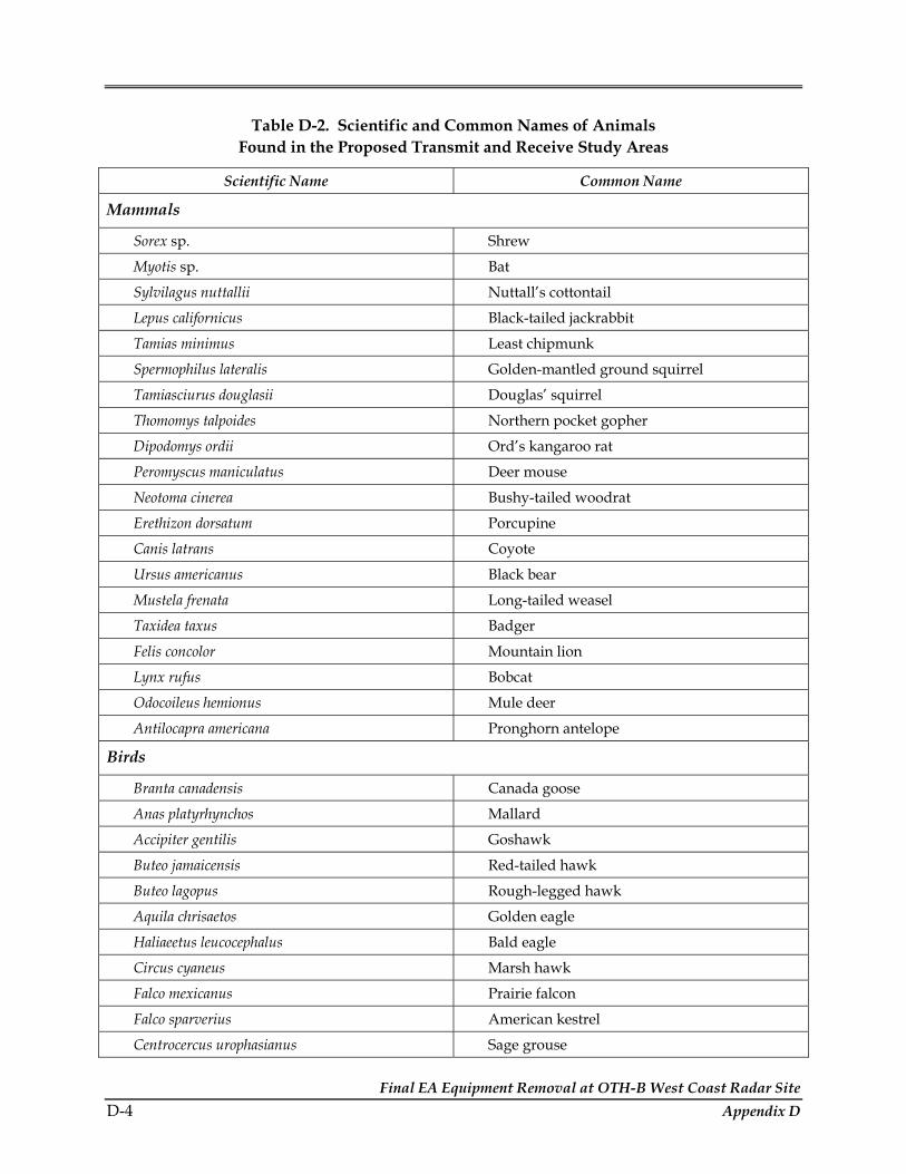
Final EA Equipment Removal at OTH-B West Coast Radar Site D-4 Appendix D
Table D-2. Scientific and Common Names of Animals Found in the Proposed Transmit and Receive Study Areas
Scientific Name Common Name
Mammals
Sorex sp. Shrew
Myotis sp. Bat
Sylvilagus nuttallii Nuttall’s cottontail
Lepus californicus Black-tailed jackrabbit
Tamias minimus Least chipmunk
Spermophilus lateralis Golden-mantled ground squirrel
Tamiasciurus douglasii Douglas’ squirrel
Thomomys talpoides Northern pocket gopher
Dipodomys ordii Ord’s kangaroo rat
Peromyscus maniculatus Deer mouse
Neotoma cinerea Bushy-tailed woodrat
Erethizon dorsatum Porcupine
Canis latrans Coyote
Ursus americanus Black bear
Mustela frenata Long-tailed weasel
Taxidea taxus Badger
Felis concolor Mountain lion
Lynx rufus Bobcat
Odocoileus hemionus Mule deer
Antilocapra americana Pronghorn antelope
Birds
Branta canadensis Canada goose
Anas platyrhynchos Mallard
Accipiter gentilis Goshawk
Buteo jamaicensis Red-tailed hawk
Buteo lagopus Rough-legged hawk
Aquila chrisaetos Golden eagle
Haliaeetus leucocephalus Bald eagle
Circus cyaneus Marsh hawk
Falco mexicanus Prairie falcon
Falco sparverius American kestrel
Centrocercus urophasianus Sage grouse

Final EA Equipment Removal at OTH-B West Coast Radar Site Appendix D D-5
Table D-2. Scientific and Common Names of Animals Found in the Proposed Transmit and Receive Study Areas (cont.)
Scientific Name Common Name
Birds (cont.)
Zenaida macroura Mourning dove
Colaptes auratus Northern flicker
Dryocopos pileatus Pileated woodpecker
Contopus sordidulus Western wood peewee
Eremophila alpestris Horned lark
Cyanocitta stelleri Steller’s jay
Gymnorhinus cyanocephalus Pinyon Jay
Aphelocoma coerulescens Scrub jay
Pica pica Black-billed magpie
Parus gambeli Mountain chickadee
Psaltriparus minimus Bushtit
Oreoscoptes montanus Sage thrasher
Turdus migratorius American robin
Sialia mexicana Western bluebird
Bombycilla cedrorum Cedar waxwing
Lanius ludovicianus Loggerhead shrike
Lanius excubitor Northern shrike
Sturnella neglecta Western meadowlark
Leucosticte tephrocotis Rosy finch
Chondestes grammacus Lark sparrow
Amphispiza belli Sage sparrow
Spizella breweri Brewer’s sparrow
Reptiles
Sceloporus graciosus Sagebrush lizard
Pituophis melanoleucus Gopher snake
Crotalus viridis Western rattlesnake

Final EA Equipment Removal at OTH-B West Coast Radar Site D-6 Appendix D
THIS PAGE INTENTIONALLY LEFT BLANK.