Embed Size (px)
Citation preview

Placer County Water Agency Middle Fork American River Hydroelectric Project
(FERC No. 2079)
FINAL
2006 AQUATIC HABITAT CHARACTERIZATION
STUDY PLAN
Prepared for:
Placer County Water Agency
144 Ferguson Road Auburn, CA 95604
September 8, 2006
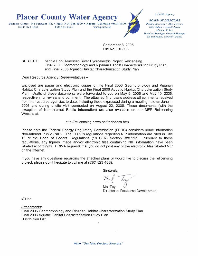
Placer County Water Agency Middle Fork American River Hydroelectric Project (FERC Project No. 2079)
Final 2006 Geomorphology and Riparian Habitat Characterization Study Plan Final 2006 Aquatic Habitat Characterization Study Plan
Distribution List
Copyright 2006 by Placer County Water Agency 1 September 2006
US Forest Service – Region 5 – Regional Hydropower Assistance Team (RHAT)
Bob Hawkins US Forest Service Regional Hydro Coordinator 650 Capitol Mall Suite 8-200 Sacramento, CA 95814
Dennis Smith RHAT Fisheries Biologist US Forest Service 650 Capitol Mall, Suite 8-200 Sacramento, CA 95814-4706
US Forest Service – Eldorado National Forest
Beth Paulson FERC Coordinator Eldorado National Forest 100 Forni Road Placerville, CA 95667
Jon Jue Resource Officer Georgetown Ranger District Eldorado National Forest 7600 Wentworth Springs Road Georgetown, CA 95634
Tim Dabney Georgetown District Ranger Eldorado National Forest 7600 Wentworth Springs Road Georgetown, CA 95634
Jann Williams Biologist Eldorado National Forest 100 Forni Road Placerville, CA 95667
US Forest Service – Tahoe National Forest
Dan Teator American River Ranger District Tahoe National Forest 22830 Foresthill Road Foresthill, CA 95631
Mo Tebbe, Resource Officer American River Ranger District Tahoe National Forest 22830 Foresthill Road Foresthill, CA 95631
Matt Triggs Tahoe National Forest American River Ranger District 22830 Foresthill Road Foresthill, CA 95631
Rick Weaver, Hydrologist Tahoe National Forest 631 Coyote Street Nevada City, CA 95959-2250
US Fish and Wildlife Service
William E. Foster Senior Fish and Wildlife Biologist Energy and Instream Flow Branch U.S. Fish and Wildlife Service Habitat Conservation Division 2800 Cottage Way, Rm W-2605 Sacramento, CA 95825-1846
US Bureau of Land Management
Deane Swickard Field Manager US Bureau of Land Management 63 Natoma Street Folsom, CA 95630

Placer County Water Agency Middle Fork American River Hydroelectric Project (FERC Project No. 2079)
Final 2006 Geomorphology and Riparian Habitat Characterization Study Plan Final 2006 Aquatic Habitat Characterization Study Plan
Distribution List
Copyright 2006 by Placer County Water Agency 2 September 2006
California State Water Resources Control Board
Jim Canaday FERC Relicensing Team Leader CA State Water Resources Control Board Division of Water Rights 1001 I St 14th Floor Sacramento, CA 95814
Beth Lawson CA State Water Resources Control Board Division of Water Rights 1001 I St, 14th Floor Sacramento, CA 95814
Matt Myers CA State Water Resources Control Board State Water Resources Control Board Division of Water Rights 1001 I St, 14th Floor Sacramento, CA 95814
California Department of Fish and Game
John Hiscox California Department of Fish & Game Sacramento Valley Central Sierra Region 1701 Nimbus Road Rancho Cordova, CA 95670
Robert Hughes California Department of Fish & Game NAFWB 830 S Street Sacramento, CA 95814
Stafford Lehr, Associate Fisheries Biologist California Department of Fish & Game Sacramento Valley Central Sierra Region 1701 Nimbus Road Rancho Cordova, CA 95670
MaryLisa Lynch California Department of Fish & Game Staff Environmental Scientist 1701 Nimbus Road Rancho Cordova, CA 95670
California State Parks
Bill Deitchman California State Parks Boating Program Manager Auburn State Recreation Area 501 El Dorado Street Auburn, CA 95603 Jim Michaels California State Parks Folsom State Recreation Area 7806 Folsom Auburn Road Folsom, CA 95630
Jay Galloway California State Parks Sector Superintendent Auburn State Recreation Area 501 El Dorado Street Auburn, CA 95603
Julie Leimbach Foothills Water Network P.O. Box 713 Lotus, CA 95651
Final Plan
Copyright 2006 by Placer County Water Agency i September 2006
TABLE OF CONTENTS
Page
1.0 INTRODUCTION........................................................................................1
2.0 STUDY OBJECTIVES ................................................................................1
3.0 GENERAL APPROACH .............................................................................1
4.0 STUDY METHODOLOGY ..........................................................................2
4.1 Refine Phase 1 Habitat Mapping .....................................................2
4.2 Verify and Expand Upon the Phase 1 Habitat Mapping...................2
4.3 Map Aquatic Habitat Along Streams Not Surveyed During Phase 1............................................................................................3
4.4 Conduct Detailed Mapping of Aquatic Habitat At Geomorphic and Riparian Quantitative Study Sites ....................................................4
4.5 Assess and Map Potential Comparison Streams.............................4
5.0 DATA REDUCTION AND WORK PRODUCTS..........................................4
6.0 REPORTING ..............................................................................................5
7.0 NEXT STEPS .............................................................................................5
8.0 SCHEDULE MILESTONES........................................................................6
9.0 REFERENCES...........................................................................................6
LIST OF TABLES
Table 1. Phase 2 Study Site Locations
LIST OF FIGURES
Figure 1. 2006 Geomorphology, Riparian, and Aquatic Study Reaches (Sheets 1- 3)
LIST OF APPENDICES
Appendix A. Survey Methods
Final Plan
Copyright 2006 by Placer County Water Agency 1 September 2006
1.0 INTRODUCTION
This study plan describes Placer County Water Agency’s (PCWA) proposed approach for conducting Phase 2 of a two-part Aquatic Habitat Characterization Study (Study). Phase 1 of the Aquatic Habitat Characterization Study was completed during 2005, in accordance with the approaches and methods presented in PCWA’s 2005-2006 Existing Environment Study Plan Package dated June 17, 2005 (PCWA 2005). The technical approaches included in this study plan represent a refinement of the methods originally presented in PCWA’s 2005-2006 Existing Environment Study Plan Package. The Phase 2 studies will be conducted during the summer of 2006 and will augment the work completed in 2005. The 2005 study methods and results are documented in a report titled Draft 2005 Physical Habitat Characterization Report dated January 30, 2006 (PCWA 2006).
PCWA circulated a draft version of the Proposed 2006 Aquatic Habitat Characterization Study Plan to the resource agencies for review and comment on May 10, 2006. All comments received from the resource agencies, including those expressed during a meeting held on June 1, have been addressed in this final plan. PCWA intends to continue to consult with the resource agencies and other interested stakeholders as the work described in this plan is completed and to address any outstanding questions or issues.
2.0 STUDY OBJECTIVES
The purpose of the study is to develop information regarding the types and distributions of aquatic habitats in the stream and river reaches in the vicinity of the Middle Fork American River Hydroelectric Project (Project or MFP). Habitat information is important in developing an understanding of the factors that influence the distribution and abundance of fish and other stream organisms. Information developed as part of this study will be used as a basis for designing future technical studies involving aquatic resources.
3.0 GENERAL APPROACH
The Phase 2 studies proposed in this study plan are designed to augment and build upon information developed as part of the Phase 1 studies conducted in 2005. During Phase 1, aquatic habitat was mapped along the Middle Fork American and the Rubicon rivers using a combination of videography and aerial photography. The smaller streams, including Duncan Creek and Long Canyon, were not mapped due to the presence of dense vegetation, which obscured the view of the streams. The Phase 2 aquatic habitat studies will focus on refining, verifying, and expanding the mapping conducted during Phase 1, using a combination of helicopter surveys and ground surveys. In addition, aquatic habitat information will be collected along the streams that could not be mapped during Phase 1 through focused ground surveys. Detailed measurements of aquatic habitat characteristics will be collected during the ground surveys.
Final Plan
Copyright 2006 by Placer County Water Agency 2 September 2006
4.0 STUDY METHODOLOGY
The following summarizes the aquatic habitat mapping activities PCWA plans to accomplish in 2006:
• Refine habitat mapping conducted along select reaches of the Middle Fork American and Rubicon rivers using low altitude helicopter reconnaissance surveys.
• Verify and expand upon the habitat mapping information developed in 2005 for the Middle Fork American River and the Rubicon River. This effort would involve conducting focused ground truthing in accessible representative portions of major strata in the Middle Fork American River and Rubicon River.
• Conduct ground surveys to map aquatic habitats along the smaller tributary study streams including Duncan Creek, North and South Forks of Long Canyon Creek, and Long Canyon Creek.
• Complete detailed aquatic habitat mapping at each geomorphic and riparian quantitative study site to provide continuity of information.
• Map aquatic habitat upstream of the diversions on Duncan Creek, North Fork Long Canyon Creek, and South Fork Long Canyon Creek for potential comparison reaches. Assess, in consultation with the resource agencies, if any additional aquatic mapping in comparison reaches is needed.
• Prepare a report documenting the 2006 aquatic habitat mapping results.
The methods associated with each of these activities are described in the following subsections.
4.1 REFINE PHASE 1 HABITAT MAPPING
During 2005, habitat mapping was completed along the Middle Fork American River from French Meadows Dam to the confluence with the North Fork American River, and along the Rubicon River from Hell Hole Dam to the confluence with the Middle Fork American River, using a combination of aerial photography and low altitude aerial videography. The results of this effort are described in the 2005 Aquatic Habitat Characterization Study Report dated January 30, 2006 (PCWA 2006). The visual classification information developed during Phase 1 will be refined in 2006 by conducting low altitude helicopter surveys. Any modifications to the original habitat classifications will be recorded on maps and aerial photographs and will be documented in the 2006 Study Report.
4.2 VERIFY AND EXPAND UPON THE PHASE 1 HABITAT MAPPING
Ground surveys will be conducted to verify and expand upon the aquatic habitat mapping information completed in the Middle Fork American River and Rubicon River in 2005. PCWA proposes to ground-truth accessible reaches along the Middle Fork

Final Plan
Copyright 2006 by Placer County Water Agency 3 September 2006
American River and Rubicon River. The survey will include those accessible reaches necessary to evaluate up to 20% of the total length of the Middle Fork American and Rubicon rivers downstream of Project facilities. One hundred percent of all accessible reaches will be surveyed if the cumulative total length of all accessible reaches is less than 20% of the total length of the Middle Fork American River and Rubicon River downstream of Project facilities.
Within each of the accessible Rosgen channel type reaches, contiguous lengths of stream will be ground-truthed for efficiency, to the extent feasible. The selection of lengths to be ground-truthed will be based on accessibility and overlap of the geomorphic and riparian quantitative study sites (Table 1 and Figure 1). Survey methods will follow those described in PCWA’s 2005-2006 Existing Environment Study Plan Package dated June 17, 2005, and provided in Appendix A.
4.3 MAP AQUATIC HABITAT ALONG STREAMS NOT SURVEYED DURING PHASE 1
Existing aerial photography and low altitude aerial video could not be used to map habitat along the smaller streams mainly due to the presence of dense vegetation, which obscures the view of the stream. Accordingly, PCWA will conduct ground-based surveys along the smaller streams, including:
• Duncan Creek
• North Fork Long Canyon Creek
• South Fork Long Canyon Creek
• Long Canyon Creek
PCWA proposes to utilize a habitat assessment approach that is a modification of BVET (Dolloff et al. 1993). All reasonably accessible reaches in these streams will be inventoried on the ground as indicated in Table 1. All habitat units will be classified to habitat type and the length of each unit will be measured. This approach will provide the location and length of each habitat unit.
In addition, PCWA proposes to take detailed measurements of 20% of the units in each habitat type along each creek following methods described in PCWA’s 2005-2006 Existing Environment Study Plan Package dated June 17, 2005, and provided in Appendix A. Units to be measured will typically be selected by systematic sampling of each habitat type. Typically, the first habitat unit of a particular type will be sampled, followed by the sixth unit of that type, and every succeeding fifth unit in each section of stream mapped. Detailed information from a minimum of 10 units of each Dolloff et al. (1993) habitat type (pool, riffle, cascade, complex) will be collected, if present within the survey area.
Final Plan
Copyright 2006 by Placer County Water Agency 4 September 2006
4.4 CONDUCT DETAILED MAPPING OF AQUATIC HABITAT AT GEOMORPHIC AND RIPARIAN QUANTITATIVE STUDY SITES
Detailed ground surveys will be completed at each geomorphic and riparian quantitative study site following the methods provided in Appendix A. Field measurements will be collected in each habitat unit included in the geomorphic and riparian quantitative study sites. One hundred percent of the length of each quantitative geomorphic and riparian study site will be surveyed. This will allow more detailed assessment of factors affecting aquatic habitat and will provide continuity of data between the studies. The locations for the quantitative study sites are identified in Table 1 and Figure 1.
4.5 ASSESS AND MAP POTENTIAL COMPARISON STREAMS
It may be necessary to compare aquatic habitat between the study streams and other streams, such as unregulated streams upstream of Project diversions (and reservoirs). In order to evaluate the usefulness of unregulated streams as reference sites for study streams, it is important to understand their similarities and differences. Physical habitat resulting from geomorphic characteristics and hydrologic conditions can affect aquatic biota and riparian communities. These characteristics may result from underlying geomorphic and hydrologic differences in addition to differences that may be attributable to Project presence and operations.
PCWA proposes to map one mile upstream of the Project diversions on Duncan Creek, North Fork Long Canyon Creek, and South Fork Long Canyon Creek for possible comparison reaches. In addition, PCWA proposes to consult with the resource agencies regarding the selection of additional possible comparison reaches, study goals, and objectives as they relate to the selection of comparison reaches, study methodologies, and evaluation criteria.
5.0 DATA REDUCTION AND WORK PRODUCTS
Field data will be entered into a database, where data will be stored by stream, reach, channel type, and river mile. Habitat classifications and detailed measurements will be associated with each habitat unit. All data entered in the database will be checked against the original field data sheets for quality control purposes. Data contained in the database will be provided in Microsoft Excel format. Ground-truthing locations and overlap with geomorphic and riparian study sites will be mapped using a Geographic Information System (GIS).
Tabular and graphical summaries of habitats and habitat measurements by stream, reach, and channel type will be produced. Summaries of habitats will be provided by length and frequency. These will include summaries of pool depths, spawning gravel, dominant and subdominant substrates, woody debris, barriers, and other measured parameters. Data and data summaries also will be produced as GIS layers depicting the locations of significant spawning gravels, woody debris, and unusual features or observations of biota of interest.
Final Plan
Copyright 2006 by Placer County Water Agency 5 September 2006
Photographs will be associated with habitat locations or coordinates and stored electronically.
6.0 REPORTING
A report describing the results of the Phase 2 aquatic habitat studies will be prepared. The report will provide a description of the study objectives, methods, and results. All work products described in this study plan will be incorporated into the report, with text descriptions, tables, graphs, and photographs, as appropriate. In addition, for perspective, the report will include a discussion of recent climatic and hydrologic conditions prior to and during the period of study.
The report and data will be made available to the resource agencies with text descriptions, tables, graphs, and photographs, as appropriate. All study measurement sites will be identified on a base map. GIS layers will be identified on a common base map and provided on a compact disk (CD) to the identified GIS contact at each agency. All data will be provided in raw format on an accompanying CD.
7.0 NEXT STEPS
PCWA is currently conducting the studies presented in this study plan, based on feedback obtained for the resource agencies during the June 1, 2006 meeting and during a field trip conducted on August 22, 2006. The Phase 2 study results will be documented in a report, which will be provided to the resource agencies and other interested stakeholders in January 2007. The combined results of the 2005-2006 Aquatic Habitat Characterization Study will be utilized as a basis to identify the need for additional studies. Any future studies will be developed in consultation with the resource agencies and other interested stakeholders as part of a collaborative stakeholder process, and documented in the Technical Study Plans to be included in PCWA’s Pre-Application Document (PAD). The PAD will be circulated for review and comment during the fall of 2007.
PCWA plans to continue to consult with the resource agencies and other interested stakeholders regarding the methods presented in this study plan, and to address any outstanding issues or questions. Consultation would occur by telephone, or in person, if necessary. PCWA plans to continue to consult with the resource agencies regarding:
• Obtain consensus on the location of ground surveys to be performed to verify habitat mapping on the Middle Fork American and Rubicon rivers completed during Phase 1; and
• Identify potential comparison reaches for additional surveys, if appropriate.
As agreed upon during the June 1, 2006 meeting, PCWA developed a schedule showing the dates during which fieldwork is expected to be conducted during the 2006 field season. The field schedule was provided to specific individuals identified by the resource agencies. Updated field schedules will be provided if the field schedule is

Final Plan
Copyright 2006 by Placer County Water Agency 6 September 2006
modified. PCWA encourages and looks forward to participation by the resource agencies in the field work.
8.0 SCHEDULE MILESTONES
The 2006 studies (Phase 2) will be carried out in accordance with the following schedule.
Proposed 2006 Schedule
Date Milestone May – June 2006 Consult with agencies regarding Proposed Phase 2 study plan and methods. July - Oct 2006 Refine habitat mapping conducted along select reaches of the Middle Fork
American River and Rubicon River using low altitude helicopter surveys. July – Sep 2006 Consult with resource agencies regarding the selection of reaches for focused
ground surveys and potential comparison streams. Jul - Oct 2006 Verify (ground truth) and conduct detailed mapping of the Middle Fork and Rubicon
rivers, along reaches selected in consultation with the resource agencies. Jul - Oct 2006 Map aquatic habitats along smaller streams that were not mapped during Phase 1. Jul - Oct 2006 Complete detailed mapping at quantitative riparian and geomorphology study sites.Aug - Oct 2006 Map aquatic habitat within comparison streams, if determined to be appropriate. Sept – Nov 2006 Data tabulation, reduction and preliminary analysis. Oct – Dec 2006 Report preparation Jan 2007 Distribute report to resource agencies and interested parties for review and
comment.
9.0 REFERENCES
Bjorn, T.C. and D.W. Reiser. 1991. Habitat requirements for salmonids in streams. Pages 83-138 in W.R. Meehan [editor] Influences of forest and range land management of salmonid fishes and their habitats. American Fisheries Society Special Publication 19, Bethesda, MD.
Dolloff, C.A., Hankin, D.G., and G. H. Reeves. 1993. Basinwide Estimation of Habitat and Fish Populations in Streams. General Technical Report SE-83. USDA Forest Service. Southeastern Forest Experiment Station P.O. Box 2680 Asheville, North Carolina 28802.
Hawkins, C. P., J. L. Kershner, P. A. Bisson, M. D. Bryant, L. M. Decker, S. V. Gregory, D. A. McCullough, C. K. Overton, G. H. Reeves, R. J. Steedman, and M. K. Young. 1993. A hierarchical approach to classifying habitats in small streams. Fisheries. 18(6): 3-12.
Final Plan
Copyright 2006 by Placer County Water Agency 7 September 2006
McCain, M., D. Fuller, L. Decker, and K. Overton. 1990. Stream habitat classification and inventory procedures for northern California. FHR Currents: R-5’s fish habitat relationships technical bulletin. No. 1. US Dept. of Agriculture, Forest Service, Pacific Southwest Region, Arcata, California.
Placer County Water Agency (PCWA). 2005. 2005-2006 Existing Environment Study Plan Package. June 17, 2005.
PCWA. 2006. Draft 2005 Physical Habitat Characterization Report. January 30, 2006.
United States Department of Agriculture-Forest Service (USDA-FS) Region 5 (USFS R5). 1996. Pacific Southwest Region Stream Condition Inventory Version 3.4 (6/27/96). USFS Region 5, Vallejo, California.

Final Plan
Copyright 2006 by Placer County Water Agency September 2006
TABLE
Final Plan
Copyright 2006 by Placer County Water Agency 1 September 2006
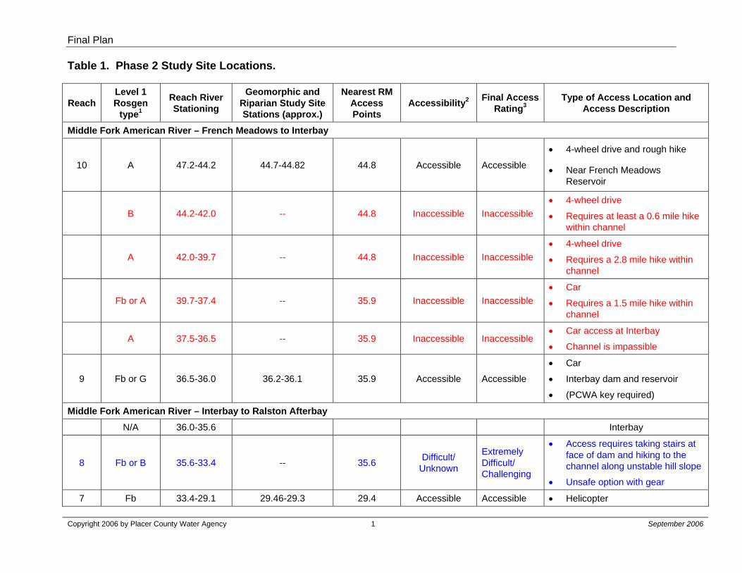
Table 1. Phase 2 Study Site Locations.
Reach Level 1 Rosgen
type1
Reach River Stationing
Geomorphic and Riparian Study Site Stations (approx.)
Nearest RM Access Points
Accessibility2 Final Access Rating3
Type of Access Location and Access Description
Middle Fork American River – French Meadows to Interbay
10 A 47.2-44.2 44.7-44.82 44.8 Accessible Accessible
• 4-wheel drive and rough hike
• Near French Meadows Reservoir
B 44.2-42.0 -- 44.8 Inaccessible Inaccessible • 4-wheel drive
• Requires at least a 0.6 mile hike within channel
A 42.0-39.7 -- 44.8 Inaccessible Inaccessible • 4-wheel drive
• Requires a 2.8 mile hike within channel
Fb or A 39.7-37.4 -- 35.9 Inaccessible Inaccessible • Car
• Requires a 1.5 mile hike within channel
A 37.5-36.5 -- 35.9 Inaccessible Inaccessible • Car access at Interbay
• Channel is impassible
9 Fb or G 36.5-36.0 36.2-36.1 35.9 Accessible Accessible
• Car
• Interbay dam and reservoir
• (PCWA key required)
Middle Fork American River – Interbay to Ralston Afterbay N/A 36.0-35.6 Interbay
8 Fb or B 35.6-33.4 -- 35.6 Difficult/ Unknown
Extremely Difficult/ Challenging
• Access requires taking stairs at face of dam and hiking to the channel along unstable hill slope
• Unsafe option with gear
7 Fb 33.4-29.1 29.46-29.3 29.4 Accessible Accessible • Helicopter
Final Plan
Copyright 2006 by Placer County Water Agency 2 September 2006
Table 1. Phase 2 Study Site Locations (continued).
Reach Level 1 Rosgen
type1
Reach River Stationing
Geomorphic and Riparian Study Site Stations (approx.)
Nearest RM Access Points
Accessibility2 Final Access Rating3
Type of Access Location and Access Description
Middle Fork American River – Interbay to Ralston Afterbay (continued) 6 F or B 29.1-27.7 28.87-28.53 29.4 Accessible Accessible • Helicopter
5 Fb or B 27.7-26.1 -- 27.7 Difficult/ Unknown
Extremely Difficult
• 950-foot descent over 1 mile on steep trail to river
• Strenuous hike and challenging with gear
4 Fb 26.1-25.7 26.2-26.1 25.9 Accessible Accessible • Car
N/A 25.7-24.7 Ralston Afterbay
Middle Fork American River – Oxbow to Folsom Reservoir High Water Mark
3 F 24.7-10.8 17.4-16.25 Accessible Accessible • Helicopter landing zones at RM 17.4, RM 16.8, and RM 16.3
2 F or B 10.8-9.6 TBD Accessible Accessible • Gated road to trail which
parallels entire “Ruck-A-Chucky” reach
1 F 9.6-0 5.75-3.95 4.2 Accessible Accessible
• Helicopter landing zones at RM 5.8, Philadelphia Bar, RM 4.7 Buckeye Bar, RM 3.9 Hoosier Bar, or 4-wheel drive, or trail along river
Duncan Creek 3 B or G 8.6-7.9 8.4-8.25 8.4 Accessible Accessible • 4-wheel drive and gage trail
2 B 7.9-5 6.37-6.19 6.15 Accessible Accessible • 4-wheel drive and rough trail
1 B or G 5-4 4.63-4.4 4.5 Difficult/ Unknown Accessible • 4-wheel drive and rough trail
Final Plan
Copyright 2006 by Placer County Water Agency 3 September 2006
Table 1. Phase 2 Study Site Locations (continued).
Reach Level 1 Rosgen
type1
Reach River Stationing
Geomorphic and Riparian Study Site Stations (approx.)
Nearest RM Access Points
Accessibility2 Final Access Rating3
Type of Access Location and Access Description
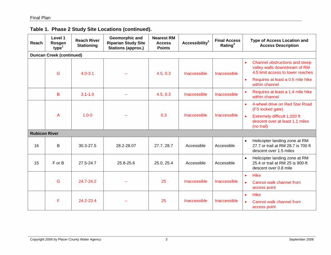
Duncan Creek (continued)
G 4.0-3.1 -- 4.5, 0.3 Inaccessible Inaccessible
• Channel obstructions and steep valley walls downstream of RM 4.5 limit access to lower reaches
• Requires at least a 0.5 mile hike within channel
B 3.1-1.0 -- 4.5, 0.3 Inaccessible Inaccessible • Requires at least a 1.4 mile hike within channel
A 1.0-0 -- 0.3 Inaccessible Inaccessible
• 4-wheel drive on Red Star Road (FS locked gate)
• Extremely difficult 1,020 ft descent over at least 1.1 miles (no trail)
Rubicon River
16 B 30.3-27.5 28.2-28.07 27.7, 28.7 Accessible Accessible • Helicopter landing zone at RM
27.7 or trail at RM 28.7 is 700 ft descent over 1.5 miles
15 F or B 27.5-24.7 25.8-25.6 25.0, 25.4 Accessible Accessible • Helicopter landing zone at RM
25.4 or trail at RM 25 is 900-ft descent over 0.8 mile
G 24.7-24.2 -- 25 Inaccessible Inaccessible • Hike
• Cannot walk channel from access point
F 24.2-23.4 -- 25 Inaccessible Inaccessible • Hike
• Cannot walk channel from access point

Final Plan
Copyright 2006 by Placer County Water Agency 4 September 2006
Table 1. Phase 2 Study Site Locations (continued).
Reach Level 1 Rosgen
type1
Reach River Stationing
Geomorphic and Riparian Study Site Stations (approx.)
Nearest RM Access Points
Accessibility2 Final Access Rating3
Type of Access Location and Access Description
Rubicon River (continued)
14 F or G 23.4-22.5 22.6 Accessible Inaccessible
• Trail hike from RM 21.2 to 22.6 in disrepair due to landslide
• At least a 0.8 mi hike in channel.
• South Fork Rubicon confluence at RM 22.6
F 22.5-21.9 -- 21.2 Inaccessible Inaccessible • Hike
• Requires at least a 0.7 mile hike within channel
13 F or G 21.9-19.7 21.0-20.6 21.2 Accessible Accessible • Trail from Rd 2 at Ellicott Bridge
12 F or G 19.7-17.6 19.65-19.28 20.25 Accessible Accessible • Trail from Rd 2 at Ellicott Bridge
11 G 17.6-14.6 -- 14.3 Difficult/ Unknown Inaccessible
• Inaccessible from Reach 10
• Steep bedrock confined channel with step pools
10 F or G 14.6-13.5 14.42-14.1 14.3 Difficult/ Unknown Accessible • Helicopter landing zone at RM
14.3
9 G 13.5-8.7 -- 14.3 Difficult/ Unknown Inaccessible
• Helicopter landing zone at RM 9.5 washed out in 2006
• Requires difficult, and possibly inaccessible 0.8 mile hike from helicopter landing zone in Reach 10
8 F or G 8.7-6.1 -- 14.3 Difficult/ Unknown Inaccessible • No helicopter landing zone
7 G 6.1-5.6 -- 5.3 Difficult/ Unknown Inaccessible
• 4-wheel drive and difficult hike
• Requires 1,540 ft descent over 2.5 miles to reach channel, then at least 0.4 mile channel hike
Final Plan
Copyright 2006 by Placer County Water Agency 5 September 2006
Table 1. Phase 2 Study Site Locations (continued).
Reach Level 1 Rosgen
type1
Reach River Stationing
Geomorphic and Riparian Study Site Stations (approx.)
Nearest RM Access Points
Accessibility2 Final Access Rating3
Type of Access Location and Access Description
Rubicon River (continued)
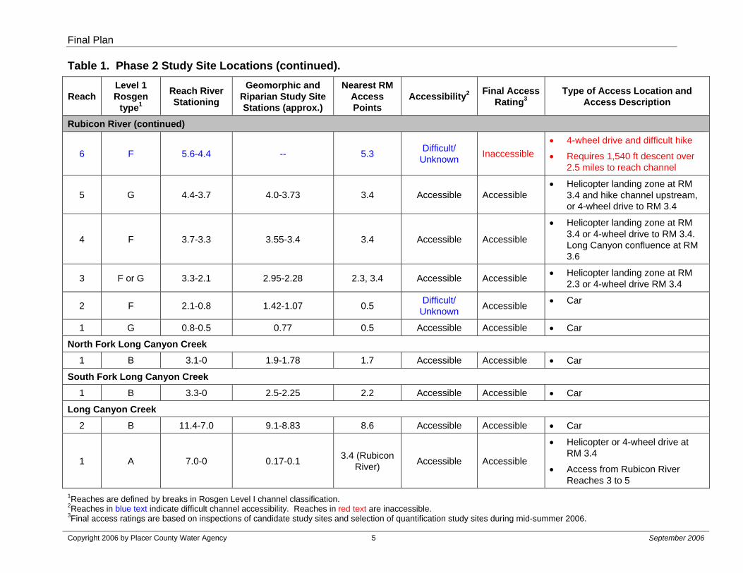
6 F 5.6-4.4 -- 5.3 Difficult/ Unknown Inaccessible
• 4-wheel drive and difficult hike
• Requires 1,540 ft descent over 2.5 miles to reach channel
5 G 4.4-3.7 4.0-3.73 3.4 Accessible Accessible • Helicopter landing zone at RM
3.4 and hike channel upstream, or 4-wheel drive to RM 3.4
4 F 3.7-3.3 3.55-3.4 3.4 Accessible Accessible
• Helicopter landing zone at RM 3.4 or 4-wheel drive to RM 3.4. Long Canyon confluence at RM 3.6
3 F or G 3.3-2.1 2.95-2.28 2.3, 3.4 Accessible Accessible • Helicopter landing zone at RM 2.3 or 4-wheel drive RM 3.4
2 F 2.1-0.8 1.42-1.07 0.5 Difficult/ Unknown Accessible • Car
1 G 0.8-0.5 0.77 0.5 Accessible Accessible • Car
North Fork Long Canyon Creek 1 B 3.1-0 1.9-1.78 1.7 Accessible Accessible • Car
South Fork Long Canyon Creek 1 B 3.3-0 2.5-2.25 2.2 Accessible Accessible • Car
Long Canyon Creek 2 B 11.4-7.0 9.1-8.83 8.6 Accessible Accessible • Car
1 A 7.0-0 0.17-0.1 3.4 (Rubicon River) Accessible Accessible
• Helicopter or 4-wheel drive at RM 3.4
• Access from Rubicon River Reaches 3 to 5
1Reaches are defined by breaks in Rosgen Level I channel classification. 2Reaches in blue text indicate difficult channel accessibility. Reaches in red text are inaccessible. 3Final access ratings are based on inspections of candidate study sites and selection of quantification study sites during mid-summer 2006.

Final Plan
Copyright 2006 by Placer County Water Agency September 2006
FIGURES

Final Plan
Copyright 2006 by Placer County Water Agency September 2006
Placeholder for Figure 1
Figure 1. 2006 Geomorphology, Riparian, and Aquatic Study Reaches (Sheets 1- 3)
Non-Internet Public Information
These Figures have been removed in accordance with the Commission regulations at 18 CFR Section 388.112.
These Figures are considered Non-Internet Public information and should not be posted on the Internet. This information may be accessed from the Placer County Water Agency’s (PCWA’s) Public Reference Room, but is not expected to be posted on PCWA’s Website, except as an indexed item.
Final Plan
Copyright 2006 by Placer County Water Agency September 2006
APPENDIX A
Survey Methods

Final Plan
Copyright 2006 by Placer County Water Agency A-1 September 2006
Introduction
PCWA proposes to develop detailed aquatic habitat information at select locations along the Rubicon River, the Middle Fork American River, and along the smaller streams, including the South Fork and North Forks of Long Canyon, Long Canyon and Duncan Creek. In general, detailed aquatic habitat information will be developed along 20% of each accessible candidate reach, except in those locations where quantitative riparian and geomorphology study sites are established. In these cases, 100% of the quantitative study site will be surveyed. The detailed aquatic habitat information will be developed in accordance with the methods originally presented in PCWA’s 2005-2006 Existing Environment Study Plan Package dated June 17, 2005, and further described below. The data sheets for the detailed data collection are shown in Appendix B.
Habitat Classification
During Phase 1, habitats were classified by using two sets of criteria, Hawkins et al. (1993) and McCain et al. (1990). This same approach will be utilized for visual assessments in 2006. The Hawkins et al. (1993) mesohabitat typing yields a general view of the quantity of aquatic habitats available and is generally more amenable to visual classification than other approaches. Hawkins et al. (1993) outlines a hierarchy for types of aquatic habitats as summarized in Table A-1. As indicated, the aquatic habitats are first divided into fast and slow water types. Second, the fast water types are grouped into turbulent or non-turbulent types. Slow water types are further grouped into dammed pool or scour pool types.
Table A-1. Hawkins et al. (1993) Level I and Level II Habitat Classifications.
Fast Water (Riffle/Run) Slow Water (Pool) Turbulent Non-Turbulent Scour Pool Dammed Pool
Riffle Habitat – High Turbulence – Caused by geomorphological differences (i.e. gradient, bed roughness, and/or step development
Run Habitat – Non-Turbulent – Caused by geomorphological differences (i.e. gradient, bed roughness, and/or step development
Pool Habitat – Formed by Scour - Pool created by erosion of stream bank, boulder, bedrock, etc.
Pool Habitat - Formed by Dam - Pool created by water blockage due to debris, landslide, beaver dam, large boulders, etc.
The United States Department of Agriculture-Forest Service (USDA-FS) Fish Habitat Relationships Technical Bulletin (McCain et al. 1990) (Table A-2) uses a more detailed level of habitat typing than provided by Hawkins et al. (1993). McCain et al. (1990) outlined procedures to inventory fish habitat using riffle, run and pool habitats as the three primary categories of habitat found in stream channels. Riffle and run habitats fall into the turbulent and non-turbulent categories described by Hawkins et al. (1993). Pool habitats are described by their position and cause of their formation; they are either dammed pool habitats or scour pool habitats.

Final Plan
Copyright 2006 by Placer County Water Agency A-2 September 2006
Table A-2. Habitat Types and Codes Adapted from McCain et al. (1990).
Riffle Low Gradient Riffle LGR High Gradient Riffle HGR Cascade Cascade CAS Bedrock Sheet BRS Flatwater Pocket Water POW Glide GLD Run RUN Step Run SRN Trench Chute TRC Edgewater EGW Pool Main Channel Pool MCP Lateral Scour Pool LSP Corner Pool CRP Secondary Channel Pool SCP Dammed Pool DPL Backwater Pool BWP Step Pool SPO Plunge Pool PLP Channel Confluence Pool CCP Additional Unit Designations Dry DRY Road-Crossing RDC Concrete Box Culvert CBC
Habitat types will be classified in the field according to both classification schemes. Habitat lengths and widths will be measured to the nearest foot using a hip-chain for length and a stadia rod or tape for widths. The mean and maximum depth of each habitat type will be measured to the nearest 0.1 feet with a stadia rod for depth of less than 20 feet. A hand held depth finder or a weighted marked rope will be used to measure depths in excess of 20 feet.

Final Plan
Copyright 2006 by Placer County Water Agency A-3 September 2006
Substrate Classification
During the habitat mapping surveys, the stream channel substrate will be characterized and recorded by the field team. In each mesohabitat, the percent distribution of different size classes of substrate will be visually estimated to the nearest 10%. Streambed substrate classes will be grouped as follows:
• Fines (organic material)
• Fines (silt/clay), <0.062 mm;
• Sands, 0.062 - 2 mm;
• Gravels, 2 - 64 mm;
• Cobbles, 64 - 256 mm;
• Boulders, 256 - 4096 mm; or
• Bedrock.
A sand card will be carried by each field team to aid in the classification of sand and fine materials. Substrate characteristics associated with each mesohabitat will be recorded on datasheets.
Spawning Gravel
Spawning gravel, including gravel present in small pockets, will be measured as the estimated amount (square feet) of spawning-sized gravel (0.25-2.5 inches diameter, adapted from Bjorn and Reiser (1991)) occurring in each mesohabitat. In addition, habitat areas with spawning gravel will be assigned a “Spawning Quality” score of “Poor, Fair, Good, or Excellent.” The score will be based primarily on substrate composition, since much of the mapping will be conducted during the summer months when streamflow will be low. The quality of spawning gravel will be characterized based on the angularity of the gravels and embeddedness. Gravels of higher suitability for use by spawning trout are highly rounded. Gravel that is more angular is considered of lower quality for spawning. Generally, a “Good” or “Excellent” score will be assigned to rounded spawning gravels with little sand and fines present and low embeddedness. Spawning gravels with high embeddedness and a high proportion of sand will receive a “Fair” or “Poor” score, regardless of angularity. The scoring criteria are presented in Table A-3.

Final Plan
Copyright 2006 by Placer County Water Agency A-4 September 2006
Table A-3. Description of Spawning Gravel Quality.
Spawning Quality Description of Substrate Excellent Round-shaped spawning gravels loose in substrate. Good Round-shaped spawning gravels slightly embedded in substrate or moderately
jagged-shaped spawning gravels loose in substrate. Fair Round-shaped spawning gravels embedded in substrate or moderately jagged-
shaped spawning gravels slightly embedded in substrate. Poor Round or jagged-shaped gravels deeply embedded in substrate.
Wolman Pebble Counts
Wolman pebble counts will be performed at stream segments encountered during the mesohabitat mapping effort. This effort will focus on reaches with substrates that are different from those surveyed as part of the Phase 2 geomorphology studies.
Stream Bank Erodability
Stream bank erodability will be visually estimated in one of four categories: zero, low, medium or high. A score will be assigned to the stream banks of each habitat. Zero will be typically assigned to stream banks that have very low erodability, such as bedrock and boulder. Low and medium scores will be assigned to stream banks that have good bank structures, such as an intact riparian zone or boulder/cobble dominated bank. High scores will be assigned to stream banks that are very unstable; such as sand dominated stream banks.
Vegetation
Riparian habitat information will be developed including a description of the dominant vegetation covering the stream banks. Vegetative groups will include no vegetation, grasses, shrubs, deciduous trees, coniferous trees, and mixed trees. Stream bank vegetation will be characterized by the percentage category of each stream bank covered by vegetation. The categories recorded will be: zero, 1% - 25%, 25% - 50%, 50% - 75%, and 75% - 100%. Stream shade will be measured to the nearest 10% using a spherical densiometer. Riparian graminoids will be mapped as part of the aquatic habitat characterization study and as part of the riparian habitat mapping study. Presence and absence of graminoids and approximate cover will be estimated along each stream bank within each habitat unit as part of this study element. Graminoid mapping will only be conducted along larger rivers where hardhead are known or expected to reside.
Fish Habitat Cover
Fish cover in each habitat unit will be characterized. The percent of the unit that contains boulders, bedrock ledges, turbulence, depth, aquatic vegetation, algae, terrestrial vegetation, undercut banks, woody debris, or rootwad cover will be quantified.
Final Plan
Copyright 2006 by Placer County Water Agency A-5 September 2006
This refers to cover that fish can hide in or under. Terrestrial cover must be within 1.5 feet of the water surface to be considered cover.
Graminoids
Riparian graminoids will be mapped as part of the aquatic habitat characterization study and as part of the riparian habitat mapping study. Presence and absence of graminoids and approximate cover will be estimated along each stream bank within each habitat unit as part of the aquatic study element. Graminoid mapping will only be conducted along larger rivers where hardhead are known or expected to reside.
Large Woody Debris
Large woody debris will be counted in each stream habitat unit. The woody debris data will be collected according to the Stream Condition Inventory by Region 5, USDA-FS. According to this protocol, the length of all downed wood recorded would be at least one-half bankfull width and recorded if any part lies in the bankfull channel. In the case of debris jams or other accumulations of wood, all pieces of wood meeting the criteria will be counted.
Potential Fish Barriers
Potential fish passage barriers will be visually assessed and characterized by experienced fish biologists. These will include culverts, road crossings, debris jams, cascades, bedrock sheets, shallow riffles, and dewatered areas, among others. Additionally, a visual assessment of potential fish passage barriers at the mouths of tributaries will be conducted. Photographs will be taken and spatial coordinates collected using a Global Positioning System (GPS) for each of the barriers identified during the ground surveys. Crews also will identify the location of prominent features, such as tributaries, gaging stations, diversions, recreational facilities and other facilities with GPS coordinates.
Tributary Flow and Temperature
Field crews will estimate flow in tributaries that are encountered during the habitat mapping ground surveys. Specifically, field crews will measure stream width, and take three measurements of depth and velocity of each flowing tributary immediately upstream of the confluence with the stream being mapped. A General Oceanographics™ current meter, or other small velocity meter, will be used to take the three timed current measurements across the wetted channel. Spot measurements of water temperature will be taken with a standard thermometer.
Incidental Observations
Incidental observations of fish, wildlife, and amphibians will be recorded on maps and in notebooks, along with GPS coordinates, species, date, number of individuals, and lifestages (where possible). Photographs of amphibians or reptiles will be taken, when the species cannot be identified by sight.
Final Plan
Copyright 2006 by Placer County Water Agency A-6 September 2006
Organic Material
The presence of Didymosphenia geminata (nuisance algae) will be documented, when observed. Samples of suspected Didymosphenia geminata will be sampled and dried for later analysis, if necessary. Decisions regarding the need for sample analysis will be made in consultation with the resource agencies.


![Restoring Salmonid Aquatic/Riparian Habitat...aquatic/riparian habitat restoration activities. [5] [6] VISION AND OBJECTIVES The overreaching goal of this initiative is to improve](https://img.dokumen.tips/doc/110x75/6104737c127ac45d1972c9a7/restoring-salmonid-aquaticriparian-habitat-aquaticriparian-habitat-restoration.jpg)