Embed Size (px)
Citation preview


AF
-7
Figure A.6.1 Schematic Diagrams of River Maintenance Flow from the Yangran Khola
SCHEMATIC DIAGRAM OFRIVER MAINTENANCE FLOW
FROM YANGRAN KHOLA- Plan -B -
0.0
0.2
0.4
0.6
0.8
1.0
1.2
Jan
Feb
Mar
Apr
May Jun
Jul
Aug Sep
Oct
Nov
Dec
Dis
char
ge in
cum
.
Mean Flow
Aquatic Life Release
Irrigation Release
The aquatic life release is set to be;Dry season : average of 90% dependable dischargeWet season : average of 90% dependable discharge
SCHEMATIC DIAGRAM OFRIVER MAINTENANCE FLOW
FROM YANGRAN KHOLA- Plan -A -
0.0
0.2
0.4
0.6
0.8
1.0
1.2
Jan
Feb
Mar
Apr
May Jun
Jul
Aug Sep
Oct
Nov
Dec
Dis
char
ge in
cum
.
Mean Flow
Aquatic Life Release
Irrigation Release
The aquatic life release is set to be;Dry season : 20 % of mean discharge in the driest 3 monthesWet season : 4 times of dry season.


AnnexPart A

Supporting Report (2) Environmental Impact Assessment Annex
JICA KULEKHANI III HPP AX-1 February 2003
ANNEX A1 - LIST OF MAIN ACTS OF HMG NEPAL APPLICABLE TO
ENVIRONMENTAL MATTERS FOR HYDROELECTRIC PROJECTS
- Environment Protection Act,2053 (1997) - Environment Protection Regulations,2054 (1997) - National Environmental Assessment Guidelines,2050 (1993) - EIA Guidelines for Forestry Sector, 2052 (1995) - Draft EIA Guidelines for Water Resources Sector, 2052 (1995) - Forest Act,2050 (1993) and Forest Regulations, 2052 (1995) - Forestry Sector Policy,2054 (1997) - Soil & Water Conservation Act, 2039 (1982) - National Parks & Wildlife Conservation Act,2029 (1973) - Aquatic Animals Protection Act, 2039 (1982) &Amend’t,2055(1999) - Electricity Act & Regulations,2050 (1992) - Land Acquisition Act,2034 (1977) - Water Resources Regulations, 2050 (1993) - Local Self Governance Act,2055 (1999) & Regulations,2056 (2000). - Explosives Act, 1961; - Vehicle and Transportation Management Act, 1992; - Labour Act, 1991; - Solid Waste (Management and Resource Mobilisation), Act, 1986; - Land Acquisition Guideline, 1993; - Public Roads Act, 1974; - Hydropower Development Policy, 2002

Supporting Report (2) Environmental Impact Assessment Annex
JICA KULEKHANI III HPP AX-2 February 2003
ANNEX A2 – LIST OF SELECTED STANDARDS COMMONLY USED IN NEPAL
FOR VARIOUS EMISSIONS
Proposed Ambient Air Quality Standards in the Project Area
(Adopted from WHO guideline values with modifications)
Level S.N. Parameters Average time in a day
ppm mg/m3 µg/m3
1. Co 15 min. 30min. hr. 8.00 hrs.
----
100603010
100000600003000010000
2. No2 24 hrs. 1 hr.
--
0.15 0.35
150350
3. So2 24 hrs. 1 hrs. 10 min.
-0.30 0.43
0.125 0.35 0.5
125350500
4. SPM 24 hrs. - 0.250 250 5. PM10 24 hrs. - 0.150 150 6. Lead 24 hrs. - - 0.5-1
Source: WHO (1977, 1978, 1979, 1987).
Proposed Noise Exposure Limits for the Work Environment
(Adopted from Occupational Safety and Health Administration (OSHA). S.N. Noise Exposure (dBA) Permissible exposure (Hours and Minutes) 85 16 hrs. 87 12 hrs. –18 min. 90 8 hrs. 93 5 hrs – 18 min. 96 3 hrs.-30 min. 99 2 hrs. – 18 min. 102 1 hr. – 30 min. 105 1 hr. 108 40 min. 111 26 min. 114 17 min. 115 15 min. 118 10 min. 121 6.6 min. 124 4 min. 127 3 min. 130 1 min.
Source: Marsh, 1991.
Supporting Report (2) Environmental Impact Assessment Annex
JICA KULEKHANI III HPP AX-3 February 2003
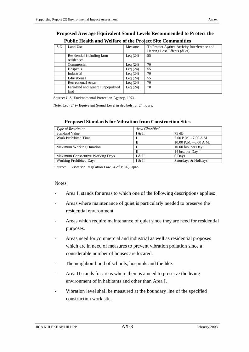
Proposed Average Equivalent Sound Levels Recommended to Protect the
Public Health and Welfare of the Project Site Communities S.N. Land Use Measure To Protect Against Activity Interference and
Hearing Loss Effects (dBA) Residential including farm
residences Leq (24) 55
Commercial Leq (24) 70 Hospitals Leq (24) 55 Industrial Leq (24) 70 Educational Leq (24) 55 Recreational Areas Leq (24) 70 Farmland and general unpopulated
land Leq (24) 70
Source: U.S, Environmental Protection Agency, 1974
Note: Leq (24)= Equivalent Sound Level in decibels for 24 hours.
Proposed Standards for Vibration from Construction Sites Type of Restriction Area Classified Standard Value I & II 75 dB Work Prohibited Time I 7.00 P.M. - 7.00 A.M. II 10.00 P.M. - 6.00 A.M. Maximum Working Duration I 10.00 hrs. per Day II 14 hrs. per Day Maximum Consecutive Working Days I & II 6 Days Working Prohibited Days I & II Saturdays & Holidays
Source: Vibration Regulation Law 64 of 1976, Japan
Notes:
- Area I, stands for areas to which one of the following descriptions applies:
- Areas where maintenance of quiet is particularly needed to preserve the
residential environment.
- Areas which require maintenance of quiet since they are need for residential
purposes.
- Areas need for commercial and industrial as well as residential proposes
which are in need of measures to prevent vibration pollution since a
considerable number of houses are located.
- The neighbourhood of schools, hospitals and the like.
- Area II stands for areas where there is a need to preserve the living
environment of in habitants and other than Area I.
- Vibration level shall be measured at the boundary line of the specified
construction work site.

Supporting Report (2) Environmental Impact Assessment Annex
JICA KULEKHANI III HPP AX-4 February 2003
Proposed Limits for Road Traffic Vibration Time area Day time Night time Applicable areas I 65 dBA 60 dBA Areas where maintenance of quiet is particularly needed to
preserve a good living environment and where quiet is called for us as they are used for residential purpose.
II 70 dBA 65 dBA Areas need for commercial and industrial as well as residential purposes where there is a need to preserve the living environment of local inhabitants and areas mainly serving industrial propose which are in need of measures to prevent the living environment of local residents from deteriorating.
Source: Vibration Regulation Law 64 of 1976, Japan
Note: Vibration level shall be measured at the boundary line of the road.
PART B
SOCIAL ENVIRONMENTAL ASSESSMENT
- i -
THE UPGRADING FEASIBILITY STUDY ON THE DEVELOPMENT
OF THE KULEKHANI III HYDROPOWER PROJECT
IN THE KINGDOM OF NEPAL
FINAL REPORT
VOLUME III SUPPORTING REPORT (2)
PART B: SOCIAL ENVIRONMENTAL ASSESSMENT
TABLE OF CONTENTS
INTRODUCTION
EXECUTIVE SUMMARY
SOCIAL Impact Assessment (SIA).............................................................................BS- 1
Resettlement Plan (RP)................................................................................................BS- 5
Social Action Plan (SAP) Framework.........................................................................BS- 8
Public Consultation Program.......................................................................................BS-13
Further Studies - Detailed Design Phase .....................................................................BS-14
CHAPTER B.1 SOCIAL IMPACT ASSESSMENT (SIA)
B.1.1 Introduction ...........................................................................................B1- 1
B.1.2 Makwanpur District ...............................................................................B1- 1
(1) General............................................................................................................B1- 1
(2) Hetauda ...........................................................................................................B1- 2
(3) Household and Population ..............................................................................B1- 3
(4) Caste and Ethnic Composition........................................................................B1- 4
(5) Other Social and Economic Indicators ...........................................................B1- 8
B.1.3 Project Impacted Communities .............................................................B1- 9
(1) General............................................................................................................B1- 9
(2) Household and Population ..............................................................................B1-10
(3) Caste and Ethnic Composition........................................................................B1-10
(4) Other Social and Economic IndicatorsB1-11
(5) Project’s Most Impacted Communities (MIC) ...............................................B1-17
(6) Indirect Project Resettlement Effects..............................................................B1-17
CHAPTER B.2 RESETTLEMENT PLAN (RP)
B.2.1 Introduction ...........................................................................................B2- 1
B.2.2 Glossary .................................................................................................B2- 1
B.2.3 Definition of Terms ...............................................................................B2- 2
B.2.4 Description of Project ............................................................................B2- 4

ii
(1) Overview.........................................................................................................B2- 4
(2) Project Components........................................................................................B2- 6
(3) Project Facilities..............................................................................................B2- 6
B.2.5 Scope of Land Acquisition and Resettlement........................................B2-12
(1) Resettlement Effects .......................................................................................B2-12
(2) Measures for Minimizing Resettlement Effects .............................................B2-20
B.2.6 Socioeconomic Information ..................................................................B2-23
(1) Project’s Most Impacted Communities (MIC) ...............................................B2-23
(2) Households and Population.............................................................................B2-23
(3) Caste and Ethnic Composition........................................................................B2-24
(4) Other Social And Economic Indicators ..........................................................B2-24
B.2.7 Objectives, Policy Framework and Entitlements ..................................B2-34
(1) Laws Regarding Land Acquisition Procedures...............................................B2-34
(2) The Kulekhani III Project Involuntary Resettlement Principles
and Objectives .................................................................................................B2-41
(3) Eligibility and Entitlement ..............................................................................B2-47
B.2.8 Consultation, Participation, and Grievance Redress .............................B2-65
(1) Consultation and Participation........................................................................B2-65
(2) Grievance Redress ..........................................................................................B2-65
B.2.9 Relocation of Housing and Settlements.................................................B2-66
(1) Resettlement and Rehabilitation Measures .....................................................B2-66
(2) Compensation for Land and Property.............................................................B2-67
B.2.10 Income Restoration Strategy .................................................................B2-68
(1) General............................................................................................................B2-68
(2) Displacement Allowance ................................................................................B2-68
(3) Rehabilitation Support ....................................................................................B2-68
(4) Other Support ..................................................................................................B2-69
B.2.11 Institutional Framework ........................................................................B2-70
B.2.12 Resettlement Budget and Financing ......................................................B2-73
(1) Budget Estimate ..............................................................................................B2-73
(2) Direct Cost ......................................................................................................B2-73
(3) Cost of Rehabilitation Measures .....................................................................B2-78
B.2.13 Implementation Schedule ......................................................................B2-81
B.2.14 Monitoring and Evaluation ....................................................................B2-81
(1) General............................................................................................................B2-81
(2) Internal Monitoring.........................................................................................B2-81
(3) External Monitoring & Evaluation .................................................................B2-81
iii
CHAPTER B.3 SOCIAL ACTION PLAN (SAP) FRAMEWORK
B.3.1 Introduction ...........................................................................................B3- 1
(1) Background to Social Action Plan (SAP).......................................................B3- 1
(2) Basis of SAP Formulation ..............................................................................B3- 2
B.3.2 Glossary .................................................................................................B3- 3
B.3.3 Social Action Plan (SAP) Components .................................................B3- 3
(1) Summary .........................................................................................................B3- 3
(2) Description of SAP Components ....................................................................B3- 4
(3) Estimated Budget ............................................................................................B3-15
(4) SAP Design and Administration .....................................................................B3-16
CHAPTER B.4 PUBLIC CONSULTATION PROGRAM
B.4.1 Background............................................................................................B4- 1
B.4.2 First Public Consultation Meeting.........................................................B4- 1
B.4.3 Second Public Consultation Meeting ....................................................B4- 2
B.4.4 Consultation with Individuak and Groups.............................................B4- 3
B.4.5 Public Consultation Strategy .................................................................B4- 5
B.4.6 Cost for Public Consultation..................................................................B4-10
CHAPTER B.5 FURTHER STUDIES – DETAILED DESIGN PHASE
B.5.1 Costs ......................................................................................................B5- 2

iv
LIST OF TABLES
Table B.1. 1: Makwanpur District Households and Population ..................................B1-3
Table B.1. 2: Population Features of Makwanpur District Compared with
and the Central Development Region (2001 Census) ...........................B1-3
Table B.1. 3: Makwanpur District: Future Population Trend...................................B1-4
Table B.1. 4: Makwanpur District: Caste/Ethnic Composition...................................B1-4
Table B.1. 5: Makwanpur District: Edible Food Availability .....................................B1-8
Table B.1. 6: Makwanpur District: Livestock
and other Animals and Their Produce .........................................................................B1-8
Table B.1. 7: Project Impacted Communities: VDCs and Hetauda Municipality.......B1-10
Table B.1. 8: Affected Communities: Households and Population.............................B1-10
Table B.1. 9: Project Impacted Communities: Ethnic Composition ...........................B1-11
Table B.1.10: Project Impacted Communities: Literacy Status (Percent)...................B1-11
Table B.1.11: Vulnerable Groups of the Project Impacted Communities:
Elderly, Widows & Handicapped, No. and Percent of Population........B1-12
Table B.1.12: Persons with Technical Skills
in the Project Impacted Communities .................................................B1-12
Table B.1.13: Project Impacted Communities, Livestock HH Holding Size ..............B1-13
Table B.1.14: Project Impacted Communities, Average Land Holding Size..............B1-13
Table B.1.15: Project Impacted Communities, Land Holding Size ............................B1-14
Table B.1.16: Project Impacted Communities, Food Sufficiency...............................B1-14
Table B.1.17: Project Impacted Communities, Percent of HHs
Using Different Kinds of Cooking Fuel ..............................................B1-15
Table B.1.18: Project Impacted Communities, Time to Collect Firewood .................B1-15
Table B.1.19: Project Impacted Communities,
Drinking Water Source (Percent of HHs)............................................B1-16
Table B.1.20: Project Impacted Communities, Water Fetching Time ........................B1-16
Table B.1.21: Project Impacted Communities, HHs Having Sanitation Facilities......B1-17
Table B.1.22: Summary Resettlement Effects: Relocation &
Loss of Agricultural Land, No.of Potentially Affected HHs
and Estimated Population ....................................................................B1-18
Table B.1.23: Summary of Indirect Resettlement Effects...........................................B1-19
Table B.1.24: Water Mills Below Tailrace Outlet.......................................................B1-21
Table B.1.25: Irrigation Schemes Possibly Affected by Kulekhani III Project ..........B1-24
Table B.1.26: Estimation of Impoverishment Risks Associated
with Kulekhani III Project, Assuming No Mitigation .........................B1-31
Table B.2. 1: Design Alternatives Considered for Upgrading Feasibility Study ........B2-6

v
Table B.2. 2: Land Use Along the Access Roads........................................................B2-10
Table B.2. 3: Structures, as Affected by Project Components ....................................B2-14
Table B.2. 4: Status of House Plot Land Ownership
for Potentially Relocated HHs.............................................................B2-14
Table B.2. 5: Percentage of Affected Land, by Land Use Categories.........................B2-15
Table B.2. 6: Affected Land, by Land Use Categories in Different Project Sites.......B2-15
Table B.2. 7: Affected Land by Type..........................................................................B2-15
Table B.2. 8: Summary Resettlement Effects: Relocation &
Loss of Agricultural Land, No. of Potentially
Affected HHs and Estimated Population.............................................B2-16
Table B.2. 9: Estimation of Potentially Affected HHs
by Agricultural Land Acquisition........................................................B2-18
Table B.2.10: Distribution of Potentially Affected HHs
Losing Houses, by Caste/Ethnicity......................................................B2-19
Table B.2.11: Distribution of Landowning Potentially
Affected HHs by Caste/Ethnic Status..................................................B2-19
Table B.2.12: MIC, Age Structure, Average HH Size ................................................B2-24
Table B.2.13: MIC, Population by Gender..................................................................B2-24
Table B.2.14: MIC, Ethnicity of Sanutar, Ghumaune, Ghumaune Pari (52 HH)........B2-24
Table B.2.15: MIC, Educational & Literacy Status ....................................................B2-25
Table B.2.16: MIC, Household Religion.....................................................................B2-25
Table B.2.17: Length of Residence In MIC ................................................................B2-25
Table B.2.18: MIC, Type of Family ............................................................................B2-25
Table B.2.19: MIC, Occupations.................................................................................B2-26
Table B.2.20: MIC, Skilled Workers...........................................................................B2-26
Table B.2.21: MIC, Women’s Primary Activities, by Percent of Women Reporting.B2-27
Table B.2.22: MIC, Women’s Involvement in CBOs and User Groups
(44 Respondents) .................................................................................B2-27
Table B.2.23: MIC, Households Having Livestock ....................................................B2-27
Table B.2.24: MIC, Average Livestock & Animals Owned by HHs..........................B2-28
Table B.2.25: MIC, Milk Production, Litres/Day .......................................................B2-28
Table B.2.26: MIC, Land Holding Size by Ownership Pattern (Ha) ..........................B2-28
Table B.2.27: MIC, Households Owning Fruit Trees .................................................B2-29
Table B.2.28: MIC, Household Fruit Tree Holdings, by Type of Tree and Whether
Yielding or Non Yielding ....................................................................B2-29
Table B.2.29: MIC, Yield of Major Crops Compared to District ...............................B2-29
Table B.2.30: MIC, Total and Average Production of Cereals, Vegetables,
and Cash Crops....................................................................................B2-30

vi
Table B.2.31: MIC, Households’ Food Sufficiency....................................................B2-30
Table B.2.32: MIC, Households’ Duration of Food Insufficiency..............................B2-30
Table B.2.33: MIC, Households’ Copy Strategy for Food Insufficiency....................B2-31
Table B.2.34: MIC, Annual HH Income (NRs) ...................................................................... B2-31
Table B.2.35: MIC, Summary Annual HH Income (NRs) .................................................. B2-31
Table B.2.36: MIC, Annual HH Income (NRs) ...................................................................... B2-32
Table B.2.37: MIC, Summary Annual HH Expenditure (NRs) ......................................... B2-32
Table B.2.38: MIC, Households’ Reliance on Financial Services ..............................B2-32
Table B.2.39: MIC, Water Sources Reported by HHs ................................................B2-33
Table B.2.40: MIC, HHs Reporting Illnesses during Previous Year ..........................B2-33
Table B.2.41: Details of Reported Cases (42) of Illness among MIC HHs. ...............B2-34
Table B.2.42: Entitlement Matrix................................................................................B2-58
Table B.2.43: Compensation for Land Acquisition.....................................................B2-72
Table B.2.44: Compensation to House Structures and Sheds
(Sanutar and Ghumaune) .....................................................................B2-74
Table B.2.45: Compensation for the Loss of Fruit Trees,
Fodder Trees and Sissou Plantation in Private Land at Sanutar,
Ghumaune, and Tailrace Outlet...........................................................B2-76
Table B.2.46: Resettlement & Rehabilitation Cost .....................................................B2-78
Table B.2.47: Environmental Costs.............................................................................B2-79
Table B.3. 1: Allocated Costs for Restoration of Project
Impacted Infrastructures Outside Construction Sites ..........................B3-5
Table B.3. 2: Allocated Costs for Awareness Program
for Accident Risks Downstream of the Tailrace
and along the Tribhuvan Rajpath ........................................................B3-5
Table B.3. 3: Allocated costs for Agricultural Development Programs......................B3-9
Table B.3. 4: Itemized Allocated Costs for Community/Public
Health and Education Enhancement Programs ...................................B3-10
Table B.3. 5: Itemized Allocated Costs for Skill Enhancement ..................................B3-12
Table B.3. 6: Allocated Costs for Rural Electrification ..............................................B3-12
Table B.3. 7: Allocated Costs for Yangran Watershed Management .........................B3-13
Table B.3. 8: Allocated Costs for Neighborhood Support Program............................B3-14
Table B.3. 9: Allocated Costs for Women Development Program .............................B3-15
Table B.3.10: Cost Summary for SAP ........................................................................B3-16
Table B.3.11: Allocated Costs for Preparation of Details of Social Programs ...........B3-19
Table B.4. 1: Estimated Costs for Public Consultation in the detail Design Phase.....B4-12
Table B.5. 1: Social Environmental Mitigation And Monitoring Plan
- Summary of Costs -.............................................................................B5- 2

vii
LIST OF FIGURES
Figure B.2. 1: Proposed Organizational Chart of Kulekhani III
Social and Environment Division........................................................B2-71
Figure B.4. 1: Consultation Strategy ...........................................................................B4-11
LIST OF ANNEXIES
Annex B. 1 References Annex B. 2 Castes and Ethnic Groups of Nepal Annex B. 3 Summary Table List of HHs Surveyed, SIA Annex B. 4 Questionnaire for Socioeconomic Study Annex B. 5 Conceptualized Project Affected Area Social Impacts Annex B. 6 Kulekhani III Impoverishment Risks and Reconstruction (IRR)
Model Annex B. 7 Land Acquisition and Resettlement: Issues and Procedures in
Nepal, 1991 Background Paper Annex B. 8 Public Consultation Diagram Annex B. 9 Public Consultation Annex B.10 Stakeholders and Groups Met during Socioeconomic Fieldwork Annex B.11 List of Household Whose House Structure is Affected

Supporting Report (2) Environmental Impact Assessment Introduction
JICA KULEKHANI III HPP BI-1 February 2003
PART B SOCIAL ENVIRONMENTAL ASSESSMENT
INTRODUCTION
The previous EIA prepared by NEPECON/DIP has been supplemented in this
report with respect to ‘land acquisition and compensation and the actual plots
affected’, especially with regards to the adoption of the proposed final design
alternative. Over half of the plots identified for land acquisition were in Hetauda,
Ward 1, to be affected by the Tailrace Outlet’s impacts downstream, 4 km to the
Hetauda Bridge. On investigation, it was found that much of the irrigated
agricultural fields had already been destroyed by the 1993 floods; that the lands
would not be impacted by the Tailrace Outlet, for reasons given below, and that
only one or two of the properties listed in the EIA annexes could actually be found
using official cadastral maps obtained from the District Survey Office in Hetauda
as part of a GIS mapping exercise to identify land plots to be affected by land
acquisition.
Although not predictable at the beginning of the fieldwork subcontracted to NESS,
it has since transpired that much of the irrigated lands, as well as water mills, that
might have been affected in Ward 1 have since also been destroyed by floods that
occurred during July 2002, which has been documented in the Volume III:
Supporting Report (2).
The existing EIA did also not account for resettlement effects, making the
assumption that there would be no dislocation of households requiring relocation
of families or loss of land to the extent that loss of livelihood would occur. This
was despite the fact that the camps associated with the Project were, on close
examination of existing documents, found to be planned for placement on top of
Sanutar’s school and many of its homes as well as most of its irrigated rice paddy
fields, so that it would be virtually impossible to avoid resettlement.
The environmental legislation in Nepal, under which the EIA was prepared, is
notoriously weak in this area, and it was assumed that the question of land
required by the Project would be adequately handled under the Land Acquisition
Act, 2034 (1977), or LAA, which also makes no provision for resettlement effects
caused by development Projects. Accordingly, to meet international standards in
this regard, the Study Team adopted the Asian Development Bank’s (ADB’s)
policy for involuntary resettlement as a guideline for investigating and preparing
mitigation for any resettlement effects encountered. This was appropriate also,
as the ADB has been providing technical assistance to HMG for updating the LAA
with regards to resettlement effects. Also the ADB’s recent involvement in the

Supporting Report (2) Environmental Impact Assessment Introduction
JICA KULEKHANI III HPP BI-2 February 2003
Kali Gandaki A and Melamchi Water Supply Projects have provided the Study
Team with applied examples setting precedents for the policy adopted in the
Resettlement Plan (RP) that has been one outcome of this study, updating the
existing EIA in this important area. This has been an important improvement to
the existing EIA, since although efforts have been made to minimize resettlement
effects, such as moving most of the associated camps to Hetuada, placing spoil
sites within the river plains, and carefully aligning the access roads to avoid
houses, it has been impossible to entirely avoid the dislocation of houses, and it is
likely that many of those households losing agricultural land will suffer a
significant impact on their livelihoods for which the RP will provide adequate
rehabilitation assistance.
The existing EIA proposed a set of social programs that were well conceived, and
the Study Team has improved upon this formulation through integrating them into
a Social Action Plan (SAP) designed to take advantage of the opportunities for
local development the Project will provide, to mitigate identified indirect
resettlement effects not immediately caused by land acquisition, and to promote
good long term community relations for the Project extending beyond its
construction phase into operation.
The NESS sub-consultants have carried out a socioeconomic study of the 55
households of the most impact communities of Sanutar, Ghumaune and Pari
Ghumaune, updating the work done in the existing EIA. Coordinating with NITI,
another sub-consultant specializing in digital mapping, to prepare a GIS based
Natural and Social Environment Map that includes official cadastral map data as
well as the final Project Design Boundaries, they have identified the direct
resettlement effects of the Project’s land acquisition, so that an RP budget could be
prepared based on the best information to date. The data base now acquired will
be updated during the Detailed Design Study phase, both to incorporate data that
could not be obtained at this time and also upon completion of the detailed design
work through a Detailed Measurement Survey, on which the final draft RP will be
based.

Supporting Report (2) Environmental Impact Assessment Executive Summary
JICA KULEKHANI III HPP BS-1 February 2003
EXECUTIVE SUMMARY
SOCIAL Impact Assessment (SIA)
The Study Team, through its sub-consultant NESS, organized a Social Impact
Analysis (SIA) that provided community profiles at the Makwanpur District Level
(including its only municipality, Hetauda), at the level of the Project Impacted
Communities, which included all communities from the Headworks area to
downstream of the Tailrace Outlet, to the Most Impacted Communities (MIC) of
Sanutar, Ghumaune, and Pari Ghumaune villages, where all of the houses and
privately owned agricultural land to be acquired by the Project is found.
The SIA addressed in particular the Project’s indirect resettlement effects, within
the framework of an impoverishment risk model, to better prepare an SAP that
would counter these risks with a well informed development strategy suited to
local conditions. Resettlement Effects is taken to mean, very broadly, all negative
situations directly caused by the Project, including loss of land, property, income
generation opportunity, and cultural assets. Therefore, the mitigation measures for
adverse impacts as outlined in the SIA are for the most part found in the SAP’s
several social programs components, whereas the RP will address the direct
resettlement effects arising from the Project’s land acquisition.
SIA Findings
The Study Team provided a general profile of the Project impacted Makwanpur
District, in particular of Hetauda municipality, as well as of the Project Impacted
Communities, providing household and population and caste and ethnic
composition for these levels and several comparative social and economic
indicators for the broader Project impacted area, defined as Bhainse Village
Development Committee (VDC) Ward 6 where the main Project components are
situated, Wards 8 & 9 of Basamadi VDC, where the Tailrace Outlet is located and
has its downstream effects, and Ward 1 of Hetauda Municipality, where the
Tailrace Outlet downstream impacts will occur, along a 4 km stretch of the Rapti
River to Hetauda Bridge.
Makwanpur District is one of the seven Hill districts located in Nepal’s Central
Development Region, with a population of 372,604, almost half (48.2 percent) of
whom are Tamang ethnic ‘tribal’ peoples who will be considered among
‘vulnerable’ groups in the RP policy due to past official discriminatory policies
and their widely acknowledged level of relative poverty. Chief among the other
major groups that also fall within the Project impacted communities are

Supporting Report (2) Environmental Impact Assessment Executive Summary
JICA KULEKHANI III HPP BS-2 February 2003
Brahmin-Chetri (together 26.6 percent) high castes in the Hindu social hierarchy,
and Newars, a largely urbanized group that is found primarily in Hetauda but are
also absentee landlords in the MIC villages of Sanutar, Ghumaune, and Pari
Ghumaune.
Both Brahmin-Chetri and Newars predominate in Hetauda municipality, at about
56 and 15 percent respectively, with Tamangs only 10 percent of the
municipality’s population of 64,482. However, in the rural VDCs impacted by
the Project, Tamangs are as much as 68 percent of the population in Bhaise and
more than 52 percent in Basamadi, whereas Brahmin-Chetri are as little as 6
percent in Bhaise and 31 percent in Basamadi VDC, while Newars are only about
2 percent in both VDCs. Bhainse VDC’s population is 6,616 and Basamadi’s
10,232.
The MIC (Sanutaur, Ghumane, and Pari Ghumaune) consists of 55 households
and a population of only 349, 100 percent surveyed by the Study Team for the
socioeconomic profile that is more appropriately given in the RP rather than in the
SIA, since these Most Impacted Communities are the only ones to lose their
housing and substantial amounts of productive agricultural land. Here is the
highest proportion of Tamangs, at almost 70 percent of the households,
Brahmin-Chetri at only 13 percent, and no resident Newars, although this ethnic
groups serve as absentee landlords and so are among the potentially affected
households identified during the fieldwork’s efforts to identify more precisely land
to be acquired.
Other social and economic indicators provided for District, the Project Impacted
Communities and the MIC are literacy status, religion, length of residence (MIC),
type of families (nuclear/extended), occupation and skills (particularly Project
employment-related), Gender Analysis (MIC), livestock holdings and produce,
land holding size and ownership pattern, fruit tree ownership, food production,
food self-sufficiency and coping strategies, household income and expenditure
patterns, energy sources, sources of financial services, access to water and
sanitation, and health status. These are given in the SIA for the District and
Project Impacted Communities and in the RP for the MIC.
The SIA took into account both direct Resettlement Effects caused by land
acquisition and indirect Resettlement Effects caused by a variety of other Project
impacts. Together these could affect some estimated 1,100 households or 6,600
persons, assuming that some quantification is possible for the indirect
Resettlement Effects.

Supporting Report (2) Environmental Impact Assessment Executive Summary
JICA KULEKHANI III HPP BS-3 February 2003
Estimated Direct and Indirect Resettlement Impacts Direct Resettlement Effects Due To Land Acquisition, Impacted HHs and Population No. Potentially Affected HHs Estimated Potentially
Affected Population* HHs Losing 26 Houses 25 150 (Incl. HH Losing Only 1 Ancillary Structure)
(1) (6)
HHs Losing 15 Ha Agricultural Land
72 454
Total 97 604
Indirect Resettlement Effects Due to Various Project Impacts Description No. HHs Water Mills 10 Mills 11 6 Downstream Irrigation Intakes
215 Ha 325
Sanutar-Ghumaune Irrigation 8 Ha 25 Water shortage in Natural Springs
23 Used Springs along Tunnel Route, 7 villages
400
Forest Reserves – Clearing and Encroachment
11 Ha Direct Clearing, 31 Ha indirectly impacted
308
Total Quantifiable Indirect Resettlement Effects:
Approx. 1,000 HHs, 6,000 Pop.
Foot Transport across Rapti River
Undetermined Seasonal Wooden Bridges
Unknown
Misc. Uses of Rapti Recreation, Collection of Construction Materials, Etc.
Unknown
Fishing Undetermined Unknown
July 2002 Floods. It is noted that since the fieldwork assessing the above indirect
resettlement effects was carried out, disastrous floods occurred, fully or partially
destroying many of the water mills and irrigation schemes discussed below. A
two-day visit to Hetauda briefly confirmed this damage, and the next study phase
will update this information for appropriate revisions to the SAP to take the new
situation into account, especially in assessing whether or not HHs or communities
have managed to rebuild in the meantime.
Kulekhani III Impoverishment Risks and Reconstruction (IRR) Model. The ADB
has adopted Impoverishment Risks and Reconstruction (IRR) model as an
analytical tool for helping to prevent the onset of new causes of impoverishment
caused by resettlement effects. A Matrix indicating some of the possible
impoverishment risks associated with the Kulekhani III Project, and including
measures to mitigate impoverishment risks and is shown in Annex B.6, where the
specific risks discussed above of direct and indirect resettlement effects are ranked
on a scale from very high to very low.
This approach encompasses impoverishment measurements not only in terms of

Supporting Report (2) Environmental Impact Assessment Executive Summary
JICA KULEKHANI III HPP BS-4 February 2003
income, but also in terms of employment opportunities, health care, nutrition and
food security, common assets, education, shelter, or social capital. Indeed, the
eight most common impoverishment risks captured in the model, and also
signaled in the ADB Handbook on Resettlement, are: (a) landlessness; (b)
joblessness; (c) homelessness; (d) marginalization; (e) increased morbidity and
mortality; (f) food insecurity; (g) loss of access to common property; and (h)
social (community) disarticulation.
During the fieldwork, the following impoverishment risks were assessed from the
Project’s direct and indirect resettlement effects:
Estimation of Impoverishment Risks Associated with Kulekhani III Project,
Assuming no Mitigation Impoverishment Risks Without MitigationLandlessness High-Very High Joblessness Medium-High Homelessness High-Very High Marginalization High – Very High Increased Morbidity & Mortality Medium-High Food Insecurity Medium-High Loss of Access to Common Property Medium-High Social Disarticulation Medium-High (Risk Assessment = Very Low, Low, Medium, High, Very High)
These are to a large extent subjective findings, but they do provide needed focus
for prioritizing mitigation actions and were useful in framing the SAP and those
parts of the EMP that relate to social impacts, such as the impacts on forests or on
fish. The finding show that, while the number of potentially affected households
is not as great as, say, a reservoir hydro power plan, the impacts on those
households that are affected will need to be no less carefully considered in order
to avoid the identified impoverishment risks.
In the design of the RP and the SAP, an effort will be made to adopt development
strategies so that these risks may be transformed into ‘counter-risk strategies’
through targeted provisions.
Maximum safeguarding is achieved when involuntary displacement is avoided
altogether. This is the first and foremost response to risks that should be
considered. Recognizing risks upfront and their financial implications is often a
powerful stimulus to search for an alternative that will eliminate the need for
displacement completely or cut down its size. The Study Team has attempted
wherever possible to propose measures, such as placing camps in Hetauda,
placing spoil sites away from agricultural lands, incorporating the Sanutar-

Supporting Report (2) Environmental Impact Assessment Executive Summary
JICA KULEKHANI III HPP BS-5 February 2003
Ghumaune canal into the Access Road design, and careful alignment of the Main
Access Road, to avoid land acquisition and HH displacement whenever possible.
Resettlement Plan (RP)
A major aspect of the upgrading of the existing EIA was the preparation of a
Resettlement Plan (RP) for Kulekhani III Hydropower Project. The RP, presented
in a ‘stand alone’ format in the Supporting Report attempts to highlight the extent
of the Project’s resettlement impacts and proposes mitigation measures so that the
affected persons (APs) can improve their living standard or restore their living
standard to its pre-Project status. The precise details of land and property to be
acquired by the Project are yet to be finalized, and the RP is based on the most
recent data available from field surveys undertaken in June 2002, as the design
alternative for the Project was still being finalized. The RP takes into account the
most recent attempts to develop comprehensive resettlement policies and action
plans including practices by other Projects in Nepal, and it incorporates the
policies of the Asian Development Bank (ADB) and World Bank (WB) as far as
they are applicable in the local context.
Loss of Houses. The fieldwork discovered 24 HHs that lose their homes and will
be required to relocate under direct resettlement effects. At this stage, all HHs
identified within the Project Design Boundaries, as shown on the Natural and
Social Environment Map, are presented as ‘potentially affected’ HHs, as it is not
clear which agricultural or forest land owners will actually be affected once the
Detailed Design is completed. On the other hand, it is almost certain that these
24 homeowners will be classified as SPAFs1 during the Detailed Design Stage
studies, based on their having lost their residence. All of the HHs also own
ancillary structures for which they will receive compensation. In addition, the
owner of an ancillary structure (a cow shed) at Check Dam 1 will also receive
compensation. Compensation for ancillary structures has been figured into the
1 Project Affected Family (PAF) is the term commonly used in Projects in Nepal for APs, but with special reference to households, each ‘household’ defined as those family members – especially in extended families – that share a cooking hearth, or kitchen (bhanse). In many extended families, several ‘households’ may live under one roof but have separate kitchens, and adult sons will have inheritance rights to family land that will be recognized by the Project, although the land may not as yet be registered in their name. Severely Affected Families (SPAFs) are those PAFs who are displaced from their residences or commercial establishments or who are severely affected through loss of agricultural land as defined in the Kulekhani III Project’s Resettlement Policy Entitlement Matrix: (a) PAFs who lose 25% or more of their land (owned and operated and taking into consideration the local situation) within the Project area or whose production levels are severely affected by the loss of land; (b) PAFs who lose residential/business house SPAFs will be assisted with special rehabilitation measures, including displacement allowances and preferential Project employment, to achieve the Project’s Involuntary Resettlement Policy goals of restoration or improvement of pre-Project living standards.

Supporting Report (2) Environmental Impact Assessment Executive Summary
JICA KULEKHANI III HPP BS-6 February 2003
estimated RP costs, as a part of compensation estimated as required by each
affected HH. All of the Project induced relocation of households will take place
in the Most Impacted Communities (MIC) of Sanutar, Ghumaune and Pari
Ghumaune.
Impacts on Productive Lands. The total potentially affected land area is estimated
to be 79.6 Ha. Of the potentially affected land area, some 22 percent is agriculture
land under private ownership. The largest proportion of potentially affected land is
forestland, most of which is under Community Forest management.
Of the total potentially affected land, some 17.295 ha are, according to the official
Cadestral Maps obtained from the Survey Department in Hetauda, classed as
agriculture land. Of this, about 15 ha are required by the Project for permanent
and temporary acquisition. This includes all land required from the Sanutar,
Ghumaune, Nakoligaon settlements and by the Yangran Regulating Reservoir.
Of the total agricultural land needed, 12.36 ha (82 percent) of private lands are to
be acquired permanently for various Project facilities at the Sanutar, Ghumaune,
Nakoligaon settlements and along the Yangran Khola. Likewise 2.64 ha (18
percent) of land under private ownership will be needed for the Construction
Camps at Ghumaune but may be acquired on a temporary, rental basis.
Households Losing Agricultural Land. It is presently estimated that some 72
households, compromising around 430 persons, will lose agricultural land and
require compensation. These figures will, however, need to be updated at the
beginning of the new Detailed Design Study phase with more reliable data, to
verify the actual numbers of affected HHs. While useful for planning purposes,
this estimate necessarily has to remain inconclusive.
There are three reasons for this inconclusiveness of the data on households losing
agricultural land: (1) the first is due to the difficulties due to time constraints of
carrying out the socioeconomic study while the final Project design was still under
decision, so that some land plots were newly within the defined Project Design
Boundaries that as yet have no ownership assigned to them; (2) the second reason
is due to inaccuracies found with the official Cadastral Maps obtained from the
Survey Office in Hetauda; (3) the third reason has to do with absentee landowners,
most of whom appear to be the urban, business oriented ethnic group, Newars, are
probably living in Hetauda or possibly in some cases farther abroad, even in
Kathmandu. They are the second largest ethnic group seen to be losing
agricultural land, after the ‘tribal’ ethnic Tamangs, but there are no Newars
resident in the most affected communities. More detail about these circumstances

Supporting Report (2) Environmental Impact Assessment Executive Summary
JICA KULEKHANI III HPP BS-7 February 2003
is provided in the Supporting Report.
The Natural and Social Environmental Map will be updated using data from a
plane table survey of agricultural fields, combined with new household lists from
the District Survey Office, to update this information at the beginning of the next
study phase. Final information will be obtained, though, only after the
completion of the Final Design, when a Detailed Measurement Survey (DMS) will
be conducted to obtain the most accurate planning information possible.
Despite its limitations, the Land Acquisition Act 2034 (1977) (LAA) so far is the
main legislation to guide land acquisition in Nepal. The Water and Energy
Commission Secretariat (WECS) is currently taking the initiative for amending
the LAA, with technical assistance from the ADB to be more in line with
international donor policies. This is, however, likely to take some time. Therefore,
based on the limitations in the existing legal framework, a Project-specific Policy
for the Kulekhani III Project will be developed anticipating the ADB-supported
proposed amendments to the LAA. These proposed amendments to the LAA to
incorporate mitigation measures for Resettlement Effects are similar to the
Resettlement Policy developed for the ADB-financed Melamchi Water Supply
Project, which has been approved by the Cabinet and is being implemented. The
Middle Marsyangdi Hydroelectricity Project has also adapted a similar Policy for
Resettlement. Based on these, as well as precedents set in previous NEA projects
such as the Kali Gandaki A, a set of principles and policies together with an
Entitlement Matrix has been prepared to form a Policy Framework for the
Kulekhani III Project.
The terms ‘Involuntary Resettlement’ and ‘Resettlement Effects’ in the RP are
understood to cover all social and economic impacts, permanent or temporary,
caused by direct and involuntary acquisition of land and other fixed assets, by
change in the use of land, or by restrictions imposed by the Project on access to
land and natural resources resulting in the loss of assets, incomes and livelihood,
with or without physical relocation of affected people from housing. The, as
mentioned above, the basic principle of resettlement planning is to avoid
involuntary resettlement or, if it is unavoidable, to minimize the acquisition of
land and other property as far as possible and to also to minimize other impacts
that may cause loss of livelihood.
In line with the above, the Basic Principles and Objectives of the Kulekhani III
Project will be:

Supporting Report (2) Environmental Impact Assessment Executive Summary
JICA KULEKHANI III HPP BS-8 February 2003
Land acquisition and involuntary resettlement will be avoided where feasible
or minimized to the extent possible through the incorporation of social
considerations into the Project design options.
Where population displacement is unavoidable, individuals, households and
communities losing assets, livelihood and other resources will be fully
compensated and assisted so that they can improve or at a minimum restore
their former economic and social conditions.
The Project will seek to enable communities in the Project area to benefit
from the Project
The RP follows the standard outline found the ADB’s Handbook on Resettlement,
and the RP contains a detailed Entitlement Matrix, outlining specific measures for
compensation and rehabilitation for all categories of Affected Person (AP).
Social Action Plan (SAP) Framework
The following ten components are proposed for inclusion in the SAP:
1. Restoration of Project Impacted Infrastructure Outside
the Construction Sites
The reduction and fluctuation in Rapti River flow in the Project operation period
is likely to impact five water mill canals, and eight irrigation canals. Restoration
of these canal intakes for the diversion of water requirements during the different
seasons for different crops and other uses is a priority program to reduce risks to
food security, marginallization, and increased morbidity and mortality to the APs
who depend on the water mills and/or the irrigated fields. Accordingly, this
component will address rehabilitation and maintenance of water mills and intakes
for irrigation schemes, as well as construction of one suspension bridge at Maintar
to compensate for disruption of foot traffic across the Rapti and study of the
feasibility of moving the current suspension bridge at Sanutar to Choke Tole in
Hetauda, near the NEA Diesel Plant.
2. Awareness Program for Accident Risks Downstream of the Tailrace and
along the Tribhuvan Rajpath (Tribhuvan Highway)
To reduce the accidental risks related to tailrace water release downstream tailrace
and traffic accidents in the Tribhuvan Rajpath corridor and other access corridors
due to increase in traffic a special program on environmental awareness against
accidental risks is proposed for the people of tailrace downstream areas. This
will involve Community Awareness Programs for Accident Risks Due to
Increased Traffic through the Communities along Tribhuvan Rajpath and within
the Project Construction Sites; Placing of Traffic Signs Along the Highway;
Placement of Display Boards and Warning Signs (Tailrace Downstream Areas);

Supporting Report (2) Environmental Impact Assessment Executive Summary
JICA KULEKHANI III HPP BS-9 February 2003
Community Awareness Programs for Accident Risks of Daily Tailrace Water
Releases (Hetauda Ward 1, Maintar and Laljhundi and Downstream Communities
along the Tribhuvan Rajpath); and Sanitation Program For The River Bank
Communities Downstream of the Tailrace.
3. Agricultural Development Program
The Agricultural Development Program will be focused on minimizing any
adverse impacts on the agricultural productivity of the about 208 ha of agricultural
land irrigated by the irrigation facilities downstream tailrace and on increasing
their productivity. The Program shall also include impact minimization and
enhancement of the irrigated rice fields at the directly Project impacted villages of
Sanutar, Ghumaune, and Ghumaune Pari villages. In addition, the Program will
launch activities to enhance the agricultural production and diversification of
agricultural crops, including vegetables and fruit, of the Yangran catchment area,
including the villages of Kisedi, Nakhudanda, Kamitole, Machhebas, Shikharibas,
Nayagaon, Kitni, Yangran, and Amdanda. This component will also include
animal husbandry enhancement activities.
Currently, the Rural-Urban Partnership Program (UNDP) is assisting local
communities in Makawanpur District to establish Micro-Enterprise Groups. This
NGO has already established over 200 Micro-Enterprise Groups in the District.
One of the activities supported is creation of market linkages between towns and
the rural hinterlands. In similar fashion, and possibly through coordination with
this NGO’s activities or directly contracting with it, the Agricultural Development
Program will be a support program for additional income generation for the
project area communities to take advantage of the Project constructed motorable,
all-weather bridge across the Rapti River. The constitution of Micro-Enterprise
Groups will be helpful in organizing Collection Depots for local agricultural
produces and for improving marketing arrangements at the Hetauda Township.
The co-ordination of the Agricultural Development Program particularly in
Sanutar and Yangran hinterland with the Rural-Urban Partnership Program will
open venues of sustainable agricultural development and income generation in the
rural areas. In the context of the Project’s all-weather bridge across the Rapti
River, and extension of the Project’s Access Roads deep into the Yangran
hinterland, the Program will provide needed social capital for improving
rural-urban market linkages.
4. Community/Public Health & Education Enhancement in Areas
Close to the Construction Camps
The influx of outside workers, their families and various entrepreneurs providing

Supporting Report (2) Environmental Impact Assessment Executive Summary
JICA KULEKHANI III HPP BS-10 February 2003
services, including shopkeepers, hotel and restaurant owners, consumable item
dealers, and vegetable grocers will not only put pressure on existing institutions
such as schools, health care centers, and telecommunications in the directly
affected villages and more generally in the Hetauda area. In particular they will
create increasing pressure on the existing water supply and sanitation conditions.
Experience in the construction camps and labor camps of other development
projects in Nepal reveals a general decline in sanitary conditions, with
implications for the community and public health of the Project impacted area.
Though the Project envisages locating the labor camps away from the rural
settlements of Sanutar, Ghumaune, Ghumaune Pari and Bhaise to minimize these
impacts to on communities nearby the Project construction sites, it will be difficult
to avoid boomtown settlements that generally spring up spontaneously close to
Project construction sites. There are no legal mechanisms under prevailing HMG
legislation to control such boomtown settlements. Considering the likelihood of
the boomtown impacts, a targeted support Program for public health, sanitation,
water supply, health and education institutions are proposed at Sanutar, Ghumaune,
Ghumaune Pari, and Bhaise.
The Program will also focus on support for improved schooling accommodations,
including more classroom space and provision of new teachers, at Sanutar and
Bhaise. Sanitation facilities (water supply taps, toilets and waste management)
will be planned based on an informed estimation of the likely influx of outsiders.
A health clinic facility manned by a medical doctor will be established at Sanutar
and Bhaise on a rotational basis during the construction phase. Also a preventative
health program will be designed and implemented. To prevent fecal-borne
diseases such as cholera and other gastro-intestinal diseases from becoming a
problem in the construction areas environmental sanitation and water education
will be part of the Program. A focused program on public awareness and
education about HIV-AIDS and its prevention will be launched. Due to the influx
of population and poor wastewater management, malaria is likely to be a health
issue and will be addressed through proper education about sanitation, proper
water management, and other appropriate measures to control and prevent Malaria
vectors.
5. Skill Development & Project Employment of Local Population
Experience from completed and ongoing projects in Nepal show that local people
frequently have little or no skills suited to Project work that draws higher salaries.
Kulekhani III Project area is not an exception. The only opportunity availed to
local people from the Project area is expected to be employment as general

Supporting Report (2) Environmental Impact Assessment Executive Summary
JICA KULEKHANI III HPP BS-11 February 2003
laborers. In the existing social environment, common laborer work in front of their
kith and kins is below dignity of many who would otherwise be qualified for these
jobs. Also, local agriculture labor rates are higher than the district rates for
common laborers, and most local populace prefers not to become laborers unless
no other option is available.
To provide access to the better paying jobs, skill enhancement suited to the Project
construction works for those local people who are interested and eligible is a
necessity for achieving a higher local employment rate in the Project, and the
quality of the training needs to meet the Project’s employment requirements. Such
training will also provide certification at the level of training taken and according
to the quality of trainee performance. Such training will take longer, however, it
will provide life long skills that can be used in other locations or may be adapted
for self-employment.
There are also many in the Project area who have working skills but due to lack of
certificates, or accreditation from recognized institutions, will not be eligible for
jobs at their potential. A pre-project skills and testing of skills, certification and
accreditation of skills will also help getting project employment. In both ongoing
and upcoming projects in Nepal, provisions for maximizing local employment are
one of the contractual obligations. Accordingly, contractors have employed many
locals in preferential order, from SPAF to PAF to Project VDC inhabitants, to
those from the adjoining VDCs, to employing from the affected Districts, to
employing Nepalese nationals. Even so, the rate of local employment is
considerably below desired levels due to a number of factors. Among these is the
lack of stringent contractual clauses to ensure that the principal contractors and
their sub-contractors establish transparent employment mechanisms. Often
employment is made without prior public notice and local people have no
opportunity to know about the availability of Project job opportunities. Often too,
local people are never been told the reasons why they have been judged not
eligible for specific higher-level jobs.
Therefore, contractual clauses will need to be incorporated into the civil contracts
whereby the contractors and their sub-contractors are responsible to set up a
transparent employment mechanism to provide skilled job opportunities to the
local people in preferential order from SPAF, PAF, Project VDC, Adjoining VDCs,
Project District, to hiring Nepalese in general. The civil contract clauses will also
need to include employment of only Nepali Citizens for unskilled and semi-skilled
jobs. For skilled jobs, the civil contract clauses need to required proof of
non-availability of qualified person in Nepal as a condition for employment of

Supporting Report (2) Environmental Impact Assessment Executive Summary
JICA KULEKHANI III HPP BS-12 February 2003
foreigners by the contractor or sub contractor. Table // provides the Allocated
Costs for Skill Enhancement and Training.
6. Rural Electrification Program
Rural electrification is one of the expectations of residents in the Kulekhani III
Project area. Currently, being close to the Hetauda Township and more over to
Kulekhani I and Kulekhani III hydropower Projects, Wards 6 and 8 of Bhaise
VDC and Ward 9 of Basamadi VDC are not connected to the domestic electricity
supply despite being directly affected by these Projects. And Kulekhani
exploratory audit work is supported in Sanutar and Ghumaune by an electric
connection that goes directly over the heads of the village houses. It is
recommended to connect the affected VDC Wards to the National Electricity Grid
in line with making APs direct project beneficiaries and as a development gesture
on the part of the Kulekhani III Project.
7. Yangran Watershed Management Program
The Yangran Khola Watershed is relatively untouched, with a forest cover area of
about seventy four percent The Kulekhani III Project will put pressure on the
Yangran Watershed forests, not only by direct clearance of vegetation in the
Regulating Reservoir, Check Dam, and Access Road areas but also by improving
access into the forested areas. Since the Kulekhani Regulating Reservoir is located
on the middle reaches of the Yangran Khola, increased erosion in the Watershed
due to increasing forest exploitation also presents a risk to the long-term capacity
Reservoir by increasing siltation. Though two Check Dam structures upstream of
the Reservoir are included in the Project for control of Reservoir sedimentation,
given the nature of Nepal’s high intensity monsoon rains, additional preventive
measures to control erosion in the watershed are highly desirable. In this context,
the Yangran Watershed Management Program is proposed as a key social program.
Although a key social environment program, it also is highly important to the
natural environment and will be carried out as part of the EMP.
8. Neighborhood Support Programs
The Neighborhood Support Program will be designed to provide financial
assistance in particular to the project affected communities of Bhaise Wards 1, 6
and 8; Basamadi Ward 9 and Hetauda Municipality Ward 1. This Program will
allocate development funds to each of the affected Wards. The Ward and its
constituent communities will select development programs and will use the
allocated funds for these programs on the condition that the Ward or community
will contribute about twenty five percent of the estimated cost (in cash or in kind)
of the selected program. From this financial assistance, large development works

Supporting Report (2) Environmental Impact Assessment Executive Summary
JICA KULEKHANI III HPP BS-13 February 2003
may not be possible, but the Program will help in executing a number of medium
and small sized community development projects, such as the repair and
expansion of schools, student hostels, and teacher's quarter; improvement or
construction of water supply systems, irrigation systems, trails, temples, and
health posts.
9. Women’s Development Program
A specially designed Women’s Development Program will focus on improved
family and preventative health, household sanitation, income generation skills,
STD, HIV AIDS education, family planning, and girl trafficking. Inclusion of
micro-credit funds in the Project affected areas is also proposed. The program will
be launched in Bhaise Wards 1, 6, 8; Basamadi Ward 9 and Hetauda Municipality,
Ward 1.
10. Information Dissemination and Feedback
This Program will include the establishment of Public Information Centers inside
and outside the Project, dissemination of information through the local FM radio
station and by use of Internet services for establishing a Project Webpage. The
Program shall also include Stakeholders Meetings within the Project area on
regular basis.
It is important to reiterate that the SAP, as presented in this Framework, is still a
very generalized ‘Program of Activities.’ Tentative cost allocations are made to
ensure that the costs are included in the Project. However, the Project in its Detail
Design Phase will carry out an exercise to fill in the details of the individual
programs through the use of extensive public consultations and the use of experts
from NGOs and other agencies, including from Government and private sources.
Public Consultation Program
A Public Consultation Strategy has been developed based on experience during
the fieldwork carrying out two Public Consultation Meetings, described in detail
in the Supporting Report. It will be important to carefully plan for and budget
the next phase of the Public Consultation, during the Detailed Design Study. It is
recommended to have three stakeholder Public Consultation Meetings held in
Hetauda. One will be at the beginning and reiterate the findings of the feasibility
stage studies. The second meeting will come approximately six months into the
next phase studies to present inception findings and obtain public feedback. The
third and final meetings will present the final study findings.
The Hetauda stakeholder Public Consultation Meetings will need to be set up
through the Chief District Officer’s (CDO’s) office and sufficient time allotted

Supporting Report (2) Environmental Impact Assessment Executive Summary
JICA KULEKHANI III HPP BS-14 February 2003
both to accommodate this formal process and to assure all attendees have adequate
advance notice. It is recommended that sufficient budget be allotted to produce
brochures and posters, as well as to have flip chart equipment, for these meetings
to properly record issues and recommendations. Preparation of PowerPoint
presentations is recommended. However, it will be a good idea to rent a small
back up generator for assuring an uninterrupted supply of electricity during the
presentations. Adequate budget for refreshments is recommended for about 200
attendees per meeting, as well as for conference hall rental. Finally, it will be an
important courtesy to the village attendees to rent at least one van or small bus to
assist the villagers in coming to and returning from Hetauda The Public
Consultation Strategy identifies key stakeholders and also content that will need to
be covered.
Further Studies - Detailed Design Phase
The following are studies required for the next stage, under categories of RP and
SAP.
Resettlement Plan
Plane Table Survey of Agricultural Plots & updating of household records &
GIS Natural and Social Environment Map, also using records obtained from
Tax Office (Mal Addha) and District Survey Office, to prepare for Detailed
Measurement Survey
Detailed Measurement Survey (DMS) when Detailed Design is completed,
for updating and finalizing the RP
Social Action Plan (SAP) Framework
Strengthening the Urban-Rural Linkage in Rural Development of the
Kulekhani III Project Area, to explore both existing and potential economic
activities related to rural-urban linkage development, particularly as a spur to
agricultural development in the Project Affected Area and its surroundings.
Includes GIS Tracking survey of foot traffic for proposed Choki Tole
suspension Bridge (and for feasibility of relocation of Sanutar’s suspension
Bridge) and for assessing economic impact of Project’s motorable bridge over
Rapti River, possible development commercial nucleus (produce collection
center, bus stand) on spoil site at Sanutar
Survey of irrigation and water mill water diversion downstream Tailrace,
updating information from July 2002 floods, including survey of type and
volume of agricultural produce in downstream irrigation. and economies of
water mills
Preparation of Social Program Details, with NGO involvement

Supporting Report (2) Environmental Impact Assessment ChapterB.1 Social Impact Assessment(SIA)
JICA KULEKHANI III HPP February 2003B1-1
Chapter B.1 SOCIAL IMPACT ASSESSMENT (SIA)
B.1.1 Introduction
The Study Team, through its sub-consultant NESS, organized a Social Impact
Analysis (SIA) that provided community profiles at the Makwanpur District Level
(including its only municipality, Hetauda), at the level of the Project Impacted
Communities, which included all communities from the Headworks area to
downstream of the Tailrace Outlet, to the Most Impacted Communities (MIC) of
Sanutar, Ghumaune, and Pari Ghumaune villages, where all of the houses and
privately owned agricultural land to be acquired by the Project is found.
The SIA addressed in particular the Project’s indirect resettlement effects, within
the framework of an impoverishment risk model, to better prepare an SAP that
would counter these risks with a well informed development strategy suited to
local conditions. Resettlement Effects is taken to mean, very broadly, all negative
situations directly caused by the Project, including loss of land, property, income
generation opportunity, and cultural assets. Therefore, the mitigation measures for
adverse impacts as outlined in the SIA are for the most part found in the SAP’s
several social programs components, whereas the RP will address the direct
resettlement effects arising from the Project’s land acquisition.
SIA Findings. The Study Team provided a general profile of the Project impacted
Makwanpur District, in particular of Hetauda municipality, as well as of the
Project Impacted Communities, providing household and population and caste and
ethnic composition for these levels and several comparative social and economic
indicators for the broader Project impacted area, defined as Bhainse Village
Development Committee (VDC) Ward 6 where the main Project components are
situated, Wards 8 & 9 of Basamadi VDC, where the Tailrace Outlet is located and
has its downstream effects, and Ward 1 of Hetauda Municipality, where the
Tailrace Outlet downstream impacts will occur, along a 4 km stretch of the Rapti
River to Hetauda Bridge.
B.1.2 Makwanpur District
(1) General
Makwanpur District is one of the seven Hill districts located in Nepal’s Central
Development Region2 Makwanpur is categorized as "Intermediate" among
2 Overall there are three Zones (Makwanpur is in Narayani Zone), nineteen districts and twenty municipalities, including Makwanpur’s only municipality, Hetauda, and the national capitol city Kathmandu in the Central Development Region. Nepal has five Development Regions, Eastern, Central, Western, Mid Western, and Far Western.

Supporting Report (2) Environmental Impact Assessment ChapterB.1 Social Impact Assessment(SIA)
JICA KULEKHANI III HPP February 2003B1-2
Nepal’s districts according to its the overall development parameters. However,
its position is considered less advantaged with respect to natural resources
(ICIMOD/SNV1997). There are 43 Village Development Committees (VDCs
and one Municipality, Hetauda, in the District.
This chapter provides a brief account on the various overall socio-economic
related indicators of Makwanpur District. The Social Impact Assessment (SIA) is
based on the thorough review of secondary information collected at national and
district level and on discussions held with key informants in the field. The
information provides a basis for designing the key social environmental measures
to mitigate problems that may be caused as a result of the proposed Kulekhani III
Hydropower Project.
(2) Hetauda
Hetauda Municipality, with eleven Wards and a population of 64,482, contains
most of Makwanpur’s district offices, although technically it is not the District
headquarters. It is located in a valley between the Mahabharat and Churi Ranges,
The town is situated along the Rapti River, some 2-3 kilometers south of the
proposed Kulekhani powerhouse location, whose Tailrace Outlet water release is
expected to have consequences some 4 km downstream to the Hetauda Bridge, on
Mahendra Rajmarg (East-West Highway). Hetauda is centrally located in relation
to the eastern part of the East-West Highway and linked by the 210 km Tribhuvan
Rajpath (Highway) to Kathmandu. The Trihuvan Highway was the major route
to Kathmandu during the 1950s and 60s but has since been superseded by routes
further west, and the Hetauda-Kathmandu Ropeway that was a major link to the
Capitol during this earlier period, has also been closed down for several decades.
Hetuada Cement Industries LTD (HCIL), which commenced operation in 1985, is
a major industry in the area, one of the largest industrial plants in Nepal3, as are
twenty-eight public and private industries, mostly located in an industrial part at
the south end of the town. The establishment of HCIL and the industrial park
has helped to make Hetauda a trade center for the southern and western part of
Makwanpur District, having 1,500 shops and commercial establishments and
approximately six hundred diverse cottage industries, including food related
industries and serving as a trade center for cereal sand imported goods, for
distribution in its hinterland and surrounding districts. Hetauda’s industrial
sector, though, has been declining due to the tremendous industrial development
of Bharatpur that is better strategically located. On the other hand, the proposed
3 http://www.sajilo.com/hetaudacement/

Supporting Report (2) Environmental Impact Assessment ChapterB.1 Social Impact Assessment(SIA)
JICA KULEKHANI III HPP February 2003B1-3
Kanti Raj Path and Tunnel Highway may improve Hetauda’s economic situation
should it restore the previous strategic link with Kathmandu that the town held in
earlier decades.
(3) Household and Population
The District population is 372,604, consolidated into 71,112 households. The
household size is 5.52 persons per HH, which is slightly greater than the national
average size of 5.44. From 1991 to 2001, the district’s population grew by 25
percent, with the annual growth of 2.13 percent per annum, compared to the
national rate of 2.24 percent (Table B.1.1).
Table B.1.1: Makwanpur District Households and Population 1991 Census 2001 Census
Population Population HH No
Av. HH Size Total Male Female
HH No Av. HH Size Total Male Female
56,091 5.6 314,599 159,562 155,037 71,112 5.52 392,604 199,144 193,460 Note: Population Growth rate during 1991-2001 Census: 2.13% compared to 2.24% of national average. Source: I) District Population Census 2001 (Final Results), CBS, National Planning Commission. II) Population of Nepal by Districts and VDCs/Municipalities, Population Census 1991 CBS, 1994.
Makwanpur District constitutes 1.7 percent of Nepal’s population and 4.9 percent
of the Central Development Region’s population. The population is 162
person/km2, which is considerably lower than that of the Central Development
Region, standing at 293 person/km2 and somewhat lower than the central hill
average, at 153 person.km2. It is, however, slightly higher than the national
average density of 157 person/km2 (Table B.1.2).
Table B.1.2: Population Features of Makwanpur District Compared with and
the Central Development Region (2001 Census)
Population Area Number %
Number of Households
Average HH Size
Area In Km2
Population Density/ Km2
Nepal 23,151,423 100 4,253,220 5.44 147,181 157 Central Development Region
8,031,629 34.7 1,475,477 5.44 27,410 293
Central Hill 643,246 7.1 309,149 5.32 10,749 153 Makwanpur District
392,604 1.7 71,112 5.52 2,426 162
Source: District Population Census 2001 (Final Results), CBS, National Planning Commission.
The District’s population is expected to increase at the rate of 2.33 percent/annum
and reach to 563,880 by the year 2016.

Supporting Report (2) Environmental Impact Assessment ChapterB.1 Social Impact Assessment(SIA)
JICA KULEKHANI III HPP February 2003B1-4
Table B.1.3: Makwanpur District: Future Population Trend 2006 2011 2016
Population Growth Rate
Population Growth Rate
Population Growth Rate
Growth Rate (1991-2016)
457,497 2.39 510,785 2.20 563,880 1.98 2.33 Source: Population Projections for Nepal 1996-2016; Volume II, Sub-National Projections, Ministry of Population and Environment, HMG/N, June 1998
(4) Caste and Ethnic Composition
At 48.2 percent of the population, the Tamang ethnic, or ‘tribal’ group, dominates
the Makwanpur District, Other caste/ethnic groups are: Brahmin at 15.4 percent,
Chhetri, at 11.2 percent, Newars at 6.7 percent, Magar at 4.8 percent, Chepang
(Praja) at 3.8 percent, Kami/Damai/Sarki at 4.2 percent and other hill groups at
5.7 percent (Table B.1.4).
Table B.1.4: Makwanpur District: Caste/Ethnic Composition Caste/Ethnic Group Percent Tamang 48.2 Brahmin 15.4 Chetri 11.2 Newar 6.7 Magar 4.8 Chepang (Praja) 3.8 Kami/Damai/Sarki 4.2 Other Hill Groups 5.7 Total 100
Caste/Ethnic Descriptions4
Currently there is no accurate taxonomic systematization for Nepal’s caste and
ethnic diversity, although a rough correlation does exist between Nepal’s step-like
geographical structure and the ethnical structure of its population. The 1991
Census, however, did for the first time indicate caste and ethnic categories, and
this systematic outline of Nepal’s caste and ethnic composition is presented in
Annex 3.
About 60 percent of the population lives in the intermediate hill, or Pahar, areas,
which constitute most of Nepal. Here, although Indo-European Nepali language
predominates throughout, there are also several Tiebeto-Burman languages
(Tamang, Newari, Magar, Rai Kirati, gurung, Limbu, and Sunuwar) found in
distinct regions. Some 35 percent of Nepal’s population resides in the low-lying,
tropical strip of land to the south known as the Terai. Here, Indo-Aryan languages
in common with India predominate, although small indigenous populations speak
4 Descriptions adapted from: Dor Bahadur Bista.2000. People of Nepal. Kathmandu: Ratna Pustak Bandar, 7th Ed. And Finlay, Hugh. 2001. Nepal. Melbourne: Lonely Planet. .

Supporting Report (2) Environmental Impact Assessment ChapterB.1 Social Impact Assessment(SIA)
JICA KULEKHANI III HPP February 2003B1-5
Dravidian languages. Lastly, 5 percent of Nepal’s population lives in the high
Himalayan region, speaking a number of Tibeto-Burman languages.5
The Kulekhani III Project is located in the intermediate hill area, although close to
the Terai, and by and large it exhibits the ethnic characteristics of this, Pahar,
area.
Tamangs
Tamangs are the largest of the Tibeto-Nepalese, groups originally from Tibet, and
usually living in the middle to higher elevations in Nepal. They generally live in
the high hills east, north, south and west of Kathmandu Valley.
Their religion is closely associated with Tibetan Buddhism, though some Tamangs
follow Bön, the pre-Buddhist religion of Tibet. Tamang areas will usually have
chortens, Tibetan Buddhist stupas with a square base, topped with a dome, and
mani walls made of prayer stones engraved with Buddhist mantras. Tamang
homesteads are often solitary, with modest sized houses constructed of brick or
stone, with a porch, a courtyard, a mud finish and thatched roof.
Although one of the largest groups in Nepal, Tamangs during the period before the
1950s were relegated to bonded labor and were dependent on menial work,
particularly as porters. They were prevented from joining the government or the
military, unlike many other Tibeto-Burman hill groups such as the Gurung,
Mangar, Limbu and Rai. Tamangs remain in general very poor, and girl trafficking
has been a feature of their community. They are therefore to be considered one
of the vulnerable groups within the Project’s RP policy.
Brahmin (Bahun) and Chetri
Brahmin (Bahun) and Chetri are the two highest castes in Nepal, as Priest and
Warrior (Kshatriya) in the four fold Hindu caste hierarchy, and both wear a sacred
thread, the janai, with the Bahun tending to be more caste-conscious than other
Nepali Hindus. They are Indo-Nepali, originally from India, though in more recent
history from the Khas kingdoms that flourished in Western Nepal for at least a
millennium before Nepal’s unification in the late 18th century. They are currently
about 30 percent of Nepal’s total population. Although widely distributed
throughout Nepal, more than half live in Nepal’s Western hills, where they are 80
percent of the population.
Bahuns and Chetris played an important role in the court and armies of Prithvi
5 Adapted from Tod A. Ragsdale, Once a Hermit Kingdom: Ethnicity, Education, and National Integration in Nepal. Delhi: Manohar Press, 1989.

Supporting Report (2) Environmental Impact Assessment ChapterB.1 Social Impact Assessment(SIA)
JICA KULEKHANI III HPP February 2003B1-6
Narayan Shah, and after unification they were rewarded with lands throughout the
country. Their language, Khas Kura (Nepali), became the national language, and
they continue to dominate the processes of government in Kathmandu.
Outside of Kathmandu Valley, however, the majority of Bahun-Chetri (a term
used in the Hills to refer to these two high castes as one group) are simple peasant
farmers, indistinguishable in most respects from their neighbors. Most live in
two-storey stone and mud-brick thatched houses that are washed with lime or red
ochre and sometimes reflecting their relative wealth through being of larger size.
Generally their homes are found loosely scattered along hill slopes, on hilltops, in
flat valleys or along ridges, and Bahun-Chetri are associated closely with
ownership of irrigated Khet paddy lands. Many had roles as tax collectors in the
earlier regime, and some of these are moneylenders, often with a great deal of
power.
Newar
Newars, who make up about 6 percent of Nepal’s population, are closely
associated with Kathmandu Valley, where they are the indigenous inhabitants and
more than half of them, about 55 percent, reside, concentrated in the large cities of
Kathmandu, Patan, Bhadgaun, Kirtipur and half a dozen smaller towns.
Although Kathmandu Valley can be said to be their principal home, they are found
in great numbers in every market town and village in the outlying districts of the
Hills and in the Terai, where they have spread since Nepal’s unification in the late
18th century, as small shopkeepers, big businessmen, importers, exporters, farmers
and craftsmen.
Newars number about 1.1 million and speak Newari, a language distinct from
Tibetan, Nepali or Hindi. Bista (2000) has called them a ‘unique and interesting
people, one of the oldest groups in Nepal,’ among whom are ‘artisans and caste
groups ranging from the lowest to the highest, from sweeper to priest, both
Buddhist and Hindu.’
The most striking Newar characteristic is their love of communal life, and Newari
houses are invariably clustered together, usually around sites of religious
significance. Always traders and merchants, they have continued to fulfill this role
in Nepal, and their proximity in Kathmandu Valley to the center of power has led
them to having a disproportionate influence in the Government’s bureaucracy.
Magar.
Like the Tamang, Magars are a numerically large, around 8 percent of Nepal’ls
population, Tibeto-Nepali ‘tribal’ ethnic group who live in many parts of the

Supporting Report (2) Environmental Impact Assessment ChapterB.1 Social Impact Assessment(SIA)
JICA KULEKHANI III HPP February 2003B1-7
midlands zone of Western and Central Nepal. Until the 18th century they had their
own kingdoms, but close contact with Indo-Nepalese Bahun-Chetri and their
participation in the armies that united Nepal under the shah dynasty, led to the
gradual increase in Hindu influence and to their cultural assimilation in terms of
religion, farming practices, housing and dress, in all of which they closely
resemble the Chetris.
They are the largest single group in the British and Indian Gurkha regiments, and
their earnings and foreign remittances have played an enormously important role
in improving their village living standards, otherwise based as they are on
subsistence agriculture, and in the Nepali economy as a whole. They generally
live in two-storey, rectangular or square thatched houses washed in red clay
similar to those of the Bahun-Chetri, although historically these houses were often
round or oval in shape.
Chepang (Praja)
Chepangs, also known as Praja (the ‘subjects’) are a Tibeto-Nepalese group called
by Bista (2000) ‘one of the least known groups of Nepal.’ They live exclusively
in the southern part of Dhading district, the western part of Makwanpur, the
northern part of Chitwan, and the southern part of Gorkha, along the steeper
slopes of the Mahabharata Range at elevations between 2,500 and 4,000 feet,
generally just below Tamangs and above the other hill groups in their
‘homeland.’
Bista describes them as ‘economically at a disadvantage compared to the people
living around them,’ with most of their lands mortgaged as security against
amounts they have borrowed from Bahun and other moneylenders, and they
generally have few artisan or artistic skills, according to Bista, aside from weaving
baskets and leaf umbrellas for protection against the rains. They will be
considered a ‘vulnerable’ group in the Kulekhani III Project’s RP policy.
Kami/Damai/Sarki
The Kami (metal workers), Damai (tailors), and Sarki (leather workers) are the
traditional occupational, ‘untouchable,’ castes in the Nepalese Hindu hierarchy.
Although many live in towns or among Tibeto-Nepalese hill peoples, they are
traditionally associated with Bahun-Chetri to whom they are closely related
ethnically, although at the lower end of the social scale and generally few in
population compared to their neighbors, out of necessity to not compete in
supplying occupational services to other caste and ethnic groups. This has kept
them both politically and socially dominated and by and large in greater poverty

Supporting Report (2) Environmental Impact Assessment ChapterB.1 Social Impact Assessment(SIA)
JICA KULEKHANI III HPP February 2003B1-8
than most other groups in Nepal.
Although none are recorded to live in the most directly affected villages of
Sanutar and Ghumaune, they, like the Chepang and Tamang, will be categorized
as a ‘vulnerable’ group in the Kulekhani III Project’s RP policy.
(5) Other Social and Economic Indicators
1) Literacy Status
Makwanpur District has a low literacy ratio 36.7 percent, compared to national
average 50 percent. The ratio of literacy among women is only 31 percent. Poverty,
poor social infrastructure, and ‘backwardness’ have been cited as some of the
reasons for the District’s low-level educational level.
2) Food Production and Sufficiency
Makwanpur District is a food deficit Hill district, with the total amount of food
deficiency estimated to be 23,441 metric tons (Table B.1.5).
Table B.1.5: Makwanpur District: Edible Food Availability Edible Production [Metric Ton]
Population Rice Wheat Maize Millet Barley Total Required Deficit 37,553 14,623 6,610 28,379 2,825 10 52,447 75,808 -23,441
Source: Agricultural Marketing Information Bulletin, Special Issue-199, Dept. of Agriculture, marketing Development division 1999.
3) Livestock Population and Their Products
Makwanpur District has 227,680 livestock and 366,826 chickens. The average
number of livestock, including poultry, is 8.4 per household and is relatively high
for Nepal (Table B.1.6). One of the key reasons of this is that Tamangs, the
dominant ethnic group, keep a significant number of poultry and pigs for
consumption, which many higher caste Nepalis would not.
Table B.1.6: Makwanpur District: Livestock and other Animals and Their Produce Cattle Buffalo Sheep Goat Pig Total Poultry
Birds Total Animals
Livestock No. 130,951 34,356 539 17,399 8,845 366,826 227,689 Product Total Amounts Milk [mt] 7,566 9,177 16,743 Meat [mt] 3 365 157 238 2159 Egg [000nos] 8,829 8,829 Wool [kg] 370 370 Fish [kg] 30,500
Source: Statistical Information on Nepalese Agriculture 1998/99, Ministry of Agriculture, And Agricultural Statistics Division.
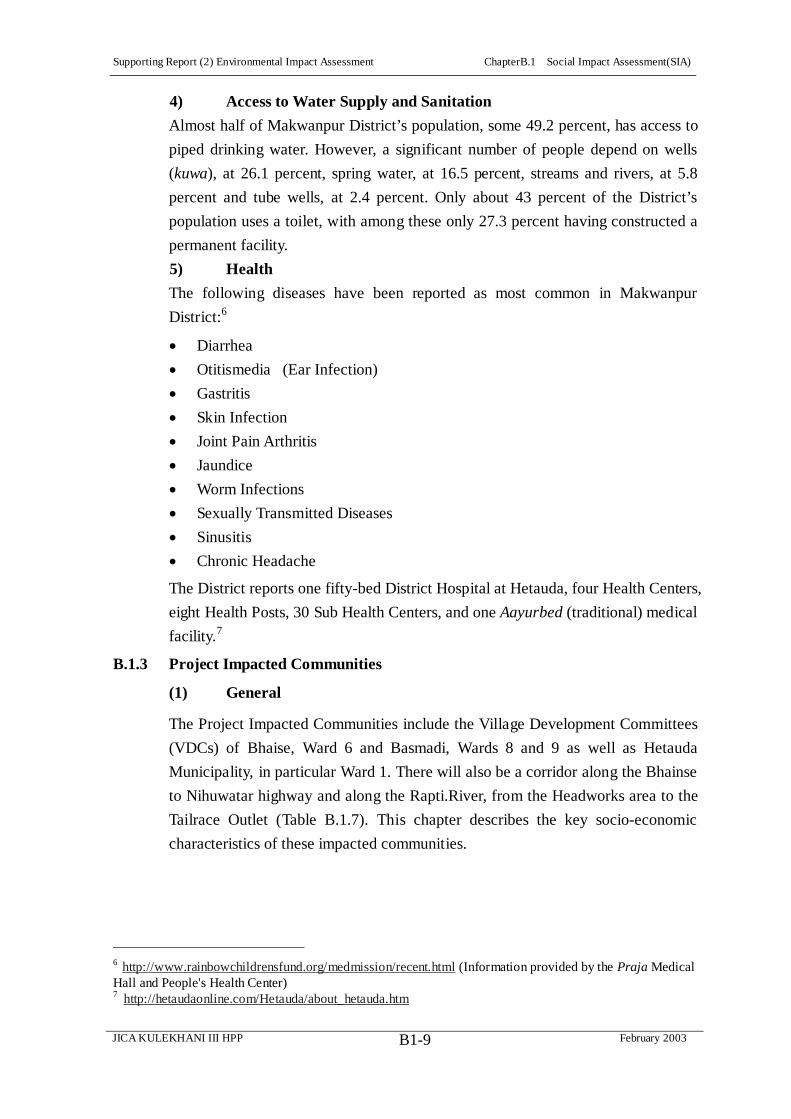
Supporting Report (2) Environmental Impact Assessment ChapterB.1 Social Impact Assessment(SIA)
JICA KULEKHANI III HPP February 2003B1-9
4) Access to Water Supply and Sanitation
Almost half of Makwanpur District’s population, some 49.2 percent, has access to
piped drinking water. However, a significant number of people depend on wells
(kuwa), at 26.1 percent, spring water, at 16.5 percent, streams and rivers, at 5.8
percent and tube wells, at 2.4 percent. Only about 43 percent of the District’s
population uses a toilet, with among these only 27.3 percent having constructed a
permanent facility.
5) Health
The following diseases have been reported as most common in Makwanpur
District:6
Diarrhea
Otitismedia (Ear Infection)
Gastritis
Skin Infection
Joint Pain Arthritis
Jaundice
Worm Infections
Sexually Transmitted Diseases
Sinusitis
Chronic Headache
The District reports one fifty-bed District Hospital at Hetauda, four Health Centers,
eight Health Posts, 30 Sub Health Centers, and one Aayurbed (traditional) medical
facility.7
B.1.3 Project Impacted Communities
(1) General
The Project Impacted Communities include the Village Development Committees
(VDCs) of Bhaise, Ward 6 and Basmadi, Wards 8 and 9 as well as Hetauda
Municipality, in particular Ward 1. There will also be a corridor along the Bhainse
to Nihuwatar highway and along the Rapti.River, from the Headworks area to the
Tailrace Outlet (Table B.1.7). This chapter describes the key socio-economic
characteristics of these impacted communities.
6 http://www.rainbowchildrensfund.org/medmission/recent.html (Information provided by the Praja Medical Hall and People's Health Center) 7 http://hetaudaonline.com/Hetauda/about_hetauda.htm

Supporting Report (2) Environmental Impact Assessment ChapterB.1 Social Impact Assessment(SIA)
JICA KULEKHANI III HPP February 2003B1-10
Table B.1.7: Project Impacted Communities: VDCs and Hetauda
Municipality
VDC/Municipality Ward No Village/Area 1. Bhainse VDC 6 Sanutar, /Ghumaune; Kisedi
Village 2. Basamadi VDC 8,9,11 Bokheda, Maintar Villages 3.Hetauda Municipality 1 Choke Tole, Suparitar Military
Camp/Police, NEA Diesel Plant 4. Bhainse Dhoban-Nibuwatar Corridor Area
Hwy to Bhimpedu, KL I Power Plant, Reservoir
5.Corridor along Rapti and Connecting Tunnel
Bhainse VDC
(2) Household and Population
The Project impacted VDCs and Municipality have altogether some 86,266 people,
consolidated within 18,102 households. The average household is 4.8, lower than
the District’s average size of 5.5 and the national average size of 5.4 persons per
household. The population has increased by 22 percent between 1991 and 2001
census, with the annual growth of 2.2 percent, a slightly lower growth rate than
that of the District (Table B.1.8)
Table B.1.8: Affected Communities: Households and Population 1991 Census 2001 Census Description Bhainse
VDC Basamadi
VDC Hetauda Munic.
Bhainse VDC
Basamadi VDC
Hetauda Munic.
Total
Total Households
1,105 1,815 10,420 1,286 2,545 14,271 18,102
Population Male Female
6,6153,415 3,164
102325,209 5,023
53,83627,805 26,031
7,6143,827 3,787
14,1707,213 6,957
64,48235,320 33,162
86,266 46,360 43,906
Source: I) Population of Nepal by Districts, VDCs/Municipalities (Population Census 1991), CBS 1994. ii) District Population Census 2001 (Final Results), CBS, National Planning Commission.
The impacted VDCs and Municipality make up only 1 percent of the Central
Development Region’s population and only 2.2 percent of Makawanpur District’s
population.
(3) Caste and Ethnic Composition
The Project impacted communities are predominately Tamang, some 43.53
percent. This is especially the case in Bhainse VDC, where the Tamang are 68.25
percent, followed by Basamadi VDC, where they are 52.62 percent. In Hetauda
Municipality, on the other hand, Tamangs make up only 9.73 percent of the
population. Other caste and ethnic groups in the impacted communities include
Brahmin, some 21.75 percent, Chhetri, at 11.2 percent, Newar, 9.04 percent,
Magar, 7.01 percent, the occupational castes of Kami/Damai/Sarki at 4.2 percent,
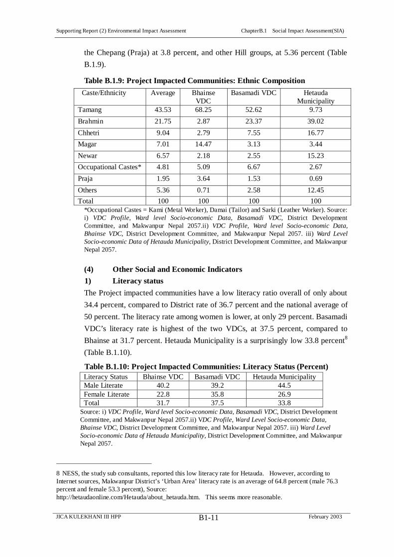
Supporting Report (2) Environmental Impact Assessment ChapterB.1 Social Impact Assessment(SIA)
JICA KULEKHANI III HPP February 2003B1-11
the Chepang (Praja) at 3.8 percent, and other Hill groups, at 5.36 percent (Table
B.1.9).
Table B.1.9: Project Impacted Communities: Ethnic Composition
Caste/Ethnicity Average Bhainse VDC
Basamadi VDC Hetauda Municipality
Tamang 43.53 68.25 52.62 9.73
Brahmin 21.75 2.87 23.37 39.02
Chhetri 9.04 2.79 7.55 16.77
Magar 7.01 14.47 3.13 3.44
Newar 6.57 2.18 2.55 15.23
Occupational Castes* 4.81 5.09 6.67 2.67
Praja 1.95 3.64 1.53 0.69
Others 5.36 0.71 2.58 12.45
Total 100 100 100 100 *Occupational Castes = Kami (Metal Worker), Damai (Tailor) and Sarki (Leather Worker). Source: i) VDC Profile, Ward level Socio-economic Data, Basamadi VDC, District Development Committee, and Makwanpur Nepal 2057.ii) VDC Profile, Ward level Socio-economic Data, Bhainse VDC, District Development Committee, and Makwanpur Nepal 2057. iii) Ward Level Socio-economic Data of Hetauda Municipality, District Development Committee, and Makwanpur Nepal 2057.
(4) Other Social and Economic Indicators
1) Literacy status
The Project impacted communities have a low literacy ratio overall of only about
34.4 percent, compared to District rate of 36.7 percent and the national average of
50 percent. The literacy rate among women is lower, at only 29 percent. Basamadi
VDC’s literacy rate is highest of the two VDCs, at 37.5 percent, compared to
Bhainse at 31.7 percent. Hetauda Municipality is a surprisingly low 33.8 percent8
(Table B.1.10).
Table B.1.10: Project Impacted Communities: Literacy Status (Percent) Literacy Status Bhainse VDC Basamadi VDC Hetauda Municipality Male Literate 40.2 39.2 44.5 Female Literate 22.8 35.8 26.9 Total 31.7 37.5 33.8
Source: i) VDC Profile, Ward level Socio-economic Data, Basamadi VDC, District Development Committee, and Makwanpur Nepal 2057.ii) VDC Profile, Ward Level Socio-economic Data, Bhainse VDC, District Development Committee, and Makwanpur Nepal 2057. iii) Ward Level Socio-economic Data of Hetauda Municipality, District Development Committee, and Makwanpur Nepal 2057.
8 NESS, the study sub consultants, reported this low literacy rate for Hetauda. However, according to Internet sources, Makwanpur District’s ‘Urban Area’ literacy rate is an average of 64.8 percent (male 76.3 percent and female 53.3 percent), Source: http://hetaudaonline.com/Hetauda/about_hetauda.htm. This seems more reasonable.

Supporting Report (2) Environmental Impact Assessment ChapterB.1 Social Impact Assessment(SIA)
JICA KULEKHANI III HPP February 2003B1-12
2) Vulnerable groups
Some 4.3 percent of the Project Impacted Community’s population is elderly,
widows or handicapped (Table B.1.11).
Table B.1.11: Vulnerable Groups of the Project Impacted Communities: Elderly,
Widows & Handicapped, No. and Percent of Population Bhainse Basamadi Hetauda Municipality Vulnerable Group
HH No. % HH No % HH No %
Elderly 38 91 496 Widows 36 76 453 Handicapped 2 1 14 Total 76 1.12 168 1.32 963 1.86
Source: i) VDC Profile, Ward Level Socio-economic Data, Basamadi VDC, District Development Committee, and Makwanpur Nepal 2057.ii) VDC Profile, Ward Level Socio-Economic Data, Bhainse VDC, District Development Committee, and Makwanpur Nepal 2057. iii) Ward Level Socio-economic Data of Hetauda Municipality, District Development Committee, and Makwanpur Nepal 2057.
3) Occupation and Skills
The impacted communities constitute some 1.54 percent of District population
acknowledged as having various skills such as electricity, construction worker,
health worker that might be useful for the Kulekhani III Project construction
works. Some 30 percent of these belong to Hetauda Municipality, followed by
Basamadi, 71 [21] percent and Bhainse, with 19 percent (Table B.1.12).
Table B.1.12: Persons with Technical Skills in the Project Impacted
Communities Bhainse Basamadi Hetauda Municipality Skills
HH No. % HH No % HH No %
Electricity 2 51 59 Civil Construction 1 5 131 Shoe Maker 1 0 2 Health 4 1 49 Rural Veterinary 11 0 3 Rural Agricultural - - - - 18 Other 0 20 45 Total 19 0.28 77 0.66 307 0.59 Source: I) VDC Profile, Ward level Socio-economic Data, Basamadi VDC, District Development Committee, and Makwanpur Nepal 2057.ii) VDC Profile, Ward level Socio-economic Data, Bhainse VDC, District Development Committee, and Makwanpur Nepal 2057. iii) Ward level Socio-economic Data of Hetauda Municipality, District Development Committee, and Makwanpur Nepal 2057.
4) Livestock Population and their Products
Rearing livestock is an integral part of rural economy in the Project Impacted
Communities. The average livestock holding size varies from 3.5 animals per HH
in Hetauda to 8 animals per HH in Bhainse VDC, including poultry.

Supporting Report (2) Environmental Impact Assessment ChapterB.1 Social Impact Assessment(SIA)
JICA KULEKHANI III HPP February 2003B1-13
Table B.1.13: Project Impacted Communities, Livestock HH Holding Size
Livestock Type Bhainse VDC Basmadi VDC Hetauda Municipality Poultry 2.9 2.1 2.3 Goat 2.5 1.9 0.5 Bull 1 1 0.2 Cow 1 0.9 0.4 Buffalo 0.5 0.2 0.5 He-buffalo 0.1 0.4 0.1 Pig 0.1 0 0.1 Other (Rabbit) 0 0 0 Total Livestock 5 4.4 1 Total 8 7 3.5
Source: I) VDC Profile, Ward Level Socio-economic Data, Basamadi VDC, District Development Committee, and Makwanpur Nepal 2057.ii) VDC Profile, Ward Level Socio-economic Data, Bhainse VDC, District Development Committee, and Makwanpur Nepal 2057. iii) Ward level Socio-economic Data of Hetauda Municipality, District Development Committee, and Makwanpur Nepal 2057.
5) Land Holding Size and Ownership
The average land holding size of the area varies from 0.2 in Hetauda Municipality
to 1.6 ha. The households of Bhainse VDC have the highest holdings, with 1.6 ha
including both Khet (irrigated paddy land), although the land is mostly
un-irrigated type (Pakho) (Table B.1.14). It should be noted, however, that the
data for Bhainse VDC is incorrect, as the 8 Ha of Khet (irrigated paddy land) at
Sanutar-Ghumaune has not been accounted for. Or, on the other hand, since the
canal system there was only recently repaired, this land was not under irrigation at
the time the data was compiled. It does illustrate, however, the importance and
relative scarcity of such irrigated Khet land.
Table B.1.14: Project Impacted Communities, Average Land Holding Size Bhainse VDC Basamadi VDC Hetauda Municipality Land Type Area (Ha)
% Area (Ha)
% Area (Ha)
%
Av/HH - Khet 0.00 0 0.01 23.71 0.10 58.0 Av/HH- Pakho 1.60 100 0.30 76.29 0.07 42.0 AV/HH- Both 1.60 100 0.40 100 0.20 100
Source: I) VDC Profile, Ward Level Socio-economic Data, Basamadi VDC, District Development Committee, and Makwanpur Nepal 2057.ii) VDC Profile, Ward Level Socio-economic Data, Bhainse VDC, District Development Committee, and Makwanpur Nepal 2057. iii) Ward level Socio-economic Data of Hetauda Municipality, District Development Committee, and Makwanpur Nepal 2057.
The number of landless farmers ranges from 5 percent in Hetauda to 16 percent in
Bhainse VDC, with Basamadi VDC between the two, at 11 percent. The large
majority of the households in Hetauda Municipality, 91.6 percent, and Bhaise
VDC, 44.87 percent, own up to 0.25 hectors of land. In Basmadi VDC, however,
almost 30 percent household own land raising 0.25-0.5 hectare. The highest

Supporting Report (2) Environmental Impact Assessment ChapterB.1 Social Impact Assessment(SIA)
JICA KULEKHANI III HPP February 2003B1-14
number of households holding more than one hectare of land [13.5%] is also
recorded in Basmadi VDC (Table B.1.15).
Table B.1.15: Project Impacted Communities, Land Holding Size Bhainse VDC Basmadi VDC Hetauda Municipality
HH Holding Size Percent Percent Percent
Landless 15.5 11.2 5.2 Having up to 0.25Ha. 44.8 24.5 91.6 Having up to0.25- 5 Ha. 26.6 29.7 2.3 Having up to 0.5-1 Ha. 11.4 21.1 0.8 Having above 1Ha. 1.7 13.5 0.1 Total 100 100 100
Source: I) VDC Profile, Ward Level Socio-economic Data, Basamadi VDC, District Development Committee, and Makwanpur Nepal 2057.ii) VDC Profile, Ward Level Socio-economic Data, Bhainse VDC, District Development Committee, and Makwanpur Nepal 2057. iii) Ward level Socio-economic Data of Hetauda
Municipality, District Development Committee, and Makwanpur Nepal 2057.
6) Food Sufficiency and Coping Strategies
The food production in the Project Impacted Communities is insufficient to meet
local food sufficiency. About 64 percent of households say they must buy food
each year, adopting a number coping strategies, such as taking out loans, finding
wage, employment, firewood collection, selling livestock, and hunting. Key
constraints for improving this situation are cited as: Insufficient irrigation and
inputs, traditional agricultural practices lack of improved farming skills, lack of
transportation and of a marketing network, lack of a minimum in social services,
and natural calamities.
Table B.1.16: Project Impacted Communities, Food Sufficiency Food Sufficiency, Yes or No Percentage Yes 36 No 64 Total 100
7) Energy Sources
All households in Bhainse VDC and 89 percent of those in Basamadi VDC use
firewood as their key energy resource. In Hetauda, most households, 40 percent,
use kerosene followed by firewood, 38 percent, LP Gas, 16 percent, Biogas, 5
percent, and other sources, 1 percent (Table B.1.17).

Supporting Report (2) Environmental Impact Assessment ChapterB.1 Social Impact Assessment(SIA)
JICA KULEKHANI III HPP February 2003B1-15
Table B.1.17: Project Impacted Communities, Percent of HHs Using Different
Kinds of Cooking Fuel
Bhainse VDC Basamadi VDC Hetauda Municipality Firewood 100 89 38 Biogas 0 3 5 Electricity 0 0 1 Kerosene 0 7 40
LP Gas 0 1 15 More Than Two Sources - - 1 Total 100 100 100
Source: I) VDC Profile, Ward Level Socio-economic Data, Basamadi VDC, District Development Committee, and Makwanpur Nepal 2057.ii) VDC Profile, Ward Level Socio-economic Data, Bhainse VDC, District Development Committee, and Makwanpur Nepal 2057. iii) Ward level Socio-economic Data of Hetauda Municipality, District Development Committee, and Makwanpur Nepal 2057.
Almost 90 percent of the VDC population using firewood spends above 60
minutes daily collecting firewood (Table B.1.18).
Table B.1.18: Project Impacted Communities, Time to Collect Firewood Bhainse Basamadi Hetauda Municipality Time
HH No. % HH No % HH No %
Over 60 Minutes 1,091 93 1755 83 45-60 Minutes 80 7 216 10 NA 10-15 Minutes 0 0 0 0 15-30 Minutes 0 0 148 7 30-45 Minutes 0 0 0 0 Total 1,171 100 2,119 100
Source: I) VDC Profile, Ward Level Socio-economic Data, Basamadi VDC, District Development Committee, and Makwanpur Nepal 2057.ii) VDC Profile, Ward Level Socio-economic Data, Bhainse VDC, District Development Committee, and Makwanpur Nepal 2057. iii) Ward level Socio-economic Data of Hetauda Municipality, District Development Committee, and Makwanpur Nepal 2057.
8) Access to Water Supply and Sanitation
The population having access to piped drinking water ranges from 30 percent in
Basamadi to 80 percent in Bhainse, compared to 49 percent of District average. In
Bhaise, probably the activities of Plan International over the last eight years
account for the high, at 80 percent, proportion of the population with piped
drinking water. This is followed by Well water, 12 percent, spring water, 7
percent, and river water, at less than 1 percent. Basamadi has its highest reliance
on spring water, 39 percent, followed by piped water, 30 percent and wells, 23
percent, river, 5 percent, and tube wells, 3 percent. Hetauda’s greatest reliance,
like Bhaise, is on piped water, 66 percent, well, 14 percent, spring, 11 percent,
tube well, 6 percent, and river water, 1 percent (Table B.1.19).
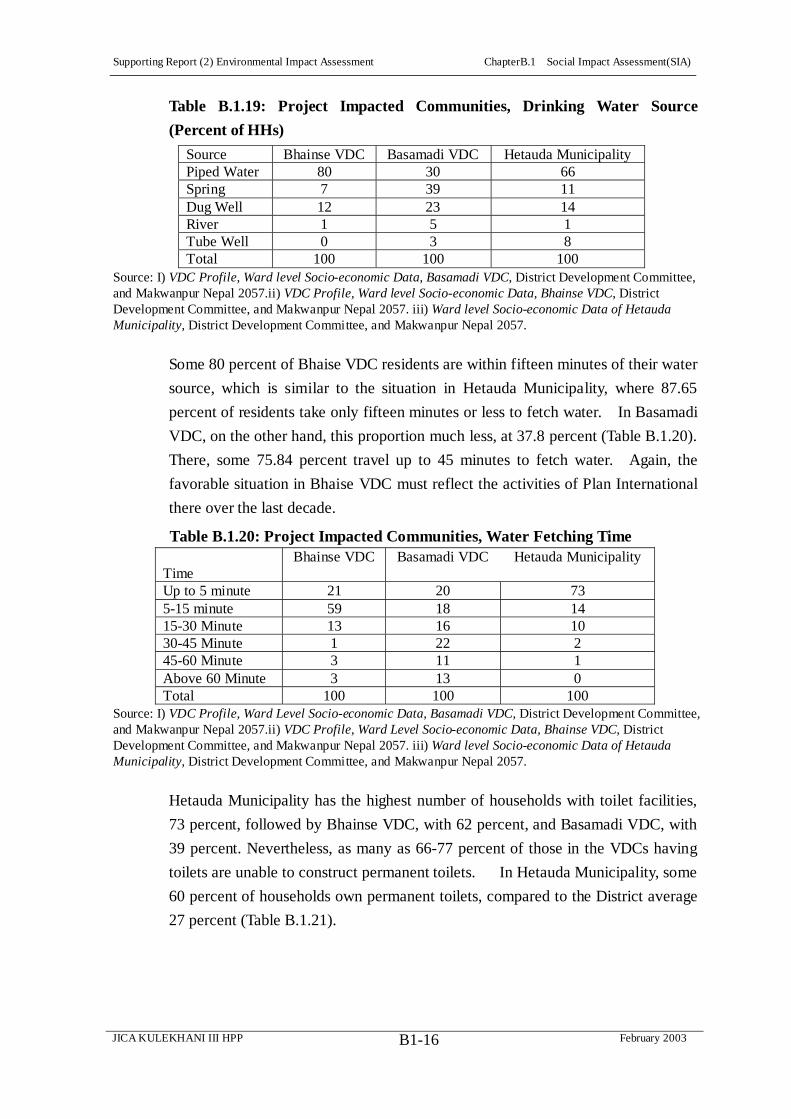
Supporting Report (2) Environmental Impact Assessment ChapterB.1 Social Impact Assessment(SIA)
JICA KULEKHANI III HPP February 2003B1-16
Table B.1.19: Project Impacted Communities, Drinking Water Source
(Percent of HHs)
Source Bhainse VDC Basamadi VDC Hetauda Municipality Piped Water 80 30 66 Spring 7 39 11 Dug Well 12 23 14 River 1 5 1 Tube Well 0 3 8 Total 100 100 100
Source: I) VDC Profile, Ward level Socio-economic Data, Basamadi VDC, District Development Committee, and Makwanpur Nepal 2057.ii) VDC Profile, Ward level Socio-economic Data, Bhainse VDC, District Development Committee, and Makwanpur Nepal 2057. iii) Ward level Socio-economic Data of Hetauda Municipality, District Development Committee, and Makwanpur Nepal 2057.
Some 80 percent of Bhaise VDC residents are within fifteen minutes of their water
source, which is similar to the situation in Hetauda Municipality, where 87.65
percent of residents take only fifteen minutes or less to fetch water. In Basamadi
VDC, on the other hand, this proportion much less, at 37.8 percent (Table B.1.20).
There, some 75.84 percent travel up to 45 minutes to fetch water. Again, the
favorable situation in Bhaise VDC must reflect the activities of Plan International
there over the last decade.
Table B.1.20: Project Impacted Communities, Water Fetching Time
Time Bhainse VDC Basamadi VDC Hetauda Municipality
Up to 5 minute 21 20 73 5-15 minute 59 18 14 15-30 Minute 13 16 10 30-45 Minute 1 22 2 45-60 Minute 3 11 1 Above 60 Minute 3 13 0 Total 100 100 100
Source: I) VDC Profile, Ward Level Socio-economic Data, Basamadi VDC, District Development Committee, and Makwanpur Nepal 2057.ii) VDC Profile, Ward Level Socio-economic Data, Bhainse VDC, District Development Committee, and Makwanpur Nepal 2057. iii) Ward level Socio-economic Data of Hetauda Municipality, District Development Committee, and Makwanpur Nepal 2057.
Hetauda Municipality has the highest number of households with toilet facilities,
73 percent, followed by Bhainse VDC, with 62 percent, and Basamadi VDC, with
39 percent. Nevertheless, as many as 66-77 percent of those in the VDCs having
toilets are unable to construct permanent toilets. In Hetauda Municipality, some
60 percent of households own permanent toilets, compared to the District average
27 percent (Table B.1.21).

Supporting Report (2) Environmental Impact Assessment ChapterB.1 Social Impact Assessment(SIA)
JICA KULEKHANI III HPP February 2003B1-17
Table B.1.21: Project Impacted Communities, HHs Having Sanitation
Facilities
Bhainse VDC Basamadi VDC Hetauda Municipality Toilet Facilities % % % Permanent Toilet 14 13 44 Temporary Toilet 47 26 29 Total 62 39 73
Source: I) VDC Profile, Ward Level Socio-economic Data, Basamadi VDC, District Development Committee, and Makwanpur Nepal 2057.ii) VDC Profile, Ward Level Socio-economic Data, Bhainse VDC, District Development Committee, and Makwanpur Nepal 2057. iii) Ward level Socio-economic Data of Hetauda Municipality, District Development Committee, and Makwanpur Nepal 2057.
(5) Project’s Most Impacted Communities (MIC)
1) General
Among the Project Impacted Communities, the socio-economic characteristic of
the residents of Sanutar, Bokedaha, and Ghumaune Pari communities, totaling
some fifty five households, are especially relevant, as they will bear the main
brunt of the Project’s direct impacts due to land acquisition and resulting
Resettlement Effects for private households, and they are also likely to experience
most of the Project’s significant indirect impacts. The socioeconomic fieldwork
surveyed all of these households, which are altogether the Most Impacted
Communities (MIC).
2) Resettlement Plan: Section on Socioeconomic Information
The socioeconomic information collected during the fieldwork, which covered
100 percent of the fifty-five households of the Most Impacted Communities, or
MIC, as above, is presented in the Resettlement Plan (RP) under the section on
Socioeconomic Information. This profile provides the context for understanding
the MIC and the direct and indirect Project impacts on the relatively small area
that constitutes the villages of Sanutar, Bokedaha, and Ghumaune Pari as well as
the primary area where Project construction and its associated camp areas, access
roads and other facilities are most concentrated.
(6) Indirect Project Resettlement Effects
1) Summary of HHs Affected by Direct Resettlement Effects
As indicated in the Resettlement Plan (RP), total number of HHs currently
estimated to be potentially affected by the Project’s land acquisition is 97 HH,
with an estimated population of 611 persons.

Supporting Report (2) Environmental Impact Assessment ChapterB.1 Social Impact Assessment(SIA)
JICA KULEKHANI III HPP February 2003B1-18
Table B.1.22: Summary Resettlement Effects: Relocation & Loss of
Agricultural Land, No. of Potentially Affected HHs and Estimated
Population
Description No. Potentially Affected HHs
Estimated Potentially Affected Population*
HHs Losing 26 Houses 25 150 (Incl. HH Losing Only 1 Ancillary Structure)
(1) (6)
HHs Losing 15 Ha Agricultural Land 72 454 Total 97 604
* Estimated at 6.3 persons per HH, as per MIC field survey
The ADB defines ‘Significant Resettlement Effect’ requiring a Full RP (as
outlined in its Handbook on Resettlement) as 200 people or more experiencing
major impacts, with “major” impacts being physical displacement from housing
and/or more than 10 percent of the household’s productive (income generating)
assets are lost. Currently, the Project most likely falls below this defined level of
‘significance’ with respect to loss of housing. On the other hand, at this time an
expression of the level of severity of HHs loss of agricultural land as a percentage
of HH income is not possible. This will be determined, however, during the next
study phase. In any case, the Project will finalize an RP at the ADB’s standard of
‘significant resettlement effect.’
Table B.1.22 above provides useful overall numbers for HHs likely to experience
relocation due to loss of a house and HHs potentially affected by loss of
agricultural land, and these have allowed the Study Team to broadly define the
scope of likely resettlement effects associated with Project, for purposes of this
early draft RP. However, these figures will need to be updated at the beginning
of the new Detailed Design Study phase with more reliable data, to verify the
actual numbers of affected HHs, and this new data will be used to update the RP,
which is the primary mitigative measure for addressing the Project’s direct
resettlement effects.
In addition to the above potentially affected HHs, there are also institutions
owning land that will be acquired by the Project, most particularly Hetauda
Cement Industries Limited (HCIL) in the Headworks area and along its ropeway
through Sanutar, NEA through its Kulekhani II Hydropower Project facilities at
the Headworks area.
2) Range of Indirect Resettlement Impacts
While the direct impact of the Project’s land acquisition is easily understood and
readily addressed in the RP, the term Resettlement Effects is also more broadly
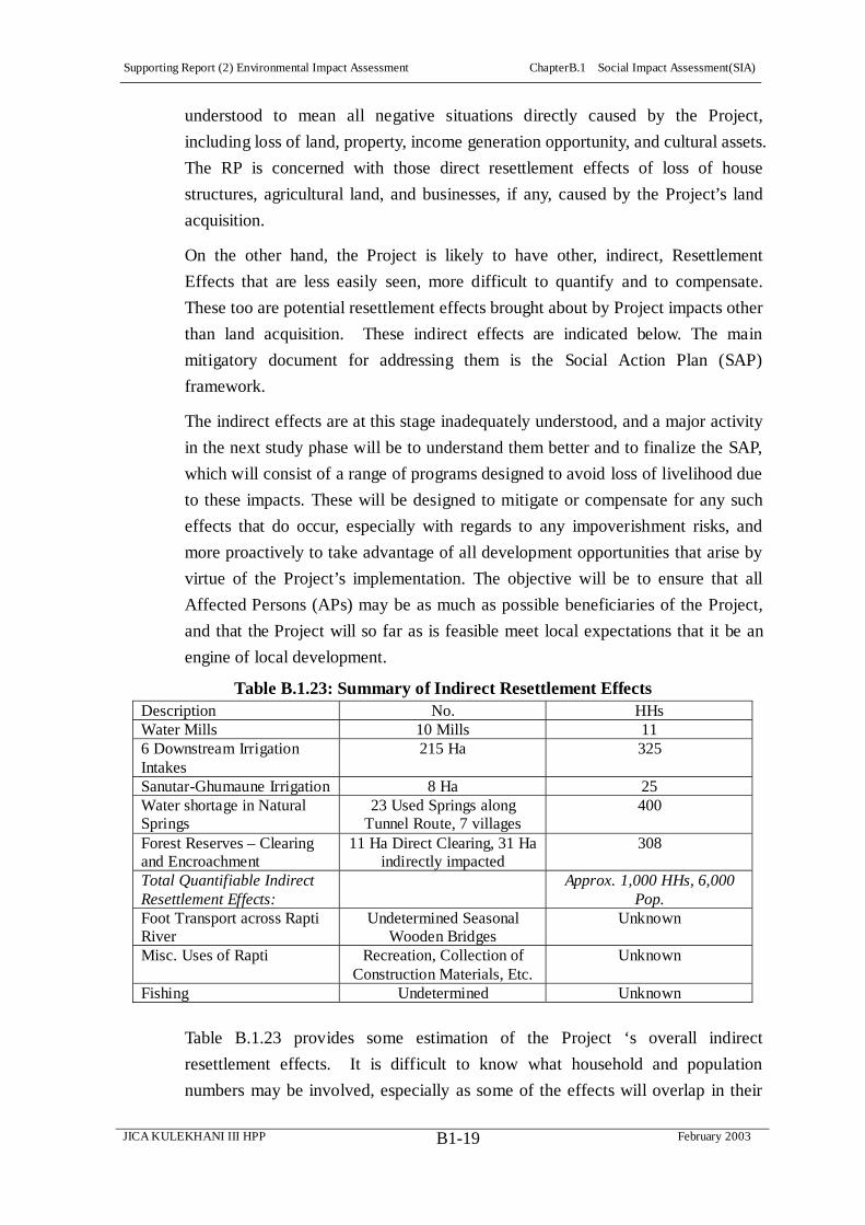
Supporting Report (2) Environmental Impact Assessment ChapterB.1 Social Impact Assessment(SIA)
JICA KULEKHANI III HPP February 2003B1-19
understood to mean all negative situations directly caused by the Project,
including loss of land, property, income generation opportunity, and cultural assets.
The RP is concerned with those direct resettlement effects of loss of house
structures, agricultural land, and businesses, if any, caused by the Project’s land
acquisition.
On the other hand, the Project is likely to have other, indirect, Resettlement
Effects that are less easily seen, more difficult to quantify and to compensate.
These too are potential resettlement effects brought about by Project impacts other
than land acquisition. These indirect effects are indicated below. The main
mitigatory document for addressing them is the Social Action Plan (SAP)
framework.
The indirect effects are at this stage inadequately understood, and a major activity
in the next study phase will be to understand them better and to finalize the SAP,
which will consist of a range of programs designed to avoid loss of livelihood due
to these impacts. These will be designed to mitigate or compensate for any such
effects that do occur, especially with regards to any impoverishment risks, and
more proactively to take advantage of all development opportunities that arise by
virtue of the Project’s implementation. The objective will be to ensure that all
Affected Persons (APs) may be as much as possible beneficiaries of the Project,
and that the Project will so far as is feasible meet local expectations that it be an
engine of local development.
Table B.1.23: Summary of Indirect Resettlement Effects Description No. HHs Water Mills 10 Mills 11 6 Downstream Irrigation Intakes
215 Ha 325
Sanutar-Ghumaune Irrigation 8 Ha 25 Water shortage in Natural Springs
23 Used Springs along Tunnel Route, 7 villages
400
Forest Reserves – Clearing and Encroachment
11 Ha Direct Clearing, 31 Ha indirectly impacted
308
Total Quantifiable Indirect Resettlement Effects:
Approx. 1,000 HHs, 6,000 Pop.
Foot Transport across Rapti River
Undetermined Seasonal Wooden Bridges
Unknown
Misc. Uses of Rapti Recreation, Collection of Construction Materials, Etc.
Unknown
Fishing Undetermined Unknown
Table B.1.23 provides some estimation of the Project ‘s overall indirect
resettlement effects. It is difficult to know what household and population
numbers may be involved, especially as some of the effects will overlap in their

Supporting Report (2) Environmental Impact Assessment ChapterB.1 Social Impact Assessment(SIA)
JICA KULEKHANI III HPP February 2003B1-20
effects on particular households. Of those resettlement effects that can be
quantified to any degree, it might be supposed that approximately one thousand
households could be potentially affected, without mitigation measures, with
respect to diminished livelihood and other quality of life indices, constituting a
population of roughly six thousand. This is in addition to the almost one
hundred households and 600 persons who might experience direct resettlement
effects from the Project’s land acquisition in the MIC.
Thus, taking into account both direct Resettlement Effects caused by land
acquisition and indirect Resettlement Effects caused by a variety of other Project
impacts there could be overall a potential estimated 1,100 households or 6,600
persons, assuming that some quantification is possible for the indirect
Resettlement Effects, affected either directly or indirectly by the Project. The
various identified indirect resettlement effects are described in more detail below.
Summary Downstream Effects
In addition to land acquisition effects, there are about 450 HHs potentially
affected by alteration in water flows due to the Project, either having an economic
interest in water mills along the river’s course or dependent to some degree on
irrigated fields from intakes along the river.
There could also be Resettlement Effects (effecting household income) difficult to
measure on an unknown number of villagers who presently cross the Rapti River
over small, seasonal wooden bridges on a regular basis going to and from
Hetauda.
July 2002 Floods
It is noted that since the fieldwork assessing the above indirect resettlement effects
was carried out, disastrous floods occurred, fully or partially destroying many of
the water mills and irrigation schemes discussed below. A two day visit to
Hetauda briefly confirmed this damage, and the next study phase will update this
information for appropriate revisions to the SAP to take the new situation into
account, especially in assessing whether or not HHs or communities have
managed to rebuild in the meantime.
Water Mills
As shown in Table B.1.24, here are ten water mills in operation, four at Chauki
Tole on the Rapti’s Left Bank, three at Mainatar on the Rapt’s Right Bank, two at
Sanutar on the Rapti’s Left Bank, and one at Nayagaon on the Rapti River’s Right
Bank. Short canals divert water from the Rapti River. The intake structures are
temporary and require regular readjustment of their intakes with the frequent

Supporting Report (2) Environmental Impact Assessment ChapterB.1 Social Impact Assessment(SIA)
JICA KULEKHANI III HPP February 2003B1-21
variations in the Rapti River’s flow.
Table B.1.24: Water Mills Below Tailrace Outlet Location No. Water Mills Chauki Tole (Rapti Left Bank) 4 Mainatar (Rapti Right Bank) 3 Sanutar (Rapti Left Bank) 2 Nayagaon (Rapti Right bank) 1 Total 10
All of the water mills are operated round the year. The water mills are used for the
grinding of the cereals such as maize, millet and wheat. Water mills are the
traditional mechanical means of grinding. Though slow, it is also the cheapest
service facility available to the local communities. Besides, it is a means of
economy generation to the eight households.
Dewatering Effects downstream of the Tailrace Outlet. Since reduction in water
volume will occur downstream of the Tailrace for about twenty hours (20.00 to
16.00 hours) on the Rapti River, some seven Water Mills between Nakoligaon and
the Hetauda Bridge) may be effected by dewatering impacts, causing loss in
subsistent income to about five households.
Dewatering Effects upstream of the Tailrace Outlet. Although the Rapti’s water
will not be diverted to the Kulekhani III at Bhaise, there will still be substantial
water to operate the water mills in the dewatered section of Rapti floodplain for
the three water mills during operation on the Rapti River between Bhaise and
Nakoligaon, i.e., upstream of the Kulekhani III Proejct’s Tailrace Outlet but
downstream from the Project’s Tunnel Inlet. They will be, however, partially
impacted as their existing water diversion intakes will not be able to divert water
to their requirements of about. 1.5/m3/s due to dewatering effects along this stretch
of the Rapti. About 3 households would stand to lose their subsistent income.
Irrigation
The Rapti River and its tributaries in the Project Region of Influence are the prime
source of irrigation water. Irrigation canal intakes on the Rapti River are
observed downstream from the Kesadi-Rapti confluence. Between Kesadi-Rapti
Confluence and Hetauda Highway Bridge there are six irrigation intake locations
on the Rapti River. Another scheme, at Sanutar, will also be affected by
construction activities and by the Project’s operation. Altogether, there could be,
without mitigation activities, roughly some 224 hectares and about 350 families
having their income reduced through the Kulekhani III Project’s construction.
Actual water diversions from these irrigation canals in different seasons are

Supporting Report (2) Environmental Impact Assessment ChapterB.1 Social Impact Assessment(SIA)
JICA KULEKHANI III HPP February 2003B1-22
largely unknown and are a matter of further study, as are details about the
production of the schemes or the families served. It is to be noted that User
Groups and Committees of the several irrigation canals on the Rapti River
maintain and readjust the irrigation canal intakes regularly as the Rapti’s main
channel shifts in the Dry and Wet Seasons. In addition to these schemes, thee
was some concern by the District’s Irrigation Department about potential effects
on the E. Rapti Irrigation Project. However, the Kulekhani III Project is not
expected to pose any problems for this scheme.
Impacts in the other irrigation canals downstream of the Tailrace Outlet due to
water reduction for at least twenty hours daily are, however, envisaged to render
their existing intake structures ineffective. The Kulekhani III Project’s dewatering
of the Rapti during these periods will impact about 216 ha of irrigated land and its
agricultural production with adverse implication for the quality of life of some 325
or so households reliant on the fields with intakes between the Hetauda Bridge
and the Tailrace Outlet:
Nakoligaon opposite the military camp at Suparitar. Here an irrigation
intake on the Rapti’s Right Bank is located just at the Kesadi-Rapti
confluence, irrigating about to three hectares of paddy on the protected
natural levees of on the Rapti below the main village. The irrigation canal
here benefits about six families of the Basamadi VDC Wards 8 and 9. The
intake structure is a simple river diversion using loose boulders and gravel.
Regular intake maintenance is required for the operation of irrigation canal.
Maintar, on the Rapti’s Right Bank. At this location an irrigation canal
irrigates about five hectares of paddy land, benefiting about twenty-five
families, also of Basamadi, Wards 8 and 9. The intake is a simple water
diversion using loose boulders and gravel. With the assistance of the District
Irrigation Department about two years back, water from the intake was
diverted through a 400 m long poly pipe of 6" diameter across a landslide area
that lies in the path of the Kulekhani III’s planned Tailrace Outlet’s daily
water discharge into the Rapti and so could be undermined by this daily 45
m2/sec pulse of water.
Satghatte and Ghate Kulo (canal), below Chauki Tole. These two intakes at
this location on the Rapti’s Left Bank, just below Hetauda, irrigate together
about fifteen hectares of paddy land, benefiting some forty five families of
Hetauda, Ward 1. There is no permanent irrigation intake structure. A simple
and loose weir of boulder and gravel divert the Rapti water into the irrigation
canal.

Supporting Report (2) Environmental Impact Assessment ChapterB.1 Social Impact Assessment(SIA)
JICA KULEKHANI III HPP February 2003B1-23
Nawalpur Basamadi Irrigation Canal, on the Rapti’s Right Bank close to the
abutment of the Hetauda Highway Bridge. The Nawalpur Basamadi Irrigation
Scheme was constructed in 2040 B.S. (1983) and irrigates about 125 hectares
of paddy land, benefiting about 180 families of Hetauda Municipality, Ward
11 and Basamadi VDC, Ward 9. Temporary weirs of boulders and heaps of
gravel divert the Rapti water into the irrigation canal. This irrigation scheme
is operated and maintained by the same Water User Committee as the
following Simaltar-Gopingtar scheme.
The Simaltar-Golpingtar Irrigation Scheme. The intake for this recently
constructed scheme is also nearby the abutment of the Hetauda Highway
Bridge. It irrigates about 66 hectares of paddy land, benefiting Hetauda, Ward
11. The District Department of Irrigation provides about NRs. 100,000
annually for the intake and canal maintenance.
Kesadi Khola-Rapti Confluence. Two apparently temporary irrigation canal
intakes were observed on the Kesadi’s Right Bank near Bokedaha, within the
Project’s Zone of Influence, irrigating about two hectares of land in total,
benefiting // families of Basamadi VDC, Ward 9. Although above the
Tailrace Outlet, these too may be affected by the Project’s changing of river
flows, particularly those of the Yangran Khola.

Supporting Report (2) Environmental Impact Assessment ChapterB.1 Social Impact Assessment(SIA)
JICA KULEKHANI III HPP February 2003B1-24
Table B.1.25: Irrigation Schemes Possibly Affected by Kulekhani III Project Location Ha HHs Remarks 1 Right Bank of Rapti -
Kesadi-Rapti Confluence 3 6 Irrigates protected natural levees of Rapti below Nakoligaon, opposite Suparitar.
Intake structure - simple river diversion by loose boulders and gravel. Basamadi VDC Wards 8 and 9.
2 Right Bank of Rapti River at Maintar
5 25 Intake is simple water diversion by loose boulders and gravel. Water from the intake is diverted through a 400m long poly pipe of 6" diameter across the landslide area on the assistance of District Irrigation Department about 2 years back. Basamadi Wards 8 and 9
3 Two-irrigation intakes on the Rapti Left Bank (below Chauki Tole) at Satghatte & Ghate Kulo (canal),
15 45 No permanent irrigation intake structure. Simple and loose weir of boulder and gravel divert the Rapti water into the irrigation canal. Hetauda Municipality Ward 1.
4 Nawalpur Basamadi Irrigation on Rapti Right Bank close to abutment of Hetauda Highway Bridge.
125 180 Constructed in 2040 BS (1983). Temporary weirs of boulders and heaps of gravel divert the Rapti water into the irrigation canal. Hetauda Ward 11 & Basamadi VDC Ward 9.
5 Simaltar- Golpingtar Irrigation on Rapti Right Bank close to abutment of Hetauda Highway
66 67 Hetauda Ward 11. District Department of Irrigation provides about NRs. 100,000.00 annually for the intake and canal maintenance. Both Nawalpur Basamadi & Simaltar- Golpingtar canals operated and maintained by a single irrigation Water User Committee. (No. of HHs an estimation)
6 On Kesadi Khola, two temporary irrigation canals on the Right Bank near Bokedaha.
2 2 (No. of HHs an estimation)
7 Sanutar and Ghumaune 8 25 Total 224 350 (Estimated Totals)

Supporting Report (2) Environmental Impact Assessment ChapterB.1 Social Impact Assessment(SIA)
JICA KULEKHANI III HPP February 2003B1-25
Impacts Downstream of Water Released from the Kulekhani III Tailrace
Outlet
Impacts Downstream of Water released from the Kulekhani III Tailrace will
increase the present instantaneous Dry Season flows by more than three fold. This
will bring a drastic change in the river dynamism, with the daily fluctuations in
water flows to extremes of from as little as 2.1 m3/s to a high of around 47.1 m3/s).
This will bring a change in the configuration of the Rapti River channels and sand
bars, particularly in the Dry Season.
The water releases from the Kulekhani III tailrace will have, however, both a
positive as well as an adverse impact. Water released from the Kulekhani III
Tailrace will be sediment free and will therefore have a higher erosive power than
water currently in the river. The Tailrace water is thus expected to initiate a cycle
of riverbed erosion, and his will have a positive implication to the currently
aggrading riverbed between Tailrace to the Hetauda Bridge. The extent of the
riverbed erosion is very difficult to predict; however, will play a positive role in
the protection of the currently used agricultural areas from the currently frequent
Monsoon flood inundation.9
On the negative side, the riverbed erosion caused by the sediment free Tailrace
Outlet water, as well the high amount of water discharge, may displace the
currently operational irrigation intakes of at least five schemes, one just below the
Tailrace Outlet, at Maintar Village, two at the Chauki Tole, and the two at the
Hetauda Bridge, with adverse effects on the agricultural production of about 216
ha of land along the 4 km stretch between the Tailrace and the Hetauda Bridge.
The EIA Report (NEA, 2001) had predicted adverse impacts from the water
release of the Kulekhani III Project’s Tailrace Outlet on agricultural land
downstream of the Tailrace up to Hetauda Bridge, over a course of only about 4
km. Nearly fifty percent of the land acquisition and compensation proposed in the
EIA, in fact, was for this agricultural land below Tailrace and above the Hetauda
Bridge. Release of the Tailrace water of 45m3/s, which will be limited to 16.00 to
20.00 hours every day, was envisaged by the EIA to increase the width of wet
channel as well as the depth of the wet channel below the Tailrace Outlet for four
hours every day. The HEC-2 Study of water surface profiles simulation (NEA
9 Other Beneficial Impacts are easy access for people and stone collecting vehicles across the Rapti River between Bhaise and Nakoligaon; easy access to the Trikhandeshwor Mahadev Temple due to lowering of Rapti River during the festival season (at present due to high Rapti water during festival season, worshipers have difficulty visiting the temple located on the opposite bank of the river); and easy access to the HCL mining area due to reduction in the water flows downstream from Bhaise.

Supporting Report (2) Environmental Impact Assessment ChapterB.1 Social Impact Assessment(SIA)
JICA KULEKHANI III HPP February 2003B1-26
2001) has shown that the Rapti River width and depth will change. On the other
hand, the Tailrace water release will be mostly in the Dry Season, and it will not
over spill the main channels presently occupied by the Rapti during the Dry
Season. The over spilling of the Rapti’s banks in the Wet Season, on the other
hand, affecting agricultural lands above the Rapti flood plain, is expected to occur
only in flood conditions exceeding 1 in 10 years.
Considering that Nepal’s Run-of-River Projects will operate at their installation
capacities during the Monsoon, it is highly unlikely that the Kulekhani III Project
will be operated in the Monsoon for peak load supply. In normal practice, Peaking
Power Plants, such as the Kulekhani III, are in fact shut down for maintenance
during the Monsoon. In this context, there will not be any additional release of
water from the Kulekhani III Tailrace Outlet over and above a Monsoon flood. If
the Kulekhani III is at all operated in the Monsoon, it will be only during very dry
periods. Even if the Kulekhani III were operated during a normal Monsoon period,
the water released from the Tailrace Outlet will not over spill the flood plains
presently occupied by the Rapti River (refer hydrological data, JICA 2002).
Hence, impacts of Kulekhani III Tailrace water release during the Monsoon floods
need no consideration for impact analysis. Since water released in other seasons
from the Tailrace Outlet will be confined to the limits of the existing channels, the
impacts of water release on the agricultural land above the Rapti flood plain,
including those of the E. Rapti Irrigation Project so far downstream, does not arise.
Any impacts in future to downstream agricultural land during monsoon will be the
result of only high floods, a natural phenomenon of the region. Such floods have
occurred in the past and will have the potential to occur in the future, which is one
of the major risks in any case for agricultural land lying near the Rapti River.
E. Rapti Irrigation Project. Consultation with the Irrigation Department in
Hetauda found concern about the E. Rapti Irrigation Project, some forty km plus
downstream on the Rapti River. The East Rapti Irrigation Project (ERIP), funded
by His Majesty's Government of Nepal, the Asian Development Bank, and
USAID is a large-scale (more than 9500 ha) surface water irrigation scheme in the
Nepal Inner Terai. A low dam diverts water from the river into a canal network for
distribution to farmers' fields.
There was concern that during peak flooding, the barrage freeboard design of the
irrigation scheme embankments might not be adequate during a 800 m3/sec flood
to withstand pulse releases of 40 m3/sec plus from the Project’s Tailrace Outlet.
The Study Team visited the E. Rapti Irrigation Project to gain some understanding
of this issue. This, however, given the above circumstances of the Kulekhani III

Supporting Report (2) Environmental Impact Assessment ChapterB.1 Social Impact Assessment(SIA)
JICA KULEKHANI III HPP February 2003B1-27
not being run during the Monsoon mean that this is unlikely to be a major issue.
Sanutar-Ghumaune Irrigation Scheme
The Yangran Khola provides irrigation water for irrigating about eight hectares of
paddy, benefiting about // families in these two villages, of Bhaise VDC, Ward 6.
The local communities of Sanutar recently, with the assistance of Plan
International, renovated this irrigation canal. The estimated Summer Wet Season
water diversion on the canal is about 100 l/sec, and the Winter Dry Season flow is
about 45 l/sec. The irrigation water user committee of Sanutar operates this canal.
The Main Access Road to the Yangrang Re-Regulating Dam Structure will impact
the irrigation facility at Sanutar severely during construction.
During the Kulekhani III’s operation, the scheme will also be severely impacted
due to reduction of Yangran flows particularly in the Dry Season. There will be
virtually no water for diversion to irrigate about 8 ha of land at Sanutar and
Ghumaune and nearly twenty-five household's agricultural production will be
reduced, with adverse effect on their quality of life and household income. In the
Wet Season, since water is abundant due to recharging of natural springs during
the Monsoon, the impact will be minimal.
Transportation Routes across Rapti River
A number of wooden bridges are constructed annually in the Dry Season along the
downstream section of the Rapti River, between the Tailrace and the Hetauda
Bridge in order to provide easy access across the river for the local communities.
Due to high discharges of Tailrace, such bridges will not be possible and this will
impact local village foot traffic to and from Hetauda.
Based on local requests during the Public Consultation Meetings, two suspension
bridges have been recommended across Rapti River to provide all season access
across the river for, among others, the communities of Hetauda at Chauki Tole,
Laljhundi, Maintar, Thakal Danda, Bhairav Danada, Nakauli, and Dhabto. The
recommended locations for the suspension bridges are at Maintar, the current
location of a rope ferry, and at the downstream NEA Electricity Sub-Station at
Chauki Tole in Hetauda, Ward 1. The estimated length of the suspension bridge at
Maintar is 375 m and at Chauki Tole 325 m.
Water Pipes for Irrigation and Water Supply
Besides, at various locations local communities on their own or on government
assistance have established poly pipe facilities to conduit water for irrigation and
water supply in the Dry Season, for example, for Maintar’s irrigation (already
mentioned above) and the water supply to Chauki Tole, which is part of
Supporting Report (2) Environmental Impact Assessment ChapterB.1 Social Impact Assessment(SIA)
JICA KULEKHANI III HPP February 2003B1-28
Hetauda’s Ward 1 and brings its water by pipe across the Rapti. The high water
discharges of the Tailrace will disrupt these facilities.
Fishing
Local people from Syauli Bazar and Bhainse Dhobhan area are found to involved
in fishing. Professional fishermen are not found, however. The Rapti River is the
major fishing ground although fishing is also observed in Samari Khola and
Kesadi Khola.
According to available information, fishing takes place throughout the year, but
the peak fishing mainly from March to June and September to November. Fishing
is particularly high during high water phase of July to October. The gear most
commonly used is cast net, dip net, bamboo trap, sneering loops and hook line.
Manual methods such as poisoning by using various plant leaves, stems and barks
are also used.
Most of the fish species of the Rapti River and its tributaries are of high economic
value. All the fish species collected/reported during the field are edible and have
considerable food value.
Impacts Downstream of the Tailrace
The aquatic life below tailrace will be subjected to impulse of high and low water
flow daily which will have an unprecedented impact on the aquatic habitat such as
spawning grounds, rearing grounds and feeding grounds. The impacts could be
severe to the fish species that has a limited range of adjustment with the flow
volume and flow speed. Spawning and rearing grounds of the stretch as far as tens
of kilometers downstream may be impacted. The temporary isolation of fish in
pools under such a regime will make them more vulnerable to prey and to
exploitation.
Impacts Upstream of the Tailrace
The reduction of flows in the Rapti River downstream Khani Khola to the Tailrace
will stabilize the riverine conditions to levels prior to Kulekhani I (1982). The
impacts of this reversal hence are not envisioned as adverse to the aquatic
communities. However it will depart from the current conditions, particularly in
the Dry Season. The low water conditions will reduce the current rearing and
feeding grounds of fish species. But stabilized water flows will maintain the
ecological conditions affected by the daily fluctuations in flows of from 2.1 to
14.8 m3/s, with positive implications on bio-diversity of fish, phytoplanktons and
zooplanktons. Conversely, the low water will favor excessive fishing activities in
the stretch with implication on current diversity of the fish and overall population.

Supporting Report (2) Environmental Impact Assessment ChapterB.1 Social Impact Assessment(SIA)
JICA KULEKHANI III HPP February 2003B1-29
However, in the Wet Season, due to availability of excess water, there will not be
any additional impact on fish migration nor on their spawning and feeding
grounds.
Water flow reduction in the lower Khani and Yangran Khola are considered
adverse. Aquatic communities on both the areas will suffer the most. Some
implications due to lowered water volume in dry season (October - June) is
expected even in the habitat conditions in the Kesadi Khola.
Resettlement Effects from Changes in Natural Springs
The Project will construct a 3.5 km long Connection Tunnel, a 0.6 km long
Headrace Tunnel, a 2.1 km long Tailrace Tunnel, and an Access Tunnel, Adits and
a Powerhouse Cavern, all components totaling some 7 km. The domestic water
used for villagers around the Project Area could be decreased since the
groundwater may be lowered by excavation of tunnels. Therefore, an inventory
survey of spring water and surface water is being carried out before the Project
construction in order to establish baseline information against any claims later on
that the Tunnel construction has affected groundwater supplies in the Project Area.
A compensation fund will be set up and administered, as required, .as part of the
EMP.
The Spring Water Inventory Survey has located 25 springs, 23 used, 2
occasionally used in the Mountains & Hills along Headrace, Connection, and
Tailrace Tunnels These are in the villages of Amdada, Kitini, Kiteni, Nayagaun,
Sanutar, Shikaribas, Bokedah.
The survey will be held once for about a week in Dry & in Wet Seasons, carried
into next Study Phase, when the next Dry season (October-May) will occur. The
survey will include:
Location of spring or surface water source
Purpose of use, including domestic source, livestock watering, irrigation of
seedlings or crops, etc.
Periods and volume of use
Number of households using specific source
Alternative sources at varying times of the year
Online storage or lengths of piping connected to the source
Discharge from the source using most appropriate technology
Encroachment of Forest Resources
This is another potential Resettlement Effect of the Kulekhani III Project, i.e.,
having direct income impacts on the residents within the Project’s Zone of

Supporting Report (2) Environmental Impact Assessment ChapterB.1 Social Impact Assessment(SIA)
JICA KULEKHANI III HPP February 2003B1-30
Influence.
Direct impacts, covered in this RP, are those of the project Facilities, such as the
Main Access Road, Work Adit 1, the Dam at Yangran, the Regulating Reservoir,
and the Check Dams are sited within community forestlands. Nearly 10.64 ha of
forested land will be impacted directly by the vegetation clearance, whereas over
31 ha of forestland will be impacted indirectly due to construction activities.
Major impacts on the forestland will be on the mixed sub-tropical vegetation lying
along the riverine belt of Yangran. Part of this forest belongs to Bokedaha and
Kalika Community forests. Nearly 308 households will be impacted by the loss of
the Community forest resource.
On the other hand, other impacts will need to be mitigated through other means.
For instance, a large number of construction workforces and their families are
expected in various construction sites once the construction starts. The
mushrooming of tea stalls and restaurants, to cater the needs of construction
workforces, is an obvious feature in the adjoining areas of construction sites. To
supplement the energy need for cooking and other needs, families of the
workforces as well as local shopkeepers are expected to venture into the adjoining
forest areas for firewood collection. Even the local peoples may do so to
maximize their secondary economic benefits. Such activities are envisaged to
diminish the forest resources of the adjoining areas and to have along term
adverse impact on local incomes.
While the direct impacts caused by the Project construction will be mitigated
through the RP for direct compensation to private owners and Community Forest
User Groups, other impacts associated with greater accessibility to the forest lands
through the construction period and also afterwards due to new motor access to
the area will be addressed through the EMP and through its proposed Yangran
Watershed Management Program for the longer term.
Mitigation of Resettlement Effects aside from those brought about by
LandAcquisition.
The RP is primarily concerned with providing a program to mitigate direct
resettlement effects as a result of land acquisition. The SAP (see below) and the
EMP will contain mitigation programs for these other resettlement effects, some
of which are indirect and all of which are difficult for assessing compensation to
individual households.
3) Kulekhani III Impoverishment Risks and Reconstruction (IRR) Model
The ADB has adopted Impoverishment Risks and Reconstruction (IRR) model as

Supporting Report (2) Environmental Impact Assessment ChapterB.1 Social Impact Assessment(SIA)
JICA KULEKHANI III HPP February 2003B1-31
an analytical tool for helping to prevent the onset of new causes of
impoverishment caused by resettlement effects.10 A Matrix indicating some of the
possible impoverishment risks associated with the Kulekhani III Project, and
including measures to mitigate impoverishment risks where the specific risks
discussed above of direct and indirect resettlement effects are ranked on a scale
from very high to very low.
This approach encompasses impoverishment measurements not only in terms of
income, but also in terms of employment opportunities, health care, nutrition and
food security, common assets, education, shelter, or social capital. Indeed, the
eight most common impoverishment risks captured in the model, and also
signaled in the ADB Handbook on Resettlement,11 are: (a) landlessness; (b)
joblessness; (c) homelessness; (d) marginalization; (e) increased morbidity and
mortality; (f) food insecurity; (g) loss of access to common property; and (h)
social (community) disarticulation.
During the fieldwork, the following impoverishment risks were assessed from the
Project’s direct and indirect resettlement effects:
Table B.1.26: Estimation of Impoverishment Risks Associated with
Kulekhani III Project, Assuming No Mitigation
Impoverishment Risks Without MitigationLandlessness High-Very High Joblessness Medium-High Homelessness High-Very High Marginalization High – Very High Increased Morbidity & Mortality Medium-High Food Insecurity Medium-High Loss of Access to Common Property Medium-High Social Disarticulation Medium-High (Risk Assessment = Very Low, Low, Medium, High, Very High)
These are to a large extent subjective findings, but they do provide needed focus
for prioritizing mitigation actions and were useful in framing the SAP and those
parts of the EMP that relate to social impacts, such as the impacts on forests or on
fish. The finding show that, while the number of potentially affected households
is not as great as, say, a reservoir hydro power plan, the impacts on those
households that are affected will need to be no less carefully considered in order
to avoid the identified impoverishment risks. The details behind these assessments
10 Asian Development Bank (ADB). 2000. Operational Directive: Risks Assessment and Risks Reduction in Resettlement. Manila. October. Cernea, Michael M. and Christopher McDowell (eds.) Risks and Reconstruction: Experiences of Resettlers and Refugees The World Bank: Washington DC. 2000. 11 ADB, Handbook on Resettlement. A Guide to Good Practice, OESD, Manila, 1998, p 61

Supporting Report (2) Environmental Impact Assessment ChapterB.1 Social Impact Assessment(SIA)
JICA KULEKHANI III HPP February 2003B1-32
are given in Annex B6, as well as suggested counter measures to turn the risks
around into development opportunities, and these provide the basis for developing
the SAP framework.
In the design of the RP and the SAP, an effort will be made to adopt development
strategies so that these risks may be transformed into ‘counter-risk strategies’
through targeted provisions.
Maximum safeguarding is achieved when involuntary displacement is avoided
altogether. This is the first and foremost response to risks that should be
considered. Recognizing risks upfront and their financial implications is often a
powerful stimulus to search for an alternative that will eliminate the need for
displacement completely or cut down its size. The Study Team has attempted
wherever possible to propose measures, such as placing camps in Hetauda,
placing spoil sites away from agricultural lands, incorporating the
Sanutar-Ghumaune canal into the Access Road design, and careful alignment of
the Main Access Road, to avoid land acquisition and HH displacement whenever
possible.

Supporting Report (2) Environmental Impact Assessment ChapterB.2 Resettlement Plan (RP)
JICA KULEKHANI III HPP February 2003B2-1
CHAPTER B.2 RESETTLEMENT PLAN (RP)
B.2.1 Introduction
This Resettlement Plan (RP) has been prepared for Kulekhani III Hydropower
Project. The RP attempts to highlight the extent of the Project’s resettlement
impacts and proposes mitigation measures so that the affected persons (APs) can
improve their living standard or restore their living standard to its pre-Project
status. The precise details of land and property to be acquired by the Project are
yet to be finalized, and the RP is based on the most recent data available from
field surveys undertaken in June 2002, as the design alternative for the Project
was still being finalized. The RP takes into account the most recent attempts to
develop comprehensive resettlement policies and action plans including
practices by other Projects in Nepal, and it incorporates the policies of the Asian
Development Bank (ADB) and World Bank (WB) as far as they are applicable in
the local context.
B.2.2 Glossary
ACRS Acquisition, Compensation & Resettlement Section
ADB Asian Development Bank
AP Affected Person
Bigha Nepali land measurement equaling 0.66 Ha
CBO Community Based Organization
CCV Community Consensus Valuation
CDC Compensation Determination Committee
CDO Chief District Officer
DDC District Development Committee
DMS Detailed Measurement Survey
DoR Department of Roads
EL Elevation
EA Executing Agency
EIA Environmental Impact Assessment
EMP Environment Management Plan
Ha Hectare
HCIL Hetauda Cement Industries Limited
HH Household (Potentially affected by the Project)
HW Headworks
INGO International Nongovernmental Organization
KESMU Kulekhani III Environment & Social Monitoring Unit

Supporting Report (2) Environmental Impact Assessment ChapterB.2 Resettlement Plan (RP)
JICA KULEKHANI III HPP February 2003B2-2
Km Kilometer
LAA Land Acquisition Act, 2034 (1977)
LCG Local Consultative Group
l/sec Liters per second
LRA Land Reform Act, 2021 (1964)
LRO Land Revenue Officer
m Meter
m asl Meters at Sea Level
m3/sec Cubic Meters per Second
MIC Most Impacted Communities (With special reference to
Sanutar,Bokedaha, and Ghumaune Pari)
MW Megawatt
NGO Non Governmental Agency
PIC Public Information Center
Project Kulekhani III Hydrodevelopment Project
PAF Project Affected Family
Ropani Nepali land measurement equaling 0.05 Ha
RP Resettlement Plan (Also Regulating Pond)
RRO Resettlement & Rehabilitation Officer, RU, KESMU
RU Resettlement Unit (Of KESMU, includes ACRS)
SAP Social Action Plan
SPAF Severely Project Affected Family
VAC Village Advisory Committee
VDC Village Development Committee
WECS Water and Energy Commission Secretariat
B.2.3 Definition of Terms
Resettlement Plan (RP) is a time-bound action plan with budget setting out
resettlement strategy, objectives, entitlement, actions, responsibilities, monitoring,
and evaluation.
Affected Person 12 (AP) indicates any juridical person being as it may an
12 This is in line with international practice. The ADB, for instance, defines the term Affected Person (AP) as including any person or persons, households, a firm, or private or public institution who, as of the cut-off date on account of the execution of the project, or any of its sub-components or part thereof, would have their: i) standard of living adversely affected; ii) right, title, or interest in any house, land (including residential, commercial, agricultural, forest and grazing land) or any other moveable or fixed assets acquired or possessed, in full or in part, permanently or temporarily or; iii) business, occupation, place of work or residence or habitat adversely affected, with or without displacement. AP means persons or affected household and consist of all members of a household residing under one roof and operating as a single economic and social unit, who are adversely affected by the Project or any of its components.

Supporting Report (2) Environmental Impact Assessment ChapterB.2 Resettlement Plan (RP)
JICA KULEKHANI III HPP February 2003B2-3
individual, a household, a firm or a private or public who, on account of the
execution of the Project, or any of its components or sub-projects or parts thereof
would have their:
(i) Right, title or interest in any house, land (including residential,
agricultural and grazing land) or any other fixed or moveable asset
acquired or possessed, in full or in part, permanently or temporarily; or
Business, occupation, work, place of residence or habitat adversely affected; or
Standard of living adversely affected.
Project Affected Family (PAF) is the term commonly used in Projects in Nepal
for APs, but with special reference to households, each ‘household’ defined as
those family members – especially in extended families – that share a cooking
hearth, or kitchen (bhanse). In many extended families, several ‘households’
may live under one roof but have separate kitchens, and adult sons will have
inheritance rights to family land that will be recognized by the Project, although
the land may not as yet be registered in their name.
Severely Affected Families (SPAFs) are those PAFs who are displaced from their
residences or commercial establishments or who are severely affected through loss
of agricultural land as defined in the Kulekhani III Project’s Resettlement Policy
Entitlement Matrix: (a) PAFs who lose 25% or more of their land (owned and
operated and taking into consideration the local situation) within the Project area
or whose production levels are severely affected by the loss of land;13 (b) PAFs
who lose residential/business house SPAFs will be assisted with special
rehabilitation measures, including displacement allowances and preferential
Project employment, to achieve the Project’s Involuntary Resettlement Policy
goals of restoration or improvement of pre-Project living standards.
Potentially Affected Household (HH) refers to all households that are located
within the Project zones as shown on the Natural and Social Environment Map,
2002. These HHs have been the subjects of social surveys carried out in 2002
13 It may be risky to specify a flat cut-off percentage because area specific realities may be different. The RP will take this threshold into consideration and may adjust within a range of five percent. However, differentiation based only on a percentage land loss potentially ignores or simplifies complex socio-economic processes, especially in urban or peri-urban areas, such as Sanutar, located only 2.5 Km from Hetauda. In urban and peri-urban areas, households losing less than 25–30 percent of land but with their income loss based on the annual production in the affected plot being 25-30 percent or more of their total household income will be considered for inclusion into the SPAF category. Depending upon the circumstances, in consultation with Village Advisory Committees and Local Consultative Groups (VACs and LCGs), the Compensation Determination Committee (CDC) may propose additional criteria to categorize PAFs whose production levels are severely affected and need special assistance.

Supporting Report (2) Environmental Impact Assessment ChapterB.2 Resettlement Plan (RP)
JICA KULEKHANI III HPP February 2003B2-4
within the defined Project zones where the main Project and components and
facilities will be located. The exact location of these components and facilities
will only be determined during the Detailed Design Phase, at which time a
Detailed Measurement Survey (DMS) will be carried out to provide precise
information on which households will actually be affected, and these HHs will be
redefined as PAFs or SPAFs, as per the Project’s Resettlement Policy.
Land Acquisition means the process whereby a person is compelled by a public
agency to alienate all or part of the land s/he owns or possesses, to the ownership
and possession of that agency, for public purpose in return for fair compensation.
Replacement Cost means the cost of replacing lost assets and incomes, including
cost of transactions. If land, it means the cost of buying a replacement land near
the lost land with equal productive potential and same or better legal status,
including transaction costs. If structures, the replacement cost is the current fair
market price of building materials and required labor cost without depreciation or
deductions for salvaged building material or other transaction cost. Market
prices will be used for crops, trees and other commodities.
Resettlement Effects mean all negative situations directly caused by the
Project/subproject, including loss of land, property, income generation opportunity,
and cultural assets.
Relocation means the physical relocation of an AP from her/his pre-Project place
of residence.
Rehabilitation means the process to restore income earning capacity, production
levels and living standards in a longer term. Rehabilitation measures are provided
in the entitlement matrix as an integral part of the entitlements.
Compensation means payment in cash or in kind to replace losses of land,
housing, income and other assets caused by a project.
B.2.4 Description of Project
(1) Overview
The Kulekhani III is the last feasible Project in a series of hydropower
development on the Kulekhani River and the upper Rapti River by utilizing the
hydropower potential of a total head of about 1,000 m between the two rivers. The
series consists of three hydropower projects: 1) the Kulekhani I Hydropower
Project by constructing a 114 m high Kulekhani Dam on the Kulekhani River and
diverting the water to the 60 MW Power Station at the upper Rapti River, 2) the
Kulekhani II Hydropower Project of the 32 MW run-of-river type along the upper

Supporting Report (2) Environmental Impact Assessment ChapterB.2 Resettlement Plan (RP)
JICA KULEKHANI III HPP February 2003B2-5
Rapti River, and 3) the Kulekhani III Hydropower Project of the peaking
run-of-river type (PROR) based on a daily storage of Kulekhani II releases.
The Kulekhani River originates about 5 km west of Palung near Daman around
2,500 m asl in the Mahabarat range. The Kulekhani River is one of the tributaries
of the Bagmati River and joins the Bagmati River about 26 km downstream of the
Kulekhani Dam. The upper Rapti River basin is adjacent to the south of the
Kulekhani River basin. The upper Rapti River originates in a ridge on the
Mahabarat range about 4 km east of Bhimphedi and forms an open valley down to
Bainsedobahan and Hetauda. The upper Rapti basin ranges from EL. 2,480 m at
Sim Bhanjyang and EL. 460 m in Hetauda.
The Kulekhani Dam (Kulekhani I), situated at about 120 km southwest of
Kathmandu, impounds the water of the Kulekhani River for power generation.
The Kulekhani I Hydropower Project generates a power output of 60 MW by
utilizing a gross head of 600 m and a maximum discharge of 13.1 m3/sec between
the Kulekhani Dam and the Mandu River. The Kulekhani I Power Station is 400 m
upstream from the confluence of the upper Rapti River. The Kulekhani II
Hydropower Project utilizes the water released from the tailrace of the Kulekhani
I Power Station and the natural runoff at the Mandu River. The Kulekhani II
Power Station generates a power output of 32 MW by utilizing a maximum
discharge of 13.3 m3/sec and the gross head of 320 m between the Mandu River
and the Khani River. Its Power Station is 250 m upstream of the confluence of the
upper Rapti River.
The Kulekhani III Hydropower Project will be located in Makwanpur District,
about 130 km southwest of Kathmandu. The Kulekhani III Power Station will take
the released water from the Kulekhani II Power Station and the natural runoff of
the Khani and Yanrang Rivers. The Kulekhani III Project will generate a power
output of 42 MW as a peaking run-off river type station by utilizing a gross head
of 130 m. The Kulekhani III Project will use a maximum discharge of 40.1 m3/sec
for peak power generation by regulating the outflow of the Kulekhani II in a
regulating pond on the Yangrang River, one of tributaries of the Kesadi Khola, a
tributary to the Rapti River.
For the Project design, three alternatives were considered, and Alternative 1 was
chosen at about the time of the fieldwork on which this draft RP is based was
being undertaken to identify households likely to be affected by the Project. This
alternative, now the final design, will have its Headworks just below the
Kulekhani II at the Khani River near Bhaise town, with a regulating pond on the

Supporting Report (2) Environmental Impact Assessment ChapterB.2 Resettlement Plan (RP)
JICA KULEKHANI III HPP February 2003B2-6
Yangran River, an underground Powerhouse, and a culvert tailrace across the
Kesadi River. This design alternative was conceived as the optimum layout from
an economical point of view for the Detailed Design Study.
Table B.2.1: Design Alternatives Considered for Upgrading Feasibility Study Alternatives Headworks (HW) Regulating Pond
(RP) Power Station Tailrace NPV
(Million US$) 1 Khani HW Yangran RP with Dam Underground Culvert +1.119 2 Khani HW Underground RP without Dam Underground Tunnel - 36.218 3 Khani HW Distributed RP without Dam Underground Tunnel - 14.596
Source: JICA 2002
(2) Project Components
Kulekhani III Hydroelectric Project is located in Makawanpur District of the
Central Development Region of Nepal.
(3) Project Facilities
1) Headworks
Project Headworks are confined on the lower section of the Khani Khola riverbed
about 200 m upstream of the Khani-Rapti Confluence. Various structures of the
Headworks will extend for about 500 m along the Khani Khola riverbed by the
side of the Kulekhani II Powerhouse.
Most of the Headworks area lies on the riverbed. In part they occupy the degraded
vegetation area on the Khani Khola Right Bank, within the Hetauda Cement
Industries Limited’s (HCIL’s) mining area and to some abandoned agricultural
land on the Khani‘s Left Bank occupied by the Kulekhani II Project.
2) Connection Tunnel
A 3.25 m diameter horseshoe shape Connecting Tunnel, of about 3,500 m, will
connect the Headworks at Khani Khola with the Re-Regulating Dam on the
Yangran Khola. The Tunnel will pass through the HCIL’s mining area near Bhaise
and across the Nayagaon Kitini Ridge.
3) Re-regulating Dam and Regulating Reservoir
A 52 m high concrete gravity Dam with a crest elevation of 600 m and crest length
of 110 m will be constructed across the Yangran Khola approximately 1.2 km
upstream of the Yangran-Kesadi confluence. The Reservoir behind the Dam will
occupy an approximate area of 45,000 m2 and will extend approximately 475 m
along the Yangran valley.
The Regulating Reservoir will inundate the Yangran riverbed and a forested
vegetation area on either flank of the Yangran valley.

Supporting Report (2) Environmental Impact Assessment ChapterB.2 Resettlement Plan (RP)
JICA KULEKHANI III HPP February 2003B2-7
4) Check Dams
Two Check Dams, one approximately 900 m and the other about 1,600 m
upstream of the Yangran Dam, will be constructed across the Yangran Khola. The
first Check Dam will occupy an area of deposition of about 15,000 m2 and will
extend about 200 m upstream from the Check Dam axis. The second Check Dam
is envisioned to occupy an area of deposition of about 26,000 m2 and will extend
about 475 m upstream from the Check Dam axis along the Yangran Khola.
The Check Dams and the area occupied for deposition of sediments mostly lie on
the Yangran riverbed and on the vegetated riverbanks. The Check Dams and their
depositional areas affect of private agricultural land.
5) Headrace Tunnel
A 350 m long horseshoe shaped 4.1 m diameter Headrace Tunnel will connect the
Surge Tank with the Regulating Reservoir. The Tunnel will pass beneath the
northwestern flank of the Shikharibas hill complex.
6) Penstock
A vertical drop Shaft will connect the Tunnel to the Penstock. The length of the
Penstock is 130 m, and the diameter of Penstock is 3.4 m. This structure will be
located underground about 200 m north of the Shikharibas settlement.
7) Underground Powerhouse
The Powerhouse is an underground cavern structure. The dimension of the
Powerhouse cavern will be 74 m long, 17 m wide and 31 m height. It will house 2
units of Power Turbines and a gallery for transformers and the Tailrace Surge Tank.
The structure will be located underground about 150 m north of the Shikharibas
settlement.
8) Tailrace Tunnel
Approximately 1,750 m long, the ‘D’ shaped 4.4 m diameter Tailrace Tunnel will
connect the Powerhouse cavern with the Rapti River opposite Suparitar at
Nakoligaun. At the Kesadi Khola crossing, an approximately 400-m section of the
Tailrace Tunnel will be constructed through a cut and filling method. The open cut
and fill at this section is expected to disturb about 90,000 m2, of which eighty
percent lies on the Kesadi flood plain, fifteen percent lies on the eastern part of the
Sanutar settlement, and five percent will occupy agricultural land on the Kesadi’s
Right Bank.
The Tailrace Tunnel Outlet at Nakoli is expected to extend over about 6,250 m2 of
the agricultural land
9) Access Adits/Tunnel
Work Adit 1

Supporting Report (2) Environmental Impact Assessment ChapterB.2 Resettlement Plan (RP)
JICA KULEKHANI III HPP February 2003B2-8
Work Adit 1 is proposed to be located on the Rapti River’s Right Bank, opposite
Taubas, to facilitate construction of the Connection Tunnel. Approximately 450 m
long and 4.4 m in diameter, the Work Audit will drive into the eastern facing slope
of the Kitini-Amdanda ridge. This is a temporary facility for the construction
period only. The Work Adit 1 surface opening area will be located in an area of
highly degraded rocky-forested land.
Access Tunnel
The Access Adit to the Powerhouse cavern is located on the Yangran Khola’s Left
Bank, about 350 m north of Ghumaune. Approximately 650 m long, 5.6 m in
width and 5.45 m in hight, the Access Tunnel will drive into the west facing slope
of the Shikharibas hill complex. This is a permanent facility. The Access Tunnel
surface opening location will be located within a degraded vegetation area.
10) Access Roads
Main Access Road
A permanent Main Access Road approximately 3.7 km long will be constructed
from near Kamalimati to Sanutar, Ghumaune, and along the left flank of the
Yangran Khola to Check Dam No 2 in the middle reaches of the Yangrang. To
cross the Rapti River at Kamalimati, a 150 m long motorable bridge is proposed.
At Ghumaune a permanent road of approximately 675 m long will bifurcate to the
Access Tunnel. The land use across the various Access Roads is presented in Table
B.2.2. The proposed Main Access Road including right of the way will have an
average width of 30m.
Access Road to Work Adit 1 and Headworks
About 1,100 m long, the temporary Access Road will be constructed from Bhaise
(Sundari Mai Ghat) to Work Adit 1 along the Rapti River’s Right Bank around
HCIL’s Mine Office area. It will improve and utilize the causeway currently used
by HCIL for approach to Work Adit 1 and to the Headworks. Land use across the
road is also given in Table B.2.2.
Access Road to Spoil Bank A
The Project will utilize the Adit 1 Access Road and Tribhuvan Rajpath (Highway)
from Sundari Maighat to Baghjhora Khola (approximately 5 km) to transport spoil
to Spoil Bank A. Construction of a new Access Road for Spoil Bank A will not be
required.
Access Road to Spoil Bank B
A temporary Access Road of approximately 100 m will be constructed from

Supporting Report (2) Environmental Impact Assessment ChapterB.2 Resettlement Plan (RP)
JICA KULEKHANI III HPP February 2003B2-9
Ghumaune to Spoil Bank B. Land use across the road is given in Table B.2.2.
Access Road to Spoil Bank C
A temporary Access Road of approximately 850 m will be constructed from
Ghumaune to Spoil Bank C. Land use for constructing the road is given in Table
B.2.2.
Access Road to Spoil Bank D and Tailrace
A permanent Access Road to Spoil Bank D and to the the Tailrace of
approximately 850 m will be constructed from Kholpan to Nakoligaun. It will
utilize the existing entrance road to the Rapti River at Kholpan. An approximately
225 m long causeway will be constructed across the Rapti River. Land use for
constructing the road is given in Table B.2.2.
11) Camps
Construction Camps
Two Construction Camps, one at the Headworks (Bhaise) and the other at
Ghumaune, will be established. The Headworks Camp will utilize the land and
facilities of the Kulekhani II Project at Nibuwatar. At Ghumaune, the entire
settlement of Ghumaune will be acquired on a temporary basis, paying rent,
during the construction period. The land, but not the structures, will be returned to
the owners after reestablishment of the land conditions to their pre-existing levels.
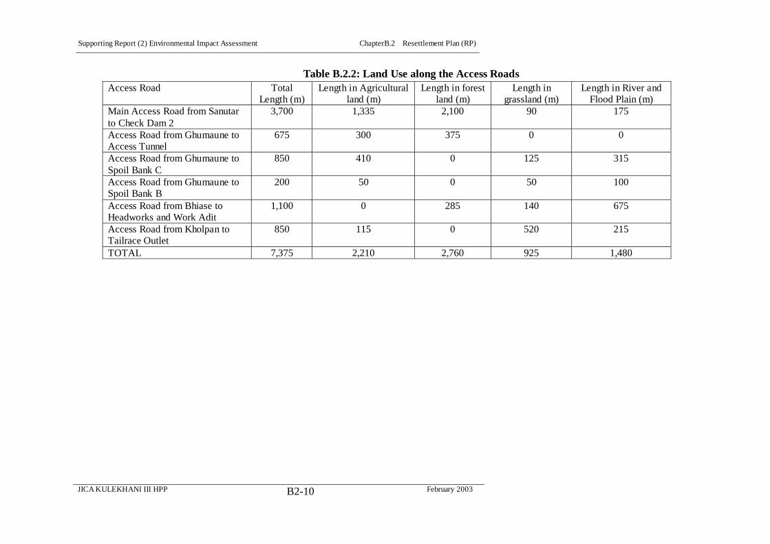
Supporting Report (2) Environmental Impact Assessment ChapterB.2 Resettlement Plan (RP)
JICA KULEKHANI III HPP February 2003B2-10
Table B.2.2: Land Use along the Access Roads Access Road Total
Length (m) Length in Agricultural
land (m) Length in forest
land (m) Length in
grassland (m) Length in River and
Flood Plain (m) Main Access Road from Sanutar to Check Dam 2
3,700 1,335 2,100 90 175
Access Road from Ghumaune to Access Tunnel
675 300 375 0 0
Access Road from Ghumaune to Spoil Bank C
850 410 0 125 315
Access Road from Ghumaune to Spoil Bank B
200 50 0 50 100
Access Road from Bhiase to Headworks and Work Adit
1,100 0 285 140 675
Access Road from Kholpan to Tailrace Outlet
850 115 0 520 215
TOTAL 7,375 2,210 2,760 925 1,480
Supporting Report (2) Environmental Impact Assessment ChapterB.2 Resettlement Plan (RP)
JICA KULEKHANI III HPP February 2003B2-11
Labor Camps
Available areas at Sanutar and Ghumaune are not sufficient to meet the area
requirements for the establishment of Labor Camps by the side of the
Construction Camp. It is proposed to utilize the land area of the
Kathmandu-Hetauda Ropeway Station at Hetauda as a Labor Camp for lthe
Yangran and Sanutar areas. There is also land available at the Nepal Food
Corporation’s warehouse facilities across the road and a number of open plots that
could be utilized for this purpose in this part of Hetauda, paying rent to the owners.
There is available space at the Kulekhani II Camp at Nibuwatar for a Labor Camp
for the Headworks work area. Both of these locations lie within 5 km distance
from their respective work areas.
Engineer's Camp
The land area and structures of NEA’s Diesel Power Plant at Hetauda is proposed
for the Engineer's Camp both during construction and operation of the Kulekhani
III. If necessary, there appear to be numerous other land options in this part of
Hetauda that may be investigated during the design phase for this facility. For
Engineers working at the Headworks, available officer's residential structures at
Nibuwatar may also be utilized as an optional location.
12) Spoil Disposal Sites
For spoil management four Spoil Disposal Sites have been identified as below:
Spoil Bank A
Spoil Bank A will be located on the Rapti River ‘s floodplain below the Tribhuvan
Rajpath, just upstream of Baghjora Creek and the major landslide there. It is
proposed for the management of spoil from the Headworks, Adit 1, and top end of
the connection tunnel. The proposed area is about 16,000 m2 of the Rapti River
flood plain.
Spoil Bank B
Spoil Bank B will be located on the Kesadi Khola’s floodplain below Sanutar. It is
proposed for the management of muck from the main Access Road during the
Summer Rainy Season, as well as for part of Connecting Tunnel, the Power
Station Adit and Cavern, the Dam, the Regulation Pond and the Check Dams spoil.
It covers an approximate area of 28,000 m2, of which nearly sixty percent is the
river flood plain and forty percent is agricultural and grassland, with a few
standing trees.
Spoil Bank C

Supporting Report (2) Environmental Impact Assessment ChapterB.2 Resettlement Plan (RP)
JICA KULEKHANI III HPP February 2003B2-12
Spoil Bank C will be located on the Kesaadi Khola east of Ghumaune Pari It is
proposed for the management of muck from the main Access Road, part of the
Connecting Tunnel, the Power Station Adit and Cavern, the Dam, the Regulation
Pond and the Check Dams during the Winter Dry Season. It covers an area of
21,000 m2, of which nearly seventy five percent is the flood plain and twenty five
percent is grassland, with a few standing trees.
Spoil Bank D
Spoil Bank D is located on the Rapti River floodplain in the vicinity of the
Tailrace Outlet. It is proposed for the spoil management of the Tailrace Tunnel, the
Tailrace Outlet and part of the Tailrace Access Road. It covers an approximate
area of 13,000 m2, of which nearly eighty percent is occupied by the Rapti flood
plain and about twenty percent by the grassland, with a few trees.
B.2.5 Scope of Land Acquisition and Resettlement
(1) Resettlement Effects
Resettlement Effects is understood to mean all negative situations directly caused
by the Project, including loss of land, property, income generation opportunity,
and cultural assets. In the context of the RP, we are concerned with those direct
resettlement effects of loss of house structures, agricultural land, and businesses, if
any, caused by the Project’s land acquisition.
The resettlement impact of the Kulekhani III Hydropower Project III is limited. A
large part of the Project land will be on little utilized Government land,
particularly, that belonging to the Ministry of Forests and Soil Conservation. The
Project will utilize some areas already transferred to NEA (e.g. for the Headworks
area) and belonging to HCIL (Work Adit 1 Access Road) or to Bhainse (Ward 1).
In addition, the impact on the Re-regulating Pond area (Yangran) on private land
is also minimal.
As a result, the focus here is largely limited to Sanutar and Ghumaune areas that
are the Most Impact Communities (MIC) by the construction of the Main Access
Road, the establishment of the Construction Camp at Ghumaune and Tailrace
Outlet Tunnel’s aboveground culvert at Sanutar. Except for a very small
proportion, which lies in Basamadi, all the affected land in the Headworks area
lies in Bhainse Village Development Committee (VDC) of Makwanpur District,
and the potentially affected HHs identified so far in the MIC of Sanutar,
Ghumaune, and Pari Ghumaune villages
1) Resettlement
The fieldwork discovered 24 HHs that lose their homes and will be required to
Supporting Report (2) Environmental Impact Assessment ChapterB.2 Resettlement Plan (RP)
JICA KULEKHANI III HPP February 2003B2-13
relocate (See Annex 5 for a detailed list). At this stage, all HHs identified within
the Project Design Boundaries (see Natural and Social Environment Map), are
presented as potentially affected HHs, it is not clear which agricultural or forest
land owners will actually be affected once the detailed design is completed. On
the other hand, it is almost certain that these 24 homeowners will be classified as
SPAFs during the Detailed Design Stage studies, based on their having lost their
residence. As can be seen from Table B.2.3 below, all of the HHs also own
ancillary structures for which they will receive compensation. In addition, the
owner of an ancillary structure (a cow shed) at Check Dam 1 will also receive
compensation. Compensation for ancillary structures has been figured into the
estimated RP costs, as a part of compensation estimated as required by each
affected HH. All of the Project induced relocation of households will take place
in the Most Impacted Communities (MIC) of Sanutar, Ghumaune and Pari
Ghumaune.
Resettlement Caused by Project Components & Facilities
It can be seen that among the Project Components, only the Tailrace Tunnel will
cause household relocation, specifically its Tailrace Culvert component, where the
Tunnel goes above ground across Sanutar, affecting both houses and agricultural
Khet (irrigated paddy) lands. Table B.2.3 is a schematic representation of the
Project design layout indicating these affected residential structures.
So far as the Project Facilities are concerned, there are 21 houses as yet identified
as requiring acquisition. The Main Access Road will acquire 7 houses, although
because of the heavy erosion of lands along the Rapti River side of Sanutar, the
road may require further realignment, and likely will acquire more houses. The
Main Access Road was carefully aligned to avoid Sanutar’s primary school and
maternal and child health center, as well as as many residences as possible,
including several that are along the Sanuthar-Ghumaune irrigation canal on
government land and contain small family shops. Finally, the Construction Camp
at Ghumaune will take a total of 14 residential structures, affecting 13 HHs
owning these structures (one family owns two).
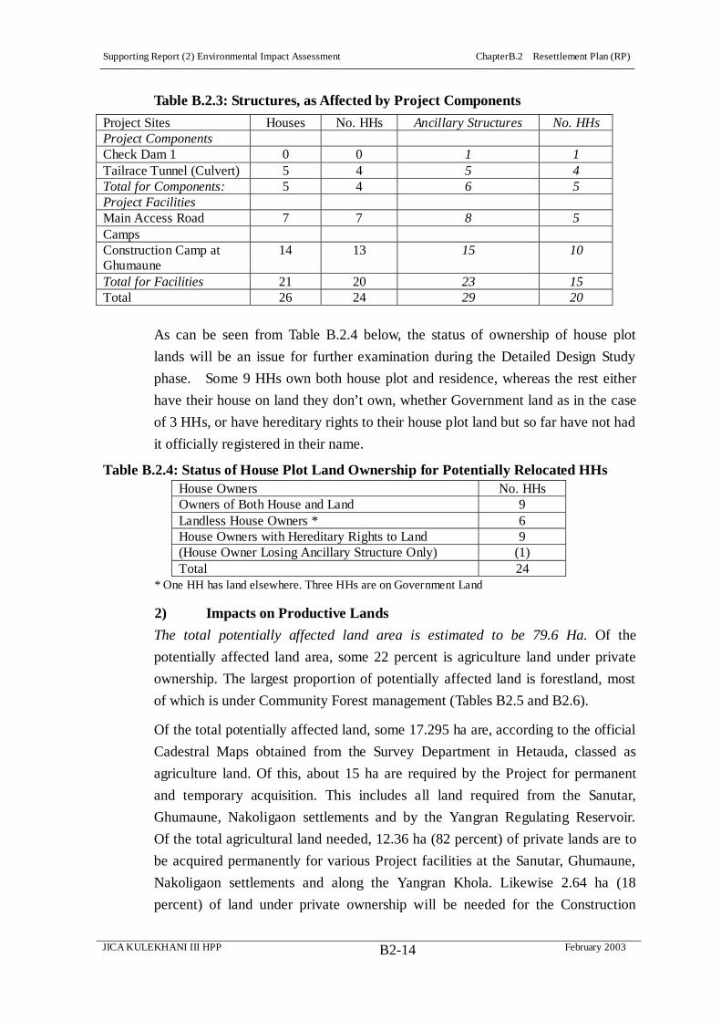
Supporting Report (2) Environmental Impact Assessment ChapterB.2 Resettlement Plan (RP)
JICA KULEKHANI III HPP February 2003B2-14
Table B.2.3: Structures, as Affected by Project Components
Project Sites Houses No. HHs Ancillary Structures No. HHs Project Components Check Dam 1 0 0 1 1 Tailrace Tunnel (Culvert) 5 4 5 4 Total for Components: 5 4 6 5 Project Facilities Main Access Road 7 7 8 5 Camps Construction Camp at Ghumaune
14 13 15 10
Total for Facilities 21 20 23 15 Total 26 24 29 20
As can be seen from Table B.2.4 below, the status of ownership of house plot
lands will be an issue for further examination during the Detailed Design Study
phase. Some 9 HHs own both house plot and residence, whereas the rest either
have their house on land they don’t own, whether Government land as in the case
of 3 HHs, or have hereditary rights to their house plot land but so far have not had
it officially registered in their name.
Table B.2.4: Status of House Plot Land Ownership for Potentially Relocated HHs House Owners No. HHs Owners of Both House and Land 9 Landless House Owners * 6 House Owners with Hereditary Rights to Land 9 (House Owner Losing Ancillary Structure Only) (1) Total 24
* One HH has land elsewhere. Three HHs are on Government Land
2) Impacts on Productive Lands
The total potentially affected land area is estimated to be 79.6 Ha. Of the
potentially affected land area, some 22 percent is agriculture land under private
ownership. The largest proportion of potentially affected land is forestland, most
of which is under Community Forest management (Tables B2.5 and B2.6).
Of the total potentially affected land, some 17.295 ha are, according to the official
Cadestral Maps obtained from the Survey Department in Hetauda, classed as
agriculture land. Of this, about 15 ha are required by the Project for permanent
and temporary acquisition. This includes all land required from the Sanutar,
Ghumaune, Nakoligaon settlements and by the Yangran Regulating Reservoir.
Of the total agricultural land needed, 12.36 ha (82 percent) of private lands are to
be acquired permanently for various Project facilities at the Sanutar, Ghumaune,
Nakoligaon settlements and along the Yangran Khola. Likewise 2.64 ha (18
percent) of land under private ownership will be needed for the Construction

Supporting Report (2) Environmental Impact Assessment ChapterB.2 Resettlement Plan (RP)
JICA KULEKHANI III HPP February 2003B2-15
Camps at Ghumaune but may be acquired on a temporary, rental basis.
The discussion here primarily focuses on the impacts of permanent loss of
privately owned land through land acquisition by the Project, since this loss has a
direct impact on the living standards of the households presently owning, and or
farming, this land.
Table B.2.5: Percentage of Affected Land, by Land Use Categories Affected land use categories Area Affected (Ha) Percent Forestland, Community Forest 35.595 45 Grassland, River, Other 26.709 33 Agriculture Land 17.296 22 Total 79.6 100 Source: Field Survey 2002/ Natural and Social Environment Map, 2002.
Table B.2.6: Affected Land, by Land Use Categories in Different Project Sites Project Sites Agriculture
Land (ha) Forestland
(ha) Grassland and
Other (ha) Total Land (ha)
Khani Khola Headworks 1.64 0 1.96 3.6 Work Adit and Access Road to Adit 1 and Headorks
0.656 1.875 2.869 5.4
Spoil Bank A 0 0 1.6 1.6 Sanutar, Ghumaune, Ghumaune Pari, Yangran Regulating Pond and Check Dams including Spoil Banks B and C
13.5 33.72 16.38 63.6
Tailrace Outlet including Access Road to Tailrace and Spoil Bank D
1.5 0 3.9 5.4
Total 17.296 35.595 26.709 79.6
Categories of Affected Agricultural Land
The Kulekhani III Hydropower Project affects two categories of cultivated land
under private ownership. In the local terminology these categories are called khet
and bari. Khet refers to irrigated lowland and bari refers to rain-fed upland
cultivated area. Table B.2.7 gives the likely proportion of affected land by quality
Sixty percent of the affected land is bari and 40 percent is khet. Sanutar and
Ghumaune are the most affected areas due to land loss for Project facilities,
especially for the Main Access Road and the Construction Camp.
Table B.2.7: Affected Land by Type Description Area (Ha) Percent Bari 9 60 Khet 6 40 Total 15 100
Source: Field Survey, 2002/Natural and Social Environment Map, 2002

Supporting Report (2) Environmental Impact Assessment ChapterB.2 Resettlement Plan (RP)
JICA KULEKHANI III HPP February 2003B2-16
(1) Summary Resettlement Effects:
1) Relocation & Loss of Agricultural Land
The discussion has primarily focused on the impacts of permanent loss of
privately owned land through the Project’s land acquisition, including houses and
house plots, since this loss has a direct impact on the living standards of the
households presently owning, living on, and or farming, this land.
For purposes of establishing an RP budget to cover agricultural land acquisition
and compensation costs, there are understood to be, provisionally, overall some 97
potentially affected HHs.
2) Loss of Housing Structure
Some 24 HHs with an estimated population of 151 persons who by virtue of
losing their house, will have to relocate. In addition to this, there is one HH
affected through loss of a cow shed, who will not have to relocate, as shown
below in Table B.2.8.
3) Loss of Agricultural Land
The Study Team has made the assumption that 72 HHs, with an estimated
population of 454 persons, will be potentially affected by losing their agricultural
land, as shown in Table B.2.8.
4) Summary: Potentially Affected HHs
The total number of HHs estimated to be potentially affected by the Project’s land
acquisition is 97 HH, with an estimated population of 604 persons.
Table B.2.8: Summary Resettlement Effects: Relocation & Loss of Agricultural Land,
No. of Potentially Affected HHs and Estimated Population Description No. Potentially Affected
HHs Estimated Potentially Affected Population*
HHs Losing 26 Houses 25 150 (Incl. HH Losing Only 1 Ancillary Structure)
(1) (6)
HHs Losing 15 Ha Agricultural Land 72 454 Total 97 604 * Estimated at 6.3 persons per HH, as per MIC field survey
The ADB defines ‘Significant Resettlement Effect’ requiring a Full RP (as
outlined in its Handbook on Resettlement) as 200 people or more experiencing
major impacts, with “major” impacts being physical displacement from housing
and/or more than 10 percent of the household’s productive (income generating)
assets are lost. Currently, the Project most likely falls below this defined level of
‘significance’ with respect to loss of housing. On the other hand, at this time an
expression of the level of severity of HHs loss of agricultural land as a percentage
Supporting Report (2) Environmental Impact Assessment ChapterB.2 Resettlement Plan (RP)
JICA KULEKHANI III HPP February 2003B2-17
of HH income is not possible. This will be determined, however, during the next
study phase. In any case, the Project will finalize an RP at the ADB’s standard of
‘significant resettlement effect.’
Table B.2.9 provides useful overall numbers for HHs likely to experience
relocation due to loss of a house and HHs potentially affected by loss of
agricultural land, and these have allowed the Study Team to broadly define the
scope of likely resettlement effects associated with Project, for purposes of this
early draft RP. However, these figures will need to be updated at the beginning
of the new Detailed Design Study phase with more reliable data, to verify the
actual numbers of affected HHs.
There are three reasons for the figures in Table B.2.9 to be considered, while
useful for planning purposes, as yet inconclusive. The first is due to the difficulties
due to time constraints of carrying out the socioeconomic study while the final
Project design was still under decision, so that some land plots were newly within
the defined Project Design Boundaries that as yet have no ownership assigned to
them. The second reason is due to inaccuracies found with the official Cadastral
Maps obtained from the Survey Office in Hetauda. The third reason has to do with
absentee landowners, most of whom appear to be Newars, probably living in
Hetauda or possibly in some cases farther abroad, even in Kathmandu.
5) Shifting Project Design Boundaries
The Survey Team undertook the socio-economic field survey while the Project’s
Final Design was still being decided from three alternative designs. The Study
Team was able, using cadastral maps and corresponding ownership lists obtained
from the Survey Office in Hetauda, to prepare, though GIS methodology, a
Natural and Social Environment Map that shows both the cadastral map layout for
the affected communities and also the Project design boundaries, within which all
potentially affected structures and lands are expected to be found.
For the sake of thoroughness, the socio-economic survey covered the entire 55
HHs residing the Most Impacted Communities (MIC) of Sanutar, Ghumaune, Pari
Ghumaune, and Nokaligaon, and the results are presented below. The Study
Team has, therefore, a complete data set for all of the potentially affected HHs
living in the Project’s main zone of impact, which will be affected either directly
or indirectly. At the time of the socio-economic survey, Project design
boundaries were used to identify affected property owners within the then
understood area of impact.
After the survey was completed, the final Project Design was chosen, and this

Supporting Report (2) Environmental Impact Assessment ChapterB.2 Resettlement Plan (RP)
JICA KULEKHANI III HPP February 2003B2-18
resulted in a shift in the defined Project Design Boundaries, as shown in the
revised Natural and Social Environment Map attached to this reports Annexes.
Within the newly revised boundaries, the Study Team could identify from
ownership lists previously obtained, some 36 land owners. It found, however, an
additional 36 land plots newly falling within the Final Design Boundaries for
which there are at present no names associated. The Study Team has made the
assumption that the set of 36 land plots newly falling within the Final Design
Boundaries are equal to 36 potentially affected HHs, although the actual number
of HHs can only be known during the next study phase. Table B.2.9 summarizes
the current situation, with regards to known land owners and land plots for which
there is currently no name associated.
Table B.2.9: Estimation of Potentially Affected HHs by Agricultural Land
Acquisition Known Status of Agricultural Land within Project Design Boundaries Potentially Affected
HHs Identified Agricultural Land Owners (No Correlation of 1 HH to 1 Land Plot)
36
Not Identified Agricultural Land Plots (Assumption 1 Land Plot = 1 HH)
36
Total (Known Owners + Known Land Plots) 72
During the next study phase, the land ownership lists will be updated and the data
revised accordingly, through a visit to the Survey Office in Hetauda.
6) Inaccuracy of Cadastral Maps
While the official cadastral maps for Sanutar and other areas within the Project
Design Boundaries appear to be accurate, there are whole sections where the
block of land plots, while appearing to be essentially correct, are shifted over into
areas inconsistent with an accurate rendering. For instance, at Ghumaune a
block of land plots appears to be, as indicated through the GIS compilation, to be
in the middle of the Keshadi Khola. This inaccuracy will be rectified early in the
next study phase through a plane table survey to assure complete accuracy of the
cadastral plot information.
7) Absentee Landlords
As can be seen below, in the section on Socio-economic Information about the 55
households residing in the Most Impacted Communities of Sanutar, Ghumaune,
and Pari Ghumaune, all are of ‘tribal’ ethnic Tamangs, Magars, and Gurungs, or of
the Hindu caste groups, Brahmin and Chetri. The same is true for the ethnic
composition of HHs potentially affected by losing their house, as shown in Table
B.2.10.

Supporting Report (2) Environmental Impact Assessment ChapterB.2 Resettlement Plan (RP)
JICA KULEKHANI III HPP February 2003B2-19
Table B.2.10: Distribution of Potentially Affected HHs Losing Houses, by
Caste/Ethnicity Caste/Ethnic Groups HHs Percent Tamang 16 66.6 Brahmin 5 20.8 Chetri 1 4.2 Gurung 1 4.2 Magar 1 4.2 Total 24 100
(Does not include one HH losing a shed only)
On the other hand, the ethnic composition of HHs so far identified as losing
agricultural land has Newar and Chepangs with the potentially affected HHs.
While the 100 percent survey of the MIC community 55 households provided a
good overlay to assure a reasonable coverage of impacted HHs among those
surveyed, there was a number of HHs not present in these communities who fell
outside the survey.
Table B.2.11: Distribution of Landowning Potentially Affected HHs by Caste/Ethnic
Status Caste/Ethnic Groups Percent Land Owning HHs Tamang 55.5 Newar 15.6 Brahmin 15.6 Chhetri 6.7 Magar 4.4 Chepang [Praja] 2.2 Total 100
Source: Field Survey 2002.
As it is common for business oriented Newars living in urban localities to have
tenant arrangements in surrounding peri-urban areas, it is reasonable to assume
that some form of formal and informal tenant arrangements are currently in place.
During the next study phase, this issue of tenancy will be clarified, and as many
landlords living outside the directly impacted communities interviewed to update
the socioeconomic profile of the affected HHs.
The socioeconomic survey indicates some 2.33 Ha of irrigated Khet by 5 HHs and
3.14 of un-irrigated Bari lands rented in by 11 HHs, mostly from two absentee
Newari landowners. Whether or not this is a complete picture of the informal
land tenancy situation will be investigated during the next study phase.
8) Vulnerable Communities
In Sanutar and Ghumaune there are 3 households who are landless and have been
living in the structures built on land not belonging to them. They are among the
Supporting Report (2) Environmental Impact Assessment ChapterB.2 Resettlement Plan (RP)
JICA KULEKHANI III HPP February 2003B2-20
most vulnerable groups potentially affected by the Project and at risk of losing
their livelihood options. Any rehabilitation measures proposed by the Project will
pay particular attention to the risk to these HHs.
Likewise there are 5 women headed HHs in Sanutar and Gumaune who may lose
their house. Also, of the land plots having ownership associated with them, some
thirteen are in women’s names, the majority Tamang These HHs are also among
the vulnerable groups who may need special assistance.
There is one Chepang (Praja) HHs that may lose its land, and the Chepang
community is among the most disadvantaged groups in Nepal. Tamangs, largely
due to a past history of officially sanctioned social restrictions, and constituting
the most affected HHs, may also be considered a vulnerable group.
(2) Measures for Minimizing Resettlement Effects
Irrespective of the design and the Project’s layout, the proposed design
alternatives required various project facilities for the construction and operation of
the Project. The facilities required and their siting by all the alternatives that were
considered were more or less similar. Various Project facility alternatives were
studied in the course of the upgrading the feasibility study. The RP principle of
minimizing land acquisition and resettlement was a foremost concern in choosing
the proposed facilities. The following are examples of design choices, where
minimization of land impacts was a major feature of the decision arrived at.
1) Access Roads
Main Access Road
To cross the Rapti River two alternatives were analyzed:
Alternative 1, Causeway Option. It would be cheap but difficult to operate on
a round the year basis during Monsoon floods and would require repeated
repair and maintenance. This option was envisaged to give operational
difficulties during construction as well as during operation. Hence this option
was rejected.
Alternative 2, the Permanent Bridge Option. Though costly, this option had
number of advantages. It provided round the year transportation facilities
across the Rapti River and thus would avoid any operational difficulties
during the construction and operation of the Project. Besides, it would open
an opportunity for round the year transportation and marketing facilities to the
people of the Kesadi catchment in general and for Sanutar and Ghumaune in
particular.
For the alignment of the Main Access Road, particularly at Sanutar and

Supporting Report (2) Environmental Impact Assessment ChapterB.2 Resettlement Plan (RP)
JICA KULEKHANI III HPP February 2003B2-21
Ghumaune, two alternatives were analyzed:
Alternative 1, was a lower alignment through the flat agricultural land of
Sanutar and Ghumaune. This alternative involved acquisition of much fertile
agricultural land and residential structures.
Alternative 2, was an upper alignment through the marginal land above
Sanutar and Ghumaune agricultural land. This option involved minimum
private land acquisition but would have problems of excessive erosion related
to land instability. The steep slope is highly unstable and the bedrock is weak
and fragile.
It was considered that:
The Construction Camps will be located at Ghumaune
Other temporary access to the facilities and Spoil Banks would have to pass
through Ghumaune
Land disturbance should be minimized, and
The local people prefer the lower alignment,
So the lower alignment was selected, avoiding house structures as much as
possible.
Access Road to Work Adit 1 and Headworks
Two alternatives for access were analyzed to approach Work Adit 1 from the
Trivhuvan Rajpath:
Running the Access Road from north of the Kulekhani II Powerhouse across
the Khani Khola and to the Headworks and then to Work Adit 1 along the
Khani Khola’s Right Bank
Reaching Work Adit 1 via the currently used causeway to the HCIL Mine
area across the Rapti River and then following the Rapti’s Right Bank to the
Headworks and to Work Adit 1.
The first alternative would provide round the year access to the Intake but would
require considerable private land acquisition, including that of HCIL. This
alternative would have incurred a higher social cost and financial investment. The
second alternative using the existing causeway would inhibit access to the site
during the Monsoon. However, this second alternative would be less costly and
would traffic-related problems in the Bhainse Dobhan bazaar area.
The second alternative was selected with measures such as elevation of the
causeway and provision of a flood protection embankment for round year access.
2) Camps
Construction Camps.
Supporting Report (2) Environmental Impact Assessment ChapterB.2 Resettlement Plan (RP)
JICA KULEKHANI III HPP February 2003B2-22
Two alternative options were analyzed for the Construction Camp required for the
construction of the Dam and the Underground Power Station and for the various
other Project components in the Sanutar area.
Alternative 1: Sanutar Settlement Area
Alternative 2: Ghumaune Settlement Area
The Sanutar settlement area is wide, flat, and productive and comprises a large
number of structures. It also houses a primary school and a childcare center (Matri
Sisu Kendra). The Ghumaune settlement, on the other hand, is small, less
productive, and has fewer house structures.
Considering the above factors the Ghumaune settlement area was selected for the
establishment of the Construction Camp, on the condition that the area will be
re-established and returned to the Ghumaune residents after the completion of the
construction works. This option will further avoid long-term resettlement of the
affected people. The Ghumaune area also has advantages such as not being visible
from the Tribhuvan Rajpath and its closeness to the main construction sites.
Labor Camps
Two alternatives were analyzed for the establishment of the Labor Camps for the
Powerhouse and Regulating Dam construction workforce.
Alternative 1: Labor camps at Sanutar or at Ghumaune Pari
Alternative 2: Labor camps in the Hetauda Area at the now abandoned
Kathmandu-Hetauda Ropeway Camp
Alternative 1 would need relocation and resettlement of the entire population of
either Sanutar or Ghumaune Pari, involving a high degree of social impact by the
Project. To avoid this social impact, Alternative 2, the unutilized Ropeway Camp
at Hetauda is proposed for the Labor Camp, in coordination with the Ministry of
Works and Physical Planning, on rental basis. There are also a number of other
options available in this part of Hetauda, including the Nepal Food Corporation’s
warehouse, largely unutilized, across the road from the Ropeway Camp and a
number of open areas that could likewise be rented.
Engineer's Camp
For the construction period, as well as for the operation of the Kulekhani III, an
Engineer’s Camp is needed. Two alternatives were analyzed.
Alternative 1: Establishment of the Engineer’s Camp at Sanutar
Alternative 2: Engineer’s Camp at Hetauda
To avoid high relocation and resettlement, the establishment of the Engineer's

Supporting Report (2) Environmental Impact Assessment ChapterB.2 Resettlement Plan (RP)
JICA KULEKHANI III HPP February 2003B2-23
Camp at Sanutar was rejected. Besides, the underused facility at Hetauda Diesel
power plant may be utilized as the Project’s Engineers' Camp. There may be
noise issues during rare occasions when the Diesel power plan might be in
operation. As with the Labor Camps, there are other land options available in
this part of Hetauda that may also be considered, though this option is preferred to
maximize NEA’s available resources.
3) Spoil Disposal Sites
A substantial volume of spoil material is expected from the construction activities
of the Kulekhani III Project. Alternatives for the final spoil disposal management
in the near by areas is very limited. Two possible alternatives have been
envisioned.
Alternative 1: It proposed to use the wide floodplain of Rapti for spoil
management.
Alternative 2: It proposed to use the relatively flat areas above the riverbed.
Alternative 2 was rejected, because such flat areas above the riverbed are mostly
agricultural areas or developed areas with settlements and structures. Occupying
these areas would mean inviting a wide range of social impacts and conflicts.
Alternative 1, though, would involve risk of change in river morphology and a
high degree of erosion and sedimentation of riverbeds, with implications many
kilometers downstream. However, these risks can be minimized with adequate
stabilization of spoil against river related erosion, a problem particularly in the
Monsoon. One of the advantages of this option would be land development, which
can be used for afforestation or as recreational sites after the Project construction
is completed. Accordingly four spoil disposal sites, Spoil Sites A-D, two on the
Rapti River’s the flood bank and two on the Kesadi’s flood bank have been
identified and proposed.
B.2.6 Socioeconomic Information
(1) Project’s Most Impacted Communities (MIC)
This section profiles the socio-economic characteristic of the residents of Sanutar,
Bokedaha, and Ghumaune Pari communities, totaling some fifty five households,
on which Project activity will have the most significant direct and indirect impacts.
The fieldwork surveyed all of these households, which are altogether the Most
Impacted Communities (MIC).
(2) Households and Population
The total population in the three MIC communities, Sanutar, Ghumaune,
Ghumaune Pari, is estimated to be 349, with an average household size of 6.3.

Supporting Report (2) Environmental Impact Assessment ChapterB.2 Resettlement Plan (RP)
JICA KULEKHANI III HPP February 2003B2-24
Some 59 percent fall into the economically active 15-65 years age group. About
27 percent are in the school going 5-14 years age group, while 10 percent are less
than 5 years and 3 percent are over 65 years. The ratio of female to male is 1:1.05.
Table B.2.12: MIC Age Structure, Average HH Size
Table B.2.13: MIC Population by Gender Sex No. Percentage M/F Ratio Male 170 48.7 Female 179 51.3 Total 349 100.00
1:1.05
(3) Caste and Ethnic Composition
The majority of the households are Tamang ethnic group, 69 percent, compared
with the District ratio of 48 percent and that of the Project Impacted Communities,
45.5 percent. Other groups affected are Magar and Gurung, at 18 percent,
Brahmin, at 11 percent and Chhetri at nearly 2 percent.
Table B.2.14: MIC, Ethnicity of Sanutar, Ghumaune, Ghumaune Pari (52 HH) Caste/Ethnicity No. HHs Percentage Tamang 38 69 Other [Gurung/Magar] 10 18 Brahmin 6 11 Chetri 1 2 Total 55 100
[NOTE: Why put Magar and Gurung together? What are they separately? Please clarify. Seems silly when there are as many as 10 houses, the second largest component in the MIC, to mix them up and call them ‘others.’]
(4) Other Social And Economic Indicators
1) Literacy Status
About 75 percent of the MIC population is estimated to be literate. This
percentage includes those who can read and write only, 19 percent without benefit
of formal education, as well as those having only a primary level of education,
about 36 percent, making about 61 percent who are literate either by virtue of a
primary education or by their own efforts. The overall literacy rate, of 75
percent, seems high compared to the District average of only 31 percent and to
Age No. Percentage Av. HH Size <5 37 10
5 - 14 97 27 15- 35 135 39 36-50 44 13 51-65 27 8 >65 9 3
Total 349 100
6.3

Supporting Report (2) Environmental Impact Assessment ChapterB.2 Resettlement Plan (RP)
JICA KULEKHANI III HPP February 2003B2-25
that of the Project Impacted Communities, at 35 percent, although these official
figures only reflect literacy achieved through formal education.
Table B.2.15: MIC, Educational & Literacy Status Educational & Literacy Status No. Percentage Primary 127 36 Illiterate 87 25 Can Read And Write Only 66 19 Lower Secondary 40 11 Higher Secondary 20 6 SLC 7 2 Intermediate 2 1 Bachelor 0 0 Master 0 0 Total 349 100.00
2) Religion
Some 65 percent of MIC households are Buddhists and 35 percent are Hindu.
Table B.2.16: MIC, Household Religion Religion No. HHs Percentage Buddhist 36 65 Hindu 19 35 Total 55 100.00
3) Length of Residence
The majority of the households, 69 percent have been residing in the area for more
than 25 years. Some 90 percent have lived in the MIC more than 15 years. There
are only 4 percent of populations who have been settled in the area for less than 5
years. (Table B.2.17).
Table B.2.17: Length of Residence in MIC Duration No. HHs Percentage More than 25 Years 38 70 16 to 25 Years 11 20 5 to 15 Years 4 6 Less than 5 Years 2 4 Total 55 100
4) Nucleus and Extended Family Residences
Some 65 percent of MIC households are in nuclear (single family) residence, and
35 percent are in extended (joint) family residences.
Table B.2.18: MIC, Type of Family Family Type No. HHs Percentage Nuclear 36 65.45 Extended (Joint) 19 34.55 Total 55 100.00

Supporting Report (2) Environmental Impact Assessment ChapterB.2 Resettlement Plan (RP)
JICA KULEKHANI III HPP February 2003B2-26
5) Occupation and Skills
Of the total population, including the children, 35 percent are involved in
agriculture while 28 percent are students, 12 percent labor and 12 percent are
unable to work. Some 7 percent are involved in job/services and 7 percent are
doing business. This table covers 360 persons from the MIC’s fifty-five
households, rather than only 349, as some listed are working outside the MIC.
Table B.2.19: MIC, Occupations Occupation Population Percentage Agriculture 127 35 Student 101 28 Labor 43 12 Unable To Work 44 12 Job/Services 25 7 Business 17 5 Others 3 1 Total 360 100
About 10 percent of the MIC population, or 37 persons, posses various skills such
as driver, general construction, and masonry, and four persons from the MIC work
for HCIL and one for NEA.
Table B.2.20: MIC, Skilled Workers Occupation Population % Total Pop Driver 10 3 Construction 10 3 Mason 7 2 Other 5 1 HCIL 4 1 NEA 1 0.3 Carpenter 0 0 Tailor 0 0 Blacksmith 0 0 Shoemaker 0 0 Weaving Doko/Nanglo* 0 0 Total 37 10
*Local handicraft items, used by porters to carry loads
6) Gender
Women’s Primary Activities
MIC women are involved in number of farm and household related activities. All
are participate in processing grains, some 69 percent are involved in transporting
and storing agricultural products, and 6 percent in land preparation. The highest
female involvement is in cooking and in processing grains, 100 percent, fetching
water, 99 percent, and fuel wood and fodder collection as well as in looking after
children, 96 percent, followed by raising livestock. About half or more of

Supporting Report (2) Environmental Impact Assessment ChapterB.2 Resettlement Plan (RP)
JICA KULEKHANI III HPP February 2003B2-27
women report being involved in activities such sowing, land preparation,
fertilizing and weeding, harvesting, and working as agricultural laborers.
Virtually none report participating in plowing or in irrigation activities.
Table B.2.21: MIC Women’s Primary Activities, by Percent of Women Reporting Activities Average (%) Processing Grain 100 Cooking 100 Fetching Water 99 Fuel Wood & Fodder Collection 96 Looking After children 96 Raising Livestock 90 Transportation & Storing 69 Sowing 61 Land Preparation 56 Fertilizing 53 Weeding 53 Agricultural Labor 52 Harvesting 50 Plowing 1 Irrigation 0
MIC Women’s Participation in Community Organizations and User Groups
In the MIC, some 36 percent of women report being involved with various
community organizations and user committees, related to a range of political,
social, cultural and economic activities.
Table B.2.22: MIC Women’s Involvement in CBOs and User Groups (44
Respondents)
Women’s Involvement Total Percentage No 28 64 Yes 16 36 Total 44 100
7) Livestock Holding and Their Product
Almost 80 percent MIC households keep livestock.
Table B.2.23: MIC Households Having Livestock HHs with Livestock Total Percentage Yes 44 80 No 11 20 Total 55 100
The average livestock holding size is estimated to be 7.6, excluding poultry. The
average holding of poultry, 7.8 percent is higher than the District and the more
general Project Impacted Community figures. Among the livestock animals, the
number of sheep/goat is highest, at 4.9 per household.
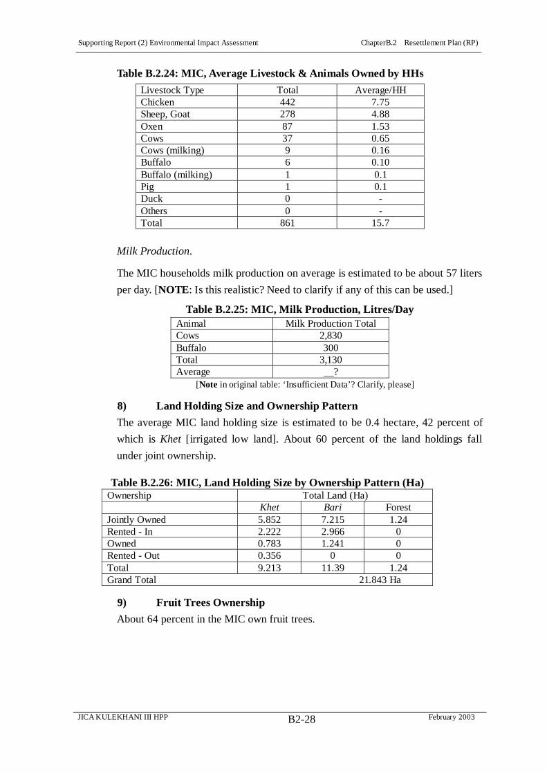
Supporting Report (2) Environmental Impact Assessment ChapterB.2 Resettlement Plan (RP)
JICA KULEKHANI III HPP February 2003B2-28
Table B.2.24: MIC, Average Livestock & Animals Owned by HHs
Livestock Type Total Average/HH Chicken 442 7.75 Sheep, Goat 278 4.88 Oxen 87 1.53 Cows 37 0.65 Cows (milking) 9 0.16 Buffalo 6 0.10 Buffalo (milking) 1 0.1 Pig 1 0.1 Duck 0 - Others 0 - Total 861 15.7
Milk Production.
The MIC households milk production on average is estimated to be about 57 liters
per day. [NOTE: Is this realistic? Need to clarify if any of this can be used.]
Table B.2.25: MIC, Milk Production, Litres/Day Animal Milk Production Total Cows 2,830 Buffalo 300 Total 3,130 Average __?
[Note in original table: ‘Insufficient Data’? Clarify, please]
8) Land Holding Size and Ownership Pattern
The average MIC land holding size is estimated to be 0.4 hectare, 42 percent of
which is Khet [irrigated low land]. About 60 percent of the land holdings fall
under joint ownership.
9) Fruit Trees Ownership
About 64 percent in the MIC own fruit trees.
Table B.2.26: MIC, Land Holding Size by Ownership Pattern (Ha) Ownership Total Land (Ha)
Khet Bari Forest Jointly Owned 5.852 7.215 1.24 Rented - In 2.222 2.966 0 Owned 0.783 1.241 0 Rented - Out 0.356 0 0 Total 9.213 11.39 1.24 Grand Total 21.843 Ha

Supporting Report (2) Environmental Impact Assessment ChapterB.2 Resettlement Plan (RP)
JICA KULEKHANI III HPP February 2003B2-29
Table B.2.27: MIC Households Owning Fruit Trees
HH Owning Fruit Trees Total Percentage Yes 35 64 No 20 36 Total 55 100
Most fruit trees owned by MIC households are banana, pineapple, and guava,
followed by a relatively smaller number of mango, lemon, and papaya.
Table B.2.28: MIC Household Fruit Tree Holdings, by Type of Tree and
Whether Yielding or Non Yielding
Description Yielding Non Yielding Total Banana 413 378 799 Pineapple 505 158 663 Gauva 120 34 154 Mango 54 43 97 Lemon 19 14 33 Papaya 5 6 11 Litchi 3 3 6 Orange 0 1 1 Other 44 37 81 Total 1163 674 1845
10) Food Production
The MIC households produce cereals, vegetables and other cash crops. Crops
such as paddy, wheat, maize, millet are popular among the cereals, while pulse,
potato, mustard, sugarcane are grown as cash crops. The paddy yields of 3.4,
maize at 3.8 and potato at 34 ton/ha are higher than the respective District
averages of 2.3, 1.7, and 10.5 ton/ha respectively. On the other hand, the yields
for other crops are relatively low compared to District averages.
Table B.2.29: MIC Yield of Major Crops Compared to District Paddy Wheat Maize Millet Pulses Vegetable Potato Mustard MIC 3.4 0.90 2.8 0.84 0.3 1.3 34.0 0.6 District 2.3 1.7 1.7 1.1 1.1 14.0 10.5 0.7

Supporting Report (2) Environmental Impact Assessment ChapterB.2 Resettlement Plan (RP)
JICA KULEKHANI III HPP February 2003B2-30
Table B.2.30: MIC, Total and Average Production of Cereals, Vegetables, and Cash
Crops Crops Area (Ha) Average Production (Kg/Ha) Total Production (Kg) Cereals Paddy 8.049 3.4 27.4 Wheat 6.566 0.90 5.9 Maize 19.49 2.8 55.5 Millet 9.382 0.84 7.8 Pulses 9.649 0.3 3 Other 0 - - Total 53.136 1.88 99.6
Vegetables
Vegetable 2.519 1.3 3.4 Total 2.519 1.3 3.4 Cash Crops Potato 3.026 34 103 Mustard 1.982 0.6 1.3 Sugarcane 0 - - Other 0 - - Total 5.008 20.8 104.3
11) Food Sufficiency and Coping Strategies
Food Sufficiency
The food grown by the MIC households is sufficient for only 51 percent
population.
Table B.2.31: MIC, Households’ Food Sufficiency Sufficiency Total Percentage Sufficient 28 51 Insufficient 27 49 Total 55 100
Most households, some 41 percent, report food insufficiency for 6-8 months,
another 33 percent for 9-11 months, 14.8 percent for 2-5 months, and 1.2 percent
for the whole year, 12 months, respectively.
Table B.2.32: MIC, Households’ Duration of Food Insufficiency Duration Overall Percentage 6 to 8 month 11 41 9 to 11 month 9 33 2 to 5 month 4 15 For 12 month 3 11 Up to 1 month 0 0 Total 27 100
Coping Strategies
MIC households, when facing food deficiency, generally report taking up wage

Supporting Report (2) Environmental Impact Assessment ChapterB.2 Resettlement Plan (RP)
JICA KULEKHANI III HPP February 2003B2-31
work, 56 percent, and engagement in other jobs, such as service and business, 44
percent, to cope with food insufficiency. This means that some families are not
self reliant on the crops they grow themselves but regularly seek employment
outside of agriculture, such as families known to be working for HCIL and NEA.
None report borrowing or selling off household property to purchase food.
Table B.2.33: MIC, Households’ Copy Strategy for Food Insufficiency Coping Strategy Total Percentage Daily Wages Work 15 56 Others [Salary/Business] 12 44 Selling Of HH Property 0 0 Borrowing 0 0 Total 27 100
12) Household Income and Expenditure Patterns
Income
The average MIC household annual income is estimated to be Rs. 68,659,
compared to an annual expenditure of Rs. 81,783. A large proportion of income is
derived from agricultural production, 30.0 percent, and wage earning, 25.2
percent.
Table B.2.34: MIC, Annual HH Income (NRs)
Item Total (NRs.) Ave/HH/Year (NRs.) Agriculture Income Cereal 1,145,413 20,827 Vegetable 111,734 2,032 Fruit 72,242 1,314 Livestock Livestock 383,100 6,965 Milk 55,300 1,005 Ghee - - Eggs - - Other Sources Service 536,000 9,745 Wages 1,134,800 20,633 Pension 17,136 312 Trade 100,000 1,818 Cottage Industry - - Professional Job 265,000 4,818 Remittances 282,000 5,127 Business 325,000 5,909 Others 70,000 1,273 Total 4,497,725 68,659
Table B.2.35: MIC, Summary Annual HH Income (NRs)
Agriculture Live. Service Wage Pension Trade/Business Job Remit. Other Total 24,169 7,970 9,745 20,633 312 7,727 4,818 5,127 1,272 81,773
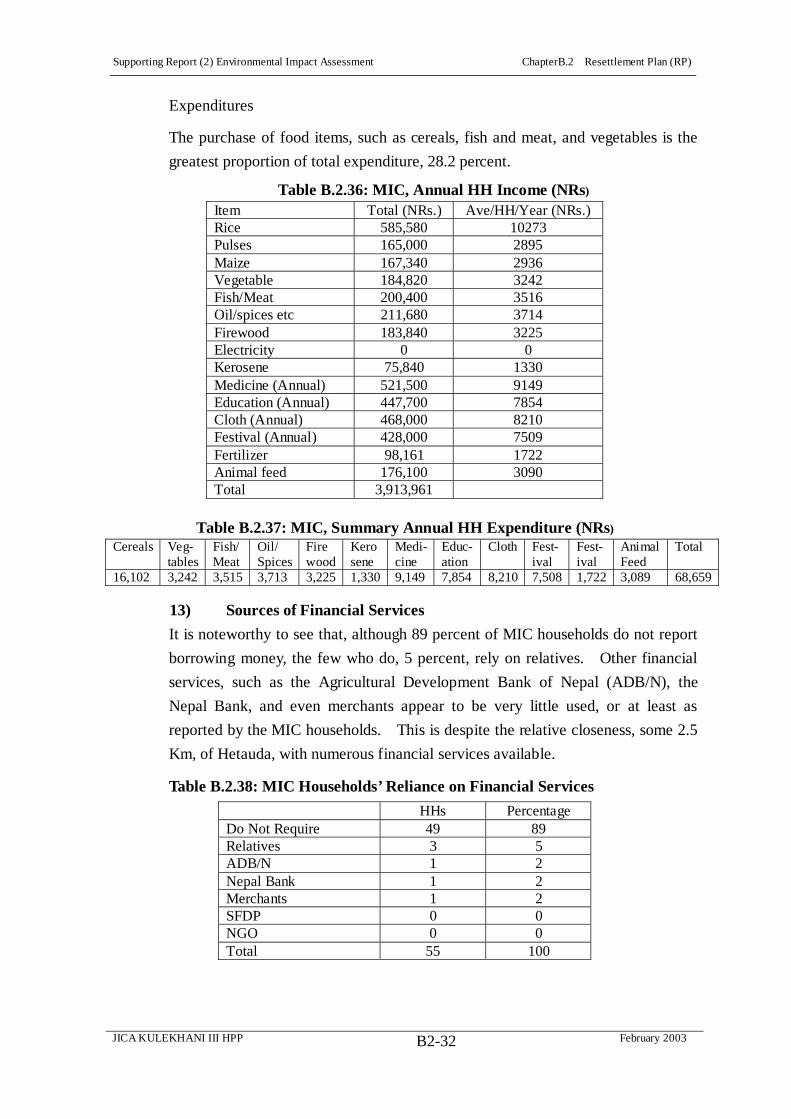
Supporting Report (2) Environmental Impact Assessment ChapterB.2 Resettlement Plan (RP)
JICA KULEKHANI III HPP February 2003B2-32
Expenditures
The purchase of food items, such as cereals, fish and meat, and vegetables is the
greatest proportion of total expenditure, 28.2 percent.
Table B.2.36: MIC, Annual HH Income (NRs)
Item Total (NRs.) Ave/HH/Year (NRs.) Rice 585,580 10273 Pulses 165,000 2895 Maize 167,340 2936 Vegetable 184,820 3242 Fish/Meat 200,400 3516 Oil/spices etc 211,680 3714 Firewood 183,840 3225 Electricity 0 0 Kerosene 75,840 1330 Medicine (Annual) 521,500 9149 Education (Annual) 447,700 7854 Cloth (Annual) 468,000 8210 Festival (Annual) 428,000 7509 Fertilizer 98,161 1722 Animal feed 176,100 3090 Total 3,913,961
Table B.2.37: MIC, Summary Annual HH Expenditure (NRs)
Cereals Veg- tables
Fish/ Meat
Oil/ Spices
Fire wood
Kero sene
Medi- cine
Educ- ation
Cloth Fest- ival
Fest- ival
Animal Feed
Total
16,102 3,242 3,515 3,713 3,225 1,330 9,149 7,854 8,210 7,508 1,722 3,089 68,659
13) Sources of Financial Services
It is noteworthy to see that, although 89 percent of MIC households do not report
borrowing money, the few who do, 5 percent, rely on relatives. Other financial
services, such as the Agricultural Development Bank of Nepal (ADB/N), the
Nepal Bank, and even merchants appear to be very little used, or at least as
reported by the MIC households. This is despite the relative closeness, some 2.5
Km, of Hetauda, with numerous financial services available.
Table B.2.38: MIC Households’ Reliance on Financial Services
HHs Percentage Do Not Require 49 89 Relatives 3 5 ADB/N 1 2 Nepal Bank 1 2 Merchants 1 2 SFDP 0 0 NGO 0 0 Total 55 100

Supporting Report (2) Environmental Impact Assessment ChapterB.2 Resettlement Plan (RP)
JICA KULEKHANI III HPP February 2003B2-33
14) Access to Water Supply and Sanitation
Sources of Drinking Water
Slightly more than 60 percent of MIC households have access to piped water.
However, a significant proportion of households depend on river, 23 percent,
stream 14 percent, well 2 percent, sources for their drinking water. Most
households reported using the same sources during both Dry and Wet Seasons.
Table B.2.39: MIC, Water Sources Reported by HHs Sources Total Dry Season Percentage Piped Water 35 61 River 12 23 Stream 7 14 Well 1 2 Total 55 100
Sanitation
Nearly 90% households have toilets in Sanutar Ghumaune.
15) Health Status
Since, a significant number of MIC households depend in unhygienic water
sources, such as rivers and streams for their drinking water, it is perhaps not
surprising that almost 60 percent households reported to be suffering from various
types of diseases during the previous year.
Table B.2.40: MIC HHs Reporting Illnesses during Previous Year HHs Reporting Illness Total Percentage Yes 33 60.00 No 22 40.00 55 100.00
It is perhaps surprising that some 64 percent of cases of illness reported were
female and that relatively few cases were reported for the age group 0-5 years,
which normally suffers disproportionately from pneumonia and gasto-intestinal
illness and suffers a correspondingly high death rate in rural areas in Nepal. On
the other hand, the prevalence of pneumonia and tuberculosis, as well as various
water-related diseases such as typhoid, diarrhea, dysentery and jaundice, is typical
of rural areas such as the MIC, although the high prevalence of piped water and
also of sanitary facilities should have some positive influence on disease incidence
over the long run.
The MIC during public consultation meetings has expressed a desire for a local
clinic. On the other hand, a variety of health institutions are in Hetauda, within 5

Supporting Report (2) Environmental Impact Assessment ChapterB.2 Resettlement Plan (RP)
JICA KULEKHANI III HPP February 2003B2-34
km of the community.
Table B.2.41: Details of Reported Cases (42) of Illness among MIC HHs. Details Total Percentage Sex Female 27 64 Male 15 36 Total 42 100.00 Age Group 15 to 59 27 64 6 to 14 11 26 0 to 5 3 7 60 and above 1 2 Total 42 100 Diseases Type Pneumonia 5 12 Typhoid 4 10 Tuberculosis 3 7 Blood Pressure 3 7 Diarrhea 2 5 Respiration 2 5 Dysentery 1 2 Jaundice 1 2 Skin Disease 1 2 Cholera 0 0 Malaria 0 0 AIDS & Other Sex Related Diseases 0 0 Others 20 48 Total 42 100
B.2.7 Objectives, Policy Framework and Entitlements
(1) Laws Regarding Land Acquisition Procedures
1) Introduction
Despite project objectives of providing new national infrastructure and/or
productive assets or projects aiming at the protection of natural resources and
benefiting the country’s population at large, there necessarily are also adverse
social impacts. There is a need to incorporate social dimension into development
and to mitigate adverse social impacts, especially resettlement effects. It is
important to ensure that directly affected persons (APs) are not disadvantaged in
the process of development. The rationale of addressing resettlement effects in
projects in Nepal is based on the assertion:
Human beings are the ultimate objective of development.
People have sovereign human rights derived from national and international
law and any development project must recognize this.

Supporting Report (2) Environmental Impact Assessment ChapterB.2 Resettlement Plan (RP)
JICA KULEKHANI III HPP February 2003B2-35
For the greater benefit of society, development interventions such as roads,
hydropower projects may have to, with appropriate mitigation measures,
nevertheless proceed.
Every development project must ensure that APs are supported to restore their
livelihood in an improved situation or at least assisted in maintaining their socio-
economic status to its pre-project status. As a matter of principle, APs should be
incorporated into project planning as also direct project beneficiaries, though this
does not happen very often. Addressing resettlement effects is important primarily
to protect disadvantaged groups created by the development process, but it is also
necessary in the long run in order to protect the future of development itself.
2) Review of Existing Legal and Policy Framework for Land Acquisition and Resettlement
This section reviews the current policy and legal framework in Nepal regarding
land acquisition and resettlement. Since the legislation mandating
Environmental Impact Assessments (EIAs) does not embody social concerns to
any serious degree, the discussion will cover policies, laws, and guidelines as
reviewed in New Era 1999 (also, Molnar, Augusta and Tod A. Ragsdale. 1991.
Land Acquisition and Resettlement: Issues and Procedures in Nepal. Draft
Working Paper. Washington, DC: World Bank. February). The Legal discussion
includes detailed consideration of the:
Constitution of the Kingdom of Nepal, 2047 (1990);
Land Reform Act 2021 (1964);
Land Acquisition Rules 2026 (1969);
Land Acquisition Act, 2034 (1997);
Land Revenue Act 2034 (1977);
The Hydropower Development Policy, 2049 (1992);
Electricity Rules 2000;
Environmental Protection Act (EPA) 1996 and Environmental Protection Rule
(EPR) 1997;
Water Resources Regulation 1993;
Local Self-Governance Act 1999 and Local Self-Governance Regulation
2000;
Arun III Access Road, Land Acquisition Guideline, 2045 (1989);
Guidelines Relating to Land Acquisition for Arun III Hydroelectric Project,
2050 (1993);
Melamchi Water Supply Project Resettlement Plan.
The discussion will focus on description and also limitations and constraints of

Supporting Report (2) Environmental Impact Assessment ChapterB.2 Resettlement Plan (RP)
JICA KULEKHANI III HPP February 2003B2-36
these with respect to forming a national policy for Nepal. Since resettlement
policy and implementation has de facto been carried out on a project-by-project
basis, the ‘best practices’ of Projects is identified and emulated in formulating a
policy framework for the Kulekhani III Project.
The Constitution of the Kingdom of Nepal
Article 17 of the Constitution of Nepal (1990), establishes the right to property as
a fundamental right. All Nepalese citizens are guaranteed the right to acquire, own,
sell and otherwise dispose their property. It states that no person shall be deprived
of his property saved in accordance with the law. However, the right is not an
absolute right since it further states that these rights are to be exercised "subject to
the existing laws." In conditions where the State acquires or establishes its rights
over individual's property for public interest, it shall compensate for the loss of
property. The basis of compensation and the procedures for delivering
compensation for any property acquired by the State shall therefore be as
prescribed by the law.
Land and asset acquisition will be undertaken within the framework of the Land
Acquisition Act (for permanent land acquisition) and the Public Road Act (for
temporary land acquisition).14
Land Acquisition Act, 2034 (1977)
Since the Land Acquisition Act 2034 (LAA) is so far the main legislation to guide
social impact mitigation in Nepal, it needs to be discussed in detail. The LAA
empowers HMG/N to acquire any land, on the payment of compensation, for
public purposes and works.
Under the LAA, the acquisition and compensation of privately owned assets are
undertaken according to a formal procedure, consisting of (a) initial procedures,
(b) a preliminary investigation process, (c) acquisition notification, (d)
compensation, and (e) appeal procedures.
Compensation Determination Committees (CDCs) are established at the District
level to ascertain compensation rates for land and other assets to be acquired for
the public interest. The CDC members include, the:
Chief District Officer (CDO),
Chief of the Land Revenue Office (Mal Addha),
Project Chief, when the land has to be acquired for a Project, and
14 The 1978 amendment of the Public Road Act was promulgated to ensure uniformity with the Land Acquisition Act. It amended Section 4 and repealed Sections 5 to 13 of the 1974 Act.

Supporting Report (2) Environmental Impact Assessment ChapterB.2 Resettlement Plan (RP)
JICA KULEKHANI III HPP February 2003B2-37
One representative of the District Development Committee (DDC).15
Compensation must be paid (a) for damages caused as a result of investigations
during the preliminary investigation process, and (b) for land and assets
permanently acquired by the Project (including standing crops, trees, and houses).
The LAA provides that compensation be paid in cash, although titleholders who
have lost all of their landholdings may be given replacement land, if available.
Compensation will be made to the person who has the right to claim for the
compensation; to be entitled to compensation for land, a person must submit an
official land registration certificate at the time of compensation.
Titleholders are required to submit compensation claims or complaints within a
specified period after issuance of the Land Acquisition Notice by the Local
Authority (the CDO). The CDC pays compensation for land after determination of
rates and verification of the list of entitled applicants.
Two separate rates of compensation can be paid (a) to titleholders who lose all
their land, and (b) to titleholders who lose only some part of their land.
In determining the compensation amount, the CDC has to consider relevant
periodic guidelines of HMG and the loss suffered by persons due to acquisition of
land, including the shift of residence or place of business to another place.
If the land has to be acquired for institutions other than the VDCs and institutions
fully owned by the Government, the CDC has to consider the following in
determining the compensation amount: price of the land prevailing at the time of
notification of land acquisition; price of standing crops and structures; and
damage incurred by persons being compelled to shift their residence or place of
business due to land acquisition.
Acquisition of land and other assets for the Kulekhani III Project will be
undertaken within the framework of the LAA, although in the absence of updated
Land Acquisition Rules (see below), Project-specific guidelines for applying the
LAA will be adopted.
Land Acquisition Rules, 2026 (1969)
The Land Acquisition Rules 2026 (1969) were issued in order to simplify the
provisions under the Land Acquisition Act, 2018 (1961). The Land Acquisition Act
2034 (1977) replaced the earlier Act, but the Rules have not been updated.
15 This was a member of the ‘District Panchayat’ at the time the law was framed, now outmoded and replaced with the District Development Committee (DDC).

Supporting Report (2) Environmental Impact Assessment ChapterB.2 Resettlement Plan (RP)
JICA KULEKHANI III HPP February 2003B2-38
Because the Rules governing land acquisition have not been updated,
Project-specific guidelines are needed.
Despite the Rules preceding the LAA, some provisions of the Rules are worth
mentioning. The Rules deal with compensation rates, designation of a competent
authority (A Government officer plus the CDC) for compensation, and the
determination of the amount of compensation. The CDC set up under this
legislation has to take into account the prevailing market value of the nearby land
to fix the compensation rates of affected land and other assets. The Land
Acquisition Rules also maintain that the State reserves the right to issue guidelines
and maintain uniformity in the determination of the amount of compensation in
the Projects.
Public Road Act 2031(1974)
The Public Road Act 2031 empowers the Department of Roads (DoR) to acquire
any land on a temporary basis for storage facilities, construction camps etc. during
construction and upgrading of roads. Any buildings and other structures such as
houses, sheds, schools, and temples are to be avoided wherever possible. The DoR
is required to pay compensation for any damages caused to buildings, standing
crops and trees. Compensation is negotiated between the DoR and the titleholder.
Land Reform Act, 2021 (1964)
The Land Reform Act (LRA), promulgated in 2021/9/1 (1964) and amended most
recently in 1996 (2053/9/24) is considered to be a revolutionary step towards
changing the existing system of land tenure by establishing rights of tenants and
by providing ownership rights to the actual tiller. Article 7 sets a ceiling on land
ownership. Different ceilings of agricultural land are set for Kathmandu Valley
(50 ropani), the hills and mountains (80 ropani), and for the Tarai (25 bigha) one
bigha equals, 0.66 hectare and one Ropani equals 0.05 hectare In addition to this
ceiling, for houses and kitchen garden a family may own 8 ropani in Kathmandu
Valley, 16 ropani in the Hills and Mountains, and 3 bigha in the Tarai.
The latest amendment on the land ceiling allows for 25 ropani, 70 ropani and 10
bigha for Kathmandu Valley, the Hills, including the Mountains, and the Tarai
Districts respectively for cultivation purposes. In addition, the land ceiling for
houses and for kitchen gardens is 5 ropani for the Hills and Kathmandu Valley and
1 bigha for the Tarai. This new ceiling has been effective from August 16, 2001
(Shrawan 32, 2058).
Article 25 (1) of the LRA deals with tenancy rights. The second amendment made

Supporting Report (2) Environmental Impact Assessment ChapterB.2 Resettlement Plan (RP)
JICA KULEKHANI III HPP February 2003B2-39
tenancy rights transferable after death to the tenant’s nominee, among the spouse
and sons. But according to the fourth amendment, the tenancy rights can be
transferred in the following order: spouse, son or daughter in law, adopted son, 35
or more year old daughter.
According to Article 26 (b) of the LRA, land under tenancy rights may be divided
between the owner and the tenant for single ownership. Furthermore, Article 26
(d) also specifies that if two parties i.e., the owner and the tenant, can not agree,
and one of them applies for his/her share, the concerned Government officer may
divide the land into two equal parts and cancel the previous tenancy right over the
land. In this way dual ownership of land is being abolished throughout the
country.
When the State acquires land that is under tenancy, the LRA establishes that the
tenant and owner will each be entitled to 50% of the total compensation amount.
Where the LRA and the LAA (by which the tenant is entitled to only 25% of the
total compensation amount) differ, the LRA will take precedence for paying
compensation to tenants. The LRA, however, covers only official, registered
Tenants, not unrecognized tenancy, which is the rule in most parts of Nepal.
Land Revenue Act 2034 (1977)
Acquisition of land for development projects (i.e., those in the public interest)
involves transfer of land titles for which, directly or indirectly, the Land Revenue
Act 2034 (1977) comes into force. Article 8 of this Act states that the registration,
change of ownership, termination of ownership right and maintenance of land
records are to be done by local Land Revenue (Malpot) Office. Likewise,
according to Article 16, if the concerned owner has not paid any land revenue for
a long period of time, the Government can collect revenue through the auction of
the concerned parcel. Land registration, transfer of titles and record keeping in
Nepal are governed by this Act.
Water Resources Act 2049 (1992)
Several Articles of the Water Resources Act 2049 (1992), especially 16, 19 and 20,
are directly related to land acquisition and environmental impact. Article 16 (1)
states that if private land has to be used in order to utilize water resources, the
licensed person (developer) can request the Government to acquire the land
through standard procedures.
This Act relates to any construction of a dam, or embankment, irrigation canal or
tunnel, water tank or reservoir, pond or construction works related to water

Supporting Report (2) Environmental Impact Assessment ChapterB.2 Resettlement Plan (RP)
JICA KULEKHANI III HPP February 2003B2-40
resource development.
Electricity Rules 2000
Electricity Regulation Rule 66, related to section 33 sub-section 3 of the
Electricity Act, empowers the Government, from time to time, to prohibit use of
land or structures in a Project development area, through publication of a public
notice in the HMG Gazette. But Rule 87 of the Regulation mandates payment of
compensation to the titleholders as per the decisions of the CDC.
Rule 88, related to section 28 and 29 of the Electricity Act, has made a provision
of the structure of the CDC as below:
HMG Appointee - Chairman
Proposal Proponent or its representative - Member
HMG Appointed Expert related to Power Development, - Member
Representative of the Affected Titleholders - Member
Land Revenue Officer (LRO) of the Area - Member
Affected VDC or Municipality representative – Member
The above provisions contradict the LAA. The Electricity Act and Regulation
does not clearly spell out whether this Act and its Regulation supersedes the LAA.
Although the provision in the Electricity Act’s Regulation for membership of the
CDC is more progressive, the Regulation does not ensure that the compensation
rates will be at the replacement cost. On the other hand, a positive aspect of the
Regulation is that it requires formulation of a policy to evaluate the actual
compensation rates of the affected property.
Environmental Protection Act (EPA) 1996 and Environmental Protection Rule
(EPR) 1997
Section 17 of the EPA is concerned with compensation. In case of pollution,
creation of disposal, sound, heat or wastes by anyone contrary to the provisions of
this Act, any person or organisation that suffers any loss or damage may, if s/he
desires, have compensation recovered from the person, institution or proponent in
violation of the EPA. An application must be made to the prescribed authority
(CDO) stating the details thereof of the complaint. In connection with the
determination of the amount of compensation, the CDO possesses the power to
summon the concerned individuals for negotiating an amount. The amount of
compensation determined by the CDO under this Rule must, however, be
appropriate and reasonable.
Supporting Report (2) Environmental Impact Assessment ChapterB.2 Resettlement Plan (RP)
JICA KULEKHANI III HPP February 2003B2-41
3) The ADB’s Policy on Involuntary Resettlement
The Kulekhani III Project’s land acquisition, compensation and resettlement will
also comply with the ADB’s Policy on Involuntary Resettlement, appended to the
ADB’s Handbook on Resettlement: A Guide to Good Practice (1998).
As JICA and JBIC Impact Assessment Guidelines tend to deal more with the
natural environment, the ADB’s Policy for Involuntary Resettlement is adopted
for this Project.. The main objectives and principles of the ADB’s Policy are as
follows:
Involuntary resettlement will be avoided where feasible.
Where population displacement is unavoidable, exploring all viable project
options will minimize it.
People unavoidably displaced will be compensated and assisted, so that their
economic and social future would be generally as favorable with the project
as it would have been in the absence of the project.
People affected will be informed fully and consulted on resettlement and
compensation options.
Existing social and cultural institutions of resettlers and their hosts will be
supported and used to the greatest extent possible, and resettlers will be
integrated economically and socially into host communities.
The absence of a formal legal title to land by some affected groups will not be
a bar to compensation; particular attention will be paid to households headed
by women and other vulnerable groups, such as indigenous peoples and
ethnic minorities, and appropriate assistance provided to help them improve
their status.
As far as possible, involuntary resettlement will be conceived and executed as
a part of the project.
The full costs of resettlement and compensation will be included in the
presentation of project costs and benefits.
(2) The Kulekhani III Project Involuntary Resettlement Principles and
Objectives 1) Introduction
Despite its limitations, the Land Acquisition Act 2034 (1977) (LAA) so far is the
main legislation to guide land acquisition in Nepal. The Water and Energy
Commission Secretariat (WECS) is currently taking the initiative for amending
the LAA, with technical assistance from the ADB to be more in line with
international donor policies. This is, however, likely to take some time. Therefore,
based on the limitations in the existing legal framework, a project-specific Policy

Supporting Report (2) Environmental Impact Assessment ChapterB.2 Resettlement Plan (RP)
JICA KULEKHANI III HPP February 2003B2-42
for the Kulekhani III Project will be developed anticipating the ADB-supported
proposed amendments to the LAA. These proposed amendments to the LAA to
incorporate mitigation measures for Resettlement Effects are similar to the
Resettlement Policy developed for the ADB-financed Melamchi Water Supply
Project, which has been approved by the Cabinet and is being implemented. The
Middle Marsyangdi Hydroelectricity Project has also adapted a similar Policy for
Resettlement. Based on these, as well as precedents set in previous lNEA projects
such as the Kali Gandaki A, a set of principles and policies together with an
Entitlement Matrix has been prepared to form a Policy Framework for the
Kulekhani III Project.
The terms ‘Involuntary Resettlement’ and ‘Resettlement Effects’ are understood to
cover all social and economic impacts, permanent or temporary, caused by direct
and involuntary acquisition of land and other fixed assets, by change in the use of
land, or by restrictions imposed by the Project on access to land and natural
resources resulting in the loss of assets, incomes and livelihood, with or without
physical relocation of affected people from housing. The basic principle of
resettlement planning is to avoid involuntary resettlement or, if it is unavoidable,
to minimize the acquisition of land and other property as far as possible and to
also to minimize other impacts that may cause loss of livelihood.
2) Basic Principles
In line with the above, the basic principles and objectives of the Kulekhani III
Project will be:
Land acquisition and involuntary resettlement will be avoided where feasible
or minimized to the extent possible through the incorporation of social
considerations into the Project design options.
Where population displacement is unavoidable, individuals, households and
communities losing assets, livelihood and other resources will be fully
compensated and assisted so that they can improve or at a minimum restore
their former economic and social conditions.
The Project will seek to enable communities in the Project area to benefit
from the Project 3) Policies
For implementation of the above principles during execution of the Project, the
following policies are formulated:
The term Affected Person (AP) will be used to be inclusive on all entities
affected by land acquisition and other Project social impacts, including

Supporting Report (2) Environmental Impact Assessment ChapterB.2 Resettlement Plan (RP)
JICA KULEKHANI III HPP February 2003B2-43
Institutions, businesses, and other agencies (See Glossary for detailed
definition).
Project Affected Family (PAF), as the term commonly used in Projects in
Nepal for APs who are constituted into households, will be used in the
Kulekhani III Project’s resettlement effects mitigation with special reference
to such households, each ‘household’ defined as those family members –
especially in extended families – that share a cooking hearth, or kitchen
(bhanse).16
Compensation for all lost assets will be made at full replacement cost, at
market value, without depreciation.
Plans for acquisition of land and other assets and provision of replacement
land and rehabilitation measures will be carried out in consultation with the
APs to ensure minimal disturbance.
CDCs will include in addition to the CDO, the LRO, a Representative from
the DDC, and Representative from the Project, one representative of the
Project Affected Families (PAFs) -- preferably who are also members of the
Village Advisory Committee (VAC) -- as well as representatives from the
concerned VDCs or municipalities -- preferably from the Local Consultative
Group (LCG) (see below) -- as invited members for maintaining transparency
and the full participation of PAFs and consultation with VACs and LCGs
with regard to determination and award of compensation, and to resettlement
(relocation) and rehabilitation. The CDC may propose, in consultation with
VACs and LCGs, for instance, additional criteria to categorize PAFs whose
production levels are severely affected and need special assistance. This is
in line with the Community Consensus Valuation (CCV) process for
determining land compensation rates followed by the Kali Gandaki A Project.
The apparent time gap between the Notification of Acquisition, under the
LAA, and the payment of compensation to PAFs will be kept to a minimum
to avoid inconvenience.
The cut-off date for eligibility for compensation and assistance under the
Project’s Resettlement Policy will be the date of the Notification of
Acquisition, under the LAA. However, PAFs occupying public land (the
non-title-holders) will have to have lived there with structures or cultivated
the land for at least 3 years prior to the cut-off date mentioned above (i.e., the
16 In many extended families in Nepal, several ‘households’ may live under one roof but have separate
kitchens, and adult sons will have inheritance rights to family land that will be recognized by the Project,
although the land may not as yet be registered in their name.

Supporting Report (2) Environmental Impact Assessment ChapterB.2 Resettlement Plan (RP)
JICA KULEKHANI III HPP February 2003B2-44
LAA’s Notification of Acquisition) in order to be eligible for resettlement and
rehabilitation support.
Special attention will be given to protect the interests of economically and
socially vulnerable groups, such as women-headed households, the poor, the
old, minority ethnic groups, and the landless, especially informal tenants.
Caste, religion or ethnic community will not be a bar to compensation and
rehabilitation assistance.
The LAA, Article 13 (1) has made a provision for paying compensation in
cash. However cash compensation may produce negative impacts in terms of
the proper use of cash by families who are not used to such a large cash flow.
Also, those households severely affected by the loss of large amounts of
agricultural land may be left with no productive resources. Such conditions
may require special rehabilitation assistance, and priority will be given to
providing land-for-land compensation, if so desired by the PAF and if ailani
(unclaimed land) or other Government land is available, land that may be
developed, or land that can be purchased from willing private sellers through
negotiation.
The Project will use land and/or other assets to begin the civil works
construction only after full compensation has been paid to the APs and all
PAFs entitled to relocate have been relocated on their new sites. In cases
where authentic documents for affected parcels are lacking, or titleholder
could not be present within the given time, the civil works may continue. The
compensation in such cases will be paid as soon as the authentic documents
are presented or the titleholder is present.
The Resettlement Policy will give due attention to livelihood restoration, the
improvement of production levels and income levels and to the earning
capacity of PAFs. Severely Affected Families (SPAFs) that is, those
households who are displaced from their residences or commercial
establishments or who are severely affected through loss of agricultural land
as defined in the "Entitlement Matrix" PAFs as those who lose 25% or more
of their land (owned and operated and taking into consideration the local
situation) within the Project area or whose production levels are severely
affected by the loss of land. SPAFs will be assisted with special rehabilitation
measures to achieve the Proejct’s Resettlement Policy goals with the active
participation of SPAFs. Displaced SPAFs will also be provided with
displacement allowances as detailed in the Involuntary Resettlement Policy’s
Entitlement Matrix below.

Supporting Report (2) Environmental Impact Assessment ChapterB.2 Resettlement Plan (RP)
JICA KULEKHANI III HPP February 2003B2-45
There is a provision under the LAA for paying compensation for the loss of
crops, trees and for damage to walls. Attempts will be made to protect any
trees standing on the land to be acquired, by paying separate compensation, to
avoid large scale cutting of trees in the Project area, thereby maintaining a
favorable environment.
For any large-scale resettlement, although not expected with the Kulekhani III
Project, efforts will be made to relocate communities as communities.
Assistance will also be provided to re-establish all existing social and cultural
institutions to the relocation site.
Resettled families will be given priority for the restoration of their public
facilities as utilized prior to the project (electricity, water supply and
sewerage and public transport) as an integral part of restoring their living
standards.
SPAFs, affected as a consequence of their land being acquired by the Project,
will be provided with ailani or any other government land according to the
policies of the Landless People's Problem Solving Commission, provided that
such affected individuals/households were permanently residing in the
acquired land. for a minimum of three years before the cut off date as defined
by the Project and that they do not possess any legal ownership over such
land, do not possess land, house or property anywhere else within Nepal and
are either non-registered tenants or landless squatters. They will also be
assisted for increasing their income levels and productivity according to the
entitlement matrix attached herewith.
One person from each SPAF and vulnerable group household will be given
priority for employment in Project-related construction works based on their
capability and qualifications. Skills training will be provided to at least one
member of the SPAF and vulnerable households prior to the commencement
of the civil works to qualify them for Project construction work employment.
The Project will undertake consultation with Contractors and with local
communities to establish mutually agreeable conditions for employment,
including the establishment of an Employment Center and requirement of
keeping records to document local employment compliance. Bidding
documents and contract specifications will include requirements for hiring
SPAFs and vulnerable groups, in this order of priority, according to
agreements reached during consultation. If there are still jobs available, the
local community will also be encouraged to apply, according to their
capability and qualifications, for priority hiring followed by Nepalese
nationals more generally.

Supporting Report (2) Environmental Impact Assessment ChapterB.2 Resettlement Plan (RP)
JICA KULEKHANI III HPP February 2003B2-46
The Project will not bar PAFs having documented evidence of their land and
other assets from making use of their private property prior to the full
payment of compensation entitlements. Necessary arrangements will also be
made to provide SPAFs with displacement allowances and compensation in
advance, as necessary.
The RP will include estimates of all expenditures related to land acquisition,
compensation, resettlement and rehabilitation, as well as an implementation
schedule. The RP will also specify the responsibilities of the concerned
organizations.
In order to replace the loss of farmland, if any PAF/SPAF purchases farmland
in another place within one year from the date of receiving compensation, the
land registration fees for an equal amount and all Government taxes and
duties related to the acquisition and registration of affected assets will be
borne by the Project.
Construction works will, as far as possible, be planned to allow for the
harvesting of standing crops before land is acquired. Where crops cannot be
harvested or the destruction of crops is unavoidable, cash compensation will
be paid, based on market values.
A Village Advisory Committee (VAC) or Local Consultative Group (LCG) in
municipal areas will be established in each affected VDC/Ward to ensure
PAFs make informed decisions and assist them with the reinvestment of their
compensation in other productive assets. The RP will specify their formation
process. The VAC/LCGs will also provide ‘invited’ members to the CDC, to
assure transparency in the proceedings and provide for decisions on land
compensation based on full local consultation.
The Project will assist resettlers to integrate socially and economically, as
appropriate to the circumstances, into host communities so that adverse
impacts on host communities are minimized. Benefits will also be provided to
host communities and to the remaining communities to ensure fairness and
avoid unnecessary problems caused by large differences in allocation of
infrastructure or services or other rehabilitation measures.
After the acquisition of land, if the remaining portion is considered too small
to be viable for cultivation or other use, the owner will have the option to
relinquish the remainder of that parcel or landholding if they desire so. Such a
limit will be decided after the Detailed Measurement Survey (DMS), based on
the area boundaries set by the final design. PAFs/SPAFs who choose to
relinquish the whole parcel or landholding will be entitled to assistance with
the identification and purchase of replacement land or with cash
Supporting Report (2) Environmental Impact Assessment ChapterB.2 Resettlement Plan (RP)
JICA KULEKHANI III HPP February 2003B2-47
compensation at replacement cost for the entire parcel or landholding, as
noted in the Entitlement Matrix. PAFs will also be entitled to compensation
and rehabilitation as SPAFs if they meet the criteria for SPAFs defined in the
Entitlement Matrix below.
PAFs will have access to effective procedures for lodging complaints and for
the appropriate resolution of such complaints. Complaint hearings and their
resulting resolutions will be as per existing legal provisions as far as they
come within this framework. Any inadequacies for addressing grievances will
be specified in the Resettlement Plan and strengthened accordingly.
Affected populations will be systematically informed and consulted about the
Project, the rights and options available to them and proposed mitigating
measures, and to the extent possible be involved in the decisions that are
made concerning their resettlement. Preparation of a Due Process Brochure
on Land Acquisition and Entitlements will be prepared and distributed early
on in the Nepali language, with an English counterpart for Project staff,
consultants, and Contractors.
The consultative process will include not only those affected, but also
representatives of the local governments of the areas in which the Project is
located, host communities' community leaders, civil society organizations
such as NGOs, and members of local people’s organizations, and efforts will
be made in preparing the final RP document to make APs direct beneficiaries
of the Project, as feasible.
(3) Eligibility and Entitlement
1) Introduction
This section sets out the entitlements and implementation strategies proposed to
be adopted for for the compensation, resettlement, and the rehabilitation measures
to mitigate the adverse impacts of the Project. It describes the following, the:
Unit of Entitlement
APs
Types of Entitlements
2) Unit of Entitlement
Most development projects of public interest affect property owners and
occupants, their dependants and community groups through acquisition of private
and community assets. The Entitlement Policy accordingly specifies
compensation and/or rehabilitation measures for two units of entitlement:
individuals (i.e. affected individuals and their households) and for groups.
Supporting Report (2) Environmental Impact Assessment ChapterB.2 Resettlement Plan (RP)
JICA KULEKHANI III HPP February 2003B2-48
3) Affected Persons (APs)
Affected Persons (APs) will include any person or persons, households,
enterprises, firms, or private or public institution who would be adversely affected
by the execution of the project, and who would have their (i) standard of living
adversely affected; (ii) right, title, or interest in any house, land (including
residential, commercial, agricultural and grazing land) or any other moveable or
fixed assets acquired or possessed, in full or in part, permanently or temporarily
or; (iii) business, occupation, place of work or residence or habitat adversely
affected, with or without their physical displacement.
Individuals
APs include, for instance, individuals (men and women) who may suffer one or a
combination of the following losses:
All or part of residential land;
All or part of cultivated and forestry land (titleholders and registered and
non-registered tenants);
All or part of guthi (trust) land;
All or part of residential structures (titleholders, tenants, encroachers and
landless squatters);
All or part of commercial structures (titleholders, tenants, encroachers and
landless squatters);
Rented accommodation (tenants);
All or part of other structures (titleholders, tenants, encroachers and landless
squatter;
Income sources and income-earning capacity (farmers, commercial
establishment owners);
Other losses e.g., reduced water flow (mill owners, irrigation users etc.).
Households
APs also include household members of the person suffering any of the
above-mentioned losses. The unit of entitlement for compensation for household
losses will be the titleholder/household head, or heir(s), in the case of the loss of
privately owned assets and resources. However, for displacement allowances, the
unit of entitlement will be each household member. However, for the
rehabilitation assistance the unit of entitlement will be the household. For example,
in some cases, household subsistence and survival strategies may be disrupted
through the loss of land or business enterprises. In these cases, rehabilitation
assistance will be provided to the household. In addition, some rehabilitation
measures such as the provision of employment will be extended to adult family
Supporting Report (2) Environmental Impact Assessment ChapterB.2 Resettlement Plan (RP)
JICA KULEKHANI III HPP February 2003B2-49
members.
PAF/SPAFs.
In the context of past practice in Nepal, all APs who are members of households
will be designated either PAF or SPAF, according to the severity of impacts, such
as loss of housing or of more than 25 percent of occupied and farmed agricultural
land. This term does not encompass Groups, Institutions, business or other
‘non-family’ entities.
Groups. The term ‘AP’ may also apply to groups, as the project may have indirect,
less-quantifiable or unforeseen effects on people living within the affected area or
in the vicinity of the project. Potential negative impacts may include reduced
access to natural resources, impacts on water supply and irrigation systems, or
changes to local employment practices. For example, people living below the
Intake or Tailrace may suffer from reduced or altered water flow resulting in
lowered agricultural production or fish harvests or reduced operation of water
mills. Where these impacts occur, they will be mitigated under the Project.
Similarly, for measures to re-establish community structures such as burial sites
(ghat), temples, irrigation canals, as well as compensation for loss of Community
Forests, groups or the community will be the unit of entitlement.
The impact of the Project due to acquisition of land and other assets will not be
equal for all PAFs. While some households may be marginally affected or a
fraction of land or income lost, others may lose a significant amount of land or
their residential house or both. Thus, for convenience of determining entitlements,
the Project will distinguish households into having serious impacts and marginal
impacts. This will help the determination of rehabilitation assistance.
In the agrarian context, two types of loss are helpful to differentiate PAFs into
having significant and marginal impact. These are:
Loss of land or income as percentage of total owned land or total income in
the Project area
Loss of residential house
Titleholders who lose less than 25 percent of their total landholdings (taking into
consideration the local situation) in the project area or whose production levels are
not severely affected by the loss of land will be considered PAFs in general. This
also includes persons who due to acquisition of land or other community resources
by the project lose livelihood options, business or income.
PAFs who lose 25% or more of their land (owned and operated and taking into

Supporting Report (2) Environmental Impact Assessment ChapterB.2 Resettlement Plan (RP)
JICA KULEKHANI III HPP February 2003B2-50
consideration the local situation) within the Project area or whose production
levels are severely affected by the loss of land will be classified as having serious
impact, and therefore categorized as SPAFs. It may be risky to specify a flat
cut-off percentage because area specific realities may be different. The RP
prepared will take this threshold into consideration and may adjust within a range
of five percent.1 It may be risky to specify a flat cut-off percentage because area
specific realities may be different. The RP will take this threshold into
consideration and may adjust within a range of five percent. However,
differentiation based only on a percentage land loss potentially ignores or
simplifies complex socio-economic processes, especially in urban or peri-urban
areas, such as Sanutar, located only 2.5 Km from Hetauda. In urban and
peri-urban areas, households losing less than 25–30 percent of land but with their
income loss based on the annual production in the affected plot being 25-30
percent or more of their total household income will be considered for inclusion
into the SPAF category.
PAFs who lose their residential house and as a result have to be displaced from
their house due to Project activities will also be considered as having significant
impact.
Depending upon the circumstances, in consultation with VAC/LCGs, the CDC
may propose additional criteria to categorize PAFs whose production levels are
severely affected and need special assistance.
4) Types of Entitlements The type of entitlement depends upon the extent of impact to the PAFs. Not all
PAFs deserve all entitlements. Three types of entitlements that PAFs (or, or
broadly, APs) will receive, as determined by the Entitlement Matrix, are discussed
below. These are:
Compensation
Rehabilitation Allowances,
Other Rehabilitation Assistance
Other Assistance
The following section provides a brief summary of the entitlements. The
entitlements are given in more detail in the Entitlement Matrix following this
summary description.
Compensation
All types of losses due to Project activities will be compensated. Compensation
will be provided to the APs (including PAFs) as entitlement for various types of
Supporting Report (2) Environmental Impact Assessment ChapterB.2 Resettlement Plan (RP)
JICA KULEKHANI III HPP February 2003B2-51
losses.
The Loss of Land (Agricultural, Residential, Commercial and Forestry)
Land in Nepal is grouped into different types and classes, which, in turn, form the
basis for the calculation of land taxes. The main land types are khet, bari and
ghaderi. Khet is irrigated land, generally situated in valleys and mainly used for
paddy rice and wheat production. Bari is not irrigated since it is situated mostly on
hill slopes and is used mainly for rainfed production of crops such as millet and
maize. Gharderi is homestead land. Khet, bari and ghaderi are subdivided into
the following land classes: Abal (class 1 land); Doyam (class 2 land); Sim (class 3
land); and Chahar (class 4 land).
Those who lose land due to Project activities are entitled for compensation. Such
entitled persons include titleholders (owner cum cultivator), absentee landlords,
registered tenants, and non-registered tenants (legalizable). The extent of
compensation entitlement for them is given in the Entitlement Matrix below.
Non-registered tenant farmers will be assisted to become registered tenants
wherever possible. This requires a formal agreement to be signed between the
tenant and the titleholder. If the agreement is formalized, the tenant will be
entitled to compensation as a registered tenant.
Non-registered tenants who have cultivated the affected land for at least 3 years
prior to the cut-off date (to be validated by the VDC and the Local Consultative
Group) and who do not have title to any other land, will be entitled to allocation of
land if ailani or other Government land is available, land that may be developed,
or land that can be purchased from willing private sellers through negotiation, as
determined by the Project authorities and concerned authority in the District, and
they are also entitled to rehabilitation assistance.
Wherever possible, the spouse of the AP (PAF/SPAF head of household) will be
present during the compensation payment. PAFs having significant impact will be
in addition to compensation for their lost assets, be entitled to additional
rehabilitation measures and to other assistance.
VACs and LCG will be established in each affected VDC and municipality to
assist PAFs having significant impact with the reinvestment of their compensation
in other productive assets, specifically with the identification and purchase of
suitable privately owned cultivation land for purchase in the vicinity.
In order to replace the loss of farmland, if any PAF/SPAF purchases farmland in
another place within one year from the date of receiving compensation, the land

Supporting Report (2) Environmental Impact Assessment ChapterB.2 Resettlement Plan (RP)
JICA KULEKHANI III HPP February 2003B2-52
registration fee for equal amount shall be paid by the Project. This option will be
provided to the owners of agricultural land in the urban areas as well.
Compensation and restoration of land if already temporarily acquired for the some
works will be made retroactively.
Temporary Loss of Cultivated Land. Land taken for the construction period only
will be leased, with standard stipulations in the leasing contract, covering:
Lease Period
Formula for the calculation of annual rent, e.g., market value of crops normally
produced on the required land, and annual inflation adjustments
Form of payment, e.g., money or grain
Frequency of payment/delivery, e.g., quarterly
Land protection measures during the lease; and
Land rehabilitation measures at end of lease period
Where communal land (e.g. grazing land) is affected and has to be acquired by the
project, the Department of Agriculture will be consulted for assistance to the
affected communities in the improvement of their remaining grazing areas and
fodder resources to ensure that pre-project levels are maintained or improved upon.
As required, these support programs will be funded by the Project, within the SAP
framework.
Owners of Guthi (trust) land will be compensated according to the Guthi
Corporation Act 2033 (1996). Severely affected land will be replaced with other
land if ailani (unclaimed land) or other government land is available, or cash (or
cheque) at full replacement cost. Marginal losses will be compensated with cash.
In cases where circumstances suggest that it is both cost efficient and agreeable
with the owners/cultivators, land can be taken on easement under special
agreement with the owner. This is anticipated for the Ghumaune settlement area.
The CDC in this case will formulate the detail terms of reference. In this situation
apart from a long-term acquisition agreement, PAFs will be entitled to:
Compensation for crop losses for the duration of each period of temporary
occupation
Compensation for other disturbances and damages caused to property
Restored land to its original condition at the end of each temporary acquisition
period
Supporting Report (2) Environmental Impact Assessment ChapterB.2 Resettlement Plan (RP)
JICA KULEKHANI III HPP February 2003B2-53
Use of land for agriculture with restrictions where structures will not be permitted,
and
Right to sell the land
The Loss of Crops and Other Natural Resources
Construction works will as far as possible be planned to allow for the harvesting
of non-perennial and perennial crops before land is acquired. Where crops cannot
be harvested or the destruction of crops is unavoidable, compensation will be paid,
based on crop market values at the time of compensation, as determined by the
CDCs. All other resources from privately owned trees (e.g. timber/fuelwood) will
remain the property of the concerned owner.
For land under registered tenancy, the amount of compensation for standing crops
and permanent crops such as bamboo, timber and fruit trees shall be divided
equally between the landowner and the tenant.
For land occupied by non-registered tenants, the amount of compensation for
standing crops shall be divided between tenant and landowner. However,
compensation for loss of permanent crops such as bamboo, timber and fruit trees
shall be provided to the owner only.
The Departments of Agriculture and Forestry will be consulted for assisting
affected owners with the reestablishment of new trees/perennial crops. As required,
support programs will be funded by the Project under the SAP.
The Loss of Houses and Other Structures
Owners of houses and other structures such as goth (sheds), walls, and water mills
will be compensated in cash, for full or partial losses, at replacement cost as
determined by the CDCs according to market rates. This will include titleholders
and tenants on private land, and encroaches and landless squatters occupying
public land at the time of the eligibility cut-off date (Notice of Acquisition under
the LAA) for each component and sub-component. If there are structures that can
be re-installed at a new site, the re-installation cost and transport cost will be
provided by the Project. Furthermore, PAFs whose structures are only partially
affected will be entitled to the cost of repairing the structure in addition to
compensation for affected materials at replacement cost.
Compensation for land and structures will be paid in one lump sum. It will be
paid on the spot rather than making the PAFs travel to the District office. Owners
will have the right to salvage materials from the affected buildings. The value of
salvaged materials will not be deducted from the final compensation amount.

Supporting Report (2) Environmental Impact Assessment ChapterB.2 Resettlement Plan (RP)
JICA KULEKHANI III HPP February 2003B2-54
The necessity of relocation determines the severity of impact for partially affected
residential land. If relocation is required, the impact will be considered to be
severe.
Owners (i.e., titleholders, tenants in own accommodation, and encroachers and
squatters on public land) of houses and commercial establishments to be relocated
will be provided a Displacement Allowance, as described in the Entitlement
Matrix below.
If there is a need for relocation of households to new settlements involving host
communities, resettlement assistance will be provided to ensure effective
integration with host communities as well as adequate provision of facilities,
services and infrastructure.
The Loss of Community Facilities and Resources
Affected community buildings and facilities will be restored to their previous
condition or replaced in areas identified in consultation with the affected
communities and the with the relevant authorities. The community facilities may
include schools, temples, health posts, water points, irrigation canals and
footbridges, graves and ghats.
Where communal grazing lands are affected, under the current HMG regulations,
the Department of Agriculture will be requested to assist communities so that
impacts on the grazing areas are adequately mitigated. Likewise where
community-owned trees are acquired, the Department of Forestry will be
consulted to advise Forest User Groups regarding future production losses and
compensation modalities. These consultations will be formally recorded to ensure
equitable access to rehabilitation and/or compensation measures. User Groups will
be assisted with the re-establishment of new trees and perennial crops and the
establishment or improvement of Community Forestry Programs. As required,
these support programs will be funded by the Project as part of the SAP. In
addition, advance notice will be given so that PAFs may harvest resources from
affected areas.
Any loss of trees in the Project area of influence will be mitigated by means of
afforestation programs to be undertaken by the Project, in consultation with the
local communities and with the Department of Forestry.
Group Losses
Vulnerable social categories and others such as porters and other providers of
non-vehicular transport along the direct Project affected area who may be determined
to lose income indirectly as a result of the Project will be entitled to rehabilitation

Supporting Report (2) Environmental Impact Assessment ChapterB.2 Resettlement Plan (RP)
JICA KULEKHANI III HPP February 2003B2-55
assistance as defined in RP. Vulnerable social categories affected by the Project
will be identified in consultation with local Government and VAC/LCGs.
If the diversion of water by the Project results into a loss of water for irrigation or
for water mills, it will be mitigated before it can affect farmers and concerned
property owners. The mitigation measures will be based on findings or baseline
information from the Environmental Management Plan and the concerned group
will be entitled to a one-time payment for the cost of construction of any
necessary mitigation measures. If such measures are also required in subsequent
years, the affected owners will be entitled to funds from a Revolving Fund to
construct mitigation measures to restore access to water for the affected systems.
This also applies to downstream fisheries and to spring water points affected by
the Project’s tunnelling. (For other assistance in these situations see Table B.2.42).
Damages Caused During the Construction Works
Extreme care will be taken by contractors to avoid damaging public and private
property during construction. Where damages do occur to public or private
property as a result of construction works, the Contractor will be required to pay
compensation immediately to PAFs, and to other APs, such as groups,
communities, or government agencies, for damages to crops and trees. Damaged
land, structures and infrastructure will be restored immediately to their former
condition.
Government Property
Government infrastructure and facilities including utilities affected by the Project
will be repaired or replaced in consultation with the relevant departmental
authorities.
Government forested areas will be acquired in consultation with the Department
of Forestry, and any loss of trees therein will be mitigated by means of
afforestation programs undertaken by the Project as far as possible, under the
EMP.
Rehabilitation Allowances
In addition to compensation for lost assets, SPAFs will be entitled for the
following Rehabilitation Allowances:
Households that require relocation will receive a Housing Displacement
Allowance equivalent 3 months wages for each of the adult members of the
household. The wage rate will be as established at the national or local level,
whichever amount is higher. Such an allowance shall be paid to the household
head. Titleholders, tenants in own accommodation and encroachers and squatters

Supporting Report (2) Environmental Impact Assessment ChapterB.2 Resettlement Plan (RP)
JICA KULEKHANI III HPP February 2003B2-56
will be entitled to this allowance, to be paid at the time of compensation payment.
Owners of commercial enterprises who are required to relocate will receive a
Business Displacement Allowance equivalent to 3 months wages as established at
the national or local level, whichever amount is higher. This allowance will be
paid at the time of compensation payment. Titleholders, tenants in own
accommodation, encroachers and squatters will be entitled to this allowance, to be
paid at the time of compensation payment.
Households whose landholdings are no longer economically viable as a result of
land losses, as defined in RP, will receive a Cultivation Disruption Allowance
equal to one season’s production on the area of cultivation land lost. The amount
payable will be based on published district production figures, land type (i.e.
irrigated and non-irrigated) and market prices for crops for the year in which the
land is acquired. The allowance will be paid at the time of compensation payment.
Displaced households who have to build new accommodation and have to make
transitional accommodation arrangement will receive rental stipend for 6 months.
Displaced households of rented accommodation also will receive, in addition to
the Housing Displacement Allowance, a Rental Stipend (Allowance) equal to 30
days wage amount as established at the national or local level, whichever amount
is higher, paid at the time of compensation payment to the house owner.
All displaced households will be entitled a Transportation Allowance or direct
transportation assistance provided by the Project to move their belongings
including salvaged materials. The amount will be paid depending on the quantity
of materials and distance to be moved.
Rehabilitation Assistance
Apart from the provision of Displacement Allowances, the rehabilitation of PAFs
severely impacted (SPAFs) and vulnerable groups in the vicinity of the Project
area will be supported through the following measures:
Counselling regarding the Project impacts, compensation alternatives and risks
and resettlement options (as required);
Counselling on saving schemes and cash management;
Assessment of current economic activities and potential for improvement of these
activities, as well as alternative income-earning opportunities.
SPAFs over 18 years of age will be entitled to skills to help in obtaining
employment and/or earning livelihood as specified in RP, and through the auspices
of the SAP. Efforts will be made to tie training to definite employment
Supporting Report (2) Environmental Impact Assessment ChapterB.2 Resettlement Plan (RP)
JICA KULEKHANI III HPP February 2003B2-57
opportunities. SPAFs who undergo training as a form of rehabilitation assistance
will be supported by the Project through the training period (see Table B.2.42).
The Project will facilitate the assessment and, where feasible, establishment of
small-scale Income-Generating Schemes for SPAFs. Similarly, the Project will
investigate the potential for co-ordination with existing programs in order to
provide assistance to gain access to National Poverty Alleviation and Credit
Programs.
SPAFs will have access to Agricultural Extension Services to increase production
on their remaining agricultural and forestry land. The Department of Agriculture
and Forestry will be asked to assist, under the SAP. Any costs to this effect will
be borne by the Project.
Other Assistance
Vulnerable groups and indigenous people (such as Tamangs and Chepangs in the
Kulekhani III Project area) may require special assistance. They may lack formal
representation and recognition of customary land usage. Vulnerable groups and
those having serious impacts will be given preferential access to Project
construction employment opportunities to the extent possible. Because people may
not be qualified for the available jobs, a long-term benefit to needy PAFs and
vulnerable groups will be the provision of training by the Contractors to qualify
them for Project construction employment. Requirements for the Contractor to
provide training and a hiring program will be included in the bidding documents
and the contract specifications. The Project will undertake consultation with the
Contractors and with local communities to establish mutually agreeable conditions
for employment of the local population, especially those belong to vulnerable
groups.
General Information Dissemination And Counselling will be provided to all
persons within the Project areas to inform them about the Project impacts,
construction schedules and acquisition dates, valuation, compensation and
grievance resolution mechanisms, construction employment procedures, and local
development initiatives. In particular a Due Process Brochure on Land Acquisition
and Compensation will be prepared in Nepali for local distribution and in English
for distribution to Project staff, consultants, and Contractors.
Finally, through the establishment of VACs and LCGs, local communities will be
able to discuss the position of the severely affected and vulnerable people within
their communities, monitor their rate of re-establishment, and recommend
additional corrective measures where necessary.
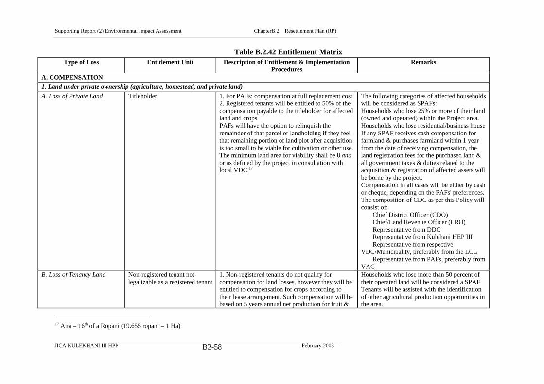
Supporting Report (2) Environmental Impact Assessment ChapterB.2 Resettlement Plan (RP)
JICA KULEKHANI III HPP February 2003B2-58
Table B.2.42 Entitlement MatrixType of Loss Entitlement Unit Description of Entitlement & Implementation
ProceduresRemarks
A. COMPENSATION1. Land under private ownership (agriculture, homestead, and private land)A. Loss of Private Land Titleholder 1. For PAFs: compensation at full replacement cost.
2. Registered tenants will be entitled to 50% of thecompensation payable to the titleholder for affectedland and cropsPAFs will have the option to relinquish theremainder of that parcel or landholding if they feelthat remaining portion of land plot after acquisitionis too small to be viable for cultivation or other use.The minimum land area for viability shall be 8 anaor as defined by the project in consultation withlocal VDC.17
The following categories of affected householdswill be considered as SPAFs:Households who lose 25% or more of their land(owned and operated) within the Project area.Households who lose residential/business houseIf any SPAF receives cash compensation forfarmland & purchases farmland within 1 yearfrom the date of receiving compensation, theland registration fees for the purchased land &all government taxes & duties related to theacquisition & registration of affected assets willbe borne by the project.Compensation in all cases will be either by cashor cheque, depending on the PAFs' preferences.The composition of CDC as per this Policy willconsist of: Chief District Officer (CDO) Chief/Land Revenue Officer (LRO) Representative from DDC Representative from Kulehani HEP III Representative from respectiveVDC/Municipality, preferably from the LCG Representative from PAFs, preferably fromVAC
B. Loss of Tenancy Land Non-registered tenant not-legalizable as a registered tenant
1. Non-registered tenants do not qualify forcompensation for land losses, however they will beentitled to compensation for crops according totheir lease arrangement. Such compensation will bebased on 5 years annual net production for fruit &
Households who lose more than 50 percent oftheir operated land will be considered a SPAFTenants will be assisted with the identificationof other agricultural production opportunities inthe area.
17 Ana = 16th of a Ropani (19.655 ropani = 1 Ha)

Supporting Report (2) Environmental Impact Assessment ChapterB.2 Resettlement Plan (RP)
JICA KULEKHANI III HPP February 2003B2-59
Type of Loss Entitlement Unit Description of Entitlement & ImplementationProcedures
Remarks
fodder trees & 3 years annual net production fortimber/fuel wood trees & other perennial crops.2. If the landowner is not identified, the fullcompensation amount as per (1) above will be paidto the tenant cultivator (operator).
C. Temporary Loss of PrivateLand
Titleholder 1. Compensation for crop losses for the duration oftemporary occupation plus one more year necessaryfor the soil to be adequately prepared to its originalproductivity. PAFs will sign a temporaryoccupation contract specifying: Period of occupancy, Formula for the calculation of annual rent, e.g.,
market value of crops normally produced onthe required land, and annual inflationadjustments;
Form of payment, e.g., money or grain; Frequency of payment/delivery, e.g., quarterly Compensation for other disturbances &
damages caused to property. Land protection measures during the lease; and Land will be returned to the owner at the end
of temporary acquisition, restored to itsoriginal condition.
2. Crops and TreesA. Loss of Trees & PerennialCrops
TitleholderTenantLessee/cultivators havingagreement with the owner
1. Advance notice to harvest crops will be given.2. Net value of crops where harvesting is notpossible will be provided.3. Compensation at market value on the basis ofloss of future production, based on 5 years annualnet production for fruit & fodder trees & 3 yearsannual net production for timber/ fuel wood trees &other perennial crops.
Crop market values will be determined by theCDCs & compensation prices will be finalizedwith active participation of PAFrepresentatives, including VACs and LCGs.If the land is registered under tenancy, both theowner & the tenant will be entitled for 50percent of compensation amount each.When a tenant/lessee & landowner have a nonregistered sharecropping arrangement, thecompensation payable will be apportionedaccording to the arrangement.

Supporting Report (2) Environmental Impact Assessment ChapterB.2 Resettlement Plan (RP)
JICA KULEKHANI III HPP February 2003B2-60
Type of Loss Entitlement Unit Description of Entitlement & ImplementationProcedures
Remarks
B. Loss of Non-perennialCrops
Titleholder 1. Advance notice to harvest crops will be given.2. Where harvesting is not possible, the net value ofcrops will be provided.
Crop market values will be determined by theCDCs & the compensation process will befinalized with active participation of PAFrepresentatives, VACs and LCGs.Where there is a registered tenant, the tenant &titleholder will each be entitled to 50% of thecompensation payable.Where there is a non-registered tenant witha sharecropping arrangement with thetitleholder, the compensation payable willbe apportioned according to thearrangement.
3. Houses and Other StructuresA. Loss of other privately-owned structures
Titleholder (Owner) Compensation for full or partial loss at fullreplacement cost, according to structure type,without deduction for depreciation.Cash compensation for damages to structuresresulting from temporary occupation of land atreplacement cost.
Other structures include such items as: sheds,walls, fences, and water mills.Loss of structures other than houses does notentail payment of a Displacement Allowance.Compensation determination and compensationpayment as per 1A above.
4. Damages Caused During ConstructionA. Public and PrivateBuildings And Structures,Infrastructure, Land, Crops,Trees
All categories of EntitledPersons
Extreme care will be taken by Contractors to avoiddamaging public and private propertyunnecessarily.Where damages do occur to public or privateproperty as a result of construction works, thePAF/SPAFs, groups, communities, or governmentagency shall be compensated for damages to cropsand trees; damaged land, structures, andinfrastructure shall be restored to their formerconditions.
CDC will make compensation determination forthe losses in consultation with VACs andLCGs, as per CCV procedures.
5. Community Facilities And ResourcesA. Loss of Buildings andStructures
Local community Restoration of affected community buildings andstructures to at least previous condition, orreplacement in areas identified in consultation withaffected communities and relevant authorities.
Community buildings and structures include:schools, temples, graves, ghats, waiting sheds,irrigation channels, water points, trails/footpaths and bridges.
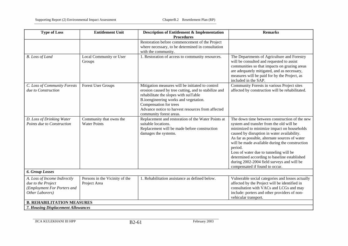
Supporting Report (2) Environmental Impact Assessment ChapterB.2 Resettlement Plan (RP)
JICA KULEKHANI III HPP February 2003B2-61
Type of Loss Entitlement Unit Description of Entitlement & ImplementationProcedures
Remarks
Restoration before commencement of the Projectwhere necessary, to be determined in consultationwith the community.
B. Loss of Land Local Community or UserGroups
1. Restoration of access to community resources. The Departments of Agriculture and Forestrywill be consulted and requested to assistcommunities so that impacts on grazing areasare adequately mitigated, and as necessary,measures will be paid for by the Project, asincluded in the SAP.
C. Loss of Community Forestsdue to Construction
Forest User Groups Mitigation measures will be initiated to controlerosion caused by tree cutting, and to stabilize andrehabilitate the slopes with suiTableB.ioengineering works and vegetation.Compensation for treesAdvance notice to harvest resources from affectedcommunity forest areas.
Community Forests in various Project sitesaffected by construction will be rehabilitated.
D. Loss of Drinking WaterPoints due to Construction
Community that owns theWater Points
Replacement and restoration of the Water Points atsuitable locations.Replacement will be made before constructiondamages the systems.
The down time between construction of the newsystem and transfer from the old will beminimized to minimize impact on householdscaused by disruption in water availability.As far as possible, alternate sources of waterwill be made available during the constructionperiod.Loss of water due to tunneling will bedetermined according to baseline establishedduring 2002-2004 field surveys and will becompensated if found to occur.
6. Group LossesA. Loss of Income Indirectlydue to the Project(Employment For Porters andOther Laborers)
Persons in the Vicinity of theProject Area
1. Rehabilitation assistance as defined below. Vulnerable social categories and losses actuallyaffected by the Project will be identified inconsultation with VACs and LCGs and mayinclude: porters and other providers of non-vehicular transport.
B. REHABILITATION MEASURES7. Housing Displacement Allowances

Supporting Report (2) Environmental Impact Assessment ChapterB.2 Resettlement Plan (RP)
JICA KULEKHANI III HPP February 2003B2-62
Type of Loss Entitlement Unit Description of Entitlement & ImplementationProcedures
Remarks
A. Displacement ofHouseholds
Titleholder (Resident)TenantLandless Squatter on PublicLand (prior to cut off date)
Every SPAF household will be entitled to aHousing Displacement Allowance.Each displaced household will be entitled for areasonable amount of Rental Stipend for sixmonths.
Each member of a displaced household willreceive a fixed amount of HousingDisplacement Allowance for three months.Housing displacement allowance will be basedon minimum wage as established at the nationalor local level, whichever amount is higher.Allowances will be paid prior to displacement.
B. Severe Disruption toCultivation
TitleholderLessee/Cultivator havingAgreement with the Owner
SPAFs as defined in clause 1 A. column 4 in thisEntitlement Matrix will be entitled to a CultivationDisruption Allowance for severe disruption tohousehold cultivation levels.2. The Cultivation Disruption Allowancewill be equal to one season’s production on the areaof cultivation land lost, based on the publishedDistrict and VDC productions figures, land typesand market prices for crops for the year in whichthe land is acquired, to be paid at the time ofcompensation payment.
SPAFs as defined in clause 1-A. Column 4 inthis Entitlement Matrix will be entitled to aCultivation Disruption Allowance
C.Transportation Allowance TitleholderTenantPersons living on rentedaccommodationLandless Squatters/ Encroacherson Public Land As per clause 4of this Policy
1. Each displaced SPAF household will be entitledto Transportation Assistance to move theirbelongings.
8 Other Rehabilitation AssistanceSPAFsSeriously Affected Populationover 18 years of age
A. Severe Loss of AssetsDirectly due to the Project,and Severe Impact indirectlycaused by the Project.
1. Counseling regarding Project impacts, compensation alternatives andrisks, and resettlement options (where required).2. Counseling on saving schemes and cash management3. Preferential access to project construction employment opportunities,to the extent possible.4. Assistance with training in life skills that would help in obtainingemployment and/or earning livelihood.5. The Project will facilitate the assessment and (where feasible)establishment of small-scale income generating schemes for seriouslyaffected households in the areas.6. Assistance to gain access to National Poverty Alleviation and CreditPrograms to SPAFs will be provided.7. Households shall be entitled to Agricultural Extension Services toincrease production on their remaining agricultural and forestry land.
The Rehabilitation Measures will be targeted to SPAFs and to othervulnerable groups in the vicinity of the Project area who may beadversely affected by the Project, even though they do not loseassets. Vulnerable groups include: porters and other non-vehiculartransport providers who may lose jobs because of projectinterventions, Chepang (praja) households, and landless households.Specifications for training and hiring workers will be included inContractors' contracts.The Project’s Resettlement Unit (located in KESMU) willinvestigate the potential for coordination with existing programs.The respective Agriculture Institutions will be requested to assist inimplementing the program. Any costs will be borne by the project,as part of the SAP.
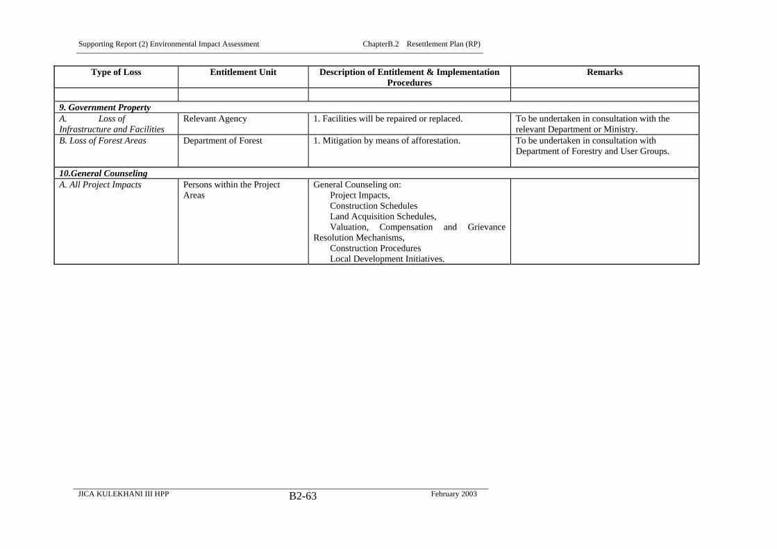
Supporting Report (2) Environmental Impact Assessment ChapterB.2 Resettlement Plan (RP)
JICA KULEKHANI III HPP February 2003B2-63
Type of Loss Entitlement Unit Description of Entitlement & ImplementationProcedures
Remarks
9. Government PropertyA. Loss ofInfrastructure and Facilities
Relevant Agency 1. Facilities will be repaired or replaced. To be undertaken in consultation with therelevant Department or Ministry.
B. Loss of Forest Areas
Department of Forest
1. Mitigation by means of afforestation.
To be undertaken in consultation withDepartment of Forestry and User Groups.
10.General Counseling A. All Project Impacts Persons within the Project
AreasGeneral Counseling on: Project Impacts, Construction Schedules Land Acquisition Schedules, Valuation, Compensation and GrievanceResolution Mechanisms, Construction Procedures Local Development Initiatives.

Supporting Report (2) Environmental Impact Assessment ChapterB.2 Resettlement Plan (RP)
JICA KULEKHANI III HPP February 2003B2-64
B.2.8 Consultation, Participation, and Grievance Redress
(1) Consultation and Participation
The APs (inclusive of PAFs.SPAFs and other groups and institutions, such as
HCIL) will participate throughout the various stages of the planning and
implementation of the RP. They will be properly informed through issuance of
Due Process Brochures in the Nepali language on all activities to be carried out.
The information will include the specific activities, schedules, organization
responsible, potential impacts, entitlements, compensation and resettlement,
rehabilitation and mitigation measures.
To date, APs and other stakeholders are being consulted during the RP preparation
through an explicit Consultation Strategy outlined as part of the EIA update.
During Project Implementation, meetings with APs will be carried out to identify
their needs and preferences pertaining to compensation and rehabilitation
assistance in order to avoid and mitigate any negative impacts caused by the
Project.
(2) Grievance Redress
All APs will have the right of appeal against any aspect of decisions made not in
accordance with the RP or with commitments given to them, or on which they
disagree with the level or manner of compensation.
The main objectives of the Grievance Procedure will be to provide a mechanism
to ensure that the compensation and resettlement programs have been
implemented accurately and fairly, alleviating any adverse effects on APs, to
mediate conflict and to avoid lengthy litigation that is unfair to APs and can delay
the project. It also will provide people who have objections or concerns about
their assistance with an accessible and known procedure through which to raise
their objections and have them resolved.
Attempts will be made to settle the issues at the village level through community
consultation, involvement of social and resettlement experts, NGOs and mediators
and facilitators if required. The concerned resettlement committees will properly
document all complaints and resolutions.
The APs will be made fully aware of their rights to grievance and the procedures
by doing so verbally and in writing during consultation, survey and time of
compensation. The APs may present their complaints to the concerned local
administrative officials and resettlement committees. The complaint will be filed
first at the village level and will be elevated to the highest or provincial level if the
Supporting Report (2) Environmental Impact Assessment ChapterB.2 Resettlement Plan (RP)
JICA KULEKHANI III HPP February 2003B2-65
APs are not satisfied with the decisions made by the village and district
levels/committees. VACs and LCGs at each level will settle the complaint within
15 days. APs will be exempted from all taxes, administrative and legal fees.
The affected households and persons will have access to Grievance Redress both
through Project organization and through formal courts of appeal. The
Resettlement Unit will handle initial grievances. Grievances related to land price
fixation and compensation amounts will be handled by the CDC. The PAF/SPAFs
may appeal for review of the compensation amount if felt very unsatisfactory
compared with the market price of the adjoining plots. The VAC or LCG will
facilitate APs to file a formal appeal and complaint if necessary to the CDC.
The Land Acquisition Procedures are specified in the LAA. The procedure will
ensure public consultation, consensus building, adequate time of notification,
adequate information on resettlement options and participation of APs in decision
making as far as possible.
To ensure transparency of procedures, payment of compensation and other
allowances will, as far as possible, be made in the presence of the PAF/SPAF’s
significant family member (spouse) and other local authorities. These witnesses
will ensure that the AP (PAF/SPAF) understands and agrees with the
compensation amount, and is informed of the Grievance Appeal Mechanisms
made available through the Project. Certificates of Compensation will, in addition,
be issued to each entitled AP.
All Government taxes and duties related to the acquisition and registration of
affected assets will be borne by the Project.
Lessons learned from other development projects show that local officials or
organizations often ask APs for ‘donations’ and/or ‘service fees’. Thus, APs are
obliged to share or contribute a portion of their compensation payment as part of
the administrative requirements for their Compensation Payment. To avoid this, it
will be clearly discussed during the meetings that APs are not allowed to give or
donate a portion of their money to any officials or members of any other agencies
or organizations or to Project Staff.
B.2.9 Relocation of Housing and Settlements
(1) Resettlement and Rehabilitation Measures
A number of measures are proposed in order to mitigate the Project’s Resettlement
Effects. The cut-off date for resettlement entitlement eligibility will be the
Acquisition Notice as specified in the LAA.. Details of compensation and

Supporting Report (2) Environmental Impact Assessment ChapterB.2 Resettlement Plan (RP)
JICA KULEKHANI III HPP February 2003B2-66
rehabilitation measures are given in the Entitlement Matrix above. In general the
main measures include:
Compensation,
Rehabilitation Support (Allowances),
Rehabilitation Assistance, and
Other Assistance (e.g. General Counseling)
(2) Compensation for Land and Property
All compensation for affected land and property will be based on the principle of
replacement cost. Depending upon the type of land and asset affected and the
ownership, either the individual or the community will be the unit of entitlement.
A detail of the unit of entitlement is already discussed. The compensation measure
will include:
Full compensation of land at market rate to the owner before construction work of
project begins. If there are registered tenants they are eligible for 50 percent of the
compensation for the affected plot operated by them.
Full compensation of house and sheds at replacement cost before the Project takes
into possession of the structure i.e., allowing reasonable time to settle in the new
site. Once the cost for the structures has been finalized some proportion of
payment of their residential house can be given house-owners in advance if they
demanded.
Full compensation of community structures or reconstruction at the site
convenient to the affected community
Separate rates for compensation apply for khet and bari as khet is more valuable
and productive than bari. At the time of field survey the average market rate for
khet was NRs.100,000 per ropani which means approx. NRs. 2,000,000 per
hectare.
The average rate for bari was NRs. 75, 000 per ropani, which means
NRs.1,500,000 per hectare. The estimated total compensation for land is given in
resettlement budget later.
The compensation for houses and other structures are based on the type of
structure, storeys, and area covered (sq. ft.) including type of building material.
The compensation estimate for house structure ranges from approximately NRs.
26,000 for kachhi to approx. NRs. 620,000 fro pakki house.
In addition to paying compensation for private land the Project will also negotiate
with various agencies since construction of Project facilities is likely to affect
Supporting Report (2) Environmental Impact Assessment ChapterB.2 Resettlement Plan (RP)
JICA KULEKHANI III HPP February 2003B2-67
public land, institutional land and the Community Forestland. For example,
negotiation with the District Department of Forest and the Forest User
Committees of Kalia and Bokedaha community will be done for the 35.58 ha of
forest land of Yangrang and Work Adit 1. Similarly for the headworks with 1.64
ha, dealing with Kulekhani II project is a must. Private and grassland of about
3.53 ha to be used for Work Audit 1 will be negotiated with HCIL. Moreover,
likely to be affected the river areas and grassland of some 23.38 ha affected by
different Project components and facility sites has to be negotiated with
Department of Forest, DDCs and local VDCs. This issue will be dealt in detail in
the Project’s EMP.
B.2.10 Income Restoration Strategy
(1) General
Rehabilitation support will cover Displacement Allowances and other
rehabilitation assistances to improve or at least restore the living standard of APs
(inclusive of PAF/SPAFs) and affected communities. The Kulekhani III Project
will adopt the following rehabilitation support measures for those who lose land
and house structures due to the construction of Project facilities.
(2) Displacement Allowance
Household members affected due to displacement of residential house structure
will be entitled for displacement allowances which include Displacement
Allowance, Cultivation Disruption Allowance equivalent to one season’s
production (who lose land and house) and Transportation Allowance. Details are
given in the Entitlement Matrix above.
(3) Rehabilitation Support
The Project will provide various rehabilitation assistance measures to restore the
livelihood of APs and communities. This assistance will be largely focused on
PAFs having serious impact (by loss of residential house and more than 25 percent
of total land in the Project area) and vulnerable communities. Since the Detailed
Design and DMS has not been done, the SPAFs due to loss of land greater than 25
percent of the total owned and operated land have not be identified. Once the
detail design is done and a clear demarcation of area for Project work is available,
all these details will be worked out. If possible, the Project may consider
providing land plots for construction of houses for those who loose their
residential house or a fixed sum of money can be provided in addition to other
allowances.

Supporting Report (2) Environmental Impact Assessment ChapterB.2 Resettlement Plan (RP)
JICA KULEKHANI III HPP February 2003B2-68
A Transfer Fee for those who buy land with cost equivalent to the compensation
amount received within a year will be provided by the Project as a rehabilitation
measure. The skill training, preferential employment and other similar measures
will provide assistance to the affected households. Details are given in Entitlement
Matrix above
(4) Other Support
1) General
In addition to compensation, allowances and rehabilitation assistance, the affected
households are entitled for general counseling on various aspects of economic and
social life. Preferential access to employment for vulnerable groups, access to
training provided by the contractors and utilization of other project related
facilities by affected persons are some other assistance provisions.
In addition to the Resettlement Entitlements the affected families singly or
collectively will benefit from various measures related to public health and
sanitation, education, community support works, neighborhood support programs,
life skill training and many others proposed by the Project’s SAP.
2) Cage Fish Culture on Re-Regulating Pond
Cage fish culture is recommended for ten percent of the total available area of the
Kulekhani III Regulating Pond. The cage fish culture will replace the loss of fish
catch in Rapti River and its feeder streams. This is also helpful in maintaining the
fish population and protein consumption of local people and also may designed as
a rehabilitation measure for PAF/SPAFs to replace income lost due to land
acquisition.
The Indrasarobar Reservoir, of Kulekhani I is the only reservoir, that has utilized
cage fishery development. The Fisheries Development Center in Markhu initiated
commercial fish culture from 2045 BS (1988), involving local people. The Center
started cage fish culture with five households, and currently one hundred and
seventeen households are involved in cage fish farming. Out of the total available
potential of //, only an area of about 11,770m3 has so far been exploited for cage
fish culture. Artificial feeding is not required for the fish culture on the
Indrasarobar Reservoir. Approximately 17,000 kg fish was sold last year, 12,972
kg from the private producers and 4,058 kg from Government cages established
on the Indrasrobar Reservoir. (Kantipur Paush 2057 [2000]).
3) Commercial Development at Sanutar & Ghumaune
The SAP includes provision for vegetable produce collection centre and bus stop
to take advantage of the construction of the new Kulekhani III’s motorable bridge
across the Rapti River.

Supporting Report (2) Environmental Impact Assessment ChapterB.2 Resettlement Plan (RP)
JICA KULEKHANI III HPP February 2003B2-69
It is likely that the new bridge and the Project’s ‘boomtown’ effects will spur
considerable economic activity in the area, probably leading to the development of
a small bazaar town along the lines of what is observed near suspension bridges in
other parts of Nepal.
A possibility that will be examined as part of the SAP will be the siting of the bus
stop and produce collection facility on the spoil site at Sanutar, once construction
is completed, laying out commercial and residential development plots that may
be either given by lottery to the the local residents, PAF/SPAFs receiving first
priority, or managed in a corporate way by these communities but with provisions
in place for assuring the development is used as a rehabilitation measure
benefiting PAF/SPAFs. Options will be further investigated during the Detailed
Design Stage studies.
B.2.11 Institutional Framework
Since the Resettlement Effects are not very large, say compared to those of a
reservoir hydro project, no separate institutional arrangement for resettlement is
proposed. There will be a Resettlement Unit (RU) within the Kulekhani III
Project’s Environment and Social Monitoring Unit (KESMU) to handle
resettlement implementation. The proposed organization chart of the Division is
given in Figure B.2.1. The Resettlement and Rehabilitation Officer (RRO) in the
Acquisition, Compensation and Resettlement Section (ACRS) will be responsible
for all resettlement-related activities.
Within the umbrella of LAA there is a provision of CDC (discussed earlier with
suggested improvements) to negotiate the price and facilitate land acquisition for
the Project. The above Entitlement Matrix also specifies the composition of the
CDC. The ACRS will work as a Secretariat for the CDC. However, if land and
other assets can be acquired through negotiation with the owners, this will have
priority, and the Project itself will negotiate the acquisition. In both situations the
ACRS will play an important role for coming up in consultation with the APs with
acceptable conditions and costs for lost land and assets.
The ACRS will have provision of Surveyors, Resettlement Assistants,
Accountants and other lower level staff to facilitate the RRO.
To facilitate the resettlement implementation, VAC and LCG will be organized.
The VAC/LCGs will consist of representatives from VDC (Chair), Ward Chair/s
of affected Wards, two representatives of PAFs (one male and one female), a
representative from local government institutions such as the High School, Health
Post, Agriculture, or Forest Ministries, representatives of the S&E Division and a
Supporting Report (2) Environmental Impact Assessment ChapterB.2 Resettlement Plan (RP)
JICA KULEKHANI III HPP February 2003B2-70
local knowledgeable person or Social Worker, possibly from an NGO or CBO.
The VDC Chair will Chair the meetings of the Committee. The RRO will attend
the VAC/LGC meetings and keep minutes. These will be largely advisory bodies.
They will function as liaison between the KESMU and the APs. Their
establishment at the VDC level and in municipality Wards is to effectively address
the social issues associated with the Project. The objectives of this participation
program will be to (i) ensure ongoing dissemination of Project information to APs
(PAF/SPAFs) and ii) to involve affected communities and local government
structures in the social impact management, grievance resolution and monitoring,
thereby promoting collective organization and decision-making.
For effective delivery of Resettlement Entitlements the coordination with other
Government line agencies (e.g., Department of Forestry and Ministry of
Agriculture) is important. The RU will work diligently with those in the
community who may not be directly affected but who may have been affected
indirectly, to handle issues related to social, as well as environmental impacts.
The resettlement activities of the Project will not end with delivery of
compensation and direct assistance. The rehabilitation measures will continue
for a longer period. The monitoring of APs (PAF/SPAFs) is also an important task
of the RU. The resettlement activities will be considered as part of a set of
comprehensive local development activities and not only as compensatory
measures.

Supporting Report (2) Environmental Impact Assessment ChapterB.2 Resettlement Plan (RP)
JICA KULEKHANI III HPP February 2003B2-71
Figure B.2.1 Proposed Organizational Chart of Kulekhani III Social and
Environment Division
NEA
Kulekhani III PMO
Kulekhani III Environmental
and Social Monitoring Unit
Technical Units
Environmental and Social
Monitoring Section
Acquisition,
compensation and
Resettlement section
Social Action Plan
Section
Other Units
Public Information and Co-
ordination section
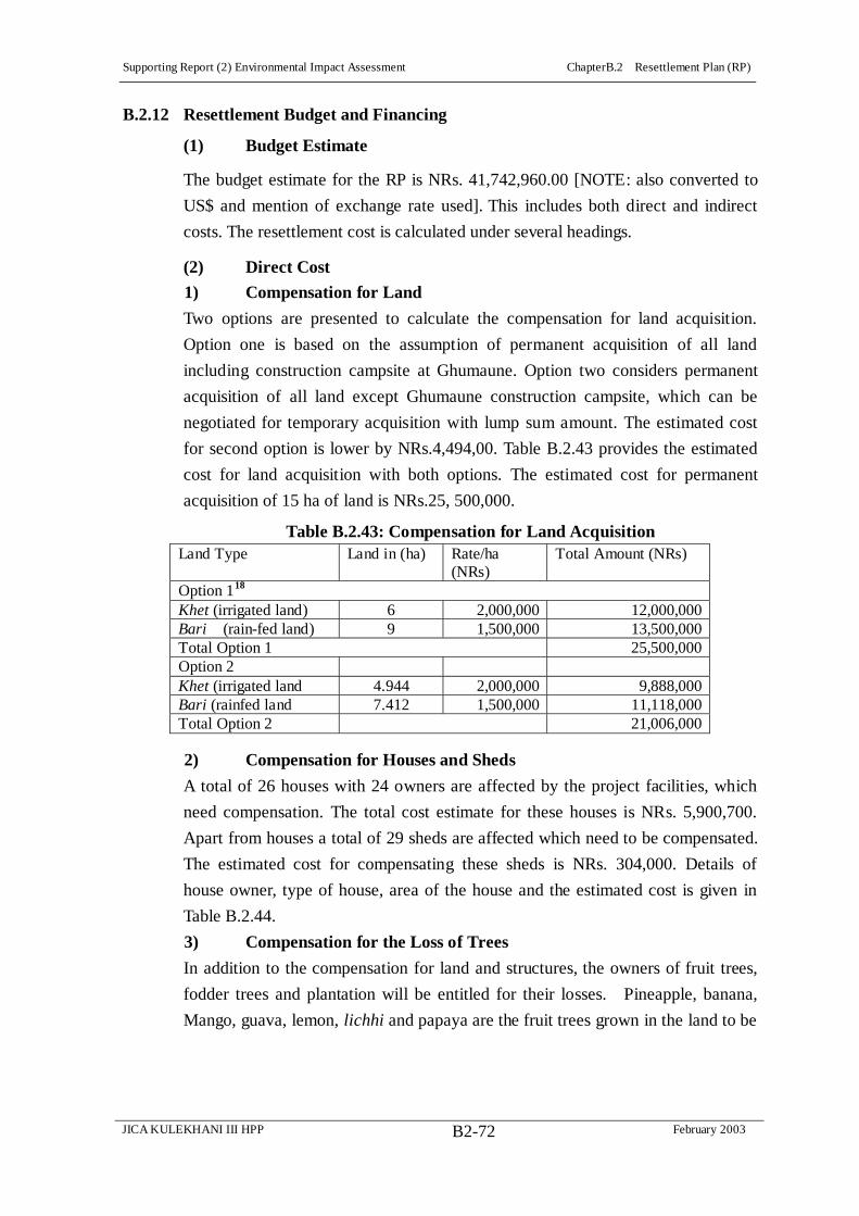
Supporting Report (2) Environmental Impact Assessment ChapterB.2 Resettlement Plan (RP)
JICA KULEKHANI III HPP February 2003B2-72
B.2.12 Resettlement Budget and Financing
(1) Budget Estimate
The budget estimate for the RP is NRs. 41,742,960.00 [NOTE: also converted to
US$ and mention of exchange rate used]. This includes both direct and indirect
costs. The resettlement cost is calculated under several headings.
(2) Direct Cost
1) Compensation for Land
Two options are presented to calculate the compensation for land acquisition.
Option one is based on the assumption of permanent acquisition of all land
including construction campsite at Ghumaune. Option two considers permanent
acquisition of all land except Ghumaune construction campsite, which can be
negotiated for temporary acquisition with lump sum amount. The estimated cost
for second option is lower by NRs.4,494,00. Table B.2.43 provides the estimated
cost for land acquisition with both options. The estimated cost for permanent
acquisition of 15 ha of land is NRs.25, 500,000.
Table B.2.43: Compensation for Land Acquisition Land Type Land in (ha) Rate/ha
(NRs) Total Amount (NRs)
Option 118
Khet (irrigated land) 6 2,000,000 12,000,000 Bari (rain-fed land) 9 1,500,000 13,500,000 Total Option 1 25,500,000 Option 2 Khet (irrigated land 4.944 2,000,000 9,888,000 Bari (rainfed land 7.412 1,500,000 11,118,000 Total Option 2 21,006,000
2) Compensation for Houses and Sheds
A total of 26 houses with 24 owners are affected by the project facilities, which
need compensation. The total cost estimate for these houses is NRs. 5,900,700.
Apart from houses a total of 29 sheds are affected which need to be compensated.
The estimated cost for compensating these sheds is NRs. 304,000. Details of
house owner, type of house, area of the house and the estimated cost is given in
Table B.2.44.
3) Compensation for the Loss of Trees
In addition to the compensation for land and structures, the owners of fruit trees,
fodder trees and plantation will be entitled for their losses. Pineapple, banana,
Mango, guava, lemon, lichhi and papaya are the fruit trees grown in the land to be

Supporting Report (2) Environmental Impact Assessment ChapterB.2 Resettlement Plan (RP)
JICA KULEKHANI III HPP February 2003B2-73
acquired. The compensation amount for these fruit trees together with fodder trees
and sissou plantation is given in Table B.2.45. Two households have planted
sissou trees in a total of about 1.75 hectare. Since these plantations are in initial
stage and will take several years to mature a lump sum estimate of the cost is
made.
18 Note: Option 1: Permanent acquisition of all land including construction campsite at Ghumaune. Option 2: Permanent acquisition of all land excluding Ghumaune construction camp site
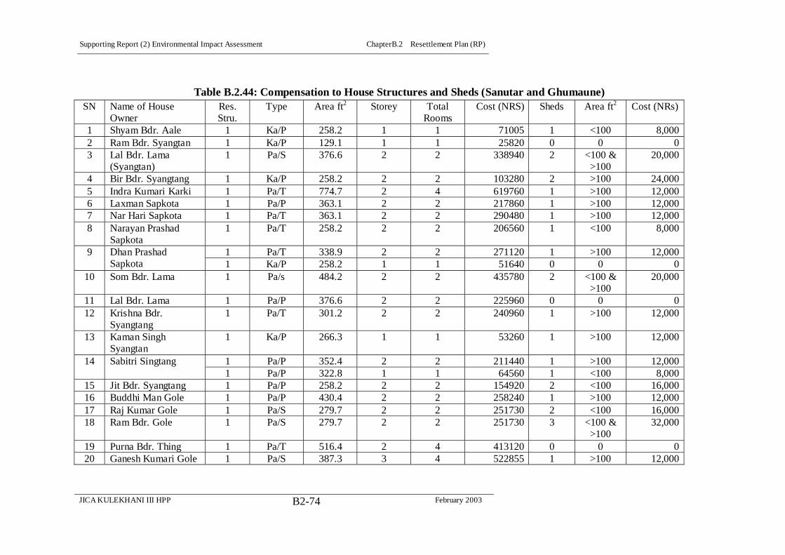
Supporting Report (2) Environmental Impact Assessment ChapterB.2 Resettlement Plan (RP)
JICA KULEKHANI III HPP February 2003B2-74
Table B.2.44: Compensation to House Structures and Sheds (Sanutar and Ghumaune) SN Name of House
Owner Res. Stru.
Type Area ft2 Storey Total Rooms
Cost (NRS) Sheds Area ft2 Cost (NRs)
1 Shyam Bdr. Aale 1 Ka/P 258.2 1 1 71005 1 <100 8,000 2 Ram Bdr. Syangtan 1 Ka/P 129.1 1 1 25820 0 0 0 3 Lal Bdr. Lama
(Syangtan) 1 Pa/S 376.6 2 2 338940 2 <100 &
>100 20,000
4 Bir Bdr. Syangtang 1 Ka/P 258.2 2 2 103280 2 >100 24,000 5 Indra Kumari Karki 1 Pa/T 774.7 2 4 619760 1 >100 12,000 6 Laxman Sapkota 1 Pa/P 363.1 2 2 217860 1 >100 12,000 7 Nar Hari Sapkota 1 Pa/T 363.1 2 2 290480 1 >100 12,000 8 Narayan Prashad
Sapkota 1 Pa/T 258.2 2 2 206560 1 <100 8,000
1 Pa/T 338.9 2 2 271120 1 >100 12,000 9 Dhan Prashad Sapkota 1 Ka/P 258.2 1 1 51640 0 0 0
10 Som Bdr. Lama 1 Pa/s 484.2 2 2 435780 2 <100 & >100
20,000
11 Lal Bdr. Lama 1 Pa/P 376.6 2 2 225960 0 0 0 12 Krishna Bdr.
Syangtang 1 Pa/T 301.2 2 2 240960 1 >100 12,000
13 Kaman Singh Syangtan
1 Ka/P 266.3 1 1 53260 1 >100 12,000
1 Pa/P 352.4 2 2 211440 1 >100 12,000 14 Sabitri Singtang 1 Pa/P 322.8 1 1 64560 1 <100 8,000
15 Jit Bdr. Syangtang 1 Pa/P 258.2 2 2 154920 2 <100 16,000 16 Buddhi Man Gole 1 Pa/P 430.4 2 2 258240 1 >100 12,000 17 Raj Kumar Gole 1 Pa/S 279.7 2 2 251730 2 <100 16,000 18 Ram Bdr. Gole 1 Pa/S 279.7 2 2 251730 3 <100 &
>100 32,000
19 Purna Bdr. Thing 1 Pa/T 516.4 2 4 413120 0 0 0 20 Ganesh Kumari Gole 1 Pa/S 387.3 3 4 522855 1 >100 12,000
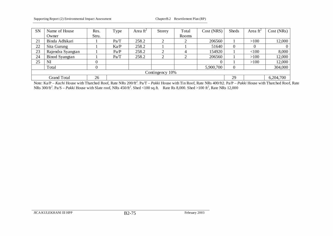
Supporting Report (2) Environmental Impact Assessment ChapterB.2 Resettlement Plan (RP)
JICA KULEKHANI III HPP February 2003B2-75
SN Name of House Owner
Res. Stru.
Type Area ft2 Storey Total Rooms
Cost (NRS) Sheds Area ft2 Cost (NRs)
21 Binda Adhikari 1 Pa/T 258.2 2 2 206560 1 >100 12,000 22 Sita Gurung 1 Ka/P 258.2 1 1 51640 0 0 0 23 Rajendra Syangtan 1 Pa/P 258.2 2 4 154920 1 <100 8,000 24 Binod Syangtan 1 Pa/T 258.2 2 2 206560 1 >100 12,000 25 NI 0 0 1 >100 12,000 Total 0 5,900,700 0 304,000
Contingency 10% Grand Total 26 29 6,204,700
Note: Ka/P – Kachi House with Thatched Roof, Rate NRs 200/ft2. Pa/T – Pakki House with Tin Roof, Rate NRs 400/ft2. Pa/P – Pakki House with Thatched Roof, Rate NRs 300/ft2. Pa/S – Pakki House with Slate roof, NRs 450/ft2. Shed <100 sq.ft. Rate Rs 8,000. Shed >100 ft2, Rate NRs 12,000

Supporting Report (2) Environmental Impact Assessment ChapterB.2 Resettlement Plan (RP)
JICA KULEKHANI III HPP February 2003B2-76
Table B.2.45: Compensation for the Loss of Fruit Trees, Fodder Trees and Sissou Plantation in Private Land at Sanutar, Ghumaune,
and Tailrace Outlet Number of Trees Rate NRs/Trees Total NRs. Description
Fruit Bearing Not Bearing Total Fruit Bearing Not Bearing Fruit Bearing Not Bearing Grand Total
Mango 38 30 68 3,000 1,200 11,4000 36,000 150,000 Banana 209 158 367 150 30 31,350 7,900 39,250 Lemon 10 0 10 2,500 1,000 25,000 0 25,000 Guava 20 3 23 1,000 400 20,000 1,200 21,200 Pineapple 265 58 323 50 20 13,250 1,160 14,410 Papaya 2 4 6 2,500 1,000 5,000 4,000 9,000 Lichhi 3 2 5 1,500 600 4,500 1,200 5,700 Orange 0 1 1 2,500 1000 0 1,000 1,000 Other Fruit Trees 15 12 27 500 250 7,500 3,000 10,500 Fodder trees 350 150 500 1,000 200 350,000 52,500 402,500 Sissou Plantation* 0 1925 1925 0 2,500 0 4,812,500 4,812,500
912 2,343 3,255 - - 570,600 4,920,460 5,491,060 Note: Losses of trees are estimated based on the preliminary survey of the households whose structures and land were affected. Compensation rates for the fruit bearing plants and fodder trees are based on the average number of fruits/tree or fodder/tree times cost NRs/fruit or fodder multiplied by production life of the fruit bearing tree (e.g. 5 years). For trees/plants not bearing fruit or for fodder trees compensation is estimated for the production life of 2 years after three years of acquisition. About 1.75 ha of land is under sissou plantation (Mr. Chandra Lal Dong with 1.24 ha and Indra Kumari Karki with 0.51 ha). Compensation for sissou trees are lump sum estimation, it is assumed that sissou plant will take at least further 10 years to be sold as timber.

Supporting Report (2) Environmental Impact Assessment ChapterB.2 Resettlement Plan (RP)
JICA KULEKHANI III HPP February 2003B2-77
(3) Cost of Rehabilitation Measures
1) Housing Displacement Allowance
Housing displacement allowances are based on a fixed sum of NRs1,500 per
month for each member of the displaced household for three months. Considering
6 persons per household this amount comes out to be (1,500/p/m*6 persons/hh*3
months*24 hh) NRs. 648,000.
2) Rental Stipend
Rental stipend estimate is based on NRs 3,000 per month for 6 months
(3,000/month* 24hh*6 months) and it is estimated to be NRs. 432,000.
3) Cultivation Disruption Allowance
The Cultivation Disruption Allowance is based on one season's production on the
area of cultivation land lost, types and market prices for crops for the in which the
land is acquired. For the purpose of this budget the allowance has been based on
average production figures as reported in the field survey. The total land loss for is
14.88 ha from among 46 households. This means average loss of 0. 323 ha
(approx. 6.5 ropani) per household. Assuming about one-fourth households losing
more than 25 percent of their land who could be entitled for this allowance a lump
sum of NRs. 144,000 is estimated (12 hh* annual production of paddy in 0.323 ha
in kg * NRs 20 price/kg).
4) Transportation Allowance
Assuming a lump sum of NRs 5,000 per displaced household to transport their
salvaged materials for 24 households, this amounts to be NRs. 120,000.
5) Other Rehabilitation Measures
One person each SPAF household will be provided life skill training and for this a
lump sum of 360,000 (36 person month @ 10,000/month). For other rehabilitation
measures such as support for agricultural extension, support to small income
generating activities and miscellaneous activities an equivalent amount is
estimated. Table B.2.46, provides a summary estimate of resettlement cost for the
Kulekhani III Project.

Supporting Report (2) Environmental Impact Assessment ChapterB.2 Resettlement Plan (RP)
JICA KULEKHANI III HPP February 2003B2-78
Table B.2.46: Resettlement & Rehabilitation Cost
Description Cost estimate Direct cost Compensation for Private Land (Negotiated cost for temporary acquisition of private land)
25,500,000
Transfer Fee (to be paid if affected HH buy land of equivalent value) 1,897,200 Privately owned trees (fixed sum at this time) 5,491,060 Private Structures Houses 5,900,700 Sheds 304,000 Community Structures (provisional) 100,000
39,198,960 Indirect Cost Displacement Allowance (HH * monthly allowance * 3) 648,000 (HH * monthly rental * 6) 432,000 Cultivation Disruption Allowance 144,000 (Transportation Allowance) 120,000 House plot grant to 24 residential house owners @ NRs. 50,000.00 1,200,000.00 TOTAL 41,742,960.00 Rehabilitation Measures Skill training
Agriculture extension Support to small income generating activities
Refer SAPF
Refer SAPF
Implementation & Management Refer EMP Monitoring and Evaluation Refer EMP Administrative Cost Refer EMP
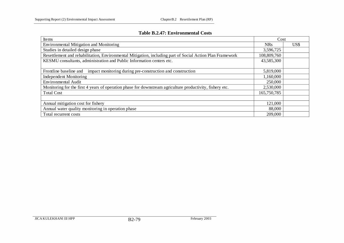
Supporting Report (2) Environmental Impact Assessment ChapterB.2 Resettlement Plan (RP)
JICA KULEKHANI III HPP February 2003B2-79
Table B.2.47: Environmental Costs Items Cost Environmental Mitigation and Monitoring NRs US$ Studies in detailed design phase 3,596,725 Resettlement and rehabilitation, Environmental Mitigation, including part of Social Action Plan Framework 108,809,760 KESMU consultants, administration and Public Information centers etc. 43,585,300
Frontline baseline and impact monitoring during pre-construction and construction 5,819,000 Independent Monitoring 1,160,000 Environmental Audit 250,000 Monitoring for the first 4 years of operation phase for downstream agriculture productivity, fishery etc. 2,530,000 Total Cost 165,750,785
Annual mitigation cost for fishery 121,000 Annual water quality monitoring in operation phase 88,000 Total recurrent costs 209,000
Supporting Report (2) Environmental Impact Assessment ChapterB.2 Resettlement Plan (RP)
JICA KULEKHANI III HPP February 2003B2-80
B.2.13 Implementation Schedule
The implementation schedule closely follows the overall project schedule (see
EMP). It is dependent upon the start of the construction work of the project.
However, it is recommended that full payment of compensation to structure
owners will be made at least three month prior to the initiation of construction
work to give time for demolition, transportation of salvaged materials,
construction of new residence etc. For other property, full compensation shall be
made prior to occupancy. The rehabilitation schedules will be consistent with the
project activities and will be the focus of pre-construction part of project
B.2.14 Monitoring and Evaluation
(1) General
Resettlement activities do not end with compensation payment and payment of
necessary allowances. The internal and external monitoring is essential to examine
the delivery of resettlement entitlements and to find out if the affected families
were able to improve or at least restore their living standard to pre-Project status.
(2) Internal Monitoring
Monitoring takes place against the activities, entitlements, timeframe and budget
set out in the resettlement plan. The socio-economic survey conducted for the
environment and social action plan will provide basic information of the affected
population. Internal monitoring of activities and entitlements will be done
periodically. The Environmental and Social Monitoring Unit could do this.
However, an external agency is desirable to conduct such surveys. During the
payment of compensation a short information format will be filled with the
affected household. This can be used as baseline to which changes can be assessed
in the future surveys. At least after three years of entitlement delivery a survey of
the affected households is desirable so that affected household’s change can be
monitored. Monitoring indicators will be developed after the detailed design and
survey is over. However, monitoring of timeframe, budget and entitlements will
be part of regular project process. Since complete recovery from resettlement
impact can be protracted monitoring sometimes requires well after Project
activities are completed.
(3) External Monitoring & Evaluation
Post evaluation of resettlement is an integral part of project cycle. An external
agency (independent consultant) is needed for external monitoring and evaluation.
The tasks of external monitor is to verify results of internal monitoring; assess
whether resettlement objectives are met; assess resettlement efficiency,
Supporting Report (2) Environmental Impact Assessment ChapterB.2 Resettlement Plan (RP)
JICA KULEKHANI III HPP February 2003B2-81
effectiveness, impact and sustainability; ascertain if the resettlement entitlements
were appropriate to meeting the objectives and whether the objectives were suited
to the conditions of project affected households. A Panel of Expeerts (POE) may
be appointed to follow the progress of the RP, SAP, and EMP and to make
recommendations as required.

Supporting Report (2) Environmental Impact Assessment ChapterB.3 Social Action Plan (SAP) Framework
JICA KULEKHANI III HPP February 2003B3-1
CHAPTER B.3 SOCIAL ACTION PLAN (SAP) FRAMEWORK
B.3.1 Introduction
(1) Background to Social Action Plan (SAP)
Implementation of a Project of the scale of Kulekhani III requires careful planning
for managing a number of social impacts of diverse nature, aside from the
acquisition of land and relocation of houses. These include the disruption of social
infrastructure such as irrigation canals, water supply systems, and health and
education facilities. This also includes the direct and indirect de-capitalization of
Affected Persons (APs), who may risk losing capital in all its forms: natural
capital and man-made capital, as well as human and social capital.
The Resettlement Plan (RP) addresses the de-capitalization issues in its various
forms for the APs losing their land or house. However, the Project indirect impacts
on those whose land and property will not be directly affected by the Project, but
who are living by the side of Project activity areas are often poorly addressed. Past
project experiences have revealed this to be an issue of dissatisfaction of most of
the project area peoples in Nepal.
Among the general population, projects such as the Kulekhani III are seen as a
potential wheel of development in the Project area. In fact most of the projects,
national or donor funded, have a basic underlying objective of poverty reduction
and improvement of the quality of life of the Nepalese people. While this may be
realized in the national context, if viewed in terms of revenue generated from the
Project, in most of the cases people of the project area have little or no access to
the project benefits. In a number of instances, the loss of local area resources has
not been compensated in any way, and the local people may suffer from the
outcome of the project induced losses in various unrecognized ways.
If the Kulekhani III Project is implemented, there will be a number such
de-capitalization risk issues potentially leading to impoverishment of households
in the project area. For example, reduction and fluctuation of water discharges in
the Rapti River may impart the existing irrigation canal intakes ineffective for
water diversion, with adverse effects on agricultural production. Similarly
diversion of the Yangran River’s water will risk the agricultural production of
Sanutar and Ghumaune villages. Loss of the Yangran catchment vegetation,
forming a part of Bokedaha and Kalika community forests will be not only a
community loss but also a loss of natural resources, and this will particularly
affect the livelihood of the poorer peoples of the area, who traditionally depend on

Supporting Report (2) Environmental Impact Assessment ChapterB.3 Social Action Plan (SAP) Framework
JICA KULEKHANI III HPP February 2003B3-2
forest resources to make up for lack of agricultural. Increased access to the
hinterland due to project's access roads and the motorable bridge to be constructed
across the Rapti River is likely to bring competition for natural resource extraction
between local sand outsiders entering the project area for economic gain. This
Project induced encroachment to the local people’s communal property will be an
indirect Project impact.
There will be a number of other impacts besides these examples given above. The
Construction Phase impacts will include a number of ‘boom town’ effects due to
outsiders entering the project area. Housing complexes may be constructed to
house the project laborers and their families, and new business enterprises and
various other services will spontaneously be established nearby the the
construction camps. The implications are a decline in sanitary conditions, increase
in solid waste, pressure on existing water supply facilities, as well as on the
existing education and health institutions. The carry over effects for health could
be the spread of diseases such as cholera and malaria, and HIV AIDS. Girl
trafficking will very likely increase. It is also likely that around the construction
sites outsiders will actually out number the local villagers, and this will have
possibly adverse impacts on local culture, and social institutions. Thus a number
of impoverishment risks of marginalization, increased morbidity and mortality,
food insecurity, loss of access to common property, and social (community)
disarticulation may become potential issues for local people, and these may
surface in various negative forms that will potentially disrupt the project
construction and even its long term operation.
To reverse these impoverishment risks due to the project construction and
operation, a package of social action s were broadly suggested for implementation
in the previous EIA (NEA 2001). These included an Agricultural Development
Program, Skill Development Training, a Community Development Program, a
Rural Electrification Program, and Priority for Local Employment. In the context
of the upgrading the feasibility study, the enhancement programs proposed in the
NEA EIA study were reviewed and improved. These are now proposed as a
Social Action Plan (SAP) in this section, which lays out the framework for the
detailed design of the proposed SAP in the next study phase.
(2) Basis of SAP Formulation
The formulation of the SAP Framework is based on the evaluation of the Project’s
potential social impacts, through field surveys in the various Project-affected areas.
Interaction with the various APs, including individuals, groups, and user

Supporting Report (2) Environmental Impact Assessment ChapterB.3 Social Action Plan (SAP) Framework
JICA KULEKHANI III HPP February 2003B3-3
communities, has provided valuable input into the selection of programs, which
were further strengthened by the deliberation of the various interest groups and
stakeholders, expressing their felt needs for project-sponsored development
programs, during public consultation meetings (see Public Consultation Program).
Lessons from Kaligandaki 'A', Middle Marsyangdi, and other projects in Nepal
were of importance particularly in framing the implementation strategy learned.
B.3.2 Glossary
ADB Asian Development Bank
AP Affected Person
CBO Community Based Organization
EA Executing Agency
INGO International Non-Governmental Agency
Km Kilometer
NGO Non-Governmental Agency
NRs Nepali Rupees
PIC Public Information Center
Project Kulekhani III Hydrodevelopment Project
RP Resettlement Plan
RUPP Rural-Urban Partnership Program
SAP Social Action Plan
TLO Tole/Lane Organization
B.3.3 Social Action Plan (SAP) Components
(1) Summary
The following ten components are proposed for inclusion in the SAP:
o Restoration of Project Impacted Infrastructure Outside the Construction Sites
o Awareness Program for Accident Risks Downstream of the Tailrace and along
the Tribhuvan Rajpath (Tribhuvan Highway)
o Agricultural Development Program
o Community/Public Health & Education Enhancement in Areas Close to the
Construction Camps
o Skill Development & Project Employment of Local Population
o Rural Electrification Program
o Yangran Watershed Management Program
o Neighborhood Support Programs
o Women’s Development Program
o Information Dissemination and Feedback
The total allocated cost for the SAP is estimated at NRs 19,250,000. This will be

Supporting Report (2) Environmental Impact Assessment ChapterB.3 Social Action Plan (SAP) Framework
JICA KULEKHANI III HPP February 2003B3-4
revised during the Detailed Design Phase, as NGOs, agencies, and contractors are
consulted and, as appropriate, brought into the detailed planning for each
component. It is understood, however, that the program designers, while preparing
the detailed programs, will not exceed these allocated costs, which are based on
previous project experience in Nepal. The costs, as finally ‘allocated’ will be the
budgets within which contracting parties will bid to implement the SAP programs.
Although considered to be ‘ceiling’ estimates, at this time, these allocated costs
must still be considered tentative estimations based the current level of
understanding of Project activities and about the Project impact areas.
It is important to reiterate that the SAP, as presented in this Framework, is still a
very generalized ‘Program of Activities.’ Tentative cost allocations are made to
ensure that the costs are included in the Project. However, the Project in its Detail
Design Phase will carry out an exercise to fill in the details of the individual
programs through the use of extensive public consultations and the use of experts
from NGOs and other agencies, including from government and private sources.
It is proposed that a Fund be established of NRs 1,550,000 for preparing the
details of the SAP activities and costs with implementation and manning
schedules, including support materials, and program output in the Detail Design
Phase. This will involve a number of International Non Governmental
Organizations and Non Governmental Organizations (INGOs/NGOs), as well as
Community Based Organizations (CBOs) in the Hetauda area identified during the
current fieldwork as key players in local development activities, as well as
government organizations and NEA, where within their proposed fields of activity,
described below.
(2) Description of SAP Components
1) Restoration of Project Impacted Infrastructure Outside the Construction Sites
The following programs have been proposed for the reduction of project
implementation risks to the local area people who are not directly adjacent to the
Construction Sites.
The reduction and fluctuation in Rapti River flow in the Project operation period
is likely to impact five water mill canals, and eight irrigation canals. Restoration
of these canal intakes for the diversion of water requirements during the different
seasons for different crops and other uses is a priority program to reduce risks to
food security, marginallization, and increased morbidity and mortality to the APs
who depend on the water mills and/or the irrigated fields. The impacts and
mitigation programs are discussed in some detail in the section Downstream

Supporting Report (2) Environmental Impact Assessment ChapterB.3 Social Action Plan (SAP) Framework
JICA KULEKHANI III HPP February 2003B3-5
Consequences And River Maintenance Flow. Table B.3.1 presents the itemized
programs and cost allocations.
Table B.3.1: Allocated Costs for Restoration of Project Impacted Infrastructures
Outside Construction Sites Itemized Programs Costs NRs Implementation Schedule Improvement of Water Intakes for Five Water Mill Canals
125,000 Concomitant to Operation. Estimated at 25,000/Canal
Design and Construction of Five Irrigation Canals (Maintar Canal, Satghatte Canal, and Ghatte Canal, Nawalpur - Basamadi Canal And Simaltar- Golpingtar) and Required Canal Extension Located Downstream of the Tailrace
(0) Before Operation. Design Engineer to Make Cost Estimate
Improvement of Intakes of Three Irrigation Canals Upstream of the Tailrace, on the Rapti and Keasadi Rivers
100,000 Concomitant to Operation. Estimated at 33,000/Canal
Total (225,000) 2) Awareness Program for Accident Risks Downstream of the Tailrace
and along the Tribhuvan Rajpath (Tribhuvan Highway)
To reduce the accidental risks related to tailrace water release downstream tailrace
and traffic accidents in the Tribhuvan Rajpath corridor and other access corridors
due to increase in traffic a special program on environmental awareness against
accidental risks is proposed for the people of tailrace downstream areas. The
program details are elaborated in section "Downstream Consequences and River
Maintenance Flows" and "Environmental Risks". Table B.3.2 presents the
itemized allocations of costs for the proposed programs.
Table B.3.2: Allocated Costs for Awareness Program for Accident Risks Downstream
of the Tailrace and along the Tribhuvan RajpathItemized Programs Costs
(NRs) Implementation Schedule
Community Awareness Programs for Accident Risks Due to Increased Traffic through the Communities along Tribhuvan Rajpath and within the Project Construction Sites
300,000 Every Six Months During Construction
Placing of Traffic Signs Along the Highway 275,000 Before Construction Placement of Display Boards and Warning Signs (Tailrace Downstream Areas)
300,000 Before Operation
Community Awareness Programs for Accident Risks of Daily Tailrace Water Releases (Hetauda Ward 1, Maintar and Laljhundi and Downstream Communities along the Tribhuvan Rajpath)
500,000 Just Before Operation and Every Six Months After Operation for Two Years
Sanitation Program For The River Bank Communities Downstream of the Tailrace(Chaukitole, Maintar, Laljundi)
1,500,000 Before Operation
Total 2,875,000

Supporting Report (2) Environmental Impact Assessment ChapterB.3 Social Action Plan (SAP) Framework
JICA KULEKHANI III HPP February 2003B3-6
3) Agricultural Development Program
The Agricultural Development Program will be focused on minimizing any
adverse impacts on the agricultural productivity of the about 208 ha of agricultural
land irrigated by the irrigation facilities downstream tailrace and on increasing
their productivity. The Program shall also include impact minimization and
enhancement of the irrigated rice fields at the directly Project impacted villages of
Sanutar, Ghumaune, and Ghumaune Pari villages. In addition, the Program will
launch activities to enhance the agricultural production and diversification of
agricultural crops, including vegetables and fruit, of the Yangran catchment area,
including the villages of Kisedi, Nakhudanda, Kamitole, Machhebas, Shikharibas,
Nayagaon, Kitni, Yangran, and Amdanda. This component will also include
animal husbandry enhancement activities.
A site-specific Agricultural Development Program will be decided upon through
detailed consultation with the local area people and by assessment of the
agricultural production potentials. However, at this stage, it is clear that the
agricultural development components will entail, among other things, hands on
training for agricultural intensification, animal husbandry, and horticulture. The
Program will also explore various options of production increment such as the
distribution of improved seeds, alternative crops, improved livestock, improved
fodder production, and vegetable cultivation.
Currently, the Rural-Urban Partnership Program (UNDP) is assisting local
communities in Makawanpur District to establish Micro-Enterprise Groups. This
NGO has already established over 200 Micro-Enterprise Groups in the District.
One of the activities supported is creation of market linkages between towns and
the rural hinterlands. In similar fashion, and possibly through coordination with
this NGO’s activities or directly contracting with it, the Agricultural Development
Program will be a support program for additional income generation for the
project area communities to take advantage of the Project constructed motorable,
all-weather bridge across the Rapti River. The constitution of Micro-Enterprise
Groups will be helpful in organizing Collection Depots for local agricultural
produces and for improving marketing arrangements at the Hetauda Township.
The co-ordination of the Agricultural Development Program particularly in
Sanutar and Yangran hinterland with the Rural-Urban Partnership Program will
open venues of sustainable agricultural development and income generation in the
rural areas. In the context of the Project’s all-weather bridge across the Rapti
River, and extension of the Project’s Access Roads deep into the Yangran
hinterland, the Program will provide needed social capital for improving

Supporting Report (2) Environmental Impact Assessment ChapterB.3 Social Action Plan (SAP) Framework
JICA KULEKHANI III HPP February 2003B3-7
rural-urban market linkages.
Since the details of Agricultural Development Program will be worked out only
after consultations with the local communities, only cost allocations are proposed
at this juncture. It is understood that the program designers, while preparing the
detailed Agricultural Development Program in the respective areas will not exceed
these allocated costs.
Strengthening the Urban-Rural Linkage in Rural Development of the
Kulekhani III Project Area
A proposed study, for one of the key sub components of the Agricultural
Development Program, will be the Strengthening the Urban-Rural Linkage in
Rural Development of the Kulekhani III Project Area. This will explore both
existing and potential economic activities related to rural-urban linkage
development, particularly as a spur to agricultural development in the Project
Affected Area and its surroundings.
Components to be covered
Identification of potential activities and resource use
Backward and forward linkages of local produce, services, and people
Magnitude, type, cost and direction of flows of goods
Identification of villages (origin places) and destination centers for goods and
services
Identification of potential entrepreneurs both in villages and Hetauda town to
undertake economic and social activities, and their development needs or
constraints
Identification of town-based enterprises (both formal and informal urban
sectors) involving in marketing of goods, as well as other rural development
services.
Designing measures to be adopted for improving rural-urban linkage activities
Survey Methods
Following data acquisition methods will be adopted:
Information on type of produce and their volume, consumption and marketing
pattern, flow, destination places, problems, etc from villagers through
administering questionnaire sheets
Participatory method in data gathering from key informants (local elites)
Sample selection of rural households by village-wise
Use of existing data sources such as the environmental impact study for this

Supporting Report (2) Environmental Impact Assessment ChapterB.3 Social Action Plan (SAP) Framework
JICA KULEKHANI III HPP February 2003B3-8
project, PLAN International, Rural-Urban Partnership Program (RUPP) and other
relevant sources
Use of analogue map information of land capability of Makawanpur District
(1:50,000 prepared in 1986 by Survey Department) to analyze capability of land
units for different agricultural crops and other uses for GIS analysis.
Methods of Analysis
Use of GIS to analyse origin and destination places and level of linkages, and
identify areas (VDCs) for specific agricultural and other primary production
activities
Backward and forward linkage analysis of magnitude of flow of local produce,
people and services, and their types
Potential analysis of flow of local produce
Identify priority areas and village settlements for further development
Collaborative organizations at local level may include RUPP, PLAN
International, and other relevant NGOs.
Expected Outputs
GIS mapping analysis to show interacting pair of places and linkages
GIS mapping analysis for agricultural capability and suitability
Identification of potential activities, entrepreneurs, constraints and measures
of linkage activities
Formulation of action-oriented measures to bring on local area development
activities and surplus marketable produce, and for sustainable development
The estimated time for this study would be about four months, for field survey,
data analysis, GIS mapping analysis, and GIS output and report.
The study would be keyed to not only the Kulekhani III’s motorable bridge across
the Rapti River for construction for enhancing rural-uban linkages but also the
suspension bridge planned across the Rapti at Mainetar (included in the Project
costs) and the study of the feasibility for a bridge at Choke Tole, possibly by
shifting the present suspension bridge at Sanutar.

Supporting Report (2) Environmental Impact Assessment ChapterB.3 Social Action Plan (SAP) Framework
JICA KULEKHANI III HPP February 2003B3-9
Table B.3.3: Allocated costs for Agricultural Development Programs
Itemized Programs Costs (Nrs)
Implementation Schedule
Agricultural Development Program for the Affected Irrigated Lands Downstream of the Tailrace
1,000,000 Later half of the Construction Phase
Agricultural Development Program for the Directly Impacted Landowners and Farmers of Sanutar, Ghumaune and Nakoligaon
550,000 From the Start of the Construction phase
Agricultural Development Program for the Yangran hinterland and adjoining settlements of the project
2,000,000 From the Start of the Construction Phase
Total 3,550,000 4) Community/Public Health & Education Enhancement in Areas
Close to the Construction Camps
The influx of outside workers, their families and various entrepreneurs providing
services, including shopkeepers, hotel and restaurant owners, consumable item
dealers, and vegetable grocers will not only put pressure on existing institutions
such as schools, health care centers, and telecommunications in the directly
affected villages and more generally in the Hetauda area. In particular they will
create increasing pressure on the existing water supply and sanitation conditions.
Experience in the construction camps and labor camps of other development
projects in Nepal reveals a general decline in sanitary conditions, with
implications for the community and public health of the Project impacted area.
Though the Project envisages locating the labor camps away from the rural
settlements of Sanutar, Ghumaune, Ghumaune Pari and Bhaise to minimize these
impacts to on communities nearby the Project construction sites, it will be difficult
to avoid boomtown settlements that generally spring up spontaneously close to
Project construction sites. There are no legal mechanisms under prevailing HMG
legislation to control such boomtown settlements.
Considering the likelihood of the boomtown impacts, a targeted support Program
for public health, sanitation, water supply, health and education institutions are
proposed at Sanutar, Ghumaune, Ghumaune Pari, and Bhaise.
The Program will also focus on support for improved schooling accommodations,
including more classroom space and provision of new teachers, at Sanutar and
Bhaise. Sanitation facilities (water supply taps, toilets and waste management)
will be planned based on an informed estimation of the likely influx of outsiders.
A health clinic facility manned by a medical doctor will be established at Sanutar
and Bhaise on a rotational basis during the construction phase. Also a preventative
health program will be designed and implemented. To prevent fecal-borne
diseases such as cholera and other gastro-intestinal diseases from becoming a

Supporting Report (2) Environmental Impact Assessment ChapterB.3 Social Action Plan (SAP) Framework
JICA KULEKHANI III HPP February 2003B3-10
problem in the construction areas environmental sanitation and water education
will be part of the Program. A focused program on public awareness and
education about HIV-AIDS and its prevention will be launched. Due to the influx
of population and poor wastewater management, malaria is likely to be a health
issue and will be addressed through proper education about sanitation, proper
water management, and other appropriate measures to control and prevent Malaria
vectors.
Though the details of the program sub-components will be designed at the later
stage during Detail Design Phase, tentative estimations of the costs have been
made based on the present understanding of Project activities and the Project
impact areas. Table B.3.4 presents the itemized allocation of funds for the
proposed Program itemized by sub-component.
Table B.3.4: Itemized Allocated Costs for Community/Public Health and Education
Enhancement Programs Program Sub-Components Costs
(NRs) Implementation Schedule
Extension and Improvement of Water Supply Systems and Taps, Construction of Public Toilets and Waste Management Systems in the Boomtowns at Sanutar, Ghumaune, Ghumaune Pari, Bhaise, and Nibuwatar
750,000 Start of the Construction Phase and As The Construction Works Progress
Support for Educational Institutions at Sanutar, Bhaise, And Nibuwatar to Cater Additional School Going Children (Room Space, Teachers)
450,000 Start of the Construction Phase and As The Construction Work Progress
Rotational Clinical Facility Manned by a Medical Doctor during the Construction Phase at Sanutar and Bhaise
(0) Throughout the Construction Phase. Will Be Costs will be incorporated Into the Civil Contract Provisions
Education and Prevention Programs for Environmental Sanitation, Water Related Disease, STD, HIV AIDS, and Malaria at the Construction Camps, Labor Camps, Boomtowns and Settlements Close to Project Camp Sites
800,000 Throughout the Construction Phase
Total 2,000,000
5) Skill Development & Project Employment of Local Population
Construction projects such as the Kulekhani III require a large pool of workers,
skilled and semi-skilled, as well as a general labor force. Public consultation
meetings clearly reflect the employment expectations of the people from the
Project area for jobs with the Project.
Providing maximum job opportunities to the local people is by itself a mitigation
measure to lessen the diverse social, cultural and public health risks that come
with the influx of a large outside work force. Work with the Project is also a key

Supporting Report (2) Environmental Impact Assessment ChapterB.3 Social Action Plan (SAP) Framework
JICA KULEKHANI III HPP February 2003B3-11
Income restoration option that a Project can provide to local communities.
Experience from completed and ongoing projects in Nepal show that local people
frequently have little or no skills suited to Project work that draws higher salaries.
Kulekhani III Project area is not an exception. The only opportunity availed to
local people from the Project area is expected to be employment as general
laborers. In the existing social environment, common laborer work in front of their
kith and kins is below dignity of many who would otherwise be qualified for these
jobs. Also, local agriculture labor rates are higher than the district rates for
common laborers, and most local populace prefers not to become laborers unless
no other option is available.
To provide access to the better paying jobs, skill enhancement suited to the Project
construction works for those local people who are interested and eligible is a
necessity for achieving a higher local employment rate in the Project, and the
quality of the training needs to meet the Project’s employment requirements. Such
training will also provide certification at the level of training taken and according
to the quality of trainee performance. Such training will take longer, however, it
will provide life long skills that can be used in other locations or may be adapted
for self-employment.
There are also many in the Project area who have working skills but due to lack of
certificates, or accreditation from recognized institutions, will not be eligible for
jobs at their potential. A pre-project skills and testing of skills, certification and
accreditation of skills will also help getting project employment.
In both ongoing and upcoming projects in Nepal, provisions for maximizing local
employment are one of the contractual obligations. Accordingly, contractors have
employed many locals in preferential order, from SPAF to PAF to Project VDC
inhabitants, to those from the adjoining VDCs, to employing from the affected
Districts, to employing Nepalese nationals. Even so, the rate of local employment
is considerably below desired levels due to a number of factors. Among these is
the lack of stringent contractual clauses to ensure that the principal contractors and
their sub-contractors establish transparent employment mechanisms. Often
employment is made without prior public notice and local people have no
opportunity to know about the availability of Project job opportunities. Often too,
local people are never been told the reasons why they have been judged not
eligible for specific higher-level jobs.
Therefore, contractual clauses will need to be incorporated into the civil contracts
whereby the contractors and their sub-contractors are responsible to set up a
Supporting Report (2) Environmental Impact Assessment ChapterB.3 Social Action Plan (SAP) Framework
JICA KULEKHANI III HPP February 2003B3-12
transparent employment mechanism to provide skilled job opportunities to the
local people in preferential order from SPAF, PAF, Project VDC, Adjoining VDCs,
Project District, to hiring Nepalese in general. The civil contract clauses will also
need to include employment of only Nepali Citizens for unskilled and semi-skilled
jobs. For skilled jobs, the civil contract clauses need to required proof of
non-availability of qualified person in Nepal as a condition for employment of
foreigners by the contractor or sub contractor. Table B.3.5 provides the Allocated
Costs for Skill Enhancement and Training.
Table B.3.5: Itemized Allocated Costs for Skill Enhancement Program Sub-Components Costs
(NRs) Implementation Schedule
Training for Skilled Employment Required For Project Construction Works, including Electrician, Plumber, Mechanical Welder, Scaffolding, Jack Hammer Operation, Tunnel Excavations.
1,000,000 Pre-Construction Phase
Skill Survey and Certification of Skilled And Semiskilled Persons by Recognized Institutions after Testing
250,000 Pre-Construction
Total 1,250,000
6) Rural Electrification Program
Rural electrification is one of the expectations of residents in the Kulekhani III
Project area. Currently, being close to the Hetauda township and more over to
Kulekhani I and Kulekhani III hydropower Projects, Wards 6 and 8 of Bhaise
VDC and Ward 9 of Basamadi VDC are not connected to the domestic electricity
supply despite being directly affected by these Projects. And Kulekhani
exploratory audit work is supported in Sanutar and Ghumaune by an electric
connection that goes directly over the heads of the village houses. It is
recommended to connect the affected VDC Wards to the National Electricity Grid
in line with making APs direct project beneficiaries and as a development gesture
on the part of the Kulekhani III Project. Table B.3.6 presents the allocated costs
for Rural Electrification of these areas.
Table B.3.6: Allocated Costs for Rural Electrification Program Sub-Components Costs
(NRs) Implementation Schedule
Rural Electrification Of Settlements of Yangran Catchment In Wards 6 and 8 of Bhaise VDC and Settlements of Ward 9 and 8 of Basmadi VDC, Approximately 20 Km Of TL Length
5,000,000 Construction Phase
Total 5,000,000
7) Yangran Watershed Management Program
The Yangran Khola Watershed is relatively untouched, with a forest cover area of
about seventy four percent The Kulekhani III Project will put pressure on the
Yangran Watershed forests, not only by direct clearance of vegetation in the

Supporting Report (2) Environmental Impact Assessment ChapterB.3 Social Action Plan (SAP) Framework
JICA KULEKHANI III HPP February 2003B3-13
Regulating Pond Check Dam, and Access Road areas but also by improving
access into the forested areas.
Since the Kulekhani Regulating Pond is located on the middle reaches of the
Yangran Khola, increased erosion in the Watershed due to increasing forest
exploitation also presents a risk to the long-term capacity Reservoir by increasing
siltation. Though two Check Dam structures upstream of the Reservoir are
included in the Project for control of Reservoir sedimentation, given the nature of
Nepal’s high intensity monsoon rains, additional preventive measures to control
erosion in the watershed are highly desirable.
In this context, the Yangran Watershed Management Program is proposed as a key
social program. The envisaged Watershed Management Program will be a
community-based program that will include the communities within the
Watershed generally and the Community Forest User Groups of Bokedaha and
Kalik Community Forests in particular. The Watershed Management Program will
extend Community Forestry into forest areas of the Yangran Watershed presently
not covered by the Bokedaha and Kalika Community Forests and will improve the
management capacity of these already existing Forest User Groups. The Program
will help the communities design Community Forest Master Plans, prepare Forest
Resource Inventories, form new Forest User Groups, register Community Forests,
and more effectively manage forest resources for community development. It will
also train Forest User Groups in the development of nurseries, sapling plantations,
and improved lopping and topping of forest vegetation for better production and
for more effective use of forest based resources. Table B.3.7 presents the
allocated costs for the Yangran Watershed Management.
Table B.3.7: Allocated Costs for Yangran Watershed Management Program Sub-Components Costs
(NRs) Implementation Schedule
Extension of the community forests in the other areas of Yangran watershed including formation of forest user groups, preparation of forest management master plans, resource inventories, and training to the forest user groups
1,000,000 From start of construction Phase
Establishment of forest nurseries in the old and new community forests including nursery development and management training
500,000 From start of Construction Phase
Total 1,500,000
8) Neighborhood Support Programs
The local people have many expectations from the Project. Their expressions in
the Public Consultation Meetings so far held reflect these desires and expectations,
and it will not be possible for the Project alone to fulfill these aspirations for local

Supporting Report (2) Environmental Impact Assessment ChapterB.3 Social Action Plan (SAP) Framework
JICA KULEKHANI III HPP February 2003B3-14
development. However, the Project can be a catalyst in providing some assistance
to meet local development needs on priority basis, in order to make the APs and
others in the vicinity direct beneficiaries of the Project, and also in attracting other
available resources to these communities. For instance, Sanutar residents
expressed the desire for a post office, and the Project may exert its influence in
this regard at little expense to the Project itself, especially as Sanutar will be a
nexus for the expected boomtown development, and the likelihood of its
developing over time into a small bazaar town is high once the motorable bridge is
constructed across the Rapti River.
The Neighborhood Support Program will be designed to provide financial
assistance in particular to the project affected communities of Bhaise Wards 1, 6
and 8; Basamadi Ward 9 and Hetauda Municipality Ward 1.
This Program will allocate development funds to each of the affected Wards. The
Ward and its constituent communities will select development programs and will
use the allocated funds for these programs on the condition that the Ward or
community will contribute about twenty five percent of the estimated cost (in cash
or in kind) of the selected program. From this financial assistance, large
development works may not be possible, but the Program will help in executing a
number of medium and small sized community development projects, such as the
repair and expansion of schools, student hostels, and teacher's quarter;
improvement or construction of water supply systems, irrigation systems, trails,
temples, and health posts. The allocated costs for the Neighborhood Support
Program are presented in Table B.3.8.
Table B.3.8: Allocated Costs for Neighborhood Support Program Program Sub-Components Costs (NRs) Implementation Schedule Support Funds for Bhaise Ward 1 750,000 Start of Construction Support Funds for Bhaise Ward 6 750,000 Start of Construction Support Funds for Bhaise Ward 8 750,000 Start of Construction Basamadi Ward 9 750,000 Start of Construction Hetauda Municipality Ward 1 750,000 Start of Construction Total 3,750,000
9) Women’s Development Program
Women are the among the more vulnerable sections Nepalese society. The
Kulekhani III Project area is not an exception to this, and the women of
indigenous ‘tribal’ Tamang, Magar, and Chepang (Praja) communities are
especially vulnerable to impoverishment risks due to economic conditions and
their low level of literacy. Girl trafficking, in particular, is high among these
groups, and early marriage practices are also prevalent. Recently the two NGOs

Supporting Report (2) Environmental Impact Assessment ChapterB.3 Social Action Plan (SAP) Framework
JICA KULEKHANI III HPP February 2003B3-15
Plan International and Mira Samstha have been active in the formation of womens
groups and in the upliftment of women, especially in these communities. Some
of the current ongoing activities are provision of maternal health checkups, skill
training, and support of entrepreneurship through operation of micro-credit funds.
A specially designed Women’s Development Program will focus on improved
family and preventative health, household sanitation, income generation skills,
STD, HIV AIDS education, family planning, and girl trafficking. Inclusion of
micro-credit funds in the Project affected areas is also proposed. The program will
be launched in Bhaise Wards 1, 6, 8; Basamadi Ward 9 and Hetauda Municipality,
Ward 1.
Allocated costs for the Women’s Development Program are presented in Table
B.3.9.
Table B.3.9: Allocated Costs for Women Development Program Program Sub-Components Costs
(NRs) Implementation Schedule
Education Program for Family Health, Household Sanitation, STD, HIV AIDS, Family Planning, and Girl Trafficking
350,000 Start of Construction
Livelihood Skill Training to Women 750,000 Start of Construction Micro-Credit Funds for Women 500,000 Start of Construction Total 1,600,000
10) Information Dissemination and Feedback
Timely and proper dissemination of information by responsible authorities
through various means, including the media, is an essential part of the Project
implementation and operation strategy. No information, or misinformation, some
times create problems in Project execution that otherwise would be avoidable. To
avoid such instances, and to strengthen the Project planning and execution through
feedback from local and outside stakeholders, it is proposed to institute an
Information Dissemination And Feedback Program as a part of the SAP.
This Program will include the establishment of Public Information Centers inside
and outside the Project, dissemination of information through the local FM radio
station and by use of Internet services for establishing a Project Webpage. The
Program shall also include Stakeholders Meetings within the Project area on
regular basis.
Allocated costs for the Information Dissemination And Feedback Program are
included in the administrative and management of KESMU in the EMP section.
(3) Estimated Budget
The Estimated Costs Allocated for the SAP are Summarized in Table B.3.10.
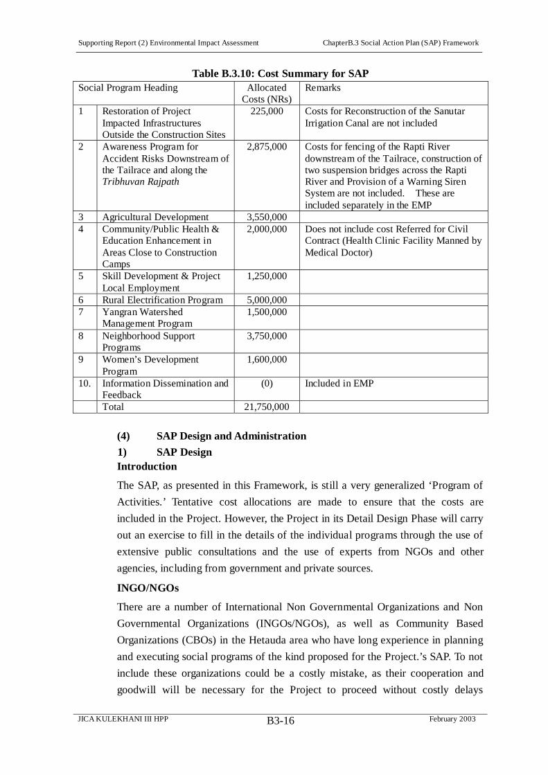
Supporting Report (2) Environmental Impact Assessment ChapterB.3 Social Action Plan (SAP) Framework
JICA KULEKHANI III HPP February 2003B3-16
Table B.3.10: Cost Summary for SAP Social Program Heading Allocated
Costs (NRs) Remarks
1 Restoration of Project Impacted Infrastructures Outside the Construction Sites
225,000 Costs for Reconstruction of the Sanutar Irrigation Canal are not included
2 Awareness Program for Accident Risks Downstream of the Tailrace and along the Tribhuvan Rajpath
2,875,000 Costs for fencing of the Rapti River downstream of the Tailrace, construction of two suspension bridges across the Rapti River and Provision of a Warning Siren System are not included. These are included separately in the EMP
3 Agricultural Development 3,550,000 4 Community/Public Health &
Education Enhancement in Areas Close to Construction Camps
2,000,000 Does not include cost Referred for Civil Contract (Health Clinic Facility Manned by Medical Doctor)
5 Skill Development & Project Local Employment
1,250,000
6 Rural Electrification Program 5,000,000 7 Yangran Watershed
Management Program 1,500,000
8 Neighborhood Support Programs
3,750,000
9 Women’s Development Program
1,600,000
10. Information Dissemination and Feedback
(0) Included in EMP
Total 21,750,000
(4) SAP Design and Administration
1) SAP Design Introduction
The SAP, as presented in this Framework, is still a very generalized ‘Program of
Activities.’ Tentative cost allocations are made to ensure that the costs are
included in the Project. However, the Project in its Detail Design Phase will carry
out an exercise to fill in the details of the individual programs through the use of
extensive public consultations and the use of experts from NGOs and other
agencies, including from government and private sources.
INGO/NGOs
There are a number of International Non Governmental Organizations and Non
Governmental Organizations (INGOs/NGOs), as well as Community Based
Organizations (CBOs) in the Hetauda area who have long experience in planning
and executing social programs of the kind proposed for the Project.’s SAP. To not
include these organizations could be a costly mistake, as their cooperation and
goodwill will be necessary for the Project to proceed without costly delays

Supporting Report (2) Environmental Impact Assessment ChapterB.3 Social Action Plan (SAP) Framework
JICA KULEKHANI III HPP February 2003B3-17
brought about, as has happened in many other Projects not only in Nepal but in
many other countries as well, by social discontent over inadequate handling of
Project social impacts and their mitigation.
During the Detail Design Phase, it is recommended to mobilize the NGOs and
CBOs working in the area to design the specific social programs as to the concepts
presented within the allocated budget framework presented here.
Specific NGOs proposed for involvement include the following:
Plan International has an eight year history in the Project area in a variety of
programs including Education, Sanitation, Integrated Forest Management
Groups, Plantation, Forestation, and Rejuvenating Degraded River Banks.
Plan International is increasingly working through local NGOs, and its local
NGO partners can be involved for the design of the Agricultural Development,
Skill Development, and Yangran Watershed Management Programs.
Rural-Urban Partnership Program (RUPP). Has created 200
micro-enterprise groups, linkages between Hetuada, Bhaise-Dhoban,
Bhimpedi – collection points for vegetable and other produce, to urban
markets. The NGO is active in eleven Wards of Hetauda, creating 10
Tole/Lane Organizations (TLOs) that, for instance, meet monthly in Ward 1
for various community development activities, such as improving drains,
sanitation, and drinking water facilities. The Rural-Urban Partnership
Program and its TLOs can be involved in the protection of water mill and
irrigation facilities in the downstream tailrace area, the Awareness Program
against Accidental Risks Downstream Tailrace and along Tribhuvan
Rajpath, and in the Agricultural Development Program, particularly in respect
to taking advantage of the new motorable bridge across Rapti River to choose
a collection point for marketing of vegetables in Hetauda, and for a produce
nitration program along Rapti River area.
Samaja Jagaran Mancha, Hetauda, Ward 1: This local NGO has number of
environmental related projects along the Rapti River in Hetauda, Ward 1. It is
involved in Income Generation Projects. This NGO can be involved in the
Awareness Program against Accidental Risks Downstream Tailrace and along
the Tribhuvan Rajpath and in the Community/Public Health & Education
Enhancement in Areas Close to Construction Camps.
Maiti Nepal has an awareness program on women trafficking and for
HIV/AIDS prevention in Bhainse and Basamadi VDCs. It also has income
generating and skill training programs for women. This organization can be
involved in the Women’s Development Program and in the

Supporting Report (2) Environmental Impact Assessment ChapterB.3 Social Action Plan (SAP) Framework
JICA KULEKHANI III HPP February 2003B3-18
Community/Public Health & Education Enhancement in Areas Close to
Construction Camps.
HIV/AIDS STD Swiss Technical Development has extensive education
materials and condom distribution program. This NGO can be involved in the
Community/Public Health & Education Enhancement in Areas Close to
Construction Camps.
Other Agencies and Organizations
The District Development Committee and the local VDCs have the main role of
planning of the local development needs in consultation with the people. They can
be involved in the Neighborhood Support Program for the affected VDCs. In
particular, their role in conjunction with the various user groups for the
Restoration of Project Impacted Infrastructure Outside Construction Sites will be
very important.
For the planning and execution of the Rural Electrification Program, Nepal
Electricity Authority has the expertise. The Rural Electrification Division of the
NEA can be involved in the preparation of the Rural Electrification program for
the proposed electrification areas.
Dissemination of information and seeking feedback is the sole responsibility of
Nepal Electricity Authority, through the Kulekhani III Project Management.
Establishment of a Public Information Center, holding regular stakeholders
meetings, and dissemination of information to the media will lie within their
purview. Other media organizations which can play roles in planning and
executing information dissemination are Manakamana FM Radio Station and
Vianet,s Internet Club on Hetauda. The possibility of a short video presentation
on Nepal TV may also be weighed.
For the details of the proposed SAP components within the Allocated Budget
Framework, a Fund (Table B.3.11) is proposed for preparing the details of the
SAP activities and costs with implementation and manning schedules, including
support materials, and program output in the Detail Design Phase.

Supporting Report (2) Environmental Impact Assessment ChapterB.3 Social Action Plan (SAP) Framework
JICA KULEKHANI III HPP February 2003B3-19
Table B.3.11: Allocated Costs for Preparation of Details of Social Programs
SAP Individual Programs Costs (NRs)
1 Restoration of Project Impacted Infrastructures outside Construction Sites (The engineers will prepare the costs during the Detail Design Phase)
(0)
2 Environmental Awareness Program against Accidental Risks Downstream Tailrace and Tribhuvan Rajpath
150,000
3 Agricultural Development 200,000 4 Community/Public Health & Education Enhancement in Areas Close to
Construction Camps 150,000
5 Skill Development & Project Local Employment 125000 6 Rural Electrification Program 250,000 7 Yangran Watershed Management Program 150,000 8 Neighborhood Support Programs 250,000 9 Women’s Development Program 125,000 10 Information Dissemination and Feedback 150,000 Total 1,550,000 Note: Program Preparation costs are estimated between 5 to 10% of the allocated budget.
2) SAP Administration
As has been the practice in Nepal, the Project itself will be responsible for
planning and implementing the SAP. In this context, the Kulekhani III Project
Management will be responsible for the implementation through its line offices
(the Environmental Division of NEA) or through a separate project specific office.
Since the NEA Environmental Division is short of manpower and resources and is
actively involved in the preparation of EIA and IEE for upcoming electricity
development projects, and involved in most of the ongoing projects, a project
specific unit will need to be established to carry out day to day environmental,
social and resettlement activities. This Project specific unit will include one
Environmental Division staff with the responsibility to streamline Project
activities as per NEA Environmental Division Policy. Various names have been
given to such units, such as the Environmental and Social Management Unit
(KESMU) for the Kaligandaki 'A' Project and the Resettlement and Rehabilitation
Unit (RERU) for the Middle Marsyangdi Project.
As with other hydropower development projects, for the Kulekhani III
Hydroelectric Project a Project specific Environmental and Social Management
Unit (KESMU) is proposed. One member from the NEA Environmental Division
will head the proposed KESMU. The KESMU will be responsible for day-to-day
environmental and social program management. It will be located under the
Project Director/Manager’s office, and logistic facilities will be provided by the
Project. There will be a full time staff delegated from NEA and a contingent of
short-term consultants for managing the various programs that are proposed.
Supporting Report (2) Environmental Impact Assessment ChapterB.3 Social Action Plan (SAP) Framework
JICA KULEKHANI III HPP February 2003B3-20
The KESMU will have a Socio-economist/Community Liaison Expert for full
time and also a Community Development Expert (CDE) as a short-term consultant,
under the KESMU’s Unit Chief, from NEA’s Environmental Division. The CDE
will work with local development NGOs contracted to assist in implementing the
several SAP components.
Internal monitoring of the SAP will be carried out by the KESMU. Little or no use
has been made in Nepal of external Monitoring and Evaluation (M&E) by
independent domestic institutions, although this is one of the main requirements of
Donors including JIBC. The Melamchi Water Supply Project has included an
independent monitoring of the Project activities once a year, and this is also
proposed for the Kulekhani III Project (see Environmental Management Plan). It
is envisaged that this M&E function will help assess ongoing SAP implementation
and assist in making necessary adjustments in strategies if the adopted ones
require reorientation. The KESMU will have included in its staff a Liaison
member, haing a natural and/or social environmental background, from the
Managing Engineer to assure that maximum coordination is achieved overall and
that, especially, contractors are observant of KESMU directives during the
Project’s construction period.
Supporting Report (2) Environmental Impact Assessment ChapterB.4 Public Consultation Program
JICA KULEKHANI III HPP February 2003B4-1
CHAPTER B.4 PUBLIC CONSULTATION PROGRAM
B.4.1 Background
Discussions with the project affected people on the matters of project, its adverse
and beneficial impacts, and on the matters of mitigation and monitoring options
including environmental enhancement opportunities and programs in order to
come into a consensus understanding through Public Consultations, is a legal
requirement of Nepal's Environmental Protection Act (1996) and Environmental
Protection Rules (1997). JBIC (2002) Guideline for Confirmation of
Environmental and Social Consideration also emphasize on the need of public
consultation to strengthen the environmental and social aspects of the Project.
The Nepal Electricity Authority (NEA), in the process of the Environmental
Impact Assessment (EIA) of the Kulekhani III Hydropower Project (2001) had
held a series of public consultation meetings both at the field and central levels.
During this Upgrading Feasibility Study Phase, the Study Team has carried out
two Stakeholder’s Meetings, the first on May 5th in Bhaise VDC and the second
one in Hetuada Municipality on June 24th.
B.4.2 First Public Consultation Meeting
About 40 persons, including affected VDC officials, teachers, and a number of
villagers from Nayagaon village, Bhaise VDC, Ward 8, attended the first Public
Consultation Meeting of May 5th 2002. Details of the meeting outcome and
member attendee are presented in Annex 12. One of the key issues discussed
was the type and nature of assistance from the project to the local communities to
minimize the project-related impacts and to maximize the Project benefits. Most
of the members present expressed that it would be very difficult to list the type of
assistance without further discussions with the other members of communities not
present in the meeting. Further they would like to know more from the technical
experts on the type and nature of the Project direct and indirect impacts. They
wanted more time for discussion with the other members of the affected
communities so as to give their suggestions. They emphasized on the need of such
consultation meetings at the grass root village levels. However, members of
Nayagoan Village presented a list of ‘felt needs,’ below, for which it would seek
Project assistance:
Provision of Drinking Water Facilities;
Employment for Local People in the Project, According to their
Qualifications;

Supporting Report (2) Environmental Impact Assessment ChapterB.4 Public Consultation Program
JICA KULEKHANI III HPP February 2003B4-2
Construction of a School;
Construction of a Road;
Compensation for Houses Cracked or Damaged by Project Activities,
Particularly by Blasting;
Electrification of Ward No.8 as a Whole; and
Housing Facilities for the Schoolteacher
The general mood of the attendee was positive towards the Project. Though agreed
areas were not identified for Project assistance, there was consensus among the
present members that project should also look positively for the social
development of the communities of the Project area and not only of the directly
project affected people. Local employment, education, rural electrification, and
health and hygiene were among the issues raised by most of the members where
the communities need project assistance for the overall development of the Project
area.
B.4.3 Second Public Consultation Meeting
The second stakeholder’s Public Consultation Meeting was held at Hetauda
Municipality, in the Avocado Motel’s conference hall on 24th June 2002.
Approximately 130 attendees representing a wide cross section of officials,
military, NGOs, and affected communities were present in the meeting. The Study
Team, introduced by its NEA counterpart, presented a PowerPoint presentation of
the Project proposed design and its expected social impacts. Attendees were
registered and issues recorded, after a long and lively discussion following the
presentation (Annex 12).
Key issue raised in this consultation meeting were:
Effect to the downstream irrigation facilities and measures to ensure the water
supply in the irrigation canals
Effect to the Sanutar irrigation canal and measures to ensure the water supply
to irrigate Sanutar - Ghumaune agricultural fields
Measures to ensure local employment in the proposed Project
Downstream effect to the communities using river area of Rapti for various
purpose and mechanism to ensure public safety in the event of high water
discharges from the tailrace
Effects to community forest and measures to compensate the Community
Forest User Groups.
Compensation and rehabilitation issues for the people whose land and
property will be acquired by the Project.
Based upon the past experiences of promises and its implementation practices by

Supporting Report (2) Environmental Impact Assessment ChapterB.4 Public Consultation Program
JICA KULEKHANI III HPP February 2003B4-3
the Project proponents, many of the members doubted on the sincerity of the
Project proponent in dealing with the local issues once the project is approved for
implementation. They also warned that without addressing the local people's
aspirations, it would be difficult to launch the Project.
However, the general consensus was positive for the Project in the context of
current energy demand, but were in view that the Project should not disregard the
contribution of the local people of their personal and community resources for
Project implementation. All the communities and people who have contributed to
the Project should be compensated adequately by the project. Besides, Project
should also launch programs for the development of the local area and help for the
betterment of the local people's quality of life.
B.4.4 Consultation with Individual and Groups
The Study Team has held numerous meetings with the several Project
Stakeholders in the Hetauda and Project area, particularly with Government
officials, the military camp at Suparitar, local formal and informal leaders, and the
numerous NGOs that are based in Hetuada. The Study Team has also met with a
wide variety of officials and affected peoples, including the Chief District Officer
of Makwanpur, the Mayor of Hetauda, the Chairman of Hetauda’s Ward 1 (the
ward most affected), Irrigation User Group members of possibly affected schemes,
and others. Annex B.10 lists the individuals and groups consulted and issues
discussed and observations made by the Study Team.
During the socioeconomic studies, the Study Team has asked Sanutar villagers for
their development priorities. Priority list expressed by the local communities are
presented below:
Sanutar Village’s Felt Needs
Electrification
Telephone service
Post office (local students who go to Bhaise and Hetauda bring letters from
the post office )
Health post (nearest health post is Bhaise and Hetauda, Common disease of
the area is fever, Pneumonia, dysentery)
Similarly, the Heatuda Mayor and chairman of municipality ward 1 have
expressed the following priority lists as project enhancement measures (Box 3).
Hetauda Ward 1 Felt Needs
Embankment Chauki Tole to the High way bridge
Suspension bridge to link Hetauda with Maintar

Supporting Report (2) Environmental Impact Assessment ChapterB.4 Public Consultation Program
JICA KULEKHANI III HPP February 2003B4-4
Sanitation program in Ward No. 1
Improvement of facilities of Jyoti Primary school at Chauki Tole
Improvement of Maranghat [Cremation] Ghats at Hetauda Highway Bridge
Other issues discussed in these meetings with the diverse stakeholders were:
Modalities of public consultation process in the context of the present security
situations, Chief District Officer (CDO), Makawanpur District)
Security provisions during construction phase (Military officials and Police)
Impacts to the Trikhandeshwor Mahadev Temple by diversion of Kulekhani
II discharges, Pujari (priest) of the Temple)
Downstream Impacts to irrigation canals, Water User Committee and
beneficiary farmers
Flood effects to the low lying irrigation lands of Maintar, Chaukitole,
Laljhundi and downstream areas, current practices adopted by the farmers,
and status of land registration, Farmers of the said areas
Areas of activities launched by various NGOs, CBOS and private
organization in the project areas and their interest to work with the project's
SAP Framework, Plan International, Maiti Nepal, Smaj Jagaran Manch,
Rural-Urban Partnership Program, HIV/AIDS STD Swiss Technical
Development, and HCIL.
The Public Consultation Meetings in the future will need to be arranged with the
approval of the CDO with prior notice to the security authorities in the present
security context. Regular interaction with the security authorities is envisaged to
monitor security problems during the construction period. Discussion with the
pujari (priest) of the Trikhandeshwor Temple revealed no impact to the temple’s
religious activities due to Project operation. All the downstream Water User's
Committees and farmers expressed concern about the Project’s water regulation
impacts on their irrigation intakes and on their agricultural productivity. They
emphasized the need to ensure irrigation water requirements are met, so as to
maintain their agricultural productivity during the Project operation period.
The farmers of the low-lying irrigation canal revealed the effect of floods to their
agricultural lands in every 5 to 15 years. They were not sure about the increased
effect of the Tailrace release but wanted some kind of protection against the
monsoon floods. The agricultural land on the island like sand bar of the Rapti
River has not been irrigated since 1993 flood, though subsequent floodwaters have
not inundated the sand bar. The farmers who own the land have heard about the
numbering of cadestral plot number by the land registration office, but the office
has not issued the land registration certificates to the land owners. When asked

Supporting Report (2) Environmental Impact Assessment ChapterB.4 Public Consultation Program
JICA KULEKHANI III HPP February 2003B4-5
about their future plan to irrigate the land, they said they are not sure of the next
flood and are afraid that their land development labor may be a waste.
Consulted NGOs, CBOs and the private parties were willing to co-operate the
project in the implementation of Social Action Plan Framework during the Project
implementation phase. But when requested to provide Social Action programs in
their field of expertise and work area only few could come up with some kind of
proposal.
B.4.5 Public Consultation Strategy
Although there has been considerable progress made by the Study Team in public
consultation, the effort has somewhat insufficient due to various reasons such as
monopolizing of discussion by Hetauda political elites, frequent electric stoppages
during the Powerpoint presentation, lack of resources for assisting villagers from
the affected VDCs to reach consultation venue, lack of budget for important
materials such as brochures, posters, flip chart equipment, lack of sufficient
advance notice of meetings, especially for going through formal channels to make
the stakeholder meetings in any way ‘official,’ and the like.
It is important to carefully plan for and budget the next phase of the Public
Consultation, during the Detailed Design Study. It is recommended to have three
stakeholder Public Consultation Meetings held in Hetauda. One should be at the
beginning and reiterate the findings of the feasibility stage studies. The second
meeting should come approximately six months into the next phase studies to
present inception findings and obtain public feedback. The third and final
meetings should present the final study findings.
The Hetauda stakeholder Public Consultation Meetings will need to be set up
through the Chief District Officer’s (CDO’s) office and sufficient time allotted
both to accommodate this formal process and to assure all attendees have adequate
advance notice. It is recommended that sufficient budget is allotted to produce
brochures and posters, as well as to have flip chart equipment, for these meetings
to properly record issues and recommendations. Preparation of PowerPoint
presentations is recommended. However, it will be a good idea to rent a small
back up generator for assuring an uninterrupted supply of electricity during the
presentations. Adequate budget for refreshments is recommended for about 200
attendees per meeting, as well as for conference hall rental. Finally, it will be an
important courtesy to the village attendees to rent at least one van or small bus to
assist the villagers in coming to and returning from Hetauda.
Experience in other development projects has shown the importance of a
Supporting Report (2) Environmental Impact Assessment ChapterB.4 Public Consultation Program
JICA KULEKHANI III HPP February 2003B4-6
continuing and complete documentation of the public consultation process.
Therefore, it is recommended to maintain documentation files of the consultation
meetings that will include a detailed account of public meetings and other
stakeholder interactions, including photographs, issues discussed, decisions
reached and the like in chronological order from now on words. Such
chronological recordings should continue not only in the detail design phase but
also during project construction and operation.
Future consultation meeting in the detail design phase should plan to include
peoples from all walks of life from the following affected VDCs:
Bhaise VDC Wards 1, 3, 8 and 6
Nebuwatar VDC (Kulekhani II Camp Area)
Basamadi VDC Wards 9 and 8
Hetauda VDC Wards 1 and 11
Other stakeholders that need to be included are:
Chairman and other public elected representatives Bhaise VDC
Chairman and other public elected representatives Nibuwater VDC
Chairman and other public elected representatives Basamadi VDC
Mayor and other public elected representatives Hetauda Municipality
Chairmen Irrigation Water User's Committee at Sanutar, Maintar, Chaukitole,
and Basamadi
Chairmen Community Forest User's Committee, Kalika and Bokedaha
Community Forest
Chairman and public elected Elaka representatives of the above VDCs
Makawanpur District Development Committee (DDC)
CDO, Makawanpur District
Local Development Officer (LDO), Makawanpur DDC
Officer In Charge, District Forest Office, District Education Office, District
Agricultural Office, District Health Office, District Water Supply Office, and
District Irrigation Office
General Manager, and Mines Manager, Hetauda HCIL
INGOs/NGOs working in Hetauda, such as Plan International, Maiti Nepal,
Smaj Jagaran Manch, Rural-Urban Partnership Program, HIV/AIDS STD
Swiss Technical Development
CBOs working in the Project affected VDCs, Lane/Tole Organizations
(LTOs), and Village Advisory Groups (VACs)

Supporting Report (2) Environmental Impact Assessment ChapterB.4 Public Consultation Program
JICA KULEKHANI III HPP February 2003B4-7
Representatives of the News media, National Daily News Papers and
Television, Local News Papers, and Hetauda based Manakamana FM,
Internet Service providers
Chief of Army Staff Suparitar Military Camp
Chief of Armed Police Makawanpur District
Chief of Police Makawanpur District
As women are among the more vulnerable of the Nepalese society, so special
consultation programs will need to be organized for the women. This is not just to
protect them from adverse Project impacts but also to gain their support for the
Project’s activities, as experience with other Projects shows that often this is
where public discontent begins, when women are not properly informed and their
understanding and support obtained. At least female staff member will be required
during the next study phase for organizing such programs, to ensure that these
critical stakeholders are fully informed and allowed sufficient opportunity to voice
their concerns and to provide feedback to the Project. Without this, social
problems may arise unexpectedly later on in the Project construction and
operation, when it will be more difficult to address them.
Presentations of issues to be discussed in the Public Consultation Meetings will
need to be prepared in advance. Some of the key issues for discussions in the next
phase of consultation are as follows:
Project Layout – The Mapping/GIS illustrating the Final Design layouts. Local
communities will be interested in knowing what the Project will ‘look like,’ as
well as how it will operate and to what benefit for Nepal.
Project Design Schedule and Process – A question that arises frequently is
‘when will construction begin?’ The consultation will explain the processes of
feasibility, basic, and final design phases, and especially how long these design
phases will take, so that the APs, stakeholders and the communities at large
understand that the process is still in an early stage and that at some point – 3-4
years – The Project activities will become more definite. The Public will need to
know what to expect and when.
Possible Project Impacts – These need to be explained in mass and in person
with graphic displays and feedback sought.
Land Acquisition and Resettlement - Peoples are interested to know whose land
and property is likely to be impacted and what are the modalities of compensation
and rehabilitation. Brochures explaining the Land Acquisition Act (LAA) and the
proposed Community Consensus Valuation (CCV) and its methodology will be
Supporting Report (2) Environmental Impact Assessment ChapterB.4 Public Consultation Program
JICA KULEKHANI III HPP February 2003B4-8
prepared for distribution to APs including other rehabilitation packages to the Aps
and feedback sought.
SAP Framework - People will be interested to know what other development
benefits will the project offer to them. How these development plans will be
implemented. Brochures explaining type of development programs, area coverage,
co-ordination with the beneficiaries and local institutions, and type of
development program and process of program design and implementation need
explanations and feedback.
In addition to the above formal consultation process, it is recommended to
disseminate information to the local area people and outside by the use of media.
The consultation media type and its placement for maximum public consultation
is recommended as below:
Vianet’s Internet Club on Hetauda’s Main Road – This commercial
establishment provides services for developing a web page, a CD presenting the
Project in an illustrated PowerPoint format, brochures, on annual fee basis for the
use of their facilities. The establishment has good accessibility and using a local,
Hetauda firm for developing such multimedia materials may provide good public
relations. This multimedia approach fits the requirements of many of Hetauda’s
municipal stakeholders, where a ‘wired’ community is considered a valued
community attribute. Hetauda’s existing web pages, for instance, advertise the
community’s environmental awareness and achievements, and free community
Internet access was a featured part of a recent festival held in the city.
Posters, Photos and CD may be placed at Vianet and at DDO’s District
Information Center, as well as in PICs in Sanutar and Bhainse-Dhoban. The
District’s official Web Page currently under construction and existing private ones
may be linked to Project’s Web Page. A PIC at NEA in Kathmandu may be
explored
Manakamana FM Station provide commercial service to disseminate
information and awareness programs related to Project, potential environmental
impacts and precaution measures to be adopted by affected communities.
TV – Hetauda receives two Nepal TV channels, and there are battery-operated
village TVs, for instance at least one observed in Sanutar
Physical Model –Construction of a to the scale physical model to illustrate the
Project. The Melamchi Water Project had such a scale model at a recent
international water resources conference held in Kathmandu and other Projects
have effectively utilized such models. This may provide a highly mobile way to
demonstrate Project’s workings to the affected municipal and rural communities,
especially to those who are not literate.

Supporting Report (2) Environmental Impact Assessment ChapterB.4 Public Consultation Program
JICA KULEKHANI III HPP February 2003B4-9
Normally public consultations are arranged in one central location. Due to various
reasons, participation in such meetings from the common walks of life is not
always possible. Their concerns and feedback are usually left out and only the
concerns of the village elite and rich are reflected in such central location
meetings. While central location meetings are important to get consent of the
HMG officers, INGOs, DDC and VDC office bearer's, the village level
consultation meetings are very important to get feedback from the directly
affected communities and persons. Hence besides central level consultations at
Kathmandu and at Hetauda, it is recommended to conduct consultation meetings
at the following location at village levels:
Sanutar/Gumaune/Shikarbas Villages – These three villages will bear the most
direct construction effects, from the Access Road to construction camps.
Kisedi Village – This is also a part of Bhainse, Ward 6, is probably where the
Reservoir Area will impinge.
Bhainse-Dhoban and Nibuwatar – A number of Construction ‘footprints’ such
as head works, work aadit, construction camps, store yards etc locates in this area.
Construction traffic between the Intake Area and Nibuwater, where NEA will put
its construction camp in the existing NEA facilities used for Kulekhani II, will be
greatly increased.
Bokheda – The Community Forest in Bhokhada is affected by the project, and
some land will be acquired for the Tailrace Outlet. Besides irrigation water issue is
a major concern of the area.
Hetauda Ward 1 – About 4 km stretch of the Rapti River will be affected by the
Tailrace Outlet water releases, up to the Hetauda Bridge. Also, irrigation intakes
and the erosion of agricultural land will be an issue of concern in this area.
Last but not the least it is recommended to establish a Public Information Center
(PIC) at various locations of the Project site. Recommended sites for such PICs
are:
District Information Center, District Development Committee (DDC) Office,
Hetauda
Commercial Internet providers on the main road, Hetauda
Sanutar School, Sanutar
Bhaise VDC Office at Bhaise
Basamadi VDC School at Ward 9

Supporting Report (2) Environmental Impact Assessment ChapterB.4 Public Consultation Program
JICA KULEKHANI III HPP February 2003B4-10
In addition to the above, NEA’s PIC at Kathmandu will also provide information
with regard to the Project. The PICs at local level will display project layouts,
posters, photographs and will supply, as requested, relevant brochures.
The Study Team has also noted that there is an ADB Urban and Environmental
Improvement Project expected to be implemented in Hetauda during the
Kulekhani III detailed design and construction phases, and efforts have already
been made to liaise with the designers and implementers of this project to assure
maximum compatibility in project components that closely overlap with the SAP.
The following Figure B.4.1 is a graphic representation of the proposed
Consultation Strategy.
B.4.6 Cost for Public Consultation
The cost proposed here is for the public consultation during the Detail Design
Phase. As mentioned before at least three Public Consultation Meetings will be
arranged during the Detail Design Phase.
The first Public Consultation Meeting will present the feasibility stage findings.
The feedback obtained will be incorporated in the Final Design RP, SAP
Framework, and EMP.
The second Public Consultation Meeting will present the proposed modifications
of the Project’s Final Design, again for constructive feedback to be taken into
account during the final stages of the Detail Design Phase fieldwork for
incorporation into the Final Design and Planning documents.
The third Public Consultation Meeting will present the final study findings, in
particular the proposed final versions of RP, SAP, and EMP.
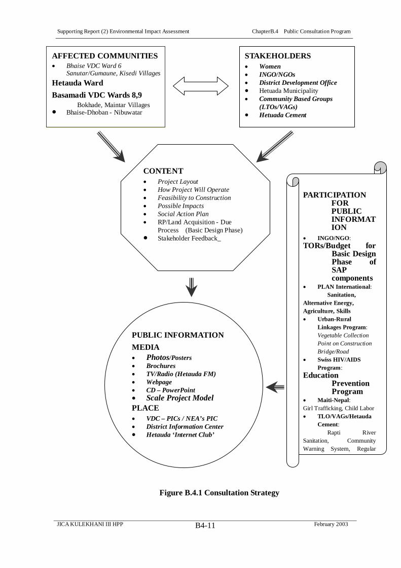
Supporting Report (2) Environmental Impact Assessment ChapterB.4 Public Consultation Program
JICA KULEKHANI III HPP February 2003B4-11
Figure B.4.1 Consultation Strategy
CONTENT Project Layout How Project Will Operate Feasibility to Construction Possible Impacts Social Action Plan RP/Land Acquisition - Due Process (Basic Design Phase)
Stakeholder Feedback_
AFFECTED COMMUNITIESBhaise VDC Ward 6 Sanutar/Gumaune, Kisedi Villages
Hetauda Ward
Basamadi VDC Wards 8,9Bokhade, Maintar Villages
Bhaise-Dhoban - Nibuwatar
STAKEHOLDERS Women INGO/NGOs District Development Office Hetuada MunicipalityCommunity Based Groups (LTOs/VAGs) Hetuada Cement
PARTICIPATION FOR PUBLIC INFORMATION
INGO/NGO:TORs/Budget for
Basic DesignPhase of SAP components
PLAN International:Sanitation,
Alternative Energy, Agriculture, Skills
Urban-Rural Linkages Program:Vegetable Collection Point on Construction Bridge/RoadSwiss HIV/AIDS Program:
Education Prevention Program
Maiti-Nepal:Girl Trafficking, Child Labor
TLO/VAGs/Hetauda Cement:
Rapti River Sanitation, Community Warning System, Regular
PUBLIC INFORMATION
MEDIA Photos/Posters Brochures TV/Radio (Hetauda FM) Webpage CD – PowerPoint Scale Project Model
PLACE VDC – PICs / NEA’s PIC District Information Center Hetauda ‘Internet Club’
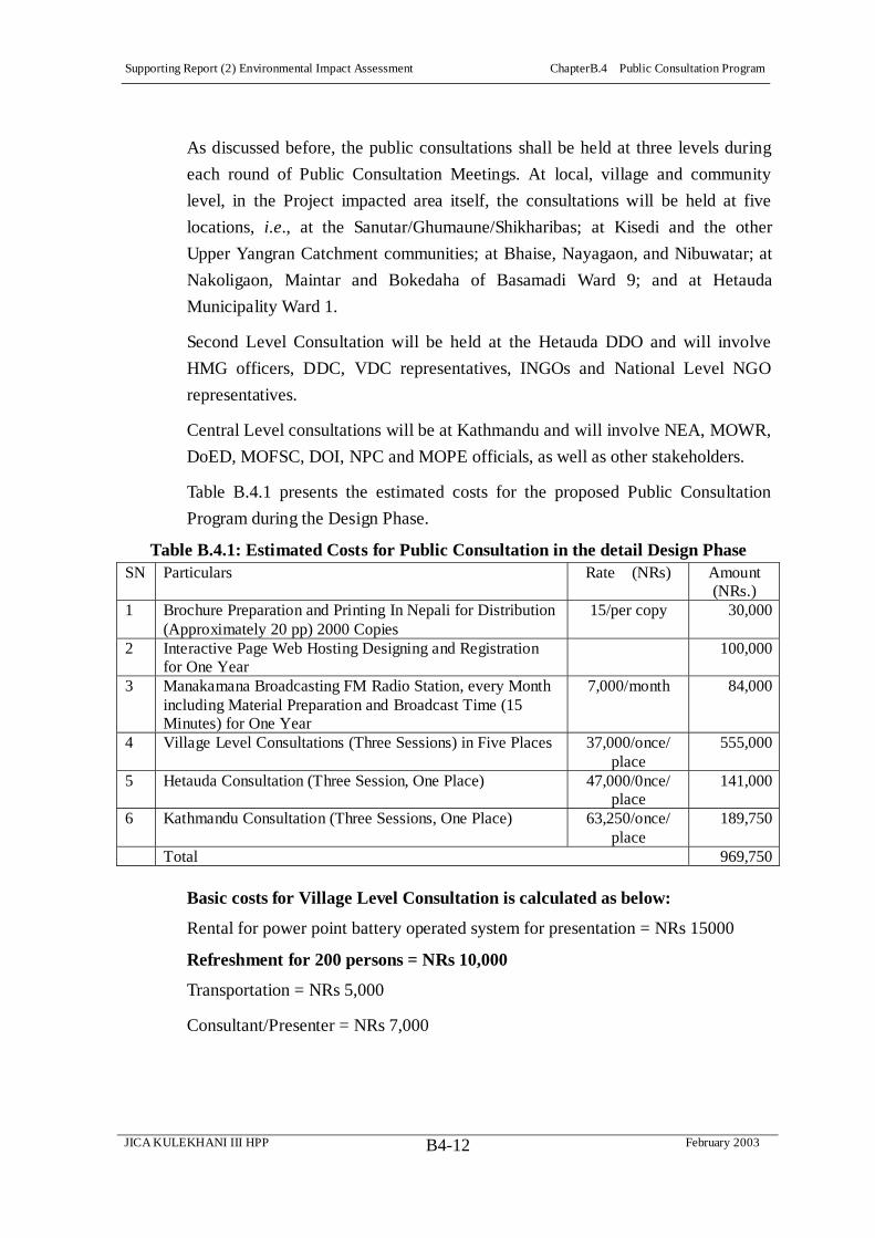
Supporting Report (2) Environmental Impact Assessment ChapterB.4 Public Consultation Program
JICA KULEKHANI III HPP February 2003B4-12
As discussed before, the public consultations shall be held at three levels during
each round of Public Consultation Meetings. At local, village and community
level, in the Project impacted area itself, the consultations will be held at five
locations, i.e., at the Sanutar/Ghumaune/Shikharibas; at Kisedi and the other
Upper Yangran Catchment communities; at Bhaise, Nayagaon, and Nibuwatar; at
Nakoligaon, Maintar and Bokedaha of Basamadi Ward 9; and at Hetauda
Municipality Ward 1.
Second Level Consultation will be held at the Hetauda DDO and will involve
HMG officers, DDC, VDC representatives, INGOs and National Level NGO
representatives.
Central Level consultations will be at Kathmandu and will involve NEA, MOWR,
DoED, MOFSC, DOI, NPC and MOPE officials, as well as other stakeholders.
Table B.4.1 presents the estimated costs for the proposed Public Consultation
Program during the Design Phase.
Table B.4.1: Estimated Costs for Public Consultation in the detail Design Phase SN Particulars Rate (NRs) Amount
(NRs.) 1 Brochure Preparation and Printing In Nepali for Distribution
(Approximately 20 pp) 2000 Copies 15/per copy 30,000
2 Interactive Page Web Hosting Designing and Registration for One Year
100,000
3 Manakamana Broadcasting FM Radio Station, every Month including Material Preparation and Broadcast Time (15 Minutes) for One Year
7,000/month 84,000
4 Village Level Consultations (Three Sessions) in Five Places 37,000/once/ place
555,000
5 Hetauda Consultation (Three Session, One Place) 47,000/0nce/ place
141,000
6 Kathmandu Consultation (Three Sessions, One Place) 63,250/once/ place
189,750
Total 969,750
Basic costs for Village Level Consultation is calculated as below:
Rental for power point battery operated system for presentation = NRs 15000
Refreshment for 200 persons = NRs 10,000
Transportation = NRs 5,000
Consultant/Presenter = NRs 7,000
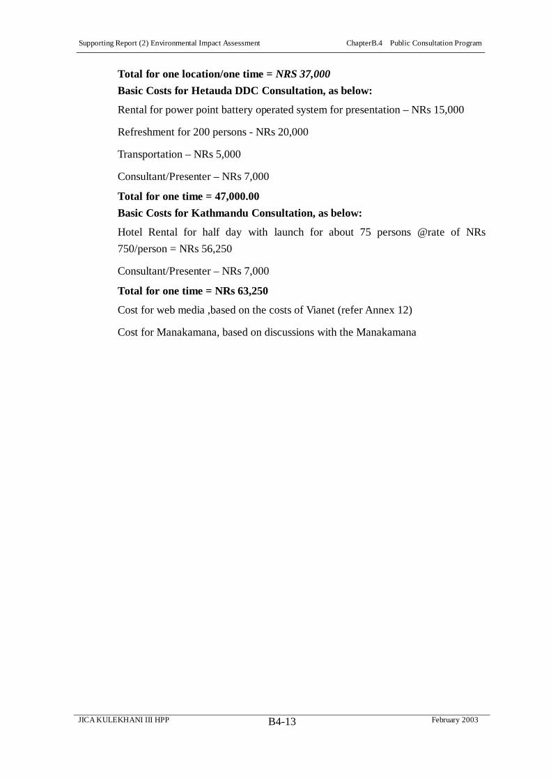
Supporting Report (2) Environmental Impact Assessment ChapterB.4 Public Consultation Program
JICA KULEKHANI III HPP February 2003B4-13
Total for one location/one time = NRS 37,000
Basic Costs for Hetauda DDC Consultation, as below:
Rental for power point battery operated system for presentation – NRs 15,000
Refreshment for 200 persons - NRs 20,000
Transportation – NRs 5,000
Consultant/Presenter – NRs 7,000
Total for one time = 47,000.00
Basic Costs for Kathmandu Consultation, as below:
Hotel Rental for half day with launch for about 75 persons @rate of NRs
750/person = NRs 56,250
Consultant/Presenter – NRs 7,000
Total for one time = NRs 63,250
Cost for web media ,based on the costs of Vianet (refer Annex 12)
Cost for Manakamana, based on discussions with the Manakamana

Supporting Report (2) Environmental Impact Assessment ChapterB.5 Further Studies – Detailed Design Phase
JICA KULEKHANI III HPP February 2003B5-1
CHAPTER B.5 Further Studies – Detailed Design Phase
The following are studies required for the next stage, under categories of RP and
SAP.
Resettlement Plan
Plane Table Survey of Agricultural Plots & updating of household records &
GIS Natural and Social Environment Map, also using records obtained from
Tax Office (Mal Addha) and District Survey Office, to prepare for Detailed
Measurement Survey
Detailed Measurement Survey (DMS) when Detailed Design is completed,
for updating and finalizing the RP
Social Action Plan (SAP) Framework
Strengthening the Urban-Rural Linkage in Rural Development of the Kulekhani
III Project Area, to explore both existing and potential economic activities related
to rural-urban linkage development, particularly as a spur to agricultural
development in the Project Affected Area and its surroundings. Includes GIS
Tracking survey of foot traffic for proposed Choki Tole suspension Bridge (and
for feasibility of relocation of Sanutar’s suspension Bridge) and for assessing
economic impact of Project’s motorable bridge over Rapti River, possible
development commercial nucleus (produce collection center, bus stand) on spoil
site at Sanutar
Survey of irrigation and water mill water diversion downstream Tailrace, updating
information from July 2002 floods, including survey of type and volume of
agricultural produce in downstream irrigation. And economies of water mills
Preparation of Social Program Details, with NGO involvement

Supporting Report (2) Environmental Impact Assessment ChapterB.5 Further Studies – Detailed Design Phase
JICA KULEKHANI III HPP February 2003B5-2
B.5.1 COSTS
Table B.5.1: Social Environmental Mitigation and Monitoring Plan – Summary of
Costs – Kulekhani III HEP, Preparation and Construction Phases Description Frequency/Unit Unit Costs Costs NRs
1. PROJECT DESIGN & PRE-CONSTRUCTION PHASE 1.1 Resettlement Plan (RP) Plane Table Survey – Agri. Plots & updating HH records & GIS map, from Tax Office (Mal Addha) to prepare for DMS
1.5 mos. Lump Sum 50,000
Detailed Measurement Survey (DMS) – when Detailed Design is completed & Updating RP
3 mos. Lump Sum 500,000
Sub Total 550,000 1.2 Social Action Plan (SAP)GIS Tracking survey of foot traffic for proposed 2 susp. Bridges and for econ. Impact of Project’s motorable bridge – Rapti River
1 month Dry & 1 month Wet Season
Lump Sum 75,000
Survey irrigation and water mill water diversion downstream Tailrace
1 month Dry & 1 month Wet Season
Lump Sum 50,000
Survey type and vol. Of agri. Produce – downstream irrigation.
1 month Dry & 1 month Wet Season – Harvest periods
Lump Sum 50,000
Preparation of Social Program Details 5-10% of SAP Allocated Costs
1,550,000
Sub Total 1,725,000 1.3 Public Consultation Brochure Preparation & printing in Nepali for distribution
Approximately 20 pages, 2,000 copies
15NRs/copy 30,000
Interactive Web page hosting designing & registration
One year 100,000
Manakama FM Radio Broadcasting, Incl. Material preparation.
12 Mo/15 min 7,000/Mo 84,000
Village Consultations 3 sessions in 5 VDCs 37,000/once/Place 555,000 Hetauda Consultation 3 sessions, 1 place 47,000/Once/Place 141,000 Kathmandu Consultation 3 sessions, 1 place 63,250/Once/Place 189,750 Sub Total 1,099,750 Total 3,374,750
(To be continued)

Supporting Report (2) Environmental Impact Assessment ChapterB.5 Further Studies – Detailed Design Phase
JICA KULEKHANI III HPP February 2003B5-3
(Continued) 2.CONSTRUCTION PHASE – 4 YEARS 2.1 Resettlement Plan (RP) Compensation for private land 6 Ha. Khet (Irrig) Land
9 Ha Bari (Non-Irrig) Land
Khet (Irrig) land 2,000,000NRs/Ha Bari (Non-Irrig)
1,500,000 NRs/Ha (Negotiated cost for any
temporary acq.)
25,500,000
Transfer fee for buying replacement land Provisional Lump Sum 1,897,200 Compensation for Privately Owned Trees 3,255 trees – 11 varieties Rates calculated for each
variety of tree 5,491,060
Compensation for Houses 26 Houses 226,950 NRs average/House
5,900,700
Compensation for Sheds 29 Sheds 10,483 Nrs average/Shed 304,000 Compensation for Community Structures Provisional Lump Sum 100,000 Displacement Allowance 24 HHs 1,500 Nrs/Person @ 6
Person/HH 648,000
Rental Stipend 24 HHs NRs 3,000/mo*6mo 432,000 Cultivation Disruption Allowance 12 HHs 12HH*annual paddy
0.323 kg/ha*NRs 20/kg 144,000
Transportation Allowance 24 HHs NRs5,000/HH 120,000 House Plot Grant 24 HHs NRs 50,000/HH 1,200,000 Sub Total 41,736,960 2.2 Social Action Plan (SAP) Improvement of intakes for 5 water mill canals
5 Canal Intakes 25,000/canal 125,000
Design & construction 3 Irrigation Canals 3 Irrigation Canals 2,000,000/canal 6,000,000 Improvement intakes for 3 irrigation canals downstream tailace
3 Canal Intakes 33,000/canal 100,000
Constr. of 2 Susp. bridges @ Maintar & Chaukitole - Rapti River
1 Suspension Bridges on Rapti
NRs 15,000,000 each 15,000,000
Awareness Program – Accidental Risks Downstream Tailrace, Tribhuvan Highway
Riverbank sanitation, traffic signs; traffic and tailrace public education
Provisional Lump Sum 2,875,000
Agricultural Development – Veg. Produce Pickup Center & Bus Stop
3 Components - Downstream Tailrace,
Project Area at Sanutar, Yangran Hinterlands
Provisional Lump Sum 5,000,000
Community/Public Heath & Education Enhancement
Water Supply, Schools, Clinic, STD/Aids, Malaria
Education
Provisional Lump Sum 2,000,000
Skill Enhancement Skill Survey & Training Provisional Lump Sum 1,250,000Rural Electrification 20 Km TL length – 4
Wards Provisional Lump Sum 5,000,000
Neighborhood Support Matching Community Development Funds – 5
Wards
Provisional Lump Sum 3,750,000
Women’s Development Skill Training, Micro-Credit Funds,
Public Health Education
Provisional Lump Sum 1,600,000
Sub Total 42,700,000 2.3 Public Consultation Information Dissemination & Feedback Public Information Center,
Radio, Internet Provisional Lump Sum 1,286,000
Total Costs 85,722,960 3. TOTAL COST OF SOCIAL IMPACTS & MITIGATION PROGRAM - NRs 89,097,710

Explanation of Results of the Supplemental EIA Survey compared with the Check Sheet in the JBIC Guideline Check Items for ODA Loan
Dam Construction Project Results of the Supplemental Environmental Impact Assessment Survey
(the Supplemental EIA Survey) I. Gaining stakeholders’ participation and
understanding of the project The impacts on the social environment by implementing the Project are resettlement and land acquisition in Sanutar and Gumaune Villages, the Yangran regulating pond area, and the tailrace outlet. Resettlement and land acquisition are estimated at 25 households and 15 ha. The direct project affected families (PAFs) are 97 households, and 604 persons, while ethnic minorities are included in the direct PAFs.During the Upgrading Feasibility Study of the Project, two Public Consultation Meetings were held on May 5 2002, and June 24, 2002 by attendance of 40 and 130 concerned persons (direct affected families, affected VDC officials, teachers, and local NGOs). The main features, implementation schedule, and impact on social environment by the Project are explained in these meetings. As a result of these public consultation meetings, three Stakeholder’ meetings are recommended during next stage of detailed design for implementing the Public Consultation Program (Refer to Section 4.6)As a result of two Public Consultation Meetings, it was concluded that three Stakeholders’ meetings should be carried out during the detailed design.
II. Examination of comprehensive alternatives, consultation with stakeholders
Through the project optimization study of the Project, three alternatives are studied: Alternative 1 is the regulating dam type pond + underground powerhouse, Alternative 2 is the underground type pond + underground powerhouse, and Alternative 3 is the dispersion type regulating pond + underground powerhouse. The results of the study on the optimum project layout selects Alternative 1 of the regulating dam type pond and underground powerhouse (refer to Section 6.3). Resettlement is a livestock house only in the regulating pond. The optimum project layout of main structures in the Project is selected so as to minimize the resettlement and land acquisition. As a result, the major impact on the social environment is led by construction of the access road. The Environmental Impact Assessment carried out by NEA in 2001 was approved by the MoPE in March 2002 through evaluation of NEA’s evaluation committee. The Supplemental Environmental Impact Assessment (Supplemental EIA) aims at supplementing the existing NEA’s EIA. The result of the supplemental EIA reports that there is a local information of existence of Leopard in the basin area of the regulating pond. Though this existence is not verified by the supplemental EIA, it will be surveyed by the Environmental Monitoring Plan (EMP) proposed by this Draft Final Report. Common Langur (Cites I), Yellow throated marten (Cites III), Rhesus macaque and Rat snake (Cites II) and Otter (IUCN/K) are common to all areas surveyed and similar habitats throughout Nepal, frequenting the agriculture fringe areas. It is noted that Cites I: threatened with extension, Cites II: species not threatened with extinction but could become so, and Cites III: species requiring international cooperation to control trade.
III. Setting maintenance flow, maintaining productive fisheries, and preparing reservoir operating rules
The study of the river maintenance flow in the Yangran River, on which the regulating dam will be constructed, referred to the existing concepts in the Medium Hydropower Project Study and the Melamchi Water Supply Project. A guideline in Nepal, ‘Aquatic Animals Protection Act, 2001’, and several related standards in Japan were also referred. As a result, the maintenance flow was proposed to be 0.1 m3/s in the dry season and 0.3 m3/s in the wet season by applying the 90 % dependable discharge in each season as the minimum requirement for keeping the aquatic life in addition to the irrigation water use of 0.04 m3/s.
IV. Analysis of and consideration of impacts on project affected people (PAP)
An inventory survey was carried out to identify households and land acquisition in the project area as a part of the supplemental EIA survey fieldwork. The Resettlement Plan (RP) was developed and proposed in accordance with principles of the ‘Land Acquisition Act 2034, 1977’ (LAA) in Nepal and ADB’s guidelines, ‘Handbook on Resettlement’ (refer to section 4.5.2 and Table 4.5.3). Also the Social Action Plan (SAP) was formulated to mitigate the anticipated several impacts on the communities affected by the Project (refer to section 4.5.3 and Table 4.5.4).
V. Ensuring compliance On the implementation of the Project, the Nepal Electricity Authority (NEA) will take the responsibility for social environmental and natural environmental matters. The Environmental Management Plan (EMP) was proposed to implement the four major plans smoothly, namely resettlement, social action plan, monitoring, and mitigation measures. The EMP will be conducted for the Pre-Construction and Construction Phases by coordination of the Kulekhani Environmental and Social Management Unit (KESMU) with NEA, the Project’s supervising consultant, stakeholders of the Project including NGOs.
VI. Agreement among relevant nations for projects involving an international river
The Project is of a run-of-river scheme without involving of an international river and also not causing changes of the reservoir basin.

AnnexPart B

Supporting Report (2) Environmental Impact Assessment Annex B1 References
JICA KULEKHANI III HPP February 2003 BX-1-1
Annex B1 References
Documents Collected for EIA and RP/SAP
Adhikari, P.P. 2001. Development and Utilization Prospects of Nepal’s Water Resources Potential and the Recommendations of the World Commission on Dams. Paper presented at Workshop on WCD Report Dams & Development, Nepal Water Partnership, S. Asia Technical Advisory Committee (GWP-SASTAC), Kathmandu, August 23.
Adiga, Poorna Bhadra. 2001. WCD Report in Comparison with Guidelines and Policies of Some International Financing Agencies. Paper presented at Workshop on WCD Report Dams & Development, Nepal Water Partnership, S. Asia Technical Advisory Committee (GWP-SASTAC), Kathmandu, August 23.
Ashe, Jeffrey and Lisa Parrott. 2001. Impact Evaluation: PACT’s Women’s Empowerment Program in Nepal: A Savings and Literacy Led Alternative to Financial Institution Building. Brandeis University: Institute for Sustainable Development, Heller School and Freedom from Hunger. October.
Asian Development Bank. 2000. Final Report. Review of Regional Resettlement Policies and Experience with Involuntary Resettlement Projects. ADB No. 5781-REG. April. Toronto, Canada: Acres, International.
Asian Development Bank (ADB). 2000. Operational Directive: Risks Assessment and Risks Reduction in Resettlement. Manila. October
Asian Development Bank (ADB). 1998. Handbook on Resettlement: A Guide to Good Practice. Manila.
Asian Development Bank. 1991. Guidelines for Social Analysis of Development Projects.Manila. June.
Bhatta, Upendra Dev. 2001. WCD Guidelines and Kali Gandaki ‘A; HEP in Nepal. Nepal Electricity Authority. Paper presented at Workshop on WCD Report Dams & Development, Nepal Water Partnership, S. Asia Technical Advisory Committee (GWP-SASTAC), Kathmandu, August 23.

Supporting Report (2) Environmental Impact Assessment Annex B1 References
JICA KULEKHANI III HPP February 2003 BX-1-2
Bhattachan, Krishna B., et al. 2001. NGO, Civil Society and Government in Nepal: Critical Examination of Their Roles and Responsibilities. Kathmandu: Central Department of Sociology and Anthropology, Tribhuvan University, in Cooperation with Sriedrich-Ebert0Stiftung.
Bhattari, Basundhara. 2001. Protection of Community Forests: Options and Innovations in the Hills of Nepal. In Journal of Forestry and Livelihoods. No 1, July, 2001.
Bista, Dor Bahadur. 2000. People of Nepal. Kathmandu: Ratna Pustak Bhandar.
Bjonnes, Inger-Mari. 1983. Socio-Economic Analysis of Effects from the Kulekhani Hydroelectric Project, Nepal. University of Oslo, Department of Geography.
Cernea, Michael M. 2002. Targeted Hiring for SPAFs-PAFs Employment [Note on Kali Gandaki A HEP Experience]. January 2.
Cernea, Michael M. and Christopher McDowell (eds.) Risks and Reconstruction: Experiences of Resettlers and Refugees The World Bank: Washington DC. 2000.
Chhetri, Meen B. Poudyal and Damodar Bhattarai. 2001. Mitigation and Management of Floods in Nepal. Kathmandu: Ministry of Home Affairs, Singha Durbar.
Department of Electricity Development (DOED). 2001. Manual for Preparing Scoping Document for Environmental Impact Assessment (EIA) of Hydropower Projects. Private Sector Hydropower Development Project (PSHDP). In collaboration with United States Agency for International Development (USAID) and International Resources Group (IRG). Kathamandu.
Department of Electricity Development (DOED). 2001. Manual for Preparing Terms of Reference (TOR) for Environmental Impact Assessment (EIA) of Hydropower Projects, with Notes on EIA Report Preparation. Private Sector Hydropower Development Project (PSHDP). In collaboration with United States Agency for International Development (USAID) and International Resources Group (IRG). Kathmandu.
District Development Committee. 2001 (2058). District Profile: Socio-economic Data Nibuwatar VDC, Makawanpur, Nepal. Hetauda: District Information Center.

Supporting Report (2) Environmental Impact Assessment Annex B1 References
JICA KULEKHANI III HPP February 2003 BX-1-3
District Development Committee. 2000 (2057). VDC Profile: Ward Level Socio-economic Data Nibuwatar VDC, Makawanpur, Nepal. Hetauda: District Information Center.
District Development Committee. 2000 (2057). VDC Profile: Ward Level Socio-economic Data Bhainse VDC, Makawanpur, Nepal. Hetauda: District Information Center.
District Development Committee. 2000 (2057). VDC Profile: Ward Level Socio-economic Data Basamadi VDC, Makawanpur, Nepal. Hetauda: District Information Center.
Dixit, Ajaya. 2001. Dams and Development: Contesting the Paradigm. Paper presented at Workshop on WCD Report Dams & Development, Nepal Water Partnership, S. Asia Technical Advisory Committee (GWP-SASTAC), Kathmandu, August 23.
Integrated Consultants Nepal. 2001. Environmental Monitoring of Modi Khola Hydroelectric Project: Final Report. Kathmandu: Nepal Electricity Authority, Modhi Khola Hydroelectric Project. July.
International Finance Corporation (IFC). 2002. Handbook for Preparing a Resettlement Action Plan. Washington, DC: Environmental and Social Department.
Karmacharya, Janak L. 2001. Dams and Development Report: Ways to Make Adoptable.Paper presented at Workshop on WCD Report Dams & Development, Nepal Water Partnership, S. Asia Technical Advisory Committee (GWP-SASTAC), Kathmandu, August 23.
Khadka, Ram B., Stefan Gorzula and Sudesh KI. Malla, eds. 2001. Environmental Impact Assessment Process for Hydropower Project in Nepal: Results of One-Day SWOT Analysis). Kathmandu: Department of Electricity Development (DOED) in collaboration with United States Agency for International Development (USAID) and International Resources Group (IRG).
Lahmeyer International. 1997. Middle Marsyangdi Hydroelectric Project: Upgrading of Feasibility Study. Vol. 2. Main Report. In association with Metcon Consultants,
Supporting Report (2) Environmental Impact Assessment Annex B1 References
JICA KULEKHANI III HPP February 2003 BX-1-4
Nepalconsult, and Shah Consult for Nepal Electricity Authority (NEA). Kathmandu. October.
Maskay, Bishwa Keshar. 2000. Development Governance: Agenda for Action.Kathmandu: Centre for Development and Governance. January.
Ministry of Water Resources. 1989. Technical Report for East Rapti Irrigation Project, Hydrological Study. Kathmandu: HMG Department of Irrigation, East Rapti Irrigation Project. Prepared by Nippon Keoi Co, Ltd. February.
Molnar, Augusta and Tod A. Ragsdale. 1991. Land Acquisition and Resettlement: Issues and Procedures in Nepal. Draft Working Paper. Washington, DC: World Bank. February.
Morrison Knudsen International, Inc (MKI)/NEA. 1999. Response to Environmental and Social Advisory Panel of Experts Report No. 4. Nepal, Beltari: Kali Gandaki Environmental Management Unit (KGEMU). August.
Morrison Knudsen International, Inc (MKI)/NEA. 1999. Response to Environmental and Social Advisory Panel of Experts Report No. 3. Nepal, Beltari: Kali Gandaki Environmental Management Unit (KGEMU). January.
Morrison Knudsen International, Inc (MKI)/NEA. 1998. Environmental and Social Advisory Panel of Experts Status Report No. 1, Environmental and Social Aspects.Nepal, Beltari: Kali Gandaki Environmental Management Unit (KGEMU). August.
NEA. 2000. Kulekhani-III Hydroelectric Project Detailed Feasibility Study Report (42 MW Option) Main Report. Vol. 1. Kathmandu: Prepared by Soil, Rock and Concrete Laboratory, Swayambhu., NEA. July.
NEA. 2000. Kulekhani-III Hydroelectric Project Detailed Feasibility Study Report (42 MW Option) Annexes. Vol. 3. Kathmandu: Prepared by Soil, Rock and Concrete Laboratory, Swayambhu., NEA. July.
NEA. 1999. Kulekhani III Hydroelectric Project: Updated Feasibility Study for 42 MW Option: Volume 1:Main Report. Nepal Electricity Authority-Project Implementation Directorate. September.

Supporting Report (2) Environmental Impact Assessment Annex B1 References
JICA KULEKHANI III HPP February 2003 BX-1-5
NEA. 1997. Kulekhani III Environmental Impact Assessment (EIA) Study Final Report.Kathmandu: Environment Division, Project Preparation and Studies Directorate. Produced by METCON Consultants Pvt. Ltd in association with INSEEN Nepal. March.
NEA. 1997. Kulekhani III Environmental Impact Assessment (EIA) Study Report. Vol. 6. Kathmandu: Environment Division, Project Preparation and Studies Directorate. Produced by METCON Consultants Pvt. Ltd in association with INSEEN Nepal. July.
NEA. 1996. Background Paper for the Third Public Consultation Meeting. Kathmandu: Kali Gandaki “A” Project. April
NEA. 1996. Kali Gandaki “A” Status Report. Kathmandu: Kali Gandaki “A” Hydroelectric Project. March.
NEA. 1996. A Report on Discussion with NGOs on Kali Gandaki “A” Hydroelectric Project and Its Environmental Considerations. Kathmandu: Kali Gandaki “A” Hydroelectric Project. February.
NEA. 1994. First Public Consultation Campaign at Jaipate. Final Report. Kathmandu: Kali Gandaki “A” Hydroelectric Project. March
NEA. 1994. A Report on Public Consultation Campaign at Syangja. Kathmandu: Kali Gandaki “A” Hydroelectric Project. March
NEPCON. 2001. Environmental Impact Assessment of Kulekhani III Hydroelectric Project. National Engineering Consultancy Servces Center Limited for National Electricity Authority. March.
New Era. 1999. Nepal Resettlement Policy and Practice: Review and Recommendations. Kathmandu: Water and Energy Commission Secretariat (WECS). Asian Development Bank, Regional Technical Assistance No. 5781. August.
Nippon Koei. 2001. Inception Report – The Upgrading Feasibility Study on Development of Kulekhan III Hydropower Project in the Kingdom of Nepal. October.

Supporting Report (2) Environmental Impact Assessment Annex B1 References
JICA KULEKHANI III HPP February 2003 BX-1-6
Nippon Koei. 2000. Melamchi Water Supply Project: Resettlement Plan, Vol. 1 Action Plan. Kathmandu: HMG of Nepal and ADB. In association with TAEC Consult P. Ltd. & NESS P. Ltd. December. Updated August 2001.
Norpower A.S. 1992. Kali Gandaki ‘A’ Hydroelectric Project Final Report, Detailed Feasibility Study: Acquisition, Compensation and Rehabilitation Plan for Access Roads. Kathmandu: NEA, UNDP. July.
Overseas Economic Cooperation Fund (OECF). 1995. OECF Environmental Guidelines.2nd Version. August.
Panel of Experts (POE), Environmental and Social Advisory. 2001. Report No. 7.Kathmandu: NEA, Kali Gandaki “A” Hydroelectric Project. April.
Panel of Experts (POE), Environmental and Social Advisory. 2002. Report No. 8.Kathmandu: NEA, Kali Gandaki “A” Hydroelectric Project. January.
Pande, Badri D., Sharada D. Maharjan, Vidyadhar Shakya, and Uddhab B. Karki, eds. 2000. Environmental Education Source Book for Bachelor of Education Programme. Kathmandu: IUCN-The World Conservation Union.
Plan International Nepal. 2001. Annual Review and Planning Workshop (July 9-13, 2001).Hetauda: Makwanpur Program Unit.
Plan International Nepal. 1995. PRA in Project Life Cycle: Base-Line Info – Time Line, Soc/Res Map, Well-being Ranking, Seasonal Calendar, Venn Diagram, Activity Flow Chart Exercise. Hetauda: Makwanpur Program Unit.
Plan International Nepal. 1998. Developing Baseline Census Profile of Foster Child Families and Assessing Domain-wise Situation of Bhainse VDC to Support Future Development Interventions by Plan Makwanpur Program. Hetauda: Makwanpur Program Unit. July.
Pokharel, Bharat. 2001. Community Forests and People’s Livelihoods. In Journal of Forestry and Livelihoods. No 1, July, 2001.
Supporting Report (2) Environmental Impact Assessment Annex B1 References
JICA KULEKHANI III HPP February 2003 BX-1-7
Pokharel, Dina. 2001. Legal Aspects of Biodiversity Conservation. Upadaya Books, Kathmandu, Nepal
Pokharel, Jagdish. 1995. "Population Displacement and Compensation Planning in Kulekhani Hydro-electric Project, Nepal," In H. M. Mathur (ed), Development, Displacement and Resettlement. Focus on Asian Experiences, Delhi: Vikas Publishing House.
Sapkota, Nogendra. 2001. Kali Gandaki ‘A’ HEP and Cultural Heritage. Nepal, Beltari: KGEMU, Morrison Knudsen International, Inc. September.
Sapkota, Nogendra. 2001. Kali Gandaki “A” Resettlement: Evolution of Employment and Cash Income-Flows to SPAF/PAFs Nepal, Beltari: KGEMU, Morrison Knudsen International, Inc. January.
Sapkota, Nogendra. 2000. A Study of Botes of Kali Gandaki Riverbanks (Part One: Upstream of the Dam). Nepal, Beltari: KGEMU, Morrison Knudsen International, Inc. January.
Sapkota, Nogendra. 2000. A Study of Botes of Kali Gandaki Riverbanks (Part Two: Dam through Powerhouse). Nepal, Beltari: KGEMU, Morrison Knudsen International, Inc. January.
Sapkota, Nogendra. 1999. Impoverishment Risks and Evaluation among Seriously Project Affected Families in the Kali Gandaki Hydropower Project, Nepal, Beltari: KGEMU, Morrison Knudsen International, Inc.
Shah, Sandip. 2001. Private Sectors Perspective on Dams and Development – A New Framework for Decision Making. Paper presented at Workshop on WCD Report Dams & Development, Nepal Water Partnership, S. Asia Technical Advisory Committee (GWP-SASTAC), Kathmandu, August 23.
Sharma, Raj Kumar. n.d. Environmental Audit Of Upper Bhotekoshi Hydroelectric Project (Socio-Economic And Cultural Aspects). Paper.

Supporting Report (2) Environmental Impact Assessment Annex B1 References
JICA KULEKHANI III HPP February 2003 BX-1-8
Swar, Bal Bahadur; Shalik Ram Naupane; and Shiva Kumar Basnet. Rijal, Sumitra, Public Coordinator.. Social Development and INGO’s Activities in Nepal. Kathmandu: Rijal, Sumitra, Public Coordinator.
TAEC Consult P. Ltd. and NESS (P) Ltd. 2002. Draft Report: Baseline Study on STD/HIV/AIDS (Middle Marsyangdi Hydroelectric Project Area. Kathmandu: Middle Marsyangdi Hydroelectric Project, Durbar Marg. Joint Venture with NESS (P.) Ltd. April.
TAEC Consult P. Ltd. and NESS (P) Ltd. 2001. Environmental Impact Assessment Study of Middle Marsyangdi Hydroelectric Project: Main EIA Report. Vol. I. Kathmandu: NEA. February.
TAEC Consult P. Ltd. and NESS (P) Ltd. 2001. Environmental Impact Assessment Study of Middle Marsyangdi Hydroelectric Project: EMAP Report. Vol. II. Kathmandu: NEA. February.
TAEC Consult P. Ltd. and NESS (P) Ltd. 2001. Environmental Impact Assessment Study of Middle Marsyangdi Hydroelectric Project: Annexes. Vol. III. Kathmandu: NEA. February.
Tembe, Damber. 2001. Community Forestry and Integrated Natural Resource Management in the Churia Region of Nepal. In Journal of Forestry and Livelihoods. No 1, July, 2001.
WCD. 2000. Dams and Development: A New Framework for Decision-Making. The Report of the World Commission on Dams. November, 2000.

Supporting Report (2) Environmental Impact Assessment Annex B2 Castes and Ethnic Groups of Nepal
JICA KULEKHANI III HPP February 2003 BX-2-1
Annex B2 Castes and Ethnic Groups of Nepal – Population 18.5 Million (1991 Census)
Main Categories Caste & Ethnic Groups Percent
(1) PARBATIYAS (Hill People, Hindu-Caste) (40.3)
Twice-Born: BRAHMAN 12.9
THAKURI 1.6
CHETRI (formerly KHAS) 16.1
Renouncers: Dashnami Sanyasi & Kanphata Yogi
1.0
Untouchables: Kami (Iron-Workers) 5.2
Damai (Tailors) 2.0
Sarki (Cobblers) 1.5
(2) NEWARS (5.6)
Entitled to full initiation (Hindu-Caste) BRAHMAN 0.1
BAJRACHARYA/SHAKYA 0.5
SHRESTHA 1.0
Uray 0.3
Other pure castes: MAHARJAN (JYAPU) 2.3
‘Ekthariya’ etc. 0.5-0.7
Impure castes: Khadgi (Kasai), Dyahla (Pore), etc.
0.3
(3) OTHER HILL OR MOUNTAIN ETHNIC GROUPS (‘TRIBES’)
(20.1)
MAGAR 7.2
TAMANG 5.5
RAI 2.8
GURUNG 2.4
LIMBU 1.6
SHERPA 0.6
Chepang 0.2

Supporting Report (2) Environmental Impact Assessment Annex B2 Castes and Ethnic Groups of Nepal
JICA KULEKHANI III HPP February 2003 BX-2-2
Main Categories Caste & Ethnic Groups Percent
Sunuwar 0.2
Bhotiya 0.1
Thami 0.1
(4) MADHESHIS (Terai Dwellers) (32.0)
(a) Castes [16.1]
Twice-Born: BRAHMAN 0.9
RAJPUT (Kshatriya) 0.3
Kayastha (Kshatriya) 0.3
Rajbhat (Kshatriya) 0.2
Baniya (Vaishya) 0.6
Other pure castes: YADAV/Ahir (Herdsmen) 4.1
Khushawaha (Vegetable Growers)
1.1
Kurmi (Cultivators) 0.9
Mallah (Fishermen) 0.6
Kewat (Fishermen) 0.5
Kumhar (Potters) 0.4
Halwai (Confectioners) 0.2
Impute, but
Touchable: Kalawar (Brewers, Merchants) 0.9
Dhobi (Washermen)` 0.5
Teli (Oil-pressers) 1.4
Kanu (Oil-pressers) 0.4
Untouchable: Chamar (Leather-workers) 1.1
Dushadh (Basket-makers) 0.5
Kharawe (Laborers) 0.4
Musahar 0.8
(b) Ethnic Groups [9.0]
Inner Tarai: Kumal 0.4

Supporting Report (2) Environmental Impact Assessment Annex B2 Castes and Ethnic Groups of Nepal
JICA KULEKHANI III HPP February 2003 BX-2-3
Main Categories Caste & Ethnic Groups Percent
Majhi 0.3
Danuwar 0.3
Darai 0.1
Tarai Proper: THARU 6.5
Dhanuk 0.7
Rajbanshi 0.4
Gangai 0.1
Dhimal 0.1
(c) Muslims [3.5]
(d) Marwaris [0.2]
(e) Sikhs [0.1]
(5) OTHERS (Tarai origin and below 0.1%) (4.7)
Source: John Whelpton. ‘Political Identity in Nepal: State, Nation, and Community,’ in David N. Gellner, Joanna Pfaff-Czarnecka, and John Whelpton, Eds. 1997. Nationalism and Ethnicity in a Hindu Kingdom: The Politics of Culture in Contemporary Nepal. Amsterdam: Harwood Academic Publishers, pp. 39-78.

Supporting Report (2) Environmental Impact Assessment Annex B3 Summary Table List of HHs Surveyed, Social Impact Assessment t
JICA KULEKHANI III HPP February 2003 BX-3-1
Annex B3 Summary Table List of HHs Surveyed, Social Impact Assessment
The Study Team has inventoried all houses in the likely Project impact areas around the Sanutar community. The list of households, which
are now being surveyed through a detailed socioeconomic questionnaire, is as follows:
1. Household information
Location: Gumaune
SN Plot
No.
HH
No.
House Owner’s Name Address
VDC-Ward
Building Size Registered/
Unregistered
Type of Bulding
(Kachhi, Pakki ,
No. of Story
Family
Size
Remarks
Length
(m)
Breadth
(m)
Height
(m)
Wooden, Stone
mortar etc)
1 1 Krishna Bdr. Sayangtan
Wife: Phul Maya Sayangtan
Bhaise –6 7 4 5 R Pakki 2 6
2 2 Kaman Sing Syangtan
Wife: Maya Syangtan
Bhaise –6 5.5 4.5 3.5 R Kachhi 2 6
3 3 Dil Bdr. Singtan Bhaise - 6 6 5 4 R Kachhi 2 8 Sahu ko Jagga
4 512 4 Jit Bdr. Syangtan Bhaise –6 6 4 4 R Pakki 2 8
5 5 Buddhi Man Gole
Wife: Buddi Maya Gole
Bhaise –6 8 5 5 R Pakki 2 13
6 6 Raj Kumar Gole
Wife: Kali Maya Gole
Bhaise –6 6.5 4 4 R Pakki 2 9
SN Plot
No.
HH
No.
House Owner’s Name Address
VDC-Ward
Building Size Registered/
Unregistered
Type of Bulding
(Kachhi, Pakki ,
No. of Story
Family
Size
Remarks
Length
(m)
Breadth
(m)
Height
(m)
Wooden, Stone
mortar etc)
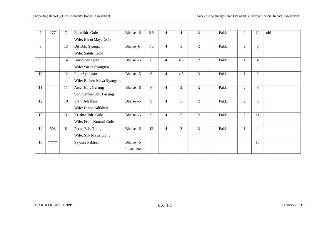
Supporting Report (2) Environmental Impact Assessment Annex B3 Summary Table List of HHs Surveyed, Social Impact Assessment t
JICA KULEKHANI III HPP February 2003 BX-3-2
7 177 7 Ram Bdr. Gole
Wife: Bhim Maya Gole
Bhaise –6 6.5 4 4 R Pakki 2 12 old
8 13 Dil Bdr. Syangtan
Wife: Sabitri Gole
Bhaise -6 7.5 4 5 R Pakki 2 8
9 14 Binod Syangtan
Wife: Sarita Syangtan
Bhaise –6 6 4 4.5 R Pakki 1 4
10 12 Raju Syangtan
Wife: Bishnu Maya Syangtan
Bhaise –6 6 4 4.5 R Pakki 1 3
11 11 Amar Bdr. Gurung
Son: Sankar Bdr. Gurung
Bhaise –6 6 4 5 R Pakki 2 8
12 10 Prem Adikhari
Wife: Binda Adikhari
Bhaise –6 6 4 5 R Pakki 2 6
13 9 Krishna Bdr. Gole
Wife: Prem Kumari Gole
Bhaise –6 9 4 5 R Pakki 2 11
14 503 8 Purna Bdr. Thing
Wife: Suk Maya Thing
Bhaise –6 12 4 2 R Pakki 1 4
15 ****** Sayauri Pakhrin Bhaise –6
Sikari Bas
15
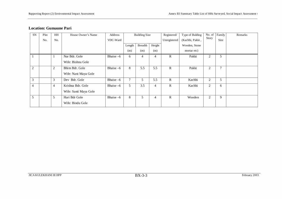
Supporting Report (2) Environmental Impact Assessment Annex B3 Summary Table List of HHs Surveyed, Social Impact Assessment t
JICA KULEKHANI III HPP February 2003 BX-3-3
Location: Gumaune Pari
SN Plot
No.
HH
No.
House Owner’s Name Address
VDC-Ward
Building Size Registered/
Unregistered
Type of Bulding
(Kachhi, Pakki ,
No. of Story
Family
Size
Remarks
Length
(m)
Breadth
(m)
Height
(m)
Wooden, Stone
mortar etc)
1 1 Nar Bdr. Gole
Wife: Bishnu Gole
Bhaise –6 6 4 4 R Pakki 2 5
2 2 Bhim Bdr. Gole
Wife: Nani Maya Gole
Bhaise –6 8 5.5 5.5 R Pakki 2 7
3 3 Dev Bdr. Gole Bhaise –6 7 5 5.5 R Kachhi 2 5
4 4 Krishna Bdr. Gole
Wife: Santi Maya Gole
Bhaise –6 5 3.5 4 R Kachhi 2 6
5 5 Hari Bdr Gole
Wife: Bindu Gole
Bhaise –6 8 5 4 R Wooden 2 9

Supporting Report (2) Environmental Impact Assessment Annex B3 Summary Table List of HHs Surveyed, Social Impact Assessment t
JICA KULEKHANI III HPP February 2003 BX-3-4
Location: Sanotar
SN Plot
No.
HH
No.
House Owner’s Name Address
VDC-Ward
Building Size Registered/
Unregistered
Type of Bulding
(Kachhi, Pakki ,
No. of Story
Family
Size
Remarks
Length
(m)
Breadth
(m)
Height
(m)
Wooden, Stone
mortar etc)
1 1 Shyam Bdr. Aale
Wife: Kumari Aale
Bhaise –6 6 4 4.5 UR Wooden 1 5
2 2 Ram Bdr. Syangtan
Wife: Kumari Syangtan
Bhaise –6 4 3 3.5 Kachhi 1 5
SN Plot
No.
HH
No.
House Owner’s Name Address
VDC-Ward
Building Size Registered/
Unregistered
Type of Bulding
(Kachhi, Pakki ,
No. of Story
Family
Size
Remarks
Length
(m)
Breadth
(m)
Height
(m)
Wooden, Stone
mortar etc)
3 190 3 Kanchhi Maya Syangtan
Husband: Lal Bdr. Syangtan
Bhaise –6 8 5 5 Ram jee
Gorkhari
Pakki 2 14
4 4 Bir Bdr. Syangtan
Wife: Thuli Maya Syangtan
Bhaise –6 6 4 4.5 Ram jee
Gorkhari
Kachhi 2 10
5 5 Tek Bdr. Thing
Wife: Mailee Maya Thing
Bhaise –6 5.5 4 3 Kachhi 1 9
6 6 Ram Kumar Thing
Wife:Ram Maya Thing
Bhaise –6 6 4.5 3 Kachhi 1 6
7 7 Purna Bdr. Thing
Wife: Thulee Maya Thing
Bhaise –6 4 2.5 3.5 Kachhi 1 8
8 8 Chandra Bdr. Titung
Wife: Phool Maya Titung
Bhaise –6 6 4 4.5 UR Wooden 2 3 Last 10 years
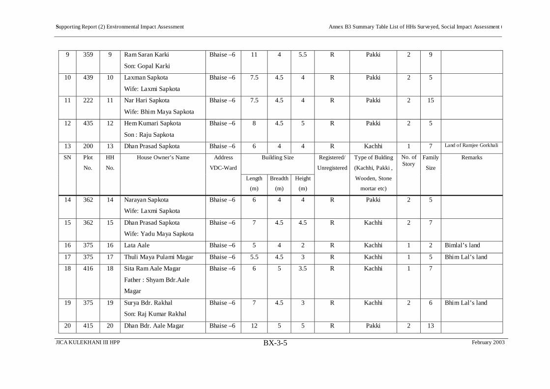
Supporting Report (2) Environmental Impact Assessment Annex B3 Summary Table List of HHs Surveyed, Social Impact Assessment t
JICA KULEKHANI III HPP February 2003 BX-3-5
9 359 9 Ram Saran Karki
Son: Gopal Karki
Bhaise –6 11 4 5.5 R Pakki 2 9
10 439 10 Laxman Sapkota
Wife: Laxmi Sapkota
Bhaise –6 7.5 4.5 4 R Pakki 2 5
11 222 11 Nar Hari Sapkota
Wife: Bhim Maya Sapkota
Bhaise –6 7.5 4.5 4 R Pakki 2 15
12 435 12 Hem Kumari Sapkota
Son : Raju Sapkota
Bhaise –6 8 4.5 5 R Pakki 2 5
13 200 13 Dhan Prasad Sapkota Bhaise –6 6 4 4 R Kachhi 1 7 Land of Ramjee Gorkhali
SN Plot
No.
HH
No.
House Owner’s Name Address
VDC-Ward
Building Size Registered/
Unregistered
Type of Bulding
(Kachhi, Pakki ,
No. of Story
Family
Size
Remarks
Length
(m)
Breadth
(m)
Height
(m)
Wooden, Stone
mortar etc)
14 362 14 Narayan Sapkota
Wife: Laxmi Sapkota
Bhaise –6 6 4 4 R Pakki 2 5
15 362 15 Dhan Prasad Sapkota
Wife: Yadu Maya Sapkota
Bhaise –6 7 4.5 4.5 R Kachhi 2 7
16 375 16 Lata Aale Bhaise –6 5 4 2 R Kachhi 1 2 Bimlal’s land
17 375 17 Thuli Maya Pulami Magar Bhaise –6 5.5 4.5 3 R Kachhi 1 5 Bhim Lal’s land
18 416 18 Sita Ram Aale Magar
Father : Shyam Bdr.Aale
Magar
Bhaise –6 6 5 3.5 R Kachhi 1 7
19 375 19 Surya Bdr. Rakhal
Son: Raj Kumar Rakhal
Bhaise –6 7 4.5 3 R Kachhi 2 6 Bhim Lal’s land
20 415 20 Dhan Bdr. Aale Magar Bhaise –6 12 5 5 R Pakki 2 13

Supporting Report (2) Environmental Impact Assessment Annex B3 Summary Table List of HHs Surveyed, Social Impact Assessment t
JICA KULEKHANI III HPP February 2003 BX-3-6
Wife: Sani Maya Aale Magar
21 376 21 Man Bdr. Thapa Magar
Wife: Seti Maya Thapa
Magar
Bhaise –6 8.5 5 5 R Pakki 2 10
22 430 22 Bhabhuk Aale Magar
Father: Shyam Bdr. Aale
Magar
Bhaise –6 9 5 4 R Kachhi 1 5
23 426 23 Prem Bdr Tamang
Wife: Jamuni Tamang
Bhaise –6 11.5 7 5.5 R Pakki 2 11
SN Plot
No.
HH
No.
House Owner’s Name Address
VDC-Ward
Building Size Registered/
Unregistered
Type of Bulding
(Kachhi, Pakki ,
No. of Story
Family
Size
Remarks
Length
(m)
Breadth
(m)
Height
(m)
Wooden, Stone
mortar etc)
24 426 23 Prem Bdr. Tamang
Wife: Jamuni Tamang
Bhaise –6 10 5.5 5 R Pakki 2 11
25 426 24 Keshav Ghalan
Wife: Ranju Ghalan
Bhaise –6 6 4 3 R Pakki 1 4
26 425 25 Dev Bdr. Thing
Wife: Hira Maya Thing
Bhaise –6 7 5 4.5 R Pakki 2 6
27 26 Ram Bdr. Gole Bhaise –6 7 5 4 R Pakki 2 12 Bhim Lal Gorkhali’s
land
28 27 Sumita Tamang
Husband: Ram Bdr. Bomjan
Bhaise –6 6 5 3 R Kachhi 1 4
29 28 Ganesh Kr. Gole Bhaise –6 6 5 3 R Pakki 2 1
30 29 Bishnu Maya Gole Bhaise –6 9 5.5 5.5 R Pakki 2 21

Supporting Report (2) Environmental Impact Assessment Annex B3 Summary Table List of HHs Surveyed, Social Impact Assessment t
JICA KULEKHANI III HPP February 2003 BX-3-7
Husband : Bir Bdr. Gole
31 30 Bishnu Maya Gole
Husband : Bir Bdr. Gole
Bhaise –6 8 5 5 R Pakki 2
32 31 Ganesh Shyantan Bhaise –6 5 3.5 3 R Kachhi 1 5
33 32 Purna Bdr. Lama Bhaise –6 8 4.5 5 R Pakki 2 5
34 33 Lal Bdr. Lama Bhaise –6 7 5 5.5 R Pakki 2 2
35 34 Som Bdr. Lama Bhaise –6 9 5 5 R Pakki 2 2
36 35 Dev Lal Gole
Wife: Thuli Maya Gole
Bhaise –6 8 4.5 5.5 R Pakki 2 4
SN Plot
No.
HH
No.
House Owner’s Name Address
VDC-Ward
Building Size Registered/
Unregistered
Type of Bulding
(Kachhi, Pakki ,
No. of Story
Family
Size
Remarks
Length
(m)
Breadth
(m)
Height
(m)
Wooden, Stone
mortar etc)
37 36 Hari Bdr Gole
Wife: Buddhi Maya Gole
Bhaise –6 10 4.5 5 R Pakki 1 8
38 37 Chandra Lal Dong
Wife: Suku Maya Dong
Bhaise –6 16 5 5 R Pakki 2 9
39 37 Chandra Lal Dong
Son: Gyan Bdr. Dong
Bhaise –6 10 5 4 R Pakki 1
40 38 Purna Bdr. Lama
Wife: Padam Maya Lama
Bhaise –6 8 4 3 R Pakki 1 5

Supporting Report (2) Environmental Impact Assessment Annex B3 Summary Table List of HHs Surveyed, Social Impact Assessment t
JICA KULEKHANI III HPP February 2003 BX-3-8
Location: Bokedaha
SN Plot
No.
HH
No.
House Owner’s Name Address
VDC-Ward
Building Size Registered/
Unregistered
Type of Bulding
(Kachhi, Pakki ,
No. of Story
Family
Size
Remarks
Length
(m)
Breadth
(m)
Height
(m)
Wooden, Stone
mortar etc)
1 294 1 Dhan Bdr. Tamang
Wife: Hira Maya Tamang
Basmadi-
9
9 5 5.5 R Pakki 2 8
2 4 2 Santa Maya Moktan
Son: Gunja Man Moktan
Basmadi-
9
9 5 5.5 R Pakki 2 10
3 3 6 Purna Bdr. Thing
Wife: Kami Thing
Basmadi-
9
9 5.5 7 R Pakki 2 4
4 4 Prem Bdr. Thing
Wife: Tara Maya Thing
Basmadi-
9
6 4 5 R Pakki 2 5
5 5 Rameshowr Thing
Wife:Jog Maya Thing
Basmadi-
9
6.5 5 5 R Pakki 2 5
6 7 Radha Thing
Kushina Thing
Basmadi-
9
5 3 3 R Kachhi 1 3
7 3 Lok Bdr. Gishing
Wife: Mhendu Maya Gishing
Basmadi-
9
8 5 5.5 R Pakki 2 6
8 3 Lok Bdr. Gishing
Wife: Mhendu Maya Gishing
Basmadi-
9
6 5 5 R Kachhi 2
9 8 Hasta Bdr. Rakhal Thapa
(Gandane Budha)
Wife: Thuli Maya Thapa
Basmadi-
9
6 4 4.5 R Kachhi 2 2

Supporting Report (2) Environmental Impact Assessment Annex B3 Summary Table List of HHs Surveyed, Social Impact Assessment t
JICA KULEKHANI III HPP February 2003 BX-3-9
Location: Nakauli (Tailrace Outlet)
SN Plot
No.
HH
No.
House Owner’s Name Address
VDC-Ward
Building Size Registered/
Unregistered
Type of Bulding
(Kachhi, Pakki ,
No. of Story
Family
Size
Remarks
Length
(m)
Breadth
(m)
Height
(m)
Wooden, Stone
mortar etc)
1 305 1 Gauri Kanta Dhital
Wife: Krishna Maya Dhital,
Pabitra Dhital
Basmadi-
9
7 4 4 Pakki 2 7

Supporting Report (2) Environmental Impact Assessment Annex B3 Summary Table List of HHs Surveyed, Social Impact Assessment t
JICA KULEKHANI III HPP February 2003 BX-3-10
The Study Team prepared a sketch map of all of these households and took photographs of each one.
Sketch Map of Sanutar Project Affected Area Houses

Supporting Report (2) Environmental Impact Assessment Annex B3 Summary Table List of HHs Surveyed, Social Impact Assessment t
JICA KULEKHANI III HPP February 2003 BX-3-11
Ghumaune Pari
1 Nar Bh/Bishnu Gole
2 Bhim Bh/Nani Maya Gole
3 Dev Bhd Gole
4 Krishna Bh/Santi Maya Gole
55 Hari Bh/Bindu Gole
The example of Ghumane Pari illustrates the photographs
taken of each household.
House Photos in Ghumaune Pare

Supporting Report (2) Environmental Impact Assessment Annex B4 Questionnaire for Socioeconomic Study
JICA KULEKHANI III HPP February 2003BX-4-1
Annex B4 Questionnaire for Socioeconomic Study
Family Details that will be included in this questionnaire will be secret according to Statistical Rule 2015
1. General Information about Project Area
a. Zone: Narayani b. District: Makawanpur
c. VDC:……………………………………. d. Ward No: ……………
e. Village/Tole:……………………………..
2. Information about the Family
2.1 General
a. Name of house owner/Head of household………………………………………
b. Sex Male Female
c. Surname [Jati]…………………………………
d. Occupation: …………………………………..
e. Religion: ……………………………………….
f. Education: ……………………………………..
2.2 Since when did your family settle here?
a. Are from this village.
b. Came some years ago [Specify how many years]………….
c. Transition…………..
d. Other ……………..
2.3 From where did your ancestors come here?
a. Nepal : District …………
b. India or any other country or area………….
2.4 Type of Family
a. Single (Live separated) ………..
b. Joint Family ………..
2.5 Information about members of family who live together without separating their
kitchen (Including name of head of household).

Supporting Report (2) Environmental Impact Assessment Annex B4 Questionnaire for Socioeconomic Study
JICA KULEKHANI III HPP February 2003BX-4-2
Ser. No.
Sex Age Education. Occupation. Skill/ Training
If Stay Away More than 6 Months
Remarks
1 Time Reason Place 2 3 4 5 6 7 8 9 10 11 12
Code:
2. Sex 1. Male 2. Female 4. Education 0. Illiterate 1. Literate but no schooling 2.Primary (Class 1-5) 3. Pre-Secondary Level (Class 6-7) 4. Secondary (Class 8-10) 5. SLC (School Leaving Certificate) 6. Intermediate Level 7. Bachelors or Graduate 8. Higher Education 5. Occupation 1. Agriculture (Livestock) 2. Business/Service 3. Student 4. Service (Job) 5. Laborer 6. Disabled 7. Other 6. Skill/Training 1. Laborer (Wall Maker) 2. Carpenter 3. Sewing/Knitting 4. Driver/Light or Heavy 5. Suchikar? 6. Construction (Seed production, Steel, Work for
Factory) 7. Blacksmith 8. Cobbler [Sarki] 9. Other ……… 7. Time/Reason/Place 1. Service/Job 2. Studies 3. Health cure 4. Other …….
3. Agriculture and Livestock
3.1 Agriculture
3.1.1 Have you any land in your name or in your family member’s name?
Yes No

Supporting Report (2) Environmental Impact Assessment Annex B4 Questionnaire for Socioeconomic Study
JICA KULEKHANI III HPP February 2003BX-4-3
3.1.2 If you have land, how many Ropani/Bigha?
Ownership Rice Field [khet] Dryland [Bari] Grass [Kharbari] Remarks Own Joint Self-Farming Others Work Total
3.1.3 What is the main harvest on your land? How much income do you get from it?
Farming Land (Ropani/Bhiga)
Production Sale Total
Riceland Dryland Unit Quantity Unit Quantity Paddy Wheat Maize Millet Grain [Dal Gedragudi]
FoodCrops
Others Potato Mustard[Tori]
Sugar cane
CashCrops
Other
3.1.4 Have you any kind of fruit tree/plants at your house? Yes No
3.1.4 If yes, give the following information.
Last Year’s Production Name of Fruit No. of Plants Unit Quantity Selling Price
a. Lemon b. Orange c. Mango d. Papaya e. Guava f. Lichi g. Pineapple h. Banana i. Other Total
3.1.6 Did your family produce enough to feed your family last year? Yes No
3.1.7 If not, for how many months was it not enough? ………………. Months
3.1.8 At the time of food insufficiency, how did you manage to feed your family?
a. Taking out a loan…………
b. By daily labor………….
c. Selling Household goods…………..
d. Forest Food
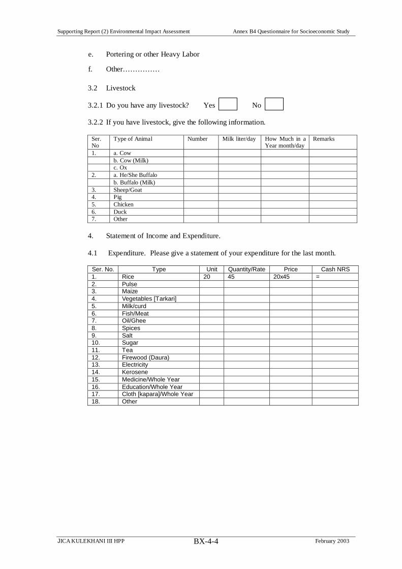
Supporting Report (2) Environmental Impact Assessment Annex B4 Questionnaire for Socioeconomic Study
JICA KULEKHANI III HPP February 2003BX-4-4
e. Portering or other Heavy Labor
f. Other……………
3.2 Livestock
3.2.1 Do you have any livestock? Yes No
3.2.2 If you have livestock, give the following information.
Ser. No
Type of Animal Number Milk liter/day How Much in a Year month/day
Remarks
1. a. Cow b. Cow (Milk) c. Ox 2. a. He/She Buffalo b. Buffalo (Milk) 3. Sheep/Goat 4. Pig 5. Chicken 6. Duck 7. Other
4. Statement of Income and Expenditure.
4.1 Expenditure. Please give a statement of your expenditure for the last month.
Ser. No. Type Unit Quantity/Rate Price Cash NRS 1. Rice 20 45 20x45 = 2. Pulse 3. Maize 4. Vegetables [Tarkari] 5. Milk/curd 6. Fish/Meat 7. Oil/Ghee 8. Spices 9. Salt 10. Sugar 11. Tea 12. Firewood (Daura) 13. Electricity 14. Kerosene 15. Medicine/Whole Year 16. Education/Whole Year 17. Cloth [kapara]/Whole Year 18. Other

Supporting Report (2) Environmental Impact Assessment Annex B4 Questionnaire for Socioeconomic Study
JICA KULEKHANI III HPP February 2003BX-4-5
4.2 Income. Please tell your income and income source for the past year.
Ser. No. Type Unit Quantity/Rate Price per unit Price NRS 1. Agricultural Income
Food a. Paddy b. Maize
c. Wheat d. Millet e. Soybean f. Pulse
1.1
g. Other 1.2 Vegetable [Tarkari] 1.3 Fruit 2. Livestock
Milk Production a. Milk b. Curd c. Ghee
2.1
d. Cheese 2.2 Eggs/Chickens 2.3 Meat 2.4 Fish 3. Other Sources Daily/Monthly/Yearly Rate Remarks 3.1 Job/Service 3.2 Labor/Work 3.3 Pension 3.4 Service 3.5 Cottage/Domestic Industry 3.6 Related Service 3.7 Fishing 3.8 Other Total Income
5. Energy and Water Resources
5.1 What is the source of drinking water here?
a. Brook/Stream b. River
c. Well d. Pipe (Distribution System)
5.2 What do you use mostly for Lighting?
a. Kerosene b. Oil Lamp
c. Electricity d. Fuel [Jhari]
e. Other
5.3 What do you use mostly for cooking?
a. Firewood b. Kerosene
c. Guetha? [Dung?] d. Straw

Supporting Report (2) Environmental Impact Assessment Annex B4 Questionnaire for Socioeconomic Study
JICA KULEKHANI III HPP February 2003BX-4-6
e. Gas f. Other 5.3.1 If you use firewood, how much do you need in one month?
Quantity ( ) Imaginary Weight ( )
5.3.2 From where do you bring the firewood for your home?
a. From nearby forest (government or local authority)
b. Own private forest……..
c. Buy the firewood……….
d. Other…………
6. Affected by the Project
6.1 Land
6.1.1 If your land is affected to the this Project, then please give the following statement.
Area Ropane/Bhiga and Rate in Thousands NRS Ser. No.
Plot No.
Place Name
VDC/ WardNo.
Rice Fields
Price Dryland Price Thatch
Kharbari Price
1. 2. 3. 4. 5.
6.2 House/Cowshed [goth]
6.2.1 Is this your own house? Yes No
6.3 If it is your own house, please give the following information.
Serial No. of House 1 2 3 Type of House 1 2 3 1 2 3 1 2 3 Storeys 1 2 3 4 1 2 3 4 1 2 3 4 No. of Rooms 1 2 3 4 5 1 2 3 4 5 1 2 3 4 5 Roof 1 2 3 4 1 2 3 4 1 2 3 4 Materials Used 1 2 3 4 5 6 7 8 9 1 2 3 4 5 6 7 8 9 1 2 3 4 5 6 7 8 9
Length (feet) Area (square feet) Year Built Nepali Calendar Estimated Price Present Condition
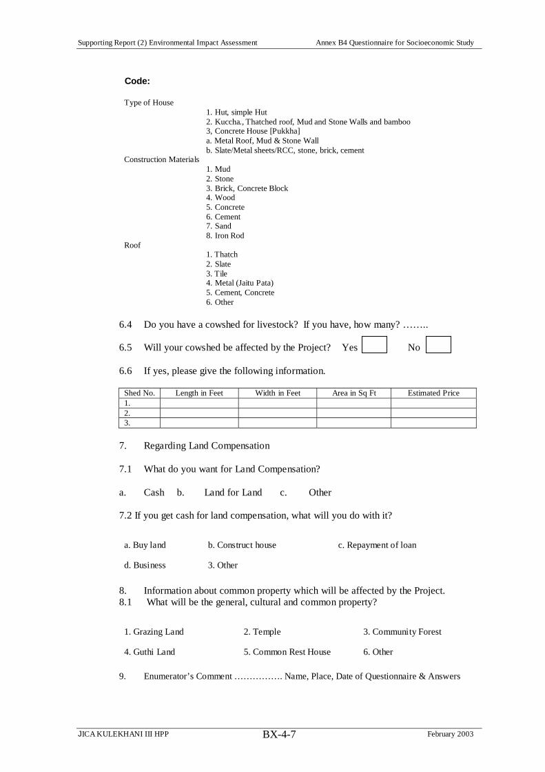
Supporting Report (2) Environmental Impact Assessment Annex B4 Questionnaire for Socioeconomic Study
JICA KULEKHANI III HPP February 2003BX-4-7
Code:
Type of House 1. Hut, simple Hut 2. Kuccha., Thatched roof, Mud and Stone Walls and bamboo 3, Concrete House [Pukkha] a. Metal Roof, Mud & Stone Wall b. Slate/Metal sheets/RCC, stone, brick, cement Construction Materials 1. Mud 2. Stone 3. Brick, Concrete Block 4. Wood 5. Concrete 6. Cement 7. Sand 8. Iron Rod Roof 1. Thatch 2. Slate 3. Tile 4. Metal (Jaitu Pata) 5. Cement, Concrete 6. Other
6.4 Do you have a cowshed for livestock? If you have, how many? ……..
6.5 Will your cowshed be affected by the Project? Yes No
6.6 If yes, please give the following information.
Shed No. Length in Feet Width in Feet Area in Sq Ft Estimated Price 1. 2. 3.
7. Regarding Land Compensation
7.1 What do you want for Land Compensation?
a. Cash b. Land for Land c. Other
7.2 If you get cash for land compensation, what will you do with it?
a. Buy land b. Construct house c. Repayment of loan
d. Business 3. Other
8. Information about common property which will be affected by the Project. 8.1 What will be the general, cultural and common property?
1. Grazing Land 2. Temple 3. Community Forest
4. Guthi Land 5. Common Rest House 6. Other
9. Enumerator’s Comment ……………. Name, Place, Date of Questionnaire & Answers

Supporting Report (2) Environmental Impact Assessment Annex B5 Conceptualized Project Affected Area Social Impacts
JICA KULEKHANI III HPP February 2003
BX-5-1
Annex B5 Conceptualized Project Affected Area Social Impacts
Bhaise-Dhoban – Nibuwatar Corridor
Intake Bhaise-Dhoban
Connecting Tunnel & Rapti River Corridor
Regulating Reservoir, Powerhouse, Tailrace
Below Tailrace
Tertiary Impacts – NEA Camp Traffic Other Construction ‘footprints’?
Secondary Impacts – Construction ‘footprints,’ such as storage yards, batching plants? Traffic – Adit Road Construction – SAP Requirement
Tertiary Impacts - Spoil Area Traffic, Hydrological Effects, Water Mills Trikandi Mandir
Primary Impacts – Bridge & Access Road, Operating Camp, Dam and Regulating Reservoir, Powerhouse, Tailrace Land Acquisition (Resettlement?) to Permanent and Temporary Project ‘footprints’. SAP, RP Required
Primary Impacts - 40 cum Daily Water Release, 5-8pm. Land Acquisition Claimed for in EIA 1993 Flood Damaged Lands or other Land probably not effected – 55% of proposed Land Acquisition Scouring Effects & Canalization – Irrigation Pipe, Ropeway Tower Foundations, Water Mill, Irrigation Water Requirements Required Siren Warning, Community-Based Action (Sanitation, Warning, Other Community Based Solutions), Guaranteed Water Access, Scouring Prevention – Use of Satellite Mapping in mapping/GIS for post 1993 land changes.
Hetauda Bridge

Supporting Report (2) Environmental Impact Assessment Annex B6 Kulekhani III Impoverishment Risks and Reconstruction (IRR) Model – June 2002 Draft for Discussion
JICA KULEKHANI III HPP February 2003 BX-6-1
Annex B6 Kulekhani III Impoverishment Risks and Reconstruction (IRR) Model – June 2002 Draft for Discussion Impoverishment Risks Risk Assessment Rationale for Assessment Risk Reversal & Reconstruction
Landlessness. Expropriation of land removes the main
foundation on which many people build productive
systems, commercial activities and livelihoods. Often
land is lost forever; sometimes it is partially replaced,
seldom fully replaced or fully compensated. This is the
main form of de-capitalization and pauperization of the
people who are displaced. Both natural and man-made
capital is lost (from ADB Operational Directive Risks
Assessment and Risks Reduction in Resettlement, Oct
2000).
High-Very High Nepal does not have a good history of
providing land for land resettlement.
Virtually always cash is the sole credible
offer, with land being given only if unused
or Government Land is available, which
means in effect that no credible land for land
offer in the past has been made to resettlers.
Are differential risks: In Kulekhani I, those
ethnic groups (e.g., Newar) with long
experience in the cash economy benefited
from cash compensation, whereas those
ethnic groups (e.g., Tamang) with lesser
experience tended to suffer landlessness and
poverty consequences.
Gumaune, which is predominantly Tamang,
will be affected by placement of temporary
construction facilities (cement batching,
storage, limited contractor’s housing) and
permanent land acquisition of access road.
Sanutar, which is largely Jaise Brahmin and
Chhetri but also includes some Tamang, as
From landlessness to land-based resettlement
First Principle will be to avoid land acquisition.
1. Placing construction camps in Hetauda, in a)
NEA’s diesel power station and adjacent
properties, b) Defunct Ktm-Hetauda Ropeway
facility, c) Nepal Food Corporation storage
facility.
a. Highly important to get high-level
agreement on this as early as
possible.
b. Suparitar Military Camp is critical
stakeholder to make use of Hetauda
sites possible. Need to (1) keep them
regularly informed, (2) obtain passes
for construction period, (3) assist
them in building explosives bunker.
2. Place temporary construction facilities in
Gumaune, with rental allowances for houses
temporarily acquired and lease payment for
agricultural land, equal or greater than annual
lost production.
3. Taking care in placement of spoil disposal

Supporting Report (2) Environmental Impact Assessment Annex B6 Kulekhani III Impoverishment Risks and Reconstruction (IRR) Model – June 2002 Draft for Discussion
JICA KULEKHANI III HPP February 2003 BX-6-2
Impoverishment Risks Risk Assessment Rationale for Assessment Risk Reversal & Reconstruction
well as Magar, with about 5 families having
their house structures on government land,
precluding formal compensation under
Nepal’s Land Acquisition Act. These may be
affected by placement of partially
underground powerhouse and by excavation
of tailrace channel, as well as by the access
road.
Risk of an Inadequate definition for
PAFs/.SPAFs. Providing a clear definition of
SPAF and PAF for objective evaluation
needs to be based not only on percentage of
land lost, as was done in Kali Gandaki A but
also on reliance of a family on agricultural
income, poverty levels, and to some extent
ethnic risk factors. Reliance on percentage of
property lost only can lead to well-off
absentee landowners being declared SPAFs.
However, property holdings, income and
expenditure data based on the social survey
can also unrealistic, as expenditures are
usually exaggerated and income are stated
on lower side.
Risk of, in defining SPAFs, not taking into
account lands held outside the Project area,
areas to avoid houses and agricultural land.
4. Carefully factoring in resettlement costs to
Project – both financial and political – in
placement decision for powerhouse.
Where land acquisition is unavoidable, making sure
that there is a viable and credible land for land
option offered in the Project’s policy framework,
especially taking into account ethnic factors in
experience with handling large sums of cash,
something that NEA has not provided in the past.
Creating a Land for Land Option: (a) carrying out
field assessment (soil fertility, water availability,
access to public services, etc.) of the considerable
Government land within the District for suitability
of relocation and land for land options including
some 246.84 hectares of public land (Ailani Pakho)
within the Kulekhani III affected VDCs and
mumicipalities; (b) in parallel, exploring open
market viability for purchasing land for land for
land options; (c) exploring options for land
development in the area and for improving
agricultural productivity (see below, Joblessness);
(d) placing of spoil in degraded areas and later
develop them into productive land; (e) flood plain

Supporting Report (2) Environmental Impact Assessment Annex B6 Kulekhani III Impoverishment Risks and Reconstruction (IRR) Model – June 2002 Draft for Discussion
JICA KULEKHANI III HPP February 2003 BX-6-3
Impoverishment Risks Risk Assessment Rationale for Assessment Risk Reversal & Reconstruction
which may result in relatively well off
families receiving SPAF status on the pretext
of being poor.
Much of land acquisition identified by EAI
was below Tailrace outlet, within the Rapti
riverbed, at Hetauda Ward 1 and Basamadi
Ward 9. The need for acquiring these lands,
and the impact of doing so on the affected
families, needs to be assessed.
Also below the Tailrace outlet are 4
potentially vulnerable irrigation schemes that
may be undermined by water released from
the Project: 1) Maintar Village’s irrigation
scheme, which has an irrigation pipe
crossing a slide area just below the tailrace
area that could be eroded by released waters,
as well as in intake from the Rapti River for
lower lying fields; 2) Chauki Tole Irrigation
Project, serving Hetauda Ward 1; 3)
Nawalpur Basamadi Irrigation Scheme, also
serving Hetauda Ward 11 and Basamadi
Ward 9, and 4) Simaltar-Golpingtar
Irrigation Scheme, serving Hetuada Ward 11
rehabilitation for land development.
Exploring the option to provide house plots within
the Project area for those households having their
house structures on Government Land. For this
experience may be had from the Middle
Marsyangdi: Hydro-electric Project (70Mw). The
NEA provided gift land plots for those whose
houses are demolished, more than 65 families, the
majority of whom are were businessmen & traders.
NEA purchased the lands for resettlements from
private owners. Many of the land recipients have
constructed the houses on the land area provided by
NEA. They were also compensated for their
business losses. Experience may also come from the
Government’s recently launched Kamaiya (bonded
laborers) settlement program in the western region.
Similarly experience may be gained from many
districts where the Government has formed High
Level Landless People Settlers Commissions
(Sukumbasi Ayoga)..
Better SPAF Definition. Provision of Seriously
Projected Affected Family (SPAF) status for those
losing greater proportion of their income due to land
acquisition. Making sure the definition for SPAF is
adequate, taking into account percentage of
household income affected by land acquisition, the

Supporting Report (2) Environmental Impact Assessment Annex B6 Kulekhani III Impoverishment Risks and Reconstruction (IRR) Model – June 2002 Draft for Discussion
JICA KULEKHANI III HPP February 2003 BX-6-4
Impoverishment Risks Risk Assessment Rationale for Assessment Risk Reversal & Reconstruction
preexisting poverty level of households and relevant
ethnic factors (such as the vulnerability of the Praja
community). Giving priority in land for land
options, priority for Project employment, training,
income generation, etc. Exploring cross check
methodologies for identifying household
landholdings outside the Project area, for better
assessment of SPAF status for individual
households.
Better assessment of land acquisition requirements
and situation of the affected families listed in EIA
for below Tailrace outlet. GIS Mapping, impact
assessment, interviews with HHs to determine their
dependence on these lands and likely impacts.
During this study phase, a community-wide, rather
than household by household, evaluation will be
made of impacts, to avoid raising false expectations
of compensation. GIS and field surveys will clarify
the impacts on plots listed in NEA’s EIA.
Better assessment of irrigation schemes likely to be
impacted below Tailrace Outlet and design of
underground inlets for four of them, protection
works for the Maintar irrigation pipe that crosses
over slide area just below the outlet. Maybe some
technical assistance other ways for Maintar to

Supporting Report (2) Environmental Impact Assessment Annex B6 Kulekhani III Impoverishment Risks and Reconstruction (IRR) Model – June 2002 Draft for Discussion
JICA KULEKHANI III HPP February 2003 BX-6-5
Impoverishment Risks Risk Assessment Rationale for Assessment Risk Reversal & Reconstruction
manage this slide area and irrigation pipe.
Joblessness. Loss of wage employment occurs both in
rural and urban displacement. People losing jobs may
be landless agricultural laborers, service workers, or
artisans. The unemployment or underemployment
among resettlers may linger long after physical
relocation. Creating new jobs for them is difficult and
requires substantial investment, new creative
approaches, and relying more on sharing project
benefits.
Medium – High Few job opportunities exist in the most
impacted area of Sanutar and Gumaune,
though these communities may serve as a
base for employment in nearby Hetauda and
even in Kathmandu. However, there are a
few absentee landowners and many tenants
working the land. Loss of land can lead to
loss of agricultural work, especially for
unregistered tenants, who will not be eligible
to receive compensation under Nepalese law.
There is considerable risk that these non-
registered may not be identified accurately,
and others who are not really qualified may
claim any benefits the Project wishes to
extend to non-registered tenants.
From joblessness to reemployment
Need to carefully assess Tenant situation and make
provision for compensation and social programs for
both registered and unregistered tenants. The Project
will need to establish an independent research and
verification mechanism for accurately identifying
genuine non-registered Tenants who may be
affected by land acquisition.
Involvement of Hetauda-based NGOs in
formulation of a Social Action Framework (SAF) to
reverse this risk, through obtaining their
collaboration in preparing a detailed Social Action
Plan (SAP) during the next, design phase:
1. Plan International is increasingly working
through local NGOs. Has had 8-year history in
the Project area. Education, Sanitation,
Integrated Forest Management Groups,
Plantation, Forestation, Rejuvenating
Degraded River Banks, Integrated Forest
Management Groups. Possible application in
KL III for (a) agricultural development to

Supporting Report (2) Environmental Impact Assessment Annex B6 Kulekhani III Impoverishment Risks and Reconstruction (IRR) Model – June 2002 Draft for Discussion
JICA KULEKHANI III HPP February 2003 BX-6-6
Impoverishment Risks Risk Assessment Rationale for Assessment Risk Reversal & Reconstruction
provide new winter vegetable (Hydroponics)
and other produce to take advantage of new
bridge across Rapti and collection points for
Hetauda markets, (b) alternative energy, e.g.,
briquettes for construction camps.
2. Samaja Jagaran Mancha. Has number of
environmental related projects along Rapti
River in Hetauda, Ward 1. Involved in Income
Generation Projects. KL III application
possibly in: (a) Income Generation program in
Ward 1, assuming any loss of income from
effects on land of Tailrace water release (still
to be determined)
3. Rural-Urban Partnership Program. Has
created 200 micro-enterprise groups, linkages
between Hetuada, Bhaise-Dhoban, Bhimpedi –
collection points for vegetable and other
produce, to urban markets. Are active in
eleven wards of Hetauda, creating 10
Tole/Lane Organizations (TLOs) meeting
monthly in Ward 1 for various community
development activities, such as drains,
sanitation, drinking water. Application to KL
III – (a) Protection of Hetauda irrigation
facilities, (b) Income Generation program in
Ward 1, assuming any loss of income from
effects on land of Tailrace water release (still

Supporting Report (2) Environmental Impact Assessment Annex B6 Kulekhani III Impoverishment Risks and Reconstruction (IRR) Model – June 2002 Draft for Discussion
JICA KULEKHANI III HPP February 2003 BX-6-7
Impoverishment Risks Risk Assessment Rationale for Assessment Risk Reversal & Reconstruction
to be determined), (c) Taking advantage of
new bridge across Rapti to choose a collection
point for Hetauda marketing of vegetables,
produce. Linking this to agricultural
development program for Sanutar/Gumaune
and other communities now better linked to
Hetauda because of bridge.
4. Maiti Nepal. Has awareness program on
women trafficking, HIV/AIDS in Bhainse and
Basamadi VDCs, also income generating and
skill training programs for women.
Application to KL III – (a) income generation
and skills training for women.
Provision of skills training – short and long (3
months) term. Based on assessment of existing
skills and education levels in project affected
communities, likely Project requirements, and
priority for PAF/SPAF and affected VDCs.
Provision of an explicit system of targeted hiring
and priority rankings for employment eligibility
resulting in a high percentage of affected families
receiving income-generating employment (one job
per family). Tender documents asked the principal
contractors for all lots of the KG Hydroelectric
Power that:
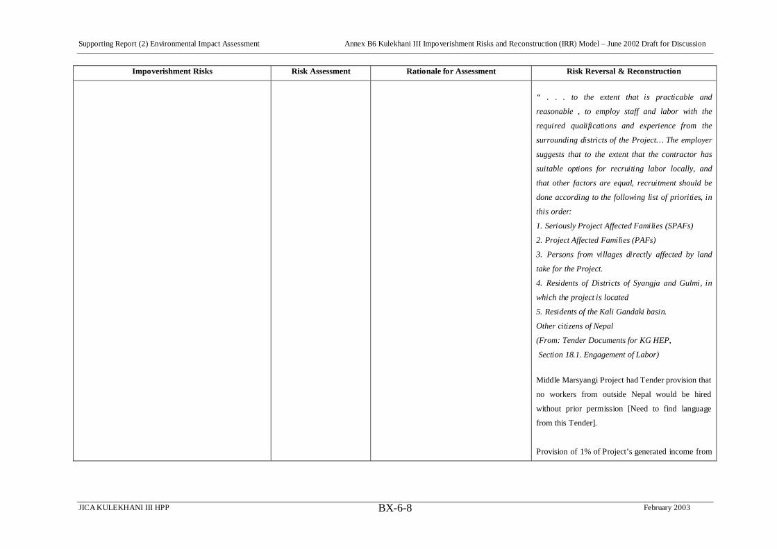
Supporting Report (2) Environmental Impact Assessment Annex B6 Kulekhani III Impoverishment Risks and Reconstruction (IRR) Model – June 2002 Draft for Discussion
JICA KULEKHANI III HPP February 2003 BX-6-8
Impoverishment Risks Risk Assessment Rationale for Assessment Risk Reversal & Reconstruction
“ . . . to the extent that is practicable and
reasonable , to employ staff and labor with the
required qualifications and experience from the
surrounding districts of the Project… The employer
suggests that to the extent that the contractor has
suitable options for recruiting labor locally, and
that other factors are equal, recruitment should be
done according to the following list of priorities, in
this order:
1. Seriously Project Affected Families (SPAFs)
2. Project Affected Families (PAFs)
3. Persons from villages directly affected by land
take for the Project.
4. Residents of Districts of Syangja and Gulmi, in
which the project is located
5. Residents of the Kali Gandaki basin.
Other citizens of Nepal
(From: Tender Documents for KG HEP,
Section 18.1. Engagement of Labor)
Middle Marsyangi Project had Tender provision that
no workers from outside Nepal would be hired
without prior permission [Need to find language
from this Tender].
Provision of 1% of Project’s generated income from

Supporting Report (2) Environmental Impact Assessment Annex B6 Kulekhani III Impoverishment Risks and Reconstruction (IRR) Model – June 2002 Draft for Discussion
JICA KULEKHANI III HPP February 2003 BX-6-9
Impoverishment Risks Risk Assessment Rationale for Assessment Risk Reversal & Reconstruction
energy sales towards local rural electrification
(Existing NEA policy).
Homelessness. Loss of housing and shelter may be
only temporary for many people, but for some it
remains a chronic condition and is felt as loss of
identity, and cultural impoverishment. Loss of dwelling
may have consequences on family cohesion and mutual
help patterns if neighboring households of the same
kinship group get scattered. Group relocation of related
people and neighbors is therefore preferable over
dispersed relocation.
High-Very High This risk is heightened do to Tailrace Outlet
Culvert, which requires taking of houses in
Sanutar. Also the placement of the
construction camp at Ghumaune,
Because the numbers of households likely to
lose housing is relatively small, provision for
replacement should not be difficult.
Risk could be more for houses built on
Government land, above the Sanutar
irrigation canal, if acquired.
Below Tailrace outlet and in inlet area near
Kulekhani II Powerhouse, there is no loss of
housing.
From homelessness to house reconstruction
Providing housing grants to and relocation
assistance to Sanutar households, rental to
Ghumaune households and restoration of their land
after lease period. Assistance to relocate as a
community, as required.
Careful placement of spoil disposal areas to avoid
taking of houses.
Taking full account of the full financial, social and
political implications of possible house
displacement in decision to opt for partially
underground power station.
Provision of rent allowances in Gumaune for use of
houses within temporary facilities area, rather than
destruction of houses.
Marginalization. Marginalization occurs when
relocated families lose economic power and slide down
towards lesser socio-economic positions: middle
income farm-households become small landholders;
High – Very High The risk could be high for any unregistered
tenant farmers in Gumaune and Sanutar, if
lands are temporarily or permanently
acquired. Resulting loss of income could
From marginalization to social inclusion
Activities of NGOs in Risk Reversal for
landlessness and joblessness will also be applicable

Supporting Report (2) Environmental Impact Assessment Annex B6 Kulekhani III Impoverishment Risks and Reconstruction (IRR) Model – June 2002 Draft for Discussion
JICA KULEKHANI III HPP February 2003 BX-6-10
Impoverishment Risks Risk Assessment Rationale for Assessment Risk Reversal & Reconstruction
small shopkeepers and craftspeople lose business and
fall below poverty thresholds, and so on.
lead to marginalization.
The risk is also high for land holders due to
loss of property holdings and related
productivity.
Very high influx of outsiders, boomtown
effects, could greatly outnumber locals.
to risks of martinalization and food insecurity.
Land distribution from land developed from spoil
disposal sites or land for land option can also
reverse the risk of marginalization.
Activities of Maiti Nepal in preventing child labor,
women trafficking, prostitution and in HIV/AIDs
prevention important for risk reversal of
marginalization.
INCREASED MORBIDITY & MORTALITY.
Vulnerability of the poorest people to illness is
increased by forced relocation, because tends to be
associated with increased stress, psychological traumas,
and the outbreak of parasitic and vector-born diseases.
Serious decreases in health levels result from unsafe
water supply and sewage systems that proliferate
epidemic infections, diarrhea, dysentery, etc.
Medium-High Risk is less from forced relocation than from
influx of labor force and of attendant service
population, putting strain on sanitation and
health environment.
Construction impacts from noise, dust,
traffic accidents.
Danger downstream from Tailrace outlet of
water releases to Rapti river use – defecation
along river banks, collection of construction
materials, seasonal river crossing, bathing,
washing vehicles, ghats, water mills,
grazing, children playing.
Social dangers associated with construction
From increased morbidity to improved health
care
Proactive planning to provide sanitation, drinking
water, etc. for any informal service communities
likely to occur in Project area, such as along access
roads, particularly on Government land above
Sanutar irrigation canal, where some shop
construction already underway in seeming
anticipation of the Project.
Contract provisions governing traffic, safety, noise
and dust abatement, child labor.
Involvement of Hetauda-based NGOs in
formulation of a Social Action Framework (SAF) to
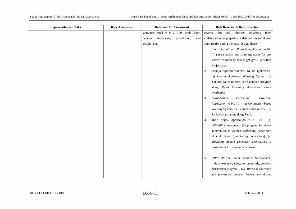
Supporting Report (2) Environmental Impact Assessment Annex B6 Kulekhani III Impoverishment Risks and Reconstruction (IRR) Model – June 2002 Draft for Discussion
JICA KULEKHANI III HPP February 2003 BX-6-11
Impoverishment Risks Risk Assessment Rationale for Assessment Risk Reversal & Reconstruction
activities, such as HIV/AIDS, child labor,
women trafficking, prostitution, and
alcoholism.
reverse this risk, through obtaining their
collaboration in preparing a detailed Social Action
Plan (SAP) during the next, design phase:
1. Plan International. Possible application in KL
III (a) sanitation and drinking water for any
service community that might grow up within
Project area.
2. Samaja Jagaran Mancha.. KL III application:
(a) Community-based Warning System for
Tailrace water release, (b) Sanitation program
along Rapti lessening defecation along
riverbanks.
3. Rural-Urban Partnership Program.
Application to KL III – (a) Community-based
Warning System for Tailrace water release, (c)
Sanitation program along Rapti.
4. Maiti Nepal. Application to KL III – (a)
HIV/AIDS awareness, (b) program for direct
intervention in women trafficking, prevention
of child labor (monitoring contractors), (c)
providing income generation alternatives to
prostitution for vulnerable women.
5. HIV/AIDS STD Swiss Technical Development
- Have extensive education materials, condom
distribution program. - (a) HIV/STD education
and prevention program before and during

Supporting Report (2) Environmental Impact Assessment Annex B6 Kulekhani III Impoverishment Risks and Reconstruction (IRR) Model – June 2002 Draft for Discussion
JICA KULEKHANI III HPP February 2003 BX-6-12
Impoverishment Risks Risk Assessment Rationale for Assessment Risk Reversal & Reconstruction
construction period.
Food Insecurity. Forced uprooting diminishes self-
sufficiency, dismantles local arrangements for food
supply, and thus increases the risk that people will fall
into chronic food insecurity. This is defined as calorie-
protein intake levels below the minimum necessary for
normal growth and work.
Medium-High Risk will be for any unregistered tenants
who lose access to land they are tilling
without adequate compensation – resulting
in both land access and job loss.
Not the same level of risk as found in large
reservoir forces relocation of large
populations, which creates a highly
vulnerable situation, difficult for authorities
to manage.
From food insecurity to adequate nutrition
Activities of NGOs in Risk Reversal for
landlessness and joblessness will also be applicable
to risks of martinalization and food insecurity.
Loss of Access to Common Property. Poor farmers,
particularly those without assets, suffer a loss of access
to the common property goods belonging to
communities that are relocated (e.g., loss of access to
forests, water bodies, grazing lands, etc.). This
represents a form of income loss and livelihood
deterioration that is typically overlooked by planners
and therefore uncompensated.
Medium-High Access road will require acquisition of
community forest, which may be a loss to
formal user groups and possibly also to
poorer sections of the community who do
not have formal and recognized access to the
forest but nevertheless depend on it for their
livelihood. Such situations are often
‘tolerated’ by communities, in recognition of
the need of these families.
From loss of access to restoration of community
assets and services
Project will work with Forest User Groups to assist
in forest management, with assistance in developing
program by Plan International.
Assuring proper compensation to Forest User
Groups, communities, or private owners for trees
acquired by Project.
Identification of any vulnerable groups dependent of
forest resources who are likely to be affected by
acquisition of forest lands. Provision of social
programs to assist them, particularly income

Supporting Report (2) Environmental Impact Assessment Annex B6 Kulekhani III Impoverishment Risks and Reconstruction (IRR) Model – June 2002 Draft for Discussion
JICA KULEKHANI III HPP February 2003 BX-6-13
Impoverishment Risks Risk Assessment Rationale for Assessment Risk Reversal & Reconstruction
generation.
Social Disarticulation. The dismantling of community
structures and social organization, the dispersion of
informal and formal networks, local associations, etc. is
a massive loss of social capital. Such disarticulation
undermines livelihoods in ways usually not recognized
and not measured by planners, and is a cause of
disempowerment and impoverishment.
Medium-High Again, this risk is more likely for
unregistered tenants who might lose access
to land/jobs through acquisition of the land
they till, which belongs to absentee
landlords.
Risk moderated by relatively low numbers of
people affected, compared to large reservoir
projects, and by wider kin-networks beyond
the immediate project area.
From social disarticulation to rebuilding
Strengthen Networks and Communities
Involvement of Hetauda-based NGOs in
formulation of a Social Action Framework (SAF) to
reverse this risk, through obtaining their
collaboration in preparing a detailed Social Action
Plan (SAP) during the next, design phase:
Plan International, Samaja Jagaran Mancha, Rural-
Urban Partnership Program, Maiti Nepal will all
assist in maintaining a social support system for
communities during Project construction period, as
they are already currently doing.
Any uavoidable relocation will be to the extent
possible to nearby locations, so that community
linkages and bonds are kept at parand any relocates
may look after their remaining lands and other
property without difficulty.
Risk Assessment = Very Low, Low, Medium, High, Very High