Embed Size (px)
Citation preview

2009 Spring Meeting and Field Trip of the
Wisconsin Section of the
American Institute of Professional Geologists May 30-31, 2009
Brown and Door Counties, Wisconsin
Field Trip Guide Book: Geology
of Brown and Door Counties, Wisconsin
May 30-31, 2009

AIPG – Wisconsin Field Trip May 30-31, 2009 Introduction
1
AN OVERVIEW OF THE 2009 GEOLOGY FIELD CONFERENCE OF THE
WISCONSIN SECTION OF THE
AMERICAN INSTITUTE OF PROFESSIONAL GEOLOGISTS
Jack W. Travis, Ph.D., CPG, PG AIPG CPG-07378
Wisconsin PG 814-013
INTRODUCTION The 2009 Geology Field Conference of the Wisconsin section of the American Institute of Professional Geologists will familiarize participants to the stratigraphic and glacial setting of the Door Peninsula and demonstrate some geologic hazards associated with the bedrock. On Saturday, May 30, 2009, a bus tour will introduce you to some potential geologic hazards in Door County, along with some shoreline phenomena. On Sunday, May 31, 2009, the field conference will continue by motor caravan looking primarily at the stratigraphic setting of the Door Peninsula.
LOCATION OF THE TOUR AREA The Door Peninsula is to be investigated during the 2009 Geology Field Conference of the Wisconsin section of the American Institute of Professional Geologists. In addition to traversing most of Door County, the northeastern part of Brown County, Wisconsin will also be investigated. Brown and Door counties make up the Door Peninsula. A field trip log in this report provides a description of the trip route and location of the various stops.
GEOLOGIC CHARACTERISTICS OF THE STUDY AREA
General Geologists have subdivided Wisconsin into two major physiographic provinces (i.e., areas with similar topography and geology), the Superior Upland and Central Lowlands. The area that will be investigated during the 2009 Geology Field Conference of the Wisconsin section of the American Institute of Professional Geologists lies in Eastern Ridges and Lowlands sub-province of the Central Lowlands physiographic province. The Eastern Ridges and Lowlands sub-province occurs along the eastern and northern borders are Lake Michigan and Lake Superior, respectively. Therefore, Door Peninsula occurs in the Eastern Ridges and Lowlands area. The area was glaciated. The landscape in this area is influenced by alternating resistant and nonresistant Paleozoic sedimentary rocks that basically parallel lake shorelines. Lower Ordovician Prairie du Chien and the Silurian Niagara dolostone form cuestas (i.e., a gently sloping plain, which is terminated on one end of the plain by a steep erosional slope). Upper Cambrian sandstones, the Middle Ordovician St. Peter Sandstone through the Upper Ordovician Maquoketa Shale and the Devonian limestones form the lowlands.

AIPG – Wisconsin Field Trip May 30-31, 2009 Introduction
2
Many people believe that the Door Peninsula is the Niagara Escarpment. All of the Door Peninsula is, however, a classic example of a cuesta with an escarpment (i.e., steep bluff) on the northwestern shore of the peninsula, known as the Niagara Escarpment. Bedrock lies beneath a thin veneer of soil and unconsolidated sediments (such as till, beach sand and dune sand) in Door Peninsula. The rock is a sedimentary rock, mostly dolostone (i.e., older terminology called the rock dolomite). Sedimentary rocks, dolostone included, occur in beds or layers known as strata. Table 1 presents the geologic column for Door County, Wisconsin and surrounding area. Table 1 Geologic column for Door County, Wisconsin and surrounding area.
Holocene Series Variable unconsolidated deposits including modern soils, beach sand, peat, and lake sediments
QU
AT
ER
NA
RY
Pleistocene Series
Glacial tills and outwash sands and gravels
DEVONIAN through PLIOCENE absent in Door County Cayugan Series Absent in Door County
Engadine Dolostone Brown medium bedded white weathering dolostone
Cordell Dolostone Buff, wavy bedded, fossiliferous dolostone
Manistique Group Schoolcraft Dolostone Gray, cherty,
fossiliferous dolostone Hendricks Dolostone Buff, thin-to-thick
bedded dolostone
Niagaran Series
Burnt Bluff Group Byron Dolostone Bluish-gray, dense
dolostone
SILU
RIA
N
Alexandrian Series
Mayville Formation
Gray, thick-bedded, cherty, rough weathered dolostone
Neda Iron Ore
Red-brown clays and fossiliferous ironstones (Except of a possible outcrop west of Little Sturgeon Bay, it is absent in Door County)
Brainard Shale
Greenish-gray shale with thin layers of dolostone O
RD
OV
ICIA
N
Cincinnatian Series
Maquoketa Formation
Fort Atkinson Dolostone
Exposed strata in Door Peninsula are primarily middle Silurian-aged dolostones. Ordovician-aged calcareous shales and lower Silurian-aged dolostones are exposed in northeastern Brown County. Older rocks, Cambrian and Precambrian, are not exposed in the Door Peninsula. There are, however, some Precambrian glacial erratic boulders.

AIPG – Wisconsin Field Trip May 30-31, 2009 Introduction
3
Ordovician-aged Rocks The Maquoketa Formation is the only unit of late Ordovician-aged Cincinnatian Series, Richmondian Stage that is exposed in the Door Peninsula, especially along the shore of Green Bay south of Dyckesville, Wisconsin. The Maquoketa Formation is divided into three members; the Brainerd Shale, Fort Atkinson Dolostone and Scales Shale. All three members are visible along the valley walls of Wequiock Creek, Brown County, Wisconsin. Brainerd Shale The Brainerd Shale is greenish-gray, calcareous shale containing an abundance of brachiopods and bryozoa. The greenish coloration is probably due to chloritic clay particles in the rock. When the Wisconsin Department of Transportation was recently constructing the new north lane of Wisconsin State Highway 57 in the vicinity of Wequiock Falls, they used rock quarried from the Brainerd Shale as subbase material for the roadway. Fort Atkinson Dolostone The Fort Atkinson is a dominantly a gray to white, coarse crystalline dolostone with thin beds of green and gray shale. It contains many fossils of brachiopods and corals. Scales Formation The Scales Formation in Door Peninsula consists of bluish, dolomitic shale. The bluish color is due to volcanic ash. The source of the ash was from the Appalachians area, which were undergoing the Taconic orogeny at this time. The ash was carried by wind and oceanic currents and deposited on the sea floor in this area. Neda Formation The Neda Formation consists of soft, red clay representing a reentrant of Ordovician-aged sea water. A layer, which is several centimeters thick, occurs below the Mayville Dolostone at Brown County Bay Shore County Park, This layer is possibly a thin representation of the Neda Formation at this site.
Silurian-aged Rocks The name Silurian comes from an ancient British tribe, the Silures, which inhabited southeastern Wales. Silurian-aged rocks in North America are divided into the three rock units, the Alexandrian Series, Niagaran Series, and Cayugan Series (see Table 1). Rocks belonging to the Alexandrian Series (lower Silurian rocks) forms the uppermost falls at Wequiock Falls County Park and are also present at Bayshore County Park, both in Brown County.

AIPG – Wisconsin Field Trip May 30-31, 2009 Introduction
4
Alexandrian Series – Mayville Dolostone The Mayville Dolostone in Door Peninsula consists of three distinct lithologic units. The top unit is a light gray, fine-grained, thin-bedded dolostone. Some beds are very dense whereas others contain open vugs. The middle unit is composed of dolostone interbedded with nodular layers of gray chert, which breaks into small pieces and often has a fractured and rubbly appearance. The lowermost unit consists of gray mostly fine-grained, thick-bedded dolomite with some vugs and nodular layers of chert. Niagara Series The middle rock unit of the Silurian Period in North America is called the Niagaran Series. Rocks deposited during this phase of geologic time are called the Niagara Series, named from Niagara Falls; thus the common name, Niagaran or Niagara Dolostone. Rocks belonging to the Niagaran Series are exposed throughout Door County. Geologists have subdivided the Niagara Series into three smaller rock units (Groups or formations) because of slight differences in composition or fossil content; the Burnt Bluff Group, the Manistique Group, and the Engadine Dolostone. Likewise, the Burnt Bluff and Manistique groups are subdivided into two smaller rock units. The Burnt Bluff Group is subdivided into the Bryon Dolostone and Hendricks Dolostone. The Manistique Group is subdivided into the Schoolcraft Dolostone and Cordell Dolostone. Niagara Series - Bryon Dolostone The Byron Dolostone is basal unit of the Burnt Bluff Group in the Niagaran Series. It is a white to light gray, dense, very finely grained, even-textured, sub-lithographic dolostone that reaches a maximum thickness of 130 feet. Because the rock is so well stratified in even and regular beds, it breaks down into rectangular blocks. These blocks weather into brick-like cobbles such as those on the beach at Schoolhouse beach in Washington Harbor on Washington Island. Because of the textural and bedding qualities, the rock makes an excellent building stone as seen in many of the older buildings in Sturgeon Bay and the Thordarsson buildings on Rock Island (Rock Island State Park), Door County, Wisconsin. Fossils are absent or rare except for a single species of ostracod, Leperditia fonticula. Cyanobacterial mats give the rock is commonly laminated appearance; in places these mats are represented by hemispherical domes and mounds. Mudcracks are present on some of the bedding surfaces, suggesting that some of the carbonate sediments were deposited in the supratidal zone of a carbonate bank while the mound-shaped mats of cyanobacteria suggest that some of the sediments were deposited near the low tide zone of the bank. The Byron, along with the overlying Hendricks Dolostone of the Burnt Bluff Group, form most of the extensive cliff exposures which range from 100 to 200 feet high along the western shore of the Door Peninsula north of Sturgeon Bay. The most prominent of these cliffs can be seen at Quarry Point in Potawatomi State Park, the old Leatham D. Smith quarry across the mouth of Sturgeon Bay from Quarry Point, along the western
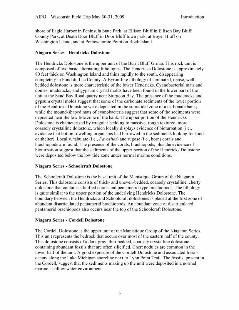
AIPG – Wisconsin Field Trip May 30-31, 2009 Introduction
5
shore of Eagle Harbor in Peninsula State Park, at Ellison Bluff in Ellison Bay Bluff County Park, at Death Door Bluff in Door Bluff town park, at Boyer Bluff on Washington Island, and at Pottawatomie Point on Rock Island. Niagara Series - Hendricks Dolostone The Hendricks Dolostone is the upper unit of the Burnt Bluff Group. This rock unit is composed of two basic alternating lithologies. The Hendricks Dolostone is approximately 80 feet thick on Washington Island and thins rapidly to the south, disappearing completely in Fond du Lac County. A Byron-like lithology of laminated, dense, well-bedded dolostone is more characteristic of the lower Hendricks. Cyanobacterial mats and domes, mudcracks, and gypsum crystal molds have been found in the lower part of the unit at the Sand Bay Road quarry near Sturgeon Bay. The presence of the mudcracks and gypsum crystal molds suggest that some of the carbonate sediments of the lower portion of the Hendricks Dolostone were deposited in the supratidal zone of a carbonate bank; while the mound-shaped mats of cyanobacteria suggest that some of the sediments were deposited near the low tide zone of the bank. The upper portion of the Hendricks Dolostone is characterized by irregular bedding to massive, rough textured, more coarsely crystalline dolostone, which locally displays evidence of bioturbation (i.e., evidence that bottom-dwelling organisms had burrowed in the sediments looking for food or shelter). Locally, tabulate (i.e., Favosites) and rugose (i.e., horn) corals and brachiopods are found. The presence of the corals, brachiopods, plus the evidence of bioturbation suggest that the sediments of the upper portion of the Hendricks Dolostone were deposited below the low tide zone under normal marine conditions. Niagara Series - Schoolcraft Dolostone The Schoolcraft Dolostone is the basal unit of the Manistique Group of the Niagaran Series. This dolostone consists of thick- and uneven-bedded, coarsely crystalline, cherty dolostone that contains silicified corals and pentamerid-type brachiopods. The lithology is quite similar to the upper portion of the underlying Hendricks Dolostone. The boundary between the Hendricks and Schoolcraft dolostones is placed at the first zone of abundant disarticulated pentamerid brachiopods. An abundant zone of disarticulated pentamerid brachiopods also occurs near the top of the Schoolcraft Dolostone. Niagara Series - Cordell Dolostone The Cordell Dolostone is the upper unit of the Manistique Group of the Niagaran Series. This unit represents the bedrock that occurs over most of the eastern half of the county. This dolostone consists of a dark gray, thin-bedded, coarsely crystalline dolostone containing abundant fossils that are often silicified. Chert nodules are common in the lower half of the unit. A good exposure of the Cordell Dolostone and associated fossils occurs along the Lake Michigan shoreline next to Lynn Point Trail. The fossils, present in the Cordell, suggest that the sediments making up the unit were deposited in a normal marine, shallow water environment.
AIPG – Wisconsin Field Trip May 30-31, 2009 Introduction
6
Pentamerid brachiopods (Pentamerus) are common. Disarticulated valves (shells) of Pentamerus are present throughout, but locally occur in densely packed layers. Localized patches of articulated individuals of Pentamerus are occasionally found, some in life positions. The most conspicuous fossils are the abundant and diverse tabulate corals that frequently appear to form colonies as much as three feet in diameter and one foot high. Favosites, the “honeycombed” coral, Halysites, the “chain” coral, and Syringopora, the tube-like coral are most commonly found. Nearly any gravel or beach deposit on the peninsula contains numerous specimens of these fossils. They are also commonly found in stone fence rows that characterize northern Door.
Other fossils that are associated with the above mentioned tabulate corals include Heliolites, a tabulate coral; Chadopora, a tabulate coral; Strombodes, a non-tabulate coral that resembles the fossil in a Petoskey stone; Zaphrentis, a solitary, horn coral; Stromatoporoids, a fossil sponge; bryozoans (commonly known as moss animals); stromatolites, fossil algae; snails; disarticulated crinoids; and cephalopods. Cayugan Series - Engadine Dolostone The Engadine Dolostone is youngest formation of the Niagaran Series of Silurian strata present in Door County. The rock consists of an extremely dense and crystalline, hard, even textured, light gray to white dolostone, commonly displaying a pinkish or purplish hue. Weathered exposures display a conspicuous pattern of deep horizontal creases and vertical crevices that represent solution-enlarged joints. Fossils found in the Engadine Dolostone are not silicified and, as a result, are not common. Scattered brachiopods, snails, corals, and trilobite pygidiums (i.e., tail portion of the trilobite), of Ekwanoscutellum are occasionally found in the Engadine. Sediments that make up the Engadine Dolostone were probably deposited in a normal marine, shallow water environment.
The Engadine Dolostone is thought to be stratigraphically equivalent to the Lockport Dolostone of the Niagara Series that caps Niagara Fall. Because of the regional eastward dip of the Silurian strata in Door County, the Engadine, which is approximately 40 feet thick on Washington Island at “The Mountain”, is exposed sporadically only on the Lake Michigan shore. The best exposures are at Newport State Park along Lynd Point Trail above the more fossiliferous layers of Cordell Dolostone near lake level and possibly the upper layer at Cave Point.
Structural Setting of the Rocks in Newport State Park The rocks outcropping in Door Peninsula are inclined (i.e., they dip) between 2 and 3 degrees from the horizontal eastward or southeastward towards the center of Michigan. Door Peninsula can be thought of as being on the west lip of the Michigan basin or east flank of the Wisconsin dome. Rocks in Door Peninsula display two joint sets having azimuths of about 72 and 155 degrees.

AIPG – Wisconsin Field Trip May 30-31, 2009 Introduction
7
GLACIAL AND POST GLACIAL HISTORY OF DOOR PENINSULA Wisconsin has experienced numerous phases of continental glaciation by the Laurentide Ice Sheet during the Pleistocene. The last major episode of glaciation is called the Wisconsin Glaciation or the Wisconsin Age. It began about 100,000 years ago and is considered to have ended 10,000 years ago. The southern margin of the Laurentide Ice Sheet was largely controlled by the landscape over which the ice advanced, and lobes or tongues of ice flowed generally southward, following structurally controlled bedrock lowlands, including the Lake Michigan and Green Bay basins. Both the Lake Michigan and Green Bay lobes undoubtedly played a significant role in the glacial history of Door Peninsula. Ice of the Green Bay lobe of ice left behind coarse-grained, yellowish brown to brown sediment in northern Door County, called the Liberty Grove till. This till is named from the Town of Liberty Grove Toward the end of the Pleistocene Epoch and throughout much of the postglacial Holocene Epoch that began about 10,000 years ago, water levels in the Great Lakes basins fluctuated widely due to a variety of causes (i.e., ice dams, changes in drainage outlets, elastic rebound, etc.). Three major, former lake stages are readily recognized in Door Peninsula by the presence of wave cut terraces and wave built beaches. These ancient shoreline features result from glacial Lake Algonquin phase, glacial Lake Nipissing phase and glacial Lake Algoma phase.
Door County Soil Profile Soils in Door County vary in thickness from 0 to about 172 inches. In many places of northern Door County, bedrock surfaces are exposed at the surface without any type of soil covering the rock. Table 2 displays a typical soil profile found in northern Door County. Table 3 displays a typical soil profile found in southern Door County. The general lack of any significant thickness of soil overlying bedrock in northern Door County causes groundwater to be quite susceptible to contamination. Table 2. Typical Soil Profile in Northern Door (17 to 32 inches of soil is quite common) O 0-5 inches thick; very dark grayish brown loam; weak medium sub-angular
blocky structure parting to moderate to medium granular; friable; many roots A 5 to 12 inches thick; grayish brown loam; moderate medium sub-angular blocky
structure; friable; common roots B 12 –15 inches thick; dark brown loam; moderate medium sub-angular blocky
structure; firm; common roots R Consolidated dolomitic bedrock

AIPG – Wisconsin Field Trip May 30-31, 2009 Introduction
8
Table 3. Typical Soil Profile in Southern Door (101 – 172 inches of soil) O 0 – 9 inches thick; very dark grayish brown sandy loam; moderate medium
granular; very friable; many roots; neutral A1 0 – 18 inches thick; brown loamy sand; fine sub-angular blocky structure; very
friable; slightly acid A2 16 – 24 inches thick; brown sandy loam; medium sub-angular blocky structure;
friable; slightly acid B1 24 – 27 inches thick; reddish brown heavy loam; moderate medium sub-angular
blocky structure; firm; neutral B2 27 – 34 inches thick; reddish brown sandy loam; weak coarse sub-angular
blocky structure; friable; neutral C 34 – 60 inches thick; light brown sandy loam; medium sub-angular blocky
structure; friable; strongly effervescent; mildly alkaline
Groundwater Aquifers in Door County In the past there have been three primary aquifer units in Door County: (1) within the sand and gravel aquifer; (2) eastern dolostone aquifer of Silurian age; and (3) underlying Cambro-Ordovician sandstone and carbonate aquifers. Table 4 lists the primary aquifer units in Door County. Table 4. Primary aquifer units in Door County.
Geologic Age Principal Lithology Hydrogeologic Nomenclature Pleistocene Unconsolidated
sand and gravel Sand and Gravel Aquifer
Shale and dolostone Dolostone Shaly dolostone
Maquoketa Confining Unit
Sandstone (St. Peter)
Ordovician
Dolostone (Prairie du Chien) and sandstone (Jordan)
St. Peter-Prairie du Chien-Jordan Aquifer
Dolostone and fine-grained mudstone (shale)
St. Lawrence Confining Unit
Sandstone (Ironton-Galesville)
Ironton-Galesville Aquifer
Shaly sandstone (Eau Claire)
Eau Claire Confining Unit
Cambrian
Sandstone (Mount Simon)
Mount Simon Aquifer
Precambrian Very difficult to find groundwater supplies in Precambrian terrains
Cam
bro-
Ord
ovic
ian
Aqui
fer S
yste
m

AIPG – Wisconsin Field Trip May 30-31, 2009 Introduction
9
The sand and gravel aquifer consists of debris deposited by glacial ice and rivers between 10,000 and 1 million years ago. Early settlers drove point wells in the glacial sediments, particularly in Southern Door, as water sources. Such wells can and still provide water for agricultural practices. However, such a well is illegal when the property is sold, for fear that it would be used as a household water supply. Water from these wells is quite susceptible to contamination The eastern dolostone aquifer occurs along Lake Michigan and Door County, and consists of deposits that were lain down by large inland seas some 400 to 425 million years ago. Water flows through interconnected cracks and pores in the dolostone, and well yields can be variable. The Mayville Dolostone is the primary carbonate aquifer. Water occurs primarily in fractures that are nearly vertical, and in larger horizontal bedding plane fractures. The Maquoketa Shale layer beneath the aquifer is considered impermeable and acts as a barrier between the eastern dolostone aquifer and the sandstone and dolomite aquifer. The fractures provide an intricate network of water flow channels that efficiently transport water from the surface to the groundwater reserves. The fractures are enlarged by dissolution, which contributes to the efficiency of water flow within the aquifer. Recharge of the Silurian aquifer occurs primarily through precipitation, which is greatest during the spring months by the combination of snowmelt and rainfall. Today, the Wisconsin DNR usually does not approve this aquifer as a source for potable water in homes or businesses. Wells in Northern Door have to be drilled and sealed to at least 260 to eliminate too much of the contaminants from reaching the major aquifer. The Cambro-Ordovician sandstone and carbonate aquifer is the principal bedrock aquifer for the southern and western parts of the state, and is relied upon by many major cities for drinking water. The following Cambro-Ordovician units serve as aquifers: St. Peter-Prairie du Chien-Jordan aquifer (sandstone with some dolomite), the Ironton-Galesville aquifer (sandstone) and Mount Simon aquifer (sandstone). In eastern Wisconsin the aquifer is confined as it lies below the Silurian dolostone aquifer and at other places it lies below the surficial aquifer Groundwater Contamination Susceptibility in Door County Groundwater contamination is rapidly becoming a formidable problem in Door County due to the nature of the soil cover and the increasing population of the area. All residents of Door County depend on groundwater, but groundwater quality problems have plagued the county for many years. Bacteria and nitrate exceed U.S. Environmental Protection Agency and Wisconsin drinking water standards in about 30 percent of the private wells in the county, and private well owners often report turbid or muddy water in their wells during certain times of the year. Other groundwater contaminants include agricultural chemicals, pesticide residues from cherry and apple orchards, and petroleum and other non-aqueous phase liquids such as gasoline and solvents.

AIPG – Wisconsin Field Trip May 30-31, 2009 Introduction
10
Northern Door County represents some of the most susceptible areas of groundwater contamination in Wisconsin. This is due to a thin soil layer and highly fractured, carbonate (i.e., limestone and dolostone) bedrock near the surface. Water supply for Sturgeon Bay comes entirely from municipal wells drawing water from the fractured dolostone aquifer. Over the years the city has installed 12 municipal wells within the city limits. Nine of these wells have shown signs of bacterial contamination, and seven of the wells have been shut down and abandoned. Currently the city operates five wells. Water from three of these wells is disinfected on site. Only two wells have remained free of bacterial contamination. In 1998, the Sturgeon Bay Water Utility, with support and funding from the Wisconsin Department of Natural Resources, requested that the Wisconsin Geological and Natural History Survey (WGNHS) provide assistance in delineating the capture zones for its municipal wells in support of a wellhead-protection plan. The motivation for this project was twofold: to assist the City of Sturgeon Bay and the county, and to gain a better understanding of how groundwater moves and of techniques for delineating the capture zone. Groundwater movement studies show that groundwater flow from recharge areas outside the city limits, up to 10 kilometers from the municipal wells. These studies also have shown that only 2 years are required for the groundwater to move this distance. Armed with the technical understanding that municipal well water is coming from several kilometers away and from outside the city limits, the city, water utility and county officials are working together to develop a wellhead-protection plan that will identify and perhaps reduce potential contaminant sources at the land surface in the contributing areas for the city wells. Contamination problems tend to be most severe at the end of the summer tourist season. Contamination of the groundwater system does not occur continuously throughout it, but primarily where fractured bedrock is near or at the surface. Contaminants enter the groundwater system from human, agricultural, industrial and municipal sources. The most common contaminant is bacterial, both viral and pathogenic. Over much of Wisconsin’s Door Peninsula, fractured dolomite is exposed at or near the land surface. Rain or snow falling on this landscape enters the groundwater system through an interconnected network of vertical and horizontal bedrock fractures. In such systems, contaminated surface runoff can directly enter underground water supplies through fractured rock outcroppings, sink holes, quarries and abandoned wells. Rapid groundwater movement and minimal contaminant attenuation are common, and so the land-use practices in the areas where the water originates — often called the capture zones or contributing areas — highly influence the quality of groundwater produced by local wells. Determining these capture zones and understanding how groundwater moves from recharge to local wells are critical to protecting groundwater in fractured-rock terrains. Once in the aquifer, the water flows laterally, through horizontal fractures, until it discharges to local lakes, springs or streams or is captured by water-supply wells. To make matters worse, large areas of Northeast Wisconsin suffer from naturally high levels

AIPG – Wisconsin Field Trip May 30-31, 2009 Introduction
11
of toxic minerals and contaminants - such as arsenic, lead, fluoride, iron and radium - in certain layers of the underground aquifer. Arsenic contamination in water supplies was discovered in Vinland Township in Winnebago County, Wisconsin in 1987. When 18 wells in Brown County were tested, they all had arsenic concentrations above 50 !g/L in Brown County, 17 of those wells are located in the same square mile. Groundwater collected from the St. Peter Sandstone and the overlying Platteville/Galena Dolostone, were found to be the principal sources of the elevated arsenic concentrations. These two formations supply most of the drinking water to a large portion of eastern Wisconsin. Since then, the Wisconsin DNR require wells in arsenic contaminated areas to be sealed off to eliminate the upper 100 feet of the St. Peter Sandstone from being exposed in the open borehole of water supply wells. When these toxic layers are drilled through or pumped, the contaminants can spread into clean aquifer layers resulting in wider groundwater contamination problems. The vertical and horizontal fractures in the Silurian dolostones in Door County are typical of the fractures that underlie the county and affect the groundwater. The vertical fractures are easily spotted in alfalfa fields during the summer because the vegetation is greener above the fractures.
Fractured Bedrock and Sinkholes The dominantly carbonate rocks of Door County have been subjected to solution by groundwater activity. This activity has produced sinkholes (collapsed area of bedrock, glacial drift, and soil), Karst topography (area with numerous sinkholes), disappearing streams, caves and enlarged joints. The orientation of the sinkholes in Door County coincides primarily with the orientation of the 72 and 155 degree azimuths of the rock joints.
REFERENCES Allen, Paula E., 1980, Paleoecology and Depositional History of a Portion of the Fort Atkinson Member of the Maquoketa Formation (Upper Ordovician) in Eastern Wisconsin: in Stieglitz, Ronald D. Editor, 1980. Geology of eastern and northeastern Wisconsin, a guidebook for 44th Annual Tri-State Geological Field Conference. Green Bay, Wisconsin. Dott, Robert H., Jr. and Attig, John W., 2004, Roadside Geology of Wisconsin. Missoula, MT: Mountain Press Publishing Company. Kluessendorf, Joanne and Mikulic, Donald G., 1989, Bedrock Geology of the Door Peninsula of Wisconsin: in Palmquist, John C., Editor, Wisconsin’s Door Peninsula: A Natural History. Appleton, WI. Perin Press.

AIPG – Wisconsin Field Trip May 30-31, 2009 Introduction
12
Paull, Rachel Krebs and Paull, Richard A., 1977, Geology of Wisconsin and Upper Michigan. Dubueque IA. Kendall/Hunt Publishing Company. Schneider, Allan, 1989, Geomorphology and Quaternary Geology of Wisconsin’s Door Peninsula: in Palmquist, John C., Editor, Wisconsin’s Door Peninsula: A Natural History. Appleton, WI. Perin Press. Schneider, Allan and Travis, Jack, 2008, Geology of Newport State Park. A Brochure. Ellison Bay, WI. The Newport Wilderness Society. Stieglitz, Ronald D. Editor, 1980. Geology of eastern and northeastern Wisconsin, A guidebook for 44th Annual Tri-State Geological Field Conference. Green Bay, Wisconsin. Stieglitz, Ronald D., 1989, The Geological Environment and Water Quality in Wisconsin’s Door Peninsula: in Palmquist, John C., Editor, Wisconsin’s Door Peninsula: A Natural History. Appleton, WI. Perin Press. Templeton, J. S. and Willman, H. B., 1963, Champlainian Series (Middle Ordovician) in Illinois, Illinois State Geol. Survey Bulletin 89, 260 p.

AIPG – Wisconsin Field Trip May 30-31, 2009 Road Log
13
ROAD LOG
for the 2009 BROWN/DOOR COUNTIES, WISCONSIN
GEOLOGY FIELD TRIP for the
WISCONSIN SECTION of the
AMERICAN INSTITUTE OF PROFESSIONAL GEOLOGISTS
MILES___REMARKS__________________________________________________
0.0
0.1
0.2
2.3
3.5
10.7
18.2
20.1
21.3
DEPARTURE TIME VIA CHARTERED BUS: 8:00 A.M., SATURDAY, MAY 30, 2009 Intersection of 1st Street and the entrance to Stone Harbor Resort parking lot in Sturgeon Bay. Turn left (west) onto 1st Street. Intersection of 1st Street and Jefferson Street. Turn right (northeast) onto Jefferson Street. Intersection of Jefferson Street and 3rd Street. Continue on Jefferson Street. Jefferson Street eventually becomes Egg Harbor Road (Business 42/57). Intersection of Egg Harbor Road and State Highways 42/57. Turn left (north) onto State Highway 42/57. Intersection of State Highway 42 and State Highway 57. Turn right (east) onto State Highway 57. Intersection of State Highway 57 and Door County WD (Clarke Lake Road). Door County WD goes to Whitefish Dunes State Park and Door County Cave Point County Park. However, this trip will continue in a northerly direction on State Highway 57. 45th Parallel County Park on the west side of State Highway 57. Iraq war casualty sign on west side of State Highway 57. The property is owned by Al (does not own Al Johnson’s restaurant in Sister Bay) & Cynthia Johnson. Intersection of State Highway 57 and Town of Baileys Harbor Frog Town Road. Turn right (east) onto Frog Town Road.

AIPG – Wisconsin Field Trip May 30-31, 2009 Road Log
14
MILES 22.1
22.2
22.8
23.2
23.6
32.0
32.3
32.5
32.6
32.8
32.9
REMARKS Stop 1: Frog Town Road Collapse Exit bus and walk along Frog Town Road to road cave-in site. Return to bus immediately after site discussion. Continue south on Frog Town Road. Intersection of Frog Town Road and State Highway 57. Turn right (north) onto State Highway 57. Intersection of State Highway 57 and Ridge Road. Turn right (east) onto Ridge Road. Intersection of Ridge Road and entrance to Baileys Harbor Ridges County Park parking lot. Stop 2: Ridges Sanctuary Exit bus and walk south along Ridge Road to Range Light Trail of Ridges Sanctuary. Return to bus immediately after site discussion. Turn left (south) onto Town of Baileys Harbor Ridge Road from Baileys Harbor Ridges County Park parking lot. Intersection of Town of Baileys Harbor Ridge Road and State Highway 57. Turn right (north) onto State Highway 57. Intersection of Highway 57 and Village of Sister Bay Country Walk Road. Turn left (west) onto Country Walk Road. Intersection of Village of Sister Bay Country Walk Road and parking lot drive way. Turn right (north) into parking lot. Stop to pick up lunches at Top Shelf. Intersection of parking lot driveway and Village of Sister Bay Country Walk Road. Turn right (west) onto Country Walk Road. Intersection of Village of Sister Bay Country Walk and State Highway 42. Turn right (north) onto State Highway 42 Intersection of State Highway 42 and State Highway 57. Continue straight (north) on State Highway 42. Intersection of State Highway 42 and Village of Sister Bay Mill Road. Turn right (east) onto Mill Road.

AIPG – Wisconsin Field Trip May 30-31, 2009 Road Log
15
MILES 33.0
33.1
33.5
33.9
34.9
35.4
36.3
36.7
36.9
38.0
38.5
REMARKS Intersection of Village of Sister Bay Mill Road and driveway entrance to Sister Bay/Liberty Grove library parking lot. Park on Mill Road just west of the intersection. Stop 3: Potential site for a building collapse Exit bus and walk into the library parking lot. Return to bus immediately after site discussion. Continue east on Mill Road. Park on Mill Road just west of the intersection of Mill Road and the entrance to the Sister Bay Fire Station parking lot. Stop 4: Initial site for a new Sister Bay Fire Station Exit bus and walk across Mill Road to view a wetland park. Return to bus immediately after site discussion. Continue east on Mill Road to the intersection of Village of Sister Bay Mill Road and Town of Liberty Grove Woodcrest Road. Turn left (north) onto Woodcrest Road. Intersection of Town of Liberty Grove Woodcrest Road and Town of Liberty Grove Scandia Road. Turn right (east) onto Scandia Road. Intersection of Town of Liberty Grove Scandia Road and Town of Liberty Grove Old Stage Road. Turn left (north) onto Old Stage Road. Intersection of Old Stage Road and Town of Liberty Grove Hill Road. Turn right (east) onto Hill Road. Entering a drumlin field. Road cut through a drumlin. Intersection of Town of Liberty Grove Hill Road and Door County ZZ. Turn left (north) onto County ZZ. Intersection of Door County ZZ and Town of Liberty Grove Wildwood Road. Turn left (west) onto Wildwood Road. A ridge of a recessional moraine parallels Wildwood on the north side of the road. Intersection of Town of Liberty Grove Wildwood Road and Town of Liberty Grove Lake View Road. Turn right (north) onto Lake View Road.

AIPG – Wisconsin Field Trip May 30-31, 2009 Road Log
16
MILES 40.8
41.1
42.1
46.2
46.7
47.4
48.1
48.2
48.3
48.8
49.3
REMARKS Entrance to Cottage Glen Estates. This is a town house/condominium project. The buildings are built on top of approximately 250 feet of sand. The sand is an infilling of the preglacial drainage channel of Mink River. Intersection of Town of Liberty Grove Lake View Road and Town of Liberty Grove Mink River Road. Continue in a northwesterly direction on Lake View Road. Intersection of Town of Liberty Grove Lake View Road and State Highway 42 in Ellison Bay, Wisconsin. Turn right (northeast) onto State Highway 42. Intersection of State Highway 42 and Town of Liberty Grove Isle View Road. Turn right (east) onto Isle View Road. Intersection of Town of Liberty Grove Isle View Road and Town of Liberty Grove Timberline Road. Continue east on Isle View Road. Intersection of Town of Liberty Grove Isle View Road and Jack Travis/Diane Morgan driveway. Continue east on Isle View Road. Drainage culvert under Isle View Road. The culvert drains water from Europe Lake, which is barely visible to the south of Isle View Road. Blue herons frequently feed at either end of this drainage culvert. Original house of Ted Olson, U.S. Solicitor General during the first 4-year term of George W. Bush. During the summer of 2002, numerous TV shows of Larry King Live originated at this house. Barbara Olson, Ted’s former wife who was killed in the plane that crashed into the Pentagon on the morning of September 11, 2002, was a frequent guest on the TV show, which was shot by CNN TV crews. Isle View Road would be partially blocked by satellite TV trucks. Intersection of Town of Liberty Grove Isle View Road and Town of Liberty Grove Skaugum Road. Turn right (south) onto Skaugum Road. Intersection of Town of Liberty Grove Skaugum Road and Town of Liberty Grove Northern Door Road. Turn left (north) onto Northern Door Road. Intersection of Town of Liberty Grove Northern Door Road, Town of Liberty Isle View Road and entrance to Liberty Grove End of Road Town Park (Isle View Road).

AIPG – Wisconsin Field Trip May 30-31, 2009 Road Log
17
MILES
51.0
53.5
54.0
54.6
54.8
55.7
57.4
58.9
59.9
63.2
63.9
65.1
REMARKS Stop 5: Collection of Zebra Mussel Shells Exit bus and walk into the Town Park to the Lake Michigan shore line. Return to bus immediately after site discussion. Travel west on Town of Liberty Grove Isle View Road. Intersection of Town of Liberty Grove Isle View Road and Town of Liberty Grove Timberline Road. Turn left (south) onto Timberline Road. Intersection of Town of Liberty Grove Timberline Road and Door County Highway NP. Turn left (east) onto Highway NP. Intersection of Door County NP and Newport State Park Road/County NP. No stop, turn right onto Newport State Park Road/County NP. Entrance to Newport State Park. Park Visitors Holtz Nature Center. Continue on the main park road to Parking Lot 3. Stop 6: Bedrock geology of Newport State Park Exit bus and walk Europe Bay and Lynd Point trails towards outcrops of rock on the Lake Michigan shore line. Return to bus immediately after site discussion. Return to the entrance of Newport State Park and continue on Newport State Park Road/County NP to the intersection of Door County NP and Newport State Park Road/County NP. Turn left (west) onto County NP. Door County NP turns north. The small parking lot to the west of this turn is for people wanting to hike on Nature Conservancy property to Mink River. Intersection of Door County NP and State Highway 42. Turn left (south) onto State Highway 42. Intersection of State Highway 42 and Town of Liberty Grove Porcupine Road. Turn right (west) onto Porcupine Road. Intersection of Town of Liberty Grove Porcupine Road and entrance to Ellison Bay Bluff County Park. Turn right (north) onto road leading to Ellison Bay Bluff County Park. Main parking lot for Ellison Bay Bluff County Park.

AIPG – Wisconsin Field Trip May 30-31, 2009 Road Log
18
MILES
65.8
65.9
66.0
66.7
67.0
68.7
70.1
75.0
77.9
78.4
97.8
REMARKS Stop 7: Ellison Bay Bluff County Park. Exit bus and walk towards the bluff edge. Return to bus immediately after site discussion. Return to intersection of road leading to Ellison Bay Bluff County Park and Town of Liberty Grove Porcupine Road. Turn right (west) onto Porcupine Road. Intersection of Town of Liberty Grove Porcupine Road and Town of Liberty Grove Beach Road. Turn left (south) onto Beach Road. Big house to the north of the road. This house recently sold for $13,000,000. It is presently on the market for $17,000,000. Martin and Alice Krebs House. Stop 8A: View of the middle portion of Mossy Cliff Trail Exit bus and walk behind the Krebs’s house to look at the middle of Mossy Cliff Trail. Return to bus immediately after site discussion. Intersection of Town of Liberty Grove Beach Road and Town of Liberty Grove Mossy Cliff Trail. Stop 8B: Mossy Cliff Trail Exit bus and walk along Mossy Cliff Trail for a short distance. Return to bus immediately after site discussion. Continue in a southerly direction on Town of Liberty Grove Beach Road to the intersection of Beach Road and State Highway 42. Turn right (south) onto Highway 42. Intersection of State Highway 42 and State Highway 57. Continue straight (south) on Highway 42. Intersection of State Highway 42 and North entrance to Peninsula State Park. Intersection of State Highway 42 and South and main entrance to Peninsula State Park. Three-way stop sign in Fish Creek. Turn left and continue in a southerly direction on State Highway 42. Intersection of State Highway 42 and State Highway 57. Continue straight in a southerly direction on State Highway 42/57.

AIPG – Wisconsin Field Trip May 30-31, 2009 Road Log
19
MILES 99.1
101.2
101.3
101.4
0.0
1.8
5.5
6.8
8.3
8.7
9.2
REMARKS Intersection of State Highways 42/57 and Business 42/57 (Egg Harbor Road). Turn right (west) onto Business 42/57 (Egg Harbor Road). Business 42/57 (Egg Harbor Road) eventually becomes Jefferson Street. Intersection of 3rd Street and Jefferson Street. Continue on Jefferson Street. Intersection of Jefferson Street and 1st Street. Turn left (southeast) onto 1st Street. Intersection of 1st Street and entrance to Stone Harbor Resort parking lot. Site of Annual Meeting and Saturday Night Lodging. SUNDAY, MAY 31, 2009 DEPARTURE TIME VIA PRIVATE CAR CARAVAN: 8:00 A.M. Intersection of the entrance to Stone Harbor Resort parking lot and 1st Street in Sturgeon Bay. Turn left (west) onto 1st Street. Intersection of 1st Street and 3rd Street/Iowa Street. Turn left (northerly direction) onto 3rd Street, which eventually becomes Door County Highway B. Abandoned quarry on the east side of the Highway B. Intersection of Door County Highway B and entrance to Old Stone Quarry County Park. Turn right (east) into the boat trailer parking lot for Old Stone Quarry County Park. Stop 9: Old Stone Quarry County Park Exit cars and walk towards the quarry face. Return to cars immediately after site discussion. Intersection of Bluff Court Road and Door County Highway B. Turn right (east) onto Bluff Court Road. Intersection of Pine Tree Road and Bluff Court Road. Turn right (south) onto Pine Tree Road. Intersection of Old Orchard Road and Pine Tree Road. Turn left (east) onto Old Orchard Road.

AIPG – Wisconsin Field Trip May 30-31, 2009 Road Log
20
MILES 10.2
11.7
27.6
28.1
28.3
32.3
36.5
37.0
37.1
38.7
39.7
REMARKS Intersection of Old Orchard Road and Reynolds Road. Continue on an easterly direction on Old Orchard Road, which becomes Door County Highway HH. Intersection of State Highway 42 and Door County Highway HH (Old Orchard Road). Turn left (north) onto State Highway 42. Stop sign in Fish Creek on State Highway 42. Turn right (east) on State Highway 42. Intersection of South and main entrance to Peninsula State Park and State Highway 42. Turn left onto Peninsula State Park Road. Park Office. Stop for Park sticker check. Continue on Peninsula State Park Road to parking lot for Eagle Bluff Lighthouse. Stop 10: Eagle Bluff Lighthouse. Exit cars and walk to the bluff edge to the west of the lighthouse. Return to cars immediately after site discussion. Turn right onto Peninsula State Park Road. Intersection of Peninsula State Park Road and State Highway 42. Turn right (west) onto Highway 42. Three-way stop sign in Fish Creek. Intersection of Main Street and State Highway 42. Continue straight (west) onto Main Street. Intersection of Main Street and Cottage Row Road. Turn left (south) onto Cottage Row Road. While on this road you will have to navigate through two hairpin turns to get to the top of the Niagara Escarpment. Intersection of Gibraltor Bluff Road and Cottage Row Road. Turn right (south) onto Gibraltor Bluff Road. Stop 11: Sinkhole. Exit cars and walk to the sinkhole to the west of the road. Return to cars immediately after site discussion. Intersection of Gibraltor Bluff Road and Orchard Road. Continue straight (south) on Gibraltor Bluff Road.

AIPG – Wisconsin Field Trip May 30-31, 2009 Road Log
21
MILES 40.2
40.5
48.6
57.3
63.3
68.4
73.0
76.9
82.1
REMARKS Intersection of Peninsula Players Road and Gibraltor Bluff Road. Turn left (east) onto Peninsula Players Road. Intersection of State Highway 42 and Peninsula Players Road. Turn right (south) onto State Highway 42. Log Den Restaurant visible to the east of State Highway 42. A May 29 - June 1, 2007 outbreak of norovirus at the Log Den restaurant left 212 customers and employees of the Log Den restaurant ill. The same strain of norovirus found in the stools of some of the sickened patrons and employees was found in the drinking water source for the restaurant. Intersection of State Highway 42 and State Highway 57. Continue on a southerly direction on State Highway 42/57. Intersection of State Highway 42/57 and Door County Highway S. Continue in a southerly direction on State Highway 42/57. Intersection of State Highway 42/57 and Door County PD. Door County PD goes to Potawatomi State Park. However, this trip will continue in a southerly direction on State Highway 42/57. Intersection of Wisconsin State Highway 57 and Wisconsin State Highway 42. Continue in a southerly direction on State Highway 57. At the foot of the North slope of Brussels Hill. A steep hill near Brussels with numerous Silurian exposures. The layers are tilted in the roadcuts on old State Highway 57 due to karst collapse. Crest of Brussels Hill. Beginning onto the South slope of Brussels Hill. Door County line. A road cut in Silurian Mayville Dolostone and top two feet of calcareous shales of the Brainerd Shale Member of the Maquoketa Formation at the base to the east of State Highway 57 (See Photograph 1).
Photograph 1. Greenish grey layer at the bottom is the Brainerd Shale.

AIPG – Wisconsin Field Trip May 30-31, 2009 Road Log
22
MILES 88.5
88.8
89.1
94.7
94.8
95.2
95.3
95.4
95.5
REMARKS Intersection of State Highway 57 and Bay Shore Park Road. Turn right (west) onto Bay Shore Park Road. Bay Shore County Park parking lot. Stop 12: Bay Shore County Park Exit cars. Walk towards a road cut leading to the parking lot and breakwater at the base of the bluff. We will walk down towards the lower parking lot, looking at the geology while enroute. The grade of the road, although still steep, was lowered after initially constructed because of the difficulty of towing boat trailers back up the slope. Return to cars immediately after site discussion. Intersection of Bay Shore Park Road and State Highway 57. Turn right (south) onto State Highway 57. Intersection of State Highway 57 and Champion Road. Turn right (west) onto Champion Road. Intersection of Champion Road and Bay Settlement Road. Turn left (south) onto Bay Settlement Road. Intersection of Bay Settlement Road and parking lot entrance for Wequiock Falls(NOTE: There are seven parking stalls in this parking lot. There is another parking lot at the intersection of Bay Settlement Road and Van Lannen Road. Stop 13: Wequiock Falls Exit cars. Walk to the bridge crossing Wequiock Creek. On the south side of the bridge, there are some stair-like steps going down to stream level. Return to cars immediately after site discussion. Bridge crossing Wequiock Creek. Intersection of Bay Settlement Road and Van Lannen Road. Turn left onto Van Lannen Road. Intersection of Van Lannen Road and State Highway 57. If you turn right onto Highway 57, you will head for Green Bay. If you turn left onto Highway 57, you will head for Sturgeon Bay. END OF TRIP HAVE A SAFE DRIVE HOME.

AIPG – Wisconsin Field Trip May 30-31, 2009 Stop 1
23
Stop 1: Frogtown Road Collapse
Location: Latitude 45.0542119 – Longitude 87.125187
Author: Jack W. Travis, Ph.D., Professional Geologist – AIPG CPG-07378; WI 814-013
Summary:
An 800 foot section of the east lane of Frogtown Road collapsed into Lake Michigan in the spring of 2007. The Town of Baileys Harbor, Wisconsin does not own the shore frontage along the road. As a result, steps for restoring the roadway were complicated. The road was finally restored for safe travel in October 2008.

AIPG – Wisconsin Field Trip May 30-31, 2009 Stop 1
24
Description:
Frogtown Road is a town road of the Town of Baileys Harbor, Wisconsin. The road nearly parallels the shoreline of Lake Michigan for approximately 0.7mile in the Town of Baileys Harbor, Wisconsin at the south end of the Village of Baileys Harbor, Wisconsin.
Over many years, wave action undercut bedrock of the Niagara Dolostone that supported Frogtown Road. From this, approximately an 800 foot section of the east lane of the road collapsed on May 16, 2007 (See Photographs 1-1).
Photograph 1-1. This photograph depicts approximately 800 feet of the east lane of Frogtown Road that collapsed in the spring of 2007. The crack in the road that is trending in an easterly-westerly direction is following a major joint in the underlying Niagara Dolostone. The picture also depicts some of the undercutting of the roadway by past wave action in Lake Michigan.
The Town made a request to the DNR for an emergency permit in June 2007, following the road collapse and sent a request to the U.S. Corps of Engineers for financial support to shore up and armor the eroded section along Frogtown Road. There was a lack of money available from the Corps for this project. The DNR mailed a copy of a 30 day

AIPG – Wisconsin Field Trip May 30-31, 2009 Stop 1
25
public notice to the Town in early July 2007 that had to be published in a newspaper about the pending project. In addition to getting this public notice published, the Town had to also notify all affected property owners by mail because the shore frontage is private property rather than being town property. Copies of all public comments and permission letters from all concerned property owners were sent to DNR.
The DNR requested that the Town create cross-sections to show the extent of wave erosion along and under the roadway before a permit would be granted. Town personnel prepared a number of cross-sections perpendicular to the collapsed roadway at 50 foot spacing, which were submitted to DNR.
Using the 50 foot cross-sections, two different plans were developed for repairing the collapsed roadway by DNR personnel and construction engineers. The first plan called for the void spaces under the roadway to be filled with shot rock or breaker run and then placing large riprap in front. After the fill had been completed a number of 3 to 4 inch diameter holes would be drilled from above and then filled with lean concrete to provide support for the road. This plan was favored by most DNR reviewers because this method would only affect 6 ½ to 10 feet of shore frontage and would offer the least disruptive view of the shoreline, as seen from the water. The second plan called for knocking off all of the overhangs and then working upward with fill material and riprap to the original roadway level. DNR reviewers did not prefer this method because it would affect 12 to 12 feet of shore frontage extending the high water level inland under the roadway.
The DNR issued a permit for restoring Frogtown Road in October 2007, using Plan 2. Construction bids were opened in November 2007. Iron Works, LLC of Baileys Harbor, Wisconsin got the contract to do the repair work on Frogtown Road. Repair work started in mid-December, 2007. All work on restoring the road was completed in August, 2008 (See Figure 1-2).
Photograph 1-2. This photograph is looking in an southerly direction and shows the repair of the collapsed left lane of Frogtown Road.

AIPG – Wisconsin Field Trip May 30-31, 2009 Stop 1
26
Significance:
This site demonstrates the power of wave action in Lake Michigan and the ramifications such power can have on private/public property. It also demonstrates the
References:
Minutes of an Emergency Town Board Meeting, May 16, 2007, Town of Baileys Harbor, Wisconsin, 1 page.
Minutes of Town Board Meeting and an e-mail from Steve Parent, July 9, 2007, Town of Baileys Harbor, Wisconsin, 2 pages.
Minutes of Town Board Meeting, August13, 2007, Town of Baileys Harbor, Wisconsin, 2 pages.
Minutes of Town Board Meeting, September 24, 2007, Town of Baileys Harbor, Wisconsin, 1 page.
Minutes of Town Board Meeting, October 16, 2007, Town of Baileys Harbor, Wisconsin, 1 page.

AIPG – Wisconsin Field Trip May 30-31, 2009 Stop 2
27
Stop 2: Ridges Sanctuary Location: Latitude 45.0704292 – Longitude 87.119951
Author: Jack W. Travis, Ph.D., Professional Geologist – AIPG CPG-07378; WI 814-013 Summary: The Ridges Sanctuary is noted for three things. First, it has a remarkable series of Holocene wooded beach ridges that are separated by low swampy open swales, second it is a relict boreal forest, and third, it has two range lights that were built in 1869

AIPG – Wisconsin Field Trip May 30-31, 2009 Stop 2
28
Description:
History of The Ridges and its Range Lights - In 1869, the United States Government built six sets of range lights on the Great Lakes. Today, the range light buildings in Baileys Harbor are the only ones of their style and class still standing in their original positions. The range lights at Baileys Harbor were constructed on a range light reserve, consisting of 40 acres, on the southwest portion of an area now known as "The Ridges" abutting on Lake Michigan in Door County, Wisconsin. The Range Lights were built because they were considered to be the most effective way to keep ships off the treacherous reefs and shallows at the entrance to Baileys Harbor. From the water, a sailor got "on range" by lining up vertically the white light in the Upper Range Light, which shone at a height of 39 feet above the water, with the red beacon light of the Lower Range Light, fixed at 22 feet above the water (See Photograph 2-1).
Photograph 2-1. This photograph depicts the range lights at the Ridges Sanctuary. The lower range light in the foreground and the upper range light is in the distance. In 1934, the Bureau of Lighthouses, United States Government, deeded the land, which comprised about 30 acres, and the buildings on it to the Door County Park Commission for a park. Some individuals immediately started to exert pressure on the Door County Park Commission to build a rather extensive campsite for tourists on this property. The Campsite Project was approved and work started in 1936. Some of the trees on the property were cleared and rock was hauled in to fill the swales along the trail between the Range Light structures.

AIPG – Wisconsin Field Trip May 30-31, 2009 Stop 2
29
On March S, 1937, Albert M. Fuller, Curator of Botany for the Milwaukee Public Museum, gave an illustrated talk "Preserving the Ridges at Baileys Harbor" at a meeting in Sturgeon Bay, which was sponsored by the Woman's Club of Sturgeon Boy. Members of the Door County Park Commission were present as well as a few residents of Baileys Harbor. The Park Commission, not long after that meeting, decided to have the Baileys Harbor area set aside as a wild flower sanctuary. Then, a group of people from Baileys Harbor (i.e., Emma Toft and Olivia Traven), Ephraim, and Ellison Bay (i.e., Jens Jensen), interested in permanent wildlife conservation for Door County, met at Baileys Harbor on October 4, 1937 for the purpose of forming a corporation under the name, "The Ridges Sanctuary." The land acquisition program of the Ridges was started in January, 1938 when the late Ferdinand Hotz of Chicago, Illinois, gave forty acres. In 1944, Mr. Hotz gave an additional two hundred acres. Miss Emma Toft of Baileys Harbor, who has been indefatigable in her zeal for the Ridges, has contributed at least a forty. By 1944 the Ridges Sanctuary entailed at least 310 acres of ridges and swales. Through other land donations and land purchases the present acreage of the Ridges Sanctuary is now 1001.9 acres. As a result of all of this, the Ridges Sanctuary encompasses an isolated pocket of the only known boreal (northern) forest in eastern Wisconsin. Geologic History of “The Ridges” - The region of the Ridges Sanctuary that this stop is interested in consists of about 30 crescent-shaped Lake Michigan sand dunes or ridges forested with black spruce, white spruce, balsam fir, and white pine with wet swales lying between the ridges. Swamp conifers, plus marsh and bog plants grow in the swales. This ridge and swale landform is Holocene in age and still forming. The crescent-shaped ridges parallel the Lake Michigan shoreline. How did these crescent-shaped ridges and swales develop? All of Door County was glaciated during the Wisconsin stage of glaciation, primarily by ice of the Green Bay lobe. Glacial drift was deposited in the newly formed Lake Michigan basin when the glacier melted. As the ice front was retreating by melting, various stages of post-glacial lakes occupied the Great Lakes region as different lake outlets developed. About 9,000 years ago (i.e., 9 ka) glacial ice had melted to the point that the glacial history of the Great Lakes watershed had ended. Isostatic uplift continued, however, and its effect has had a major role in the postglacial evolution of the Great Lakes. About 3 ka an intermediate post-glacial level common to Superior, Michigan and Huron known as Lake Algoma also developed, but there is some debate as to whether strands related to this level were the result of temporary stabilization of the outlet at Port Huron or whether this high stand was climatically induced. The shoreline of post-glacial Lake Algoma extended inland approximately a mile from the location of the present day Lake Michigan shoreline at this site. As a result, the land of present-day Ridges Sanctuary was beneath water. Sand laden, longshore currents currently flow in a southerly direction along the Lake Michigan shoreline into Baileys Harbor. These currents are slowed by the shallow U-

AIPG – Wisconsin Field Trip May 30-31, 2009 Stop 2
30
shaped harbor, causing sediments to be deposited on the harbor floor. Aerial photographs of Baileys Harbor reveal underwater sand bars separated by troughs paralleling the present shore, the nuclei of future ridges and swales. Another important factor in ridge formation is the natural cycle of high and low water levels of Lake Michigan. On average, Lake Michigan undergoes a high stage about every 11 years. Assuming that longshore currents were flowing in a north-to-south direction along the Wisconsin shoreline of post-glacial Lake Algoma, sediments would be deposited in harbor where present day Ridges Sanctuary exists. When lake levels were high, wave action pushed the sand into a low ridge along the shoreline. Off-lake winds also played a role by picking sand grains up and moving them inland where they would be trapped by grasses and low lying shrubs. As lake levels dropped, the ridge became exposed and was sometimes capped by wind-blown sand. Approximately 100 to 140 years were required to form one ridge by wind and wave action. One by one, the ridges continued to form, reflecting the natural ups and downs of the lake level. Thus, the ridges closest to the shoreline are the youngest. Each new ridge was rapidly stabilized by plants. Sedges and grasses were the first in line, followed by small shrubs and a few species of trees. These plants stabilized the "new" land and provide conditions for other plant communities to form. Gradually other trees and plants moved in, finally becoming the boreal forest community that we see today (See Photograph 2-2).
Photograph 2-2. Aerial photograph of Baileys Harbor and Ridges Sanctuary.
The above model used to explain the origin of the ridges and swales suggest that they would all contain a series of lakeward-dipping reflectors and a strong concave reflector that extends lakeward from the base of swales. The strong reflector would represent an erosional surface (ravinement) created during lake-level rises while the other reflectors would represent the offlapping part of the progradational development of beach ridges. If continuous GPR reflection surveys using a Noggin 250 SmartCart with a fixed 250 MHz antennae and a recording interval of 5 cm between traces across beach ridges was conducted, this could be a way to validate this model of ridge and swale development
AIPG – Wisconsin Field Trip May 30-31, 2009 Stop 2
31
Some of the swales contain water year around, while others are periodically wet. The depth of the swales and the height of the water table dictate whether water is present year around or not. Ridges may support assemblages similar to boreal, northern mesic, or northern dry-mesic forests. Water depth is a controlling factor in the swales, and the vegetation may run the gamut from open (emergent marsh, fen, or sedge meadow), shrub (bog birch, alder), or forested wetlands (often white cedar, black ash are prominent in these). Significance: This stop discusses the origin of the ridge and swale topography seen at the Ridges Sanctuary, Baileys Harbor, Wisconsin. References: Fuller, A. M. 1950. The Ridges Wildflower Sanctuary at Baileys Harbor, Wisconsin, Transactions of the Wisconsin Academy of Sciences, Arts and Letters 40: 149-57. http/://ridgesanctuary.org/preservation.htm. 2009. The Ridges Sanctuary. Lukes, R. W. 1988. The Ridges Sanctuary. Baileys Harbor: The Ridges Sanctuary, Inc. Marquardt, T. C. 1986. Age and Paleoclimatic Significance of a Lake Michigan Beach Dune Ridge Complex Located at Baileys Harbor, Wisconsin. M.S. Thesis, University of Wisconsin-Green Bay.

AIPG – Wisconsin Field Trip May 30-31, 2009 Stop 3
32
Stop 3: Potential site for a building collapse Location: Latitude 45.1879049 – Longitude 87.1204661
Author: Jack W. Travis, Ph.D., Professional Geologist – AIPG CPG-07378; WI 814-013 Summary:
An investigation of this site requested that the ad hoc Library Planning Committee should seriously consider selecting a different site for a new library in Sister Bay, Wisconsin, or, at least, contract a geological and environmental survey of the chosen site for the new library before finalizing the site selection. These requests were made because the chosen site may not be a geologically safe site. The site may be a former landfill site as well as an upland marsh-type site, either of which would make the site unsuitable for such a building.

AIPG – Wisconsin Field Trip May 30-31, 2009 Stop 3
33
Description: As population grew in the Village of Sister Bay and the Town of Liberty Grove in the 1990’s, it became evident that there was a need for a larger library facility for the area. An ad hoc citizens planning committee was formed to develop plans for such a library. By the end of 2000, the planning committee had selected a site in the Village of Sister Bay for the new library, a site adjacent to the Sister Bay/Liberty Grove fire department station at that time. At the request of several concerned citizens, the author, Jack W. Travis (Certified Professional Geologist CPG-07378 Professional Geologist PG-814), was asked to conduct a site analysis to determine if the selected site for the library was a geologically safe site for such a building. These concerned citizens were concerned because they, along with all the citizens in the Village of Sister Bay and the Township of Liberty Grove had received a letter from the Sister Bay/Liberty Grove Fire Department explaining that a new fire station was to be built soon at taxpayer expense. The letter gave several reasons why a new fire station was needed. One of the reasons given was that the building was showing its age, even though the building was only 20 plus years old. Resident Interviews - The first phase of this investigation involved interviews with some long-time residents of Sister Bay, who wish to remain anonymous because they owned businesses in the area. These interviews revealed why the fire station might be “showing its age”. They remembered the following about the proposed site: " While growing up in Sister Bay in the 1940s and 1950s, they played baseball and
softball on a baseball field that occupied the site of the present fire station and the future library.
" An individual that collected village garbage dumped all of that garbage at the site of the present fire station property for many years.
" Fill material was hauled in periodically as cover material for the garage, dumped and leveled out.
" The eastern portion of the site was always very wet in the spring because of a number of springs yielding water from the hillside to the east and south. They thought that Spring Street was given its name because of all of the active springs to the east of the street and in the vicinity of the present fire station.
" The cement floor in the fire station has many cracks. " Water is frequently on the cement floor of the fire station. These comments sent up two “red flags” for a new library at this site. First, landfills are not conducive for constructing buildings on top of the landfill for two reasons. Garbage placed in a landfill slowing undergoes decay. As decay occurs, the ground surface subsides differentially and methane gas is produced. The methane gas moves upward. Buildings have exploded when methane gas from an underlying landfill has accumulated in buildings.

AIPG – Wisconsin Field Trip May 30-31, 2009 Stop 3
34
Second, due to weathering and wave action during glacial lake Nipissing phase, the escarpment of the Niagara Dolostone retreated eastward between the location of the present day Sister Bay Bowl and the former site of Hotel Du Nord (i.e., now a condo development project). This former wave action built a wave cut/wave built terrace between the escarpment and water level. Ground water flows along joints and bedding planes in the Niagara Dolostone from higher elevations. Springs emit along the face of the escarpment. The water moves to lower elevations through the sediments making up the wave cut/wave built terraces as artesian water and creates an upland marsh-type site. Artesian-type water has a certain amount of buoyancy-effect, causing materials to be differentially lifted. Site Reconnaissance - The second phase of this investigation involved a site reconnaissance. This investigation revealed four things. First, the garage door on the southeast corner of the building was open during this reconnaissance. Looking through the open door revealed that the cement floor in this part of the building has many cracks. Second, a drainage ditch had been dug along the east and south sides of the fire station property as an attempt to keep water out of the fire station. Water was flowing in the ditch and this investigation was conducted in December 2000, suggesting that water probably flows in this ditch year around. Third, the outside walls of the fire station building at the site consist of metal and stone. In many places the stone is pulling away from the building at ground level (see Picture 3-1).
Photograph 3-1. This photograph is looking in an easterly direction and shows that the stonework on the Sister Bay/Liberty Grove Fire Department station at 275 East Mill Road in Sister Bay, Wisconsin is pulling away from the building at ground level on the north side of the building.

AIPG – Wisconsin Field Trip May 30-31, 2009 Stop 3
35
Forth, the investigation also revealed that the cement driveway approach apron on the north side of the building is migrating to the north away from the building (see Picture 3-2). Investigation Summary - This investigation revealed the following: " Interviews with long-time residents of Sister Bay revealed the eastern portion of the
site was always very wet in the spring when they were playing baseball/softball at this site in the 1940s and 1950, village garbage was dumped for many years at the site of the present fire station property, and fill material was hauled in as cover material for the garage, dumped and leveled out, producing the present ground surface.
Picture 3-2. The cement driveway approach apron on the north side of the Sister Bay/Liberty Grove Fire Department station at 275 East Mill Road in Sister Bay is migrating to the north away from the building. " Site reconnaissance revealed the stone work on the fire station building is pulling
away from the building at ground level, the cement driveway approach apron on the north side of the building is migrating northward away from the building, and (3) the cement floor in the southeast part of the building has many cracks.
" If the fire station building had been built on a former landfill site or in an area of numerous springs, this could explain why the building which is only twenty plus years old is “showing its age”.
" Landfills are not conducive for constructing buildings on top of the landfill. " Spring water emits along the face of the escarpment from higher elevations; as well as
moving to lower elevations through sediments making up wave cut/wave built terraces as artesian water.

AIPG – Wisconsin Field Trip May 30-31, 2009 Stop 3
36
" Artesian-type water has a certain amount of buoyancy-effect, causing materials to be differentially lifted.
" If the new library is built on this site with such conditions, the new library might have to be replaced much sooner that the taxpayers of the Village of Sister Bay and the Township of Liberty Grove would be willing to accept.
A summary report of this investigation was submitted to the chair of the Town of Liberty Grove, the ad hoc library planning committee and Door County Librarian with the following recommendations: " Interview a number of long-time residents of Sister Bay to insure that the chosen site
is not a former landfill site for the Village of Sister Bay. " Contract with an engineering/environmental consulting firm to complete some test
borings to determine whether the site was a landfill or not " Contract with an engineering/environmental consulting firm to complete some test
borings to determine what construction steps will have to be taken to control differential settling of the new library.
" Seriously consider selecting another site for a new Sister Bay/Liberty Grove library that is a geologically sound site.
" If the library has to be built at this site, additional money should be spent to drive pilings and “hang” the building on the pilings. This is about the only way a stable building can be built in such conditions.
" Some might suggest, however, that putting drainpipes around the outside of the foundation is a way to alleviate the subsurface water problem. Often times, however, the soil settles differentially with this approach, causing the foundation to start cracking.
This investigative report slowed the project down for a few months. The village and town contracted with an environmental drilling firm to test for possible buried garbage and water problems. The firm made three random borings in the vicinity of where the new library was supposed to be constructed. The borings did not reveal any evidence of buried garbage and the boring reports indicated that the soil was damp, but no free water in the hole. With that, the project was started. The excavator dug trenches and placed frames for the cement pores for the footings one day. The next day, the cement was supposed to be pored, but when the workers arrived at the site all of the trenches were filled with water. There was no snow on the ground to melt and it had not rained during the night. This caused construction to stop for awhile. Eventually, it was decided to double the width and thickness of the footing of the building foundation. Construction officially began in the summer of 2001. Pumps were constantly running while the concrete cured. Eventually the library was completed in June 2002 (See Photograph 3-3).

AIPG – Wisconsin Field Trip May 30-31, 2009 Stop 3
37
Photograph 3-3. This photograph shows the new Sister Bay/Liberty Grove library. The old fire station building is to the right of the parking lot. Significance: To many “i’s” had been dotted before any consideration had been made about the geologic safety of this site for such a project. Only time will tell if the Sister Bay/Liberty Grove library will collapse in the near future. Therefore, this site demonstrates the need of geological input by professional geologists on site selection before a project progresses to the point of no return. Reference: Travis, Jack W., 2001, Geological Site Analysis of 275 East Mill Road, Sister Bay, Wisconsin for the New Sister Bay/Liberty Grove Library.

AIPG – Wisconsin Field Trip May 30-31, 2009 Stop 4
38
Stop 4: Initial site for a new Sister Bay Fire Station Location: Latitude 45.1873907 – Longitude 87.1185351
Author: Jack W. Travis, Ph.D., Professional Geologist – AIPG CPG-07378; WI 814-013 Summary: This stop provides an opportunity to visualize a partially destroyed wetland by local government officials while attempting to construct a new fire station in Sister Bay, Wisconsin.

AIPG – Wisconsin Field Trip May 30-31, 2009 Stop 4
39
Description: This site is located on Mill Road, 0.3 mile east of Wisconsin State Highway 42, in Sister Bay, Wisconsin. The site was the first site selected for a new fire station by the Village of Sister Bay. The fire station that had served the Sister Bay/Liberty Grove area for 20+ years was collapsing (see Stop 3). As a result the Village and Town boards began searching for a site for a new fire station/Emergency Medical Service (EMS) facility. The Village of Sister Bay offered to buy a 7+ acres parcel of land east of a seller’s home on Spring Street, providing that the seller could demonstrate that the land was not a wetland. The Village made this offer even though old Village maps in the Village office depicted the property in question as a wetland, known as Pond C. Also, Door County maintains Wetland Inventory Maps at the Zoning and Planning Department. Every village and town have access to file records of such maps as part of relevant wetland ordinances or for zoning purposes. The site in question was a part of a delineated wetland on the Wetland Inventory Maps. The latest issue of these maps is dated 1992. The seller contracted with Baudhuin Incorporated, an engineering consulting firm in Sturgeon Bay, to complete a wetland delineation of the property. Baudhuin Incorporated concluded that the property in question was not a wetland sometime before February 12, 1998 because the U.S. Corps of Engineers office in Green Bay, Wisconsin confirmed the interpretation without any field checking in a letter dated February 12, 1998. The letter, however, stated ”PLEASE NOTE THAT THIS CONFIRMATION LETTER DOES NOT ELIMINATE THE NEED FOR STATE, LOCAL OR OTHER AUTHORIZATIONS SUCH AS THOSE OF THE DEPARTMENT OF NATURAL RESOURCES OR DOOR COUNTY”. Based on the results provided by Baudhuin Incorporated and the confirmation letter from the Corps of Engineers, the Village of Sister Bay entered into a contract to purchase the land in April, 2000 and closed on the purchase in December, 2000. Purchase price was $200,000.00 for 7+ acres. The Village of Sister Bay initiated site work on May 7, 2001 after the 2001 Wisconsin Act 6 became state law. Site work entailed cutting approximately 3 acres of trees adapted to wetlands, root removal and four loads of fill material before the Wisconsin Department of Natural Resources (DNR) stopped the project. Shortly after the trees and roots had been removed, a retired mechanical engineer, Zalman “Phil” Saperstein, and his wife returned to their home on Park Street, which is adjacently south of the site in question, from a vacation. He contacted the author, Jack Travis, questioning what could be done. We learned that the Door County Resource Planning Committee (RPC) was holding a meeting that would pertain to issuing county funds for the construction of an EMS facility at the site. We attended the meeting and

AIPG – Wisconsin Field Trip May 30-31, 2009 Stop 4
40
tried to convince the committee that the area was a wetland and tax money should not be released for the EMS facility unless it could be proven that the area was not a wetland. The RPC requested that the Village complete more study before proceeding. The Village contracted with Robert E. Lee & Associates, Inc, Green Bay, Wisconsin, to work with DNR wetland specialists to determine if the site was a wetland or not. I accompanied Phil Saperstein to the DNR office in Sturgeon Bay for a pre-sampling meeting with DNR and Robert E. Lee wetland specialists. I asked if there was a map showing where the original samples were collected and was provided such a map by DNR officials. One look at the sampling locations on the map told me that only three samples had been collected and all of them had been collected essentially in a straight line at elevations ranging from about 600 to 605 feet above sea level (See Photographs 4-1 and 4-2). Those elevations in the Sister Bay/Gills Rock area represent an ancient beach ridge, glacial Lake Nipissing. With the three samples showing no sign of wetland sediments, the Corps apparently elected to approve the site as high ground. No samples, however, had taken in the swale between the ancient beach ridge and Park Lane where the fire station was to be built.

AIPG – Wisconsin Field Trip May 30-31, 2009 Stop 4
41
Photograph 4-1. Aerial photograph depicting the proposed site of the new fire station on Mill Road, Sturgeon Bay, Wisconsin. The dark soil of the wetland is visible. When DNR and Robert E. Lee wetland specialists took one sample in the swale, they declared the area as a wetland. The DNR verbally informed the Village of Sister Bay to

AIPG – Wisconsin Field Trip May 30-31, 2009 Stop 4
42
cease work on the site on December 17, 2001 and verified the verbal instructions with a follow up letter on December 20, 2001. The Village of Sister Bay and the Town of Liberty Grove built a new facility adjacently to the east of this site. The Village owned this property and displaced a recreation area (baseball field during summer months and an ice skating rink during winter months) for the new fire station facility. Unfortunately, the facility was probably built, in part, on a continuation of this wetland.
Photograph 4-2. This photograph is looking in a northwesterly direction. The photograph shows the portion of the wetland that was cleared for the new fire station. Looking through the trees, one can see a ridge line. This ridge line corresponds to the closed contour line on the topographic map with an elevation of 600 feet above sea level. The three soil samples that were used to depict this area as dry land were collected on this ridge. Significance: This stop shows again why it is necessary for geological input by professionals (geologists and wetland specialists) on site selection before a project progresses to the point of no return. Reference: Travis, Jack W., 2002, What Really Happened in Sister Bay. Letter to the Editor, Door County Advocate.

AIPG – Wisconsin Field Trip May 30-31, 2009 Stop 5
43
Stop 5: Collection of Zebra Mussel Shells Location: Latitude 45.0704292 – Longitude 87.119951
Author: Jack W. Travis, Ph.D., Professional Geologist – AIPG CPG-07378; WI 814-013 Summary: This stop provides a view of a relatively recent concentration of Zebra mussel shells. Description: The Town of Liberty Grove maintains a trapezoid-shaped, 0.5 acre park, Isle View Town Park, at the east end of Isle View Road, Door County, Wisconsin. The park is on the western shore of Lake Michigan. Washington Island, Plum Island, Detroit Island and Pilot Island are visible from the park (See Photograph 5-1).

AIPG – Wisconsin Field Trip May 30-31, 2009 Stop 5
44
Early Characteristics of the Beach at Isle View Town Park - Prior to the early 1990’s the beach along Lake Michigan at Isle View Town Park was primarily sand. However, the southern end of the beach next to the point of bedrock projecting into Lake Michigan was a pebble beach. Later Characteristics of the Beach at Isle View Town Park - By early 2000’s, this section of the beach of Lake Michigan had been transformed into a beach of zebra mussels shells (See Photographs 5-2 and 5-3).
Photograph 5-1. This photograph is looking east from Isle View Town Park. The western shore of Lake Michigan is visible at this site, in addition to the south end of Detroit Island and Pilot Island with a small navigation light is visible to the distant right of Detroit Island. Zebra Mussel - The Zebra mussel, Dreissena polymorpha, is a bivalve mussel native to freshwater lakes of southeast Russia. Zebra mussels were first detected in Lake St. Clair, between Detroit, Michigan and Windsor, Ontario in 1988. It is believed they were inadvertently introduced during the release of ballast water of ocean-going ships while traversing the St. Lawrence Seaway. Since then, Zebra mussels have invaded into all of the Great Lakes, except Lake Superior. They have also invaded into a large number of United States waterways, including the Mississippi, Hudson, St. Lawrence, Ohio, Cumberland, Missouri, Tennessee, Colorado and Arkansas rivers. They are also present in many inland fresh water lakes in the Midwest now.

AIPG – Wisconsin Field Trip May 30-31, 2009 Stop 5
45
Photograph 5-2. This photograph is looking in a southerly direction on the beach at Isle View Town Park. Four windrows of Zebra mussel shells are visible along the Lake Michigan shoreline at this site.
Photograph 5-3. This photograph is looking in a northerly direction on the beach at Isle View Town Park. Windrows of Zebra mussel shells are visible closer to the waterline. A sandy beach is visible to the west of the Zebra mussel shell deposits. A man-made harbor for the Washington Island Car Ferry is visible approximately one mile north from this site.
AIPG – Wisconsin Field Trip May 30-31, 2009 Stop 5
46
Zebra mussels are sedentary, voracious filter-feeding organisms. They anchor themselves with adhesive threads, called byssus coming out from under the umbo (i.e., very strongly convex part of the valve adjacent to the beak) area on the dorsal surface (i.e., side with the hinge), to objects. The shells of Zebra mussels are D-shaped and are relatively small in size with adults ranging from ¼ to 1½ inches long. Tiny stripes usually run down their shells, hence the name Zebra Mussels. Adult female Zebra mussels may produce thousands of eggs per year. If food is abundant in the water and water temperatures are above 12 degrees Celsius, spawning usually will occur in late spring to early summer. If water becomes colder, however, spawning may be postponed until the water has warmed. Veligers are hatched from the eggs of the Zebra mussel. A veliger is the free-swimming, planktonic larva. Eventually, veligers become juvenile Zebra mussels. Juvenile Zebra mussels settle down through the water column and attach themselves to an object by the byssus. When feeding, Zebra mussels remove particles from the water column, which increases water clarity. With higher degrees of water clarity, sunlight penetrates to greater depths. As a result, Cladophora - a branching, green, filamentous macro-algae - is growing at greater depths in the Great Lakes than in the past. Cladophora attaches to Zebra mussel shells living on rocks, in addition to the rocks themselves. During storms, wave action may detach Zebra mussels. Large mats of Cladophora and attached Zebra mussels wash ashore. Eventually the Cladophora decays, leaving behind windrows of Zebra mussels on the shore, as seen at this site. Zebra rock? - The Atlantic shore of northeast Florida, near St. Augustine, is well known for its Coquina rock. In Spanish, Coquina means "tiny shell" and the small clam, Donaxvariabilis, making up the natural aggregate for Coquina rock is commonly called Coquina. Are we looking at a deposit of Zebra mussel shells that will eventually be transformed into Zebra rock? Time will tell. Significance: This stop demonstrates that anthropologic events can cause significant changes in the landscape in a short period of time. Reference: "zebra mussel." Wikipedia. Wikipedia, 2008. Answers.com 03 Apr. 2009. http://www.answers.com/topic/zebra-mussel

AIPG – Wisconsin Field Trip May 30-31, 2009 Stop 6
47
Stop 6: Bedrock geology of Newport State Park Location: Latitude 45.0704292 – Longitude 87.119951
Author: Jack W. Travis, Ph.D., Professional Geologist – AIPG CPG-07378; WI 814-013 Summary: This stop allows you to view the youngest strata exposed on the Door Peninsula, the Engadine Dolostone, as well as the upper part of the underlying, fossiliferous Cordell Dolostone. Remember, there will be no fossil collecting at this site.

AIPG – Wisconsin Field Trip May 30-31, 2009 Stop 6
48
Description: Newport State Park consists of approximately 2,400 acres of land and 11 miles of Lake Michigan shoreline on the western shore of Lake Michigan at the northeast end of the Door Peninsula of Wisconsin. A multitude of different natural habitats occur within the park. These natural habitats, resulting from the underlying geology found in the park and the close proximity of Lake Michigan, provide homes for a diverse plant and wildlife community. The Door Peninsula, including Newport State Park, is a glaciated bedrock upland situated between two linear topographic lowlands, the Lake Michigan basin on the east and Green Bay basin on the west. The gently eastward-dipping rocks of the Door Peninsula form a landform called a cuesta. Ancient Geologic History of Newport State Park - The rocks outcropping at various places in the park are primarily fossiliferous dolostone of middle Silurian age, a subdivision of the Paleozoic Era, and are commonly known as the Niagara Dolostone. The Niagara Dolostone is Silurian (438 to 408 Ma years before the present). Dolostone is a sedimentary rock consisting of crystals of the mineral dolomite. The Engadine and Cordell subdivisions of the Niagara Dolostone outcrop in Newport State Park. A good exposure of the Cordell Dolostone and associated fossils occurs along the Lake Michigan shoreline next to Lynd Point Trail (See Photograph 6-1). The Engadine Dolostone overlies the Cordell Dolostone on the Lynd Point Trail (See Photograph 6-2).
Photograph 6-1. People looking for fossils on a bedding plane surface of the Cordell Dolostone at Newport State Park.
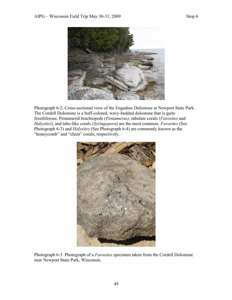
AIPG – Wisconsin Field Trip May 30-31, 2009 Stop 6
49
Photograph 6-2. Cross-sectional view of the Engadine Dolostone at Newport State Park. The Cordell Dolostone is a buff-colored, wavy-bedded dolostone that is quite fossiliferous. Pentamerid brachiopods (Pentamerus), tabulate corals (Favosites and Halysites), and tube-like corals (Syringopora) are the most common. Favosites (See Photograph 6-3) and Halysites (See Photograph 6-4) are commonly known as the “honeycomb” and “chain” corals, respectively.
Photograph 6-3. Photograph of a Favosites specimen taken from the Cordell Dolostone near Newport State Park, Wisconsin.

AIPG – Wisconsin Field Trip May 30-31, 2009 Stop 6
50
The Engadine Dolostone is brownish gray on a fresh surface, medium bedded, white weathering dolostone, but not very fossiliferous. Weathered exposures display a conspicuous pattern of deep horizontal creases and vertical crevices that represent solution-enlarged joints.
Photograph 6-4. Photograph of Halysites as seen on a bedding plane of the Cordell Dolostone at Newport State Park, Wisconsin. The Silurian sea floor sloped gently from present day Newport State Park towards the center of present day Michigan, as part of a structural basin during Silurian time. Coral and algal reefs developed along the lip of this basin. Sediments deposited on the Silurian sea floor at present day Newport State Park were deposited in a fore reef environment. Glacial and Post Glacial History of Newport State Park - Both the Lake Michigan and Green Bay lobes of the Laurentide Ice Sheet undoubtedly played a significant role in the glacial history of Newport State Park during the Pleistocene. However, there is virtually no direct evidence about the glacial history of Door County for over 99 percent of Pleistocene time. The absence of glacial sediments older than about 18,500 radiocarbon years is undoubtedly due to the great erosional power of glacier ice. Any ice-deposited sediments were simply eroded during one or more subsequent glacial advances, transported by the ice, and deposited farther south. The last ice advance into northern Door County for which there is conclusive evidence occurred about 18,500 radiocarbon years (22,000 calendar years) ago during the latter

AIPG – Wisconsin Field Trip May 30-31, 2009 Stop 6
51
part of the Wisconsin Glaciation. Moving generally southward, the ice came out of the Green Bay basin, overtopped the Niagara Escarpment, and flowed obliquely across the peninsula to the Lake Michigan basin. The long axes of several drumlins (streamlined hills composed of glacial sediment) that form the Liberty Grove drumlin field about 5 miles southwest of this stop trend S. 15o E. Many of these drumloid hills are only 10-20 feet high, although a few of the more prominent ones have relief of over 30 feet. The trend of these hills and the fact that the north end of these hills display a steeper slope indicate that the ice was flowing from the north in a southerly direction. The Green Bay ice left behind coarse-grained, yellowish brown to brown sediment called the Liberty Grove till, named from the Town of Liberty Grove, which includes Newport State Park. The deposit is a pebbly loam till with a high carbonate content, which is mostly dolostone, in all size fractions. Most of the material (about 95 percent) was clearly derived by erosion of the local dolostone bedrock. Toward the end of the Pleistocene Epoch and throughout much of the following postglacial Holocene Epoch that began about 10,000 years ago, water levels in the Great Lakes basins fluctuated widely due to a variety of causes. In the Lake Michigan basin, the level ranged from a high of about 640 feet, or 60 feet above modern lake level, to a low that was possibly 350 feet below modern lake level during the Chippewa phase. In Newport State Park, a gravelly beach deposit east of County Highway NP north of the entrance to the park has an elevation of 650 feet; it was deposited about 11,000 radiocarbon years ago during the glacial Lake Algonquin phase of lake history when the level of Lake Michigan was 605 feet. A later shoreline that formed during the Lake Nipissing phase about 5,000 years ago, also at an elevation of 605 feet, remains at 605 feet because it has not been uplifted. Several segments of this shoreline occur in the park; perhaps the best one is a wave-cut bedrock bluff along Lynd Point Trail a short distance west of Lynd Point. Europe Lake is a shallow medium-size lake at the north end of Newport State Park. It is located a short distance behind (west of) the northern half of Europe Bay and is separated from Lake Michigan by a bedrock headland on the north and by a moderately large sand dune complex on the south. Sometime near the end of the Nipissing transgression, perhaps about 6,000 years ago, Lake Michigan waters apparently inundated the Europe Lake basin, thus converting it into an embayment. Shortly thereafter, probably between 5,000 and 4,500 years ago, the deposition of sand resulted in the construction of a sand spit attached to the bedrock headland at the north end of Europe Bay. As the spit grew from north to south, it gradually evolved into a baymouth bar across the mouth of that embayment. By about 4,500 B.P. when the Nipissing shoreline attained an altitude of 605 feet (184 m), Europe Lake was largely cut off from Lake Michigan by the growth of the bar and associated sand-dune complex.

AIPG – Wisconsin Field Trip May 30-31, 2009 Stop 6
52
Significance: This stop provides a chance to see the two youngest units of the Niagara Series, the Engadine and Cordell dolostones. An abundance of fossils are readily available for observing and photographing in the Cordell Dolostone. The typical weathering characteristics of the Engadine Dolostone are visible at this site. References: Dott, Robert H., Jr. and Attig, John W., 2004, Roadside Geology of Wisconsin. Missoula, MT: Mountain Press Publishing Company. Kluessendorf, Joanne and Mikulic, Donald G., 1989, Bedrock Geology of the Door Peninsula of Wisconsin: in Palmquist, John C., Editor, Wisconsin’s Door Peninsula: A Natural History. Appleton, WI. Perin Press. Paull, Rachel Krebs and Paull, Richard A., 1977, Geology of Wisconsin and Upper Michigan. Dubueque IA. Kendall/Hunt Publishing Company. Schneider, Allan, 1989, Geomorphology and Quaternary Geology of Wisconsin’s Door Peninsula: in Palmquist, John C., Editor, Wisconsin’s Door Peninsula: A Natural History. Appleton, WI. Perin Press. Schneider, Allan and Travis, Jack, 2008, Geology of Newport State Park. A Brochure. Ellison Bay, WI. The Newport Wilderness Society.

AIPG – Wisconsin Field Trip May 30-31, 2009 Stop 7
53
Stop 7: Ellison Bay Bluff County Park
Location: Latitude 45.0704292 – Longitude 87.119951
Author: Jack W. Travis, Ph.D., Professional Geologist – AIPG CPG-07378; WI 814-013
Summary: This stop provides an excellent opportunity to view the Niagara Escarpment, as well as being able to observe the units of the Burnt Bluff Group of the Niagara Series.

AIPG – Wisconsin Field Trip May 30-31, 2009 Stop 7
54
Description: Ellison Bay Bluff County Park, occurring between Ellison Bay and Gills Rock on the south shore of Green Bay, is a 174-acre park in Door County, Wisconsin. This stop provides an awesome view of the Niagara Escarpment. An enclosed catwalk allows one to view the shear bluff face of the escarpment at eye level, with the water of Green Bay about 100 feet below (See Photograph 7-1). Units of the Burnt Bluff Group, the Byron and Hendricks dolostones, are exposed in the shear bluff face at this site (See Photograph 7-2). The Byron Dolostone is a white to light gray, dense, very finely grained, even-textured, sub-lithographic dolostone. It is well stratified in even and regular beds, which breaks down into rectangular blocks.
Photograph 7-1. Enclosed catwalk for viewing the shear bluff face of the Niagara Escarpment at Ellison Bay Bluff County Park.
Photograph 7-2. Units of the Burnt Bluff Group in the Niagara Escarpment at Ellison Bay Bluff County Park.
AIPG – Wisconsin Field Trip May 30-31, 2009 Stop 7
55
The Hendricks Dolostone is composed of two basic alternating lithologies. A Byron-like lithology of laminated, dense, well-bedded dolostone is more characteristic of the lower Hendricks. The upper portion of the unit is characterized by irregular bedding to massive, rough textured, more coarsely crystalline dolostone Cyanobacterial mats and domes, mudcracks, and gypsum crystal molds have been found in this unit in Door County. Locally may display evidence of bioturbation and may contain tabulate and rugose (horn) corals and brachiopods. Significance: In addition to being able to stand on an enclosed catwalk that is overhanging the Niagara Escarpment, this stop allows you to observe rocks of the Burnt Bluff Group of the Niagara Series. References: Dott, Robert H., Jr. and Attig, John W., 2004, Roadside Geology of Wisconsin. Missoula, MT: Mountain Press Publishing Company. Kluessendorf, Joanne and Mikulic, Donald G., 1989, Bedrock Geology of the Door Peninsula of Wisconsin: in Palmquist, John C., Editor, Wisconsin’s Door Peninsula: A Natural History. Appleton, WI. Perin Press. Paull, Rachel Krebs and Paull, Richard A., 1977, Geology of Wisconsin and Upper Michigan. Dubueque IA. Kendall/Hunt Publishing Company.

AIPG – Wisconsin Field Trip May 30-31, 2009 Stop 8A
56
Stop 8A: View of the middle portion of Mossy Cliff Trail Location: Latitude 45.0704292 – Longitude 87.119951
Author: Jack W. Travis, Ph.D., Professional Geologist – AIPG CPG-07378; WI 814-013 Summary: This site provides an opportunity to visualize possible destructive results that a road widening project could trigger if the project is not done properly. Description: Mossy Cliff Trail is bounded on the west by an accumulation of weathered rock debris that has moved downslope from the cliff to the east of the road under the influence of gravity (i.e., a talus slope) between the road and homes built on the first erosional level of

AIPG – Wisconsin Field Trip May 30-31, 2009 Stop 8A
57
the Niagara Escarpment along the east shore of Green Bay, on the east by a continuation of the talus slope to the base of the cliffs forming the second step of the Niagara Escarpment, on the north by private property north of a small cul-de-sac or turnaround, and on the south by the intersection of Mossy Cliff Trail and Beach Road (a paved Town road). It was an unimproved, unpaved road that was built on a talus slope for access to homes built at lower elevations than that of the road without too much alteration of the talus slope in the 1950’s. At the request of a several newer residents on Mossy Cliff Trail, the Town Board of Liberty Grove scheduled to widen the road for health and fire protection benefits without any plans for constructing retaining or gabion walls where needed. Town officials marked numerous trees for removal before excavating the talus slope along most of Mossy Cliff Trail in order to widen the roadbed. At the request of a representative for the Mossy Cliff Trail Association, Ms. Julia Rosner, the author, Jack W. Travis (Certified Professional Geologist CPG-07378 Professional Geologist PG-814), to investigate the possibility that the Niagara Escarpment to the east of Mossy Cliff Trail would be unstable if the talus slope was modified, as planned by the Town of Liberty Grove. The investigation entailed a literature review, interviews and a visual site inspection of the subject site and surrounding area. I completed a Potential Landslide Site Assessment along and adjacent to Mossy Cliff Trail in Liberty Grove Township, Door County, Wisconsin on July 9, 2000. The author made an oral presentation of this investigation at a Special Board meeting of the Town of Liberty Grove on July 15, 2000 (See Appendices 1,2, and 4). Results of Interviews – Interviews with two property owners with houses on Mossy Cliff Trail revealed the road was adequate for fire fighters to put out a brush fire that had been started on a neighbor's lot a few years ago and for ambulance service several times at another house on the road. Interviews also revealed that an investigation concerning slope stability was completed by Dr. Richard Paull, Geology Professor Emeritus at the University of Wisconsin-Milwaukee, for a property owner (i.e., Martin Krebs) with a house (i.e., the house at this stop) at the top of Niagara Escarpment between Beach Road and Mossy Cliff Trail. For some reason the report was not accepted by Liberty Grove Township board members, so Mr. Krebs had another investigation done by Michael Wheeler, P.E. (Principal Engineer) along with Bon Hsiang Lien, Ph.D., P.E.-Senior Project Director that were associated with STS Consultants, Inc. in Milwaukee, Wisconsin. For some reason, Town Board members would not accept the STS report. Reports for both investigations indicated that the widening of Mossy Cliff Trail could weaken the rocks in the cliff to the west of the road and recommended no road improvement. The author completed a reconnaissance inspection of the site before he had an opportunity to read the reports from the two previous investigations. This study came to the same conclusion as the two previous investigations. This investigation, however, looked at the total picture, not just the effects the road improvement project would have on the properties on Beach Road at the top of the cliff, but to properties to the west of Mossy Cliff Trail.

AIPG – Wisconsin Field Trip May 30-31, 2009 Stop 8A
58
Site Geology – The bedrock exposed at Mossy Cliff Trail is the Silurian aged Niagara Dolostone, a layered sedimentary rock. The Niagara Dolostone displays two types of weakness in this area. First are the natural bedding planes which are gently dipping (i.e., about 3° from the horizontal towards the east). The second type of weakness that is visible in this area is vertical fractures in the rock along which there has been no movement called joints. Two sets of joints, essentially at right angles to each other, occur. The waters of Green Bay lie to the west of Mossy Cliff Trail. Mossy Cliff Trail was built on a talus slope associated with the Niagara Escarpment. The Niagara Escarpment is an erosional cliff formed initially by stream erosion and later enhanced by continental glaciation and wave action when glacial Lake Algonquin and Lake Nisissing phases of the Great Lake history were at higher levels. Two wave cut/wave built terraces formed during higher water levels of the glacial lake phases, sometime after glaciation. The lower wave cut/wave built terrace occurs at the top of the first step in the Niagara Escarpment. The second terrace is occupied by Beach Road to the east of Mossy Cliff Trail. The step for the second terrace of the Niagara Escarpment forms a cliff that occurs between Mossy Cliff Trail and Beach Road. Following the development of the lower wave cut/wave built terrace of the Niagara Escarpment in this area, the rock in the cliff forming the step to the higher terrace has undergone weathering. With the aid of gravity this weathered material was moved onto the lower wave cut/wave built terrace to form a talus slope. Trees have sprouted and grown on the talus slope. Based on the size of many of the trees growing on the talus slope, they have been growing 50 to 100 years or more. Such trees have extensive root systems that help to stabilize the talus slope. Concerns About the Widening of Mossy Cliff Trail – Roots of mature trees growing on the talus slope help to stabilize the talus slope along Mossy Cliff Trail. The removal of a number of these trees could make the talus slope less stable. By making cuts into the slope parallel or sub-parallel to the Mossy Cliff Trail could also weaken the rocks in the cliff to the east of the road. Also, there were no plans to construct retaining or gabion walls in the Town plan where needed. Such construction could trigger mass movement of the materials making up the talus slope. Some of the homes built on or at the toe of the talus slope below road level could be highly damaged or totally destroyed by such movement. As materials are moved to lower levels by mass movement following such construction, the cliff at the head of the talus slope, to the east of Mossy Cliff Road, would be weakened and start collapsing to lower levels. With this condition, the houses built on top of the second wave cut/wave built terrace could also be subjected to structural damage or destruction.

AIPG – Wisconsin Field Trip May 30-31, 2009 Stop 8A
59
Recommendations – The report by the author and those completed by Dr. Paull and an STS engineer recommended that the Liberty Grove Township board abandon plans of widening Mossy Cliff Trail in order to minimize the chance for creating mass movements of materials in the talus slope which could damage or destroy the homes built at elevations lower that Mossy Cliff Trail and the collapse of the cliff to the east of Mossy Cliff Trail. Special Town Board Meeting - At the Special Board meeting, the author requested that the Town Board accept his written report as part of the minutes for the meeting after giving an oral report on the subject site (See Appendix 1). The request was honored. Following that, Mr. Krebs requested that the Town Board accept the two reports that he had contracted earlier, which was also honored. Before relinquishing the stage, the author also requested that the Town Board contract with another engineering consulting firm concerning the safety of the proposed road widening project for Mossy Cliff Trail. Status of the Project – Following the Special Board meeting the Town Board contracted with Owen Ayres & Associates, Inc. in Green Bay, Wisconsin to analyze for any potential problems that might be associated with a road widening project on Mossy Cliff Trail. A report from Ayres & Associates stated that “The problem is well documented in the previous studies. The removal of some material at the base of the cliff may cause cliff failure”..... (See Appendix 3). Shortly after receiving the Ayres report the Town Board chairperson resigned from the Board. Later, the Town Board submitted a road improvement grant proposal to Wisconsin Department of Transportation (DOT) for improvements on Mossy Cliff Trail, which was funded. Since the Town had a dictum from Wisconsin DOT to improve Mossy Cliff Trail, the Town Board then contracted with Kapur & Associates, Inc. in Milwaukee, Wisconsin to provide professional engineering services for the design of the road. The author attended every Town meeting that dealt with the Mossy Cliff Project after the Town contracted with Kapur & Associates. In the end, Mossy Cliff Trail was not widened as much as originally planned and gabion walls were constructed where needed. There are two locations that are still of concern. First, one of the gabion walls might not be large enough to control rock falls from above. Likewise, rock falls are still possible on the east side of a cul-de-sac at the north end of Mossy Cliff Trail. Significance: This investigation demonstrates the need for due diligence of road construction projects planned by a governmental agency in order to alleviate or minimize the potential for triggering landslides that might affect citizens in the future. References: Paull, Rachel K. and Paull, Richard A., 1977, Geology of Wisconsin and Upper Michigan Including Parts of Adjacent States: Kendall Hunt Publishing Company, Dubuque, Iowa, 232 pp. Travis, Jack W., 2000, Mossy Cliff Trail: Investigative Report Prepared for Mossy Cliff Trail Association.

AIPG – Wisconsin Field Trip May 30-31, 2009 Stop 8A
60
Appendix 1 – Minutes of Special Board Meeting TOWN OF LIBERTY GROVE. Special Board meeting. Saturday, July 15, 2000 at 8 AM. Agenda: informational meeting regarding the Town's plans for improving Mossy C1ift Trail. Chairman Kubet Luchterhand called the meeting to order at 8:05 AM. Supervisors Casey, Jungwirth, Mahoney and Clerk Kalms were also present, Supervisor Most was absent. Luchterhand stated that Mossy Cliff is a Town road, and needs improvement for snow removal and emergency vehicular access. Quinn Brennan spoke on behalf of the road residents, saying the group is not adverse to widening of the road as long as it is done safely. Several separate studies have been done on the geology of the road, and they have all come to the same conclusion. The group is asking for a detailed project plan including engineering and budget figures with costs for tree removal, retaining walls, and future liability of police patrols. Police are mentioned because of the possibility of a public park at the end of the easement to the water becoming an attractive nuisance. Luchterhand said the easement is not relevant, the access to the water is not being decided today. He said there is no plan to develop the easement. Amy Tuttweiler, counsel for the Mossy Cliff Association, said the legal status of the easement is not clear. The question is if the Town has done enough to dedicate it as a road. If it is a logging road then it is not to be used for other purposes. John Mahoney said the original purpose was to get to the water. Lee Telfer said this easement is shoreline access, the equivalent of another lot in fee simple. Geologist Jack Travis of Isle View Road presented a report (attached to these minutes} showing concerns with houses on top of the bluff and below the road. He recommended that the Town get a study by an engineering firm. STS has also done a study. Travis said that even with retaining walls there is movement of rock. Suzanne Brennan asked why there is a huge gap between the Board and the Mossy Cliff people in terms of this being such a major project. Luchterhand said the idea is to not have a four lane road there. The problems are emergency vehicle access and snow removal, and to accomplish this with the least amount of disruption. He feels there is not an active talus slope there. Travis said the turnaround on the north end has a recent land slide. Elaine Johnson is concerned with the liability if houses fall and people get hurt, and the studies must be considered before proceeding. Wm Casey said there is also liability if deaths occur because a fire truck can't get down the road. June Rosner said she had a serious fire and fire trucks came down the road. Luchterhand said we are looking at a minimum width of 16 feet of traveled surface. Tuttweiler said if the Town proceeds contrary to the evidence someone could win in court. She stressed the need for an independent analysis, and if that shows that the project cannot be done safely the Board may have to come to terms with that. Luchterhand said the entire Town Board is just as concerned with the problems, and that the people need to trust the Board to do this carefully and right. The Board is not making a decision today. John Lowry asked if adjacent owners would be assessed for the improvements. Luchtertland said this has been treated as a normal part of the budget (levied over the whole Town). Tuttweiler suggested a committee to represent all the interested parties. Martin Krebs asked that the geological and STS reports be included in the minutes. Luchterhand asked if there would be strong objection to moving the road to the west, and Brennan said it would make already steep driveways even steeper. John Lowry and Quinn Brennan will get meeting notices as representatives of Beach Road and Mossy Cliff Trail. Tuttweiler said an environmental assessment of what is proposed may be needed. Luchterhand expressed concern with moving too slowly. The group adjourned to Mossy Cliff Trail. The Trail was walked from end to end, completing the tour at noon. Signed Walter L. Kalms Clerk and Adminstrator

AIPG – Wisconsin Field Trip May 30-31, 2009 Stop 8A
61
Appendix 2 - Letter COPY
Davis & Kuelthau,s.c. ATTORNEYS AT LAW
Mailing Address: PO Box 1068
Madison, WI 53701-1068 Ten East Doly, Suite 6000 Madison, WI 53703
608-280-8235!Fax 608-280-8231 www.daviskuelthau.com
AMY B. F. TUTWILER Direct Dial: (608) 280-6207
E-Mail: [email protected] August 1, 2000 Mr. Kubet Luchterhand Town Chairman Town of Liberty Grove 1540 School Road Box 220 Ellison Bay, WI 54210 RE: Mossy Cliff Trail Association Dear Mr. Luchterhand: I am writing on behalf of the Mossy Cliff Trail Association to follow up on the July15th Town Board meeting. As an initial matter and following up on two telephone calls to the Board from Mr. Quinn Brennan, please send me a copy of the minutes from the Town Board meeting. At the meeting, you and other Board members agreed that the Town should commission an engineering firm to review the Town's plans for widening Mossy Cliff Trail and make a written recommendation for precisely how, if at all, the Trail can be safely widened. To the extent the Board needs to take formal action to hire a consultant, the Association requests that the Board identify a consultant before the Board's next meeting and then, at the next meeting, pass a resolution to retain the consultant. It would also be helpful to know the consultant's expected timeline for completing its report. If you could advise me of the status of this matter, I would appreciate it. The Board also concurred with the suggestion that it form a Committee with which to communicate about activities related to the Trail area. Toward that end, we request that the Board form the committee now and recommend the following members: 1. Two Board members, chosen at the Board's discretion; 2. One member and an alternate from Beach Road, who were identified at the meeting as
Frank Dayton and John Lawry respectively;
Milwaukee. Madison. Sheboygan. Green Bay

AIPG – Wisconsin Field Trip May 30-31, 2009 Stop 8A
62
Mr. Kubet Luchterhand August 1, 2000 Page 2 3. One member and an alternate from the Mossy Cliff Trail Association. Quinn Brennan is
willing to serve as the regular member. Given that Mr. Brennan and other association members do not live in the area year round, we recommend designating three alternate members, Julie Rosner, John Koehn and Glenn Hoslett.
4. Jack Travis, as an independent interested party. In conclusion, we request that the Committee be formed immediately and be kept informed in writing about the Board's activities on this matter, including the proposed study. I ask that you also copy me on all such correspondence. It is important that the Board allow affected residents a meaningful opportunity to participate in the decision making process. Please do not hesitate to call me with any questions or comments you have on these requests. Thank you. Very truly yours, DAVIS & KUELTHAU, S.c. (signature) Amy B. F. Tutwiler~ ABFT:cca cc: Mr. William Casey
Mr. Charlie Most, Jr. Mr. John Mahoney Mr. Budd Kalms Ms. Denise Jungwirth Frank Dayton Jack Travis
::ODMAIWO DOXlG:11240011831OICCA2980.WPD

AIPG – Wisconsin Field Trip May 30-31, 2009 Stop 8A
63
Milwaukee. Madison. Sheboygan. Green Bay Appendix 3 – Investigative Report Summary (FAX)
09/26/00 TUE 15:20 FAX 920 498 1204 AYRES ASSOCIATES ~OOl AYRES ASSOCIATES
September 26, 2000 Mr. Kubet Luchterhand, Chairman Town of Liberty Grove 11161 Old Stage Road Sister Bay, WI 54234 Subject: Mossy Cliff Trail Reconstruction Dear Mr. Luchterhand: Thank you for the opportunity to submit a proposal for the reconstruction of Mossy Cliff Trail. After we met last month and reviewed the project, we have studied the problem and may have come up with a workable solution. The problem is well documented in the previous studies. The removal of some material at the base of the cliff may cause cliff failure. Therefore, if we can not excavate at the bottom of the hill, we should be able to fill on the opposite side of the road to build a shelf wide enough to construct the road on (please see attached drawing). Our proposed roadway would meet town road standards with 16' of pavement, curb and gutter on the right side, and a 2' gravel shoulder on the left. This typical section should fit in most of the areas. Some places may require the construction of a retaining wall to keep the fill away from houses. Additional right-of-way will be required along the left-side of the roadway in some areas. Several driveways on the left-side may be fairly steep. We propose to conduct a study for the Town of Liberty Grove to investigate the feasibility of our proposal. Our study will include the following: " Field check roadway width to determine approximate right-of-way required and amount of retaining wall required " Determine approximate construction cost estimate " Investigate funding sources for the town " Have project concepts reviewed by soils consultant " Present findings to town at a regularly scheduled town board meeting We propose to conduct the above tasks for the Lump Sum of $4,000. We propose to complete the project within 2 months of notice to proceed. If you are in agreement with our proposal, please let us know and we will prepare a contract and forward it to you to sign. Owen Ayres & Associates, Inc. Engineers/Architects/Scientists/Surveyors 916 Willard Drive, suite 200 Green Bay, WI 54304. (920) 498-1200, FAX (920) 498-1204 09/26/00 TUE 15:20 FAX 920 498 1204 AYRES ASSOCIATES ~OO2 Mr. Kubat Luchterhand, Chairman September 26, 2000 Page 2 of 2 If you have any questions, please give Michelle Snyder or myself a call at 800-678-4828. Sincerely, Owen Ayres & Associates, Inc. (Signature) Mark S. Schuster, P.E. Transportation Manager MSS/kls Enclosure

AIPG – Wisconsin Field Trip May 30-31, 2009 Stop 8A
64
Appendix 4 - Door Reminder Article, page 2. JULY 18, 2000 TOWN OF LIBERTY GROVE SPECIAL BOARD MEETINGS JULY 13 and 15, 2000 On Thursday Evening at 6:00 PM, the Pierce Fire Truck Company was to demonstrate their 100 foot ladder truck. We all waited with anxious anticipation, and the truck never showed up until 6:40 PM. This was going to infringe on a dinner engagement for me so Denise Jungwirth said she would get me a brochure and fill me in on it later. I will report the specifics of the fire truck to you at a later date. On Saturday, July 15, there was an informational meeting on the Mossy Cliff Trail Road improvements. Several residents who live below the bluff were there, people from the Beach Road, and the Town Board, with the exception of Charlie Most. A concerned citizen, Jack Travis, Ph.D., is a certified professional geologist. He gave testimony as to the potential of landslides should our town make drastic changes to improve traffic conditions on Mossy Cliff Road. The Town Board wishes to widen the road for the health and fire protection for the residents that live there. However, investigations by a Richard Paull, Ph.D., Professor of Geosciences, U.W. Milwaukee, has this to say. "If the toe of the talus slope that helps support the dolomite cliff were removed, it will continue to fail and will ultimately effect this cliffs' stability. Some of these landslides may be significant." The Town has marked 190 plus trees that may have to be removed. To an old fish peddler this looks like trouble to me. You only have to look at the erosion after trees have been cut down and bulldozers have rutted them out. I ain't no rocket scientist, but even I can figure this one out! The Solutions through Science and Engineering (STS) had this to say, "roadway widening and tree removal will have an adverse affect on the stability of the bluff, potentially costly stabilization measures will likely be required, even if the planned roadway width is reduced There were three separate documentaries 'potential landsliding assessments' given by three licensed professional people and companies: Richard Paull, geologist; Michael Wheeler, P.E. (Principal Engineer) along with Bon Hsiang Lien, Ph.D., P.E.-Senior Project and Jack Travis, Ph.D., Professional Certified Geologist. Quinn Brennan asked the Town Board that all three of these documentaries become part of the minutes of this meeting. I would imagine if the road is widened, trees cut and the bluff comes tumbling down, there will be lawsuits! I don't know if the taxpayers can take much more of this joy. Mr. Travis suggested that the Town find their own geologist/engineer and the ramifications that could occur should the road be widened. This meeting lasted two hours and then a group walked along the Mossy Cliff Trail. I stopped home for a minute to find the toilet tank was overflowing. I shut it off and hurried to Ace Hardware. I missed the walk, but I have walked the Trail before, so I realize this is an issue to be followed very closely. Last week I gave you the wrong setback on the Axelson's house. The garage is six feet too close, not three feet! I was just checking to see if you were paying attention. I also told you the Planning Department Staff or the County Planning Committee had staked the house site. Not true! Parent Construction staked it, but maybe the Planning Department approved it. The story goes on so don't miss any of the episodes.

AIPG – Wisconsin Field Trip May 30-31, 2009 Stop 8B
65
Stop 8B: Mossy Cliff Trail Location: Latitude 45.0704292 – Longitude 87.119951
Author: Jack W. Travis, Ph.D., Professional Geologist – AIPG CPG-07378; WI 814-013 Summary: This site provides an opportunity to walk on a portion (i.e., from the intersection of Beach Road and Mossy Cliff Trail to the first visible house above the road) of Mossy Cliff Trail to visualize possible destructive results that a road widening project could trigger if the project is not done properly.
AIPG – Wisconsin Field Trip May 30-31, 2009 Stop 8B
66
Description: The south end of Mossy Cliff Trail intersects with Beach Road (a paved Town road). Mossy Cliff Trail was built on a talus slope for access to homes built at lower elevations than that of the road without too much alteration of the talus slope in the 1950’s. The Town Board of Liberty Grove scheduled a widening of the road for health and fire protection benefits without any plans for the construction of retaining or gabion walls where needed. Numerous trees were marked between the road and the upper cliff for removal before excavating the talus slope along most of Mossy Cliff Trail in order to widen the roadbed. When one walks to the first visible home at the top of the bluff above Mossy Cliff Trail, you should be able to visualize potential damages to houses above and below Mossy Cliff Trail that could result if road widening is not done properly. Unfortunately, we will not walk the entire length of Mossy Cliff Trail, but there are recent rock falls on the east side of the cul-de-sac at the north end of the road. During a walk along Mossy Cliff Trail, following the special Town Board meeting of the Town of Liberty Grove on July 15, 2000 (See Appendix 1, Stop 8A), the town board chairman tried to convince participants that there was no movement of talus material because all the boulders were covered with moss. The author pointed out that he had not presented the idea that mass movement was occurring at the present time in his oral presentation, but there was a possibility that movement could be triggered sometime after the removal of all the trees that were presently stabilizing the talus slope and the talus between Mossy Cliff Trail and the upper bluff. Significance: This investigation demonstrates the need for due diligence of road construction projects planned by a governmental agency in order to alleviate or minimize the potential for triggering landslides that might affect citizens in the future. References: Travis, Jack W., 2000, Mossy Cliff Trail: Investigative Report Prepared for Mossy Cliff Trail Association.

AIPG – Wisconsin Field Trip May 30-31, 2009 Stop 9
67
Stop 9: Old Stone Quarry County Park Location: Latitude 45.0704292 – Longitude 87.119951 The majority of the quarry is located in sec 13, T 28N, R25E although it extends north in to section 12, and east into sec 18, T28N, R26E. The Old Stone Quarry County Park is located on the lowest level of the former Leathem and Smith Quarry which was established in 1893. The quarry, which primarily produced crushed stone, operated under various owners until the middle of the last century. The majority of the quarry in which the dolomite stratigraphy is exposed is owned by Blain & Margaret Dreutzer; it is recommended to contact the owner prior to visiting the quarry. Portion of Idlewild and Institute Topographic Maps Showing Stop Location
Author: Maureen A Muldoon, Dept of Geology, UW-Oshkosh, 800 Algoma Blvd., Oshkosh, WI 54901. [email protected], 920-424-4461

AIPG – Wisconsin Field Trip May 30-31, 2009 Stop 9
68
Summary: This stop has been studied extensively by a variety of geoscientists and the resulting data sets provide a unique opportunity to integrate stratigraphic, hydrogeologic, geophysical, and fracture mechanical data. Data from this site include a stratigraphic section of the quarry walls (Simo and others, 1998), electric logs from a private well behind the main quarry wall, subsurface core and hydrogeologic data from a research corehole located near the southern end of the quarry (Muldoon and others, 2001) and fracture maps and mechanical stratigraphy (Underwood and others, 2003). Description: Stratigraphy While the stratigraphy of the Door Peninsula has been studied since the late 1870’s, work by Mark Harris of UW-Milwaukee and his students provided a sequence stratigraphic framework for the area (Harris and Waldhuetter, 1996; Hegrenes 1996; and Harris and others, 1998). The description for this stop follows the lithostratigraphic framework outlined by Simo and others (1998) who grouped Silurian lithologies into eight lithofacies on the basis of depositional textures, structures, fauna, and sedimentary associations (Figures 9-1 and 9-2). The eight lithofacies, described in detail in Simo et al. (1998), can be grouped into two characteristic facies associations: the Inner Shelf Facies Association deposited in supratidal to shallow tidal environments (restricted-marine conditions) and the Middle Shelf Facies Association deposited in subtidal environments (open marine conditions). The Inner-Middle Shelf Facies Association is transitional between these two end members. The facies associations have characteristic geophysical signatures that are easily recognized and correlated throughout the Sturgeon Bay area. Figure 9-3 illustrates the similarity between the stratigraphy and lithofacies patterns observed in the cores and the measured quarry sections. The section exposed in Big Quarry consists primarily of Inner Shelf Facies Association with some Middle Shelf Facies Association of the Byron (lower quarry wall; Figure 9-4) and Hendricks (upper quarry wall; Figure 9-5) dolomites. The contact between the two dolomites is at the base of the upper quarry wall, and is at the top of a thick bed with a distinct gray-blue color (unweathered; whitish in weathered quarry wall) that is composed of argillaceous mudstone (Figure 2-4). This bed shows a pronounced high in the natural gamma log that has been correlated throughout the study area and is used as datum in Figure 1-5. The Inner Shelf Facies Association (Byron Dolomite) in the lower wall contains numerous closely-spaced depositional cycles with minor argillaceous mudstones (Figure 2-3). Near the middle of the lower wall, an erosional surface truncates cycles and was interpreted by Waldhuetter (1994) and Harris and Waldhuetter (1996) as a sequence boundary separating sequences 2 from 3 (Harris and others, 1998; Figure 2-3).

AIPG – Wisconsin Field Trip May 30-31, 2009 Stop 9
69
The Byron and Hendricks dolomites above this surface show increasing proportions of Middle Shelf Facies Associations reflecting an overall transgression. Hydrostratigraphy Muldoon and others (2001) used a detailed stratigraphic analysis, coupled with geophysical and hydrogeologic data, to characterize the hydraulic-conductivity distribution of the Silurian dolomite aquifer. The vertical variability of hydraulic conductivity in the aquifer was characterized by short-interval (<1-m) packer tests conducted in a core hole that penetrated almost the entire Silurian section. These packer tests provided data on both matrix and fracture hydraulic conductivities. Measured hydraulic conductivity values range over five orders of magnitude from 1.5×10⁻¹ to 2.0×10⁻⁶ cm/s. The hydraulic-conductivity (K) profile (Figure 9-4) provides data on the relative permeabilities of the matrix as well as high-permeability fractures, and suggests that there are several distinct populations of measured hydraulic-conductivity values that are related to lithologic variations. Flow features in 16 wells within around the Sturgeon Bay area were identified using fluid temperature/resistivity and flowmeter logs. By combining stratigraphic, geophysical, and hydrogeologic data, 14 high-permeability zones within the Silurian aquifer were identified and correlated at a regional scale (Figure 9-5). Outcrop Description The section exposed in Big Quarry consists primarily of Inner Shelf Facies Association with some Middle Shelf Facies Association of the Byron (lower quarry wall; Figure 9-5) and Hendricks (upper quarry wall; Figure 9-6) dolomites. The contact between the two dolomites is at the base of the upper quarry wall, and is at the top of a thick bed with a distinct gray-blue color (unweathered; whitish in weathered quarry wall) that is composed of argillaceous. This bed shows a pronounced high in the natural gamma log that has been correlated throughout the study area and is used as datum in Figure 9-3. The Inner Shelf Facies Association (Byron Dolomite) in the lower wall contains numerous closely-spaced depositional cycles with minor argillaceous mudstones. Near the middle of the lower wall, an erosional surface truncates cycles and was interpreted by Harris and Waldhuetter (1996) as a sequence boundary separating sequences 2 from 3 (Harris and others, 1998; Figure 2-3). The Byron and Hendricks dolomites above this surface show increasing proportions of Middle Shelf Facies Associations reflecting an overall transgression. The units exposed in the wall and subsurface core from Big Quarry form the aquifer that provides the City of Sturgeon Bay’s water supply. We will discuss the high-permeability features visible in the quarry wall and how these features were incorporated into a regional groundwater flow model used to delineate the zones of contributions for Sturgeon Bay’s well. The outcrop positions of these features have been correlated using natural gamma logs; hard hydrogeologic data are not available for the outcrop section of Big Quarry as the water table lies several meters below the quarry floor.

AIPG – Wisconsin Field Trip May 30-31, 2009 Stop 9
70
Figure 9- 1. Summary of Silurian stratigraphy for the Door Peninsula. A. Stratigraphic nomenclature is shown on the left; sequences are based on Harris and Waldhuetter (1996). A composite stratigraphic column, based on core and outcrop descriptions, is shown along with the natural gamma, spontaneous potential, and single-point resistivity logs from corehole DR-394. Correlatable geophysical units are delineated by dashed lines.

AIPG – Wisconsin Field Trip May 30-31, 2009 Stop 9
71
Figure 9- 2. Legend for all stratigraphic columns.
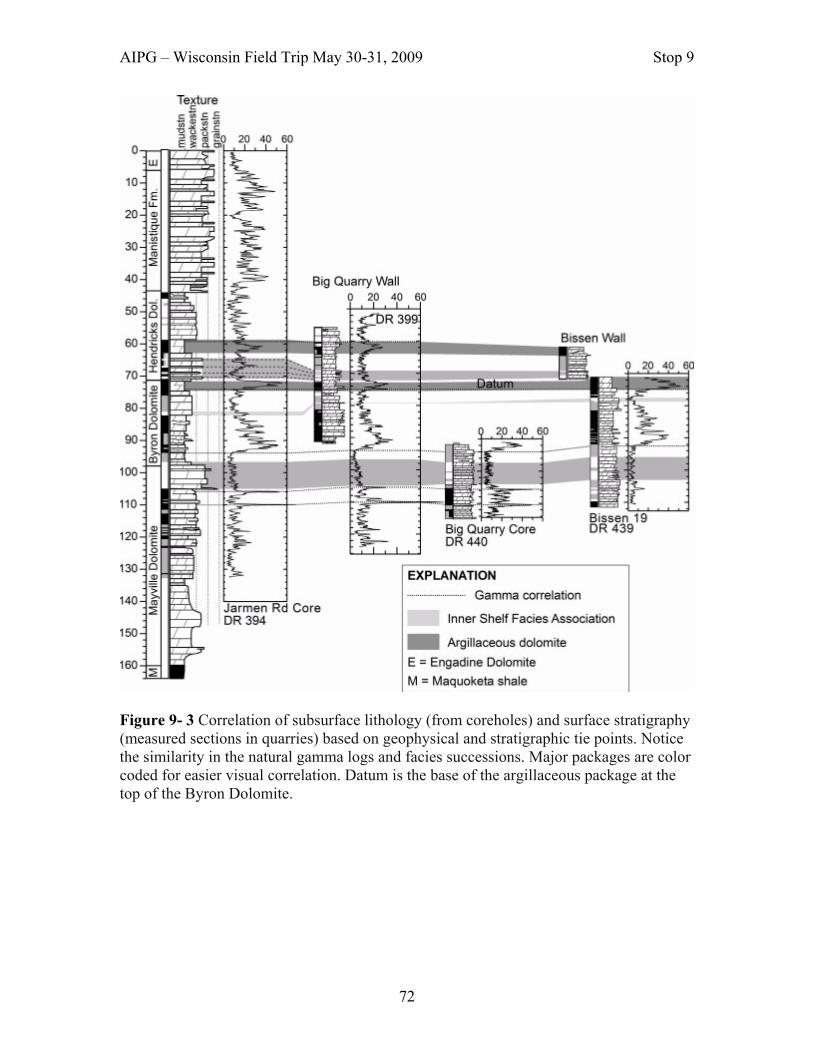
AIPG – Wisconsin Field Trip May 30-31, 2009 Stop 9
72
Figure 9- 3 Correlation of subsurface lithology (from coreholes) and surface stratigraphy (measured sections in quarries) based on geophysical and stratigraphic tie points. Notice the similarity in the natural gamma logs and facies successions. Major packages are color coded for easier visual correlation. Datum is the base of the argillaceous package at the top of the Byron Dolomite.

AIPG – Wisconsin Field Trip May 30-31, 2009 Stop 9
73
Figure 9- 4 Hydraulic conductivity profile and stratigraphic column for corehole DR-394. The profile has been divided into nine segments based on variations in hydraulic conductivity and lithology.

AIPG – Wisconsin Field Trip May 30-31, 2009 Stop 9
74
Figure 9- 5. Correlation of flow features from 16 wells; the stratigraphic column for hole DR-394 is shown to the left. The small black bars indicate the position of flow features in each well. Dashed horizontal lines and boxes with diagonal lines indicate the 14 regionally-important high permeability zones, these are labeled A to N. The cased and uncased portion of each hole and the depth of water in each hole are shown. Stratigraphic positions of flow features were correlated using natural gamma and all features were projected onto hole DR-394 to allow for comparison with lithologic data

AIPG – Wisconsin Field Trip May 30-31, 2009 Stop 9
75

AIPG – Wisconsin Field Trip May 30-31, 2009 Stop 9
76
Mechanical Stratigraphy Vertical fractures as well as horizontal partings and dissolution zones provide the primary pathways for groundwater flow in the Silurian dolomite aquifer. Underwood and others 2003) completed a project to explore 1) mechanical controls on fracture development and

AIPG – Wisconsin Field Trip May 30-31, 2009 Stop 9
77
2) fracture controls on flow system configuration and bedding-parallel high-permeability zones in carbonate strata. Stratigraphic, geophysical, and hydrogeologic data have been used to identify laterally continuous high-permeability zones within the Silurian dolomite in the vicinity of Sturgeon Bay (Muldoon and others, 2001). While these features appear to correlate with stratigraphy, it was not clear why certain stratigraphic discontinuities develop into regionally important high-permeability features while others do not. We hypothesized that the distribution of vertical fractures and the mechanical properties of the various stratigraphic units contributed to the development of these bedding-parallel high-permeability zones. Vertical opening-mode fractures were mapped on quarry walls to assess the stratigraphic controls on fracture patterns in the relatively undeformed Silurian. The study used maps of vertical fractures to assess the effectiveness of various types of stratigraphic horizons (e.g., organic partings or cycle-bounding mud horizons) in terminating opening-mode fractures. First, the mechanical stratigraphy of the exposures was interpreted from the observed fracture pattern. The second stage of the study stochastically predicted mechanical stratigraphy and subsequent fracture pattern from empirical relationships between the observed sedimentary stratigraphy and the interpreted mechanical stratigraphy. For example, 63% of cycle-bounding mud horizons within the inner-middle and middle shelf facies associations serve as mechanical interfaces. Significance: Olde Stone quarry provide is a unique stop in that it let’s us explore several aspects of carbonate stratigraphy (lithostraogrpahy & mechanical stratigraphy) and integrates that stratigraphy with subsurface hydrogeologic data in order to highlight the stratigraphic controls on hydrogeologic properties on the Silurian aquifer. References: Harris, M. T., and Waldhuetter K. R., 1996. Silurian of the Great Lakes Region, Part 3: Llandovery Strata of the Door Peninsula, Wisconsin: Milwaukee Public Museum Contributions in Biology and Geology, no. 90, 162 p. Harris, M.T., Kuglitsch, J.J., Watkins, R., Hegrenes, D.P., and Wauldhuetter, K.R., 1998. Early Silurian stratigraphic sequences of eastern Wisconsin: In Landing, E. and Johnson, M.E., ed., Silurian Cycles, New York State Museum Bulletin 491, p. 39-49. Hegrenes, D., 1996. A Core Study of the Sedimentology, Stratigraphy, Porosity and Hydrogeology of the Silurian Aquifer in Door County, Wisconsin: Unpublished M.S. thesis, University of Wisconsin-Milwaukee, 156 p. Muldoon, M.A., J.A. Simo, and K.R. Bradbury, 2001. Correlation of high-permeability zones with stratigraphy in a fractured-dolomite aquifer, Door County, Wisconsin. Hydrogeology Journal, vol 9, no.6, p

AIPG – Wisconsin Field Trip May 30-31, 2009 Stop 9
78
Simo, J. A.(Toni), M. T. Harris, and M. A. Muldoon, 1998. Stratigraphy and Sedimentology of the Silurian Dolostones, Door County, Wisconsin, in Field Trip Guidebook SEPM Research Conference, Fluid Flow in Carbonates: Interdisciplinary Approaches, p. 3-15. Underwood, C.A, M.L. Cooke, J.A. Simo, and M.A. Muldoon, 2003. Stratigraphic Controls on Vertical Fracture Patterns in Silurian Dolomite, Northeastern Wisconsin, Bulletin of the American Association of Petroleum Geologists, V. 87, no. 1, pg 121-142.
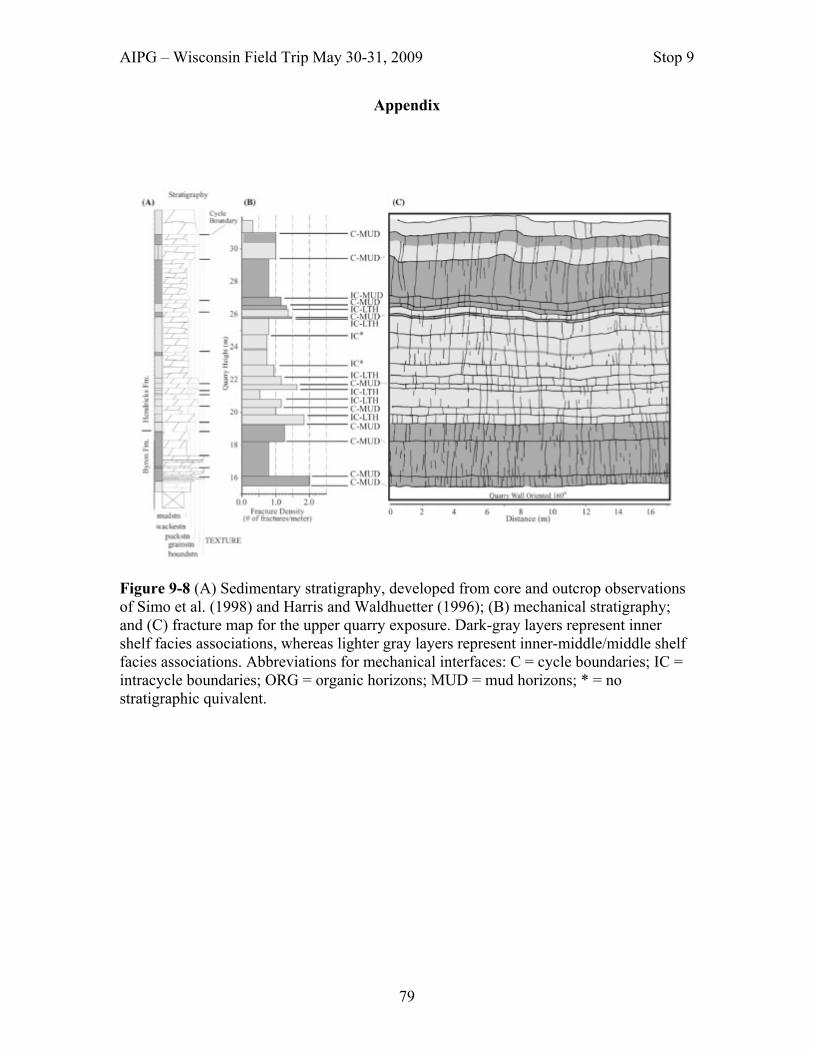
AIPG – Wisconsin Field Trip May 30-31, 2009 Stop 9
79
Appendix
Figure 9-8 (A) Sedimentary stratigraphy, developed from core and outcrop observations of Simo et al. (1998) and Harris and Waldhuetter (1996); (B) mechanical stratigraphy; and (C) fracture map for the upper quarry exposure. Dark-gray layers represent inner shelf facies associations, whereas lighter gray layers represent inner-middle/middle shelf facies associations. Abbreviations for mechanical interfaces: C = cycle boundaries; IC = intracycle boundaries; ORG = organic horizons; MUD = mud horizons; * = no stratigraphic quivalent.

AIPG – Wisconsin Field Trip May 30-31, 2009 Stop 9
80
Figure 9-9 (A) Sedimentary stratigraphy developed from core and outcrop observations of Simo et al. (1998) and Harris and Waldhuetter (1996); (B) mechanical stratigraphy; and (C) fracture map for the lower quarry exposure. Whereas the horizontal axis of the stratigraphic section (A) describes the texture of the facies association, the horizontal axis of the mechanical stratigraphic section (B) shows the fracture density of the mechanical unit. Dark-gray layers represent inner shelf facies associations, whereas lighter gray layers represent inner-middle/middle shelf facies associations. Abbreviations for mechanical interfaces: C = cycle boundaries; IC = intracycle boundaries; ORG = organic horizons; MUD * mud horizons; * = no stratigraphic equivalent. Dashed lines indicate a major scour surface; irregular circles are weathered stromatoporoids.

AIPG – Wisconsin Field Trip May 30-31, 2009 Stop 10
81
Stop 10: Eagle Bluff Lighthouse.
Location: Latitude 45.0704292 – Longitude 87.119951
Author: Jack W. Travis, Ph.D., Professional Geologist – AIPG CPG-07378; WI 814-013
Summary: This stop provides an opportunity to view one of the oldest standing lighthouses on Lake Michigan waters. The Mayville Dolostone underlies the lighthouse. Description: Eagle Bluff Lighthouse is located on a 40-foot bluff overlooking the waters of Green Bay in Peninsula State Park, near the center of Fish Creek, Wisconsin. Early settlement and economic growth of Door County required swift and safe water transportation. A channel

AIPG – Wisconsin Field Trip May 30-31, 2009 Stop 10
82
to the west of Chambers Island and another channel between the Strawberry Islands and the shoreline of Door County were used by vessels sailing in this area. The Strawberry channel was and is still quite treacherous. As a result, the United States Government built Eagle Bluff Lighthouse in 1868 at a cost of $12,000 to mark Strawberry Passage. This lighthouse is one of the oldest lighthouses still standing around Lake Michigan with its same walls. It consists of a square, cream city brick (i.e., Milwaukee brick), 43-foot tower that is set at an angle to a rectangular, 2-story, cream colored brick dwelling for the keepers (See Photograph 10-1). A ten-sided cast iron lantern room sits on top of the brick portion of the tower with glass in 8 of the panels and metal in the other two. The original lens was a Third and One-half Order Fresnel with an oil fired lamp. A smaller Fifth Order lens was installed in 1919. The lens was automated with the installation of an acetylene light with a sun valve in 1926. Since then, the lens has been replaced with a solar-powered 300MM plastic lens. The lighthouse still operates as an active aid to navigation. An oil building and outhouse, made of the same materials as the lighthouse, also survive at the site.
Photograph 10-1. This photograph shows the western side of the Eagle Bluff Lighthouse. A date of 1868 appears over the outside door for the tower. Henry Stanley was the first lighthouse keeper for Eagle Bluff Lighthouse, serving from 1868 to 1883. William Ducion followed Mr. Stanley as the lighthouse keeper, serving from 1883 to 1918. The last official lighthouse keeper was Peter Coughlin, serving from 1919 to 1926. Geology of Peninsula State Park and the Eagle Bluff Lighthouse Site - Peninsula State Park is located in Door County, Wisconsin. It was established in 1909 and now contains 3,776 acres. It is surrounded by the waters of Green Bay on three sides,

AIPG – Wisconsin Field Trip May 30-31, 2009 Stop 10
83
producing nearly seven miles of cobblestone and natural sand beach shoreline. Rocky bluffs ascend upward from the water approximately 180 feet in some areas. The Alexandrian Mayville Dolostone outcrops in the western side of the park. The 40-foot bluff that Eagle Bluff Lighthouse was constructed on consists of Mayville Dolostone. Wave action at the base of the bluff has undercut rock to the point that a former hiking trail at the top of the bluff between the lighthouse and the edge of the bluff has been closed. Looking west from Eagle Bluff Lighthouse site, Raspberry Islands and Chambers Island can be seen. These islands contain Mayville Dolostone. Chambers Island is unique because the southern end of the island is straight. The orientation of this southern shoreline lines up with the south shoreline of Fish Creek Harbor, all of which coincides with joint orientations in this area. Rocks of the Burnt Bluff Group, the Byron and Hendricks dolostones, occur in the central and eastern part of the park. The prominent bluff to the east of the fire tower in the park, especially along the western shore of Eagle Harbor, contains dolostones of the Burnt Bluff Group. Shorelines of Glacial Lake Algonquin and Glacial Lake Nipissing are marked by notched or stepped bluff profiles that are visible in the park. The Glacial Lake Algonquin shoreline is represented by a cobble beach at the base of steep wave-cut cliffs. The shoreline for Glacial Lake Nipissing occurs about 60 feet below the shoreline of Glacial Lake Algonquin. Significance: Lower (i.e., Mayville Dolostone) and middle (i.e., Byron Dolostone and Hendricks Dolostone) Silurian rocks are exposed in Peninsula State Park. One of the oldest lighthouses is still standing on a bluff consisting of the Mayville Dolostone in the park. References: Dott, Robert H., Jr. and Attig, John W., 2004, Roadside Geology of Wisconsin. Missoula, MT: Mountain Press Publishing Company. Kluessendorf, Joanne and Mikulic, Donald G., 1989, Bedrock Geology of the Door Peninsula of Wisconsin: in Palmquist, John C., Editor, Wisconsin’s Door Peninsula: A Natural History. Appleton, WI. Perin Press. Paull, Rachel Krebs and Paull, Richard A., 1977, Geology of Wisconsin and Upper Michigan. Dubueque IA. Kendall/Hunt Publishing Company. Schneider, Allan, 1989, Geomorphology and Quaternary Geology of Wisconsin’s Door Peninsula: in Palmquist, John C., Editor, Wisconsin’s Door Peninsula: A Natural History. Appleton, WI. Perin Press.

AIPG – Wisconsin Field Trip May 30-31, 2009 Stop 11
84
Stop 11: Bear Cave Sink Hole in Door County Location: Latitude 45.0704292 – Longitude 87.119951
Bear Cave is located in the woods near the top of Hairpin Turn on Cottage Row. It is between the road and a home about 50 feet to the south of the road. Author: Bob Bultman, Wisconsin Speleological Society Summary: This stop provides an opportunity to view one of many sink holes that are present east of the Niagara Escarpment in the Door Peninsula.

AIPG – Wisconsin Field Trip May 30-31, 2009 Stop 11
85
Description: Bear Cave is the top of a large, linear solution shaft that is mostly filled in with glacial debris. It appears as a collapse sinkhole approximately 28 feet long, 6 feet wide and from 12 to 19 feet deep. An explorable cave passage extends from both ends of the visible pit. Approximately 90 feet of cave passage can be explored at this time, most of it on the easterly side. It is mostly crawling passage, with a 5 foot high room and a narrow 8 foot high dome. A challenging 8 foot long squeeze leads to the final 10 feet of the easterly section. A few small stalactites up to one inch can be found. A collection point in the local landscape, the cave regularly floods briefly in spring. Numerous bones of various animals can be found in the open part of the pit.
Open shafts and exposed sinkholes such as this one are common on the Door Peninsula and anywhere east of the Niagara Escarpment in Wisconsin where Silurian bedrock is veiled in thin soil. This large, linear sinkhole has a WSW-ENE orientation, as do the majority of fractures and sinkholes in northeast Wisconsin. With its proximity to the bluff, this shaft is likely quite deep, probably measuring well more than 100 feet deep if excavated of glacial fill. The full extent of horizontal cave passage is unknown. Where the glaciers did not completely fill the sinkholes in, farmers have done a good job obscuring them, finding them to be a convenient place to dump fieldstone as well as preventing livestock (and soil) from ‘going down the hole’. Many piles of stones in the middle of Door County farm fields (especially those in a line or series, or those that follow gentle surface valleys) are filled sinkholes. The fourth longest known cave in the state of Wisconsin, Paradise Pit Cave, located in southern Door, was discovered by excavating three sequential sinkholes down to the single, horizontal passage (approximately 30 feet below the surface). Another sink hole near this site is Peninsula Players Road sinkhole. The sink is located less than 0.3 miles east of State Hwy 42 on the south side of the road in wooded property owned by Gary Witalison. This sink hole is a rather nondescript depression just off the roadside in the woods. (When traveling east, you have gone too far if you pass a gravel driveway heading into an old field and fire number 4125). The current owner is a descendant of the homesteaders and reports that his grandfather said this sinkhole was once much deeper. Over the years, logging and farming practices have utilized the sink as a convenient dumping place. Significance: This site was selected because it occurs near the edge of the Niagara Escarpment. The long axis of the sink hole corresponds to the trend of most sink holes in the Door Peninsula, which corresponds to one of the major trends of joints in Silurian aged rock in the area. Reference: Geyer, Tim, Editor, 1988, Hodag Hunt 1988 Guidebook: Wisconsin Speleological Society.

AIPG – Wisconsin Field Trip May 30-31, 2009 Stop 12
86
Stop 12: Bay Shore County Park Location: Latitude 45.0704292 – Longitude 87.119951; NW¼, SW¼, Sec. 14, T25N, R22E, Brown County, Wisconsin, Dyckesville 7.5-Minute Quadrangle.
Author: Jack W. Travis, Ph.D., Professional Geologist – AIPG CPG-07378; WI 814-013 Summary: This stop allows you to view the three lithologic units of the Mayville Dolostone and mass movement associated with jointing in the rocks.

AIPG – Wisconsin Field Trip May 30-31, 2009 Stop 12
87
Description: Brown County Park Department constructed an access road to a boat launching facility on Green Bay at Bay Shore County Park. The park is to the west of State Highway 57, approximately 15 miles north of Green Bay and two miles south of Dykesville. The access road cuts through Alexandrian strata exposed along the Niagara Escarpment, providing access to boat launching facilities constructed on the shore of Green Bay. The parking lot and breakwater for the marina at the base of the bluff are built on artificially filled material. The grade of the road, although still steep, was lowered after its initial construction because of the difficulty of towing boat trailers up the slope. Mayville Dolostone - At this area the escarpment front is mantled by coarse talus and loose material which have also been truncated by the road. The free face of the bluff overlying the mantled front consists of about 3005 feet of Mayville Dolostone (Figure 12-1). At this stop, the Mayville displays three informal units.
Photograph 12-1.This photograph is looking in an easterly direction, showing the extent of the Alexandrian Mayville strata exposed in the road cut of the access road to a boat launching facility on Green Bay. The uppermost unit of the Mayville Dolostone at this site, capping the lip of the escarpment, is a light gray, fine-grained, thin-bedded dolostone. Some beds are very dense whereas others contain open vugs (See Photographs 12-2 and 12-3).

AIPG – Wisconsin Field Trip May 30-31, 2009 Stop 12
88
The middle unit is composed of dolostone interbedded with nodular layers of gray to black chert. The entire unit breaks into small pieces and often has a fractured and rubbly appearance (See Photograph 12-4). The lowermost unit consists of gray, mostly fine-grained, thick-bedded dolostone. Some vugs and nodular layers of chert are present (See Photograph 12-5). Large blocks of dolostone have separated from the face of the escarpment, probably as a result of ice wedging. The blocks then moved along the surface of the underlying shale or argillaceous beds, tilting the bedding in the blocks of the Mayville Dolostone to the west (See Photograph 12-6).
Photograph 12-2. Photograph shows the upper few feet of the upper unit of the Mayville Dolostone that is exposed in the road cut of the access road. Note the vuggy zones.

AIPG – Wisconsin Field Trip May 30-31, 2009 Stop 12
89
Photograph 12-3. Photograph shows the upper unit and the upper few feet of the middle unit of the Mayville Dolostone that is exposed in the road cut of the access road.
Photograph 12-4. Photograph shows the middle unit of the Mayville Dolostone that is exposed in the road cut of the access road. Note the cherty zones.
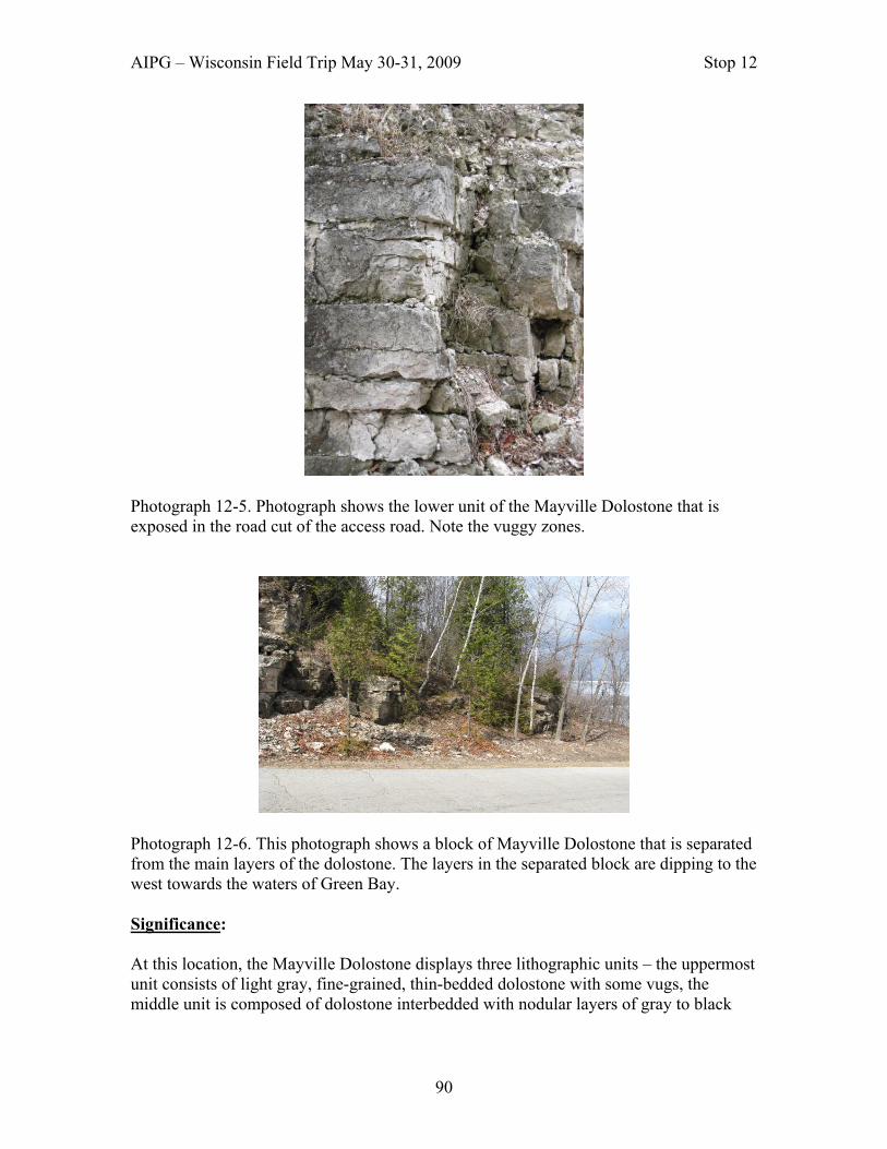
AIPG – Wisconsin Field Trip May 30-31, 2009 Stop 12
90
Photograph 12-5. Photograph shows the lower unit of the Mayville Dolostone that is exposed in the road cut of the access road. Note the vuggy zones.
Photograph 12-6. This photograph shows a block of Mayville Dolostone that is separated from the main layers of the dolostone. The layers in the separated block are dipping to the west towards the waters of Green Bay.
Significance: At this location, the Mayville Dolostone displays three lithographic units – the uppermost unit consists of light gray, fine-grained, thin-bedded dolostone with some vugs, the middle unit is composed of dolostone interbedded with nodular layers of gray to black
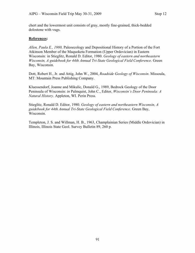
AIPG – Wisconsin Field Trip May 30-31, 2009 Stop 12
91
chert and the lowermost unit consists of gray, mostly fine-grained, thick-bedded dolostone with vugs. References: Allen, Paula E., 1980, Paleoecology and Depositional History of a Portion of the Fort Atkinson Member of the Maquoketa Formation (Upper Ordovician) in Eastern Wisconsin: in Stieglitz, Ronald D. Editor, 1980. Geology of eastern and northeastern Wisconsin, A guidebook for 44th Annual Tri-State Geological Field Conference. Green Bay, Wisconsin. Dott, Robert H., Jr. and Attig, John W., 2004, Roadside Geology of Wisconsin. Missoula, MT: Mountain Press Publishing Company. Kluessendorf, Joanne and Mikulic, Donald G., 1989, Bedrock Geology of the Door Peninsula of Wisconsin: in Palmquist, John C., Editor, Wisconsin’s Door Peninsula: A Natural History. Appleton, WI. Perin Press. Stieglitz, Ronald D. Editor, 1980. Geology of eastern and northeastern Wisconsin, A guidebook for 44th Annual Tri-State Geological Field Conference. Green Bay, Wisconsin. Templeton, J. S. and Willman, H. B., 1963, Champlainian Series (Middle Ordovician) in Illinois, Illinois State Geol. Survey Bulletin 89, 260 p.

AIPG – Wisconsin Field Trip May 30-31, 2009 Stop 13
92
Stop 13: Wequiock Falls Location: Latitude 45.0704292 – Longitude 87.119951; S½, SW¼, Sec. 7, T24N, R22W, Brown County, Wisconsin. Green Bay East 7.5-minute Quadrangle.
Author: Jack W. Travis, Ph.D., Professional Geologist – AIPG CPG-07378; WI 814-013 Summary: This stop allows you to view the oldest strata exposed on the Door Peninsula, the Maquoketa shale. A small waterfall exposes the contact between the few feet of resistant Silurian Mayville dolomite and the underlying Ordovician shale.

AIPG – Wisconsin Field Trip May 30-31, 2009 Stop 13
93
Description: Wequiock Creek flows over the Niagara Escarpment face at this location, cutting a little glen back through the rock (See Photograph 13-1). This stream is best viewed in spring, but usually trickles over the edge into late summer. In the glen, you will notice other rock-types besides dolostone. The escarpment is predominantly dolostone, but not entirely. The lip of Wequiock Falls is capped by about a 15-foot thick layer of lower Silurian Mayville Dolostone (see Photographs 13-2 and 13-3). The Mayville Dolostone is quite cherty and unfossiliferous at this location (Kluessendorf and Mikulic, 1989).
Photograph 13-1. This photograph shows a ravine that Wequiock Creek is cutting through the Niagara Escarpment. The Mayville Dolostone appears at the top of the ravine and is underlain by the Brainerd Shale Member of the Maquoketa Formation.

AIPG – Wisconsin Field Trip May 30-31, 2009 Stop 13
94
Photograph 13-2. View of Wequiock Falls, Brown County, Wisconsin in spring. Wequiock Creek flows through a notch cut in the Mayville Dolostone. The Mayville Dolostone is more resistant that the underlying calcareous shales of the Brainerd Shale Member of the Maquoketa Formation. Underlying the Mayville is the Brainerd Shale Members of the upper Ordovician Maquoketa Formation. The Brainerd Shale Member is considered Richmondian in age (Templeton and Willman, 1963).

AIPG – Wisconsin Field Trip May 30-31, 2009 Stop 13
95
Photograph 13-3. View of Wequiock Falls in winter. The Brainerd Shale is a greenish-gray calcareous shale containing an abundance of brachiopods and bryozoa. Since the Maquoketa Formation consists primarily of shale, it does not withstand weathering and erosion too well. When the Wisconsin Department of Transportation was constructing the new north lane of Wisconsin State Highway 57 in the vicinity of Wequiock Falls, they used rock quarried from the Brainerd Shale as subbase material for the roadway. A block of Mayville Dolostone fell into the splash pool of Wequiock Falls while a group of secondary students were participating on a fossil collecting field trip in the fall of 2008 (See Photograph 13-4).
Photograph 13-4. The rock layers under the middle snow pile represents the 2008 rock fall.

AIPG – Wisconsin Field Trip May 30-31, 2009 Stop 13
96
Significance: This stop offers a chance to investigate the oldest rocks exposed in the Door Peninsula. It also offers a chance to see the contact between Silurian and Ordovician aged rocks in Wisconsin.
References: Allen, Paula E., 1980, Paleoecology and Depositional History of a Portion of the Fort Atkinson Member of the Maquoketa Formation (Upper Ordovician) in Eastern Wisconsin: in Stieglitz, Ronald D. Editor, 1980. Geology of eastern and northeastern Wisconsin, A guidebook for 44th Annual Tri-State Geological Field Conference. Green Bay, Wisconsin. Dott, Robert H., Jr. and Attig, John W., 2004, Roadside Geology of Wisconsin. Missoula, MT: Mountain Press Publishing Company. Kluessendorf, Joanne and Mikulic, Donald G., 1989, Bedrock Geology of the Door Peninsula of Wisconsin: in Palmquist, John C., Editor, Wisconsin’s Door Peninsula: A Natural History. Appleton, WI. Perin Press. Stieglitz, Ronald D. Editor, 1980. Geology of eastern and northeastern Wisconsin, A guidebook for 44th Annual Tri-State Geological Field Conference. Green Bay, Wisconsin. Templeton, J. S. and Willman, H. B., 1963, Champlainian Series (Middle Ordovician) in Illinois, Illinois State Geol. Survey Bulletin 89, 260 p.

AIPG – Wisconsin Field Trip May 30-31, 2009 Evaluation Form
Wisconsin Section – American Institute of Professional Geologists Please answer the following questions based on a scale of 1 = poor to 5 = excellent
1. Please rate the quality of the field trip content… were the stops what you expected? Less than expected? Exceeded you expectations?
1 2 3 4 5 2. Please rate the quality of the accommodations. 1 2 3 4 5 3. Please rate the quality of the meals provided. 1 2 3 4 5
4. Please rate the field trip guidebook. 1 2 3 4 5
5. Please rate the field trip leader. 1 2 3 4 5
6. Please rate the post-dinner speaker on Saturday night. 1 2 3 4 5
7. Please provide ideas for future field trips. Are there any areas of Wisconsin that
you would like to see included in a future field trip?
8. Would you be interested in leading a future field trip, or do you have suggestions for a future field trip leader?
Please return this form to either Andy Graham or Jayne Englebert by noon on Sunday. Thank you for attending the 2009 AIPG-Wisconsin Section Field Trip!