Embed Size (px)
Citation preview
Field Meeting in the
Central Cotswolds3-5 June 1955
Report by the Director: D. V. AGER
Received 30 September 195.5
IN SPITE of a national railway strike, thirty-three members and friends ofthe Association met at Stroud during the first week-end in June for a twoday study of the Lower and Middle Jurassic rocks of the neighbourhood.The primary aim of the excursion was a demonstration of lateral variationin the Inferior Oolite and higher Liassic rocks of the Cotswolds betweenWotton-under-Edge and Cheltenham. Most of the exposures studied hadbeen previously visited by the Association, but some of the Liassic pitsnotably Robin's Wood Hill-have never been so visited, although theomission was noted long ago by Richardson (l91Oa, p. 339).
Saturday, 4 June
The first day was devoted to the area south of the headquarters atStroud. In a coach the party proceeded southwards on the Nailsworthroad, and then across the remarkably flat limestone plateau to Combe Hillon the escarpment above Wotton-under-Edge. Here the first halt was madeat the 'Waterworks Quarry' (map reference ST 767943) where the UpperTrigonia Grit of the Upper Inferior Oolite (Vesulian) was seen resting onthe Lower Freestone of the Lower Inferior Oolite (Aalenian). This wasmainly below the older section described here by Richardson (l 9 lOb,pp. 103-4). At this locality the Vesulian beds proved to be highly fossiliferous, with Trigonia costata (Sowerby), Acanthothyris spinosa (Schlotheim), Tricites sp., and many other characteristic fossils. The top of theunderlying bed was conspicuously bored, marking the posit ion of animportant non-sequence.
The party then continued down the hill into Wotton-under-Edge, andat the north end of the village examined the fine sections beside the oldLondon road up Wotton Hill. These sections have also been described indetail by Richardson (op. cit., pp . 104-6). In the lower of the two sections(map reference ST 753938), the Cephalopod Bed with its abundantammonites and belemnites, was seen to be resting on the Cotswold Sands,which were also displayed in an entrance-way farther down the lane . Herethe section may be summarised as follows:
356

FIELD MEETING IN THE CENTRAL COTSWOLDS 357
ft. in.
2
8o
5 63 6
scissumbeds
(f) Massive limestone with Tmetoceras scissum in theupper beds, and Lioceras opaliniformis in thelower
(e) Marly beds with Homoeorhynchia cynocephala(d) Ironshot marls, highly fossiliferous with Dumor
tieria sp. in the upper beds, and Grammocerasdispansum in the lower 6 4
ee:;lopod (c) Massive, somewhat ironshot limestone, with marlypartings
(c") Coarsely ironshot marl(b) Massive ironshot oolite, highly fossiliferous, with
Grammoceras striatulum ...Cotswold (a) Yellow micaceous sands, massive, with calcareous
Sands doggers ... seen to about 20 0
The Director reminded the party of the diachronism of the sands at thebottom of the section, first clearly demonstrated in a classic work by S. S.Buckman (1889). The Cotswold, Midford, Yeovil and Bridport Sands,though lithologically similar, represent a belt of deposition which movedprogressively southwards during Toarcian and Aalenian times.
Farther up the hill the party visited a quarry in Inferior Oolite limestones(map reference ST 754940). This was also still very much as described byRichardson (loc. cit.), and may be summarised as follows:
ft. in.Upper Coral Bed: White shelly rock in lenticular masses
with corals 0 10Vesulian Dundry Freestone equivalent: Limestone, hard, shelly,
slightly iron-speckled 0 2Upper Trigonia Grit: Limestone, hard grey above, rubbly
below, top bored 2 6Lower Freestone: Limestone, coarsely oolitic, bored upper
Aalenian surface, rubbly bands near base 17 9Pea-Grit horizon: Rubbly limestone ... 0 6LowerLimestone: Limestone,massive ... seento about 18 0
Again the Director drew special attention to the evidence of a nonsequence between the Vesulian and Aalenian deposits. The party thenreturned to the coach and drove northwards along the marked platformformed by the Middle Lias Marlstone Rock-bed which lies below the mainInferior Oolite escarpment. This was particularly clear at Nibley Knoll,from where a distinct view was obtained of the Severn estuary and the hillsbeyond. The Palaeozoic inlier of Tortworth could be seen in the foreground, and the Director commented on the narrowness of the Lias andTrias outcrops at this point, when compared with their widths farthernorth. This is a reflection of the thinning of the Mesozoic strata towardsthe Mendip axis.
As the coach approached the westerly-projecting spur of StinchcombeHill, the Director pointed out the narrow ridge that forms its only connec-

358 D.V. AGER
tion with the main escarpment. At the foot of the hill, the side-road on thesouth-west side of the Yew Tree Inn was taken for a short distance. Thehamlet here-known as 'The Quarry'-stands in what was once anextensive working in the Marlstone Rock-bed. A small part of the face ofthis old quarry was examined in the field beyond Newent Quarry House(map reference ST 735994). Here there is exposed about ten feet of Marlstone Rock-bed, in its usual form of a highly fossiliferous ferruginous limestone. The small rhynchonellid Gibbirhynchia micra was especially abundant in the lower part of the face, and was first described from this locality(Ager, 1954). A specimen of the zonal ammonite-Pleuroceras spinatum(Bruguierej-s-though not previously known from here, was found by amember of the party. It was recalled that the so-called 'Transition Bed' ofthe Midlands, with Tiltoniceras acutum (Tate), was once recorded abovethe Marlstone Rock-bed at Dursley, Lunch was taken in Dursley, a shortdistance farther along the main road.
After leaving Dursley, the outliers of Downham Hill and Cam LongDown were seen on the left, followed by extensive views across the SevernValley to May Hill, the Malvems and beyond. The party left the coachagain by Selsley Hill Farm, at the south end of Selsley Common, and spentsome time examining the various quarries described in detail by Richardson (op. cit., pp. 123-7), in pursuance of Witchell's earlier work. Thefollowing section was examined at 'Leigh's Quarry', at the south end of thehill (map reference SO 826026):
ft. in.
5 01 32 20 80 90 72 6
010
0 62 00 62 1
4 21100 ot
1 30 2
13 0seen toMarl with brachiopods ...
Lower Freestone Limestone,massive, white,oolitic
C/ypeus Grit Limestone, somewhat f1aggy, Stiphrothyris spp.,'Rhynchonella' hampenensis, etc.LimestoneLimestone, top bored ... ... aboutLimestone with irregular under surfaceLimestone, grey-brown ...LimestoneLimestone, rubbly
non-sequence,....-----------Upper Trigonia Limestone,veryshelly,with a layerof oysterson top ...
Irregular pale-brown, non-oolitic limestone and shalymarl ... about
Ragstone ... 1 ft. 6 in. toRubbly limestoneRagstone (= 'Gryphite Grit' of Witchell) 1 ft. 6 in. to
------------non-sequenceUpper Freestone Limestone,white, oolitic, top bed conspicuouslyboredOolite Marl Limestone, rubbly, whitish
Marly parting, small sponges ...Limestone, Plectothyris fimbria, G/obirhynchia spp.
about

FIELD MEETING IN THE CENTRAL COTSWOLDS 359
It was observed that additional beds of the Aalenian (i.e. the UpperFreestone and Oolite Marl) present here, had been absent at Wotton Hill.This conforms to the general theory of an Aalenian basin in the Cotswoldregion, the deposits of which were planed off by pre-Vesulian erosion.
The party then walked to the tumulus at the top of the hill, from whichthe Director pointed out geomorphological features of the surroundingcountryside, including the three terraces which are recognised on eitherside of the River Frome west of Stroud. To the north-east was seen theadjacent hill of Rodborough Common, with its Victorian castle. Thoughnot visited on this excursion, it is noteworthy that exposures on this hillshow the presence of the Lower Trigonia Grit and Buckmani Grit of theMiddle Inferior Oolite (Bajocian s.s.). Their presence marks the edge of asynclinal trough-the Painswick syncline-in which a small thickness ofthese beds is preserved on account of gentle folding at the end of Bajociantimes, prior to the Vesulian transgression.
Just north-east of the tumulus, the party noted a very shallow exposure(Witchell's Quarry No.1, mentioned by Richardson); this showed rubblylimestone probably belonging to the Upper Trigonia Grit. A larger quarry,north of this, beside a corrugated iron shed, was Witchell's Quarry No.2.This shows the following succession, all of which appears to belong tothe Freestones and Oolite Marl horizon (which are often not clearlyseparable) :
(d) Flaggy oolite, becoming more massive with shaly partings ft. in.below seen to 13 0
(c) Massive oolitic limestone with Plectothyris fimbria and otherfossils 2 2
(b) Shale band '" 0 6(a) Massive oolitic limestone ... seen to I 0
The flaggy oolite at the top of this section was observed to be falsebedded, and the possibility was discussed of deducing a prevailing currentdirection for this horizon from a large number of such observations. Afossiliferous band at the top of bed (d) yielded a good fauna including thecharacteristic Aalenian terebratulid Plectothyris fimbria (Sowerby). Theparty left this quarry by the old trackway which leads down the north sideof the hill. To the left of this track is Witchell's Quarry No.4, which stillshows the following section:
ft. in.Pea Grit Limestone, rather flaggy, pisolitic 3 0
Brownish marly deposit with loose pisoliths, Pseudoglossothyris simplex, Rhynchonelloidea(?) sub-angulata, Stomechinus spp. etc. I 0
Rubbly pisolitic rock . .. . . . 2 ft. 6 in. to 3 6Brown marly layer with pisoliths 0 2
Lower Limestone Limestone, even surface above, uneven below 2 4Limestone, small gastropods ... seen to 17 0
360 D.V.AGER
This was the first section in which the highly distinctive Pea Grit wasseen by the party. Southwards it diminishes to less than a foot in thicknessat Uley Bury and cannot be distinguished thereafter, though at WottonHill Richardson attributed six inches of rubbly limestone to this division(see above, p. 356). Besides being notable for its pisolitic lithology, the PeaGrit is also remarkable for the variety and abundance of its fauna, including echinoids.
As the party descended the north side of Selsley Hill to the road, theDirector pointed out Witchell's Quarry No.6, beyond a stone wall. Nowit is used as a rubbish dump. Here, again the Lower Freestone is seen,dipping fairly steeply on account of a local fault. Hereabouts this divisionhas been called the 'Dapple Beds' on account of its content of white oolitepebbles, produced by penecontemporaneous erosion.
After rejoining the coach near the New Inn, the party proceeded northwards to the main road near Dudbridge. The middle terrace of the threeStroud terraces was then followed through Ebley to Jeffries Brick Worksnear Stonehouse (map reference SO 816050). Here a complete section ofthe Middle Lias was seen in an excellent exposure which appears to havebeen overlooked by geologists. At the top of the face the Marlstone Rockbed is again present, but here it is in the form of a buff, fine-grained sandstone. The Director expressed his view that this facies replaced the usualferruginous limestone (as seen near Dursley) between Stroud and Cheltenham, and probably represents an inshore deposit. He suggested that thepalaeogeographical reconstructions usually made for the Lias are foundedon the evidence available for the lowermost zones, when the sea was moreextensive than it was at the time of deposition of the Marlstone Rock-bed.
At the base of the Rock-bed there is a nodule bed, about six inchesthick, comparable to that developed at the same level throughout theMidlands. Further evidence supporting the postulated correlation was theoccurrence of occasional specimens of Gibbirhynchia micra in the lowermost two or three feet.
Bands of ferruginous limestone occur lower down in the section. Theyare of the same general appearance as the Marlstone Rock-bed elsewhere,but without the characteristic brachiopods, and yielding a small species ofAmaltheus. Therefore these beds are attributed to the margaritatus Zone.The 'rock' bands were seen to have been broken up into a series of tiltedblocks, clearly related to the present slope of the ground, and presumablyattributable to a period of perma-frost conditions during the Pleistocene.It is proposed to give a more detailed description of this section, and thenext, in a subsequent work on the Lias of the Vale of Gloucester.
After collecting a large fauna at Jeffries' pit, the party went on to Stonehouse for tea. Finally, a visit was paid to the large brick-pit of the Stonehouse Brick and Tile Company by Stonehouse Station. Here the Middle

FIELD MEETING IN THE CENTRAL COTSWOLDS 361
Lias was seen, as before, but in a more inaccessible position at the top of asteep face. It is underlain by clays and argillaceous limestones of thedavoei Zone, at the top of the Lower Lias. Species of Androgynoceras andLytoceras are common in these lower beds, together with a large fauna oflamellibranchs. An excellent specimen of the 'brittle-star' Ophiodermagaveyi Wright was found by one member of the party in a loose block.
A few members scrambled to the top of the section east of the main face,and again saw the Marlstone Rock-bed in its sandy facies with a basalnodule bed and Gibbirhynchia micra. The more energetic members alsowent on to the summit of Doverow Hill, where a large and overgrownquarry shows the lower divisions of the Inferior Oolite, here apparentlyresting directly on the Cotswold Sands. The party then gathered once morein the station approach and returned to Stroud.
After dinner, the majority of the members present visited the CowIeMuseum, Stroud, which was specially opened for the purpose. There theywere welcomed by the curator, Mr. L. Walrond, and spent some timeexamining geological and other specimens collected in the neighbourhood.A special attraction was a large number of reptilian bones from theChipping Norton Limestone. Before leaving, the president (Dr. L. R. Cox)expressed the Association's thanks to Mr. and Mrs. Walrond for theirkindness in entertaining the party.
Sunday. 5 June
The second day was devoted to an examination of the area extendingnorth of Stroud as far as Cheltenham. The route lay up the PainswickValley past a road cutting in the Middle Lias and through the lovelyvillage of Painswick.
Just north of the Royal William Hotel, at the south end of PrinknashPark, there was a short halt to examine a small exposure of the GryphiteGrit of the Middle Inferior Oolite (Bajocian s.s.). Though now almostovergrown, this was the only convenient exposure on this route at which todemonstrate the presence of the middle division in the Painswick syncline.Several specimens were seen of the characteristic lamellibranch-Gryphaeasublobata (Deshayes)-and vertical borings were noted, suggesting theproximity of the sub-Vesulian unconformity.
The coach then carried the party to Birdlip where the Roman road fromLondon to Gloucester-Ermin Street-descends the Cotswold escarpment. Here a road-cutting was examined behind the Royal George Hotel,showing once again Vesulian rocks resting directly on the Upper Freestoneof the Aalenian. The following section was examined:

362 D.V.AGER
ft. in.C/ypeus Grit Rubbly, whiteto goldenoolite, veryfossiliferous,
C/ypeus ploti, Stiphrothyris tumida, etc. 14 6-------------Iparting:--------------Upper Trigonia Grit Massive oolite,poorlyfossiliferous 4 6
non-sequenceUpper Freestone Massive golden oolite, oyster-covered upper sur-
face, otherwise unfossiliferous ... seen to 7 6
The lower beds represent the core of the Birdlip anticline, folded andplaned off before the Vesulian transgression. The village of Birdlip is builton the Clypeus Grit and specimens of the characteristic echinoid are to befound in the cottage gardens.
A short distance north of Birdlip the coach stopped at Barrow Wake, aspot famous for its extensive views over the Vale of Severn and the hills ofthe Welsh Borderland. In the quarry to the east of the road is a section instrongly false-bedded Upper Freestone. The Director drew the attentionof the party to an anomalous feature at the top of the quarry, where a thinbut wide slice of unbroken limestone overlies a small thickness of brashysoil, and is separated from the main rock face. Mr. D. J. Shearman hassuggested that, under peri-glacial conditions, melting of the top few feet ofground-water may have caused this thin slice of limestone to slide downthe dip slope for a short distance. Comparable phenomena are known innorthern Canada at the present day.
After admiring the view from here, the party moved on to Tumey'sQuarry, near the Air Balloon public house (map reference SO 932159),where the excellent section is still much as it was when described byRichardson (1904, p, 110), and shows Bajocian beds up to and includingthe Buckmani Grit beneath the sub-Vesulian unconformity. These beds arepreserved in the complementary Cleeve Hill syncline on the north-east sideof the Birdlip anticline.
Before lunching at the 'Air Balloon', the party descended Crickley Hillfor a short distance to examine sections in the Pea Grit north of the road(map reference SO 930160). About 40 ft. of highly fossiliferous Pea Gritwas seen to overlie the Lower Limestone. Corals were obtained from thethin coral bed at the top of the Pea Grit at this locality.
After lunch, the coach took the party to the hairpin bend north ofUllenwood, where a dip fault breaks the line of the escarpment. The partythen climbed the southern flank of Leckhampton Hill, briefly examiningen route the large quarry in Lower Freestone and Pea Grit oppositeSalterley Grange Sanatorium. At the top of the hill the party walked acrossa 'Gryphaea pavement' on the floor of an extensive old quarry. This surface, covered with specimens of Gryphaea sublobata, represents theGryphite Grit of the Bajocian, which is almost immediately overlain by theUpper Trigonia Grit on this southern side of the hill. A small 'stack', left

FIELD MEETING IN THE CENTRAL COTSWOLDS 363
by the quarrying, clearly displays the sub-Vesulian unconformity (mapreference SO 951180). The beds above this yielded abundant specimens ofTrigonia costata, together with Acanthothyris spinosa, Parkinsonia parkinsoni (the zone ammonite) and other fossils. The actual contact between thetwo divisions is encrusted with oysters and the lower bed is extensivelybored by marine organisms.
After descending the hill again, the party walked round below the westward-facing cliffs, noting the false-bedding in the freestones and thefamous landmark of the 'Devil's Chimney'. The section in the old Leekhampton Quarry (map reference SO 949186) is too well known to requirefurther description (see Richardson, 1904, pp. 79-80). The softer beds ofthe Aalenian are now much obscured by fallen material, but most of thebest-known fossils were found. The party then rejoined the coach on themain road and drove to the equally famous Battledown Brick-pit on theeastern outskirts of Cheltenham (map reference SO 960218). Here anabundant fauna of ammonites, lamellibranchs and brachiopods wascollected from the ibex and davoei zones at the top of the Lower Lias.
The route then lay south-westwards from Cheltenham, past the outlierof Churchdown (or Chosen) Hill, and by-passing Gloucester to reach thenearby outlier of Robin's Wood Hill. At Tumey, on the western flank ofth is hill, the party examined the excellent section of Lower and MiddleLias exposed in the brick-works (map reference SO 836149). This section,though one of the best in the region, has never been described in detail. Aparticularly interesting note about it was published by the Rev. A. Watts(1928) in an account of an excursion by the Cotteswold Naturalists' FieldClub. He recorded a supposed evolutionary sequence of ammonites in theLower Lias here, ranging from involute spinose sphaerocones below, toevolute non-spinose serpenticones above. He explained this trend as beingtowards 'safety in swiftness rather than armour'. Though he misidentifiedthe ammonites in question, there is no doubt, on the evidence afforded byboth the present section and the specimens named by Watts in the StroudMuseum, that he was dealing with the Liparoceras-Androgynoceraslineage. Therefore, without realising it, Watts reversed what was then thestandard evolutionary (cum recapitulatory) story for the Liparoceratidae,and anticipated by ten years the classic work of Spath in this matter (1938).
Though more may have been visible in 1928, when it was studied byWatts, the present section is as follows:
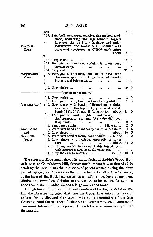
364 D. V. AGER
18 0
16 8
1 621 0
1 10
10 0
2 01 0
53 0
0 42 04 6
16 01 0
48 0
1 110 0
~ ~~
~17. Soft, buff, micaceous, massive, fine-grained sand
stone, weathering into large rounded doggersin places; the top 3 to 4 ft. flaggy and highlyfossiliferous, the lowest 6 in. nodular withoccasional specimens of Gibbirhynchia micra
about1
16. Grey shales15. Ferruginous limestone, nodular in lower part,
Amaltheus sp,14. Grey shales ...13. Ferruginous limestone, nodular at base, with
Amaltheus spp. and a large fauna of lamellibranchs and belemnites ...
margaritatusZone
spinatumZone
davoei Zoneand
ibex Zone(pars)
(age uncertain)
L12. Grey shales ...
----------~floor of upper quarry~---------
11. Grey shales ...10. Ferruginous band, lower part weathering white ...9. Grey shales with bands of ferruginous nodules,
especially in the top 6 ft.; prominent nodulebands 15 ft., 24 ft. and 48 ft. below top about
8. Ferruginous band, highly fossiliferous, withAndrogynoceras sp, and •Rhynchonella' gen.et sp, indet.
7. Sandy grey shales ... ... 1 ft. 6 in. to6. Prominent band of hard sandy shales 2 ft. 4 in. to5. Grey shales ... about4. Prominent band of ferruginous nodules 6 in to3. Grey shales with nodules, especially in lower
part ... about2. Grey argillaceous limestone, highly fossiliferous,
with Androgynoceras spp., Oxytoma, etc.1. Grey shales with nodules .. . seen to
The spinatum Zone again shows its sandy facies at Robin's Wood Hill,as it does at Churchdown Hill, farther north, where it was described indetail by the Rev. F. Smithe in a series of papers written during the latterpart of last century. Once again the nodule bed with Gibblrhynchia micra,at the base of the Rock-bed, serves as a useful guide. Several membersclimbed the lower face of shales (or shaly clays) to inspect the ferruginousband (bed 8 above) which yielded a large and varied fauna.
Though time did not permit the examination of the higher strata on thehill, the Director indicated that here the Upper Lias takes the form ofunfossiliferous silts and silty clays, with no representative of the trueCotswold Sand facies as seen farther south. Only a very small capping ofowermost Inferior Oolite is present beneath the trigonometrical point at
the summit.
FIELD MEETING IN THE CENTRAL COTSWOLDS 365
When the party had reassembled in the coach, after leaving the brickpit, the president (Dr. L. R. Cox) thanked the Director and Mrs. Ager, onbehalf of the Association, for organising the excursion. A brief halt wasmade on Scottsquar Hill during the ride back to Stroud, to admire thelarge quarry in golden freestone, near where it is being worked at presentfor repairs to Gloucester Cathedral. At Stroud, members of the partydispersed.
REFERENCESAGER, D. V. 1954. The genus Gibbirhynchia in the British Domerian. Proc. Geol.
Ass., Lond., 65, 25-51, pl. I.BUCKMAN, S. S. 1889. On the Cotteswold, Midford, and Yeovil Sands, and the Division
between Lias and Oolite. Quart. J. geol, Soc. Lond., 45,440-74.RICHARDSON, L. 1904. A Handbook to the Geology of Cheltenham and Neighbourhood.
Cheltenham, 303 pp., 19 pls., I folding map.---. 19100. The Neozoic Rocks of Gloucestershire and Somerset in Geology in
the Field. Jubilee volume Geol, Assoc., 1, 329-64, pis. VIII-XI.---,. 1910b. The Inferior Oolite and contiguous deposits of the South Cottes
wolds. Proc, Cotteswold Nat. Fld. CI., 17, 63-136, pIs. XV-XXI.SPATH, L. F. 1938. A Catalogue of the Ammonites of the Liassic family Liparoceratidae
In the British Museum (Natural History). London, 191 pp., 26 pls,WATIS, A. 1928. Excursion to Robin's Wood Hill. Proc, Cotteswold Nat. Fld. CI., 23,
137-9, pl. XVIII.