Embed Size (px)
Citation preview

FIELD MEETING AT THE STOUR ESTUARY
Sunday, 18 May 1952
Report by the Directors: A. G. Davis, F.G.S., G. F. Elliott, F.G.S. andH. E. P. Spencer, F.G.S.
[Received 22 August 1952]
THIRTY-ONE members and friends assembled at Charing Cross andproceeded to north Essex, where they were joined by six more. After
lunch at Ramsey the party visited the Harwich foreshore, where one of thedirectors (G.F.E.) gave a brief account of the local succession in the London Clay and its correlation with that of countries across the North Seaand with the rest of England. Some copies of an old engraving (1730) of thesection at this spot were handed round so that members might see theconsiderable changes brought about there in the last two centuries (seePlate 4). Returning to the coach, the party proceeded round the head of theestuary at Manningtree and into Suffolk. They examined the section ofPleistocene brickearth on the shore at Stutton Ness. The directors (A.G.D.•H.E.P.S.) spoke respectively on the rich molluscan fauna of the brickearthand on the history of its study, and on the local succession and extent ofthe deposit (see notes on pp. 25-30). After successful collecting there, theparty were taken through a surprisingly hilly part of Suffolk to Harkstead.Here a hurried descent through fields and marsh brought them to a finecliff-section of contorted and gravelly drift resting on and impacted intoLondon Clay; one of the directors (H.E.P.S.) spoke on the relation of thismarginal deposit to the brickearth earlier seen, and on the extent and possible mode of formation of the whole deposit. Tea was taken in Stutton;Mr. Davis exhibited some old literature and portraits ofgeological worthiesconnected with the district. The President proposed a vote of thanks tothe Directors and to the Secretary, Miss J. M. Spires, after which the mainparty returned to London.
EXPLANATION OF PLATE 4
Fig. J. Harwich cliff in the early eighteenth century: London Clay (E) with stoneband (I) near the base of the cliff, capped by Red Crag (D). After Samuel Dale,The History and Antiquities of Harwich and Dovercourt, etc., pl. 8, London,1730.
Fig. 2. Approximately the same spot as in Fig. 1, May 1952. Marine erosion has cutback the cliff with complete loss of the Red Crag: the stone band outcropsalong the foreshore, the London Clay below and above being obscured bybeach material and by the sea-wall and vegetation.
24

PROC. G EOL. ASSOC., VOL. 64 (1953) PLA TE 4
A .L and -g uaI".1 t'"rf .ll . il/" . -1...1"" ,,, ..' l iJ_r 1'/ ".;f.m .1 ,..;....,. q r"'" IA:"-;7..rl . c . f,";... J ruth •.•. n..~ ~ r Courl .~"l"''' ,,/ Ij,~It • • "1IJ ~.. IIt. D D ~M, . " ,." J ../ ~,,"d . G,,~...I. Fur,il - ~"CU •.d';.L tft.c,r G;""4"I<"U/,,4. 1:;.:7A.. .!/rdh.,., "r nl~w ilh Cby .Ii."'''l''.r
':::~-rt:'~NM::''i~(:::;~; ~J:''},i) 'iiI~:~::.~!~~:;Y:;:ffj.~ ~~~~:''~~;''!· :::.:~::':;·~;:::':'''#·G . C l , ff · $ ro.. .. ,J;.>._""~
Fig. I. Harwich ClifT in Ino
Fig. 2. Approximately same site as Fig. 1 in 1952[To face p- 24
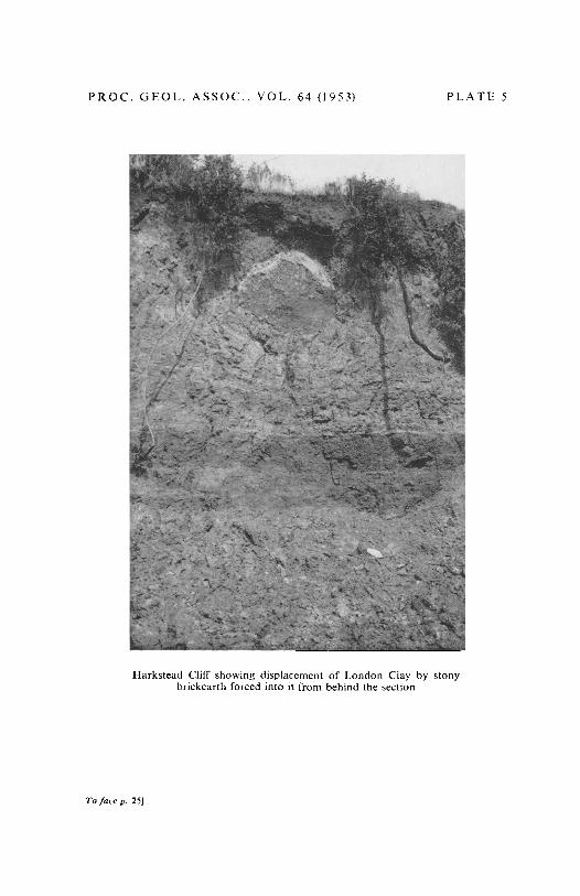
PROC. GEOL. ASSOC .. YOLo 64 (1953) PLATE 5
Harkstead ClifT showing displacement of London Clay by stonybrickearth forced into it from behind the section
To face p, 251