Embed Size (px)
Citation preview

Selecting and Accomodating Inflow Design Floods for Dams
April 2004
Federal Guidelines for Dam Safety
FEDERAL GUIDELINES FOR DAM SAFETY: SELECTING AND ACCOMMODATING INFLOW DESIGN FLOODS FOR DAMS
prepared by the INTERAGENCY COMMITTEE ON DAM SAFETY
U.S. DEPARTMENT OF HOMELAND SECURITY FEDERAL EMERGENCY MANAGEMENT AGENCY OCTOBER 1998
Reprinted April 2004

PREFACE
In April 1977, President Carter issued a memorandum directing the review of federal dam safety activities by an ad hoc panel of recognized experts. In June 1979, the ad hoc interagency committee on dam safety (ICODS) issued its report, which contained the first guidelines for federal agency dam owners. The Federal Guidelines for Dam Safety (Guidelines) encourage strict safety standards in the practices and procedures employed by federal agencies or required of dam owners regulated by the federal agencies. The Guidelines address management practices and procedures but do not attempt to establish technical standards. They provide the most complete and authoritative statement available of the desired management practices for promoting dam safety and the welfare of the public.
To supplement the Guidelines, ICODS prepared and approved federal guidelines in the areas of emergency action planning; earthquake analysis and design of dams; and selecting and accommodating inflow design floods for dams. These publications, based on the most current knowledge and experience available, provided authoritative statements on the state of the art for three important technical areas involving dam safety. In 1994, the ICODS Subcommittee to Review/Update the Federal Guidelines began an update to these guidelines to meet new dam safety challenges and to ensure consistency across agencies and users. In addition, the ICODS Subcommittee on Federal/Non-Federal Dam Safety Coordination developed a new guideline, Hazard Potential Classification System for Dams.
With the passage of the National Dam Safety Program Act of 1996, Public Law 104-303, ICODS and its Subcommittees were reorganized to reflect the objectives and requirements of Public Law 104-303. In 1998, the newly convened Guidelines Development Subcommittee completed work on the update of all of the following guidelines:
• Federal Guidelines for Dam Safety: Emergency Action Planning for Dam Owners
• Federal Guidelines for Dam Safety: Hazard Potential Classification System for Dams
• Federal Guidelines for Dam Safety: Earthquake Analyses and Design of Dams
• Federal Guidelines for Dam Safety: Selecting and Accommodating Inflow Design Floods for Dams
• Federal Guidelines for Dam Safety: Glossary of Terms
The publication of these guidelines marks the final step in the review and update process. In recognition of the continuing need to enhance dam safety through coordination and information exchange among federal and state agencies, the Guidelines Development Subcommittee will be responsible for maintaining these documents and establishing additional guidelines that will help achieve the objectives of the National Dam Safety Program.
The members of all of the Task Groups responsible for the update of the guidelines are to be commended for their diligent and highly professional efforts:
Harold W. Andress, Jr. Chairman, Interagency Committee on Dam Safety

SELECTING AND ACCOMMODATING INFLOW DESIGN FLOODS FOR DAMS
TASK GROUP
David Achterberg** DOI, Bureau of Reclamation
Jerrold W. Gotzmer* Federal Energy Regulatory Commission
Ronald Spath* Federal Energy Regulatory Commission
Ming Tseng* U.S. Army Corps of Engineers
Donald E. Woodward* USDA, Natural Resources Conservation Service
Norman Miller USDA, Natural Resources Conservation Service
Sam A. Shipman Tennessee Valley Authority
*Chair of Task Group that completed final document **Member of Task Group that completed final document
TABLE OF CONTENTS
I. INTRODUCTION ..............................................................................................................................1 A. Purpose ...............................................................................................................................1 B. Background .............................................................................................................................1
1. Early Periods.................................................................................................................1 2. Transition .....................................................................................................................2 3. Current Practices ..........................................................................................................2
C. Scope .......................................................................................................................................3 1. General .........................................................................................................................3 2. Philosophy and Principles ............................................................................................3 3. Content .........................................................................................................................4
II. DEFINITIONS OF TERMS ............................................................................................................5
III. SELECTING INFLOW DESIGN FLOODS ..............................................................................11 A. Introduction............................................................................................................................11 B. Hazard Potential Evaluation ..................................................................................................11
1. General ........................................................................................................................12 2. Hydrologic Modes of Failure .....................................................................................12
a. Overtopping.....................................................................................................12 b. Erosion in Earth Spillways..............................................................................12 c. Overstressing of Structural Components .......................................................13
3. Defining the Hazard Potential ....................................................................................13 4. Evaluating the Consequences of Dam Failure ...........................................................14 5. Studies to Define the Consequences of Dam Failure .................................................15 6. Incremental Hazard Evaluation for Inflow Design Flood Determination .................17 7. Criteria for Selecting the Inflow Design Flood...........................................................19
C. PMFs for Dam Safety ............................................................................................................21 1. General ........................................................................................................................21 2. PMP.............................................................................................................................21
D. Floods To Protect Against Loss of Benefits During the Life of the Project- Applicable Only to Low-Hazard Dams .............................................................................22
IV. ACCOMMODATING INFLOW DESIGN FLOODS ...............................................................23 A. Introduction ...........................................................................................................................23
1. General .......................................................................................................................23 2. Guidelines for Initial Elevations ................................................................................23 3. Reservoir Constraints .................................................................................................23 4. Reservoir Regulation Requirements ..........................................................................23 5. Evaluation of Domino-like Failure ............................................................................24
i

TABLE OF CONTENTS (Continued)
B. Spillway and Flood Outlet Selection and Design ..................................................................25 1. General .......................................................................................................................25 2. Gated or Ungated Spillways ......................................................................................25 3. Design Considerations ...............................................................................................26
C. Freeboard Allowances ...........................................................................................................27 1. General .......................................................................................................................27 2. Freeboard Guidelines .................................................................................................28
Appendix A - References by Top ....................................................................................................... A-1
Appendix B – Inflow Design Flood Selection Procedures Figure 1. Illustration of Incremental Increase Due to Dam Failure Figure 2. Illustration of Incremental Area Flooded by Dam Failure Figure 3. Regions Covered by PMP Studies
ii
I. INTRODUCTION
A. Purpose The purpose of these Guidelines is to provide thorough and consistent procedures for selecting and accommodating Inflow Design Floods (IDFs). The IDF is the flood flow above which the incremental increase in water surface elevation downstream due to failure of a dam or other water retaining structure is no longer considered to present an unacceptable additional downstream threat.
B. Background Current practice in the design of dams is to use the IDF that is deemed appropriate for the hazard potential of the dam and reservoir, and to design spillways and outlet works that are capable of safely accommodating the floodflow without risking the loss of the dam or endangering areas downstream from the dam to flows greater than the inflow. However, there are many dams whose discharge capabilities were designed using methods that are now considered unconservative and potentially unsafe.
Inflow design flood selection began primarily as a practical concern for protection of a dam and the benefits it provides. The early 1900's saw an increase in the Nation's social awareness that was demonstrated by various legislative acts designed to protect the public from certain high risk activities. The same era witnessed an increase in the number and size of dams built. When the "big dam" era began in the 1930's, safety clearly became a more dominant factor. It was recognized that dams needed to be designed to accommodate water flows that might be greater than the anticipated "normal" flow.
1. Early Periods. Before 1900, designers of dams had relatively little hydrologic data or tools to indicate flood potential at a proposed dam site. Estimates of flood potential were selected by empirical techniques and engineering judgment based on high water marks or floods of record on streams being studied.
Later, engineers began examining all past flood peaks in a region to obtain what was hoped to be a more reliable estimate of maximum flood-producing potentials than a limited record on a single stream. Designers would base their spillway design on these estimates, sometimes providing additional capacity as a safety factor. Some spillways were designed for a multiple of the maximum known flood, for example, twice the maximum known flood. The multiples and safety factors were based on engineering judgment; the degree of conservatism in the design was unknown.
By the 1930's, it became apparent that this approach was inadequate. As longer hydrologic records were obtained, new floods exceeded previously recorded maximum floods. With the introduction of the unit hydrograph concept by Sherman in 1933, it became possible to estimate floodflows from storm rainfall. The design of dams began to be based upon the transposition of major storms that had occurred within a region, i.e.,
1

transfer and centering of relevant storm rainfall patterns over the basin above the dam site being evaluated. It was recognized that flood peaks are dependent on topography, size of individual watersheds, and chance placement of the storm's center over the watershed. In addition, within meteorologically similar areas, observed maximum rainfall values could provide a better indication of maximum flood potentials than data on flood discharges from individual watersheds. If, in the judgment of the designer, the storm was not representative of what might occur, rainfall amounts were increased to represent a more severe event, and the dam was designed accordingly.
2. Transition. Engineers next turned to hydrometeorologists to determine if upper limits for rates of precipitation could be established on a rational basis. Careful consideration was given to the meteorology of storms that produced major floods in various parts of the country. The large scale features of the storm and measures of atmospheric moisture, such as dewpoint temperatures, were considered as well as the rainfall depth-area-duration values produced by these storms. It was then possible to increase the storm dewpoint temperature and other factors affecting rainfall to the maximum appropriate values. This increase resulted in estimates of probable maximum precipitation (PMP), and thus introduced the concept of a physical upper limit to precipitation. When translated to runoff, the estimated floodflow is known as the probable maximum flood (PMF).
At first, the terms maximum possible precipitation and maximum possible flood were used. However, the terminology was changed to probable maximum to recognize the uncertainties in the estimates of the amount of precipitation, and the most severe combination of critical meteorological and hydrologic conditions that are reasonably possible in the region. Today, the PMF is generally accepted as the standard for the safety design of dams where the incremental consequences of failure have been determined to be unacceptable.
In the late 1940's, the ability to estimate the consequences of dam failure, including the loss of life, was still quite limited. The height of the downstream flood wave and the extent of wave propagation were known to be a function of dam height and reservoir volume. Thus, early standards for dam design were based upon the size of the dam in terms of its height, the reservoir storage volume, and the downstream development.
The practice of setting inflow design flood standards based upon the size of a dam, its reservoir volume, and current downstream development resulted in an inconsistent level of design throughout the country. The determination of the consequences of a dam failure is more complex than can be evaluated by these simple relationships.
3. Current Practices. In 1985, the National Academy of Sciences (NAS) published a study of flood and earthquake criteria which contained an inventory of current practices in providing dam safety during extreme floods. The inventory showed considerable diversity in approach by various federal, state, and local government agencies,
2

professional societies, and private firms. While the inventory shows a fair consensus on spillway requirements for dams having a high-hazard potential, there is a wide range of criteria being applied to dams with lower hazard classifications.
Several observations about the evaluation of hydrologic conditions were made in the NAS study. Use of PMP for evaluating spillway capacity requirements for large, high-hazard dams predominates, although some state agencies have standards that do not require such dams to pass the full estimated PMF based on the PMP. The influence of the principal federal dam-building and dam safety agencies is evident in the majority of the standards for large, high-hazard dams, but the practices of those agencies have had less effect on current state standards for small dams in less hazardous situations.
As a result of inspections authorized by Public Law 92-367, the National Dam Inspection Act, and carried out by the U.S. Army Corps of Engineers from 1977 to 1981, several states have adopted the spillway capacity criteria used in those inspections. Several other states have adopted the standards used by the Natural Resources Conservation Service (formerly the Soil Conservation Service) for the design of smaller dams constructed under that agency's programs.
Most agencies draw a distinction between design criteria that are applied to existing dams and those that are applied to new dams. However, because dam failures present the same consequences to life and property, it is desirable that existing dams meet the criteria established for new dams.
Today, hydrologically safe designs should be based on current state-of-the-art criteria. Now that engineers can estimate downstream flood levels resulting from dam failure, safety design standards can be tied specifically to a detailed evaluation of the impacts of a flood if a dam were to fail. Although debate continues over the proper criteria and degree of conservatism warranted when evaluating and designing modifications to existing dams, and when designing new dams, criteria used by dam designers, regulators, and owners now focus on ensuring public safety.
C. Scope 1. General. These Guidelines are not intended to provide a complete manual of all procedures used for estimating inflow design floods; the selection of procedures is dependent upon available hydrologic data and individual watershed characteristics. All studies should be performed by an engineer experienced in hydrology and hydraulics, directed and reviewed by engineers experienced in dam safety, and should contain a summary of the design.
2. Philosophy and Principles. The basic philosophy and principles are described in sufficient detail to achieve a reasonable degree of uniformity in application, and to achieve a consistent and uniform nationwide treatment among federal agencies in the design of dams from the standpoint of hydrologic safety.
3

3. Content. The following topics are discussed in these Guidelines:
• Selecting the IDF - The selection of the appropriate IDF for a dam is related to the hazard potential classification and is the result of the incremental hazard evaluation.
• Accommodating the IDF - Site-specific considerations are necessary to establish hydrologic flood routing criteria for each dam and reservoir. The criteria for routing the IDF or any other flood should be consistent with the reservoir regulation procedure that is to be followed in actual operation.
4

II. DEFINITION OF TERMS
This chapter contains definitions of technical terms used in these Guidelines.
Breach: An opening through a dam which drains the reservoir. A controlled breach is a constructed opening. An uncontrolled breach is an unintentional discharge from the reservoir.
Concurrent Inflows: Flows expected on tributaries to the river system downstream of the dam at the same time a flood inflow occurs.
Concurrent Floods: Flows expected on the river to which the river system with a dam is a tributary at the same time a flood inflow occurs at the reservoir.
Dam Failure: The catastrophic breakdown of a dam, characterized by the uncontrolled release of impounded water. There are varying degrees of failure.
Deterministic Methodology: A method in which the chance of occurrence of the variable involved is ignored and the method or model used is considered to follow a definite law of certainty, and not probability.
Dewpoint Temperature: The temperature at which dew begins to form or vapor begins to condense into a liquid.
Dynamic Routing: Hydraulic flow routing based on the solution of the St.-Venant Equation(s) to compute the changes of discharge and stage with respect to time at various locations along a stream.
Embankment Dam: Any dam constructed of excavated natural materials (includes both earthfill and rockfill dams).
Erosion: The wearing away of a surface (bank, streambed, embankment) by floods, waves, wind, or any other natural process.
Flashboards: Structural members of timber, concrete, or steel placed in channels or on the crest of a spillway to raise the reservoir water level but are intended to be quickly removed, tripped or fail, in the event of a flood.
Flood: A temporary rise in water surface elevation resulting in inundation of areas not normally covered by water. Hypothetical floods may be expressed in terms of average probability of exceedance per year such as one-percent-chance flood, or expressed as a fraction of the probable maximum flood or other reference flood.
5
Flood Plain: The downstream area that would be inundated or otherwise affected by the failure of a dam or by large flood flows.
Flood Routing: A process of determining progressively the amplitude of a flood wave as it moves past a dam and continues downstream.
Flood Storage: The retention of water or delay of runoff either by planned operation, as in a reservoir, or by temporary filling of overflow areas, as in the progression of a flood wave through a natural stream channel.
Freeboard: Vertical distance between a specified stillwater reservoir surface elevation and the top of the dam, without camber.
Foundation: The portion of the valley floor that underlies and supports the dam structure.
Gate: A movable water barrier for the control of water.
Hazard: A situation which creates the potential for adverse consequences such as loss of life, property damage, or other adverse impacts. Impacts in the area downstream of a dam are defined by the flood waters released through spillways and outlet works of the dam or waters released by partial or complete failure of the dam. There may also be impacts upstream of the dam due to backwater flooding or landslides around the reservoir perimeter.
Hazard Potential Classification: A system that categorizes dams according to the degree of adverse incremental consequences of a failure or misoperation of a dam. The Hazard Potential Classification does not reflect in any way on the current condition of the dam (i.e., safety, structural integrity, flood routing capacity).
Hydrograph, Flood: A graphical representation of the flood discharge with respect to time for a particular point on a stream or river.
Hydrology: One of the earth sciences that encompasses the natural occurrence, distribution, movement, and properties of the waters of the earth and their environmental relationships.
Hydrometeorology: The study of the atmospheric and land-surface phases of the hydrologic cycle with emphasis on the interrelationships involved.
Inflow Design Flood (IDF): The flood flow above which the incremental increase in downstream water surface elevation due to failure of a dam or other water impounding structure is no longer considered to present an unacceptable additional downstream threat. The IDF of a dam or other water impounding structures is the flood hydrograph
6

used in the design or evaluation of a dam, its appurtenant works, particularly for sizing the spillway and outlet works, for determining maximum height of a dam, freeboard, and flood storage requirements. The upper limit of the IDF is the probable maximum flood.
Intake: Placed at the beginning of an outlet-works waterway (power conduit, water supply conduit), the intake establishes the ultimate drawdown level of the reservoir by the position and size of its opening(s) to the outlet works. The intake may be vertical or inclined towers, drop inlets, or submerged, box-shaped structures. Intake elevations are determined by the head needed for discharge capacity, storage reservation to allow for siltation, the required amount and rate of withdrawal, and the desired extreme drawdown level.
Inundate: To overflow, to flood.
Inundation Map: A map showing areas that would be affected by flooding from an uncontrolled release of a dam's reservoir.
Landslide: The unplanned descent (movement) of a mass of earth or rock down a slope.
Maximum Wind: The most severe wind for generating waves that is reasonably possible at a particular reservoir. The determination will generally include results of meteorologic studies which combine wind velocity, duration, direction, fetch, and seasonal distribution characteristics in a realistic manner.
Meteorological Homogeneity: Climates and orographic influences that are alike or similar.
Meteorology: The science that deals with the atmosphere and atmospheric phenomena, the study of weather, particularly storms and the rainfall they produce.
One-Percent-Chance Flood: A flood that has 1 chance in 100 of being equaled or exceeded during any year.
Orographic: Physical geography that pertains to mountains and to features directly connected with mountains and their general effect on storm path and generation of rainfall.
Outlet Works: A dam appurtenance that provides release of water (generally controlled) from a reservoir.
Probable Maximum Flood (PMF): The flood that may be expected from the most severe combination of critical meteorologic and hydrologic conditions that are reasonably possible in the drainage basin under study.
7

Probable Maximum Precipitation (PMP): Theoretically, the greatest depth of precipitation for a given duration that is physically possible over a given size storm area at a particular geographical location during a certain time of the year. Reservoir Regulation Procedure (Rule Curve): Refers to a compilation of operating criteria, guidelines, and specifications that govern the storage and release function of a reservoir. It may also be referred to as operating rules, flood control diagram, or water control schedule. These are usually expressed in the form of graphs and tabulations, supplemented by concise specifications and are often incorporated in computer programs. In general, they indicate limiting rates of reservoir releases required or allowed during various seasons of the year to meet all functional objectives of the project.
Reservoir Rim: The boundary of the reservoir including all areas along the valley sides above and below the water surface elevation associated with the routing of the IDF.
Risk: The relationship between the consequences resulting from an adverse event and its probability of occurrence.
Risk-based Analysis: A procedure in which the consequences and risks of adverse events and alternatives for mitigation are evaluated and arranged in a manner that facilitates a decision on the action to be taken. A risk-based analysis may be the basis for the selection of the IDF for a particular dam.
Seiche: An oscillating wave in a reservoir caused by a landslide into the reservoir or earthquake-induced ground accelerations or fault offset.
Sensitivity Analysis: An analysis in which the relative importance of one or more of the variables thought to have an influence on the phenomenon under consideration is determined.
Settlement: The vertical downward movement of a structure or its foundation.
Significant Wave Height: Average height of the one-third highest individual waves. May be estimated from wind speed, fetch length, and wind duration.
Spillway: A structure over or through which flow is discharged from a reservoir. If the rate of flow can be controlled by mechanical means, such as gates, it is considered a controlled spillway. If the geometry of the spillway is the only control, it is considered an uncontrolled spillway. Definitions of specific types of spillways follow:
Service Spillway: A spillway that is designed to provide continuous or frequent regulated or unregulated releases from a reservoir without significant damage to either the dam or its appurtenant structures. This is also referred to as principal spillway.
8
Auxiliary Spillway: Any secondary spillway which is designed to be operated infrequently, possibly in anticipation of some degree of structural damage or erosion to the spillway that would occur during operation.
Emergency Spillway: A spillway that is designed to provide additional protection against overtopping of dams, and is intended for use under extreme flood conditions or misoperation or malfunction of the service spillway and/or the auxiliary spillway.
Spillway Capacity: The maximum spillway outflow which a dam can safely pass with the reservoir at its maximum level.
Stillwater Level: The elevation that a water surface would assume if all wave actions were absent.
Storm: The depth, area, and duration distributions of precipitation.
Storm Center: Location of the storm pattern such that the precipitation falls on a specific drainage basin to create the runoff at the site under consideration.
Storm Transposition: The application of a storm from its actual location of occurrence to some other area within the same region of meteorological homogeneity. Storm transposition requires the determination of whether the particular storm could occur over the area to which it is to be transposed.
Surcharge: The volume or space in a reservoir between the controlled retention water level and the maximum water level. Flood surcharge cannot be retained in the reservoir but will flow out of the reservoir until the controlled retention water level is reached.
Toe of the Dam: The junction of the downstream slope or face of a dam with the ground surface; also referred to as the downstream toe. The junction of the upstream slope with the ground surface is called the heel or the upstream toe.
Topographic Map: A detailed graphic delineation (representation) of natural and man-made features of a region with particular emphasis on relative position and elevation.
Tributary: A stream that flows into a larger stream or body of water.
Unit Hydrograph: A hydrograph with a volume of one inch of direct runoff resulting from a storm of a specified duration and areal distribution. Hydrographs from other storms of the same duration and distribution are assumed to have the same time base but with ordinates of flow in proportion to the runoff volumes.
Watershed: The area drained by a river or river system.
9

Wave Runup: Vertical height above the stillwater level to which water from a specific wave will run up the face of a structure or embankment.
Wind Setup: The vertical rise of the stillwater level at the face of a structure or embankment caused by wind stresses on the surface of the water.
10
III. SELECTING INFLOW DESIGN FLOODS
A. Introduction Many thousands of dams have been constructed in the United States, and new dams continue to add to this total. The proper operation of dams to withstand natural forces, including extreme hydrologic events, is an important matter of public safety and concern.
In today's technical world, extreme hydrologic events resulting in dam failures are classified as "low-probability, high-consequence" events. In addition, the potential for losses due to increased downstream development may increase the consequences of a dam failure.
There has been a growing concern and increased attention to dam safety over the past two decades, primarily as a result of a number of catastrophic dam failures. As a result, the inspection of non-federal dams authorized by Public Law 92-367, the National Dam Inspection Act, identified some 2,900 unsafe dams of which 2,350 had inadequate spillway capacities. Since there are approximately 23,772 high and significant-hazard dams in the present National Inventory of Dams, the number of dams which have inadequate spillways could be significantly higher.
The adequacy of a spillway must be evaluated by considering the hazard potential, which would result from failure of the project works during flood flows. (See Chapter II for a definition of hazard potential.) If failure of the project works would present an unacceptable downstream threat, the project works must be designed to either withstand overtopping for the loading condition that would occur during a flood up to the probable maximum flood, or to the point where a failure would no longer cause an unacceptable additional downstream threat.
The procedures used to determine whether or not the failure of a project would cause an unacceptable downstream threat vary with the physical characteristics and location of the project, including the degree and extent of development downstream.
Analyses of dam failures are complex, with many historical dam failures not completely understood. The principal uncertainties in determining the outflow from a dam failure involve the mode and degree of failure. These uncertainties can be circumvented in situations where it can be shown that the complete and sudden removal of the dam would not result in unacceptable consequences. Otherwise, reasonable failure postulations and sensitivity analyses should be used. Suggested references regarding dam failure studies are listed in Appendix A. If it is judged that a more extensive mode of failure than that normally recommended for the type of structure under investigation is possible, then analyses should be done to determine whether remedial action is required. Sensitivity studies on the specific mode of failure should be performed when failure is due to overtopping.
B. Hazard Potential Evaluation A properly designed, constructed, and operated dam can be expected to improve the safety of downstream developments during floods. However, the impoundment of water by a dam can
11
create a potential hazard to downstream developments greater than that which would exist without the dam because of the potential for dam failure. There are several potential causes of dam failure, including hydrologic, geologic, seismic, and structural.
These Guidelines are limited to the selection of the inflow design flood (IDF) for the hydrologic design of a dam.
1. General. Once a dam is constructed, the downstream hydrologic regime may change, particularly during floods. The change in hydrologic regime could alter land use patterns to encroach on a flood plain that would otherwise not be developed without the dam. Consequently, evaluation of the consequences of dam failure must be based on the dam being in place, and must compare the impacts of with-failure and without-failure conditions on existing development and known and prospective future development when evaluating the downstream hazard potential.
2. Hydrologic Modes of Failure. Many dam failures have resulted because of an inability to safely pass flood flows. Failures caused by hydrologic conditions can range from sudden, with complete breaching or collapse, to gradual, with progressive erosion and partial breaching.
The most common modes of failure associated with hydrologic conditions include overtop-ping, erosion of earth spillways, and overstressing the dam or its structural components. The following paragraphs describe briefly each of the modes of failure caused by hydrologic conditions.
a. Overtopping. Overtopping of a dam occurs when the water level in the reservoir exceeds the height of the dam and flows over the crest. Overtopping will not necessarily result in a failure. Failure depends on the type, composition, and condition of the dam and the depth and duration of flow over the dam.
Embankment dams are very susceptible to failure when overtopped because of potential erosion. If the erosion is severe, it can lead to a breach and failure of the dam. During overtopping, the foundation and abutments of concrete dams also can be eroded, leading to a loss of support and failure from sliding or overturning. In addition, when a concrete dam is subjected to overtopping, the loads can be substantially higher than those for which the dam was designed. If the increased loading on the dam itself due to overtopping is too great, a concrete dam can fail by overturning or sliding.
b. Erosion in Earth Spillways. High or large flows through earthen spillways adjacent to dams can result in erosion that progresses to the dam and threatens it. Erosion can also cause headcutting that progresses toward the spillway crest and eventually leads to a breach. Discontinuities in slope, nonuniform vegetation or bed materials, and concentrated flow areas can start headcuts and accelerate the erosion process. Flood depths that exceed the safe design parameters can produce erosive forces that may cause serious erosion in the spillway.
12

Erosion that occurs due to flow concentrations can start where roads or trails are devoid of vegetation or have ruts that run parallel to the spillway flow. A varied mix of earth materials, unlevel cross sections, uneven stands of vegetation, and obstructions such as trash accumulations can cause turbulent, concentrated flow conditions that start gullies that can widen and migrate upstream to breach the spillway crest.
Runoff brought into a spillway channel by a side inlet may also disrupt the desirable uniform flow pattern and increase the erosion in the channel.
The probability of failure of an earthen auxiliary spillway due to erosion is increased when the capacity of the service spillway inlets (outlet works) or gates are reduced due to trash accumulations. These accumulations reduce the available capacity through these appurtenances and increase the volume, depth, frequency, and duration of flow in the auxiliary spillway.
c. Overstressing of Structural Components. As flood flows enter the reservoir, the reservoir will normally rise to a higher elevation. Even though a dam (both concrete and earth embankment dams) may not be overtopped, the reservoir surcharge will result in a higher loading condition. If the dam is not properly designed for this flood surcharge condition, either the entire dam or the structural components may become overstressed, resulting in an overturning failure, a sliding failure, or a failure of specific structural components (such as the upstream face of a slab and buttress dam). Embankment dams may be at risk if increased water surfaces result in increased pore pressures and seepage rates, which exceed the seepage control measures for the dam.
3. Defining the Hazard Potential. The hazard potential is the possible adverse incremental consequences that result from the release of water or stored contents due to failure of the dam or misoperation of the dam or appurtenances. Hazard potential does not indicate the structural integrity of the dam itself, but rather the effects if a failure should occur. The hazard potential assigned to a dam is based on consideration of the effects of a failure during both normal and flood flow conditions.
Dams assigned the low hazard potential classification are those where failure or misoperation results in no probable loss of human life and low economic and/or environ-mental losses. Losses are principally limited to the owner's property.
Dams assigned the significant hazard potential classification are those dams where failure or misoperation results in no probable loss of human life but can cause economic loss, environmental damage, disruption of lifeline facilities, or can impact other concerns. Significant hazard potential classification dams are often located in predominantly rural or agricultural areas but could be located in areas with population and significant infrastructure.
13

Dams assigned the high hazard potential classification are those where failure or misoperation will probably cause loss of human life.
The hazard potential classification assigned to a dam should be based on the worst-case failure condition, i.e., the classification is based on failure consequences resulting from the failure condition that will result in the greatest potential for loss of life and property damage. For example, a failure during normal operating conditions may result in the released water being confined to the river channel, indicating a low-hazard potential. However, if the dam were to fail during a floodflow condition, and the resultant incremental flood flow would be a potential loss of life or serious damage to property, the dam would have high-hazard potential classification.
In many cases, the hazard potential classification can be determined by field investigations and a review of available data, including topographic maps. However, when the hazard potential classification is not apparent from field reconnaissance, detailed studies, including dambreak analyses, are required. These detailed studies are required to identify the floodflow condition above which the additional incremental increase in elevation, due to failure of a dam, is no longer considered to present an unacceptable threat to downstream life and property.
The hazard potential classification of a project determines the level of engineering review and the criteria that are applicable. Therefore, it is critical to determine the appropriate hazard potential of a dam because it sets the stage for the analyses that must be completed to properly evaluate the integrity of any dam.
4. Evaluating the Consequences of Dam Failure.There have been about 200 notable dam failures resulting in more than 8,000 deaths in the Twentieth Century. Dam failure is not a problem confined to developing countries or to a compilation of past mistakes that are unlikely to occur again.
Many dam owners have a difficult time believing that their dams could experience a rainfall many times greater than any they have witnessed over their lifetimes. Unfortunately, this attitude leads to a false sense of security because floods much greater than those experienced during any one person's lifetime can and do occur.
Estimates of the potential for loss of human life and the economic impacts of damage resulting from dam failure are the usual bases for defining hazard potential. Social and environmental impacts, damage to national security installations, and political and legal ramifications are not easily evaluated, and are more susceptible to subjective or qualitative evaluation. Because their actual impacts cannot be clearly defined, particularly in economic terms, their consideration as factors for determining the hazard potential must be on a case-by-case basis.
In most situations, the investigation of the impacts of failure on downstream life and property is sufficient to determine the appropriate hazard potential rating and to select the appropriate IDF for a project. However, in determining the appropriate IDF for a project, there could be
14

circumstances beyond loss of life and property damage, particularly when a failure would have minimal or no impact on downstream life and property, which would dictate using a more conservative hazard potential and IDF. For example, the reservoir of a dam that would normally be considered to have a low-hazard potential classification based on insignificant incremental increases (in elevation) due to a failure may be known to contain extensive toxic sediments. If released, those toxic sediments would be detrimental to the ecosystem. Therefore, a low-hazard potential classification would not be appropriate. Instead, a higher standard should be used for classifying the hazard potential and selecting the IDF.
5. Studies To Define the Consequences of Dam Failure. The degree of study required to sufficiently define the impacts of dam failure for selecting an appropriate IDF will vary with the extent of existing and potential downstream development, the size of the reservoir (depth and storage volume), and type of dam. Evaluation of the river reach and areas impacted by a dam failure should proceed only until sufficient information is generated to reach a sound decision, or until there is a good understanding of the consequences of failure. In some cases, it may be apparent from a field inspection or a review of aerial photographs, Flood Insurance Rate Maps, and recent topographic maps, that consequences attrib-utable to dam failure would occur and be unacceptable. In other cases, detailed studies, including dambreak analyses, will be required. It may also be necessary to perform field surveys to determine the basement and first floor elevations of potentially affected habitable structures (such as residential and commercial).
When conducting dambreak studies, the consequences of the incremental increase due to failure under both normal (full reservoir with normal streamflow conditions prevailing) and floodflow conditions up to the point where a dam failure would no longer significantly increase the threat to life or property should be considered. For each flood condition, water surface elevations with and without dam failure, flood wave travel times, and rates of rise should be determined. This evaluation is known as an incremental hazard evaluation (See Appendix B, Flowchart 2). Since dambreak analyses and flood routing studies do not provide precise results, evaluation of the consequences of failure should be conservative.
The type of dam and the mechanism that could cause failure require careful consideration if a realistic breach is to be assumed. Special consideration should be given to the following factors:
• Size and shape of the breach
• Time of breach formation
• Hydraulic head
• Storage in the reservoir
• Reservoir inflow
15

In addition, special cases where a dam failure could cause domino-like failure of downstream dams resulting in a cumulative flood wave large enough to cause a threat should be considered.
The area affected by dam failure during a given flow condition on a river is the additional area inundated by the incremental increase in flood elevation due to failure over that which would occur normally by flooding without dam failure. The area affected by a flood wave resulting from a theoretical dam breach is a function of the height of the flood wave and the downstream distance and width of the river at a particular location. An associated and important factor is the flood wave travel time. These elements are primarily a function of the rate and extent of dam failure, but also are functions of channel and floodplain geometry and roughness and channel slope.
The flood wave should be routed downstream to the point where the incremental effect of a failure will no longer result in unacceptable additional consequences. When routing a dambreak flood through the downstream reaches, appropriate concurrent inflows should be considered in the computations. Downstream concurrent inflows can be determined using one of the following approaches:
• Concurrent inflows can be based on historical records if these records indicate that the tributaries contributing to the flood volume are characteristically in a flood stage at the same time that flood inflows to the reservoir occur. Concurrent inflows based on historical records should be adjusted so they are compatible with the magnitude of the flood inflow computed for the dam under study.
• Concurrent inflows can be developed from flood studies for downstream reaches when they are available. However, if these concurrent floods represent inflows to a downstream reservoir, suitable adjustments must be made to properly distribute flows among the tributaries.
• Concurrent inflows may be assumed equal to the mean annual flood (approximately bankfull capacity) for the channel and tributaries downstream from the dam. The mean annual flood can be determined from flood flow frequency studies. As the distance downstream from the dam increases, engineering judgment may be required to adjust the concurrent inflows selected.
In general, the study should be terminated when the potential for loss of life and property damage caused by routing floodflows appears limited. This point could occur when the following takes place:
• There are no habitable structures, and anticipated future development in the floodplain is limited.
• Floodflows are contained within a large downstream reservoir.
16

• Floodflows are confined within the downstream channel.
• Floodflows enter a bay or ocean.
The failure of a dam during a particular flood may increase the area flooded and also alter the flow velocity and depth of flow as well as the rate of rise of flood flows. These changes in flood flows could also affect the amount of damage. To fully evaluate the hazard created by a dam, a range of flood magnitudes needs to be examined. Water surface profiles, flood wave travel times, and rates of rise should be determined for each condition.
The results of the downstream routing should be clearly shown on inundation maps with the breach-wave travel time, maximum depth of flow, and maximum velocity, indicated at critical downstream locations. The inundation maps should be developed at a scale sufficient to identify downstream habitable structures within the impacted area. The current recommended method for dambreak analysis is the unsteady flow and dynamic routing method used in the National Weather Service (NWS) model.
Most of the methods used for estimating dambreak hydrographs, including the widely used NWS model, required selecting the size, shape, and time of formation of the dam breach as input parameters for the computations. Therefore, sensitivity analyses are considered necessary. Sensitivity analyses, based on varying flood inflow conditions and breach parameters, should be performed only to the extent necessary to make a decision.
Dambreak studies should be performed in accordance with accepted Guidelines. Refer to Appendix A for a list of sources of information related to dambreak studies.
6. Incremental Hazard Evaluation for Inflow Design Flood Determination. The appropriate IDF for a project is selected based on the results of the incremental hazard evaluation. This evaluation involves simulating a dam failure during normal and floodflow conditions and routing the water downstream. The additional down-stream threat due to the incremental increase in water surface elevation from dam failure is assessed for each failure scenario.
To evaluate the incremental increase in consequences due to dam failure, begin with the normal inflow condition and the reservoir at normal full reservoir level with normal streamflow conditions prevailing. That condition should be routed through the dam and downstream areas, with the assumption that the dam remains in place. The same flow should then be routed through the dam with the assumption that the dam fails.
The incremental increase in downstream water surface elevation between the with-failure and without-failure conditions should then be determined, i.e., how much higher would the water downstream be if the dam failed than if the dam did not fail? The consequences that could result should then be identified. If the incremental rise in flood water downstream results in unacceptable additional consequences, assess the need for remedial action.
17
If the study under normal flow conditions indicates no adverse consequences, the same analyses should be done for several larger flood levels to determine the greatest unacceptable consequences. Under each incrementally larger inflow condition, identify the consequences of failure. For each larger assumed flood inflow condition (which can be percentages of the probable maximum flood (PMF)):
• assume the dam remains in place during the nonfailure conditions; and
• assume the dam fails when the peak reservoir elevation is attained for the assumed inflow condition.
It is not appropriate to assume that a dam fails on the rising limb of the inflow hydrograph. For example, current methods cannot accurately determine the extent of overtopping that an earth dam can withstand or how rapidly the dam will erode and ultimately breach from overtopping. Therefore, until such methodologies are available and proven, a conservative approach should be followed which assumes that failure occurs at the peak of the flood hydrograph. The assumption should also be made that the dam has been theoretically modified to contain or safely pass all lower inflow floods. This is an appropriate assumption because this procedure requires that the dambreak analyses start at the normal operating condition, with incremental increases in the flood inflow condition for each subsequent failure scenario up to the point where a failure no longer constitutes unacceptable additional consequences. In summary, before selecting larger floods for analysis, determine what failure at a lower flood constituted a threat to downstream life and property.
The above procedure should be repeated until the flood inflow condition is identified such that a failure at that flow or larger flows (up to the PMF) will no longer result in unacceptable additional consequences. The resultant flood flow is the IDF for the project. The maximum IDF is always the PMF, but in many cases the IDF will be substantially less than the PMF.
A PMF should be determined if it is needed for use in the evaluation. If a PMF value is already available, it should be reviewed to determine if it is still appropriate. The probable maximum precipitation (PMP) for the area should be determined either through the use of the Hydrometeorological Reports (HMR's) developed by the NWS or through the services of a qualified hydrometeorologist. In addition, the hydrologic characteristics of the drainage basin that would affect the runoff from the PMP into the reservoir should be determined. After this information is evaluated, the PMF can be determined.
Once the appropriate IDF for the dam has been selected (whether it is the PMF or something less), it should then be determined whether the dam can safely withstand or pass all floodflows up through the IDF. If it can, then no further evaluation or action is required. If it cannot, then measures must be taken to enable the project to safely accommodate all floods up through the IDF to alleviate the incremental increase in unacceptable additional consequences a failure may have on areas downstream.
18

It is important to investigate the full range of flood flow conditions to verify that a failure under flood flows larger than the selected IDF up through the PMF will not result in any additional hazard. In addition, once the design for remedial repairs is selected, the IDF should be verified for that design.
Appendix B provides specific guidance and procedures, including a comprehensive flowchart, for conducting an incremental hazard evaluation to select the appropriate IDF for a dam and determine the need for remedial measures.
7. Criteria for Selecting the Inflow Design Flood. Ideally, dams should be able to safely accommodate floodflows in a manner that will not increase the danger to life and property downstream. However, this situation is not always the case, and may not always be achievable.
There are various methods or reasons for selecting the inflow design flood and determining whether the dam can safely accommodate the flood. The method chosen may be determined by the amount of time and/or funds available to conduct an evaluation. For example, if time and funds are scarce, a conservative inflow design flood (e.g., the PMF) can be selected.
Sometimes, inflow design flood selection is straightforward, i.e., given certain criteria, a specific inflow design flood must be used, due to political decisions and policies established by government agencies. For example, statutes may require that a flood such as the PMF, a specific fraction of the PMF, or a flood of specific frequency be selected for a dam with a certain hazard classification. Fortunately, the most widely accepted approach involves incremental hazard evaluations to identify the appropriate IDF for a dam.
There is not a separate IDF for each section of a dam. A dam is assigned only one IDF, and it is determined based on the consequences of failure of the section of the dam that creates the greatest hazard potential downstream. This should not, however, be confused with the design criteria for different sections of a dam which may be based on the effect of their failure on downstream areas.
The PMF should be adopted as the IDF in those situations where consequences attributable to dam failure for flood conditions less than the PMF are unacceptable.
A flood less than the PMF may be adopted as the IDF in those situations where the consequences of dam failure at flood flows larger than the selected IDF are acceptable. In other words, where detailed studies conclude that the risk is only to the dam owners' facilities and no increased damage to downstream areas is created by failure, a risk-based approach is acceptable. Generally, acceptable consequences exist when evaluation of the area affected indicates the following:
19
• There are no permanent human habitations, known national security installations, or commercial or industrial developments, nor are such habitations or commercial or industrial developments projected to occur within the potential hazard area in the foreseeable future.
• There are permanent human habitations within the potential hazard area that would be affected by failure of the dam, but there would be no significant incremental increase in the threat to life or property resulting from the occurrence of a failure during floods larger than the proposed IDF. For example, if an impoundment has a small storage volume and failure would not add appreciably to the volume of the outflow flood hydrograph, it is likely that downstream inundation would be essentially the same with or without failure of the dam.
The consequences of dam failure may not be acceptable if the hazard potential to these habitations is increased appreciably by the failure flood wave or level of inundation. When a dambreak analysis shows downstream incremental effects of approximately two feet or more, engineering judgment and further analysis will be necessary to finally evaluate the need for modification to the dam. In general, the consequences of failure are considered acceptable when the incremental effects (depth) of failure on downstream structures are approximately two feet or less. However, the two-foot increment is not an absolute decision-making point. Sensitivity analyses and engineering judgment are the tools used in making final decisions. For example, if it is determined that a mobile home sitting on blocks can be moved and displaced by as little as six inches of water, then the acceptable incremental impact would be much less than two feet. As a second example, if a sensitivity analysis demonstrates that the largest breach width recommended is the only condition that results in an incremental rise of two feet, then engineering judgment becomes necessary to determine whether a smaller breach having acceptable consequences of failure is more realistic for the given conditions, e.g., flow conditions, characteristics of the dam, velocity in vicinity of structures, location, and type of structures.
In addition, selection of the appropriate magnitude of the IDF may include consideration of whether a dam provides vital community services such as municipal water supply or energy. Therefore, a higher degree of protection may be required against failure to ensure those services are continued during and following extreme flood conditions when alternate services are unavailable. If losing such services is economically acceptable, the IDF can be less conservative. However, loss of water supply for domestic purposes may not be an acceptable public health risk.
Flood frequency and risk-based analyses may be used to hold operation and maintenance costs to a reasonable level, to maintain public confidence in owners and agencies responsible for dam safety, and to be in compliance with local, state, or other regulations
20

applicable to the facility. Generally, it would not be an appropriate risk to design a dam having a potential for failure at a flood frequency of less than once in 100 years.
When determining the effect flood inflows will have on dam safety, a hydrologic approach may be used. Simply stated, when determining the effect flood inflows will have on dam safety, the following approach establishes the IDF for the project, and either:
• determines whether an existing project can safely accommodate the IDF; or
• determines how a new project will be designed to safely accommodate the IDF.
Because the entire spectrum of floods up to the PMF level generally needs to be considered in selecting the IDF, it is usually necessary to determine the PMP magnitudes and to develop the PMF based on that information.
The effort involved in conducting PMP and PMF analyses is quite detailed. Depending on the significance of the study being pursued, these analyses should be directed by an engineer trained and experienced in this specialized field.
The incremental hazard evaluation procedure presented in the previous section is the most direct method for selecting an inflow design flood. However, there are times when selection becomes difficult and it may be necessary to conduct further analyses with a risk-based approach. The incremental hazard evaluation is, in essence, a risk-based approach.
C. PMFs for Dam Safety. The PMF is the upper limit of floods to be considered when selecting the appropriate IDF for a dam.
1. General. A deterministic methodology should be used to determine the PMF. In the deterministic methodology, a flood hydrograph is generated by modeling the physical atmospheric and drainage basin hydrologic and hydraulic processes. This approach attempts to represent the most severe combination of meteorologic and hydrologic conditions considered reasonably possible for a given drainage basin. The PMF represents an estimate of the upper limit of run-off that is capable of being produced on the watershed. Refer to Appendix A for a list of sources of information related to flood studies.
2. PMP. The concept that the PMP represents an upper limit to the level of precipitation the atmosphere can produce has been stated in many hydrometeorological documents. The commonly used approach in deterministic PMP development for non-orographic regions is to determine the limiting dew point temperature at the surface (used to obtain the moisture maximization factor) and to collect a "sufficient" sample of extreme storms. These extreme storms are moved to other parts of the study area. The latter are done through a method known as storm transposition, i.e., the adjustment of moisture observed in a storm at its actual site of occurrence to the corresponding moisture level at the site from which the PMP is to be determined. Storm transposition is based on the concept that all storms within a meteorologically
21

homogeneous region could occur at any other location within that region with appropriate adjustments for effects of elevation and moisture supply. The maximized transposed storm values are then enveloped both depth-durationally and depth-areally to obtain PMP estimates for a specific basin. Several durations of PMP should be considered to ensure the most appropriate duration is selected.
In orographic regions, where local influences affect the delineation of meteorological homogeneity, transposition is generally not permitted. Alternative procedures are offered for these regions that are less reliant on the adequacy of the storm sample. Most of these procedures involve development of both nonorographic and orographic components (sometimes an orographic intensification factor is used) of the PMP. Orographic and nonorographic PMPs are then combined to obtain total PMP estimates for an orographic basin. Currently, generalized PMP estimates are available for the United States (see Figure 3).
As our understanding and the availability of data increases, the "particular" PMP estimates that appear in NWS HMRs may require adjustment to better define the conceptual PMP for a specific site. Therefore, it may be appropriate to refine PMP estimates with site-specific or regional studies. The results of available research, such as that developed by the Electric Power Research Institute, should be considered in performing site-specific studies. Because these studies can become very time consuming and costly, the benefit of a site-specific study must be considered carefully. Currently, generalized NWS PMP estimates are available for the entire conterminous United States, as well as Alaska, Hawaii, and Puerto Rico.
D. Floods To Protect Against Loss of Benefits During the Life of the Project - Applicable Only to Low-Hazard Dams Dams identified as having a low-hazard potential should be designed to at least meet a minimum standard to protect against the risk of loss of benefits during the life of the project, hold operation and maintenance costs to a reasonable level, maintain public confidence in owners and agencies responsible for dam safety, and be in compliance with local, state, or other regulators applicable to the facility. Floods having a particular frequency may be used for this analysis. In general, it would not be appropriate to design a dam having a low-hazard potential for a flood having an average return frequency of less than once in 100 years.
22

IV. ACCOMMODATING INFLOW DESIGN FLOODS
A. Flood Routing Guidelines 1. General. Site-specific considerations should be used to establish flood routing criteria for each dam and reservoir. The criteria for routing any flood should be consistent with the reservoir regulation procedure that is to be followed in actual operation. The general guidelines to be used in establishing criteria are presented below and should be used if applicable.
2. Guidelines for Initial Elevations. In general, if there is no allocated or planned flood control storage (i.e., run-of-river), the flood routing usually begins with the reservoir at the normal maximum pool elevation. If regulation studies show that pool levels would be lower than the normal maximum pool elevation during the critical inflow design flood (IDF) season, then the results of those specific regulation studies should be analyzed to determine the appropriate initial pool level for routing the IDF.
3. Reservoir Constraints. Flood routing criteria should recognize constraints that may exist on the maximum desirable water surface elevation. A limit or maximum water surface reached during a routing of the IDF can be achieved by providing spillways and outlet works with adequate discharge capacity. Backwater effects of floodflow into the reservoir must specifically be considered when constraints on water surface elevation are evaluated. Reservoir constraints may include the following:
• Topographic limitations on the reservoir stage which exceed the economic limits of dike construction; public works around the reservoir rim, which are not to be relocated, such as water supply facilities and sewage treatment plants; dwellings, factories, and other developments around the reservoir rim, which are not to be relocated. If there is a loss of storage capacity caused by sediment accumulation in portions of the reservoir, then this factor should be accounted for in routing the IDF. Sediment deposits in reservoir headwater areas may build up a delta, which can increase flooding in that area, as well as reduce flood storage capacity, thereby having an effect on routings.
• Geologic features that may become unstable when inundated and result in landslides, which would threaten the safety of the dam, domestic and/or other developments, or displace needed storage capacity.
• Flood plain management plans and objectives established under federal or state regulations and/or authorities.
4. Reservoir Regulation Requirements. Considerations to be evaluated when establishing flood routing criteria for a project include the following:
23
• Regulation requirements to meet project purposes, the need to impose a maximum regulated release rate to prevent flooding or erosion of downstream areas and control rate of drawdown, the need to provide a minimum regulated release capacity to recover flood control storage for use in regulating subsequent floods, the practicability of evacuating the reservoir for emergencies and for performing inspection, maintenance, and repair. Spillways, outlet works, penstocks, and navigation locks for powerplants are sized to satisfy project requirements and must be operated in accordance with specific instructions if these project works are relied upon to make flood releases, subject to the following limitations:
o Only those release facilities which can be expected to operate reliably under the assumed flood condition should be assumed to be operational for flood routing. Reliability depends upon structural competence and availability for use. Availability and reliability of generating units for flood release during major floods should be justified. Availability of a source of auxiliary power, for gate operation, effects of reservoir debris on operability and discharge capacity of gates and other facilities, accessibility of controls, design limits on operating head, reliability of access roads, and availability of operating personnel at the site during floods are other factors to be considered in determining whether to assume release facilities are operational. A positive way of making releases to the natural watercourse by use of a bypass or wasteway must be available if canal outlets are to be considered available for making flood releases. Bypass outlets for generating units may be used if they are or can be isolated from the turbines by gates or valves.
o In flood routing, assumed releases are generally limited to maximum values determined from project uses, by availability of outlet works, tailwater conditions including effects of downstream tributary inflows and wind tides, and downstream nondamaging discharge capacities until allocated storage elevations are exceeded. When a reservoir's capacity in regulating flows is exceeded, then other factors, particularly dam safety, will govern releases. During normal flood routing, the rate of outflow from the reservoir should not exceed the rate of inflow until the outflow begins to exceed the maximum project flood discharge capacity at normal pool elevation, nor should the maximum rate of increase of outflow exceed the maximum rate of increase of inflow. This is to prevent outflow conditions from being more severe than pre-dam conditions. An exception to the above would be where streamflow forecasts are available and pre-flood releases could reduce reservoir levels to provide storage for flood flows.
5. Evaluation of Domino-like Failure. If one or more dams are located downstream of the site under review, the failure wave should be routed downstream to determine if any of the
24

downstream dams would breach in a domino-like action. The flood routing of flows entering the most upstream of a series of such dams may be either dynamic or level pool. The routing through all subsequent downstream reservoirs should be a dynamic routing. Tailwater elevations should consider the effect of backwater from downstream constrictions.
B. Spillway and Flood Outlet Selection and Design 1. General. Spillways and flood outlets should be designed to safely convey major floods to the watercourse downstream from the dam. They are selected for a specific dam and reservoir on the basis of release requirements, topography, geology, dam safety, and project economics.
2. Gated or Ungated Spillways. An ungated spillway releases water when-ever the reservoir elevation exceeds the spillway crest level. A gated spillway can regulate releases over a broad range of water levels.
Ungated spillways are more reliable than gated spillways. Gated spillways provide greater operational flexibility. Operation of gated spillways and/or their regulating procedures should generally ensure that the peak flood outflow does not exceed the natural downstream flow that would occur without the dam.
The selection of a gated or ungated type of spillway for a specific dam depends upon site conditions, project purposes, economic factors, costs of operation and maintenance, the IDF itself, and other considerations.
The following paragraphs focus on considerations that influence the choice between gated and ungated spillways:
• Discharge capacity - For a given spillway crest length and maximum allowable water surface elevation, a gated spillway can be designed to release higher discharges than an ungated spillway because the crest elevation may be lower than the normal reservoir storage level. This is a consideration when there are limitations on spillway crest length or maximum water surface elevation.
• Project objectives and flexibility - Gated spillways permit a wide range of releases and have capability for pre-flood drawdown.
• Operation and maintenance - Gated spillways may experience more operational problems and are more expensive to construct and maintain than ungated spillways. Constant attendance or several inspections per day, by an operator during high water levels, is highly desirable for reservoirs with gated spillways, even when automatic or remote controls are provided. During periods of major flood inflows, the spillway should be closely monitored. Gated spillways are more subject to clogging from debris and jamming from ice, whereas properly designed ungated spillways are basically free from these problems. Gated spillways require regular maintenance and periodic testing of gate operations. However, ungated spillways can have flashboards, trip gates, and stop log
25

sections, which can have operational problems during floods and may require constant attendance or several inspections per day during high water levels.
• Reliability - The nature of ungated spillways reduces dam failure potential associated with improper operation and maintenance. Where forecasting capability is unreliable, or where time from the beginning of runoff to peak inflow is only a few hours, ungated spillways are more reliable, particularly for high-hazard structures. Consequences of failure of operation equipment or errors in operation can be severe for gated spillways.
• Data and control requirements - Operational decisions for gated spillways should have real time hydrologic and meteorologic data to make proper regulation possible.
• Emergency evacuation - Unless ungated spillways have removable sections, such as flashboards, trip gates, or stop log sections, they cannot be used to evacuate a reservoir during emergencies. The capability of gated spillways to draw down pools from the top of the gates to the spillway crest can be an advantage when emergency evacuation to reduce head on the dam is a concern.
• Economics and selection - Designs to be evaluated should be technically adequate alternatives. Economic considerations often indicate whether gated or ungated spillways are selected. The possibility of selecting a combination of more than one type of spillway is also a consideration. Final selection of the type of crest control should be based on a comprehensive analysis of all pertinent factors, including advantages, disadvantages, limitations, and feasibility of options.
3. Design Considerations. Dams and their appurtenant structures should be designed to give satisfactory performance. These Guidelines identify three specific classifications of spillways (service, auxiliary, and emergency) and outlet works that are used to pass floodwaters, each serving a particular function. The following paragraphs discuss functional requirements.
Service spillways should be designed for frequent use and should safely convey releases from a reservoir to the natural watercourse downstream from the dam. -Considerations must be given to waterway free-board, length of stilling basins, if needed, and amount of turbulence and other performance characteristics. It is acceptable for the crest structure, discharge channel (e.g., chute, conduit, tunnel), and energy dissipator to exhibit marginally safe performance characteristics for the IDF. However, they should exhibit excellent performance characteristics for frequent and sustained flows, such as up to the 1-percent chance flood event. Other physical limitations may also exist that have an effect on spillway sizing.
26
Auxiliary spillways are usually designed for infrequent use and it is acceptable to sustain limited damage during passage of the IDF. The design of auxiliary spillways should be based on economic considerations and should be subject to the following requirements:
• The auxiliary spillway should discharge into a watercourse sufficiently separated from the abutment to preclude abutment damage and should discharge into the main stream a sufficient distance downstream from the toe of the dam so that flows will not endanger the dam's structural integrity or usefulness of the service spillway. The auxiliary spillway channel should either be founded in competent rock or an adequate length of protective surfacing should be provided to prevent the spillway crest control from degrading to the extent that it results in an unacceptable loss of conservation storage or a large uncontrolled discharge which exceeds peak inflow.
Emergency spillways may be used to obtain a high degree of hydrologic safety with minimal additional cost. Because of their infrequent use, it is acceptable for them to sustain significant damage when used and they may be designed with lower structural standards than those used for auxiliary spillways.
An emergency spillway may be advisable to accommodate flows resulting from misoperation or malfunction of other spillways and outlet works. Generally, they are sized to accommodate a flood smaller than the IDF. The crest of an emergency spillway should be set above the normal maximum water surface (attained when accommodating the IDF) so it will not overflow as a result of reservoir setup and wave action. The design of an emergency spillway should be subject to the following limitations:
• The structural integrity of the dam should not be jeopardized by spillway operation. Large conservation storage volumes should not be lost as a result of degradation of the crest during operation. The effects of a downstream flood resulting from uncontrolled release of reservoir storage should not be greater than the flood caused by the IDF without the dam.
Outlet works used in passing floods and evacuating reservoir storage space should be designed for frequent use and should be highly reliable. Reliability is dependent on foundation conditions, which influence settlement and displacement of waterways, on structural competence, on susceptibility of the intake and conduit to plugging, on hydraulic effects of spill-way discharge, and on operating reliability.
C. Freeboard Allowances 1. General. Freeboard provides a margin of safety against overtopping failure of dams. It is generally not necessary to prevent splashing or occasional overtopping of a dam by waves under extreme conditions. However, the number and duration of such occurrences should not threaten the structural integrity of the dam, interfere with project operation, or create hazards to personnel. Freeboard provided for concrete dams can be less conservative than for embankment
27

dams because of their resistance to wave damage or erosion. If studies demonstrate that concrete dams can withstand the IDF while overtopped without significant erosion of foundation or abutment material, then no freeboard should be required for the IDF condition. Special consideration may be required in cases where a powerplant is located near the toe of the dam. The U.S. Bureau of Reclamation has developed guidelines (See Appendix A) that provide criteria for freeboard computations.
Normal freeboard is defined as the difference in elevation between the top of the dam and the normal maximum pool elevation. Minimum freeboard is defined as the difference in pool elevation between the top of the dam and the maximum reservoir water surface that would result from routing the IDF through the reservoir. Intermediate freeboard is defined as the difference between intermediate storage level and the top of the dam. Intermediate freeboard may be applicable when there is exclusive flood control storage.
2. Freeboard Guidelines. Following are guidelines for determining appropriate freeboard allowances:
• Freeboard allowances should be based on site-specific conditions and the type of dam (concrete or embankment). Both normal and minimum freeboard requirements should be evaluated in determining the elevation of the top of the dam. The resulting higher top of dam elevation should be adopted for design. Freeboard allowances for wind-wave action should be based upon the most reliable wind data available that are applicable to the site. The significant wave should be the minimum used in determining wave runup, and the sum of wind setup and wave runup should be used for determining requirements for this component of freeboard.
• Computations of wind-generated wave height, setup, and runup should incorporate selection of a reasonable combined occurrence of pool level, wind velocity, wind direction, and wind durations based on site-specific studies. It is highly unlikely that maximum winds will occur when the reservoir water surface is at its maximum elevation resulting from routing the IDF, unless the reservoir capacity is small compared to flood volume because the maximum level generally persists only for a relatively short period of time (a few hours). Consequently, winds selected for computing wave heights should be appropriate for the short period the pool would reside at or near maximum levels. Normal pool levels persist for long periods of time. Consequently, maximum winds should be used to compute wave heights.
• Freeboard allowance for settlement should be applied to account for consolidation of foundation and embankment materials when uncertainties exist in computational methods or data used yield unreliable values for camber design. Freeboard allowance for settlement should not be applied where an accurate determination of settlement can be made and is included in the camber. Freeboard allowance for embankment dams for estimated earthquake-generated movement, resulting seiches, and permanent embankment displacements or deformations should be considered if a dam is located in
28

an area with potential for intense seismic activity. Reduction of freeboard allowances on embankment dams may be appropriate for small fetches, obstructions that impede wave generation, special slope and crest protection, and other factors.
• Freeboard allowance for wave and volume displacement due to potential landslides, which cannot be economically removed or stabilized, should be considered if a reservoir is located in a topographic setting where the wave or higher water resulting from displacement may be destructive to the dam or may cause serious downstream damage.
• Total freeboard allowances should include only those components of freeboard which can reasonably occur simultaneously for a particular water surface elevation. Components of freeboard and combinations of those components, which have a reasonable probability of simultaneous occurrence, are listed in the following paragraphs for estimating minimum, normal, and intermediate freeboards. The top of the dam should be established to accommodate the most critical combination of water surface and freeboard components from the following combinations.
For minimum freeboard combinations, the following components, when they can reasonably occur simultaneously, should be added to determine the total minimum freeboard requirement:
• Wind-generated wave runup and setup for a wind appropriate for the maximum reservoir stage for the IDF.
• Effects of possible malfunction of the spillway and/or outlet works during routing of the IDF.
• Settlement of embankment and foundation not included in crest camber.
• Landslide-generated waves and/or displacement of reservoir volume (only cases where landslides are triggered by the occurrence of higher water elevations and intense precipitation associated with the occurrence of the IDF).
For normal freeboard combinations, the most critical of the following two combinations of components should be used for determining normal freeboard requirements:
Combination 1 -
• Wind-generated wave runup and setup for maximum wind, and settlement of embankment and foundation not included in camber.
29

Combination 2 -
• Landslide-generated waves and/or displacement of reservoir volume, settlement of embankment and foundation not included in camber, and settlement of embankment and foundation or seiches as a result of the occurrence of the maximum credible earthquake.
For intermediate freeboard combinations, in special cases, a combination of inter-mediate winds and water surface between normal and maximum levels should be evaluated to determine whether this condition is critical. This may apply where there are exclusive flood control storage allocations.
30

Appendix A - References By Topic
Flood Studies
A. American Nuclear Society, "Determining Design Basis Flooding at Power Reactor Sites," ANSI/ANS-2.8-, 1981.
B. Cudworth, Arthur G., Jr., Flood Hydrology Manual, U.S. Department of the Interior, Bureau of Reclamation, Denver Office, 1989.
C. Federal Energy Regulatory Commission, Chapter 8, "Determination of the Probable Maximum Flood," 1993.
D. Federal Energy Regulatory Commission, Engineering Guidelines for the Evaluation of Hydropower Projects, Chapter 2, "Selecting and Accommodating Inflow Design Floods for Dams," October 1993.
E. Hydrologic Engineering Center, Flood Hydrograph Package (HEC-1) Users Manual for Dam Safety Investigations, September 1990.
F. Hydrologic Engineering Center, Flood Emergency Plans, Guidelines for Corps Dams, June 1980.
G. Hydrology Subcommittee, Estimating Peak Flow Frequencies for Natural Ungaged Watersheds, a Proposed Nationwide Test, U.S. Water Resources Council, 346 pp, 1981.
H. Hydrology Subcommittee, Guidelines for Determining Flood Flow Frequency, Hydrology Subcommittee Bulletin 17B, with editorial corrections, Interagency Advisory Committee on Water Data, U.S. Geological Survey, 28 pp., 1982.
I. Interagency Committee on Water Data, Feasibility of Assigning a Probability to the Probable Maximum Flood, Prepared by Working Group of Hydrology Committee, 1985 Draft.
J. International Symposium on Flood Frequency and Risk Analyses at Louisiana State University, Baton Rouge, LA, May 14-17, 1986.
K. Lane, W. L., Rare Flood Frequency Estimation, a Case Study of the Pecos River, (Abstract), EOS Transactions of AGU, 66(18), 267, 1985.
L. Myers, V.A., "The Estimation of Extreme Precipitation as the Basis for Design Floods - Resume of Practice in the United States," Proceedings of the Leningrad Symposium on Floods and Their Computation, August 1967, Vol. 1, International Association of Scientific Hydrology, Gentbrugge, Belgium, 84-101, 1969.
A- 1

M. Naef, F., Can We Model the Rainfall-Runoff Process Today?, Hydrological Sciences Bulletin, 26, 1981.
N. Powledge, G. R. and D. L. Sveum, Overtopping Embankment Dams--An Alternative in Accommodating Rare Floods?, Paper presented at the ICOLD meeting, San Francisco, 1988.
O. Reidel, J. T. and L. C. Shreiner, "Comparison Of Generalized Estimates Of Probable Maximum Precipitation With Greatest Observed Rainfall," NOAA Technical Report NWS 25, National Weather Service/National Oceanic and Atmospheric Administration, U.S. Department of Commerce, Silver Spring, Maryland, 1980.
P. U.S. Army Corps of Engineers, "Inflow Design Floods for Dams and Reservoirs," Engineer Regulation No. 1110-8-2 (FR), 1991.
Q. U.S. Army Corps of Engineers, "Water Levels and Wave Heights for Coastal Engineering Design," Engineer Manual No, 1110-2-1414, 1989.
R. U.S. Bureau of Reclamation, Training Aids for Dam Safety, Module: Evaluation of Hydrologic Adequacy, Technical Service Center, Denver, CO, 1990.
S. U.S. Department of Commerce, "Meteorological Estimation of Extreme Precipitation for Spillway Design Floods," Myers, V. A., Weather Bureau Technical Memorandum WBTM HYDRO-5, Environmental Science Services Administration, Office of Hydrology, Washington, D.C., 1967.
Selecting and Accommodating Inflow Design Floods Studies
A. American Society of Civil Engineers, "Evaluation Procedures for Hydrologic Safety of Dams," Report by the Task Committee on Spillway Design Flood Selection, Committee on Surface Water Hydrology, Hydraulics Division, New York, New York, 1988.
B. Chow, V. T., Open Channel Hydraulics, McGraw-Hill Book Company, Inc., New York, Chapter 20, 1959.
C. Committee on Safety Criteria for Dams, Safety of Dams - Flood and Earthquake Criteria, Prepared under the Auspices of Water Science and Technology Board, Commission on Engineering and Technical Systems, National Research Council, Washington, D.C., National Academy Press, 374 pp., 1985.
D. Federal Energy Regulatory Commission, Engineering Guidelines for the Evaluation of Hydropower Projects, Chapter 2, "Selecting and Accommodating Inflow Design Floods for Dams," October 1993.
A- 2
E. Henderson, F. M., Open Channel Flow, McMillan Company, New York, Chapters 8 and 9, 1966.
F. Hydrologic Engineering Center, UNET, One-Dimensional Unsteady Flow Through a Full Network of Open Channels, September 1992.
G. National Research Council, Safety of Existing Dams: Evaluation and Improvement, Committee on the Safety of Existing Dams, Water Science and Technology Board, Commission on Engineering and Technical Systems, National Academy Press, Washington, D.C., 1983.
H. Powledge, G. R. and D. L. Sveum, Overtopping Embankment Dams--An Alternative In Accommodating Rare Floods?, Paper presented at the ICOLD meeting, San Francisco, 1988.
Dam Failure/Dambreak Studies
A. Cecilio, C. B. and A. G. Strassburger, Downstream Hydrograph from Dam Failure, Engineering Foundation Conference on Evaluation of Dam Safety, 1976.
B. Federal Energy Regulatory Commission, Engineering Guidelines for the Evaluation of Hydropower Projects, Chapter 2, "Selecting and Accommodating Inflow Design Floods for Dams," October 1993.
C. Fread, D. L., DAMBRK - The NWS Dam-Break Flood Forecasting Model, National Weather Service, Silver Spring, Maryland, 1988 Version.
D. Fread, D. L., "NWS FLDWAV Model: The Replacement of DAMBRK for Dam-Break Flood Prediction," Proceedings, Association of State Dam Safety Officials, 10th Annual Conference, Kansas City, Missouri, September 26-29, 1993.
E. Fread, D. L., "The Development and Testing of a Dam-Break Flood Forecasting Model," Proceedings, Dam-Break Flood Modeling Workshop, U.S. Water Resources Council, Washington, D.C., pp. 164-197, 1977.
F. Gandlach, D. L. and W. A. Thomas, "Guidelines for Calculating and Routing a Dam-Break Flood," Research Note No. 5, U.S. Army Corps of Engineers, Hydrologic Engineering Center, 1977.
G. Soil Conservation Service, Simplified Dam-Breach Routing Procedure, (To be used only for flood routing technique, not dambreak discharge), March 1979.
A- 3

H. U.S. Bureau of Reclamation, "Freeboard Criteria and Guidelines for Computing Freeboard Allowances for Storage Dams," ACER Technical Memorandum No. 2., 1981.
I. U.S. Bureau of Reclamation, Training Aids for Dam Safety, Module: Evaluation of Hydrologic Adequacy, Technical Service Center, Denver, CO, 1990.
J. Westmore, Jonathan N. and Danny L. Fread, The NWS Simplified Dam-Break Flood Forecasting Model, National Weather Service, Silver Spring, Maryland, 1981.
A- 4

Appendix B – Inflow Design Flood Selection Procedures
IDF SELECTION PROCEDURES: OVERVIEW
HOW IS THE IDF SELECTED?
The purpose of this Appendix is to describe the procedures used to select the appropriate inflow design flood (IDF) for a dam, and to determine the need for remedial action. These procedures are presented in two flowcharts. The first flowchart describes the steps needed to determine:
• If the probable maximum flood (PMF) was used in the original design of the dam.
• If the PMF or some lesser flood is the appropriate IDF.
• Whether remedial action at the dam is needed to enable it to safely accommodate the appropriate IDF.
To determine whether the PMD or some lesser flood is the appropriate IDF, it may be necessary to conduct an incremental hazard evaluation. This process is presented in the second flowchart.
Following each flowchart is a breakdown of the procedures. Each block is presented individually, and includes an explanation of the steps taken.

IDF SELECTION PROCEDURES: SELECTING THE APPROPRIATE IDF
INTRODUCTION
PROCEDURES FOR DETERMINING THE APPROPRIATE IDF AND THE NEED FOR REMEDIAL ACTION
Flowchart 1 presents a logical, step-by-step approach for evaluating the hydrologic design of an existing dam, and determining the appropriate IDF for the dam and whether remedial action is needed in order for the dam to safely accommodate the IDF.
Flowchart 1 is on the next page.
>
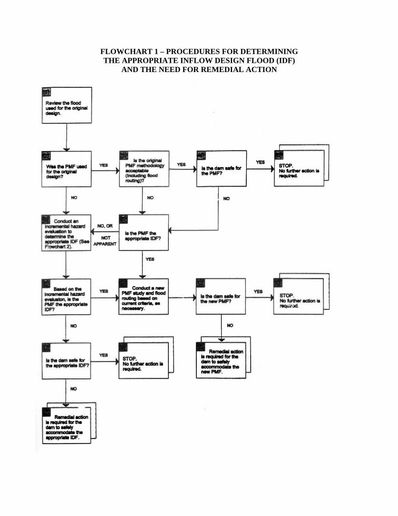
FLOWCHART 1 – PROCEDURES FOR DETERMINING THE APPROPRIATE INFLOW DESIGN FLOOD (IDF)
AND THE NEED FOR REMEDIAL ACTION

IDF SELECTION PROCEDURES: DETERMINING THE APPROPRIATE IDF
EXPLANATION OF FLOWCHART 1 – An explanation of the IDF flowchart is presented below.
The initial step in selecting the appropriate IDF and determining the need for dam safety modification is to review the basis for the original hydrologic design of an existing dam. This information will provide valuable insight regarding whether the flood originally used for design purposes satisfies current criteria or whether detailed investigations and analyses will be required to determine the appropriate IDF for the dam.
In those situations where the original design information has been lost, detailed investigations and analyses will normally be required.
Once you have identified the basis for the original hydrologic design, the next step is to determine if the flood used for the original design is the probable maximum flood (PMF). This question is important, since the upper limit of the IDF is the PMF.
If your answer is YES, continue to Block 3.
If your answer is NO, go to Block 7. In Block 7 you will perform an incremental hazard evaluation to determine the appropriate IDF.
To ensure the reliability of the original PMF study or the assumptions made on the various parameters affecting the study, it is necessary to determine if the PMF methodology originally used is still acceptable under current criteria.
If your answer is YES, continue to Block 4.
If your answer is NO, go to Block 6. In Block 6, you will answer the question: Is the PMF the appropriate IDF?
Continued…

IDF SELECTION PROCEDURES: DETERMINING THE APPROPRIATE IDF
EXPLANATION OF FLOWCHART 1 (Continued)
Determine if the dam is safe for the PMF. Your answer to this question will indicate whether remedial action will be required.
If your answer is YES, continue to Block 5.
If your answer is NO, go to Block 6. In Block 6, you will answer the question:
Is the PMF the appropriate IDF?
If the PMF is considered to be the appropriate IDF for the dam, no further investigations or remedial work for hydrologic conditions will be required.
Continued…
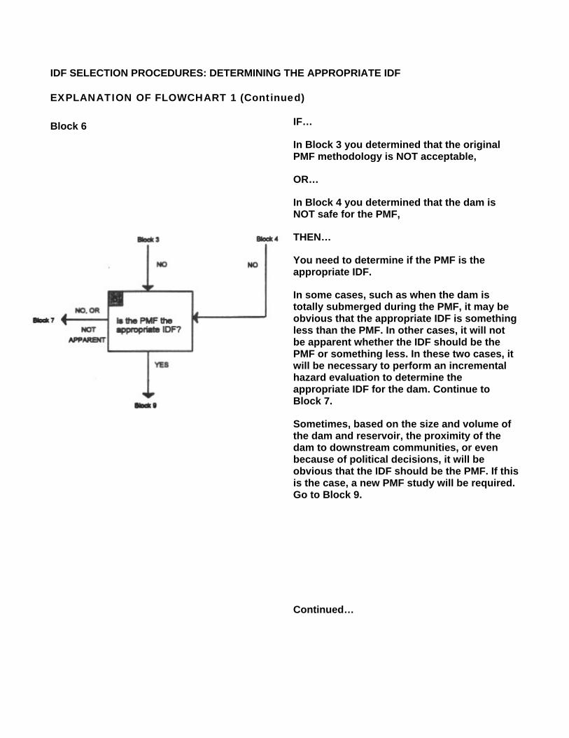
IDF SELECTION PROCEDURES: DETERMINING THE APPROPRIATE IDF
EXPLANATION OF FLOWCHART 1 (Continued)
Block 6 IF…
In Block 3 you determined that the original PMF methodology is NOT acceptable,
OR…
In Block 4 you determined that the dam is NOT safe for the PMF,
THEN…
You need to determine if the PMF is the appropriate IDF.
In some cases, such as when the dam is totally submerged during the PMF, it may be obvious that the appropriate IDF is something less than the PMF. In other cases, it will not be apparent whether the IDF should be the PMF or something less. In these two cases, it will be necessary to perform an incremental hazard evaluation to determine the appropriate IDF for the dam. Continue to Block 7.
Sometimes, based on the size and volume of the dam and reservoir, the proximity of the dam to downstream communities, or even because of political decisions, it will be obvious that the IDF should be the PMF. If this is the case, a new PMF study will be required. Go to Block 9.
Continued…

IDF SELECTION PROCEDURES: DETERMINING THE APPROPRIATE IDF
EXPLANATION OF FLOWCHART 1 (Continued)
Block 7 IF…
In Block 2 you determined that the flood used in the original design is NOT the PMF,
OR…
In Block 6, you determined that it is obvious that the IDF should be less than the PMF or it is not apparent if the IDF should be the PMF or something less,
THEN…
You need to perform an incremental hazard evaluation to determine the appropriate IDF. Performing the incremental hazard evaluation involves:
Conducting dambreak sensitivity studies, reviewing incremental rises between with-failure and without-failure conditions for a range of flood inflows (see Flowchart 2), and
Selecting the appropriate IDF on the basis of the dambreak studies and incremental impacts on downstream areas.
A procedural flowchart for performing a hazard evaluation appears in Flowchart 2, followed by an explanation of the procedure.
Continued…

IDF SELECTION PROCEDURES: DETERMINING THE APPROPRIATE IDF
EXPLANATION OF FLOWCHART 1 (Continued)
You should use the results of the incremental hazard evaluation and dambreak studies conducted in Block 7 to determine if the PMF is the appropriate IDF.
The IDF should be the PMF when the incremental consequences of failure are unacceptable, regardless of how large the assumed flood inflow becomes.
If your answer is YES, continue to Block 9.
If your answer is NO, go to Block 13. In Block 13 you will answer the question: Is the dam safe for the appropriate IDF?
IF…
In Block 6 you determined that the PMF is obviously the appropriate IDF,
OR…
If, based on the incremental hazard evaluation conducted in Block 8, the PMF is the appropriate IDF,
THEN…
You should conduct a new PMF study and flood routing based on current criteria, unless it was determined in Block 3 that the original PMF is acceptable under current criteria.
Continued…

IDF SELECTION PROCEDURES: DETERMINING THE APPROPRIATE IDF
EXPLANATION OF FLOWCHART 1 (Continued)
Once the new PMF is calculated, you should determine if the dam is safe for the new PMF.
If the dam is SAFE for the new PMF no further investigations or remedial actions for hydrologic conditions are required.
If the dam is NOT SAFE for the new PMF, remedial action is required for the dam to safely accommodate the PMF.
IF…
In Block 8 you determined that the PMF is NOT the appropriate IDF,
THEN…
You need to determine if the dam is safe for the appropriate IDF.
If the dam is SAFE for the appropriate IDF, no further investigations or remedial action for hydrologic conditions are required.
If the dam is NOT SAFE for the appropriate IDF, remedial action is required for the dam to safely accommodate the appropriate IDF.
Depending on the type of remedial action considered, it may be necessary to reevaluate the IDF to ensure that the appropriate IDF has been selected for the design of any modification.

IDF SELECTION PROCEDURES: PERFORMING A HAZARD EVALUATON
INTRODUCTION
As stated previously, if the PMF was not used for the original design of a dam, or if the PMF is not the appropriate IDF, an incremental hazard evaluation must be performed to determine the appropriate IDF.
PROCEDURES FOR CONDUCTING AN INCREMENTAL HAZARD EVALUATION
Flowchart 2 shows the procedures for performing an incremental hazard evaluation. This flowchart is an expansion of Block 7 in Flowchart 1.
Flowchart 2 is on the next page.
>

FLOWCHART 2 – PROCEDURES FOR CONDUCTING AN INCREMENTAL HAZARD EVALUATION

IDF SELECTION PROCEDURES: PERFORMING A HAZARD EVALUATON
EXPLANATION OF FLOWCHART 2 – An explanation of the Hazard Evaluation Flowchart is presented below.
Assume that the normal reservoir level with normal streamflow conditions prevailing is the initial failure condition. Starting at this point will ensure that the full range of flood inflow conditions will be investigated and will include the “sunny day” failure condition. It will also assist in verifying the initial hazard assigned to the dam. Using the normal maximum water surface level as the initial condition is particularly important if the initial hazard rating was low.
Next, conduct dambreak sensitivity studies (of various breach parameters) and route the dambreak flood to the point downstream where it no longer constitutes a threat to downstream life and property.
It is important to remember that the incremental increases should address the differences between the nonfailure condition with the dam remaining in place and the failure condition. Also, the dam should not be assumed to fail until the peak reservoir water surface elevation is attained for the assumed flood inflow condition being analyzed. Dams should be assumed to fail as described in these guidelines.
Continued…

IDF SELECTION PROCEDURES: PERFORMING A HAZARD EVALUATON
EXPLANATION OF FLOWCHART 2 (continued)
Now, determine – if the additional increase in consequences due to failure is acceptable. Answering this question is critical in the incremental hazard evaluation, and doing so involves an estimate of loss of life and property with and without dam failure.
If the consequences of failure under the assumed floodflow condition are NOT ACCEPTABLE go to Block 4.
If the consequences of failure ARE ACCEPTABLE, continue to Block 5.
IF…
In Block 3 it was determined that the consequences of failure under the assumed floodflow conditions are NOT ACCEPTABLE,
THEN…
Assume a new (larger) flood inflow condition (e.g., some percentage of the PMF) and perform a dambreak analysis (see Block 2). This procedure should be repeated until an acceptable level of flooding is identified, or the full PMF has been reached.
Continued…

IDF SELECTION PROCEDURES: PERFORMING A HAZARD EVALUATON
EXPLANATION OF FLOWCHART 2 (continued)
IF…
In Block 3 you determined that the consequences of failure under the assumed floodflow conditions are ACCEPTABLE; i.e., failure of the dam under “sunny day” conditions was insignificant,
THEN…
Determine if failure at a larger flood inflow condition will result in unacceptable consequences. This question is very important. For example, situations exist where a failure during normal water surface conditions results in the flood wave being contained completely within the banks of a river and obviously would not cause a threat to life and property downstream. However, under some floodflow conditions, the natural river flows may go out-of-bank, and a failure on top of that flood condition will result in an additional threat to downstream life and property.
If failure at another flood level will result in UNACCEPTABLE additional incremental consequences, or if you are NOT SURE, return to Block 4. Assume larger flood inflow conditions and perform new dambreak studies. This procedure should be repeated to determine the acceptable level of flooding.
If failure at another flood level will NOT result in unacceptable consequences, continue to Block 6.
You should now select the appropriate IDF based on the results of dambreak studies and incremental impacts on downstream areas.
Continued …

IDF SELECTION PROCEDURES: PERFORMING A HAZARD EVALUATON
EXPLANATION OF FLOWCHART 2 (continued)
Continue this process with the steps in Flowchart 1, starting with Block 8. In Block 8 you will answer the question: Based on the incremental hazard evaluation, is the PMF the appropriate IDF?
IDF SELECTION PROCEDURES: SUMMARY
SUMMARY: INFLOW DESIGN FLOOD (IDF) SELECTION PROCEDURES
This Appendix described the procedures used to select the appropriate IDF for a dam and to determine the need for remedial action.
The steps involved to select the appropriate IDF for a dam were presented in Flowchart 1. If you determine that the PMF was used for the original design of the dam, and that the PMF is the appropriate IDF, further investigation or remedial action for hydrologic, conditions is not necessary.
If you determine that the PMF was not used for the original design of the dam, or if the PMF was not the appropriate IDF, conduct an incremental hazard evaluation to determine the appropriated IDF. Flowchart 2 presented the procedures for conducting an incremental hazard evaluation.
Then, if it is determined that the dam is not safe for the new PMF or the appropriate IDF, remedial action must be taken.

FIGURE 1 – ILLUSTRATION OF INCREMENTAL INCREASE DUE TO DAM FAILURE
FIGURE 2 – ILLUSTRATION OF INCREMENTAL AREA FLOODED BY DAM FAILURE
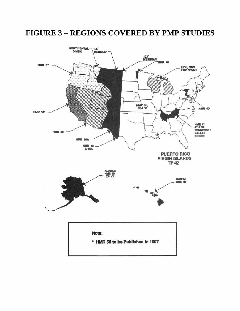
FIGURE 3 – REGIONS COVERED BY PMP STUDIES