Embed Size (px)
Citation preview
The environmental review, consultation, and other actions required by applicable Federal environmental laws for this
project are being, or have been, carried-out by TxDOT pursuant to 23 U.S.C. 327 and a Memorandum of
Understanding dated December 16, 2014, and executed by FHWA and TxDOT.
SH 29 Feasibility Study Summary Report From Southwestern Boulevard near the City of
Georgetown to State Highway 95
Williamson County, Texas
June 2017
Texas Department of Transportation, Austin District

SH 29 Feasibility Study Summary Report
1
Executive Summary
The Texas Department of Transportation initiated a corridor feasibility study in March 2015
for State Highway 29 extending from Southwestern Boulevard in Georgetown to SH 95 near
the community of Circleville. The purpose of the study was to evaluate the SH 29 corridor
including deficiencies and identify recommended improvements and/or options that would be
further evaluated for study and implementation, should funding become available.
The area for the SH 29 study extended from Southwestern Boulevard (western boundary) near
the city of Georgetown to SH 95 (eastern boundary). The project study area generally followed
the San Gabriel River to the south and County Road 124 to the north and covered
approximately 15,000 acres. SH 130, a toll facility, crosses SH 29 1.7 miles east of
Southwestern Boulevard.
The study evaluated several potential improvements, including improving the existing SH 29
roadway between these limits as well as new location alternatives. In order to develop
alternatives for the study, a purpose and need statement and study goals and objectives were
developed. Traffic data including existing and future traffic projections, level of service,
accident data, engineering information, current land use, environmental constraints, right-of-
way requirements, and public input were examined during the study.
For the SH 29 study, TxDOT identified the following Purpose and Need Statement:
Purpose: To upgrade the existing roadway to meet current design standards and
potentially provide a new location alignment between SH 130 and SH 95.
Need: To accommodate existing and projected traffic volumes, improve safety, and
address roadway flooding.
Study goals and objectives include the following:
Avoid and/or minimize impacts to parcels and residential properties
Utilize existing county or state right-of-way where possible
Avoid and/or minimize flooding issues
Minimize bridge structures
Avoid and/or minimize impacts based on constraints identified
Avoid impacts to cemeteries
Bring SH 29 up to meet current design standards
Develop the route above/out of the 100-year floodplain

SH 29 Feasibility Study Summary Report
2
Three open house public meetings were held for the SH 29 corridor feasibility study. The
majority of comments received after each meeting concerned potential impacts to
homeowners, preference or dislikes for particular alternative alignments presented, safety
issues along SH 29, and roadway flooding issues. Based on public input received from these
public meetings and environmental and engineering constraints, four alternatives were
developed. These alternatives included Alternative A, located in the northern portion of the
study area, Alternative D, located in the southern portion of the study area, a hybrid
alternative that combined portions of Alternatives A and D (Alternative A-A1-D), and
Alternative E, which generally follows the existing SH 29 roadway. Throughout the study, the
No-Build Alternative was also evaluated as a comparison to the four build alternatives.
Based on the study findings, it is recommended that the northernmost alignment,
Alternative A, be advanced for further refinement and study. Alternative A would meet the
purpose and need of the study, while resulting in the least amount of floodplain impacts,
property parcel impacts, prime farmland soils impacts, and impacts to woodlands. In
addition, Alternative A best fulfils the goals and objectives of the study.
This is a planning level study and no construction funds have been identified. Should the study
be advanced into the National Environmental Policy Act (NEPA) phase of project development,
additional environmental study, alternatives evaluation, schematic development, and public
involvement would be undertaken. Should it be determined during the NEPA process that the
best alternative is one that provides for a new location alternative, the existing SH 29 facility
would be left in place and maintained to provide access to adjacent property owners.

SH 29 Feasibility Study Summary Report
3
Table of Contents
Executive Summary ....................................................................................................................... 1
1.0 Introduction ........................................................................................................................ 5
2.0 Purpose and Need ............................................................................................................. 8
2.1 Population and Traffic Growth Projections ........................................................... 9
2.2 Existing Roadway Safety ...................................................................................... 11
2.3 Flooding and Maintenance .................................................................................. 12
3.0 Goals and Objectives ....................................................................................................... 14
4.0 Facility Type ...................................................................................................................... 14
5.0 Public Outreach ................................................................................................................ 15
5.1 Open House Public Meeting #1 .......................................................................... 15
5.2 Public Meeting #2 ................................................................................................ 17
5.3 Public Meeting #3 ................................................................................................ 19
6.0 Alternative Alignments Evaluation .................................................................................. 21
6.1 Preliminary Alternatives Summary ...................................................................... 24
6.2 Preliminary Alternatives Eliminated/Refined, and Renamed ........................... 26
7.0 Recommended Alternative .............................................................................................. 28
8.0 Next Steps ........................................................................................................................ 30
9.0 References ....................................................................................................................... 30
Figures
Figure 1. TxDOT Project Development Process ............................................................................ 5
Figure 2. SH 29 Feasibility Study Area ......................................................................................... 6
Figure 3. Urban Section of the Feasibility Study Area ................................................................. 7
Figure 4. Rural Section of the Feasibility Study Area .................................................................. 8
Figure 5. Population Growth in Williamson County ..................................................................... 9
Figure 6. SH 29 Average Daily Traffic. Source: *TxDOT, **2040 CAMPO Model with Growth
Rate .............................................................................................................................. 10
Figure 7. Existing and Forecasted Truck Traffic Percentages along SH 29 ............................. 10
Figure 8. Crash Rates .................................................................................................................. 11
Figure 9. SH 29 Crash History ..................................................................................................... 12
Figure 10. SH 29 Study Area Floodplains Map .......................................................................... 13
Figure 11. Summary of Public Meeting #1 Comments Received ............................................. 17
Figure 12. Summary of Public Meeting #2 Comments Received ............................................. 19
Figure 13. Summary of Public Meeting #3 Comments Received ............................................. 21
Figure 14. Preliminary Alternative Alignments ........................................................................... 22
Figure 15. Urban Section ............................................................................................................. 23
Figure 16. Typical Roadway Configuration ................................................................................. 24
Figure 17. Rural Section .............................................................................................................. 25
Figure 18. Final Alternative Alignments ..................................................................................... 26
Figure 19. Comparison of Alternatives Matrix ........................................................................... 28
SH 29 Feasibility Study Summary Report
4
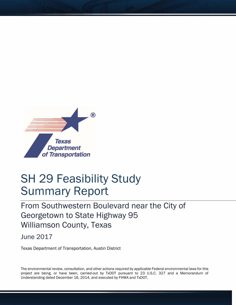
Glossary
100-year Floodplain: The 100-year floodplain is the land that is predicted to flood during a
100-year storm, which has a 1 percent chance of occurring in any given year. The 100-year
floodplain is used by FEMA to administer the federal flood insurance program and local
governments to regulate development.
Average Daily Traffic (ADT): Average daily traffic volume represents the total two-way traffic
on a roadway for some period less than a year, divided by the total number of days it
represents, and includes both weekday and weekend traffic. Usually, ADT is adjusted for day
of the week, seasonal variations, and/or vehicle classification.
Crash Rate: The number of crashes per 100,000,000 vehicle miles travelled.
Environmental Constraint: An environmental factor or consideration (such as natural or
human resources) that would impose limitations on project planning or design.
Extraterritorial Jurisdiction (ETJ): The legal ability of a government to exercise authority
beyond its normal boundaries.
Horizontal Curve: The piece connecting straight (tangent) sections that changes (turns) the
directions the road will follow. Curves can vary by degrees between gentle and sharp in
measurement. The choice of curve sharpness impacts other design elements such as the
amount of banking (superelevation) required in the curve to provide vehicles the ability to
safely and comfortably negotiate. The design of a safe roadway curvature is associated with
highway design speed.
Level of Service (LOS): Level of Service is a measure of traffic flow and congestion. As
defined in the Highway Capacity Manual - A qualitative measure describing operational
conditions within a traffic stream; generally described in terms of such factors as speed and
travel time, freedom to maneuver, traffic interruptions, comfort and convenience, and
safety.
Typical Roadway Configuration Diagrams: Also referred to as typical section(s), these
diagrams show usual roadway (or bridge) cross-sectional features including lane and shoulder
widths, limits of surfacing, typical right-of-way limits, median width and slopes, and curb
location and geometry.

SH 29 Feasibility Study Summary Report
5
1.0 Introduction
The following report provides the formal recommendation for the State Highway 29 corridor
feasibility study extending from Southwestern Boulevard to SH 95 in Williamson County, Texas
conducted by the Austin District of the Texas Department of Transportation.
According to TxDOT’s Transportation Planning Manual, “TxDOT performs feasibility studies to
determine critical elements of engineering and the economic feasibility of a proposed
facility/corridor. Typically, these studies focus on improvements to particular transportation
facilities or corridors, including construction of a new highway route instead of adding
capacity to an existing facility or adding a high-occupancy vehicle facility or express lanes to
an existing roadway rather than adding main lanes. Such studies establish design concepts,
general right-of-way requirements, and [general] project impacts.”
In addition, the following report summarizes Phase 1 of TxDOT’s Project Development Process
as illustrated in the TxDOT Project Development Process Chart below (Figure 1). During Phase
1 TxDOT first identified and considered local planning features and then sought public input
to develop potential alternative alignments to address proposed improvements to SH 29 and
connecting facilities. This report provides a recommendation for the advancement of a route
to be studied for future SH 29 improvements. This planning level study does not include the
development of a final schematic or construction plans.
Figure 1. TxDOT Project Development Process
SH 29 Feasibility Study Summary Report
6
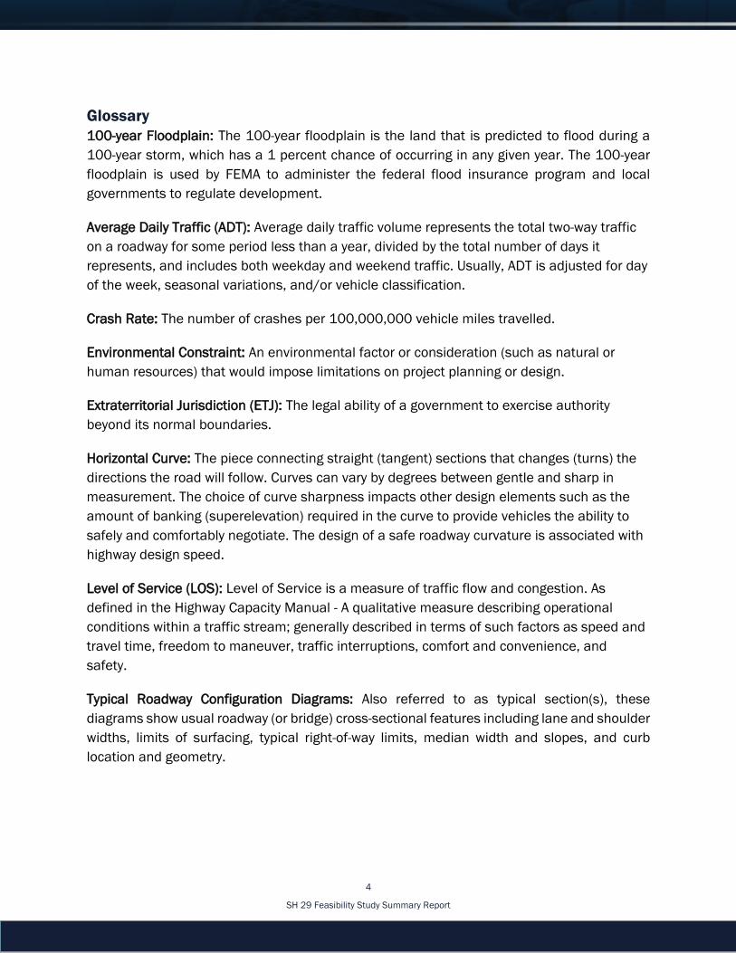
SH 29 is an east-west highway located in the central portion of Williamson County, a rapidly
developing area. The existing SH 29 roadway typically consists of two 12-foot travel lanes (one
in each direction) with variable width paved shoulders, and turn lanes at various locations.
There are three major water crossings within the study area, which are the San Gabriel River,
Smith Branch, and Mileham Branch. A map of the study area covering 15,419 acres is
provided in Figure 2.
Figure 2. SH 29 Feasibility Study Area
The extreme western end of the study area is partially located within the extraterritorial
jurisdiction (ETJ) of the city of Georgetown and exhibits urban development with residential
subdivisions and commercial establishments. SH 130 crosses SH 29 1.7 miles east of
Southwestern Boulevard. East of SH 130, adjacent land use is generally rural and used for
agricultural and farming purposes.
The study area was further subdivided into an urban section and a rural section because of
the different needs of the urban section (from Southwestern Boulevard to the San Gabriel
River) versus the rural section (from the San Gabriel River to SH 95). The alignment for the
urban section (Figure 3) has followed the existing facility throughout the study due to
previously developed properties surrounding SH 29.

SH 29 Feasibility Study Summary Report
7
Figure 3. Urban Section of the Feasibility Study Area
East of the San Gabriel River, the rural section (Figure 4), land use trends are typically
agricultural in nature with scattered residential developments. The existing SH 29 alignment
east of the river crosses or is located within the floodplain for most of its length within the
study area. The alternative alignments for the rural section were developed to avoid the
existing floodplain to the maximum extent possible.

SH 29 Feasibility Study Summary Report
8
Figure 4. Rural Section of the Feasibility Study Area
Williamson County has developed the Williamson County Long Range Transportation Plan,
which identifies road and transit improvements that should be built or improved over the next
25 years. The Plan identifies a new location for a controlled access roadway requiring a typical
right-of-way width of 350 feet located east of the San Gabriel River and connecting to SH 95.
The SH 29 corridor study was developed in consideration of this information. Throughout the
study process, TxDOT has coordinated with Williamson County.
2.0 Purpose and Need
A purpose and need statement was developed to guide the study, identify deficiencies, and
evaluate potential alternatives. This statement identifies what needs or problems exist for the
transportation facility and what potential improvements could possibly be implemented to
solve the problem or address the needs. The statement was used for identifying and
comparing reasonable alternatives and in identifying a recommended solution.
The purpose of this study was to evaluate potential upgrades to the existing SH 29 roadway
to meet current design standards and potentially provide a new location alignment between
SH 130 and SH 95. Originally, SH 29 was constructed between 1932 and 1934. Since that
SH 29 Feasibility Study Summary Report
9
249,967
422,679
987,500
0
200,000
400,000
600,000
800,000
1,000,000
1,200,000
2000 2010 2020 2030 2040
Po
pu
lati
on
Year
Williamson County Population
time, only routine maintenance or operational improvements have been made to the road.
The existing roadway does not meet current design standards for the volume of traffic the
facility currently carries.
The study is needed to address population growth and the resultant traffic growth, safety,
flooding, and maintenance issues associated with the existing SH 29 roadway.
2.1 Population and Traffic Growth Projections
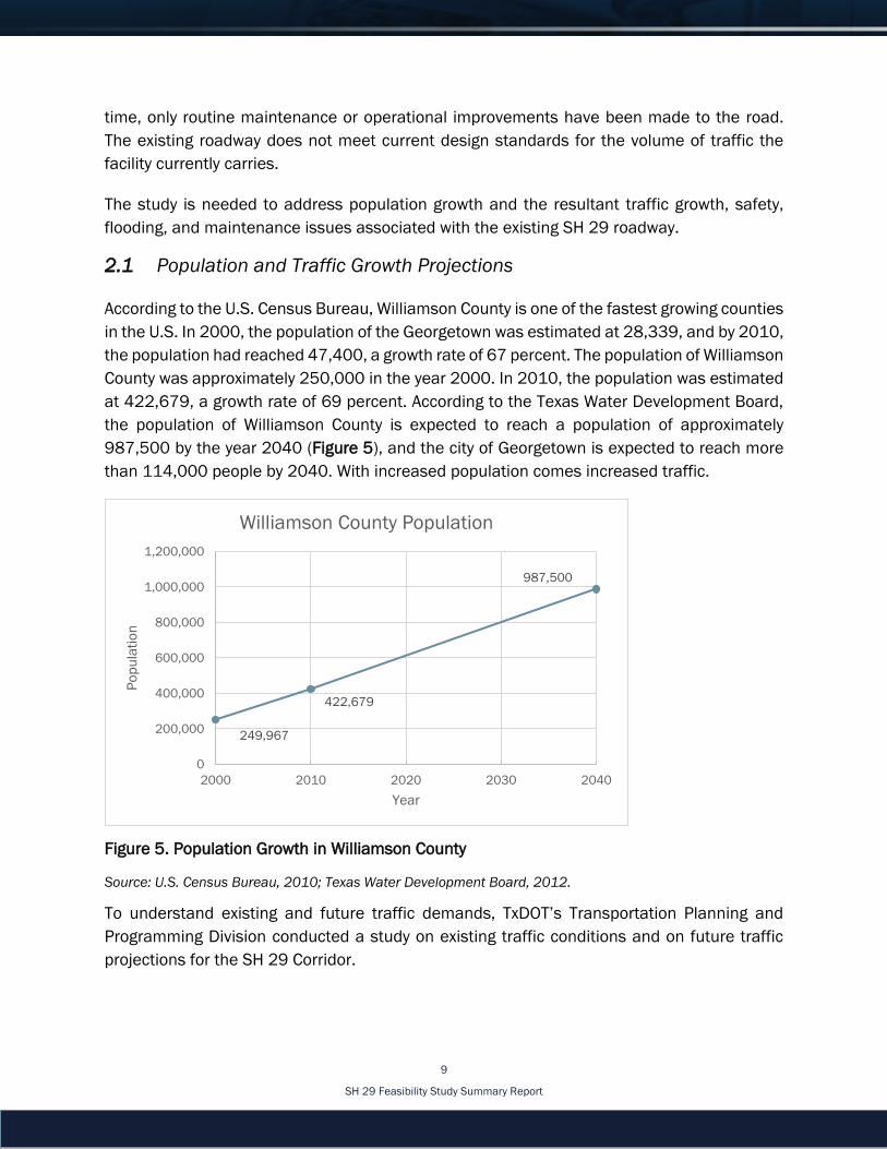
According to the U.S. Census Bureau, Williamson County is one of the fastest growing counties
in the U.S. In 2000, the population of the Georgetown was estimated at 28,339, and by 2010,
the population had reached 47,400, a growth rate of 67 percent. The population of Williamson
County was approximately 250,000 in the year 2000. In 2010, the population was estimated
at 422,679, a growth rate of 69 percent. According to the Texas Water Development Board,
the population of Williamson County is expected to reach a population of approximately
987,500 by the year 2040 (Figure 5), and the city of Georgetown is expected to reach more
than 114,000 people by 2040. With increased population comes increased traffic.
Figure 5. Population Growth in Williamson County
Source: U.S. Census Bureau, 2010; Texas Water Development Board, 2012.
To understand existing and future traffic demands, TxDOT’s Transportation Planning and
Programming Division conducted a study on existing traffic conditions and on future traffic
projections for the SH 29 Corridor.

SH 29 Feasibility Study Summary Report
10
Between Southwestern Boulevard and CR 120, average daily traffic is projected to range from
25,700 to 27,100 vehicles per day (vpd) in the year 2045, with the higher vehicle numbers
being closer to Georgetown. There would be a 95 percent increase between Southwestern
Boulevard and SH 130, and a 221 percent increase between SH 130 and CR 120. The largest
increase in traffic is anticipated to occur in the eastern portion of the study area, between CR
120 and SH 95. The 2015 average daily traffic for this section was 3,800 vpd and is projected
to increase to 19,600 vpd by the year 2045, a 416 percent increase (Figure 6).
Location 2015 ADT* 2045 ADT** Annual Growth
Southwestern Blvd. to SH 130 13,900 27,100 2.3%
SH 130 to CR 120 8,000 25,700 4.0%
CR 120 to SH 95 3,800 19,600 5.7%
Figure 6. SH 29 Average Daily Traffic. Source: *TxDOT, **2040 CAMPO Model with Growth Rate
Forecasted truck percentages along the corridor are also expected to increase. Between
Southwestern Boulevard and CR 104, truck traffic is anticipated to increase from 2.1 percent
in 2015 to 10.7 percent in 2045, which is five times more compared to 2015 truck
percentages. The remainder of the study area is projected to increase to approximately 15
percent trucks for the year 2045 (Figure 7).
Figure 7. Existing and Forecasted Truck Traffic Percentages along SH 29
Source: Existing – 2015 peak hour turning movement counts;
Future – TxDOT Statewide Planning Map

SH 29 Feasibility Study Summary Report
11
108.09
122.98
112.97
82.66
90.2993.3993.34
103.21 105.15
0
20
40
60
80
100
120
140
2011 2012 2013
SH 29 Crash Rates with Comparison to Statewide Averages
SH 29 Crash Rate Statewide Average- Rural State Highway Statewide Average- Rural Two Lane, Two Way
Improvements to the roadway are needed to accommodate increased traffic volumes
resulting from the past and future projected population growth in the city of Georgetown and
Williamson County. The existing road does not meet current design standards for the volume
of traffic the road currently carries and the projected traffic volume it would carry in the future.
2.2 Existing Roadway Safety
The increase in traffic volumes has led to an above average crash rate on the roadway. TxDOT
also evaluated crash data and found that in the study area the crash rate on SH 29 exceeds
the statewide average rates for rural state highways. Data from the TxDOT maintained Crash
Records Information System (CRIS) between 2011 and 2013 shows the crash rate per 100
million vehicle miles travelled in the study area for SH 29 is higher than the statewide average
crash rate, as seen in Figure 8. (At the beginning of the study, data for the year 2014-2017
were not available.)
Figure 8. Crash Rates
Source: TxDOT Maintained Crash Records Information System, 2014
In addition to an above average crash rate, the absolute total number of crashes has
increased along SH 29 in the study area as well. In 2011 there were 24 crashes, in 2012
there were 28 crashes, in 2013 there were 27 crashes, and in 2014 there were 33 crashes
(Figure 9).

SH 29 Feasibility Study Summary Report
12
Figure 9. SH 29 Crash History
Source: TxDOT Maintained Crash Records Information System, 2014
The existing SH 29 roadway does not currently meet design standards. Some examples of
how the existing SH 29 roadway does not meet design standards are as follows:
Sharp horizontal curves that require vehicles to slow down to safely negotiate them
Lack of full width shoulders that allow vehicles to recover from errant driving and
provide areas for turning vehicles to slow down out of the main travel lane prior to
turning
Structure crossings that contain obsolete design and layouts of metal beam guard
fence (MBGF) and safety end treatments
Large trees and other objects located inside the clear zone that do not allow for areas
of recovery for errant vehicles
2.3 Flooding and Maintenance
Portions of the existing SH 29 roadway are located within the 100-year floodplains of the San
Gabriel River, Mileham Branch, and Smith Branch. As a result, floodwaters occasionally
overtop the roadway. This contributes to the flooding and maintenance issues that SH 29
currently experiences. The blue shading on the floodplain map (Figure 10) shows the

SH 29 Feasibility Study Summary Report
13
Figure 10. SH 29 Study Area Floodplains Map
100-year floodplain in relation to SH 29, and illustrates what areas of the existing road are
located within the floodplain. One of the goals and objectives of this study is to avoid and/or
minimize flooding issues.
Between March 2015 and June 2016, there were a total of 27 flood maintenance reports
over this 16-month period. Twenty-three cases resulted in water over the roadway, and four
cases resulted in the roadway being closed due to high water. Water over the roadway has
caused various issues such as travel delays, reduction in usable lanes, and the need to use
alternative routes. In addition, dirt and debris over the roadway were reported numerous times
during rain events, and during one flooding event an advisory warning discouraged the use of
the route.
During the study, TxDOT evaluated correcting flooding issues for the existing SH 29 roadway.
After analyzing several options for adding fill into the floodplain, it was determined that would
not be practical, for the following reasons: cost, permitting requirements with Federal
Emergency Management Agency (FEMA) and the U.S. Army Corps of Engineers, and potential
increases in flooding issues resulting from construction.
SH 29 Feasibility Study Summary Report
14
3.0 Goals and Objectives
After the study’s purpose and need were identified, study goals and objectives were
established to help aid in the development of alternative alignments and to ensure that all of
the study’s priorities were met. A working set of goals and objectives were developed by staff
in preparation for the first open house public meeting and were adjusted based on public
input. Public concerns and input were similar to those previously developed by the project
team.
The main objective of the SH 29 corridor feasibility study was to identify a recommended
alternative that would best meet the purpose and need for the project and fulfill the goals and
objectives of the study. Objectives include upgrading SH 29 to meet current design standards
and moving the route out of the 100-year floodplain. Further goals and objectives are:
Avoid and/or minimize impacts to parcels and residential properties
Utilize existing county or state right-of-way where possible
Avoid and/or minimize flooding issues
Minimize bridge structures
Avoid and/or minimize impacts based on constraints identified
Avoid impacts to cemeteries
4.0 Facility Type
SH 29 is classified as a principal arterial/rural arterial road based on its traffic volume and
function. The design speed for this project was determined to be 60 miles per hour (mph)
from Southwestern Boulevard to the San Gabriel River (urban section) and 70 mph from the
San Gabriel River to SH 95 (rural section). These two elements determined the desirable
design criteria such as horizontal and vertical curves, grade, and clear zone requirements.
The typical roadway configuration was determined from several resources. The number of
lanes needed to accommodate the future traffic was based on a traffic analysis. TxDOT
consulted with Williamson County and determined that any improvements should match the
typical roadway configurations in the Williamson County Long Range Transportation Plan. This
resulted in a 350-foot right-of-way needed for the study corridor. There would be three lanes
in each direction in the rural section. The urban section would have curb and gutter and a
narrow raised median. The raised median was selected due to the number and type of
crashes, and the anticipated increase in future traffic volumes that would require the need to
provide safe turning movements at controlled locations. The rural section would have 10-foot
shoulders and a wide median. To accommodate pedestrian and bicycle users, a 10-foot
shared use path is proposed for both sides of the roadway.
SH 29 Feasibility Study Summary Report
15
Various engineering constraints were used to evaluate each alternative alignment.
Alternatives would utilize the existing right-of-way as much as possible and therefore minimize
the amount of new right-of-way required. Wherever new right-of-way was needed, the
alignment was designed to minimize impacts to residential and commercial structures. The
alignments were also designed to avoid and/or minimize impacts to the environmental
constraints identified during project development. Several stream crossings with large
floodplains are located within the study area. The designs would minimize the amount of
earthwork in the floodplain, as well as limit the number and length of bridges needed at each
crossing. Major utility crossings, such as electrical transmission lines, are also an engineering
constraint and thereby influenced the alignments of the roadway to avoid impacts and the
need for relocations.
5.0 Public Outreach
From the beginning of the study, TxDOT has sought to include public input as a crucial
component into the corridor study process. Three public meetings were conducted over a year-
and-a-half time span, with time in between the meetings for refinement of the alternative
alignments, in an effort to include as much public input as possible. Public comments were
taken into consideration and guided the goals and objectives of the study.
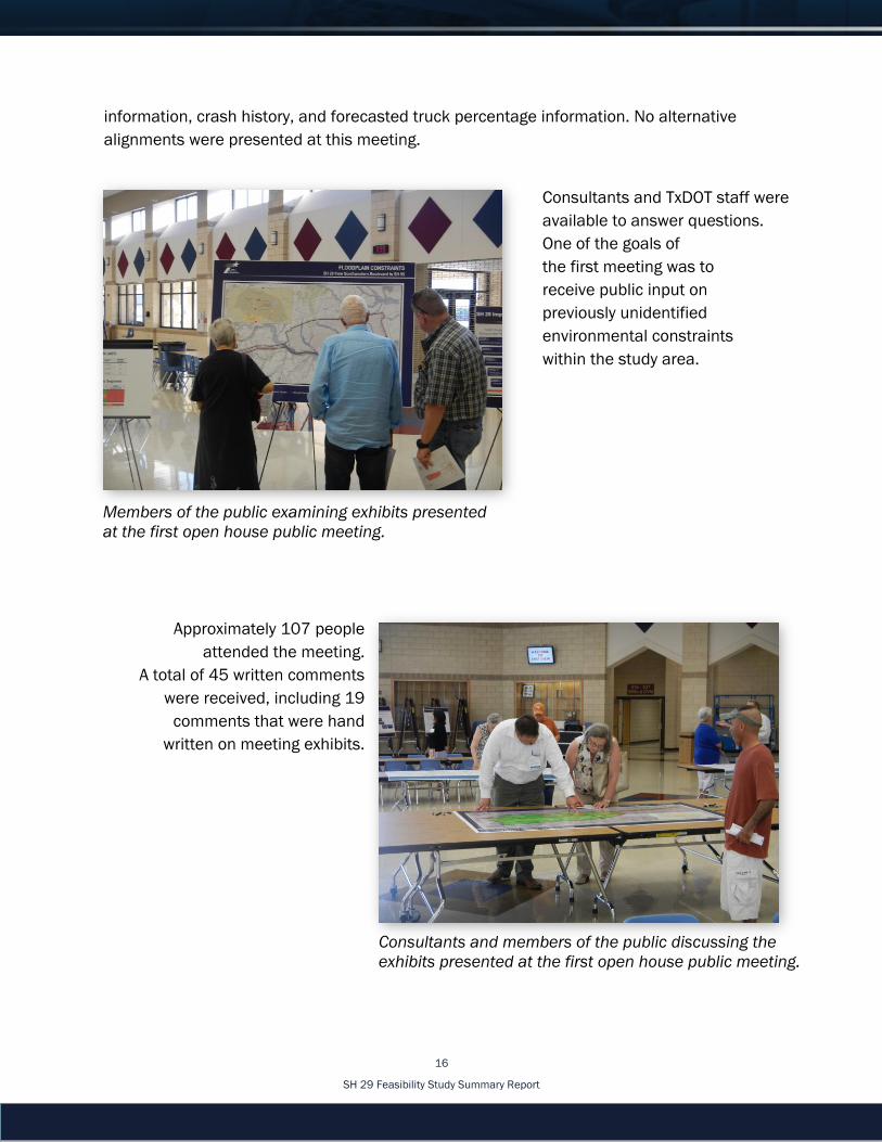
5.1 Open House Public Meeting #1
The first open house public meeting
was held on September 1, 2015 and
introduced the SH 29 feasibility
corridor study to the public. Public
meeting notices were sent to property
owners within the study area and
elected officials. Notices announcing
the meeting were published on
TxDOT’s website and in local
newspapers. Notices of the first open
house public meeting were published
in the Taylor Press on August 19,
2015, and the Williamson County Sun
on August 21, 2015.
Displays at this meeting included
study area maps, environmental constraint maps, the purpose and need statement, existing
and proposed typical sections, existing and projected traffic volumes, level of service
SH 29 first open house public meeting.
SH 29 Feasibility Study Summary Report
16
information, crash history, and forecasted truck percentage information. No alternative
alignments were presented at this meeting.
Members of the public examining exhibits presented
at the first open house public meeting.
Consultants and TxDOT staff were
available to answer questions.
One of the goals of
the first meeting was to
receive public input on
previously unidentified
environmental constraints
within the study area.
Consultants and members of the public discussing the
exhibits presented at the first open house public meeting.
Approximately 107 people
attended the meeting.
A total of 45 written comments
were received, including 19
comments that were hand
written on meeting exhibits.
SH 29 Feasibility Study Summary Report
17
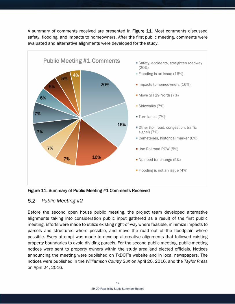
A summary of comments received are presented in Figure 11. Most comments discussed
safety, flooding, and impacts to homeowners. After the first public meeting, comments were
evaluated and alternative alignments were developed for the study.
Figure 11. Summary of Public Meeting #1 Comments Received
5.2 Public Meeting #2
Before the second open house public meeting, the project team developed alternative
alignments taking into consideration public input gathered as a result of the first public
meeting. Efforts were made to utilize existing right-of-way where feasible, minimize impacts to
parcels and structures where possible, and move the road out of the floodplain where
possible. Every attempt was made to develop alternative alignments that followed existing
property boundaries to avoid dividing parcels. For the second public meeting, public meeting
notices were sent to property owners within the study area and elected officials. Notices
announcing the meeting were published on TxDOT’s website and in local newspapers. The
notices were published in the Williamson County Sun on April 20, 2016, and the Taylor Press
on April 24, 2016.
20%
16%
16%7%
7%
7%
7%
6%
5%
5%4%
Public Meeting #1 Comments Safety, accidents, straighten roadway
(20%)
Flooding is an issue (16%)
Impacts to homeowners (16%)
Move SH 29 North (7%)
Sidewalks (7%)
Turn lanes (7%)
Other (toll road, congestion, traffic
signal) (7%)
Cemeteries, historical marker (6%)
Use Railroad ROW (5%)
No need for change (5%)
Flooding is not an issue (4%)

SH 29 Feasibility Study Summary Report
18
The second open house public meeting was then held on May 10, 2016, to present the three
feasible alternative alignments that were developed. These were named A (also known as A-
A1-C), A-A1-D, and D. Any alternative alignments placed between Alternatives A and D would
have resulted in increased impacts to residential properties. Expanding the existing SH 29
east of the San Gabriel River crossing was considered; however, it was determined to have
more impacts to floodplains and residential and commercial properties, compared to the
other three alternative alignments. Expanding the existing roadway east of the river could not
be accomplished while minimizing additional bridge structures that would need to be
constructed.
SH 29 second open house public meeting.
Approximately 175 people
attended the meeting. After the
meeting, TxDOT summarized all
comments received within the
comment period. A total of 103
written comments were received
during the meeting and following
comment period, including six
comments written on the exhibit
presented at the meeting, which
was displayed on tables.
Consultants and members of the public discussing
exhibits presented at the second open house public
meeting.
A summary of comments received
are presented in Figure 12. Most
comments discussed impacts to
homeowners and/or farms, pro
Alternative D/against Alternative A,
and flooding. After the second
public meeting, comments were
summarized and evaluated.

SH 29 Feasibility Study Summary Report
19
31%
28%
8%
7%
6%
6%
6%
5%3%
Public Meeting #2 Comments Impact homeowners/farms (31%)
Pro D (against A) (28%)
Flooding (8%)
Neither Alternative, Project Unneccessary
(7%)
Raise, widen, straighten current SH 29 (6%)
Other (safety, traffic control measures,
cemetery, turn lane, traffic light, speed) (6%)
Expand Chandler Rd (6%)
Pro A (against D) (5%)
Noise (3%)
Figure 12. Summary of Public Meeting #2 Comments Received
5.3 Public Meeting #3
Based on comments received after the second meeting, it was determined that a third public
meeting was needed to inform the public of the study process and provide another opportunity
for public comments.
The third open house public meeting was held on November 10, 2016. This meeting included
a presentation and open house. TxDOT provided a PowerPoint presentation with an overview
of the SH 29 feasibility study, a summary of the purpose and need statement with supporting
information, a summary of public comments received after meetings one and two, and a
matrix providing a comparison of alternatives and anticipated impacts. In addition to the three
alternative alignments, the matrix and environmental displays included Alternative E. This
alternative is located along the existing SH 29 alignment, and was included based on public
input from the second meeting.
For the third public meeting, public meeting notices were sent to property owners within the
study area and elected officials. Notices announcing the meeting were published on TxDOT’s

SH 29 Feasibility Study Summary Report
20
website and in local newspapers. The notices were published in the Williamson County Sun
on October 29, 2016, and in the Taylor Press on October 30, 2016.
Approximately 221 people attended the public meeting. A total of 96 written comments were
received during the meeting and the following comment period, including 36 comments
written on the roll plots by the public.
Presentation given at the SH 29 third public meeting.

SH 29 Feasibility Study Summary Report
21
Figure 13. Summary of Public Meeting #3 Comments Received
A summary of comments received are presented in Figure 13. Most comments discussed
impacts to homeowners and/or farms, against Alternative A, and improving the existing SH
29 corridor. After the third public meeting, comments were summarized and evaluated.
6.0 Alternative Alignments Evaluation
Following the first SH 29 open house public meeting, five possible alternative alignments were
developed. On September 3, 2015, the project team presented the preliminary alternative
alignments and an evaluation matrix to TxDOT for consideration. The alternative alignment
corridors were 300-feet in width. Based on input TxDOT received from Williamson County, the
corridors were then expanded from 300-feet to 350-feet wide to match Williamson County’s
Long Range Transportation Plan.
Development of alternative alignments was based on the purpose and need, design goals and
objectives, and public input. Some concepts were dismissed early in the study due to fatal
23%
14%
11%
10%
6%
5%
5%
5%
4%
4%
3%
3%3%
2%2% 2%
Public Meeting #3 Comments Impact homeowners/farms (23%)
Other (14%)
Against A (11%)
Raise, widen, straighten current SH 29 (10%)
Neither alternative, project unnecessary (6%)
Flooding (5%)
Environmental impacts (5%)
Cost (5%)
Pro D (4%)
Questioning aspects of study results (4%)
Suggested modifying proposed alignments (3%)
Pro A (3%)
Proposed roadway too wide (3%)
Against D (2%)
Comments on PM (2%)
Expand Chandler Rd (2%)

SH 29 Feasibility Study Summary Report
22
flaws. The concepts to use FM 971 (to the north of the study area) and Chandler Road (to the
south of the study area) were eliminated due to their location outside the study area, and the
fact that these roadways serve different travel sheds. Using the railroad right-of-way north and
parallel to FM 971 as the alignment was suggested at public meetings; however, the
Georgetown Railroad is located outside the study area and serves a different travel shed, and
was therefore eliminated from consideration.
The public did provide alignment concepts that were within the northern, central, and
southern portions of the study area. The team designed alternative alignments that were
similar to those drawn by the public. The public also had comments concerning upgrading the
existing SH 29 roadway. The team developed one alternative alignment for this option.
All of the first five alignments in the rural section avoided impacting the David Sackville Cooke
Historic Texas State Cemetery, located east of the river. After the presentation of the first
preliminary alternative alignments and evaluation matrix to TxDOT, more combinations of
these primary alternative alignments were developed, resulting in 10 possible alternative
alignments (Figure 14).
Figure 14. Preliminary Alternative Alignments

SH 29 Feasibility Study Summary Report
23
For evaluation purposes, the alternative alignments were split into two areas: from
Southwestern Boulevard to the San Gabriel River (or the urban section), and from the San
Gabriel River to SH 95 (or the rural Section).
The alignment for the urban section has followed the existing roadway throughout the study
due to previously developed properties surrounding SH 29 (Figure 15). The proposed typical
roadway configuration for the urban section would consist of four 12-foot-wide travel lanes,
with two lanes in each direction separated by a variable width center turn lane. The roadway
would include 10-foot-wide outside shoulders flanked by a 10-foot-wide shared use path on
both sides.
Figure 15. Urban Section
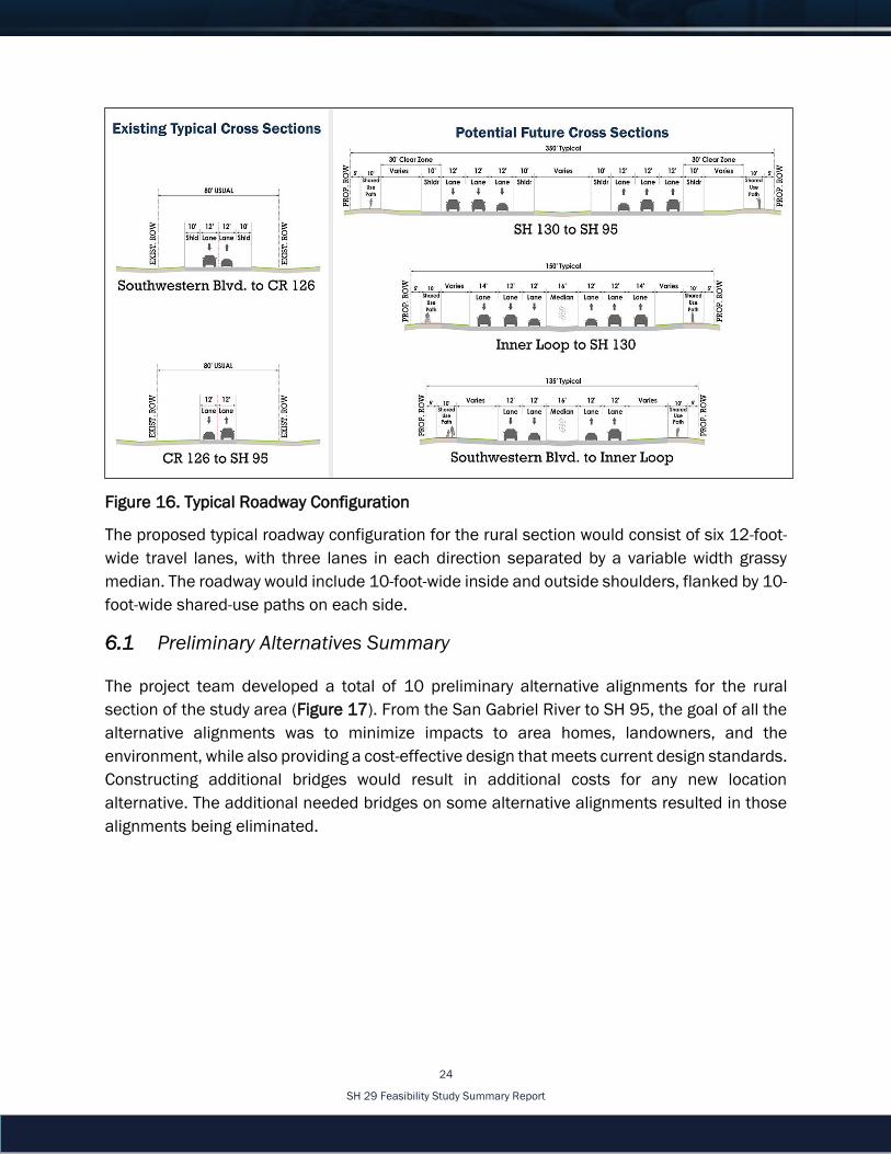
Typical roadway configuration diagrams are illustrated in Figure 16. The design incorporates
the future needs of connecting streets such as Inner Loop and SH 130. The design for each
connection considers turning movements and the number of lanes needed.
SH 29 Feasibility Study Summary Report
24
Figure 16. Typical Roadway Configuration
The proposed typical roadway configuration for the rural section would consist of six 12-foot-
wide travel lanes, with three lanes in each direction separated by a variable width grassy
median. The roadway would include 10-foot-wide inside and outside shoulders, flanked by 10-
foot-wide shared-use paths on each side.
6.1 Preliminary Alternatives Summary
The project team developed a total of 10 preliminary alternative alignments for the rural
section of the study area (Figure 17). From the San Gabriel River to SH 95, the goal of all the
alternative alignments was to minimize impacts to area homes, landowners, and the
environment, while also providing a cost-effective design that meets current design standards.
Constructing additional bridges would result in additional costs for any new location
alternative. The additional needed bridges on some alternative alignments resulted in those
alignments being eliminated.

SH 29 Feasibility Study Summary Report
25
Figure 17. Rural Section
Alternative A would utilize existing county right-of-way on CR 121 and CR 124; however, this
alignment would require a longer bridge over Pecan Branch which was not desirable and
would result in displacing a residential property. Alternative B was similar to Alternative A and
required a lengthy bridge over Pecan Branch; therefore, it was not considered desirable. Like
Alternative A, Alternative B would displace a residential property.
The eastern limits of Alternatives A and B were not preferable because they would connect
with SH 95 in a less than desirable horizontal curve, resulting in limited sight distance at
intersections. Alternatives A and B allow for a future connection with CR 346 to the east, but
it was determined that there was not a future need to extend SH 29 to the east, and Granger
Lake would be a constraint to all potential roadways extending east in this area.
The western portion of Alternative C was eliminated as it would result in more impacts to
outbuildings such as barns and feed troughs, than the other alternative alignments. The
eastern limit for Alternative C was acceptable; however, Alternative C1 would terminate at CR
346 and connect to SH 95 in a less than desirable horizontal curve.

SH 29 Feasibility Study Summary Report
26
Alternatives D/D1 were determined feasible. Alternative D1 was desirable, as only one bridge
would be needed to cross Pecan Branch and it had acceptable geometry at the eastern limit.
Furthermore, no residential displacements were anticipated with Alternatives D or D-D1-D.
Alternative D2 was not preferred, because the endpoint at SH 95 would be located in the
floodplain.
Alternative E, which follows the existing SH 29 alignment, did not meet a goal of the project,
which is to move the roadway out of the floodplain. It would also not meet the goal of
upgrading the SH 29 roadway to design standards. Furthermore, it would result in more
residential impacts than the other alternatives because the area adjacent to the existing
facility is more developed than the other alternatives.
6.2 Preliminary Alternatives Eliminated/Refined, and Renamed
The 10 rural section alternative alignments were screened by the project team and narrowed
down to four final alternatives plus the No-Build option. These alternatives were relabeled and
renamed and are described below. Refinement of the alternative alignments were based on
the purpose and need, design goals and objectives (such as moving the roadway out of the
floodplain), and avoiding and/or minimizing impacts to previously identified constraints.
The final four build alternative alignments plus the No-Build alternative were presented at the
third public meeting (Figure 18).
Figure 18. Final Alternative Alignments
Alternative A (also known as A-A1-C): This alternative is the northernmost alignment under
consideration for the SH 29 study. It has a length of 13.2 miles and would require 386 acres
of new right-of-way. Along Alternative A, the following displacements are anticipated: four
SH 29 Feasibility Study Summary Report
27
houses, one eight-plex (apartment complex), one storage unit facility, one barn, and one
abandoned barn (Figure 19).
Alternative A-A1-D: This alternative is similar to Alternative A, except this alternative connects
to SH 95 south of Alternative A-A1-C. This alternative has a length of 13.3 miles and would
require 399 acres of new right-of-way. Along Alternative A-A1-D, the following displacements
are anticipated in the rural section: four houses, one eight-plex (apartment complex), two
storage unit facilities, one barn, and one abandoned barn
Alternative D: This alternative is located just north of SH 29. It has a length of 13.1 miles and
would require 407 acres of new right-of-way. Along Alternative D, the following displacements
are anticipated in the rural section: one house, one eight-plex (apartment complex), two
storage unit facilities, and one abandoned house.
Alternative E: This alternative is located along the existing SH 29 alignment. It has a length of
13.7 miles and would require 348 acres of new right-of-way. Along Alternative E, the following
displacements are anticipated in the rural section: four houses, one eight-plex (apartment
complex), one storage unit facility, 14 mobile homes, one maintenance building, one cell
tower, two barns, one transmission tower, one old log cabin, one commercial building, and
one office.

SH 29 Feasibility Study Summary Report
28
Matrix/ Comparison of Alternatives
Unit of Measure
A A-A1-D D E No-Build
Meets Purpose and Need
Yes/ No Yes Yes Yes Yes No
Length Mile 13.2 13.3 13.1 13.7 0
Proposed ROW
Acre 386 399 407 348 0
Residential Displacements
Number 5 5 3 20 0
Commercial Displacements
Number 1 2 2 3 0
Other Structure
Displacements
Number 2 0 2 6 0
Parcels Impacted
Number 129 145 142 220 0
Bisected Properties
Number 10 14 24 6 0
Floodplain Impacts
Acre 30 34 38 199 0
Prime Farmland
Soils Impacts
Acre 326 338 359 358 0
Impacts to Woodlands
Acre 12 15 16 37 0
Potential Impacts to Parks
Acre 0.2 (Trail Use)
0.2 (Trail Use)
0.2 (Trail Use)
7.3 (Blackland
Heritage Park- Proposed)
0
Figure 19. Comparison of Alternatives Matrix
7.0 Recommended Alternative
As seen in the Comparison of Alternatives Matrix above, the four alternative alignments and
the no-build scenario were evaluated.
The engineering constraints, such as corridor length, earthwork in the floodplain, and number
and length of bridges, are similar between Alternatives A, A-A1-D, and D. The only engineering
constraint that has a slight difference is public ROW. Since Alternative A follows along county

SH 29 Feasibility Study Summary Report
29
roads for a significant length, and Williamson County is open to transferring the needed right-
of-way to TxDOT at no cost, this would provide a cost savings to TxDOT.
Alternative D would have the least amount of residential displacements and would be the
shortest alternative alignment, however, it requires the most amount of proposed ROW, has
the most amount of bisected properties, and has the most impacts to prime farmland soils.
Alternative A-A1-D was similar to Alternative A in alignment and impacts, however, Alternative
A-A1-D would result in slightly more impacts to commercial properties, parcels, floodplains,
prime farmland soils, and woodlands when compared to Alternative A. Alternative A-A1-D also
required more additional right-of-way than Alternative A.
Alternative E would have the least amount of additional right-of-way required and bisected
properties, however, it would have the most residential, commercial, and other structure
displacements; most impact to parcels; floodplain impact; impact to woodlands; and impact
to parks. Alternative E would also be the longest alternative alignment. Since the east end of
the existing SH 29 has over a mile of roadway located inside the floodplain, the vertical grade
would need to be raised by approximately six feet. An equal amount of fill needed within the
floodplain to raise the roadway would have to be removed in other areas of the floodplain to
meet permit requirements. With a right-of-way width of 350 feet and a new fill of six feet, this
would be a significant amount of fill and would require an extensive permitting process. It
would most likely require additional right-of-way along the existing roadway to remove equal
amounts of fill. The team considered retaining walls and bridging options to minimize the
amount of earthwork in the floodplain. These options come at a higher cost for construction
than traditional roadway, and present access issues with the adjacent property owners. The
retaining walls and bridges would need to connect with local streets and all driveways. The
design could accommodate the current situation, but as development moves into the area, it
would require special design to provide gaps in the retaining walls or bridges to supply new
access points. This would be cost prohibitive and require qualified TxDOT inspectors to
monitor construction for driveway access. The retaining walls would need to be specially
designed and constructed with select materials suitable for floodplains which would result in
a higher cost than traditional retaining wall construction.
The No-Build option does not meet the purpose and need for the feasibility study to upgrade
the roadway to current design standards, accommodate existing and projected traffic
volumes, improve safety, and address roadway flooding.
Based on the anticipated impacts, purpose and need statement, and goals and objectives, it
was determined that Alternative A would be more favorable when compared to all other build
alternatives considered. Alternative A would meet the purpose and need of the study, while
resulting in the least amount of impact to land parcels, floodplain, prime farmland soils and
SH 29 Feasibility Study Summary Report
30
woodlands. Alternative A would also address safety, by constructing a new highway that would
meet current design standards, while removing the roadway from the floodplain, thus
addressing flooding issues. Therefore, it is recommended that Alternative A advance into
Phase 2 for environmental study and detailed engineering.
8.0 Next Steps
This is a planning level study and no construction funds have been identified as of May 2017.
Should the study be advanced into the NEPA phase of project development, additional
environmental study, alternatives evaluation, schematic development, and public
involvement would be undertaken. Should it be determined during the NEPA process that the
best alternative is one that provides for a new location alternative, the existing SH 29 facility
would be left in place and maintained to provide access to adjacent property owners.
9.0 References
National Research Council (U.S.). 2010. HCM 2010: Highway Capacity Manual. Washington,
D.C.: Transportation Research Board.
Texas Department of Transportation. October 2014. Roadway Design Manual.
http://onlinemanuals.txdot.gov/txdotmanuals/rdw/rdw.pdf (accessed April 18, 2017).
Texas Department of Transportation. June 2001. Transportation Planning Manual.
http://onlinemanuals.txdot.gov/txdotmanuals/pln/pln.pdf (accessed April 18, 2017).
Texas Department of Transportation. October 2013. TxDOT Glossary.
http://onlinemanuals.txdot.gov/txdotmanuals/glo/glo.pdf (accessed April 18, 2017).
Texas Water Development Board. “Population and Water Demand Projections,” TPWD website
http://www.twdb.texas.gov/waterplanning/data/projections/index.asp (accessed
May 4, 2017).
U.S. Census Bureau. 2010. “Hispanic or Latino, and Not Hispanic or Latino by Race,” 2010
Census Summary File 1. Williamson County P9 Data Table.
Williamson County. 2009. Williamson County Long Range Transportation Plan.
http://roadbond.wilco.org/Projects/LongRangeTransportationPlan/tabid/5295/Defa
ult.aspx (accessed February 27, 2017).