Embed Size (px)
Citation preview

Climate proofing the Danube Delta through integrated land and water management
____________________________________________________________________________
FEASIBILITY STUDY
of Restoration of the Zarzy Polder Ecosystem
Odessa – Izmail – Orlovka – 2014
____________________________________________________________________________
The project is implemented by the WWF Romania with the financial support from the
European Commission through the thematic programme for Environment and Sustainable
Management of Natural Resources including Energy (ENRTP)

2
Authors: Ph.D Dyakov O. (senior researcher, the Centre for Regional Studies, project expert),
Ph.D Podozshny S. (project expert), Plotnitskiy L. (researcher, the Centre for Regional Studies,
project expert)
Consultants: Chernichko J., Cheroi I., Kironaki I., Kurilova I., Vinokurova S.
Maps: Sizo R. (GIS expert, the Centre for Regional Studies)
Copyright Statement
This publication is an output from the project ―Climate proofing the Danube Delta through
integrated land and water management‖ with the financial support from the European
Commission through the thematic programme for Environment and Sustainable Management of
Natural Resources including Energy (ENRTP). The views expressed are not necessarily those of
the European Commission.
The copyright of this material is held by the Centre for Regional Studies. The material can be
freely reproduced but the project ―Climate proofing the Danube Delta through integrated land and
water management‖ and its funding by the European Commission through the
thematic programme for Environment and Sustainable Management of Natural Resources
including Energy (ENRTP) must be acknowledged. Reproduction of this material with commercial
purposes is prohibited. Any organisation wishing to reproduce the material should contact the
Centre for Regional Studies at [email protected]
© Centre for Regional Studies, Odessa, 2014

3
Table of contents
1. Characteristics of the system of the Western Group of the Danube Lakes ................................. 4
1.1 General characteristic of the area .............................................................................................. 4 1.1.1 Location .................................................................................................................................. 4 1.1.2 Geology and geomorphology .............................................................................................. 4 1.1.3 Soils ........................................................................................................................................ 6 1.1.4 Climate ................................................................................................................................... 6 1.1.5 Surface and ground waters ................................................................................................. 7 1.1.6 Flora ...................................................................................................................................... 11 1.1.7 Fauna .................................................................................................................................... 13
1.2 Assessment of natural resources and their use ..................................................................... 17 1.2.1 Characteristics of land users of the Zarzy polder. ......................................................... 17 1.2.2 Water resources .................................................................................................................. 17 1.2.3 Fish resources ..................................................................................................................... 18 1.2.4 Vegetation resources ......................................................................................................... 20 1.2.5 Hunting resources ............................................................................................................... 26
2 Assessment of the ecological status of the Kartal Lake ecosystem ........................................... 27 2.1 Relief ............................................................................................................................................. 27 2.2 Hydrological regime .................................................................................................................... 27
2.2.1 Hydrological connections in the system of the Western Group of the Danube Lakes .......................................................................................................................... 28 2.2.2 System of feeding and discharge canals and sluices ................................................... 30
2.3 Ecological consequences of the regulated water regime ..................................................... 31 2.3.1 Water quality ........................................................................................................................ 31 2.3.2 Breach of connectivity in the system ............................................................................... 35
3 Identification of optimal water regime of the Kartal Lake and adjacent areas ........................... 36 3.1 Identification of optimal hydrological parameters for the Kartal Lake ecosystem ............. 36
3.1.1 Vegetation (semi-submerged, submerged, water and meadow vegetation) ............. 36 3.1.2 Fish ....................................................................................................................................... 38 3.1.4 Birds ...................................................................................................................................... 39
3.2 Identification of limiting conditions (technical possibilities, state of infrastructure, water transportation capacity, time for filling/discharge) ............................................................................. 39
3.2.1 Risks assessment (flooding of adjacent lands and infrastructure) .............................. 39 4 Elaboration of options for restoration/revitalisation of the Kartal Lake wetland and costs assessment .................................................................................................................................................. 40
4.1 Technical details of the proposed restoration option ............................................................ 40 4.2 Costs calculation ......................................................................................................................... 41
Conclusions and recommendations ......................................................................................................... 42

4
1. Characteristics of the system of the Western Group of the Danube Lakes 1.1 General characteristic of the area
1.1.1 Location The Zarzy polder is located in the south of the steppe zone of Ukraine within the
administrative limits of the Reni District, Odessa Region (Fig.1.1), and in the medium steppe subzone of the Greater Black Sea medium steppe province of the Transnistria and Greater Black Sea lowland.
Fig. 1.1 – Location of the Zarzy polder in the Ukrainian part of the Danube Delta Region As the size of the polder is rather small, its ecosystem should be viewed as a part of the
integral structure of the «Kartal Lake» wetlands ecosystem of international significance which is represented by diverse fragments of the appropriate biotopes that facilitate a high degree of biological diversity.
1.1.2 Geology and geomorphology The Greater Danube territory of Ukraine is situated in the south-western part of the
Greater Black Sea plain. That part of the Greater Black Sea area incorporates three geological structural elements: a platform slope of the Greater Black Sea depression, the Pre-Dobruja fore deep and the Dobruja hidden wrinkles area. A part of the platform contacts the Pre-Dobruja fore deep in kind of a strip of step faults; thickness of Tertiary and Cretaceous deposits increases southward where they come out in Jurassic rock sections.
The total peculiarity of the Greater Black Sea depression geological structure features a monoclinal plunge of the bedding rock southward which are raised by sublatitudinal slips.

5
Absolute elevations of the surface vary from 150 m to 45 m. Crystalline foundation in the near-axis part of the downfall is found at a 4-5 km depth.
The surface structure is directly made of the Heogene and anthropogenic deposits, save for the Kagul – Yalpug interfluvial plain where the Triassic and Jurassic deposits represented by marbled limestone, sandstone and chalky clays come on the surface above the Danube low-water line. The Neogene formations of the Meotian and Pontian stages are deposited higher than the local erosion basis.
The Meotian stage formations are underlined with the Sarmatian sea deposits which are more than 100 m thick. The Meotian deposits lie regressively on the Sarmatian ones, their thickness being small.
The Pontian deposits are observed everywhere. Their lithological composition is far from being homogenous: shelly limestones are interlaced with clay and sand. Their thickness varies from 4-6 m to 70 m.
The Neogene deposits are covered with anthropogenic loess and loess-like loamy soil. Loess deposits on elevated areas are not thick and, sometimes, are absent. However on slopes their thickness reached 10-15 m due to diluvial processes.
The peculiarity of the anthropogenic surface of the territory is that a considerable area is covered with alluvial and diluvial deposits of valleys and narrows, sea-and-liman and sea clay and sand deposits observed in parallel with a wide spread of loess in the interstream areas.
Almost the entire adjacent interstream plain areas are covered with eolian-diluvian upper anthropogenic deposits. Above II-IV flood-plain terraces are covered with alluvial medium and upper anthropogenic deposits, and the coastal area is characteristic of the sea and liman-and-sea lower anthropogenic deposits. Contemporary deposits are represented by alluvial soils.
From the geomorphological viewpoint the area is an accumulative low-lying sea plain dissected with valleys and narrows.
Contemporary landscapes commenced to be formed by the end of the Pontian period – it is definitely known that the Danube proto-valley looked like a big bay-liman during the Kyualnik time and in the beginning of the anthropogenic period.
The maximum elevations of the modern territory do not exceed 140 m. Erosion dissection depth fluctuates from 80 to 90 m in the north-western part and to 20 – 50 m in the Greater Danube sea-adjacent strip. The average density of the narrow-and ravine system equals 0.50 – 0.75 km/km2.
All these factors determine the diversity of the local areas: • water-divide plains; • valley-and-ravine areas; • near Danube terraces; • Danube flood plains; • Danube delta and wetland areas. The water-divide plains are characteristic of slight erosion dissection and wide interfluvial
(inter-narrow) territories. Valleys structure indicates a clear morphology of terrace levels in the northern part of the
area and a general levelling of the terrace steps in the near-Danube part. In certain places the terrace steps disappear completely. The valleys here become wider southward (to 1-2 km) and are transformed into limans that are 1-2 km wide in the upstream and to 5-8 km wide in the lower reaches (Yalpug, Katlabukh, Sasyk). Transverse sections of valleys are asymmetrical. The right banks are steep and dissected with narrows and valleys. In certain places there are morphologically well pronounced terraces. At plain interstream areas of the low-lands there occur enclosed shallow depressions that appeared, probably, due to underwashing. Left bank terraces of the Danube valley are slightly pronounced morphologically, also they are modified and levelled due to erosion and accumulation activity of the left bank tributaries.
The Lower Danube above flood-plain terraces are lowland plains with absolute elevation from 10 m to 55 m, that are slightly inclined southward, to the Danube flood plain and the delta.
Near Danube flood plains occupy the left bank strip of the Kiliya estuary flood plain and look like gentle sloping benches of the first above flood-plain terrace.
The Danube delta and wetlands are the youngest landscape formations that arose instead of the shallow liman. Contemporary growth rate of the Danube River delta reaches 80 m per year. The Kiliya estuary is aqueous by 80%, and the land occupies 20% area only.

6
Singularity of the modern development of the relief is due to peculiar neotectonic movements. Low part of the area which is situated to the south from the East-West strip upheaval suffers tectonic subsidence. The downdraft rate of the Greater Black Sea area between the Danube delta and the Dniester liman equals 2-4 mm/year.
1.1.3 Soils Human economic activities make a powerful factor of contemporary soil formation and
transformation of original soils of the river basin. As far as the region has already been developed almost completely, a whole series of soil degradation processes take place – erosion, dehumification, dispersion of agriculturally valuable structure and compaction of the upper section levels. Ecological condition of soil became still worse as a result of a large-scale irrigation construction in the region which was launched beginning from the 60-ies – 70-ies of the last century. Use of bad quality water from the upper reaches and the middle part of the Danube lakes for irrigation purpose has led to the development of disaggregation processes, soil compaction and secondary salinization.
The main soil-forming material in the Ukrainian Greater Danube area (Fig. 1.3) are brown and straw-coloured loess and loess-like loamy clays characterized by high porosity (total porosity to 50-60%) and carbon content (СаСО3 – 14-18%). Coarse dust fraction (0.05-0.01 mm) prevail in the grading composition of these materials – usually 35-45%, and, in a number of cases, 50-55%; the fractions of coarse and medium-size sand (1.00-0.25 mm) are completely absent. There is a clear trend to a lighter grading of soils to the south of the studied territory – from heavy loams within the interfluvial plain limits to medium loams within the Greater Danube terrace plain. Soils in the entire studied area are not salted (the total salt is, as a rule, less than 1.1%) and have рН 7.6-8.1. However, in the irrigated areas, especially when water is taken from the upstream and the middle part of the Danube lakes, salt content of soil loess and loess-like loams becomes higher and reaches 0.12-0.20%, i.e. 2-3 times more as compared with non-irrigated analogues and nears the limit level (0.3-0.4%) when such soils are referred to as salty.
Generally, the soils in the region are referred to as common black earth and southern black earth – within the Greater Danube terrace plain and in the south-west of the interfluvial plain they are exclusively mycelial and carbonaceous. Black earth of the region is peculiar of a high biological activity which facilitates mineralization of organic substances, well pronounced and strong ―coprogenic‖ structure, high porosity (to 50-55%) and good water permeability (filtration coefficient 1.5 – 3.5 mm/min).
From north to south the lake basin areas possess less humus layer thickness and less humus content in the upper layer. In the extreme north of the region the humus layer thickness in the common black earth exceeds 85 cm, and the humus content in the upper level reaches 3.3-3.5%. Towards south the formidable varieties of common black earth are replaced with medium-formidable (65-85 cm) and small black earth variety (less than 65 cm) containing little humus (humus content at a level of 3%). Practically in the entire region southern black earth is not formidable and contains small percentage of humus as the humus content in the upper level is less than 3%. Comparison of the humus content in the black earth of the region measured 30-40 years ago and now indicates that the humus content became considerably less (decrease by 20-30%).
Generally, the black earth soils of the region are characterized by unsatisfactory nutrient status. Content of mineral forms that are accessible to plants – nitrogen, phosphorus and potassium – is at the low-medium availability level. Low level of nutrients in soil is due, on one hand, to the unsatisfactory input quantities of organic and mineral fertilizers during the last decade, and, on the other hand, the specificity of black earth in this particular region of Ukraine (their fractions and mineral composition, high calcareousness and low humus content).
1.1.4 Climate
The Greater Danube region climate combines both moderately continental and
Mediterranean features, with little snow, mild and unstable winter and hot, quite often arid summer. On the background of other steppe regions this area is distinguished by the greatest

7
heat resources, the warmest winters and the minimum climate continentality. Noticeable influence on the region climate is produced by the Black Sea. In particular, breeze circulation at the sea coast facilitates cloud dissipation and reduction of precipitation. The active vegetation period lasts 190 days and positive temperature lasts for 200 days.
The Black Sea produces a great effect upon the climate of the region: the winds blowing from the sea facilitate cloud dissipation and lower precipitation. Though the average annual precipitation in the Greater Danube region comprises 380-410 mm only (towards the north, in the lake water catchment area it is considerably higher) and evaporation exceeds 800 mm, this region can be described as arid. The annual precipitation amplitude is very considerable: from 570-590 mm in a water-abundant year to 190-220 mm in a dry year. Only 65-85 days with precipitation are recorded during a year. Draughts of various intensities may last to 30-40 days and occur once in 3-4 years though during the last 20-25 years particularly lasting draught periods were observed. From 65 to 70% of the annual precipitation occurs due to summer rainfalls which cause extensive erosion of soil. Cold season is characterized with lower intensity precipitation. The decisive importance for water supply to soil is given to autumn and winter rainfalls. The maximum reserve of productive water in the root range is observed in spring at the level of 90-100 mm. The minimum moisture reserve (25-30 mm) is recorded by the end of summer and in autumn.
Snow cover is not established every year. On the average, it appears in the beginning of December and remains until the end of February or beginning of March. Soil freezing lasts from the second half of December till the end of February and, usually, includes the plough-layer. In case of frequent winter thaws the soil thaws out completely and up to 60-70% of the winter precipitation seeps into soil moisturizing and washing it to 1-3 m depth. During the vegetation period moisture ascends towards the soil surface and facilitates the movement of carbonates to upper soil layers. This circumstance explains why specific ―mycelial and carbonaceous‖ black earth is so widely spread in the region, particularly in its southern and south-western parts.
The winds blowing from the Black Sea penetrate the continent to 30-50 km thereby dissipating clouds and increasing solar radiation. In winter warm air masses coming from the west (from the Mediterranean and the Atlantic) prevail and form a cloudy weather with fogs and thaws. In summer the main role in weather formation belongs to local transformations of air masses. During warm season of the year (March-October) breezes are formed which comprise, on the average, to 25 days per year. Sea breeze is of north-western direction, its speed equals 3-4 m/s; the land breeze is of north-eastern direction and its speed is 1-2 m/s. The Black Sea produces a noticeable effect on air humidity. Absolute humidity at sea coast is about 6.0 mb. Maximum humidity is observed in July (11-12 mb) and minimum humidity – in winter (0.6-0.9 mb). Relative air humidity in summer time drops down to 47-55% and increases during the cold season.
1.1.5 Surface and ground waters Ground waters. The described territory makes a part of the Greater Black Sea artesian
basin and is characterized by rather complicated hydrologic and geological conditions. Ground waters are found in almost every stratigraphical division – from contemporary alluvial and diluvial deposits of the Quarternary period to the Archean and Proterozoic deposits. Altogether eight aquifers were studied in the region:
The aquifer of contemporary alluvial and diluvial deposits is spread in clay loams, sandy clays and sands, sometimes containing inclusions of limestone rocks that shape bottoms of big valleys. Ground waters are found at 0.9-5.0 m depth with the prevailing depths being 0-3.0 m.
The aquifer of contemporary lake and alluvial deposits in the estuary-adjacent parts of big valleys and small river flood plains. Ground waters are found in clay loams, sands with gravel lenses and layers, and pebbles. Thickness of aqueous rocks varies from 0.8 to 17.5 m, the prevailing thickness being 3-7 m. Abundance of water also varies and depends on the aqueous rock lithology and year season. The upper part of the aqueous horizon is discharged to rivers while the lower section of the aqueous horizon is directed to lakes and evaporates.
8
The aquifer of the Upper Quarternary contemporary lake and alluvial deposits of the Danube River basin is made of clay loams, silt and sands that quite often contain alluvial clay lenses. The deposits are 5-25 m thick. Discharge is effected into river bed deposits or is evaporated.
The aquifer of the Lower and Upper Quarternary Aeolian and diluvian deposits. The aqueous rock is presented by loess clay loams. A thick layer of loess features poor water discharge which happens due to texture and structural peculiarities, and mechanical composition of the rocks. Water is discharged in the low-lying horizons and in the system of narrows and valleys.
The aquifer of the Quarternary Aeolian and diluvian deposits and lake and alluvial deposits of the above-flood plain terraces. Here water is observed in sands and clay loams. Ground waters lie at depths from 1.0-2.0 to 15.0 m, most often at 3-7 m. Water discharge is effected in the Danube River flood plain and in the lakes.
The aquifer of the liman and sea of the Upper Pleiocene (Kyualnik) deposits. Ground waters are contained in lenses and interlayers of sandy loams and siltstone which thickness varies from 0.5 to 10 m. Water is discharged primarily to the underlying aquifers.
The aquifer of the Pontian deposits. Water is contained in 1-13 m thick shelly limestone, which are fractured and carstified, and is found at depths from 0.5-10 to 30 m. Water discharged is made to river valleys and valleys.
The aquifer of the Meotian deposits is found in the individual interlayers of fine sands, limestone and in thick clay layers. The aquifer is observed at 1-2 m depth on slopes and at 50 m depth at interstream areas. The general direction of water stream is from north to south, and from interstreams towards river valleys, limans and valleys whereto water is discharged.
Within water division plateau ground waters occur, as a rule, deep – at 20-30 m but closer to river valleys and valleys their level rises and becomes at 3-5 m depth from the surface. Red and brown clays serve as the aquaclude here. Ground waters are discharged, basically, towards south-east in the Pleiocene and Quarternary aquifer complex of the Greater Danube terrace plain; within the plateau proper water is discharged in limans, valleys and river valleys. Chemical composition of ground water is rather diverse, its mineralization differs from 1 to 15 g/l. The prevailing values are 3-5 g/l, salts are presented by sodium chlorides and sulfates.
Irrigation and precipitation are the main sources of aquifers. Forecast reserves of ground waters intended for public water supply with mineralization to 1.5 g/l amount to 142,200 m3/day while the 3waters mineralized to 3 g/l comprise 348,100 m3/day. Approved ground water reserves within the studied area amount to 20,200 m3/day. Nowadays water intake from underground sources comprises 81,100 m3/day of water mineralized to 1.5 g/l and 127,000 m3/day of water mineralized to 3 g/l.
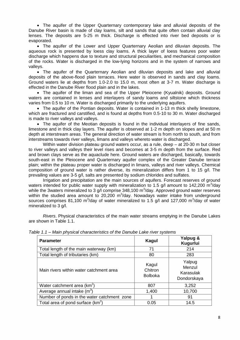
Rivers. Physical characteristics of the main water streams emptying in the Danube Lakes
are shown in Table 1.1.
Table 1.1 – Main physical characteristics of the Danube Lake river systems
Parameter Kagul Yalpug & Kugurlui
Total length of the main waterway (km) 71 214
Total length of tributaries (km) 80 283
Main rivers within water catchment area
Kagul
Chitron
Bolboka
Yalpug
Menzul
Karasulak
Dondorskaya
Water catchment area (km2) 807 3,252
Average annual intake (m3) 1,400 10,700
Number of ponds in the water catchment zone 1 91
Total area of pond surface (km2) 0.05 14.5

9
According to the water supply conditions, the rivers of the studied territory are referred to the Eastern European type. Thawing water, snow and rainfalls make the main source of water intake. The ground water share is negligible small and completely absent in some rivers. Small rivers are shallow and dry up in summer time. The water level regime is characteristic of an ascending water level in spring, which is, however, not every year, and low summer and autumn mean water with intermittent summer rain floods when water level in rivers may rise by 1.0-2.5 m higher than the permanent water level. In spring the level is rising in the second half of February or in the beginning of March, and then lowers. During the spring flood water level becomes 0.5-2.7 m higher than the permanent water level. Duration of high water periods is 1-2 days. Mean water level is established in the middle of April.
Water catchment zone in the Lower Danube region has changed considerably. Large-scale changes in the river runoff system took place within the entire water catchment territory, both on the Ukrainian side and on Moldova side. The changes were associated with construction of dams, water reservoirs for irrigation systems and other hydrotechnical facilities. Later, as a result of the intensive use of pesticides and mineral fertilizers in agriculture, as well as of a discharge of untreated effluents from villages located along the channels, water quality in many rivers deteriorated considerably. Water intake to the Kagul and Yalpug Lakes was reduced because of a great number of water reservoirs in the upper part of the water catchment zone. These water reservoirs also accumulate the bigger part of sediments.
Danube Lakes. Under natural regime the Danube Lakes were characterized by
considerable variations of water levels, which precluded sustainable use of their waters for water supply and irrigation purposes. Therefore, in 50-ies – 60-ies they were transformed into pumped water reservoirs by constructing regulating hydrotechnical facilities – locks. The construction was made so as to ensure sustainable use of their water resources for irrigation and agricultural water supply. During the next 30 years, both in Ukraine and Moldova, a great number of irrigation systems were built based on these water basins. The actual use of lake water resources does not correspond the design use requirements because of various reasons. The main parameters of the Danube Lakes are shown in Table 1.2.
Table 1.2 – Morphometric parameters of the Danube Lakes
Water reservoir
Water
catchment
area, km2
Volume, mill. m3 Water
surface
area at
permanen
t water
level, km2
Irrigated
area, thou
ha total useful
water intake
from water
reservoir
Kagul 605.0 250.0 144.0 31.8 99.2 17.6
Kartal 94.0 35.6 27.0 5.4 23.3 15.5
Yalpug-Kugurlui 4,430.0 888.0 422.0 113.5 268.0 12.9
The Kagul and Yalpug Lakes are continuations of the former river valleys that, at one time, emptied in the ancient Danube estuary. Nowadays these rivers are very shallow. The Kugurlui and Kartal Lakes are typical flood plain water basins by their origin.
Water resources of the lakes are replenished, basically, by means of gravity flows from the Danube River which has practically inexhaustible volume and rather high water quality.
Water level of the Danube Lakes in their natural condition considerably differs from the operational one (Table 1.3). Under natural conditions the water level regime of the lakes was formed by the Danube level regime with due correction for the throughput capacities of channels, flood plains and morphometric parameters of the lakes, and was dependent upon spring level rise, summer and autumn decrease and mean water level in winter. After the dams were constructed, the lakes became separated, locks were built in channels and the limiting water horizons – permanent water level, forced headwater level (FHL) and dead storage level – established Water level of the lakes is characterized by a spring rise to the permanent water level (PWL), summer and autumn replenishment of maximum levels, autumn discharge to the dead

10
storage level (DSL) and low mean water level in winter. It allows of providing conditions for a sustainable water intake the required water exchange.
Table 1.3. – Limiting and actual mean water horizons of the lakes taken for the period and under
regulated conditions
Lake Horizons, absolute, m
Нmах - Нmin, m PWL FHL DSL Нmах Нmin
Kagul 3.50 3.70 2.00 3.52 2.42 1.10
Kartal 3.00 3.20 1.60 - - -
Yalpug-Kugurlui 2.80 2.80 1.30 2.73 1.65 1.08
Considering the nowadays development level (after 1992), the possibilities to provide
power resources to the pumping stations are extremely limited which leads to further reduction of the level fluctuation amplitudes and, correspondingly, to worse water exchange (Table 1.4) and higher mineralization of the lakes.
Table 1.4. – Water exchange coefficients (Cwe) of the lakes before and after their regulation
Lake Low water year Medium year High-water year
before after before after before after
Kagul 2.17 0.37 0.71 0.62 - -
Yalpug 1.45 0.24 0.45 0.41 0.84 0.16
Lake Kagul has a shape of a ―comma‖, its tail part is a valley of Kagul River. The southern
bank is gently sloping and marshy, here there are fish ponds. The western and southern banks have a narrow shoreline which is sometimes fringed with reeds and eroded scarps. The lake communicates with the Danube via Viketa channel, and with the Kartal Lake via Zarzy and Luzarsa channels.
Lake Kartal is located in the Danube River floodplain between the south extremity of the Kagul Lake and the western part of the Kugurlui Lake. It is connected with the Danube via Orlovskiy and Prorva channels, and with the southern part of Lake Kugurlui via Tobacello creek. The Kartal Lake is very shallow and has a flat bottom.
Besides Lake Kartal proper, the Kartal basin includes two main local water basins: Dervent (with Gradeshka) and the Kartal arm. In dry years Dervent and Gradeshka are covered with hydrophytic vegetation where they communicate with the Kartal. Under such conditions water exchange in this water system becomes difficult or is completely terminated. The area of Kartal Lake and the associated water basins varies in greater limits than the Kugurlui Lake. It is due, primarily, to small depths. On the west side the Kartal communicates with the Kagul via Zarzy (currently closed) and Luzarsa creeks, and with the Danube via the Orlovskiy and Prorva channels (provided with locks). On the south-eastern part the Kartal communicates with the Kugurlui via Tobacello and other creeks. Whenever the water level in the Danube is low, the creeks connecting the Kartal with other water basins dry up. At high levels of water in the Danube the Kartal Lake is being filled as water flows from the Kagul down Luzarsa channel as well as directly from the Danube down the Orlovskiy and Prorva channels. Water from the Kartal flows to the Kugurlui thereby forming a closed system of communicating water basins where water is always flowing from the Kartal to the Kugurlui. As distinct from the Repida channel, there is no reverse flow in the Orlovskiy channel (water never flows from the Kartal to the Danube).
Lake Kartal banks are grown with reeds and sedge. The lake communicates with the Danube via three channels (the Skunda, the 105th km and the Repida). The Yalpug Lake is connected with the Kugurlui with a wide creek formed in a low-lying sand spit incorporating the Reni-Izmail road. In the upper part of the lake the valley is transformed into the Yalpug Lake flood plain.

11
The Danube. The studied section of the Danube presents the estuary-adjacent part which is divided into arms. At the 116th km from the estuary the main course is divided into the Tulcea arm (to the right, towards Rumania) and the Kiliya arm (to the left, here the major section of the Rumania/Ukrainian border is). On the average, floods in the Danube begin in the first decade of March, the flood peak occurs in the mid April and the spring flood ends in the mid May. At the same time summer floods begin, their peak being in the second decade of June; then, from the end of July till the first decade of November there is a period of low water levels, sometimes during this period we witness the summer-and-autumn mean water level; in November and December there occur autumn floods.
Average long-term runoff of the Danube River comprises 200 km3 (or 6,400 m3/s), in the 75% probability year it equals 173 km3, in the 95% probability year it is only 142 km3 per year. The Kiliya arm runoff comprises 61% of the Danube runoff in the head of the delta. The Kislitskyi arm runoff equals 10-12% of the Kiliya arm runoff. The average long-term annual volume of sediments in the Danube equals 42.2 m ton, and that of the Kiliya arm – 27.2 m ton. The average long-time water turbidity in the Kiliya arm of the Danube is 175 g/m3.
1.1.6 Flora According to geobotanical zoning of Ukraine the Greater Danube territory is located in the
European and Asian steppe region, fescue and feather grass belt, Izmail-Belgorod-Dnestrovskyi district of the fescue and feather grass steppe, the Danube wetlands with halofilous-and-sand vegetation. Despite its fragmentary nature and lasting time intervals in the studies, the Greater Danube region flora has been studied rather well. The latest works examine in greater details the flora and vegetation of the Danube Biospheric Reserve. The Kartal Lake and the adjacent territory were studied to a lesser extent.
When considering lakes Kartal, Dervent and Gradeshka together with the adjacent territories, it becomes clear that they completely encompass all range of flood plain landscapes of the Ukrainian section of the Danibe (except for wetlands ecosystems of the delta). They are characterized by a homogenous intrazonal complex of factors and represent well the complexes of aqueous and semi-aquatic vegetation.
The local flora is represented by 189 kinds of higher vascular plants that refer to 50 families. One kind of them (Salvinia natans) is entered in the Red Book of Ukraine (the 2nd category of rareness).
Quite big meadow sites in the vicinity of the Kartal Lake are located in the suburbs of Orlovka village, along the Luzarsa channel and near the hunting base. The total area of said meadows comprises about 130 ha. Besides, small fragments of meadow communities occur along the right bank of the Dervent and Gradeshka Lakes as a narrow strip (5-15 m wide).
As the natural meadow biotopes of the region are not flooded regularly and as far as intensive business activity is exercised here, they have disappeared practically completely or have been replaced with the secondary communities having low biodiversity and productivity. Nevertheless, the biocenose role of the flooded meadows is extremely important, therefore their restoration, correct operation and protection make an important component of the works aimed at optimization of the water regime and support of biodiversity of the Kartal Lake and the lakes Dervent and Gradeshka that are genetically connected with it.
The assessment of meadow biotopes in the studied region that was made in July 2010 proved a practically complete cenotical and floristic identity of the meadow sites near Orlovka village and along the Luzarsa channel and the hunting base. It is connected with the same hydrological regime of these sites (by the time of the study all of them were watered excessively, and in small depressions the water depth comprised 20-30 cm and more).
Aquatic vegetation is widely represented in the studied region – it is subdivided into free-floating, attached and submerged species. The most spread species among the attached submerged kinds are the communities where Potamogeton perfoliatus, P.pectinatus, Vallisneria spiralis and Elodea Canadensis dominate. The group of species that are free-floating on the surface (Lemnetea class) is represented, most of all, by the cenoses of Spirodela polyrhiza, Lemna minor, Salvinia natans, Hydrocharis morsus-ranae; the group of species that are free-floating in the water column is represented by Ceratophyllum denersum. Among the cenoses that

12
are formed by attached species with floating leaves the most spread in the Danube Lakes are the communities of Nymphaea alba and Nymphoides peltata.
Among the bog vegetation (air and aquatic vegetation) there are phytocenoses formed by high-, medium- and low grass species (correspondingly, high-, medium high- and low grass mires). Predominant in the Danube Lakes are high grass mires formed by the phytocenoses where Phragmites australis, Typha angustifolia and Scirpus lacustris dominate. Here and there one can meet communities where Typha latifolia dominates. More frequently and occupying relatively vast areas are the communities formed of Sparganium erectum, Typha laxmannii which refer to the medium-high grasses; the cenoses of Glyceria maxima and Acorus calamus are represented sporadically. These phytocenoses are also more characteristic of the lower part of the lakes. Low-grass air-and-aquatic vegetation communities are spread sufficiently but they do not occupy vast areas. These are met more or less evenly in the lower parts of lake basins while in the upper parts they occur sporadically. This group includes the phytocenoses with domination of Eleocharis palustris, Juncus gеrardii, J. maritimus, Alisma plantago-aquatica, Sagittaria sagittifolia and Bolboschoenus maritimus.
Same as mire plants, the meadow vegetation does not occupy vast areas because of the development of those sites where they grew earlier. The other reason of such situation is amelioration of the major part of rivers which banks were once covered with such plants. Meadow vegetation is formed at elevated sites of the lake banks. It occurs in the upper reaches of the Kitay Lake. As these habitats are also associated with salting, the grass canopy of the meadow communities exhibit halophytes that form independent communities at especially salted areas. Meadows are subdivided into genuine meadows and peat-land meadows. The first group includes the phytocenoses with domination of Calamagrostis epigeios, Elytrigia repens and Bromopsis inermis, and the second group – those where Agrostis stolonifera dominates.
Halophyte vegetation makes an integral component of the bank area vegetation and is genetically linked with the mire and meadow communities. It is characterized by sparse grass canopy, which is due to specific formation of its cenoses, and is represented by halophyte and meadow-halophyte species growing on salted lands. Genuine salt-tolerant vegetation is formed by the cenoses of Salicornia europaea and Suaeda prostrata. Sodic vegetation is represented by the Plantago salsa and Artemisia santonica communities. The latter one occurs at more elevated sites than the former community. Sodic and salt-tolerant vegetation of the studied region is referred to the Thero-Salicornietalia class. Meadow and halophyte vegetation is mostly spread among the communities of other vegetation types that occur in the shoreland strip. It is represented by the phytocenoses with domination of Alopecurus arundinacea, Bolboschoenus maritimus, Juncus gerardii as well as Trifolium fragiferum and Tripolium vulgare.
Forest vegetation in the Danube Lake region features willow and poplar forests (Salix alba, S.fragilis и Populus alba) that grow along waterway banks and the mainstream of the Danube, and are mostly specific for the Lakes Kugurlui and Kagul. Besides, individual fragments of the natural origin communities of Salix alba occur at the waterway banks and they have been considerably transformed under the influence of man-made activities.
Apart of natural forests on the banks of interlake and near-Danube waterways as well as here and there on the banks of the lakes proper there occur artificial plantings of Salix alba, S.triandra, Populus nigra and P.alba. On the coasts and in other depressions one meets sparse plantations of Elaeagnus angustifolia (the vastest plantations are observed in the vicinity of Vinogradovka village at Yalpug Lake). In places, on the lake banks it is possible to see, from time to time, sparse bushes of Tamarix ramosissima which can be referred to natural bush.
Steppe vegetation in the studies region is common at scarp elevated sites and sliding fragments of slopes. It is strongly transformed by grazing and is more preserved by the very edges of scarps where the cattle do not reach. Also, the respectively preserved areas of steppe vegetation are peculiar of steep scarps. Fragments of feather grass and sheep fescue steppe (dominated by Stipa lessingiana, S.capillata и Festuca valesiaca) and sheep fescue steppe (Festuca valesiaca) are to be considered to be most preserved. Such areas occur on the banks of the Yalpug Lake between Vinogradovka and Vladychen villages, and between Krinichnoye and Topolinoye villages, as well as in the reserve ―Zhovtnevoye‖ where the nature reserve of the same name exists.
Not uncommon in that region are the steppe community fragments with domination of Agropyron pectinatum and Koeleria cristata. However, the mostly widespread are the

13
communities where Botryochloa ischaemum dominates – they cover almost all eroded slopes which make a considerable share of the studied area relief.
Ruderal vegetation (weeds) is represented by the communities where ruderal varieties dominate, such as Onopordon acanthium, Anisantha tectorum, A.sterilis, Hordeum leporinum and Senecio vernalis. It can be observed in small patches within the territories distant from settlements (e.g., on the way of cattle driving to watering points) or as considerable lots near residential settlements.
Phytoplankton. Plankton was studied in Lakes Yalpug, Kugurlyi and Kartal. Altogether forty species of algae were recorded here, including diatomic (Bacillariophyta), blue-green algae (Cyanophyta), green algae (Chlorophyta) and yellow-green algae (Chrysophyta). The mostly spread among diatomi algae are Nitzschia acuminata (W. Sm.) Grun., N. amphibia Grun., N. sigmoidae (Ehr.) W. Sm., Navicula cryptocephala Kutz., N. halophila (Grun.) Cl. and Cocconeus pediculus Ehr. Blue-green algae are represented by Microcystis aeruginosa Kutz emend Elenk (in June they are observed in all lakes and cause blooming), Merismopeilia fenuissima Lemm., Aphanizomenon flos - aquae (L.) Ralfs, Anabena flosaquae (Lynb.) Breb. Among green algae the dominant species are Chlorococcales: Scenedesmus quadricauda (Turp.) Brebisson, S. falcatus Chodat and Pediastrum duplex Meyen. Yellow-green algae are commonly represented by Dinobryon sertularia Ehr. and Ochromonas sociata Pasch. Spring "blooming" of water in the Danube Lakes is caused by diatomic and, sometimes, yellow-green algae, in summer period – by blue-green and green (Chlorococcales).
1.1.7 Fauna Mammals. Nowadays, 41 species of mammals have been recorded in the Greater
Danube region, including 11 species of predators. Nine of the recorded species are rodents, including naturalized muskrat Ondatra zibenthicus which is, today, an inherent element of theriofauna and presents an important component of wetlands systems; in some areas the muskrat is bred to get fur. Here there are 5 species of chiropterans (Nyctalus noctula, Pipistrellus pipistrellus, Plecotus austriacus, Vespertilio murinus and Myotis daubentoni), but these are but a few of those that are recorded in the Greater Black Sea region. Racoon-like dog Nyctereutes procyonoides is still another naturalized species introduced from Moldova.
The majority of mammals are common and even numerous species of our fauna, however, some of them became rare in Europe and were included in the European Red List as well as in Berne Convention (1979) – altogether 23 species. There is also the Bonn Convention on Conservation of Migratory Bats (particularly Plecotus austriacus that winter in the region and reproduce in the Carpathians). The European Red List includes 2 species (Nannospalax leucodon and Lutra lutra); our legislation protects 8 species of mammals that were entered in the Red Book of Ukraine. Thus, more than 50% of the Greater Danube theriofauna enjoy the status of protected animals.
Chiropterans are least of all studied, not only in that region but in the country on the
whole. Noctule bat and common bat identified in the Kartal Lake area as well as the mentioned in
scientific papers common long-eared bat, brown bat and little brown bat reflect the chiropterans
of the region only fragmentary. We should assume a potential presence of such bats as mouse-
eared bat and whiskered bat, Nathusius’ pipistrelle, and, during migration periods, other species
as well.
One should take into consideration an insufficient study of the insect-eaters fauna.
Despite the available data report about this group, even a spread of many species is studied
evidently insufficient. Specifically, it causes doubt that in the Greater Danube region there are no
big water shrews which are not numerous elsewhere, however it is a common inhabitant of
wetlands almost all over Europe and North Asia. After immigration of roe deer Capreolus
capreolus from Rumania to Kislitskyi Island in 1969, there started an intensive stocking of the
Greater Danube region with this species. About the same time there appeared wild boar Sus
scrofa which population reached its maximum in 1975-1990.

14
Currently the wild boar population sharply increases from time to time not only due to local
population but also as a result of invasive movements from Rumania. Thus, the number of
animals in the Kartal Lake area may reach 300-400. We know numerous instances recording
spotty and even white boars, which is the result of crossbreeding with hogs.
Certain populations in Ukraine and in the studied region stay in a good condition,
therefore a number of species that are protected in Europe have the hunting animal status or
their protection status is not established at all. The stone and pine martens as well as the polecat
are referred to the former category while the weasel – to the second. The rarest animal of Europe
– the otter that has been included in all environmental documents is a common species in the
Greater Danube region which considerably extended its locality in the country on the whole and is
gradually increases in numbers. Due to the same reason the badger has been excluded from the
latest edition of the Red Book of Ukraine.
A small number of mammals (fox, raccoon dog, polecat, muskrat, boar, roe deer, stone
marten and hare) belong to the group of hunting animals, this resource being used with various
regularity. Most intensively hunted animals are hares, raccoon dogs, foxes, boars, roe deer and
muskrat. The stone marten which is prone to synantropization is hunted locally and rare; the
polecat gets caught in traps incidentally when hunters catch muskrats and raccoon dogs.
Birds. Reliable records made in the Greater Danube region of Ukraine contain 258 bird
species, including 124 breeding species. This makes about 64% of all known birds recorded in
Ukraine. Out of this number 42 species have been entered in the Red Book of Ukraine and 9
species in the European List of Protected Species, including the Dalmatian pelican, pygmy
cormorant, red-breasted goose, white-eyed pochard, white-tailed eagle, etc. Species diversity of
birds and the number of individual species makes it possible to consider that the habitats of the
Greater Danube region of Ukraine to be important for birds within the IBA program.
In the Ukrainian territory there occur 246 species (95%) that possess the European
conservation status. The analysis has proved that 9 species (or 2% of the entire bird fauna of
Ukraine) belong to SPEC 1 category (world protected species), 17 species – to SPEC 2 category,
63 species – to SPEC 3 category and 47 species to SPEC 4 category.
The Berne Convention on the Conservation of Wildlife and Natural Habitats (1979) tells
that more than one half of bird species recorded in the studied region present a conservation
interest on the European scale according to category II. The same Convention refers the
remaining species to the III category (save for 10 species of extremely high numbers: the herring
gull, the gray crow, the rook, and others).
Out of the birds recorded in the Ukrainian part of the Greater Danube 154 species are
protected by the Bonn Convention on Conservation of Migratory Species of Wild Animals. Ninety
seven per cent of them are referred to the II category. Forty nine bird species of the Greater
Danube are protected by the Convention on International Trade in Endangered Species of Wild
Fauna and Flora (SITES).
While analyzing the nature of birds stay in the Greater Danube water basins it is
worthwhile to note that our of the total 258 bird species registered here 90 species were recorded
at wintering grounds in that very region. The white-cheeked tern is the key species that
determines the nesting site complex. Since the middle of the 20th century this species began to
expand to north-east from its conventional place of stay (Spain, the Southern Balkans). By the
end of the 20th century the white-cheeked tern became a common species that made its nests in
Rumania and in the Ukrainian part of the Greater Danube. The numbers of this species is
increasing noticeably for the last decade.
Breeding colonies of the white-cheeked tern in the studied water basins (from several
pairs to several hundreds) are located, as a rule, on the water chestnut leaves.

15
On November 23, 1995 the Kartal Lake was given the status of wetlands of international
significance in accordance with the Ramsar Convention. The area of this reserve comprises 500
ha and presents an important place for breeding, moulting, migration and wintering of birds (to
40,000 in numbers). Here occur 32 bird species that have been entered in the Red Book of
Ukraine, such as the glossy ibis Plegadis falcinellus, the pond heron (Ardeola railloides), the
white-eyed pochard (Aythia nyroca) and the black-winged stilt (Himantopus himantopus).
Moreover, here live three bird species that are threatened with extinction: the pygmy cormorant
(Phalacrocrax pygmeus) (70 pairs, about 1% of the European population), the spoonbill Platalea
leucorodia (150 pairs, about 3% of the European population) and the red-breasted goose (Branta
ruficolis).
The territory and water basin of the Kartal Lake and the adjacent shallow water bodies are
important for a great number of hydrophilic bird species.
Bald coot Fulica atra), great-crested grebe (Podiceps cristatus), common pochard (Aythya
ferina), mute swan (Cignus olor) and others appear in great numbers at nesting. They include
eight species – the glossy ibis Plegadis falcinellus, the spoonbill (Platalea leucorodia), pygmy
cormorant (Phalacrocorax pygmaeus), the pond heron (Ardeola ralloides), the white-eyed
pochard (Aythya nyroca), saker falcon (Falco cherrug), the black-winged stilt (Himantopus
himantopus) and reed warbler (Acrocephalus scripaclus) are entered in the Red Book of Ukraine.
The number and quality of the Kartal Lake nesting complex remains relatively stable. It
includes 30-35 species, the most important being the white-eyed pochard (about 10 pairs make
nests); pond heron (30-35 pairs), etc. We record regular attempts to nest on the part of the
Dalmatian pelican. The numbers of white stork nests is increasing. During recent years the
Spanish sparrow is permanently recorded which was first spotted in the Greater Danube region in
the 90-ies.
The Mallard duck (Anas platyrhynchos), common pochard (Aythya ferina) and Caspian
gull (Larus cachinans) dominate at wintering. Thirteen species of birds spend winter here and are
entered in the Red Book of Ukraine. They also include the pygmy cormorant (Phalacrocorax
pygmaeus), red-breasted goose (Rufibrenta ruficollis) and white-tailed eagle (Haliaeetus albicilla)
that are also entered in the European List of Protected Bird Species.
Potential breeding avifauna of the Zarzy polder includes 24 species, half of which relates
to water-demanding complex. The next important share are the species of the forest complex.
Proportion of birds of meadow-steppe complex is relatively high (4 species), and they dominate in
quantity. The list of dominant breeding species: Alauda arvensis, Anthus campestris, Motacilla
feldegg.
Seasonal avifauna thanks to the adjacent Kartal Lake is very diverse - 122 species,
among which the dominants can be hardly listed. Dominants during the migration period are ibis
(Plegadis falcinellus), lapwing (Vanellus vanellus), Ruff (Philomachus pugnax), black-headed gull
(Larus ridibundus), Black Tern (Chlidonias niger), barnacle tern (Chlidonias hybrida), Sand Martin
(Riparia riparia), starling (Sturnus vulgaris).
Rare species of birds (11) are Ardeola ralloides, Plegadis falcinellus, Aythya nuroca,
Pandion haliaetus, Circus cyaneus, Circaetus gallicus, Himantopus himantopus, Numenius
phaeopus, N. arquata, Larus ichthyaetus, Hydroprogne caspia.
Avifauna of the polder is threatened by a complete draining of meadows and economic
development of the area with overgrazing.
Amphibians and reptilians. According to the latest studies of amphibians and
herpetofauna of the Greater Danube region, in this area reliably recorded were 11 species of
amphibians and 5 reptilian species. The most numerous representatives of the amphibians are:
Rana ridibunda, Hyla arborea, Bombina bombina, and of the reptilians — Natrix natrix and Emys

16
orbicularis. Commonly there live Pelobates fuscus, Bufo viridis and Lacerta agilis. Rana arvalis
and Bufo bufo should be considered the most rare amphibian species. Less represented among
the reptilians are Lacerta taurica and Eremias arguta. The most endangered herpetofauna
species is the endemic of the Lower Danube region - Triturus dobrogicus which was entered in
the IUCN Red List.
Fish fauna. The Ukrainian part of the Greater Danube region is characterized by a great
diversity of habitats that are actively used by diverse fish species. Considering ecotonic nature of
the Danube River delta, existence of a great number of flood plain water bodies as well as
zoogeographic characteristics of the region, it is possible to assume that the fish species diversity
is considerable. The Danube Biospheric Reserve reports that in its water area only 90 fish
species have been recorded that refer to 30 families. Fifteen of them are entered in the national
Red Book of Ukraine. Moreover, all 7 fish species entered in the European Red List occur within
the territory of the biospheric reserve. Typical fish fauna of the Greater Danube water bodies is
represented by a smaller number of fish species. Still, considering a branched network of
channels and waterways and unpredictable dam failures during floods, it can be assumed that
the entire fresh-water fish complex will be registered in the studies water bodies of the Greater
Danube as well.
Fish fauna of the Lower Danube hydrological system and the associated flood plain water
bodies draws careful attention of many researchers. In spite of numerous papers published in the
20th century, until now there is no single opinion about the species composition of the fish fauna.
Possibly, it is due to a permanent dynamics of the fish stock which species composition changes
due to migrations and invaders from the Black Sea. Besides, the studies of these aspects are
complicated because of different methodological and systematic approaches which entail
numerous taxonomic inversions.
Earlier the quantitative composition of the Greater Danube water body fish fauna
comprised about 80 species but a large-scale anthropogenic load had led to a reduction of fish
species number, and also on both sides of the Danube. Rumanian authors have discovered 47
fish species only in 7 flood plain water bodies of the Danube delta, 4 of them being the migrants.
However, earlier, in the 90-ies, 58 fish species were recorded in these water bodies and 16 of
them were the migrants.
On the basis of contemporary studies a preliminary list of fish species inhabiting the
Greater Danube water basins was developed. It indicates 54 species that refer to 13 families. The
most numerous are the representatives of the Cyprinoidae family — 13 species, Percoidae — 6
species and Gobiidae — 5 species.
The fish fauna of the Kartal Lake is represented by such species as the Danube bream,
common asp, silver bream, crucian carp, pike, pike perch, river perch, roach, rudd and European
catfish.
The typical fish fauna of the Kugurlui Lake comprises 41 fish species. Due to a branched
network of channels and waterways that connect with the Danube, the entire fresh-water complex
of the Danube may be registered in this water basin as well.
Entomofauna. The number of insects recorded in the Greater Danube region exceeds
2,000 species. They refer to 23 insect orders, the prevailing number of species (86.2%) referring
to 6 orders: Hymenoptera (41.3%), Diptera (20.7%), Coleoptera (10.3%), Lepidoptera (5.7%),
Hemiptera (4.6%) and Homoptera (3.6%). Forty species of the indicated taxonomic groups have
been entered in the European Red List and in the Red Book of Ukraine.

17
Background species of ehntomofauna of the Zarzy polder. In the water - the larvae of
Lestidae, Coenagrionidae, Libellulidae and Aeschnidae dragonflies; bugs: Notonecta glauca,
Corixa spp.,; diving beetles of genera Hydrophorus, Gaurodytes, Ilybris, and Dytiscus marginalis;
waterphils Hydrous piceus, Hydrobius fuscipes. Near the water - the imago of the families of
dragonflies, mosquitoes Culicidae and Tendipedidae, bugs Saldidae, ground beetles Bembidion
genera, leaf beetles Donacia. Meadow-steppe complex: bugs-miridae Miridae, dung beetles of
the genera Aphodius and Onthophagus, rove Philontus sp., weevils Tychius sp., copper-butterfly
(Lycaenidae), Vanessa atalanta, bees (Apidae), the ant Lasius niger.
Rare endangered species: a large dragonfly rocker (Aeschna grandis) (Ukrainian red
book).
Threats for entomofauna: overgrazing, for aquatic and semi-aquatic species - isolation
from the lake and drainage.
1.2 Assessment of natural resources and their use 1.2.1 Characteristics of land users of the Zarzy polder.
The entire territory of the Zarzy polder which directly borders the lands allotted for Orlovka
village is used by the Orlovka village council where 3,047 people reside. Local dwellers make use
of the polder territory as pasture and for haymaking. A drainage ditch that immediately adjoins the
polder on the north-west is used by the local dwellers for bathing during the warm season.
As it was mentioned above, the polder ecosystem should be considered as a part of the
integral ecosystem structure of the Kartal Lake. Therefore, it is expedient to consider the users of
the lake resources in terms of the use of the natural resources of the polder.
In 2003 the National Committee on Fisheries decided to set up a special commercial
fishery (SCF) in the lakes Kagul and Kartal. Until recent time it was CJSC «Aqua» (Reni) that
used this fishery. In compliance with the Instructions No.4 of 2008 issued by the National
Committee on Fisheries the SCF user has, actually, the exclusive right to manage the water live
resources (WLR) of the basin, its authority not extending on water, land and other resources.
However, in the end of 2013 the Kartal Lake was withdrawn from the SCF and currently no
permits for use of its natural resources have been issued.
All hydrotechnical facilities (dams, canals and locks) that regulate the hydrological regime
of the Kartal Lake and adjacent areas are managed by the Danube Basin Administration of Water
Resources.
1.2.2 Water resources
The Kartal Lake is a wetland of international importance.
The Kartal Lake is situated in the Danube River flooded area between the southern end of
the Kagul Lake and the Kugurlui Lake within the administrative territory of Reni District. The
nearest settlements are: vil. Orlovka and vil. Novoselskoye. The elevation above the sea level is
1.4 m. The average depth equals 1.04 m and the maximum depth – 3 m.
The Kartal Lake basin includes, apart of the Kartal Lake proper, two main local water
basins: Dervent (with Gradeshka) and the Kartal arm. During arid years Dervent and Gradeshka
overgrow with hydrophytes in the areas where they join the Kartal. Under such conditions water
exchange between the parts of this hydrologic system is rendered difficult or ceases completely.
The area of the Kartal and associated water basins varies to a greater extent than in the Kugurlyi.
It happens so, firstly, with small depths. The Kartal communicates on the west with the Kagul
Lake via the Zarzy creek (currently closed) and Luzarsa, and via the Orlovskiy and Prorva canals
with locks with the Danube. On the south-east the Kartal communicates with the Kugurlui Lake
via Tobacello and other creeks. During low-water periods in the Danube the creeks that connect
the Kartal with other water basins become shallow. At high water level in the Danube the Kartal

18
Lake fills due to water flowing from the Kagul down the Luzarsa creek and, also, directly from the
Danube via the Orlovskiy and Prorva canals. From the Kartal Lake water flows to the Kugurlui
Lakes thereby forming a closed system of communicating water basins, the water always flowing
from the Kartal to the Kugurlui. As distinct from Repida canal, there is never a water flow from the
Kartal to the Danube via the Orlovskiy canal.
The mineral composition of water in the Kartal varies from hydrocarbonate to sodium
chloride while the mineralization level fluctuates between 0.4 – 1.2 g/l.
Flooded areas near the canals are provided with embankments and turned into polders
and fish-breeding ponds.
The local population makes use of the water resources of the lake mainly for watering
their vegetable gardens.
Water resources of the Zarzy polder are limited by the drainage ditch between its territory and vil. Orlovka, by the Luzarsa creek and Zarzy creek which is filled only at high water levels in the lake system Kagul – Kartal – Kugurlui. 1.2.3 Fish resources
The original (before the 50-ies) ecosystem of the Danube Lakes was, by its nature,
―flooded wetlands with pure water and small quantity of biologically active substances‖. Wetlands
were the ideal spawning grounds for the migrating carp (the dominant species) as well as for non-
migrating species, such as pike, Danube bream, tench and roach. Streams and lakes supported
as well large populations of crawfish which size was big enough to be the object of catch.
The first steps to organize fish breeding in the Danube area were made by local fishery
collective farms as early as in 1947 when fish breeding stations were established that used non-
migratory fish like Danube bream, tench, common carp and European carp. At that time the lakes
were not separated from the Danube with dams. In the 50-ies the average annual catches in the
Greater Danube water basins reached 1,200 t.
Since the time of the Second World War these ecosystems suffered considerable
changes as the ex-USSR commenced to drainage vast areas by building dams around the
natural flooded areas of the Danube. By the end of 1959 more than 28,000 ha of the flooded
areas (particularly near the Danube Lakes) were converted into agricultural lands. As a result, the
abundant ―wild forms‖ of the common carp with its spawning migration from the Danube to the
lakes and the flooded areas was considerably reduced, and the catches of the main species
dropped almost to zero.
As the catch of the European carp reduced in the period from 1960 to 1973m some
measures had to be taken. The Institute of Hydrobiology of the Academy of Sciences developed
and implemented an action plant to support the normal water exchange and high water levels in
the lakes until late autumn. The situation with the non-migrating species such as pike, bream,
tench, roach, etc. improved but these measures did not restore the migration routes of the
common carp, and these gradually disappeared. Accordingly, since the end of the 60-ies,
considerable numbers of juvenile Chinese carp and the domesticated common carp were
released in the lakes in order to improve productivity there. Since the beginning of the 70-ies the
results of fish stocking became evident as the catches grew, the main species being the Chinese
carp.
From 1973 to 1979 such species as pike, tench and roach gradually disappeared in
catches. The main reason for a reduction of the local species number is due to the fact that since
the end of the 70-ies the quantity of biogenic matter in the Danube River and the lakes began to
grow rapidly, waters became eutrophicated and turbid because of a rapid growth of
phytoplankton which produced a tremendous effect on the natural vegetation, fish and
representatives of the fauna. The species that are typical for ―clean water‖ such as pike, tench,

19
roach and catfish were replaced with the representatives of the polluted waters in particular by
the bream.
In the 70-ies the lakes began to be stocked with silver carps – a big phytovorous species
imported from Asia because this fish belongs to a few species that can live under eutrophication
condition. This species requires artificial reproduction and stocking. Silver carp turned to be the
main species for commercial fishing. However, in the mid-80-ies and in the beginning of the 90-
ies there occurred abrupt and mass mortality of the silver carp adults (mainly females),
particularly in the Kugurlui Lake.
The fisheries in the region are represented by cooperative and private enterprises. In the
Yalpug and Kugurlui Lakes there function five fisheries: Fishery Cooperative (RMK) ―Novo-
Nekrasovskyi‖, Fishing & Agrarian Production Cooperative ―Yalpug‖, Private Enterprise
―Shcherban‖ and the Agricultural Firm ―Ripida‖. The CJSC ―Aqua‖ operates in the Kartal Lake. In
2005 the Izmail District fisheries caught 1,376 t of fish, and those of Reni District – 180 t.
On the whole, the fisheries in the Ukrainian part of the Danube delta are currently in crisis,
which is explained by the economic situation in the country and environmental problems in this
area.
The fishing pressure on the Danube Lakes increased in the 90-ies and the number of
poaching became more frequent.
All that cannot but impact the environmental condition of the water basins, the Kartal Lake being one of them.
So, during the last 30-40 years here there were no records of the bastard sturgeon, sterlet,
shemaya, Volga zander, asproon and Don ruffe. Practically no commercial value now have the
razorfish, Black Sea roach, zanthe, barbell and sneep – the fishes that spawn on a firm free of silt
bottom. Some non-exploited fishes became rare: the mudminnow, Danube gudgeon, and
percarina. Numbers of such species as the dace, orfe, verkhovka and crucian carp reduced
considerably. The chub and tench are now on the verge of perishing. At the same time the fish
fauna was ―enriched‖ by certain new species that were introduced in the lake, such as the golden
carp, silver carp and bighead, stone morocco and sunfish.
In accordance with the literature data, until recent time the fish fauna of the Danube River
and the Danube lakes numbered about 90 species and subspecies of fish. According to the
species composition, the Danube Lakes do not differ, practically, from each other, therefore the
data collected for one lake may, with certain probability, applied for the analysis of the adjacent
water basin. In the beginning of the 60-ies of the last century they recorded in the Danube Lakes
49 species and subspecies of fish that belonged to 13 orders. The greatest number of species
(49%) was the order of carp-like fishes. In the beginning of the 70-ies this order of species was
added with the introduced in local basins fishes like the golden carp, silver carp and bighead,
grass carp and stone morocco. At the same time in the Kagul Lake a reduction of the taxonomic
composition by 20% was recorded, which can be attributed to the fact that such small-size
species as the mudminnow, spiny loach, stickleback, blue bream, ruffe and some others might be
not recorded in the commercial catches. It is quite possible that such a reduction was a
consequence of the commencing process of fish fauna degradation.
The studies made in 2001, 2003 and 2004 indicated just 35 fish species. More than a half
of the recorded fishes (55%) belonged, as it was mentioned earlier, to the order of carp-like
fishes.
Historically, the fish catch in the lake was high. For instance, during a decade from 1951
to 1960 the average weight of the annual catch amounted to 162.5 t (Table 1.7), the major
importance in the catches had the golden fish, pike, roach, carp and bream. As of the 90-ies of
the last century a sharp decrease (from 2 to 3 times) of fish catches in the lake took place.

20
0
50
100
150
200
250
300
1947
1949
1951
1953
1955
1957
1959
1961
1963
1965
1967
1969
1971
1973
1975
1977
1979
1981
1983
1985
1987
1989
1991
1993
1995
1997
1999
2001
2003
2005
2007
2009
Годы
Вылов (тонн)
общий вылов Линейный (общий вылов)
Years catch of fish (tonne)
1947-1950 138,8
1951-1960 162,5
1961-1970 91,9
1971-1980 91,2
1981-1990 82,9
1991-2000 53,4
2001-2009 42,3
Table 1.7 – Average commercial catches (t) in the Kartal lake
The dominant species in the contemporary catches are the silver carp (89.7% of all
catch). The catch of commercial fish in the Kartal Lake is gradually decreasing (Fig. 1.14).
Fig, 1.14 – Dynamics of the catch weights (t) of the main commercial fish species in the Kartal
Lake from 1947 to 2009
1.2.4 Vegetation resources
When considering the Kartal Lake, Dervent, Gradeshka and the adjacent areas, we may say that they fully describe all range of the flooded area landscapes of the Ukrainian part of the Danube (except flooded plain ecosystems of the delta). They are characteristic of a homogenous intrazonal set of factors and quite completely represent the complexes of aquatic and semi-aquatic vegetation.
Here the flora is represented by 189 species of the higher vascular plants that refer to 50 plant families. One of the species (Salvinia natans) has been entered in the Red Book of Ukraine (2nd category of rarity) (Figs. 1.2, 1.3).

21
Fig. 1.2. – Flora communities dominating on the polder (2009)
Fig. 1.3. – Flora communities dominating on the polder (2013)
Sizable meadow sites nearby the Kartal Lake are located in the outskirts of vil. Orlovka, along the Luzarsa canal and at the hunting grounds, The total area of these meadow sites amounts to about 130 ha. Besides, small fragments of the meadow communities occur along the right bank of the Dervent and Gradeshka Lakes in kind of a narrow strip (5-15 m wide).
Indigenous meadow biotopes in the region are not flooded regularly and suffer from intensive business activity. As a result, they practically disappeared or were replaced with

22
secondary communities having low biological diversity and productivity. Nevertheless, the biocenotic role of the flooded meadows is extremely important and is expressed, in terms of the Kartal Lake, as follows:
- meadows are ―receptacles‖ for a solid runoff that comes together with the Danube water during floods, This process facilitates the vertical growth of the flood plain land, increases the throughput capacity of creeks and canals by preventing their silting and reduces the solid runoff to the Kartal which, in its turn, slows down shallowing of the lake;
- meadows play the important role to support biological diversity in the region as they are the places where many bird species feed and nest, where fish and amphibians spawn and where rare species of plants and communities grow;
- meadows are also important because of their social role in the region as they produce a sufficient phytomass used as forage for local dweller cattle.
Therefore their restoration, correct exploitation and protection make an important component of the works in terms of the optimization of water regime and support of the biodiversity of the Kartal Lake and the lakes of Dervent and Gradeshka that are genetically connected with it.
Appraisal of the meadow biotopes in the studied region that was made in July 2010 has proved a practically full cenotic and floristic identity of the meadow sites in the area of vil. Orlovka, along the Luzarsa canal and the hunting grounds. It is connected with a similar hydrologic regime of said sites (at the survey moment all of them were intensely watered and in small depressions the water layer comprised 20-30 cm and more).
The dog’s tooth (Cynodon dactylon (L.) Pers.) is the main dominant in the meadows. It occurs both in the more elevated sites with the projective covering (PC) – 60-70%, and in the flooded sites (where water depth equals 20-30 cm) where it is also the dominant with PC of 30-40%. At the elevated sites and in microdepressions with water depth 5-10 cm the dog’s tooth has a co-dominant –dog-grass (Elytrigia repens (L.) Desv. еx Nevsky) with the PC 5-10%, and, sporadically, rye-grass (Lolium perenne L.). These species form the grass base of the meadows.
Cat’s clover (Lotus corniculatus L. p. p.) is the background species on dry, water-free sites in the lower grass tier with the PC of 40-50%. This species frequently formed the yellow aspect of the meadow biocenoses (Fig. 1.4).
Fig. 1.4 – Meadow nearby the Luzarsa canal

23
The communities with the cat’s clover domination (see yellow aspect in the background)
At more moist places it is replaced with the creeping five-leaf grass (Potentilla reptans L.) with PC 30-40%.
Besides them, among PC less than 5% or sporadically, there occurred kura clover (Trifolium ambiguum Bieb.), creeping trefoil (Trifolium repens L.), flood plain yarrow (Achillea inundata Kondr.), hedge bedstraw (Galium mollugo L.), peristerial wort (Verbena officinalis L.), xanthium albinum (Xanthium albinum (Widd.) H. Scholz), restharrow grass (Оnonis arvensis L.), common chicory (Cichorium intybus L.), lucern (Medicago sativa L.), wild carrot (Daucus carota L.), mouse thistle (Centaurea calcitrapa L.), crabgrass (Digitaria sanguinales (L.) Scop.), verticillate mint (Mentha verticillata L.), water mint (M. aquatica L.), bur-beggar ticks (Bidens tripartite L.), British inula (Inula britannica L.) andladies’ thumb (Polygonum persicaria L.).
In depressions (where the water depth exceeds 30 cm) the dominant species are sea club-rush (Bolboschoenus maritimus (L.) Palla) and clustered club-rush (B. compactus (Hoffm.) Drob.) with PC 30-40% and spike rush (Eleocharis palustris (L.) Roem. et Schult.) (with PC 10-20%) (Fig. 1.5). Sporadically there occur Beckman’s grass (Beckmannia eruciformes (L.) Host), great bulrush (Scirpus lacustris L.), black grass (Juncus gerardii Loisel), southern reed grass (Phragmites australis (Cav.) Trin. ex Steud.) and common bladderwort (Utricularia vulgaris L.).
Fig. 1.5 – Depressed meadow areas along the Luzarsa canal where sea club-rush dominates and
solitary beds of bulrush
On the meadow sites near vil. Orlovka two species of water ferns – floating moss (Salvinia natans (L.) All.) and Carolina mosquito fern (Azolla caroliniana Willd.) are observed. The first species is rather common for stagnant water bodies with small depth. The second species was first recorded in the Danube delta in the end of the 70-ies of the 20th century and, probably, is now actively spreading up the Danube. It is a good nitrogen fixer.
It should be noted that on these meadow sites one can frequently meet solitary shrubs or small trees of oleaster (Elaeagnus angustifolia). At the time of the study their major part was in an extremely unsatisfactory condition because of the ―damping off‖ of their root systems. When exploring the meadow sites in the Ukrainian part of the Danube in the past years we identified a general trend – overgrowing of meadows with said species. This trend threatened the very existence of meadows as a biotope in the region. The main cause of such situation is an absence

24
of water supply to meadows and their aridization. So, a regular flooding can be an important management tool which precludes overgrowing of meadows.
Summing up the condition of meadow cenoses in the vicinity of the Kartal Lake, the following points should be noted:
- here there is one species Salvinia natans that is included in the Red Book of Ukraine and one plant formation Salvinieta natansis that is included in the Green Book of Ukraine;
- the medium level of the floral cenotic diversity of the meadow sites which is dur, firstly, to their uneven flooding and various depth of water stand, which determines a certain mosaic structure of the meadow biotopes;
- the meadows have a distinct cenotic structure, which is close to the natural one, because of the formed grass base. This fact is rather significant because there was, practically, no grass base when we studied these meadows in June 2009 which is due to high pasture load (Fig. 1.6).
Fig. 1.6 – Degraded meadow areas with pasture poaching in the background
(outskirts of vil. Orlovka), 2009)
Aquatic vegetation is widely represented in the explored region, it can be either free floating or attached or submerged. The most spread among the attached submerged plants there are those communities where Potamogeton perfoliatus, P.pectinatus, Vallisneria spiralis and Elodea canadensis dominate. Among the free floating on water surface (Lemnetea class) the most common are the cenoses of Spirodela polyrhiza, Lemna minor, Salvinia natans and Hydrocharis morsus-ranae; those among the free floating in the water column - Ceratophyllum denersum. As regards the cenoses formed by the attached species with floating leaves, the widespread in the Danube Lakes are the communities composed of Nymphaea alba and Nymphoides peltata.
The bog (air-and-water) vegetation is formed by the biocenoses of the high-, medium- and low grass species (accordingly, high-, medium high- and low grassy bogs, formed by the biocenoses where Phragmites australis, Typha angustifolia and Scirpus lacustris prevail. From time to time there occur the communities where Typha latifolia dominates. Asds the medium-high grasses, more frequent and occupying relatively vast areas in the Danube Lakes are the communities formed by Sparganium erectum and Typha laxmannii; the cenoses formed by Glyceria maxima and Acorus calamus are present fragmentarily. These phytocenoses are also more characteristic of the lower part of the lakes. The low-grass air-water communities are

25
extended sufficiently but they do not form vast arrays. They occur more or less evenly in the lower part of the lake water area; in the upper part of the lakes they can be met occasionally. This group includes the phytocenoses where Eleocharis palustris, Juncus gеrardii, J. maritimus, Alisma plantago-aquatica, Sagittaria sagittifolia and Bolboschoenus maritimus dominate.
Meadow vegetation as well as the bog vegetation does not occupy vast areas because the sites where it was earlier have been developed by now. The other cause of such a situation is that the majority of rivers have been meliorated and the banks of such rivers were also planted. Meadow vegetation is formed at elevations of the lake banks. Also in occurs in the upper part of the Kitai Lake. As these habitats are associated with salting, halophytes occur in the meadow community grasses which form their independent communities on especially salted patches of land. Meadows are subdivided into original and swampy. The first group includes phytocenoses where Calamagrostis epigeios, Elytrigia repens and Bromopsis inermis dominate while the second group includes the communities where Agrostis stolonifera prevails.
Halophyte vegetation is a component of the lake bank vegetation and is genetically connected with swampy and meadow communities. It is characterized by thin grasses which is due to peculiar formation features of its cenoses and is represented by halophyte and meadow/ and halophyte species that grow on salty soils. Original salt-tolerant vegetation is formed by such cenoses as Salicornia europaea and Suaeda prostrata. Original alkaline soil vegetation is represented by Plantago salsa and Artemisia santonica communities. The latter occurs more frequently on more elevated parts of the relief than the former one. Alkaline soil and soil-tolerant vegetation of the explored region is referred to the Thero-Salicornietalia class. Meadow and halophyte vegetation is mostly spread among the communities of the other vegetation types that occur within the bank strip. It is represented by phytocenoses with domination of Alopecurus arundinacea, Bolboschoenus maritimus and Juncus gerardii, as well as Trifolium fragiferum and Tripolium vulgare.
Forest vegetation in the Danube Lake region is represented by willows and poplars (of Salix alba, S.fragilis and Populus alba) that grow mostly on the waterway banks and at the mainstream of the Danube, and are most characteristic for the Kugurlui and Kagul Lakes. Besides, individual fragments of the natural communities of Salix alba occur on the waterway banks and they have been considerably transformed because of anthropogenic impact.
Apart of the natural forest, there are artificial plantings of Salix alba, S.triandra, Populus nigra and P.alba on the banks of the Greater Danube waterways and between lakes. Ione can also meet scarce plantations of Elaeagnus angustifolia on the banks and other lowland sites (these are most vast near vil. Vinogradovka on the Yalpug Lake). Here and there on the lake banks there occur scarce shrubs of Tamarix ramosissima that can be referred to the natural shrub vegetation.
Steppe vegetation in the studied region is observed on steep and elevated sites and the sliding fragments of slopes. It is a strongly converted pasture and preserved to a greater extent at the very edges of the brink where animals do not come. The relatively preserved sites of steppe vegetation can be found on rather steep slopes. The best preserved steppe areas are the fragments of the feather-and-fescue steppe (where Stipa lessingiana, S.capillata and Festuca valesiaca dominate) and fescue (Festuca valesiaca) steppes. Such sites occur on the banks of the Yalpug Lake between vil. Vinogradovka and vil. Vladychen as well as between vil. Krinichnoye and vil. Topolinoye, also in the natural boundary ―Zhovtnevoye‖ where there is a reserve of the same name.
It is not uncommon that one can meet in this region the fragments of steppe communities where Agropyron pectinatum and Koeleria cristata dominate. However, the most spread are the communities where Botryochloa ischaemum dominates and they cover almost all eroded slopes that make a considerable part of the studied region relief.
Ruderal vegetation (weeds) is represented by the communities where weeds dominate, such Onopordon acanthium, Anisantha tectorum, A.sterilis, Hordeum leporinum and Senecio vernalis. These occur on small patches in the remote areas located rather far from settlements (e.g., on the cattle driving roads leading to stock watering) or in considerable masses near settlements.
Phytoplankton. Plankton was studied in the Yalpug, Kugurlui and Kratal Lakes, Altogether
forty species of algae were recorded including diatomic (Bacillariophyta), blue-green

26
(Cyanophyta), green (Chlorophyta) and yellow-green (Chrysophyta). Among diatomic algae the
mostly spread are Nitzschia acuminata (W. Sm.) Grun., N. amphibia Grun., N. sigmoidae (Ehr.)
W. Sm., Navicula cryptocephala Kutz., N. halophila (Grun.) Cl. and Cocconeus pediculus Ehr.
Blue-green algae are represented by Microcystis aeruginosa Kutz emend Elenk (in June they are
observed in all lakes and cause blooming), Merismopeilia fenuissima Lemm., Aphanizomenon
flos - aquae (L.) Ralfs and Anabena flosaquae (Lynb.) Breb. Among green algae the dominant
species are Chlorococcales: Scenedesmus quadricauda (Turp.) Brebisson, S. falcatus Chodat
and Pediastrum duplex Meyen. Yellow-green algae are commonly represented by Dinobryon
sertularia Ehr. and Ochromonas sociata Pasch. "Water blooming" in the Danube Lakes in spring
is due to diatomic and, sometimes, yellow-green algae; in summer blooming is caused by the
blue-green and green algae (Chlorococcales).
1.2.5 Hunting resources These lands are characterized by rich bird fauna. There are registered here 140 species of birds,
including 32 species, in particular, glossy ibis (Plegadis falcinellus), spoonbill (Plataela
leucorodia), pygmy cormorant (Phalacrocrax pygmaeus), squacco heron (Ardeola ralloides), red-
breasted goose (Rufibrenta ruficollis), ferrugihous duck (Aythia nyroca), saker (Falco cherrug)
and black-winged stilt (Himantopus himantopus) have been entered in the Red Book of Ukraine.
Pygmy cormorant (70 pairs), spoonbill (150 pairs) and red-breasted goose are also in the
European Red Book. The favourite nesting spots for wetland birds are in the flooded areas,
arrays of reeds and other wetland vegetation that alternate with the open water patches. The total
number of nesting birds is about 25,000 pairs. The most numerous are coot (Fulica atra), great-
crested grebe (Podiceps cristatus), pochard (Aythia ferina) and mute swan (Cygnus olor). The
number of birds reaches 40,000 birds during seasonal aggregations in all water patches where
mosaic wetland vegetation occurs.
Hunting resources in this territory are traditionally used, primarily, by local dwellers and, if
used reasonably, can be an additional source of financial resources for the local population.
Within the studied territory only sports hunting takes place.

27
2 Assessment of the ecological status of the Zarzy polder ecosystem 2.1 Relief
On 29-30 April 2013 a geodetic survey of the Zarzy polder was conducted by
GEOKARTPROEKT Ltd. The survey was aimed at development of the topographic plan of the area in scale 1:2000 with the elevation discretion of 0,25 m.
To provide this the field works were carried out on the area of 213 hectares involving the Zarzy polder, surrounding dykes, canals and channels.
As a result a digital terrain model of the area was developed showing the current relief (fig. 2.2).
Fig. 2.2. – DTM of the Zarzy polder (2013)
2.2 Hydrological regime
Hydrological regime of the Kartal Lake depends on the hydrological regime of the Danube.
The Kartal Lake belongs to the Western group system of the Danube water basisns (Kagul-
Kartal-Kugurlui).
The Kartal Lake communicates, on the west side, with the Kagul Lake via Zarzy (now
closed) and Luzarsa canals, and via Orlovskiy and Prorva canals with the Danube River; on the
south-east side this lake communicates with the Kugurlui Lake via the Tobacello and other
creeks. In low-water seasons in the Danube the creeks that connect the Kartal with other water
basins become shallow. When water level in the Danube is high, the Kartal can be filled due to
water communicated from the Kagul via Luzarsa canal as well as directly from the Danube down
Orlovskiy and Prorva canals. Currently the former one is used only. Water from the Kartal Lake
flows to Kugurlui Lake thereby ensuring a closed system of communicating water basins, the
peculiar feature being that water always flows from the Kartal to the Kugurlui.
Drawdown of the lake takes place in autumn (at low water levels in the Danube) by
passing water down the Tobacello creek to the Kugurlui, and from the Kugurlui to the Danube via
the channels.

28
2.2.1 Hydrological connections in the system of the Western Group of the Danube Lakes Contemporary Danube Lakes, including the Kartal, had their communications with the
Danube that are characterized by different quality levels. The most typical was a single system
characterized by various degree of the communication with the river flow. The extreme variants of
the communication with the Danube suggested a full flooding in the periods of extremely high
water level in the river and, practically, complete isolation of the Kartal Lake and other water
basins from the Danube. Moreover, full isolation as well as complete flooding may have lasted
continuously during several decades. Frequently the lasting isolation of the Kartal resulted in a
complete drainage of the basin.
Before the dams were constructed, the flooded areas presented a complex combination of
the flooded meadows and sandy poorly drained flat bars covered with many dead stream
branches, creeks and small lakes.
The Danube Lakes under their natural regime were characterized by considerable level
fluctuations which ensured sustainable use of their water resources that were used for water
supply and irrigation. That is why in the 50-ies and 60-ies they were converted into off-stream
storage reservoirs by constructing dams and regulating hydrotechnical locks.
Until middle of the 60-ies the lakes communicated with the Danube via a shallow flood
plain zone. Dense reed arrays facilitated purification of water from suspended deposits. The
water in lakes was characterized by low mineralization content which, in the end of the 50-ies, did
not exceed 0.22-0.53 mg/dm3. The content of biogenic matter in water comprised: nitrates –
0.029-0.068 mg/dm3, ammonia nitrogen 0.131-0.154 mg/dm3 and phosphates – 0.020-0.035
mg/dm3.
Analysis and correlation of historical maps of various periods indicated certain regularity in
the hydrologic connection between the Danube Lakes and the Danube River, which can be
traced also in our time.
The chart developed by Capt. Spratt and entitled ―Danube Delta‖ was published by the
Hydrographic Office of the British Admiralty in 1856 and the chart prepared by the specialists of
the Austro-Hungarian Empire in the end of 1889.
These charts sufficiently and reliably reflect the condition of the Danube delta in the
second half of the 19th and the beginning of the 20th centuries, and well correlate with
contemporary charts and satellite images.
Analysis and correlation of the cartographic documents has proved that each big Danube
Lake has one big creek that connects it with the Danube or with the lake situated downstream.
For instances, the Kagul Lake communicates with the Kartyal Lake via Russkaya creek
that is further divided into Zarzy and Luzarsa creeks. The Kartal Lake communicates with the
Yalpug-Kugurlui system via the Tobacello creek (Fig. 2.1). In its turn, the Yalpug-Kugurlui Lake
communicate4s with the Danube via Repida creek. Thus, Lakes Kagul, Kartal and Yalpug-
Kugurlui form a single hydraulically connected system – the Western group of the Danube Lakes.
When analyzing the cartographic materials it is possible to conclude that the natural water
exchange of the Danube Lakes with the Danube River took place as follows:
in parallel with the elevation of the water level in the Danube above the water level in the
lake, water began to enter the basin down the main creek located in the south-eastern part of the
water basin;
from the beginning of flooding of the plain water entered the lake through depressions in
the natural levees, in so doing the temporary creeks and dead stream branches began to
function;
as the water level in the Danube increased, water came across the flooded plain in a
continuous flow and entered the lake coming thorough the flooded meadows and wetlands where
the main bulk of suspended solids precipitated and accumulated. The levels in the lake and the

29
river were balanced and the lake water level fluctuations corresponded to the changes of the
water level in the Danube;
Fig. 2.1 – Historical charts and satellite image of the flooded area of the Western group of
the Danube Lakes – the Kagul, Kartal and Yalpug-Kugurlui:
а – Capt. Spratt chart «Danube Delta» (1856),
b – Chart prepared in the Austro-Hungarian Empire (1889),
c – satellite image (2007).
as the water level in the Danube decreased, water began to flow from the lake through the
main creek. The movement of the clarified water flow from the lake leads to washout of the
deposits that have precipitated in the creek earlier. This process facilitated the maintenance of
sufficient depths in the creek;

30
the process repeated at the time of a new flooding and during next floods.
Existence of the deep south-eastern creek in those parts of the lake that are located
downstream of the Danube facilitated effective water runoff and increase of the water exchange
ratio – all that ensured high quality of water in the basins. On the other part, such creek made it
possible to replenish the lakes with Danube water at low floods and facilitated more efficient filling
of the lakes at low water levels in the Danube.
It is known that the maximum turbidity of river water is recorded during floods and high
water. At that, there is a certain lag of the growth of quantity of suspended sediments carried by
water as compared to the growth of water level in the river. It means that under natural
conditions, before the Danube Lakes have been regulated, the water directed to fill the basins
contained a relatively small quantity of sediments and was coming through the main creek, which
also facilitated low silting of the creek and considerably smaller quantity of sediments that were
coming to and accumulating in the lakes.
2.2.2 System of feeding and discharge canals and sluices
In 1960-1965 in order to meet the needs of agricultural production the Danube Lakes were
regulated and the accumulated water was use for irrigating lands, municipal needs and fish
breeding. With a view of restoring the fish stock, the Institute of Hydrobiology of the Academy of
Sciences of Ukraine developed a plan of a cardinal fishery melioration of the Danube Lakes. By
mid-sixties the canals for the Western group of basins were constructed (Table 2.1) which should
have ensured a normal water exchange and maintenance of high water levels in the lakes until
late autumn. So, the hydrological regime of these water basins was cardinally changed and, since
then, was determined based on operational tasks.
Existence of locks in the canals (Table 2.2, Fig. 2.2) resulted in a complete regulation of
water basins which turned to, actually, water reservoirs. The locks make it possible to regulate
water levels in the lakes. Majority of the locks are not strong and are rather low which does not
allow of withstanding high water floods in the Danube. They are not equipped with the required
arrangements and are not reliable in operation under such conditions. The additionally
constructed concrete crown walls along the roads are 1.0-1.2 m high and still worsen the
conditions of the static work of the locks at high floods and, accordingly, greater water level
differences.
The overwhelming majority of the locks (Fig. 3.3) are not adapted to function when water
exerts its loads on both sides. The earlier built locks were provided with a one-side lock emptying
valve so as to maintain a high water level in the lakes when the necessity arises to preclude the
inflow of the Danube water in case it is polluted.
Built-of-pipes crossing across the Tobacello canal is located 4.5 km southward vil.
Novoselskoye of Reni District, Odessa Region. This built-of-pipes crossing was constructed in
1960-1961 according to the design developed by «Yuzhgiprovodkhoz» Institute. The crossing is
made of three 1,100 mm steel pipes 5.4 m long. The pipes are placed one near the other and the
roadway width is 4.5 m.
The cap of the crossing is made of 6х1х0.22 m reinforced concrete hollow panels.
The maximum throughput capacity of the crossing is 10 m³/s.
The built-of-pipes crossing makes it possible to maintain the same water levels in the
Kartal-Yalpug-Kugurlui water reservoir.
The elevation of the built-of-pipes crossing is – 1,6 m (Baltic elevation system, hereinafter
―B.S.‖).
The elevation of the roadway is 4.0 m (B.S.).

31
2.3 Ecological consequences of the regulated water regime
2.3.1 Water quality Lake water quality directly depends on the quality of the Danube water. By their orging,
the Kugurlui and Karta Lakes are typical flood plain water basins. Therefore, by similarity, we can
assume that the water quality in the Kartal comes close to the Kagul and Kugurlui Lakes.
Mineral composition of the Kartal Lake water varies from hydrocarbonate to sodium
chloride water, and the mineralization level fluctuates from 0.4 to 1.2 g/l (―Vodno-bolotnye ugodya
Ukrainy‖ (Wetlands of Ukraine) / ed. by Marushevskyi, 2006).
Currently no monitoring of water quality in the Kartal Lake is made. That is why 4 samples
of the lake water were taken and analysed within the frame of the project. Sampling was made in
various phases of the hydrological regime.
On February 1 and April 12, 2011, samples of water were taken from the Kartal Lake
(Prorva canal) and from the Danube (Reni). Analysis of water quality parameters was made
according to the certified methodologies. On the day when the first sample was taken (01.02.11)
the water level in the Kartal was at 2.44 m (B.S.). Ice thickness equalled 5 cm. The bottom
sediment thickness was 70 cm. On the day of the second sampling (12.04.11), the water level in
the lake was at 2.47 m elevation (B.S.).
The third sample of the Kartal water was taken on August 25, 2011 at maximum summer
temperatures of water and air and at the lowest water levels in the lake, i.e., under extreme
(critical) conditions for the water ecosystem of the lake . The water temperature during sampling
was 28 °С and the air temperature – 29 °С.
It was impossible to sample water at the same point where two previous samples were
taken (in February and April). The lake became very shallow and a 250 - 300 m long sand-and-
silt spit was formed at the place of the former sampling.
The sample was taken further to the north-west, on the fish-breeding enterprises
belonging to CJSC ―AQUA‖, closer to the lake centre. The lake depth at the sampling point was
90 cm. The water level in the lake was 1.97 m (B.S.).
Besides, to determine the dissolved oxygen content, two water samples were taken (at
various points) at shallow places near the bank.
Due to severe weather events in winter of 2012, the lasting ice formation in the Kartal
water reservoir, low water levels in the Kartal water reservoir (1.71 m B.S. at the survey time) as
well as a very thick ice (to 35 cm), there emerged a threat to survival of the living aquatic
resources.
Therefore, on 22.03.2012 a survey of the Kartal water reservoir was conducted jointly with
the Izmail Territorial Fishery Protection Administration.
The survey was made practically across the entire area of the water reservoir and water
samples were taken in two sections: the 1st section – the centre of the Kartal water reservoir; the
2nd section – the Prorva canal area. Dissolved oxygen was recorded at the sampling place. No kill
of aquatic living resources was recorded across the entire surveyed territory.
The measurement accuracy was controlled in accordance with the standard procedures
prescribed by ND 33-1.1-13-2008 «Regulations of the internal quality control of measurements in
the State Water Management Administration laboratories».
Table 2.3 illustrates a comparison of data on water quality for the Kartal Lake in 2011-
2012 (in winter, spring and summer) and the data obtained in summer 2000 (within the frame of
TACIS project) (Table 2.3).

32
Table 2.3 – Data on water quality in the Kartal Lake, 2011-2012
Water quality parameters Kartal Lake
29.06.2000 1.02.2011 12.04.2011 25.08.2011 22.03.2012
Transparency, cm 16,0 26,0 30,0 4,0
Colour, deg. 30,0 8,5 9,2 18,5
Suspended matter, mg/dm3 30,5 4,8 9,8 64,2
Hydrogen index, pH 8,50 8,04 8,34 8,52 8,08
Dissolved oxygen, mg/dm3 10,4 15,4 13,3 11,5 11,1
Hydrocarbonates – ions, mg/dm3 194,9 235,7 217,6 126,3 186,1
Ammonium nitrogen, mg/dm3 0,109 0,089 0,109 0,245 0,200
Nitrite nitrogen, mg/dm3 0,002 0,008 0,011 0,005 0,038
Nitrate nitrogen, mg/dm3 0,395 0,410 0,090 0,044
Phosphate - ions, mg/dm3 0,066 0,049 0,028 0,201 0,044
Total phosphorus, mg/dm3 0,057 0,036 0,034 0,182
Iron, mg/dm3 0,080 0,017 0,135
Acid capacity, perm., mg/dm3 10,0 5,2 4,7 15,6
COD, mg/dm3 40,8 19,9 17,1 91,1 42,4
BOD5, mg/dm3 7,9 7,6 4,4 15,2 7,6
Silica, mg/dm3 3,900 2,400 4,800 1,000
Alkalinity, mg-equiv/dm3 3,19 3,86 3,57 2,07 3,05
Hardness, mg-equiv/dm3 3,74 4,75 4,48 2,50
Calciumй, mg/dm3 46,50 65,3 57,9 22,0
Magnesium, mg/dm3 17,3 18,1 19,3 17,0
Sodium + potassium, mg/dm3 54,0 24,7 28,9 45,7
Chloride ions, mg/dm3 36,3 31,7 36,9 64,2
Sulphate ions, mg/dm3 81,0 47,3 49,2 21,6
Dry residues, mg/dm3 32,6 325,0 348,0 305,0 371,0
Chromium (VI), mg/dm3 0,0019 0,0019 0,0000
Zinc, mg/dm3 0,000 0,004 0,001 0,003
Copper, mg/dm3 0,004 0,000 0,005 0,000
Manganese, mg/dm3 0,040 0,070 0,000 0,260
Oil products, mg/dm3 0,022 0,020 0,018 0,013
Phenols, mg/dm3 0,0050 0,0005 0,0008 0,0028
Total mineralization, mg/dm3 430,0 422,8 409,8 296,8
Water level, m, B.S. 2,86 1,97
It is worthy noting that these were the single time samplings and it is possible to judge on
the Kartal water quality on the basis of this data referring to said dates only.
According to the majority of environmental and sanitary parameters (nitrite nitrogen,
nitrate nitrogen, phosphorus in phosphates, and permanganate acid capacity) the Kartal Lake

33
water is referred to the ―sufficiently clean‖ category, however, according to the content of
dissolved biochemically oxidizable organic matter (BOD) the water is referred to the ―dirty‖
category.
It indicates a high content of biogenic substances (nitrogen and phosphorus compounds)
in water and an excessive productivity of aquatic vegetation in the lake.
According to mineralization, the Kartal Lake water, same as in the Danube, may be
referred to the first quality category - «fresh water, and to the category of «hypohalogen» water.
According to the ion composition the water is referred to the hydrocarbonate class of the calcium
group.
The content of manganese and anion synthetic detergents (AD) the Kartal Lake water
may be considered as «slightly polluted».
The water sampled from the Danube is worst polluted with nitrates and suspended
substances. The nitrate content in the river more than five times exceeds the nitrate content in
the Kartal Lake, and the content of phosphate ions – 3.8 times.
Comparison analysis of the data obtained in 2011-2012 indicates a sharp deterioration of
water quality in the Kartal lake in summer, at very low levels and at high temperatures:
1. The dissolved oxygen content in the first sample taken near the bank, at a shallow place,
comprised 0.6 mg/dm3, and in the second sample – 15.8 mg/dm3. Extreme low content of
dissolved oxygen in the first sample suggests possible local suffocation of aquatic organisms.
2. The content of dissolved organic substances (COD) in water increased 5 times as compared
to the spring period; the content of suspended substances increased 6 times; pH value also
increased; the dissolved oxygen concentration in water 1.5 – 2 times exceeds the oxygen
saturation concentration. Such changes of water quality result from an intensive development
of the aquatic vegetation and blooming of the water.
3. Concentration of ammonium nitrogen in the sample taken in August exceeds more than two
times the concentrations recorded in winter and spring, and concentration of phosphates –
four times. Taking into account a high degree of pollution of the lake with organic substances,
it is impossible to explain a high content of biogenic substances by the natural processes
taking place in the lake. The content of these biogenic substances in the Kartal Lake at the
time when the third sample was taken turned to be much higher than in the Danube and other
Danube Lakes. It is evident that the excessive pollution of the Kartal water with biogenic and
organic substances is linked to discharged of waste processing waters from the CJSC ―AQUA‖
fish-breeding enterprises. These enterprises are separated from the lake with a dam, however,
inside the dam core here are large-diameter pipes to discharge water into the lake. The fish-
breeding enterprises are filled with the Danube water. Excessive content of biogenic
substances in the Kartal throughout the year leads to the development of plankton algae in the
top water layer even in winter season when the temperature under ice is low. This event is not
unique; the similar situation was recorded in 2009-2011 winter s in the Kagul Lake as well. In
the literature there is a description of ―water blooming‖ under ice in the Baikal Lake. There, as
a result of the prevailing development of diatomic and peridinian algae, their biomass may
reach 100 g per sq.m. in the top water layer in certain favourable years.
4. Under low water conditions in the lake the ionic composition of water was changed: the
content of chlorides and sodium ions increased almost twice while the content of hydrocarbons
and sulphates reduced twice.
5. Under the influence of ground water inflow, there occurred not only a change in the ion
composition of lake water but also a reduction of the total mineralization of water (and that at
intensive evaporation and drying out of the lake!!!). The inflow of ground water can explain an
increase of manganese and silica concentration in water.

34
All the above indicates that the Kartal Lake flood plain system, being wetlands, performs,
among many other valuable functions, three functions vital for our region:
replenishment of the ground water reserve (penetration of water from the wetlands down
to the underground aquifer);
egress of ground water (movement of water upwards and its transformation into surface
water in the wetlands);
water purification.
All reserves of the ground water suitable for drinking water supply in Reni and Izmail
Districts are of levee type and are located along the Danube banks. Reserves of these ground
waters are limited and the rate of their replenishment is unknown. That is why it very important to
exclude losses (drainage) and further degradation of wetlands in our region.
When comparing the data of summer 2011 with the data of 2000 it is evident that the lake
water quality in summer 2011 is considerably worse than it was eleven years ago.
As we know the average annual concentration of suspended substances in the Danube
(at the observation point in Reni, 163 km) and the filling volume of the Kartal Lake in 2010, it is
possible to appraise the quantities of sediments that are formed in the Prorva canal and in the
lake due to water exchange processes.
According to the data supplied by the Danube Basin Administration of Water Resources,
the filling volume of the Kartal with the Danube water in 2010 amounted to 26.6 million m3. The
average annual concentration of suspended substances in the Danube water in 2010 was 67.2
mg/dm3. The average annual concentration values of the main biogenic substances – nitrates
and phosphates in the Danube in 2010 were 5.828 mg/dm3 and 0.156 mg/dm3, accordingly. As
far as we know the filling volume of the lake, it follows that 155 t of nitrates and 4 t of phosphates
entered the lake with the Danube water.
Consequently, together with the Danube water 1,782 t of suspended substances can get
into the approach canal and the lake during its filling.
Should a bottom sediments study is made, it will make it possible to determine which
processes prevail in soil – oxidation or reduction – and, accordingly, to determine if the sediments
are suitable as a habitat for aquatic organisms or not.
High content of biogenic substances in shallow water under favourable warming
conditions of the lake usually leads to intensive photosynthesis of aquatic vegetation; the primary
products of phytoplankton exceeds considerably the total destruction of organic matter in the lake
which results in a greater quantity of bottom sediments..
When the Kartal is filled via the Prorva canal, the quantity of sediments in the lake on the
canal side still increases due to precipitation of suspended sediments coming from the Danube.
It stands to reason that in order to better understand the processes taking place in the
Kartal lake, additional studies are required.
Comparison of the water composition and water property parameters in the samples taken
from the Kartal, Kagul and Kugurlui Lakes, as well as from the Yalpug, Katlabukh and Kitai
Lakes, indicates that at present time the quality of water in the Kartal lake is better than in other
Danube Lakes according to the mineralization criterion and the total content of dissolved organic
substances.
All Danube Lake waters are characteristic of a high content of the resistant to oxidation
organic substances, namely humic substances (these are determined by Skopintsev index). The
computed value of this index for the Kartal lLke equals the maximum which might indicate a
higher capacity of the lake water ecosystem for self-purification.
A study of biological processes in the Kartal Lake could allow of determining the main
reason for a relative (as compared to other Danube Lakes) well-being of this water basin – the
enhanced water exchange or peculiar features of the biocenosis structure.

35
The flood plain system of the Kartal Lake is included in the list of protected wetlands and
territories reserved for further conservation.
As Ukraine is a member of the International Convention on the Wetlands (ICW), it is
obliged:
to inform the Secretariat about any changes concerning wetlands environment that are
included in the List;
to set up natural reserves on the wetlands and ensure their adequate protection;
to preserve biological diversity of the wetlands.
Business activity in the Kartal Lake is possible provided the environmental legislation and the
Ramsar Convention provisions are duly observed, which is not the case now.
2.3.2 Breach of connectivity in the system
In order to meet the demands of agricultural activity, during 1960-1965 the Danube Lakes
were regulated and the water accumulated therein was used for irrigation, municipal needs and
fish-breeding. By the mid-60-ies the canals, regulating locks and pumping stations that should
have ensured normal water exchange and maintenance of high water levels in the lakes until late
autumn were constructed for the Western group of water basins. The Kartal Lake lost its direct
hydrologic communication with the Danube. As a result, the hydrological regime of the basins
was changed cardinally, and now it began to be determined by the set operational tasks. The
locks in the canals led to a complete regulation of the water basins which turned to be just water
reservoirs.
Every year, from February to April, these water basins are filled, and from June to
September they are partially empted because of evaporation from the water surface (to 800-900
mm/year) and drawing of water for irrigation. During autumn and winter the water level in the
lakes changes insignificantly. At that period the lowest annual water levels are recorded. These
measures supported to some extent more or less satisfactory quality of water in the basins. In the
90-ies of the last century the area of irrigated lands began to be decreased, accordingly, the
water intake from the lakes also decreased. It led to a reduced water exchange and worse
environmental situation in the basins, particularly to the greater mineralization of water.
After the Danube water basins of the Western group were regulated, their communication
both with the Danube and among themselves was disturbed. Zarzy creek hat connects the Kagul
with the Kartal was closed with a dam located near vil. Orlovka. Where it empties into the Kartal,
a stagnating section is being formed recently where reeds grow intensively. The Luzarsa canal
(connects the Kartal with the Kagul) is non-operational nowadays.
Thus, after the water basin system became regulated, the natural water exchanged was
disturbed. The Kartal Lake began to grow with reeds.

36
3 Identification of optimal water regime of the Kartal Lake and adjacent areas
3.1 Identification of optimal hydrological parameters for the Kartal Lake ecosystem
3.1.1 Vegetation (semi-submerged, submerged, water and meadow vegetation) The developed DTM of the Zarzy polder allowed hydrological modeling of the area for
further elaboration of recommendations for optimization of the area’s hydrological regime. Depths and areas of potentially flooded areas were modeled for different water levels
representing typical conditions for the natural regime of the Danube floodplain (fig. 2.3 – 2.6).

37
The recommended periods for flooding meadow biotopes in he Greater Danube area are:
mid-March – beginning (middle) of April. Water stays at flooding from 3.5 to 10-12 days. The

38
flooding depth is 0.1–0.5 m. At that, the high level in spring should rise gradually and smoothly,
and without any delays at a permanent level. It is desirable that the reeds biotope is watered
throughout a year. High water level (0.5-1.5 m depth) is optimum in April-June followed by its
drop, however not lower than 0.5-0.7 m. In order to regulate the reeds productivity, it is useful to
flood it for a long period of time once in 3-5 years. However, if the water level is limited artificially
and if the flooding period is too long, there exists a threat that the meadow biotopes will be
ousted by monodominant biotopes and that the close-growing reeds will be formed. Under such
conditions it is important to support the meadow biocenoses and control the reeds. Good
methods to control the reeds are:
a) to increase the amplitude of water level fluctuation to 1.5 m and more;
b) freezing out in winter time;
c) cattle grazing.
To freeze out the root system of the reeds, it is required to lower the water level in the
polder to 2.0 m elevation by the end of November and maintain this level until February. There
will be no considerable extension of the submerged and floating higher aquatic vegetation
biotope to the Kartal Lake as compared to the areas which this biotope occupies now. In future,
as in the present time, this biotope will be linked, primarily, to drainage ditches, and the main
requirement to water regime and the flooding level will be to maintain them permanently watered
and, from time to time, wash them out in spring and autumn. On the other hand, it will be useful to
drain the polder to the maximum degree in a low water year by discharging water from the
existing drainage ditches to the Danube. The annual washout and regular draining will preclude
accumulation of organic matter in the canals and protect the ecosystem against stagnation
characteristic of closed swamps. However, the washout periods are limited by a necessity to
maintain a stable water level in the polder during nesting period and ice formation. Permanent
level in ice formation period is a limiting factor and it is not desirable to change it because of
hibernators.
Such rapid restoration of the community structure due to watering proves once again how
important it is to optimize hydrologic regime of meadows and gives a hope for restoration of their
floristic diversity. Watering of meadow communities increased their productivity greatly.
So, to restore and operate meadow communities in a sustainable manner, we recommend
the following:
watering of the meadow areas with Danube water in spring (in March-April, before the active
vegetation of the meadow grasses commences) with a water level staying at 0.5-1.0 m for a
period of 15-30 days;
if it turns impossible to supply water from March to April and to ensure high water levels in
the Danube at a later period (from may to July), the meadow areas may be flooded with a 20-
30 cm layer of water for a period of 10-15 days;
in order to ensure sustainable functioning of the meadow communities, it is obligatory to
withdraw a part of the phytomass by haying or cattle grazing. The scope of phytomass to be
withdrawn and the calculation of the pasture load necessitate additional assessment;
to extend the meadow areas by organizing cattle grazing and haying of reeds on the areas
adjacent to vil. Orlovka on the Kartal Lake side.
3.1.2 Fish
The main limiting factors for the majority of fish species associated with the hydrologic
regime will be:
dissolved oxygen content in summer;
to keep stable water level during spawning and incubation of spawn;

39
to maintain a relatively high water level in winter so as to preclude freezing of
water.
In order to avoid stagnation and prevent fish mortality because of hypoxia, it is required to
ensure a sufficient intensity of water exchange by supplying water from the Danube in spring and
supplying water from the Kartal and discharging it to the Danube beginning from the second half
of August and until the autumn floods.
The other species of phytophilous fish can be divided into two groups. The first group
includes, primarily, predatory fish like river perch, pike perch as well as roach (euryphagous fish)
which mass spawning occurs at a water temperature from 10 to 150С (third decade of April – third
decade of May). The second group is represented, primarily, by carps (European carp, goldfish,
crucian carp, rudd, tench, Danube bream, etc.), Mass spawning of these species begins at a
temperature 150С and higher (from the end of May until June inclusive). Depending on the
ambient conditions, some of the above fish species spawn several times during spring and
summer.
3.1.4 Birds Birds present the greatest species wealth in the areas of the Kugurlui, Kartal and
adjacent territories. There are reliably recorded 240 bird species here. It comprises about 94% of
all known birds recorded in the Danube delta and in the adjacent water basins for the last 20
years. Forty two species of them have been entered in the Red Book of Ukraine and in the
European list of particularly threatened species, such as Dalmatian pelican, pygmy cormorant,
red-breasted goose, white-eyed pochard and white-tailed eagle.
Specificity of biotopes of the Greater Danube water basins and diversity of landscape
sites of water and semi-aquatic complexes define the theriofauna composition (total composition
of mammals inhabiting a certain area) which can be referred to the groups of typically aquatic,
semi-aquatic and those species living near water.
3.2 Identification of limiting conditions (technical possibilities, state of infrastructure, water transportation capacity, time for filling/discharge)
3.2.1 Risks assessment (flooding of adjacent lands and infrastructure) With a view of assessing a threat of flooding the adjacent settlements and business
infrastructure at maximum flooding of the Kartal Lake (to 3.5-4 n B.S.), the analysis of the results
of leveling survey performed by the Danube Basin Water Management Administration around the
Kartal Lake and adjacent settlements was made.
To appraise the degree of flooding or underflooding risk of vil. Orlovka, the elevations of
households located on the right-hand side of the Reni-Odessa highway at the entrance to vil.
Orlovka were determined. Two households with the elevations of 3.47 m B.S. and 3.83 m B.S.
that might be underflooded as a result of the rise of water in the Kartal Lake were identified.
All other households are located above the elevation 9.3 m B/S.
Having analysed the obtained levelling data related to dams and households, it is possible
to conclude that if the water levels in the Kartal Lake reach 3.5 m B.S. and higher, the existing
hydrotechnical constructions will withstand underflooding of the settlements, except one
household in vil. Orlovka which elevation is 3.47 m B.S.
Re-calculation of the constructed curves to a probability curve illustrating the maximum
annual levels in the Prorva canal section was made with due account of the water surface slope
between the water surfaces in Reni and Izmail at the maximum water levels. The constructed
probability curve of the maximum annual levels in the Prorva canal section is correlated with the
minimum flooding levels of vil. Novoselskoye and vil. Orlovka (Fig. 3.1).

40
If vil. Novoselskoye is not flooded at the maximum levels of 10% probability, then the
minimum elevations of vil. Orlovka at said level will be flooded by 27 cm.
Fig. 3.1 – Correlation of the probability curve of the maximum levels in the Danube and in the
Prorva canal section with the elevations whereat the households in the settlements will be
flooded
4 Elaboration of options for restoration/revitalisation of the Kartal Lake wetland and costs assessment 4.1 Technical details of the proposed restoration option
The proposed option for revitalization of the ecosystem of the Zarzy polder and the
adjacent areas envisages such simulation of the hydrological regime that it is to the maximum
extent approximated to the natural conditions with due account of preservation of the modern
anti-flood system.
Optimally, the regime of flooding and discharging should be commenced from the first
decade of April. It is connected with the fact that by the beginning of April there is an active
vegetation of meadow grasses and part of shoots will be above the water level (that is why the
flooding will not cause a rapid slowdown of the growth process of grasses).
As a rule, in April there begins an active development of reed apexes (both underground –
roots – and above ground). If they are flooded in that period, it will delay the growth and,
accordingly, that will be the way to regulate the numbers of reeds in the polder (without taking
pasture into account).
Duration of the «flooding» period is quite adequate (though each year there should be
some correction to be made) to ensure full supply of moisture to soil and quite well simulates the
natural regime.
0
50
100
150
200
250
300
350
400
450
0 10 20 30 40 50 60 70 80 90 100
Р,%
Н,смБС
Новосельское
Орловка
Прорва

41
Fig. 4.1 – Proposed measures to revitalize the Zarzy polder
Hydrotechnical works
Restoration of the Zarzy polder. In order to revitalize the flooded meadows and ensure that
the washout hydrological regime in the Zarzy polder is observed, it is required to restore the
Zarzy creek by making closure channels in the western part of the polder so as to connect it
with the Luzarsa creek and, in the eastern part, to connect it with the Kartal Lake. Restorative
works can also include a partial clearing of the Zarzy creek and ensuring free flow in the
drainage canal located between vil. Orlovka and the Zarzy polder.
4.2 Costs calculation
Calculation of the costs required for the restoration was made by the experts of
―Ukryuzhgiprovodkhoz‖ in accordance with the SNiP (State standard).
Works Costs, EUR
Establishment of dyke openings
Number of openings 6 30000
Restoration of the Zarzy channel
1. Length of dredging 500 м
2. Width of dredging 5,0 м
3. Depth of dredging 1,0 м
4. Volume of dredging 2500 m3 16800
Cleaning of the drainage canal between the polder and the Orlovka village
1. Length of dredging 50 м
2. Width of dredging 5,0 м
3. Depth of dredging 1,0 м
4. Volume of dredging 250 m3 3400
Total: 50200

42
Conclusions and recommendations
Accomplishment of the proposed measures to restore the Zarzy polder hydrological regime so that it is approximated to the maximum extent to the natural regime will facilitate, to a considerable extent, a formation of the mosaic landscape on that territory. The reeds and meadows will make the basis of such landscape (Fig. 5.1, Table 5.1).
Fig. 5.1 – Predicted zonation of flora and land use proposals in the restored hydrological
conditions (after flooding to level 3.7 m)
Table 5.1 – Predicted areas of the elements of the landscape that was formed in the Zarzy
polder after the restoration.
Landscape element Area, ha
Oleaster coppices 2..1
Willow plantations 31.8
Water basins 2.2
Meadows (for cattle grazing) 47.0
Meadows (for sheep grazing) 21.0
Reeds 79.0
Spawning areas 2.0
Formation of such mosaic landscape will facilitate a well-balanced business activity of
various kinds in the polder. Phytomass of meadow communities that cover up to 70 ha will be the
main resource of the revitalized ecosystem that can be used for cattle grazing or haying.
Under the proposed flooding option, genuine meadows can be formed at a part of the
polder where the dominant species will be dog-grass (Elytrigia repens (L.) Desv. Ex Nevsky) and
bush grass (Calamagrostis epigeios (L.) Roth) with the projective cover (PC) of 70-80%. The

43
height of such communities may vary from 40 cm to 120 cm. Such cenoses are quite frequent in
the polders along the Danube (polder near Viketa canal, polder at vil. Novoselskoye, etc.).
In the lower tier of these meadow communities there occur five leaf grass (Potentilla
reptans L.), birds-foot trefoil (Lotus corniculatus L.), Lythrum salicaria, rough weed (Stachys
palustris), Xanthium albinum (Xanthium albinum (Widd.) H. Scholz), field mint (Menta arvensis
L.), drug hedge hyssup (Gratiola officinalis L.) germander (Teucrium scordioides Schreb.),
European bugleweed (Lycopus europaeus), etc. As a rule, they occupy elevated sites with
elevations of 3 m and more. The approximate productivity of such meadows reaches 58-60
centner/ha of raw mass.
Our opinion is that expansion of reeds onto these communities is hardly possible. As a
result of cattle grazing the soil in these sites is rather dense which makes it considerably more
difficult for the reeds to germinate vegetative reproduction. Besides, the reeds will have to
compete with Elytrigia repens and Calamagrostis epigeios.
The presented meadow option is idealized (as it takes no account of grazing). Sufficiently
intensive grazing (cattle, sheep, horses, poultry) leads to formation of the vegetation communities
where the spreading sprouts dominate, such as (Cynodon dactylon (L.) Pers.), strawberry clover
(Trifolium fragiferum), Lotus corniculatus, etc., as well as the species that the cattle do not graze:
mouse thistle (Centaurea calcitrapa L.), Teucrium scordioides, Xanthium albinum and others.
Transient meadow and swamp communities may be formed with domination of swamp
meadow grass (Poa palustris) with PC 40-60%. The co-dominant may be lady’s thumb
(Polygonum persicaria L.), Lythrum virgatum, Stachys palustris, Xanthium albinum, hedge
bindweed (Calystegia sepium (L.) R.Br.), bur beggar-ticks (Bidens tripartita L.), water mint
(Mentha aquatica L.), Lycopus europaeus, water plantain (Alisma plantago-aquatica L.), sea
clubroot (Bolboschoenus maritimus (L.) Palla) and others. The average height of the plants may
reach 50-100 cm. The approximate productivity of such communities is 28-30 centners/ha of raw
mass.
The presented community option is an idealized version (taking no account of grazing). If
grazing is intensive, the community composition will lose, first of all, grass varieties (Poa
palustris) and other valuable forage species (Bolboschoenus maritimus, Lythrum virgatum and
others). In its turn, it will lead to domination of the non-gazed species like Mentha aquatica,
Teucrium scordioides, wild licorice (Glycyrrhiza echinata L.), etc.
Swampy meadows may be formed in depressions where the dominant species are
Bolboschoenus maritimus, water nut (Eleocharis palustris) and (Schoenoplectus lacustris (L.)
Palla). If there is no pasture, these sites may overgrow with reeds. At excessive pasture load and
in the absence of flooding these sites may degrade and turn to be the meadows with Cynodon
dactylon that has a low projective cover.
Water-and-swamp cenoses may form in the lowest parts where southern reeds and
narrow-leaved cattail (Thypha angustifolia) dominate, less often it can be Schoenoplectus
lacustris. With the proposed flooding option and if grazing is used, their area may remain stable,
Cattle feeds on sprouts of reeds and cattail in the second half of summer when the resource of
more low grasses has been already exhausted.
Though grazing looks like the optimum option for using the resources of described
meadow and meadow-and-swamp communities, it can be expedient to apply a combined option
– a combination of grazing and haying. The annual productivity of these meadows may reach 340
t of raw mass.
The proposed zoning (Fig. 5.1) suggests a support and extension of the existing willow
plantations as well as planting new ones. In vil. Orlovka willow resource are traditionally used
two-fold: procurement of wood for heating in winter and collection of raw material for willow

44
weaving. When willow wood is collected for heating, the productivity of these territories may
reach 3,500 t of wood phytomass per year.
As the hydrologic regime of the polder approximates the natural one, favourable
conditions for amateur fishing directly in the polder will also appear. It will also support the bulk of
fish resources in the adjacent Kartal Lake. Such conditions will form due to several factors. First,
during the floods the major part of the polder will present an open and shallow water area that is
directly connected with canals and creeks, which facilitates entry of fish and spawning there.
Second, due to a regular water exchange two permanent water basins will be formed in the
lowest parts of the polder.
The benefits obtained from the polder ecosystem improvement are not limited by
possibilities to directly use the natural resources. So, one of the most positive results of the
ecosystem improvement, in terms of employment and income diversification of the local
population, may be an impact for the development of diverse kinds of tourism in the area (green,
agricultural and eco-tourism, fishing and hunting, bird watching, etc.). Vil. Orlovka is located
directly along a section of Odessa-Reni international highway E87, and the Zarzy polder
immediately adjoins it. Besides, an international Orlovka-Isakchi ferry-boat project is actively
developed during recent years with a view of providing transportation across the Danube. All
these factors greatly enhance the touristic potential of the region. Still, in order that the local
tourism may acquire at least a regional significance, it is imperative to create a small touristic
infrastructure directly in the polder (pedestrian bridges across the dam outlets, walking trails,
fitted out places for rest, observation platforms, etc.) and develop the touristic infrastructure in vil.
Orlovka (primarily to create conditions for accommodation and catering for tourists).
With a view of further enhancement of the tourist attractiveness of the polder, it is possible
to consider setting up equipped enclosure for pasture and permanent stay of the Carpathian
water buffaloes.
Among additional benefits of restoration of the water regime that is close to the natural
one we should point out the improvement of the drainage canal between vil. Orlovka and the
polder. Currently this water basin is used by the local dwellers for bathing despite unsatisfactory
water condition and general unfavourable condition of the canal. Its clearing and establishment of
the regular washout regime will make it possible to considerably improve water quality and
reduce the sanitary and epidemiological risks.