Embed Size (px)
Citation preview

R
Disclaimer:
The LandFeasibility.com repwhich we believe to be reliaaccuracy or completeness. Tinformational purposes and recommendations, endorsemkind whatsoever. Opinions adate of the report issue and
Access
LandFeasibility.com is commto ensure that all electronic procured, maintained, or uspeople with disabilities, incluwe serve. This report is Sec
Report For: ____________
Aerial Photography Topography Wetlands Existing Floodplain Existing Soils Mapping Sensitive Species Historical Standing NGS Survey Control Points Crime (Crime Stats / Sex Of Pubic Safety (Hospital, Fire Census Data (County, City, Education Zoning Permissible Uses BRL / Buffer Zones Density (Est. Max Build out Water, Sewer & other Utilit Property Deed Plat (if available)
⊗ Traffic Volume ⊗ Competition Search (5mi &⊗ Adj. Property Info (Availab
Feasibility Report P03N45E122401A
ort is prepared from sources and data ble, but we make no representation as to its he report is provided solely for is not to be construed as providing advice, ents, representations or warranties of any
nd information provided are made as of the are subject to change without notice.
ibility:
itted to and is making every possible effort and information technology developed, ed by LandFeasibility.com is accessible to ding both employees and the customers
tion 508 tested.
________
fenders in Area) , Police, EMS) X Distance)
) ies
10mi) le Upon Request)

Property Location
SITE
10/3/2007 Page 1 of 35

10/3/2007
Property Information County Tax ID: RP03N45E122401A The property is not a principal residence. No Structure is built onsite. Per Legal Description, the property is 74.952 Acers in size. Property is in Tax Appraisal District 6 The property is located at:
Section 12, Township 3 North, Range 45 East, Boise Meridian Teton County ID. (Just East of Victor ID)
Victor ID Road Map
SITE
Page 2 of 35

Aerial (Zoomed Out)
Aerial (Zoomed In)
SITE
10/3/2007 Page 3 of 35

TOWN OF VICTOR, ID
View From Site:
10/3/2007 Page 4 of 35

Topography
SITE
10/3/2007 Page 5 of 35

10/3/2007 Page 6 of 35
SITE
S I TE

Zoning
Site Specific Zone Classification: A-1.0 (A/RR 1Ac Min) Zone Title: Agriculture small increment and rural residential zoning district Zone Description:
1. Purpose: The purpose of this district is to designate and provide opportunity for development of residential land use on marginal agricultural land.
2. Intent: The intent of this district is to be used
where small increment agriculture or rural residential activities are the primary use of the land.
3. Minimum Lot Size: The minimum lot size shall be
two and one half (2 ½) acres, unless smaller lot sizes are allowed in approved planned unit developments (PUD’s) or other lot splits in this and/or title 9 of this code.
SITE
10/3/2007 Page 7 of 35

4. The Agriculture small increment and rural residential zoning district (A/RR - 2.5) shall become a grandfathered zone upon the adoption of the amended process for development to establish a density-based method for subdividing land. The grandfathered zone retains all existing rights, characteristics, and obligations and shall never be expanded. The applicant may choose the method for development by using the grandfathered rights or by moving to the new density based process for development. Grandfathered means the zoning district retains all development rights and privileges allowed under this zoning district until the applicant chooses to develop under the new density-based method for subdividing land or is granted another zoning district classification for development. (amd. 05-05)
Allowed Uses On Site
AGRICULTURE USES: A-1.0 A-20 R-1 R-2 C-1 C-2 C-3 M
Agriculture general P P P P P P Beekeeping P P C C C C C C Breeding or raising domestic animals P P C P P P C Crop production commercial P P Crop production home use (garden etc.) P P P P Dairy business P P Dude ranch P P C Farm / Ranch P P Nursery / Tree farm P P C C C C Riding academy P P C C Riding or training stables P P C C Roadside stand agriculture seasonal P P P P P Wildlife game farm P P C C Wildlife reserve P P
Wildlife training facility P P
RESIDENTIAL USES: A-1.0 A-20 R-1 R-2 C-1 C-2 C-3 M
Bed & Breakfast C C C C C C Dwelling duplex C C Dwelling multi-family C C Dwelling unit, secondary (1 home + 1 guesthouse): P P P P P P P P additional 3 or more dwellings C C C C C C C C Dwelling single-family P P P P P P P Dwelling unit P P P P P P P P Home business C C C C C C C C Home occupation P P P P C C C C Garage, residential private P P P P P P P Manufactured home P P P P P P P
10/3/2007 Page 8 of 35

Mobile home subdivision C C P Mobile home P P P P P P P Pets household P P P P P P P P Planned Unit Development, RCI P** P** C** C** C** C** Planned Unit Development, Small P** P** P** C** C** C** C** C** Planned Unit Development, Density Based P** P** P** C** C** C** C** C** **Planned as outlined in the PUD process of title 9 of this code.
COMMERCIAL USES: A-1.0 A-20 R-1 R-2 C-1 C-2 C-3 M
Appliance repair shop C C C C C Bakery C - Bank C Barber / beauty shop C C C Book shop C Brewery C C C C Building materials sales C C C C Cabinet shop C C C Campground/RV Park C C C C C C Clothing sales / repair C Department store C - Driving range C C C Dry cleaning shop C - Florist store C C - Fuel storage commercial C C Furniture repair C C C Furniture store C C Garden store C C C C Gasoline station / convenience store C C C General contractor C C C C Golf course C C C Grocery store C - Hardware store C C Kennel / boarding of animals C C C C Laundry shop C C Motel / hotel C C Mortuary C C Night club / tavern / lounge C - Office professional / business C C C C C C C Parking off street C C C C C C C C Pet shop C C C Pharmacy C C - Plumbing shop C C C C Print shop C C C C Private club / lodge C C C C C Research facilities C C C C C Restaurant C C Storage units C C C C Storage truck and auto C C Storage facility C C C C Studio Art / photo / drama / dance C C C C C
10/3/2007 Page 9 of 35

Theatre, drive in C C Theatre, indoor C C Truck stop C Variety store C - Vehicle body shop C C Vehicle repair shop C C Vehicle sales lot C C Vehicle wash C C C C C Veterinary clinic / hospital C C C C C Airport repair facilities C C C C Gravel pit C C C Lumber plant C C C C Manufacturing plant C C Motorcycle race track / club C C Processing plant for agriculture products C C C C Salvage yard C Sanitary land fill / garbage disposal site, private C Sheet metal fabrication shop C C C Welding / machine shop C C C C Wholesale outlet C C
UTILITIES AND PUBLIC USES: A-1.0 A-20 R-1 R-2 C-1 C-2 C-3 M
Church C C C C C C Commercial communication tower C C C C C Day nursery / child care / preschool C C C C C Electric substations C C C C C Gas metering station C C C C C Hospital C C C C Irrigation canal P P P P P P P P Medical / dental clinic C C C C Private school C C C C C Nursing home C C C C C Residence home for the aged C C C C C Telephone utilities P P P P P P P P Utility distribution lines P P P P P P P Utility shop, storage and service building C C C C C Water treatment plant C C C C C Sanitary landfill / garbage disposal site, public C
HEIGHT, SETBACK AND LOT SIZE SCHEDULE
Zoning DistrictsDescription A-1.0 A-20 R-1 R-2 C-1 C-2 C-3 M Maximum height 30’ ** 30’ ** 30’ 30’ 45’ 45’ MIN FRONT 30 30’ 30’ 20’ 0’ 0’ MIN REAR 40’ 40’ 20’ 20’ 10’ 10’ MIN SIDE 30’ 30’ 10’ 10’ 10’ 10’ Teton River Setback*** 75’ 75’ 75’ 75’ 75’ 75’ Stream, river, creek Setback*** 50’ 50’ 50’ 50’ 50’ 50’ Minimum irrigation ditch/canal Setback*** 15’ 15’ 15’ 15’ 15’ Minimum lot width 75’ 70’
10/3/2007 Page 10 of 35

Minimum lot size * 2.5 Ac* 20 Ac* 9,000Sf 7,000Sf
OFF-STREET PARKING SCHEDULE
USE SPACE REQUIRED Business/ professional offices 1 space per for each 200 square feet of net retail store, bank, etc. usable floor space Church, auditorium, or theater 1 space for each 5 seats in the principle
assembly area Commercial, Industrial, Manufacturing 1 space for each 600 square feet of net floor
space Hospital 1 space per bed plus 1 space for each 4
employees Hotel, motel, club, lodging house 1 space per unit, 1 space per 3 beds in dormitory rooms Multiple-family unit 2 spaces per unit USE SPACE REQUIRED Nursing home 1 space for each 4 beds plus 1 space for each
employee Restaurant, dance hall, social hall, night club, sports arena or similar 1 space per allowable capacity of persons as
determined establishment by the county fire marshal Single- and two-family dwelling 2 spaces per unit A. Size: A parking space shall be useable space within a public or private
parking area or building of not less than two hundred (200) square feet in size, at least ten feet (10’) on center in width and twenty feet (20’) on center in length.
B. Change in Use: Whenever the use of a building changes to a new use,
spaces will be required to meet the new use. C. Access: Access to parking spaces for commercial and industrial uses shall
not be less than twelve feet (12’) on center in width and not more than forty feet (40’) wide at curb lines.
D. Lighting: Lighting used to illuminate off-street parking shall be directed
away from residential properties. Refer to the Title 9, Section 9-4-13 (Ord. 93-1, eff. 7-28-1993, as amd. through 1-24-2000)
10/3/2007 Page 11 of 35

Subdivision Rules and Regulations
10/3/2007 Page 12 of 35

10/3/2007
Page 13 of 35

10/3/2007
Page 14 of 35
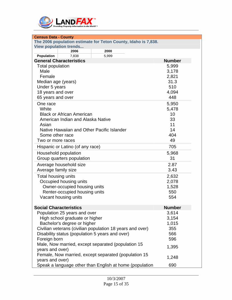
Census Data - County The 2006 population estimate for Teton County, Idaho is 7,838. View population trends...
2006 2000 Population 7,838 5,999
General Characteristics Number Total population 5,999
Male 3,178 Female 2,821
Median age (years) 31.3 Under 5 years 510 18 years and over 4,094 65 years and over 448 One race 5,950
White 5,478 Black or African American 10 American Indian and Alaska Native 33 Asian 11 Native Hawaiian and Other Pacific Islander 14 Some other race 404
Two or more races 49 Hispanic or Latino (of any race) 705 Household population 5,968 Group quarters population 31 Average household size 2.87 Average family size 3.43 Total housing units 2,632
Occupied housing units 2,078 Owner-occupied housing units 1,528 Renter-occupied housing units 550
Vacant housing units 554
Social Characteristics Number Population 25 years and over 3,614
High school graduate or higher 3,154 Bachelor's degree or higher 1,015
Civilian veterans (civilian population 18 years and over) 355 Disability status (population 5 years and over) 566 Foreign born 596 Male, Now married, except separated (population 15 years and over) 1,395
Female, Now married, except separated (population 15 years and over) 1,248
Speak a language other than English at home (population 690
10/3/2007 Page 15 of 35

5 years and over)
Economic Characteristics Number
In labor force (population 16 years and over) 3,132 Mean travel time to work in minutes (workers 16 years and over) 26.9
Median household income in 1999 (dollars) 41,968 Median family income in 1999 (dollars) 45,848 Per capita income in 1999 (dollars) 17,778 Families below poverty level 146 Individuals below poverty level 774
Housing Characteristics Number
Single-family owner-occupied homes 956 Median value (dollars) 133,000
Median of selected monthly owner costs (X) With a mortgage (dollars) 932 Not mortgaged (dollars) 261
Census Summary – County County population in 2005: 7,467 (all rural) County owner-occupied houses and condos: 1,531 Renter-occupied apartments: 547 % of renters here: 26%State: 28%Land area: 450 sq. mi. Water area: 0.2 sq. mi. Population density: 17 people per square mile (low). Residents with income below the poverty level in 1999: This county: 12.9%Whole state: 11.8% Residents with income below the 50% of the poverty level in 1999: This county: 6.4% Whole state: 4.6%
Industries providing employment: Construction (18.2%), Educational,health and social services (16.4%), Arts,entertainment,recreation,accommodation and food services (14.1%), Retail trade (11.5%), Agriculture,forestry,fishing and hunting, and mining (10.2%).
Type of workers:
• Private wage or salary: 71% • Government: 12% • Self-employed, not incorporated: 16% • Unpaid family work: 1%
Races in Teton County, Idaho:
10/3/2007 Page 16 of 35

• White Non-Hispanic (86.8%) • Hispanic (11.8%) • Other race (6.7%) • American Indian (0.9%) • Two or more races (0.8%)
Total labor force in 2004: 4,182 Unemployment rate in 2004: 2.9% Average household size: Teton County: 2.9 peopleIdaho: 2.7 people Estimated median household income in 2005: $46,292 ($41,968 in 2000) This county $46,292 Idaho: $41,443 Estimated median house/condo value in 2005: $175,727 Teton County $175,727Idaho: $134,900 Median montly rent in 2000: $603 Institutionalized population: 6 Median monthly costs for houses with a mortgage in Teton County in 2000: $932
10/3/2007 Page 17 of 35

Crime Crime in 2005 (reported by the sheriff's office or county police, not the county total):
• Murders: 0 • Rapes: 1 • Robberies: 0 • Assaults: 7 • Burglaries: 14 • Thefts: 90 • Auto thefts: 7
Crime in 2004 (reported by the sheriff's office or county police, not the county total):
• Murders: 0 • Rapes: 5 • Robberies: 1 • Assaults: 12 • Burglaries: 27 • Thefts: 87 • Auto thefts: 5
COUNTIES AND COUNTY LAW
CHAPTER 14 FIRE PROTECTION DISTRICT
31-1401. PURPOSE AND POLICY OF LAW -- SHORT TITLE. The protection of property against fire and the preservation of life, and enforcement of any of the fire codes and other rules that are adopted by the state fire marshal pursuant to chapter 2, title 41, Idaho Code, are hereby declared to be a public benefit, use and purpose. Any portion of a county not included in any other fire protection district may be organized into a fire protection district under the provisions of this chapter. All taxable property within any fire protection district created under the provisions of this chapter is and shall be benefited ratably in proportion to assessed valuation by the creation and maintenance of such district, and all taxable property within any such district shall be assessed equally in proportion to its assessed valuation for the purpose of and in accordance with the provisions of this chapter. This chapter shall be known as the "Fire Protection District Law," and whenever cited, enumerated, referred to or amended, may be designated as the "Fire Protection District Law," adding when necessary the code section number.
10/3/2007 Page 18 of 35

Medical Teton County Falls Under This New Code:
TITLE 31 COUNTIES AND COUNTY LAW
CHAPTER 39 AMBULANCE SERVICE
31-3901. AUTHORIZATION TO ESTABLISH AMBULANCE SERVICE -- SPECIAL LEVY. The boards of county commissioners in the several counties are hereby authorized, whenever existing ambulance service is not reasonably available to the inhabitants of the county or any portion thereof, to procure an ambulance and pay for the same out of any funds available and to establish an ambulanceservice to serve the areas, which do not have an existing ambulance servicereasonably available, both within and outside the cities and villages in theirrespective counties, and to levy a special tax not to exceed two hundredthspercent (.02%) of the market value for assessment purposes on all taxableproperty within the county to support the same. Providing ambulance service isa governmental function.
TITLE 27
CEMETERIES AND CREMATORIUMS CHAPTER 1
CEMETERY MAINTENANCE DISTRICT LAW 27-101. PURPOSE AND POLICY OF LAW -- SHORT TITLE. The maintaining, improving and beautifying of cemeteries for the burial of the human dead is hereby declared to be one of the first considerations of a civilized people and a fixed and permanent policy of the state of Idaho, and the same is hereby declared to be a public benefit, use and purpose, and there is hereby imposed upon the cemetery maintenance boards, provided for in this act, the duty of beautifying, improving and maintaining the cemetery or cemeteries within their cemetery maintenance districts. And it is hereby declared and determined that any and all property within any cemetery maintenance district created under the provisions of this act is and shall be benefited ratably with all other property within such district, in proportion to its assessed valuation by the creation of such district and by any and all improvements to the cemetery or
10/3/2007 Page 19 of 35

cemeteries within such district for the maintenance of which such district was created, and that all property within any such district shall be assessed equally in proportion to its assessed valuation for the purpose of cemetery improvement and maintenance under the provisions of this act. This act shall be known as the Cemetery Maintenance District Law of the state of Idaho, and whenever cited, enumerated, referred to or amended, may be designated as the Cemetery Maintenance District Law, adding when necessary, the number of the section. Hospitals/medical centers near Victor:
• TETON VALLEY HOSPITAL AND SURGICENTER (about 9 miles; DRIGGS, ID) • EASTERN IDAHO REGIONAL MED CENTER (about 20 miles; IDAHO FALLS, ID) • ST JOHNS HOSPITAL (about 27 miles; JACKSON, WY)
10/3/2007 Page 20 of 35

Transportation
10/3/2007 Page 21 of 35

TITLE 40 HIGHWAYS AND BRIDGES CHAPTER 6 COUNTY COMMISSIONERS AND HIGHWAY OFFICERS 40-601. DISTRICTS ESTABLISHED BY COMMISSIONERS. Whenever the commissioners of any county shall have caused to be described by an order made and entered upon its records any defined portion of contiguous territory, located wholly within the county, for the construction, improvement or repair of highways pursuant to the provisions of law, each defined portion of contiguous territory is recognized as a legal taxing district and body politic of this state and as a highway district for highway purposes.
10/3/2007 Page 22 of 35

Education
TITLE 33 EDUCATION CHAPTER 27 PUBLIC LIBRARY DISTRICTS 33-2701. PURPOSE AND POLICY. It is hereby declared to be the policy of the state of Idaho, as a part of the provisions for public education, to promote the establishment and development of public library service for all the people of Idaho. By so declaring, the state acknowledges that the ability of its citizens to access information has a critical impact on the
state's educational success, economic development, provision for an informed electorate, and overall quality of life. It is the purpose of this chapter to integrate, extend and add to existing library services and resources so that public library service may be available to all residents of the state from infancy through adulthood, beginning in the formative years and continuing for lifelong learning. Colleges/universities with over 2000 students nearest to Victor:
• RICKS COLLEGE (about 42 miles; REXBURG, ID; Full-time enrollment: 8,670) • IDAHO STATE UNIVERSITY (about 107 miles; POCATELLO, ID; FT enrollment: 10,057) • MONTANA STATE UNIVERSITY-BOZEMAN (about 140 miles; BOZEMAN, MT; FT
enrollment: 10,380) • UTAH STATE UNIVERSITY (about 146 miles; LOGAN, UT; FT enrollment: 16,384) • WEBER STATE UNIVERSITY (about 176 miles; OGDEN, UT; FT enrollment: 12,112) • UNIVERSITY OF UTAH (about 202 miles; SALT LAKE CITY, UT; FT enrollment: 19,866) • SALT LAKE COMMUNITY COLLEGE (about 210 miles; SALT LAKE CITY, UT; FT
enrollment: 11,896)
Public primary/middle school in Victor:
• VICTOR ELEMENTARY SCHOOL (Students: 146; Location: 43 EAST CENTER STREET; Grades: 01 - 05)
Library in Victor:
• VALLEY OF THE TETONS DISTRICT (Operating income: $72,385; Location: 56 N MAIN; 16,799 books; 361 audio materials; 812 video materials; 21 serial subscriptions)
10/3/2007 Page 23 of 35

Wetlands / FEMA FloodPlains
• Wetlands Mapped Onsite. Along East Border and North-East Corner • No Floodways Mapped Onsite Per NWI, DNR, or ID Government
10/3/2007 Page 24 of 35

Protected Lands on or Adjacent To Property
On Site Adjacent Property Forest Conservation: No No School: No No Cemetery: No No DNR Lands: No No Federal, State, or Local: No No Chesapeake Critical Area: No No National Parks: No YES
Surrounds Town On 3 Sides Local or state Parks: No No Natural Heritage Area: No No Rural Legacy Area: No No Agricultural Land Preservation: No No FIDS: No No
SITE
10/3/2007 Page 25 of 35

Different types of birds require different habitats to survive. Some birds are unique to the seashore; some to fields or swamps; while some prefer to live in a city.
The state is home to nineteen birds which are classified as "Forest Interior Dwellers", or FIDs. These birds all have one thing in common; they all require large tracts of relatively undisturbed mature forests to breed successfully.
Most of the FIDs are migratory birds. They spend the spring and summer here and travel south to warmer climates for winter. Many FIDs migrate thousands of miles to South America yet return each year to breed.
Some FID species populations are in decline. FIDS are especially sensitive to disturbance. Each year thousands of acres of forestland are lost to urbanization. The loss of forests means the FIDs must find new breeding grounds.
When FIDs are forced to move into adjacent forests, they are often not adequate in size or have too much "edge". Edge is the area where a forest meets a clearing. The forest edge is home to a number of other birds which may compete with the FIDs for food or even feed upon the FID's eggs.
Forestry practices need not be detrimental to FIDs. Forest can be thinned and harvested in ways that FID habitat is not harmed, and in many cases is actually improved.
Conservation of FID habitat is recommended in the state. Foresters and loggers should abide by the following management recommendations:
• FID breeding grounds are not harmed by thinning out inferior trees or removing select trees of merchantable quality as long as the forest canopy is not removed in excess of 70% crown cover. Some regeneration harvests (areas that cut over completely and left to regenerate naturally) are not detrimental to FIDs either. Regeneration harvests must be conducted on forest tracts that are over one-hundred contiguous acres in size. In addition, these harvests must be kept to the edges of the forest and done in less than 25 acre parcels.
• Many FIDs are cavity nesters and use dead trees, called snags, as homes. When conducting harvests or thinnings, retain as many large snags (ten inches in diameter or greater) as possible.
• The breeding season for FIDs stretches from May 1 - August 31. Forest disturbances should be minimal during the breeding season.
• To limit fragmentation of forests, limit access roads in forest interiors and keep them narrow. Also maintain forested buffers along streams and shoreline so FIDs have protected access to water.
The above recommendations are an excellent example of multiple use forest management. When careful consideration is given to all inhabitants of our forests, we can utilize the resource while maintaining healthy ecosystems.
Protected Lands Around Site Area:
10/3/2007 Page 26 of 35
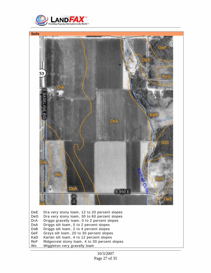
Soils
DeE Dra very stony loam, 12 to 20 percent slopes DeG Dra very stony loam, 30 to 60 percent slopes DrA Driggs gravelly loam, 0 to 2 percent slopes DsA Driggs silt loam, 0 to 2 percent slopes DsB Driggs silt loam, 2 to 4 percent slopes GeF Greys silt loam, 20 to 30 percent slopes KaD Karlan silt loam, 4 to 12 percent slopes RoF Ridgecrest stony loam, 4 to 30 percent slopes Wo Wiggleton very gravelly loam
10/3/2007 Page 27 of 35
DeE—Dra very stony loam, 12 to 20 percent slopes
Map Unit Setting
• Elevation: 6,000 to 7,500 feet • Mean annual precipitation: 16 to 22 inches • Mean annual air temperature: 37 to 41 degrees F • Frost-free period: 60 to 80 days
Map Unit Composition
• Dra and similar soils: 100 percent
Description of Dra
Setting
• Landform: Hillslopes • Down-slope shape: Convex • Across-slope shape: Convex • Parent material: Colluvium over bedrock derived from sandstone
Properties and qualities
• Slope: 12 to 20 percent • Depth to restrictive feature: 20 to 40 inches to lithic bedrock • Drainage class: Well drained • Capacity of the most limiting layer to transmit water (Ksat): Moderately high
(0.20 to 0.60 in/hr) • Depth to water table: More than 80 inches • Frequency of flooding: None • Frequency of ponding: None • Calcium carbonate, maximum content: 35 percent • Available water capacity: Low (about 5.2 inches)
Interpretive groups
• Land capability (nonirrigated): 6s • Ecological site: LOAMY 16-22 ARTRV/PSSP6 16-22" (R013XY005ID)
Typical profile
• 0 to 9 inches: Very stony loam • 9 to 21 inches: Clay loam • 21 to 32 inches: Very stony loam • 32 to 42 inches: Unweathered bedrock
DeG—Dra very stony loam, 30 to 60 percent slopes
10/3/2007 Page 28 of 35

Map Unit Setting
• Elevation: 6,000 to 7,500 feet • Mean annual precipitation: 16 to 22 inches • Mean annual air temperature: 37 to 41 degrees F • Frost-free period: 60 to 80 days
Map Unit Composition
• Dra and similar soils: 100 percent
Description of Dra
Setting
• Landform: Hillslopes • Down-slope shape: Convex • Across-slope shape: Convex • Parent material: Colluvium over bedrock derived from sandstone
Properties and qualities
• Slope: 30 to 60 percent • Depth to restrictive feature: 20 to 40 inches to lithic bedrock • Drainage class: Well drained • Capacity of the most limiting layer to transmit water (Ksat): Moderately high
(0.20 to 0.60 in/hr) • Depth to water table: More than 80 inches • Frequency of flooding: None • Frequency of ponding: None • Calcium carbonate, maximum content: 35 percent • Available water capacity: Low (about 5.2 inches)
Interpretive groups
• Land capability (nonirrigated): 7s • Ecological site: STEEP SLOPE 16-22 ARTRV/PSSP6 (R013XY003ID)
Typical profile
• 0 to 9 inches: Very stony loam • 9 to 21 inches: Clay loam • 21 to 32 inches: Very stony loam • 32 to 42 inches: Unweathered bedrock
DrA—Driggs gravelly loam, 0 to 2 percent slopes
Map Unit Setting
• Elevation: 5,800 to 6,800 feet
10/3/2007 Page 29 of 35

• Mean annual precipitation: 13 to 18 inches • Mean annual air temperature: 37 to 39 degrees F • Frost-free period: 55 to 85 days
Map Unit Composition
• Driggs and similar soils: 100 percent
Description of Driggs
Setting
• Landform: Fan remnants • Down-slope shape: Linear • Across-slope shape: Linear • Parent material: Mixed alluvium
Properties and qualities
• Slope: 0 to 2 percent • Depth to restrictive feature: 20 to 40 inches to strongly contrasting textural
stratification • Drainage class: Well drained • Capacity of the most limiting layer to transmit water (Ksat): Moderately high
to high (0.57 to 2.00 in/hr) • Depth to water table: More than 80 inches • Frequency of flooding: None • Frequency of ponding: None • Calcium carbonate, maximum content: 10 percent • Available water capacity: Low (about 4.5 inches)
Interpretive groups
• Land capability classification (irrigated): 4s • Land capability (nonirrigated): 6s • Ecological site: GRAVELLY LOAM 16-22 ARTRV/PSSP6 (R013XY007ID)
Typical profile
• 0 to 8 inches: Gravelly loam • 8 to 25 inches: Silt loam • 25 to 60 inches: Stratified cobbly coarse sand to extremely gravelly coarse
sandy loam
DsB—Driggs silt loam, 2 to 4 percent slopes
Map Unit Setting
• Elevation: 5,800 to 6,800 feet • Mean annual precipitation: 13 to 18 inches
10/3/2007 Page 30 of 35

• Mean annual air temperature: 37 to 39 degrees F • Frost-free period: 55 to 85 days
Map Unit Composition
• Driggs and similar soils: 100 percent
Description of Driggs
Setting
• Landform: Drainageways • Down-slope shape: Linear • Across-slope shape: Linear • Parent material: Mixed alluvium
Properties and qualities
• Slope: 2 to 4 percent • Depth to restrictive feature: 20 to 40 inches to strongly contrasting textural
stratification • Drainage class: Well drained • Capacity of the most limiting layer to transmit water (Ksat): Moderately high
to high (0.57 to 2.00 in/hr) • Depth to water table: More than 80 inches • Frequency of flooding: None • Frequency of ponding: None • Calcium carbonate, maximum content: 10 percent • Available water capacity: Low (about 4.5 inches)
Interpretive groups
• Land capability classification (irrigated): 3e • Land capability (nonirrigated): 4s • Ecological site: LOAMY 13-16 ARTRV/PSSP6 (R013XY001ID)
Typical profile
• 0 to 8 inches: Silt loam • 8 to 25 inches: Silt loam • 25 to 60 inches: Stratified cobbly coarse sand to extremely gravelly coarse
sandy loam
GeF—Greys silt loam, 20 to 30 percent slopes
Map Unit Setting
• Elevation: 5,500 to 7,000 feet • Mean annual precipitation: 16 to 22 inches • Mean annual air temperature: 36 to 39 degrees F
10/3/2007 Page 31 of 35
• Frost-free period: 50 to 70 days
Map Unit Composition
• Greys and similar soils: 100 percent
Description of Greys
Setting
• Landform: Mountain slopes • Down-slope shape: Concave • Across-slope shape: Linear • Parent material: Loess
Properties and qualities
• Slope: 20 to 30 percent • Depth to restrictive feature: More than 80 inches • Drainage class: Well drained • Capacity of the most limiting layer to transmit water (Ksat): Moderately high
(0.20 to 0.60 in/hr) • Depth to water table: More than 80 inches • Frequency of flooding: None • Frequency of ponding: None • Calcium carbonate, maximum content: 10 percent • Available water capacity: Very high (about 12.5 inches)
Interpretive groups
• Land capability (nonirrigated): 6e • Ecological site: MOIST MOUNTAIN LOAM 20+ POTR5 (R013XY016ID)
Typical profile
• 0 to 2 inches: Moderately decomposed plant material • 2 to 19 inches: Silt loam • 19 to 58 inches: Silt loam • 58 to 62 inches: Silt loam
KaD—Karlan silt loam, 4 to 12 percent slopes
Map Unit Setting
• Elevation: 5,500 to 7,000 feet • Mean annual precipitation: 15 to 18 inches • Mean annual air temperature: 36 to 41 degrees F • Frost-free period: 50 to 80 days
10/3/2007 Page 32 of 35

Map Unit Composition
• Karlan and similar soils: 100 percent
Description of Karlan
Setting
• Landform: Mountain slopes • Down-slope shape: Linear • Across-slope shape: Linear • Parent material: Loess over bedrock derived from rhyolite
Properties and qualities
• Slope: 4 to 12 percent • Depth to restrictive feature: 20 to 40 inches to lithic bedrock • Drainage class: Well drained • Capacity of the most limiting layer to transmit water (Ksat): Moderately high
to high (0.57 to 2.00 in/hr) • Depth to water table: More than 80 inches • Frequency of flooding: None • Frequency of ponding: None • Calcium carbonate, maximum content: 10 percent • Available water capacity: Low (about 5.6 inches)
Interpretive groups
• Land capability (nonirrigated): 4e • Ecological site: LOAMY 16-22 ARTRV/FEID (R013XY023ID)
Typical profile
• 0 to 8 inches: Silt loam • 8 to 18 inches: Silt loam • 18 to 26 inches: Gravelly silt loam • 26 to 32 inches: Extremely stony loam • 32 to 42 inches: Unweathered bedrock
RoF—Ridgecrest stony loam, 4 to 30 percent slopes
Map Unit Setting
• Elevation: 4,500 to 7,000 feet • Mean annual precipitation: 12 to 18 inches • Mean annual air temperature: 41 to 46 degrees F • Frost-free period: 50 to 100 days
Map Unit Composition
10/3/2007 Page 33 of 35

• Ridgecrest and similar soils: 100 percent
Description of Ridgecrest
Setting
• Landform: Mountain slopes • Down-slope shape: Linear • Across-slope shape: Linear • Parent material: Mixed alluvium and/or colluvium over bedrock derived from
limestone
Properties and qualities
• Slope: 4 to 30 percent • Depth to restrictive feature: 20 to 40 inches to lithic bedrock • Drainage class: Well drained • Capacity of the most limiting layer to transmit water (Ksat): Moderately high
to high (0.57 to 2.00 in/hr) • Depth to water table: More than 80 inches • Frequency of flooding: None • Frequency of ponding: None • Calcium carbonate, maximum content: 70 percent • Maximum salinity: Nonsaline (0.0 to 2.0 mmhos/cm) • Available water capacity: Low (about 3.2 inches)
Interpretive groups
• Land capability (nonirrigated): 7e • Ecological site: LOAMY 13-16 ARTRV/PSSP6 (R013XY001ID)
Typical profile
• 0 to 13 inches: Stony loam • 13 to 37 inches: Very cobbly loam • 37 to 47 inches: Unweathered bedrock
Wo—Wiggleton very gravelly loam
Map Unit Setting
• Elevation: 5,000 to 7,500 feet • Mean annual precipitation: 13 to 20 inches • Mean annual air temperature: 39 to 45 degrees F • Frost-free period: 50 to 85 days
Map Unit Composition
• Wiggleton and similar soils: 100 percent
10/3/2007 Page 34 of 35

Description of Wiggleton
Setting
• Landform: Fan remnants • Down-slope shape: Linear • Across-slope shape: Linear • Parent material: Mixed alluvium
Properties and qualities
• Slope: 0 to 4 percent • Depth to restrictive feature: 10 to 36 inches to strongly contrasting textural
stratification • Drainage class: Somewhat excessively drained • Capacity of the most limiting layer to transmit water (Ksat): Moderately high
to high (0.57 to 2.00 in/hr) • Depth to water table: More than 80 inches • Frequency of flooding: None • Frequency of ponding: None • Calcium carbonate, maximum content: 10 percent • Maximum salinity: Nonsaline (0.0 to 2.0 mmhos/cm) • Sodium adsorption ratio, maximum: 5.0 • Available water capacity: Very low (about 1.4 inches)
Interpretive groups
• Land capability classification (irrigated): 4s • Land capability (nonirrigated): 6s • Ecological site: RIVERBOTTOM 10-18 POAN3/LECI4 (R013XY049ID)
Typical profile
• 0 to 7 inches: Gravelly loam • 7 to 14 inches: Very gravelly loam • 14 to 60 inches: Error
Public Utilities: Water: Sewer:
No No
Private Utilities Information Pending From The Health Department Deed (See attached for a Copy of the Deed) Deed Book and Page: None On File Plat (See attached for a Copy of the Plat) Plat Book and Page: None On File
10/3/2007 Page 35 of 35