Embed Size (px)
Citation preview

Page 1 of 5
FARIBAULT PLANNING COMMISSION JUNE 21, 2021 PUBLIC HEARING
Case Number and Request: CUP 21-023 Application for a Conditional Use Permit (CUP) to establish a self-service outdoor storage facility at 1612 7th Street NW in the I-2 Heavy Industrial District and Shoreland Protection Overlay District.
Applicant / Owners: Leon Endres, Partner/Applicant; Energy Technology Limited of Minnesota LLC owners.
Site Address: 1612 7th Street NW
Recommendation: Approve the Requested CUP for Shoreland District Development of a new outdoor self-storage facility at 1612 7th Street NW
Deadline for Council Action: July 13, 2021 unless extended by the City
From: Peter J. Waldock, AICP, Planning Coordinator
SUMMARY OF REQUEST
On May 13th, the City received an application for a Conditional Use Permit for
Shoreland District Development and a site plan review for construction of site
improvements for a new outdoor self-storage lot at the Former Land-O’Lakes
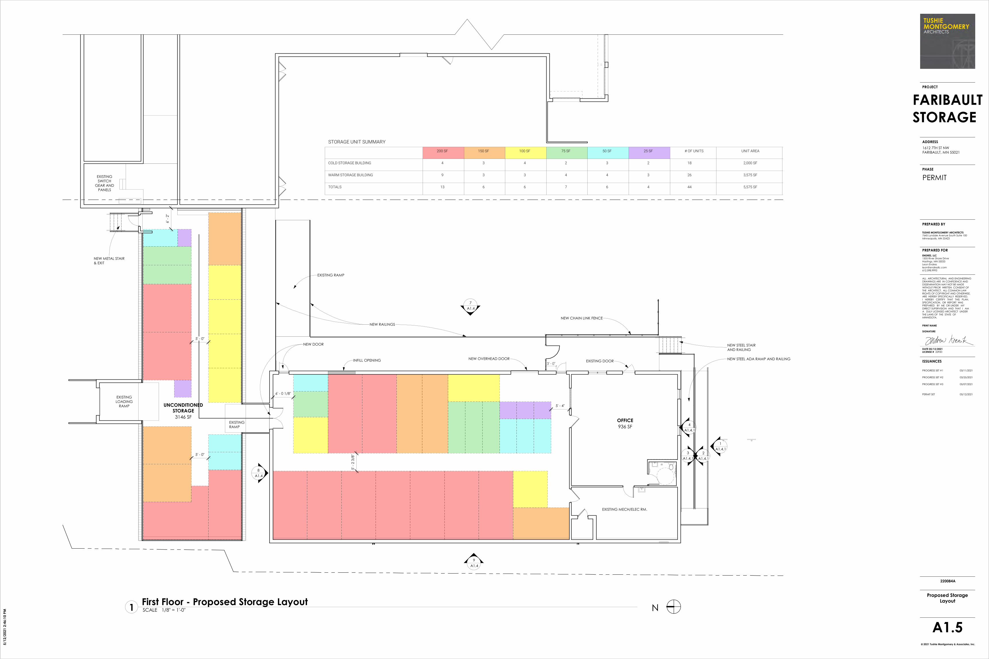
plant at 1612 7th Street NW. The proposal also includes about 7,500 SF
heated interior self-storage area and 1,082 SF of office space in the west
building (outside of the Shoreland District Boundary).
The owners plan to remove paved areas within the 7th Street NW right of way
and a paved area at the southeast corner of the site within the floodplain. New
pavement will be installed in the north portion of the site over an area
currently gravel surfaced. The maximum impervious surface coverage in the
Shoreland area will not exceed the 70% limit specified by the UDO. The
easterly buildings will remain warehouse and office as currently used.
A 6’ tall chain link fence with privacy slats are planned for the area between the buildings for 10 exterior self-storage spaces. The fence will have an angled
barbed wire deterrent top. The eastern portion of the site will have 60 outdoor self-service storage spaces on pavement. That area will be fenced as well.
New lighting will be LED fixtures downcast to reduce glare off site. They are planning security cameras to monitor the site. Hours of operation are between

Page 2 of 5
6 AM and 10 PM with card code access to the storage areas. They plan to operate on an appointment basis for new customers, and will not have full-
time staff on site.
DISCUSSION OF THE PROPOSAL
Zoning. Current zoning is I-2 Heavy Industrial District. The proposed uses are
permitted in this district. The DNR has no objections to this application. The
DNR Area Hydrologist recommends rain garden filtering areas where possible
for stormwater runoff. The application appears to meet UDO requirements in
this case.
Setbacks. The plan removes pavement placed in the required 10’ front
parking setback area along 7th Street as requested by the DRC. The disturbed
area will be restored with grass ground cover (sod within the street right of
way as required). No variances are required in this case.
Parking. The parking layout has been follows UDO requirements of 20’ by 9’
stall sizes when adjoining the sidewalk east of the building and adjoining the
fence on the east where required.
ADA Accessibility. The existing building does not appear to meet the ADA
accessibility for the current office entrance on the east wall of the east building
This is an existing condition without proposed changes to the occupants or use
of this portion of the site. The applicants are not required to improve this
access to meet current accessibility standards at this location until such time
as the use of this building change.
Security and Safety. The plans call for a six-foot-tall chain-link fence with
screening slats and an angled deterrent as recommended by the Police
Department in this case. The plan includes barbed wire on angled deterent.
Security cameras are planned to cover the entrance gate and corners of the
storage area. The site will be lit with security lights. Front fence, facing 7th
Street can be built to 8’ tall without the angled barbed wire deterrent planned
for the rest of the site.
Emergency Access. The Fire Department has requested that a Knox box (or
similar devise) for emergency access into the gated area be provided in case
of emergency. They have also asked that access to the rear of the building be
address with this development plan.

Page 3 of 5
Applicable Code Sections:
Chapter 2, Article 7, Faribault Unified Development Ordinance, Section 2-270
Application for Conditional Use Permit
Chapter 2, Article 7, Faribault Unified Development Ordinance, Section 2-280
and 2-290 regarding Approval Process and Authority.
Chapter 2, Article 7, Faribault Unified Development Ordinance, Section 2-300
Required Findings for Conditional Use Permits
Chapter 2, Article 7, Faribault Unified Development Ordinance, Section 2-310
regarding Conditions of Approval
DEVELOPMENT REVIEW COMMITTEE
The Development Review Committee (DRC) discussed the site plan and
variance proposal on June 8, 2021. The DRC supports the application with
some conditions to decrease non-conforming aspects of the site, for security
and emergency access.
The DRC recommends approval of the variances with following comments
and observations:
1. The DRC finds that the application generally meets all requirements of
the Unified Development Ordinance and will provide a reduction in hard
surface coverage overall in the Shoreland area.
2. The proposal provides better stormwater filtration than current
conditions at the site.
3. The Police Department recommends an angled deterrent above the 6’
tall chain-link fencing and security cameras.
4. Screening slats are recommended for security reasons and are allowed
by ordinance.
5. Rain Garden type filtration is recommended by the DNR Regional
Hydrologist for this site.
6. Access gates north of the buildings are needed for Fire Department
equipment and personnel.
7. A Knox Box is needed at the front gate for emergency access.
8. Parking stalls on the east lot should be striped per ordinance.
9. The paved area in the 7th Street right of way south of the main building,
should be removed and restored with grass.
10. Gravel north of the building in the setback area should be removed
and restored with grass.

Page 4 of 5
REQUIRED FINDINGS
Section 2-300 of the UDO includes eleven required findings as a prerequisite
for approval of conditional use permits. The draft resolution prepared by staff and provided with this report includes detailed findings specific to this
application recommended by staff to address all of the required findings of
the ordinance. No additional findings have been provided.
RECOMMENDED CONDITIONS FOR APPROVAL
Section 2-310 of the UDO authorizes the City Council to establish reasonable
conditions of approval to reduce or minimize the effect of such variance upon other properties in the neighborhood. The proposed conditions of
approval for the outdoor dining enclosure are as follows:
1. Construction and Design shall result in the minimum necessary new
impervious surface coverage at the site and shall not exceed 70%
coverage within the Shoreland Overlay District boundary area.
2. Stormwater Management for this project shall be as determined by the
City Engineer in accordance with City Ordinances.
3. Security cameras shall be provided in accordance with letter dated June
15, 2021 from Tushie Montgomery Architects.
4. Knox Box other similar device approved by the Fire Chief, shall be
provided for emergency access into the gated area and rear of the
building.
5. The sidewalk in 7th Street right of way is not needed by the City and
should removed and restored with sod.
6. The pavement north of the street right of in the east parking lot shall be removed and area restored with grass or ground cover to establish the
required 10’ parking lot setback from the street.
7. An accessible entrance to the main building from the east parking lot
must be provided upon any future change of use within this building that meets the Americans with Disability Act (ADA) requirements as
consistent with State Laws.
8. An emergency pass through gate at the north shall be required.
9. Gravel surface west of the north gate, within the required rear setback
area of 5’ from the north property line shall be removed and restored
grass.
10. The gravel surface south of the trail on Faribault Economic Development Authority property adjacent and north of the subject site, shall be
removed and restored with grass.

Page 5 of 5
RECOMMENDATION
Staff recommends approval of the requested CUP to establish an outdoor
self-storage use at 1612 7th Street NW.
ATTACHMENTS 1. Draft Resolution for Approval Requested Variance
2. Aerials, Location and Zoning Maps
3. Site Plans

State of Minnesota County of Rice
CITY OF FARIBAULT
RESOLUTION #2021-137 APPROVE CONDITIONAL USE PERMITS TO ESTABLISH A SELF-SERVICE OUTDOOR STORAGE FACILITY AT 1612 7TH STREET
NW IN THE SHORELAND PROTECTION DISTRICT.
WHEREAS, The Leon Endres, applicant and partner in the ownership group, on behalf of Energy Technology Limited of Minnesota LLC, owner, have requested a conditional use permit to establish a self-service storage facility in the Shoreland Overlay District at 1612 7th Street NW, legally described in Exhibit A attached hereto; and
WHEREAS, City Staff has completed a review of the application and made a report to the Planning Commission pertaining to said request (CUP 40-19), a copy of which has been presented to the City Council; and
WHEREAS, the Planning Commission, on the 21st day of June, 2021, following proper notice, held a public hearing regarding the request, and following said public hearing made findings and recommended that the City Council approve the request; and
WHEREAS, following said public hearing, the Planning Commission recommended approval of the requested conditional use permit based on the following findings as required by Section 2-300 of the City of Faribault, Unified Development Ordinance as follows:
1. The conditional use will not be detrimental to or endanger thepublic health, safety, comfort, convenience, or general welfare.The proposed self-storage use at the former Land O’Lakes facility site asproposed, brings a needed use to an underutilized site adding value toarea.
2. The conditional use will not be injurious to the use and enjoymentof other property in the vicinity and will not impede the normaland orderly development and improvement of surroundingproperty for uses permitted in the district.The proposed improvements will help clean up an underutilized industrialsite near Crocker’s Creek that will be compatible with surrounding propertyand an improvement over past uses at the site.

Resolution 2021-137 Page 2 of 6
3. The conditional use will be designed, constructed, operated, and
maintained in a manner that is compatible in appearance with the existing or intended character of the surrounding area.
The development is designed to be compatible with surrounding and nearby uses and will provide stormwater filtration and reduction of hard surface area in flood way of the creek.
4. The conditional use will not impose hazards or disturbing influences on neighboring properties.
The proposal will increase stormwater filtration by reducing hard surface area and providing a new planted filtration area near the create.
5. The conditional use will not substantially diminish the value of neighboring properties.
The new use proposed at this site will not be a detriment to property values in the area.
6. The site is served adequately by essential public facilities and services, including utilities, access roads, drainage, police and fire protection, and schools or will be served adequately as a result of improvements proposed as part of the conditional use.
The site has adequate capacity for public utilities, street capacity and access. There is sufficient police and fire protection levels in place for this use and it will not generate a need for further City services, or additional schools.
7. Development and operation of the conditional use will not create excessive additional requirements at public cost for facilities and services and will not be detrimental to the economic welfare of the community.
There are sufficient public facilities in place for this use and it will not generate a need for further City services. The proposed use will benefit the economic welfare of the community.
8. Adequate measures have been or will be taken to minimize traffic congestion in the public streets and to provide for adequate on-site circulation of traffic.
There is adequate onsite traffic circulation provided in this design.
9. The conditional use will not result in the destruction, loss, or damage of a natural, scenic, or historic feature of major importance to the community.
The redevelopment of this site will not result in damage or destruction of natural or historic features.

Resolution 2021-137 Page 3 of 6
10. The conditional use is consistent with the applicable policies and
recommendations of the city's Land Use Plan or other adopted land use studies.
The project is designed to meet current land use policies and plans.
11. The conditional use, in all other respects, conforms to the applicable regulations of the district in which it is located. The project conforms to applicable regulations of the district and applicable requirements for approval within the ordinance.
WHEREAS, the City Council, on the 13th day of July, 2021, at a public meeting considered the request; and
WHEREAS, the City Council concurs with all of the determinations and findings of the Planning Commission as stated in the above recitals and hereby makes the identical determinations and findings.
NOW, THEREFORE BE IT RESOLVED BY THE CITY COUNCIL OF THE CITY FARIBAULT, MINNESOTA AS FOLLOWS:
Section 1: Incorporation of Recitals and Exhibits. The recitals set forth in this Resolution and the Exhibits attached hereto are incorporated into and made a part of this Resolution.
Section 2: Approval of a Conditional Use Permits. As authorized in Section 2-290 of the City of Faribault Unified Development Ordinance and in accordance with the required findings listed in Section 2-300 of the City of Faribault, Unified Development Ordinance, as stated in the recitals above, a conditional use permit for establishment of an outdoor self-storage facility in the Shoreland Protection Overlay District at the subject property located at 1612 7th Street NW in accordance with plans attached as Exhibit B (site plan) as approved by the City Council.
Section 3: Conditions of Approval. As authorized in Section 2-310 of the City of Faribault, Unified Development Ordinance, the following conditions of approval are deemed necessary by the City Council to mitigate adverse impacts associated with the conditional use, to protect neighboring properties, and to achieve the objectives identified in City ordinances are as follows: 1. Construction and Design shall result in the minimum necessary new
impervious surface coverage at the site and shall not exceed 70% coverage within the Shoreland Overlay District boundary area.
2. Stormwater Management for this project shall be as determined by the City Engineer in accordance with City Ordinances.
3. Security cameras shall be provided in accordance with letter dated June

Resolution 2021-137 Page 4 of 6
15, 2021 from Tushie Montgomery Architects.
4. Knox Box other similar device approved by the Fire Chief, shall be provided for emergency access into the gated area and rear of the building.
5. The sidewalk in 7th Street right of way is not needed by the City and should removed and restored with sod.
6. The pavement north of the street right of in the east parking lot shall be removed and area restored with grass or ground cover to establish the required 10’ parking lot setback from the street.
7. An accessible entrance to the main building from the east parking lot must be provided upon any future change of use within this building that meets the Americans with Disability Act (ADA) requirements as consistent with State Laws.
8. An emergency pass through gate at the north shall be required.
9. Gravel surface west of the north gate, within the required rear setback area of 5’ from the north property line shall be removed and restored grass.
10. The gravel surface south of the trail on Faribault Economic Development Authority property adjacent and north of the subject site, shall be removed and restored with grass.
11. The City Administrator is authorized to approve plan revisions to carry out the intent of this resolution.
Section 4: This resolution shall become effective immediately upon its
passage and without publication.
Date Adopted: July 13, 2021
Faribault City Council
_______________________ Kevin R. Voracek, Mayor
ATTEST:
_______________________________ Timothy C. Murray, City Administrator

Resolution 2021-137 Page 5 of 6
Exhibit A
Legal Description

Resolution 2021-137 Page 6 of 6
Exhibit B Site Plan

Memorandum
TO: Peter Waldock, Planning Coordinator
FROM: Mark DuChene, City Engineer
DATE: June 2, 2021
SUBJECT: Faribault Storage 1612 7th Street NW – Site Plan Review
Leon Endres has submitted a conditional use permit application and site plan for the conversion of a portion of the old Land O’Lakes site at 1612 7th Street NW to outdoor and indoor storage. Plans were received from Tushie Montgomery dated 5/12/2021. The following are the Engineering Department’s review comments.
Site Plan Comments:
• The sidewalk between the two driveways to remain could be considered for removalcompletely as it doesn’t tie into any other public walk and would allow more greenspace between the existing buildings and the roadway and increase the chances ofthe proposed sod to survive.
• Pavement should be removed and the proper parking setbacks met on the parkingarea on the east side of the existing building and gravel on the north side of the buildingas shown on the attached.
• Parking stalls on the east side should be 20-ft deep as they don’t meet the overhangrequirements for 18-ft depth. There is room to narrow up the 2-way access aisle tomeet code.
• It appears the entrance to the building on the east side of the larger existing buildingis not ADA compliant. This should be reviewed.

• CitYot.Faribault
APPLICATION FOR REQUESTED ACTION Conditional Use Permit
Planning Case# __' Filing Fee __ Hearing Date __
SITE ADDRESS llot2.. 7+.b�. NW
APPLICANT �N �s E-MAIL leoneeror't!�l\e,. c.oM
PHONE _____ (H) (pl.2,- ?'18-tttfq? (W) ______ (FAX)
ADDREss l':x2'3 B.1Ve( �re Pr-l\/e , -ltl.�»3':11
MtJ 550�3
DEVELOPER(if other than applicant) _______________ _
PHONE ______ (H) _______ (W) _______ (FAX)
ADDRESS -----------------------LEGAL DESCRIPTION See o.�a&ie.tl
ACREAGE1sIzE oF PROPERTY 4. 041 ttcre? / l 1(p, 28 g �
CURRENT ZONING I - 2. --��------------,..--------we 'n e,1A1: \14£4ri't - �{'t,�� t o{:fl u. '4;(
EXISTING USE OF PROPERTY EA� � �ft¥l( � O[Aa. iASt.L'Jt--=k � � self - t. 1.01r+• t "�" �'(.
PROPOSED USE OF PROPERTY &l 0 : t ♦ St. - No C (Including number of units per acre an types o uses if mixed use)
IDENTIFY ALL ADJACENT LAND USES Ir-Ju� -¾,, No(-ffi1 ��4( -Ir, Wtst, Gi11tmut�, 1d � lV'A� . d-entlA\ -to �
SIGNATURE OF APPLICANl��������---DATE ¾�, (Must submit proof of propert
SIGNATURE OF PROPERTY OWNER _________ DATE ___ _ {If other than applicant)
PLEASE PROVIDE ALL INFORMATION REQUESTED ON THIS FORM
AND THE ATTACHED CHECKLIST.
Updated August 23. 2016
Filed5/13/2021

♦ Site plan
CONDITIONAL USE PERMIT Required Submitta/s
)!. Drawn to scale, with scale noted� Date and North arrow� Boundaries and dimensions shown graphically;sr, Location of any streets, public trails, railroads, or waterways � Present and proposed topography of the site and adjacent areas within 50 feet by
contour lines at an interval of not more than 5 feet, and by use of directional arrows, theproposed flow of storm water runoff from the siteLocation of existing and proposed structures (height and gross floor area noted), withdistance from property lines noted
� Location and dimensions of existing and proposed off-street parking and loading spaces,curb cuts, aisles, and walkways, with distance from property lines notedLocation, height, and material for screening walls and fences
� Type of surfacing and base course proposed for all parking area, loading areas, andwalkways
� Location of all existing and proposed water lines, hydrants, sanitary sewer lines andstorm drainage systems
� Existing and proposed public streets or rights-of-way, easements, or other reservationsof land on the site
� Location and method of screening of outdoor trash storage areas,o Location and size of all proposed signage � Location and height of proposed lighting facilities A Elevation views of all proposed buildings or structures, with building materials and
proposed colors noted )Q Indicate the ultimate development of the site and proposed development phases when a
site is to be developed in stages ,'4 Landscaping plan
♦ Required supplemental information
)t Describe the project in detail (Include: Size of all structures existing and proposed andany modifications to existing, type of business and associated storage/display, type of clientele, hours of operation, number of employees, number of customer seats if foodservice related, handling of deliveries, unique site characteristics, proposedmodifications to topography and/or drainage, development schedule, etc.)
.a_ Written summary explaining how the proposed use is compatible with the neighborhood� Written summary explaining If and how the proposed development will impact traffic
� Written statement as to why you feel the conditional use permit should be approved
� Other information as required
♦ Filing fee
SIGNATURE OF APPLICANT�✓� DATE s/4/4; ' ;
Planning case# ____ _

1612 7th Street NW
Faribault, MN 55021
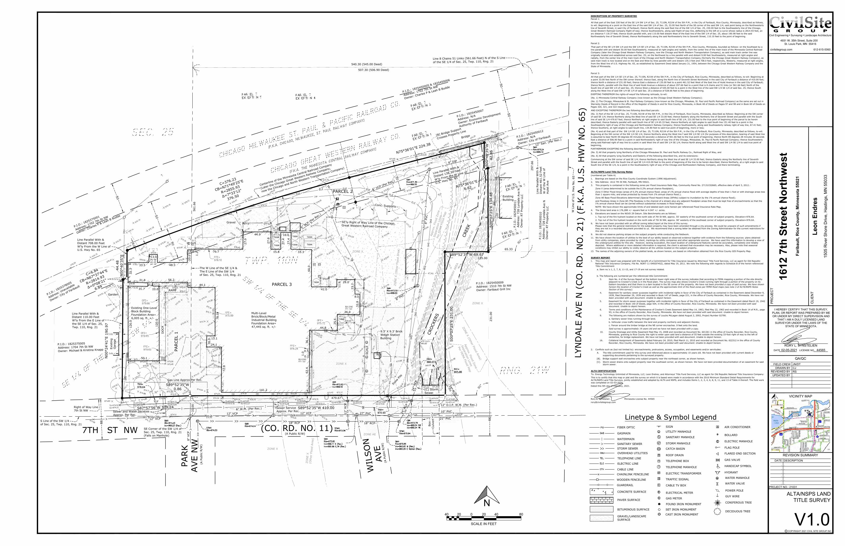
LEGAL DESCRIPTION
Refer to attached Site Survey
DESCRIPTION OF PROPERTY SURVEYED
Parcel 1:
All that part of the East 330 feet of the SE 1/4 SW 1/4 of Sec. 25, THON, R21W of the 5th P.M., in the City of Faribault, Rice County, Minnesota, described as follows,
to wit: Beginning at a point on the East line of the said SW 1/4 of Sec. 25, 33.00 feet North of the SE corner of the said SW 1/4, said point being on the Northwesterly line of Seventh Street, in said City of Faribault; thence North along the said East line of the SW 1/4 of Sec. 25, 230.00 feet to the Southeasterly line of the Chicago,
Great Western Railroad Company Right-of-way; thence Southwesterly, along said Right-of-way line, deflecting to the left on a curve whose radius is 2814.93 feet, an arc distance f 118.37 feet; thence South parallel with, and 110.00 feet distant West of the East line of the SW 1/4 of Sec. 25, about 190.98 feet to the said
Northwesterly line of Seventh Street; thence Northeasterly along the said Northwesterly line to Seventh Street, 110.10 feet to the point of beginning.
Parcel 2:
That part of the SE 1/4 SW 1/4 and the SW 1/4 SE 1/4 of Sec. 25, T110N, R21W of the 5th P.M., Rice County, Minnesota, bounded as follows: on the Southeast by a line parallel with and distant 50.00 feet Southeasterly, measured at right angles and radially, from the center line of the main track of the Minnesota Central Railroad Company (later the Chicago Great Western Railway Company, now the Chicago and North Western Transportation Company), as said main track center line was originally located and established across said Sec. 25; on the Northwest by a line parallel with and distant 9.00 feet Southeasterly, measured at right angles and radially, from the center line of the main track of the Chicago and North Western Transportation Company (formerly the Chicago Great Western Railway Company), as
said main track is now located and on the East and West by lines parallel with and distant 135.3 feet and 708.0 feet, respectively, Westerly, measured at right angles, from the West line of U.S. Highway No. 65, as established by Easement Deed dated January 21, 1954, between the Chicago Great Western Railway Company and the
State of Minnesota.
Parcel 3:
All that part of the SW 1/4 SE 1/4 of Sec, 25, T110N, R21W of the 5th P.M., in the City of Faribault, Rice County, Minnesota, described as follows, to-wit: Beginning at
a point 33.00 feet North of the SW corner thereof; thence East, along the North line of Seventh Street Northwest in the said City of Faribault a distance of 410.00 feet; thence North a distance of 231.00 feet; thence East a distance of 135.00 feet to a point 461.52 feet West of the East line of Hulet Avenue in the said City of Faribault; thence North, parallel with the West line of said Hulet Avenue a distance of about 297.66 f<Jet to a point that is 8 chains and 51 links (or 561.66 feet) North of the
South line of said SW 1/4 of said Sec. 25; thence West a distance of 545.00 feet to a point in the West line of the said SW 1/4 SE 1/4 of said Sec. 25; thence South along the West line of said SW 1/4 SE 1/4 of said Sec. 25 a distance of 528.66 feet to the place of beginning.
EXEPTING THEREFROM the rights-of-wayof the following railroads, to-wit:
(No. 1) Minnesota Central Railway Company (now known as the Chicago Great Western Railway Company);
(No. 2) The Chicago, Milwaukee & St. Paul Railway Company (now known as the Chicago, Milwakee, St. Paul and Pacific Railroad Company) as the same are set out in
Warranty Deeds of Record in the office of the Register of Deeds in and for Rice County, Minnesota, in Book 48 of Deeds on Pages 97 and 98 and in Book 69 of Deeds on Pages 320, 321, and 322 respectively.
AND EXCEPTING THEREFROM the two following described parcels:
(No. 3) Part of the SE 1/4 of Sec. 25, T110N, R21 W of the 5th P.M., in the City of Faribault, Rice County, Minnesota, described as follows: Beginning at the SW corner
of said SE 1/4; thence Northerly along the West line of said SE 1/4 33.00 feet; thence Easterly along the Northerly line of Seventh Street and parallel with the South
line of said SE 1/4 479.67 feet; thence Northerly at right angles to said South line of SE 1/4, 231.00 feet to the true point of beginning of the parcel to be herein described; thence Easterly parallel with said South line of SE 1/4 65.33 feet; thence Northerly at right angles to said South line 151.40 feet to a point in the Southeasterly right of way of the Chicago and Northwestern Railway Company; thence Southwesterly, along said Southeasterly railway right of way line, 67.41 feet;
thence Southerly, at right angles to said South line, 134.80 feet to said true point of beginning, more or less;
(No. 4) and all that part of the SW 1/4 SE 1/4 of Sec. 25, THON, R21W of the 5th P.M., in the City of Faribault, Rice County, Minnesota, described as follows, to-wit: Beginning at the SW corner of the SW 1/4 SE 1/4; thence Northerly along the West line f said SW 1/4 SE 1/4 (for purposes of this description, bearing of said West line
is assumed to bear North 00 degrees 00 minutes 00 seconds) a distance of 561.66 feet to the true point of beginning; thence North 89 degrees 28 minutes 30 seconds
East a distance of 506.90 feet to a point in said Northwesterly right of way line of the Chicago, Milwaukee, St. Paul & Pacific Railroad Company; thence Southwesterly
along said Railroad right of way line to a point in said West line of said SW 1/4 SE 1/4; thence North along said West line of said SW 1/4 SE 1/4 to said true point of beginning,
FURTHERMORE EXCEPTING the following described parcels:
(No. 5) All that property lying Northerly of the Chicago Milwaukee St. Paul and Pacific Railway Co., Railroad Right of Way, and
(No. 6) All that property lying Southerly and Easterly of the following described line, and its extensions:
Commencing at the SW corner of said SE 1/4; thence Northerly along the West line of said SE 1/4 33.00 feet; thence Easterly along the Northerly line of Seventh Street and parallel with the South line of said SE 1/4 410.00 feet to the point of beginning of the line to be herein described; thence Northerly, at a right angle to said
South line of the SE 1/4, to a point In the Southeasterly right of way of the Chicago and Northwestern Railway Company, and there terminating.

1612 7th Street NW
Faribault, MN 55021
PROJECT DESCRIPTION
The proposed scope of work at 1612 7th Street NW consists of modifying the interior of two existing
westerly buildings for 7,487 sf of self-storage space and 1,082 sf of office space. Exterior building
improvements consist of painting, door replacement, new accessibility, and dedicated parking areas
including accessible parking spaces. The existing metal panels at the easterly building shall also be
painted. Site improvements shall remove paved areas within the right-of way and at the southeast
corner of the site withing the Shoreland Overlay District and remove one curb cut access. New
bituminous shall be provided at the north for a maximum hard surface coverage within the 70%
allowance. The easterly buildings shall remain as warehouse and office use with its current tenant with
no change in use.
The area between buildings shall be fenced in with a new 6' tall chain link fence with privacy slats to
allow for (10) exterior self-storage spaces. The easterly portion of the property shall also be fenced in to
accommodate (60) exterior self-storage spaces. All spaces shall be on a paved surface. The fencing shall
be located at the edge of paved areas to prevent any storage on grassy areas. Exterior lighting at
outdoor self-storage areas shall be replaced with new LED downcast fixtures and security cameras to
monitor the area.
Anticipated hours of operation are from 6:00 am to 10:00 pm with card code access to storage areas.
The self-storage business will use an Ap based scheduling system. On occasion, a representative for the
self-storage business will meet with customers but this is not anticipated to be a full-time on-site
position.

1612 7th Street NW
Faribault, MN 55021
PROJECT STATEMENT
The self-storage use is considered an approved use within the currently zoned 1-2 district however a
Conditional Use Permit is required for the easterly portion of the site due to the proximity to the
Shoreland Overlay District.
The proposed self-storage use at the westerly buildings is similar in nature to the existing storage use.
The easterly building use of storage and office space will remain unchanged. Site fencing will be
provided at the edge of pavement to prevent storage of items on grassy areas.
The noted site and building improvements proposed are within city guidelines and allowable hard
surface coverage. We believe that providing the residents of the community with a secure and screened
location shall benefit all neighborhoods.

1612 7th Street NW
Faribault, MN 55021
PROJECT SUMMARY
The existing facility through all buildings on the property are currently used for storage and office space
with pavement around the building areas. The proposed use of interior self-storage area is well suited
for the existing site and facilities with minimal impact or change.
The exterior improvements of painting, fencing, lighting, and security will provide positive aesthetic
updates to the established component of the neighborhood. The self-storage use is not anticipated to
adversely affect traffic loads. Customers generally visit the storage areas infrequently and for brief
periods of time.

Page 1of 2
Memorandum
TO: Andy Krenik, Principal Chris Gorder, Project Manager
FROM: Peter Waldock, Planning Coordinator
DATE: June 9, 2021
SUBJECT: Faribault Storage – 1612 7th Street NW
The Development Review Committee (DRC) met yesterday and reviewed
the site plan and Conditional Use Permit Application for Faribault Storage at 1612 7th St. NW. The DRC supports the applications and will recommend
approval with the following revisions / conditions:
Parking Layout. Revise the parking lot layout to meet Sec. 8-170 of the
UDO which requires a 20’ parking stall depth when adjoining a sidewalk that is under 7’ in width. The drive aisle can be reduced to 24’ at a
minimum. The plan shows the drive aisle over 30’ wide in this area, so there seems to be plenty of room to increase the painted stall length to 20’
as required. The 9’ stall widths meet the layout standards.
Public sidewalk. The property owner has the option to remove the public sidewalk south of the main building per the City Engineers memo of June 2,
2021, because it does not tie to any other public sidewalk in this area. If removed the disturbed area must be restored with topsoil and sod. The
owners may retain this sidewalk if they determined it is necessary for pedestrian access from the east parking lot to the west parking lot of the
site.
Pavement Removal. Pavement should be removed to meet the required 5’
setback on the east parking lot as noted in the City Engineers memo. This area should be restored with landscaping mulch or grassy ground cover
Accessible Entrance to East Building. The entrance from the east parking
lot into the main building does not appear to be ADA compliant. The should be reviewed and made accessible per the state standards.
Gravel in or near Trail Right of Way. The graveled area in the 10’ required
rear setback area (it may encroach into the trial right of way) north of the main building (as noted on plan mark up attached) should be removed and
the site restored with a grassy ground cover.

Memorandum Date: June 9, 2021
Page 2 of 2
Security Cameras. The Police Department recommends security cameras
at the main entrance to the storage yard and the northeast corner of storage area. Cameras should also be installed to cover the buildings.
Generally, cameras should be considered to cover as much of the outside storage areas as possible.
Enhanced fencing. The Police Department recommends that an angled
deterrent panel be added to the top of the fence (above the 6’ tall vertical portion of the chain-link fence). The DRC noted that barbed wire topped
fencing is allowed by City ordinances in this zoning district. Maximum fence height is permitted up to 12’.
Emergency Access.
• Emergency Vehicles. The Fire Department noted that there does not
appear to be access for emergency vehicles entering the site from 7th
Street to get to the north side of the buildings. Emergency equipment
access to the north side of the building should be provided if possible.• Lock Box/Keyed Access. The Fire Department will need a lock box or a
master key to unlock the gate for emergency entrance into the storageyard areas. Please contact Dustin Deinst, Fire Chief, at
[email protected] or at 507-333-0396 for details.
Rain Garden Stormwater Filtration. The MN DNR Regional Hydrologist for our area, is recommending that stormwater runoff be directed through a
rain garden for filtration if possible.
Requested Action: Please revise the site plan to address the comments above and resubmit by
June 17, 2021. The Planning Commission will hold a public hearing on this
application on June 21, 2021 at 7:00 PM. This will be a Zoom meeting under the governor’s emergency directives. The public hearing notice
including the Zoom meeting links are attached.
Please contact me at 507-333-0374 or [email protected] to discuss any issues or questions you may have.
Thank you.
Attachments:
• DRC Memo of June 8, 2021• City Engineers memo of June 2, 2021
• Site Plan with review notes.

TUSHIE MONTGOMERY ARCHITECTS 7645 Lyndale Avenue South, Suite 100
Minneapolis, MN 55423
612.861.9636
Page 1
Peter Waldock, AICPPlanning Coordinator
City of Faribault June 15, 2021
208 NW 1st Avenue
Faribault, MN 55021
Re: CUP Application
Faribault Storage
1612 7th Street NW
Faribault, MN 55021
Dear Mr. Waldock,
Thank you for your time and assistance in coordinating the Conditional Use Permit application and
review for the proposed outdoor storage use at the above property. We have received your comments
and per our phone discussion, present the following replies and changes to the plan documents.
Revised plans dated 6-15-21 and clouded with Delta “C” are also attached.
1. Parking Layout: Parking stalls have been enlarged to 9’x20’ at the east parking lot where the stall
abuts a sidewalk or fence.
2. Public Sidewalk: The existing public concrete sidewalk along with the bituminous in the ROW along
7th Street NW will be removed and replaced with sod.
3. Pavement Removal: At the east parking lot, additional existing pavement will be removed and new
curb provided to the required 10’ setback along 7th Street NW. This area will be replaced with sod.
4. Accessible Entrance to East Building: We request that no additional accessibility be required at the
east building at this time due to the minimal nature of site improvements (parking stall striping and
reduction in bituminous) that are proposed for the east lot and that no interior improvements or uses
are being altered. With the existing conditions, providing accessibility would require removal of
existing sidewalks and pavement to provide a new sloped access walkway of approximately 24’-30’
long. The proposed self-service outdoor storage use will not have any business relationship to the
east building uses.
5. Gravel in or near Trail ROW: We request that the existing gravel area at the north trail ROW be
allowed to remain as is. This area is used for loading operations for the existing east building. This
area also serves as hard surface area for fire department access to the north. (Refer to discussion
with Fire Chief under Emergency Access comments listed below.)
6. Security Cameras: Security cameras are noted to be installed around building perimeter to oversee
outdoor storage area and building area.
7. Enhanced Fencing: An angled deterrent of barbed wire will be added to the top of the proposed
6’ high chain link fence along the perimeter.

Page 2 TUSHIE MONTGOMERY ARCHITECTS
8. Emergency Access: In discussion with Fire Chief Dustin Deinst, we propose to leave the existing
gravel at the north area in tact to allow for fire department access. We will also provide (1)
additional swinging chain link gate at the north area to allow for fire apparatus access through the
site area. We will also provide a Knox Gate and Key switch at each rolling gate along 7th Street
(Knox model 3501). Provisions and installation will be coordinated with the fire department.
9. Rain Garden Stormwater Filtration: We propose to replace the existing bituminous pavement at the
southeast corner of the site with MNDOT #250 Prairie Grass seed.
Please let us know if you have any questions to the revised documents.
Sincerely,
Andrew Krenik
Principal
CC: Leon Endres, Owner
Jim Bystrzycki, Greystone Construction

X XX X X
X XX X XX
XX
XX
XX
X
X
X
X
X
X
X
X
X
X
X
X
X
X
X
X
X
X
X
X
XX
XX
XX
XX
XX
X
X X
XX
XX
XX XX
XX XX
XX
XX
XX
XX
XX
X
X
X
X
X
X
XX
XX XXXX XX
XX
XX
XX
XX
NEW CHAIN LINK FENCE W/ ANGLED TOP
5' OFF EDGE OF PAVEMENT
APPROXIMATE FLOOD
ZONE. SEPARATION LINE
PER FEMA FLOOD MAP.
10' - 0
"
10' - 0"
10' - 0"
10
' - 0"
EXISTING ONE-LEVEL BLOCK BUILDING.PROPOSED STORAGE FACILITY
EXISTING BRICK/BLOCK/METALINDUSTRIAL BUILDING
EXISTING
STRUCTURE
EXISTING WEIGH STATION
EXISTING
STRUCTURE
PR
OP
ER
TY L
INE
EXISTING CONCRETE
EXISTING GRAVEL
CHICAGO MILWAUKEE ST. PAUL & PACIFIC RAILROAD CO.
CHICAGO GREAT WESTERN RAILROAD CO.
EXISTING CONCRETE &
BITUMINOUS
EXISTING BITUMINOUS
PROPOSED PARKING
PR
OP
ER
TY L
INE
CREEK
9' -
0"
8' -
0"
(3)
CONCRETE
RAISED
CONCRETE
PLATFORM
RAISED CONCRETE PLATFORM
TANK
TANK TANK
TANK
TANK
TANK
TANK
MECH.
EXISTING
STRUCTURES
TANK
NEW GATED ENTRY
W/ CODE ACCESS OPERATOR
& FIRE DEPARTMENT GATE &
KEY SWITCH.
CONCRETE
CO
NC
RETE
OHD
OHD
OHD OHD
OHD
OHD
OHD
OHD
OHD
TRANSFORMER
C10' x 30'
B10' x 25'
C10' x 30'
C10' x 30'
C10' x 30'
C10' x 30'
C10' x 30'
NEW GATED ENTRY
W/ ACCESS CODE &
FIRE DEPARTMENT GATE
& KEY SWITCH.
EXISTING BITUMINOUS
9' -
0"
B10' x 25'
B10' x 25'
B10' x 25'
A10' x 20'
A10' x 20'
A10' x 20'
A10' x 20'
A10' x 20'
A10' x 20'
A10' x 20'
A10' x 20'
A10' x 20'
C10' x 30'
C10' x 30'
C10' x 30'
C10' x 30'
C10' x 30'
C10' x 30'
C10' x 30'
G10' x 35'
G10' x 35'
G10' x 35'
G10' x 35'
G10' x 35'
C10' x 30'
C10' x 30'
C10' x 30'
C10' x 30'
C10' x 30'
NEW EXIT
& STAIR
SEE 7/A1.6
C10' x 30'
C10' x 30'
D10' x 35'
D10' x 35'
D10' x 35'
D10' x 35'
5' - 0" 40' - 0" 5' - 0"
REPLACE PAVEMENT & SIDEWALK WITH SOD.
NEW ADA RAMP
NEW EXTERIOR LIGHTING &
SECURITY CAMERAS.
SECURITY DESIGN BY OTHERS.
G.C. TO PROVIDE NECESSARY
INFRASTRUCTURE
NEW GATED ENTRY
W/ ACCESS CODE
9' -
0"
8' -
0"
(10)
9' -
0"
(7)
24
' -
10
"
STRIPE PARKING
PROPOSED REPLACEMENT OF REMOVED EXISTING
BITUMINOUS: 7,687 S.F.
NEW CONCRETE
CURB/GUTTER
MATCH EXISTING
C10' x 30'D
10' x 35'
NEW CONCRETE
NEW SOD
NEW MULCH
G100G100
G101
E10' x 40'
E10' x 40'
E10' x 40'
E10' x 40'
E10' x 40'
E10' x 40'
E10' x 40'
A
10' x
20'
A
10' x
20'
A
10' x
20'
A
10' x
20'
A
10' x
20'
A
10' x
20'
A
10' x
20'
A
10' x
20'
A
10' x
20'
A
10' x
20'
C10' x 30'D
10' x 35'
C10' x 30'D
10' x 35'
C10' x 30'D
10' x 35'
EXISTING
CONCRETE
NEW BITUMINOUS
24' M
IN.
NEW WALL PAC LED LIGHT
NEW WALL PAC
LED LIGHT
LIGHT TO
REMAIN
NEW WALL PAC
LED LIGHT
NEW WALL PAC
LED LIGHT
EXISTING LIGHTS
TO REMAIN
NEW WALL PAC
LED LIGHT
NEW EXTERIOR LIGHTING &
SECURITY CAMERAS.
SECURITY DESIGN BY OTHERS.
G.C. TO PROVIDE NECESSARY
INFRASTRUCTURE
7TH STREET NW
114' - 1 5/8"
4' - 1
0"
43' - 9
1/2
"
72
' -
0"
19' - 5 1/8"
20' - 0"
18' - 0"
20' - 0"
PLANT PRAIRIE GRASS
RAIN FILTRATION
HYDROSEED PRAIRIE
GRASS MIX
PROPOSED RAIN FILTRATION AREA:
PROVIDE TOP SOIL & HYDROSEED
MNDOT MIX #250 PRAIRIE GRASS MIX.
C
C
C
24' MIN.
NEW 16' WIDE GATE OPENING WITH
(2) 8' SWING GATES
A10' x 20'
10
' - 0"
C
17
' -
0"
C
5' -
0"
5' - 0"
NEW CHAIN LINK FENCE W/ ANGLED TOP
NEW CHAIN LINK FENCE
W/ ANGLED TOP
A
10' x
20'
24' MIN
.
D10' x 35'
C
PREPARED FOR
ISSUANCES
2021 Tushie Montgomery & Associates, Inc.©
PROGRESS SET #1
NO
T FO
R
CO
NSTR
UC
TIO
N
03/11/2021
ENDRES, LLC1505 River Shore Drive
Hastings, MN 55033Leon Endres
TUSHIE MONTGOMERY ARCHITECTS7645 Lyndale Avenue South Suite 100
Minneapolis, MN 55423
PROJECT
ADDRESS
PHASE
PREPARED BY
PROGRESS SET #2 03/25/2021
PROGRESS SET #3 05/07/2021
6/1
4/2
02
1 4
:24
:22
PM
FARIBAULT
STORAGE
1612 7TH ST NW
FARIBAULT, MN 55021
A1.1
Site Plan -Proposed
220084A
PERMIT
SCALE 1" = 20'-0"1SITE PLAN - PROPOSED
A 10'x20' 21
B 10'x25' 4
C 10'x30' 24
D 10'x35' 9
E 10'x40' 7
G 10'x35' W/ RV HOOKUP 5
UNIT SIZE QTY
TOTAL 70
STORAGE SPACES
N
SITE AREA . . . . . . . . . . . . . . 176,288 SF
HARD SURFACE AREA . . . . . . . . . 122,669 SF = 69.5%
BUILDING AREA . . . . . . . . . 53,466 SF
PAVEMENT AREA . . . . . . . . . 69,203 SF
PARKING
WEST BUILDING . . . 3 STALLS (1 ACCESSIBLE)
EAST LOT . . . . . . 17 STALLS (1 ACCESSIBLE)
SITE SUMMARY
Addendum C 06/15/2021

XX
X XX X X X X X
XX
XX
XX
OFFICE
100
UNCONDITIONEDSTORAGE
110
EXISTING
LOADING
RAMP
NEW RAILINGS
EXISTING RAMP
NEW STEEL RAMP
AND RAILING
NEW STEEL STAIR
AND RAILING
FD
NEW DOOR
CONDITIONEDSTORAGE
104
STORAGE
103
EXIST. MECH/ELEC
102
UNISEX
101
EXISTING RAMP
TO REMAIN
NEW METAL STAIR & EXIT
SEE 6/A1.6
NEW FENCE W/ GATE
@ PLATFORM
3' - 0"
ACCESSIBLE
AISLE SIGN
ACCESSIBLE
STALL SIGN
530 SF
2 OCC.
4,396 SF
9 OCC.
1,082 SF
8 OCC.
3,091 SF
6 OCC.
10
1' -
6 1
/4"
69' - 4"
TRA
VEL
DIS
TAN
CE
45' -
0"
TRA
VEL
DIS
TAN
CE
67' -
6"
TRAVEL DISTANCE
86' - 0"
NEW
EXIT SIGN
TRAVEL DISTANCE
51' - 0"
TRAVEL DISTANCE
76' - 6"
TRAVEL DISTANCE
66' - 0"
TRAVEL DISTANCE
66' - 0"
NEW
EXIT SIGN
NEW
EXIT SIGN
NEW EXIT SIGN
15
' - 0
" <
20
'
64
0.63
32
1.2
6
32
1.2
6
32
1.6
8
32
0.6 3
X ACTUAL OPENING WIDTH
X REQUIRED OPENING WIDTH(0.20 PER OCC.)
X NUMBER OF OCCUPANTS
13
' - 9
" <
20
'
PREPARED FOR
ISSUANCES
2021 Tushie Montgomery & Associates, Inc.©
ALL ARCHITECTURAL AND ENGINEERING
DRAWINGS ARE IN CONFIDENCE AND DISSEMINATION MAY NOT BE MADE
WITHOUT PRIOR WRITTEN CONSENT OF THE ARCHITECT. ALL COMMON LAW
RIGHTS OF COPYRIGHT AND OTHERWISE, ARE HEREBY SPECIFICALLY RESERVED.
I HEREBY CERTIFY THAT THIS PLAN,
SPECIFICATION, OR REPORT WAS PREPARED BY ME OR UNDER MY
DIRECT SUPERVISION AND THAT I AM A DULY LICENSED ARCHITECT UNDER
THE LAWS OF THE STATE OF MINNESOTA.
PRINT NAME
SIGNATURE
DATE 05/12/2021 LICENSE # 22920
PROGRESS SET #1 03/11/2021
ENDRES, LLC1505 River Shore Drive
Hastings, MN 55033Leon Endres
TUSHIE MONTGOMERY ARCHITECTS7645 Lyndale Avenue South Suite 100
Minneapolis, MN 55423
PROJECT
ADDRESS
PHASE
PREPARED BY
PROGRESS SET #2 03/25/2021
PROGRESS SET #3 05/07/2021
PERMIT SET 05/12/2021
5/1
2/2
02
1 2
:45
:59
PM
FARIBAULT
STORAGE
1612 7TH ST NW
FARIBAULT, MN 55021
A0.0
Cover Sheet
220084A
PERMIT
1. WORK TO BE DONE BY A LICENSED CONTRACTOR.2. GENERAL CONTRACTOR SHALL BE RESPONSIBLE TO FIELD VERIFY ALL
EXISTING CONDITIONS, DIMENSIONS & LOCATIONS AND NOTIFYARCHITECT OF ANY DISCREPANCIES.
3. GENERAL CONTRACTOR SHALL BE RESPONSIBLE TO PROVIDE ALL MECHANICAL,ELECTRICAL, CIVIL AND STRUCTURAL ENGINEERING DESIGN, CERTIFICATIONS,AND CONSTRUCTION COORDINATION.
4. PERFORM ALL WORK IN COMPLIANCE WITH APPLICABLE CODES &STANDARDS.
5. COORDINATE & INSTALL ALL NECESSARY BLOCKING, SHIMS & BACKINGFOR FIXTURES, EQUIPMENT AND ACCESSORIES.
6. GENERAL CONTRACTOR SHALL OBTAIN ALL REQUIRED PERMITS BEFORECOMMENCING CONSTRUCTION.
7. EACH TRADE CONTRACTOR SHALL BE RESPONSIBLE FOR INITIATING,MAINTAINING AND SUPERVISING ALL SAFETY PROCEDURES,PRECAUTIONS AND PROGRAMS IN CONNECTION WITH THEIR WORK.
8. THE WORD 'PROVIDE' AS USED IN THE DRAWINGS SHALL BE UNDERSTOOD TOMEAN FURNISHED AND INSTALLED.
9. SEPARATE ALL UTILITIES FROM ADJACENT WAREHOUSE BUILDING AND QUONSET.EACH TENANT SPACE SHALL BE PROVIDED WITH SEPARATE METERS.
10. MECHANICAL AND ELECTRICAL WORK SHALL BE DESIGN/BUILD ASPROVIDED BY GENERAL CONTRACTOR.
11. CONTRACTOR SHALL COORDINATE ALL WORK AND REQUIREMENTS WITHTENANT AND OWNER.
12. DATA & LOW VOLTAGE DISTRIBUTION BY TENANT. CONTRACTOR TOPROVIDE EMPTY BOXES WITH PULL STRING BASED UPON TENANT'SLAYOUT. COORDINATE LOCATION W/ TENANT.
13. CONTRACTOR TO PROVIDE SPECIAL INSPECTIONS AS CALLED FOR BY CITY ANDSTRUCTURAL ENGINEER
14. CONTRACTOR TO PROVIDE SHORING PLAN FOR ALL NEW OPENINGS.15. STORAGE UNIT DESIGN & CONSTRUCTION TO BE PROVIDED BY OTHERS. G.C. TO
COORDINATE INSTALLATION SCHEDULES16. TEST MASTIC & TILE FOR ASBESTOS. ABATE ANY ASBESTOS PER REGULATIONS.
1.1 PROVIDE NEW TENANT BUILD OUT AS SHOWN.1.2 REFER TO DEMO PLAN AND NOTES.1.3 REFER TO LIST OF ALTERNATES FOR SEPARATE PRICING.1.4 GENERAL CONTRACTOR TO PROVIDE FOR WINTER CONDITIONS IF
REQUIRED FOR CERTIFICATE OF OCCUPANCY DURING WINTER CONDITIONS.
2.1 REMOVE ALL NOTED WALLS, DOORS, FRAMES, FINISHES & ASSOCIATED HVAC, ELECTRICAL, PLUMBING & FIRE PROTECTION IN AREAS OF DEMO.
2.2 CAP ABANDONED PLUMBING LINES.2.3 REFER TO DEMO PLAN AND DEMO NOTES.2.4 PROVIDE NEW EXTERIOR OPENINGS AS SHOWN. GENERAL CONTRACTOR TO
PROVIDE ENGINEERED DETAILS AND CERTIFICATIONS.2.5 REPLACE BITUMINOUS W/ SOD AND MULCH AS NOTED ON SITE PLAN
3.1 PATCH CONCRETE FLOOR @ REMOVED WALLS AND DAMAGED AREAS.3.2 PREP CONCRETE FLOORS FOR NEW FINISHES.3.3 TRENCH NEW PLUMBING LINES FOR NEW RESTROOMS. PATCH
CONCRETE WITH COMPRESSIVE STRENGTH TO MATCH EXISTING.3.4 PROVIDE NEW CONCRETE SONOTUBE SUPPORTS TO FROST LEVEL @
NEW ADA WALKWAY & STEEL STAIRS3.5 PROVIDE NEW CURB, GUTTER AND SIDEWALK AS NOTED ON SITE PLAN
7.1 PROVIDE BATT OR RIGID INSULATION AT NOTED WALLS.7.2 PROVIDE NEW WEATHERSTRIPPING/SEALS AT ALL NEW EXTERIOR DOORS7.3 PROVIDE ASPHALT COATED COPPER THROUGH-WALL FLASHING AT ALL NEW
EXTERIOR OPENINGS7.4 PROVIDE WEEP VENTS AT ALL NEW OPENING HEADERS.
8.1 REFER TO DOOR SCHEDULE & ELEVATIONS FOR NEW DOORS. 8.2 PROVIDE NEW STAINED SOLID CORE WOOD DOORS.8.3 PROVIDE NEW INSULATED METAL DOORS. 8.4 PROVIDE NEW PAINTED HOLLOW METAL FRAMES.8.5 PROVIDE NEW INSULATED PRE-FINISHED WHITE OVERHEAD DOOR
WITH 2 WINDOWS. PROVIDE AUTOMATIC OPERATOR8.6 PROVIDE NEW ADA LEVER HARDWARE @ ALL NEW & EXISTING DOORS.
9.1 REFER TO FINISH SCHEDULE FOR LOCATIONS OF MATERIALS9.2 PROVIDE SECOND LOOK REVEALED EDGE CEILING TILE & GRID.9.3 PROVIDE ONE PRIMER COAT AND TWO FINISHING COATS OF SATIN PAINT
AT NEW & EXISTING HM FRAMES.9.4 TAPE AND SAND SMOOTH ALL GYP WALLS RECEIVING PAINT. PROVIDE ONE PRIMER
COAT AND TWO FINISHING COATS AT PAINTED GYP WALLS. 9.5 PAINT EXTERIOR AS NOTED.9.6 PAINT METAL PANELS @ MAIN WAREHOUSE BUILDING WEST, SOUTH & EAST9.7 PAINT ALL WALLS @ STORAGE 104
GENERAL NOTES
CONSTRUCTION NOTES 01 GENERAL REQUIREMENTS
02 SITE WORK/DEMO
03 CONCRETE
04 MASONRY
05 METALS
06 WOOD AND PLASTIC
07 THERMAL AND MOISTURE PROTECTION
08 DOORS & WINDOWS
09 FINISHES
10 SPECIALTIES 10.1 PROVIDE ADA SIGNAGE AT NEW RESTROOM10.2 PROVIDE ADA COMPLIANT TOILET ACCESSORIES AND GRAB BARS AT NEW
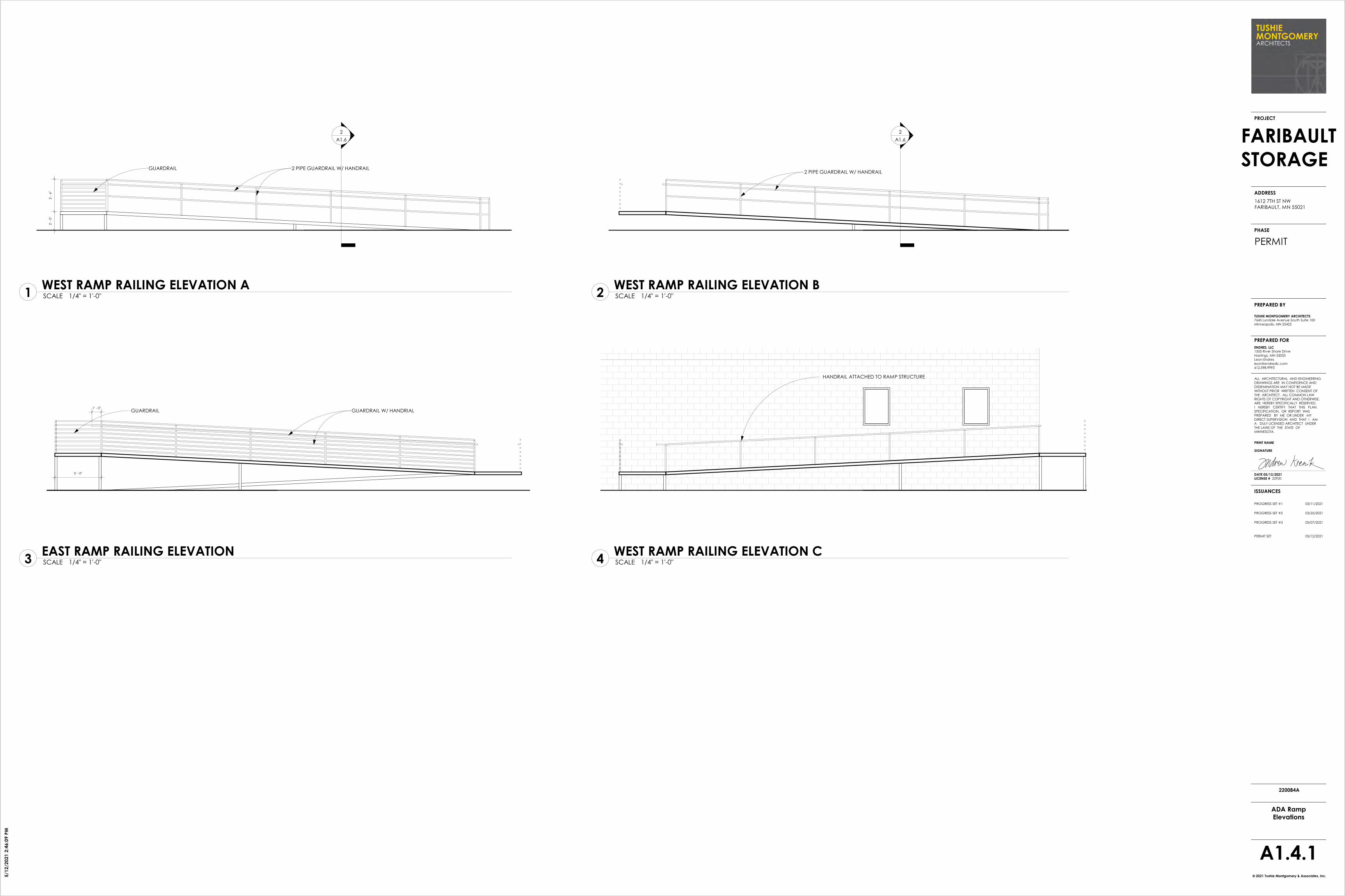
RESTROOMS.10.3 PROVIDE 6' HIGH CHAIN LINK FENCING WITH VINYL PRIVACY SLATS. PROVIDE
(2) 16' SLIDING GATES & (1) 3' SWINGING GATE. GATES TO BE CODED
11 EQUIPMENT
12 FURNISHINGS
13 SPECIAL CONSTRUCTION 14 CONVEYING EQUIPMENT
15 MECHANICAL 15.1 PROVIDE ADA RESTROOMS W/ ADA TOILETS AND ASSOCIATED ADA
ACCESSORIES & GRAB BARS @ NEW RESTROOM.15.2 PROVIDE (1) PROCELAIN WALL-MOUNTED SINK @ NEW RESTROOM.15.3 MODIFY HVAC, AND PLUMBING DISTRIBUTION FOR NEW LAYOUT. 15.4 PROVIDE ONE FLOOR DRAIN AT NEW RESTROOM.15.5 PROVIDE POWER EXHAUST AT NEW RESTROOM.15.6 PROVIDE HVAC @ STORAGE 104. EXTEND DISTRIBUTION FROM
EXISTING FURNACE. AC @ 75 DEGREES & HEAT @ 65 DEGREES15.7 PROVIDE NEW FURNACE/AC & HVAC DISTRIBUTION TO SUPPLY STORAGE 104
WITH HVAC
16 ELECTRICAL 16.1 PROVIDE LED LIGHTING THROUGHOUT ROOMS 100, 102-110. PROVIDE
DIRECT/INDIRECT 2x4 LED LIGHT @ RESTROOM 101.16.2 COORDINATE POWER REQUIREMENTS AND DISTRIBUTION WITH TENANT. 16.3 MODIFY ELECTRICAL POWER AND LIGHTING DISTRIBUTION FOR NEW LAYOUT.16.4 PROVIDE EXIT LIGHTS & EMERGENCY LIGHTING PER CODE THROUGOUT SPACES.16.5 PROVIDE EXTERIOR LIGHTING AND POWER FOR SECURITY CAMERAS16.6 PROVIDE POWER TO ALL CHAIN LINK GATES16.7 PROVIDE POWER FOR NEW OVERHEAD DOOR
4.1 PROVIDE SMOOTH FACE CMU INFILL WALLS @ REMOVED DOORS.4.2 REPAIR DAMAGED EXISTING CMU AS NEEDED.
5.1 PROVIDE PAINTED STEEL ACCESSIBLE WALKWAY WITH GUARDRAILS & HANDRAILS @ ENTRY.
5.2 PROVIDE PAINTED STEEL STAIR WITH GUARDRAILS &HANDRAILS @ COLD STORAGE.
CODE INFORMATION: IBC 2018; MN BC 2020
TYPE OF CONSTRUCTION . . . . . . . . . . . III-BTOTAL BUILDING FOOTPRINT AREA . . . . . . . . 9,099 SFBUILDING IS NOT SPRINKLEREDSINGLE STORY BUILDING
IBC TABLE 506.2 . . . . . . . . B OCCUPANCY S-1 OCCUPANCYNS ALLOWABLE AREA: 19,000 SF 17,500 SF
TOTAL ALLOWABLE AREA: 19,000 SF 17,500 SF
IBC SECTION 508.3.2 USING S-1 OCCUPANCY AS MOST RESTRICTIVE(NONSEPARATED OCCUPANCIES) OCCUPANCY FOR ENTIRE BUILDINGIBC SECTION 508.3.3 NO SEPARATION REQUIRED.
BUILDING AREA OF 9,099 SF < 17,500 SF
AREA CALCULATION AREA OCCUPANCY OCC. LOAD OCC. LOADTYPE FACTOR
PROPOSED STORAGE 7,487 SF S-1 500 15
OFFICE 1,082 SF B 150 8
MECH/UTILITY 530 SF S-1 300 2
TOTAL TENANT AREA 9,099 SF 25
CODE ANALYSIS
EXIT ACCESS REQUIREMENTSIBC TABLE 1006.2.1:
COMMON PATH OF EGRESS TRAVEL < 100'DISTANCE PROVIDED < 100'
IBC TABLE 1006.2.1:ONE EXIT REQUIRED @ B OCC. (8 OCCUPANTS < 49)
ONE EXIT PROVIDEDONE EXIT REQUIRED @ S OCC. (17 OCCUPANTS < 29)
THREE EXITS PROVIDEDIBC 1007.1.1
SEPARATE DISTANCE BETWEEN EXITS W/OUT AUTOMATICSPRINKLERS SHALL BE > 1/2 DIAGONAL DISTANCE
DISTANCE PROVIDED > 1/2IBC TABLE 1017.2:
MAXIMUM TRAVEL DISTANCE W/OUT AUTOMATIC SPRINKLERS200' MAX. @ B (MAX. < 200')200' MAX. @ S (MAX. < 200')
IBC TABLE 2902.1: PLUMBING CALCULATIONSOFFICE: 1,082 SF/ 150= 8MECH/UTILITY: 530 SF/ 300= 2STORAGE: 7,487 SF/ 500= 15
REQUIRED FIXTURES WC LAVOFFICE 8/25= 0.32 8/40= 020MECH/UTILITY 2/100= 0.02 2/100= 0.02STORAGE 15/100= 0.15 15/100= 0.15TOTAL REQUIRED 0.49 0.37
IBC SECTION 2902.2, EXC. #2:SEPARATE FACILITIES NOT REQUIRED WITH 25 OR FEWER OCCUPANTS.
DRINKING FOUNTAIN:OCCUPANT LOAD OF 25<50 NOT REQUIRED
SERVICE SINK:(1) SERVICE SINK WITHIN TENANT SPACE PROVIDED.
SCALE 3/32" = 1'-0"1EGRESS PLAN
N
1
2222
EXISTING ONE-LEVEL BLOCK BUILDING.PROPOSED STORAGE FACILITY
EXISTING MULTI-LEVELBRICK/BLOCK/METALINDUSTRIAL BUILDING
EXISTING STRUCTURE
EXISTING WEIGH STATION
EXISTING STRUCTURE
PR
OP
ER
TY L
INE
EXISTING CONCRETE
EXISTING GRAVEL
CHICAGO MILWAUKEE ST. PAUL & PACIFIC RAILROAD CO.
CHICAGO GREAT WESTERN RAILROAD CO.
APPROXIMATE FLOOD
ZONE. SEPERATION LINE
PER FEMA FLOOD MAP.
PROPERTY SETBACK
CREEK
EXISTING CONCRETE
RAISED
CONCRETE
PLATFORM
TANK
TANK TANK
TANK
TANK
TANK
TANK
MECH.
EXISTING
STRUCTURES
OHD
RAISED
CONCRETE
PLATFORM
OHD
OHD OHD
OHD
OHD
OHD
OHD
TANK
OHD
EXISTING CONCRETE
& BITUMINOUS
EXISTING BITUMINOUS
CONCRETE
CO
NC
RETE
TRANSFORMER
3
3
3 3
3
3 3
PROPOSED REMOVAL OF BITUMINOUS
IN FLOOD ZONE - 1,900 S.F.
4
5
EXISTING TREE
TO REMAIN
6
6
LIGHTS TO REMAIN
LIGHT TO REMAIN
7
7
7
7
77
77
7
7
PREPARED FOR
ISSUANCES
2021 Tushie Montgomery & Associates, Inc.©
ALL ARCHITECTURAL AND ENGINEERING
DRAWINGS ARE IN CONFIDENCE AND DISSEMINATION MAY NOT BE MADE
WITHOUT PRIOR WRITTEN CONSENT OF THE ARCHITECT. ALL COMMON LAW
RIGHTS OF COPYRIGHT AND OTHERWISE, ARE HEREBY SPECIFICALLY RESERVED.
I HEREBY CERTIFY THAT THIS PLAN,
SPECIFICATION, OR REPORT WAS PREPARED BY ME OR UNDER MY
DIRECT SUPERVISION AND THAT I AM A DULY LICENSED ARCHITECT UNDER
THE LAWS OF THE STATE OF MINNESOTA.
PRINT NAME
SIGNATURE
DATE 05/12/2021 LICENSE # 22920
PROGRESS SET #1 03/11/2021
ENDRES, LLC1505 River Shore Drive
Hastings, MN 55033Leon Endres
TUSHIE MONTGOMERY ARCHITECTS7645 Lyndale Avenue South Suite 100
Minneapolis, MN 55423
PROJECT
ADDRESS
PHASE
PREPARED BY
PROGRESS SET #2 03/25/2021
PROGRESS SET #3 05/07/2021
PERMIT SET 05/12/2021
5/1
2/2
02
1 2
:46
:00
PM
FARIBAULT
STORAGE
1612 7TH ST NW
FARIBAULT, MN 55021
A1.0
Site Plan - Demo
220084A
PERMIT
SCALE 1" = 20'-0"1SITE PLAN - DEMO
1
2
REMOVE BITUMINOUS PAVING IN PEDESTRIAN RIGHT OF WAY
REMOVE CONCRETE SUPPORTS TO BELOW GRADE UNLESS FULL REMOVAL IS MORE COST EFFECTION
DEMOLITION NOTES
N
3 REMOVE BRUSH ADJACENT TO BUILDING
4 REMOVE BITUMINOUS SURFACE
5 REMOVE CONCRETE CURB CUT AND GUTTER & ASSOCIATED PAVING
6 REMOVE SOD/ GRADE FOR NEW BITUMINOUS
7REPLACE EXISTING LIGHT WITH NEW LED FIXTURE
First Floor100' - 0"
Roof A115' - 3"
Quonset Level98' - 6"
Grade Level96' - 0"
GAS METER
ELETRIC METER
PATCH QUONSET & ANNEX AS NEEDED. CLEAN AND PREP CLEAN AND PREP CMUCLEAN AND PREP CMU
REMOVE PORTION OF
WALL FOR NEW EXIT
PATCH METAL PANELS @
DOCK STRUCTURE
First Floor100' - 0"
Roof A115' - 3"
Quonset Level98' - 6"
Grade Level96' - 0"
PATCH QUONSET AS NEEDED. CLEAN AND PREP
CLEAN AND PREP CMU
REMOVE
RAILINGS
REMOVE
CONCRETE STEPS
First Floor100' - 0"
Roof A115' - 3"
Quonset Level98' - 6"
Grade Level96' - 0"
CLEAN AND PREP CMU
REMOVE AND INFILL
OVERHEAD DOOR
REMOVE
CONCRETE STAIR
AND RAILINGS
REMOVE WOOD BUMPER
REPLACE LIGHTS W/ LED WALL PACREMOVE CMU
FOR NEW EXIT
REMOVE & REPLACE OHD
EXISTING WINDOW AND DOOR
REPLACE LIGHT W/
LED WALL PAC
PAINT QUONSET - PNT-1
PAINT CMU - PNT-1
NEW STEEL ADA WALKWAY AND
PAINTED METAL GUARDRAIL - PNT-3
NEW STEEL STAIR AND PAINTED
METAL GUARDRAIL & HANDRAILS. -
PNT-3 - SEE RAILING ELEVATIONS
PNT-1 @ METAL PANEL
EXISTING WALL TO REMAIN - NO PAINT
PNT-1 @ CMU
NEW STAIR
AND RAILING - PNT-1
NEW ENTRY AND
ENCLOSURE - PNT-1
9
A1.6
2
A1.6
4
A1.6
PNT-2 @ UPPER CMU BAND
PNT-2 @ PRECAST
NEW LED WALL PAC
PAINT METAL PANEL
PNT-1
PROPOSED BACKLIT BUILDING SIGNAGE BY
OTHERS. G.C. TO PROVIDE ELECTRIC ROUGH-IN
NEW PAINTED METAL
GUARDRAIL - PNT-3
5
A1.6PNT-2 @ UPPER CMU PNT-2 @ PRECASTPNT-1@ CMU
INFILL CMU WALLREPLACE LIGHTS W/
LED WALL PAC REPLACE LIGHTS
W/ LED WALL PAC
PNT-1
NEW STEEL
WALKWAY - PNT-3
PNT-1 @ CMU
PNT-1@ METAL PANEL
PNT-1 @ CMU
PNT-1 @ METAL PANEL
PAINT QUONSET - PNT-1PNT-2 @ UPPER CMU
PNT-2 @ UPPER CMU PNT-1@ CMU
PREPARED FOR
ISSUANCES
2021 Tushie Montgomery & Associates, Inc.©
ALL ARCHITECTURAL AND ENGINEERING
DRAWINGS ARE IN CONFIDENCE AND DISSEMINATION MAY NOT BE MADE
WITHOUT PRIOR WRITTEN CONSENT OF THE ARCHITECT. ALL COMMON LAW
RIGHTS OF COPYRIGHT AND OTHERWISE, ARE HEREBY SPECIFICALLY RESERVED.
I HEREBY CERTIFY THAT THIS PLAN,
SPECIFICATION, OR REPORT WAS PREPARED BY ME OR UNDER MY
DIRECT SUPERVISION AND THAT I AM A DULY LICENSED ARCHITECT UNDER
THE LAWS OF THE STATE OF MINNESOTA.
PRINT NAME
SIGNATURE
DATE 05/12/2021 LICENSE # 22920
PROGRESS SET #1 03/11/2021
ENDRES, LLC1505 River Shore Drive
Hastings, MN 55033Leon Endres
TUSHIE MONTGOMERY ARCHITECTS7645 Lyndale Avenue South Suite 100
Minneapolis, MN 55423
PROJECT
ADDRESS
PHASE
PREPARED BY
PROGRESS SET #2 03/25/2021
PROGRESS SET #3 05/07/2021
PERMIT SET 05/12/2021
5/1
2/2
02
1 2
:46
:08
PM
FARIBAULT
STORAGE
1612 7TH ST NW
FARIBAULT, MN 55021
A1.4
Building Elevations
220084A
PERMIT
SCALE 1/8" = 1'-0"4EXISTING WEST ELEVATION
SCALE 1/8" = 1'-0"1EXISTING NORTH ELEVATION
SCALE 1/8" = 1'-0"2EXISTING SOUTH ELEVATION
SCALE 1/8" = 1'-0"3EXISTING EAST ELEVATION
SCALE 1/8" = 1'-0"5PROPOSED NORTH ELEVATION
SCALE 1/8" = 1'-0"6PROPOSED SOUTH ELEVATION
SCALE 1/8" = 1'-0"7PROPOSED EAST ELEVATION
SCALE 1/8" = 1'-0"9PROPOSED WEST ELEVATION
REMOVE CMU FOR NEW EXIT
PAINT EXISTING MTL. PANEL - PNT-1
PAINT
EXISTING
MTL. PANEL -
PNT-1
FINISH SCHEDULE
PNT-1: TBD
PNT-2: TBD
PNT-3: TBD
SCALE 1/8" = 1'-0"8PROPOSED NORTH ELEVATION B
2
A1.6
2 PIPE GUARDRAIL W/ HANDRAIL
3' -
6"
2' -
0"
GUARDRAIL
2
A1.6
2 PIPE GUARDRAIL W/ HANDRAIL
GUARDRAIL W/ HANDRIALGUARDRAIL
5' - 0"
1' - 0"
HANDRAIL ATTACHED TO RAMP STRUCTURE
PREPARED FOR
ISSUANCES
2021 Tushie Montgomery & Associates, Inc.©
ALL ARCHITECTURAL AND ENGINEERING
DRAWINGS ARE IN CONFIDENCE AND DISSEMINATION MAY NOT BE MADE
WITHOUT PRIOR WRITTEN CONSENT OF THE ARCHITECT. ALL COMMON LAW
RIGHTS OF COPYRIGHT AND OTHERWISE, ARE HEREBY SPECIFICALLY RESERVED.
I HEREBY CERTIFY THAT THIS PLAN,
SPECIFICATION, OR REPORT WAS PREPARED BY ME OR UNDER MY
DIRECT SUPERVISION AND THAT I AM A DULY LICENSED ARCHITECT UNDER
THE LAWS OF THE STATE OF MINNESOTA.
PRINT NAME
SIGNATURE
DATE 05/12/2021 LICENSE # 22920
PROGRESS SET #1 03/11/2021
ENDRES, LLC1505 River Shore Drive
Hastings, MN 55033Leon Endres
TUSHIE MONTGOMERY ARCHITECTS7645 Lyndale Avenue South Suite 100
Minneapolis, MN 55423
PROJECT
ADDRESS
PHASE
PREPARED BY
PROGRESS SET #2 03/25/2021
PROGRESS SET #3 05/07/2021
PERMIT SET 05/12/2021
5/1
2/2
02
1 2
:46
:09
PM
FARIBAULT
STORAGE
1612 7TH ST NW
FARIBAULT, MN 55021
A1.4.1
ADA RampElevations
220084A
PERMIT
SCALE 1/4" = 1'-0"1WEST RAMP RAILING ELEVATION A
SCALE 1/4" = 1'-0"2WEST RAMP RAILING ELEVATION B
SCALE 1/4" = 1'-0"3EAST RAMP RAILING ELEVATION
SCALE 1/4" = 1'-0"4WEST RAMP RAILING ELEVATION C
XX
X XX X X X X X
XX
XX
XX
936 SF
OFFICE
EXISTING
SWITCH
GEAR AND
PANELS
3146 SF
UNCONDITIONEDSTORAGE
EXISTING
LOADING
RAMP
NEW DOOR
NEW RAILINGS
INFILL OPENING
EXISTING RAMP
NEW STEEL ADA RAMP AND RAILING
NEW STEEL STAIR
AND RAILING
STORAGE UNIT SUMMARY
COLD STORAGE BUILDING
WARM STORAGE BUILDING
TOTALS
9
200 SF 150 SF 100 SF 75 SF 50 SF 25 SF # OF UNITS UNIT AREA
3 3 4 4 3 26
2,000 SF4 3 4 2 3 2 18
13 6 6 7 6 4 44
3,575 SF
5,575 SF
EXISTING MECH/ELEC RM.
NEW OVERHEAD DOOR
7
A1.4
9
A1.4
6' - 0 1/8"
5' - 4"
5' -
2 3
/8"5' - 0"
5' - 0"
6' -
2"
EXISTING
RAMP
NEW METAL STAIR
& EXIT
3' - 0"EXISTING DOOR
NEW CHAIN LINK FENCE
1
A1.4.12
A1.4.1
3
A1.4.1
4
A1.4.1
8
A1.4
PREPARED FOR
ISSUANCES
2021 Tushie Montgomery & Associates, Inc.©
ALL ARCHITECTURAL AND ENGINEERING
DRAWINGS ARE IN CONFIDENCE AND DISSEMINATION MAY NOT BE MADE
WITHOUT PRIOR WRITTEN CONSENT OF THE ARCHITECT. ALL COMMON LAW
RIGHTS OF COPYRIGHT AND OTHERWISE, ARE HEREBY SPECIFICALLY RESERVED.
I HEREBY CERTIFY THAT THIS PLAN,
SPECIFICATION, OR REPORT WAS PREPARED BY ME OR UNDER MY
DIRECT SUPERVISION AND THAT I AM A DULY LICENSED ARCHITECT UNDER
THE LAWS OF THE STATE OF MINNESOTA.
PRINT NAME
SIGNATURE
DATE 05/12/2021 LICENSE # 22920
PROGRESS SET #1 03/11/2021
ENDRES, LLC1505 River Shore Drive
Hastings, MN 55033Leon Endres
TUSHIE MONTGOMERY ARCHITECTS7645 Lyndale Avenue South Suite 100
Minneapolis, MN 55423
PROJECT
ADDRESS
PHASE
PREPARED BY
PROGRESS SET #2 03/25/2021
PROGRESS SET #3 05/07/2021
PERMIT SET 05/12/2021
5/1
2/2
02
1 2
:46
:10
PM
FARIBAULT
STORAGE
1612 7TH ST NW
FARIBAULT, MN 55021
A1.5
Proposed StorageLayout
220084A
PERMIT
SCALE 1/8" = 1'-0"1First Floor - Proposed Storage Layout
N

2
A1.6
4
A1.6
40' - 0"
PAINTED METAL
GUARDRAIL &
HANDRAIL - PNT-3
NEW LED WALL PAC PNT-1 @ CMUPNT-2 @ UPPER CMU
2
A1.6
4
A1.6
40
' - 0
"5
' - 0
"
4' - 0" 4' - 0"
8' - 0"
[No Slope]
FD
101A
UNISEX
S3
S1S10
EXISTING EDGE OF CONCRETE
A1.6
3 5.0
% M
AX
5.0
% M
AX
1
A1.4.1
2
A1.4.1
3
A1.4.1
4
A1.4.1
STEEL PERFERATED METAL RAMP
CONCRETE SONOTUBES TO
FROST LEVEL
PAINTED METAL 2 PIPE
GUARDRAIL & HANDRAIL
PAINTED METAL
GUARDRAIL & HANDRAIL
STEEL STAIR
5 1
/4"
5 1
/4"
5 1
/4"
5 1
/4"
5 1
/4"
5 1
/4"
5 1
/4"
4 1
/8"
3' -
6"
EDGE OF
PLATFORM3"
7' -
0"
7' -
2"
3' - 4"
2" 2"
A
1SCWD
7' -
0"
3' - 0"
GLAZING
1/4" CLEAR TEMPERED
A
HM
3HM
7' -
0"
3' - 0"
2HM/STL
7' -
0"
3' - 0"
7' -
0"
7' -
4"
3' - 4"
2" 2"
BHM
@ EXTERIOR
A
6" 6"
2' -
6"
6"
10
' - 0
"
8' - 0"
4STL
B B
1/4" CLEAR TEMPERED
B
7' -
0"
FD
A
B
8' - 0"
CLEAR
5' - 0"
SD
PTHTPH
SND
MAINTAIN 30"x48"CLEAR SPACE @ SINK
MAINTAIN 60"x78"CLEAR SPACE @TOILET
60" MIN. DIA.TURNING SPACE
MIRROR
PROVIDE PLUMBING STUBS IN WALLSFOR FUTURE RESTROOM
PAINT
PT WAINSCOTWET WALLS ONLY
6" COVE PT BASE TPH
AREA
24" x 36"MIRROR
INSUL. PIPES
WALL HUNG SINKW/ ADA FAUCET
AB
54" MIN.
42" MIN.
39"-41"
12" MAX.
SE
AT
17
"-1
9"
1 1
/2"
MIN
.
18
" M
IN.
24" MIN.
42" MAX.
33
"-3
6"
39
"-4
1"
18
" M
IN.
12" MIN.24" MIN.
16"-18"
17
"-1
9"
33
"-3
6"
SIN
K R
IM
2' -
10
"
40
" M
AX
.
4' -
0"
PTH
TOILET LEVERON OPEN SIDE
36" MIN.
S.S. GRAB BARS
SND
TPH
5' -
4"
MIN.
1' - 3"
SD
5' -
4"
O.C
.4
"
1' - 0"
5' - 0"
2' - 9"
11"
34
"-3
8"
EXTERIOR WALL
DOOR THRESHOLDPROVIDE 1/2" MAXIMUM HEIGHT
DIFFERENTIAL VETWEEN STAIRLANDING AND DOOR
THRESHOLD
STL. POST SUPPORTSCLOSED RISER (TYP).
PATCHBITUMINOUS
12" DIA. SONOTUBECONCRETE FOOTING;EXTEND BELOW FROST.
CHANNEL STRINGERSW/ GRIP STRUTTREADS & LANDING;FASTEN STAIR TO WALL
1 1/2" DIA. PIPE GUARDRAIL
1 1/2" DIA. PIPE HANDRAIL
1 1/2" DIA. PIPE
VERTICAL BALUSTERS SPACEDTO PREVENT A 4" DIA. SPHEREFROM PASSING THRU.
MIN.
5' - 4"
5' -
0"
3T
@1
1"
= 2
'-9"
1'-6" MIN.
1' -
0"
4"
1 1/4" STL. TUBING
EXTERIOR WALL
3' -
6"
EXISTING FOUNDATION TO REMAIN
DORMER WALL
CORRUGATED METAL PANEL SIDING
AIR BARRIER
EXTERIOR GYPSUM SHEATHING
6" METAL STUD W/ R-21 BATT INSUL.
VAPOR BARRIER
5/8" TYPE "X" GYP. BD.
NEW OPENING IN EXISTING QUONSET -
REMOVE ROOFING & PURLINS -
REINFORCE AS NEEDED
10
A1.6
DORMER ROOF
CORRUGATED METAL ROOFING
ROOFING UNDERLAYMENT
3/4" EXTERIOR-GRADE PLYWOOD DECKING
8" METAL CHANNEL JOIST W/ BATT INSUL.
VAPOR BARRIER
5/8" TYPE "X" GYP. BD.
INFILL CRICKET W/ FLASHING
AND SEALANT
NEW STEEL STAIR
4' - 0"
9
A1.6
6' - 2 1/2"
9
A1.6
10
A1.6
4' -
0"
5' - 0"
EXISTING QUONSET
PREPARED FOR
ISSUANCES
2021 Tushie Montgomery & Associates, Inc.©
ALL ARCHITECTURAL AND ENGINEERING
DRAWINGS ARE IN CONFIDENCE AND DISSEMINATION MAY NOT BE MADE
WITHOUT PRIOR WRITTEN CONSENT OF THE ARCHITECT. ALL COMMON LAW
RIGHTS OF COPYRIGHT AND OTHERWISE, ARE HEREBY SPECIFICALLY RESERVED.
I HEREBY CERTIFY THAT THIS PLAN,
SPECIFICATION, OR REPORT WAS PREPARED BY ME OR UNDER MY
DIRECT SUPERVISION AND THAT I AM A DULY LICENSED ARCHITECT UNDER
THE LAWS OF THE STATE OF MINNESOTA.
PRINT NAME
SIGNATURE
DATE 05/12/2021 LICENSE # 22920
PROGRESS SET #1 03/11/2021
ENDRES, LLC1505 River Shore Drive
Hastings, MN 55033Leon Endres
TUSHIE MONTGOMERY ARCHITECTS7645 Lyndale Avenue South Suite 100
Minneapolis, MN 55423
PROJECT
ADDRESS
PHASE
PREPARED BY
PROGRESS SET #2 03/25/2021
PROGRESS SET #3 05/07/2021
PERMIT SET 05/12/2021
5/1
2/2
02
1 2
:46
:13
PM
FARIBAULT
STORAGE
1612 7TH ST NW
FARIBAULT, MN 55021
A1.6
Sections & Details
220084A
PERMIT
SCALE 1/4" = 1'-0"8ADA RAMP/STAIR ELEVATION
SCALE 1/4" = 1'-0"1ENLARGED PLAN
SCALE 3/8" = 1'-0"2SECTION @ RAMP
SCALE 3/8" = 1'-0"4SECTION @ STAIRS
SCALE 1 1/2" = 1'-0"5STEEL RAILING PROFILE
DOOR SCHEDULENO SIZE DTL MAT DTL HDW RATINGMAT
DOOR FRAMEREMARKS ALT.
ROOM FINISH SCHEDULENO LOCATION FLOOR REMARKS ALT.BASE WALLS CEILING
LOCATION
V - VINYL CONC - CONCRETE EP GRIT - EXPOXY NON-SKID GRIT FRP - FIBER REINFORCED PANELSPNT - PAINT PC - POLISHED CONCRETE EPOXY - EPOXY FLOOR COATING SCWD - SOLID CORE WOOD DOORCPT - CARPET SC - SEALED CONCRETE VT - VINYL CEILING TILE STL - STEEL OVERHEAD DOORCT - CERAMIC TILE VCT - VINYL COMPOSITE TILE ACT - ACOUSTIC CEILING TILE C - COMPOSITE DOORPT - PORCELAIN TILE LVT - LUXURY VINYL TILE VWC - VINYL WALL COATING ETR - EXISTING TO REMAINALUM - ALUMINUM HM - HOLLOW METAL ME - MATCH EXISTING CL - CHAIN LINK
100UNISEX
3'-0" x 7'-0" SCWD 1 HM A3'-0" x 7'-0" SCWD 1 HM A
- - - -3'-0" x 7'-0" 3 HM B
PRIVACYENTRY
3 B
101A
102A
103A
104A
104B
UNISEX
MECHANICAL
STORAGE
STORAGE
STORAGE
SC PT/PNT 1 ACT
3'-0" x 7'-0" HM
-
SCALE 1/4" = 1'-0"6DOOR & FRAME TYPE
HMHM
SCALE 1/4" = 1'-0"3UNISEX RESTROOM
101102
ETR, ADA LEVERINSULATEDINSULATED
103104110
OFFICE
MECH/ELECSTORAGESTORAGESTORAGE
PTCONC - PNT PNT
ETR ETR ETR ETRETR ETR ETR ETR
CONC - PNT ETRETR ETR ETR ETR
104C STORAGE
SCALE 1/4" = 1'-0"7NEW STEEL STAIR
104D STORAGE
PT TO 64" - ALL WALLS
#1, #2
- - - - - -100A OFFICE ETR
- - - - - -102B MECHANICAL
-
ETR, ADA LEVER
ENTRYENTRY
PR 3'-0" x 7'-0" HM 3 HM A PASSAGE INSULATED8'-0" x 10'-0" STL 4 - - - INSULATED OHD - OPENER
110A COLD STORAGE 3'-0" x 7'-0" HM 3 HM A ENTRY INSULATED
110B COLD STORAGE - - - - - - ETR
SCALE 1/4" = 1'-0"9SECTION @ DORMER
SCALE 1/4" = 1'-0"10CROSS SECTION @ DORMER
SCALE 1/4" = 1'-0"11PLAN @ DORMER
G100
G101
EXTERIOR GATE
EXTERIOR GATE
16'-0" x 8'-0"
G100 EXTERIOR GATE 16'-0" x 8'-0"4'-0" x 8'-0"
KEY CODEKEY CODEKEY CODE
Addendum A 04/08/2021
C=6.84
CB=N67°37'44"E
R=2814.93
Δ=0°08'21"
6.84
C=376.23
CB=N71°49'25"E
R=2855.93
Δ=7°33'12"
376.50
44.4
8N
00°4
0'35
"E
N75°36'01"E 224.38
S00
°40'
35"W
42.4
6
N75°36'01"E
6.62
S00
°07'
25"E
134
.48
S89°52'35"W 69.67
S00
°07'
25"E
231
.00
S89°52'35"W 410.00
S89°52'35"W0.86
N00
°24'
41"E
190
.97
TANK
TANK TANK
TANK
TANK
TANK
TANK
TANK
SCALE
DO
CK
RAMP
32.3
33.5 13.2
13.4
13.0
48.3
20.5
12.4
1.2 76.7
27.9
44.9
27.9
15.8
27.4
16.6
27.4
33.3
60.0
41.0
11.6 29.0
23.2
8.0
32.8
36.0
25.6
44.8
36.1
0.5
1.0
0.2
63.4
141.2
72.8
24.118.0 13.1
78.0
44.18.1
56.2
6.0
10.0
120.
0
50.1
120.
0
31.7
5.9
31.8
9.3' X 9.3' BrickWeigh StationBuilding
Multi-LevelBrick/Block/MetalIndustrial BuildingFoundation Area=47,445 sq. ft. +/-
Existing One-LevelBlock BuildingFoundation Area=6,005 sq. ft. +/-
Gravel
Garden
Snow
Pile
6" W.M. (Per Rec.)12" D.I.P. W.M. (Per Rec.)
12" VCP
8" V
CP
12" VCP 27" PVC10" PVC
21" PVC
12"
RCP
18" RCP 18" RCP
24"
RCP
24"
RCP
24" RCP
CRO
CKER
S
CREE
K
7TH ST NW (A Public R/W)
PARK
AVE
NW
(A P
ublic
R/W
)
WIL
SON
AVE
(A P
ublic
R/W
)
LYN
DALE
AVE
N (
CO
. RD
. N
O.
21)
(F.K
.A.
U.S
. H
WY
NO
. 65
)
(CO. RD. NO. 11) Box
Cul
vert
SE Corner of the SW 1/4 ofSec. 25, Twp. 110, Rng. 21(Falls on Manhole)
Appr
ox. Fl
ood
Zone
Sepa
ratio
n Li
nes
Per
FEM
A Fl
ood
Map
ZONE X
ZO
NE
X (
Oth
er F
lood
Are
a)
ZONE X
FLO
ODW
AY A
REA
IN Z
ONE
AE
ZONE X
Approx. Flood Zone
Separation Lines
Per FEMA Flood M
ap
ZONE X (O
ther Flood Area)
ZONE X
ZO
NE
X(O
ther
Flo
od A
rea)
ZONE AE
S87°57'56"W 109.24
33.0
0
Exis
ting
Gar
age
ExistingBuilding
The W Line of the SE 1/4 &The E Line of the SW 1/4of Sec. 25, Twp. 110, Rng. 21
Line Parallel With &Distant 708.00 FeetW'ly From the W Line ofU.S. Hwy No. 65
Right of Way Line7th St NW
Line Parallel With &Distant 110.00 FeetW'ly From the E Line ofthe SE 1/4 of Sec. 25,Twp. 110, Rng. 21
Centerline of the Minnesota Central Railroad Company
(Later the Chicago Great Western Railway Company,
now the Chicago and North Western Transportation Company)
SE'ly Right of Way Line of the Chicago,Great Western Railroad Company
PARCEL
1
PARCEL 3
PARCEL 2
Line Parallel With &
Distant 135.30 Feet
W'ly From the W Line of
U.S. Hwy No. 65
W L
ine
of U
.S.
Hw
y N
o. 6
5
S Line of the SW 1/4of Sec. 25, Twp. 110, Rng. 21
Line
Par
alle
l With
&D
ista
nt 4
61.5
2 Fe
etW
of
the
W L
ine
ofH
ulet
Ave
135.00
65.33
231.
00
479.67
Line 8 Chains 51 Links (561.66 Feet) N of the S Lineof the SE 1/4 of Sec. 25, Twp. 110, Rng. 21
297.
66
540.30 (545.00 Deed)
507.30 (506.90 Deed)
561.
66
Gas Line Approx Per Rec.
Sewer and Water ServicesApprox. Per Rec.
6" VCP (
Per R
ec.)
8" DIP
12" San. (Per Rec.)
12" VCP
6" VCP (Per Rec.)
Conc. Supports
P.I.D.: 1
825378005
Address: Unavailable
Owner: City of Fa
ribault
P.I.D.: 1825375005Address: 1704 7th St NWOwner: Michael & Kristina Knapp
P.I.D.: 1825450009Address: 1510 7th St NWOwner: Faribaut Grill Inc
P.I.
D.:
182
5450
011
Add
ress
: 72
8 Ly
ndal
e Ave
NO
wne
r: R
T Pr
oper
ty L
LC
P.I.
D.:
182
5450
010
Add
ress
: 72
8 Ly
ndal
e Ave
NO
wne
r: R
T Pr
oper
ty L
LC
P.I.D.: 1825450012
Address: N/A
Owner: City of Faribault
P.I.D.: 1825450007
Address: N/A
Owner: Economic Development
Authority of Faribault
P.I.D.: 1825450005 & 1825450006
Address: 1702 7th St NW
Owner: Charles P & Leah B Budde
P.I.D.: 1825375001
Address: 1702 7th St NW
Owner: Charles P & Leah B Budde
Bridge[B] Bridge Support
Crosses Property Line
8" P
VC
8" PVC
[C] StormSewer
Sewer ServiceApprox. Per Rec.
VICINITY MAP
1612
7th
Str
eet N
orth
wes
tFa
ribau
lt, R
ice
Cou
nty,
Min
neso
ta 5
5021
1505
Riv
er S
hore
Driv
e, H
astin
gs, M
N 5
5033
Leon
End
res
PRO
JEC
T
PROJECT NO.: 21031
COPYRIGHT 2021 CIVIL SITE GROUP INC.c
REVISION SUMMARYDATE DESCRIPTION
V1.0
ALTA/NSPS LANDTITLE SURVEY
. .
. .
. .
. .
. .
. .
N
44565RORY L. SYNSTELIEN
LICENSE NO.DATE
I HEREBY CERTIFY THAT THIS SURVEY,PLAN, OR REPORT WAS PREPARED BY MEOR UNDER MY DIRECT SUPERVISION AND
THAT I AM A DULY LICENSED LANDSURVEYOR UNDER THE LAWS OF THE
STATE OF MINNESOTA.
02-05-2021
N
CLI
ENT
Civil Engineering Surveying Landscape Architecture
4931 W. 35th Street, Suite 200St. Louis Park, MN 55416
civilsitegroup.com 612-615-0060
QA/QCFIELD CREW
DRAWN BYREVIEWED BYUPDATED BY
JN/DTCJRS.
OVERHEAD UTILITIES
FIBER OPTIC
SANITARY SEWER
STORM SEWER
TELEPHONE LINE
CABLE LINE
WATERMAIN
ELECTRIC LINE
GASMAIN
CHAINLINK FENCELINE
SIGN
SANITARY MANHOLE
STORM MANHOLE
CABLE TV BOX
TELEPHONE MANHOLE
ELECTRIC TRANSFORMER
TELEPHONE BOX
TRAFFIC SIGNAL
GAS METER
ELECTRICAL METER
WATER MANHOLE
WATER VALVE
AIR CONDITIONER
BOLLARD
CATCH BASIN
ELECTRIC MANHOLE
GAS VALVE
FLAG POLE
HANDICAP SYMBOL
FOUND IRON MONUMENT
HYDRANT
CAST IRON MONUMENT
SET IRON MONUMENT
FLARED END SECTION
Linetype & Symbol Legend
POWER POLE
UTILITY MANHOLE
CONCRETE SURFACE
PAVER SURFACE
BITUMINOUS SURFACE
GRAVEL/LANDSCAPE
GUY WIRE
CONIFEROUS TREE
DECIDUOUS TREE
SURFACE
WOODEN FENCELINE
GUARDRAIL
ROOF DRAIN
8020 4002040
SCALE IN FEET
DESCRIPTION OF PROPERTY SURVEYEDParcel 1:
All that part of the East 330 feet of the SE 1/4 SW 1/4 of Sec. 25, T110N, R21W of the 5th P.M., in the City of Faribault, Rice County, Minnesota, described as follows,to wit: Beginning at a point on the East line of the said SW 1/4 of Sec. 25, 33.00 feet North of the SE corner of the said SW 1/4, said point being on the Northwesterlyline of Seventh Street, in said City of Faribault; thence North along the said East line of the SW 1/4 of Sec. 25, 230.00 feet to the Southeasterly line of the Chicago,Great Western Railroad Company Right-of-way; thence Southwesterly, along said Right-of-way line, deflecting to the left on a curve whose radius is 2814.93 feet, anarc distance f 118.37 feet; thence South parallel with, and 110.00 feet distant West of the East line of the SW 1/4 of Sec. 25, about 190.98 feet to the saidNorthwesterly line of Seventh Street; thence Northeasterly along the said Northwesterly line to Seventh Street, 110.10 feet to the point of beginning.
Parcel 2:
That part of the SE 1/4 SW 1/4 and the SW 1/4 SE 1/4 of Sec. 25, T110N, R21W of the 5th P.M., Rice County, Minnesota, bounded as follows: on the Southeast by aline parallel with and distant 50.00 feet Southeasterly, measured at right angles and radially, from the center line of the main track of the Minnesota Central RailroadCompany (later the Chicago Great Western Railway Company, now the Chicago and North Western Transportation Company), as said main track center line wasoriginally located and established across said Sec. 25; on the Northwest by a line parallel with and distant 9.00 feet Southeasterly, measured at right angles andradially, from the center line of the main track of the Chicago and North Western Transportation Company (formerly the Chicago Great Western Railway Company), assaid main track is now located and on the East and West by lines parallel with and distant 135.3 feet and 708.0 feet, respectively, Westerly, measured at right angles,from the West line of U.S. Highway No. 65, as established by Easement Deed dated January 21, 1954, between the Chicago Great Western Railway Company and theState of Minnesota.
Parcel 3:
All that part of the SW 1/4 SE 1/4 of Sec. 25, T110N, R21W of the 5th P.M., in the City of Faribault, Rice County, Minnesota, described as follows, to-wit: Beginning ata point 33.00 feet North of the SW corner thereof; thence East, along the North line of Seventh Street Northwest in the said City of Faribault a distance of 410.00 feet;thence North a distance of 231.00 feet; thence East a distance of 135.00 feet to a point 461.52 feet West of the East line of Hulet Avenue in the said City of Faribault;thence North, parallel with the West line of said Hulet Avenue a distance of about 297.66 feet to a point that is 8 chains and 51 links (or 561.66 feet) North of theSouth line of said SW 1/4 of said Sec. 25; thence West a distance of 545.00 feet to a point in the West line of the said SW 1/4 SE 1/4 of said Sec. 25; thence Southalong the West line of said SW 1/4 SE 1/4 of said Sec. 25 a distance of 528.66 feet to the place of beginning.
EXEPTING THEREFROM the rights-of-wayof the following railroads, to-wit:
(No. 1) Minnesota Central Railway Company (now known as the Chicago Great Western Railway Company);
(No. 2) The Chicago, Milwaukee & St. Paul Railway Company (now known as the Chicago, Milwakee, St. Paul and Pacific Railroad Company) as the same are set out inWarranty Deeds of Record in the office of the Register of Deeds in and for Rice County, Minnesota, in Book 48 of Deeds on Pages 97 and 98 and in Book 69 of Deeds onPages 320, 321, and 322 respectively.
AND EXCEPTING THEREFROM the two following described parcels:
(No. 3) Part of the SE 1/4 of Sec. 25, T110N, R21W of the 5th P.M., in the City of Faribault, Rice County, Minnesota, described as follows: Beginning at the SW cornerof said SE 1/4; thence Northerly along the West line of said SE 1/4 33.00 feet; thence Easterly along the Northerly line of Seventh Street and parallel with the Southline of said SE 1/4 479.67 feet; thence Northerly at right angles to said South line of SE 1/4, 231.00 feet to the true point of beginning of the parcel to be hereindescribed; thence Easterly parallel with said South line of SE 1/4 65.33 feet; thence Northerly at right angles to said South line 151.40 feet to a point in theSoutheasterly right of way of the Chicago and Northwestern Railway Company; thence Southwesterly, along said Southeasterly railway right of way line, 67.41 feet;thence Southerly, at right angles to said South line, 134.80 feet to said true point of beginning, more or less;
(No. 4) and all that part of the SW 1/4 SE 1/4 of Sec. 25, T110N, R21W of the 5th P.M., in the City of Faribault, Rice County, Minnesota, described as follows, to-wit:Beginning at the SW corner of the SW 1/4 SE 1/4; thence Northerly along the West line f said SW 1/4 SE 1/4 (for purposes of this description, bearing of said West lineis assumed to bear North 00 degrees 00 minutes 00 seconds) a distance of 561.66 feet to the true point of beginning; thence North 89 degrees 28 minutes 30 secondsEast a distance of 506.90 feet to a point in said Northwesterly right of way line of the Chicago, Milwaukee, St. Paul & Pacific Railroad Company; thence Southwesterlyalong said Railroad right of way line to a point in said West line of said SW 1/4 SE 1/4; thence North along said West line of said SW 1/4 SE 1/4 to said true point ofbeginning,
FURTHERMORE EXCEPTING the following described parcels:
(No. 5) All that property lying Northerly of the Chicago Milwaukee St. Paul and Pacific Railway Co., Railroad Right of Way, and
(No. 6) All that property lying Southerly and Easterly of the following described line, and its extensions:
Commencing at the SW corner of said SE 1/4; thence Northerly along the West line of said SE 1/4 33.00 feet; thence Easterly along the Northerly line of SeventhStreet and parallel with the South line of said SE 1/4 410.00 feet to the point of beginning of the line to be herein described; thence Northerly, at a right angle to saidSouth line of the SE 1/4, to a point in the Southeasterly right of way of the Chicago and Northwestern Railway Company, and there terminating.
ALTA/NSPS Land Title Survey Notes(numbered per Table A)1. Bearings are based on the Rice County Coordinate System (1996 Adjustment).2. Site Address: 1612 7th St NW, Faribault, MN 55021.3. This property is contained in the following zones per Flood Insurance Rate Map, Community Panel No. 27131C0266D, effective date of April 3, 2012.:
Zone X (area determined to be outside the 0.2% annual chance floodplain),Zone X Other Flood Areas (areas of 0.2% annual chance flood; areas of 1% annual chance flood with average depths of less than 1 foot or with drainage areas lessthan 1 square mile; and areas protected by levees from 1% annual chance flood.);Zone AE Base Flood Elevations determined (Special Flood Hazard Areas (SFHAs) subject to inundation by the 1% annual chance flood);and Floodway Areas in Zone AE (The floodway is the channel of a stream plus any adjacent floodplain areas that must be kept free of encroachments so that the1% annual chance flood can be carried without substantial increases in flood heights.NOTE: We have shown the approximate limits of and labeled each zone hereon per referenced Flood Insurance Rate Map.
4. The Gross land area is 176,288 +/- square feet or 4.047 +/- acres.5. Elevations are based on the NGVD 29 Datum. Site Benchmarks are as follows:
1. Top nut of the fire hydrant located on the north side of 7th St NW, approx. 55' easterly of the southwest corner of subject property. Elevation=976.64.2. Top nut of the fire hydrant located on the north side of 7th St NW, approx. 90' westerly of the southeast corner of subject property. Elevation=976.64.
6. We have not been provided with an official zoning letter/report at the time of this survey.Please note that the general restrictions for the subject property may have been amended through a city process. We could be unaware of such amendments ifthey are not in a recorded document provided to us. We recommend that a zoning letter be obtained from the Zoning Administrator for the current restrictions forthis site.
9. We did not observe parking stripes on the subject property while conducting the fieldwork.11. We have shown the location of utilities to the best of our ability based on observed evidence together with evidence from the following sources: plans obtained
from utility companies, plans provided by client, markings by utility companies and other appropriate sources. We have used this information to develop a view ofthe underground utilities for this site. However, lacking excavation, the exact location of underground features cannot be accurately, completely and reliablydepicted. Where additional or more detailed information is required, the client is advised that excavation may be necessary. Also, please note that seasonalconditions may inhibit our ability to visibly observe all the utilities located on the subject property.
13. The names of the adjoining owners of the platted lands, as shown hereon, are based on information obtained from the Rice County GIS Property Map.
SURVEY REPORT1. This map and report was prepared with the benefit of a Commitment for Title Insurance issued by Attorneys' Title Fund Services, LLC as agent for Old Republic
National Title Insurance Company, File No. NORT-11-049(87452), dated May 19, 2011. We note the following with regards to Schedule B of the herein referencedTitle Commitment:a. Item no.'s 1, 2, 7, 8, 11-15, and 17-19 are not survey related.
b. The following are numbered per the referenced title Commitment:3. Item No. 4 of the Survey Report at the bottom lower-right area of the survey indicates that according to FEMA mapping a portion of the site directly
adjacent to Crocker's Creek is in the flood plain. The survey map also shows Crocker's Creek running right through a portion of the property on itsEastern boundary and that there is a dam located in the SE corner of the property. We have not been provided a copy of said survey. We have shownhereon the location of Crocker's Creek as well as the approximate limit of the flood zones per FEMA flood maps (see note 3 of ALTA/NSPS NotesSection of this survey).
4. Easement for sanitary sewer purposes together with incidental rights in favor of the City of Faribault as contained in the Easement dated December 9,1939, filed December 29, 1939 and recorded in Book 147 of Deeds, page 221, in the office of County Recorder, Rice County, Minnesota. We have notbeen provided with said document. Unable to depict hereon.
5. Easement for storm sewer purposes together with incidental rights in favor of the City of Faribault as contained in the Easement dated March 19, 1942and recorded in Book 150 of Deeds, page 504, in the office of County Recorder, Rice County, Minnesota. We have not been provided with saiddocument. Unable to depict hereon.
6. Terms and conditions of the Maintenance of Crocker's Creek Easement dated May 14, 1963, filed May 22, 1963 and recorded in Book 14 of M.R., page93, in the office of County Recorder, Rice County, Minnesota. We have not been provided with said document. Unable to depict hereon.
9. The following are matters shown by the survey of Loucks McLagan dated August 2, 2002, Project Number 02790.a. Sanitary sewer lines running through land;b. Vehicular cross traffic between the land and property northerly and adjacent thereto;c. Fencer around the timber bridge at the NE corner encroaches .9 feet onto the land.Said survey is approximately 19 years old and we have not been provided with a copy.
10. County Drainage and Utility Easement filed May 15, 2008 and recorded as Document No. 601261 in the office of County Recorder, Rice County,Minnesota, granting to Rice County the right to enter upon said land a distance of 55 feet outside the existing 33-foot right of way to the left ofcenterline, for bridge replacement. We have not been provided with said document. Unable to depict hereon.
16. Collateral Assignment of Easements dated February 24, 2010, filed March 11, 2010 and recorded as Document No. 622312 in the office of CountyRecorder, Rice County, Minnesota. We have not been provided with said document. Unable to depict hereon.
2. Conflicts such as (but not limited to): encroachments, protrusions, access, occupation, and easements and/or servitudes:A. The title commitment used for this survey and referenced above is approximately 10 years old. We have not been provided with current deeds or
supporting documents pertaining to the surveyed property.[B]. Bridge support wall encroaches onto subject property near the northeast corner, as shown hereon.[C]. Storm sewer drains onto subject property near the southeast corner, as shown hereon. We have not been provided documentation of an easement for said
storm sewer.
ALTA CERTIFICATIONTo: Energy Technology Unlimited of Minnesota, LLC; Leon Endres; and Attorneys' Title Fund Services, LLC as agent for Old Republic National Title Insurance Company:This is to certify that this map or plat and the survey on which it is based were made in accordance with the 2016 Minimum Standard Detail Requirements forALTA/NSPS Land Title Surveys, jointly established and adopted by ALTA and NSPS, and includes Items 1, 2, 3, 4, 6, 8, 9, 11, and 13 of Table A thereof. The field workwas completed on 02-03-2021.Dated this 5th day of February, 2021.
________________________________________________________Rory L. Synstelien Minnesota License No. [email protected]