Embed Size (px)
Citation preview
« Ftlrs Ajaccio campaigns : opérations and positionning analysis over 2002 and 2005 campaigns
F. Pierron, Pierre Exertier, P. Berio, M. Pierron, D. Coulot, P. Bonnefond-OCA, Grasse, FRANCEB. Gourine - CNTS, Arzew, ALGERIA
Ftlrs
Oca-Grasse
! Scientific investigation and results for positionning
! Conclusion and prospects
! Introduction and Operational issues for Corsica campaigns
!Jason1 calibration/validation data

" Need for carrying out an accurate SLR positioning from the geodetic satellites observations" Need for carrying out an accurate SLR positioning from the geodetic satellites observations
The Ajaccio Site (Corsica) is the main calibration site of the satellite altimeters in the Mediterranean area.
Notice:Altimeter calibration = precisely compare
– altimeter data– satellite altitude above the sea level
! Absolute sea level monitoring, altimeter calibration and orbit validation (CAL/VAL) of the Topex/Poseidon, Jason-1 and Envisatsatellites from the Ajaccio site (Corsica - FRANCE).
! Estimation of the satellite altimeters biases and drifts
Objectives :
IntroductionIntroduction

Geographical situation :- Naval base at Aspretto (Ajaccio)- In situ instruments at Senetosa Cape : Tide gauges,- GPS buoys, meteo station,..
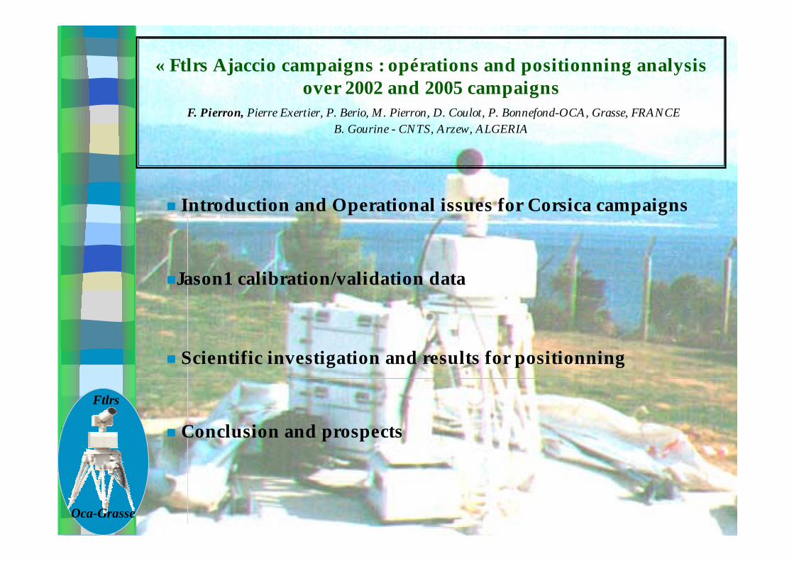
Laser campaigns :- January – September 2002 (10 months)- May – October 2005 (5 months)- 4 satellites used : combination multi-satellite
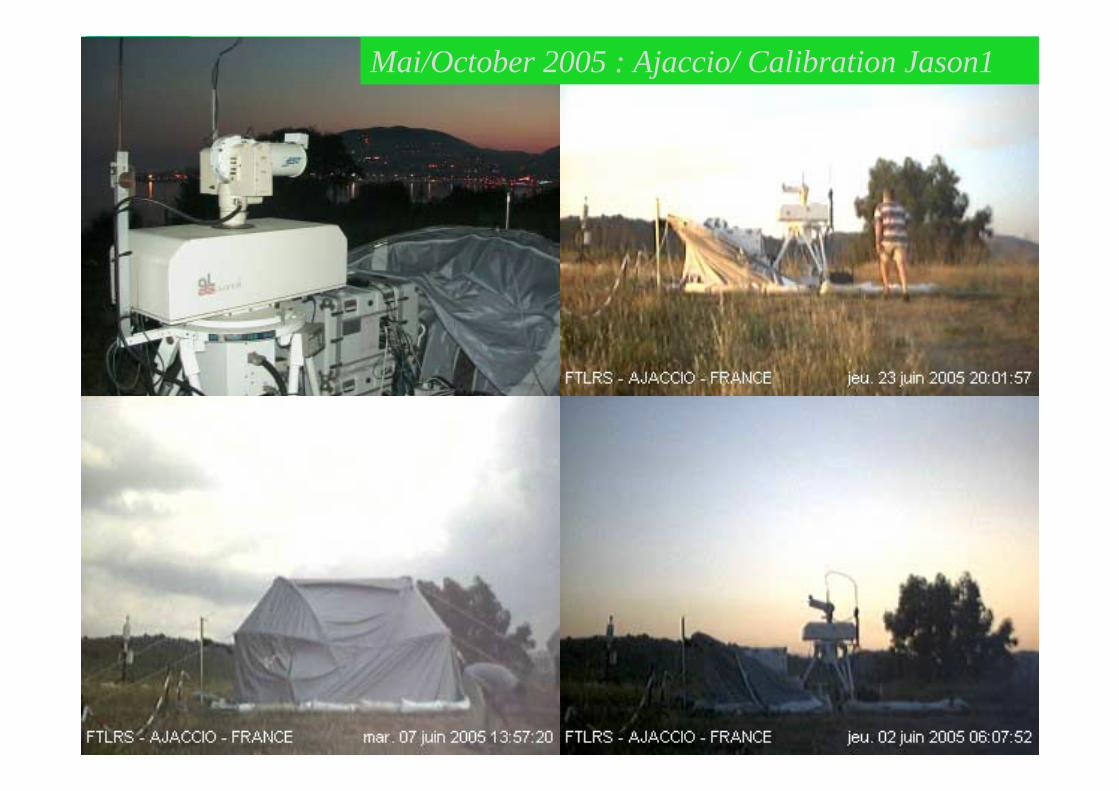
Instrument :French Transportable Laser Ranging System (FTLRS)
LASER campaigns in CorsicaLASER campaigns in Corsica
T/P JASON-1
Mai 2005:Ajaccio Mai/October 2005 : Ajaccio/ Calibration Jason1
FTLRS
OCA-Grasse
# Very small SLR system in operation for 5 years– 350 Kg – ∅ tel = 13 cm (emission/reception)– Time = GPS steered rubidium– LEO satellites to Lageos-1&-2
- Satellite Altimeter Calibration
- Reference Frame
- Charge Effects
- Co-localisation Mono or Multi-techniques
- Satellite Altimeter Calibration
- Reference Frame
- Charge Effects
- Co-localisation Mono or Multi-techniques
Applications
FTLRS : French Transportable Laser Ranging SystemFTLRS : French Transportable Laser Ranging System
Electroniccontainers
Groundmarker
Telescope
Laserbench
Ref.point
Detector
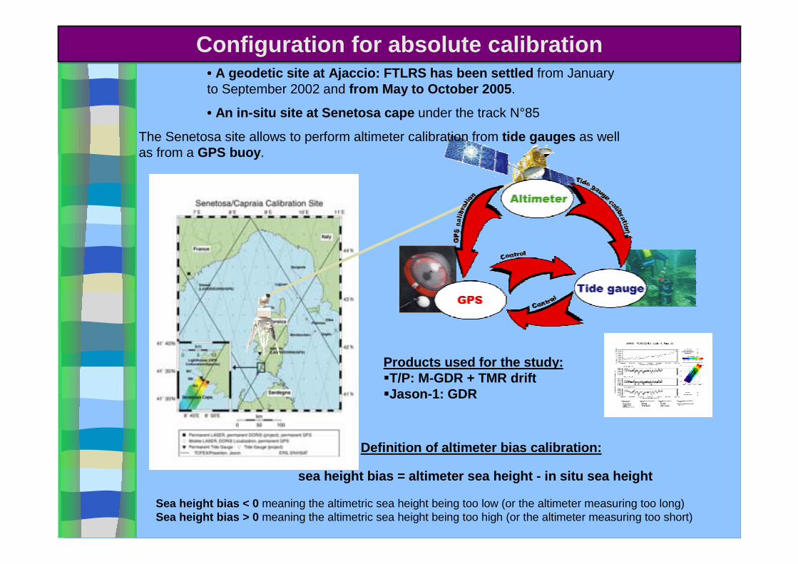
• A geodetic site at Ajaccio: FTLRS has been settled from January to September 2002 and from May to October 2005.
• An in-situ site at Senetosa cape under the track N°85
The Senetosa site allows to perform altimeter calibration from tide gauges as well as from a GPS buoy.
Definition of altimeter bias calibration:
sea height bias = altimeter sea height - in situ sea height
Sea height bias < 0 meaning the altimetric sea height being too low (or the altimeter measuring too long)Sea height bias > 0 meaning the altimetric sea height being too high (or the altimeter measuring too short)
Products used for the study:$T/P: M-GDR + TMR drift$Jason-1: GDR
Configuration for absolute calibration Configuration for absolute calibration
JASON|1
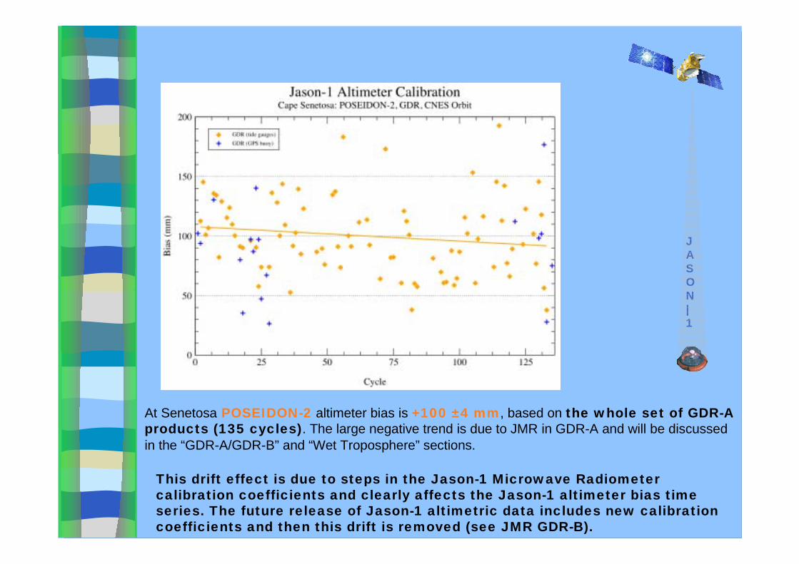
At Senetosa POSEIDON-2 altimeter bias is +100 ±4 mm, based on the whole set of GDR-A products (135 cycles). The large negative trend is due to JMR in GDR-A and will be discussed in the “GDR-A/GDR-B” and “Wet Troposphere” sections.
This drift effect is due to steps in the Jason-1 Microwave Radiometercalibration coefficients and clearly affects the Jason-1 altimeter bias time series. The future release of Jason-1 altimetric data includes new calibration coefficients and then this drift is removed (see JMR GDR-B).

IMPACT
OF
ORBIT
-100-90-80-70-60-50-40-30-20-10
0102030405060708090
100
Jaso
n-1
Old
CN
ES P
OE
New
CN
ES P
OE
JPL
GPS
-RD
06
Short
-Arc
TO
PEX/P
ose
idon
Old
NASA P
OE
New
NASA P
OE
Type of orbit
14726-23New NASA POE14829-10Old NASA POE
Based on RGDR-1 productsTOPEX/Poseidon
581988Short-Arc571694JPL GPS-RD 06581990New CNES POE5122685Old CNES POE
Based on GDR-B productsJason-1
NumberStandard Error
Standard Deviation
BiasOrbit
For Jason1, the new CNES POE really shows an improvement in term of standard deviation with a decrease of 18 mm in term of root square difference compared to the old one. The same level of improvement is obtained with the Short-Arc orbits. The GPS Reduced-Dynamic orbits have the lower standard deviation with a decrease of 10 mm compared to the new CNES POE or the Short-arc orbits.For T/P, the level of improvement on the standard deviation is a little less(13 mm) than for Jason-1. Concerning the value of the altimeter bias itself, it decreases by -13mm so 8 mm more than between the old and new POE for Jason-1.
Scientific Investigation for Positionning Scientific Investigation for Positionning
% Main steps of the work methodology :
a – Orbit computation
b – Positioning of the FTLRS Station
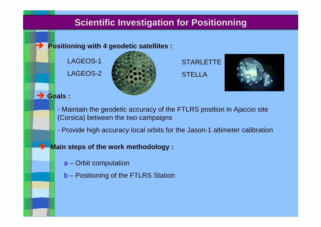
LAGEOS-1
LAGEOS-2
% Positioning with 4 geodetic satellites :
STARLETTE
STELLA
% Goals :
- Maintain the geodetic accuracy of the FTLRS position in Ajaccio site (Corsica) between the two campaigns
- Provide high accuracy local orbits for the Jason-1 altimeter calibration
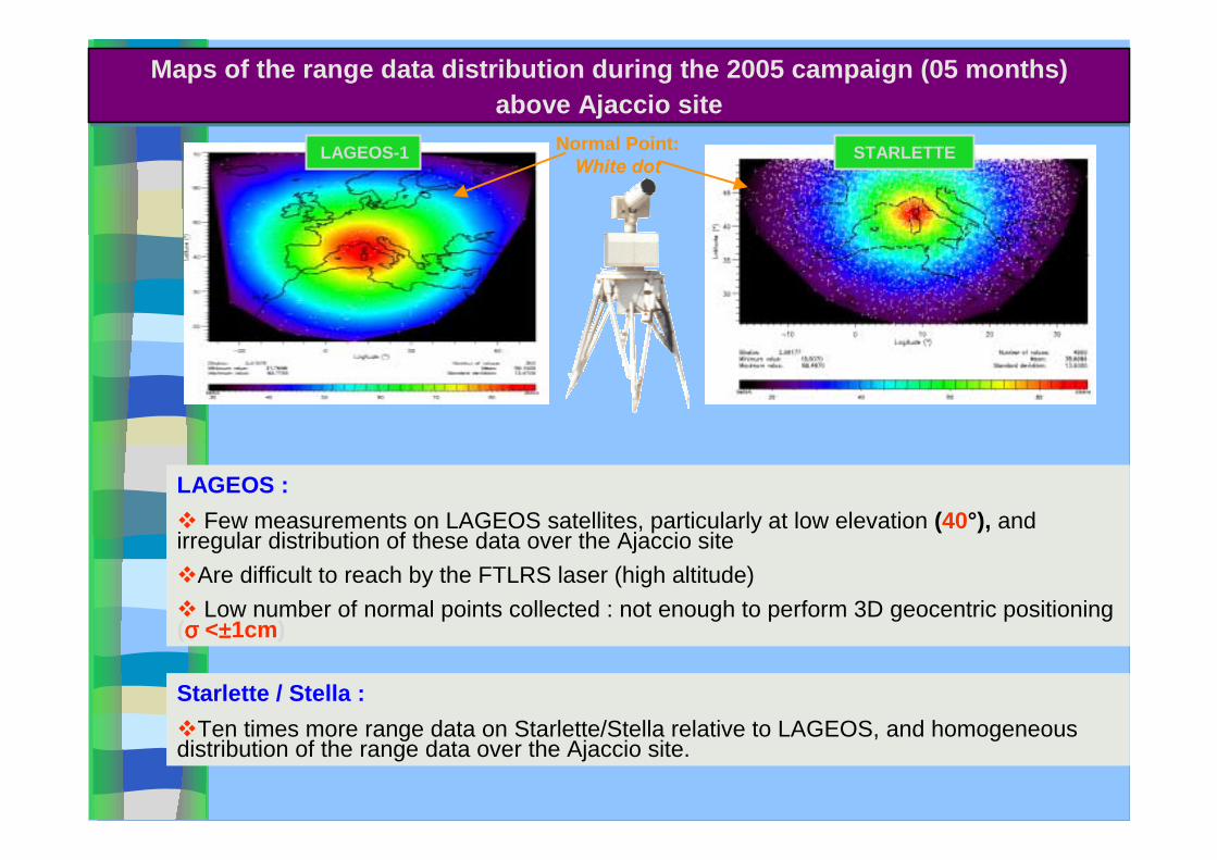
LAGEOS :& Few measurements on LAGEOS satellites, particularly at low elevation (40°), and irregular distribution of these data over the Ajaccio site&Are difficult to reach by the FTLRS laser (high altitude)& Low number of normal points collected : not enough to perform 3D geocentric positioning(σσσσ <±±±±1cm)
Starlette / Stella :&Ten times more range data on Starlette/Stella relative to LAGEOS, and homogeneous distribution of the range data over the Ajaccio site.
LAGEOS-1 STARLETTENormal Point: White dot
Maps of the range data distribution during the 2005 campaign (05 months) above Ajaccio site
Maps of the range data distribution during the 2005 campaign (05 months) above Ajaccio site

% Quality of the FTLRS positioning depends on the accuracy of the orbits.
% Starlette / Stella : More sensitive to remaining uncertainties in the dynamical models (gravit. & non gravit. Effects).
Problematic ?
' Since few years: Improvement of the field gravity model (GRACE mission)
' Adoption of an accurate field gravity model for the LEO computation
' Multi-satellite Combination
Solution :
Problematic Problematic
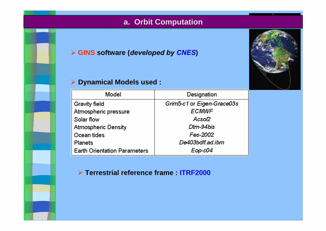
# GINS software (developed by CNES)
# Terrestrial reference frame : ITRF2000
# Dynamical Models used :
a. Orbit Computation a. Orbit Computation
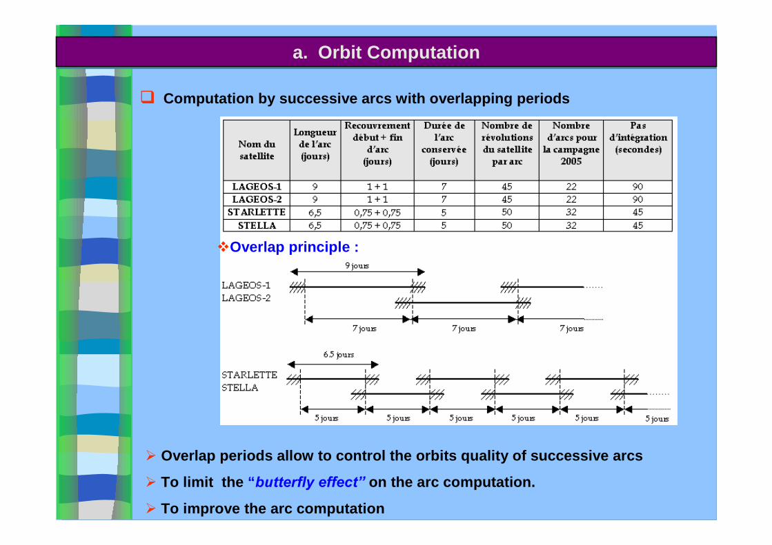
( Computation by successive arcs with overlapping periods
&Overlap principle :
# Overlap periods allow to control the orbits quality of successive arcs
# To limit the “butterfly effect� on the arc computation.
# To improve the arc computation
a. Orbit Computation a. Orbit Computation

a. Orbit Computation a. Orbit Computation
)) RMS (mm) of satellites orbits :RMS (mm) of satellites orbits :
* LAGEOS orbits are more precise & less affected by the change of the gravity field model
* Eigen-Grace03s: improvement of the Starlette / Stella orbits precision (+/- 5mm)
* The Mediterranean area seems to be less affected by a permanent effect
)) Effect of the gravity field model on Effect of the gravity field model on the quality of the orbits :the quality of the orbits :
- Grim5-c1 (Gruber et al., 2000)
- Eigen-Grace03s (Reigber et al., 2005)
RMSStarlette = +/- 15 mm
RMSLageos = +/- 5 mm
Radial orbit differences :
Mean Radial orbit differences (m) geographically correlated of Starlette orbits
Mean Radial orbit differences (m) geographically correlated of Starlette orbits
STARLETTE ( 32 arcs / 2005)
b. Positioning of FTLRS Stationb. Positioning of FTLRS Station
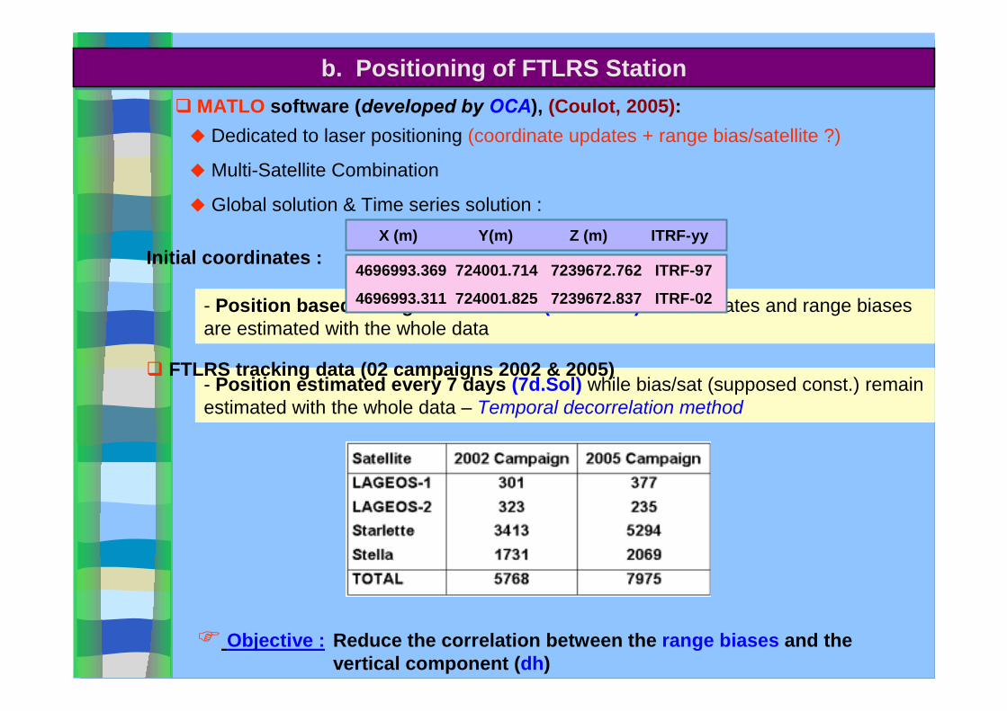
- Position estimated every 7 days (7d.Sol) while bias/sat (supposed const.) remain estimated with the whole data – Temporal decorrelation method
- Position based on a global solution (Glob. Sol) : Coordinates and range biases are estimated with the whole data
( MATLO software (developed by OCA), (Coulot, 2005): + Dedicated to laser positioning (coordinate updates + range bias/satellite ?)
+ Multi-Satellite Combination
+ Global solution & Time series solution :
Reduce the correlation between the range biases and the vertical component (dh)
* Objective :
( FTLRS tracking data (02 campaigns 2002 & 2005)
Initial coordinates : 4696993.369 724001.714 7239672.762 ITRF-97
4696993.311 724001.825 7239672.837 ITRF-02
X (m) Y(m) Z (m) ITRF-yy

Adjusted FTLRS
parameters(2005 Campaign)
Adjusted FTLRS
parameters(2005 Campaign)
(1): Grim5-c1
(2): Eigen-Grace03s
(1): Grim5-c1
(2): Eigen-Grace03s
! Glob.Sol : Correlation remains too high between biases and dh (94%) - Some part of the bias may move to dh and vice versa
! 7d.Sol : Correlation decreases significantly (55%) " This solution is held
! Statistically, the estimates of coordinates updates with Eigen-Grace03s model are betterthan those with Grim5-c1 model.
Results & AnalysisResults & Analysis
Gravity field models :

Range Bias
# Differences between Lageos & Starlette/Stella biases : target response and FTLRS detection process
#The adjusted values of the FTLRS range bias in 2002 of ~ - 10 mm explained :
#Non linearity of Stanford Chronometer not modelised at this epoch : ~ - 4.2 mm
#Geometrical path for external calibration not adjusted : ~ - 3 mm
#Total : 7.2 mm
- Remaining correlation (~50%) between the range bias and the altitude update
-New coordinates (from 2002 & 2005 data sets) along with -5 mm mean range bias : validating the latest Jason-1 precise orbits (Bonnefond et al., 2006)
Adjusted FTLRS
parameters(over 2005 & 2002
Campaigns)
Adjusted FTLRS
parameters(over 2005 & 2002
Campaigns)
Results & AnalysisResults & Analysis
, Time Series Sol.
, Eigen-Grace03s
, Time Series Sol.
, Eigen-Grace03s
With:

Coordinates differences
Geographical coordinates
differences from(Exertier et al., 2004)
solution:
Geographical coordinates
differences from(Exertier et al., 2004)
solution:
Results & AnalysisResults & Analysis
10.310.512.37.520200512.910.513.114.6282002
σ(mm)
σh(mm)
σλ(mm)
σϕϕϕϕ(mm)
Numberof
solution
CampaignStability :Stability :
# Global mean of bias (-5mm): very close to the published one (-7mm) (Exertier et al., 2004)
# Coordinate updates values for 2002 and 2005 are at 3mm level in average relatively to(Exertier et al., 2004) solution.
# Coordinates differences are very small at level of residuals errors in the ITRF2000 velocities
# No significant differences between 2002 and 2005 coordinates (at level of the tectonicmovement): FTLRS point is locally stable.

' Multi-satellite combination has allowed to palliate the lack of measurements on the high satellites (Lageos),
Conclusions & Ftlrs Prospects Conclusions & Ftlrs Prospects
Conclusions :
'The improvement of the dynamical models, notably of the terrestrial gravity field (thanks to the GRACE satellite data:( Eigen-Grace03s) has permitted a precise computation of the orbits, in particular for the low satellites, and so a more precise geographical positioning,
'Considerable decorrelation (~ 40%) is obtained between the range bias and the station vertical component, using the time series solution (MATLO),
'The station position is stable between the two observation campaigns,
'In conclusion, the FTLRS has allowed a precise terrestrial positioning. That confirms its importance for the absolute calibration process of oceanographic satellites.

' New laboratory built in Grasse Observatory to achieve technology upgrade and slr tracking between “fields campaigns”
Wednesday presentation : “Grasse Laser stations in evolution to future“
Conclusions & Prospects Conclusions & Prospects Ftlrs Prospect :
'Laser upgrade to multi pulse concept (~+70 % energy) to increase link budget and facilitate Lageos acquisition
'“Australian Collaborative Research Infrastructure” proposal for Ftlrs campaign
Jason 1 Calibration on Tasmania site in 2007
Tasmanie
GPS + Laser + DORIS
Tide gauge+ GPS buoy
Radar&
Laser


![Reference: [1] Nicolas, J., F. Pierron, E. Samain and F. Barlier (2001). Centimeter Accuracy for the French Transportable Laser Ranging Station (FTLRS)](https://img.dokumen.tips/doc/110x75/551b409f550346d31b8b4756/reference-1-nicolas-j-f-pierron-e-samain-and-f-barlier-2001-centimeter-accuracy-for-the-french-transportable-laser-ranging-station-ftlrs.jpg)