Embed Size (px)
Citation preview
EXXONMOBIL CANADA LTD.
SOUTHEASTERN NEWFOUNDLAND OFFSHORE
EXPLORATION DRILLING PROJECT, 2020-2029
Environmental Assessment Project Description
Pursuant to the Requirements of the Canadian Environmental Assessment Act, 2012
FINAL REPORT
Submitted by:
ExxonMobil Canada Ltd.
100 New Gower Street, Suite 1000
St. John’s, Newfoundland and Labrador
Canada A1C 6K3
Prepared by:
Wood Environment & Infrastructure Solutions
A Division of Wood Canada Limited
133 Crosbie Road, PO Box 13216
St. John’s, Newfoundland and Labrador
Canada A1B 4A5
Wood. TF 1775225
September 2018

ExxonMobil Canada Ltd. Environmental Assessment Project Description
ExxonMobil Southeastern Newfoundland Offshore Exploration Drilling, 2020-2029 EA Project Description September 2018 Page 0
TABLE OF CONTENTS Page No.
1 INTRODUCTION ........................................................................................................................ 5
1.1 Project Overview and Background ..................................................................................... 5 1.2 Proponent Information ........................................................................................................ 8
1.2.1 Corporate Overview ................................................................................................ 8
1.2.2 ExxonMobil Safety, Health, Environment and Security Management ...................... 9
1.2.3 Proponent Contacts .............................................................................................. 11
1.3 Regulatory Context ........................................................................................................... 12 1.3.1 Environmental Assessment................................................................................... 12
1.3.2 The Accord Acts ................................................................................................... 13
1.3.2.1 Land Tenure and Licencing ....................................................................... 14
1.3.2.2 Authorizations and Approvals .................................................................... 14
1.3.3 Other Potential Regulatory Requirements and Interests ....................................... 16
2 PROJECT DESCRIPTION ............................................................................................................. 17
2.1 Project Area and Its Location ........................................................................................................ 17 2.2 Project Timing and Schedule ............................................................................................ 20 2.3 Project Components and Activities ................................................................................... 21
2.3.1 Drilling .................................................................................................................. 21
2.3.2 Vertical Seismic Profiling ...................................................................................... 25
2.3.3 Well Testing .......................................................................................................... 25
2.3.4 Well Abandonment or Suspension ........................................................................ 26
2.3.5 Supply and Servicing ............................................................................................ 26
2.4 Potential Environmental Emissions, Discharges and Associated Waste Management ..... 29 2.4.1 Atmospheric Emissions ......................................................................................... 29
2.4.2 Underwater Sound ................................................................................................ 30
2.4.3 Drilling Wastes ...................................................................................................... 31
2.4.4 Liquid Wastes ....................................................................................................... 32
2.4.5 Solid Wastes ......................................................................................................... 32
2.5 Potential Accidental Events and Their Prevention and Response ..................................... 32 3 ENVIRONMENTAL SETTING ...................................................................................................... 34
3.1 Previous Environmental Assessments and Studies .................................................................. 34 3.2 Physical Environment ....................................................................................................... 35
3.2.1 Geology ................................................................................................................ 35
3.2.2 Bathymetry ........................................................................................................... 35
3.2.3 Climatology ........................................................................................................... 37
3.2.4 Oceanography ...................................................................................................... 37
3.2.5 Ice Conditions ....................................................................................................... 37
3.3 Biological Environment ..................................................................................................... 38 3.3.1 Marine Fish and Fish Habitat ................................................................................ 38
3.3.2 Marine Birds ......................................................................................................... 41
3.3.3 Marine Mammals and Sea Turtles ........................................................................ 41
3.3.4 Species at Risk ..................................................................................................... 42
3.3.5 Special Areas ....................................................................................................... 46
3.4 Socioeconomic Environment ............................................................................................ 48 3.4.1 Fisheries ............................................................................................................... 48

ExxonMobil Canada Ltd. Environmental Assessment Project Description
ExxonMobil Southeastern Newfoundland Offshore Exploration Drilling, 2020-2029 EA Project Description September 2018 Page 1
3.4.2 Other Human Activities ......................................................................................... 53
4 ENGAGEMENT ........................................................................................................................ 57
4.1 Regulatory Engagement ................................................................................................... 57 4.2 Indigenous Engagement................................................................................................... 57 4.3 Stakeholder and Community Engagement ....................................................................... 59
5 POTENTIAL PROJECT-RELATED ENVIRONMENTAL INTERACTIONS ............................... 61
5.1 Possible Project-Related Changes to the Environment .................................................... 61 5.1.1 Planned Project Components and Activities .......................................................... 62
5.1.2 Potential Unplanned Events .................................................................................. 66
5.2 Environmental Assessment Scoping Considerations ........................................................ 69 6 REFERENCES ......................................................................................................................... 71
LIST OF TABLES Page No.
Table 1.1 Exploration Licence 1136: Participating Interests and Terms ........................................ 7
Table 2.1 Project Area Corner Coordinates ................................................................................ 17
Table 2.2 Overview of Exploration Licence 1136 ........................................................................ 20
Table 2.3 Exploration Licence 1136 Coordinates ....................................................................... 20
Table 3.1 Species at Risk or Otherwise of Special Conservation Concern (Current
Designations) ............................................................................................................. 43
Table 5.1 Potential Environmental Interactions and Associated Mitigation ................................. 63
Table 5.2 Environmental Components / Issues and Potential Environmental Interactions Relevant
to CEAA 2012 – Planned Project Components and Activities ..................................... 64
Table 5.3 Environmental Components / Issues and Potential Environmental Interactions Relevant
to CEAA 2012 – Unplanned Project Components and Activities ................................. 67
LIST OF FIGURES Page No.
Figure 1.1 ExxonMobil Canada Ltd. Southeastern Newfoundland Offshore Exploration Drilling Project, 2020-2029 ....................................................................................................... 6
Figure 2.1 Project Area and Associated Exploration Licence and Sector ..................................... 18 Figure 2.2 Exploration Licence 1136 Location ............................................................................. 19 Figure 2.3 Typical Offshore Drilling Units: Semisubmersible Drilling Unit..................................... 23 Figure 2.4 Schematic of a Typical Offshore Well and Associated Drilling Sequence ................... 24 Figure 2.5 Existing and Potential Vessel Traffic Routes ............................................................... 28 Figure 3.1 Regional Bathymetry and Key Features ..................................................................... 36 Figure 3.2 Primary Water Depth Zones of the Project Area and Surrounding Marine Environments
and Corals / Sponge Distributions Based on Existing Datasets .................................. 40 Figure 3.3 Special Areas off Eastern Newfoundland in Proximity to the Project Area .................. 47 Figure 3.4 Commercial Fisheries Locations, All Species (2011-2016) ......................................... 49 Figure 3.5 Commercial Fisheries Locations, Fixed and Mobile Gear (2011-2016) ....................... 50 Figure 3.6 NAFO Fishing Zones and Foreign Fleet Fisheries “Footprint” ..................................... 52 Figure 3.7 Known Shipwrecks, Legacy Sites and Marine Cables ................................................ 54 Figure 3.8 Previous Wells and Current Production Projects off Eastern Newfoundland ............... 55

ExxonMobil Canada Ltd. Environmental Assessment Project Description
ExxonMobil Southeastern Newfoundland Offshore Exploration Drilling, 2020-2029 EA Project Description September 2018 Page 2
LIST OF APPENDICES
Appendix A Table of Concordance with the Prescribed Information for the Description of a
Designated Project Regulations under CEAA 2012

ExxonMobil Canada Ltd. Environmental Assessment Project Description
ExxonMobil Southeastern Newfoundland Offshore Exploration Drilling, 2020-2029 EA Project Description September 2018 Page 3
LIST OF ACRONYMS AND ABBREVIATIONS
2D Two-dimensional
3D Three-dimensional
Accord Acts Canada-Newfoundland and Labrador Atlantic Accord Implementation
Newfoundland and Labrador Act and the Canada-Newfoundland and Labrador
Atlantic Accord Implementation Act
ADW Approval to Drill a Well
AHTS Anchor Handling Tug Supply vessel
bbls barrels
BOP Blow-out Preventer
CAPP Canadian Association of Petroleum Producers
CCO Chief Conservation Officer
CEAA 2012 Canadian Environmental Assessment Act, 2012
C-NLOPB Canada-Newfoundland and Labrador Offshore Petroleum Board
CO Carbon monoxide
CO2 Carbon dioxide
COSEWIC Committee on the Status of Endangered Wildlife in Canada
CPAWS Canadian Parks and Wilderness Society
CTD Conductivity / Temperature / Depth
DFO Fisheries and Oceans Canada
DP Dynamic Positioning
EA Environmental Assessment
EBSA Ecologically and Biologically Significant Area
ECMP Environmental Compliance Monitoring Plan
ECSAS Eastern Canadian Seabirds at Sea
EEM Environmental Effects Monitoring
EEZ Exclusive Economic Zone
EIS Environmental Impact Statement
EL Exploration Licence
EPP Environmental Protection Plan
EU European Union
ExxonMobil ExxonMobil Canada Ltd.
FFAW Fisheries, Food and Allied Workers Union
FLO Fisheries Liaison Officer
FPSO Floating Production, Storage and Offloading
GBS Gravity Based Structure
GHGs Greenhouse Gases
HMDC Hibernia Management and Development Corporation
IBAs Important Bird Areas
LWD Logging / Testing While Drilling
MARPOL International Convention for the Prevention of Pollution from Ships
MBES Multi-Beam Echo-Sounder
NAFO Northwest Atlantic Fisheries Organization
NL ESA Newfoundland and Labrador Endangered Species Act
NL Newfoundland and Labrador
nm nautical mile
Nox Nitrogen oxides

ExxonMobil Canada Ltd. Environmental Assessment Project Description
ExxonMobil Southeastern Newfoundland Offshore Exploration Drilling, 2020-2029 EA Project Description September 2018 Page 4
NRA NAFO Regulatory Area
OA Operating Authorization
OIMS Operations Integrity Management System
OL Operating Licence
OSRP Oil Spill Reference and Oil Spill Response Plan
OSVs Offshore Supply Vessels
OWTG Offshore Waste Treatment Guidelines
PL Production License
psi pounds per square inch
PSV Platform Supply Vessel
ROV Remotely Operated Vehicle
RV Research Vessel
SARA Canadian Species at Risk Act
SBM Synthetic-based Drilling Mud
SBP Subbottom Profiler
SDHA Shallow Drilling Hazard Assessment
SDL Significant Discovery License
SEA Strategic Environmental Assessment
SSHE Safety, Security, Health and Environment
Sox Sulphur oxides
UXO Unexploded Ordnance
VC Valued Component
VME Vulnerable Marine Ecosystem VSP Vertical Seismic Profile
WBM Water-based Drilling Mud

ExxonMobil Canada Ltd. Environmental Assessment Project Description
ExxonMobil Southeastern Newfoundland Offshore Exploration Drilling, 2020-2029 EA Project Description September 2018 Page 5
1 INTRODUCTION
Project Name: ExxonMobil Canada Ltd. Southeastern Newfoundland Offshore Exploration
Drilling Project, 2020-2029
ExxonMobil Canada Ltd. (ExxonMobil) and its co-venturers are planning to conduct a program of
petroleum exploration drilling and associated activities in the southeastern portion of the Canada-
Newfoundland and Labrador (NL) Offshore Area over the period 2020 to 2029 (hereinafter also referred
to as the Project).
The proposed Project Area (Figure 1.1) covers Exploration Licence (EL) 1136 offshore southeastern
Newfoundland in the Carson Basin area, for which ExxonMobil is currently the Operator and which has
not yet been subject to exploration drilling activity pursuant to that licence. The Project Area also
includes an area surrounding that EL that includes Sector NL01-SEN identified by the Canada-
Newfoundland and Labrador Offshore Petroleum Board (C-NLOPB), which is anticipated to be the
subject of a 2019 Call for Bids. Planned Project activities will include exploration drilling, possible
delineation drilling in the case of a hydrocarbon discovery, vertical seismic profiling (VSP), well testing,
eventual well abandonment or suspension procedures, and associated supply and service activities.
The Project requires review pursuant to the requirements of the Canadian Environmental Assessment
Act, 2012 (CEAA 2012), as it has been determined to constitute a “designated project” under the
associated Regulations Designating Physical Activities.
This document comprises a Project Description under CEAA 2012, and has been prepared and
submitted by ExxonMobil (as Proponent) for review by the Canadian Environmental Assessment
Agency and other relevant departments, agencies, organizations and the public to help inform a
governmental decision regarding whether a federal environmental assessment (EA) review of the
Project is required. This Project Description is also intended to assist other government departments
and agencies, Indigenous and stakeholder groups and the public to determine their potential interest in
the Project and any such EA review.
This Project Description has been planned and developed in accordance with, and contains the
prescribed information set out in, the Prescribed Information for the Description of a Designated Project
Regulations under CEAA 2012 and associated guidance (see Appendix A).
1.1 Project Overview and Background
ExxonMobil Corporation (which includes ExxonMobil Canada Ltd. (ExxonMobil) and ExxonMobil
Canada Properties) is actively evaluating potential oil and gas resources off the east coast of the Island
of Newfoundland on both its existing and possible future land holdings in this region.
At present, ExxonMobil Corporation holds an interest in nine ELs, 22 Significant Discovery Licences
(SDLs) and seven Production Licences (PLs) in the Canada-NL Offshore Area (Figure 1.1).

ExxonMobil Canada Ltd. Environmental Assessment Project Description
ExxonMobil Southeastern Newfoundland Offshore Exploration Drilling, 2020-2029 EA Project Description September 2018 Page 6
Figure 1.1 ExxonMobil Canada Ltd. Southeastern Newfoundland Offshore Exploration Drilling Project, 2020-2029

ExxonMobil Canada Ltd. Environmental Assessment Project Description
ExxonMobil Southeastern Newfoundland Offshore Exploration Drilling, 2020-2029 EA Project Description September 2018 Page 7
As noted above, the Project encompasses ExxonMobil’s EL 1136 in the Carson Basin area, which has
not yet been subject to exploration drilling activity to date pursuant to that licence (Table 1.1). Offshore
exploratory wells in the first drilling program on that EL are a designated project and require the
submission of a Project Description under CEAA 2012. The Project Area also includes an area
surrounding that EL that covers Sector NL01-SEN, which is anticipated to be the subject of a C-NLOPB
Call for Bids in 2019. The Project Area has therefore been defined so as to allow for the potential future
inclusion of any ELs that ExxonMobil may acquire through the C-NLOPB’s future Call for Bids process,
or other licences within the Project Area that ExxonMobil acquires operatorship of.
Table 1.1 Exploration Licence 1136: Participating Interests and Terms Exploration
Licence * Owners Participating
Interest (%) Effective
Date * Expiry Date *
(Periods 1 and 2,
respectively)
Previous Drilling Activity
1136 ExxonMobil Canada Ltd. 33.34 January 15,
2015
January 15,
2021
January 15,
2024
No exploration
drilling to date
under this EL
Suncor Energy Offshore
Exploration Partnership
33.33
Total E&P Canada Ltd. 33.33
* ELs have the maximum nine year (9) term consisting of two consecutive periods referred to as Period I and
Period II. The interest owner is required to drill or spud and diligently pursue one exploratory well on or before
the expiry date of period I as a condition precedent to obtaining tenure to period II. Failure to drill or spud a well
will result in reversion to Crown reserve of the licence, and forfeiture of the security deposit or any balance
thereof. If the licence requirement is fulfilled, the interest owner is entitled to obtain tenure to period II.
The purpose of this Project is to drill prospective oil and gas targets identified from the interpretation of
existing well logs and 2D and 3D seismic survey data, in order to help determine the potential presence
of hydrocarbons at these locations. As not all of the required and relevant seismic data have been fully
interpreted or acquired, the number and specific locations of potential drill sites have not been selected
and finalized at this early stage of Project planning, nor have the various drilling and support services
required for the Project been finalized. All drilling operations carried out as part of the scope of this
Project will be conducted within the defined boundaries of the EL(s) themselves (see Figure 1.1 and
Table 1.1 above).
Should the Project require an EA under CEAA 2012, and in the event that ExxonMobil acquires
additional ELs, it is proposed that the new EL(s) may be included in the scope of the potential EA.
Should it be determined that a federal EA is required, additional information on these additional ELs will
be provided to the Canadian Environmental Assessment Agency along with a request that these be
included in the scope of the EA.
Current Project plans would involve drilling between one and possibly up to five wells on EL 1136 (and
similar numbers of wells on any future ELs within the Project Area, as outlined above). Potential wellsite
locations will be determined and refined as Project planning activities continue, based on existing and
new seismic survey data and information from previously drilled wells, and with the specific number,
location and type (exploration or delineation) of these wells being dependent upon the results of
previous wells. It is also anticipated that the Project will include associated VSP surveys, well testing
and eventual abandonment or suspension procedures, and associated supply and service activities
required to support drilling activities. Existing shore-based support facilities operated by third party
contractors will be used for the Project.

ExxonMobil Canada Ltd. Environmental Assessment Project Description
ExxonMobil Southeastern Newfoundland Offshore Exploration Drilling, 2020-2029 EA Project Description September 2018 Page 8
If a suitable prospect within EL 1136 is identified through the available seismic data and existing well
information, drilling operations could begin as early as 2020, depending on the availability, quality and
economic viability of drilling targets, availability of suitable drilling units and pending the receipt of
required regulatory and corporate approvals.
As part of its planned, overall program of oil and gas exploration activities off eastern Newfoundland,
ExxonMobil is also carrying out an Eastern Newfoundland Offshore Geophysical, Geochemical,
Environmental and Geotechnical Program, 2015 to 2024, which has undergone separate EA review
under the regulatory requirements of the C-NLOPB pursuant to the Canada-Newfoundland Atlantic
Accord Implementation Act and Section 134(1) b of the Canada-Newfoundland and Labrador Atlantic
Accord Implementation Newfoundland and Labrador Act (the Accord Acts). EA approval was received
for that project in June 2016, the Project Area for which fully encompassed that for this current Project.
The scope of that project and its EA (Amec Foster Wheeler 2015) included “wellsite-geohazard … work
.. to complete site investigation prior to exploratory drilling”, which was described as follows (see Section
2.4.2 of that EA Report):
[During] site investigation prior to exploratory drilling, geohazard and engineering geophysical data
would be collected using 2D high-resolution reflection seismic, sub-bottom profilers (possibly
involving deep tow, mid water tow, hull-mounted or over the side mounted equipment), side-scan
sonar, multi-beam echosounder and magnetometers. Core, grab and seabed samples may also
be acquired to determine seabed sediment characteristics. For each of these activities, the survey
vessel could be either a dedicated survey ship, or involve the equipment being deployed from a
vessel of opportunity
As the proposed survey activities that comprise that separate project are initiated and completed and
their results are analysed and interpreted, possible wellsite locations may be identified within the Project
Area for the current Project, and evaluated further through such wellsite surveys. These wellsite
investigations are included within the scope of that project and its separate EA review under the
jurisdiction of the C-NLOPB and will be conducted under that previous C-NLOPB EA approval and
associated permitting.
1.2 Proponent Information
Name of Corporate Body: ExxonMobil Canada Ltd.
Address: 100 New Gower Street, Suite 1000
St. John’s, Newfoundland and Labrador
Canada A1C 6K3
1.2.1 Corporate Overview
ExxonMobil Canada Ltd. and its Canadian affiliates, which include ExxonMobil Canada Properties, are
actively involved in on-going operations and petroleum exploration on Canada's East Coast, with
interests that include PLs, SDLs and ELs in the Jeanne d’Arc, Flemish Pass, and Carson / Salar basins
offshore eastern Newfoundland. ExxonMobil Canada Properties is a leading developer and operator of
oil and gas in the region, including lead owner of Hibernia Management and Development Company
Ltd. (HMDC) the operator of the Hibernia Project, the operator of the Hebron Project as well as a co-
venturer in the Terra Nova Project. In addition, ExxonMobil Canada Properties intends to be the

ExxonMobil Canada Ltd. Environmental Assessment Project Description
ExxonMobil Southeastern Newfoundland Offshore Exploration Drilling, 2020-2029 EA Project Description September 2018 Page 9
Operator of the proposed Eastern Newfoundland Offshore Exploration Drilling Project presently under
review under CEAA 2012.
1.2.2 ExxonMobil Safety, Health, Environment and Security Management
ExxonMobil conducts its business in a responsible and ethical manner that protects the safety and
health of employees, others involved in its operations, its customers and the public. Furthermore, it is
committed to conducting its business in a manner that is compatible with the balanced environmental
and economic needs of the communities in which it operates. This commitment requires compliance
with all applicable laws and regulations, facilities that are designed and operated to a high standard,
and the systematic identification and management of safety, security, health, and environmental risks
(SSHE). These commitments are documented in ExxonMobil’s safety, health, environmental, product
safety and security policies and systems, a brief overview of which is provided below.
ExxonMobil has a variety of environmental policies, plans and procedures in place that pertain to its
activities, including associated environmental management systems and other processes to ensure the
effective and efficient implementation and monitoring of these. This includes general policies, principles
and corporate systems that relate to its overall operations worldwide (see, for example,
http://corporate.exxonmobil.com/en/) and/or which relate to its activities in a particular jurisdiction or
operating environment or on a project-specific basis.
Environmental management for this Project will be guided by ExxonMobil's Environment Policy, its
“Protect Tomorrow. Today.” initiative, and relevant corporate management systems. These systems
provide a systematic, structured and disciplined approach to environmental management. ExxonMobil’s
approach to environmental protection is guided by the ExxonMobil’ Corporation’s Environment Policy,
as shown below. ExxonMobil Canada has adopted those policies.

ExxonMobil Canada Ltd. Environmental Assessment Project Description
ExxonMobil Southeastern Newfoundland Offshore Exploration Drilling, 2020-2029 EA Project Description September 2018 Page 10
These concepts are put into practice through a disciplined management framework called the
Operations Integrity Management System (OIMS), which is a standard framework to manage SSHE
risks to achieve consistent, reliable and incident free results. OIMS includes 11 elements, as illustrated
below, each with an underlying principle and a set of expectations. The OIMS framework establishes
common worldwide expectations for controlling operations integrity risks inherent in the company’s
business activities.
ExxonMobil seeks to deliver superior environmental performance, and in this spirit, an Environmental
Management Process has been developed, which is integrated with project design and operations
processes and procedures and has been deployed consistently around the world. This process allows
ExxonMobil to conduct its business in a manner that is compatible with the balanced environmental and
economic needs of the communities in which it operates. ExxonMobil is committed to continuous efforts
to improve environmental performance.
ExxonMobil’s structured Environmental Management Process ensures that a variety of tools, plans and
processes are in place to safeguard the environment - its biodiversity, cultural heritage and value. These
features are a priority in business planning throughout any project's life cycle. The Environmental
Management Process requires an early engagement approach to identifying environmental issues and
alternatives, even before the project concept is determined. In a project’s early stages, alternatives
analyses guide project concepts and decisions as more knowledge about site characteristics and facility
designs become known. Decisions early in a Project’s life can lead to an overall reduced environmental
footprint.
In addition, ExxonMobil has a variety of applicable plans and procedures in place that pertain to its
activities, including associated environmental management systems and other processes to manage
SSHE issues. These plans include (but are not limited to) the following, which apply to both ExxonMobil
as well as its contractors:
Risk Management Plan;
OIMS 11 Elements
“operations”
2. Risk Assessment and Management
3. Facilities Design and Construction4. Information / Documentation
5. Personnel and Training6. Operations and Maintenance
7. Management of Change8. Third-Party Services
9. Incident Investigation and Analysis
10. Community Awareness and Emergency Preparedness
1. Management Leadership, Commitment
and Accountability
11. Operations Integrity Assessment and
Improvement
driver evaluation

ExxonMobil Canada Ltd. Environmental Assessment Project Description
ExxonMobil Southeastern Newfoundland Offshore Exploration Drilling, 2020-2029 EA Project Description September 2018 Page 11
Safety Management Plan;
Health Plan;
Environmental Management Plan;
Security Management Plan;
Regulatory Compliance Plan;
Competency Assurance System;
Facility Integrity Management System (FIMS);
Maintenance and Reliability Program;
Wellbore Management Plan;
Waste Management Plan;
Emergency Response Plan;
Emergency Communications Plan;
Oil Spill Response Plan;
Environmental Effects Monitoring Plan;
Ice Management Plans;
Marine Incident Plan; and
Abandonment / Decommissioning Plan.
Plans related to ice management, waste management, oil spill response, contingency planning and
other issues and requirements are also often developed and implemented on a project- or activity-
specific basis and build on programs currently in place for ExxonMobil’s activities off eastern
Newfoundland.
Additional, more detailed information on these and other aspects of ExxonMobil’s environmental policy,
plans and procedures can be found on the corporate website (http://corporate.exxonmobil.com/en/).
ExxonMobil uses a variety of tools that will help to ensure that the environmental commitments and
mitigations identified for a project are communicated and followed during its operations. Notwithstanding
these internal processes and requirements for managing, monitoring and reporting on its environmental
performance, ExxonMobil will also adhere to all of the applicable legislative and regulatory requirements
that pertain to this Project, including any terms and conditions imposed as conditions of any associated
EA review and approval for the Project, and will monitor and report on these in accordance with
applicable regulatory procedures or other relevant requirements.
1.2.3 Proponent Contacts
ExxonMobil Canada Ltd. has an established office at Cabot Place, 100 New Gower Street in St. John’s
NL, and in conjunction with the other Eastern Canada ExxonMobil affiliates has fully staffed offices and
support facilities in the region where appropriate levels of decision-making and support are in place.
The principal ExxonMobil contacts concerning this Project and its EA review are as follows:
Andrew McNeill, P.Geo
Geoscience Supervisor – East Coast Operations
ExxonMobil Canada Ltd.
Suite 1000, 100 New Gower Street
St. John's, NL Canada A1L 6K3
Tel (709) 273-1462

ExxonMobil Canada Ltd. Environmental Assessment Project Description
ExxonMobil Southeastern Newfoundland Offshore Exploration Drilling, 2020-2029 EA Project Description September 2018 Page 12
Email: [email protected]
Stephen Edwards, P.Eng.
Safety, Security, Health and Environment Manager
ExxonMobil Canada Ltd.
Suite 1000, 100 New Gower Street
St. John's, NL Canada A1C 6K3
Tel (709) 273-1810
Email: [email protected]
1.3 Regulatory Context
The Project will require a number of approvals and authorizations under applicable regulatory
processes, as summarized below.
1.3.1 Environmental Assessment
Proposed oil and gas exploration activities in the Canada - NL Offshore Area may be subject to EA
review pursuant to the requirements of the Canadian Environmental Assessment Act, 2012 (CEAA
2012) and its associated Regulations.
The federal EA process under CEAA 2012 focuses on potential adverse environmental effects that are
within areas of federal jurisdiction, including: fish and fish habitat, migratory birds, federal lands and
other changes to the environment that are directly linked to or necessarily incidental to any federal
decisions about a project. CEAA 2012 also has an associated set of Regulations Designating Physical
Activities, which identify the physical activities that constitute the "designated projects" that may require
a federal EA. These Regulations specify a number of types and scales of oil and gas activities that may
be subject to federal EA review, including (Section 10):
The drilling, testing and abandonment of offshore exploratory wells in the first drilling program
in an area set out in one or more exploration licences issued in accordance with the Canada–
Newfoundland and Labrador Atlantic Accord Implementation Act or the Canada-Nova Scotia
Offshore Petroleum Resources Accord Implementation Act.
The Minister of Environment and Climate Change may also require an EA for any project if there is the
potential for environmental effects in areas of federal jurisdiction or public concerns about such effects.
This Project, which includes the drilling, testing and abandonment of offshore exploratory wells in EL
1136 (which has not been subject to previous exploration drilling under that licence) therefore requires
review pursuant to the requirements of CEAA 2012, as it has been determined to constitute a
“designated project” under the above referenced Regulations.
In cases where CEAA 2012 does apply to a proposed project, the review commences with the
proponent’s submission of a Project Description document. Upon receipt of a Project Description from
the proponent of an applicable project, the Canadian Environmental Assessment Agency has up to 10
days to determine if the document is complete. If the Project Description is complete, the Canadian
Environmental Assessment Agency can then take up to 45 days (including a 20-day public comment
period) to determine whether to require a federal EA. During this "screening" step, government

ExxonMobil Canada Ltd. Environmental Assessment Project Description
ExxonMobil Southeastern Newfoundland Offshore Exploration Drilling, 2020-2029 EA Project Description September 2018 Page 13
examines whether the project may cause adverse environmental effects on areas of federal jurisdiction
or as a result of an associated federal decision.
This Project involves environmental components, issues and requirements that fall within areas of
federal jurisdiction. This includes, for example, the fact that Project activities are planned to take place
within the offshore marine environment, which, as federal waters, are considered “federal lands” under
CEAA 2012. The Act specifically defines “federal lands” as including “. (i) the internal waters of Canada,
in any area of the sea not within a province, (ii) the territorial sea of Canada, in any area of the sea not
within a province, (iii) the exclusive economic zone of Canada, and (iv) the continental shelf of Canada”.
The Project also has the potential to affect environmental components such as fish and fish habitat,
marine and migratory birds, and marine mammals and sea turtles that fall under federal jurisdiction, and
a number of relevant permits, authorizations and/or compliance may be required under the federal
Fisheries Act, Migratory Birds Convention Act, Species at Risk Act and possibly others.
No federal funding has been or will be requested or received by ExxonMobil from any federal authority
to support this Project.
Petroleum exploration and development activities offshore Newfoundland and Labrador are regulated
by the C-NLOPB (see Section 1.3.2). In addition to EA requirements under CEAA 2012, the C-NLOPB
also requires that project-specific EAs be completed in relation to certain types of petroleum activities
in the Canada-NL Offshore Area, as part of their required authorizations pursuant to Section 138(1) b
of the Canada-Newfoundland Atlantic Accord Implementation Act and Section 134(1) b of the Canada-
Newfoundland and Labrador Atlantic Accord Implementation Newfoundland and Labrador Act. The C-
NLOPB’s EA review process typically involves the Proponent completing an EA Report in compliance
with a project-specific Scoping Document issued by the C-NLOPB, with associated input from and
review by a group of provincial and federal government agencies and non-governmental organizations.
It is anticipated that any required EA review for this Project under CEAA 2012 will involve C-NLOPB
participation, and that any Environmental Impact Statement (EIS) completed under CEAA 2012 will also
address the C-NLOPB’s EA requirements.
Given the nature, scope and location of the Project, which will take place in the marine environment
offshore eastern Newfoundland it will not involve the development and use of any new on-land or near
shore infrastructure. Therefore it is not anticipated that provincial environmental regulatory interests will
be triggered for this Project. Specifically, it is not expected that EA review and approval will be required
under the NL Environmental Protection Act (Part X – Environmental Assessment), or that other
provincial or municipal permits or authorizations will be required. This will be confirmed through
discussions with relevant provincial government departments and agencies as Project planning and
regulatory reviews progress.
1.3.2 The Accord Acts
The C-NLOPB is responsible, on behalf of the Governments of Canada and Newfoundland and
Labrador, for petroleum resource management in the Canada-NL Offshore Area. The Accord Acts,
administered by the C-NLOPB, provide for joint management of the Canada-NL Offshore Area and
govern all oil and gas activities in the region. The Board's responsibilities under the Accord Acts include:
the issuance and administration of petroleum and exploration and development rights; administration
of statutory requirements regulating offshore exploration, development and production; and approval of
Canada-NL benefits and development plans.

ExxonMobil Canada Ltd. Environmental Assessment Project Description
ExxonMobil Southeastern Newfoundland Offshore Exploration Drilling, 2020-2029 EA Project Description September 2018 Page 14
The Canada-NL Offshore Area, as defined in the Accord Acts, includes those lands within Canada’s
200 nautical mile Exclusive Economic Zone (EEZ) or to the edge of the continental margin, whichever
is greater.
The overall Project Area includes marine areas (lands) that are located both within and beyond
Canada’s EEZ on the outer continental shelf (see Figure 1.1).
1.3.2.1 Land Tenure and Licencing
The C-NLOPB administers a scheduled land tenure system in relation to rights issuance in the Canada-
NL Offshore Area. The rights issuance process commences with an initial nomination of “sectors”, after
which there is a period of time appropriate to the cycle for exploration efforts to be undertaken. This is
followed by the issuance of an eventual call for nomination of parcels for lands within an identified
sector. A Call for Bids is then issued for specific parcels, from which successful bidders are issued an
EL. Nominations may otherwise be received for lands that are not offered in a scheduled cycle and a
Call for Bids may be issued. Normally, the interest owner of an EL will explore that licence and, upon
finding a discovery, be issued a SDL to further delineate the discovery in anticipation of finding
commercial resources which may lead to the issuance of a PL.
Of particular relevance to the proposed offshore exploration activities that are the subject of this Project
Description, once issued by the C-NLOPB an EL confers: 1) the right to explore for, and the exclusive
right to drill and test for, petroleum; 2) the exclusive right to develop those portions of the offshore area
in order to produce petroleum; and 3) the exclusive right, subject to compliance with the other provisions
of the Accord Acts, to obtain a PL. As noted previously, ELs have a maximum nine-year term consisting
of two consecutive periods. The interest owner is required to drill or spud and diligently pursue one
exploratory well on or before the expiry date of Period I as a condition of obtaining tenure to Period II.
Period 1 may be extended with the filing of a drilling deposit.
1.3.2.2 Authorizations and Approvals
The C-NLOPB’s regulatory responsibilities also include the issuing of several authorizations and
approvals pertaining to offshore oil and gas exploration and development projects and activities in the
Canada-NL Offshore Area. Indeed, the issuance of an EL for a particular portion of this Offshore Area
does not, in and of itself, authorize the licence holder to carry out physical exploration activities
(fieldwork) within that licence area. The drilling of an exploration well, for example, requires various
project-specific regulatory approvals and authorizations, through which the Operator must present
detailed information on its planned exploration activities, and in doing so, demonstrate that they can
undertake such work in a manner that is in keeping with applicable requirements and standards for
safety and environmental protection.
Before carrying out any work or activity respecting oil and gas operations, an Operator must, for
example, obtain an Operating Licence (OL) which is a prerequisite for any oil and gas activity in the
Canada-NL Offshore Area that involves fieldwork. Various authorizations and approvals are also
required for particular activities and other matters, which may - depending on the specific nature and
scope of the activity being planned - include applying for and obtaining an Operating Authorization (OA)
from the C-NLOPB. In accordance with the Accord Acts and Section 6 of the Newfoundland Offshore

ExxonMobil Canada Ltd. Environmental Assessment Project Description
ExxonMobil Southeastern Newfoundland Offshore Exploration Drilling, 2020-2029 EA Project Description September 2018 Page 15
Petroleum Drilling and Production Regulations, prior to the issuance of an OA the following information
must be submitted by the Operator and approved by C-NLOPB:
EA Report (completed under CEAA 2012, as applicable, or under the Accord Acts, see
above);
Canada-Newfoundland and Labrador Exploration Benefits Plan;
Safety Plan;
Transport Canada Letter of Compliance for the drilling installation;
Environmental Protection Plan;
Emergency Response and Spill Contingency Plans;
Appropriate Financial Security
Certificate of Fitness for the proposed equipment / facilities to be used to carry out drilling
activities; and
Declaration of Fitness
Other required C-NLOPB approvals may also involve the approval of certain documents, plans or other
matters as specified by the relevant legislation or regulations, or the approval of specific activities
conducted under an earlier authorization. Of particular relevance to this Project, an Approval to Drill a
Well (ADW) is required for operations involving drilling within or under the marine environment. A
separate ADW is required for each well in a proposed drilling program, with the process involving the
provision and review of specific details about the drilling program and well design. An ADW covers the
operations on a well up to, and including, the termination of the well, which itself could include
suspension, abandonment or completion. A wellsite-geohazard seabed survey must be completed prior
to the issuance of such an ADW. The type of wellsite-geohazard survey required and completed will be
dependent upon such factors as site water depth and type of drilling unit being used. Other approvals,
notifications or records are also required to undertake well testing, abandonment, suspension,
completion or termination, or to alter the condition of a well.
An important aspect of the C-NLOPB’s mandate is the administration of the various provisions of the
Accord Acts that pertain to industrial and employment benefits resulting from the exploration for, and
development of, oil and gas resources in the Canada-NL Offshore Area. This includes the creation and
optimization of such benefits for Canada in general and the Province of Newfoundland and Labrador in
particular. The Accord Acts require that before any work or activity is authorized in this area, a Canada-
Newfoundland and Labrador Benefits Plan must be submitted to, and approved by, the Board. This
Plan must identify and describe the measures to be taken regarding the employment of
Newfoundlanders and Labradorians and other Canadians, as well as providing manufacturers,
consultants, contractors and service companies in the province and other parts of Canada with full and
fair opportunity to participate on a competitive basis in the supply of goods and services to such a
project. ExxonMobil is committed to creating and optimizing opportunities and benefits for
Newfoundland and Labrador and Canadian workers and companies as part of its activities and
operations in the Canada-NL Offshore Area, and to carrying out its business in full compliance with
relevant Canada-Newfoundland and Labrador Benefits Plan Guidelines and other applicable
requirements.
There are also a number of associated Regulations under the Accord Acts which govern particular
exploration or development activities, as well as various Guidelines (some of which have been jointly
developed with other agencies) that are intended to address specific environmental, health, safety and
economic issues related to offshore petroleum exploration and production. Of particular relevance to

ExxonMobil Canada Ltd. Environmental Assessment Project Description
ExxonMobil Southeastern Newfoundland Offshore Exploration Drilling, 2020-2029 EA Project Description September 2018 Page 16
this Project and its EA are the Offshore Waste Treatment Guidelines, Offshore Chemical Selection
Guidelines for Drilling and Production Activities on Frontier Lands, Environmental Protection Plan
Guidelines, Canada-NL Benefits Plan Guidelines, and various others.
As noted above, this Project Description has been prepared in accordance with the requirements of
CEAA 2012 and the C-NLOPB’s EA review process, and it is expected that any EIS that may be required
for the Project under CEAA 2012 will be carried out with the involvement of the C-NLOPB and will
address the Board’s EA requirements under the Accord Acts.
1.3.3 Other Potential Regulatory Requirements and Interests
Various other federal and provincial government departments and agencies also may have regulatory
responsibilities, information and advice and/or other interests regarding the Project and its
environmental setting and potential effects, pursuant to their associated legislation and mandates.
These include the following:
• Fisheries and Oceans Canada (DFO);
• Environment and Climate Change Canada;
• Transport Canada;
• Department of National Defence;
• Natural Resources Canada (NRCan)
• NL Department of Municipal Affairs and Environment;
• NL Department of Fisheries and Land Resources; and the
• NL Department of Natural Resources
Legislation and associated regulations that are or may be relevant to the Project and its EA therefore
include the:
Accord Acts and associated Regulations and Guidelines (as discussed above);
Canadian Environmental Assessment Act;
Fisheries Act;
Canadian Environmental Protection Act;
Oceans Act;
Navigation Protection Act;
Canada Shipping Act;
Migratory Birds Convention Act; and the
Species at Risk Act (Canada) and Endangered Species Act (NL).
In planning and conducting its oil and gas exploration activities, ExxonMobil will comply with these and
all relevant provincial and federal legislation, regulations and guidelines, as well as applicable
international conventions and standards.
As described in Section 1.2.2, the Company also has in place its own comprehensive SSHE policies,
plans and procedures for planning and conducting its oil and gas exploration and development activities,
and requires its contractors to adhere to these as applicable.

ExxonMobil Canada Ltd. Environmental Assessment Project Description
ExxonMobil Southeastern Newfoundland Offshore Exploration Drilling, 2020-2029 EA Project Description September 2018 Page 17
2 PROJECT DESCRIPTION
The following sections provide an overview description of the Project, including its planned location,
equipment, activities and schedule, as well as various associated environmental planning and
management considerations.
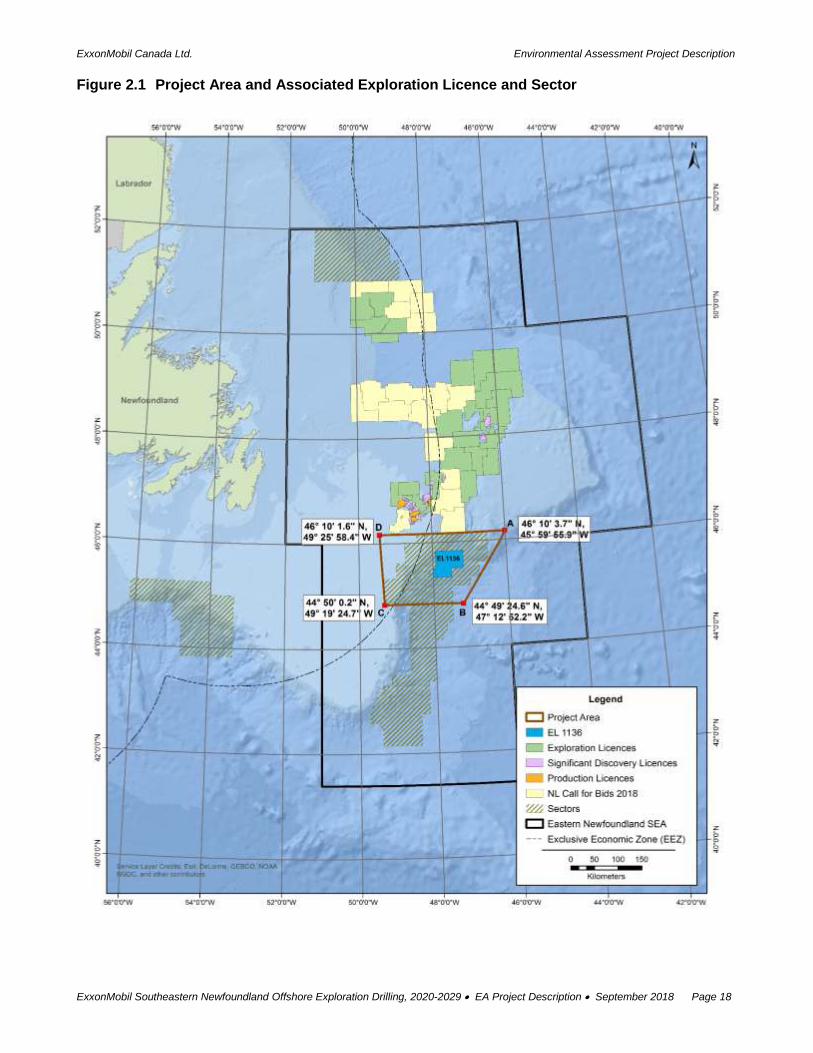
2.1 Project Area and Its Location
The Project will take place in a marine area offshore eastern Newfoundland and Labrador. The Project
Area itself (Figures 2.1 and 2.2, Table 2.1) covers an area of approximately 24,335 km2, with its western
edge being located nearly 300 km east of St. John’s NL. It encompasses EL 1136 and possible future
ELs in the region where ExxonMobil may conduct exploration drilling activities between 2020 and 2029
(Table 2.2).
Although the overall Project Area has been defined as a single polygon encompassing EL 1136 and
the Sector identified above (Figure 2.1), all drilling operations carried out as part of the scope of this
Project will be conducted within the defined boundaries of an EL (Figure 2.1, Table 2.3). Current Project
plans would involve drilling between one and possibly up to five wells on EL 1136 (exploration or
delineation), with similar numbers of wells possible for any future ELs that may be issued to ExxonMobil
and eventually become part of the Project. Specific wellsite numbers, types and locations will be
determined and refined as Project planning activities continue based on existing and new seismic
survey data and information from previously drilled wells.
The Project Area also includes a surrounding area to accommodate the location and extent of ancillary
activities that are often carried out in support of drilling activities. These may include, for example, any
Project activities that are required to extend beyond the immediate boundaries of the EL(s), such as the
required temporary presence and movement of the drill rig(s) or support vessels and aircraft during
initial mobilization and set up or eventual demobilization from the drill site, as well as any required non-
drilling activities that could conceivably extend to outside the EL (eg, walk-away VSP, Section 2.3.2).
Table 2.1 Project Area Corner Coordinates
Point Easting Northing Latitude Longitude
A 886057 5124848 46° 10' 3.7" N 45° 59' 55.9" W
B 799272 4970317 44° 49' 24.6" N 47° 12' 52.2" W
C 632515 4965809 44° 50' 0.2" N 49° 19' 24.7" W
D 620980 5113810 46° 10' 1.6" N 49° 25' 58.4" W
Note: Project Area Coordinates in NAD83 UTM Zone 22
ExxonMobil Canada Ltd. Environmental Assessment Project Description
ExxonMobil Southeastern Newfoundland Offshore Exploration Drilling, 2020-2029 EA Project Description September 2018 Page 18
Figure 2.1 Project Area and Associated Exploration Licence and Sector

ExxonMobil Canada Ltd. Environmental Assessment Project Description
ExxonMobil Southeastern Newfoundland Offshore Exploration Drilling, 2020-2029 EA Project Description September 2018 Page 19
Figure 2.2 Exploration Licence 1136 Location

ExxonMobil Canada Ltd. Environmental Assessment Project Description
ExxonMobil Southeastern Newfoundland Offshore Exploration Drilling, 2020-2029 EA Project Description September 2018 Page 20
Table 2.2 Overview of Exploration Licence 1136
Exploration License
Approximate Distance from St. John's NL
(km)
Licence Area (km2)
Water Depth (m)
Max Min Range
EL 1136 415 2,888.00 2,730 395 2,335
Table 2.3 Exploration Licence 1136 Coordinates
Exploration Licence Latitude Longitude
EL 1136
45°50’N 47°00’W
45°50’N 47°15’W
45°50’N 47°30’W
45°50’N 47°45’W
45°40’N 47°00’W
45°40’N 47°15’W
45°40’N 47°30’W
45°40’N 47°45’W
45°30’N 47°30’W
45°30’N 47°45’W
Licence Coordinates as Defined by C-NLOPB C-NLOPB Legal Disclaimer: The C-NLOPB does not represent or guarantee that any information contained in this document is accurate, complete or a true copy. Users are advised to contact the Registrar or Deputy Registrar at (709) 778-1400 to obtain certified copies or to visit the Registry at the C-NLOPB offices to view official records.
Should an EA be required, direction on setting spatial boundaries will be provided in applicable EIS
Guidelines issued by the Canadian Environmental Assessment Agency.
The location and spatial extent of a Study Area for any required EIS for the Project will be determined
as part of the planning and design phase of that document, including any associated direction provided
in the EIS Guidelines referenced above. This will be defined based on consideration of the nature and
extent (including movement patterns, as relevant) of the various environmental components that may
be affected by the Project and upon which the EIS is focused, the potential geographic zone of influence
of Project components and activities (both planned and potential accidental events) and their
environmental interactions.
2.2 Project Timing and Schedule
As noted previously in Section 1.3.2, ELs issued by the C-NLOPB have a maximum nine-year term
(consisting of two consecutive periods), where the interest owner is required to drill or spud and
diligently pursue one exploratory well on or before the expiry date of Period I as a condition of obtaining
tenure to Period II. The proposed temporal scope of this Project (which covers a 10 year period from
2020 to 2029), has been defined in order to address the term of the existing EL 1136 identified
previously (within which EA and other associated regulatory approvals must be obtained and drilling
planned and commenced within that timeframe), as well as to allow for exploration drilling on this and
any additional ELs that ExxonMobil may acquire through the previously referenced Calls for Bids by the

ExxonMobil Canada Ltd. Environmental Assessment Project Description
ExxonMobil Southeastern Newfoundland Offshore Exploration Drilling, 2020-2029 EA Project Description September 2018 Page 21
C-NLOPB over that period. It also considers any possible approved extensions to these ELs, and the
associated stages of well drilling, testing and abandonment or suspension as required.
Within this period, the planned exploration activities that comprise this Project will occur at various times
of the year for each and all years of the proposed drilling program.
Detailed logistical planning and drilling unit and services procurement processes for the Project may
commence in 2018 and continue throughout the life of the Project. If a prospective wellsite is identified
and pending the receipt of applicable regulatory and corporate approvals, exploration drilling could
commence in EL 1136 in 2020 with an initial well. Upon evaluation of the first well and the analysis of
its results, a potential second well location site will be determined, and it is currently anticipated that up
to five wells (exploration and possibly delineation) may be drilled over the term of that EL. Based on the
phased planning and drilling approach outlined previously, the Project may also involve drilling from
one, and potentially up to five, wells (exploration and possibly delineation) on any future ELs that
eventually comprise part of the Project.
It is anticipated that each well will require approximately 60-75 days for drilling and testing (if required),
which will be followed by well abandonment or suspension. At times there may be multiple drilling units
working in different areas simultaneously for reasons of efficiency and if synergistic opportunities arise
through, for example, the presence and availability of suitable equipment working in the region.
The temporal boundaries established for any future EIS for the Project will include and encompass the
overall timing of Project related activities in the offshore environment, as well as the likely timing and
duration of any resulting environmental interactions and effects and any associated direction provided
in the EIS Guidelines referenced above. In conducting the environmental effects assessment,
consideration will be given to the relevant temporal characteristics of the affected environment, including
the timing and presence of relevant environmental components (e.g., species and activities) within the
EIS Study Area, any particularly sensitive or critical periods, likely response and recovery times to
potential effects, and any natural (without-Project) variation in the baseline environment.
2.3 Project Components and Activities
The objective of this proposed exploration drilling program is to help determine the potential presence
of hydrocarbons in ExxonMobil held ELs in the Project Area. In the case of a discovery, delineation
wells may be drilled to help further define its geographic extent, and the Project will also include
associated VSP surveys, well testing, eventual abandonment or suspension, and associated supply
and service activities.
2.3.1 Drilling
Pending the receipt of all required regulatory and corporate approvals (including determination of a
prospective drilling location) for the Project, ExxonMobil currently anticipates drilling as soon as 2020.
As indicated previously, drilling would initially take place on EL 1136, and depending on the results of
the initial well, potentially up to four additional wells may be drilled at other (as yet undefined) locations
over the term of this EL. The Project may also involve drilling between one and potentially up to five
wells on any future ELs within the Project Area for which ExxonMobil is Operator.
Specific wellsite locations will be selected as Project planning and design activities move forward, based
on existing and new seismic survey data and information derived from previously drilled wells in the

ExxonMobil Canada Ltd. Environmental Assessment Project Description
ExxonMobil Southeastern Newfoundland Offshore Exploration Drilling, 2020-2029 EA Project Description September 2018 Page 22
region. It should be noted that the planning process for an offshore well commences early in the wellsite
selection process and involves close coordination between the geoscience and drilling teams.
Geoscience personnel focus on the rock formation physical properties and pore pressure prediction
and provide this information to the drilling team to determine the well drilling plan, equipment design
and other associated considerations. During the well planning exercise, each depth interval is evaluated
and re-evaluated to design the wellbore, drilling fluid density, casing to be run and cement to be used.
A multi-disciplinary team also completes a detailed risk analysis focusing on well control once the
preliminary drilling plan has been completed. In preparation for drilling unit arrival at the drilling location,
positioning transponders will be placed on the seabed and metocean equipment will be deployed.
Wells will be drilled using a Semi-submersible Drilling Unit (Figure 2.3), and it is again possible that at
times there will be multiple drilling units involved in Project-related drilling activities in various locations
simultaneously. The type of rig chosen is often based primarily on the characteristics of the physical
environment at the proposed drill site, particularly water depth, expected drilling depth and expected
weather and ice conditions and associated mobility requirements, as described below (CAPP 2006,
cited in Amec 2014).
Semisubmersible Drilling Units are typically used in relatively deep waters (70-1,000 m on anchor or at
greater depths up to 3000 m using dynamic positions systems) or in areas where increased mobility is
required due to ice or other factors and operational risks. These units can either be towed to the drill
site or move under their own power and are designed for drilling in rougher seas. The main deck of the
unit is supported by a series of vertical columns, which in turn sit atop steel pontoons that float below
the water surface during operations. The pontoons are filled with water so that the unit floats with the
main deck above water and the remainder below the surface, and the platform can be raised or lowered
by adjusting the amount of ballast water they contain. Because much of the mass of the rig is below
water, these units are relatively stable in rough seas. On site, the unit is moored to the bottom with a
series of large anchors (up to 1000 m water depth), and in deeper waters (over 1,000 m), these units
utilize a dynamic positioning system in which thrusters position the vessel and keep it steady.
Jack-Up Drilling Units are typically used in shallow water depths of between 10 and 100 m. These units
are towed to a drill site, at which time the rig’s 3-4 retractable legs are placed above the hull structure.
Once on site, the legs are lowered until they come into contact with and rest upon the sea floor, and the
drilling barge or unit platform is elevated up the legs until it is at the desired height above the sea
surface. Due to the water depths present in the Project Area Jack-Up drill rigs would not be considered
for this Project.

ExxonMobil Canada Ltd. Environmental Assessment Project Description
ExxonMobil Southeastern Newfoundland Offshore Exploration Drilling, 2020-2029 EA Project Description September 2018 Page 23
Figure 2.3 Typical Offshore Drilling Units: Semisubmersible Drilling Unit
Any drilling unit proposed to be operated off Newfoundland and Labrador must first be evaluated and
granted an Operations Authorization by the C-NLOPB.
A Semi-Submersible Drilling Rig could be anchored (in depths of less than approximately 1000 m) or will maintain its station through dynamic positioning (DP) systems in deeper water.
Figure 2.4 provides a generalized schematic of a typical offshore well and summarizes the typical drilling
sequence for the upper section of a well and associated well head, blow-out preventer (BOP), casing
and riser installation for wells such as those being proposed as part of this Project.
For the planned exploration drilling activities being undertaken as part of this Project there will be no excavated drill centers and no required underwater construction activities. The installation of seabed or near-seabed components would be restricted to the wellhead, BOP and riser, and the wellheads themselves would typically protrude a maximum of five metres above the seabed.

ExxonMobil Canada Ltd. Environmental Assessment Project Description
ExxonMobil Southeastern Newfoundland Offshore Exploration Drilling, 2020-2029 EA Project Description September 2018 Page 24
Figure 2.4 Schematic of a Typical Offshore Well and Associated Drilling Sequence
1 Drill riserless large diameter hole using water-based muds and return cuttings to seafloor
2 Run wellhead and cement casing, taking returns back to the seafloor
3 Install BOP and riser
4 With installation of riser and BOP complete, continue drilling through casing with either water or synthetic based muds, cuttings and mud returned to rig deck for processing and disposal
NOTE: For general illustration only, Drilling unit and well components not to scale
Drilling muds are fluids which lubricate and cool the drill bit and hole, circulate cuttings and carry them
back to the surface, and help to maintain appropriate pressure in the well. Several types of drilling muds

ExxonMobil Canada Ltd. Environmental Assessment Project Description
ExxonMobil Southeastern Newfoundland Offshore Exploration Drilling, 2020-2029 EA Project Description September 2018 Page 25
will be utilized, with water-based muds (WBMs) primarily being used for the uppermost sections of a
well, and synthetic-based muds (SBMs) being used once the riser has been installed. Drilling muds are
also used to provide hydrostatic pressure to prevent high pressure formation fluids from rising to the
surface through the wellbore and are the primary barrier in well control (the BOP is the second barrier).
Once the drill site clearance has been completed and the drilling unit has been positioned the initial top-
hole drilling commences, which is a large diameter hole that is drilled without a riser in place. The initial
sections are drilled using a WBM, where mud and cuttings are returned to the seabed as permitted by,
and in accordance with, the Offshore Waste Treatment Guidelines. When top section drilling has been
completed to the depth where the rock formation strength is sufficient, the structural casing is run and
cemented, and the wellhead is installed at seabed. The BOP and riser are then installed. Once the riser
has been installed, drilling mud and cuttings are then returned to the rig deck in a closed loop system,
where the drilling fluids and cuttings are separated and treated. Cutting and drilling mud fluid use,
treatment and eventual disposal is discussed further in a later section of this Chapter.
2.3.2 Vertical Seismic Profiling
In obtaining and interpreting the results of oil and gas exploration drilling activities, the correlation of
time-based depth information from seismic data to the actual drilling depth is critical. VSP enables the
acquisition of time, depth, and velocity information for the formations in which drilling has been
completed, with a number of techniques being available for acquiring VSP data. In the marine
environment, receivers are typically placed in the borehole and a sound source is deployed, usually
from the drilling platform crane into the water column at a predetermined depth (approximately 5-20 m)
to achieve a near zero offset. Walk-away VSP surveys may also be undertaken, which involve placing
a sound source on a vessel which then moves away while firing the seismic source at pre-determined
distances from the borehole receiver.
VSP acquisition surveys are typically short-term activities of several days duration, with seismic source
firing often limited to just a few hours. In undertaking any required VSP surveys as part of this Project,
ExxonMobil will apply seismic source recommended environmental mitigation measures as outlined in
the Statement of Canadian Practice with Respect to the Mitigation of Seismic Sound in the Marine
Environment (DFO 2007).
2.3.3 Well Testing
During offshore exploration drilling programs, well formation logging is typically an ongoing process to
identify the rock types encountered and to identify any possible zones where hydrocarbons are present.
Mud logging and the evaluation of drill cuttings and mud gases are the primary well formation zone
logging methods. Additional evaluation is accomplished by logging/testing while drilling (LWD) / wireline
well logging techniques which provide detailed rock formation and rock properties information.
If there is sufficient indication of hydrocarbon presence, well flow testing may also be undertaken to
sample and identify formation fluids and to measure flow rates. During this procedure, potential zones
are isolated, and samples are acquired, and if gas is present flaring is required. The duration of the well
testing process is dependent upon the complexity of the subsurface rock formations, and if encountered,
the potential for establishing the extent of hydrocarbon reservoir. As part of this Project, flaring activities
will be kept to a minimum, and will only be carried out if a drill stem test is required. The likely duration
of flaring during a drill stem test is approximately one to two days. Section 2.4.1 provides a discussion

ExxonMobil Canada Ltd. Environmental Assessment Project Description
ExxonMobil Southeastern Newfoundland Offshore Exploration Drilling, 2020-2029 EA Project Description September 2018 Page 26
of the various atmospheric emissions that may be associated with any required flaring activity. If
required any associated flaring will be closely monitored and carried out as per the Formation Flow Test
Program outlined in the ADW.
2.3.4 Well Abandonment or Suspension
Once drilling and any associated well testing is completed, offshore wells are typically then
decommissioned and abandoned. These activities involve the isolation of the well bore by placing
cement plugs, potentially in combination with mechanical devices, at various depths, with the casing
then being cut and removed just below the surface of the seafloor and all equipment removed.
Wellheads are often removed from the seafloor using a mechanical casing / wellhead cutting device.
An ROV or other equipment is then used to inspect the seabed to ensure that no equipment or
obstructions remain in place.
Well decommissioning and suspension or abandonment for this Project will be carried out as per
ExxonMobil’s standard internal procedures for same, as well as applicable industry practice and in
compliance with relevant regulatory requirements. These activities will adhere to the requirements set
out under the Newfoundland Offshore Petroleum Drilling and Production Regulations. In the event that
planned, conventional well abandonment techniques such as those described above are ineffective for
a particular well, alternative approaches may be required and will be investigated and implemented in
consultation with relevant regulatory authorities and in compliance with applicable authorizations. Wells
will be inspected in accordance with applicable regulatory requirements at the time of abandonment.
In some circumstances, the well may not be abandoned, but suspended for future re-entry. The same
cement plugging program would be implemented, ensuring isolation of all hydrocarbon-bearing
intervals. The casing / wellhead may be left in place for future use.
2.3.5 Supply and Servicing
All drilling units and vessels that are used for this Project will meet the operational and environmental
capabilities needed for the associated exploration activities, including for implementing relevant
environmental mitigations and safety and emergency response procedures. All vessels will be in
compliance with applicable legislation and regulations and will be inspected by Transport Canada and
approved for operation by the C-NLOPB before beginning any Project-related work. They will have
appropriate oil spill / pollution prevention and emergency response plans in place, and each will be
International Convention for the Prevention of Pollution from Ships (MARPOL) compliant.
It is anticipated that offshore supply vessels (OSVs) and helicopter services for the Project will be based
in St. John’s NL. ExxonMobil’s activities off Newfoundland and Labrador are supported through an
existing marine facility (the A. Harvey Marine Base) located at the Port of St. John’s, which is used for
loading and offloading required supplies and equipment. This and/or other existing facilities in eastern
Newfoundland will be utilized for these purposes for this Project, as well as for the supply and disposal
of drilling fluids and for fueling. Aircraft support for the Project will be based at the St. John’s International
Airport. These shore-based facilities are owned and operated by independent third-party service
providers. They service multiple operators and their activities in Newfoundland and Labrador and were
developed and operate in accordance with relevant regulatory requirements and approvals. The Project
will not require or result in any upgrades or the development and use of new infrastructure at these
established shore base facilities.

ExxonMobil Canada Ltd. Environmental Assessment Project Description
ExxonMobil Southeastern Newfoundland Offshore Exploration Drilling, 2020-2029 EA Project Description September 2018 Page 27
It is anticipated that with a single drilling unit up to four vessels could be required to support the drilling
program, including two to three Anchor Handling Tug Supply (AHTS) vessels or Platform Supply
Vessels (PSVs) and one standby vessel, as well as two helicopters. An additional seabed survey vessel
could also be used occasionally to complete short duration ROV inspections, environmental and/or
geohazard surveys as required. During the ice management season, the number of vessels required
could increase.
It is anticipated that there will be two to three trips to and from the drilling units by the supply vessels
per week during the course of the Project. These services will again be procured from existing,
established third party suppliers that service the offshore oil and gas sector. In the case that two drilling
units are operating at the same time, the number of offshore supply vessels would increase to four or
five and the number of trips to the onshore marine base would increase up to four or five trips weekly.
Supporting vessels that are involved in Project activities will travel in an essentially straight line between
a drill rig operating within an EL in the Project Area and an established port facility in eastern
Newfoundland, a practice which is common in the oil and gas industry that has been active in this region
for several decades. Figure 2.5 illustrates a number of key supply and support vessel traffic routes
related to the existing oil production facilities off eastern Newfoundland, as well as a potential traffic
route that may be used for this Project. This is again provided for general information and illustrative
purposes, recognizing that specific routes may vary at times based on the particular location of the
active drilling unit(s), the shore-based support facility being used, environmental conditions (including
weather and ice), and other logistical factors.
The planning and conduct of Project-related vessel traffic will be undertaken in consideration of these
factors, relevant regulatory requirements, and through established cooperative processes that involve
discussions and communications between the oil and gas sector, fishing industry and other ocean
users.

ExxonMobil Canada Ltd. Environmental Assessment Project Description
ExxonMobil Southeastern Newfoundland Offshore Exploration Drilling, 2020-2029 EA Project Description September 2018 Page 28
Figure 2.5 Existing and Potential Vessel Traffic Routes

ExxonMobil Canada Ltd. Environmental Assessment Project Description
ExxonMobil Southeastern Newfoundland Offshore Exploration Drilling, 2020-2029 EA Project Description September 2018 Page 29
2.4 Potential Environmental Emissions, Discharges and Associated Waste Management
Potential environmental emissions and discharges that may be associated with offshore exploration
drilling programs include noise, light and other atmospheric emissions (exhaust), liquid discharges, and
other waste materials associated with the offshore drilling unit and support vessels and aircraft.
The key regulatory guidance pertaining to emissions and offshore discharges, disposal and treatment
for these types of offshore activities is contained in the Offshore Waste Treatment Guidelines. Offshore
waste discharges for this Project will also be managed in strict compliance with these Guidelines, as
well as the MARPOL. ExxonMobil will also comply with applicable sections of these and other relevant
regulations and guidelines as adopted in the Environmental Protection Plan (EPP) approved by the
Chief Conservation Officer (CCO). A comprehensive Waste Management Plan similar to those used by
the other Operators will also be developed and implemented for the Project.
ExxonMobil is committed to the establishment of safe and environmentally responsible procedures for
the generation, storage, handling, transportation, treatment and disposal of all waste materials
generated throughout the course of this Project. The Company will attempt to reduce, reuse and recycle
liquid and solid waste and reduce liquid and atmospheric emissions. All onshore and offshore waste
discharges will be managed and disposed of as per the Project’s Environmental Management Plan,
Offshore Chemical Management Plan and the Waste Management Plan. Waste products offloaded at
the on-shore supply base(s) will be disposed of by licenced third-party waste disposal companies in
accordance with relevant provincial and municipal regulations. Waste types and volumes will be
documented as per relevant regulatory requirements.
An ExxonMobil Environmental Compliance Monitoring Plan (ECMP) will be prepared once the drilling
unit(s) and OSVs have been selected, which is a key component of the Company’s environmental
management system. This Plan identifies waste streams, sampling, analysis and reporting
requirements for regulated waste streams that are discharged to the marine environment and
atmosphere resulting from the drilling activities, as well as those that are released to the sea and do not
require compliance monitoring. Once generated, this document will be focused solely on the proposed
exploration drilling program and intended to satisfy the requirements specified in subsections 9(i)(j) of
the Newfoundland Offshore Petroleum Drilling and Production Regulations. The requirements outlined
in the ECMP are generally aligned with the Offshore Waste Treatment Guidelines.
The following sections provide a further overview of a number of environmental emissions, discharges
and waste materials that will or may be generated over the course of Project activities, as well as how
these will be managed.
2.4.1 Atmospheric Emissions
Atmospheric emissions during Project activities may include exhaust from the drill rig(s), support
vessels and associated equipment (such as on-board power generators), as well as emissions from the
storage and flaring of hydrocarbons associated with well testing (if and as required). The primary air
emissions, including greenhouse gases (GHGs), that would result from these Project activities include:
Drill rig, vessel and aircraft exhausts (carbon monoxide (CO), nitrogen oxides (NOX), total
suspended particulates (TSP), volatile organic compounds (VOCs), GHGs); and
Power generation (CO, NOX, TSP, VOCs, sulphur dioxide, GHGs).

ExxonMobil Canada Ltd. Environmental Assessment Project Description
ExxonMobil Southeastern Newfoundland Offshore Exploration Drilling, 2020-2029 EA Project Description September 2018 Page 30
During any formation flow well testing there could also be short periods of flaring and associated
emissions of associated gases (CO, NOX, VOCs, TSP, GHGs)
These air emissions will be in keeping with relevant regulatory requirements and standards, including
the Canadian Environmental Protection Act, National Ambient Air Quality Objectives and the
Newfoundland and Labrador Air Pollution Control Regulations for specified criteria air contaminants, as
well as relevant regulations under MARPOL. Potential flaring will occur in accordance with the Drilling
and Production Guidelines.
For the purposes of this Project Description, a general and preliminary estimate of potential GHG
emissions that may be associated with the drilling of a well as part of this Project is provided here.
Assuming that it could take up to 60-75 days to drill a well, it is estimated that CO2 equivalent emissions
associated with operational drilling (including any associated well evaluation and testing activities) and
associated vessel traffic could be in the range of 5,000 to 15,000 tonnes CO2 per well. It is currently
anticipated that the number of wells drilled in each year of the Project could range from one to five wells,
which would result in total CO2 emissions ranging from 5,000 to up to 60,000 tonnes CO2 annually. It
should be noted that these are preliminary estimates only, and specific emission types and volumes will
depend on a variety of factors, including drilling unit and support vessel types and classes, time of year,
the duration of drilling, and other considerations. An estimate of, and analysis regarding, potential
Project-related GHG emissions will be calculated and discussed as relevant and required in the EIS.
Noise emissions into the atmospheric environment associated with an offshore drilling program include
those associated with drilling and other activities on the drilling unit itself, as well as from supporting
vessel and aircraft traffic.
Light emissions from the drilling platform include platform lighting as well as those which may be
associated with any flaring that is required during well testing operations. Light will also be generated
by the OSVs, which will be comparable to that from other ships of similar size operating off eastern
Newfoundland and elsewhere. Since lights can attract and otherwise affect marine birds and other fish
and wildlife, lighting will be kept to a minimum to the extent that it does not affect crew / vessel safety.
ExxonMobil will apply for a Migratory Bird Handing Permit from the Canadian Wildlife Service which will
enable the crew to salvage and release any seabirds which may become stranded on the drilling
platform. A seabird salvage log will be maintained to record any and all seabird interactions as per the
permit conditions.
2.4.2 Underwater Sound
Underwater sound will also be generated as a result of the planned Project activities, which will include
the noise generated by the drilling unit and supply and standby vessels as well as the sound energy
from the source array for any associated VSP data collection. In the case of the former, this will include
the sound emitted into the marine environment by the drilling activity itself, as well as from the platform
while operating in dynamic positioning mode. Underwater sound generated during VSP operations are
periodic and of short term duration (up to several hours or days), with source array volumes ranging
from 450-2,400 in3 with operating pressures of approximately 2,000 psi, producing approximate peak-
to-peak pressures of 100 to 180 bar-m. Again, the relevant mitigations outlined in the Statement of
Canadian Practice with Respect to the Mitigation of Seismic Sound in the Marine Environment (DFO
2007, Appendix 2) will be adhered to in order to address any potential environmental effects.

ExxonMobil Canada Ltd. Environmental Assessment Project Description
ExxonMobil Southeastern Newfoundland Offshore Exploration Drilling, 2020-2029 EA Project Description September 2018 Page 31
2.4.3 Drilling Wastes
As described earlier, drilling muds are fluids which lubricate and cool the drill bit and hole, circulate
cuttings and carry them back to the surface when the riser is in place, and help to maintain appropriate
subsurface pressure in the well. These can be a water-based muds (WBMs) or synthetic-based muds
(SBMs). The primary component of WBMs is seawater, with other additives (primarily bentonite (clay),
barite and potassium chloride) and approved chemicals also added as required to control and achieve
the required mud properties. The initial “riserless” sections of the well bore are generally drilled using
WBMs in which case the mud and cuttings are returned to the seabed as permitted by, and in
accordance with, the Offshore Waste Treatment Guidelines. Once installed, the riser system serves as
a conduit to bring mud and cuttings back to the drilling unit in a closed loop system. These deeper
sections of the well bore are typically drilled using SBMs, which are returned to the drilling unit’s deck
via the riser and then separated and treated before disposal. The SBM itself is reused, and treated SBM
cuttings are discharged to the marine environment as specified in the Offshore Waste Treatment
Guidelines.
The primary environmental issues and interactions that are associated with the disposal of drill wastes
(fluids and cuttings) are related to their potential effects on marine habitats and biota, particularly the
possible alteration (smothering) or contamination of marine habitats and benthos due to their discharge
and deposition on the seabed. Previous EA reviews for proposed projects in the Canada-NL Offshore
Area that involve drilling activities have included detailed modelling of drill cuttings deposition on the
seafloor based on project and site-specific (oceanographic) factors, often at one or more representative
locations within their respective project areas. As described later in Section 3.4, there have been
numerous such modelling studies carried out as part of previous EA reviews for planned exploration or
production drilling programs off eastern Newfoundland, including sites near the Project Area. In addition,
environmental effects monitoring (EEM) programs have also been designed and implemented for the
three producing developments (Hibernia EEM initiated in 1998, Terra Nova EEM initiated in 2000, White
Rose EEM initiated in 2004), and the Hebron EEM is currently ongoing. While the specific nature,
methods and outcomes of these on-going or planned EEM programs vary somewhat between projects,
they each include associated sampling and analysis focused on marine sediments (with a focus on
detecting any environmental effects from drill cuttings), seawater and commercial fish species. These
EEM programs have generally found any environmental implications for sediment or benthic organisms
to be limited to the area immediately surrounding the developments, with no indication of significant
adverse environmental effects. Details on EEM study designs, methods and results to date are available
at http://www.cnlopb.ca/environment/projects.php.
In addition to these project-specific modeling and monitoring studies for drilling projects off
Newfoundland and Labrador, a number of other, generic investigations of the environmental
implications of drill cuttings and fluids disposal have also been carried out. A recent study published by
International Association of Oil and Gas Producers (IOGP 2016) for example, found that the biological
effects of ocean discharge of drill cuttings and associated drilling fluids are mainly restricted to the
benthic environment, and that the effects of WBM and treated (Group III) SBM cutting accumulations in
sediment are usually minor and biological recovery is often well underway within a year of completion
of discharge. Similarly, the results of a DFO (2006) study in the Jeanne d’Arc Basin area on the Grand
Banks found that any significant sediment toxicity stemming from the use of IPAR type drilling fluids in
this area should be confined to a range of tens of meters from any cuttings pile deposited on the seabed
below the drilling unit. The acute toxicity potential in relatively high concentrations of barite were tested

ExxonMobil Canada Ltd. Environmental Assessment Project Description
ExxonMobil Southeastern Newfoundland Offshore Exploration Drilling, 2020-2029 EA Project Description September 2018 Page 32
and found to be non-toxic to capelin, snow crab larvae or planktonic jellyfish after 24 hours of continuous
exposure. Another study by the Society of Petroleum Engineers (SPE 2006) of cuttings and associated
fluid disposal and its environmental effects in deep water (950 m) found that cuttings drilled with
nonaqueous drilling fluid discharged into deep water had a very limited environmental effect.
2.4.4 Liquid Wastes
Liquid wastes and other materials generated by the Project activities will include storage displacement,
bilge, ballast, cooling, gray and black and fire control systems test water, as well as treatment fluids,
desalination brines and possibly other liquid materials. Allowable chemical properties for offshore
disposal to the marine environment and associated reporting requirements are also specified in the
Offshore Waste Treatment Guidelines. ExxonMobil will follow these guidelines and incorporate them
into the Project EMCP. Liquid discharges that do not meet the applicable standards for ocean disposal
will be transported back to shore for disposal at an existing and approved facility.
2.4.5 Solid Wastes
Domestic waste materials will be generated primarily by Project-related personnel housed at
accommodations on-board the drilling unit and support vessels. All solid and domestic waste will be
collected in dedicated waste receptacles and disposed of on a regular basis, with materials being
separated and recycled where possible. Food wastes will be disposed of in compliance with MARPOL
73/78 Annex V (Food Waste Regulations). Solid wastes that are intended for disposal will be stored in
dedicated waste skips that will be collected dockside by an approved waste contractor for transportation
to an existing and approved waste disposal facility. An approved waste management contractor will
also collect any used / replaced equipment at dockside and will make the necessary arrangements for
its recycling or disposal.
Hazardous waste materials that will or may be generated during Project activities include spent and
waste chemicals, chemical containers, spent absorbents and oily rags, batteries, and biomedical waste.
These will be stored in dedicated and appropriate waste receptacles for transportation to shore and
eventual disposal at an existing and approved facility.
2.5 Potential Accidental Events and Their Prevention and Response
During an offshore oil and gas exploration program, an accidental event or malfunction is an unlikely
occurrence, for which there are multiple barriers and safety systems in place. Environmental incidents
which may be associated with offshore drilling programs include potential blowouts (subsea and
surface), as well as other possible spills of hydrocarbons or other substances from the drilling unit and/or
associated vessel activities, which may vary considerably in terms of their nature, scale, duration and
potential environmental consequences.
Oil spill prevention is a key focus of ExxonMobil’s plans and activities. Oil spill prevention, response
and overall preparedness approaches for the Project will be further developed and defined as the
various regulatory review and approval processes move forward. The Operator will develop and
implement a Project and site-specific Oil Spill Reference and Oil Spill Response Plan (OSRP), which
will be submitted to the C-NLOPB as part of the OA application process described in Chapter 1.
ExxonMobil’s Emergency Response Bridging Document clarifies the emergency response interface
between ExxonMobil and drilling platform emergency response systems.

ExxonMobil Canada Ltd. Environmental Assessment Project Description
ExxonMobil Southeastern Newfoundland Offshore Exploration Drilling, 2020-2029 EA Project Description September 2018 Page 33
The EA reviews for proposed exploration drilling and production projects in the Canada-NL Offshore
Area may include detailed analysis of the probability and eventual fate and behaviour of potential spills
based on project and site-specific factors. There have been numerous such modeling studies carried
out for projects and locations offshore eastern Newfoundland. In the instance that a subsea and surface
oil spill trajectory model for representative location(s) is required for this Project, the trajectory model
will incorporate anticipated oil chemical and physical properties, flow rates, time needed to stop the
flow, water depths, surface and subsurface currents, seasonal weather conditions, historical storm
tracks, containment time-lines and other factors that would affect oil spill trajectories.
Existing, and if required additional, oil spill trajectory modeling will be a key aspect of any eventual EIS
for the Project, including the associated environmental effects analysis and the development and
definition of required mitigation (prevention and response) measures. Any and all such incidents will be
managed in accordance with the C-NLOPB Incident Reporting and Investigation Guidelines. The
ExxonMobil Incident Notification, Investigation and Reporting procedure will be followed for incident
management on the drilling platform and support vessels. The Operator’s SSHE Advisor will be
responsible for initial incident notification submission to the C-NLOPB (see Section 5.1.2).
Environmental incident requirements and triggers are also outlined in the ExxonMobil EMCP.
Ice management is also a required activity that is part of normal offshore operations during the ice
season offshore eastern Newfoundland (normally March to June). ExxonMobil conducts dedicated ice
monitoring activities (including overflights and mapping) in relation to its activities off eastern
Newfoundland, which commence early in the season and continue throughout that period. Should ice
pose a threat to the drilling platform and/or other Project equipment, personnel or the environment, an
emergency situation may be initiated in which case the established ice management process, as
documented in ExxonMobil’s Ice Management Plans, will be implemented. These include established
procedures for iceberg towing and deflection, and if required, procedures for the safe disconnect and
movement of the drilling unit while leaving the well in a safe condition.

ExxonMobil Canada Ltd. Environmental Assessment Project Description
ExxonMobil Southeastern Newfoundland Offshore Exploration Drilling, 2020-2029 EA Project Description September 2018 Page 34
3 ENVIRONMENTAL SETTING
This Chapter provides a description of the existing biophysical and socioeconomic environments that
overlap and may interact with the Project, including relevant components of the physical (geology,
climate, oceanography, ice), biological (plankton, benthos, fish, marine and migratory birds, marine
mammals, sea turtles) and socioeconomic (fisheries, other human activities) environments that
characterize the Project Area.
3.1 Previous Environmental Assessments and Studies
Portions of the Canada-NL Offshore Area, including the Project Area, have been subject to previous
environmental studies that would be relevant to this Project and any EIS that may be required for it.
Offshore oil and gas exploration and development activities have, for example, been occurring off
Newfoundland and Labrador for several decades, and the environmental studies and analysis that have
been carried out in relation to these projects and activities over that period provide important and
valuable sources of information on the existing environmental setting in the region, as well as the
potential environmental issues and interactions that may be associated with these activities.
Of particular relevance to this Project and its EA review, in 2014 the C-NLOPB completed a Strategic
Environmental Assessment (SEA) for the Eastern Newfoundland Offshore Area (Amec 2014), which
involved identifying, reviewing and presenting regional environmental baseline information (physical,
biological and socioeconomic), and completing a review and analysis of likely environmental issues and
mitigation and planning approaches as input to future exploration licencing decisions by the C-NLOPB
in this area. This SEA provides a key source of regional environmental information for the subsequent,
project-specific EAs of individual proposed oil and gas exploration and development projects in this
area and will serve as such for any required EIS for this Project.
It is ExxonMobil’s understanding that the Project will not take place on lands that have been subject to
a regional study as described in Sections 73 to 77 of CEAA 2012. If a future regional study is completed
in this area, ExxonMobil will engage in discussions with the Canadian Environmental Assessment
Agency regarding the applicability of that study to this Project.
A large number of previous, project-specific EAs have also been completed or are in progress for
proposed projects and activities off eastern Newfoundland, including parts of the Project Area and in
other adjacent regions. These include the recent and on-going EAs (available on the C-NLOPB’s EA
website - http://www.cnlopb.ca/assessments) which can be consulted for additional information. In
addition, each of the existing offshore petroleum production projects offshore eastern Newfoundland
(see Section 3.3) were subject to comprehensive EA reviews under the applicable legislation and
processes, including the collection and presentation of detailed environmental baseline information, as
well as on-going data collection and analysis through their respective EEM programs. As summarized
briefly in the sections that follow, there have also been numerous other environmental studies and
surveys completed on relevant components of the existing biophysical and socioeconomic
environments within and adjacent to the Project Area, which provide a useful and informative description
and understanding of the existing environmental setting of the region.
In ExxonMobil’s opinion, the existing and available information that is provided through these past EAs
and other environmental studies in the region is considered to provide adequate and appropriate
environmental baseline information for the Project Area for EA purposes, and so no additional and

ExxonMobil Canada Ltd. Environmental Assessment Project Description
ExxonMobil Southeastern Newfoundland Offshore Exploration Drilling, 2020-2029 EA Project Description September 2018 Page 35
dedicated environmental field work is required or planned in relation to this Project and any EIS that
may eventually be required for it. ExxonMobil again recognizes that should an EA be required under
CEAA 2012, the scope of the Project and its EA will be set by the Canadian Environmental Assessment
Agency.
3.2 Physical Environment
This section gives an overview description of relevant aspects of the physical environment of the Project
Area, including its geology, bathymetry, climatology, oceanography and ice conditions.
3.2.1 Geology
The geology of the marine area off eastern Newfoundland is complex and varied, and the current
bedrock and surficial characteristics of the Project Area and surrounding regions have been shaped by
various natural factors and processes over time. Located on the eastern continental shelf, this area was
formed by extension during the breakup of Pangea and the opening of the Atlantic Ocean during the
Late Triassic to mid-Cretaceous and is underlain by pre-rift basement rocks (Fader et al 1989). Rifting,
combined with salt tectonics in the area created a complex series of Mesozoic rift basins that are
separated by basement highs along the central to outer shelf. The resulting combination of stratigraphy,
structure and timing have been conducive to hydrocarbon generation and entrapment (Bell and
Campbell 1990). The main sedimentary basin in the area is the Carson Basin (Fader et al 1989).
All of the Eastern Canadian continental shelf has been strongly influenced by Quaternary glaciation,
which has resulted in an erosional morphology (Piper 1991). This glaciation produced a variety of glacial
deposits, including sands and gravels, which are generally present as a veneer, basinal muds, muddy
sands and gravels, glaciomarine sediments and glacial drift sediments. In and around the Project Area,
the seabed texture ranges from mud to muddy sand (Cameron and Best 1985). Seabed features in the
area include major canyons and valleys (Rudolph et al 2017).
Canada’s eastern continental margin is tectonically passive, and seismicity is relatively low throughout
much of the region. Natural Resources Canada (NRCan 2016a) estimates that approximately 450
earthquakes occur each year in Eastern Canada, with seismicity generally occurring randomly along
the Grand Banks margin (NRCan 2016a, 2016b). The most recent edition of the Seismic Hazard Map
prepared by NRCan (2016b) indicates that the Project Area has been classified as having a relatively
low seismic hazard.
3.2.2 Bathymetry
The western portion of the Project Area includes the eastern Grand Banks of Newfoundland with depths
there as shallow as about 70 m in the northwest, 50 m in the southwest and about 200 m to the east
(Figure 3.1). Farther east, over the central portion of the Project Area, the Grand Banks quickly slope
down to 1,000 m and into the Flemish Pass with depths of 1,300 m and greater. To the southeast,
numerous canyons run down from the Grand Banks and continental slope into the Newfoundland Basin
and deep ocean where depths exceed 2,000 m. The northeastern corner of the Project Area lies over
the southern tip of the Flemish Cap at depths of about 600 m. Waters are deepest in the southeastern
portion of the Project Area exceeding 3,000 m. Depths over EL 1136 range from about 395 m in the
northwest to 2,730 m in the southeast.

ExxonMobil Canada Ltd. Environmental Assessment Project Description
ExxonMobil Southeastern Newfoundland Offshore Exploration Drilling, 2020-2029 EA Project Description September 2018 Page 36
Figure 3.1 Regional Bathymetry and Key Features

ExxonMobil Canada Ltd. Environmental Assessment Project Description
ExxonMobil Southeastern Newfoundland Offshore Exploration Drilling, 2020-2029 EA Project Description September 2018 Page 37
3.2.3 Climatology
Available climatological information for sites near the Project Area indicate that the prevailing winds
over this region are from the west to northwest in winter and from the southwest and south in summer.
A primary data source is the Environment Canada MSC50 wind and wave hindcast (see Amec 2014)
which indicate mean hourly wind speeds on the order of 11 m/s in winter and 6 m/s in summer for the
Project Area. Maximum hourly wind speeds might be expected to range from about 20 m/s in summer
to 30 m/s or greater in winter. The Project Area is also subject to tropical systems (gale force winds of
17-24 m/s or stronger) from June to November, with September being the most frequent month, where
one storm might be expected about every two to three years and about half of those to reach or exceed
hurricane strength (33 m/s) (based on a 1951-2000 Canadian Hurricane Centre Analysis).
Air temperatures in the Project Area are generally coolest in January or February, averaging about 2 to
3°C and warmest from July through September, averaging about 15°C. Rain or drizzle can be expected
to occur at any time of year and is most likely to occur with southerly or southwesterly winds. Snow and
freezing rain are possible any time from October through May, and snow can accompany winds of any
direction. Visibility is the most favourable in fall and winter and most frequently restricted in summer
and spring with poor and very poor conditions being about twice as likely in June and July compared
with the annual average (Amec 2014).
3.2.4 Oceanography
While any wave measurements in the Project Area itself are quite sparse (and are generally restricted
to ship observations), the MSC50 wind and wave hindcast noted above provides a good general
indication of the wave climate. Mean significant wave heights over the Project Area are on the order of
2 m in summer and 4 m in winter, with maximum significant wave heights of 8 to 10 m in summer and
13 m or greater possible in winter. The largest waves are from the southwest through northwest in
winter and southwest through west in summer.
Ocean circulation near the Project Area is dominated by the generally southward flow of the cold
Labrador Current. This current flows over the upper Continental Slope and through the Flemish Pass.
Over the Project Area average speeds near-surface are approximately 40 cm/s and about 10 cm/s at
depths of 1,000 m and deeper. The flow, guided by the bathymetry, is generally to the southwest at all
depths (e.g., Amec 2014, C-CORE 2015). Over those portions of the Project Area on the Grand Banks
to the northwest, with water depths less than 100 m, the mean currents are generally weak and flow
southward, dominated by wind-induced and tidal current variability.
Monthly sea surface temperatures are likely to range from a minimum of about -2°C in winter and early
spring to 20°C or greater in summer; mean sea surface temperatures are likely to range from about 0°C
in winter to about to 15°C or greater in summer. Near-bottom mean sea temperatures generally range
from -1 to 0°C on the Grand Banks to 4°C in deeper waters year-round (Amec 2014).
3.2.5 Ice Conditions
The Project Area is, like the rest of the marine environment off eastern Newfoundland, subject to
seasonal intrusions of sea ice and icebergs, as well as vessel icing during particular meteorological
conditions. Sea ice and iceberg conditions will vary each year and by location and are influenced by
colder or milder winter conditions over Newfoundland and the surrounding waters.

ExxonMobil Canada Ltd. Environmental Assessment Project Description
ExxonMobil Southeastern Newfoundland Offshore Exploration Drilling, 2020-2029 EA Project Description September 2018 Page 38
Sea ice is likely in the Project Area about every six or seven years and can be present as soon as the
fourth week of January and generally no later than the end of April, although very small portions of the
Project Area have experienced ice as late as the first week of June. Ice concentrations as high as 9 to
9+/10 are possible in March. Grey white ice (10-30 cm thickness) is the predominant ice type from
January to early February, with first year ice (30-120 cm) most frequent in March and April (CIS 2011).
The iceberg season offshore eastern Newfoundland traditionally lasts from January through August with
occasional sightings as late as December. For the Project Area most icebergs are likely encountered
between March and June. Most icebergs near the Project Area will range in size from growler (height
less than 1 m; length greater than 5 m) to large (height 50 to 100 m; length 100 to 200 m) (Amec 2014).
3.3 Biological Environment
The following sections present an overview of relevant aspects of the biological environment of the area
including fish and fish habitat, marine and migratory birds, marine mammals and sea turtles.
3.3.1 Marine Fish and Fish Habitat
Marine ecosystems are comprised of interacting biological and physical elements that form complex
and variable patterns across a seascape. Biological ecosystem elements span primary producers such
as phytoplankton to higher trophic level consumers that include zooplankton, benthic invertebrates and
fish. The relative occurrence of species is influenced by physical ecosystem elements including
currents, temperature, light, depth, substrate and nutrients. The Eastern Newfoundland SEA (Amec
2014) provides a detailed overview of marine fish and fish habitat that are known or considered likely
to occur within the overall Project Area and surrounding environments. This includes relevant
information on habitats, plankton, benthos, deep-water corals, and fish, based on existing information
and datasets.
The Project Area and surrounding marine environments are known to be inhabited by a variety of marine
biota, within which the presence, abundance and distribution of specific fish and invertebrate species
varies considerably based on habitat characteristics (both abiotic and biotic) and variability across this
marine environment. The aggregation of species types based on environmental factors form species
assemblages. Key fish assemblages (Gomes et al 1992; Nogueira et al 2013; Amec 2014) in the overall
region of which the Project Area is a part include:
a) The “warm water” assemblages (e.g. white hake, argentine, silver hake, Atlantic halibut, longfin
hake, butterfish, billfish) that occupy Gulf stream influenced waters along the southern Grand
Bank;
b) Depth-segregated assemblages with “shallow water” groups (yellowtail flounder, sea ravens and
longhorn sculpin) that give way to “slope” assemblages (Greenland halibut, wolffish and redfish)
and finally to “deep slope-abyssal assemblages” (lanternfish, grenadiers, blue hake, deepwater
eels, and Bean’s saw-toothed eels). Within depth zones, habitat complexity can be a
discriminating factor of assemblages. For example, spotted wolffish and some invertebrate
species are found primarily associated with structured habitats, whereas other species avoid
habitat complexity (e.g. snub-nosed eels); and

ExxonMobil Canada Ltd. Environmental Assessment Project Description
ExxonMobil Southeastern Newfoundland Offshore Exploration Drilling, 2020-2029 EA Project Description September 2018 Page 39
c) Some species are widely spread across the region (e.g. American plaice, Atlantic cod, thorny
skate and striped wolffish) with no strong association to specific habitat characteristics.
Deep-sea corals and sponges are also of particular environmental interest due to the habitat forming
and nursery capacity aspects of these benthic invertebrates and their relative sensitivity to
anthropogenic stressors. Existing and available information on corals and sponges in this region (Figure
3.2) indicates that portions of the overall Project Area will overlap with several areas where such species
are known to be present. (Murillo et al 2016; Kenchington et al 2014, see Section 3.3.5). For example,
the deep slopes off the eastern Grand Banks are dominated by large Astrophorid sponges that support
high species diversity (Guijarro et al 2016; Murillo et al 2012; 2016). While the Project Area is not an
area of high diversity for gorgonian corals, cup corals, and sea pens, soft corals are commonly
distributed on the eastern slopes of the Grand Bank (Murillo et al 2011). In addition, there are several
associated protection (fisheries closure) zones located within and adjacent to the Project Area (Section
3.3.5) (Templeman 2007).
A variety of existing and available sources provide relevant and useful information related to marine fish
and fish habitat in and around the Project Area and other portions of the marine environment off eastern
Newfoundland. These include published and unpublished reports, available datasets and other sources,
many of which were reviewed and are summarized in the recent SEA completed for this region (Amec
2014). This includes information and mapping describing the presence, distribution and abundance of
fish species in the area from the recent DFO Research Vessel (RV) surveys that cover part of the
Project Area. Further information on fish and fish habitats are available through grey literature and peer
reviewed publications (Houston and Haedrich 1984; Snelgrove and Haedrich 1985; Gomes et al 1992;
Murua and de Cardenas 2005) which has included associated seabed sampling in various areas.
Environmental surveys, predictive habitat modelling, and other analysis related to the presence and
distribution of corals and sponges have also been completed and are reported in the available literature
(e.g., WGEAFM 2008; Gilkinson and Edinger 2009; Murillo et al 2011, 2012, 2016; Knudby et al 2013;
Guijarro et al 2016).
In addition to areas within the 200-nautical mile limit, the continental slope beyond this area has also
been surveyed (NAFO Division 3N) in considerable detail to address the United Nations General
Assembly (UNGA) 2004 Resolution 59/25 to protect marine vulnerable ecosystems and other such
initiatives. Scientific groundfish bottom trawl surveys have, for example, been carried out by the Spanish
Institute of Oceanography (Instituto Español de Oceanografía) and the European Union (EU). While
these datasets are not directly available, a number of refereed scientific papers have been published
based on this work (Nogueira et al 2013, 2014, 2015; Murillo et al 2011; 2016). For example, Nogueira
et al (2013) observed relatively higher species diversity in deep areas in the Project Area compared to
shallow water assemblage and wider bathymetric ranges for species compared to other areas of the
Grand Bank.

ExxonMobil Canada Ltd. Environmental Assessment Project Description
ExxonMobil Southeastern Newfoundland Offshore Exploration Drilling, 2020-2029 EA Project Description September 2018 Page 40
Figure 3.2 Primary Water Depth Zones of the Project Area and Surrounding Marine
Environments and Corals / Sponge Distributions Based on Existing Datasets

ExxonMobil Canada Ltd. Environmental Assessment Project Description
ExxonMobil Southeastern Newfoundland Offshore Exploration Drilling, 2020-2029 EA Project Description September 2018 Page 41
3.3.2 Marine Birds
A variety of bird species occur within the Project Area and in adjacent marine and coastal regions,
including seabirds and other avifauna that inhabit the offshore region at particular or extended periods
for breeding, feeding, migration and other activities. A number of important habitats for birds have also
been identified at locations along the coastline of eastern Newfoundland, well outside of the Project
Area.
Seabirds are relatively long-lived species with low fecundity, delayed recruitment and low rates of
population growth. They are key indicators of ecosystem health and are also important in terms of
recreational (including hunting) and tourism pursuits. A variety of seabird species occur in the marine
waters of the area, including cormorants, gannets, phalaropes, gulls, terns, alcids, jaegers and skuas,
fulmars, petrels and shearwaters. Seabirds occur year-round in offshore waters and are present at
colonies on the eastern coast of Newfoundland throughout much of the year (Amec 2014). The nutrient-
rich Grand Banks and Flemish Cap regions off eastern Newfoundland, for example, serve as a major
feeding area for dozens of marine bird species throughout the year, particularly during the summer
months. Many seabird groups such as cormorants and terns tend to have a more coastal distribution
and are therefore rarely observed this far offshore. Waterfowl occur in large numbers in marine habitats
off eastern Newfoundland, especially during the winter months, but they prefer open water in coastal
areas and are thus not likely to frequent the offshore environments that characterize the Project Area
(Amec 2014).
The eastern coast of Newfoundland is also home to several major colonies supporting tens of millions
of seabirds, which travel long distances offshore from their nest sites to forage for themselves and their
chicks. The region also contains several designated Important Bird Areas (IBAs) which provide
important habitat for nationally and/or globally significant numbers of birds and/or for avian species at
risk, and there are various other sites of provincial and regional significance to birds. Although none of
these areas or sites occurs within the Project Area itself, many bird species that make use of these
designated habitats may spend some of their time in the Project Area.
A variety of existing information sources are available related to the characteristics, presence and
distribution of marine and migratory birds within and around the Project Area. The Eastern
Newfoundland SEA (Amec 2014), for example, includes a detailed overview of the presence, life
histories, and spatial and temporal distributions of marine avifauna within and around the region. Other
existing and available sources such as the current Eastern Canadian Seabirds at Sea (ECSAS) dataset,
other available literature and datasets, and marine birds sightings data collected by ExxonMobil and
other operators working in the area provide additional information and insights on key species, times
and locations for use in the EIS should one be required.
3.3.3 Marine Mammals and Sea Turtles
The waters off eastern Newfoundland support a diverse assemblage of marine fauna that includes more
than 20 marine mammals and as many as five sea turtle species, many of which are considered to be
at risk or otherwise of special conservation concern (see Section 3.3.4). The Eastern Newfoundland
SEA (Amec 2014) summarizes the distribution and abundance of marine mammals and sea turtles in
the region and describes these species’ relevant life history characteristics. According to existing and
available information sources, marine mammals that are known or considered likely to occur within the
area include cetaceans, which comprise mysticetes (baleen whales) and odontocetes (toothed whales,

ExxonMobil Canada Ltd. Environmental Assessment Project Description
ExxonMobil Southeastern Newfoundland Offshore Exploration Drilling, 2020-2029 EA Project Description September 2018 Page 42
dolphins and porpoises), as well as pinnipeds (seals). Different groups of marine mammals and sea
turtles vary considerably in their likelihood of presence and in the particular locations and habitat types
that they utilize and the times at which they occur in or pass through the region. Key feeding grounds
such as the Grand Banks are of particular importance to marine mammals and turtles, and several
Ecologically and Biologically Significant Areas (EBSAs) have been identified due in part to their known
importance to a number of marine mammal species (Templeman 2007). Given that a number of these
species have been designated as species at risk under Canadian legislation or are otherwise
considered to be of conservation concern, they are typically a key consideration in the EA review
process for projects and activities off eastern Newfoundland.
Again, there are a number of existing and available information sources that provide information on the
characteristics, presence and spatial and temporal distribution of marine mammals and seabirds in and
around the Project Area. These are summarized in the Eastern Newfoundland SEA (Amec 2014), and
include, for example, the current DFO marine mammal’s sightings database, other available literature
(e.g., Templeman 2007) and marine mammal sightings data collected by ExxonMobil and other
operators working in the area.
3.3.4 Species at Risk
The Canadian Species at Risk Act (SARA) provides for the protection of species at the national level to
prevent extinction and extirpation, facilitate the recovery of endangered and threatened species, and to
promote the management of other species to prevent them from becoming at risk in the future.
Designations under the Act follow the recommendations and advice provided by the Committee on the
Status of Endangered Wildlife in Canada (COSEWIC).
There are currently a number of schedules associated with the SARA. Species that have formal
protection are listed on Schedule 1, which includes the following potential designations:
Extirpated: A species that no longer exists in the wild in Canada, but exists elsewhere;
Endangered: A species that is facing imminent extirpation or extinction;
Threatened: A species that is likely to become endangered if nothing is done to reverse the
factors leading to its extirpation or extinction; and
Special Concern: A species that may become threatened or endangered because of a
combination of biological characteristics and identified threats.
Schedule 1 of SARA is therefore the official federal list of species at risk in Canada. Once a species is
listed, measures to protect and recover a listed species are established and implemented, including the
development of a Recovery Strategy. Action Plans summarize the activities required to meet recovery
strategy objectives and goals, and Management Plans set goals and objectives for maintaining
sustainable population levels of one or more species that are particularly sensitive to environmental
factors.
At the provincial level, the Newfoundland and Labrador Endangered Species Act (NL ESA) provides
protection for indigenous species, sub-species and populations considered to be endangered,

ExxonMobil Canada Ltd. Environmental Assessment Project Description
ExxonMobil Southeastern Newfoundland Offshore Exploration Drilling, 2020-2029 EA Project Description September 2018 Page 43
threatened, or vulnerable within the province. These potential designations under the legislation are
defined as follows:
Endangered: A species that is facing imminent extirpation or extinction;
Threatened: A species that is likely to become endangered if nothing is done to reverse the
factors leading to its extirpation or extinction; and
Vulnerable: A species that has characteristics which make it particularly sensitive to human
activities or natural events.
Designations are based on recommendations from COSEWIC and/or the provincial Species Status
Advisory Committee (SSAC). Habitat that is important to the recovery and survival of endangered or
threatened species can also be designated as critical habitat or recovery habitat, and protected under
the NL ESA.
Table 3.1 provides a listing of identified species at risk and species of conservation concern that are
known or considered likely to occur off eastern Newfoundland, indicating their current designations
under applicable legislation and by COSEWIC. There is currently no designated critical habitat for any
of these species in or near the Project Area.
Comprehensive and up to date information on the protection and current designations of these species
at risk and any associated Recovery Strategies, Action Plans and Management Plans (including any
identified and designated critical habitat) is available from the relevant sources and will be used in any
required EIS for this Project.
Table 3.1 Species at Risk or Otherwise of Special Conservation Concern (Current Designations)
Family
Species Federal
NL ESA Common Name Scientific Name
SARA Status (Schedule 1)
COSEWIC Designation
MARINE FISH
Anarhichadidae Atlantic wolffish Anarhichas lupus Special
Concern
Special
Concern
Anarhichadidae Northern wolffish Anarhichas
denticulatus Threatened Threatened
Anarhichadidae Spotted wolffish Anarhichas minor Threatened Threatened
Anguillidae American eel Anguilla rostrata Threatened Vulnerable
Cetorhinidae Basking shark Cetorhinus
maximus
Special
Concern
Gadidae
Atlantic cod
(Newfoundland and
Labrador population)
Gadus morhua Endangered
Gadidae Cusk Brosme brosme Endangered
Lamnidae Porbeagle Lamna nasus Endangered
Lamnidae Shortfin mako Isurus oxyrinchus Special
Concern
Lamnidae White shark Carcharodon Endangered Endangered

ExxonMobil Canada Ltd. Environmental Assessment Project Description
ExxonMobil Southeastern Newfoundland Offshore Exploration Drilling, 2020-2029 EA Project Description September 2018 Page 44
Family
Species Federal
NL ESA Common Name Scientific Name
SARA Status (Schedule 1)
COSEWIC Designation
carcharias
Macrouridae Roughhead
grenadier
Macrourus
berglax
Special
Concern
Macrouridae Roundnose grenadier Coryphaenoides
rupestris Endangered
Phycidae
White hake (Atlantic
and Northern Gulf of
St. Lawrence
population)
Urophycis tenuis Threatened
Pleuronectidae
American plaice
(Newfoundland and
Labrador population)
Hippoglossoides
platessoides Threatened
Rajidae
Smooth skate (Funk
Island Deep
Population)
Malacoraja senta Endangered
Rajidae Thorny skate Amblyraja radiata Special
Concern
Rajidae
Winter Skate
(Eastern Scotian
Shelf -
Newfoundland)
Leucoraja ocellata Endangered
Salmonidae
Atlantic salmon
(South Newfoundland
Population; outer Bay
of Fundy population)
Salmo salar
Endangered
(Inner Bay of
Fundy
Population)
Data Deficient
(Nunavik
Population)
Special
Concern
(Quebec
Eastern North
Shore
Population,
Quebec
Western North
Shore
Population,
Inner St.
Lawrence
Population,
Gaspe-
Southern Gulf
of St.
Lawrence
Population)
Threatened
(South
Newfoundland

ExxonMobil Canada Ltd. Environmental Assessment Project Description
ExxonMobil Southeastern Newfoundland Offshore Exploration Drilling, 2020-2029 EA Project Description September 2018 Page 45
Family
Species Federal
NL ESA Common Name Scientific Name
SARA Status (Schedule 1)
COSEWIC Designation
Population);
Endangered
(Anticosti
Island, Eastern
Cape Breton,
Nova Scotia
Southern
Upland
Population,
Inner Bay of
Fundy
Population,
Outer Bay of
Fundy
population)
Extinct (Lake
Ontario
Population)
Scombridae Atlantic bluefin tuna Thunnus thynnus Endangered
Scorpaenidae Acadian redfish
(Atlantic population)
Sebastes
fasciatus Threatened
Scorpaenidae Deepwater redfish
(Northern Population)
Sebastes
mentella Threatened
Squalidae Spiny dogfish Squalus
acanthias
Special
Concern
MARINE BIRDS
Laridae Ivory Gull Pagophila
eburnea Endangered Endangered Endangered
Scolopacidae Red-necked
Phalarope
Phalaropus
lobatus
Special
Concern
MARINE MAMMALS AND SEA TURTLES
Balaenopteridae Blue Whale - Atlantic
Population
Balaenoptera
musculus Endangered Endangered
Balaenopteridae Fin Whale - Atlantic
Population
Balaenoptera
physalus
Special
Concern
Special
Concern
Balaenidae North Atlantic Right
Whale
Eubalaena
glacialis Endangered Endangered
Ziphiidae
Northern Bottlenose
Whale - Davis Strait,
Baffin Bay, Labrador
Sea population;
Scotian Shelf
population
Hyperoodon
ampullatus
Endangered
(Scotian Shelf
population)
Special Concern
(Davis Strait, Baffin Bay,
Labrador Sea population); Endangered
(Scotian Shelf population)

ExxonMobil Canada Ltd. Environmental Assessment Project Description
ExxonMobil Southeastern Newfoundland Offshore Exploration Drilling, 2020-2029 EA Project Description September 2018 Page 46
Family
Species Federal
NL ESA Common Name Scientific Name
SARA Status (Schedule 1)
COSEWIC Designation
Ziphiidae Sowerby’s Beaked
Whale
Mesoplodon
bidens
Special
Concern Special Concern
Delphinidae
Killer Whale
(Northwest Atlantic /
Eastern Arctic
population)
Orcinus orca Special Concern
Phocoenidae
Harbour Porpoise
(Northwest Atlantic
population)
Phocoena Special Concern
Dermochelyidae Leatherback Sea
Turtle
Dermochelys
coriacea Endangered Endangered
Cheloniidae Loggerhead Sea
Turtle Caretta Endangered Endangered
3.3.5 Special Areas
A number of onland, marine and coastal areas within and off eastern Newfoundland have been
designated as protected under provincial, federal and/or other legislation and processes, or have been
formally identified through relevant forums and processes as being otherwise special or sensitive due
to their ecological, historical and/or socio-cultural characteristics and importance.
The Project will occur in a marine area that is located several hundred kilometres from shore. The
planned marine exploration activities that comprise this Project will therefore not occur within, or
otherwise interact directly with, any of the existing provincial or federal Parks, Ecological Reserves,
Wildlife Reserves, Marine Protected Areas or Areas of Interest, Migratory Birds Sanctuaries, Important
Bird Areas, heritage sites (provincial, national or UNESCO) or other areas that have been designated
as protected or identified for their special features on or around the Island of Newfoundland. Neither will
the Project overlap with any areas regulated as Marine Refuges or Federal Fisheries Closures within
Canada’s EEZ.
The overall Project Area does, however, overlap with a number of identified special areas in the offshore
environment (Figure 3.3). These include two EBSAs, two VMEs, two NAFO Fishery Closure Areas and
a Preliminary Representative Marine Area (GOC 2011; WGEAFM 2008; NAFO 2017; Parks Canada
2017).

ExxonMobil Canada Ltd. Environmental Assessment Project Description
ExxonMobil Southeastern Newfoundland Offshore Exploration Drilling, 2020-2029 EA Project Description September 2018 Page 47
Figure 3.3 Special Areas off Eastern Newfoundland in Proximity to the Project Area

ExxonMobil Canada Ltd. Environmental Assessment Project Description
ExxonMobil Southeastern Newfoundland Offshore Exploration Drilling, 2020-2029 EA Project Description September 2018 Page 48
In terms of the various special areas that overlap with the Project Area, there are no known prohibitions
of marine activities such as that being proposed as part of this Project. Moreover, the important and
defining ecological and socio-cultural characteristics of these areas will not likely be adversely affected
by planned Project activities to the degree that there is a decrease in their overall integrity, value or use.
For those areas that are formally designated as protected or special under federal or provincial
government legislation or other means, there is good information available (including mapping data)
regarding their presence, location, size and important ecological and/or socioeconomic features and
value, for use in the EIS should one be required.
3.4 Socioeconomic Environment
The following sections provide a brief overview of relevant aspects of the socioeconomic environment
of the area, with a key focus on commercial fishing activity as well as other human uses of the marine
environment.
3.4.1 Fisheries
Fisheries are an important component of the socioeconomic environment of Newfoundland and
Labrador and other parts of Canada, including the various communities and regions that extend along
the coastline of eastern Newfoundland. Fisheries in this region are extensive and diverse, with the
Project Area overlapping a number of NAFO Divisions and Unit Areas, and thus, fishing activities that
involve a range of species, gear types and other characteristics at various times of the year.
Commercial fisheries data are provided by DFO Statistical Services in Ottawa, ON, including landings
(weight and value) statistics and geospatial information illustrating the overall location and timing of
fishing activity. The mapping information is provided by DFO as an aggregated data set which gives a
general indication of fishing areas (by species, gear types and other pre-determined categories and
data classes) for individual grid “cells” that are approximately 6 x 4 nautical miles in size. The DFO
datasets record and report domestic and foreign fish harvests that are landed in Canada.
Figures 3.4 and 3.5 provide annual, locational summary information for commercial fishing activity in
the Project Area and surrounding region for the previous five years (2011 to 2016). These are based
on the above described DFO datasets, including the most current year (2016) for which such data are
available from DFO. The Figures include relevant and representative maps showing overall fishing
activity by year, as well as for the various categories of gear types (mobile and fixed gear). The data
indicate that key species that are fished in the region include snow crab, yellowtail flounder, American
plaice, Atlantic halibut, Atlantic cod, turbot / Greenland halibut, clams and cockles (various species),
redfish, and others. Fishing activity occurs year-round but is concentrated primarily in the April-August
period.

ExxonMobil Canada Ltd. Environmental Assessment Project Description
ExxonMobil Southeastern Newfoundland Offshore Exploration Drilling, 2020-2029 EA Project Description September 2018 Page 49
Figure 3.4 Commercial Fisheries Locations, All Species (2011-2016)

ExxonMobil Canada Ltd. Environmental Assessment Project Description
ExxonMobil Southeastern Newfoundland Offshore Exploration Drilling, 2020-2029 EA Project Description September 2018 Page 50
Figure 3.5 Commercial Fisheries Locations, Fixed and Mobile Gear (2011-2016)

ExxonMobil Canada Ltd. Environmental Assessment Project Description
ExxonMobil Southeastern Newfoundland Offshore Exploration Drilling, 2020-2029 EA Project Description September 2018 Page 51
There are also various regulatory jurisdictions that pertain to marine fish and fisheries within and around
the Project Area. While the Government of Canada has jurisdiction over fish stocks and fishing activities
within the EEZ and for benthic invertebrates (such as crab) across the entire continental shelf, NAFO
manages groundfish activities and other resources beyond that 200-mile limit. The NAFO Regulatory
Area (NRA) is some 2,707,895 km2 in size (or 41 percent of the total NAFO Convention Area) and
comprises that part of the Northwest Atlantic high seas located adjacent to Canada’s 200-mile EEZ.
Fishing activity in the NRA targets a range of species, including cod, redfish, Greenland halibut, shrimp,
skates, and other finfish, and has an approximate landed value of $200 million annually across all
members (NAFO 2014). As a result of the 2007 United Nations General Assembly (UNGA Res. 61/105,
paragraph 83) request that Regional Fisheries Management Organizations regulate bottom fisheries,
NAFO undertook an exercise to identify bottom fishing areas in the NRA, and in doing so, to identify
and map NAFO’s bottom fishing footprint in the area. The NAFO fisheries footprint is 120,048 km2 in
size, and its location and relationship to the current Project Area is illustrated in Figure 3.6.
Information on fishing activity by the NAFO members that fish in the NAFO Divisions that overlap with the Project Area are available from various sources, including the STATLANT21A Databases (NAFO 2015). As discussed further in Chapter 4, several Indigenous groups hold commercial fishing licences for
NAFO Divisions off eastern Newfoundland. This includes licences that permit access to a variety of
species and locations within NAFO Divisions 3KLMN (see preceding figures), as follows:
Labrador Inuit (Nunatsiavut Government): Inshore groundfish enterprises licensed to
operate in 3KL, and seal licences in Seal Fishing Areas 4-33 (Atlantic-wide).
Labrador Innu (Innu Nation): Mid-shore enterprise (65 to 100 feet) with a groundfish licence
permitting access to a variety of areas (Atlantic-wide) including 3KLMN and an Area 6 (3K)
shrimp licence; an inshore enterprise with a mobile gear and fixed gear groundfish licence
for 3KL.
NunatuKavut Community Council: Multiple inshore enterprises with access to 3KL
groundfish; Area 6 (3K) shrimp licences; seal licences allowing access in Seal Fishing Areas
4-33 (Atlantic-wide).
Miawpukek First Nation: Multiple enterprises and licences that give access to 3KL; tuna
licences in 3LN; a seal licence for Seal Fishing Areas 4-33; a swordfish licence that includes
3KLMNO.
Qalipu Mi’kmaq First Nation Band: An inshore enterprise with a groundfish licence for 3K; a
shrimp licence for Area 6 (3K); pelagic fishery access (herring, mackerel, and capelin) which
occurs close to shore in 3KL; a snow crab licence for Area 4 (3K).
Mi'kmaq Alsumk Mowimsikik Koqoey Association (MAMKA): (formed by Miawpukek First
Nation and Qalipu Mi’kmaq First Nation Band) an enterprise with a groundfish licence in
3KL.

ExxonMobil Canada Ltd. Environmental Assessment Project Description
ExxonMobil Southeastern Newfoundland Offshore Exploration Drilling, 2020-2029 EA Project Description September 2018 Page 52
Figure 3.6 NAFO Fishing Zones and Foreign Fleet Fisheries “Footprint”

ExxonMobil Canada Ltd. Environmental Assessment Project Description
ExxonMobil Southeastern Newfoundland Offshore Exploration Drilling, 2020-2029 EA Project Description September 2018 Page 53
In addition to Newfoundland and Labrador based Indigenous fisheries, several First Nations
communities and councils in the DFO Maritimes and Gulf Regions hold communal licences which permit
access to, for example, NAFO Subarea 3 fisheries (eg, for swordfish).
There is no documented food, social, or ceremonial licences within or near the Project Area. The closest
Reserve to the Project is Conne River, located on the south coast of Newfoundland several hundred
kilometers west of the Project Area.
Several fisheries survey programs are also undertaken by government and/or industry, including DFO
Multispecies RV Trawl Surveys, which comprise annual (spring and fall) standardized bottom-trawl
surveys to collect information for managing and monitoring fish resources in the Newfoundland and
Labrador Region. There is also an annual Industry - DFO Collaborative Post-season Trap Survey for
snow crab in NAFO Divisions 2J3KLOPS4R, which is conducted using commercial and modified snow
crab traps at established trap stations starting in late August or early September after the commercial
snow crab season has ended.
3.4.2 Other Human Activities
A number of other human activities also take place in parts of the Project Area on either a year-round
or seasonal basis. General shipping traffic within and through the region includes marine tanker traffic
and supply vessels associated with the existing offshore oil development and activities, as well as cargo
ships, fishing vessel transits, and other vessel traffic. Naval training exercises also occur in the general
area, which involve both surface vessels and submarines. There are also unexploded ordnance (UXO)
sites in the Atlantic Ocean, which include shipwrecks and submarines as well as munitions dump sites
(Amec 2014), of which no known sites are located within the Project Area. A number of existing marine
cable networks also cross through the region (Figure 3.7).
The area off eastern Newfoundland is subject to considerable oil and gas exploration activity, including
geophysical surveys and drilling programs (Figure 3.8), with many thousands of kilometers of seismic
survey data collected and several hundred wells having been drilled to date. Offshore oil production
activities have also been occurring since the 1990s, including several producing oilfields (Amec 2014,
Figure 3.8):
1) Hibernia Oilfield: Discovered in 1979, Hibernia is operated by the Hibernia Management and
Development Company Ltd. The development phase of that project commenced in late 1990
and continued until the mating of the Gravity Based Structure (GBS) and its topsides at Bull Arm
NL in 1997, after which the platform was towed to and installed at its site on the Grand Banks in
June of that year. Commercial production from the Hibernia field commenced in November 1997
and is on-going. In recent years the project has been further expanded to include the Hibernia
South Extension Unit, from which production commenced in 2011.
2) Terra Nova Oilfield: Discovered in 1984 and declared a significant discovery in 1985, the Project
is currently in operation by Suncor Energy Inc. using a floating production, storage and offloading
(FPSO) vessel. Construction of the Terra Nova FPSO vessel began in early 1999, and it arrived
at Bull Arm in May 2000 where outfitting, hook-up and commissioning of the vessel took place.
The FPSO arrived at the oilfield in August 2001 and began producing oil in January 2002.

ExxonMobil Canada Ltd. Environmental Assessment Project Description
ExxonMobil Southeastern Newfoundland Offshore Exploration Drilling, 2020-2029 EA Project Description September 2018 Page 54
Figure 3.7 Known Shipwrecks, Legacy Sites and Marine Cables

ExxonMobil Canada Ltd. Environmental Assessment Project Description
ExxonMobil Southeastern Newfoundland Offshore Exploration Drilling, 2020-2029 EA Project Description September 2018 Page 55
Figure 3.8 Previous Wells and Current Production Projects off Eastern Newfoundland

ExxonMobil Canada Ltd. Environmental Assessment Project Description
ExxonMobil Southeastern Newfoundland Offshore Exploration Drilling, 2020-2029 EA Project Description September 2018 Page 56
1) White Rose Oilfield and Satellite Expansion: Discovered in 1984, a significant discovery licence
for the field was issued in January 2004. The White Rose oilfield and its satellite expansions are
operated by Husky Energy Inc. utilizing a FPSO vessel, and first oil was produced in November
2005 followed by the North Amethyst expansion in May 2010.
2) Hebron Oilfield: First discovered in 1980, this oilfield is estimated to contain more than 700
million barrels of recoverable resources. The Project is designed for an oil production rate of
150,000 barrels of oil per day. The Hebron Platform was towed to field in June 2017, and first
oil from the Hebron Project occurred in November 2017.
These offshore oil and gas exploration and development activities include a variety of ancillary and
supporting activities as well. Each of these development projects were subject to detailed and
comprehensive EA reviews under the federal EA processes that were in place at the time they were
proposed, and as described earlier many of the previous exploration (geophysical and drilling) programs
have also been subject to EA review. As a result, there have been environmental studies (baseline and
monitoring) and associated modelling (drill cuttings, oil spill fate and behaviour) exercises completed
for numerous locations throughout eastern Newfoundland.
Although there have been no wells drilled previously within the boundaries of EL 1136 itself (as reflected
in the C-NLOPB’s latest Schedule of Wells, July 2018), there have been six exploration wells drilled
elsewhere in the Project Area (see Figure 3.8 and earlier Figure 2.2). These wells were drilled over the
1971 to 1986 period, in water depths ranging from approximately 65 m to 105 m (C-NLOPB 2018).

ExxonMobil Canada Ltd. Environmental Assessment Project Description
ExxonMobil Southeastern Newfoundland Offshore Exploration Drilling, 2020-2029 EA Project Description September 2018 Page 57
4 ENGAGEMENT
Engagement is often considered to be the cornerstone of the EA process, and is a key component of
ExxonMobil’s approach to the planning and implementation of its exploration programs and other
business activities. A number of associated initiatives have been undertaken, are in progress, or are
being planned in relation to the Project, including discussions with relevant government departments
and agencies, Indigenous groups, stakeholder organizations and interested members of the public.
4.1 Regulatory Engagement
As noted in Chapter 1, a number of provincial and federal government departments and agencies may
have regulatory responsibilities or other mandates and interests related to the Project and its potential
environmental effects. As part of the planning and preparation of this Project Description, ExxonMobil
has met with a number of regulatory organizations and plans to meet with or otherwise provided Project
information to various others, including the:
Canadian Environmental Assessment Agency;
C-NLOPB;
Fisheries and Oceans Canada (DFO);
Environment and Climate Change Canada;
Transport Canada;
Department of National Defence;
Natural Resources Canada (NRCan)
NL Department of Municipal Affairs and Environment;
NL Department of Fisheries and Land Resources; and the
NL Department of Natural Resources
The governmental review of this Project Description will help to identify any important environmental
questions and issues related to the Project, for consideration by the Canadian Environmental
Assessment Agency in determining whether (and if so, what level of) an EA is required and the scope
and focus of that review. If further assessment is deemed necessary, relevant departments and
agencies will also be involved in the development and finalization of EIS Guidelines, the eventual review
of the Project’s EIS, and at other stages of the review process.
ExxonMobil will also continue to consult directly with relevant government departments and agencies
as part of the planning and completion of any required EIS for the Project, as well as in any post-EA
environmental permitting and overall environmental management initiatives during its eventual
implementation.
4.2 Indigenous Engagement
ExxonMobil is committed to ensuring that Indigenous groups are appropriately informed and engaged
regarding the company’s on-going and planned activities, particularly where these groups are known to
reside and/or undertake activities in areas where the company is planning to carry out its operations.
A number of Indigenous groups reside in Newfoundland and Labrador and elsewhere in Eastern
Canada, and as stated above ExxonMobil is aware that fishing enterprises associated with several of

ExxonMobil Canada Ltd. Environmental Assessment Project Description
ExxonMobil Southeastern Newfoundland Offshore Exploration Drilling, 2020-2029 EA Project Description September 2018 Page 58
these organizations do or may undertake commercial fishing activity within NAFO Divisions that overlap
parts of the Project Area. This includes fishing activity by the: 1) Labrador Inuit (Nunatsiavut
Government) 2) Labrador Innu (Innu Nation), 3) NunatuKavut Community Council, 4) Conne River
Mi’kmaw (Miawpukek First Nation), and 5) the Qalipu Mi’kmaq First Nation Band (see Section 3.4.1).
ExxonMobil is not aware, however, that these or any other Indigenous groups hold, claim or otherwise
assert Aboriginal or Treaty rights within or near the Project Area, pursuant to Section 35 of the Canadian
Constitution Act, 1982. Rather, it is ExxonMobil’s understanding that these organizations undertake
fishing activity off eastern Newfoundland through commercial licences issued by the federal government
under the Fisheries Act and its associated Aboriginal Communal Fisheries Licencing Regulation, as
well as other government policies and strategies that are designed to involve Indigenous people and
communities in commercial fisheries in Canada. As part of its planned engagement with relevant
commercial fishing interests in and near the Project Area during the EA process, ExxonMobil will engage
with Indigenous organizations that are known to be involved in the commercial fishery in the area.
As part of the planning and preparation of this Project Description, the Company has contacted the
following Indigenous groups to provide information about the Project and to seek any initial input:
Newfoundland and Labrador
Labrador Inuit (Nunatsiavut Government)
Labrador Innu (Innu Nation)
NunatuKavut Community Council
Qalipu Mi’kmaq First Nation Band
Miawpukek First Nation
Mi'kmaq Alsumk Mowimsikik Kaqoey Association (MAMKA)
Nova Scotia
11 Mi’kmaq First Nation groups represented by Kwilmu’kw Maw-klusuaqn Negotiation Office
(KMKNO):
- Acadia First Nation
- Annapolis Valley First Nation
- Bear River First Nation
- Eskasoni First Nation
- Glooscap First Nation
- Membertou First Nation
- Paqtnkek Mi’kmaw Nation
- Pictou Landing First Nation
- Potlotek First Nation
- Wagmatcook First Nation
- Waycobah First Nation
Millbrook First Nation
Sipekne’katik First Nation
New Brunswick
Eight Mi’gmaq First Nations groups represented by Mi’gmawe’l Tplu’taqnn Inc. (MTI,
correspondence directed through MTI):
- Fort Folly First Nation
- Eel Ground First Nation
- Pabineau First Nation

ExxonMobil Canada Ltd. Environmental Assessment Project Description
ExxonMobil Southeastern Newfoundland Offshore Exploration Drilling, 2020-2029 EA Project Description September 2018 Page 59
- Esgenoôpetitj First Nation
- Buctouche First Nation
- Indian Island First Nation
- Eel River Bar First Nation
- Metepnagiag Mi’kmaq First Nation
Elsipogtog First Nation
Five Maliseet First Nation groups represented by Wolastoqey Nation of New Brunswick (WNNB):
- Kingsclear First Nation
- Madawaska Maliseet First Nation
- Oromocto First Nation
- Saint Mary’s First Nation
- Tobique First Nation
Woodstock First Nation
Peskotomuhkati Nation at Skutik (Passamaquoddy)
Prince Edward Island
Mi'kmaq Confederacy of PEI
Abegweit First Nation
Lennox Island First Nation
Quebec
Three Mi’gmaq First Nation groups represented by Mi’gmawei Mawiomi Secretariat (MMS,
correspondence directed through MMS)
- Micmas of Gesgapegiag
- La Nation Micmac de Gespeg
- Listuguj Mi’gmaq Government
Les Innus de Ekuanitshit
Innu First Nation of Nutashkuan
This included writing to each Indigenous group in January 2018 to provide an initial notification of the
Project, and an opportunity for them to identify any questions or comments regarding the Project and
its potential environmental effects for consideration in the EA, as well as inviting further information
sharing and engagement as the EA review progresses. Several groups have responded to ExxonMobil
confirming receipt of the original correspondence. As of the time of finalization and submission of this
Project Description, ExxonMobil has not yet received any specific questions or concerns related to the
Project and its potential effects.
4.3 Stakeholder and Community Engagement
As part of its on-going exploration and development activities off Newfoundland and Labrador,
ExxonMobil regularly consults with applicable stakeholders through existing forums (such as the One
Ocean initiative) and conducts additional and specific engagements with interested persons and groups
if and as new activities, issues and requirements arise.
During the preparation of this Project Description, ExxonMobil has met with and/or otherwise contacted
the following stakeholder groups:

ExxonMobil Canada Ltd. Environmental Assessment Project Description
ExxonMobil Southeastern Newfoundland Offshore Exploration Drilling, 2020-2029 EA Project Description September 2018 Page 60
Fish, Food and Allied Workers Union (FFAW-Unifor);
One Ocean;
Association of Seafood Producers;
Ocean Choice International (OCI); and
Nature NL.
Several organizations have responded indicating their overall familiarity with offshore oil and gas
exploration programs such as those being proposed and with the relevant EA processes, as well as
their intention to participate in and respond through the EA review for the Project. No additional or
specific environmental issues or concerns were raised by any of the stakeholder groups contacted to
date.
As part of its on-going and future Project planning, ExxonMobil will continue to meet or otherwise
communicate as appropriate with these and other key stakeholders, including other fishing industry
representatives, communities, environmental organizations, and others to provide Project details and
to identify and discuss any information, questions or concerns that these stakeholders may have.
Should an EIS be required for the Project under CEAA 2012, ExxonMobil will design and implement an
engagement program that will provide various mechanisms and opportunities for persons and groups
to receive and review information, as well as to provide information and perspectives related to the
Project and its potential effects. This will include opportunities to identify questions, concerns and issues
which require consideration in the EIS, as well as in eventual Project planning and implementation. A
key focus of these engagement activities will therefore be around obtaining and recording information
and input related to:
1) Questions, issues or comments regarding the Project and its potential environmental and
socioeconomic effects (including benefits);
2) Suggestions for any means through which these issues could be addressed in future Project
planning and decisions / actions; and
3) Local knowledge regarding the existing biophysical and socioeconomic environments in and
around the Project Area.
The results of this engagement program will therefore be used to identify key issues and questions to
be considered and addressed in the EIS, and thus, to appropriately focus the analysis. Identified
questions and issues will be recorded at each interface, for consideration in Project planning and
assessment, and for follow-up as appropriate.

ExxonMobil Canada Ltd. Environmental Assessment Project Description
ExxonMobil Southeastern Newfoundland Offshore Exploration Drilling, 2020-2029 EA Project Description September 2018 Page 61
5 POTENTIAL PROJECT-RELATED ENVIRONMENTAL INTERACTIONS
The following sections provide an overview of some of the potential environmental issues and
interactions that may result from the Project, and which would therefore form a key area of focus for
any EIS that may eventually be required for it.
5.1 Possible Project-Related Changes to the Environment
The implementation and conduct of the proposed offshore oil and gas exploration activities that
comprise this Project have the potential to interact with, and result in associated changes to, a number
of environmental components. CEAA 2012 includes the following definitions and specifications related
to assessing the environmental effects of a designated project:
[E]nvironment means the components of the Earth, and includes
(a) land, water and air, including all layers of the atmosphere;
(b) all organic and inorganic matter and living organisms; and
(c) the interacting natural systems that include components referred to in paragraphs (a)
and (b)
5 (1) For the purposes of this Act, the environmental effects that are to be taken into account in
relation to an act or thing, a physical activity, a designated project or a project are
(a) a change that may be caused to the following components of the environment that
are within the legislative authority of Parliament:
(i) fish and fish habitat as defined in subsection 2(1) of the Fisheries Act,
(ii) aquatic species as defined in subsection 2(1) of the Species at Risk Act,
(iii) migratory birds as defined in subsection 2(1) of the Migratory Birds
Convention Act, 1994, and
(iv) any other component of the environment that is set out in Schedule 2;
(b) a change that may be caused to the environment that would occur
(i) on federal lands,
(ii) in a province other than the one in which the act or thing is done or where the
physical activity, the designated project or the project is being carried out, or
(iii) outside Canada; and
(c) with respect to aboriginal peoples, an effect occurring in Canada of any change that
may be caused to the environment on
(i) health and socio-economic conditions,
(ii) physical and cultural heritage,
(iii) the current use of lands and resources for traditional purposes, or
(iv) any structure, site or thing that is of historical, archaeological, paleontological
or architectural significance.
(2) However, if the carrying out of the physical activity, the designated project or the project
requires a federal authority to exercise a power or perform a duty or function conferred on it
under any Act of Parliament other than this Act, the following environmental effects are also to
be taken into account:

ExxonMobil Canada Ltd. Environmental Assessment Project Description
ExxonMobil Southeastern Newfoundland Offshore Exploration Drilling, 2020-2029 EA Project Description September 2018 Page 62
(a) a change, other than those referred to in paragraphs (1)(a) and (b), that may be caused
to the environment and that is directly linked or necessarily incidental to a federal authority’s
exercise of a power or performance of a duty or function that would permit the carrying out,
in whole or in part, of the physical activity, the designated project or the project; and
(b) an effect, other than those referred to in paragraph (1)(c), of any change referred to in
paragraph (a) on
(i) health and socio-economic conditions,
(ii) physical and cultural heritage, or
(iii) any structure, site or thing that is of historical, archaeological, paleontological or
architectural significance.
In the case of this Project, potential environmental effects may occur as a result of its planned
components and activities, as well as any unplanned events such as an accident or malfunction.
5.1.1 Planned Project Components and Activities
As described in Chapter 2, the Project includes a number of planned offshore petroleum exploration
activities in an area off eastern Newfoundland that encompasses EL 1136 and potentially other licences
that may be awarded to ExxonMobil through the C-NLOPB’s future Calls for Bids. The purpose of this
exploration program is to help determine the potential presence of hydrocarbons in these areas, and it
could involve drilling from one and potentially up to five wells (exploration or delineation) on each EL,
with specific well types and locations being selected as Project planning and design activities continue.
The Project could also include VSP surveys, well testing and eventual abandonment or suspension and
associated supply and service activities.
Some of the key components and activities, and potential environmental disturbances or interactions,
that may be associated with the Project and which would be particularly relevant to any environmental
effects analysis therefore include those listed below:
a) The presence and movement of the drilling unit(s) and supporting vessels / aircraft and
equipment;
b) Drilling activities and the associated discharge and deposition of drill cuttings / fluids;
c) Project-related noise into the atmospheric and marine environment (e.g., operation and
movement of rigs / vessels, DP systems, other equipment, VSP surveys, eventual wellhead
removal);
d) Air emissions (exhausts, well testing / flaring) and lighting on Project vessels and equipment;
e) The generation of solid and liquid waste materials and their management; and
f) Eventual well abandonment and rehabilitation activities.
Based on these elements, some potential environmental issues and interactions that may be associated
with the Project are identified below in Table 5.1.

ExxonMobil Canada Ltd. Environmental Assessment Project Description
ExxonMobil Southeastern Newfoundland Offshore Exploration Drilling, 2020-2029 EA Project Description September 2018 Page 63
Any potential environmental issues and interactions that may be associated with the Project can be
avoided or reduced through the use of good planning and sound operational practices and procedures,
supported by standard mitigations that are well established and outlined in relevant regulatory
procedures and guidelines.
A summary of some of the standard mitigation measures that are often implemented in relation to
offshore exploration drilling programs off Newfoundland and Labrador is also provided in the Table
below, for initial review and illustrative purposes. These measures have been routinely and successfully
applied to similar oil and gas exploration programs off Newfoundland and Labrador and elsewhere in
previous years. These and/or other planning and management measures, in combination with
ExxonMobil’s own policies, principles and environmental management plans and procedures, will help
to ensure that the Project is planned and completed in a manner that avoids or reduces potential
environmental effects. In planning and implementing the Project, ExxonMobil will continue to be guided
and informed by these and other such requirements and approaches, as well as the various applicable
mitigation measures that were identified and described through the C-NLOPB’s Eastern Newfoundland
SEA (Amec 2014).
Table 5.1 Potential Environmental Interactions and Associated Mitigation
Potential Environmental Changes Potential Mitigation Measures (For Illustration)
Possible effects on water quality
and the contamination,
smothering or other alteration of
marine habitats and benthic
organisms due to physical
disturbance of the substrate (and
associated sedimentation), the
discharge and deposition of drill
cuttings and/or fluids, and other
potential environmental
emissions during planned
activities.
Possible temporary avoidance of
areas by marine fish, birds,
mammals and sea turtles due to
underwater noise or other
disturbances, which may alter
their presence and abundance
as well as disturbing movements
/ migration, feeding or other
activities.
Possible attraction of marine fish,
birds, mammals and sea turtles
to drill rigs and vessels, with
increased potential for injury,
mortality, contamination or other
interactions (e.g., collisions).
Avoidance of known important and sensitive species and areas /
times where possible in the planning and conduct of oil and gas
activities.
Minimizing the amount of associated vessel and aircraft traffic,
the use of existing and common travel routes where possible and
the avoidance of low-level aircraft operations wherever possible.
Minimizing environmental discharges and emissions from
planned operations and activities, including compliance with
relevant regulations and standards.
Pre-drilling surveys of the sea bed to assess the potential
presence of sensitive benthic micro-habitats (such as corals).
Selection of non-toxic drilling fluids, including the use of WBMs
wherever possible and technically feasible.
Treatment of operational discharges (such as sewage, deck
drainage) prior to release in compliance with the Offshore Waste
Treatment Guidelines and other applicable regulations and
standards.
Installation and use of oil water separators to treat contained
deck drainage, with collected oil stored and disposed of properly.
Minimizing the use of artificial lighting, where possible with due
regard to safety and associated operational requirements.
Programs and protocols for the collection and release of marine
birds that become stranded on offshore installations, including
associated regulatory guidance and permit requirements.
Inspections of ship hulls, drilling units and equipment for alien
invasive species and associated follow-up maintenance.
Maximizing use of local vessels, drilling unit and equipment
where possible.
Avoiding or minimizing flaring, and the use of high efficiency
burners where flaring is required.

ExxonMobil Canada Ltd. Environmental Assessment Project Description
ExxonMobil Southeastern Newfoundland Offshore Exploration Drilling, 2020-2029 EA Project Description September 2018 Page 64
Potential Environmental Changes Potential Mitigation Measures (For Illustration)
Potential effects on fisheries
(landings and values) and other
marine activities due to possible
biophysical effects (including
resource abundance, distribution
or quality).
Interference with and possible
reduced access to (safety zones)
preferred fishing or other marine
areas during Project activities in
certain locations, with possible
decreases in activity success,
efficiency, value or enjoyment.
Potential damage to fishing gear,
vessels of other equipment and
infrastructure as a result of direct
interactions with Project
equipment, activities or
environmental discharges.
Potential direct or indirect
interactions with protected and
sensitive areas in the marine
environment, and associated
impacts on their ecological
integrity (ecological, aesthetic)
and/or human use and value.
Appropriate handling, storage, transportation and on-shore
disposal of solid and hazardous wastes.
Water contaminated with hydrocarbons generated during flow
testing (within certain tolerances), can be atomized in the flare
(using high efficiency burners) or shipped on-shore for disposal
Selection and screening of chemicals under the Offshore
Chemical Selection Guidelines for Drilling and Production
Activities on Frontier Lands.
Spill prevention plans and procedures, with associated and
effective spill preparedness and response plans in place.
On-going information gathering and analysis regarding fishing
areas and times and continued monitoring of fishing activity.
Establishment and communication of safety / no-fishing zones.
Active and continuous communications and coordination
procedures.
Issuance of Notices to Mariners and other notifications / direct
industry communications.
Educational and training initiatives for Project personnel.
Establishment, communication and implementation of a Fishing
Gear Damage or Loss Compensation Program (as per the
associated Guidelines).
Table 5.2 links each of the potential environmental interactions that may be associated with planned
Project components and activities to the various environmental components and issues that are
specified under CEAA 2012.
Table 5.2 Environmental Components / Issues and Potential Environmental Interactions
Relevant to CEAA 2012 – Planned Project Components and Activities
Environmental
Component / Issue
Relevant
Section(s) of
CEAA 2012
Potential Environmental Interactions / Changes
(See Also Associated Mitigations Described Earlier)
Fish, Fish Habitat, and
Aquatic Species
5(1)(a)(i)
5(1)(a)(ii)
Disturbances (noise, lights, others) associated with the
drill rig and vessel movements, resulting in possible
avoidance or attraction by marine biota (fish,
mammals, turtles).
Associated direct (injury or mortality) or indirect
(alterations of key life history activities and
requirements, such as migration, reproduction,
communication, availability and quality of food sources)
effects on marine biota

ExxonMobil Canada Ltd. Environmental Assessment Project Description
ExxonMobil Southeastern Newfoundland Offshore Exploration Drilling, 2020-2029 EA Project Description September 2018 Page 65
Environmental
Component / Issue
Relevant
Section(s) of
CEAA 2012
Potential Environmental Interactions / Changes
(See Also Associated Mitigations Described Earlier)
Possible effects on water quality and the
contamination, smothering or other alteration of marine
habitats and benthic organisms due to physical
disturbance of the substrate, the discharge and
deposition of drill cuttings and/or fluids, or other solid
and liquid wastes.
Migratory Birds 5(1)(a)(iii) Attraction and disturbance / disorientation, potential
injury or mortality
Possible health effects due to contamination of
individuals and/or their habitats
Potential effects on prey species / food sources
Project Activities Occurring
on Federal Lands
5(1)(b)(i) The overall Project Area includes marine areas (lands)
that are located both within and beyond Canada’s EEZ
on the outer continental shelf.
Where planned Project components and activities
occur on or near such federal lands, any resulting
environmental effect described in this Project
Description may affect existing environmental
conditions on these lands.
Transboundary Issues 5(1)(b)(ii)
5(1)(b)(iii)
Most planned and routine Project activities that take
place within the area of Canada’s jurisdiction are not
anticipated to result in environmental emissions or
other direct interactions that will extend to the
environment outside Newfoundland and Labrador or
outside the marine waters under the jurisdiction of
Canada.
Air emissions (including GHGs) may extend to other
jurisdictions.
Although the direct environmental zone of influence of
any Project components and activities that occur within
the area of Canada’s jurisdiction are not expected to
extend to other jurisdictions, the Project may, however,
affect environmental components (such as migratory
fish, aquatic species, or birds and air and water quality)
that extend to and/or move both within and outside the
areas under the jurisdiction of Canada.
Health and Socio-
Economic Conditions for
Aboriginal and Non-
Aboriginal People
5(1)(c)(i)
5(2)(b)(i)
Potential effects on fisheries (landings and values) and
other marine activities due to biophysical changes
(resource availability, distributions, quality), access /
interference, damage to equipment or other direct or
indirect interactions.
Potential interactions with protected or special marine
areas and possible associated effects on their human
use and value.

ExxonMobil Canada Ltd. Environmental Assessment Project Description
ExxonMobil Southeastern Newfoundland Offshore Exploration Drilling, 2020-2029 EA Project Description September 2018 Page 66
Environmental
Component / Issue
Relevant
Section(s) of
CEAA 2012
Potential Environmental Interactions / Changes
(See Also Associated Mitigations Described Earlier)
Planned Project activities are not expected to result in
any changes to the environment that would affect
human health conditions.
Physical and Cultural
Heritage, or Resources of
Historical, Archaeological,
Paleontological, or
Architectural Significance
5(1)(c)(ii)
5(1)(c)(iv)
5(2)(b)(ii)
5(2)(b)(iii)
No interactions or adverse effects are anticipated as a
result of planned Project activities in this marine
environment, which is located nearly 300 km offshore.
(To be confirmed through pre-drilling well site surveys
and associated mitigations).
Current Use of Lands and
Resources for Traditional
Purposes by Aboriginal
Groups
5(1)(c)(iii) A number of Indigenous groups are known to
undertake commercial fishing activity off eastern
Newfoundland.
ExxonMobil is not aware that these (or any other)
Indigenous groups hold, claim or otherwise assert
Aboriginal or Treaty rights within or near the Project
Area, nor undertake any traditional activities within or
near the Project Area.
There are no documented food, social, or ceremonial
licences within the Project Area.
There are therefore no anticipated interactions with or
adverse effects on the current use of lands and
resources for traditional purposes by Aboriginal groups
as a result of planned Project activities.
Other Changes to the
Environment Directly
Related or Necessarily
Incidental to a Federal
Authority’s Exercise of a
Power or Performance of a
Duty or Function in Support
of the Project
5(2)(a) None identified in addition to the potential
environmental effects described above.
Relevant environmental planning, management and mitigation measures will be considered integrally
in the environmental effects analyses provided as part of any future EIS for the Project. This will include
those that have been “built-in” to the Project through its on-going planning and design in order to
proactively avoid or reduce potential environmental issues, as well as the other general and component-
specific environmental protection measures which will be further identified and proposed as the EA
review progresses.
5.1.2 Potential Unplanned Events
Environmental incidents that may be associated with offshore drilling programs include potential
blowouts (subsea and surface), as well as other possible spills of hydrocarbons or other substances
from the drilling unit and/or associated vessel activities, which may vary considerably in terms of their
nature, scale, duration and potential environmental consequences.

ExxonMobil Canada Ltd. Environmental Assessment Project Description
ExxonMobil Southeastern Newfoundland Offshore Exploration Drilling, 2020-2029 EA Project Description September 2018 Page 67
An overview of ExxonMobil’s policies, plans and systems related to oil spill prevention and response
were provided earlier in Section 2.5. As indicated, oil spill prevention is a key focus of ExxonMobil’s
plans and activities and an integral component of all aspects of the planning and implementation of its
offshore petroleum exploration and development activities. This includes the incorporation of multiple
preventative barriers in Project design and execution, such as in well and casing design, BOP design
and associated activation and control procedures, well control and detection processes, the definition
of severe environmental operating conditions and associated contingency (including disconnect)
procedures, and other relevant measures. In the very unlikely event of a spill, ExxonMobil’s project and
site-specific OSRP will detail the equipment and procedures that will be implemented to effectively
respond to such an incident.
As part of its regulatory review processes (see Section 1.3), the C-NLOPB receives and considers
information from operators that detail the proposed drilling location and activities, the equipment and
procedures involved, and the qualifications and training of personnel, through multi-tiered approval and
authorization processes. Operators are also required to develop and implement systematic and
comprehensive oil spill prevention and response plans and procedures. In the event of a large oil spill,
a number of processes and measures also exist to compensate any affected parties for any associated
losses or damages. These are described in the associated Compensation Guidelines Respecting
Damages Relating to Offshore Petroleum Activity and other documentation. Oil spill prevention,
response and overall preparedness approaches for the Project will be further developed and defined
as the various regulatory review and approval processes move forward.
As the fate and behaviour of accidental spills are dependent upon Project and site-specific
characteristics, such as hydrocarbon volumes, types and properties, oceanographic conditions, as well
as the size, location and timing of the spill, the EA reviews for individual proposed drilling programs may
include a project-specific analysis of oil spill probabilities, as well as modelling studies of the likely fate
and behaviour of possible oil spills. Any eventual EIS for this Project will describe and assess any such
accidental events and malfunctions that could potentially occur, including the results of any associated
spill modelling conducted for the Project (if and as required) which will form an integrated part of the
associated environmental effects analysis and the identification of appropriate mitigation. The EIS will
also describe relevant accident prevention and emergency response plans and procedures.
Table 5.3 links the various potential environmental interactions that may be associated with unplanned
Project components and activities to the environmental components and issues that are specified under
CEAA 2012.
Table 5.3 Environmental Components / Issues and Potential Environmental Interactions
Relevant to CEAA 2012 – Unplanned Project Components and Activities
Environmental
Component / Issue
Relevant
Section(s) of
CEAA 2012
Potential Environmental Interactions / Changes
(See Also Associated Mitigations Described Earlier)
Fish, Fish Habitat, and
Aquatic Species
5(1)(a)(i)
5(1)(a)(ii)
Changes in the presence, abundance, distribution
and/or health of marine fish / other aquatic species as
a result of exposure to accidental spills (including injury
or mortality through physical exposure, ingestion, or
effects on prey and habitats / water quality).
Migratory Birds 5(1)(a)(iii) Changes in the presence, abundance, distribution

ExxonMobil Canada Ltd. Environmental Assessment Project Description
ExxonMobil Southeastern Newfoundland Offshore Exploration Drilling, 2020-2029 EA Project Description September 2018 Page 68
Environmental
Component / Issue
Relevant
Section(s) of
CEAA 2012
Potential Environmental Interactions / Changes
(See Also Associated Mitigations Described Earlier)
and/or health of marine birds as a result of exposure to
accidental spills (including injury or mortality through
physical exposure, ingestion, or effects on prey and
important habitats).
Project Activities Occurring
on Federal Lands
5(1)(b)(i) The overall Project Area includes marine areas (lands)
that are located both within and beyond Canada’s EEZ
on the outer continental shelf.
Where Project components and activities and any
associated unplanned events (such as an oil spill)
occur on or near such federal lands, any associated
environmental effects as described in this Project
Description may affect existing environmental
conditions on these lands.
Transboundary Issues 5(1)(b)(ii)
5(1)(b)(iii)
An accidental event could result in transboundary
effects by extending outside an area of Canada’s
jurisdiction, as well as by affecting environmental
components (such as migratory fish, aquatic species,
or birds and air and water quality) that extend and/or
move both within and outside the areas under the
jurisdiction of Canada. No land masses are anticipated
to be affected.
Oil spill modelling and analyses (previous and possible
additional studies) assess the nature and geographic
extent of any such accidental event and its potential
effects.
Any associated air emissions (including GHGs) may
extend to other jurisdictions.
Health and Socio-
Economic Conditions for
Aboriginal and Non-
Aboriginal People
5(1)(c)(i)
5(2)(b)(i)
Potential effects of offshore oil spills or other
unauthorized discharges on other marine activities
(including fishing) equipment and resources and the
resulting implications for users and their livelihoods and
communities (resulting from loss of resources, taint /
quality, loss of markets, gear damage).
Potential interactions with protected or special marine
areas and associated effects on their human use and
value.
Physical and Cultural
Heritage, or Resources of
Historical, Archaeological,
Paleontological, or
Architectural Significance
5(1)(c)(ii)
5(1)(c)(iv)
5(2)(b)(ii)
5(2)(b)(iii)
No interactions or adverse effects are anticipated as a
result of unplanned Project activities in this marine
environment, which is located nearly 300 km offshore.
Oil spill modelling and analyses (previous and possible
additional studies) assess the nature and geographic
extent of any such accidental event and its potential
effects.

ExxonMobil Canada Ltd. Environmental Assessment Project Description
ExxonMobil Southeastern Newfoundland Offshore Exploration Drilling, 2020-2029 EA Project Description September 2018 Page 69
Environmental
Component / Issue
Relevant
Section(s) of
CEAA 2012
Potential Environmental Interactions / Changes
(See Also Associated Mitigations Described Earlier)
Current Use of Lands and
Resources for Traditional
Purposes by Aboriginal
Groups
5(1)(c)(iii) A number of Indigenous groups are known to
undertake commercial fishing activity off eastern
Newfoundland.
ExxonMobil is not aware that these (or any other)
groups hold, claim or otherwise assert Aboriginal or
Treaty rights within or near the Project Area, nor
undertake any traditional activities within or near the
Project Area.
There are no documented food, social, or ceremonial
licences within the Project Area.
Oil spill modelling and analyses (previous and possible
additional studies) assess the nature and geographic
extent of any such accidental event and its potential
effects, including the potential for these effects to
extend to or otherwise affect lands and resources that
are currently used by an Aboriginal group for traditional
purposes.
Other Changes to the
Environment Directly
Related or Necessarily
Incidental to a Federal
Authority’s Exercise of a
Power or Performance of a
Duty or Function in Support
of the Project
5(2)(a) None identified in addition to the potential
environmental effects described above.
5.2 Environmental Assessment Scoping Considerations
Any required EIS for this Project will be planned and prepared in accordance with the requirements of
CEAA 2012 and its associated Regulations, and in full compliance with the EIS Guidelines that will be
issued by the Agency following governmental review and input. The EIS will provide the required
information about the Project, its existing environmental setting, potential environmental effects,
proposed mitigations and any associated residual environmental effects and proposed follow-up
initiatives.
The Project will involve each of the components and activities described previously in Chapter 2,
including those associated with the drilling of exploration and possibly delineation wells, VSP surveys,
well testing and eventual abandonment or suspension, and relevant supply and service activities. Any
Project-related onshore support activities will again take place at an existing, established onshore
supply facility that is operated by a third-party contractor, has been previously approved under
applicable regulatory processes, and provides services to multiple offshore operators. It is therefore
proposed that these onshore components and activities not be included as part of the scope of the
Project for EA purposes. ExxonMobil again recognizes that should an EA be required under CEAA
2012, the scope of the Project and its EA will be set by the Canadian Environmental Assessment
Agency.

ExxonMobil Canada Ltd. Environmental Assessment Project Description
ExxonMobil Southeastern Newfoundland Offshore Exploration Drilling, 2020-2029 EA Project Description September 2018 Page 70
Based on the initial information and analysis provided above, and in keeping with most recent EAs for
similar exploration projects of Newfoundland and Labrador and elsewhere, a preliminary list of potential
Valued Components (VCs) upon which any eventual EIS will be focused is provided below:
a) Marine Fish and Fish Habitat (including Species at Risk) 1;
b) Marine and Migratory Birds (including Species at Risk);
c) Marine Mammals and Sea Turtles (including Species at Risk);
d) Special Areas;
e) Indigenous Peoples; and
f) Fisheries and Other Ocean Uses.
ExxonMobil recognizes that the scope and focus of any EIS that may be required under CEAA 2012,
including the final selection of VCs upon which it will focus, will be informed by and based upon the
results of the review processes described previously, including associated input from participating
governmental interests, and again will be set by the Canadian Environmental Assessment Agency.
1 The Marine Fish and Fish Habitat VC includes relevant fish species as well as marine plants, plankton, algae, benthos and relevant components of their habitats (such as water and sediment), given the clear interrelationships between these environmental components. The consideration of Marine Fish and Fish Habitat within a single VC is in keeping with current and standard EA practice, and provides for a more comprehensive, holistic approach while at the same time reducing unnecessary repetition.

ExxonMobil Canada Ltd. Environmental Assessment Project Description
ExxonMobil Southeastern Newfoundland Offshore Exploration Drilling, 2020-2029 EA Project Description September 2018 Page 71
6 REFERENCES
Amec Environment and Infrastructure (2014). Eastern Newfoundland Strategic Environmental
Assessment (SEA). Prepared for the Canada-Newfoundland and Labrador Offshore Petroleum Board.
Amec Foster Wheeler Environment and Infrastructure (2015). Eastern Newfoundland Offshore
Geophysical, Geochemical, Environmental and Geotechnical Programs 2015-2024 – Environmental
Assessment. Prepared for ExxonMobil Canada Ltd.
Bell, J.S., and G.R. Campbell (1990). Petroleum resources in, Keen, M.J., and Williams, G.L., eds.,
Geology of the continental margin of eastern Canada: Geological Survey of Canada, Geology of
Canada, 2: 677-720.
Cameron, G.D.M. and M.A. Best. (1985). Surface Features of the Continental Margin of Eastern
Canada. Map compilation for the Atlantic Geoscience Centre, Bedford Institute of Oceanography.
C-CORE (Center for Cold Ocean Resources Engineering) (2015). Cell Report on Cell # 434 (Nalcor
Energy Exploration Strategy System (NESS) Cell 434 located at 45.75°N, 47.5°W in EL1136),
MetOcean Climate Study. Prepared for Nalcor Energy, St. John’s, NL.
CIS (Canadian Ice Service) (2011). Sea Ice Climatic Atlas, East Coast, 1981-2010.
http://www.ec.gc.ca/Publications/default.asp?lang=Enandxml=8DFED3F9-4BD6-49F3-9ACA-
F9AA9F52A96D
C-NLOPB (Canada-Newfoundland and Labrador Offshore Petroleum Board) (2018). Schedule of Wells.
Updated April 2018.: http://www.cnlopb.ca/wells/
DFO (Department of Fisheries and Oceans Canada) (2006). Risks Associated with Drilling Fluids at
Petroleum Development Sites in the Offshore: Evaluation of the Potential for a liphatic Hydrocarbon
Based Drilling Fluid to Produce Sedimentary Toxicity and for Barite to be Acutely Toxic to Plankton.
DFO Canadian Technical Report of Fisheries and Aquatic Sciences No. 2679 28p.
DFO (Department of Fisheries and Oceans Canada) (2007). Statement of Canadian Practice with
respect to the Mitigation of Seismic Sound in the Marine Environment: http://www.dfo-
mpo.gc.ca/oceans/management-gestion/integratedmanagement-gestionintegree/seismic-
sismique/information-eng.asp
Fader, G.B., G.D.M. Cameron and M.A. Best (1989). Geology of the Continental Margin of Eastern
Canada, Geological Survey of Canada, Map 1705A.
Gilkinson, K. and E. Edinger (2009). The Ecology of Deep-Sea Corals of Newfoundland and Labrador
Waters: Biogeography, Life History, Biogeochemistry, and Relation to Fishes. Canadian Technical
Report of Fisheries and Aquatic Sciences 2830.
Gomes, M.C., Haedrich, R.L. and J.C. Rice (1992). Biogeography of groundfish assemblages on the
Grand Bank. Journal of Northwest Atlantic Fishery Science, 14: 13-27.

ExxonMobil Canada Ltd. Environmental Assessment Project Description
ExxonMobil Southeastern Newfoundland Offshore Exploration Drilling, 2020-2029 EA Project Description September 2018 Page 72
GOC (Government of Canada) (2011). National Framework for Canada’s Network of Marine Protected
Areas. Fisheries and Oceans Canada, Ottawa. 31 pp.
Guijarro, J., Beazley, L., Lirette, C., Kenchington, E., Wareham, V., Gilkinson, K., Koen-Alonso, M. and
F.J. Murillo (2016). Species Distribution Modelling of Corals and Sponges from Research Vessel Survey
Data in the Newfoundland and Labrador Region for Use in the Identification of Significant Benthic Areas.
Canadian Technical Report of Fisheries and Aquatic Sciences, 3171: vi + 126p.
Houston, K.A. and R.L. Haedrich (1984). Abundance and biomass of macrobenthos in the vicinity of
Carson Submarine Canyon, northwest Atlantic Ocean. Marine Biology 82: 301-305.
IOGP (International Association of Oil and Gas Producers) (2016). Environmental Fates and Effects of
Ocean Discharge of Drill Cuttings and Associated Drill Fluids From Offshore Oil and Gas Operations.
IOGP Report 543, March 2016.
Kenchington, E., Murillo, F.J., Lirette, C., Sacau, M., Koen-Alonso, M., Kenny, A., Ollerhead, N.,
Wareham, V. and L. Beazley (2014). Kernel density surface modelling as a means to identify significant
concentrations of vulnerable marine ecosystem indicators. PLoS One, 9(10): e109365.
Knudby, A., Lirette, C., Kenchington, E., and F.J. Murillo (2013a). Species Distribution Models of Black
Corals, Large Gorgonian Corals and Sea Pens in the NAFO Regulatory Area. NAFO Scientific Council
Research Document 13/078. 1-17.
Knudby, A., Kenchington, E. and F.J. Murillo (2013b). Modeling the distribution of Geodia sponges and
sponge grounds in the Northwest Atlantic. PloS one, 8(12): e82306.
Murillo, F. J., Muñoz, P. D., Altuna, A., and A. Serrano (2011). Distribution of deep-water corals of the
Flemish Cap, Flemish Pass, and the Grand Banks of Newfoundland (Northwest Atlantic Ocean):
interaction with fishing activities. ICES Journal of Marine Science: Journal du Conseil, 68(2), 319-332.
Murillo, F.J., Muñoz, P.D., Cristobo, J., Ríos, P., González, C., Kenchington, E. and A. Serrano (2012).
Deep-sea sponge grounds of the Flemish Cap, Flemish Pass and the Grand Banks of Newfoundland
(Northwest Atlantic Ocean): distribution and species composition. Marine Biology Research, 8(9): 842-
854.
Murillo, F.J., Kenchington, E., Lawson, J.M., Li, G. and D.J.W. Piper (2016a). Ancient deep-sea sponge
grounds on the Flemish Cap and Grand Bank, Northwest Atlantic. Mar. Bio. 163:63. Doi:
10.1007/s00227-016-2839-5
Murillo, F.J., Serrano, A., Kenchington, E. and J. Mora (2016b). Epibenthic assemblages of the Tail of
the Grand Bank and Flemish Cap (Northwest Atlantic) in relation to environmental parameters and
trawling intensity. Deep Sea Research Part I: Oceanographic Research Papers, 109: 99-122.
Murua, H. and E. De Cárdenas (2005). Depth-distribution of deepwater species in Flemish Pass.
Journal of Northwest Atlantic Fisheries Science, 37: 1-12.

ExxonMobil Canada Ltd. Environmental Assessment Project Description
ExxonMobil Southeastern Newfoundland Offshore Exploration Drilling, 2020-2029 EA Project Description September 2018 Page 73
NAFO (Northwest Atlantic Fisheries Organization). (2014). The NAFO Convention Area. www.nafo.int.
NAFO (Northwest Atlantic Fisheries Organization). (2015). STATLANT21A and STATLANT21B
Datasets for 2010-2013. http://www.nafo.int/data/frames/data.html
NAFO (Northwest Atlantic Fisheries Organization) (2017). Conservation and Enforcement Measures
2017. https://www.nafo.int/Portals/0/PDFs/fc/2017/CEM-2017-web.pdf?ver=2016-12-28-151739-477.
Nogueira, A., Paz, X. and D. González-Troncoso (2013). Persistence and variation on the groundfish
assemblages on the Southern Grand Banks (NAFO Divisions 3NO): 2002–2011. Journal of Northwest
Atlantic Fishery Science, 45: 19-41.
Nogueira, A., Paz, X. and D. González-Troncoso (2014). Changes in the exploited demersal fish
assemblages in the Southern Grand Banks (NAFO Divisions 3NO): 2002–2013. ICES Journal of Marine
Science, 72(3): 753-770.
Nogueira, A., González-Troncoso, D. and N. Tolimieri (2015). Changes and trends in the overexploited
fish assemblages of two fishing grounds of the Northwest Atlantic. ICES Journal of Marine Science,
73(2): 345-358.
NRCan (Natural Resources Canada) (2016a). Earthquake Zones in Eastern Canada.
http://earthquakescanada.nrcan.gc.ca/zones/eastcan-en.php.
NRCan (Natural Resources Canada) (2016b). Simplified Seismic Hazard Map for Canada.
http://earthquakescanada.nrcan.gc.ca/hazard-alea/simphaz-en.php.
Parks Canada (2017). Canada’s National Marine Conservation Areas. https://www.pc.gc.ca/en/amnc-
nmca
Piper, D.J.W. (1991). Seabed Geology of the Canadian Eastern Continental Shelf. Con. Shelf Res.,
11(8-10):1013-10udolph, N., Piper, D.J.W. and D.C. Campbell (2017). Late Quaternary stratigraphy,
sedimentology and geohazards in Flemish Pass. Geological Survey of Canada, Open File 8168
Snelgrove, P.V.R., and R.L. Haedrich (1985). Structure of the deep demersal fish fauna off
Newfoundland. Marine Ecology Progress Series, 27(1-2): 99-107.
SPE (Society of Petroleum Engineers) (2006). Fate of Nonaqueous Drilling Fluid Cuttings Discharged
from a Deep Water Exploration Well. SPE 98612.
Templeman, N.D. (2007). Placentia Bay-Grand Banks Large Ocean Management Area Ecologically
and Biologically Significant Areas. DFO Canadian Science Advisory Secretariat Research Document
2007/052.

ExxonMobil Canada Ltd. Environmental Assessment Project Description
ExxonMobil Southeastern Newfoundland Offshore Exploration Drilling, 2020-2029 EA Project Description September 2018 Page 74
WGEAFM (Working Group on Ecosystem Approach Framework to Fisheries Management) (2008).
Report of the NAFO Joint Fisheries Commission-Scientific Council Working Group on Ecosystem
Approach Framework to Fisheries Management. 26-30 May 2008. Dartmouth, NS. NAFO SCS Doc.
08/10. Serial No. N5511.

ExxonMobil Canada Ltd. Environmental Assessment Project Description
ExxonMobil Southeastern Newfoundland Offshore Exploration Drilling, 2020-2029 EA Project Description September 2018 Page 75
Appendix A
Table of Concordance with the Prescribed Information for the
Description of a Designated Project Regulations under CEAA 2012

ExxonMobil Canada Ltd. Environmental Assessment Project Description
ExxonMobil Southeastern Newfoundland Offshore Exploration Drilling, 2020-2029 EA Project Description September 2018 Page 76
Prescribed Information for the Description of a Designated Project
Regulations
Guide to Preparing a Description of a Designated Project under CEAA 2012
Where Addressed in the Project Description
General Information / General Information and Contacts
1 The project’s name, nature and proposed location.
1.1 Describe the nature of the designated project, and proposed location
Section 1.1, 2.1
2 The proponent’s name and contact information and the name and contact information of their primary representative for the purpose of the description of the project.
1.2 Proponent information 1. Name of the designated project. 2. Name of the proponent. 3. Address of the proponent. 4. Chief Executive Officer or equivalent (include name, official title, email address and telephone number). 5. Principal contact person for purposes of the project description (include name, official title, email address and telephone number).
Section 1.2
3 A description of and the results of any consultations undertaken with any jurisdictions and other parties including Aboriginal peoples and the public.
1.3 Provide a list of any jurisdictions and other parties including Aboriginal groups and the public that were consulted during the preparation of the project description. (A description of the result of any consultations undertaken is to be provided in sections 6 and 7).
Section 4.0
4 The environmental assessment and regulatory requirements of other jurisdictions
1.4 Provide information on whether the designated project is subject to the environmental assessment and/or regulatory requirements of another jurisdiction(s).
Section 1.3
4.1 A description of any environmental study that is being or has been conducted of the region where the project is to be carried out
1.5 Provide information on whether the designated project will be taking place in a region that has been the subject of an environmental study.
Section 3.1
Project Information
5 A description of the project’s context and objectives
2.1 Provide a general description of the project, including the context and objectives of the project. Indicate whether the designated project is a component of a larger project that is not listed in the Regulations Designating Physical Activities
Section 1.1, 2.0
6 The provisions in the schedule to the Regulations Designating Physical Activities describing the project in whole or in part.
2.2 Indicate the provisions in the schedule to the Regulations Designating Physical Activities that describe the designated physical activities that are proposed to be carried out as part of the designated project
Section 1.3.1
7 A description of the physical works that are related to the project including their purpose, size and capacity
2.3 Provide a description of the components associated with the designated project, including: 1. The physical works associated with the designated project (e.g., large buildings, other structures, such as bridges, culverts, dams, marine
Section 2.3

ExxonMobil Canada Ltd. Environmental Assessment Project Description
ExxonMobil Southeastern Newfoundland Offshore Exploration Drilling, 2020-2029 EA Project Description September 2018 Page 77
Prescribed Information for the Description of a Designated Project
Regulations
Guide to Preparing a Description of a Designated Project under CEAA 2012
Where Addressed in the Project Description
transport facilities, mines, pipelines, power plants, railways, roads, and transmission lines) including their purpose, approximate dimensions, and capacity. Include existing structures or related activities that will form part of or are required to accommodate or support the designated project.
8 The anticipated production capacity of the project and a description of the production processes to be used, the associated infrastructure and any permanent or temporary structures
2.3 2. Anticipated size or production capacity of the designated project, with reference to thresholds set out in the Regulations Designating Physical Activities, including a description of the production processes to be used, the associated infrastructure, and any permanent or temporary structures. The production capacity does not refer to the planned production capacity of a project but the maximum production capacity based on the project’s design and operating conditions. 3.If the designated project or one component of the designated project is an expansion, describe the size and nature of the expansion with reference to the thresholds set out in the Regulations Designating Physical Activities
Section 2.3
9 A description of all activities to be performed in relation to the project
2.3 4. A description of the physical activities that are incidental to the designated project. In determining such activities, the following criteria shall be taken into account: • nature of the proposed activities and whether they are subordinate or complementary to the designated project; • whether the activity is within the care and control of the proponent; • if the activity is to be undertaken by a third party, the nature of the relationship between the proponent and the third party and whether the proponent has the ability to “direct or influence” the carrying out of the activity; • whether the activity is solely for the benefit of the proponent or is available for other proponents as well; and, • The federal and/or provincial regulatory requirements for the
Section 2.0
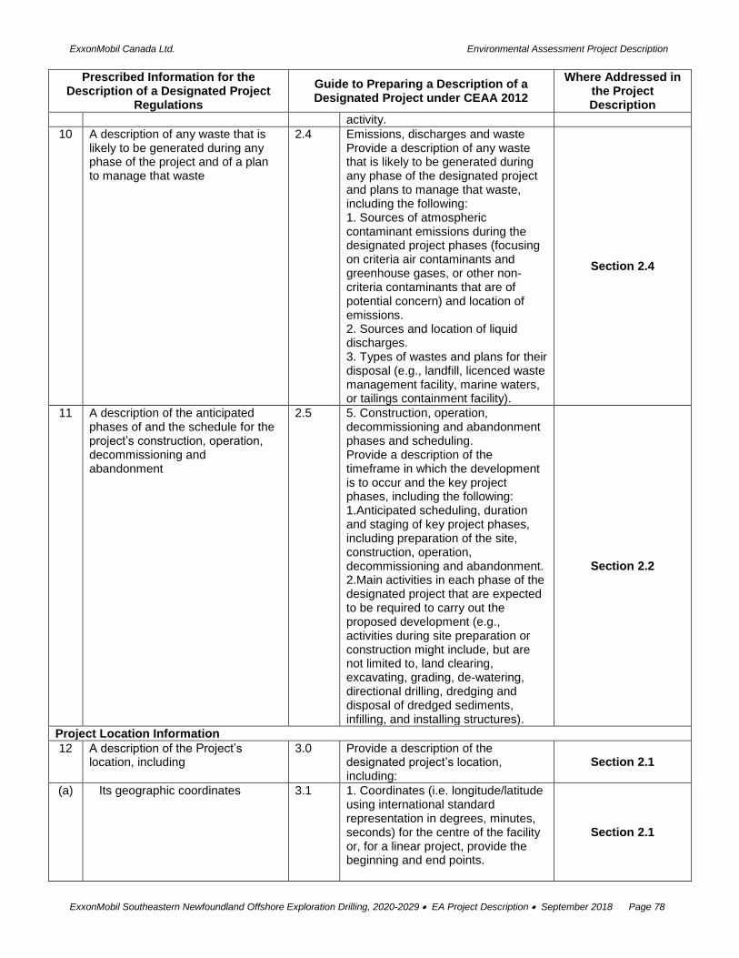
ExxonMobil Canada Ltd. Environmental Assessment Project Description
ExxonMobil Southeastern Newfoundland Offshore Exploration Drilling, 2020-2029 EA Project Description September 2018 Page 78
Prescribed Information for the Description of a Designated Project
Regulations
Guide to Preparing a Description of a Designated Project under CEAA 2012
Where Addressed in the Project Description
activity.
10 A description of any waste that is likely to be generated during any phase of the project and of a plan to manage that waste
2.4 Emissions, discharges and waste Provide a description of any waste that is likely to be generated during any phase of the designated project and plans to manage that waste, including the following: 1. Sources of atmospheric contaminant emissions during the designated project phases (focusing on criteria air contaminants and greenhouse gases, or other non-criteria contaminants that are of potential concern) and location of emissions. 2. Sources and location of liquid discharges. 3. Types of wastes and plans for their disposal (e.g., landfill, licenced waste management facility, marine waters, or tailings containment facility).
Section 2.4
11 A description of the anticipated phases of and the schedule for the project’s construction, operation, decommissioning and abandonment
2.5 5. Construction, operation, decommissioning and abandonment phases and scheduling. Provide a description of the timeframe in which the development is to occur and the key project phases, including the following: 1.Anticipated scheduling, duration and staging of key project phases, including preparation of the site, construction, operation, decommissioning and abandonment. 2.Main activities in each phase of the designated project that are expected to be required to carry out the proposed development (e.g., activities during site preparation or construction might include, but are not limited to, land clearing, excavating, grading, de-watering, directional drilling, dredging and disposal of dredged sediments, infilling, and installing structures).
Section 2.2
Project Location Information
12 A description of the Project’s location, including
3.0 Provide a description of the designated project’s location, including:
Section 2.1
(a) Its geographic coordinates 3.1 1. Coordinates (i.e. longitude/latitude using international standard representation in degrees, minutes, seconds) for the centre of the facility or, for a linear project, provide the beginning and end points.
Section 2.1

ExxonMobil Canada Ltd. Environmental Assessment Project Description
ExxonMobil Southeastern Newfoundland Offshore Exploration Drilling, 2020-2029 EA Project Description September 2018 Page 79
Prescribed Information for the Description of a Designated Project
Regulations
Guide to Preparing a Description of a Designated Project under CEAA 2012
Where Addressed in the Project Description
(b) Site maps produced at an appropriate scale in order to determine the project’s overall location and the spatial relationship of project components
3.1 2. Site map/plan(s) depicting location of the designated project components and activities. The map/plan(s) should be at an appropriate scale to help determine the relative size of the proposed components and activities. 3.Map(s) at an appropriate scale showing the location of the designated project components and activities relative to existing features, including but not limited to: • watercourses and waterbodies with names where they are known; • linear and other transportation components (e.g., airports, ports, railways, roads, electrical power transmission lines and pipelines); • other features of existing or past land use (e.g., archaeological sites, commercial development, houses, industrial facilities, residential areas and any waterborne structures); • location of Aboriginal groups, settlement land (under a land claim agreement) and, if available, traditional territory; • federal lands[3] including, but not limited to National parks, National historic sites, and reserve lands; • nearby communities; • permanent, seasonal or temporary residences; • fisheries and fishing areas (i.e., Aboriginal, commercial and recreational); • environmentally sensitive areas (e.g., wetlands, and protected areas, including migratory bird sanctuary reserves, marine protected areas, National Wildlife areas, and priority ecosystems as defined by Environment Canada); and, • provincial and international boundaries.
Section 1.1, 2.1, 3.3, 3.4
(c) The legal description of land to be used for the project, including the title, deed or document and any authorization relating to a water lot
Section 1.3, 2.1
3.1 4. Photographs of work locations to the extent possible
n/a
(d) The project’s proximity to any permanent, seasonal or
3.1 5. Proximity of the designated project to:
Section 2.1, 3.4

ExxonMobil Canada Ltd. Environmental Assessment Project Description
ExxonMobil Southeastern Newfoundland Offshore Exploration Drilling, 2020-2029 EA Project Description September 2018 Page 80
Prescribed Information for the Description of a Designated Project
Regulations
Guide to Preparing a Description of a Designated Project under CEAA 2012
Where Addressed in the Project Description
temporary residences • any permanent, seasonal or temporary residences; • traditional territories, settlement land (under a land claim agreement) as well as lands and resources currently used for traditional purposes by Aboriginal peoples; and, any federal lands.
(e) The project’s proximity to reserves, traditional territories as well as lands and resources currently used for traditional purposes by Aboriginal peoples
Section 3.4, 4.2
(f) The project’s proximity to any federal lands
Section 1.3, 2.1
3.2 Land and Water Use To the extent that is known at this time, describe the ownership and zoning of land and water that may be affected by the project, including the following. 1. Zoning designations. 2. Legal description of land to be used (including information on sub-surface rights) for the designated project, including the title, deed or document and any authorization relating to a water lot. 3. Any applicable land use, water use (including ground water), resource management or conservation plans applicable to or near the project site. Include information on whether such plans were subject to public consultation. 4. Describe whether the designated project is going to require access to, use or occupation of, or the exploration, development and production of lands and resources currently used for traditional purposes by Aboriginal peoples.
Section 1.3, 2.1, 3.4, 4.2
Federal Involvement
13 A description of any financial support that federal authorities are, or may be, providing to the project
4.1 Describe if there is any proposed or anticipated federal financial support that federal authorities are, or may be, providing to support the carrying out of the designated project.
Section 1.3
14 A description of any federal land that may be used for the purpose of carrying out the project
4.2 Describe any federal lands that may be used for the purpose of carrying out the designated project. This is to include any information on any granting of interest in federal land (i.e., easement, right of way, or transfer of ownership).
Section 1.3
15 A list of permits, licences or other authorizations that may be required under any Act of Parliament to carry out the project
4.3 Provide a list of any federal permits, licences or other authorizations that may be required to carry out of the project.
Section 1.3
Environmental Effects
16 A description of the physical and biological setting
5.1 Using existing knowledge and available information provide an
Section 3.0

ExxonMobil Canada Ltd. Environmental Assessment Project Description
ExxonMobil Southeastern Newfoundland Offshore Exploration Drilling, 2020-2029 EA Project Description September 2018 Page 81
Prescribed Information for the Description of a Designated Project
Regulations
Guide to Preparing a Description of a Designated Project under CEAA 2012
Where Addressed in the Project Description
overview of the following: 1. A description of the physical and biological setting, including the physical and biological components in the area that may be adversely affected by the project (e.g., air, fish, terrain, vegetation, water, wildlife, including migratory birds, and known habitat use).
17 A description of any changes that may be caused, as a result of carrying out the project, to
5.2 A description of any changes that may be caused as a result of carrying out the designated project to:
Section 5.0
(a) fish and fish habitat as defined in subsection 2(1) of the Fisheries Act;
(a) Fish and fish habitat, as defined in the Fisheries Act Section 5.1, 5.2
(b) aquatic species, as defined in subsection 2(1) of the Species at Risk Act ; and
Section 5.1, 5.2
(b) b. Marine plants, as defined in the Fisheries Act; and
Section 5.1, 5.2
(c) migratory birds, as defined in subsection 2(1) of the Migratory Birds Convention Act, 1994
(c) migratory birds, as defined in the Migratory Birds Convention Act, 1994 Section 5.1, 5.2
18 A description of any changes to the environment that may occur, as a result of carrying out the project, on federal lands, in a province other than the province in which the project is proposed to be carried out or outside of Canada.
5.3 A description of any changes to the environment that may occur, as a result of carrying out the designated project, on federal lands, in a province other than the province in which the project is proposed to be carried out, or outside of Canada
Section 5.1, 5.2
19 Information on the effects on Aboriginal peoples of any changes to the environment that may be caused as a result of carrying out the project, including effects on health and socio-economic conditions, physical and cultural heritage, the current use of lands and resources for traditional purposes or on any structure, site or thing that is of historical, archaeological, paleontological or architectural significance.
5.4 A description of the effects on Aboriginal peoples of any changes to the environment that may be caused as a result of carrying out the designated project, including effects on health and socio-economic conditions, physical and cultural heritage, the current use of lands and resources for traditional purposes, or any structure, site or thing that is of historical, archaeological, paleontological or architectural significance.
Section 3.4, 4.2, 5.1, 5.2
Proponent Engagement and Consultation with Aboriginal Groups
6.0 Provide the following information to the extent that it is available or applicable:
Section 4.2
6.1 A list of Aboriginal groups that may be interested in, or potentially affected by, the designated project.
Section 4.2
6.2 2.A description of the engagement or consultation activities carried out to date with Aboriginal groups, including:
Section 4.2

ExxonMobil Canada Ltd. Environmental Assessment Project Description
ExxonMobil Southeastern Newfoundland Offshore Exploration Drilling, 2020-2029 EA Project Description September 2018 Page 82
Prescribed Information for the Description of a Designated Project
Regulations
Guide to Preparing a Description of a Designated Project under CEAA 2012
Where Addressed in the Project Description
• names of Aboriginal groups engaged or consulted to date with regard to the designated project; • date(s) each Aboriginal group was engaged or consulted; and, • means of engagement or consultation (e.g., community meetings, mail or telephone).
6.3 An overview of key comments and concerns expressed by Aboriginal groups identified or engaged to date, including any responses provided to these groups.
n/a
6.4 A consultation and information-gathering plan that outlines the ongoing and proposed Aboriginal engagement or consultation activities, the general schedule for these activities and the type of information to be exchanged and collected (or, alternatively, an indication of why such engagement or consultation is not required).
Section 4.2
Consultation with the Public and Other Parties (other than Aboriginal consultation included above)
7.0 Provide the following information to the extent that it is available or applicable
Section 4.0
7.1 An overview of key comments and concerns expressed to date by stakeholders and any responses that have been provided.
Section 4.3
7.2 An overview of any ongoing or proposed stakeholder consultation activities
Section 4.3
7.3 A description of any consultations that have occurred with other jurisdictions that have environmental assessment or regulatory decisions to make with respect to the project.
Section 4.1
Summary
20 A summary of the information required under sections 1 to 19
8.0 Proponents are to include as part of the project description a standalone section that summarizes the information identified in Sections 1 to 7 of this Guide
Provided separately, as requested