Embed Size (px)
Citation preview
73
Coastal Management, 29:73–90, 2001Copyright ã 2001 Taylor & Francis0892-0753/01 $12.00 + .00
Extant Legal and Jurisdictional Constraintson Irish Coastal Management
ANNE MARIE O’HAGANJ. ANDREW G. COOPERCoastal Research GroupSchool of Environmental StudiesUniversity of UlsterColeraine, County Derry, Northern Ireland
The success of any coastal zone management policy is dependent on, among otherthings, effective legislation and its enforcement. This article examines some possiblelegal constraints on the implementation of an integrated coastal zone managementpolicy in Ireland. An introduction to the existing legal framework is provided, andthe inconsistencies and ambiguities related, in particular, to jurisdiction and area ofresponsibility are highlighted. In particular the effect of land ownership and prop-erty rights on coastal zone management are examined with reference to two popularresort beaches in County Donegal, Ireland. While a revision of the relevant legisla-tion is desirable, it is probably unrealistic; however, powers are available to thevarious institutions involved in coastal management that are currently unused. Theseare reviewed and their potential to improve coastal zone management is discussed.
Keywords integrated coastal zone management, land ownership, legislation, plan-ning, property rights, statutory powers
Introduction
Integrated coastal zone management is defined by the European Commission (1996) as“a continuous process with the general aim of implementing sustainable development incoastal zones and maintaining their diversity. To this end it aims, by more effectivemanagement, to establish and maintain (sustainable) levels of use, development and ac-tivity in coastal zones and eventually to improve the state of the coastal environment.”Gubbay (1990) identified any coastal zone management program as requiring a nationalperspective, a long-term view, an integrated approach; communication, collaboration andcoordination, public involvement, a flexible approach, and a specific agency to take thelead.
Received 4 April 2000; accepted 3 November 2000.I would like to thank my supervisor Dr. Andrew Cooper for his help and advice. Sincere
thanks are extended to Dr. Michael MacLeod, Dr. John McKenna, and Dr. James Power (projectofficers for EU/LIFE Demonstration Programme project on ICZM entitled “Implementing Alter-native Strategies in Irish Beach and Dune Management”) who were, and still are, a constantsource of support, enthusiasm, and knowledge.
Dedicated to Catriona Allen Hamilton.Address correspondence to Anne Marie O’Hagan, Coastal Research Group, School of Envi-
ronmental Studies, University of Ulster, Coleraine, Co. Derry, BT52 1SA, N. Ireland.

74 A. M. O’Hagan and J. A. G. Cooper
Ireland’s coastline spans some 6,500 km (5,800 km in the Republic of Ireland)bordering on the North Atlantic Ocean, the Irish Sea, and the Celtic Sea (National CoastalErosion Committee, 1992). To date, coastal development here has largely proceeded inan ad hoc manner. In fact, the coastal zone was only included as a specific policy areafor the first time in 1993 in the National Development Plan for Ireland 1994–99 (Gov-ernment Publications Office, 1993). Subsequently, in 1997, the Department of theMarine and Natural Resources, the Department of the Environment and Local Govern-ment, and the Department for Arts, Heritage, Gaeltacht (native Irish-speaking areas) andthe Islands commissioned a draft coastal zone management policy for Ireland (BradyShipman Martin, 1997). In this report the coast is taken to be “a strip of land and seaterritory of varying width depending on the nature of the environment and managementneeds.” This is the same definition used by the European Commission (1995). Whateverthe definition or limits, the coastal zone cannot be neatly slotted into existing adminis-trative or planning units. In other words, the coastal zone defies definition. It is inher-ently a dynamic system, an area of infinitely variable function and condition. It is thisdynamism that causes problems in legislation for the coastal zone. Administrative boundariesin the coastal zone are rarely related to natural boundaries. Likewise, sectoral activitiesoften transcend administrative boundaries. As a result of this, there is no simple formulathat can be used to define the limits of the coastal zone. Therefore, an integrated andflexible approach is required when managing it.
The Irish Situation
Responsibility for the Irish coastal zone can best be described as “mosaic” (Kelly, 1995),with three main government departments being involved. The Department of the Marineand Natural Resources has the responsibility for marine-based activities and seawardplanning and has very little responsibility for activities that occur above the high watermark. The Department of the Environment and Local Government is responsible forlandward planning and recreational activities. This department guides local authoritieswho are, in effect, the implementation authorities for landward planning. Local authori-ties generally assume the role of coastal zone managers also, although rarely in a formalmanner. The Department for Arts, Heritage, Gaeltacht and the Islands is responsible fornature conservation. It also has the authority to designate and implement conservationareas such as National Heritage Areas (NHAs) under national legislation and SpecialAreas of Conservation (SACs) and Specially Protected Areas (SPAs) under Europeanlegislation. Responsibility for aspects of the coastal zone are further complicated by theway in which government departments are divided into more specialized subdepart-ments. The Department of the Marine, for example, is divided into separate sections foraquaculture, coastal protection, and environment. While there are no formal legal mecha-nisms for vertical or horizontal integration of these departments and subdepartments,in the majority of cases they do try to work together when dealing with large-scaledevelopments.
Tied to this administrative structure is the number of legislative enactments, at boththe national and the European level, that have a bearing on the coastal zone and conse-quently its management. According to Thomson (1994), the legislative framework inIreland is characterized by overcomplexity, ambiguities, and irregularities. O’Keefe (1990)identified 23 legislative acts at both the national and the European level that had rel-evance to the coastal zone at that time. The principal relevant legislation consists of theForeshore Acts 1933–1992, the Local Government (Planning & Development) Acts 1963–1994, and the Harbours Acts 1946–1996. These are briefly outlined below in terms oftheir applicability to coastal zone management.

Legal Constraints to ICZM in Ireland 75
Foreshore Acts 1933–1992
While the coastal zone is not defined in Irish law, the Foreshore Act 1933 defines theforeshore as “the bed and shore, below the line of high-water of ordinary or mediumtides, of the sea and of every tidal river and tidal estuary and of every channel, creekand bay of the sea or of any such river or estuary.” The word seashore is defined as “theforeshore and every beach, bank and cliff contiguous thereto and includes all sand androcks contiguous to the foreshore.” Unlike the common law foreshore, which ends at theline of low water of ordinary or medium tides, the foreshore as defined by this act hasno seaward limit, and the legal view is that the foreshore as so defined extends out tothe 12 nautical mile (1 nautical mile is equal to 1,852 meters) limit of the Irish territorialsea (Crosbie, 1995).
As a general rule in Ireland, the foreshore belongs to the state and its control isvested in the Department of the Marine and Natural Resources, which has the power togrant foreshore licences and leases. These, however, can only be granted when deemedto be in the “public interest” (Foreshore Act, Section 2(1)). This lease may refer to theforeshore itself or to any buildings or structures thereon. It may also include any miner-als to a maximum depth of 30 feet from the surface of the foreshore together with aright to exploit those minerals. The minister has discretion to give public notice ofapplications for leases, to invite objections and representations with respect thereto, and/or to hold a public inquiry in regard to the making of a lease. Section 3 of the same act,as amended, empowers the minister, if it is in the public interest, to grant a license ofstate foreshore which authorizes the licensee to “place or erect any articles, things, struc-tures or works on such foreshore, to remove any beach material from, or disturb anybeach material in, such foreshore, to set and take any minerals in such foreshore to amaximum depth of 30 feet or to use or occupy such foreshore for any purpose.” As isthe case with leases, the minister again has discretion to hold a public local inquirybefore deciding to grant a license under Section 3. Licenses may be used to restrict orprohibit any removal or disturbance of beach material or any kind or kinds of beachmaterial. Under the guidelines produced by the Department of the Marine for Foreshorelicenses and leases, it is stated that “any permission given under the Foreshore Actswould be without prejudice to the powers of the local planning authority. The applicantshould, therefore, consult with that authority regarding the proposal” (Department of theMarine, 1997). There is no statutory basis, however, to this.
Section 8 of the act empowers the minister to make regulations in respect of thepublic use of state foreshore. Here it is stated as follows:
If and whenever the Minister is of the opinion that the entry of the public on or useby the public of any particular area of foreshore belonging to the [. . .] State oughtin the public interest to be prohibited, restricted, regulated or controlled, either per-manently or temporarily, the Minister may by order make regulations prohibiting,restricting, regulating or controlling in such manner, to such extent, and for suchperiod, limited or unlimited, as the Minister shall think proper the entry of the pub-lic on or use by the public of such an area of foreshore. (Foreshore Act 1933,Section 8(1))
This could be a useful coastal management tool. Controls exercisable over privatelyowned foreshore are less extensive (Scannell, 1995). Where this is the case, the ministerhas no control unless there is an interference with navigation or fishing. It is believedthat some 1,000 Irish sites are outside the control of this act (Crosbie, 1995), and intheory these sites could be developed indiscriminately except in cases where other actsare directly applicable.

76 A. M. O’Hagan and J. A. G. Cooper
Local Government (Planning & Development) Acts 1963–1994
The second code governing development of the foreshore is that contained in the LocalGovernment Planning and Development Acts 1963–1994 and the regulations made thereunder.Section 19(1) of the 1963 act requires every local authority to “make a plan indicatingthe development objectives for their own area.” These plans are known as developmentplans. Section 19(2) provides that a development plan must consist of a written state-ment and a plan, which is essentially a map, indicating the development objectives forthe area in question. There is no exhaustive definition of the term “development objec-tives” but the term includes objectives for physical, economic, spatial, and social devel-opment (Scannell, 1995). This plan must be reviewed at least once every five years.Once the draft development plan and its amended version have been put on publicdisplay to allow objections and representations, it is the function of the elected represen-tatives of the Council to adopt the plan by resolution. Once this has been done, the planbecomes a legally binding document, therefore binding the local authority to the imple-mentation of its objectives.
Development plans operate as a framework within which planning applications aremade and planning permissions granted or refused. Planning permission is required forall “development” of land except those areas stipulated in the acts. According to the1963 act, “land includes any structure and any land covered by water (whether inland orcoastal).” Delimitation of seaward boundaries of local authorities is not standardizedthroughout the state (Reid, 1986). In general it may be said that land above the line ofordinary high water mark is within the administrative area of the appropriate CountyCouncil, while the foreshore itself is within the administrative area of the Department ofthe Marine. According to Crosbie (1995), this has come about as an accident of historyin that Charles I, and after him, Charles II, surveyed the kingdom (as it was then),inquiring about the ownership of dilapidated and inundated lands, and succeeded inremoving the foreshores from the lords of the manors. The foreshore is, thus, effectivelyexcluded from the Planning and Development Acts, because, under Section 2 of the1963 act, each County Council is appointed the planning authority for its own countyand, as the foreshore generally lies outside the administrative area of the County Coun-cil, it lies beyond its planning control. Thus, while the Planning and Development Actsapply to coastal land covered by water, the acts appoint no authority for this land. Theresult is that the Planning and Development Acts do not operate on the foreshore andthe Foreshore Acts effectively control planning there.
As a result of the above, access to the foreshore in Ireland is enjoyed freely if notas a right (Crosbie, 1995). In theory, therefore, the state, as owner, would have theauthority to prohibit access. Obviously this would cause major public outcry. With re-spect to owners of private foreshore, they have tried to exercise their right to prohibitaccess. This has, again, been criticized, as the general public believe they have a legalright of access to the foreshore. The operation in the foreshore of the Planning Acts hasresulted in the foreshore being excluded from the counties when the Ordnance Surveymaps were drawn up. This is important to coastal zone management because in theSupreme Court judgment of 9 February 1979 in the case of Browne v. Donegal CountyCouncil, it was stated that the boundary of the “existing judicial county” was defined bythe Ordnance Survey maps prepared pursuant to the Boundary Survey (Ireland) Acts1854–1859 (Reid, 1986). In law, therefore, the definitive boundary between the CountyCouncil and the Department of the Marine is the county boundary as marked on thecurrent Ordnance Survey map. Since many Ordnance Survey maps are several decades,and in some cases almost a century, old, this poses potential constraints for coastal zonemanagement.

Legal Constraints to ICZM in Ireland 77
Harbours Acts 1946–1996
The situation is further complicated by the existence of harbor authorities created bythe Harbours Act 1946. In this act the word “harbour” means the harbor of a harborauthority (Harbours Act 1946, 2(1)). The geographical extent of harbors vary, each har-bor authority having its jurisdiction defined in an order specific to that harbor. A harborauthority is made up of various members, for example, local authority members, stipu-lated in the Harbours Act (Harbours Act 1946, Part II, 7(1)(a)–(g)). The jurisdiction of aharbor authority can, and does, overlap with both planning authorities and the Depart-ment of the Marine and Natural Resources. Harbor authorities have the power to makebylaws in relation to “docks, quays, works and roadways” (Harbours Act 1946, 2ndSchedule, Part III, No. 19). They have no authority in considering a proposed develop-ment within a harbor, for example, a new marina or an extension to an existing struc-ture. Many of Ireland’s largest estuaries are under their statutory jurisdiction, for ex-ample, Waterford and Cork. Most of these harbors are in public ownership (Crosbie,1995). Under the Harbours Act 1946 each county council has considerable input intothe management of any commercial harbor touching on the county. Proposed legislationto implement the recommendations made by a Review Group on Commercial Harboursand Pilotage Policy and Legislation (1992) will provide for commercial harbors to bemanaged by port companies rather than harbor authorities. In other words, ownershipwill change from public to private. It is unclear what effect this change will have. Per-haps the company will hold the harbor in some kind of public trust. It is important tonote here that for a private body wishing to carry out a development on the foreshore,there are no statutory guidelines as to how these overlapping jurisdictions relate to eachother.
European and International Legislation
Ireland has the smallest area devoted to nature protection of any European country, andlandscape protection policy is also poorly developed (Hickie, 1996). The Wildlife Act1976 is the only countrywide nature conservation law. The National Heritage Area (NHA)designation is the basis of the system for the protection of Irish natural habitats. Allother designations, both national and European, overlap with these, but they will haveno legal standing until the Wildlife Act is amended. There are 1,246 NHAs proposedbut only 10% of these have legal backing because they are within Nature Reserves orNational Parks (Hickie, 1996). An in-depth analysis of all European legislation relevantto the coastal zone is beyond the scope of this article, however, the main directives arethe Birds Directive and the Habitats Directive. The Birds Directive (79/409/EEC) arosefrom the need to protect wild bird species as well as their habitats. This is to be achievedin Ireland through the designation of SPAs. From 1985 to 1991, 20 SPAs were desig-nated; all were coastal areas and uninhabited islands, 80% of which were on state-ownedland and foreshore (Hickie, 1996). These are enforced through the Conservation of WildBirds Regulations (S.I. No. 291, 1985), which prohibit littering and pollution but notdamaging changes in land use such as land drainage. While local authorities are sentdetails of SPA designations in their area, there is no formal interaction with the Planningand Development Acts. In the case of the Department of the Marine, informal consulta-tions take place with the staff of Dúchas (the National Parks and Wildlife Service) aboutnew applications for shellfish farms in SPAs (Dúchas, personal communication, 1999).
Under the Habitats Directive (92/43/EEC) designations of SACs are required for theprotection of natural habitats, flora, and fauna. Natural habitats include estuaries, mudflats,and sandflats not covered by water at low tide and shallow inlets and bays. Details of

78 A. M. O’Hagan and J. A. G. Cooper
proposed SACs and NHAs are sent to local authorities, who have been asked to forwardall planning applications to Dúchas for comment and recommendation. There is no for-mal arrangement for this, and again there is a problem of integration with other legisla-tive acts and administrative agencies here. Section 26(1) of the Planning and Develop-ment Act 1963 allows a planning authority to take account of “other matters” that mayregulate development. In theory, NHAs, and all other designations, should be includedhere. This directive was adopted in May 1992 and member states had two years toincorporate it into national law. In Ireland, this process has not yet been entirely com-pleted, however the Natural Habitats Regulations 1997 allowed the Minister for Arts,Heritage, Gaeltacht and the Islands to propose provisional SACs. There are approxi-mately 400 proposed SACs (Grist, 1997), all of which are currently NHAs, which haveno legal backing, again, due to the fact that the Wildlife Act 1976 has not been amended.
The Convention on Wetlands (the Ramsar Convention) came into force in Irelandon 15 March 1985. Ireland presently has 45 sites designated as Wetlands of Interna-tional Importance, with a surface area of 66,994 hectares. Many of these sites are coastal,and responsibility for them also lies with Dúchas. Many of these sites are also NHAsand/or SACs and/or SPAs. North Bull Island, Co. Dublin, for example, is a Ramsar sitebut it is also an SPA under the Birds Directive, a national nature reserve (NNR), andone of only four places in Ireland to be protected by a Special Amenity Area Orderunder the Local Government (Planning & Development) Act 1963 (Sections 42 & 43).These orders state the objective of the planning authority in relation to the preservationor enhancement of the character or special feature of the area including objectives forthe prevention or limitation of development in the area (Scannell, 1995). Essentially,they are like a site-specific development plan and must be reviewed at least once everyfive years.
Blue Flag Beaches
One form of local coastal zone management presently operating is the Blue Flag BeachScheme, which is a voluntary, nonstatutory, quality assurance scheme aimed primarilyat recreational beaches. This Europe-wide scheme is administered by the Foundation forEnvironmental Education in Europe (FEEE), at a European level, and by An Taisce (theNational Trust for Ireland) in Ireland. Under this scheme, blue flags are awarded tobeaches that meet specific criteria related to water quality, visitor facilities, beach man-agement (including litter control), environmental information, and display facilities. Withrespect to water quality, this is assessed in accordance with the European Directive onBathing Water Quality. At a site-specific level this scheme is carried out by the localauthority of the area. This beach management is performed without a foreshore licenseeven though it is below the high water mark. Such management may, at particular sites,require the erection of structures, such as bollards, for vehicular control. This is a devel-opment below the high water mark and, as such, it should include the involvement ofthe Department of the Marine and a foreshore license.
The regulations for blue flag beaches are either guideline (G) or imperative (I).These are predominantly nonstatutory except in relation to water quality. One such im-perative regulation is that “the local community must have a land-use plan for its coastalzone. This plan and the current activities of the community in the coastal zone must bein compliance with planning regulations and coastal zone protection regulations. If thecommunity is very small it may be part of a larger regional plan” (Rule 14(12)), whichin most cases would be the county development plan. Also under the imperative regula-tions is the rule that “on the beach there will be no driving unless specifically authorised;no beach bike or car races; no dumping or no unauthorised camping” (Rule 17(15)).

Legal Constraints to ICZM in Ireland 79
Beaches on which cars are allowed must have designated areas on the beach for parkingas well as car-free zones, and the water’s edge must always be kept entirely free of cars.Rule 18(16) stipulates that there must be safe access to the beach. There is no definitionof the word “safe” or method suggested as to how a beach can be safe when cars areallowed on it. While the majority of blue flag regulations have no legal standing on theirown, they could be incorporated, as suggested in the regulations, into local county de-velopment plans, which in turn would give them legal standing. There remains a prob-lem of enforcement, which would have to be addressed because the local authority isassuming a role that it is not legally entitled to do.
Methodology
Most research focusing on coastal planning and development in Ireland is at the nationalor European level. Far fewer studies have been conducted at a local level. This researchwas undertaken as part of a project in the European Union’s (LIFE) DemonstrationProgramme on Integrated Coastal Zone Management. The University of Ulster, Coleraine,is currently developing management plans for seven Co. Donegal beaches under thisprogram in association with Donegal County Council (DCC). The project was designedto demonstrate the practice of integrated coastal zone management through the sustain-able use of beach and dune systems. It is intended that the management plans producedbe incorporated into the Donegal Development Plan and hence become legally binding.To investigate the possible effects of disparate legislation enforced by a multitude ofagencies on ICZM, two study areas, Downings and Rossnowlagh, were chosen from theoriginal seven sites. While both these areas portray different natural characteristics, theeffects of legislation are similar.
First, property ownership information was collected from land registry data. Regis-tration of property in Ireland is compulsory under the Local Registration of Title (Ire-land) Act 1891. While there have been revisions of this act, it remains that a lot ofpertinent information, while actually out of date, is still legally binding. Each ownershipof a property is registered on a folio. There are in excess of 1.2 million live folios in all(Hogan, 1998). Each folio is divided into three parts. The first part describes the prop-erty and where it is located. The second part describes the owner and the nature of his/her interest in the property; that is, whether he/she is a full owner, a tenant, or a limitedowner. Part 3 of the folio describes the burdens that affect that property. Burdens couldinclude a mortgage on the property, a right of way, a right to fish, or a lease. It is thelatter information, which is crucial in coastal management, that is usually out of date.Each folio also contains a map showing the boundaries of the property. Under the LandRegistration Rules 1972 these boundaries must be taken from the current, largest scaleOrdnance Survey map.
The current largest scale Ordnance Survey maps are at 1:2,500 scale and date from1833 to 1907. This creates particular problems where the property boundary is the highwater mark as, naturally, it may have changed in the past 100 years. Up until 1995 theLand Registry’s method of map publication was by means of photocopying from origi-nals (Kirwan, 1998). Not only did this produce poor quality maps but, due to the factthat paper is heated during the photocopying process, the maps produced were distorted.Unofficial enquiries have found that maps produced in such a way result in on-the-ground errors of between 1 and 2 meters at 1:1,000 scale and between 5 and 10 metersat the 1:2,500 scale (Byrne, 1998). This makes a significant difference in the case ofRossnowlagh and Downings, where there has been actual coastal erosion and accretion,respectively. When questioned about the accuracy of such maps for court purposes, theAssistant Director of the Ordnance Survey in Ireland replied that their use was “not

80 A. M. O’Hagan and J. A. G. Cooper
recommended” (Byrne, 1994), yet this is what is legally required to satisfy Land Regis-try mapping requirements.
With respect to the survey accuracy of boundary information, the government doesnot have a monitoring function and does not dictate any requirements relating to thequalifications of the individual or organization that submits maps for property registra-tion purposes (Long, 1980). Where a map is submitted for such purposes there is nocheck carried out to ensure that the new boundaries shown on the map physically existon the ground. There are no official technical requirements governing the accuracy ofmaps for the transfer of land in Ireland (Long, 1980). Provided these newly submittedboundaries do not conflict with boundaries already mapped, which may in turn be cor-rectly or incorrectly mapped, they will be recorded on the Land Registry map. Underthis system, the legally mapped position of a right of way, for example, may be incor-rect, which could have an important effect on the management of that particular piece ofcoast.
To illustrate all these effects, the land registry data, along with actual field data,were used to create a geographical information system (GIS) for each study area. Highand low water marks, main roads, access points for both vehicles and pedestrians, studyarea boundaries, and property boundaries, along with natural and manmade features,were mapped using ARC/INFO. This information was then imported into ArcView andmaps were produced. These maps identified clearly where there are potential legal con-flict areas.
Results
Rossnowlagh
The Rossnowlagh study area consists of Belalt Strand, a 2-km stretch of coast, situatedin southwest Co. Donegal. Figure 1 shows the general location and the study areas.Figure 2 shows the Rossnowlagh study area, including the 90 properties within it andthe mean high and low water marks legally positioned on the 1907 6" Ordnance Surveymap. This beach is managed as a blue flag beach. Under the regulations of this schemevehicles must be excluded from at least part of the recreational beach. It is evident fromFigure 2, however, that such a measure is made very difficult due to the fact that threemain roads intersect at the beach, hence it becomes a main thoroughfare during busyperiods. Surveys found that 38% of people disliked the presence of cars on the beach(University of Ulster Coleraine unpublished report, 1999). This is a definite manage-ment problem, in that it increases the risk of accidents, antisocial behavior, noise, incon-venience to other beach users, traffic congestion during the summer, compaction of thebeach sand, and possibly traffic offences. The Road Traffic Acts 1933–1994 are en-forceable in any “public place.” The expression public place means “any street, road, orother place to which the public have access with vehicles whether as of right or bypermission and whether subject to or free of charge” (Road Traffic Act 1933, Part I,Section 3). As previously stated, the public have both pedestrian and vehicular access tothe foreshore, which may not be legally allowed but is enjoyed freely if not as a right. Ifthe beach is managed as a blue flag beach, under the regulations of that scheme, part ofthe beach must be car-free. This is purely a safety mechanism; that is, if cars must beallowed on the beach, at least part of it must be free from vehicles. In essence, the factthat the Road Traffic Acts are enforceable on a beach should help solve this problem;however, this has not been the case, probably due to the lack of Garda Siochána (IrishPolice Force) resources for such problems in the area and the seasonality of beach use.
Pedestrian access to the beach is another potential management problem. As one of

Legal Constraints to ICZM in Ireland 81
the most popular beaches in Co. Donegal, there is a demand for access to Belalt Strand.Currently DCC operates a car park from which access to the beach is obtained, by foot,through the dunes. This research has found that, while DCC owns the car park, it doesnot own the strip of dunes running between their car park and the beach where access isgained. There is no public or private right of way across this land. Two private rights ofway were found to exist to the north of this entry point, shown in Figure 2 also. Thepotential exists to make these into public rights of way (Local Government [Planning &Development] Act 1963, Part V, 48(1)). Continuous pedestrian trampling causes gaps toform in the dune system and consequent damage to dune vegetation. The unarmoredsections of the beach contain no foredunes or fixed dunes, which indicates that there isno current dune development or recovery. To encourage this, any new pedestrian access
Figure 1. Location map and study sites.

Fig
ure
2.
Bel
alt
Str
and,
Ros
snow
lagh
.
82

points should be raised above ground level using boardwalks or steps. A Section 38agreement (created under the Local Government [Planning & Development] Act 1963)applies just north of here, which allows for phased development of the area. As this areawill be developed anyway, there is the potential for a legal access route to be incorpo-rated.
This area of coastline is progressively eroding and the position of property bound-aries thus changes. Registration of land takes no account of such affects even though thelegal position of a right of way will have changed as a result of erosion. The position ofthe high water mark in 1907 is shown in Figure 3 along with its position in 1998.Repositioning of the high water mark was enabled by analysis of aerial photographs andlater by global positioning system (GPS) surveying. The shoreline showed its maximumretreat between 1951 and 1977, with relatively little change since then. Property ownersresponded to the problem with rock armoring. The Office of Public Works completedthe first rock armoring, at public expense, in front of a hotel in 1972. Other propertyowners followed suit at various stages. Legally, planning permission is required for suchdevelopment along with a foreshore license from the Department of the Marine. This,however, has never been sought. Currently approximately 755 m, 52% of the sand duneshore, is rock armored (unpublished UUC report, 1999). This is directly affected byproperty ownership. Owners who have the necessary financial means carry out armoring,as they believe it will be in their future financial interest. For example, if an ownerdecides to sell his land to a developer, the developer will pay more for the land if he/shethinks it is “protected.” Where there is an absentee landlord or where there is no activemanagement of the area, coastal processes will follow their natural pattern. This is evi-dent in Figure 3, where erosion is seen to have ceased in armored sections, while it hascontinued where there has not been armoring. To ensure that this situation does notcontinue, coastal management in the area must be undertaken in an integrated mannerwith all property owners being included in the decision-making process.
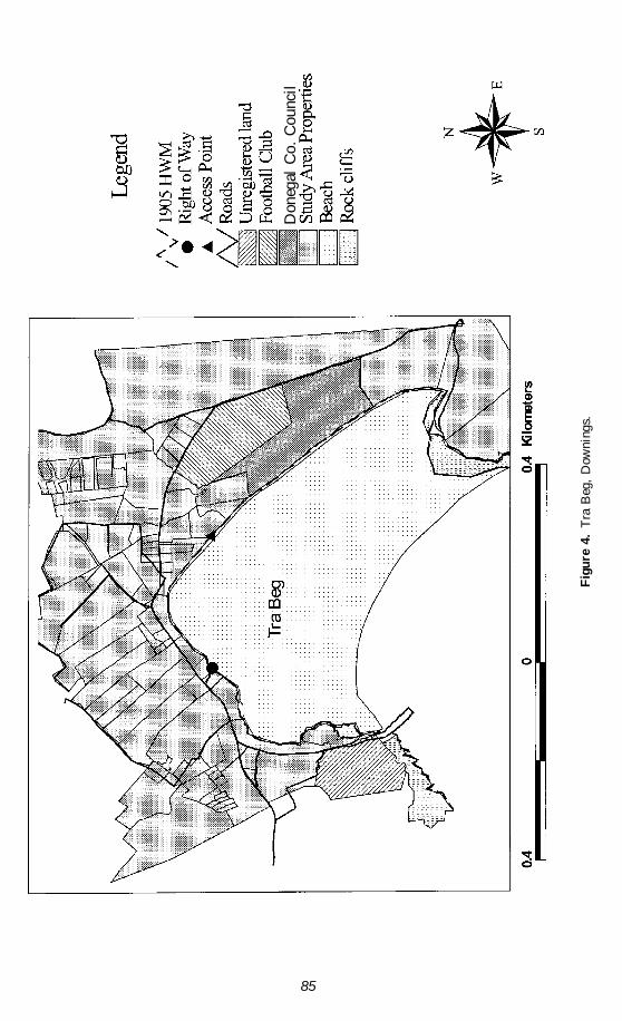
Downings
Tra Beg, Downings is situated on the eastern shore of Sheephaven Bay, a major inlet,on the north coast of Co. Donegal shown in Figure 1. It is bounded by rock headlandsthat provide a sheltered environment for water-based activities on an otherwise highenergy coast. Figure 4 shows the study area boundary along with the 40 propertieswithin it, the mean high and low water marks from the 1905 6" Ordnance Survey map,and the main access points. The general picture at Downings is one of expansion of thenatural dune system during the early part of this century. The replacement of dunes bytourism and recreation facilities since the 1960s has put an end to natural dune-formingprocesses. There is only one access point (shown in Figure 4) for vehicles onto thisbeach, and this is not a public right of way. There is a car park to the landward side ofthis entry point, which is managed by DCC, but the land itself does not belong to thecouncil. The only legal point of pedestrian access (shown in Figure 4) is via a set ofsteps from the northern part of the beach toward the pier. These are only passable at lowtide. Additional pedestrian access is gained through the Gaelic Football Club’s pitch, butthis is not a legal right of way.
Like Rossnowlagh, Downings was once a blue flag beach, but this status was lost inprevious years because of car parking on the beach, jet skis, and dumping of builder’srubble. Water quality and dog fouling pose additional problems. With respect to builder’srubble, which has been used at Downings as informal armoring, this is legally consid-ered “litter” and it is an offense to dispose of it in any “public place” under the 1963Local Government (Planning & Development) Act, Part V, Section 52(1)(b). Actions
Legal Constraints to ICZM in Ireland 83

84
Fig
ure
3.
Sho
reli
ne c
hang
es a
t R
ossn
owla
gh.
Don
egal
Co.
Cou
ncil
85
Fig
ure
4.
Tra
Beg
, D
owni
ngs.
Don
egal
Co.
Cou
ncil

against such offenses can be taken either by the local Gardai or the relevant LocalAuthority. Dog fouling is an offense under the 1997 Litter Act, which states that “wherefaeces has been deposited by a dog in any place [to which this subsection applies] theperson in charge of the dog shall immediately remove the faeces and shall ensure that itis properly disposed of in a suitable sanitary manner.” This applies to places such aspublic roads, school grounds, sports grounds. playing fields, or recreational or leisureareas and beaches (Litter Act 1997, Part IV, Sections 22(1) & (2) (a)(c)(d)).
The geographic position of Downings lends itself to many water-based activities,creating an additional set of management problems. One of these is the use of jet-skis,powerboats, and commercial fishing boats in an area also used by the public for swim-ming. The Merchant Shipping (Jet Skis and Fast Power Boats) Regulations 1992 enablea local authority to control any area of foreshore adjoining its functional area. While thishas not been formally undertaken, the beach at Downings has been divided into zonesfor particular activities to help overcome these problems. A proposed car-free zone re-quired under blue flag regulations is adjacent to the swimming area, while jet-skis arerestricted to the pier side of the beach. Zoning may provide a solution to these prob-lems, but as it is not a legally binding method there are still potential litigation problemsshould an accident occur.
Figure 5 shows how the high water mark has changed since its legally definedposition in 1905 to where it was in 1998. Aerial photographs and GPS surveying al-lowed its position to be established for 1936, 1954, 1977, 1995, and 1998. From these itis clear that a large amount of accretion of the natural dune system has occurred. Thisland formed through accretion has been claimed by the adjoining landowners, who laterconverted it into caravan parks and recreation areas. Such facilities have since been“protected” by embankments, which, depending on their position in relation to the 1905high water mark, require either planning permission from the relevant local authorityand/or a foreshore license from the Department of the Marine and Natural Resources.As can be seen, this high water mark has changed, which casts doubts over the legalposition of structures built on land formed by accretion. The legal position of such landis still unknown and will be the subject of future research. Under the Land Act 1965 theIrish Land Commission has the power to create rights of way in land formed by accre-tion (Land Act 1965, Section 20(1)). Although the Land Commission was dissolved in1992, its powers are still exercisable by the Minister for Agriculture (Irish Land Com-mission (Dissolution) Act 1992, Section 4). It is essential for successful coastal manage-ment that the legal position of accreted land be established, as ownership of land has amajor influence on management. It is also important from a litigation point of view.
Discussion
It is evident that the current legislative system in Ireland poses constraints on the imple-mentation of any coastal zone management policy. While only a few relevant acts havebeen cited here it is important to note that virtually all laws that affect land and/or seaanywhere in Ireland potentially apply to the coastal zone. For this reason consolidationof relevant legislation into one coastal zone management act would be difficult, as mostof these laws do not only relate to the coast but deal with a multitude of other issues.This does not take away from the fact that the majority of the legislation is in need ofreview and updating. It is inevitable that the management of a complex environmentsuch as the coast will involve an amount of legislation, but such legislation should bemutually consistent and should facilitate rather than impede the administrative process.This, however, is absent from the Irish situation today.
A major legal constraint is the way in which legal acts cannot take into account the
86 A. M. O’Hagan and J. A. G. Cooper

Don
egal
Co.
Cou
ncil
87
Fig
ure
5.
Sho
reli
ne c
hang
es a
t D
owni
ngs.
88 A. M. O’Hagan and J. A. G. Cooper
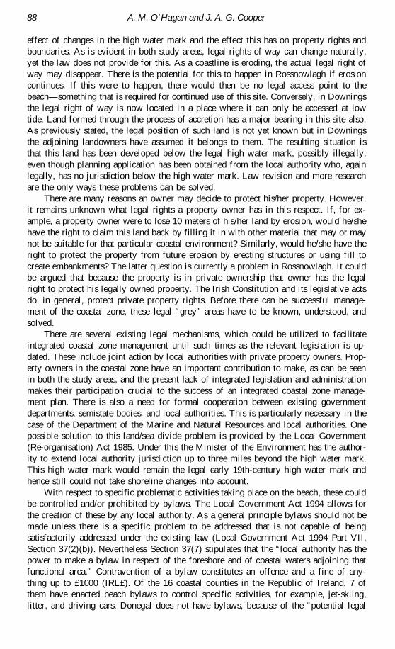
effect of changes in the high water mark and the effect this has on property rights andboundaries. As is evident in both study areas, legal rights of way can change naturally,yet the law does not provide for this. As a coastline is eroding, the actual legal right ofway may disappear. There is the potential for this to happen in Rossnowlagh if erosioncontinues. If this were to happen, there would then be no legal access point to thebeach—something that is required for continued use of this site. Conversely, in Downingsthe legal right of way is now located in a place where it can only be accessed at lowtide. Land formed through the process of accretion has a major bearing in this site also.As previously stated, the legal position of such land is not yet known but in Downingsthe adjoining landowners have assumed it belongs to them. The resulting situation isthat this land has been developed below the legal high water mark, possibly illegally,even though planning application has been obtained from the local authority who, againlegally, has no jurisdiction below the high water mark. Law revision and more researchare the only ways these problems can be solved.
There are many reasons an owner may decide to protect his/her property. However,it remains unknown what legal rights a property owner has in this respect. If, for ex-ample, a property owner were to lose 10 meters of his/her land by erosion, would he/shehave the right to claim this land back by filling it in with other material that may or maynot be suitable for that particular coastal environment? Similarly, would he/she have theright to protect the property from future erosion by erecting structures or using fill tocreate embankments? The latter question is currently a problem in Rossnowlagh. It couldbe argued that because the property is in private ownership that owner has the legalright to protect his legally owned property. The Irish Constitution and its legislative actsdo, in general, protect private property rights. Before there can be successful manage-ment of the coastal zone, these legal “grey” areas have to be known, understood, andsolved.
There are several existing legal mechanisms, which could be utilized to facilitateintegrated coastal zone management until such times as the relevant legislation is up-dated. These include joint action by local authorities with private property owners. Prop-erty owners in the coastal zone have an important contribution to make, as can be seenin both the study areas, and the present lack of integrated legislation and administrationmakes their participation crucial to the success of an integrated coastal zone manage-ment plan. There is also a need for formal cooperation between existing governmentdepartments, semistate bodies, and local authorities. This is particularly necessary in thecase of the Department of the Marine and Natural Resources and local authorities. Onepossible solution to this land/sea divide problem is provided by the Local Government(Re-organisation) Act 1985. Under this the Minister of the Environment has the author-ity to extend local authority jurisdiction up to three miles beyond the high water mark.This high water mark would remain the legal early 19th-century high water mark andhence still could not take shoreline changes into account.
With respect to specific problematic activities taking place on the beach, these couldbe controlled and/or prohibited by bylaws. The Local Government Act 1994 allows forthe creation of these by any local authority. As a general principle bylaws should not bemade unless there is a specific problem to be addressed that is not capable of beingsatisfactorily addressed under the existing law (Local Government Act 1994 Part VII,Section 37(2)(b)). Nevertheless Section 37(7) stipulates that the “local authority has thepower to make a bylaw in respect of the foreshore and of coastal waters adjoining thatfunctional area.” Contravention of a bylaw constitutes an offence and a fine of any-thing up to £1000 (IRL£). Of the 16 coastal counties in the Republic of Ireland, 7 ofthem have enacted beach bylaws to control specific activities, for example, jet-skiing,litter, and driving cars. Donegal does not have bylaws, because of the “potential legal

Legal Constraints to ICZM in Ireland 89
problems” (DCC, personal communication, 1999). The provision for making bylawsis also included in the Harbours Act 1946–1996, the Local Government (SanitaryServices) Act 1948, the Control of Dogs Act 1986, the Casual Trading Act 1995, theControl of Horses Act 1996, and the Litter Act 1997.
Under the Local Government (Planning and Development) Act 1963, a local au-thority has the compulsory power to create public rights of way (Part V, Section 48(1)).Section 38 of the same act allows a local authority to “enter into an agreement with anyperson interested in land in their area for the purpose of restricting or regulating thedevelopment or use of the land, either permanently or during such period as may bespecified by the agreement.” Essentially this is a local scale development plan allowingfor the selection of particular areas covered by the agreement to be used for particulardevelopments, for example, industry or caravan parks. Section 42 of the same act allowsfor the creation of a Special Area Amenity Order by way of an area’s natural beauty orits scenic or other amenities. In theory, these should help achieve a desirable balancebetween development and conservation, but because they can only be created by theMinister for the Environment, they are seldom used. In fact only one Special Area Ame-nity Order exists in the whole of the Republic of Ireland.
Conclusions
It is widely accepted that, due to the increasing range of pressures exerted on it, thecoastal zone needs to be managed. However, from a short analysis of the main codes oflegislation, it is clear that the development of an integrated policy for management ofthe coastal zone is very difficult due to fundamental discrepancies in these laws. Alignedto this is the fact that there are so many bodies involved in current aspects of coastalmanagement. This work identifies the problems with the prevalent legislation. Undoubt-edly, European Union legislation will have an affect on future developments even thoughas yet there is no specific European coastal zone management policy (Noe, 1995). TheBirds Directive and the Habitats Directive have direct implications on the coastal zonebut their relevance to Ireland has not yet been studied.
It is evident that a wide range of activities presently taking place on the coast ofIreland need to be controlled and/or prohibited in order to achieve sustainable develop-ment. Some aspects of the law are in need of review but with respect to powers for thecontrol of activities current legislation appears to be adequate. The problem lies in thefact that the legislation enabling these powers is often unknown, misunderstood, or un-used. Law revision would ensure that current management practices have legal standing.It would also clarify the obscurities in relation to the functional area of local authoritiesand where other acts can legally be enforced, for example, the Road Traffic Acts. Thelack of knowledge and integration is highlighted in this article by consideration of coastalproblems in two sites. The vacuum created by these problems means that a haphazardprogram of management is all that can be achieved at present.
References
Boundary Survey (Ireland) Acts 1854–1859. Government of Ireland, Dublin.Brady Shipman Martin. 1997. Coastal Zone Management—A Draft Policy for Ireland. Main Report, Gov-
ernment of Ireland, Dublin.Byrne, P. J. 1994. Letter to OSI re: accuracy of 1:1000 sheets. Dublin. In Mapping for Property Registra-
tion in Ireland. Dublin: Irish Institute of Surveyors.Byrne, P. J. 1998. Mapping difficulties being experienced within the present system. In Mapping for Prop-
erty Registration in Ireland. Dublin: Irish Institute of Surveyors.Conservation of Wild Birds Regulations. 1985. S.I. No. 291. Government of Ireland, Dublin.

90 A. M. O’Hagan and J. A. G. Cooper
Crosbie, J. 1995. Coastal zone legislation in Ireland and changes needed. In Coastal Zone Management—From Needs to Action, ed. K. Dubsky and M. Carroll. Dublin: CoastWatch Europe Network.
Department of the Marine and Natural Resources. 1997. Application guidelines for foreshore licenses &leases. Department of the Marine. Dublin.
European Commission. 1995. Communication from the Commission to the Council and European Parlia-ment on the integrated management of coastal zones. COM (95) 511 Final 2. European CommissionServices, Luxembeurg.
European Commission. 1996. Demonstration programme on integrated management of coastal zones. In-formation Document XI/79/96. European Commission Services, Luxembeurg.
Foreshore Acts. 1933–1992. Government of Ireland, Dublin.Government Publications Office. 1993. National development plan for Ireland 1994–99. Dublin: Govern-
ment Publications Office.Grist, B. 1997. Wildlife legislation—The rocky road to special areas of conservation surveyed. Irish Plan-
ning and Environmental Law Journal 4(3):87–95.Gubbay, S. 1990. A future for the coast? Proposals for a U.K. Coastal Management Plan. Report to the
WWF for Nature. London: Marine Conservation Society.Harbours Acts. 1946–1996. Government of Ireland, Dublin.Hickie, D. 1996. Evaluation of Environmental Designations in Ireland. Dublin: The Heritage Council.Hogan, C. 1998. Land registration systems in operation in Ireland. In Mapping for Property Registration in
Ireland. Dublin: Irish Institute of Surveyors.Irish Land Commission (Dissolution) Act. 1992. Government of Ireland, Dublin.Kelly, R. J. E. 1995. Responsibility for the Irish Coastal Zone. In Coastal Zone Management—From Needs
to Action, ed. K. Dubsky and M. Carroll. Dublin: CoastWatch Europe Network.Kirwan, R. A. 1998. Letter to Fingal County Council re: photocopying process used by OSI, Dublin. In
Mapping for Property Registration in Ireland. Dublin: Irish Institute of Surveyors.Land Acts. 1965–1984. Government of Ireland, Dublin.Land Registration Rules. 1972. Government of Ireland, Dublin.Litter Act. 1997. Government of Ireland, Dublin.Local Government Act. 1994. Bylaws, Regulations, S.I. No. 360 of 1995. Government of Ireland, Dublin.Local Government (Planning and Development) Act. 1963–1994. Government of Ireland, Dublin.Local Government (Re-organisation) Act. 1985. Government of Ireland, Dublin.Local Registration of Title (Ireland) Act. 1891. Government of Ireland, Dublin.Long, M. J. 1980. Mapping for the management of national resources in the Irish Republic. Master’s thesis,
Trinity College, Dublin, pp. 119–125.Merchant Shipping (Jet Skis and Fast Power Boats) Regulations. 1992. Government of Ireland, Dublin.National Coastal Erosion Committee. 1992. Coastal Zone Management: A Case for Action. Dublin: The
Irish Science and Technology Agency.Noe, R. 1995. E.U. developments in the coastal zone and environment. In Coastal Management—From
Needs to Action, ed. K. Dubsky and M. Carrol. Dublin: CoastWatch Europe Network.O’Keefe, J. 1990. Irish Marine Legislation: Its relevance to Coastal Engineering. Coastal Engineering and
Management Workshop, U.C.C., Cork.Reid, J. 1986. Development on the foreshore. Pleanáil 1(6).Review Group on Commercial Harbours and Pilotage Policy and Legislation. 1992. In Coastal Zone Man-
agement—From Needs to Action, ed. K. Dubsky and M. Carroll. Dublin: CoastWatch Europe Net-work.
Road Traffic Acts. 1961–1994. Government of Ireland, Dublin.Scannell, Y. 1995. Irish Planning and Environmental Law. Dublin: Round Hall Press.Thomson, M. J. S. 1995. A draft Irish framework coastal zone management policy & plan: Setting the
scene, area covered, aim and methods. In Coastal Zone Management—From Needs to Action, ed. K.Dubsky and M. Carroll. Dublin: CoastWatch Europe Network.
University of Ulster. 1999. Unpublished LIFE project report for Rossnowlagh, Coleraine, N. Ireland.Wildlife Act. 1976. Government of Ireland, Dublin.


![[Epicurus] Extant Writings (Bailey)](https://img.dokumen.tips/doc/110x75/577cd3a81a28ab9e789751e5/epicurus-extant-writings-bailey.jpg)