Embed Size (px)
Citation preview

20 March 2014
Exploration Results Updated to JORC 2012
Highlights
Update of previously released Exploration Results under the Australasian
Code for Reporting of Exploration Results, Mineral Resources and Ore
Reserves by the Joint Ore Reserves Committee (JORC) – The JORC Code
2012 Edition.
Laconia Resources Limited (ASX: LCR) (“Laconia” or “the Company”) now provides further
information about previously released Exploration Targets1 within the Company’s flagship Kimsa
Orcco Project (formerly the Rasuhuilca and Huaco Cucho Projects) in Peru. The potential quantity
and grade of the Exploration Targets are conceptual in nature. There has been insufficient
exploration to estimate a Mineral Resource, and it is uncertain if further exploration will result in the
estimation of a Mineral Resource.
This release contains the background information used calculate the Exploration Targets under the
JORC 2004 code, to satisfy the criteria for the JORC 2012 reporting requirements, as per section 17
of the code. Conversion of Exploration Targets and Mineral Resources and Reserves reporting to
compliance with the JORC 2012 code is encouraged by regulators to ensure all reporting of
Exploration Results is in a current format as per industry best practice. This release concerns
Exploration Targets only, over which there is currently no Mineral Resource estimated, and where
there is no certainty that completion of further work will result in the estimation of a Mineral
Resource.
By definition of JORC, “An Exploration Target is a statement or estimate of the exploration potential
of a mineral deposit in a defined geological setting where the statement or estimate, quoted as a
range of tonnes and a range of grade (or quality), relates to mineralisation for which there has been
insufficient exploration to estimate a Mineral Resource.” Information that is to be reported to bring the
1ReferASXReleasedated4February2013
For
per
sona
l use
onl
y

2
previously quoted Exploration Targets under the JORC 2004 code generated by Laconia in February
2013, into JORC 2012 reporting compliance are:
- Detailed explanation of the basis for the Exploration Target, including a description of the
level of exploration activity already completed, clarifying whether they are based on actual
exploration results or planned exploration results
- Descriptions of the processes and methods used to determine the grade and tonnage
ranges presented in the Exploration Targets summary table.
- An explanation of planned exploration work to test the Exploration Targets.
Previously released Exploration Targets, which remain unchanged since the first reporting under the
JORC 2004 code, are shown in Table 1.
Table 1: Exploration Targets previously released under the 2004 JORC Code. The potential
quantity and grade of the Exploration Targets are conceptual in nature. There has been insufficient
exploration to estimate a Mineral Resource, and it is uncertain if further exploration will result in the
estimation of a Mineral Resource.
Prospect Strike Length (m)
Average Width of
Mineralisation (m)
Specific Gravity
Strike Length Sample
Total No. of Sample
Number of samples within
Exploration Target
Percentage of Strike Length Sampled
Gold Grade (g/t)
Minimum Maximum
Silver Grade (g/t) Minimum Maximum
Ag:Au Ratio
Exploration Target Tonnage
Minimum Maximum
Condor 100 20 2.6 80 266 99 80% 1.11 1.45 184.5 244.8 169:1 59,900 167,400
Huallatas 380 11 2.6 100 257 122 26% 2.34 2.40 37.7 78.18 28:1 94,700 200,200
Olga 240 2 2.6 140 75 75 58% 2.40 2.55 81.1 90.5 77:1 42,600 49,900
Española 1 255 4 2.6 205 165 76 80% 3.76 3.88 57.7 79.2 24:1 53,950 154,200
Marcelita 975 2 2.6 675 123 123 69% 2.48 4.37 71.9 127 27:1 114,700 220,700
TOTALS: 2.40 3.10 84.9 122.4 365,850 792,400
The location of these Exploration Targets is shown below in Figure 1.
For
per
sona
l use
onl
y

3
Figure 1: Prospects and Exploration Targets – Kimsa Orcco Project (Formerly Rasuhuilca Project). The potential quantity and grade of the Exploration Targets are conceptual in nature. There has been insufficient exploration to estimate a Mineral Resource; and it is uncertain if further exploration will result in the estimation of a Mineral Resource. Grid is PSAD56, Zone 18S
For
per
sona
l use
onl
y

4
Basis for the Exploration Targets
The Exploration Targets were calculated using historic data that was collected by Cominco Peru SA
(Cominco) during 1984 to 1987, by Buenaventura Ingenieros SAC (Buenaventura) during 1998 –
2002 or by Gold Mines Peru SAC (GMP) during 2006 – 2008. Data generated during these periods
included surface mapping, development of exploration adits, mapping of the adits and surface and
adit channel sampling. The number of samples at each vein and used in the exploration target
calculations are shown in Table 1 above.
Sampling used in the Exploration Target calculations consisted of:
- Surface channel sampling over areas of outcrop, at spacing of between 2 m to 30 m apart,
collected perpendicular to vein orientations (ie, across the width of the vein) or laterally
across zones of alteration (eg, advanced argillic alunite and silica alterations). Length of
surface channel samples ranged from 0.3 m to 3.5 metres.
- Adit channel samples that were collected in each of the exploration drives developed at the
prospects. The channel samples were collected across the width of the drive along the
backs, which was generally perpendicular to the strike of the structures that control
mineralisation (veins and faults). Where breccias are present, the channel sample was still
collected perpendicular to the orientation of the adit. Adit channel samples were collected at
intervals between 2 – 5 metres apart along the adit, and ranged from 0.3 – 2.2 m.
In total, there are 886 historic surface or adit channel samples across the five prospects, of which
495 were within the areas of calculated Exploration Targets.
Techniques for Calculating the Grade and Tonnage Ranges for the Exploration Targets
The following methods were used for the calculation of the Exploration Targets:
Long sectional area calculations based on assumed sub-vertical veins or mineralisation
lodes. Thickness data averaged from available sampling. A detailed topography sliced in
three dimensions along the vein length constrains the upper limit of the sectional area
calculations.
Polygonal volume estimations using length, average width and nominal 40 metre depth
continuity. A specific gravity of 2.6 has been applied, within the range of 2.5 - 2.7 used by
previous workers, but the accuracy of this factor needs to be confirmed through future work
by Laconia.
For
per
sona
l use
onl
y

5
Wire-framing methods using three dimensional mine planning software with wireframes
clipped to a detailed topographic surface.
Implicit modelling software (Surpac's dynamic shells) with specific vein anisotropy and tightly
constrained search ellipses on available data. Shell models were set at target cut-off
grades using gold, silver and gold equivalent settings.
The methods used for Exploration Target calculation are provided for each prospect in the following
section.
Target 1 Condor Zone - Rasuhuilca Trend Extension
Condor zone is at the west end of the current Rasuhuilca Deposit2. The zone is separated from the main
Rasuhuilca zone by about 110 metres. Sampling to date has been by surface sampling and a single
underground adit development. Abundant silver at surface demonstrates potential for a silver rich body
extending to depth. The depth potential beneath the known mineralisation remains untested.
The Company believes that historic channel sampling at 4890 Level did not return any high grade silver and
gold results, since it failed to intersect the mineralisation seen on surface and in the 4961 level adit, which may
plunge to the south. (Similar to the main Rasuhuilca mineralised body 110m to the east).
The range of grades and tonnage presented in Table 1 were developed using three estimation techniques:
1. Three dimensional wire-framing of the mineralisation defined in surface and underground samples,
using the surface geological mapping as an input to interpretation. This wireframe was projected to
40 metres depth.
2. Estimating the length of the mineralised lenses, as well as the average width using a simply polygonal
method. The mineralised lens was projected to 40 metres depth, which is about 20 metres below the
adit development at the 4961 level. For both of the first two methods the grade was calculated using
a weighted average of all samples that were collected within the interpreted mineralisation area. The
weighted average was calculated as a function of sample length versus grade.
3. Intrinsic modelling using Dynamic Shells module within Surpac Mining Software. A tightly constrained
ellipse was defined for the search orientation, which was visually checked against the known
geometry of the greater Rasuhuilca vein, prior to application. A search distance of 20 metres was
applied with a very high minor-axis ratio to limit zone width. Various grade cut-off shells were
2 Refer ASX release 16 August 2012
For
per
sona
l use
onl
y

6
modelled. The shell created in this manner is presented as the area of mineralisation in Figure 2 that
is a long-section of the Condor Target Zone. The database was then interrogated for the informing
samples of this area, and these samples were again weight averaged to provide the upper grade
range for the Condor target.
Modelling of the zone using tightly constrained intrinsic modelling has indicated there are at least two parallel
sheet-like mineralised structures that dip at about - 80 degrees to the south. Figure 2 shows the interpreted
long section for the Condor Zone.
Figure 2: Schematic Long Section at the Condor Prospect. - 8,416,730 metres north. Grid is PSAD56, Zone 18S. This Exploration Target3, defined through Intrinsic Modelling, is based on historic sampling at surface and in the 4961 level. Samples that returned greater than 10 g/t silver are shown on the long section.
3 The potential quantity and grade of the Exploration Target is conceptual in nature. There has been insufficient exploration to estimate a
Mineral Resource, and it is uncertain that further exploration will result in the estimation of a Mineral Resource.
For
per
sona
l use
onl
y

7
Target 2 - Huallatas Prospect - Rasuhuilca Strike Extension
Previous workers at the Kimsa Orcco Project undertook sampling of the western extension of the Rasuhuilca
vein. The historical data contains mapping and sporadic rock chip sampling of the Rasuhuilca vein structure
for a further 520 metres to the west of the current resource. Further historical data from work completed by
Cominco was compiled during the review process, and there are channel samples of an underground adit at
the 4943 level added to the database.
Buenaventura collected 134 rock chip surface samples from the continuation of the vein, and other structures
leading off the main vein at Huallatas Prospect. Of these samples, 69 returned values greater than 1 g/t of
gold, and/or greater than 60 g/t of silver. These samples were collected over about 100 metres of the vein
extension, with many other samples being collected on breccia systems, or cross-cutting faults, leaving at least
420 metres of the main vein yet to be sampled. Detailed results from the surface sampling of the Huallatas
Vein are available in the ASX release of 13th November, 2012.
The Company has developed an Exploration Target4 based on the available sampling information from
surface and in the one level of development that is the 4943 adit. There were an additional 123 samples
collected as channel samples in the Huallatas 4943 level adit. Methods used for estimating the size of the
Huallatas target were:
Intrinsic modelling using Dynamic Shells module of Surpac Mining Software, with the same
constraints as used for the Condor Zone.
A simple polygonal estimation technique was applied based on information from surface mapping,
and the sample information.
The grade range potential for Huallatas was estimated using a weighted average (against sample length) for
all samples at Huallatas Prospect for the lower grade presented in Table 1. The higher grade was calculated
from a weighted average of samples that were within the areas defined by the dynamic shells modelling. The
tabulated sample results from the underground sampling at the 4943 level are presented in Appendix 1. The
interpreted long section for Huallatas determined through the dynamic shells modelling is presented in
Figure 3.
4 The potential quantity and grade of the Exploration Targets is conceptual in nature. There has been insufficient exploration to estimate a Mineral Resource, and it is uncertain if further exploration will result in the estimation of a Mineral Resource
For
per
sona
l use
onl
y

8
Figure 3: Schematic Long Section at the Huallatas Prospect - 8,416,780 metres north. Grid is PSAD56, Zone 18S. The Exploration Targets5, defined by Intrinsic Modelling, was based on historic sampling at surface and in the 4943 level. Samples that returned values greater than 1 g/t gold are shown on this figure.
Target 3 - Olga Prospect
Olga Prospect is a vein system that lies 1.5 km to the north west of the Rasuhuilca deposit. The system is
similar to the Rasuhuilca vein, and is comprised of a zone of silicification, with internal fracturing, and fine barite
throughout. The veining at Olga is linear, striking east – west, and dipping steeply to the north. The vein has
an average thickness of 2.5 metres, as shown by mapping in the underground development adit, the 4795
level. The current measured strike length of the vein in the underground development adit at Olga Vein is 82
metres, and contains gold and silver mineralisation extending along the drive which lies on average 25 metres
below the surface expression of the vein. Exploration completed by Cominco and Buenaventura including
surface sampling and mapping of the vein on the outcropping hill-side above the drive, suggests a potential
strike length of 240 metres6.
The exploration target modelling of the Olga vein was completed using two methods:
1. Wire-framing of the vein in three dimensions using Surpac Mining Software. The area, orientation
and projection of the wire-frame were informed by sampling and structural mapping both at surface
5The potential quantity and grade of the Exploration Target is conceptual in nature. There has been insufficient exploration to estimate a
Mineral Resource, and it is uncertain if further exploration will result in the estimation of a Mineral Resource. 6 Refer ASX release 13 November 2012
For
per
sona
l use
onl
y
9
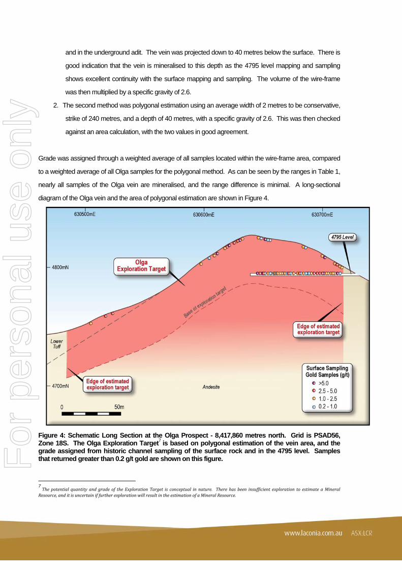
and in the underground adit. The vein was projected down to 40 metres below the surface. There is
good indication that the vein is mineralised to this depth as the 4795 level mapping and sampling
shows excellent continuity with the surface mapping and sampling. The volume of the wire-frame
was then multiplied by a specific gravity of 2.6.
2. The second method was polygonal estimation using an average width of 2 metres to be conservative,
strike of 240 metres, and a depth of 40 metres, with a specific gravity of 2.6. This was then checked
against an area calculation, with the two values in good agreement.
Grade was assigned through a weighted average of all samples located within the wire-frame area, compared
to a weighted average of all Olga samples for the polygonal method. As can be seen by the ranges in Table 1,
nearly all samples of the Olga vein are mineralised, and the range difference is minimal. A long-sectional
diagram of the Olga vein and the area of polygonal estimation are shown in Figure 4.
Figure 4: Schematic Long Section at the Olga Prospect - 8,417,860 metres north. Grid is PSAD56, Zone 18S. The Olga Exploration Target7 is based on polygonal estimation of the vein area, and the grade assigned from historic channel sampling of the surface rock and in the 4795 level. Samples that returned greater than 0.2 g/t gold are shown on this figure.
7Thepotentialquantityandgradeof theExplorationTarget is conceptual innature. Therehasbeen insufficientexploration toestimateaMineralResource,anditisuncertainiffurtherexplorationwillresultintheestimationofaMineralResource.
For
per
sona
l use
onl
y

10
Target 4 - Española 1 Prospect
The Española 1 Prospect lies about 875 metres to the north east of the Rasuhuilca deposit. The geology is a
set of two veins of different orientation, plus tectonic and hydrothermal breccias. Vein A (Española 1) is the
dominant structure, and strikes about 320 degrees, to the north west. The dip of this vein is about -80 degrees
to the south west. Vein B (Punto Triple) strikes north-south. It has a gentler dip than vein A, and dips at -76
degrees to the west. Some of the best gold and silver grades occur where vein A intersects vein B.
The veins at the Española 1 Prospect are dominated by various types of breccia, with varying styles of
alteration that range from massive silicification to silicification and alunite alteration. Sampling at Española 1
Prospect includes surface sampling and an adit at the 4805 level. There is also significant copper
mineralisation at the Española 1 Prospect. This does not form any part of this evaluation of the prospect, and
has been discussed in detail in several other ASX releases (see ASX releases dated 27 February 2013 and 11
March 2014).
The Exploration Target8 ranges for the Española 1 Prospect were calculated using:
Dynamic Shells module of Surpac Mining Software intrinsic modelling of the individual veins, each
with their own constraint parameters based on their differing orientations. A search distance of 40
metres was allowed for the models, but width was tightly constrained with a very high minor-axis ratio.
The volume was multiplied by a specific gravity of 2.6.
A polygonal estimate was also made for each of the veins, applying a width taken from the average of
the width of mineralisation mapped in the backs of the adit at the 4810 level, and assuming vertical
continuity of 40 metres. A specific gravity of 2.6 was used.
Grade ranges were calculated using the length-weighted average of informing samples for the Dynamic Shells
models, as opposed to the informing samples for the polygonal estimate. The polygonal estimate included
more low-grade material than the Dynamic Shells models, and thus had a lower weighted grade average.
The long-section of the Española 1 Prospect presented in Figure 5 shows the two intersection vein sets,
modelled using dynamic shells.
8 The potential quantity and grade of the Exploration Target is conceptual in nature. There has been insufficient exploration to estimate a Mineral Resource, and it is uncertain if further exploration will result in the estimation of a Mineral Resource.
For
per
sona
l use
onl
y

11
Figure 5: Schematic Long Section at the Española 1 Prospect - 632,470 metres east. Grid is PSAD56, Zone 18S. The Exploration Target9 is based on Intrinsic Modelling that was informed by historic channel sampling at surface, and in the drive at the 4805 level. Samples that returned greater than 1 g/t gold are shown on this figure. Target 5 - Marcelita Prospect
The Marcelita vein system and underground development is located 4.5 km to the south east of the
Rasuhuilca vein system10.
Laconia’s continuing review of the existing prospects at Marcelita has increased the potential strike length of
the veins at the prospect from 710 metres to 975 metres, through inclusion of vein splays which are not yet
sampled, and that were not included in the release dated August 16th, 2012. In addition, it has been
recognised that there has been extensive underground development driving performed on the Marcelita 2 vein.
It is currently unclear whether the full dataset for the Marcelita drive sampling is available, or can be obtained in
future. Laconia will need to undertake re-sampling of the entire Marcelita 2 adit at the 4710 level if this dataset
cannot be acquired.
9 The quantity and grade of the Exploration Target is conceptual in nature. There has been insufficient exploration to estimate a Mineral Resource, and it is uncertain if further exploration will result in estimation of a Mineral Resource. 10 Refer ASX release 16 August 2012
For
per
sona
l use
onl
y

12
The estimation of the Exploration Target11 size for Marcelita was conducted using four estimation techniques:
1. A polygonal estimation method for each vein based on the total vein lengths, including splays of veins
that are not yet sampled. Average width was estimated from sampling and mapping data. This
estimation was used for the upper tonnage potential of the prospect, once the Elsa breccia estimate
(3D wire-framing) was added.
2. A polygonal estimation method for each vein, based on the total vein lengths that had contiguous
samples greater than 1 g/t of gold and/or greater than 60 g/t of silver. Average width was estimated
from sampling and mapping data. This estimation was used for the lower tonnage potential of the
prospect, once the Elsa breccia estimate (three dimensional wire-framing) was added.
3. Areal calculations were compared to polygonal estimations as a validation tool.
4. Three dimensional wire-framing in Surpac Mining Software was done for the Elsa Breccia, assuming
a tapering pipe-like breccia structure.
There was an assumed specific gravity of 2.6 applied to calculate tonnages, and a depth of 40 metres for base
of mineralisation.
The lower grade range was calculated by compiling the weighted average of the sample grades for each vein
and the Elsa Breccia, and applying the relevant grade to each vein tonnage to get an overall weighted
average. The upper grade range was calculated using the weighted average of all samples greater than 1 g/t
gold and/or 60 g/t silver. The Marcelita Prospect is presented as a long-sectional interpretation in Figure 6.
11 The potential quantity and grade of the Exploration Targets is conceptual in nature. There has been insufficient exploration to estimate a Mineral Resource, and it is uncertain if further exploration will result in the estimation of a Mineral Resource
For
per
sona
l use
onl
y
13
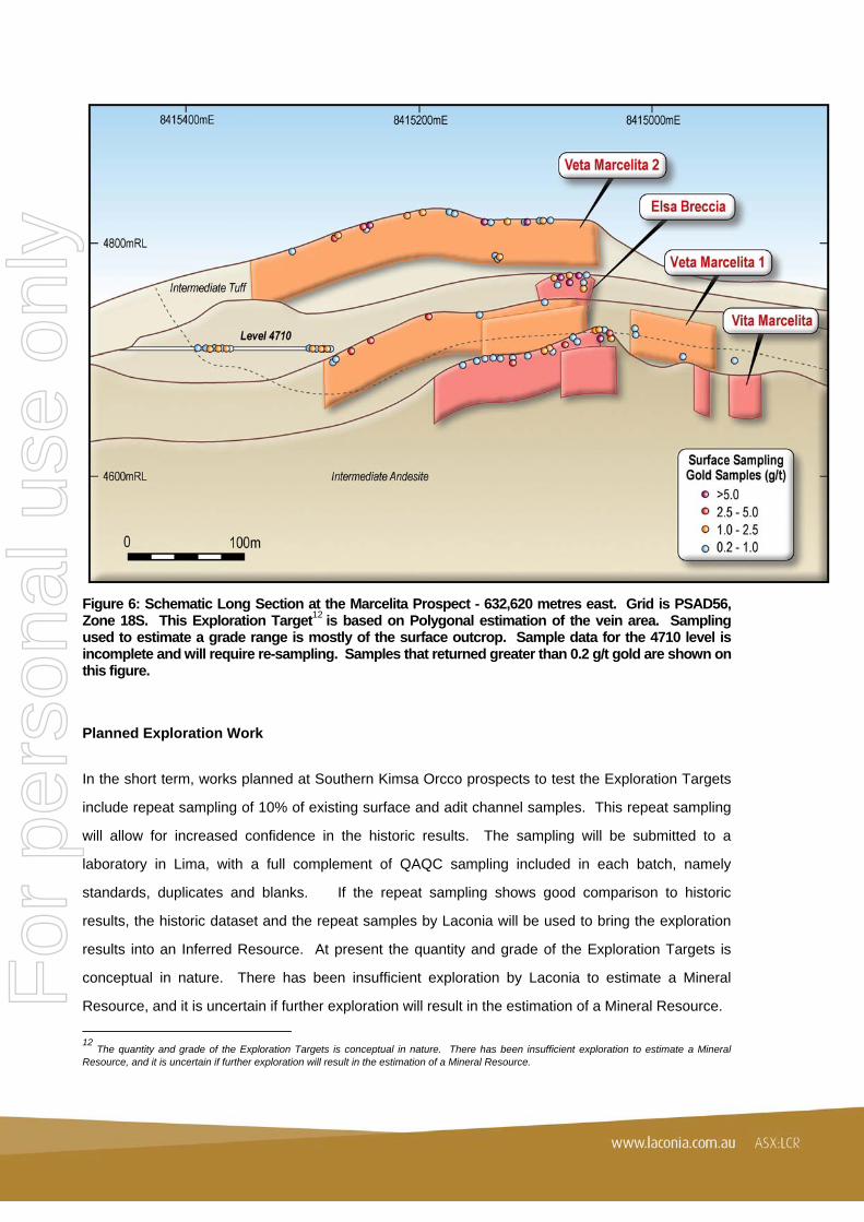
Figure 6: Schematic Long Section at the Marcelita Prospect - 632,620 metres east. Grid is PSAD56, Zone 18S. This Exploration Target12 is based on Polygonal estimation of the vein area. Sampling used to estimate a grade range is mostly of the surface outcrop. Sample data for the 4710 level is incomplete and will require re-sampling. Samples that returned greater than 0.2 g/t gold are shown on this figure.
Planned Exploration Work
In the short term, works planned at Southern Kimsa Orcco prospects to test the Exploration Targets
include repeat sampling of 10% of existing surface and adit channel samples. This repeat sampling
will allow for increased confidence in the historic results. The sampling will be submitted to a
laboratory in Lima, with a full complement of QAQC sampling included in each batch, namely
standards, duplicates and blanks. If the repeat sampling shows good comparison to historic
results, the historic dataset and the repeat samples by Laconia will be used to bring the exploration
results into an Inferred Resource. At present the quantity and grade of the Exploration Targets is
conceptual in nature. There has been insufficient exploration by Laconia to estimate a Mineral
Resource, and it is uncertain if further exploration will result in the estimation of a Mineral Resource.
12 The quantity and grade of the Exploration Targets is conceptual in nature. There has been insufficient exploration to estimate a Mineral Resource, and it is uncertain if further exploration will result in the estimation of a Mineral Resource.
For
per
sona
l use
onl
y

14
Repeat sampling will be conducted during 2014, with a work program at the project anticipated to
start in April 2014. The Company has evaluated the historic data set and found it to be of excellent
quality. For this reason, it is considered sufficient to undertake repeat channel sampling as an initial
work program, and if the results are repeatable within a satisfactory tolerance, an Inferred Resource
will be calculated for these prospects. If the results are not repeatable to a satisfactory tolerance, no
inferred resource will be calculated, and further repeat sampling and some diamond drilling will be
undertaken in late 2014 or early 2015.
Background
Laconia completed the acquisition of the four Patacancha Tenements in the Kimsa Orcco Project13 in
the Southern Andes of Peru in June 2012. Kimsa Orcco Project is an advanced, high-grade gold
and silver project which contains existing development levels and cross-cuts. In March 2013, the
Company signed a formal option agreement ("the Option Agreement") to add 5,622 hectares,
covering 11 Huaco Cucho exploration tenements adjacent to its 100% owned Patacancha
Tenements. The combined 100% Laconia Patacancha Tenements and the 80% Option Agreement
Huaco Cucho Tenements form the Kimsa Orcco Project. The Option Agreement is for seven years
and involves minimal initial outlay.
Previous explorers were aware of the potential scale and size of the Ccarhuaraso Volcanic system
and its Porphyry Copper-Gold potential due to its geological similarities to the El-Indio deposit in
Peru (Caddy, 1996.). El Indio contained some 23.2 Mt at 6.6 g/t Au, 50 g/t Ag and 4% Cu including a
bonanza gold zone of 200 kt at 209 g/t Au (Sillitoe, 1999). The Company has consequently expanded
its compilation of historical data to include any available copper sampling undertaken across the
Project licences with the view that the Project contains a buried and fully intact Epithermal/Porphyry
system. Figure 7 shows a schematic of the exploration model now being used by Laconia. It
contains examples of known vein and breccia systems on the Project and the current understanding
of how they relate to the Epithermal/Porphyry model.
Laconia continues the process of identifying and verifying all existing and available data from
sampling conducted by the Cominco SA and Buenaventura Ingenieros SA companies and will
continue with its process of re-sampling to “twin” existing surface and underground samples and drill
holes. New sampling work will be undertaken and together the data will provide increased
confidence for upgrading resource estimates.
13ReferASXRelease1June2012
For
per
sona
l use
onl
y

15
Figure 7: Schematic diagram of the high sulphidation epithermal and copper porphyry exploration models at the Kimsa Orcco Project, showing alteration and metal zonation. Some examples of prospects already identified are shown.
References Caddy, S.W., 1996, “Preliminary Structural Analysis, Mineral Alteration Zoning, Target Concepts, and Recommended Exploration Approach, Jarhaurazo District, Southern Peru”; unpublished Internal Consulting Report for Echo Bay Exploration Inc. Sillitoe, R.H., 1999, "Styles of high sulphidation gold, silver and copper mineralisation in the porphyry and epithermal environments"; in G. Weber, ed., Pacrim ’99 Congress Proceedings: Australasian Institute of Mining and Metallurgy, pp29-44.
***ENDS***
For further information please contact:
Ian Stuart
Managing Director
Laconia Resources Limited
P: +61 8 9486 1599
or visit our website at www.laconia.com.au
For
per
sona
l use
onl
y

16
About Laconia Resources Limited
ASX Listed Laconia Resources Limited (ASX: LCR) is a Perth-based precious and base metals
exploration and development Company with a Latin American focus. The Company’s flagship Kimsa
Orcco Project in Peru is an advanced copper-gold-silver project in the Ayacucho region of Southern
Peru, across four 100% Laconia Resources Ltd permits covering 27.65 km2 and a further 11
contiguous permits through an 80% earn in option agreement, covering 56.22 km2. The total area of
83.87 km2 hosts the entire Ccarhuaraso volcanic system that is proven to host high sulphidation
epithermal copper gold and silver.
In Western Australia, the Company has mineral projects across two granted tenements covering an
approximate 98.7 km2 in the Pilbara and Northern Gascoyne regions.
Competent Persons Statement
The information in this announcement that relates to Exploration Targets at the Condor, Huallatas, Olga,
Española 1 and Marcelita Prospects is based on information compiled by Mr Vincent Algar, a Competent
Person who is a Member of the Australasian Institute of Mining and Metallurgy. Mr Algar is a consultant for
Laconia Resources Limited and has sufficient experience that is relevant to the style of mineralisation and type
of deposit under consideration and to the activity currently being undertaken to qualify as a Competent Person
as defined in the 2012 Edition of the ‘Australasian Code for Reporting of Exploration Results, Mineral
Resources and Ore Reserves’. Mr Algar consents to the inclusion in this announcement of the matters based
on his information in the form and context in which it appears.
See Appendix 2 for Detailed JORC Table 1, Section 1 and Section 2
For
per
sona
l use
onl
y

17
APPENDIX 1 – List of documents for previously released exploration results sample data
No new results are used in this release. For original reporting of exploration results with full sampling data, please refer to the following Company documents:
ASX Release dated 16 August 2012
ASX Release dated 13 November 2012
ASX Release dated 4 February 2013
APPENDIX 2 – JORC CODE, 2012 Edition, Table 1 (Section 1 and 2)
SECTION 1: Sampling Techniques and Data
Criteria JORC Explanation Remarks
Sampling Techniques
Nature and quality of sampling (eg cut channels, random chips, or specific specialised industry standard measurement tools appropriate to the minerals under investigation, such as down hole gamma sondes, or handheld XRF instruments, etc). These examples should not be taken as limiting the broad meaning of sampling.
Cut surface channel samples – 30 cm width. Cut underground channel samples – 30 cm width.
Include reference to measures taken to ensure sample representivity and the appropriate calibration of any measurement tools or systems used.
Cominco used a sample size of 10 kg per metre of channel sampling. No details are known of their QAQC processes, but it is noted that results of duplicate samples taken at the same location as prior channel samples by Buenaventura are comparable, indicating there was no problem with Cominco sampling. Buenaventura used a sample size of 3.5 kg per metre of channel sampling. They routinely submitted duplicate and triplicate samples. The employed umpire laboratories to check their results with triplicate samples, as well as re-submitting pulps.
Aspects of the determination of mineralisation that are Material to the Public Report. In cases where ‘industry standard’ work has been done this would be relatively simple (eg ‘reverse circulation drilling was used to obtain 1 m samples from which 3 kg was pulverised to produce a 30 g charge for fire assay’). In other cases more explanation may be required, such as where there is coarse gold that has inherent sampling problems. Unusual commodities or mineralisation types (eg submarine nodules) may warrant disclosure of detailed information.
Channel samples were collected using best method (ie. cut with a rock saw). Duplicates and triplicates of channel samples (adit and surface) were obtained through re-cutting a second or third sample in the same location. Channel samples were not split for the purposes of creating duplicates or triplicates. Sample preparation techniques are not known.
Drilling Techniques Drill type (eg core, reverse circulation, open-hole hammer, rotary air blast, auger, Bangka, sonic, etc) and details (eg core diameter, triple or standard tube, depth of diamond tails, face-sampling bit or other type, whether core is oriented and if so, by what method, etc).
No drilling results are included in this release.
Drill Sample Recovery
Method of recording and assessing core and chip sample recoveries and results assessed.
No drilling results are included in this release.
Measures taken to maximise sample recovery and ensure representative nature of the samples.
No drilling results are included in this release.
For
per
sona
l use
onl
y

18
Criteria JORC Explanation Remarks
Drill Sample recovery (continued)
Whether a relationship exists between sample recovery and grade and whether sample bias may have occurred due to preferential loss/gain of fine/coarse material
No drilling results are included in this release.
Logging Whether core and chip samples have been geologically and geotechnically logged to a level of detail to support appropriate Mineral Resource estimation, mining studies and metallurgical studies.
Surface and underground channel samples were plotted onto geological maps that were created using a consistent legend. No geotechnical logs are available for channel samples.
Whether logging is qualitative or quantitative in nature. Core (or costean, channel, etc) photography.
Logging is qualitative, with the exception of some quantitative logging of sulphide and alteration content. No routine photography of channel sampling is available.
The total length and percentage of the relevant intersections logged
100% of surface and adit channel sample interpretation presented in this release have mapping that can be applied as logging. .
Sub-sampling Techniques and Sample Preparation
If core, whether cut or sawn and whether quarter, half or all core taken.
No core samples are reported in this release.
If non-core, whether riffled, tube sampled, rotary split, etc and whether sampled wet or dry.
Surface and Adit channel samples were not split during any part of the process. They represent complete channels. Water was used during cutting, but then a dry sample collected using a hammer and maul.
For all sample types, the nature, quality and appropriateness of the sample preparation technique.
Details on laboratory preparation of samples are not known. Accuracy of results is implied through performance of duplicate and triplicate samples and utilisation of umpire laboratories.
Quality control procedures adopted for all sub-sampling stages to maximise representivity of samples.
QAQC practices by Cominco are unknown, but samples repeated by Buenaventura indicate the original Cominco sampling was reliable. For Buenaventura channel sampling standards and blanks were interleaved with the routine samples, every 20th sample for Buenaventura sampling. For the channel sampling, duplicates were cut for every 20th sample. Triplicates were cut and sent to an umpire lab, at a frequency of about 3%.
Measures taken to ensure that the sampling is representative of the in situ material collected, including for instance results for field duplicate/second-half sampling.
For Buenaventura channel samples, duplicates and triplicates were collected through cutting another channel sample, not splitting the existing channel sample. 5% of total sample numbers were submitted as duplicates, and 2.5% were submitted as triplicates.
Whether sample sizes are appropriate to the grain size of the material being sampled
Channel sample sizes were appropriate, as shown by good correlation between primary, duplicate and triplicate results.
For
per
sona
l use
onl
y

19
Criteria JORC Explanation Remarks
Quality of Assay Data and Laboratory Tests
The nature, quality and appropriateness of the assaying and laboratory procedures used and whether the technique is considered partial or total.
For channel samples gold (Au) was analysed by AAS with Fire Assay checks on 50 g aliquots to 2 ppb detection limits and AAS was used for Silver (Ag). ICP-MS was used for the other elements (Cu, Pb, Zn, Mo, As, Sb, Bi, Hg, Te) / (Ag, Cu, Pb, Zn, Mo, N, Co, Cd, Bi, As, Sb, Hg, Fe, Mn, Te, Ba, Cr, V, Sn, W, La, Al, Mg, Ca, Na, K, Sr, Y, Ga, Li, Nb, Sc, Ta, Ti, Zr) – Adit Channel Samples was + 35 Suite or + 9 Suite. Digestion method is not known and so completeness of technique is unknown.
For geophysical tools, spectrometers, handheld XRF instruments, etc, the parameters used in determining the analysis including instrument make and model, reading times, calibrations factors applied and their derivation, etc.
No geophysical tools or other analysis methods were employed.
Nature of quality control procedures adopted (eg standards, blanks, duplicates, external laboratory checks) and whether acceptable levels of accuracy (ie lack of bias) and precision have been established.
For both channel sampling, standards and blanks were interleaved with the routine samples, every 20th sample. For the channel sampling, duplicates were cut for every 20th sample. Triplicates were cut and sent to an umpire laboratory (at a frequency of about 3%).
Verification of Sampling and Assaying
The verification of significant intersections by either independent or alternative company personnel.
No intersection verification at Condor, Huallatas, Olga, Española 1 or Marcelita Prospects has been done, though Buenaventura repeating Cominco sampling at other prospects, and Gold Mines Peru repeated Cominco and Buenaventura sampling at a later date. Laconia repeated Cominco and Gold Mines Peru sampling (33 samples) in the Rasuhuilca underground development, and the results showed the original sampling was repeatable.
The use of twinned holes.
No twinned holes have been used to verify sampling and assaying.
Documentation of primary data, data entry procedures, data verification, data storage (physical and electronic) protocols.
Data has been compiled from good quality paper plans and digitally compiled at a later date. The data has been assimilated into the Company SQL database, and exported into Microsoft Access, after compilation and validation in Surpac and Mapinfo Software and checks against topography and the quality of repeated sample locations.
Discuss any adjustment to assay data. There was re-calculation of assays reported as oz/t to g/t. The calculation was based on the imperial oz (28.34 grams to an ounce), rather than the troy ounce (31.10 grams to an ounce).
Location of Data Points
Accuracy and quality of surveys used to locate drill holes (collar and down-hole surveys), trenches, mine workings and other locations used in Mineral Resource estimation.
Cominco established professionally surveyed trigonometric points across the Kimsa Orcco project. From these survey points, surface mapping and sampling was spatially referenced. Underground development was surveyed by Cominco, with permanent survey points established in the adits. Following workers (Buenaventura, Gold Mines Peru, and Laconia Resources) utilised these survey points for spatial location of their work. Buenaventura used a company employed surveyor. Only the Rasuhuilca underground development sampling and surface sampling informs a resource estimation.
Specification of the grid system used. All data was collected as, and remain in, PSAD56, Zone 18 South, EPSG 24878.
Quality and adequacy of topographic control.
Topographic surface uses 10 metre contours that have excellent correlation to ground features.
For
per
sona
l use
onl
y
20
Criteria JORC Explanation Remarks
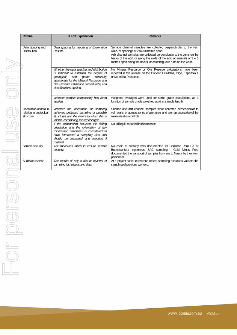
Data Spacing and Distribution
Data spacing for reporting of Exploration Results.
Surface channel samples are collected perpendicular to the vein walls, at spacings of 2 to 30 metres apart. Adit channel samples are collected perpendicular to the veins on the backs of the adit, or along the walls of the adit, at intervals of 2 – 5 metres apart along the backs, or as contiguous runs on the walls.
Whether the data spacing and distribution is sufficient to establish the degree of geological and grade continuity appropriate for the Mineral Resource and Ore Reserve estimation procedure(s) and classifications applied.
No Mineral Resource or Ore Reserve calculations have been reported in this release on the Condor, Huallatas, Olga, Española 1 or Marcelita Prospects.
Whether sample compositing has been applied.
Weighted averages were used for some grade calculations, as a function of sample grade weighted against sample length.
Orientation of data in relation to geological structure
Whether the orientation of sampling achieves unbiased sampling of possible structures and the extent to which this is known, considering the deposit type.
Surface and adit channel samples were collected perpendicular to vein walls, or across zones of alteration, and are representative of the mineralisation controls.
If the relationship between the drilling orientation and the orientation of key mineralised structures is considered to have introduced a sampling bias, this should be assessed and reported if material.
No drilling is reported in this release.
Sample security The measures taken to ensure sample security.
No chain of custody was documented for Cominco Peru SA or Buenaventura Ingenieros SAC sampling. Gold Mines Peru documented the transport of samples from site to Nazca by their own personnel.
Audits or reviews The results of any audits or reviews of sampling techniques and data.
At a project scale, numerous repeat sampling exercises validate the sampling of previous workers.
For
per
sona
l use
onl
y

21
SECTION 2: Reporting of Exploration Results
Criteria JORC Explanation Remarks
Mineral tenement and land tenure status
Type, reference name/number, location and ownership including agreements or material issues with third parties such as joint ventures, partnerships, overriding royalties, native title interests, historical sites, wilderness or national park and environmental settings.
The Kimsa Orcco Project is comprised of 4 Patacancha tenements that are 100% Laconia Resources owned, plus the 11 Huaco Cucho tenements that are subject to an Earn-in Agreement, for option of 80% interest over a 7 year period. The prospects discussed in this release are all within 100% Laconia tenements: Condor, Huallatas and Olga in Patacancha 1 tenement. Española 1 in Patacancha 3 tenement. Marcelita in Patacancha 2 tenement. The tenements are located on a high plateau within the Andes Mountain chain, in the Department of Ayacucho in Southern Peru. There are no historical sites, wilderness or national park issues known to Laconia Resources. Community agreements to address Native Title issues are completed; all 3 required agreements have been achieved.
The security of the tenure held at the time of reporting along with any known impediments to obtaining a licence to operate in the area.
Laconia knows of no impediment to obtaining a licence to operate in the area.
Exploration Done by Other Parties
Acknowledgement and appraisal of exploration by other parties.
The project area has previously been explored by COMINCO el Peru between 1985 and 1987, by Buenaventura Ingenieros SA from 1996 to 2003. Echo Bay undertook exploration in a JV partnership with Buenaventura between 1996 and 1999. Gold Mines Peru acquired the project in 2005 and started development and small-scale mining at the Marcelita 2 vein. They moved focus to the Rasuhuilca vein in September 2006.
Geology Deposit type, geological setting and style of mineralisation.
High sulphidation epithermal gold-silver veining and alteration halos, with localised enargite-rich breccias along fault controlled paths. Volcanic centre dated at 1.4 – 1.6 Ma.
Drill hole Information
A summary of all information material to the understanding of the exploration results including a tabulation of the following information for all Material drill holes:
• easting and northing of the drill hole collar • elevation or RL (Reduced Level –
elevation above sea level in metres) of the drill hole collar
• dip and azimuth of the hole • down hole length and interception depth • hole length.
Exploration results have all previously been tabulated in previous ASX releases. Reference to the relevant documents is provided in Appendix 1.
If the exclusion of this information is justified on the basis that the information is not Material and this exclusion does not detract from the understanding of the report, the Competent Person should clearly explain why this is the case.
No information is excluded.
Data Aggregate Methods
In reporting Exploration Results, weighting averaging techniques, maximum and/or minimum grade truncations (eg cutting of high grades) and cut-off grades are usually Material and should be stated.
Weighting is calculated as a function of each sample length multiplied by each grade, with the summed product divided by the total sample length, to present composited intervals. No top or bottom cut was applied.
Where aggregate intercepts incorporate short lengths of high grade results and longer lengths of low grade results, the procedure used for such aggregation should be stated and some typical examples of such aggregations should be shown in detail.
No aggregate intercepts are stated in this release.
The assumptions used for any reporting of metal equivalent values should be clearly stated.
No metal equivalents are used for the exploration results at Condor, Huallatas, Olga, Española 2 or Marcelita Prospects. F
or p
erso
nal u
se o
nly

22
Criteria JORC Explanation Remarks
Relationship between mineralisation widths and intercept lengths
These relationships are particularly important in the reporting of Exploration Results.
Surface and Adit channel samples reflect vein true widths as they are cut perpendicular to the vein walls.
If the geometry of the mineralisation with respect to the drill hole angle is known, its nature should be reported.
No drilling is reported in this release.
If it is not known and only the down hole lengths are reported, there should be a clear statement to this effect (eg ‘down hole length, true width not known’).
No drilling is reported in this release.
Diagrams Appropriate maps and sections (with scales) and tabulations of intercepts should be included for any significant discovery being reported These should include, but not be limited to a plan view of drill hole collar locations and appropriate sectional views.
Diagrams are provided that show the geology and significant samples of each prospect, and the location of prospects relative to each other.
Balanced Reporting
Where comprehensive reporting of all Exploration Results is not practicable, representative reporting of both low and high grades and/or widths should be practiced to avoid misleading reporting of Exploration Results.
All exploration sampling results are presented in previous releases, regardless of grade.
Other substantive exploration data
Other exploration data, if meaningful and material, should be reported including (but not limited to): geological observations; geological survey results, geochemical survey results; bulk samples – size and method of treatment; metallurgical test results; bulk density, groundwater, geotechnical and rock characteristics; potential deleterious or contaminating substances.
Discussion of the Condor, Huallatas, Olga, Española 1 and Marcelita Prospects geology is included in the release. To date no economic or extractive measures such as bulk samples, metallurgical testing, bulk density, groundwater, geotechnical or rock samples have been done. Mineral species hosting base metals are identified in the release.
Further Work The nature and scale of planned further work (eg tests for lateral extensions or depth extensions or large-scale step-out drilling).
Repeat sampling for modern QAQC purposes is identified as future planned work. Repeat sampling will be undertaken at a density of 10% of existing sampling to verify historic results.
Diagrams clearly highlighting the areas of possible extensions, including the main geological interpretations and future drilling areas, provided this information is not commercially sensitive.
The areas of mineralisation is outlined in Figure 1. Extensions are not currently identified.
For
per
sona
l use
onl
y