Embed Size (px)
Citation preview

4-1 Chapter 4: Highway Element Kanawha County • Putnam County
CHAPTER 4
Highway Element
Prepared by the Regional Intergovernmental Council
Existing Roadway Conditions
The challenges facing the future of the transportation network in the Kanawha Valley are a collective result of reliance on passenger vehicles for even short trips, as well as competing agendas for scarce transportation funds. To better prepare the region for the future, the existing transportation system was evaluated to identify needs and priorities for the purposes of planning. The discussion of existing roadway conditions is organized into the following sections:
Transportation Corridors and Activity Centers
Functional Classification
Traffic Safety and Crash History
Corridor Operations and System Deficiencies
Public Perception
Transportation Corridors and Activity Centers
An inherent relationship exists between land use and transportation. As development occurs and more vehicles take to the road, roadway improvements are needed to reduce traffic congestion. These roadway improvements often enhance access, thus raising land values and attracting more development.
The interaction between activity centers and the transportation corridors that link them to other centers and destinations is important, as are the mobility choices provided within the center. Often, neighborhoods and activity centers rely on a small number of transportation corridors to provide essential links between home, school, employment, shopping, social, and recreational destinations. The extent to which these origins and destinations blend into multipurpose activity centers has a dramatic effect on a person’s ability to choose between modes for their trip. In many cases, the range of trip alternatives (walk, bike, drive, or transit) also can influence

Regional Transportation Plan
4-2 Chapter 4: Highway Element
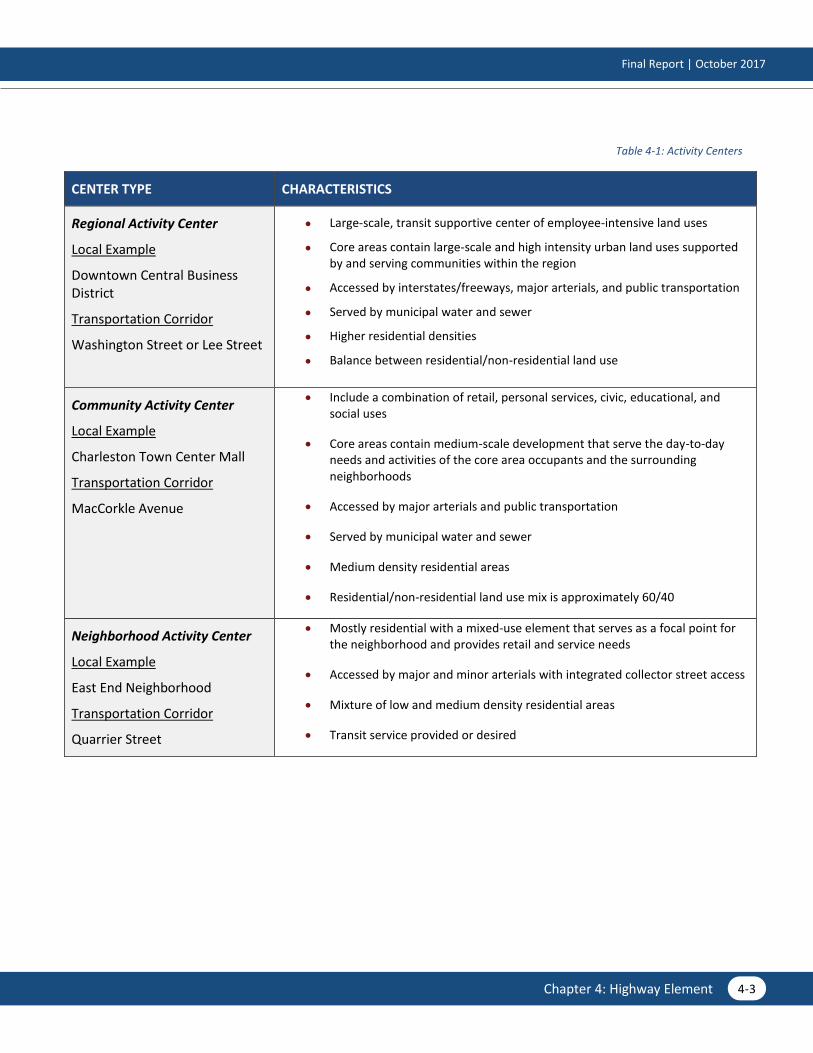
the overall perception of a community. Table 4-1 on the following page summarizes three types of activity centers—regional, community, and neighborhood—and provides local examples.
The level of success for corridors within and between activity centers depends in large part on the intended function of the street. A specific challenge for the future will be to balance the area’s mobility needs with other priorities. Traffic mobility often is given priority without regard to other considerations such as the function of the street, corridor relationship to land use, urban design, and promotion of alternate modes.
One of the unique challenges in creating a successful transportation system for Kanawha and Putnam counties is blending connectivity and access functions with the preservation of natural features and the distinctive character of the Kanawha Valley. Neighborhoods and smaller communities within the region may have different needs and priorities. While recognizing these differences, it is important not to lose focus of the practical concept of overall connectivity. This concept is particularly relevant as it relates to people’s desires to make safe and efficient trips not only by driving, but also by walking, bicycling, or using public transportation. The discussion of complete streets in this chapter sets the stage for the region to balance the mobility and access functions of a roadway.
Final Report | October 2017
4-3 Chapter 4: Highway Element
Table 4-1: Activity Centers
CENTER TYPE CHARACTERISTICS
Regional Activity Center
Local Example
Downtown Central Business District
Transportation Corridor
Washington Street or Lee Street
Large-scale, transit supportive center of employee-intensive land uses
Core areas contain large-scale and high intensity urban land uses supported by and serving communities within the region
Accessed by interstates/freeways, major arterials, and public transportation
Served by municipal water and sewer
Higher residential densities
Balance between residential/non-residential land use
Community Activity Center
Local Example
Charleston Town Center Mall
Transportation Corridor
MacCorkle Avenue
Include a combination of retail, personal services, civic, educational, and social uses
Core areas contain medium-scale development that serve the day-to-day needs and activities of the core area occupants and the surrounding neighborhoods
Accessed by major arterials and public transportation
Served by municipal water and sewer
Medium density residential areas
Residential/non-residential land use mix is approximately 60/40
Neighborhood Activity Center
Local Example
East End Neighborhood
Transportation Corridor
Quarrier Street
Mostly residential with a mixed-use element that serves as a focal point for the neighborhood and provides retail and service needs
Accessed by major and minor arterials with integrated collector street access
Mixture of low and medium density residential areas
Transit service provided or desired

Regional Transportation Plan
4-4 Chapter 4: Highway Element
Functional Classification
Functional classification is the process by which streets of different characteristics and usage are grouped into broad categories depending on the service they are intended to provide. The roadway character and traffic operation of streets define these categories.
Two major considerations for classifying arterials from neighborhood streets are access and mobility. The primary function of local or neighborhood streets is to provide access. These streets are intended to serve localized areas or neighborhoods, including local commercial and mixed-use land uses (i.e., low speeds, low volumes, and short distances). Local streets are not intended for use by through traffic. The primary function of arterials is mobility. Limiting access points (intersections and driveways) on arterials enhances mobility. Too much mobility at high speeds limits pedestrian and bicyclist access. The arterial is designed with the intent to carry more traffic than is generated within its corridor (i.e., higher speeds, higher volumes, and longer distances).
Table 4-2: Functional Classification Definitions and Examples
ARTERIALS 398 miles
Arterials provide high mobility, operate at higher speeds, provide significant roadway capacity, have a great degree of access control, and serve longer distance travel. Arterials can be subdivided into categories that include facilities with full access control such as freeways and expressways, as well as major and minor arterials. Arterials usually connect to one another or to collector streets. Very few arterials connect to local streets.
Expressways & Freeways
Interstates 64, 77, and 79
Major Arterials US 119 (Corridor G), MacCorkle Avenue (US 60/WV 61), US 35, WV 34, and WV 25
Minor Arterials WV 61, Dupont Avenue, Big Tyler Road, WV 62, and Kanawha Terrace
COLLECTORS 440 miles
Collectors typically provide less overall mobility, operate at lower speeds, have more frequent and greater access flexibility with adjacent land uses, and serve shorter distance travel than arterials. Collectors provide critical connections in the roadway network by bridging the gap between arterials and locals. Most collector streets connect with one another, with local streets, and with non-freeway/expressway arterials.
Poca River Road, Five Mile Road, Superior Avenue, Sissonville Drive, and Cow Creek Road
LOCALS 1,346 miles
Local facilities provide greater access and the least amount of mobility. These facilities typically connect to one another or to collector streets and provide a high level of access to adjacent land uses/development (e.g., frequent driveways). Locals serve short distance travel and have low posted speed limits. Most roadways within the Kanawha-Putnam area are classified as locals.
Most roadways within the Kanawha-Putnam area are classified as locals.
The study area is home to several miles of the National Highway System (NHS), which includes the interstate highway system along with other roads important for the nation’s critical functions including the economy, defense, and mobility of goods and people. Approximately
192 miles
of the NHS pass through Kanawha and Putnam counites.

Final Report | October 2017
4-5 Chapter 4: Highway Element
Roadway Functional Classification
Population Density
Figure 4-1
Regional Transportation Plan
4-6 Chapter 4: Highway Element
Traffic Safety and Crash History
Traffic safety is a key component of any successful transportation plan and a critical consideration for community-wide mobility. Examining the crash history and traffic patterns can help identify locations where improvements in traffic safety may benefit the community. Safety data was considered in the development of the Kanawha-Putnam 2045 RTP and is detailed later in Chapter 8: Safety and Security.
Corridor Operations and System Deficiencies
Congested Corridors
Congestion in corridors is related to several factors, but is often the result of bottlenecks—primarily at intersections—along the corridor. Aside from individual bottleneck locations, congestion frequently results from too many people trying to use a route that is already at or over capacity. Congested corridors were identified by using volume-to-capacity (V/C) ratios. V/C ratios are calculated by dividing the traffic volume of a roadway segment by the theoretical capacity of the roadway. Although V/C can be tied to level of service (LOS), V/C allows for a more specific analysis. The result is a universal quantitative measurement. Table 4-3 below describes the V/C categories that were used in analyzing roadways for the Kanawha-Putnam 2045 RTP. The roadways that are congested in Figure 4-2 were part of the foundation for determining future improvements intended to alleviate congestion and improve the overall transportation system.

Final Report | October 2017
4-7 Chapter 4: Highway Element
Table 4-3: Volume-to-Capacity Ratio Category Descriptions
CATEGORY DESCRIPTION
Under Capacity
V/C < 0.85
A roadway with a V/C less than 0.85 typically operates with efficiency and is not considered congested.
Approaching Capacity
V/C = 0.85 to 1.09
As the V/C nears 1.0, the roadway is becoming more congested. A roadway approaching congestion may operate effectively during non-peak hours but be congested during peak travel periods.
At Capacity
V/C = 1.10 to 1.29
Roadways operating at capacity or slightly above capacity are heavily congested during peak periods and moderately congested during non-peak periods. A change in capacity due to incidents greatly impacts the travel flow on corridors operating within this V/C range.
Above Capacity
V/C > 1.30
The roadways in this category represent the most congested corridors in the Kanawha Valley. These roadways are congested during non-peak hours and most likely operate in stop-and-go gridlock conditions during the morning and evening peak travel periods.

Regional Transportation Plan
4-8 Chapter 4: Highway Element
2015 Congested Corridors
Population Density
Figure 4-2

Final Report | October 2017
4-9 Chapter 4: Highway Element
What’s most important in terms of safety and security, participants said:
ò Improving transportation safety at the region's most dangerous intersections
Making the transportation network more reliable and travel times more predictable
Reducing emergency response times
Investing in Intelligent Transportation System (ITS) features
What’s most important in terms of mobility and accessibility, participants said:
ò Investing in bicycle-specific facilities (e.g., bicycle lanes)
Investing in pedestrian-specific facilities (e.g., sidewalks and crosswalks)
Investing in multiuse facilities (e.g., greenways and multiuse paths)
Investing in public transportation (e.g., bus routes and bus stop amenities)
WHEN ASKED…
Public Perception
Traffic problems may not always be a product of congestion. Some problems are created by confusing roadway geometry, lack of alternative travel choices, or general frustrations caused by difficult commutes. These problems cannot be measured with traditional traffic analysis methods. The nature of these problems is only discovered by going to the source of the frustration: the driving public.
As part of the public outreach component of this study, an online survey and stakeholder interviews were conducted to determine the overall perceptions of the existing transportation system and to determine the community’s appetite for potential improvements. The following map shows roadway issues identified by online survey participants.
Figure 4-3: Online Survey Input: Participant-Identified Roadway Issues

Regional Transportation Plan
4-10 Chapter 4: Highway Element

Final Report | October 2017
4-11 Chapter 4: Highway Element
Future Roadway Conditions
The challenges facing the future of the transportation network in the Kanawha-Putnam planning area are the collective result of projected employment growth, continued reliance on the automobile, and competing agendas for scarce transportation funds. Using socioeconomic data developed for the RIC Travel Demand Model, the general population in the Kanawha-Putnam planning area is expected to reduce by approximately 5% by 2045, while the employment is supposed to increase by approximately 31%. With the continued dependence on single-occupancy vehicle as the primary mode of travel, the few projects with committed funding will do little to address deficiencies in the transportation network.
This section considers these dynamics as we examine the future transportation network under a variety of conditions. The RIC Travel Demand Model was used to assess existing and future travel conditions. This TransCAD model tested the operation of the future highway network under various scenarios. Two scenarios were developed for 2045 travel conditions using the model, including the construction of existing and committed projects and the construction of all fiscally constrained projects.
This section begins with an overview existing plus committed scenario, which considers the impact committed projects will have on future travel conditions. Based on this analysis, a set of recommendations were developed to alleviate existing and future congestion problems. These recommendations were vetted through discussions with planning staff and the Steering Committee and prioritized based on the results of a series of evaluation criteria, which is discussed later in this section. This section concludes with strategies for access management, connectivity, ITS improvements, and complete streets.
Committed Conditions
The initial step in identifying projects for the Kanawha-Putnam 2045 RTP is to analyze how the existing transportation network combined with committed projects will perform in 2045, given current growth patterns. The state’s 2017-2022 Dynamic Statewide Transportation Improvement Program, which provides a financially constrained list of the most immediate priority transportation improvements for an area, and Metro Mobility 2040 list several committed projects within the planning area. The projects included in the evaluation of existing and committed conditions in the horizon year are described in Table 4-4 on the following page. Figure 4-4 displays congestion in the year 2045 if only those projects that are existing and committed are built.

Regional Transportation Plan
4-12 Chapter 4: Highway Element
Table 4-4: Committed Projects

Final Report | October 2017
4-13 Chapter 4: Highway Element
ID FACILITY
PROJECT COST
EC-1 EC-9
Interstate 64 Widening + Nitro Bridge
Interstate 64 will be widened from 4 to 6 lanes between just east of the I-64/US 35 Interchange (Exit 40) at Crooked Creek to east of the Nitro Interchange (Exit 45) in Putnam County. This project also includes a new second truss bridge over the Kanawha River. Once completed, this project will add capacity and ease travel at one of the region’s greatest existing bottlenecks
$72,054,800
EC-2 Hurricane (WV 34) Signal
While alternatives are still being explored, the intersection of Hurricane Creek Road and Teays Valley Road (WV 34) is slotted for intersection improvements. Current discussions include the addition of a right turn lane from Hurricane Creek Road to Teays Valley Road, as well as a westbound receiving lane on Teays Valley Road.
$960,000
EC-5A EC-5B EC-8
Jefferson Road (WV 601)
Jefferson Road is currently a 2-3 lane facility and is anticipated to be widened to 4-5 lanes. The project widening includes the addition of a bicycle and pedestrian path, as well as a bridge over Davis Creek, Kanawha Turnpike, and CSX railroad. Right-of-way acquisition is anticipated to begin in early 2018. This project will not only improve existing and future roadway congestion, but also enhance safety and mobility.
$55,766,560
PC-1 New US 35
New US 35 is a new 14.6 mile 4-lane divided facility spanning from Buffalo Bridge to the Mason County line and has an anticipated completion in 2019. Completion of the roadway will provide greater mobility for national, state, and local freight, as well as open the door for new economic development.
$73,136,250
Dunbar DMS The Dunbar Dynamic Message Sign will be installed on Interstate 64 to keep motorists informed about incidents and expected travel times.
$720,000

Regional Transportation Plan
4-14 Chapter 4: Highway Element
2045 Existing + Committed Conditions
Population Density
Figure 4-4

Final Report | October 2017
4-15 Chapter 4: Highway Element
Recommendations Development
As we evaluate the transportation network over the next 30 years, it is evident that increasing demands will be placed on the existing road network. With limitations to new construction including natural and manmade barriers, it will become even more important to protect the integrity of the existing system. This document provides a list of proposed improvements specific to key corridors throughout the region. The list includes projects that emerged during discussions with area stakeholders, local officials, the steering committee, and the public.
As a part of this Plan, the congestion issues remaining after the completion of the existing and committed projects described in the previous section were recognized as priority areas for improvement. Through the analysis of these congested corridors, along with social and environmental concerns and the desire s of the public, a set of roadway project recommendations was formulated. Further analysis allowed these projects to be prioritized based on benefits of implementation and barriers to construction. It is important to note that these projects were evaluated first with these criteria in mind before final prioritization and financial constraint occurred.
Recommendations are placed into a variety of categories, including widening, new location, access management, and operational improvements. It should be noted that, wherever possible, the recommendations emphasize the protection of existing roadways to meet the goal of system preservation and fiscal responsibility. The recommendations that follow as well as the multimodal solutions presented in Chapters 5 and 6 aim to alleviate system-wide congestion in a cost-effective and time efficient manner. The following sections provide a detailed discussion of the proposed projects in the Kanawha-Putnam 2045 RTP.
Figure 4-5 displays recommended improvements for the Kanawha-Putnam region and is followed by a series of project sheets that provide greater insight into each recommendation.

Regional Transportation Plan
4-16 Chapter 4: Highway Element
Facility Improvements
Population Density
Figure 4-5
Final Report | October 2017
4-17 Chapter 4: Highway Element
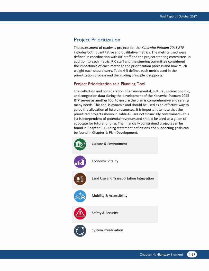
Project Prioritization
The assessment of roadway projects for the Kanawha-Putnam 2045 RTP includes both quantitative and qualitative metrics. The metrics used were defined in coordination with RIC staff and the project steering committee. In addition to each metric, RIC staff and the steering committee considered the importance of each metric to the prioritization process and how much weight each should carry. Table 4-5 defines each metric used in the prioritization process and the guiding principle it supports.
Project Prioritization as a Planning Tool
The collection and consideration of environmental, cultural, socioeconomic, and congestion data during the development of the Kanawha-Putnam 2045 RTP serves as another tool to ensure the plan is comprehensive and serving many needs. This tool is dynamic and should be used as an effective way to guide the allocation of future resources. It is important to note that the prioritized projects shown in Table 4-6 are not financially constrained – this list is independent of potential revenues and should be used as a guide to advocate for future funding. The financially constrained projects can be found in Chapter 9. Guiding statement definitions and supporting goals can be found in Chapter 1: Plan Development.
Culture & Environment
Economic Vitality
Land Use and Transportation Integration
Mobility & Accessibility
Safety & Security
System Preservation

Regional Transportation Plan
4-18 Chapter 4: Highway Element
Table 4-5: Prioritization Measures, Criteria, and Relevant Guiding Principles
MEASURE CRITERIA GUIDING PRINCIPLE
Access to Schools Improves access to school(s)
Access to Social Services Improves access to providers of social services
Alignment with Online Survey Feedback Number of comments and points along project segment
Anticipated Employment Growth Serves high growth area(s)
Anticipated Population Growth Serves high growth area(s)
Commuting/Economic Development Serves work locations (based on Censes LED jobs per square mile)
Current Freight Mobility Serves high percentage of trucks
Current Level of Service (LOS) Deficiency Poor quality of traffic flow based on speeds and density
Future Freight Mobility Serves high percentage of trucks
Peak Period Delays Project serves location with high AM/PM peak period congestion
Proximity to Community Resources Libraries, schools, parks, historical features within 1 mile
Reduction in Delay Impact on regional hours of delay
Regional Freight Shippers/Receivers Improves mobility to key shipping/receiving centers
Safety Enhancements Addresses a high-accident location
Statewide Prioritization Supports statewide goals
Transit Service Improvement Overlaps with transit route(s)
Culture & Environment Mobility & Accessibility
Economic Vitality Safety & Security
Land Use & Transportation Integration System Preservation

Final Report | October 2017
4-19 Chapter 4: Highway Element
Table 4-6: Prioritization Results
ID FACILITY NAME IMPROVEMENT TYPE
High Priority
KC-2 WV 622 (Big Tyler Road and Cross Lanes Drive) Turn Lanes
CL-8 Goff Mountain Road/Big Tyler Road (WV 622) Widening
PC-U1 Interstate 64 Widening
SH-A MacCorkle Ave (US 60) Operational
PC-6A Teays Valley Rd (CR 33) Widening
PC-6C Teays Valley Rd (CR 33) & Scott Lane Turn Lanes
PC-5 Teays Valley Road (WV 34) at West Teays E.S. Turn Lanes
KC-4 US 119 (Corridor G) Widening
KC-6 US 119 (Corridor G) Widening
KC-5 US 119 (Corridor G)
Widening, Operations, New Location, Grade Separations
Medium Priority
KC-8D Dupont Avenue (US 60) Turn Lane
KC-8A Dupont Avenue (US 60) Widening
SH-C Ford St, Vine St, Greenway Ave Operational
PC-3 Interstate 64 Widening
PC-4B Midland Trail (WV 34) at Hurricane M.S. Turn Lane
TV-4 Mt. Vernon Rd Widening
TV-5 Sleepy Hollow Rd Widening
PC-4A Teays Valley Rd (WV 34) at Hurricane H.S. Turn Lane
PC-2 Winfield Road (WV 817) Turn Lane
TV-1 WV 34 -Teays Valley Interchange Turn Lane
Lower Priority
CL-4 Big Tyler Road (WV 622) & Kroger Driveway Turn Lane
PC-8A Charleston Road (WV 62) Widening
PC-10 Charleston Road (WV 62) & Dairy Rd Intersection
KC-8C Dupont Avenue (US 60) Turn Lane
KC-8B Dupont Avenue (US 60) Turn Lane
PC-6D Teays Valley Road & Friendship Lane Intersection
CL-2 Goff Mountain Road (WV 622) & I-64 Ramp Intersection
Turn Lane

Regional Transportation Plan
4-20 Chapter 4: Highway Element
The project sheets on the following pages follow the order of Table 4-6. Each project sheet contains an “at-a-glance” overview of each project.
ID FACILITY NAME IMPROVEMENT TYPE
CL-1 Goff Mountain Road (WV 622) & New Goff Mountain Rd
Turn Lane
PC-9 Great Teays Blvd/Hillsdale Cir & Teays Valley Rd Intersection
KC-9 Greenbrier St (WV 114) Widening
KC-U1 Institute Connector New Location
CL-3 & CL-7
Intersection of WV 622 & Brick Lane + Access Management
Roundabout, Access Management
KC-7 Lens Creek Rd (WV 94) Widening
SH-B MacCorkle Ave (US 60) & Dunbar Toll Bridge Operational
PC-8B Main Street (WV 62) Turn Lane
KC-U2 Northern Connector New Location
CL-6 Old Goff Mountain Rd / Gatewater Rd Access Management
SA St. Albans RR Crossing Turn Lanes, Access Management
KC-3 Washington St, W (WV 62) Turn Lane