Embed Size (px)
Citation preview
Columbia Ethanol Project – Exhibit H
9/12/2006 Page H-i
EXHIBIT H
GEOLOGY AND SEISMICITY
OAR 345-021-0010(1)(h)
TABLE OF CONTENTS
Page
H.1 INTRODUCTION...................................................................................................1
H.2 GEOLOGICAL AND TOPOGRAPHIC FEATURES ...........................................1
H.3 SITE-SPECIFIC GEOLOGIC AND GEOTECHNICAL WORK..........................1
H.4 TRANSMISSION LINES .......................................................................................3
H.5 PIPELINES..............................................................................................................3
H.6 SOIL STABILITY MAP.........................................................................................4
H.7 SEISMIC HAZARD ASSESSMENT .....................................................................4
H.8 NON-SEISMIC GEOLOGIC HAZARDS..............................................................9
H.9 SEISMIC HAZARD MITIGATION.......................................................................9
H.10 NON-SEISMIC HAZARD MITIGATION.............................................................9
H.11 CONCLUSION .....................................................................................................10
H.12 REFERENCES......................................................................................................11
TABLES
Table H-1. Deterministic Seismic Hazard Assessment Peak Bedrock Acceleration ..........6
Table H-2. Local Earthquakes of Northern Hood River, Wasco, and Sherman Counties,
Oregon (Beaulieu, 1977)................................................................................6
Table H-3. Large Earthquakes Greater than 50 Miles from the Project Site (Niewendorp
and Neuhaus, 2003) .......................................................................................7
Table H-4. General Soil Profile...........................................................................................8
APPENDICES
H-1 RECORDED EARTHQUAKES WITHIN 50 MILES
H-2 PRELIMINARY GEOTECHNICAL SITE REPORT
CEPAPPDoc1


Columbia Ethanol Project – Exhibit H
9/12/2006 Page H-1
H.1 INTRODUCTION
OAR 345-021-0010(1)(h) Information from reasonably available sources regarding the
geological and soil stability of the site and vicinity, providing evidence to support
findings by the Council as required by OAR 345-022-0020, including:
H.2 GEOLOGICAL AND TOPOGRAPHIC FEATURES
OAR 345-021-0010(1)(h)(A) A description of the geological features and topography of
the site and vicinity.
Response: The project is located in the Deschutes-Columbia Plateau physiographic
province. This province is a north-sloping, volcanic plateau that measures over 60,000
square miles in Oregon, Washington, and Idaho. Volcanic rocks mapped as Columbia
River Basalt Group underlie nearly the entire province. These rocks are middle Miocene
in age (approximately 6 to 17 million years old) and principally consist of basalt that
erupted from vents in central and northeast Oregon, southeast Washington, and Idaho and
flowed westward to the Pacific Ocean (Beeson et al. 1989). Flood gravels deposited by
the catastrophic Pleistocene floods in the Columbia River valley overlie the basalt in the
region. In late Pleistocene time, a surficial layer of wind-derived, fine-grained sediment
referred to as “loess” was also deposited in the province along the Columbia River
drainage.
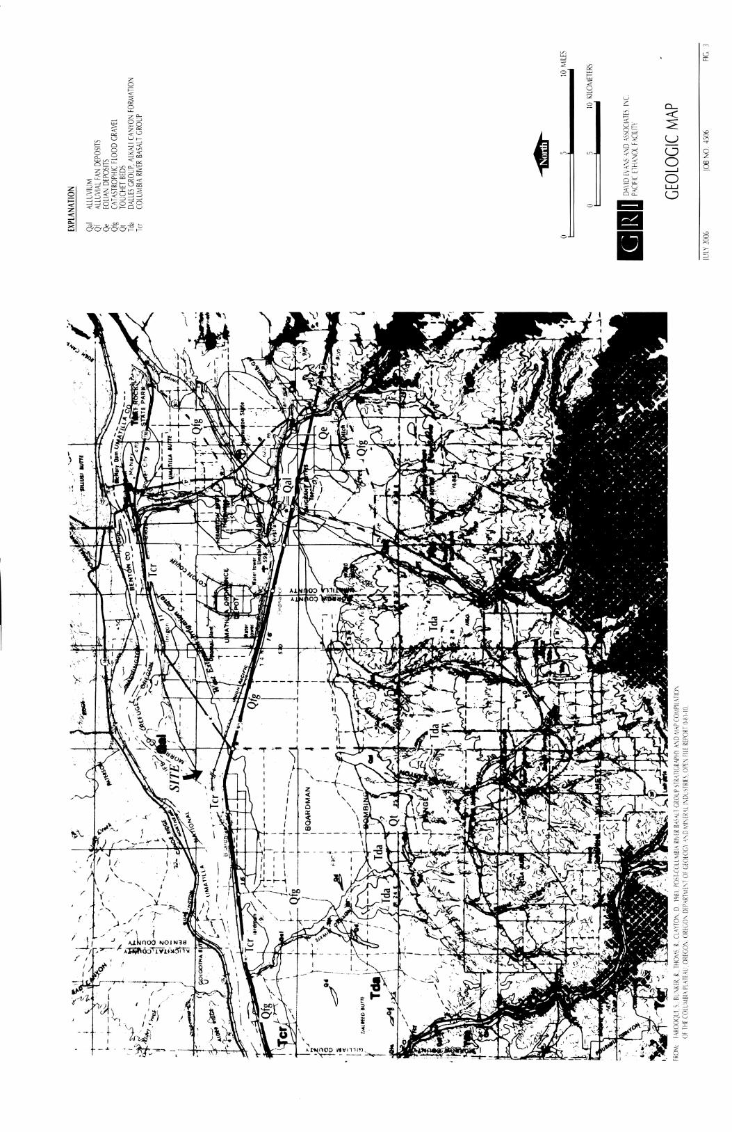
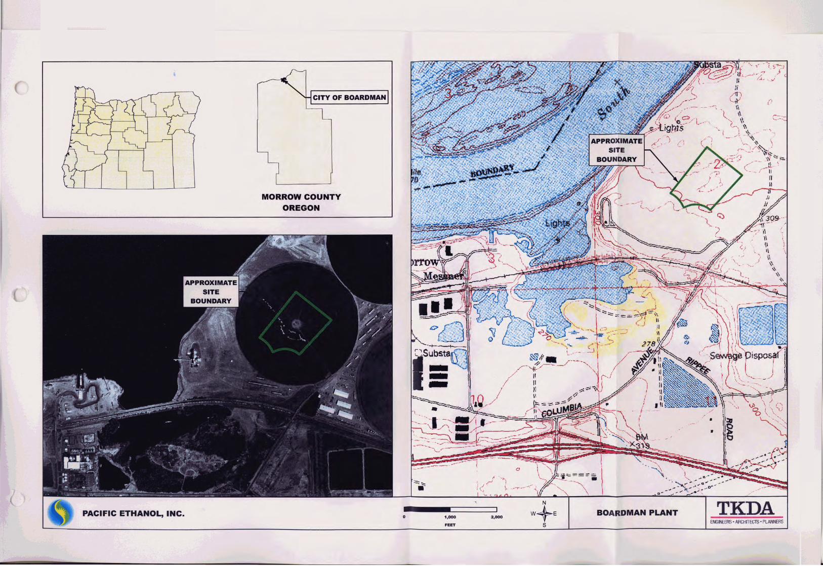
On a regional scale, the project vicinity lies on the south bank of the Columbia River, in
the northeast portion of the Port of Morrow Boardman Industrial Park. Figure 3 in
Appendix H-1 shows the location of the facility and regional geology. The site is located
about 1,500 feet southeast of the riverbank along the south channel of the river. At this
location, the river is impounded by the John Day Dam as Lake Umatilla.
H.3 SITE-SPECIFIC GEOLOGIC AND GEOTECHNICAL WORK
OAR 345-021-0010(1)(h)(B) A description of site specific geological and geotechnical
work performed or planned to be performed before construction. The application shall
include:
(i) A proposed schedule for geotechnical work;
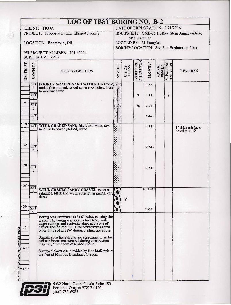
Response: Geotechnical and seismic designs have been completed for the project, which
is under construction. An April, 2006 report for the facility, prepared by Professional
Services Industries, Inc. (PSI), included 12 exploration borings that ranged from 26 to 61
feet deep (PSI 2006 as referenced in GRI 2006). On June 16, 2006, GRI Geotechnical
and Environmental Consultants (GRI) completed a geologic reconnaissance of the project
area to investigate the subsurface and foundation support conditions at the locations of
facility structures. The intent of the geologic reconnaissance was to document surficial
conditions of interest and to field-verify characterization of the soil, rock, and geologic
conditions. Emphasis was placed on identifying features or geologic hazards that could

Columbia Ethanol Project – Exhibit H
Page H-2 9/12/2006
significantly impact design, construction, and performance of planned facilities. The
results of this investigation are included as Appendix H-1.
(ii) A description of the nature and extent of the work with a discussion of the
methods used to assess the expected ground response, including amplification, at
the site;
Response: Existing information, including local, state, and federal government
documents and maps, were reviewed and used to characterize the existing geologic
conditions and potential seismic hazards in the vicinity of the project. This task included
the review of available aerial photographs of the project site. Representatives of the
Oregon Department of Geology and Mineral Industries (DOGAMI) were then contacted
for information regarding local conditions or current research that may affect the project.
A reconnaissance of the project site was performed to document surficial conditions of
interest and to field-verify characterization of the soil, rock, and geologic conditions.
Emphasis was placed on examination of mapped features or geologic hazards that could
significantly impact design, construction, and performance of the planned facilities.
A seismic hazard assessment was conducted to characterize seismicity in the vicinity of
the project and evaluate the potential seismic hazards. The work was based on the
potential for regional and local seismic activity as described in the existing scientific
literature, and on the subsurface conditions within the lease boundary, interpreted from
geotechnical explorations made by others at, and in the vicinity of, the project.
Specifically, the seismic hazard assessment included the following tasks:
1) A detailed review of the literature.
2) Compilation, examination, and evaluation of existing subsurface data gathered
at, and in the vicinity of, the site. This information was used to prepare a
generalized subsurface profile for the site.
3) Identification of the potential seismic events appropriate for the site and
characterization of those events in terms of a series of generalized design events.
4) Office studies, based on the generalized subsurface profile and the generalized
design earthquakes, resulting in conclusions and recommendations concerning:
a) Specific seismic events that might have a significant effect on the site;
b) The potential for seismic energy amplification at the site;
c) A site-specific acceleration response spectrum for the site; and
d) The potential for earthquake-induced fault displacement, landslides,
liquefaction, settlement, subsidence, and damage by tsunamis and/or
seiches (a standing wave in an enclosed or partially enclosed body of
water typically caused by an earthquake) at the site.

Columbia Ethanol Project – Exhibit H
9/12/2006 Page H-3
(iii) A list of professional literature relied on in characterizing the site; and
Response: Section H.12 identifies the professional literature that was used in
characterizing the site.
(iv) The names of the personnel responsible for the work and a description of their
relevant experience.
Response: Geotechnical work was conducted by the following:
Dwight J. Hardin, PE, served as principal-in-charge and principal geotechnical
engineer. He has 34 years of geotechnical engineering experience and has directed the
geotechnical services for numerous industrial facilities, tower structures, and marine
facilities – including numerous marine terminals along the Columbia River.
Tova R. Peltz, PE, RG, served as project engineer and geologist. She has six years of
experience and has completed seismic hazard studies and site response analysis for at
least 30 projects in Oregon.
H.4 TRANSMISSION LINES
OAR 345-021-0010(1)(h)(C) For all transmission lines, a description of locations along
the proposed route where the applicant proposes to perform site specific geotechnical
work, including but not limited to railroad crossings, major road crossings, river
crossings, dead ends, corners, and portions of the proposed route where geological
reconnaissance and other site-specific studies provide evidence of existing landslides or
marginally stable slopes that could be made unstable by the planned construction.
Response: Power to the plant will be supplied by the Umatilla Electric Cooperative via a
1,700 foot long 13.5 kV power line on single wooden poles. No existing landslides or
marginally stable slopes were noted in the project vicinity. Therefore, no additional
geotechnical work is planned.
H.5 PIPELINES
OAR 345-021-0010(1)(h)(D) For all pipelines that would carry explosive, flammable or
hazardous materials, a description of locations along the proposed route where the
applicant proposes to perform site specific geotechnical work, including but not limited
to railroad crossings, major road crossings, river crossings, and portions of the proposed
alignment where geologic reconnaissance and other site specific studies provide evidence
of existing landslides or marginally stable slopes that could be made unstable by the
planned construction;
Response: Two pipelines are proposed as part of the facility. A 1,700-foot-long pipeline
will be installed to carry natural gas from the Cascade Natural Gas pipeline to the plant.
A 2,500-foot-long pipeline will be constructed from the facility to the barge loadout
dock. Geological reconnaissance has revealed no landslides or marginally stable slopes;
therefore no additional geotechnical site investigations are anticipated.

Columbia Ethanol Project – Exhibit H
Page H-4 9/12/2006
H.6 SOIL STABILITY MAP
OAR 345-021-0010(1)(h)(E) A map showing the location of existing and significant
potential geological and soil stability hazards and problems, if any, on the site and in its
vicinity that could adversely affect, or be aggravated by, the construction and operation
of the proposed facility;
Response: No significant potential geological or soil stability hazards were identified.
Potential mapped hazards (regional faults) are shown in Figure 4 of Appendix H-1.
Geologic observations made during the site visit indicate the majority of the project area
is mantled by brown, fine-grained, silty soils, referred to as loess. An April 2006 report
by PSI for the facility included 12 exploration borings that ranged from 26 to 61 feet
deep. In general, the borings disclosed up to about 8 feet of wind-blown loose, silty sand
to sandy silt that is underlain by silty sand and sand. The sand is generally dense or very
dense below about 10 feet. The borings encountered dense, sandy gravel and sand below
depths of 20 to 25 feet. Water well reports on file with the Oregon Water Resources
Department (OWRD) for the site vicinity indicate that basalt occurs at depths of about 40
to 117 feet and is generally overlain by gravel. The units beneath the site are mapped as
catastrophic flood gravel (Qfg) and Columbia River Basalt Group (Farooqui et al. 1981).
The underlying Columbia River Basalt unit is approximately 15 million years old, and is
typically on the order of 500 feet thick or more. The unit generally consists of fine- to
medium-grained basalt. Exposures of this basalt unit are mapped along the riverbank,
both east and west of the site.
Landslide deposits are not mapped within the project boundary (Farooqui et al. 1981;
scale 1:250,000). A geologic map of the project area is provided on Figure 3 of Appendix
H-1.
Obvious surficial evidence of large-scale, deep-seated slope instability, or evidence of
faulting or ground rupture, was not observed during the June 16, 2006, reconnaissance.
Review of available aerial photography did not reveal obvious evidence of slope
instability, faulting, or ground rupture.
The borings completed by PSI typically encountered groundwater at elevation 263 to 266
feet which is very close to the level of the adjacent river or pool. In this regard, it is
anticipated that the groundwater level will typically occur at about the same elevation as
the pool level.
H.7 SEISMIC HAZARD ASSESSMENT
OAR 345-021-0010(1)(h)(F) An assessment of seismic hazards. For the purposes of this
assessment, the maximum probable earthquake (MPE) is the maximum earthquake that
could occur under the known tectonic framework with a 10 percent chance of being
exceeded in a 50-year period. If seismic sources are not mapped sufficiently to identify
the ground motions above, the applicant shall provide a probabilistic seismic hazard
analysis to identify the peak ground accelerations expected at the site for a 500 year

Columbia Ethanol Project – Exhibit H
9/12/2006 Page H-5
recurrence interval and a 5000 year recurrence interval. In the assessment, the applicant
shall include:
(i) Identification of the Oregon Building Code Seismic Zone designation for the site;
Response: With adoption of the 2003 International Building Code (ICC 2003), Oregon no
longer identifies a seismic zone designation.
(ii) Identification and characterization of all earthquake sources capable of
generating median peak ground accelerations greater than 0.05g on rock at the
site. For each earthquake source, the applicant shall assess the magnitude and
minimum epicentral distance of the maximum credible earthquake and the MPE;
Response: The geologic and seismologic information available for identifying the
potential seismicity at the project site is incomplete, and uncertainties are associated with
any estimates of the probable magnitude, location, and frequency of occurrence of
earthquakes that might affect the project. The information that is available indicates the
potential seismic sources that may affect the project vicinity or site can be grouped into
subduction zone events and local crustal events (Table H-1), as described below.
Subduction Zone Event. Since subduction zone events have not occurred in the Pacific
Northwest in historic times, estimates of their probable size, location, and frequency are
generally based on comparisons of the Cascadia Subduction Zone with active convergent
plate margins in other parts of the world and on evidence that suggests these seismic
events have likely occurred in the Pacific Northwest in the geologic past. For the purpose
of this analysis, based on the location of the project and available published information,
a subduction zone event was evaluated with an earthquake of MW = 8.8 at a focal
distance of 150 miles. This corresponds to a sudden rupture of half of the length of the
Juan de Fuca-North American plate interface, placed at the closest approach of the
interface, due west of Portland. It should be noted that this choice of a design earthquake
is based primarily on an estimate of the capability of the subduction zone to produce a
large earthquake, not on a probabilistic analysis of a demonstrated seismic history. Based
on the attenuation relationship published by Youngs et al. (1997), a subduction zone
event of this size and location would result in a peak horizontal bedrock acceleration of
approximately 0.08 g at the site.
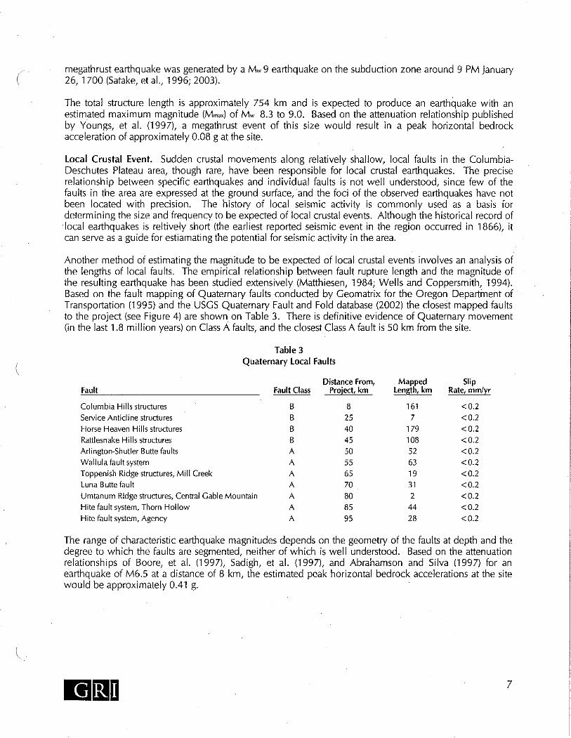
Local Crustal Event. Sudden crustal movements along relatively shallow, local faults in
the Columbia-Deschutes Plateau area, though rare, have been responsible for local crustal
earthquakes. The precise relationship between specific earthquakes and individual faults
is not well understood, since few of the faults in the area are expressed at the ground
surface, and the foci of the observed earthquakes have not been located with precision.
The history of local seismic activity is commonly used as a basis for determining the size
and frequency to be expected of local crustal events.

Columbia Ethanol Project – Exhibit H
Page H-6 9/12/2006
Table H-1. Deterministic Seismic Hazard Assessment Peak Bedrock Acceleration
Earthquake source
Attenuation relationships for target spectra
Magnitude (Mw)
Epicentral distance (miles)
Focal depth (miles)
Peak bedrock acceleration
(g)
Assumed peak bedrock
acceleration(g)
Subduction Zone
Youngs, et al., 1997
8.8 150 15 0.05 0.05
Subcrustal Youngs, et al., 1997
7 100 30 0.04 .02
Atkinson and
Boore, 1997
7 100 NA 0.007
Local Crustal Sadigh, et. al., 1997
6.5 10 NA 0.21 0.12
Boore, et al., 1997
6.5 10 NA 0.19
Abrahamson and
Silva 1997
6.5 10 NA 0.20
(iii) A description of any recorded earthquake within 50 miles of the site and of
recorded earthquakes greater than 50 miles from the site that caused ground
shaking at the site more intense than the Modified Mercalli III intensity. The
applicant shall include the date of occurrence and a description of the earthquake
that includes its magnitude and highest intensity and its epicenter location or
region of highest intensity;
Response: See Tables H-2 and H-3, below.
Table H-2. Local Earthquakes of Northern Hood River, Wasco, and Sherman Counties,
Oregon (Beaulieu, 1977)
Date
Intensity Magnitude (Richter) MR Location
November 24, 1866 IV 3.7 The Dalles
December 1866 III 3.0 The Dalles
February 29, 1892 IV 3.7 The Dalles
July 1893 II 2.3 Pleasant Ridge
December 5, 1902 II 2.3 Hood River
November 28,1920 IV 3.7 Hood River
April 12, 1976 IV-V 4.8 Maupin, Tygh Valley
Beaulieu, J.D., 1977, Geologic Hazards of Parts of Northern Hood River, Wasco, and Sherman Counties, Oregon: Oregon Department of Geology and Mineral Resources Bulletin B-91.

Columbia Ethanol Project – Exhibit H
9/12/2006 Page H-7
Table H-3. Large Earthquakes Greater than 50 Miles from the Project Site (Niewendorp
and Neuhaus, 2003)
Date Intensity Magnitude (Richter), MR Location Comments
January 26, 1700 NA 9.0 Offshore, Cascadia Subduction Zone
December 15, 1872 IV-IX 5.7 Southwest British Columbia
Intensity of I-II in Gilliam County
October 12, 1877 VII NA Troutdale-Corbett area, OR
Not felt at The Dalles
March 7, 1893 VIII 5.7 Umatilla, OR
September 14, 1921 VI 5.0 Walla Walla, WA Intensity of IV in Gilliam County
July 15, 1936 VII+ 5.8 Milton-Freewater, OR IV at The Dalles, V at Rufus
April 13, 1949 VIII 7.1 Olympia, WA V at The Dalles
January 7, 1951 V 4.3 McNary, OR Maupin, Tygh Valley
1959 VIII 6.3 Hebgen Lake, MT I - II in Gilliam County
November 5, 1962 NA 5.5 Portland, OR Vancouver, WA
1968 NA 5.1 Adel, OR
April 25, 1992 NA 7.1 Cape Mendocino, CA
March 25, 1993 NA 5.6 Scotts Mill, OR
September 20, 1993 NA 5.9 and 6.0 Klamath Falls, OR
February 28, 2001 6.8 Near Olympia, WA
NA = Not Available
Response: The probability of an earthquake of a specific magnitude occurring at a given
location is commonly expressed by its return period, i.e., the average length of time
between successive occurrences of an earthquake of that size or larger at that location.
The return period of a design earthquake can be calculated once a project design life and
some measure of the acceptable risk that the design earthquake might occur or be
exceeded are specified. These expected earthquake recurrences are expressed as a
probability of exceedance during a given time period or design life. The recently adopted
International Building Code (ICC 2003) develops a design spectrum by using two-thirds
of the Maximum Considered Earthquake (MCE) ground motion. The MCE earthquake
combines probabilistic earthquakes with a 2% probability of exceedance in 50 years
(return period of about 2,500 years) with modifications for deterministic ground motions,
where necessary (Leyendecker et al. 2000). The change to a MCE was an effort to reduce
the risk of building collapse in portions of the country where the earthquake with a 2,500-
year recurrence interval is significantly larger than the standard code recurrence interval
of 475 years.
It is important to recognize that the origin of the two-thirds reduction factor incorporated
in the IBC code is a function of the “seismic margin” identified in the 1997 National
Earthquake Hazards Reduction Program commentary. The seismic margin of 1.5 is

Columbia Ethanol Project – Exhibit H
Page H-8 9/12/2006
recognized as the inherent factor of safety in the code. In this regard, if a structure is
subjected to a ground motion of 1.5 times the design level, the structure should still have
a low likelihood of collapse.
The effect of a specific seismic event on the site is related to the type and thickness of
soil overlying the bedrock and to the type and quantity of seismic energy delivered to the
bedrock beneath the site by the earthquake. A generalized model of the subsurface profile
beneath the site was developed by GRI based on subsurface explorations in the project
area by PSI (2006, as referenced in GRI 2006), water well logs available from the
OWRD, and shear wave velocities measured for similar soil and rock conditions at other
sites. The generalized soil profile developed by GRI is summarized in Table H-4.
Table H-4. General Soil Profile
Soil type Thickness (feet) Unit Weight (pcf) Shear Wave Velocity
(feet/second)
Silt 10 100 825
Weathered basalt 20 135 to 140 825 to 2,115
Basalt undefined 160 4,000
Based on the generalized subsurface profile described above, the peak bedrock
accelerations estimated for the design events, and the strong-motion records listed in the
preceding tables, pseudoacceleration response spectra have been prepared using
PROSHAKE. The spectra were produced for a ground surface elevation corresponding to
the proposed building foundations, damped at 5% of critical damping from the larger
horizontal component of each of the strong-motion records, and scaled to match the
estimated peak horizontal bedrock accelerations of the earthquake events.
The results of the site response model indicate that for the existing site conditions, peak
horizontal ground accelerations would be generated by the local crustal model. In
addition, the response study indicates that the input of seismic energy into the bedrock
beneath the site will result in some amplification of the energy at the ground surface. To
reduce this effect, the applicant is excavating the upper 7.5 feet of loose soil and
replacing it with compacted structural fill. Based on the subsurface conditions
encountered at the site and the placement of structural fill, the site can be described as
IBC Class C, in accordance will Table 1615.1.1 of the IBC. An assessment of seismic
hazards expected to result from reasonably probable seismic events. As used in this rule
"seismic hazard" includes ground shaking, landslide, lateral spreading, liquefaction,
tsunami inundation, fault displacement, and subsidence;
Response: Based on review of local geology, there are no mapped faults on the project
site, and the risk of ground rupture due to fault displacement in the project vicinity is low.
The proposed Columbia Ethanol project is located on relatively flat terrain. In addition,
dense sand and gravel are present at shallow depths, and the groundwater table is deep.
Considering these site conditions, the potential for earthquake-induced landslides, lateral
spreading, liquefaction and settlement/subsidence at the site are low.

Columbia Ethanol Project – Exhibit H
9/12/2006 Page H-9
The project is not located near the ocean and therefore the risk of damage by tsunamis is
absent. There is limited information available about the risk of seiche on dam-impounded
rivers. The project is located approximately 30 feet above the average pool level of Lake
Umatilla, and therefore the risk of damage is considered low.
The risk of seismic hazards, such as slope instability, ground rupture, liquefaction, and
settlement or subsidence, is low. As a result, mitigation measures to address these hazards
in the siting, design, and construction of the project are not necessary.
H.8 NON-SEISMIC GEOLOGIC HAZARDS
OAR 345-021-0010(1)(h)(G) An assessment of soil-related hazards such as landslides,
flooding and erosion which could, in the absence of a seismic event, adversely affect or
be aggravated by the construction or operation of the facility;
Response: The facility, as shown on Figure 2 of Appendix H-2, has been sited on
relatively flat ground about 1,500 feet from the riverbank. In addition, the regional
groundwater table is located within the dense sand and gravel at the site. Considering
these conditions, slope instability and landslides are not geologic hazards that will impact
the ethanol project and associated infrastructure and facilities.
The project site is mantled with wind-deposited silt soil known as loess. The silt particles
are of relatively uniform size and the silt usually has sufficient cohesion, or undrained
shear strength, so that excavations made in the material can stand on near-vertical slopes.
True loess soils have never been submerged. When loaded by conventional spread
footings and subsequently saturated, the bond between the soil particles becomes
weakened and the soil structure altered, which can result in large settlements at the
ground surface.
H.9 SEISMIC HAZARD MITIGATION
OAR 345-021-0010(1)(h)(H) An explanation of how the applicant will design, engineer
and construct the facility to avoid dangers to human safety from the seismic hazards
identified in paragraph (F). The applicant shall include proposed design and engineering
features, applicable construction codes, and any monitoring for seismic hazards; and
Response: The risk of seismic hazards, such as ground rupture, liquefaction, settlement,
or subsidence, is low. As a result, mitigation measures to address these hazards in the
siting, design, and construction of the project are not necessary.
H.10 NON-SEISMIC HAZARD MITIGATION
OAR 345-021-0010(1)(h)(I) An explanation of how the applicant will design, engineer
and construct the facility to adequately avoid dangers to human safety presented by the
hazards identified in paragraph (G).

Columbia Ethanol Project – Exhibit H
Page H-10 9/12/2006
Response: With the possible exception of the presence of loess soils, the work comleted
by GRI has not identified non-seismic geologic hazards that will require special
consideration in the siting, design, and construction of the Columbia Ethanol project.
The applicant has begun site preparation, including removal of the upper 7.5 feet soil to
be replaced with compacted structural fill over the site’s entire load bearing areas.
Recompaction was accomplished in 8 inch lifts, with compaction exceeding 95%, as
specified. No other non-seismic mitigation is anticipated.
H.11 CONCLUSION
Based on the above information, the applicant has satisfied the required OAR 345-021-
0010(1)(h), and the Council may find that the standard contained in OAR 345-022-0020
is satisfied.

Columbia Ethanol Project – Exhibit H
9/12/2006 Page H-11
H.12 REFERENCES
Barr Engineering Company, 2004, Geotechnical Engineering Report, Klondike Wind Power II
Project, Wasco, Oregon: prepared for PPM Energy, Portland, Oregon.
Beaulieu, J.D., 1977, Geologic Hazards of Parts of Northern Hood River, Wasco, and Sherman
Counties, Oregon: Oregon Department of Geology and Mineral Resources Bulletin B-91.
Beeson, M.H., Tolan, T. L., and Anderson, J. L., 1989, The Columbia River Basalt Group in
western Oregon; geologic structures and other factors that controlled flow emplacement
patterns, in Reidel, S. P., and Hooper, P. R., eds., Volcanism and tectonism in the
Columbia River flood-basalt province. Geological Society of America Special Paper 239.
Bela, J.L., 1982, Geologic Compilation Map of The Dalles 1° by 2° Quadrangle, Oregon and
Washington: Oregon Department of Geology and Mineral Resources Geologic Map
Series GMS-27.
Geotechnical Resources, Inc., 2006, Geologic and Seismic Evaluation Pacific Ethanol Project,
Morrow County, Oregon.
International Code Council, 2003, International building code: Building Officials and Code
Administrators International, Inc., International Conference of Building Officials,
Southern Building Code Congress International.
Newcomb, R.C., 1966, Lithology and Eastward Extension of The Dalles Formation, Oregon and
Washington: USGS Professional Paper, 550-D, p. 59-63.
Niewendorp, C.A. and Neuhaus, M.E., 2003, Map of Selected Earthquakes for Oregon, 1841-
2002: Oregon Department of Geology and Mineral Resources Open-File Report OFR-03-
02.
Youngs, R.R., Chiou, S.J., Silva, W.J. and Humphrey, J.R., 1997, Strong ground motion
attenuation relationships for subduction zone earthquakes: Seismological Research
Letters, vol 68, no 1.


Columbia Ethanol Project – Exhibit H
9/12/2006 Page H-13
APPENDIX H-1
Recorded Earthquakes within 50 miles


Columbia Ethanol Project – Exhibit H
9/12/2006 Page H-15
APPENDIX H-2
Preliminary Geotechnical Site Report


Columbia Ethanol Project – Exhibit I
9/12/2006 Page I-i
EXHIBIT I
SOILS
OAR 345-021-0010(1)(i)
TABLE OF CONTENTS
Page
I.1 INTRODUCTION...................................................................................................1
I.2 IDENTIFICATION AND DESCRIPTION OF SOIL TYPES ...............................1
I.3 IDENTIFICATION AND DESCRIPTION OF LAND USES ...............................1
I.4 IDENTIFICATION AND ASSESSMENT OF IMPACTS TO SOILS ..................1
I.5 DESCRIPTION OF PROPOSED MITIGATION MEASURES ............................2
I.6 MONITORING PROGRAM...................................................................................2
I.7 CONCLUSION .......................................................................................................3
REFERENCES....................................................................................................................3
APPENDICES
I-1 SOIL MAP
I-2 1200-C PERMIT AND SUPPORTING APPLICATION MATERIALS
I-3 1200-C PERMIT APPLICATION FOR ETHANOL PIPELINE
CEPAPPDoc1

Columbia Ethanol Project – Exhibit I
9/12/2006 Page I-1
I.1 INTRODUCTION
OAR 345-021-0010(1)(i) Information from reasonably available sources regarding soil
conditions and uses of the site and vicinity, providing evidence to support findings by the
Council as required by OAR 345-022-0022, including:
Response: The evidence below demonstrates that facility construction and operation will
not result in significant adverse impacts to soils. The potential for erosion during facility
construction will be minimized by adhering to an erosion control plan and NPDES 1200-
C construction permit. Further, all areas of temporary soil disturbance and vegetation
removal will be reclaimed through reseeding of native vegetation or crops to protect
against loss of soil to erosion.
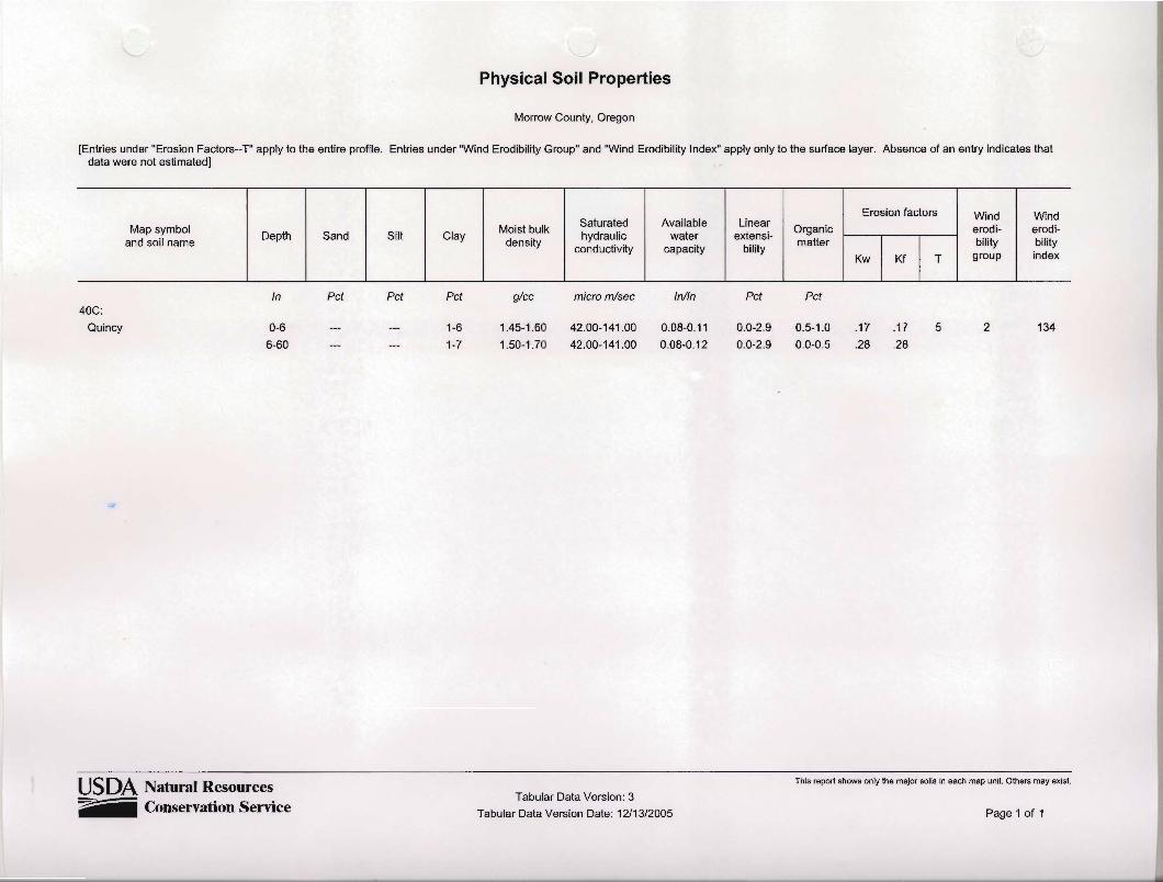
I.2 IDENTIFICATION AND DESCRIPTION OF SOIL TYPES
OAR-345-021-0010(1)(i)(A) Identification and description of the major soil types at the
site and its vicinity;
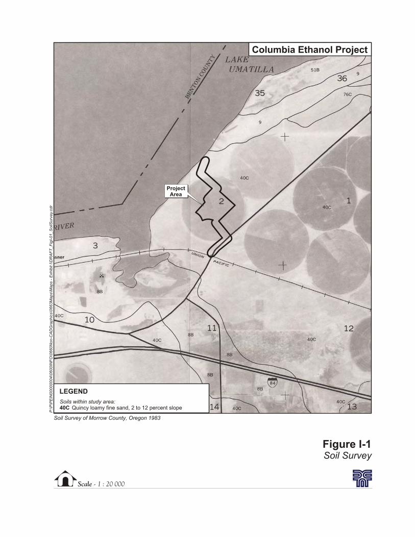
Response: The near surface soils at the project site were identified using the U.S.
Department of Agriculture (USDA), Soil Survey of Morrow County, Oregon (USDA
1983). Figure I-1 shows the soil series map with project foot print. The entire project site
is located in areas mapped as Quincy loamy fine sand, 2 to 12 percent slope (mapping
unit 40C).
I.3 IDENTIFICATION AND DESCRIPTION OF LAND USES
OAR-345-021-0010(1)(i)(B) Identification and description of any land uses on the
proposed site and its vicinity, such as growing crops, that require or depend on
productive soils;
Response: The project site is zoned as Port Industrial Land and is currently experiencing
construction activities associated with the Pacific Ethanol Plant. No crop growing or
other land uses dependent on productive soils occurs at the site.
I.4 IDENTIFICATION AND ASSESSMENT OF IMPACTS TO SOILS
OAR 345-021-0010(1)(i)(C) Identification and assessment of significant potential
adverse impact to soils from construction, operation, and retirement of the facility,
including, but not limited to, erosion and chemical factors such as salt deposition from
cooling towers, land application of liquid effluent, and chemical spills;
Response: Unavoidable impacts to soils will result from placement of permanent project
facilities on approximately 9.5 acres of soil. Additionally, facility construction will
temporarily disturb 10.7 acres (i.e. staging areas, excavation for underground utilities,
etc.). An Erosion and Sediment Control Plan has been prepared for the project and
approved by Oregon Department of Environmental Quality via issuance of a 1200-C
permit (Appendix I-2). The plan provides measures for minimizing impacts to soil

Columbia Ethanol Project – Exhibit I
Page I-2 9/12/2006
resources as a result of project construction. Similar measures would be utilized upon
project decommissioning. Temporarily disturbed areas would be revegetated to limit soil
exposure to wind and water erosion.
An application for an amendment of the existing 1200-C permit to construct the ethanol
pipeline is included as Appendix I-3. Impacts to soils from cooling towers are anticipated
to be negligible (see Exhibit Z for additional detail). Land application of liquid effluent is
proposed under the existing Port of Morrow WPCF permit. Potential impacts to soils via
chemical spills will be minimized by compliance with federal and state rules and
regulations for transport, storage, and use of such materials. A Hazardous Waste
Emergency Response/Contigency Plan for the project will be developed to aid with
management of chemical supplies and outline procedures for spill containment and
cleanup should one occur (See Exhibits G and Z for further detail).
I.5 DESCRIPTION OF PROPOSED MITIGATION MEASURES
OAR 345-021-0010(1)(i)(D) A description of any measures the applicant proposes to
avoid or mitigate adverse impact to soils; and
Response: Due to the facility footprint, direct permanent impacts to soil will be
unavoidable. Construction of all features of the project will be in compliance with an
erosion control plan and NPDES 1200-C construction permit (See Exhibit I-2) that
requires Best Management Practices (BMPs) to minimize possible impacts from erosion.
Sediment and erosion control measures to be installed during construction include:
construction of a bioswale system, sediment barrier fence, ditch checks, catch basin inlet
protection, and construction site entrance/exit treatments.
All areas disturbed that are not permanently paved or covered by new building
construction will be planted with turf or native land cover.
I.6 MONITORING PROGRAM
OAR 345-021-0010(1)(i)(E) The applicant’s proposed monitoring program, if any, for
impact to soils.
Response: All erosion and sediment control measures will be inspected and maintained
regularly as detailed in the Erosion and Sediment Control Plan (Appendix I-2). The
inspections will verify that the structural BMPs described in the plan are in good
condition and are minimizing erosion. The inspections will also verify that the procedures
used to prevent storm water contamination from construction materials and petroleum
products are effective.
As outlined in the Erosion and Sediment Control Plan, the following inspection and
maintenance practices will be used to maintain erosion and sediment controls:
• The stabilized construction entrance will be inspected for sediment tracked on the
road and to determine that all traffic uses the stabilized entrance when leaving the
site.

Columbia Ethanol Project – Exhibit I
9/12/2006 Page I-3
• Sediment barrier fence will be inspected, and accumulated sediments will be
removed when they reach one-third the height of the sediment barrier fence.
• A maintenance inspection report will be made after each inspection that details
corrective actions needed.
• An employee training program will be developed and implemented to educate
employees about the requirements of the Erosion and Sediment Control Plan.
I.7 CONCLUSION
The information provided in this exhibit describes soils on the site and potential impacts
in detail. The applicant will minimize impacts to soil by using sediment and erosion
control Best Management Practices as described in the Erosion and Sediment Control
Plan, which is part of the 1200-C permit. Temporarily disturbed areas will be revegetated
to protect soils from long term erosion potential. These measures will ensure the impacts
on soils are insignificant. Therefore, the applicant has met this standard, and the Council
may find that the standard contained in OAR 345-022-0022 is satisfied.
REFERENCES
U.S. Department of Agriculture (USDA). 1983. Soil Survey of Morrow County, Oregon.
Soil Conservation Service.


Columbia Ethanol Project – Exhibit I
9/12/2006 Page I-5
Appendix I-1
Soil Map


Columbia Ethanol Project – Exhibit I
9/12/2006 Page I-7
Appendix I-2
1200-C Permit and Supporting Application Materials


Columbia Ethanol Project – Exhibit I
9/12/2006 Page I-9
Appendix I-3
1200-C Permit Application for Ethanol Pipeline

COLUMBIA RIVER
ExistingBarge Load Out
ExistingLoop Track
Columbia Lane
0 600 1,200300
Feet
P:\P\
PEIN
0000
0004
\0600
INFO
\GS\
arcma
p\Draf
t_Fig_
I-00_
Perm
itArea
_091
606.m
xd
Columbia Ethanol Project
Existing FeaturesPaved RoadRailroadMajor ContourMinor Contour
1200-C Permit Applicationfor Ethanol Pipeline
Ethanol Plant Footprint
Lease BoundaryProposed Features
Power (Umatilla Electric Coop)Gas (Cascade Natural Gas)Barge LoadoutStaging Area
Site Boundary
Permit Area for Ethanol Pipeline
Scale - 1 : 20 000
Figure I-1Soil Survey
Soil Survey of Morrow County, Oregon 1983
ProjectArea
Soils within study area:40C Quincy loamy fine sand, 2 to 12 percent slope
LEGEND
P:\P
\PE
IN00000004\0
600IN
FO
\0660N
on-C
AD
Gra
phic
s\0
663M
aps\M
aps
-E
xhib
itI\D
RA
FT
_F
igI-
01_S
oilS
urv
ey.
cdr
Columbia Ethanol Project


APPENDIX A

[Print] [Close]

Follow these steps for clkk map to: f Identify ~nteresa improved data : '
e place @ Zoom In C Zoom Out C Re
, ~. Locate Place : . - r ld Type in mress, or Type in Iatitude/lonaitude, or Zoom and Locate with Map.
Save Location:
Find45.8561 Create 1 New Location:
[re-tented 45"51'22 -119O39'18 45.8561 -1 19.6551 County: MORROW Zip: 97844 HUC Code: 170701 01
Oregon L,, Location Fin&. . . J


Columbia Ethanol Project – Exhibit J
9/12/2006 Page J-i
EXHIBIT J
WETLANDS
OAR 345-021-0010(1)(j)
TABLE OF CONTENTS
Page
J.1 INTRODUCTION ...................................................................................................1
J.2 EFFECT ON WATERS OF THE STATE AND WETLANDS DELINEATION
REPORT ..................................................................................................................1
J.3 MAP OF WETLANDS UNDER STATE JURISDICTION ...................................1
J.4 DESCRIPTION OF EACH WETLAND IDENTIFIED..........................................1
J.5 SIGNIFICANT POTENTIAL IMPACTS TO WETLANDS..................................2
J.6 EVIDENCE THAT FILL AND REMOVAL PERMITS CAN BE ISSUED..........2
J.7 MONITORING PROGRAM, IF ANY, FOR IMPACTS TO WETLANDS ..........2
APPENDIX
J-1 WETLAND DETERMINATION
CEPAPPDoc1


Columbia Ethanol Project – Exhibit J
9/12/2006 Page J-1
J.1 INTRODUCTION
OAR 345-021-0010(1)(j) Information based on literature and field study, as appropriate,
about significant potential impacts of the proposed facility on wetlands that are within
state jurisdiction under ORS Chapter 196, including:
Response: A wetland determination, which included a review of background resources as
well as an on-site investigation, was conducted on an area that included the project site as
well as a 50-foot buffer around the project site boundary. This area constitutes the
wetland analysis area. Wetlands and other waters of the state identified within the
wetland analysis area were overlain with proposed project features to determine the
potential for project impacts. The results of the wetland determination are provided in the
following sections and in Appendix J-1.
J.2 EFFECT ON WATERS OF THE STATE AND WETLANDS DELINEATION
REPORT
OAR-345-021-0010(1)(j)(A) A determination, as defined in OAR 141-090-0020, of
whether construction or operation of the proposed facility would affect any waters of the
state, including wetlands, and, if so, a wetland delineation report, as defined in OAR 141-
090-0020, describing how those waters would be affected;
Response: A wetland determination was conducted for the proposed project and is
provided in Appendix J-1. Based on the wetland determination results, no impacts to
wetlands and other waters of the state are anticipated as a result of the proposed project.
No wetlands were identified within the wetland analysis area. One water of the state, the
Columbia River, is located within the project area. The proposed project will utilize
existing barge tie up facilities within the Columbia and will not require removal or
placement of fill below the ordinary high water mark of the river.
J.3 MAP OF WETLANDS UNDER STATE JURISDICTION
OAR-345-021-0010 (1)(j)(B) A wetland map, as defined in OAR 141-090-0020, showing
the location of any wetlands under state jurisdiction on or near the site and the source of
the water for the wetlands, including any wetlands identified in the Statewide Wetland
Inventory of the Division of State Lands;
Response: A wetland determination was conducted for the proposed project and is
provided in Appendix J-1. The report includes a map of the wetland determination
findings for the wetland analysis area.
J.4 DESCRIPTION OF EACH WETLAND IDENTIFIED
OAR 345-021-0010(1)(j)(C) A description of each wetland identified in (A);
Response: No wetlands were identified within the wetland analysis area. One water of the
state, the Columbia River, was identified within the wetland analysis area. The project
Columbia Ethanol Project – Exhibit J
Page J-2 9/12/2006
reach of the Columbia River is regulated by the John Day Dam, which has a full pool
elevation of 268.0 feet above mean sea level. This elevation represents the ordinary high
water line (i.e. jurisdictional limit) of the Columbia River at the project area.
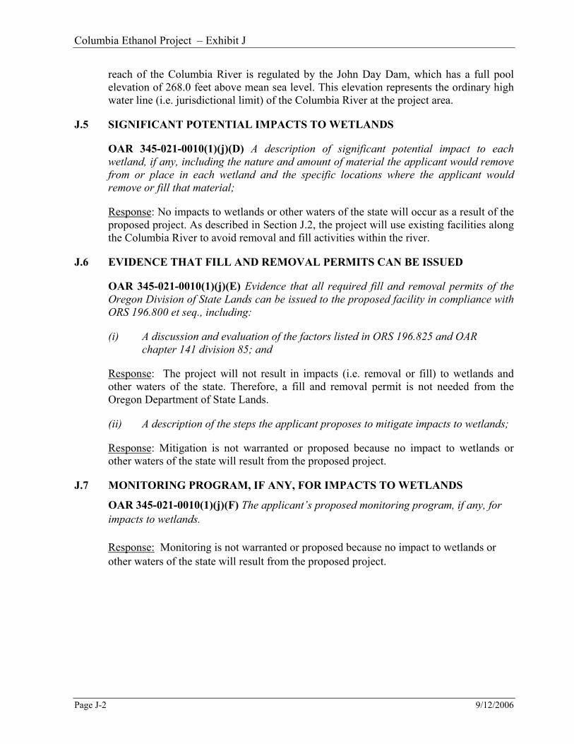
J.5 SIGNIFICANT POTENTIAL IMPACTS TO WETLANDS
OAR 345-021-0010(1)(j)(D) A description of significant potential impact to each
wetland, if any, including the nature and amount of material the applicant would remove
from or place in each wetland and the specific locations where the applicant would
remove or fill that material;
Response: No impacts to wetlands or other waters of the state will occur as a result of the
proposed project. As described in Section J.2, the project will use existing facilities along
the Columbia River to avoid removal and fill activities within the river.
J.6 EVIDENCE THAT FILL AND REMOVAL PERMITS CAN BE ISSUED
OAR 345-021-0010(1)(j)(E) Evidence that all required fill and removal permits of the
Oregon Division of State Lands can be issued to the proposed facility in compliance with
ORS 196.800 et seq., including:
(i) A discussion and evaluation of the factors listed in ORS 196.825 and OAR
chapter 141 division 85; and
Response: The project will not result in impacts (i.e. removal or fill) to wetlands and
other waters of the state. Therefore, a fill and removal permit is not needed from the
Oregon Department of State Lands.
(ii) A description of the steps the applicant proposes to mitigate impacts to wetlands;
Response: Mitigation is not warranted or proposed because no impact to wetlands or
other waters of the state will result from the proposed project.
J.7 MONITORING PROGRAM, IF ANY, FOR IMPACTS TO WETLANDS
OAR 345-021-0010(1)(j)(F) The applicant’s proposed monitoring program, if any, for
impacts to wetlands.
Response: Monitoring is not warranted or proposed because no impact to wetlands or
other waters of the state will result from the proposed project.

Columbia Ethanol Project – Exhibit J
9/12/2006 Page J-3
APPENDIX J-1 Figures J-1 through J-3
Wetland Determination


Scale - 1 : 24 000
Port of MorrowPort of Morrow
Figure J-1Vicinity
O R E G O N
EnlargedArea
ProjectArea
USGS 7.5 Minute Quadrangle: Boardman, Oregon-Washington 1993
P:\P
\PE
IN00000004\0
600IN
FO
\0660N
on-C
AD
Gra
phic
s\0
663M
aps\M
aps
-E
xhib
itJ\D
RA
FT
_F
igJ-0
1th
ruJ-0
3_W
tldD
elin
Fig
s.c
dr
Columbia Ethanol Project

Scale - 1 : 24 000
Figure J-2National Wetlands Inventory
ProjectArea
Wetlands within study area:L1OWHH Lacustrine, limnetic, open water, permanently
flooded, diked/Impounded
LEGEND
National Wetlands Inventory: Boardman, Oregon-Washington 1998
P:\P
\PE
IN00000004\0
600IN
FO
\0660N
on-C
AD
Gra
phic
s\0
663M
aps\M
aps
-E
xhib
itJ\D
RA
FT
_F
igJ-0
1th
ruJ-0
3_W
tldD
elin
Fig
s.c
dr
Columbia Ethanol Project

Scale - 1 : 20 000
Figure J-3Soil Survey
ProjectArea
Soils within study area:40C Quincy loamy fine sand, 2 to 12 percent slope
LEGEND
Soil Survey of Morrow County, Oregon 1983
P:\P
\PE
IN00000004\0
600IN
FO
\0660N
on-C
AD
Gra
phic
s\0
663M
aps\M
aps
-E
xhib
itJ\D
RA
FT
_F
igJ-0
1th
ruJ-0
3_W
tldD
elin
Fig
s.c
dr
Columbia Ethanol Project

Columbia Ethanol Project – Exhibit K
9/12/2006 Page K-i
EXHIBIT K
LAND USE
OAR 345-021-0010(1)(k)
TABLE OF CONTENTS
Page
K.1 INTRODUCTION AND LAND USE REVIEW PATH.........................................1
K.2 LAND USE ANALYSIS AREA AND MAP .........................................................2
K.3 ENERGY FACILITY AND RELATED OR SUPPORTING FACILITIES ..........2
K.4 COUNCIL DETERMINATION ON LAND USE..................................................2
K.5 ZONING ORDINANCE CRITERIA......................................................................2
K.6 COMPLIANCE WITH APPLICABLE COMPREHENSIVE PLAN
PROVISIONS..........................................................................................................2
K.7 COMPLIANCE WITH ADDITIONAL ZONING ORDINANCE PROVISIONS 3
K.8 DIRECTLY APPLICABLE STATUTES, GOALS AND LCDC RULES.............3
K.9 FEDERAL LAND MANAGEMENT PLANS .......................................................3
K.10 REFERENCES........................................................................................................3
APPENDICES
K-1 LETTER FROM MORROW COUNTY
K-2 LAND USE ANALYSIS AREA - MAP
CEPAPPDoc1


Columbia Ethanol Project – Exhibit K
9/12/2006 Page K-1
K.1 INTRODUCTION AND LAND USE REVIEW PATH
OAR 345-021-0010(1)(k) Information about the proposed facility’s compliance with the
statewide planning goals adopted by the Land Conservation and Development
Commission, providing evidence to support a finding by the Council as required by OAR
345-022-0030. The applicant shall state whether the applicant elects to address the
Council’s land use standard by obtaining local land use approvals under ORS
469.504(1)(a) or by obtaining a Council determination under ORS 469.504(1)(b). An
applicant may elect different processes for an energy facility and a related or supporting
facility but may not otherwise combine the two processes. Notwithstanding OAR 345-
021-0090(2), once the applicant has made an election, the applicant may not amend the
application to make a different election. In this subsection,“affected (sic) local
government” means a local government that has land use jurisdiction over any part of
the proposed site of the facility.
Response: The applicant elects to address the council’s land use standard by obtaining
local land use approvals under ORS 469.504(1)(a).
1. The proposed facility complies with applicable substantive criteria from the affected
local government’s acknowledged comprehensive plan and land use regulations that
are required by the statewide planning goals and in effect on the date the application
is submitted, and with any Land Conservation and Development Commission
administrative rules and goals and any land use statutes directly applicable to the
facility under ORS 197.646(3);
2. For an energy facility or a related or supporting facility that must be evaluated
against the applicable substantive criteria pursuant to subsection (5) of this section,
that the proposed facility does not comply with one or more of the applicable
substantive criteria but does otherwise comply with the applicable statewide planning
goals, or that an exception to any applicable statewide planning goal is justified
under subsection (2) of this section; or
3. For a facility that the council elects to evaluate against the statewide planning goals
pursuant to subsection (5) of this section, that the proposed facility complies with the
applicable statewide planning goals or that an exception to any applicable statewide
planning goal is justified under subsection (2) of this section.
Response: The facility will be located within the Port Industrial (PI) Zoning District, as
identified in the Morrow County Comprehensive Plan (1986) and Morrow County
Zoning and Subdivision Code (2001). Both the Comprehensive Plan, and Zoning and
Subdivision Code identify the project site as PI. The PI District (Development Code
Section 3.073) lists specific uses that are permitted outright. Such uses include: chemical
and primary metal industrial uses, which are port-related (3.073(A)(3)), and
manufacturing, refining, processing, or assembling of any agricultural, mining, or
industrial products (3.073(A)(7)). A letter from Morrow County is attached as Appendix
K-1, which states that the facility will be considered a use permitted outright and will not
require land use approval from the county.

Columbia Ethanol Project – Exhibit K
Page K-2 9/12/2006
As stated, the facility complies with the Morrow County Comprehensive Plan, and
Zoning and Subdivision Code, which have been acknowledged by the Land Conservation
and Development Commission (LCDC) and is consistent with statewide planning goals.
No exception to statewide planning goals is required to construct or operate the facility at
the proposed site.
K.2 LAND USE ANALYSIS AREA AND MAP
OAR 345-021-0010(1)(k)(A) Include a map showing the comprehensive plan
designations and land use zones of the facility site, all areas that may be temporarily
disturbed by any activity related to the design, construction and operation of the
proposed facility and property adjacent to the site.
Response: A map of the land use analysis area is attached as Appendix K-2. The
Comprehensive Plan and zoning designations are the same for the project area. Both
documents identify the project site and surrounding area as Port Industrial (PI).
K.3 ENERGY FACILITY AND RELATED OR SUPPORTING FACILITIES
Response: Three related and supporting facilities are proposed as part of the facility, as
described in Exhibit B. Morrow County did not consider related or supporting facilities as
separate projects requiring land use approval. Rather, Morrow County considered the
natural gas line, electric supply line, and ethanol pipeline as part of the overall project
when identifying the facility as a use permitted outright.
K.4 COUNCIL DETERMINATION ON LAND USE
OAR 345-021-0010(1)(k)(C)(a-e) the applicant elects to obtain a Council determination
on land use:
Response: Not Applicable.
K.5 ZONING ORDINANCE CRITERIA
Response: As stated in Section K.1, the facility is considered a use permitted outright
and will not require local land use approval other than ensuring new structures meet
setback standards. See the letter attached as Appendix K-1, which states that no land use
approvals will be required for construction of the facility.
K.6 COMPLIANCE WITH APPLICABLE COMPREHENSIVE PLAN PROVISIONS
Response: The facility complies with the Morrow County Comprehensive Plan. The
facility is a permitted use within the PI District as identified in the Comprehensive Plan,
and Zoning and Subdivision Code, and will be consistent with the surrounding
development pattern that is dominated by similar heavy industrial development. In
addition, the facility supports several of the Comprehensive Plan’s goals and objectives
identified in the Economic Element of the Comprehensive Plan, particularly Goals 2, 5,
and 6, which identify the need to improve and diversify the Morrow County economy

Columbia Ethanol Project – Exhibit K
9/12/2006 Page K-3
and increase the income level of local residents by hiring and training area residents for
new jobs that the facility will generate.
K.7 COMPLIANCE WITH ADDITIONAL ZONING ORDINANCE PROVISIONS
Response: Setbacks will apply to the facility as identified in Section 3.073(D) of the
Zoning and Subdivision Code and the letter from the Morrow County Planning
Department, attached as Appendix K-1. The facility is sited near a public right-of-way
(Columbia Lane) and is required to have a 90-foot setback from that road. Rear and side
yard setbacks of 10 feet also apply. The facility will meet all of these requirements.
K.8 DIRECTLY APPLICABLE STATUTES, GOALS AND LCDC RULES
Response: The Morrow County Comprehensive Plan and Zoning and Subdivision
Ordinance have been acknowledged by the LCDC and are consistent with statewide land
use goals and policies. The facility is consistent with these plans because it is allowed
outright within the PI Zoning District, as identified in the Morrow County
Comprehensive Plan, and Zoning and Subdivision Code. The facility, therefore, complies
with statewide land use goals and policies. No other criteria are required to be met.
K.9 FEDERAL LAND MANAGEMENT PLANS
OAR 345-021-0010(1)(k)(D) If the proposed facility will be located on federal land:
1. Identify the applicable land management plan adopted by the federal agency with
jurisdiction over the federal land;
2. Explain any differences between state or local land use requirements and federal land
management requirements;
3. Describe how the proposed facility complies with the applicable federal land
management plan;
4. Describe any federal land use approvals required for the proposed facility and the status
of application for each required federal land use approval;
5. Provide an estimate of time for issuance of federal land use approvals; and
6. If federal law or the land management plan conflicts with any applicable state or local
land use requirements, explain the differences in the conflicting requirements, state
whether the applicant requests Council waiver of the land use standard described under
paragraph (B) or (C) of this subsection and explain the basis for the waiver.
Response: The facility will not be located on federal land; it will be located on land
leased from the Port of Morrow, which manages the land for industrial use.
K.10 REFERENCES
Morrow County Comprehensive Plan. 1986.
Morrow County Zoning and Subdivision Ordinance. 2001.


Columbia Ethanol Project – Exhibit K
9/12/2006 Page K-5
Appendix K-1
Letter from Morrow County


Columbia Ethanol Project – Exhibit K
9/12/2006 Page K-7
Appendix K-2
Land Use Analysis Area – Map


COLUMBIA RIVER
ExistingBarge Load Out
ExistingLoop Track
Columbia Lane
0 600 1,200300
Feet
P:\P\
PEIN
0000
0004
\0600
INFO
\GS\
arcma
p\Draf
t_Fig_
K-02
_Zon
ing.m
xd
Existing FeaturesPaved RoadRailroadMajor ContourMinor Contour
FIGURE K-2Land Use Analysis Area
Columbia Ethanol Project
Note: The Comprehensive Plan and zoningdesignations are the same for the project area.
Ethanol Plant Footprint
Lease BoundaryProposed Features
Power (Umatilla Electric Coop)Gas (Cascade Natural Gas)Barge LoadoutStaging Area
Site Boundary
PI - Port IndustrialMG - General Industrial
Zoning Designations
Columbia Ethanol Project – Exhibit L
9/12/2006 Page L-i
EXHIBIT L
IMPACTS ON PROTECTED AREAS
OAR 345-021-0010(1)(L)
TABLE OF CONTENTS
Page
L.1 INTRODUCTION...................................................................................................1
L.2 MAP OF PROPOSED FACILITY IN RELATION TO PROTECTED AREAS...1
L.3 POTENTIAL IMPACTS.........................................................................................1
L.4 CONCLUSION .......................................................................................................4
REFERENCES....................................................................................................................5
Telephone Contacts/Personal Interviews ................................................................5
Website/Document References ...............................................................................5
TABLES
Table L- 1. Protected Areas Within Analysis Area and Their Approximate Minimum
Distance from the Proposed Facility ................................................................2
APPENDICES
L-1 PROTECTED AREAS - MAP
CEPAPPDoc1


Columbia Ethanol Project – Exhibit L
9/12/2006 Page L-1
L.1 INTRODUCTION
Exhibit L addresses impacts the proposed facility would have on Protected Areas in the
analysis area. The exhibit responds to the requirements of OAR 345-021-0010(1)(L), as
follows:
OAR 345-021-0010(1)(L) Information about the proposed facility’s impact on Protected
Areas, providing evidence to support a finding by the Council as required by OAR 345-
022-0040, including:
Response: OAR 345-022-0040 requires that the application for site certificate for the
proposed energy facility address impacts to Protected Areas as defined in OAR 345-022-
0040(l)(a)(p). Except under special circumstances defined in OAR 345-022-0040(2), the
Council will not issue a site certificate for a proposed facility located in a Protected Area.
For facilities located outside these areas, the Council “must find that, taking into account
mitigation, the design, construction, and operation of the facility are not likely to result in
significant adverse impact [to Protected Areas]”.
This Exhibit is organized in accordance with the application requirements contained in
OAR 345-021-0010(1)(L) and provides evidence to support a finding by the Council as
required by OAR 345-022-0040.
L.2 MAP OF PROPOSED FACILITY IN RELATION TO PROTECTED AREAS
OAR 345-021-0010(1)(L)(A) A map showing the location of the proposed facility in
relation to the Protected Areas listed in OAR 345-022-0040 located within the analysis
area:
Response: The analysis area for impacts on Protected Areas includes the area within the
site boundary and extends 20 miles beyond the site boundary. Figure L-1 (in Appendix L-
1) illustrates the analysis area and 11 identified Protected Areas within the analysis area.
Table L-1 lists these Protected Areas and their approximate minimum distance from the
proposed facility.
The proposed facility is not located within any of the Protected Areas as defined by OAR
345-022-0040.
L.3 POTENTIAL IMPACTS
OAR 345-021-0010(1)(L)(B) A description of significant potential impacts of the
proposed facility, if any, on the Protected Areas including, but not limited to, potential
impacts such as:
Response: Through an evaluation of potential impacts, it has been determined that the
design, construction, and operation of the facility are not likely to result in significant
adverse impact to Protected Areas. The evaluation is described below.
Columbia Ethanol Project – Exhibit L
Page L-2 9/12/2006
Table L- 1. Protected Areas Within Analysis Area and Their Approximate
Minimum Distance from the Proposed Facility
Protected Area Direction and Distance from Columbia Ethanol site (miles)
Umatilla National Wildlife Refuge N, 4.6
Irrigon Hatchery NE, 7.6
Umatilla Hatchery NE, 7.4
Crow Butte State Park (WA) NW, 9.1
Hermiston Agricultural Research and Extension Center E, 17.53
National Historic Oregon Trail ACEC SE, 19.4
Horn Butte ACEC W, 17.3
Coyote Springs Wildlife Area SE, 1.3
Irrigon Wildlife Area NE, 13.7
Power City Wildlife Area E, 17.7
Willow Creek Wildlife Area W, 14.8
(i) Noise resulting from facility construction or operation;
Response: As detailed in Exhibit X, projected noise levels resulting from facility
construction and operation would be minimal. The nearest sensitive noise
receptor, a residential property located approximately 0.9 miles from the proposed
facility, would not be affected by the proposed facility. Coyote Springs Wildlife
Area (WA) is the closest Protected Area to the proposed facility at 1.3 miles. It
follows that the remaining Protected Areas would not be affected by noise
resulting from facility construction or operation.
(ii) Increased traffic resulting from facility construction or operation;
Response: A detailed description of traffic resulting from facility construction and
operation is included in Exhibit U.
The assumed route of construction-related traffic is to take I-84 to exit 165, east
of Boardman, onto Laurel Lane. Trucks would travel a short distance north to the
Laurel Lane/Columbia Boulevard intersection where trucks would travel east on
Columbia Boulevard to the project site. Workers traveling from Washington
would take I-82 south across the Columbia River bridge at Umatilla and then
travel west on I-84 to exit 165. Construction-related traffic would then travel east
on Columbia Boulevard, located north of I-84 to the project site. Columbia Lane
is two-lane paved facility.
No adverse impacts are anticipated to the local transportation system. All of the
corn that would be processed at the proposed facility would be delivered by rail
via 110-car unit trains. It is possible that if a local supplier were found, that a
portion of the corn could be supplied locally and delivered to the facility in trucks,
although, by far, the majority of corn would not be shipped via truck.

Columbia Ethanol Project – Exhibit L
9/12/2006 Page L-3
Umatilla National Wildlife Refuge (NWR) and Coyote Springs WA are the only
Protected Areas in relative proximity that would potentially be impacted by
increased traffic. Access to Umatilla NWR is actually very limited in the project
vicinity; primary access to the refuge is via Patterson Ferry Road from Highway
730. Demand on Coyote Springs WA is assumed to be light given the small size
and limited development of the parking area located at that facility. Roads within
the project area are lightly traveled and would be able to accommodate the
increased traffic, even in a worst case scenario where all materials would
transported via truck, as opposed to rail and barge, as currently planned.
Increased traffic is expected to be limited and will not adversely affect Protected
Areas.
(iii) Water use during facility construction or operation;
Response: As stated in Exhibit O, no significant impact to resources is expected
as a result of water use during facility construction or operation.
The facility will purchase water from the Port of Morrow, which supplies users in
the Boardman Industrial Park with water for industrial use. The water is obtained
from a horizontal Ranney well collection system adjacent to and under the
Columbia River. No new water right will be needed. It is not anticipated that the
Ranney well collection system would impact the McCormack Unit of the
Umatilla NWR, because the water needed for facility operation would be drawn
from the Columbia River and the shallow marsh habitat at the McCormack Unit is
driven primarily by groundwater, not river levels (Allen 2006).
Water use during facility construction or operation would not adversely affect
Protected Areas in the analysis area.
(iv) Wastewater disposal resulting from facility construction or operation;
Response: As stated in Exhibit V, wastewater will be generated during
construction from washdown of equipment during earthwork and construction
phases. Concrete trucks could also be cleaned after concrete loads have been
emptied. Washdown will be up to the contractor and will likely occur at a
contractor owned batch plant. Portable toilets will be provided for on-site sewage
handling during construction and will be pumped and cleaned regularly by the
construction contractor. No other wastewater will be generated during
construction.
Industrial wastewater, generated during operations, will be treated at the Port of
Morrow industrial wastewater treatment facility. Wastewater from the toilets and
sinks will be treated at the Boardman wastewater treatment plant, located in
Boardman.
Based on the above, wastewater resulting from facility construction or operation
will not affect Protected Areas in the analysis area.

Columbia Ethanol Project – Exhibit L
Page L-4 9/12/2006
(v) Visual impacts of facility structures, including cooling tower or other plumes,
if any; and
Response: Analysis described in Exhibit R was used to determine whether the
proposed facility would be visible from the identified Protected Areas. The
proposed facility would not be visible from Crow Butte State Park, Hermiston
Agricultural Research and Extension Center, Oregon Trail ACEC, Willow Creek
WA, and Power City WA.
The proposed facility structures (i.e., cooling tower and distilling towers) would
not be visible from the Irrigon Hatchery, Umatilla Hatchery, or the Irrigon WA. It
is possible that portions of any plume may be visible under ideal atmospheric
conditions from these Protected Areas; however, it is also possible that vegetation
would screen the plume from view.
The proposed facility, including any plume, will be visible from the Umatilla
NWR and Coyote Springs WA. The proposed facility, including any plume, may
be visible from the Horn Butte ACEC, but at a distance of approximately 20
miles.
As determined through a review of applicable management plans and interviews
with agency staff, none of the Protected Areas from which the proposed facility
may be visible are managed for visual quality or are considered outstanding or
remarkable scenic or aesthetic resources (Allen, Brian 2006, Allen, Steve 2006,
Linehan 2006, USDI 1986). As stated in Exhibit R, the proposed facility would be
compatible with any scenic or visual goals, objectives, or policies identified in
applicable federal and local management plans. Consequently, the proposed
facility would not result in adverse visual impacts to Protected Areas in the
analysis area.
(vi) Visual impacts from air emissions resulting from facility construction or
operation, including, but not limited to, impacts on Class 1 visual resources
as described in OAR 340-204-0050;
Response: Air emissions from the facility have been permitted by DEQ, and are
not expected to have adverse visual impacts on the Protected Areas.
Dust may be generated during construction and will be controlled through the
construction period by watering. Any potential impacts are anticipated to be
temporary and negligible
There are no Class 1 Visual Resources in the analysis area.
L.4 CONCLUSION
The proposed project complies with all applicable regulatory guidelines concerning
Protected Areas as previously discussed in OAR 345-021-0010(l)(L)(A) and (B). The
design, construction, and operation of the proposed facility are not likely to result in

Columbia Ethanol Project – Exhibit L
9/12/2006 Page L-5
significant adverse impact to Protected Areas, and the Council may find that the standard
in OAR 345-022-0040 is satisfied.
REFERENCES
Telephone Contacts/Personal Interviews
Allen, Brian. Operational Manager. Umatilla National Wildlife Refuge. Telephone
conversation with Sean Sullivan. June 24, 2006.
Allen, Steve. Fish and Wildlife Manager III. Oregon Department of Fish and Wildlife.
Telephone conversation with Sean Sullivan. June 30, 2006.
Linehan, Dave. Project Leader. Mid-Columbia River National Wildlife Refuge Complex.
U.S. Fish and Wildlife Service. Telephone conversation with Sean Sullivan. June
22, 2006.
Website/Document References
USDI Bureau of Land Management. Two Rivers Resource Management Plan Record of
Decision. June 1986.


Columbia Ethanol Project – Exhibit L
9/12/2006 Page L-7
APPENDIX L-1
Figure L-1: Protected Areas – Map