Embed Size (px)
Citation preview

Eidgenössisches Departement für Umwelt, Verkehr, Energie und Kommunikation UVEK
Bundesamt für Umwelt BAFU
UNECE workshop on transboundary flood risk managementGeneva, 22-23 April 2009 Roberto Loat
EXCIMAP
Flood mapping in Europe
EXCIMAP
2UNECE workshop on transboundary flood risk managemen tRoberto Loat, Federal Office for the Environment FOEN
Contents
• Background: natural hazards
• EXCIMAP: Flood mapping in Europe
• Good practices: examples of hazard / risk maps
• Conclusions
3UNECE workshop on transboundary flood risk managemen tRoberto Loat, Federal Office for the Environment FOEN
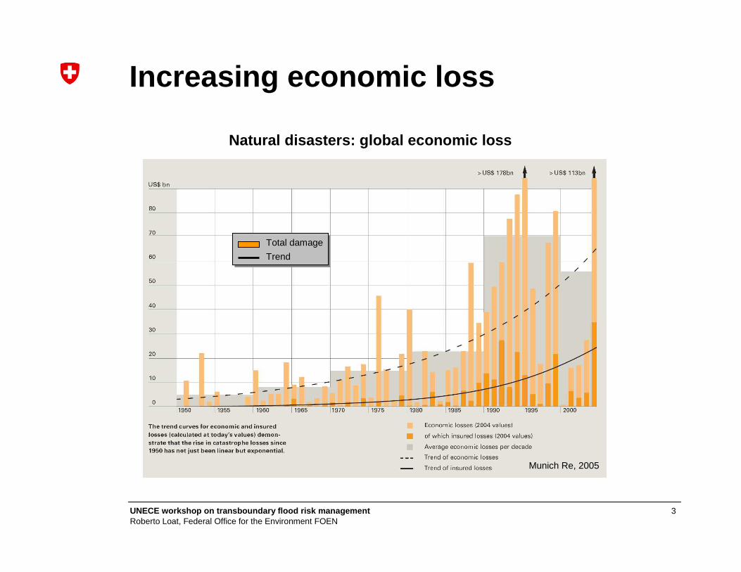
Increasing economic loss
Natural disasters: global economic loss
Munich Re, 2005
Total damage
Trend

4UNECE workshop on transboundary flood risk managemen tRoberto Loat, Federal Office for the Environment FOEN
Floods in Europe
EEA 2004
River catchments affected by flooding(1998-2002)
• 100 major floods
• 25 billion Euro damage
• 700 fatalities
ETC/TE 2003

5UNECE workshop on transboundary flood risk managemen tRoberto Loat, Federal Office for the Environment FOEN
2002: heavy floods in Europe
Elbe 2002
� Water Directors of theEuropean Union EU agreedon initiatives in the field of flood prevention and mitigation
6UNECE workshop on transboundary flood risk managemen tRoberto Loat, Federal Office for the Environment FOEN
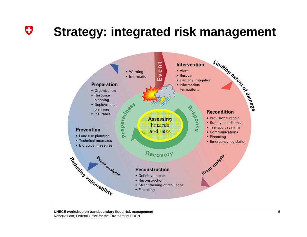
Strategy: integrated risk management
7UNECE workshop on transboundary flood risk managemen tRoberto Loat, Federal Office for the Environment FOEN
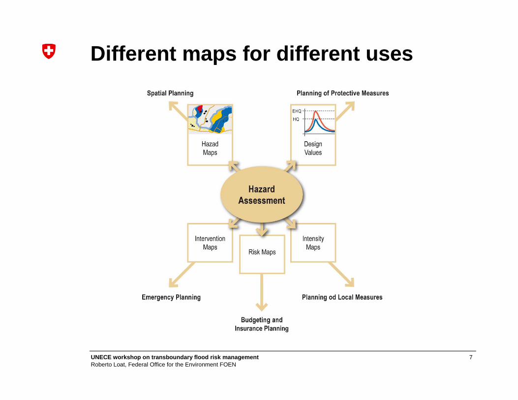
Different maps for different uses
8UNECE workshop on transboundary flood risk managemen tRoberto Loat, Federal Office for the Environment FOEN
Contents
• Background: natural hazards
• EXCIMAP: Flood mapping in Europe
• Good practices: examples of hazard / risk maps
• Conclusions
9UNECE workshop on transboundary flood risk managemen tRoberto Loat, Federal Office for the Environment FOEN
History
In 2005, the Water Directors of the European Union have acknowledged
• A common need in Europe to carry out flood mapping
• Many experiences and know-how about flood mappingin Europe
10UNECE workshop on transboundary flood risk managemen tRoberto Loat, Federal Office for the Environment FOEN
EXCIMAP
Decision to gather existing experiences and know-how in Europe into a
European exchange ci rcle onflood mapping – EXCIMAPEXCIMAP
11UNECE workshop on transboundary flood risk managemen tRoberto Loat, Federal Office for the Environment FOEN
Organisation
40 representatives: • 24 European countries, International hydrological
commissions, EU projects, European organisations, other interested stakeholders
Co-pilots: • Ministère de l’écologie et du développement durable (France)
• Federal office for the Environment (Switzerland)
12UNECE workshop on transboundary flood risk managemen tRoberto Loat, Federal Office for the Environment FOEN
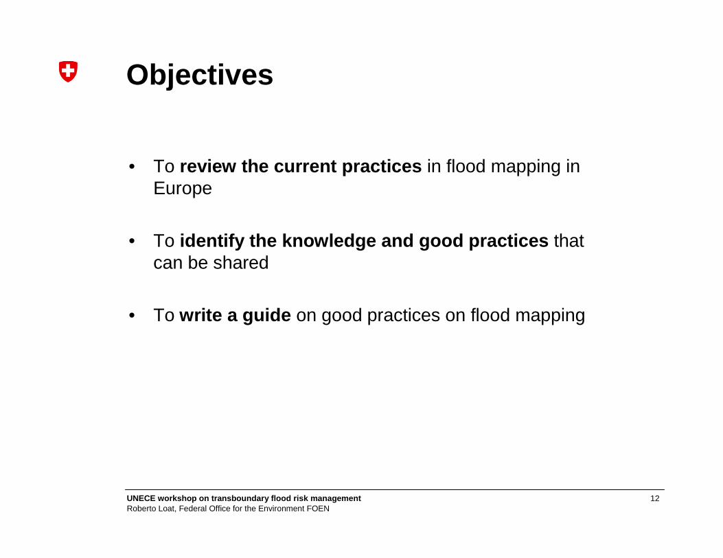
Objectives
• To review the current practices in flood mapping in Europe
• To identify the knowledge and good practices that can be shared
• To write a guide on good practices on flood mapping

13UNECE workshop on transboundary flood risk managemen tRoberto Loat, Federal Office for the Environment FOEN
4 main chapters
• Use of flood maps : What purposes for which users?• various users = various needs
• Flood hazard maps / flood risk maps : What do they show? • types of maps and contents
• Flood mapping process:• Practices, models, databases,
presentation• Flood maps dissemination:
• Format, end-users
2007: Handbook on good practices

14UNECE workshop on transboundary flood risk managemen tRoberto Loat, Federal Office for the Environment FOEN
• Consists of examples of national practices (19 European countries, USA and Japan)
• Plus additional specific chapters on:• transboundary flood mapping• flood maps for insurance• emergency maps
2007: Atlas of flood maps in Europe
15UNECE workshop on transboundary flood risk managemen tRoberto Loat, Federal Office for the Environment FOEN
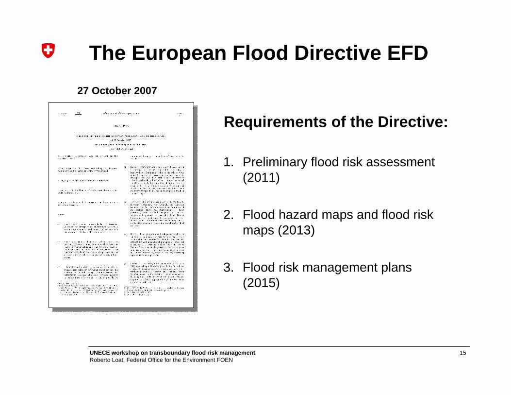
1. Preliminary flood risk assessment (2011)
2. Flood hazard maps and flood risk maps (2013)
3. Flood risk management plans (2015)
The European Flood Directive EFD
Requirements of the Directive:
27 October 2007

16UNECE workshop on transboundary flood risk managemen tRoberto Loat, Federal Office for the Environment FOEN
Contents
• Background: natural hazards
• EXCIMAP: Flood mapping in Europe
• Good practices: examples of hazard / risk maps
• Conclusions

17UNECE workshop on transboundary flood risk managemen tRoberto Loat, Federal Office for the Environment FOEN
• undertaken for each river basin district• identify those areas where a potential flood risk exists
And for those areas:
• prepare flood hazard maps and flood risk maps• establish flood risk management plans
1. Preliminary flood risk assessment
18UNECE workshop on transboundary flood risk managemen tRoberto Loat, Federal Office for the Environment FOEN
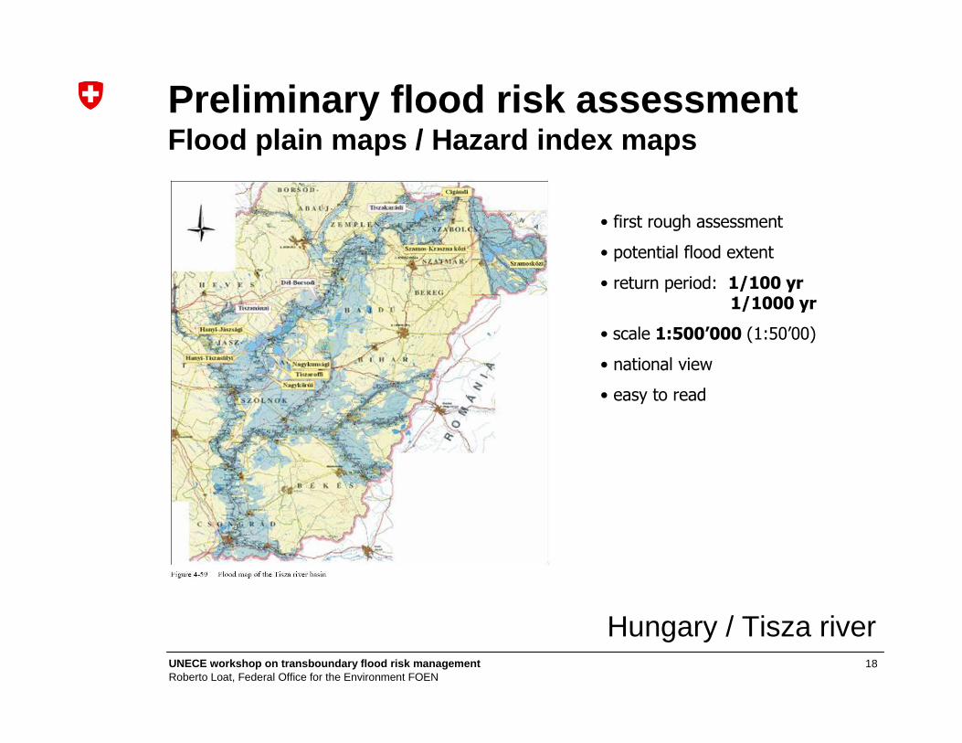
Preliminary flood risk assessmentFlood plain maps / Hazard index maps
• first rough assessment
• potential flood extent
• return period: 1/100 yr1/1000 yr
• scale 1:500’000 (1:50’00)
• national view
• easy to read
Hungary / Tisza river
19UNECE workshop on transboundary flood risk managemen tRoberto Loat, Federal Office for the Environment FOEN
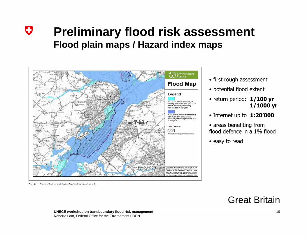
Great Britain
• first rough assessment
• potential flood extent
• return period: 1/100 yr 1/1000 yr
• Internet up to 1:20’000
• areas benefiting from flood defence in a 1% flood
• easy to read
Preliminary flood risk assessmentFlood plain maps / Hazard index maps

20UNECE workshop on transboundary flood risk managemen tRoberto Loat, Federal Office for the Environment FOEN
according to scenarios of floods with:
• high probability , where appropriate• medium probability (likely return period ≥ 100 years) • low probability or extreme event scenarios
For each scenario:
• the flood extent• water depths or water level • flow velocity or the relevant water flow (where appropriate)
2.a Flood hazard maps

21UNECE workshop on transboundary flood risk managemen tRoberto Loat, Federal Office for the Environment FOEN
Flood hazard maps
• detailed assessment of flood extension
• return period: 1/10 yr 1/50 yr 1/100 yr 1/1000 yr
• scale 1:10’000
Baden-Württemberg

22UNECE workshop on transboundary flood risk managemen tRoberto Loat, Federal Office for the Environment FOEN
R=30 R=100 R=1000
Flood intensity maps
• detailed assessment of flood depth
• return period: 30, 100, 1000yr
• water depth in 0.25m / 0.5m steps
• scale 1:5000
• high topographic accuracy 10cm
23UNECE workshop on transboundary flood risk managemen tRoberto Loat, Federal Office for the Environment FOEN
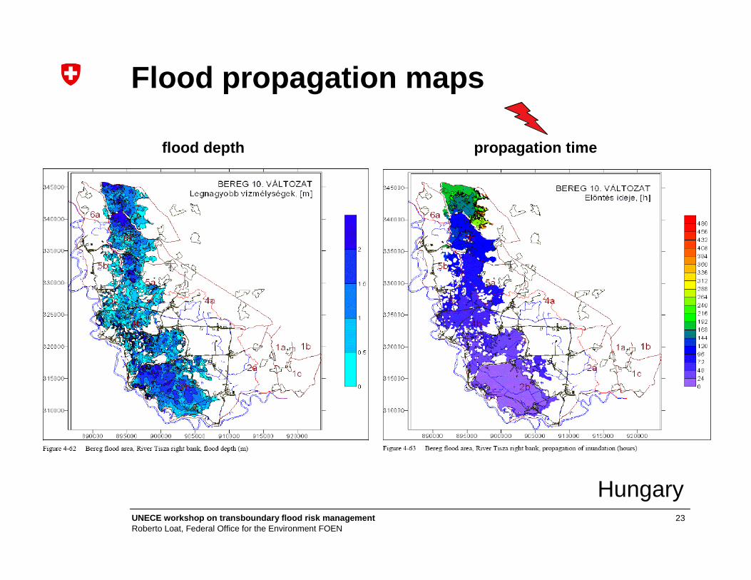
Hungary
flood depth propagation time
Flood propagation maps

24UNECE workshop on transboundary flood risk managemen tRoberto Loat, Federal Office for the Environment FOEN
Switzerland
Flood hazard zoning maps
30 300100 1000
0.5m
2m
1:5000
Land use planning
no new constructions allowed
constructions allowed with restrictions
information for the land-owners

25UNECE workshop on transboundary flood risk managemen tRoberto Loat, Federal Office for the Environment FOEN
Map before measures Hazard map after measures
Flood hazard zoning maps
Technical and non technical measures
Switzerland

26UNECE workshop on transboundary flood risk managemen tRoberto Loat, Federal Office for the Environment FOEN
shall show the potential adverse consequences associated with the flood scenarios and expressed in terms of:
• the indicative number of inhabitants potentially affected• type of economic activity of the area potentially affected• installations which might cause accidental pollution• other information which the Member State considers useful
2.b Flood risk maps
27UNECE workshop on transboundary flood risk managemen tRoberto Loat, Federal Office for the Environment FOEN
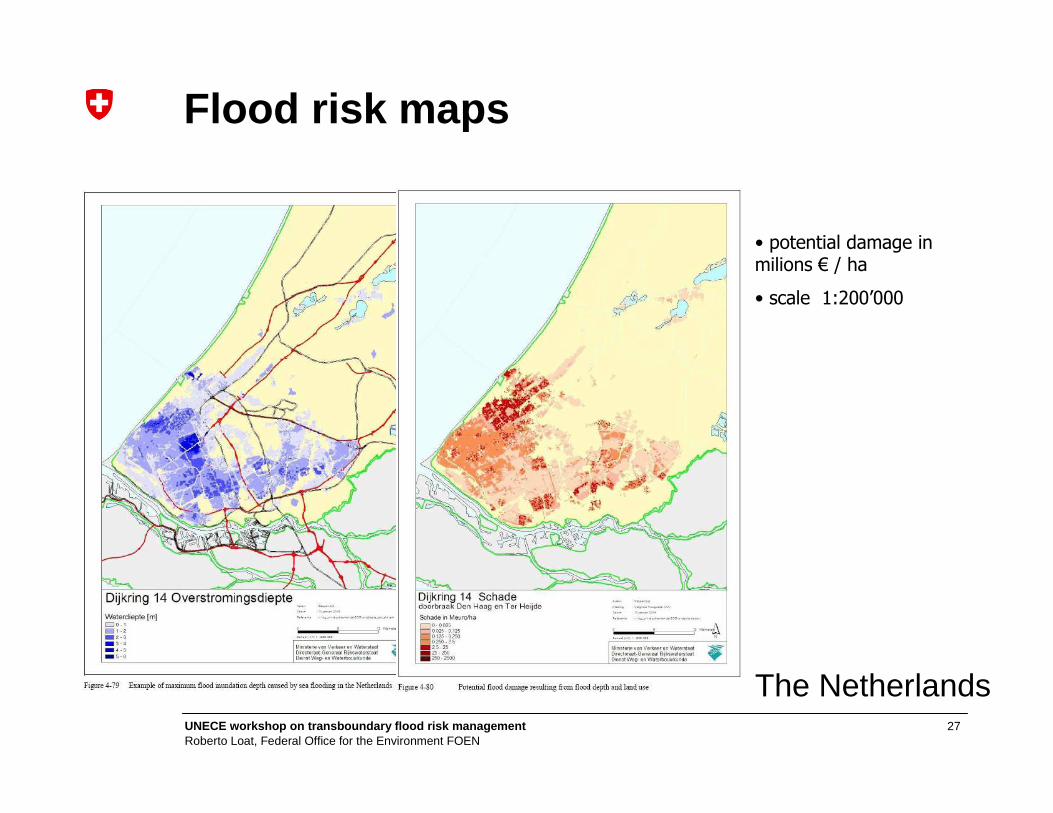
• potential damage in milions € / ha
• scale 1:200’000
The Netherlands
Flood risk maps
28UNECE workshop on transboundary flood risk managemen tRoberto Loat, Federal Office for the Environment FOEN
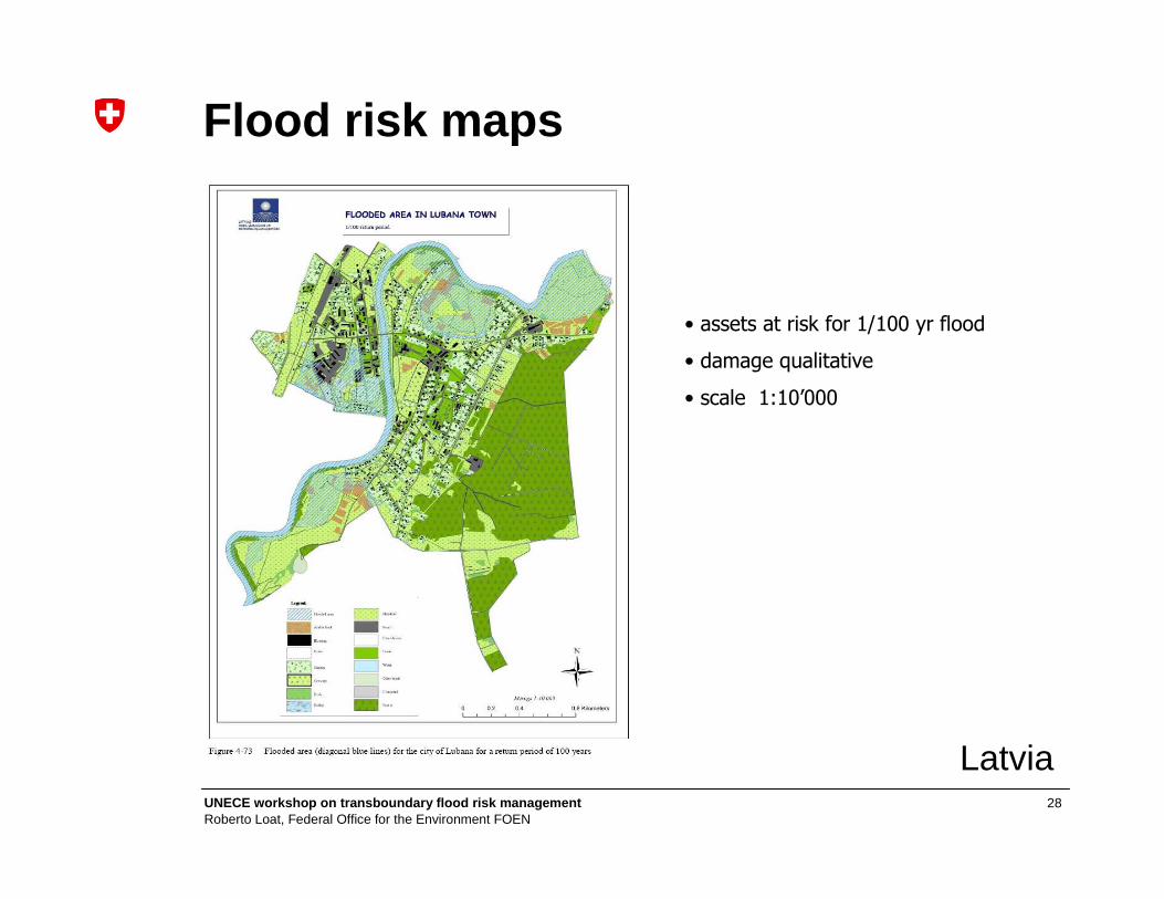
Latvia
Flood risk maps
• assets at risk for 1/100 yr flood
• damage qualitative
• scale 1:10’000
29UNECE workshop on transboundary flood risk managemen tRoberto Loat, Federal Office for the Environment FOEN
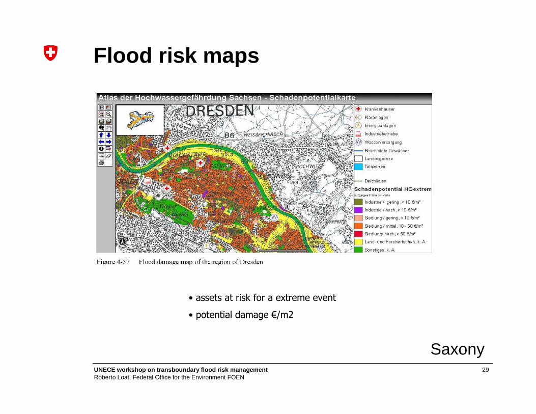
Saxony
• assets at risk for a extreme event
• potential damage €/m2
Flood risk maps
30UNECE workshop on transboundary flood risk managemen tRoberto Loat, Federal Office for the Environment FOEN
Other kind of maps
31UNECE workshop on transboundary flood risk managemen tRoberto Loat, Federal Office for the Environment FOEN
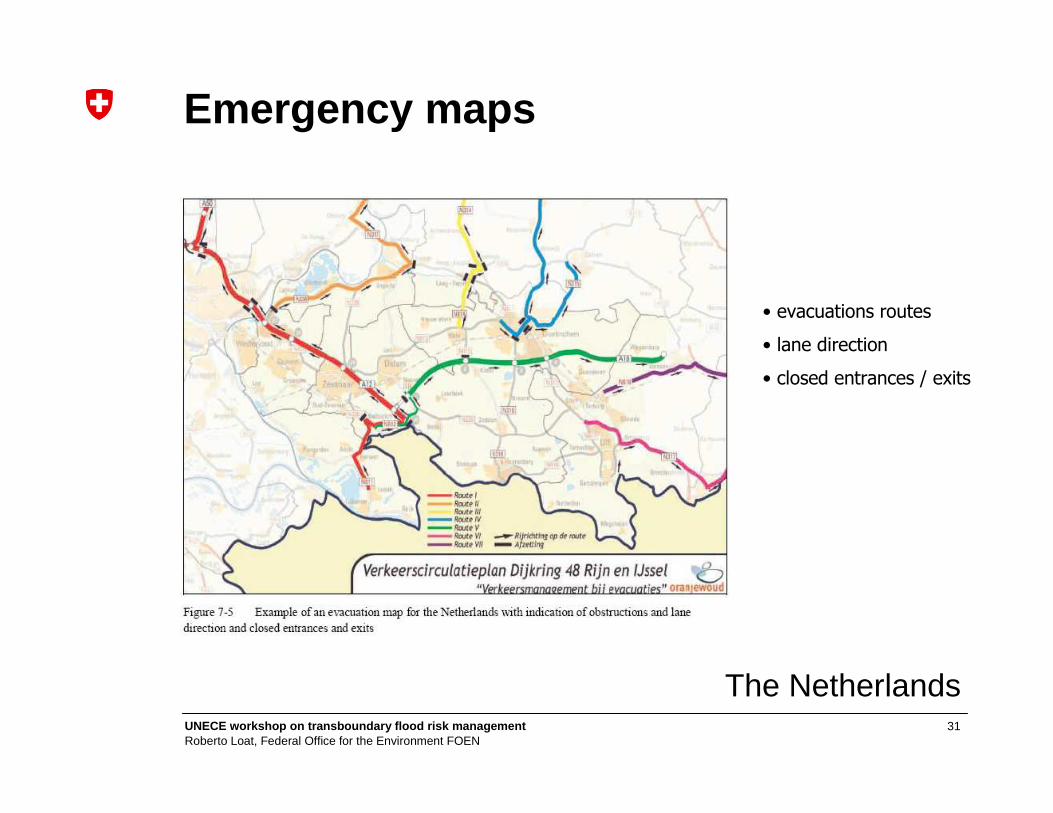
Emergency maps
The Netherlands
• evacuations routes
• lane direction
• closed entrances / exits
32UNECE workshop on transboundary flood risk managemen tRoberto Loat, Federal Office for the Environment FOEN
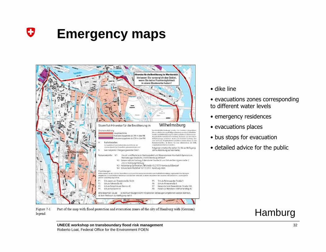
Hamburg
• dike line
• evacuations zones corresponding to different water levels
• emergency residences
• evacuations places
• bus stops for evacuation
• detailed advice for the public
Emergency maps
33UNECE workshop on transboundary flood risk managemen tRoberto Loat, Federal Office for the Environment FOEN
Dissemination
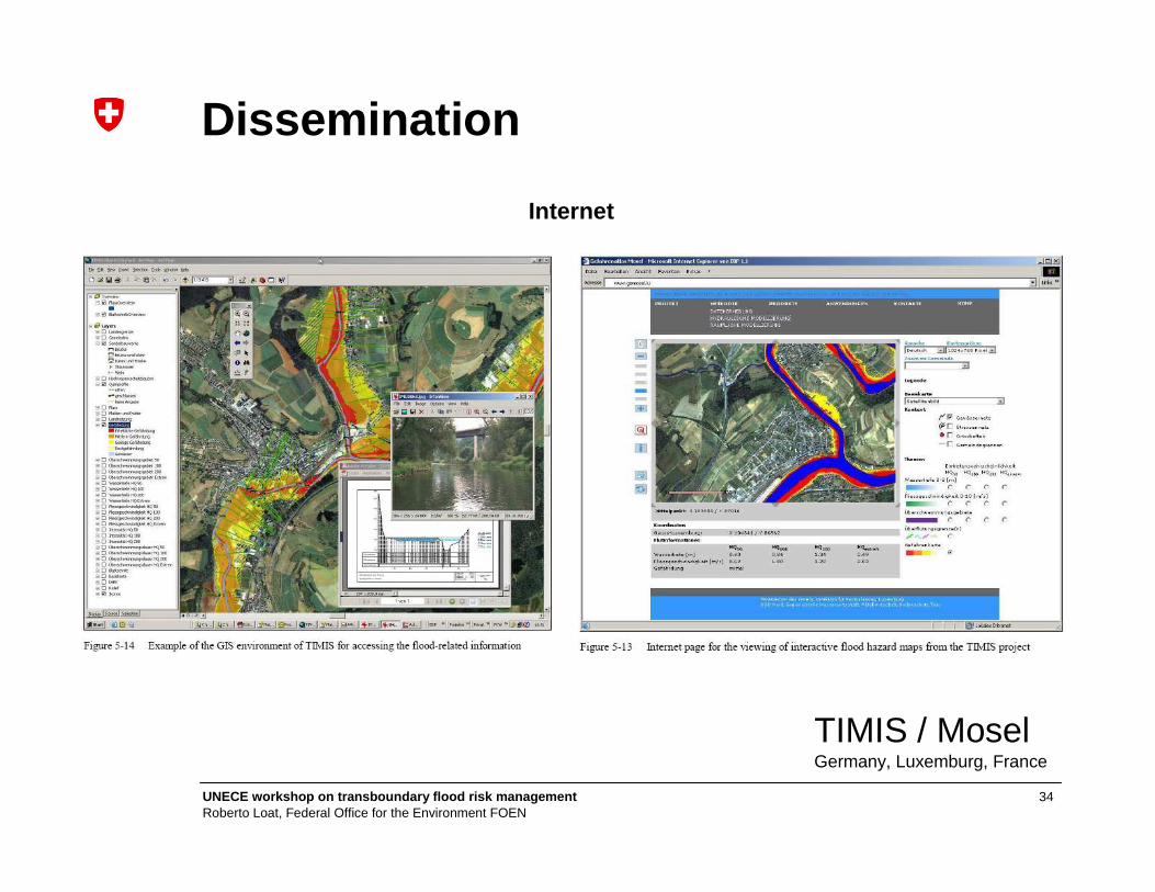
34UNECE workshop on transboundary flood risk managemen tRoberto Loat, Federal Office for the Environment FOEN
Internet
Dissemination
TIMIS / MoselGermany, Luxemburg, France

35UNECE workshop on transboundary flood risk managemen tRoberto Loat, Federal Office for the Environment FOEN
Google Earth
Dissemination
Poland

36UNECE workshop on transboundary flood risk managemen tRoberto Loat, Federal Office for the Environment FOEN
Contents
• Background: natural hazards
• EXCIMAP: Flood mapping in Europe
• Good practices: examples of hazard / risk maps
• Conclusions
37UNECE workshop on transboundary flood risk managemen tRoberto Loat, Federal Office for the Environment FOEN
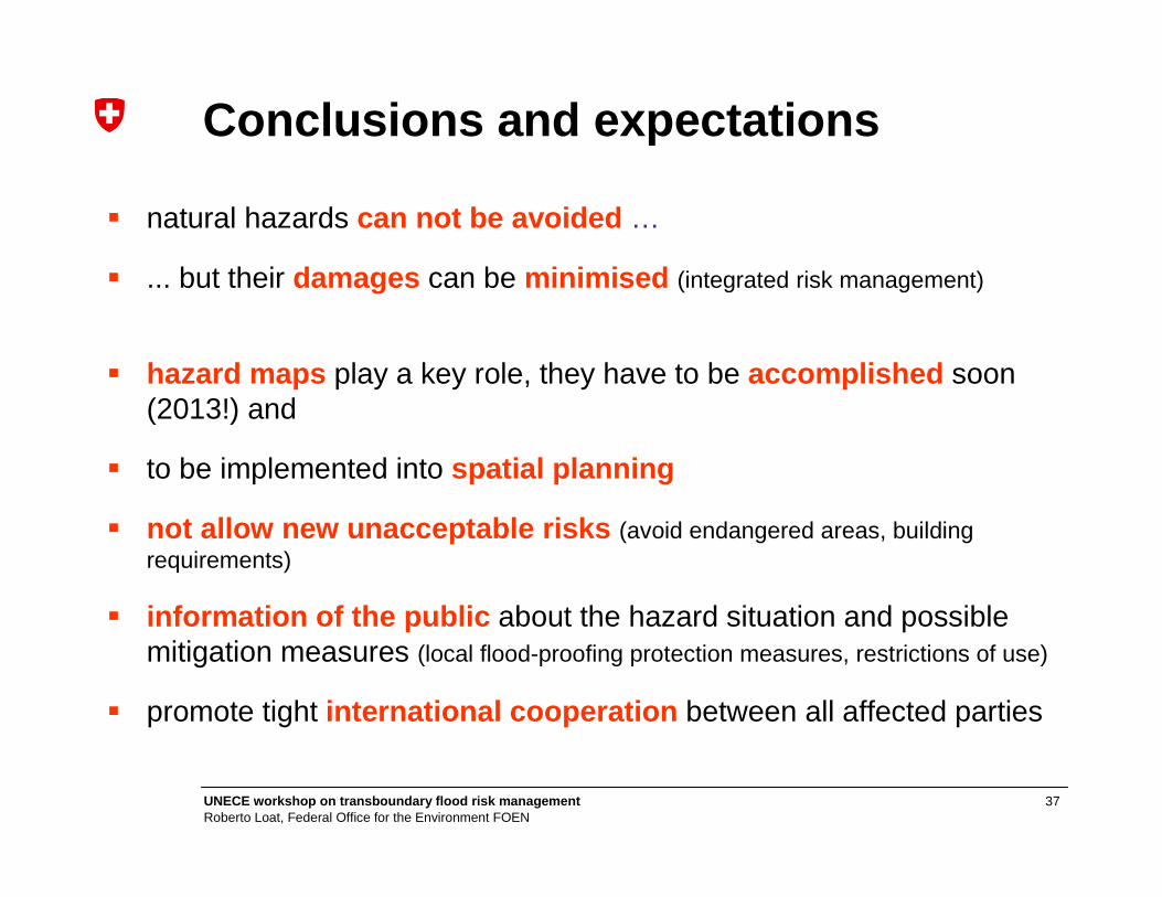
� natural hazards can not be avoided …
� ... but their damages can be minimised (integrated risk management)
� hazard maps play a key role, they have to be accomplished soon (2013!) and
� to be implemented into spatial planning
� not allow new unacceptable risks (avoid endangered areas, building requirements)
� information of the public about the hazard situation and possible mitigation measures (local flood-proofing protection measures, restrictions of use)
� promote tight international cooperation between all affected parties
Conclusions and expectations
38UNECE workshop on transboundary flood risk managemen tRoberto Loat, Federal Office for the Environment FOEN
http://ec.europa.eu/environment/water/flood_risk/flood_atlas/index.htm
Thank you for your attention !
For more informations:

39UNECE workshop on transboundary flood risk managemen tRoberto Loat, Federal Office for the Environment FOEN
40UNECE workshop on transboundary flood risk managemen tRoberto Loat, Federal Office for the Environment FOEN
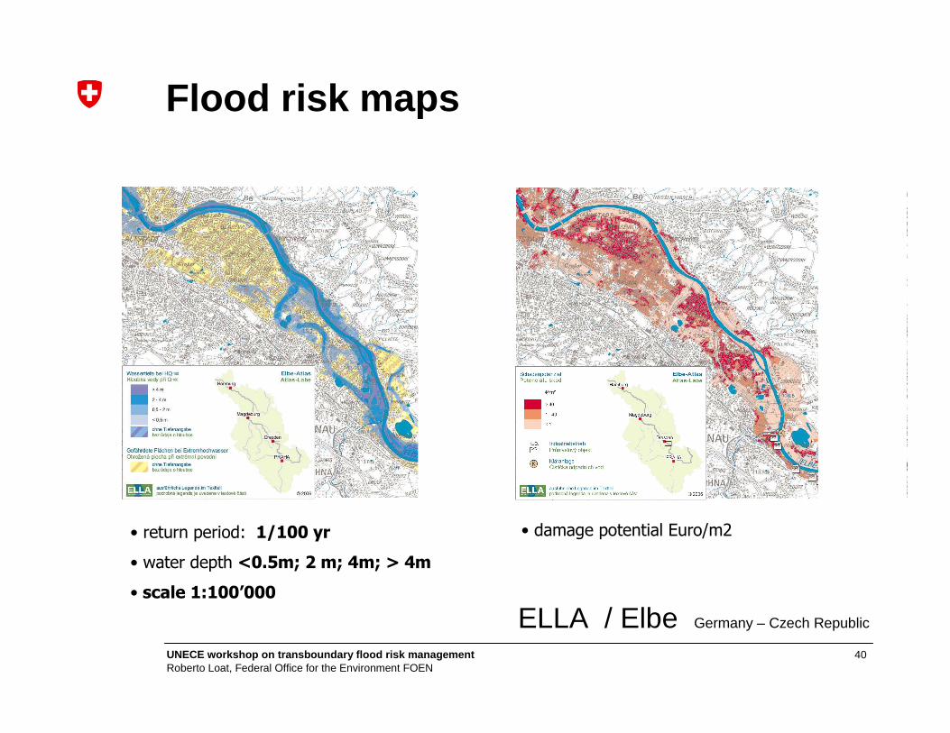
ELLA / Elbe Germany – Czech Republic
• return period: 1/100 yr
• water depth <0.5m; 2 m; 4m; > 4m
• scale 1:100’000
• damage potential Euro/m2
Flood risk maps