Embed Size (px)
Citation preview


EXCEPTION TO STANDARDS REPORT
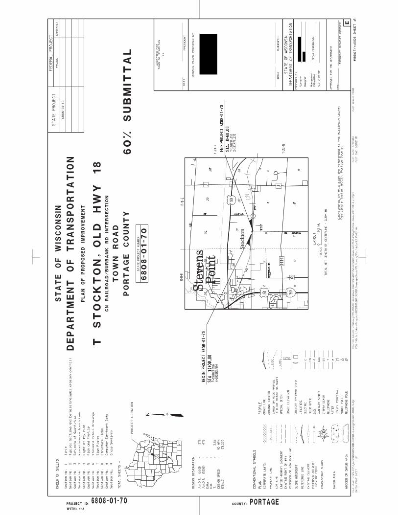
PROJECT DESCRIPTION AND NEED The project is located in Section 6, Township 23 North, Range 9 East and Section 31 Township 24 North, Range 9 East, in the Town of Stockton, Portage County, Wisconsin. See the attached Project Location Map. The project includes the reconstruction of Old Highway 18 from approximately 600 feet west of the CN railroad track to approximately 550 feet east of the Burbank Road intersections and Burbank Road from the Old Highway 18 intersection to approximately 500 feet south. This project has received funding from the Highway Safety Improvement Program (HSIP) to address the safety issues associated with this crossing. The existing geometrics of the Old Highway 18/Burbank Road intersection and CN Railroad crossing cause safety issues. The CN Railroad crosses Old Highway 18 at a 55° angle with approach grades ranging from 4% to 8%. A sharp curve is located on the north approach and the intersection of Burbank Road is located on the south approach. Although the crossing is safeguarded by cross bucks and stop signs in both directions, the skew, approach geometrics, and steep grades make it difficult to see the railroad tracks. The average number of trains per day at this location is 25 and the can travel up to 60 mph. The fast train speed and poor roadway approach geometrics contribute to safety concerns at this intersection. See the attached site photos. EXISTING CONDITIONS The functional classification and access control for Old 18/Burbank Road are as follows:
Roadway Name
Functional Class
(Arterial, Collector or Local)
Rural, Urban
or Transitional
Corridors 2020 or
Backbone (No or State which)
NHS Route (Yes
or No)
Long Truck Route(No or state
Federal or State)
Access Control
Tier
On Ped.
Trans. Plan (Yes
or No)
On Bike
Trans. Plan (Yes
or No) Old Hwy 18 Local Rural No No No N/A No Yes
Burbank Road Local Rural No No No N/A No No The design speed and posted speeds are:
Roadway or Roadway Segment Design Speed Posted Speed
Old Highway 18 (west) 40 mph 35 mph
Old Highway 18 (east) 30 mph 25 mph
Burbank Road 40 mph Not posted. The projected AADT on Old 18 in 2013 is 375 with a percentage of trucks at 3.3%. The existing typical cross section on Old 18 is as follows:
Number of roadways: One
Number of lanes: Two
Median width: None
* Lane width: 10 feet
* Shoulder width (Total and Paved or Curb & Gutter): Varies 0 to 4-feet (0 feet paved)
Bicycle Facility Type: None
Sidewalk and curb ramps: None
* Cross slope: Varies 2% - 4%

* Super-elevation: 9.1% Max
* Horizontal clearance: There are trees within 10-feet of the driving lane.
Clear Zone: There are slopes steeper than 4:1 within 5-feet of the driving lane
* Vertical clearance: No overhead obstructions
Side-slopes and Ditch sections: Normal 4:1
Maximum 2:1
* Controlling Criteria
See Attachment 2: Preliminary Plans.
SUBSTANDARD FEATURES The following features will be improved but remain substandard as part of this project:
Horizontal Curve Superelevation
The following horizontal curves will remain outside of desirable standards:
* Horizontal Feature
(Curve, P.I. Deflection, etc.)
Location
(Stationing)
* Size
(Radius, P.I. Deflection, etc.)*
* Super-
Elevation
(s.e.)
Speed Rating
Curve P.I. – 15+41.26 154’ Radius1 4.0% 25 mph
Curve P.I. – 4+25.28 485’ Radius N.C. 25 mph * Controlling Criteria 1 The superelevation runout for this curve occurs within the curve in order to transition to the existing slope of the CN railroad tracks. There will be no adverse superelevation within the curve. The minimum radius to meet a 40 mph design speed is 485 feet with a 6% superelevation. This radius cannot be achieved at P.I. Station 15+41.26 due to the restrictions of the railroad tracks to the south and the Stockton District No. 10 school house to the northeast. The Stockton District No. 10 school house has been determined to be eligible for the register of National Historic Places. The curve at P.I. Station 4+25.28 is approaching an intersection and will transition from the longitudinal grade of Burbank Road to a normal crown through the curve. Superelevation cannot be achieved do to the proximity of the curve to the intersection. This will result in adverse superelevation, however, the proximity to the intersection will result in slower traffic. CRASH DATA The following crash rates occurred near the intersection between 2001 and 2010:
Location or Pattern
Year
Number & Severity of Crashes Crash Rate(2)
Possible Factors Contributing to
Crashes
Fatal
Injury Property Damage
Total
Old Highway 18 2001
– 2010
1 6 1 8 6.0
Poor sight distance across the tracks, poor alignment
approaching the intersection from the north.
(2) Crashes per million entering vehicles (MEV) ADVERSE UPGRADING IMPACTS Improving the horizontal curve to meet a 40 mph design speed would have adverse environmental

impacts. This alternative would require that the Stockton District No. 10 school house (eligible for the National Register of Historic Places) be demolished to provide enough tangent length north of the tracks to construct the 40 mph curve and cross the railroad tracks at 90 degrees. It would also result in additional property acquisition. The only possible way to meet a 40 mph design speed and avoid impacts to the school house would be to relocate the railroad crossing. This option was not considered due to the impact it would have on the railroad, as well as the right of way impact it would have on neighboring property owners. The proposed 25 mph curve is a prudent and feasible alternative to avoid impacting the Stockton District No. 10 school house. The proposed curve has the largest possible radius while avoiding the historic boundary. PROPOSED SAFETY ENHANCEMENTS The project will include the following safety enhancements:
Increasing the radius of the horizontal approach curve north of the CN crossing to a 25 mph design speed.
Improving the angle of the railroad crossing from the current 55 degree skew to approximately a 90 degree crossing.
Moving the intersection of Old 18 east to the south to provide additional separation from the crossing.
Reducing approach grades to 0.5 to 3 percent from the current 4 to 8 percent. Installing railroad gates and signals. Providing 12 foot driving lanes with 3-foot paved shoulders for bicyclists. Providing advisory signs including curve ahead with 25 mph, railroad crossing ahead, and
chevron signing. CONCLUSION Although the curve north of the tracks does not fall within the desirable limits for the design speed of this roadway, it is a prudent and feasible alternative to avoid environmental factors. This curve is an improvement over existing conditions. The curve is not a contributing factor to the crashes at the railroad, but rather the lack of visibility, which has been addressed to the maximum extent possible. In addition, the safety at the new crossing will be enhanced by new signals and gates. Additionally, the curve east of the Burbank Road intersection, is also substandard. However, this curve is nearing a tee intersection which will result in lower vehicle speeds. The lack of superelevation through this curve will provide for a smoother transition from the longitudinal grade of Burbank Road to the cross slope of Old Highway 18. This curve also allows the intersection to be shifted south, away from the railroad crossing, which will improve sight distance for vehicles in all directions.

BEGIN PROJECT
END PROJECTEND CONSTRUCTION
OLD HWY 18
OLD HWY 18
BURB
ANK
ROAD
LEGENDProposed Asphalt
Proposed Gravel
Slope Intercepts
±
0 500 1,000250Feet
FILE NAME: PROJECT NO. DATE FIGURE NO.DRN
TOWN OF STOCKTON
6808-01-00 OLD HWY 18 (CN RAILROAD/BURBANK RD INTERSECTION)
ENVIRONMENTAL REPORT
LOCATION MAP
LOCATION_MAP.MXD 6808-01-00 Apr 2013
STOCKTON SCHOOL
BJ COURT
CN RAILROADCN RAILROAD

Railroad Approach, looking southeast
Eastbound Old Highway 18

Railroad Approach, looking north
Northbound Burbank Road