Embed Size (px)
DESCRIPTION
by D.A. Welsby — Sudan & Nubia, No 10, published by The Sudan Archaeological Research Society, 2006
Citation preview

SUDAN & NUBIA
1
2

1
Contents
Kirwan Memorial Lecture
Bir Nurayet – the Rock Art Gallery of the 2Red Sea HillsKrzysztof Pluskota
The Merowe Dam Archaeological Salvage Project
Excavations in the vicinity of ed-Doma (AKSE), 82005-2006Derek A. Welsby
Preliminary report on the excavations conducted 13on Mis Island (AKSC), 2005-2006Andrew Ginns
The Third Season of the SARS Anglo-German 20Expedition to the Fourth Cataract of the NilePawel Wolf and Ulrike Nowotnick
Comments on the two Egyptian jars found at 32Tomb no. 1 of site 3-Q-94Robert Schiestl
Fourth Nile Cataract petroglyphs in context: the 34ed-Doma and Dirbi rock-art surveyCornelia Kleinitz and Roswitha Koenitz
Reports
Cattle, sherds and mighty walls – 43the Wadi Howar from Neolithic to Kushite timesFriederike Jesse
Drawings on rocks: the most enduring monuments 55of Middle NubiaDavid N. Edwards
Roman Artillery Balls from Qasr Ibrim, Egypt 64Alan Wilkins, Hans Barnard and Pamela J. Rose
SUDAN & NUBIAThe Sudan Archaeological Research Society Bulletin No. 10 2006
Antaios the Giant and Antaios the God, or how 79could the Greeks have got it so wrong? A statuettein the Nubian Museum: a case of understatedsyncretismDonald M. Bailey
Apedemak and Dionysos. Further remarks on the 82“cult of the grape” in KushAndrea Manzo
Bread Moulds and ‘Throne Halls’: Recent Discoveries 95in the Amun Temple Precinct at DangeilJulie Anderson and Salah Mohamed Ahmed
El-Frai: a new Meroitic habitation site in ed-Damer 102Mohamed Faroug Abd el-Rahman
Gheresli: a post-Meroitic activity centre in the 104Blue Nile regionMohamed Faroug Abd el-Rahman
Paradise Lost: Nubia before the 1964 Exodus 110Herman Bell
Miscellaneous 117
Front cover: Beja man by the well at Bir Vario, Eastern Desert(photo K. Pluskota).

8
The Merowe DamArchaeologicalSalvage ProjectExcavations in the vicinity ofed-Doma (AKSE), 2005-2006Derek A. Welsby
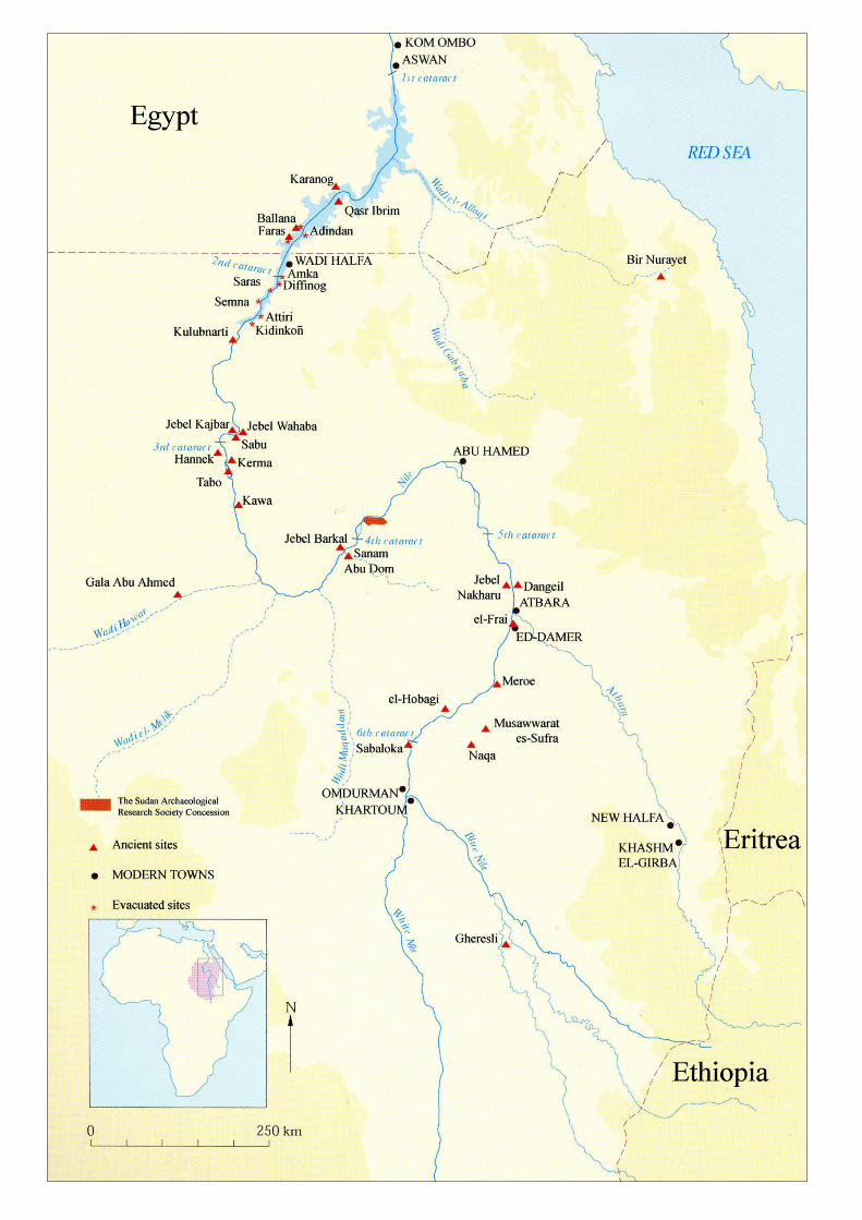
The concession of the Sudan Archaeological ResearchSociety within the Merowe Dam Archaeological SalvageProject (MDASP) includes the left bank of the Nile and theislands between the fortress at Suweigi West (Dar el-Arab)upstream to Jebel Musa at Kirbekan. The concession, whichextends along the Nile for approximately 40km, includes anumber of large islands and the area threatened by inunda-tion extends well away from the banks of the river. De-tailed survey and excavation of the whole area are impossi-ble within the timeframe available. In the light of this the
strategy has been for small areas to be surveyed in detailfollowed by excavation of a sample of the sites locatedduring those surveys. Survey began in the central part ofthe concession based at et-Tereif in 19991 (Welsby 2002)and was followed, from 2002 to the present, by four sea-
1 Directed by Derek Welsby. 2 Directed by Derek Welsby, Dorian Fuller, John Payne, GerardoCarpio and Andrew Ginns.
Plate 1. Main sites by the palaeochannel.
sons of excavations2 of cemeteries and settlements on theleft bank and on the islands of Umm Melyekta, el-Hilla,Umm Muri and Mis. In 2003-4, survey and trial excava-tions were also begun in the region around Dar el-Arabfollowed by seasons of excavation in 2004/5 and 2005/6.3
In the winter of 2004-5, SARS/The British Museumbegan work in the upstream part of the concession, basedin the hamlet of ed-Doma, where over 650 sites were re-corded (Welsby 2005). This was followed, in the winter of2005-6, by excavations of a number of those sites by twoteams, the work supported by funds from the British Mu-seum, the Egypt Exploration Society and the Institute forBioarchaeology. These teams were in the field from 2nd De-cember 2005 until 4th February 2006.4
Fourteen sites were investigated in detail by the ed-Domateam (Plate 1) although the work in the Kerma cemetery,site 4-L-88, on the tumuli at sites 4-L-41 and 4-L-68(18)and in the medieval cemetery, site 4-M-142, has not beencompleted. All other sites have been excavated down to thesubsoil and in many cases to the bedrock.
‘Settlements’
Several sites which appeared to be non-funerary wereinvestigated.
Site 4-L-343 is situated towards the north-western end ofa rocky outcrop within the palaeo-channel. It consisted of a number of con-tiguous rings, approximately 1.3-1.65min diameter, formed of stone walls onestone thick and a few courses high. Therewere no doorways into them, no rubblewhich can have fallen from the super-structure and no post-holes. Very littlematerial was found associated with these.Their function and date are unclear.
Site 4-L-340 was similar to that at 4-L-343. It was set on a level terrace a littleabove the palaeochannel on its south-western bank. The rings of stone wereagain contiguous but were often only onecourse of stone in height (Plate 2). Somewere built one against another but, as theyall rested on the same surface, they mayhave been broadly contemporary. Noth-ing was found to suggest their function.In the surface immediately predating the
3 Directed by Pawel Wolf. 4 The team based at ed-Doma consisted of Pamela Bowler (archae-ologist), Susannah Chapman (archaeologist), Henriette Hafsaas(archaeologist), Habab Idris Ahmed (NCAM inspector), Tina Jakob(archaeologist, physical anthropologist), Tay Keen (archaeologist),Mohammed Ibrahim Mohammed (cook), Matt Nicholas (archaeolo-gist), Derek Welsby (director, photographer), Isabella Welsby Sjöström(assistant director, pottery specialist).

SUDAN & NUBIA
9
Plate 2. Site 4-L-340, stone rings.
stone rings was a number of circular shallow depressions, afew of which were sealed by the stone rings. Some of thesehad a small central hollow, not deep enough to have sup-ported a central stake or post. In this surface, and in thosefound at a lower level, was a number of pits and post-holes.The recognition of the post-holes was difficult and of thoseidentified none formed recognisable structures. Very smallamounts of pottery were found throughout these layers.
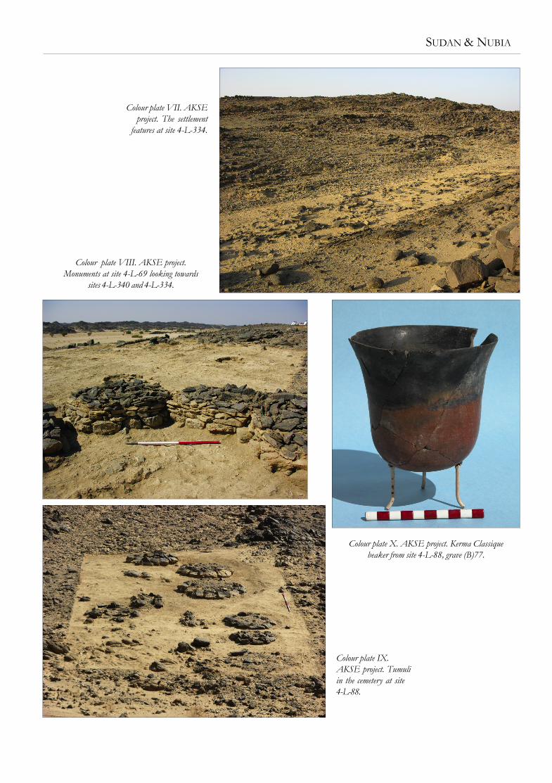
Site 4-L-334. The stone rings here were similar to those atsite 4-L-340 but much less well defined (Colour plate VII)suggesting that they were perhaps much older. Several hada circular depression in the centre with the shallow hollowin the middle. Other depressions of this type were foundelsewhere in the surface on which the rings were constructed.Again, no post-holes for structural timbers were found whichcould be associated with the rings. After removal of severallayers down to the subsoil/bedrock three substantial post-holes were found arranged in a shallow arc. These had avery distinctive and readily recognisable fill but, notwith-standing this, no further holes could be located. Pottery wasextremely scarce on this site. A little to the north-west ofthe rings a line of stones ran across the flat ground betweentwo rock outcrops. No timber features which could havemade this an effective barrier were found.
Site 4-L-311 consisted of three large circular cleared areasand four smaller ones amongst the general scatter of stoneson a flat terrace. In the centre of a few of these were thesame circular shallow depressions as found on the sitesalready noted. Concentrations of stones around the smallerareas suggested that they may have been enclosed by a low‘wall’. Many post- and stake-holes were found but only onegroup of 14 could be confidently associated with a struc-ture. They formed an arc extending for a distance of over4m. It did not prove possible to find further post-holes form-
ing the rest of a hut circle. How-ever, in some of the areas wherethese would be expected, bedrockoutcropped and hence there wouldhave been no possibility to exca-vate post-holes. Pottery from thissite was of Neolithic, Kerma andpossible of slightly later date.
Site 4-L-41 was a substantial cir-cular stone hut, with walls over500mm in height, abutted on itswest side by circular areas ringedby single rows of stones. A door-way led into the hut from the southand a semi-circular row of stonesdivided off the back of the hut.Its ‘floor’ surface contained anamount of bone and large sherdsof Kerma period pottery werefound associated with it. Further
excavation, and the identification of the bone as human,indicated that there had originally been a tumulus here oftype V (see Welsby 2005, 4) which had been partly demol-ished and incorporated into a hut after it had been robbed.Excavation of the grave has yet to be undertaken.
Site 4-L-74 was a concentration of features, each an areaabout 1m in diameter which had been cleared of the sur-face gravel exposing the underlying earth. Two of thesewere sectioned and remains of a central upright stake ofpalm was found.
Site 4-L-69 sat on a level terrace high above the palaeo-channel. The site was unique within the survey area beingcovered in flat stone slabs among which small circular struc-tures could be recognised. Removal of the slabs revealedthe well-preserved monuments standing several courses, upto 500mm high, which frequently abutted one another. Thesewere all totally excavated. Most of them contained an earthand stone fill and nothing more (Colour plate VIII, Plate 4).However, a few had pavements of stone within thembeneath the stone fill (Plate 5) and two had an arrangementof large slabs, the functions of which were unclear. Thelarge amounts of rubble on the site indicates that they musthave attained a much greater elevation.
Although originally thought to be grave monuments theabsence of a burial chamber either beneath or within them,along with the total absence of human bone associated withthem, suggests that they had another function. Structuresconstructed in a very similar way, of very similar size, somewith stone pavements within, have been found on a sitedated to the early Kushite (Napatan) period on the otherbank of the river near the village of el-Argoub in the WadiUmm Rahu by the Gdansk Archaeological Mission (pers.comm. Mahmoud et-Tayeb). These are certainly associatedwith evidence for occupation by both humans and animals.

10
Plate 4. Site 4-L-69, monuments.
In the light of this evidence it must be assumed that thestructures at site 4-L-69 relate to a settlement rather thanbeing funeray features. It might be suggested that theyformed the bases of storage facilities, perhaps quseiba (mud-storage bins).
Dug into the earth and friable bedrock of the surface onwhich the monuments were built were many pits filled withash and, in some cases, animal bone. These may have beenassociated with the stone monuments but a clear relation-ship was not observed. Certainly some pits were sealed bythe monuments. The small amount of pottery from this sitewas of Kerma Moyen and Classique date.
Funerary sites
Several cemeteries were excavated in part along witha number of isolated features which are also probablyfunerary.
Crevice graves – two natural-rock crevices in the bedrockwere investigated. Both had stone slabs across the top ofthe crevice and, at site 4-L-313, remains of a wall blockingthe north end of the crevice. No trace of bone was foundin either of these but one sherd of Kerma Classique potterywas recovered.
Tunnel grave – a single example, site 4-L-297, was inves-tigated (Plate 3). The only finds, from within the wind-blownsand in the chamber, were pieces of rope and twigs sug-gesting that it had been used as a trap. However, other struc-tures of this type in the survey area contain human skeletalmaterial so the original function as funerary monumentsseems certain. The chamber was aligned due north-south.At the northern end of the stone slabs roofing the chamberwas a small hole suggestive of a hole designed for pouringlibations to the deceased.
Dome graves – three small graves of this type were exca-vated. In all cases they contained no bone or pottery al-though those at site 4-L-91 contained many lithics whichabound in that area. These may not have been purposelydeposited within the dome graves. The other dome grave,
at site 4-L-309, was of interest. It was certainly later in datethan the adjacent boundary wall as it rested on one of thestones of that wall. This is the first secure evidence we haveto suggest the antiquity of the boundary walls although theabsence of dating evidence from the dome grave itself isnot helpful.
Site 4-L-347. The isolated circular stone platform wasexcavated. It may have been the base of a tumulus or astructure of the type found at site 4-L-69.
Site 4-L-68. One of the several type V tumuli on this sitewas excavated, the grave containing the body of a smallchild. A cairn close by was also excavated but the grave pithas yet to be examined.
Plate 5. Site 4-L-69, monument 31 with pavement 106.Plate 3. Site 4-L-297, tunnel grave.

SUDAN & NUBIA
11
Plate 6. Site 4-L-88(B), grave 42, skeleton 93accompanied by a single pottery vessel.
Plate 7. Site 4-M-142, grave 56 with slabs covering body.
The cemeteries at sites 4-L-88 and 4-M-142 were exten-sively excavated.
Site 4-L-88 was set on the sloping bank of a tributary wadileading into the palaeochannel. Two areas were excavatedwhile a further concentration of tomb monuments a littleto the north east was not examined. At the start of excava-tion the monuments appeared as semi-circular terraces onthe slope revetted by a line of large stones. Excavation,however, quickly revealed that these were circular stone
monuments partly buried under a thick layer of earth andcoarse gravel (Colour plate IX). They cover an oval or cir-cular grave pit, in area (A) excavated down to, and in somecases into, the friable granite bedrock which was close tothe surface. In the adjacent area (B) the earth layer wasmuch thicker and hence the graves were considerably deeper,many in excess of 1m. The crouched inhumations wereusually orientated east-west with the head to the east facingnorth (Plate 6) although a few had a markedly differentorientation. One grave contained two adolescents placedsupine, but one had its legs flexed. The interments in thiscemetery were accompanied by up to three pottery vesselsamong them typical Kerma Classique tulip beakers (Colourplate X), and had been laid on a hide covered in red ochreof which traces remained.
Site 4-M-142. Close to ed-Doma on the undulating alluvialplain was a cemetery of Christian box graves and Muslim
graves marked with stone slab pavements. All but three ofthe medieval graves were excavated. The graves were inmany cases typical of contemporary burials in the regionwith a long narrow grave pit containing the supine extendedbody placed with the head to the west. In several cases thehead was symbolically protected by stones. Many graveshad ledges along the sides on which rested stone slabstotally covering the body (Plate 7). A few bodies wereextremely well preserved with much soft tissue and some-times with the textile shroud and the rope binding remain-ing. A few graves were exceptional. One was covered not bya box grave but by a tumulus beneath which was a long lineof large stones set slightly to one side of the grave cut. Themethod of burial of the individual placed in the gravebeneath was normal. A few bodies were placed in a flexedposition (Plate 8) although in every other respect the gravemonument and cut were typical of the others in the cem-etery. As expected grave goods were very rare although twocrosses (Plate 9), two rings, a pendant and fragments ofleather and basketry (Plate 10) were recovered.
The FindsThe human skeletal remains recovered have greatly increasedthe Kerma population available for study from the SARS

12
Plate 8. Site 4-M-142, grave 45, crouched inhumation skeleton 85.
Plate 9. Site 4-M-142,cross.
Plate 10. Site 4-M-142,leather and basketry.
Of the sites excavated this season, the function of the stonerings remains unclear and the evidence for settlementactivities at earlier phases on those sites is limited. The smallamounts of pottery, the cleared areas, depressions, post-holes and pits indicate that human activity was taking placein those areas but the occupation was presumably of lim-ited duration.
The cemeteries are particularly interesting. Along withthose excavated by our Peruvian colleagues this season threehave been excavated which all appear to have been in useduring the Kerma Classique period, although burials at site4-L-100 may have continued in use a little later. All threecemeteries are very different, the only common character-istic being some of the pottery. The tomb monuments varydramatically as does the treatment of the grave pits and thebody orientations.
Acknowledgements
SARS would like to thank the staff of the National Corpo-ration for Antiquities and Museums for its assistance withsetting up this project and the British Council for logistichelp. The financial support given to this contribution to theMerowe Dam Archaeological Salvage Project by the BritishMuseum, the Egypt Exploration Society and patrons ofSARS is gratefully acknowledged.
BibliographyWelsby, D. A. 2002. Survey above the Fourth Nile Cataract. SARS
Publication No. 10. London.Welsby, D. A. 2005. ‘Survey in the vicinity of ed-Doma (AKSE),
2004-2005’, Sudan & Nubia 9, 2-8.
concession while the medieval remains will form a goodcomparative collection for the large number of skeletonsrecovered from site 3-J-23 at et-Tereif and on Mis Islandfurther downstream. The pottery of the Kerma period high-lights the juxtaposition of typical Kerma products being usedalong with those pots made in the local tradition.
Rock art and rock gongs
The rock art and gongs recorded during the survey werestudied in more detail by two specialists during December2005 (see Kleinitz and Koenitz, this volume).
Conculsions
As elsewhere in the central and eastern part of the SARSconcession the identification of settlements, apart from thoseof the medieval and post-medieval periods, is far from easy.
SUDAN & NUBIA
Colour plate VII. AKSEproject. The settlement
features at site 4-L-334.
Colour plate VIII. AKSE project.Monuments at site 4-L-69 looking towards
sites 4-L-340 and 4-L-334.
Colour plate X. AKSE project. Kerma Classiquebeaker from site 4-L-88, grave (B)77.
Colour plate IX.AKSE project. Tumuliin the cemetery at site4-L-88.

2

SUDAN & NUBIA
1
2