Embed Size (px)
Citation preview
*69
Excavations at Khirbet el-Maqatir: the 2009–2011 Seasons
Gary A. Byers, D. Scott Stripling, and Bryant G. Wood*
With a contribution by Marina Faerman*
AbstractAfter a hiatus of eight years, the seventh–ninth seasons of salvage excavations at Khirbet el-Maqatir, 15 km north of Jerusalem, were conducted from 2009 to 2011. Four phases of occupation were found: a small fortress from the Middle Bronze III-Late Bronze I period, an Iron Age I settlement, a Late Hellenistic-Early Roman fortified town, and a Byzantine monastery. From the fortress phase, the west fortification wall was investigated and found to be 3.5 m wide. An infant jar burial was discovered beneath a building located inside the gate. On the south side a large limestone monolith was found, which may be the remains of a damaged stela. Excavations on the east side of the site exposed a well-preserved first-century CE house. A church described by early travelers was also investigated. It was determined that it was initially a single-apse, basilica-style church. This was later replaced by a tri-apsidal church with a two-story monastery of the coenobium type built around the basilica church.
Keywords: Kh. el-Maqatir; Ai; fortress; Middle Bronze III–Late Bronze I; Iron Age I; Late Hellenistic–Early Roman; Byzantine church
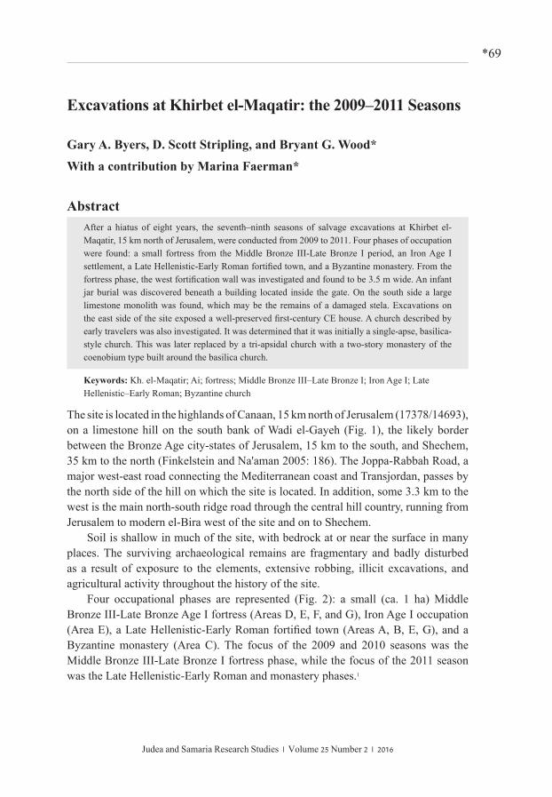
The site is located in the highlands of Canaan, 15 km north of Jerusalem (17378/14693), on a limestone hill on the south bank of Wadi el-Gayeh (Fig. 1), the likely border between the Bronze Age city-states of Jerusalem, 15 km to the south, and Shechem, 35 km to the north (Finkelstein and Na'aman 2005: 186). The Joppa-Rabbah Road, a major west-east road connecting the Mediterranean coast and Transjordan, passes by the north side of the hill on which the site is located. In addition, some 3.3 km to the west is the main north-south ridge road through the central hill country, running from Jerusalem to modern el-Bira west of the site and on to Shechem.
Soil is shallow in much of the site, with bedrock at or near the surface in many places. The surviving archaeological remains are fragmentary and badly disturbed as a result of exposure to the elements, extensive robbing, illicit excavations, and agricultural activity throughout the history of the site.
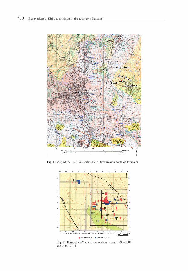
Four occupational phases are represented (Fig. 2): a small (ca. 1 ha) Middle Bronze III-Late Bronze Age I fortress (Areas D, E, F, and G), Iron Age I occupation (Area E), a Late Hellenistic-Early Roman fortified town (Areas A, B, E, G), and a Byzantine monastery (Area C). The focus of the 2009 and 2010 seasons was the Middle Bronze III-Late Bronze I fortress phase, while the focus of the 2011 season was the Late Hellenistic-Early Roman and monastery phases.1
Judea and Samaria Research Studies | Volume 25 Number 2 | 2016
Excavations at Khirbet el-Maqatir: the 2009–2011 Seasons*70
Fig. 1: Map of the El-Bira–Beitin–Deir Dibwan area north of Jerusalem.
Fig. 2: Khirbet el-Maqatir excavation areas, 1995–2000 and 2009–2011.
Gary A. Byers, D. Scott Stripling, and Bryant G. Wood *71
Middle Bronze III – Late Bronze I
The objectives of the 2009 and 2010 seasons were: 1) to investigate the north gate passageway sub-layers in Square R17 for evidence of burning (2009); 2) to investigate the area inside the gate for evidence of a "residency" in Squares O18 (2009) and O19 (2010); 3) to trace the west fortification wall in Squares M7, M8, and M9 (2009 and 2010); and 4) to locate the south fortification wall in Squares B17 and C17 (2009).
Gate passageway, Area G, Square R17
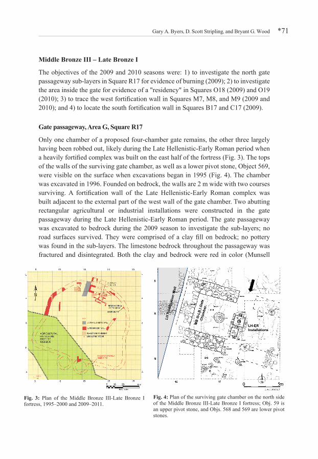
Only one chamber of a proposed four-chamber gate remains, the other three largely having been robbed out, likely during the Late Hellenistic-Early Roman period when a heavily fortified complex was built on the east half of the fortress (Fig. 3). The tops of the walls of the surviving gate chamber, as well as a lower pivot stone, Object 569, were visible on the surface when excavations began in 1995 (Fig. 4). The chamber was excavated in 1996. Founded on bedrock, the walls are 2 m wide with two courses surviving. A fortification wall of the Late Hellenistic-Early Roman complex was built adjacent to the external part of the west wall of the gate chamber. Two abutting rectangular agricultural or industrial installations were constructed in the gate passageway during the Late Hellenistic-Early Roman period. The gate passageway was excavated to bedrock during the 2009 season to investigate the sub-layers; no road surfaces survived. They were comprised of a clay fill on bedrock; no pottery was found in the sub-layers. The limestone bedrock throughout the passageway was fractured and disintegrated. Both the clay and bedrock were red in color (Munsell
Fig. 3: Plan of the Middle Bronze III-Late Bronze I fortress, 1995–2000 and 2009–2011.
Fig. 4: Plan of the surviving gate chamber on the north side of the Middle Bronze III-Late Bronze I fortress; Obj. 59 is an upper pivot stone, and Objs. 568 and 569 are lower pivot stones.
Excavations at Khirbet el-Maqatir: the 2009–2011 Seasons*72
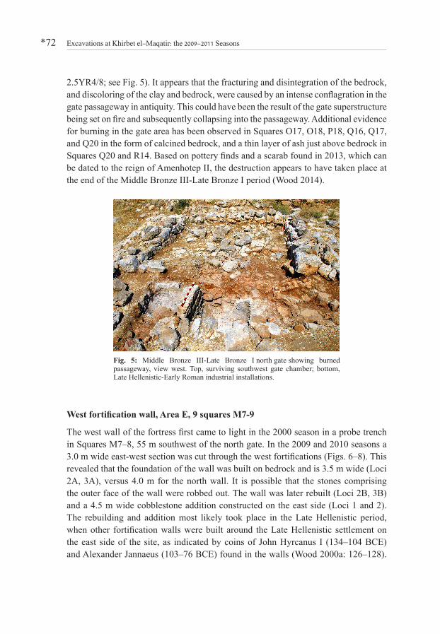
2.5YR4/8; see Fig. 5). It appears that the fracturing and disintegration of the bedrock, and discoloring of the clay and bedrock, were caused by an intense conflagration in the gate passageway in antiquity. This could have been the result of the gate superstructure being set on fire and subsequently collapsing into the passageway. Additional evidence for burning in the gate area has been observed in Squares O17, O18, P18, Q16, Q17, and Q20 in the form of calcined bedrock, and a thin layer of ash just above bedrock in Squares Q20 and R14. Based on pottery finds and a scarab found in 2013, which can be dated to the reign of Amenhotep II, the destruction appears to have taken place at the end of the Middle Bronze III-Late Bronze I period (Wood 2014).
West fortification wall, Area E, 9 squares M7-9
The west wall of the fortress first came to light in the 2000 season in a probe trench in Squares M7–8, 55 m southwest of the north gate. In the 2009 and 2010 seasons a 3.0 m wide east-west section was cut through the west fortifications (Figs. 6–8). This revealed that the foundation of the wall was built on bedrock and is 3.5 m wide (Loci 2A, 3A), versus 4.0 m for the north wall. It is possible that the stones comprising the outer face of the wall were robbed out. The wall was later rebuilt (Loci 2B, 3B) and a 4.5 m wide cobblestone addition constructed on the east side (Loci 1 and 2). The rebuilding and addition most likely took place in the Late Hellenistic period, when other fortification walls were built around the Late Hellenistic settlement on the east side of the site, as indicated by coins of John Hyrcanus I (134–104 BCE) and Alexander Jannaeus (103–76 BCE) found in the walls (Wood 2000a: 126–128).
Fig. 5: Middle Bronze III-Late Bronze I north gate showing burned passageway, view west. Top, surviving southwest gate chamber; bottom, Late Hellenistic-Early Roman industrial installations.
Gary A. Byers, D. Scott Stripling, and Bryant G. Wood *73
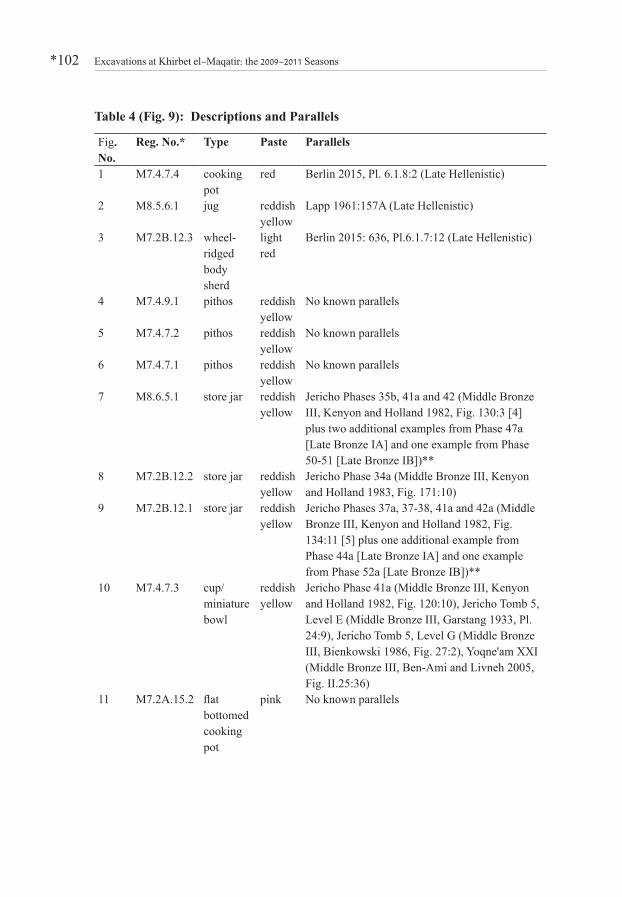
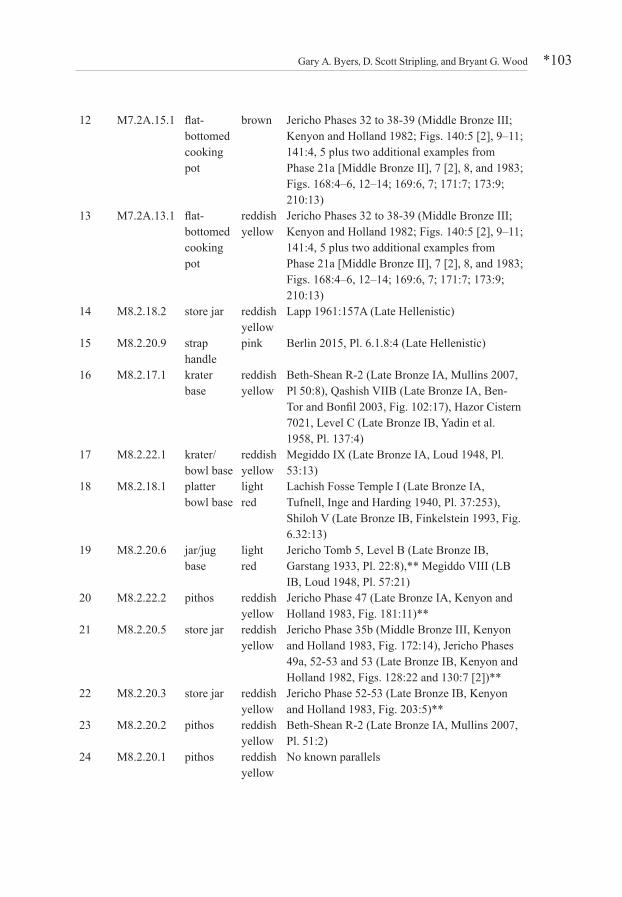
Diagnostic sherds from the various sections of the western fortifications are presented in Fig. 9; parallels for the pottery are given in Table 4.
The pottery found in M7 Locus 2A is Middle Bronze III in date (Figs. 9:11–13). Occasional Late Hellenistic sherds found in the rebuilt section of the west wall (M7 Locus 2B and M8 Locus 3B; Figs. 9:1-3) and newly-built addition (M8 Locus 2; Figs. 9:14, 15) support a Late Hellenistic dating of this construction. Of particular significance is the large amount of Late Bronze I pottery found in the rebuilt west wall and Late Hellenistic addition that was refired to a metallic hardness (Figs. 9:4–6, 16–30; see Joukowsky 1980: 368–649).2 The refiring was most likely a result of the conflagration in the fortress at the end of the Late Bronze I period. In some instances, the extreme heat resulted in the calcination and subsequent diffusion of the limestone inclusions into the clay matrix of the pottery, producing whitish areas on the surfaces
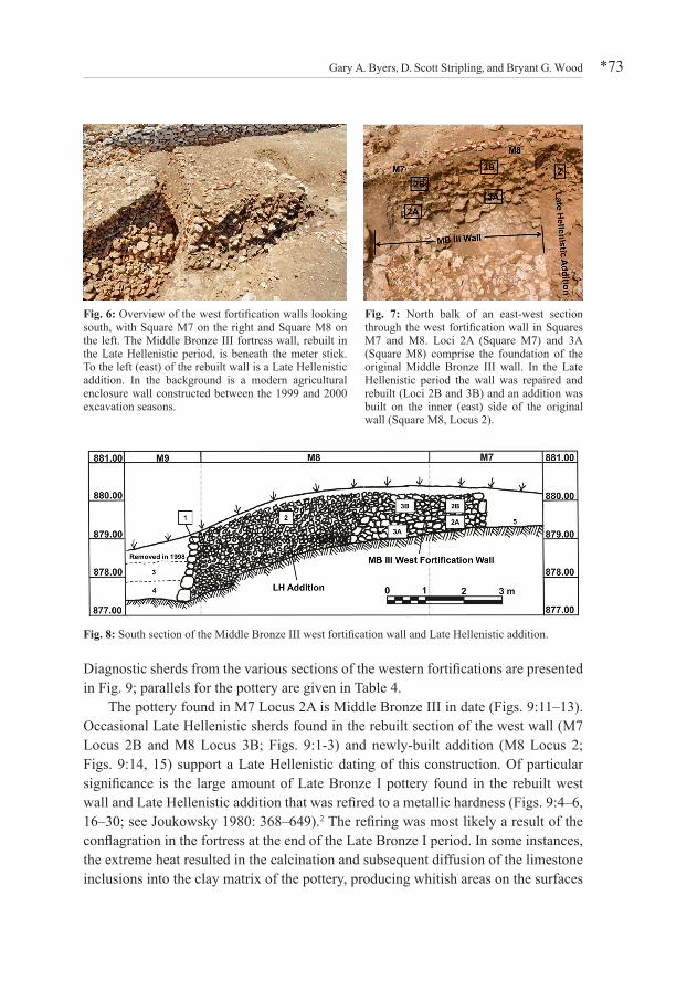
Fig. 6: Overview of the west fortification walls looking south, with Square M7 on the right and Square M8 on the left. The Middle Bronze III fortress wall, rebuilt in the Late Hellenistic period, is beneath the meter stick. To the left (east) of the rebuilt wall is a Late Hellenistic addition. In the background is a modern agricultural enclosure wall constructed between the 1999 and 2000 excavation seasons.
Fig. 7: North balk of an east-west section through the west fortification wall in Squares M7 and M8. Loci 2A (Square M7) and 3A (Square M8) comprise the foundation of the original Middle Bronze III wall. In the Late Hellenistic period the wall was repaired and rebuilt (Loci 2B and 3B) and an addition was built on the inner (east) side of the original wall (Square M8, Locus 2).
Fig. 8: South section of the Middle Bronze III west fortification wall and Late Hellenistic addition.

Excavations at Khirbet el-Maqatir: the 2009–2011 Seasons*74
of the sherds. The refired pottery is the pottery that was in the fortress at the time of the destruction, which subsequently became part of the fill of the Late Hellenistic rebuild of the west wall and the eastern Late Hellenistic addition. Similar refired Late Bronze IB pottery has been found throughout the site.
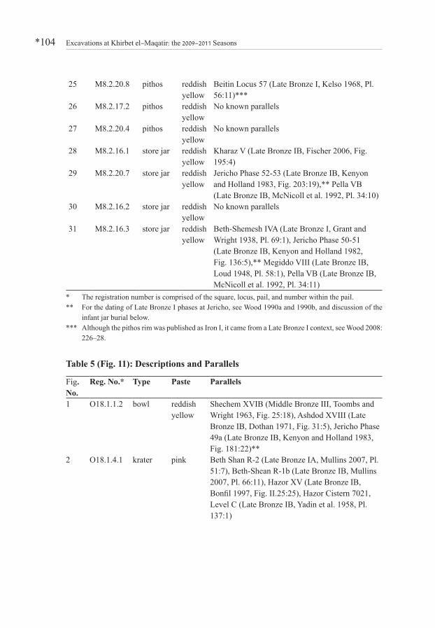
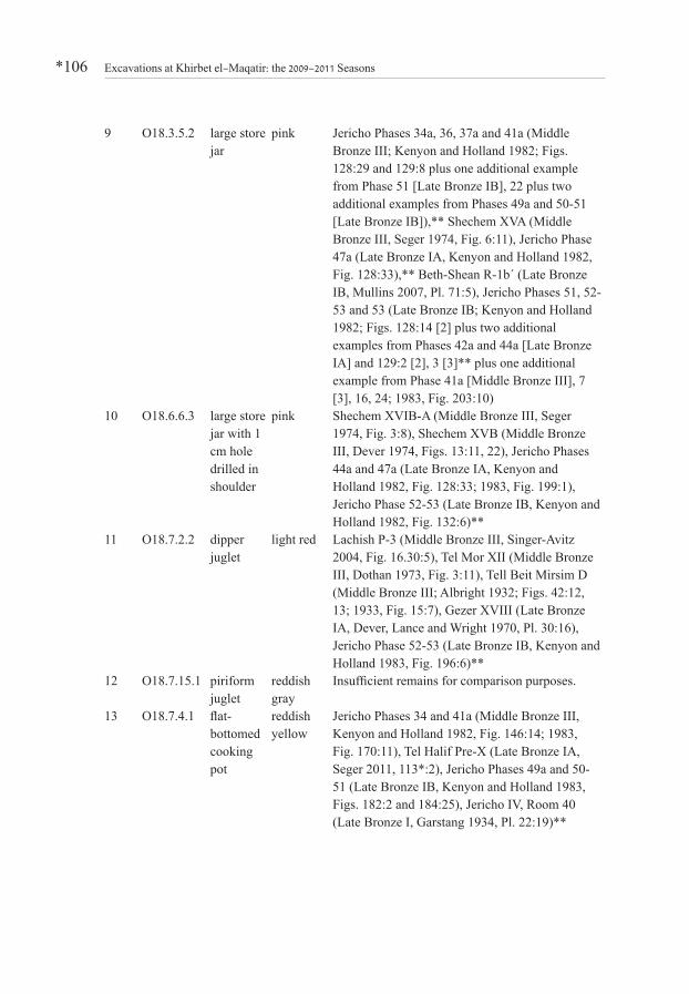
As can be seen from Fig. 9, pithoi, nos. 4–6, 20, 23–27, and store jars, nos. 7–9, 21, 22, 28–31, are prolific at Khirbet el-Maqatir in the fortress phase, as they were
Fig. 9: Middle Bronze III, Late Bronze I, and Late Hellenistic pottery from the west fortifications.

Gary A. Byers, D. Scott Stripling, and Bryant G. Wood *75
necessary to store provisions for the fortress. During the 1996–2000 seasons 137 pithos rims were registered, and in the 2009–2011 campaigns another 54 were added. There was no standardization for the rim form of the pithoi. In most cases the stance is vertical, however inverted, Figs. 9:4, 5, or everted, Fig. 9:20, types are also common. The rim form was not heavily profiled as in the earlier Middle Bronze period. It is sometimes plain (Figs. 9:6, 27), but more often folded to form a rounded (Figs. 9:24, 26) or flat (Fig. 9:25) contour. Necks are generally longer than those of early Middle Bronze and Iron Age I varieties. The join (the so-called "collar") between the upper, wheel-made, rim, neck, and upper shoulder, and the hand-made body is well down on the shoulder rather than at the base of the neck as is the case in the early Middle Bronze and Iron I periods. Good parallels for the store jars, Figs. 9:21, 22, 28, 29, 31, are found in Late Bronze I contexts at a number of sites.
Infant jar burial, Area D, Square O18A number of poorly-preserved stone walls one course high, founded on bedrock, were found in the 1997 and 2000 seasons in Squares P17, P18, and P19 (Fig. 10). The soil in this area is extremely shallow, from no soil to ca. 50 cm, and badly disturbed. As a result, no related foundation trenches or floors have survived. Square O18 was excavated in 2009 in order to further clarify the nature of the structure. Two additional walls were found in Square O18. In the northeast corner of the square an infant jar burial was discovered on the north side of one of the walls. Since the walls are approximately parallel to the surviving gate chamber walls, they appear to be related to the fortress phase. The pottery found in Square O18 and the typology of the jar burial support this conclusion.
The field readings for the pottery found in Square O18, from disturbed contexts apart from the jar burial, were: 26 Middle Bronze III-Late Bronze I, seven Iron I, ten Late Hellenistic-Early Roman, one Byzantine, and one Arab. Thus, there was considerable activity in this area following the destruction of the
Fig. 10: Plan of Middle Bronze III-Late Bronze I north gate and residency showing the location of the infant jar burial.
Excavations at Khirbet el-Maqatir: the 2009–2011 Seasons*76
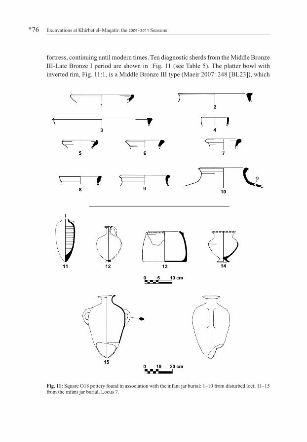
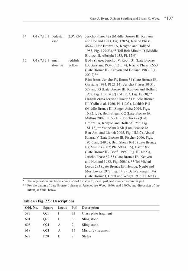
fortress, continuing until modern times. Ten diagnostic sherds from the Middle Bronze III-Late Bronze I period are shown in Fig. 11 (see Table 5). The platter bowl with inverted rim, Fig. 11:1, is a Middle Bronze III type (Maeir 2007: 248 [BL23]), which
Fig. 11: Square O18 pottery found in association with the infant jar burial: 1–10 from disturbed loci; 11–15 from the infant jar burial, Locus 7.
Gary A. Byers, D. Scott Stripling, and Bryant G. Wood *77
continues into Late Bronze I (Bonfil 2003: 278 [BIIIa]; Mullins 2007: 409 [BL6d]). The thickened-rim kraters, Figs. 11:2 and 3, are of the "necked carinated" type most popular in Late Bronze I (Mullins 2007: 420 [KR2]) and forerunner of the common T-rim krater of the Late Bronze II period. The small bowl/cup shown in Fig. 11:4 was in use in the Middle Bronze period (Ben-Ami and Livneh 2005: 260 [CIVb]), but continued into Late Bronze I as evidenced by examples from Jericho and Yoqne'am. Attested examples of the gutter-rim jar/jug (Mullins 2007: 426 [CV1e]), Fig. 11:5, come from Middle Bronze III-Late Bronze I levels. Parallels for the store jars, Figs. 11:6–10, come mainly from the Late Bronze I period.
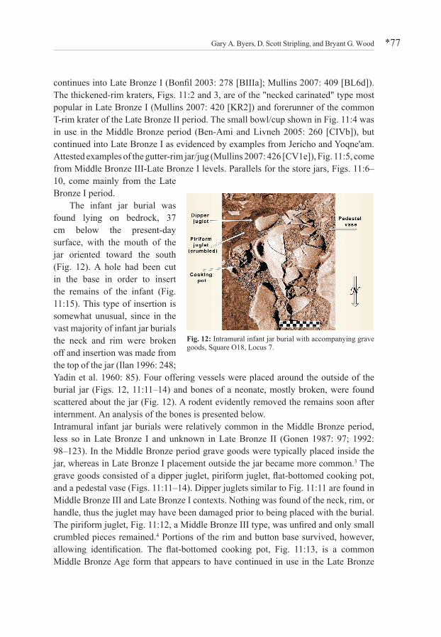
The infant jar burial was found lying on bedrock, 37 cm below the present-day surface, with the mouth of the jar oriented toward the south (Fig. 12). A hole had been cut in the base in order to insert the remains of the infant (Fig. 11:15). This type of insertion is somewhat unusual, since in the vast majority of infant jar burials the neck and rim were broken off and insertion was made from the top of the jar (Ilan 1996: 248; Yadin et al. 1960: 85). Four offering vessels were placed around the outside of the burial jar (Figs. 12, 11:11–14) and bones of a neonate, mostly broken, were found scattered about the jar (Fig. 12). A rodent evidently removed the remains soon after internment. An analysis of the bones is presented below.Intramural infant jar burials were relatively common in the Middle Bronze period, less so in Late Bronze I and unknown in Late Bronze II (Gonen 1987: 97; 1992: 98–123). In the Middle Bronze period grave goods were typically placed inside the jar, whereas in Late Bronze I placement outside the jar became more common.3 The grave goods consisted of a dipper juglet, piriform juglet, flat-bottomed cooking pot, and a pedestal vase (Figs. 11:11–14). Dipper juglets similar to Fig. 11:11 are found in Middle Bronze III and Late Bronze I contexts. Nothing was found of the neck, rim, or handle, thus the juglet may have been damaged prior to being placed with the burial. The piriform juglet, Fig. 11:12, a Middle Bronze III type, was unfired and only small crumbled pieces remained.4 Portions of the rim and button base survived, however, allowing identification. The flat-bottomed cooking pot, Fig. 11:13, is a common Middle Bronze Age form that appears to have continued in use in the Late Bronze
Fig. 12: Intramural infant jar burial with accompanying grave goods, Square O18, Locus 7.
Excavations at Khirbet el-Maqatir: the 2009–2011 Seasons*78
I period (see examples in Fig. 11 parallels). The pedestal vase (unfired), Fig. 11:14, another Middle Bronze III form, was set in an upright position; consequently the top of the vessel was destroyed by later activity. Nothing remained of the neck or rim. The burial store jar, Fig. 11:15, is a Late Bronze I type with tapered lower body and pointed base (Tufnell 1958: 220), elliptical handle cross-section and everted folded rim. The best parallel is the infant burial jar found beneath the floor of Room 31 in the Jericho "Palace Store Rooms." As in our burial, the bottom of the jar had been cut to allow insertion of the remains from the bottom (Garstang 1934, Pl. 21:14). Diagnostic Late Bronze I pottery found in adjacent rooms indicates that the final phase of Jericho City IV/"Palace Store Rooms" should be dated to the Late Bronze I period (Garstang 1934: bowls with interior concentric circles, Pls. 27:9 and 29:13; everted-rim cooking pot, Pl. 24:17; biconical jugs, Pls. 22:11, 24:4, and 28:5; and squat jars [Mullins 2007: 436–438, Type BV3], Pls. 24:6 and 25:5). Although the grave goods associated with the Khirbet el-Maqatir jar burial are Middle Bronze III-Late Bronze I in date, the context and typology of the burial tends toward Late Bronze I, and the jar itself is a Late Bronze I type. Therefore, the interment should be dated at the end of the Middle Bronze or beginning of the Late Bronze Period, ca. 1500 BCE.
The two juglets, perhaps originally containing liquids (Ilan 1996: 248), are in keeping with traditional practice as they are the most common vessels to be found with infant jar burials.5 The flat-bottomed cooking pot and pedestal vase, on the other hand, are non-traditional and unique to infant jar burials.6 They might have held foodstuffs. The pedestal vase was an expensive, finely-made item of tableware, suggesting an elite status for the residents of the building.
The striking aspect of the Khirbet el-Maqatir infant jar burial is that it was found in a remote, isolated border fortress rather than in an urban setting as is normally the case.7 It has many of the characteristic features of an urban intramural infant jar burial, such as the use of juglets as grave goods. This may be indicative of some indispensable element of the burial rite that required juglets, such as libation offerings or certain liquids that accompanied the dead. The use of a flat-bottomed cooking pot and pedestal vase as grave goods, however, represents a departure from the norm and may be the result of the unique setting of the Khirbet el-Maqatir burial.
The burial also provides a number of sociological insights. It indicates that at least some of the personnel at Khirbet el-Maqatir were allowed to have their families with them while on duty at this out-of-way location. In addition, when a family was living at a location other than their ancestral home, with all of its ties to the traditions of family, tribe, village/urban center and cult, it seems to have been socially acceptable to bury an infant family member at the provisional residence. Moreover, the necessary cultic requirements for an infant burial, whatever they might have been, must also have been available to the family at Khirbet el-Maqatir.

Gary A. Byers, D. Scott Stripling, and Bryant G. Wood *79
An Anthropological Examination of the Infant Skeletal Remains from Khirbet el-Maqatir
Marina Faerman
The skeletal remains of an infant were recovered from the vicinity of a burial jar (Fig. 13). The skull and teeth were absent and none of the postcranial bones was complete. All long bones were present except for the right humerus. The skeletal remains included almost complete right and left femora, the left humerus, shafts of both tibiae and of the right fibula, and two fragments of the left fibula. Of the forearm bones, the left ulna and radius were represented by their shafts with the intact proximal ends, while only fragments of the right ulna and radius were present. Hand bones included a metacarpal bone and a proximal phalanx. In addition, fragmentary right clavicle and right scapula were identified together with rib fragments and half arches of two thoracic and two lumbar vertebrae. No pathology was observed in the examined bones, but the skeleton was incomplete with no skull and the bones had been damaged postmortem.
Based on the size of the bones and bone fragments, the skeletal remains were attributed to a single individual—a young infant. The infant's stature was calculated from the maximal length of the almost complete right femur, which measured 71.7 mm. Application of the regression equation of Palkama, Virtama and Telkka (1962) for children under one year of age produces a stature of 50.6 cm. This value is compatible with that of a newborn.
The length of the Khirbet el-Maqatir femur was compared to the maximum length of the diaphysis of a femur at ten lunar months, as reported by Fazekas and Kósa (1978). Although the mean value of 74.3 mm is slightly higher than the length of the Khirbet el-Maqatir femur, the latter falls well within the variation observed (69.0–78.7 mm). However, when the 71.7 mm estimate is compared with femoral lengths of 51 neonates from the Late Roman-Early Byzantine Ashkelon (Smith and Kahila 1992), it slightly exceeds the 70.9 mm average, but remains well within the variation range. Thus, the Khirbet el-Maqatir femur compares favorably with local archaeological specimens of neonates.
Fig. 13: Skeletal remains of a neonate found scattered about the Square O18 burial jar. (Photo by Nathan Lundquist)

Excavations at Khirbet el-Maqatir: the 2009–2011 Seasons*80
Canaanite stele, Area F, Square C17
Another significant find in 2009 was in Square C17, close to the proposed location of the south wall of the fortress (Fig. 3). There, what is possibly the remains of a limestone stela, Object 572, was found embedded in a cobblestone matrix, most likely wall collapse, with its top just visible on the surface. A pictorial representation was carved in raised relief on the front surface, but extensive weathering rendered the image illegible (Fig. 14; Kennedy 2011). This may be the third indigenous Bronze Age stela to be found in the southern Levant and it is the largest of the three (Fig. 15).
Early Roman First Century CE House, Areas B and G, Squares PQ20-21The ruins of a small community ca. 4.5 dunams in size, first noted by Victor Guérin in 1863 (1869: 57), are located at the northeast corner of the site. A ritual bath (Wood 2001: 250–52), stone vessels, coins, and ceramic evidence suggest an Early Roman date. The southwest corner of these ruins consisted of a large mound of stones—some from the structures which once stood there, others piled about the ruins as adjacent fields were cleared for plowing. By the end of the 2011 season two complete connected rooms had emerged from beneath the rubble in Squares PQ20–21, dubbed the "First-Century House."
Fig. 14: Front and side of the Obj. 572 stela found in Square C17.
Fig. 15: Canaanite stelae found in the southern Levant: 1. Kh. el-Maqatir, limestone, 15th century BCE; 2. Tell Beit Mirsim, limestone, Stratum D, 16th century BCE (Merhav 1985, Pl. III:2); 3. Hazor, basalt, Stratum 1-a, 13th century BCE (after Yadin et al. 1958, Pl. 29:2).

Gary A. Byers, D. Scott Stripling, and Bryant G. Wood *81
Construction
While Bronze and Iron Age domestic architecture in Palestine frequently included stone foundations and a mudbrick superstructure, beginning with the Hellenistic period, dwellings built entirely of stone became increasingly common in the region (Hirschfeld 1995: 218). At Khirbet el-Maqatir, dwellings of all periods were constructed without mudbricks, as were the two complete and one partial rooms of the First Century House. Founded on bedrock or, in a few places, directly above earlier stone construction (Fig. 16), the east walls of both rooms were essentially one-stone wide—no doubt representing internal walls. North, south, and west walls—presumably external—were two rows wide. All were constructed with a combination of large hammered stones (many "two-man" sized—predominantly at corners and openings) and fieldstones (i.e., cobble and small boulder size). Unlike fencing walls and agricultural terraces, stone house walls in Roman Palestine were not dry-laid without mortar (Reich 1992: 3, 20). Lime mortar was known in the region since the fourth century BCE, but mortar of clay and water (and sometimes straw) was typical of most house construction (Hirschfeld 1995: 222–23). Evidence of mud mortar was commonly found between stones in the First Century House.
Plastering the face of walls kept mortar dry and walls stable, and could be aesthetically pleasing (Homsher 2012: 2–3). While harder lime wall plaster was also known in the region by the Hellenistic period (Hirschfeld 1995: 226), there is no evidence of such on exterior or interior First-Century House walls. Mud plaster—of similar ingredients as the mortar (Homsher 2012: 2-3)—is presumed for this house, but it too has been washed away.
Fig. 16: Two connected rooms in the First-Century CE House, view south (photograph Mike Luddeni).
Excavations at Khirbet el-Maqatir: the 2009–2011 Seasons*82
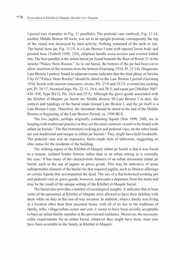
Room A
The larger northern Room A (Fig. 17) has interior dimensions of 3.5 x 7.0 m, with an entrance in its southeast corner (southern end of interior Wall 1). The wider two-stone (1 m) northern Wall 2 and western Wall 3 presumably represent the exterior of both the room and the entire structure. Based on its location at the southwest edge of the Roman-era settlement, western Wall 3 of the First Century House (ca. 1.5 m in situ height) may also represent the settlement's western edge.
Abutting the northern (exterior) face of Room A's Wall 2 is a lower wall (i.e., Wall 4). The precise relationship between the two walls is still unclear, although Wall 4 may represent a bench-like installation. The nature of Locus H (north) and its relationship to both walls is also uncertain, but it is understood as external to the First-Century House.
Eastern Wall 1 is essentially one stone wide (ca. 70 cm)—an interior wall—and connects Room A with Locus C through a 1 m wide doorway at its southern end. The only suggestion of roofing material for Room A is a single ceramic tile fragment found outside the structure (Locus H). By the first century BCE, pitched roofs of ceramic tiles began to be used for public buildings and wealthy homes in the region (cf. Hirschfeld 1995: 222, 243). But the builders of Room A likely utilized the region's typical flat roof wattle-and-daub construction style (mud and branches over wooden beams; cf. Hirschfeld 1995: 237–39; Magness 2011: 13).
Few architectural features were identified within Room A. Abutting the interior face of Wall 3, in the southwest corner, was a 50 cm high stone-built bench. Three consecutive flat stone slabs at the room's northeastern end possibly represent paving—at least in that area of the room. Roofed rooms tended to be unpaved and this room's 3.5 m width was within the maximum spanning distance of wooden roof beams
Fig. 17: Plan of First-Century CE House in Squares PQ20-21.

Gary A. Byers, D. Scott Stripling, and Bryant G. Wood *83
(Reich 1992: 10; Netzer 1992: 24). Thus, Room A is understood as a roofed room with a beaten earth floor typical of the region throughout antiquity (Reich 1992: 16).
Room B
Southwest of Room A is Room B with interior dimensions of 3.0 x 2.0 m. Western Wall 5 is the southern extension of Room A's exterior Wall 3—two-stones (ca. 1.0 m) wide. At the room's southwest corner, Wall 5 joins southern Wall 6, the widest in the dwelling—two stones (ca. 1.25 m) wide—also an exterior wall. Surface remains and present terrain suggest Wall 6 may also represent the southern extent of the Roman-era settlement.
Eastern Wall 7 bonded with southern Wall 6 on the south and Wall 1 on the north. The dog-leg connection of one-stone-wide interior Walls 1 and 6 suggests a difference in roof levels between these two rooms. But similar to Room A, this room had a beaten earth floor, and probably wattle-and-daub roofing.
Separating Rooms A and B is Wall 8. Built of field stones and hammered stone slabs, its fenestrated construction made Wall 8 unique to the dwelling (and site) thus far (Figs. 18, 19). The only access to Room B was through a central, low (1.5 m high) doorway
Fig. 19: Elevation of the fenestrated wall separating Rooms A and B in the First-Century CE House, view south.
Fig. 18: Smaller Room B (domestic stable) in the First-Century CE House, view north (photograph Mike Luddeni).
Excavations at Khirbet el-Maqatir: the 2009–2011 Seasons*84
in Wall 8 with an in situ lintel. Flanked by windows on each side, the eastern window's lintel was also in situ, while the western window lintel was found in debris on the floor.
Not as common in the central hills, this interior "window wall" was a common feature of Roman and Byzantine houses across Palestine (known from sites in the Hauran, Golan, Galilee, northern coast by Mt. Carmel, Hebron Hills, and Negev: see Hirschfeld 1995: 68–72, 267–68; Figs. 43, 44, 195, 196; and Magness 2011: 14, Fig. 21). But the fenestrated wall does continue a local domestic architectural tradition dating back to the pillared houses of the Iron Age (Horowitz 1980: 108–109; Stager 1985: 11–17; Mazar 1990: 485–86; Hirschfeld 1995: 22–23) and is frequently associated with domestic stables (Stager 1985: 11–17; Hirschfeld 1995: 259–60; Ritmeyer 2012). The diminished dimensions of Room B and its probable lower roof level also support this function. Wall 8 may represent an architectural answer to Halakhic Law's demand for ritual separation between man and beast within domestic confines (Tosefta Ohalot 14: 2; Palestinian Talmud Eruvin 7, 24b; see Hirschfeld 1995: 259, 267).
Room G
East of Room B—separated by Wall 7—is Room G. Measuring 3.0 m wide on its west side, where the wall and foundation are still standing, Room G is bounded by the fragmentary one-stone (ca. 50 cm) wide Wall 11 (north) and two-stone (ca. 1.25 m) wide exterior Wall 9 (south)—the eastern extension of Room B's Wall 6. Room G has only been excavated ca. 5 m to the east, with no evidence of its eastern wall yet identified.
While an unusual location—in a corner—a possible doorway in fragmentary Wall 11 opened between Room G and Courtyard C. Virtually the same width as Room B (ca. 3.0 m), the roof of this space would seem to be similar to that of Room B. A single basalt opus sectile paving stone was found in debris inside Room G, but a floor has not yet been reached. While the purpose of this room is still unclear, its location at the southern extremity of the dwelling helps clarify the house's overall plan.
Courtyard CWhile Courtyard C has not been clearly defined, it has some perimeters. It was entered through the doorway (Wall 1) from Room A on the west and possibly a doorway in Wall 11 to the north. Fragmentary Wall 10 (40 cm and one stone wide), possibly bonded to Wall 11 on the north, may be part of an installation. Along its western face, above a beaten earth floor, was an ashy area with a number of charred storage jar and cooking pot sherds (Fig. 20:4–8).
Gary A. Byers, D. Scott Stripling, and Bryant G. Wood *85
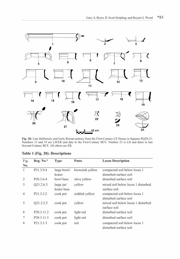
Table 1 (Fig. 20): Descriptions
Fig. No.
Reg. No.* Type Paste Locus Description
1 P21.3.9.4 large bowl/krater
brownish yellow compacted soil below locus 1 disturbed surface soil
2 P20.3.6.4 bowl base olive yellow disturbed surface soil3 Q21.2.6.3 large jar/
krater baseyellow mixed soil below locus 1 disturbed
surface soil4 P21.3.3.2 cook pot reddish yellow compacted soil below locus 1
disturbed surface soil5 Q21.2.2.5 cook pot yellow mixed soil below locus 1 disturbed
surface soil6 P20.3.11.2 cook pot light red disturbed surface soil7 P20.3.11.3 cook pot light red disturbed surface soil8 P21.3.3.3 cook pot red compacted soil below locus 1
disturbed surface soil
Fig. 20: Late Hellenistic and Early Roman pottery from the First-Century CE House in Squares PQ20-21: Numbers 13 and 19 are LH/ER and date to the First-Century BCE. Number 23 is LH and dates to late Second-Century BCE. All others are ER.
Excavations at Khirbet el-Maqatir: the 2009–2011 Seasons*86
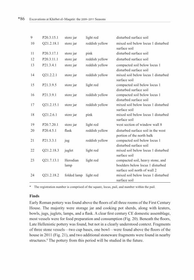
9 P20.3.15.1 store jar light red disturbed surface soil10 Q21.2.18.1 store jar reddish yellow mixed soil below locus 1 disturbed
surface soil11 P20.3.17.1 store jar pink disturbed surface soil12 P20.3.11.1 store jar reddish yellow disturbed surface soil13 P21.3.4.1 store jar reddish yellow compacted soil below locus 1
disturbed surface soil14 Q21.2.2.1 store jar reddish yellow mixed soil below locus 1 disturbed
surface soil15 P21.3.9.5 store jar light red compacted soil below locus 1
disturbed surface soil16 P21.3.9.1 store jar reddish yellow compacted soil below locus 1
disturbed surface soil17 Q21.2.15.1 store jar reddish yellow mixed soil below locus 1 disturbed
surface soil18 Q21.2.6.1 store jar pink mixed soil below locus 1 disturbed
surface soil19 P20.7.20.1 store jar light red west section of window wall 820 P20.4.5.1 flask reddish yellow disturbed surface soil in the west
portion of the north balk21 P21.3.3.1 jug reddish yellow compacted soil below locus 1
disturbed surface soil22 Q21.2.18.3 juglet light red mixed soil below locus 1 disturbed
surface soil23 Q21.7.13.1 Herodian
lamplight red compacted soil, heavy stone, and
boulders below locus 1 disturbed surface soil north of wall 2
24 Q21.2.18.2 folded lamp light red mixed soil below locus 1 disturbed surface soil
* The registration number is comprised of the square, locus, pail, and number within the pail.
FindsEarly Roman pottery was found above the floors of all three rooms of the First Century House. The majority were storage jar and cooking pot sherds, along with kraters, bowls, jugs, juglets, lamps, and a flask. A clear first century CE domestic assemblage, most vessels were for food preparation and consumption (Fig. 20). Beneath the floors, Late Hellenistic pottery was found, but not in a clearly understood context. Fragments of three stone vessels—two cup bases, one bowl—were found above the floors of the house in 2011 (Fig. 21), and two additional stoneware fragments were found in nearby structures.8 The pottery from this period will be studied in the future.

Gary A. Byers, D. Scott Stripling, and Bryant G. Wood *87
Table 2 (Fig. 21): DescriptionsFig. No. Object No. Type Square Locus Pail1 632 cup Q21 1 142 651 cup P21 3 33 655 bowl P21 2 64 844 cup P26 3 25 845 krater S24-25 6 9
Also found in debris above the floor levels of the First Century House were stone tools (flint pounders and scrapers, basalt grindstone, polishing stone and additional worked stones of unknown purpose), metal tools (bronze stylus and nail), and fragments of Roman glass (Fig. 22; Table 6). Three bronze coins came from the same context—one unreadable, another minted by Porcius Festus (Year 5 of Nero=58/59 CE), and the third was a First Revolt coin (Year 2=67/68 CE).
With at least one ritual bath, multiple stone vessel fragments, first century CE pottery and coins, Khirbet el-Maqatir appears similar to many other Early Roman communities in the territory of Benjamin, north of Jerusalem (Magen 1994: 244, 255). It is located just 7 km north of a large Early Roman stoneware quarry and workshop excavated near the modern village of Hizma (Magen 1994: 244–254).
Fig. 21: Chalkstone vessels excavated in 2011: 1–3 from the First-Century CE House; 4, 5 from nearby houses.
Fig. 22: Objects from the First-Century CE House.
Excavations at Khirbet el-Maqatir: the 2009–2011 Seasons*88
Discussion
Open-air courtyards were key elements of domestic architecture in Roman Palestine and provide a basis for categorizing houses today (see Horowitz 1980: 108–109). Hirschfeld (1995: 21–22) divided them by floor plan, based on their unroofed courtyards: 1) "simple houses" with rooms around one or two sides of the courtyard; 2) "complex houses" with rooms around three sides; 3) true "courtyard houses" with rooms on all four sides of a central courtyard.
In the current case, the courtyard—the house's main activity center (Hirschfeld 1995: 250, 272)—is presumably Locus C, first suggested by architect Leen Ritmeyer (2012). Rooms A and B would represent the western wing of an open courtyard house. Along with Room G on the south, there are rooms on at least two sides of the courtyard.
The entrance to the First Century House was probably located on the north side of courtyard C, east of Room A's Wall 2. Based on the 2011 excavation season, the structure appears to be a typical Early Roman courtyard house—common in the region during the first century CE. Aside from the excavated western and southern sides, additional rooms may have also been constructed around one or two other sides of the central courtyard.
Byzantine phase – Field C monastery
Background
At 888 m above sea level, the basilica-style church and coenobium monastery at Khirbet el-Maqatir is one of the highest ecclesiastical structures in elevation in Palestine. The numismatic evidence indicates that the church was built in the late fourth century and likely remained in use, with various repairs and remodeling, until the devastating earthquake of 749 CE. In 1838, the famous American explorer Edward Robinson was the first to record a visit to Khirbet el-Maqatir. He investigated the church and noted that it was larger than the one at nearby Burj Beitin (1841: 126). Twenty-five years later, in 1863, Victor Guérin paced off the dimensions of the church (1869: 56–57). In 1866, Captain Charles Wilson visited the site and took accurate measurements that have been borne out by recent excavation (1869–1870). Only eight years later (1874) Conder and Kitchener, in their Survey of Western Palestine, verified Wilson's measurements and diagrammed the entire complex (1882: 353). In 1882 William Thomson also noted the remains of the ecclesiastical structure, essentially echoing the observations of his predecessors (1882: 94–95). Then followed visits by Sellin (1900: 1), Baumann (1911: 124), and Sternberg (1915: 16–18). A.M. Schneider provided a detailed description and plan of the ruins as they appeared in his day (1934: 189–190, Plan 4). In 1998–1999 Leen Ritmeyer surveyed the complex on
Gary A. Byers, D. Scott Stripling, and Bryant G. Wood *89
behalf of Associates for Biblical Research (ABR). Concomitant with the survey, ABR executed several probes. Systematic excavation of the church and monastery began in December 2010. Seven 6 x 6 m squares and a 3 x 4 m probe trench were excavated in December 2010, May-June 2011, and December 2011.
Architecture
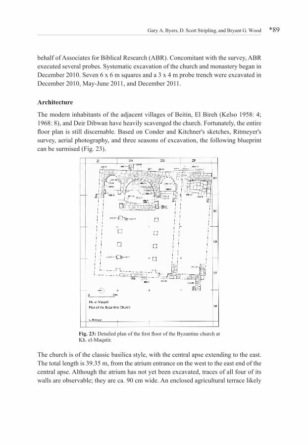
The modern inhabitants of the adjacent villages of Beitin, El Bireh (Kelso 1958: 4; 1968: 8), and Deir Dibwan have heavily scavenged the church. Fortunately, the entire floor plan is still discernable. Based on Conder and Kitchner's sketches, Ritmeyer's survey, aerial photography, and three seasons of excavation, the following blueprint can be surmised (Fig. 23).
The church is of the classic basilica style, with the central apse extending to the east. The total length is 39.35 m, from the atrium entrance on the west to the east end of the central apse. Although the atrium has not yet been excavated, traces of all four of its walls are observable; they are ca. 90 cm wide. An enclosed agricultural terrace likely
Fig. 23: Detailed plan of the first floor of the Byzantine church at Kh. el-Maqatir.
Excavations at Khirbet el-Maqatir: the 2009–2011 Seasons*90
ran the length of the structure on the north. The northeast corner of the church has been badly damaged. The nave is 6 m wide, and the aisles 3 m wide.
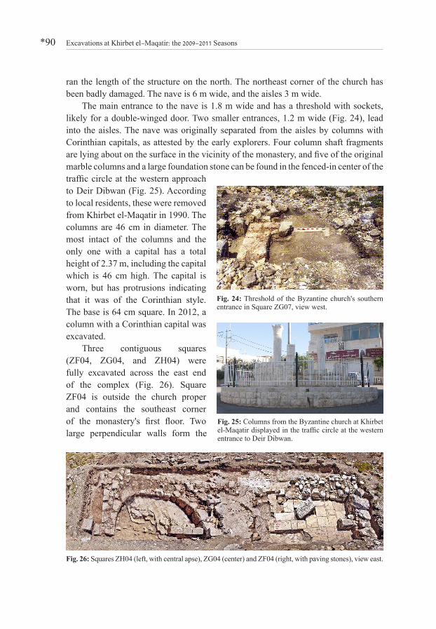
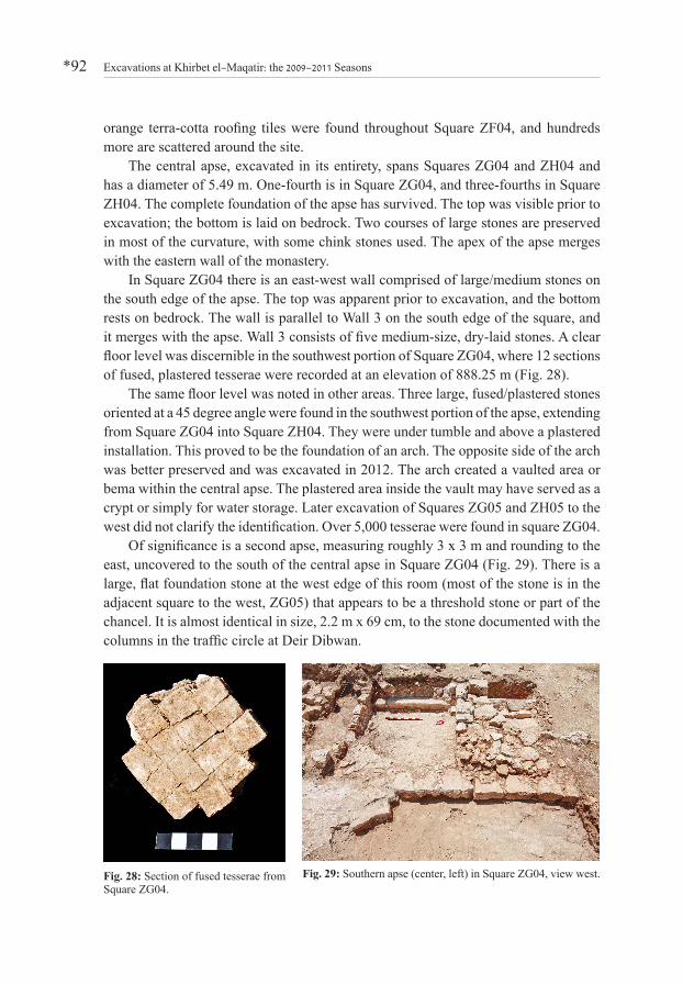
The main entrance to the nave is 1.8 m wide and has a threshold with sockets, likely for a double-winged door. Two smaller entrances, 1.2 m wide (Fig. 24), lead into the aisles. The nave was originally separated from the aisles by columns with Corinthian capitals, as attested by the early explorers. Four column shaft fragments are lying about on the surface in the vicinity of the monastery, and five of the original marble columns and a large foundation stone can be found in the fenced-in center of the traffic circle at the western approach to Deir Dibwan (Fig. 25). According to local residents, these were removed from Khirbet el-Maqatir in 1990. The columns are 46 cm in diameter. The most intact of the columns and the only one with a capital has a total height of 2.37 m, including the capital which is 46 cm high. The capital is worn, but has protrusions indicating that it was of the Corinthian style. The base is 64 cm square. In 2012, a column with a Corinthian capital was excavated.
Three contiguous squares (ZF04, ZG04, and ZH04) were fully excavated across the east end of the complex (Fig. 26). Square ZF04 is outside the church proper and contains the southeast corner of the monastery's first floor. Two large perpendicular walls form the
Fig. 24: Threshold of the Byzantine church's southern entrance in Square ZG07, view west.
Fig. 25: Columns from the Byzantine church at Khirbet el-Maqatir displayed in the traffic circle at the western entrance to Deir Dibwan.
Fig. 26: Squares ZH04 (left, with central apse), ZG04 (center) and ZF04 (right, with paving stones), view east.

Gary A. Byers, D. Scott Stripling, and Bryant G. Wood *91
southeast corner of the complex. East Wall 1 is the larger and better built of the two and sits on bedrock. It is 1.5 m wide and 81 cm high and has an outer face of large/medium limestones with a mixed matrix fill. It is 4.70 m long and continues to the northeast corner of the complex. Wall 2 on the south side of the square is 5.8 m long, its width is 70 cm, and its height is 1.1 m. It is built on bedrock and is abutted by a paved floor. It interlocks with Wall 1. The outer face is comprised of medium-size finished limestones, and the center is filled with a mixed matrix. It extends into Square ZF05 to the west and runs the entire east-west length of the complex. There is a 70 x 30 cm section of white plaster at the bottom of Wall 2 near the west end of the square. Four small fragments of red fresco and abundant plaster were found nearby, indicating that the north face of Wall 2 was once covered with plaster and finished with fresco.
Another small wall, 50 cm long, is in the center/west of the square; it runs parallel to the east wall. Unlike Walls 1 and 2, the small wall is built above the paving stones, indicating that it was likely built at a later time. It abuts Wall 2. Twenty-three paving stones in a good state of preservation are visible in Square ZF04 on ca. 10–15 cm of bedding plaster laid on bedrock. The average paving stone measures 70 x 45 cm and is made of white limestone. In the middle of the paved area there are several paving stones missing. The earth in this area yielded 14 pieces of a shell necklace/bracelet (Fig. 27). A 3.5 m north-south drainage channel is carved into bedrock just outside the east wall and runs to the north end of the square, where it comes to an end; another 90 cm portion was found in Square ZG04 to the north. This latter portion is formed by white plaster, rather than bedrock. The width varies from 10 to 38 cm, is ca. 8 cm in depth, and runs downhill from south to north. The highest elevation at the south end is 888.80 m, the midpoint is 888.71 m, and the low point at the north end is 888.59 m. Between Wall 2 and the south boundary of the square ca. 7,000 tesserae were found. They are mostly large and white. The hoard continues to the south in Square ZE04. This appears to be collapse from a second story floor. Dozens of pieces of
Fig. 27: Shell beads recovered from below the paved area in Square ZF04 in the southeast corner of the Byzantine church.
Excavations at Khirbet el-Maqatir: the 2009–2011 Seasons*92
orange terra-cotta roofing tiles were found throughout Square ZF04, and hundreds more are scattered around the site.
The central apse, excavated in its entirety, spans Squares ZG04 and ZH04 and has a diameter of 5.49 m. One-fourth is in Square ZG04, and three-fourths in Square ZH04. The complete foundation of the apse has survived. The top was visible prior to excavation; the bottom is laid on bedrock. Two courses of large stones are preserved in most of the curvature, with some chink stones used. The apex of the apse merges with the eastern wall of the monastery.
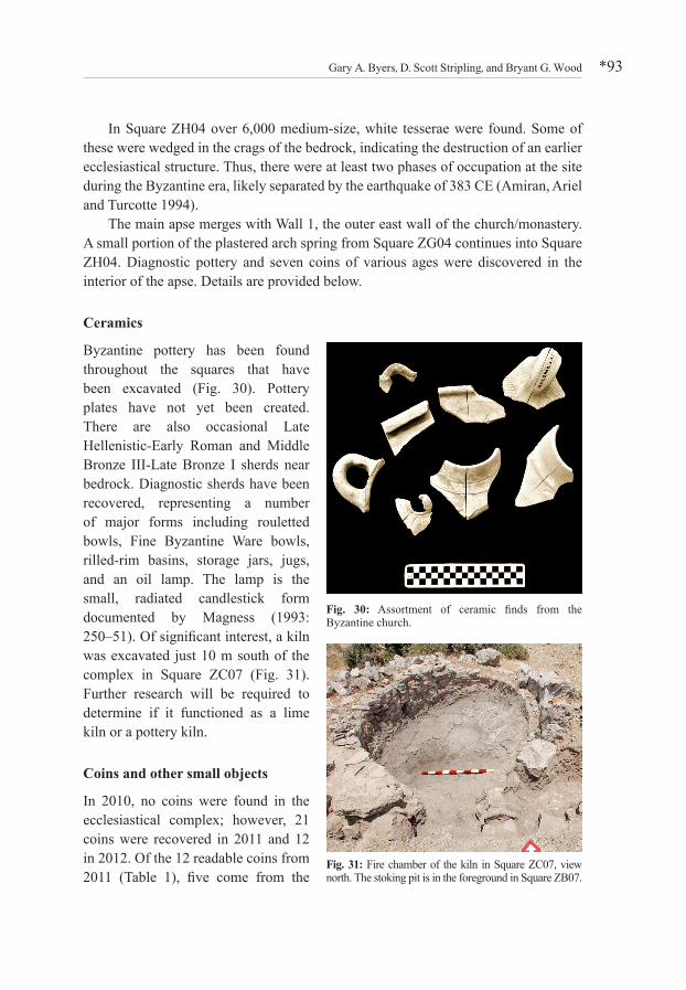
In Square ZG04 there is an east-west wall comprised of large/medium stones on the south edge of the apse. The top was apparent prior to excavation, and the bottom rests on bedrock. The wall is parallel to Wall 3 on the south edge of the square, and it merges with the apse. Wall 3 consists of five medium-size, dry-laid stones. A clear floor level was discernible in the southwest portion of Square ZG04, where 12 sections of fused, plastered tesserae were recorded at an elevation of 888.25 m (Fig. 28).
The same floor level was noted in other areas. Three large, fused/plastered stones oriented at a 45 degree angle were found in the southwest portion of the apse, extending from Square ZG04 into Square ZH04. They were under tumble and above a plastered installation. This proved to be the foundation of an arch. The opposite side of the arch was better preserved and was excavated in 2012. The arch created a vaulted area or bema within the central apse. The plastered area inside the vault may have served as a crypt or simply for water storage. Later excavation of Squares ZG05 and ZH05 to the west did not clarify the identification. Over 5,000 tesserae were found in square ZG04.
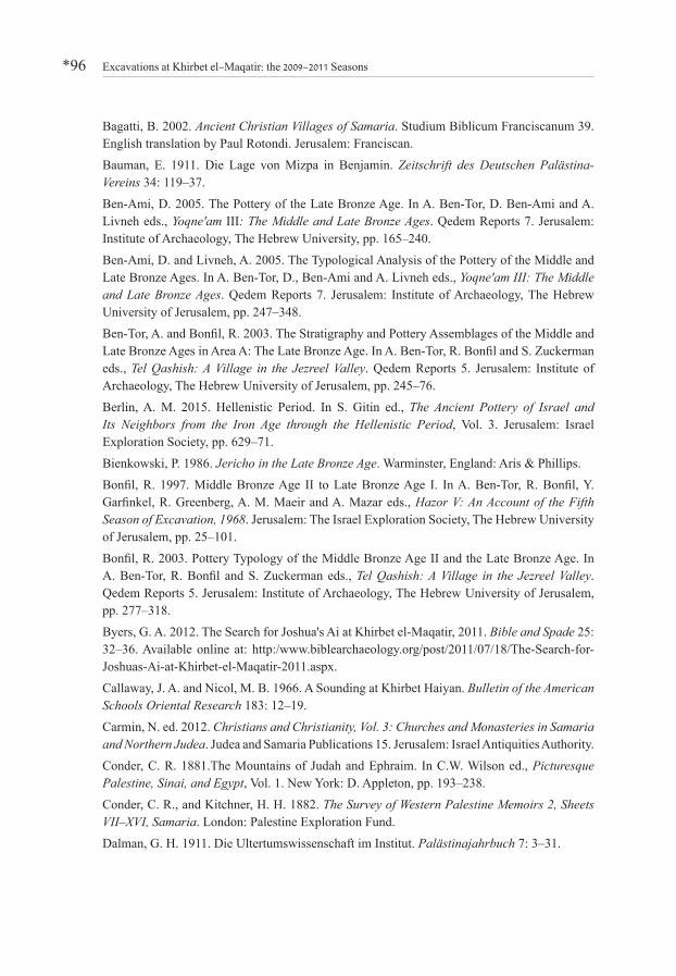
Of significance is a second apse, measuring roughly 3 x 3 m and rounding to the east, uncovered to the south of the central apse in Square ZG04 (Fig. 29). There is a large, flat foundation stone at the west edge of this room (most of the stone is in the adjacent square to the west, ZG05) that appears to be a threshold stone or part of the chancel. It is almost identical in size, 2.2 m x 69 cm, to the stone documented with the columns in the traffic circle at Deir Dibwan.
Fig. 28: Section of fused tesserae from Square ZG04.
Fig. 29: Southern apse (center, left) in Square ZG04, view west.
Gary A. Byers, D. Scott Stripling, and Bryant G. Wood *93
In Square ZH04 over 6,000 medium-size, white tesserae were found. Some of these were wedged in the crags of the bedrock, indicating the destruction of an earlier ecclesiastical structure. Thus, there were at least two phases of occupation at the site during the Byzantine era, likely separated by the earthquake of 383 CE (Amiran, Ariel and Turcotte 1994).
The main apse merges with Wall 1, the outer east wall of the church/monastery. A small portion of the plastered arch spring from Square ZG04 continues into Square ZH04. Diagnostic pottery and seven coins of various ages were discovered in the interior of the apse. Details are provided below.
Ceramics
Byzantine pottery has been found throughout the squares that have been excavated (Fig. 30). Pottery plates have not yet been created. There are also occasional Late Hellenistic-Early Roman and Middle Bronze III-Late Bronze I sherds near bedrock. Diagnostic sherds have been recovered, representing a number of major forms including rouletted bowls, Fine Byzantine Ware bowls, rilled-rim basins, storage jars, jugs, and an oil lamp. The lamp is the small, radiated candlestick form documented by Magness (1993: 250–51). Of significant interest, a kiln was excavated just 10 m south of the complex in Square ZC07 (Fig. 31). Further research will be required to determine if it functioned as a lime kiln or a pottery kiln.
Coins and other small objects
In 2010, no coins were found in the ecclesiastical complex; however, 21 coins were recovered in 2011 and 12 in 2012. Of the 12 readable coins from 2011 (Table 1), five come from the
Fig. 30: Assortment of ceramic finds from the Byzantine church.
Fig. 31: Fire chamber of the kiln in Square ZC07, view north. The stoking pit is in the foreground in Square ZB07.

Excavations at Khirbet el-Maqatir: the 2009–2011 Seasons*94
reign of Emperor Theodosius I (379–395 CE), making it clear that the church was established in the last quarter of the fourth century CE. Khirbet el-Maqatir numismatist Yoav Farhi identified numbers 645, 676, and 700 as the Vota type, dated 378–383 CE, and numbers 639 and 702 as the Salus Reilublicae type, dated to 383–395. Both types are common in fourth-fifth century CE contexts. All five Theodosius coins came from clean and contiguous loci from Squares ZH04 and ZH05 that mark the apse and bema area of the church.
Table 3: Coins Excavated in the Byzantine Church at Khirbet el-Maqatir, 2011 Object No. Ruler Date of Coin Square Locus Pail642 Ptolemy III Ca. 230–220 BCE ZH04 4 7641 John Hyrcanus I Ca. 25–103 BCE ZH04 4 7701 Hasmonean? Ca. 125–80? BCE ZH04 7 5703 Hasmonean? Ca. 125–80? BCE ZH06 8 6644 Alexander Jannaeus Ca. 80 BCE ZH04 4 7637 Agrippa I Year 6 = 41/42 CE ZF04 1 6639 Theodosius I 383–395 CE ZH04 1 6645 Theodosius I? 378–383? CE ZH04 4 6676 Theodosius I? 378–383? CE ZH04 5 4700 Theodosius I? 378–383? CE ZG05 9 6702 Theodosius I? 383–395? CE ZH04 5 4
As would be expected, Roman/Byzantine glass is abundant, including diagnostic pieces. Jewelry (Fig. 27), nails, and architectural fragments of cornices and capitals have been excavated.
Discussion
Byzantine Christians built a single apse church at Khirbet el-Maqatir in the mid fourth century CE. After only a few decades this church was destroyed, perhaps by the earthquake of 383 CE. In the late fourth or early fifth century CE, a tri-apsidal church was built from the ruins. Later in the late fifth century CE, a two-story monastery of the coenobium type was built around the basilica church (Fig. 32). Fig. 32: Isometric reconstruction of the Byzantine monastery
at Kh. el-Maqatir.

Gary A. Byers, D. Scott Stripling, and Bryant G. Wood *95
The Khirbet el-Maqatir church was one of many in the region (Carmin 2012). Many times Byzantine churches were built at a particular location to memorialize a biblical event that was thought to have occurred there. That is certainly possible at Khirbet el-Maqatir since its isolated location raises the question of the reason for building a church at this site. There were numerous other churches in nearby villages, such as Burg Beitin only 1.0 km northwest (Kelso 1958: 3; 1968: 53; Albright 1968: 2; Ovadiah and de Silva 1981: 208; Bagatti 2002: 33–34), Beitin 1.2 km northwest (Conder 1881: 219, 221; Kelso 1968: 7, 53; Ovadiah and de Silva 1981: 208; Bagatti 2002: 32–33), and Khirbet Haiyan 2.2 km southeast (Callaway and Nicol 1966, Bagatti 2002: 34–35).
In 2012, the westernmost portion of the complex was excavated, revealing the entry and a possible baptistery. In 2016, all in situ flooring will be removed in order to excavate the sealed loci beneath them. Hopefully, this will further clarify the occupational history of the ecclesiastical facility.
AcknowledgmentsThe authors wish to thank Mark Spigelman of the Hebrew University of Jerusalem for first identifying the bones found in the vicinity of the infant burial jar in Square O18 in 2009 as those of an infant less than six months old, and Marina Faerman of the Hebrew University for conducting a detailed anthropological examination of the skeletal remains.
ReferencesAlbright, W. F. 1932. The Excavation of Tell Beit Mirsim in Palestine, Vol. 1. Annual of the American Schools of Oriental Research 12. New Haven CT: American Schools of Oriental Research.
Albright, W. F. 1933. The Excavation of Tell Beit Mirsim in Palestine, Vol. 1A: The Bronze Age Pottery of the Fourth Campaign. Annual of the American Schools of Oriental Research 13. New Haven CT: American Schools of Oriental Research, pp. 55–127.
Albright, W. F. 1968. The Site of Bethel and its Identification. In J. L. Kelso ed., The Excavation of Bethel (1934–1960). Annual of the American Schools of Oriental Research 39. Cambridge MA: American Schools of Oriental Research, pp. 1–3.
Amiran, D. H. K., Ariel, E. J. and Turcotte, T. 1994. Earthquakes in Israel and Adjacent Areas: Macroseismic Observations since 100 B.C.E. Israel Exploration Journal 44: 260–305.
Anonymous 2010. Thermophysical Properties of Limestone as a Function of Origin (Part 2): Calcination Enthalpy and Equilibrium Temperature. ZKG International June 2010. www.zkg.de/en/artikel/zkg_2010-06_Thermophysical_properties_of_limestone_as_a_function_of_origin_Part_2_929574.html (accessed 5 May 2016).
Excavations at Khirbet el-Maqatir: the 2009–2011 Seasons*96
Bagatti, B. 2002. Ancient Christian Villages of Samaria. Studium Biblicum Franciscanum 39. English translation by Paul Rotondi. Jerusalem: Franciscan.
Bauman, E. 1911. Die Lage von Mizpa in Benjamin. Zeitschrift des Deutschen Palästina-Vereins 34: 119–37.
Ben-Ami, D. 2005. The Pottery of the Late Bronze Age. In A. Ben-Tor, D. Ben-Ami and A. Livneh eds., Yoqne'am III: The Middle and Late Bronze Ages. Qedem Reports 7. Jerusalem: Institute of Archaeology, The Hebrew University, pp. 165–240.
Ben-Ami, D. and Livneh, A. 2005. The Typological Analysis of the Pottery of the Middle and Late Bronze Ages. In A. Ben-Tor, D., Ben-Ami and A. Livneh eds., Yoqne'am III: The Middle and Late Bronze Ages. Qedem Reports 7. Jerusalem: Institute of Archaeology, The Hebrew University of Jerusalem, pp. 247–348.
Ben-Tor, A. and Bonfil, R. 2003. The Stratigraphy and Pottery Assemblages of the Middle and Late Bronze Ages in Area A: The Late Bronze Age. In A. Ben-Tor, R. Bonfil and S. Zuckerman eds., Tel Qashish: A Village in the Jezreel Valley. Qedem Reports 5. Jerusalem: Institute of Archaeology, The Hebrew University of Jerusalem, pp. 245–76.
Berlin, A. M. 2015. Hellenistic Period. In S. Gitin ed., The Ancient Pottery of Israel and Its Neighbors from the Iron Age through the Hellenistic Period, Vol. 3. Jerusalem: Israel Exploration Society, pp. 629–71.
Bienkowski, P. 1986. Jericho in the Late Bronze Age. Warminster, England: Aris & Phillips.
Bonfil, R. 1997. Middle Bronze Age II to Late Bronze Age I. In A. Ben-Tor, R. Bonfil, Y. Garfinkel, R. Greenberg, A. M. Maeir and A. Mazar eds., Hazor V: An Account of the Fifth Season of Excavation, 1968. Jerusalem: The Israel Exploration Society, The Hebrew University of Jerusalem, pp. 25–101.
Bonfil, R. 2003. Pottery Typology of the Middle Bronze Age II and the Late Bronze Age. In A. Ben-Tor, R. Bonfil and S. Zuckerman eds., Tel Qashish: A Village in the Jezreel Valley. Qedem Reports 5. Jerusalem: Institute of Archaeology, The Hebrew University of Jerusalem, pp. 277–318.
Byers, G. A. 2012. The Search for Joshua's Ai at Khirbet el-Maqatir, 2011. Bible and Spade 25: 32–36. Available online at: http:/www.biblearchaeology.org/post/2011/07/18/The-Search-for-Joshuas-Ai-at-Khirbet-el-Maqatir-2011.aspx.
Callaway, J. A. and Nicol, M. B. 1966. A Sounding at Khirbet Haiyan. Bulletin of the American Schools Oriental Research 183: 12–19.
Carmin, N. ed. 2012. Christians and Christianity, Vol. 3: Churches and Monasteries in Samaria and Northern Judea. Judea and Samaria Publications 15. Jerusalem: Israel Antiquities Authority.
Conder, C. R. 1881.The Mountains of Judah and Ephraim. In C.W. Wilson ed., Picturesque Palestine, Sinai, and Egypt, Vol. 1. New York: D. Appleton, pp. 193–238.
Conder, C. R., and Kitchner, H. H. 1882. The Survey of Western Palestine Memoirs 2, Sheets VII–XVI, Samaria. London: Palestine Exploration Fund.
Dalman, G. H. 1911. Die Ultertumswissenschaft im Institut. Palästinajahrbuch 7: 3–31.

Gary A. Byers, D. Scott Stripling, and Bryant G. Wood *97
Dever, W. G. 1974. The MB IIC Stratification in the Northwest Gate Area at Shechem. Bulletin of the American Schools of Oriental Research 216: 31–52.
Dever, W. G., Lance, H. D. and Wright, G. E. 1970. Gezer I: Preliminary Report of the 1964–66 Seasons. Annual of the Hebrew Union College Biblical and Archaeological School in Jerusalem. Jerusalem: Keter.
Dothan, M. 1971. Ashdod II-III: The Second and Third Seasons of Excavations 1963, 1965. 'Antiqot 9–10. Jerusalem: The Israel Antiquities Authority.
Dothan, M. 1973. The Foundation of Tel Mor and Ashdod. Israel Exploration Journal 23: 1–17.
Farhi, Y. and Lorber, C. 2012. A Note on Two Ptolemaic Coins from Israel. American Journal of Numismatics 24: 45–51.
Fazekas, I. Gy. and Kósa F. 1978. Forensic Fetal Osteology. English translation E. Kerner. Budapest: Akadémiai Kiadó.
Finkelstein, I., Bunimovitz, S. and Lederman, Z. 1993. Shiloh: The Archaeology of a Biblical Site. Monograph Series 10. Tel Aviv: Tel Aviv University Institute of Archaeology .
Finkelstein, I. and Na'aman, N. 2005. Shechem of the Amarna Period and the Rise of the Northern Kingdom of Israel. Israel Exploration Journal 55: 172–93.
Fischer, P. M. 2006. Tell Abu al-Kharaz in the Jordan Valley II: The Middle and the Late Bronze Ages. Österreichische Akademie der Wissenschaften, Denkschriften der Gesamtakademie 39. Vienna: Österreichischen Akademie der Wissenschaften.
Fischer, P. M. and Sadeq, M. 2002. Tell el-'Ajjul 2000: Second Season Preliminary Report. Ägypten und Levante 12: 109–53.
Garstang, J. 1933. Jericho: City and Necropolis. Liverpool Annals of Archaeology and Anthropology 20: 3–42, Pls. 1–34.
Garstang, J. 1934. Jericho: City and Necropolis Fourth Report VI: The Palace Area (continued). University of Liverpool Annals of Archaeology and Anthropology 21: 99–136, Pls. 13–44.
Gonen, R. 1987. Megiddo in the Late Bronze Age—Another Reassessment. Levant 19: 83–100.
Gonen, R. 1992. Burial Patterns and Cultural Diversity in Late Bronze Age Canaan. Winona Lake IN: Eisenbrauns.
Grant, E. and Wright, G. E. 1938. Ain Shems Excavations (Palestine) IV (Pottery). Biblical and Kindred Studies 7. Haverford PA: Haverford College.
Greenberg, R. and Porat, N. 1996. A Third Millennium Levantine Pottery Production Center: Typology, Petrography, and Provenance of Metallic Ware of Northern Israel and Adjacent Regions. Bulletin of the American Schools of Oriental Research 301: 5–24.
Guérin, V. 1869. Description géographique, historique et archéologique de la Palestine, Tome Troisème: Judée. Paris: Imprimerie Impériale.
Guy, P. L. O. 1938. Megiddo Tombs. The University of Chicago Oriental Institute Publications 33. Chicago: The University of Chicago.
Herzog, Z., Negbi, O. and Moshkovitz, S. 1978. Excavations at Tel Michal, 1971. Tel Aviv 5: 99–130.

Excavations at Khirbet el-Maqatir: the 2009–2011 Seasons*98
Hirschfeld, Y. 1995. The Palestinian Dwelling in the Roman-Byzantine Period. Collection minor (Studium Biblicum Franciscanum) 34. Jerusalem: Franciscan; Israel Exploration Society.
Homsher, R. S. 2012. Mud Bricks and the Process of Construction in the Middle Bronze Age Southern Levant. Bulletin of the American Schools of Oriental Research 368: 1–27.
Horowitz, G. 1980. Town Planning of Hellenistic Marisa. Palestine Exploration Quarterly 112: 93–111.
Ilan, D. 1996. The Middle Bronze Age Tombs. In A. Biran ed., Dan I: A Chronicle of the Excavations, the Pottery Neolithic, the Early Bronze Age and the Middle Bronze Age Tombs. Annual of the Nelson Glueck School of Biblical Archaeology, Hebrew Union College-Jewish Institute of Religion. Jerusalem: Nelson Glueck School of Biblical Archaeology, Hebrew Union College-Jewish Institute of Religion, pp. 163–329.
Jensen, M. H. 2013. Purity and Politics in Herod Antipas's Galilee: The Case for Religious Motivation. Journal for the Study of the Historical Jesus 1, pp. 3–34.
Jaukowsky, M. 1980. A Complete Manual of Field Archaeology: Tools and Techniques of Field Work for Archaeologists. New York: Prentice Hall.
Kelso, J. L. 1958. The Third Campaign at Bethel. Bulletin of the American Schools of Oriental Research 151: 3–8.
Kelso, J. L. 1968. The Excavation of Bethel (1934–1960). Annual of the American Schools of Oriental Research 39. Cambridge MA: American Schools of Oriental Research.
Kennedy, T. 2011. A Canaanite Massebah or Stele Found at Khirbet el-Maqatir? Bible and Spade 24: 17–21.
Kenyon, K. M. and Holland, T. A. 1982. Excavations at Jericho 4: The Pottery Type Series and Other Finds. London: British School of Archaeology in Jerusalem.
Kenyon, K. M., and Holland, T. A. 1983. Excavations at Jericho 5: The Pottery Phases of the Tell and Other Finds. London: British School of Archaeology in Jerusalem.
Killebrew, A. E. 1996. Tel Miqne-Ekron: Report of the 1985–1987 Excavations in Field INE: Areas 5, 6, 7, The Bronze and Iron Ages, Text and Data Base (Plates, Sections, Plans). Jerusalem: The Tel Miqne-Ekron Limited Edition Series.
Lapp, P. W. 1961. Palestinian Ceramic Chronology 200 B.C.–A.D. 70. American Schools of Oriental Research Publications of the Jerusalem School, Archaeology 3. New Haven CT: American Schools of Oriental Research.
Loud, G. 1948. Megiddo II: Seasons of 1935–39, Plates. The University of Chicago Oriental Institute Publications 62. Chicago: The University of Chicago.
McGovern, P. E. 1986. The Late Bronze and Early Iron Ages of Central Jordan: The Baq'ah Valley Project, 1977–1981. University Museum Monograph 65. Philadelphia: The University Museum, University of Pennsylvania.
McNicoll, A., Smith, R. H. and Hennessy, B. 1982. Pella in Jordan I, Plates and Illustrations: An Interim Report on the Joint University of Sydney and the College of Wooster Excavations at Pella 1979–1981. Canberra, Australia: Australian National Gallery.
Gary A. Byers, D. Scott Stripling, and Bryant G. Wood *99
McNicoll, A. W., Edwards, P. C., Hanbury-Tenison, J., Hennessy, J. B., Potts, T. F., Smith, R. H., Walmsley, A. and Watson, P. 1992. Pella in Jordan II: The Second Interim Report of the Joint University of Sydney and College of Wooster Excavations at Pella 1982–1985. Mediterranean Archaeology Supplement 2. Sydney: MEDITARCH.
Maeir, A. M. 2007. The Middle Bronze Age II Pottery. In A. Mazar and R. A. Mullins eds., Excavations at Tel Beth-Shean 1989–1996, Vol. 2: The Middle and Late Bronze Age Strata in Area R. Jerusalem: The Israel Exploration Society and The Institute of Archaeology, The Hebrew University of Jerusalem, pp. 242–389.
Magen, Y. 1994. Jerusalem as a Center of the Stone Vessel Industry during the Second Temple Period. In H. Geva ed., Ancient Jerusalem Revealed. Washington DC: Biblical Archaeology Society, pp. 244–56.
Magness, J. 1993. Jerusalem Ceramic Chronology circa 200–800 CE. JSOT/ASOR Monograph Series 9. Sheffield, England: Sheffield Academic.
Magness, J. 2011. Stone and Dung, Oil and Spit: Jewish Daily Life in the Time of Jesus. Grand Rapids MI: William B. Eerdmans.
Mazar, A. 1990. Archaeology of the Land of the Bible: 10,000–586 B.C.E. New York: Doubleday.
Merhav, R. 1985. The Stela of the "Serpent Goddess" from Tell Beit Mirsim and the Plaque from Shechem Reconsidered. Israel Museum Journal 4: 27–42.
Moropoulou, A., Bakolas, A. and Aggelakopoulou, E. 2001. The Effects of Limestone Characteristics and Calcination Temperature to the Reactivity of Quicklime. Cement and Concrete Research 31: 633–39, available online at www.sciencedirect.com/science/article/pii/S0008884600004907.
Mullins, R. A. 2007. The Late Bronze Age Pottery. In A. Mazar and R. A. Mullins eds., Excavations at Tel Beth-Shean 1989–1996, Vol. 2: The Middle and Late Bronze Age Strata in Area R. Jerusalem: The Israel Exploration Society and The Institute of Archaeology, The Hebrew University of Jerus alem, pp. 390–547.
Mullins, R. A. and Mazar, A. 2007. The Stratigraphy and Architecture of the Middle and Late Bronze Ages: Strata R-5–R1A. In A. Mazar and R. A. Mullins eds., Excavations at Tel Beth-Shean 1989–1996, Vol. 2: The Middle and Late Bronze Age Strata in Area R. Jerusalem: The Israel Exploration Society and The Institute of Archaeology, The Hebrew University of Jerusalem, pp. 39–241.
Netzer, E. 1992. Massive Structures: Processes in Construction and Deterioration. In A. Kempinski and R. Reich eds., The Architecture of Ancient Israel from the Prehistoric to the Persian Periods. Jerusalem: Israel Exploration Society, pp. 17–27.
Ovadiah, A., and de Silva, C. G. 1981. Supplementum to the Corpus of the Byzantine Churches in the Holy Land, Part I: Newly Discovered Churches. Levant 13: 200–61.
Palkama, A., Virtama P. and Telkka, A. 1962. Estimation of Stature from Radiographs of Long Bones in Children II: Children under One Year of Age. Annales Medicinae Experimentalis et Biologiae Fenniae 40: 219–22.

Excavations at Khirbet el-Maqatir: the 2009–2011 Seasons*100
Reich, R. 1992. Building Materials and Architectural Elements in Ancient Israel. In A. Kempinski and R. Reich eds., The Architecture of Ancient Israel from the Prehistoric to the Persian Periods. Jerusalem: Israel Exploration Society, pp. 1–16.
Ritmeyer, L. 2012. Personal communication.
Robinson, E. 1841. Biblical Researches in Palestine, Mount Sinai and Arabia Petrea: A Journal of Travels in the Year 1838, Vol. 2. Boston: Crocker and Brewster.
Schneider, A. M. 1934. Bethel und seine altchristlichen Heiligtümer. Zeitschrift des Deutschen Palästina-Vereins 57: 186–90.
Seger, J. D. 1974. The Middle Bronze IIC Date of the East Gate at Shechem. Levant 6: 117–30.
Seger, J. D. 2011. The Typology of Late Bronze Age I Cooking Pots in Canaan. Eretz Israel 30: 104*–118*.
Sellin, E. 1900. Mittheilinger von meiner Palästinareise 1899. Mittheilungen und Nachrichten des Deutschen Paläestina-Vereins 6: 1–15.
Singer-Avitz, L. 2004. The Middle Bronze Age Pottery from Areas D and P. In D. Ussishkin ed., The Renewed Archaeological Excavations at Lachish 1973–1994, Vol. 3: The Pre-Bronze Age and Bronze Age Pottery and Artefacts. Publications of the Institute of Archaeology 22. Tel Aviv: Emery and Claire Yass Publications in Archaeology, pp. 900–65.
Smith, P. and Kahila, G. 1992. Identification of Infanticide in Archaeological Sites: A Case Study from the Late Roman-Early Byzantine Periods at Ashkelon, Israel. Journal of Archaeological Science 19: 667–75.
Smith, R. H., McNicoll, A. W. and Hennessey, J. B. 1981. The 1980 Season at Pella of the Decapolis. Bulletin of the American Schools of Oriental Research 243: 1–30.
Stager, L. 1985. The Archaeology of the Family in Ancient Israel. Bulletin of the American Schools of Oriental Research 260: 1–36.
Stern, E. 1984. Excavations at Tel Mevorakh (1973–1976), Part Two: The Bronze Age. Qedem 18. Jerusalem: The Institute of Archaeology, The Hebrew University of Jerusalem.
Sternberg, G. 1915. Studien aus dem Deutschen Evangelical Institute für Altertumswisssenschaft in Jerusalem. 27. Bethel. Zeitschrift des Deutschen Palästina-Vereins 38: 16–18.
Thomson, W. M. 1882. The Land and the Book. New York: Harper & Brothers.
Toombs, L. E., and Wright, G. E. 1963. The Fourth Campaign at Balȃtah (Shechem). Bulletin of the American Schools of Oriental Research 169: 1–60.
Tufnell, O. 1958. Lachish IV (Tell ed-Duweir):The Bronze Age. London: Oxford.
Tufnell, O., Inge, C. H. and Harding, L. 1940. Lachish II (Tell ed Duweir):The Fosse Temple. London: Oxford.
Wilson, C. 1869–1870. On the Site of Ai and the Position of the Altar which Abraham Built between Bethel and Ai. Palestine Exploration Fund Quarterly Statement 1: 123–26.
Wood, B. G. 1990a. Did the Israelites Conquer Jericho? A New Look at the Archaeological Evidence. Biblical Archaeology Review 16.2: 44–58.
Gary A. Byers, D. Scott Stripling, and Bryant G. Wood *101
Wood, B. G. 1990b. Dating Jericho's Destruction: Bienkowski is Wrong on All Counts. Biblical Archaeology Review 16.5: 45, 47–49, 68–69.
Wood, B. G. 2000a. Khirbet el-Maqatir, 1995–1998. Israel Exploration Journal 50: 123–30. Available online at http://www.biblearchaeology.org/file.axd?file=2012%2f5%2f1995+to+1998+IEJ+Maqatir+Exc+Report.pdf.
Wood, B. G. 2000b. Khirbet el-Maqatir, 1999. Israel Exploration Journal 50: 249–54. Available online at http://www.biblearchaeology.org/file.axd?file=2012%2f5%2f1999+IEJ+Maqatir+Exc+Report.pdf.
Wood, B. G. 2001. Khirbet el-Maqatir, 2000. Israel Exploration Journal 51: 246–52. Available online at http://www.biblearchaeology.org/file.axd?file=2012%2f5%2f2000+IEJ+Maqatir+Exc+Report.pdf.
Wood, B. G. 2008. The Search for Joshua's Ai. In R.S. Hess, A. Klingbeil and P.J. Ray Jr. eds., Critical Issues in Early Israelite History. Winona Lake IN: Eisenbrauns, pp. 205–40.
Wood, B. G. 2014. Excavations at Kh. el-Maqatir 1995–2000, 2009–2013: A Border Fortress in the Highlands of Canaan and a Proposed New Location for the Ai of Joshua 7–8. www.bibleinterp.com/PDFs/BibleInterp_2013_report.pdf (accessed 27 April 2016).
Yadin, Y., Aharoni, Y., Amiran, R., Dothan, T., Dunayevsky, I. and Perrot, J. 1958. Hazor I: An Account of the First Season of Excavations, 1955. Jerusalem: The Magnes Press of the Hebrew University.
Yadin, Y., Aharoni, Y., Amiran, R., Dothan, T., Dunayevsky, I. and Perrot, J. 1960. Hazor II: An Account of the Second Season of Excavations, 1956. Jerusalem: The Magnes Press of the Hebrew University.
* Gary A. Byers, D. Scott Stripling, and Bryant G. Wood - Associates for Biblical Research* Marina Faerman - The Hebrew University of Jerusalem
Excavations at Khirbet el-Maqatir: the 2009–2011 Seasons*102
Table 4 (Fig. 9): Descriptions and Parallels
Fig. No.
Reg. No.* Type Paste Parallels
1 M7.4.7.4 cooking pot
red Berlin 2015, Pl. 6.1.8:2 (Late Hellenistic)
2 M8.5.6.1 jug reddish yellow
Lapp 1961:157A (Late Hellenistic)
3 M7.2B.12.3 wheel-ridged body sherd
light red
Berlin 2015: 636, Pl.6.1.7:12 (Late Hellenistic)
4 M7.4.9.1 pithos reddish yellow
No known parallels
5 M7.4.7.2 pithos reddish yellow
No known parallels
6 M7.4.7.1 pithos reddish yellow
No known parallels
7 M8.6.5.1 store jar reddish yellow
Jericho Phases 35b, 41a and 42 (Middle Bronze III, Kenyon and Holland 1982, Fig. 130:3 [4] plus two additional examples from Phase 47a [Late Bronze IA] and one example from Phase 50-51 [Late Bronze IB])**
8 M7.2B.12.2 store jar reddish yellow
Jericho Phase 34a (Middle Bronze III, Kenyon and Holland 1983, Fig. 171:10)
9 M7.2B.12.1 store jar reddish yellow
Jericho Phases 37a, 37-38, 41a and 42a (Middle Bronze III, Kenyon and Holland 1982, Fig. 134:11 [5] plus one additional example from Phase 44a [Late Bronze IA] and one example from Phase 52a [Late Bronze IB])**
10 M7.4.7.3 cup/miniature bowl
reddish yellow
Jericho Phase 41a (Middle Bronze III, Kenyon and Holland 1982, Fig. 120:10), Jericho Tomb 5, Level E (Middle Bronze III, Garstang 1933, Pl. 24:9), Jericho Tomb 5, Level G (Middle Bronze III, Bienkowski 1986, Fig. 27:2), Yoqne'am XXI (Middle Bronze III, Ben-Ami and Livneh 2005, Fig. II.25:36)
11 M7.2A.15.2 flat bottomed cooking pot
pink No known parallels
Gary A. Byers, D. Scott Stripling, and Bryant G. Wood *103
12 M7.2A.15.1 flat-bottomed cooking pot
brown Jericho Phases 32 to 38-39 (Middle Bronze III; Kenyon and Holland 1982; Figs. 140:5 [2], 9–11; 141:4, 5 plus two additional examples from Phase 21a [Middle Bronze II], 7 [2], 8, and 1983; Figs. 168:4–6, 12–14; 169:6, 7; 171:7; 173:9; 210:13)
13 M7.2A.13.1 flat-bottomed cooking pot
reddish yellow
Jericho Phases 32 to 38-39 (Middle Bronze III; Kenyon and Holland 1982; Figs. 140:5 [2], 9–11; 141:4, 5 plus two additional examples from Phase 21a [Middle Bronze II], 7 [2], 8, and 1983; Figs. 168:4–6, 12–14; 169:6, 7; 171:7; 173:9; 210:13)
14 M8.2.18.2 store jar reddish yellow
Lapp 1961:157A (Late Hellenistic)
15 M8.2.20.9 strap handle
pink Berlin 2015, Pl. 6.1.8:4 (Late Hellenistic)
16 M8.2.17.1 krater base
reddish yellow
Beth-Shean R-2 (Late Bronze IA, Mullins 2007, Pl 50:8), Qashish VIIB (Late Bronze IA, Ben-Tor and Bonfil 2003, Fig. 102:17), Hazor Cistern 7021, Level C (Late Bronze IB, Yadin et al. 1958, Pl. 137:4)
17 M8.2.22.1 krater/bowl base
reddish yellow
Megiddo IX (Late Bronze IA, Loud 1948, Pl. 53:13)
18 M8.2.18.1 platter bowl base
light red
Lachish Fosse Temple I (Late Bronze IA, Tufnell, Inge and Harding 1940, Pl. 37:253), Shiloh V (Late Bronze IB, Finkelstein 1993, Fig. 6.32:13)
19 M8.2.20.6 jar/jug base
light red
Jericho Tomb 5, Level B (Late Bronze IB, Garstang 1933, Pl. 22:8),** Megiddo VIII (LB IB, Loud 1948, Pl. 57:21)
20 M8.2.22.2 pithos reddish yellow
Jericho Phase 47 (Late Bronze IA, Kenyon and Holland 1983, Fig. 181:11)**
21 M8.2.20.5 store jar reddish yellow
Jericho Phase 35b (Middle Bronze III, Kenyon and Holland 1983, Fig. 172:14), Jericho Phases 49a, 52-53 and 53 (Late Bronze IB, Kenyon and Holland 1982, Figs. 128:22 and 130:7 [2])**
22 M8.2.20.3 store jar reddish yellow
Jericho Phase 52-53 (Late Bronze IB, Kenyon and Holland 1983, Fig. 203:5)**
23 M8.2.20.2 pithos reddish yellow
Beth-Shean R-2 (Late Bronze IA, Mullins 2007, Pl. 51:2)
24 M8.2.20.1 pithos reddish yellow
No known parallels
Excavations at Khirbet el-Maqatir: the 2009–2011 Seasons*104
25 M8.2.20.8 pithos reddish yellow
Beitin Locus 57 (Late Bronze I, Kelso 1968, Pl. 56:11)***
26 M8.2.17.2 pithos reddish yellow
No known parallels
27 M8.2.20.4 pithos reddish yellow
No known parallels
28 M8.2.16.1 store jar reddish yellow
Kharaz V (Late Bronze IB, Fischer 2006, Fig. 195:4)
29 M8.2.20.7 store jar reddish yellow
Jericho Phase 52-53 (Late Bronze IB, Kenyon and Holland 1983, Fig. 203:19),** Pella VB (Late Bronze IB, McNicoll et al. 1992, Pl. 34:10)
30 M8.2.16.2 store jar reddish yellow
No known parallels
31 M8.2.16.3 store jar reddish yellow
Beth-Shemesh IVA (Late Bronze I, Grant and Wright 1938, Pl. 69:1), Jericho Phase 50-51 (Late Bronze IB, Kenyon and Holland 1982, Fig. 136:5),** Megiddo VIII (Late Bronze IB, Loud 1948, Pl. 58:1), Pella VB (Late Bronze IB, McNicoll et al. 1992, Pl. 34:11)
* The registration number is comprised of the square, locus, pail, and number within the pail.** For the dating of Late Bronze I phases at Jericho, see Wood 1990a and 1990b, and discussion of the
infant jar burial below.*** Although the pithos rim was published as Iron I, it came from a Late Bronze I context, see Wood 2008:
226–28.
Table 5 (Fig. 11): Descriptions and Parallels
Fig.No.
Reg. No.* Type Paste Parallels
1 O18.1.1.2 bowl reddish yellow
Shechem XVIB (Middle Bronze III, Toombs and Wright 1963, Fig. 25:18), Ashdod XVIII (Late Bronze IB, Dothan 1971, Fig. 31:5), Jericho Phase 49a (Late Bronze IB, Kenyon and Holland 1983, Fig. 181:22)**
2 O18.1.4.1 krater pink Beth Shan R-2 (Late Bronze IA, Mullins 2007, Pl. 51:7), Beth-Shean R-1b (Late Bronze IB, Mullins 2007, Pl. 66:11), Hazor XV (Late Bronze IB, Bonfil 1997, Fig. II.25:25), Hazor Cistern 7021, Level C (Late Bronze IB, Yadin et al. 1958, Pl. 137:1)

Gary A. Byers, D. Scott Stripling, and Bryant G. Wood *105
3 O18.3.3.2 krater reddish yellow
Beth-Shean R-2 (Late Bronze IA, Mullins 2007, Pl. 51:7), Hazor Post-XVI (LB IA, Bonfil 1997, Fig II.12:18), Beth-Shean R-1b (Late Bronze IB, Mullins 2007, Pl. 70:14), Hazor Cistern 7021 Level C (Late Bronze IB, Yadin et al. 1958, Pl. 137:1)
4 O18.6.6.2 small bowl/cup
light red Jericho Tomb 5, Level G (Middle Bronze III, Bienkowski 1986, Fig. 27:1, 2), Yoqne'am XXI (Middle Bronze III, Ben-Ami and Livneh 2005, Fig. II.25:36), Jericho Phase 52-53 (Late Bronze IB, Kenyon and Holland 1983, Fig. 193:2),** Yoqne'am XXa (Late Bronze IB, Ben-Ami 2005, Fig. III.11:13)
5 O18.1.4.2 jar/jug reddish yellow
Qashish VIII (Middle Bronze III, Ben-Tor and Bonfil 2003, Fig. 96:13), Yokne'am XXI (Middle Bronze III, Ben-Ami and Livneh 2005, Fig. II.31:3), Beth-Shean R-2 (LB IA, Mullins 2007, Pl. 51:12), Jericho Phase 52-53 (Late Bronze IB, Kenyon and Holland 1982, Figs. 132:13 and 135:27 [2]),** Yokne'am XXa (Late Bronze IB, Ben-Ami and Livneh 2005, Fig. III.9:6)
6 O18.3.5.3 small store jar
pink Yokne'am XXb (Late Bronze IA, Ben-Ami and Livneh 2005, Fig. III.2:13), Beth Shean R-1b (Late Bronze IB, Mullins 2007, Pl. 66:16), Jericho Phase 52-53 (Late Bronze IB, Kenyon and Holland 1983, Fig. 200:2)**
7 O18.9.25.1 small store jar
reddish yellow
Jericho Phase 33a (Middle Bronze III, Kenyon and Holland 1983, Fig. 210:10), Hazor XVI (Middle Bronze III, Bonfil 1997, Figs. II.7:24 and V.5:37), Abu al-Kharaz IV/2 (Late Bronze IA, Fischer 2006, Fig. 38:5), Jericho Phases 50-51 and 52-53 (Late Bronze IB; Kenyon and Holland 1982; Figs. 136:5, 8 [2]),** Tel Miqne-Ekron XA (LB IB, Killebrew 1996, Pl. 3:2), Beth-Shemesh IVA (Late Bronze I, Grant and Wright 1938, Pl. 69:1)
8 O18.6.6.1 large store jar
pink Jericho Phases 52-53 and 53 (Late Bronze IB, Kenyon and Holland 1982, Fig. 128:14 [3]** plus two additional example from Phases 42a and 44a [Middle Bronze III])
Excavations at Khirbet el-Maqatir: the 2009–2011 Seasons*106
9 O18.3.5.2 large store jar
pink Jericho Phases 34a, 36, 37a and 41a (Middle Bronze III; Kenyon and Holland 1982; Figs. 128:29 and 129:8 plus one additional example from Phase 51 [Late Bronze IB], 22 plus two additional examples from Phases 49a and 50-51 [Late Bronze IB]),** Shechem XVA (Middle Bronze III, Seger 1974, Fig. 6:11), Jericho Phase 47a (Late Bronze IA, Kenyon and Holland 1982, Fig. 128:33),** Beth-Shean R-1b´ (Late Bronze IB, Mullins 2007, Pl. 71:5), Jericho Phases 51, 52-53 and 53 (Late Bronze IB; Kenyon and Holland 1982; Figs. 128:14 [2] plus two additional examples from Phases 42a and 44a [Late Bronze IA] and 129:2 [2], 3 [3]** plus one additional example from Phase 41a [Middle Bronze III], 7 [3], 16, 24; 1983, Fig. 203:10)
10 O18.6.6.3 large store jar with 1 cm hole drilled in shoulder
pink Shechem XVIB-A (Middle Bronze III, Seger 1974, Fig. 3:8), Shechem XVB (Middle Bronze III, Dever 1974, Figs. 13:11, 22), Jericho Phases 44a and 47a (Late Bronze IA, Kenyon and Holland 1982, Fig. 128:33; 1983, Fig. 199:1), Jericho Phase 52-53 (Late Bronze IB, Kenyon and Holland 1982, Fig. 132:6)**
11 O18.7.2.2 dipper juglet
light red Lachish P-3 (Middle Bronze III, Singer-Avitz 2004, Fig. 16.30:5), Tel Mor XII (Middle Bronze III, Dothan 1973, Fig. 3:11), Tell Beit Mirsim D (Middle Bronze III; Albright 1932; Figs. 42:12, 13; 1933, Fig. 15:7), Gezer XVIII (Late Bronze IA, Dever, Lance and Wright 1970, Pl. 30:16), Jericho Phase 52-53 (Late Bronze IB, Kenyon and Holland 1983, Fig. 196:6)**
12 O18.7.15.1 piriform juglet
reddish gray
Insufficient remains for comparison purposes.
13 O18.7.4.1 flat-bottomed cooking pot
reddish yellow
Jericho Phases 34 and 41a (Middle Bronze III, Kenyon and Holland 1982, Fig. 146:14; 1983, Fig. 170:11), Tel Halif Pre-X (Late Bronze IA, Seger 2011, 113*:2), Jericho Phases 49a and 50-51 (Late Bronze IB, Kenyon and Holland 1983, Figs. 182:2 and 184:25), Jericho IV, Room 40 (Late Bronze I, Garstang 1934, Pl. 22:19)**
Gary A. Byers, D. Scott Stripling, and Bryant G. Wood *107
14 O18.7.13.1 pedestal vase
2.3YR6/8 Jericho Phase 42a (Middle Bronze III, Kenyon and Holland 1983, Fig. 178:5), Jericho Phase 46-47 (Late Bronze IA, Kenyon and Holland 1983, Fig. 179:23),** Tell Beit Mirsim D (Middle Bronze III, Albright 1933, Pl. 12:9)
15 O18.7.12.1 small store jar
reddish yellow
Body shape: Jericho IV, Room 31 (Late Bronze IB, Garstang 1934, Pl 21:14), Jericho Phase 52-53 (Late Bronze IB, Kenyon and Holland 1983, Fig. 200:2)**Rim form: Jericho IV, Room 31 (Late Bronze IB, Garstang 1934, Pl 21:14), Jericho Phases 50-51, 52a and 53 (Late Bronze IB, Kenyon and Holland 1982, Fig. 135:14 [2] and 1983, Fig. 185:8),**Handle cross section: Hazor 3 (Middle Bronze III, Yadin et al. 1960, Pl. 113:3), Lachish P-3 (Middle Bronze III, Singer-Avitz 2004, Figs. 16.32:1, 3), Beth-Shean R-2 (Late Bronze IA, Mullins 2007, Pl. 53:10), Jericho 47a (Late Bronze IA, Kenyon and Holland 1983, Fig. 181:12),** Yoqne'am XXb (Late Bronze IA, Ben-Ami and Livneh 2005, Fig. III.3:7), Abu al-Kharaz V (Late Bronze IB, Fischer 2006, Figs. 195:6 and 249:3), Beth Shean R-1b (Late Bronze IB; Mullins 2007; Pls. 59:14, 15), Hazor XV (Late Bronze IB, Bonfil 1997, Fig. III.16:23), Jericho Phase 52-53 (Late Bronze IB, Kenyon and Holland 1983, Fig. 200:1), ** Tel Michal Locus 293 (Late Bronze IB, Herzog, Negbi and Moshkovitz 1978, Fig. 14:8), Beth-Shemesh IVA (Late Bronze I, Grant and Wright 1938, Pl. 69:1)
* The registration number is comprised of the square, locus, pail, and number within the pail.** For the dating of Late Bronze I phases at Jericho, see Wood 1990a and 1990b, and discussion of the
infant jar burial below.
Table 6 (Fig. 22): DescriptionsObj. No. Square Locus Pail Description587 Q20 I 33 Glass plate fragment601 Q20 I 36 Sling stone605 Q21 A 2 Sling stone618 Q21 A 15 Mirror(?) fragment622 P20 B 2 Stylus

Excavations at Khirbet el-Maqatir: the 2009–2011 Seasons*108
627 Q21 H 10 Roof tile fragments635 P21 F 1 AE prutah coin of Porcius Festus. Obverse (left)
NEP/WNO/C (of Nero) within wreath, bottom tied with X. Reverse (right) LE KAICAPOC (year 5 = 58/59 CE, of Caesar), palm branch. (Hendin 2010: 330, No. 1351)
646 P20 A 27 AE prutah coin of the Jewish War. Obverse (left) MYT T!f (year two = April 67–March 68 CE), amphora with broad rim and two handles. Reverse (right) !WYc TbX (the freedom of Zion), vine leaf on small branch with tendril. (Hendin 2010: 359, No. 1360)
658 P21 F 4 Opus sectile paving stone660 P21 F 9 Glass plate fragments
Endnotes1 The first six seasons of salvage excavations at Khirbet el-Maqatir were conducted from 1995 to 2000.
For reports of these seasons, see Wood 2000a, 2000b, 2001. For a discussion of the site's identification see Wood 2008. Work was suspended from 2001 to 2008 due to security considerations. Digging was resumed in 2009 and continued until 2016. The project was sponsored by the Associates for Biblical Research, Akron PA, under the direction of B. G. Wood from 1995–2000 and 2009–2013, and of D. S. Stripling from 2014–2016. Five sessions were carried out in 2009–2011: 22 May–5 June 2009, 24 May–4 June and 27–31 December 2010, and 23 May–3 June and 19–30 December 2011. Staff members were: R. M. Anderson, Jr. (Hope Church, Lenox MA; surveyor, 2009, 2010); G. A. Byers (Associates for Biblical Research; administrative director and square supervisor); O. E. Collins (Berkshire Institute for Christian Studies, Lenox MA; square supervisor, 2009, 2010); Y. Ehrlich (Ofra, Israel; surveyor); J. Figueroa (University of North Texas, Denton TX; square supervisor, 2011); T. M. Kennedy (Biola University, La Mirada CA; square supervisor, 2009, 2011); L. Klauder (Associates for Biblical Research; pottery registrar, 2010, 2011); S. R. Lattimer (Associates for Biblical Research; square supervisor, 2010, 2011); M. C. Luddeni (Associates for Biblical Research; photographer); J. Luther (Lynn Haven United Methodist Church, Lynn Haven TX; square supervisor, 2009, 2011); E. H. Merrill (Dallas Theological Seminary, Dallas TX; square supervisor); W. F. Pasedag (Associates for Biblical Research; surveyor); B. Peterson (Lee University, Cleveland TN; square supervisor, 2011); S. Rudd (Hamilton Church of Christ, Hamilton, Canada; square supervisor, 2011); S. L. Souza (Associates for Biblical Research; objects registrar); D. S. Stripling (Wharton County Junior College, Wharton TX; square supervisor, 2010, 2011); B. G. Wood (Associates for Biblical Research; director, square supervisor). Volunteers, mainly from the US but also from Australia, Canada, and Israel, provided the labor. All photographs are by Michael C. Luddeni, unless otherwise indicated.
Byers supervised the excavation of the gate passageway, west fortification wall, and First Century House; Kennedy supervised the excavation of the stela; Stripling supervised the excavation of the monastery and Wood supervised the excavation of the infant jar burial.
2 To fire pottery to a metallic hardness typically requires temperatures greater than 950° C (Greenberg and Porat 1996:16) and the calcination of limestone inclusions observed in many of the refired sherds at Khirbet el-Maqatir requires temperatures above 900° C (Moropoulou, Bakolas and Aggelakopoulou

Gary A. Byers, D. Scott Stripling, and Bryant G. Wood *109
2001: 633; Anonymous 2010), much higher than the 700–850° C range at which Late Bronze ceramics were fired (McGovern 1986: 191). Thus it is clear that the metallic Middle Bronze III - Late Bronze IB ware found at Khirbet el-Maqatir was subjected to high temperatures subsequent to its initial firing during the manufacturing process.
3 E.g., el-'Ajjul Tomb 1 (Fischer and Sadeq 2002: 135–137, 142); Megiddo Tombs 37K4, 37M (Guy 1938: 80–81) and 3026 (Loud 1948:127 [Fig. 333], 168, Area BB, Str. X, redated to early Late Bronze I by Gonen [1992: 106, Table 26]).
4 For similar unfired vessels from a tomb found at Khirbet el-Maqatir from the same time period, see Wood 2001: 250.
5 E.g., Ilan 1996: 163–329, esp. p. 248; Mullins and Mazar 2007: 111, Table 3.2; Yadin et al. 1960: 85.6 For round-bottomed cooking pots in infant jar burials, see Hazor Tomb 25 (Middle Bronze II–III; Yadin et
al. 1960: 85) and Mevorakh Tomb 53 (Middle Bronze II; Stern 1984: 48). For examples of pedestal vases in non-infant jar burial Middle Bronze III tomb contexts, see Jericho Tomb 5, Level G (Garstang 1933, Pls. 24:4, 5); Megiddo Tomb in Area AA, Str. IX (reassigned to Str. X by Gonen [1992: 104, Table 25], Room 4004 (Loud 1948, Pl. 54:19); Megiddo Tomb 4043 (Loud 1948, Pl. 44:9); Pella Tombs 18 (McNicoll, Smith and Hennessy 1982, Pl. 111:5) and 23–24 (Smith, McNicoll and Hennessey 1981, Fig. 26:1).
7 An exception is the coastal site of Mevorakh where three Middle Bronze II intramural infant jar burials were found (Stern 1984: 47–48). The site has been termed a "fortress," but it is much different in nature than Khirbet el-Maqatir. It is comprised of a rectangular earthen rampart encircling an area of less than one dunam (Stern 1984: 49). Inside the rampart was a single building, under the floors of which the three infant burials were found.
8 Widespread use of stone vessels began in the second half of the first century BCE (Herodian Period) and continued in popularity—even beyond Judea and Galilee—until 70 CE. But stoneware did not stop completely at this time. It has been identified in numerous Judean and Galilean sites dating to the early second century CE (135 CE; the Bar Kochba revolt)—and even subsequently in a few Galilean locations (Jensen 2013: 12–13; see notes 29–31).


![Archaeological Salvage Excavations at Khirbet Aqabat Al ... · Al-Fanni [13,14], suggests the Mausoleum dates to the second century AD. He refers to the finding of a large ... How](https://img.dokumen.tips/doc/110x75/5fdb44c14e0b6a4a8f1a3305/archaeological-salvage-excavations-at-khirbet-aqabat-al-al-fanni-1314-suggests.jpg)