Embed Size (px)
Citation preview
MENZIES - Excavation & Rehabilitation Management Plan Lot 668 Mogumber – Yarrawindah rd
1
EXCAVATION and REHABILITATION MANAGEMENT PLAN.
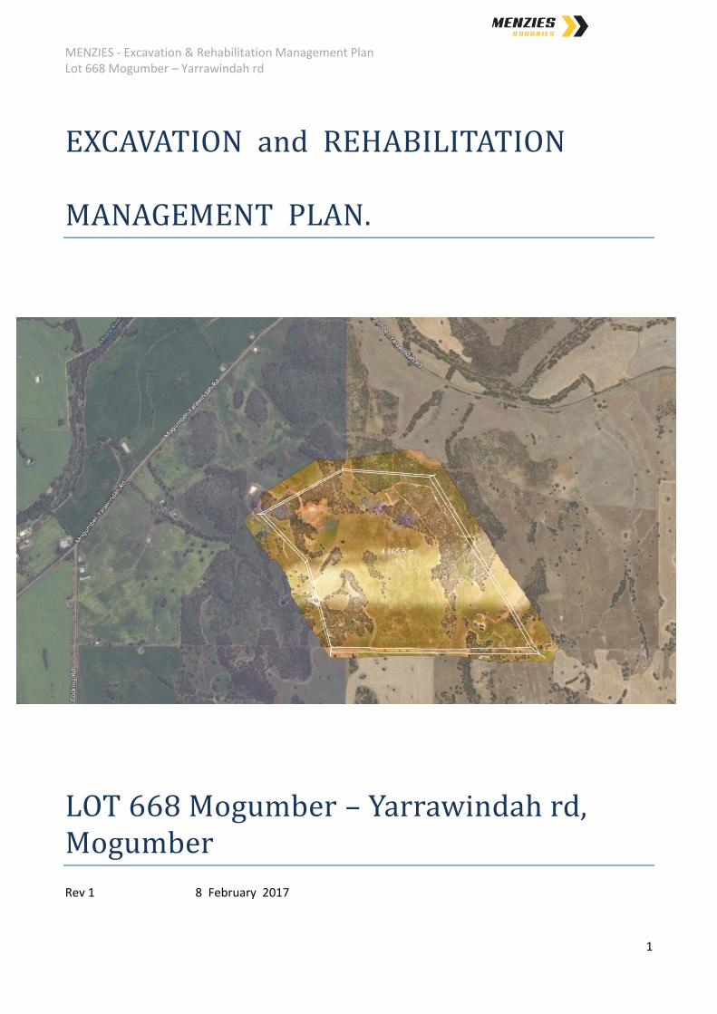
LOT 668 Mogumber – Yarrawindah rd, Mogumber
Rev 1 8 February 2017
MENZIES - Excavation & Rehabilitation Management Plan Lot 668 Mogumber – Yarrawindah rd
2
SUMMARY
Menzies Quarries Pty Ltd (Menzies) proposes to develop a
Gravel Extraction Quarry ,
Construction And Demolition Waste Recycling Facility, and
Composting Facility,
at Lot 668 Mogumber-Yarrawindah Rd, Mogumber. As a result of the gravel extraction
process, quantity of waste material proposed to be handled on site and processing of
materials, it is necessary that Planning Approval, Works Approval, Clearing Permit and
Licences are obtained.
The proposed site is Zoned Rural and located in the Shire of Victoria Plains. The area is
currently utilised as broad acre grazing and also continues to be used by the Shire of Victoria
Plains to extract gravel from an existing quarry as required. The surrounding land uses
continues to be broad acre grazing and cropping. The activities are performed to not affect
the use of the remainder of the property and adjacent properties. The operations have been
designed to minimise visual impact, noise and dust impacts.
This document provides the information for the management of the extraction of material
from the Quarry Area and subsequent rehabilitation requirements.
Gravel has been excavated from the quarry area for many years by the Shire of Victoria
Plains (the Shire) and the Shire will continue to have access to the material as per the
“Agreement for the Provision of Gravel between the Shire of Victoria plains and Menzies
Quarries Pty Ltd”, yet to be finalised. The agreement is in line with clause 2.4.1 ‘gravel
Supply Agreements’ of the Shire of Victoria Plains policy manual. The agreement will be
reviewed as required and this document amended if required.
The Quarry Area is the only known location where the presence of suitable gravel is readily
available in the region at suitable commercial quantities while meeting all technical and
environmental requirements.
A vegetation study was completed and shows that the site is covered by pasture degraded
and grazing, with a small area (1.7ha) of scattered native bushland. The bushland to be
cleared within the quarry area has been evaluated as 6 on the Keighery vegetation scale.
A die back assessment has been performed and has concluded that the site and surrounds
are excluded. Controls are in place to ensure dieback does no become introduced into the
area through the operations of Menzies.
The useable gravel reserve occupies an area of about 46 hectares and extends to an
average depth of 25 metres. Excavation will commence from the existing excavated area
and progress in a south easterly direction commencing from the existing level of 265 mAHD
with a 1:100 gradient south to north to capture storm water and sediment for treatment and
MENZIES - Excavation & Rehabilitation Management Plan Lot 668 Mogumber – Yarrawindah rd
3
reuse on site. . Minimal topsoil is present. Overburden is captured during the gravel
screening process and stockpiled along the perimeter of the quarry to reduce the handling
requirements during rehabilitation.
Water levels taken from historical data at Woury Pool indicate a maximum winter water level
of 178 mAHD (1999). Excavation works occur well above the winter ground water level.
The closest dwelling to the Quarry Area is located on Lot 668 Mogumber – Yarrawindah rd
and is approximately 900 meters from the existing quarry with the remainder of the sensitive
receptors being greater than 1.6km away.
The site is zoned Rural under the Shire of Victoria Plains Town Planning Scheme. The Local
Planning Policy #10, “Basic Raw materials and Extractive Industries” has the following
objectives;
To manage the extraction of basic raw materials within the rural zones in accordance
with best industry practices including consideration of end use and rehabilitation at
time of decommission;
To ensure appropriate buffer areas are applied to protect the extractive operations as
well as the living or agricultural environment in nearby areas.
The proposed excavation has been designed to enable rural activities to continue and thrive
once the site is no longer utilised for extractive purposes.

MENZIES - Excavation & Rehabilitation Management Plan Lot 668 Mogumber – Yarrawindah rd
4
Contents
SUMMARY ........................................................................................................................................................... 2
1. Introduction ................................................................................................................................................. 7
1.1. General Description of Proposal .......................................................................................................... 7
1.2. Proponent details ................................................................................................................................ 7
1.3. Site Location Property Location: ......................................................................................................... 9
1.4. Property Description: .......................................................................................................................... 9
1.5. Lease Area ........................................................................................................................................... 9
1.6. Description of the resource ................................................................................................................. 9
1.7. Proof of Applicant status ..................................................................................................................... 9
1.8. Facility Categories - Department of Environment Regulation........................................................... 12
1.9. Material Quantities ............................................................................................................................ 13
1.10. Facility Operating Hours ................................................................................................................. 13
1.11. Map 1 – Property, Map view – 668 Mogumber – Yarrawindah rd ............................................... 14
1.12. Map 2 –Property, Aerial view – 668 Mogumber – Yarrawindah rd .............................................. 15
1.13. Map 3 – Prescribed Premises, Map view – 668 Mogumber – Yarrawindah rd ............................. 16
1.14. Map 4 – Prescribed Premises, Aerial View – 668 Mogumber – Yarrawindah rd .......................... 17
2. Planning Issues .......................................................................................................................................... 18
2.1. District Context .................................................................................................................................. 18
2.2. Zoning ................................................................................................................................................ 18
2.3. Buffer Area ........................................................................................................................................ 20
2.4. End Use .............................................................................................................................................. 21
2.5. Community Consultation ................................................................................................................... 21
2.6. Compliance and other Legislation ................................................................................................... 22
2.7. Map 5 – Sensitive Receptor Separation Distance – Aerial View ....................................................... 25
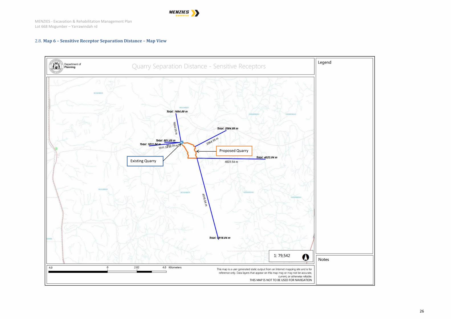
2.8. Map 6 – Sensitive Receptor Separation Distance – Map View ......................................................... 26
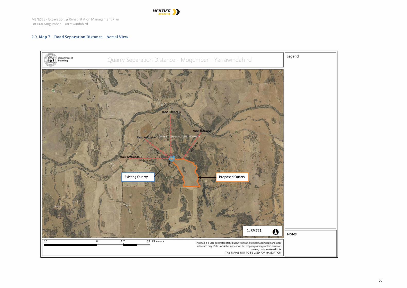
2.9. Map 7 – Road Separation Distance – Aerial View ............................................................................. 27
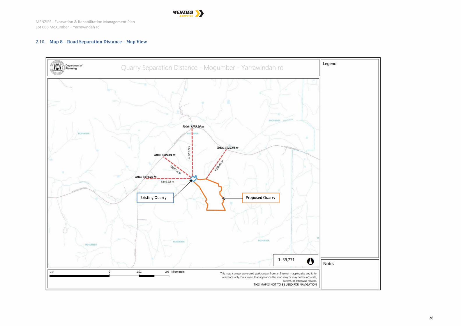
2.10. Map 8 – Road Separation Distance – Map View ........................................................................... 28
2.11. Menzies Community Consultation documents ............................................................................. 29
2.11.1. Menzies Proposal Document to sensitive receptors ..................................................................... 29
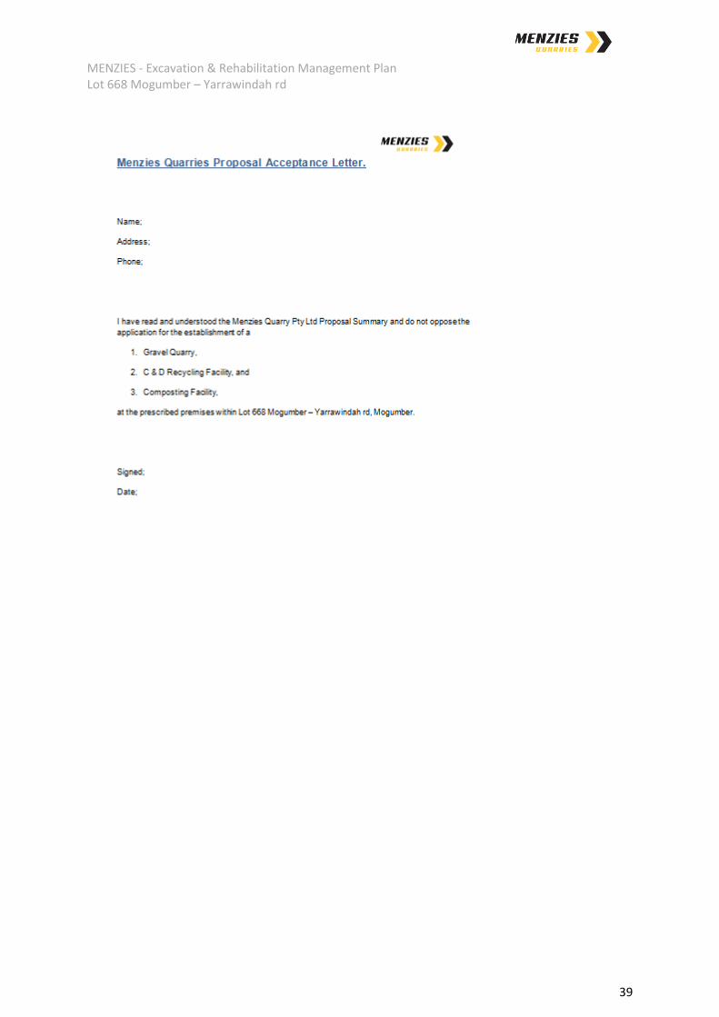
2.11.2. Signed “Menzies Quarries Proposal Acceptance” – landowner .................................................... 40
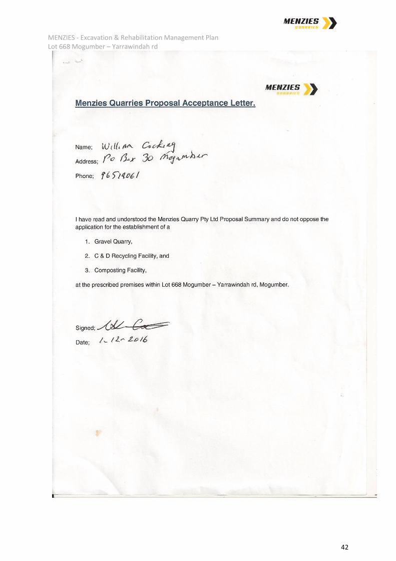
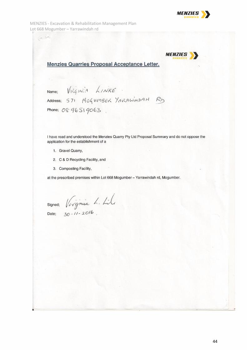
2.11.3. Signed “Menzies Quarries Proposal Acceptance” – sensitive receptors. ...................................... 41
2.12. Figure 1 – Ortho photo – Quarry Area........................................................................................... 45
MENZIES - Excavation & Rehabilitation Management Plan Lot 668 Mogumber – Yarrawindah rd
5
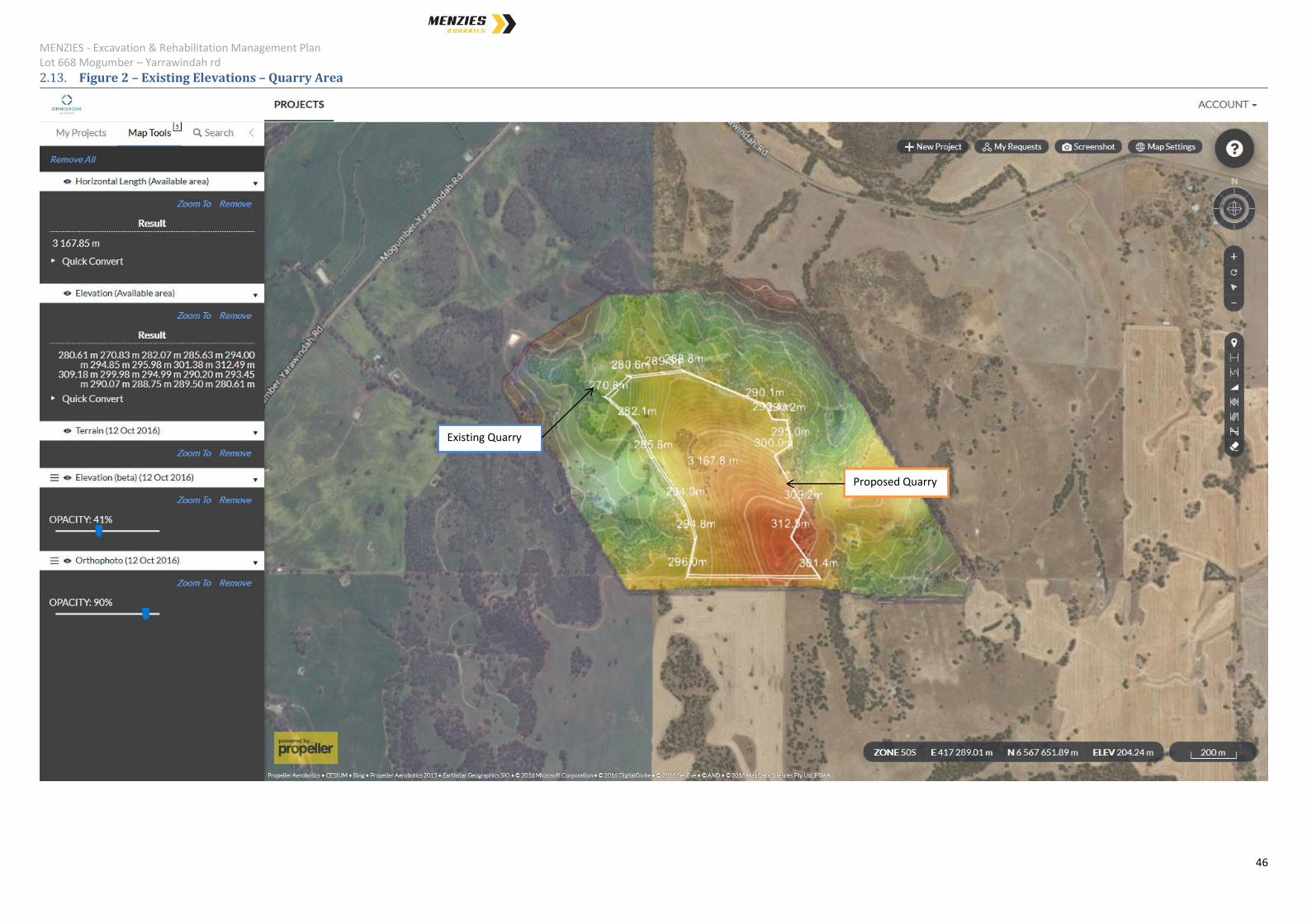
2.13. Figure 2 – Existing Elevations – Quarry Area ................................................................................. 46
3. Existing Environment ................................................................................................................................. 47
3.1. Topography ........................................................................................................................................ 47
3.2. Geology .............................................................................................................................................. 47
3.3. Climate .............................................................................................................................................. 47
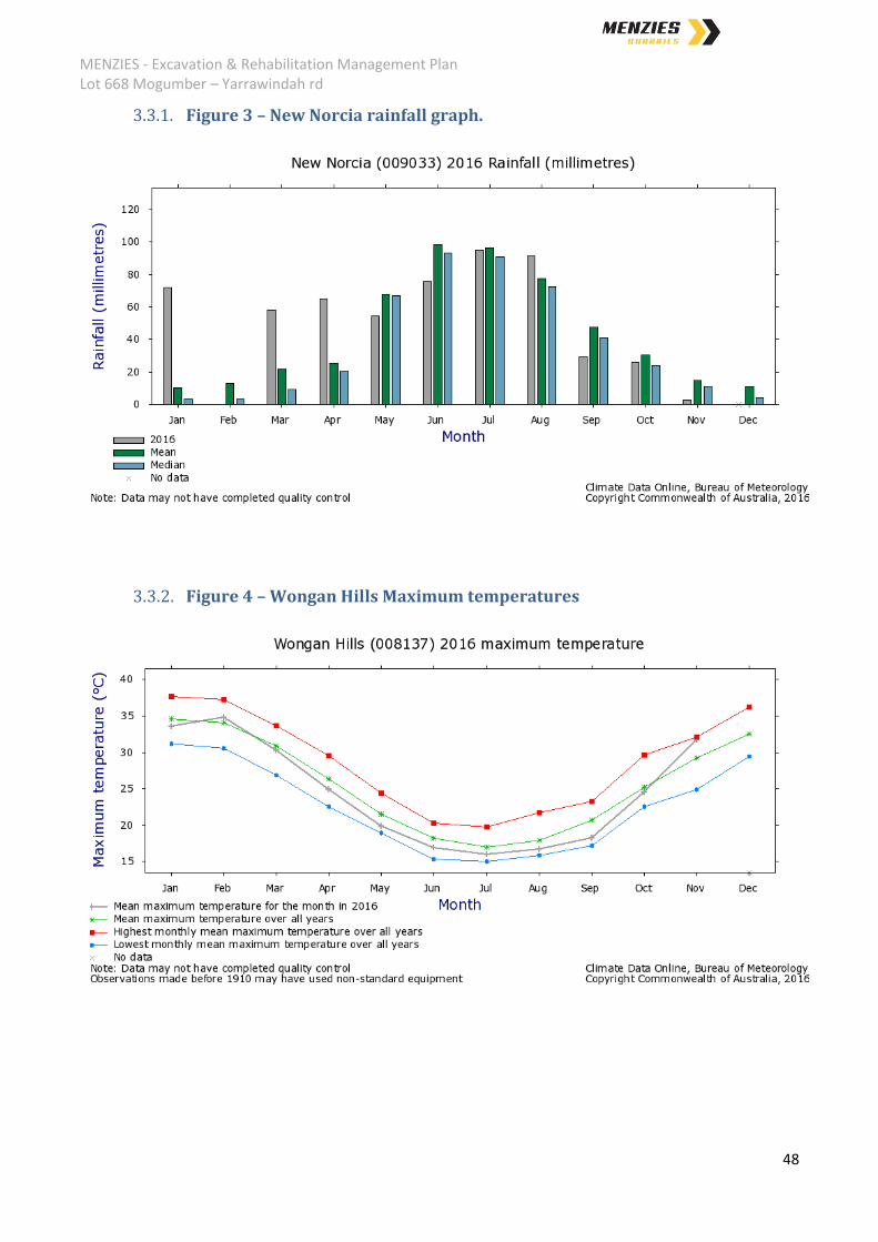
3.3.1. Figure 3 – New Norcia rainfall graph. ............................................................................................ 48
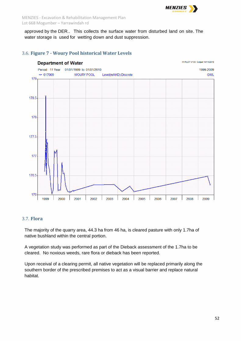
3.3.2. Figure 4 – Wongan Hills Maximum temperatures ........................................................................ 48
3.3.3. Figure 5 – Wongan Hills wind rose – 9am ..................................................................................... 49
3.3.4. Figure 6 – Wongan Hills wind rose – 3pm ..................................................................................... 50
3.4. Soils .................................................................................................................................................... 51
3.5. Hydrology .......................................................................................................................................... 51
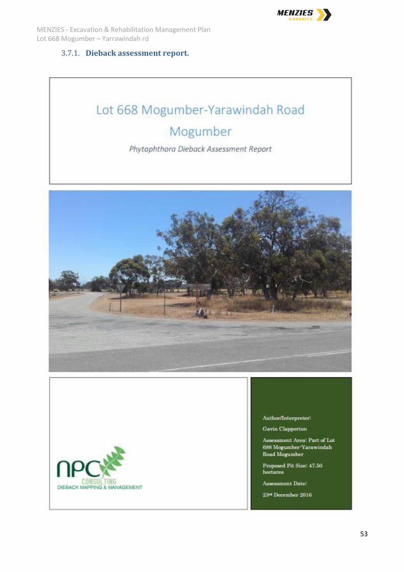
3.6. Figure 7 - Woury Pool historical Water Levels .................................................................................. 52
3.7. Flora ................................................................................................................................................... 52
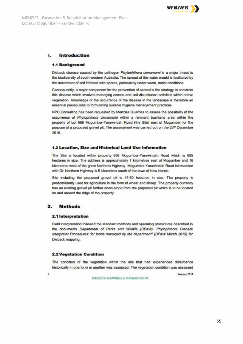
3.7.1. Dieback assessment report. .......................................................................................................... 53
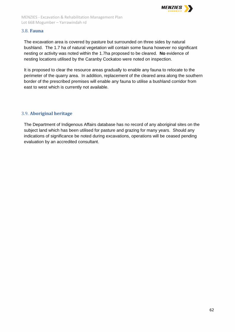
3.8. Fauna ................................................................................................................................................. 62
3.9. Aboriginal heritage ............................................................................................................................ 62
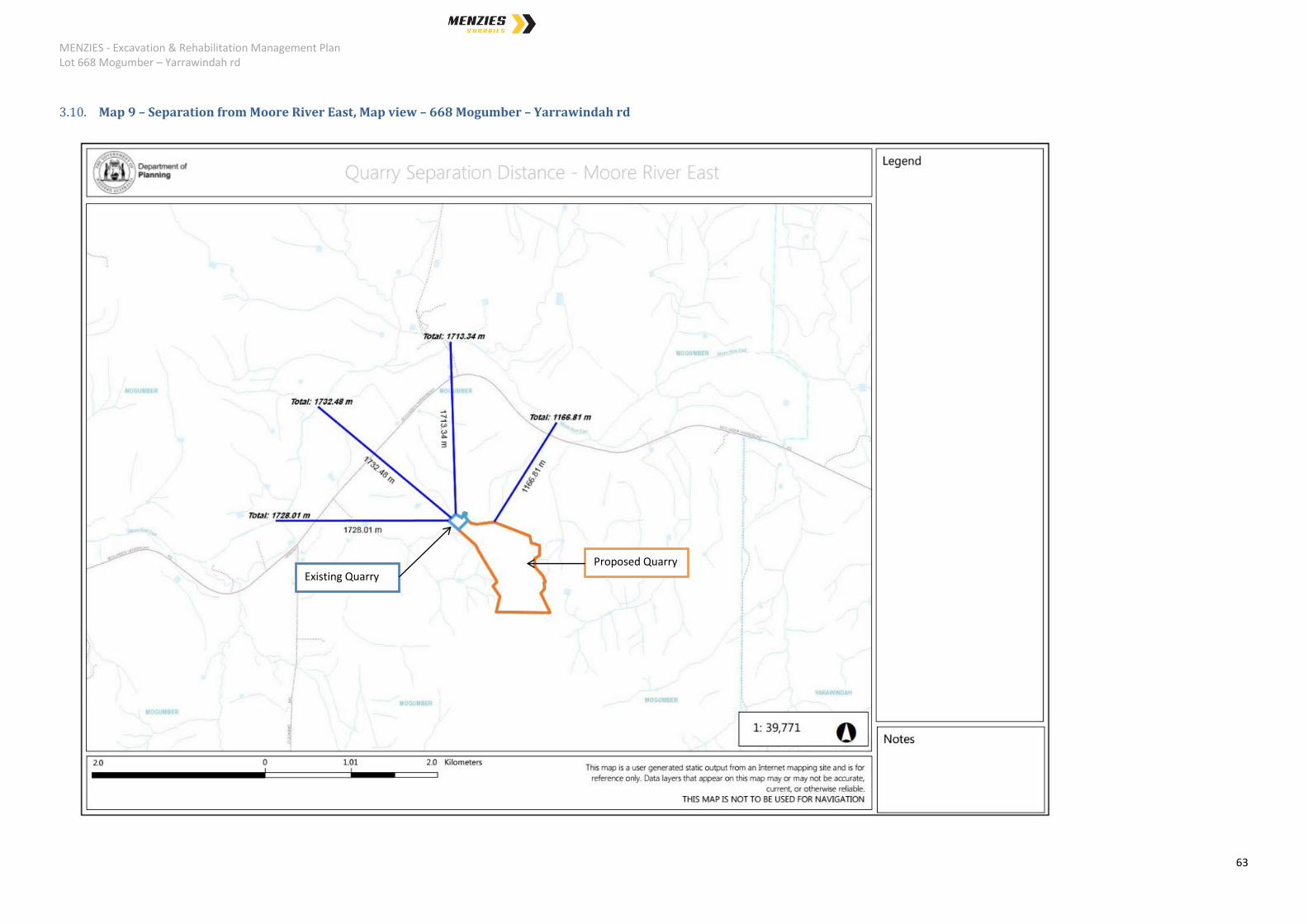
3.10. Map 9 – Separation from Moore River East, Map view – 668 Mogumber – Yarrawindah rd ....... 63
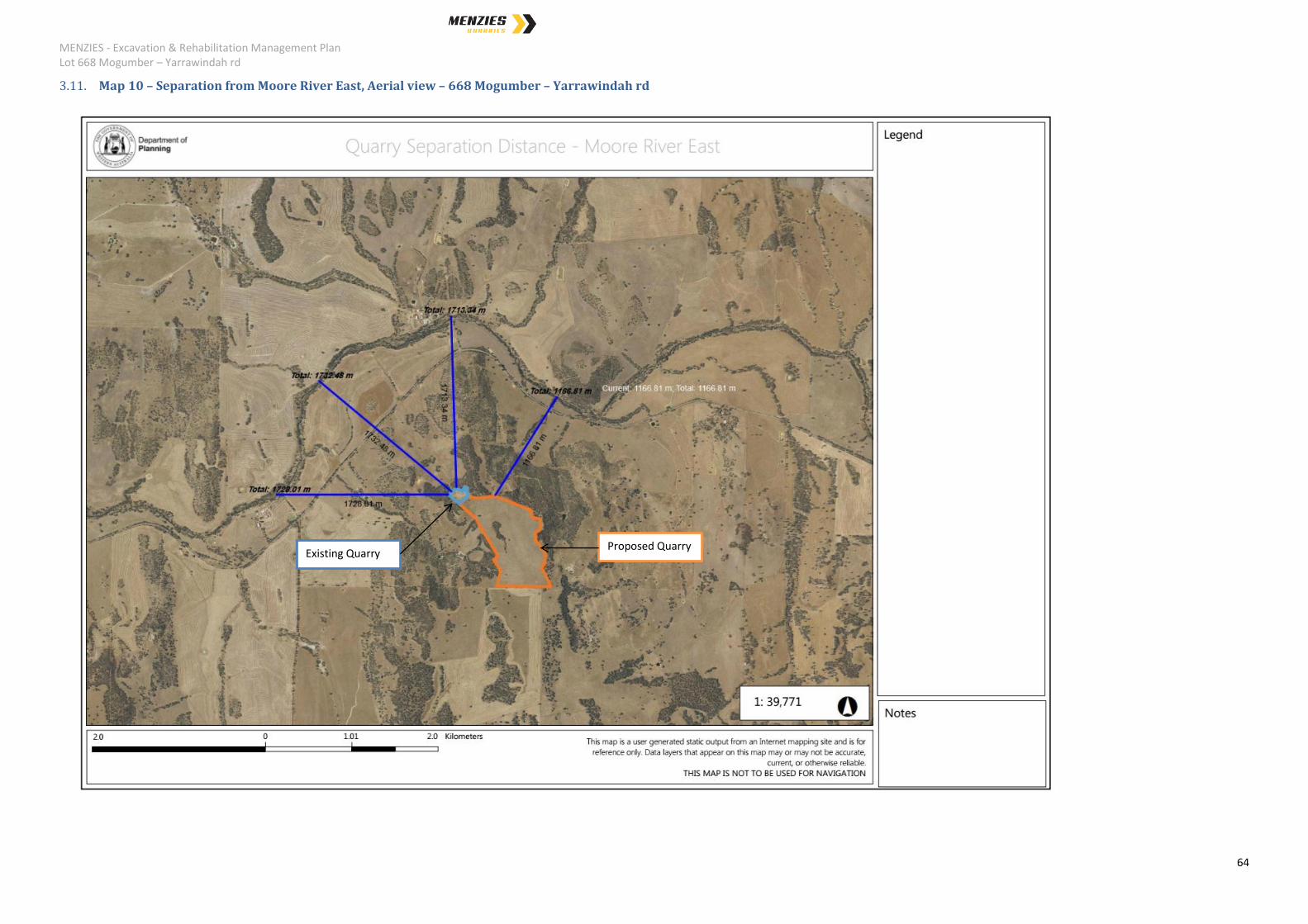
3.11. Map 10 – Separation from Moore River East, Aerial view – 668 Mogumber – Yarrawindah rd ... 64
4. Excavation Programme .............................................................................................................................. 65
4.1. Facility Operating Hours ..................................................................................................................... 65
4.2. Material Quantities ............................................................................................................................ 65
4.3. Extraction and Processing of the Resource ....................................................................................... 65
4.4. Final Contours .................................................................................................................................... 67
4.5. Map 11 – Simple layout of the prescribed area – 668 Mogumber – Yarrawindah rd. ...................... 68
4.6. Map 12 – Excavation Stages over 20 years @ 500,000 tpa ............................................................... 69
4.7. Map 13 – Final Contours ................................................................................................................... 70
4.8. Map 14 – Area to be cleared. ............................................................................................................ 71
5. Environmental management, reporting and monitoring .......................................................................... 72
5.1. Air Emissions ...................................................................................................................................... 72
5.2. Dust Emissions ................................................................................................................................... 72
5.3. Asbestos Management ...................................................................................................................... 75
5.4. Table 1 – Dust Management Risk Assessment ............................................................................... 77
5.5. Odour Emissions ................................................................................................................................ 81
5.6. Noise Emissions.................................................................................................................................. 81
MENZIES - Excavation & Rehabilitation Management Plan Lot 668 Mogumber – Yarrawindah rd
6
5.6.1. Noise Treatment Methodology: .................................................................................................... 82
5.7. Litter Emissions .................................................................................................................................. 83
5.8. Light Emissions ................................................................................................................................... 84
5.9. Discharge to Water ............................................................................................................................ 84
5.10. Discharge to Land ........................................................................................................................... 84
5.11. Vermin Management ................................................................................................................... 85
5.12. Native Vegetation, Flora and Fauna ............................................................................................ 85
5.13. Fire Management ......................................................................................................................... 86
5.13.1. Bushfire Attack Level – South – Upslope ....................................................................................... 86
5.13.2. Bushfire Attack Level – West and North – Downslope .................................................................. 87
5.13.3. Bushfire Attack Level – East – Upslope ......................................................................................... 88
5.14. Solid/Liquid Waste........................................................................................................................ 89
5.14.1. Solid Waste .................................................................................................................................... 89
5.14.2. Liquid Waste .................................................................................................................................. 89
5.15. Hydrocarbon / Chemical Storage .................................................................................................. 90
5.15.1. Hydrocarbon Storage ..................................................................................................................... 90
5.15.2. Chemical Storage ........................................................................................................................... 90
5.16. Contaminated Site Identification ................................................................................................ 90
5.17. Surface Water Management ....................................................................................................... 91
5.18. Groundwater Management .......................................................................................................... 91
5.19. Reporting requirements ................................................................................................................ 91
6. Rehabilitation Program.............................................................................................................................. 92

MENZIES - Excavation & Rehabilitation Management Plan Lot 668 Mogumber – Yarrawindah rd
7
1. Introduction
1.1. General Description of Proposal
The property is leased by the Landowner predominately for grazing purposes, with a portion
leased to Menzies for three activities being, Extraction, C&D Recycling and Composting.
The services and products to be developed are to be utilised by Menzies and its related
projects, and are commercially available to bulk customers. The site is not open for ad hoc
(walk-in) customers.
Extraction; Menzies excavates, screens and crushes the extracted material and exports
the recovered gravel and sand products from its operations to supply to off takers for
incorporation into civil and landscaping works.
As part of the excavation activities, a section of native vegetation (1.7 hectares) will be
required to be cleared and a Clearing Permit obtained.
Recycling C&D; Menzies receives, screens and crushes clean Construction and
Demolition (C&D) waste to develop saleable and re-useable products including sand, road
base, manufactured fill and other Waste Derived Materials (WDM) as defined and approved
by the Department of Environment Regulation (DER).
No WDM will be utilised or moved of site until these products are defined and approved for
use by the DER which is expected to occur middle 2017.
Composting; Menzies composts source separated clean organic waste streams to
produce compost that meets Australian Standard AS4454 -12.
1.2. Proponent details
The Proponent for this proposed development is Menzies Quarries Pty Ltd:
12 Taylor st White Gum Valley, 6162, WA

MENZIES - Excavation & Rehabilitation Management Plan Lot 668 Mogumber – Yarrawindah rd
8
MENZIES - Excavation & Rehabilitation Management Plan Lot 668 Mogumber – Yarrawindah rd
9
1.3. Site Location Property Location:
Lot 668 Mogumber-Yarrawindah Rd, Mogumber, Map 1,2.
1.4. Property Description:
Lot 668 Mogumber- Yarrawindah Rd, Mogumber, Western Australia being Lot 127, on
deposited plan 35464. Zoned ‘Rural’ within Shire of Victoria Plains - Town Planning Scheme
No. 5. Property area is 6.85M m2 (685 hectares)
1.5. Lease Area
Part of Lot 668 Mogumber-Yarrawindah Rd, Mogumber, Western Australia being part of Lot
127, on deposited plan 35464, within GIS coordinates (elevations);
E416299 N6565645 (289m), E416134 N655214 (266m), E415815 N6566521 (235m),
E416365 N6566817 (270m), E416942 N 6566821 (220m), E417618 N6565645 (240m).
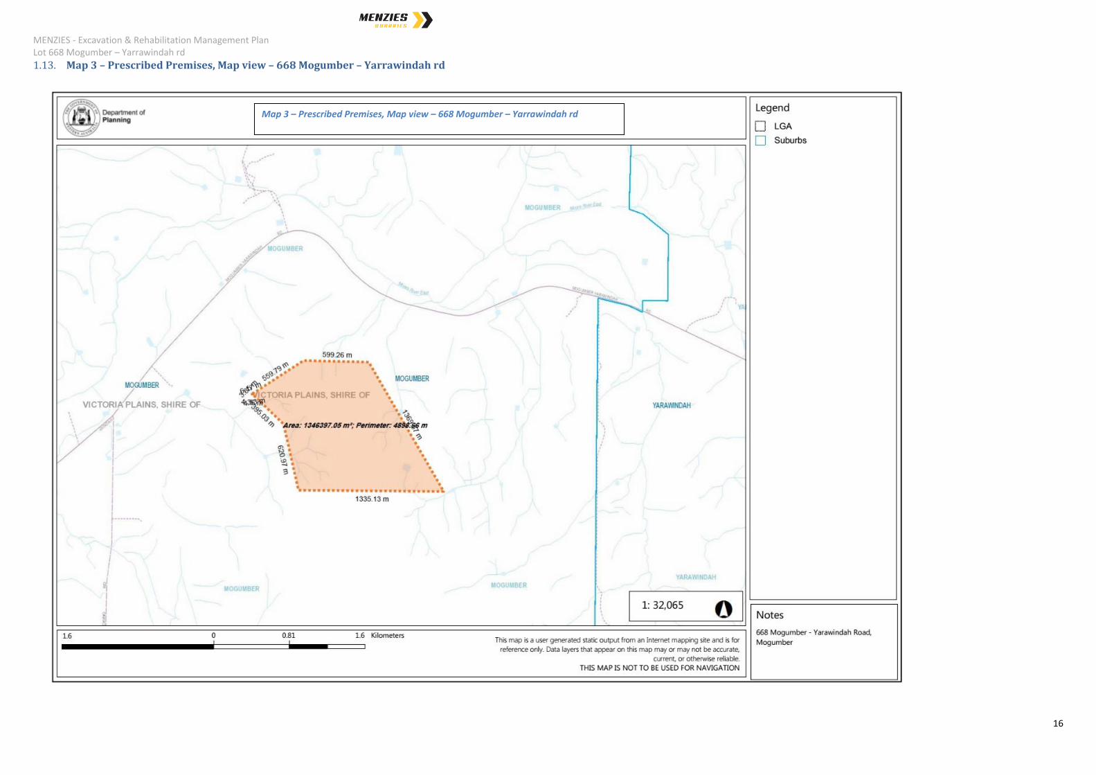
Prescribed Premises area is 1.35M m2. The Prescribed Premises boundary is the lease
area, Map 3.
1.6. Description of the resource
Within the prescribed premises, the Menzies Quarry Area occupies 460,000 m2 (46
hectares) over its expected lifespan of 20 years. The resource to be extracted is gravel. The
useable gravel reserve extends to an average depth of 25 metres.
Excavation will commence from the existing excavated area and progress in a south easterly
direction commencing from the existing level of 265 mAHD. Volume available for extraction,
including screened overburden, is approximately 16M m3.
1.7. Proof of Applicant status
Menzies has a ‘Lease and Gravel Quarrying Agreement’ with the Land Owner for the use of
the prescribed premises, landowner being Mr Montrose Matinus Driessen.
MENZIES - Excavation & Rehabilitation Management Plan Lot 668 Mogumber – Yarrawindah rd
10
MENZIES - Excavation & Rehabilitation Management Plan Lot 668 Mogumber – Yarrawindah rd
11

MENZIES - Excavation & Rehabilitation Management Plan Lot 668 Mogumber – Yarrawindah rd
12
1.8. Facility Categories - Department of Environment Regulation
Based on the proposed activities, the following facility environmental categories are relevant:
Extraction
DER Category 12 – ‘Screening etc. of material (50,000 tonnes or more per year)
Premises (other than premises within category 5 and 8) on which material extracted from the
ground is screened, washed, crushed, ground, milled sized or separated.
Recycling C & D
DER Category 13 – Crushing of building material (1,000 tonnes per year)
Premises on which waste building or demolition material (for example, bricks, stones, or
concrete) is crushed or cleaned.
DER Category 62 - Solid waste depot (500 tonnes or more per year)
Premises on which waste is stored, or sorted, pending final disposal or re-use.
Composting
DER Category 62 - Solid waste depot (500 tonnes or more per year)
Premises on which waste is stored, or sorted, pending final disposal or re-use.
DER Category 67A - Compost manufacturing and soil blending (1,000 tonnes or more
per year)
Premises on which organic material (excluding silage) or waste is stored pending processing,
mixing, drying or composting to produce commercial quantities of compost or blended soils
DER Category 61 - Liquid waste facility (1,000 tonnes or more per year)
Premises on which liquid waste produced on other premises (other than sewerage waste) is
stored, reprocessed, treated or irrigated.
Requested for the acceptance of sub categories;
‘K110 - Grease Trap Waste’
‘K130 – Sewage waste from the reticulated sewage system (Biosolids). No other
liquid waste accepted on site.

MENZIES - Excavation & Rehabilitation Management Plan Lot 668 Mogumber – Yarrawindah rd
13
NOTE: all liquid waste received is transferred directly to a sealed liquid storage tank
and only removed when mixed with green waste for immediate aeration. This
practice is common in the composting industry and has been shown to produce no
offsite odours when properly mixed and actively aerated.
1.9. Material Quantities
The estimated breakdown of the material types includes:
Gravel extraction – up to 500,000 tonnes / year to meet demand for Great Northern
highway works,
o Typical extraction will not exceed 250,000 tonnes / year
C&D waste received and processed – up to 150,000 tonnes / year,
o Expected production of 100,000 tonnes/year, and
Compost produced – up to 35,000 tonnes / year.
1.10. Facility Operating Hours
The facility will operate during the following hours:
Monday to Saturday – 6.00 am to 5.00 pm;
o with no machinery operating before 7am;
Sundays and Public Holidays – Closed.
The extraction and C&D processing activities are expected to be performed on an ‘as
required’ basis. Composting is a continuous batch process requiring regular monitoring.

MENZIES - Excavation & Rehabilitation Management Plan Lot 668 Mogumber – Yarrawindah rd
14
1.11. Map 1 – Property, Map view – 668 Mogumber – Yarrawindah rd
Map 1 – Property, Map view – 668 Mogumber – Yarrawindah rd
MENZIES - Excavation & Rehabilitation Management Plan Lot 668 Mogumber – Yarrawindah rd
15
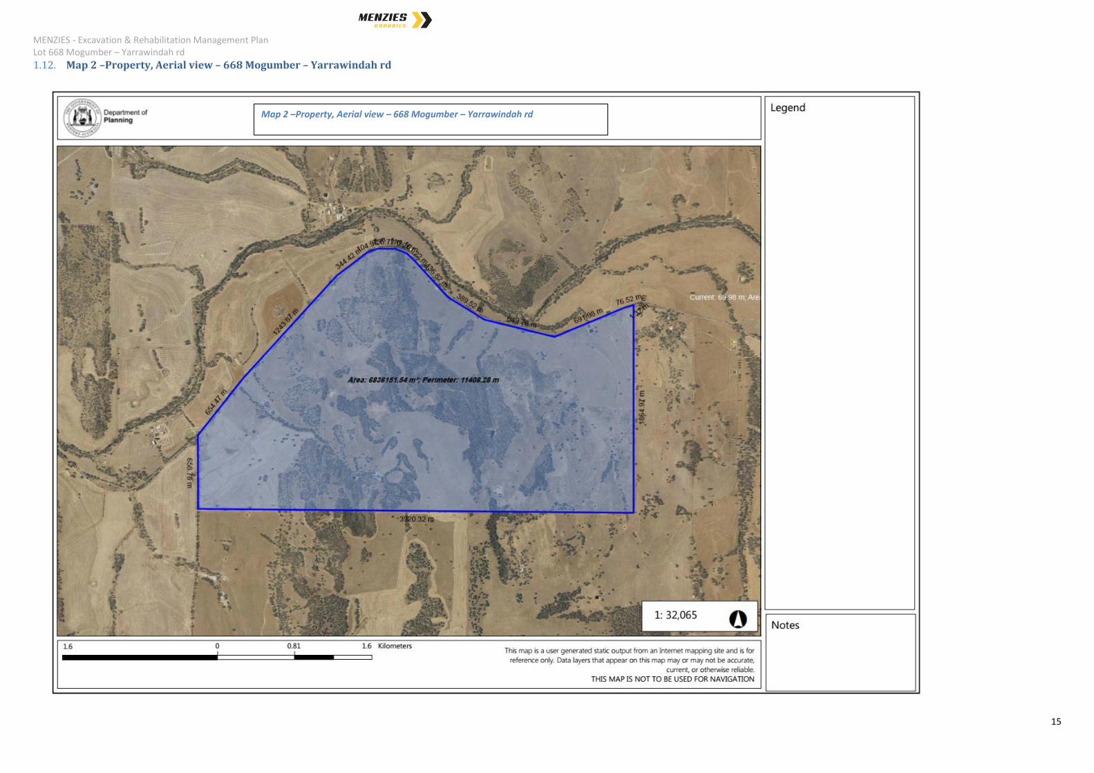
1.12. Map 2 –Property, Aerial view – 668 Mogumber – Yarrawindah rd
Map 2 –Property, Aerial view – 668 Mogumber – Yarrawindah rd
MENZIES - Excavation & Rehabilitation Management Plan Lot 668 Mogumber – Yarrawindah rd
16
1.13. Map 3 – Prescribed Premises, Map view – 668 Mogumber – Yarrawindah rd
Map 3 – Prescribed Premises, Map view – 668 Mogumber – Yarrawindah rd

MENZIES - Excavation & Rehabilitation Management Plan Lot 668 Mogumber – Yarrawindah rd
17
1.14. Map 4 – Prescribed Premises, Aerial View – 668 Mogumber – Yarrawindah rd
Map 4 – Prescribed Premises, Aerial View – 668 Mogumber – Yarrawindah rd
MENZIES - Excavation & Rehabilitation Management Plan Lot 668 Mogumber – Yarrawindah rd
18
2. Planning Issues
2.1. District Context
The quarry area leased by Menzies is currently utilised for pasture and grazing purposes.
The adjacent lots and regional area are also utilised for pasture and grazing purposes.
The prescribed premises has been utilised by the Shire for the extraction of Gravel in the
past. Gravel has been excavated from the quarry area for many years and has been shown
to be of a suitable standard requiring minimal to no processing post extraction. Menzies will
enable the Shire to continue to have access to the material as per the “Agreement for the
Provision of Gravel between the Shire of Victoria plains and Menzies Quarries Pty Ltd”, yet to
be finalised.
The agreement is in line with clause 2.4.1 ‘Gravel Supply Agreements’ of the Shire of Victoria
Plains Policy Manual. The agreement will be reviewed as required and this document
amended if required.
2.2. Zoning
The site is zoned Rural under the Shire of Victoria Plains Local Planning Scheme No. 5.
The zoning objectives are;
“• To provide for a range of rural pursuits which are compatible with the capability of the land
and retain the rural character and amenity of the locality.
• To protect land from urban uses that may jeopardise the future use of that land for other
planned purposes that are compatible with the zoning.
• To protect the land from closer development which would detract from the rural character
and amenity of the area.
• To prevent any development which may affect the viability of a holding.”
The proposed excavation has been designed to comply with these objectives following
cessation of the excavation activities and completion of the rehabilitation program. In
addition, Menzies also proposes to operate a Composting facility on site.

MENZIES - Excavation & Rehabilitation Management Plan Lot 668 Mogumber – Yarrawindah rd
19
Compost produced on site will be specifically tailored with assistance from agronomists to
improve the structure and composition of the soil within the quarry area. Adjacent
landholders have also expressed a desire to utilise the compost and soil conditioners
produced on site. This commitment will enable the excavated area to be returned to a
more productive state than it currently is in.
The Zoning table, Table 1 within the Shire of Victoria Plains Local Planning Scheme No. 5
states that “Industry Extractive” is classified as ‘D’ – “the use is not permitted unless the local
government has exercised its discretion by granting planning approval”.
The State Gravel Supply Policy, 1998, now terminated, also recognised the need to ensure
that sources of gravel are available for construction and road making. Statement of Planning
Policies are also required to be considered under the Local Authority Town Planning
Schemes.
“In December 2012 the Minister for Transport approved the termination of the original SGSS
initiative but endorsed ongoing meetings of the Management Group to address outstanding
and emerging issues related to road construction materials. The Minister for the
Environment was provided a copy of this approval.
Implementation of the SGSS was originally focussed on the needs of Main Roads and Local
Governments as the principal public road construction agencies. However in recent years,
the use of contractors and private industry partners to Government has blurred the
boundaries of responsibilities for construction and maintenance. And the DEC public road
system is now seeing increasing traffic and requires greater attention. Also, because of the
increasing restrictions on access to land to obtain materials by environmental, aboriginal and
competing mining interests, more strategic planning is now required to ensure materials can
be accessible into the future. To cater for these changes, further work and collaboration is
required between Main Roads, local governments, DOP, DMP, DEC, Aboriginal groups and
Aboriginal related agencies.
The initial focus of the strategy was naturally occurring road building materials needing
minimum processing for use as road pavement materials. However as sources of these
materials inevitably become more difficult to obtain, more processed materials such as
crushed hard rock will need to be considered. In addition, materials for other uses, not just
roads, could also be considered in the future. DMP and DOP are already working on a
broader view of needs and sources in developing strategic mapping around major centres.”
Statement of Planning Policy 2.4 – Basic Raw Materials, supports the principle that basic raw
materials should be taken before they become sterilised by development, and that they
should be protected for future use. It provides guidelines to local government to recognise
the importance of not permitting conflicting land uses to impinge on the operation of resource
extraction.
MENZIES - Excavation & Rehabilitation Management Plan Lot 668 Mogumber – Yarrawindah rd
20
Statement of Planning Policy 2.5 – Agricultural and Rural Land Use Planning, makes
provision for the extraction of basic raw materials. Point 9 states that;
"The location of rural residential and rural small holdings should avoid unacceptable impacts
on, or sterilisation, of natural primary resources including prospective areas for mineralisation
and basic raw materials ".
Statement of Planning Policy 2 - Environmental and Natural Resources Policy, Section 5.7
deals with Basic Raw Materials. Part of Section 5.7 states;
“Basic raw materials include sand, clay, hard rock, limestone and gravel together with
other construction and road building requirements. A ready supply of basic raw materials
close to development areas is required in order to keep down the cost of land development
and the price of housing.
Planning strategies, schemes and decision making should:
ii. Identify and protect important basic raw materials and provide for their extraction and
use in accordance with Statement of Planning Policy No 10 (2.5); Basic Raw Materials.
iii. Support sequencing of uses where appropriate to maximise options and resultant
benefits to community and the environment.”
The objectives outlined by relevant state and local planning policies are met by this proposal
and Menzies is committed to returning the Quarry area into an improved state suitable for
rural activities approved by the Shire.
2.3. Buffer Area
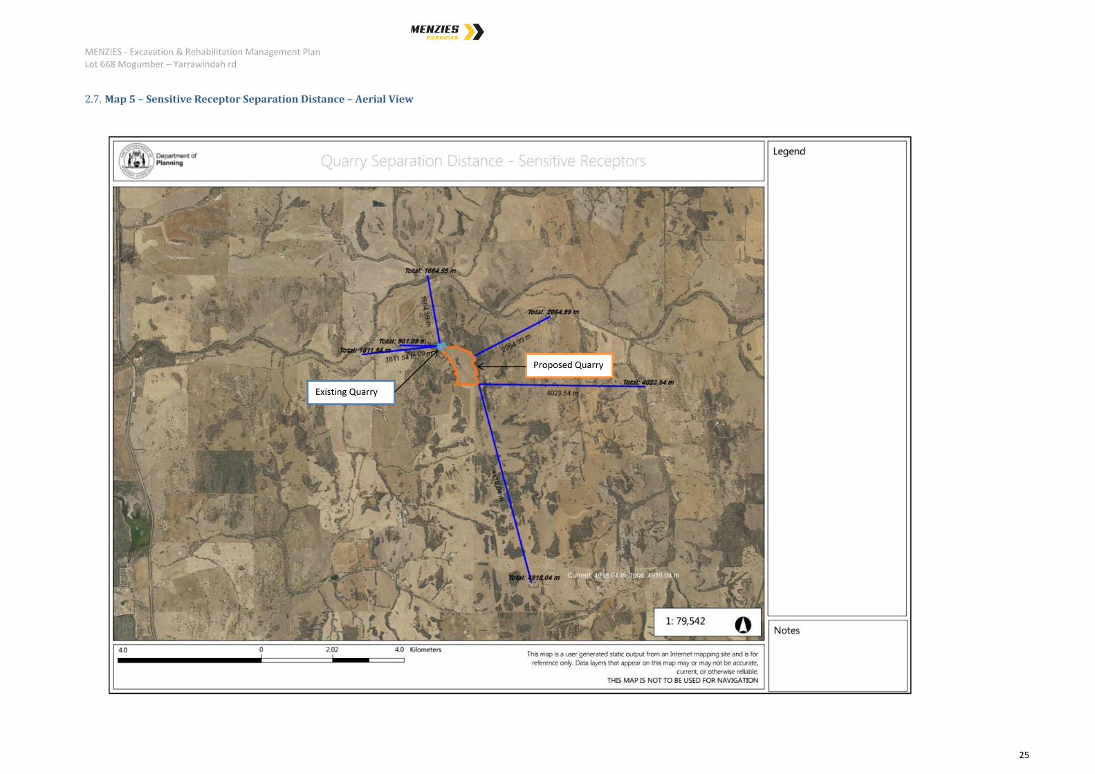
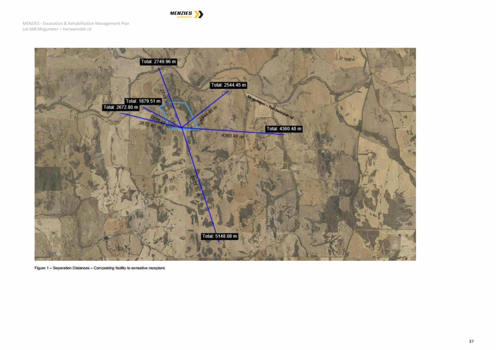
The closest dwelling to the Quarry Area is located on Lot 668 Mogumber – Yarrawindah rd
itself and is approximately 900 meters from the existing quarry with the remainder of the
sensitive receptors being greater than 1.6km away as shown on Map 5 – 6.
EPA guidance "Draft Separation Distances between Industrial and Sensitive Land Uses",
June 2005 lists the generic buffers for Extractive Industries with no blasting as 500 - 1000
meters. The DER ”Draft Separation Distances, Division 3, Part V, Environmental Protection
Act 1986” states a separation distance of 1000m for category 12 activities described as;
Screening etc. of material (50,000 tonnes or more per year) Premises (other than premises
within category 5 or 8) on which material extracted from the ground is screened,
washed,crushed, ground, milled, sized or separated.

MENZIES - Excavation & Rehabilitation Management Plan Lot 668 Mogumber – Yarrawindah rd
21
Mogumber – Yarrawindah rd is located 1km away at it closest in a north westerly direction
from the Quarry area, Map 7 – 8. Great Northern Highway and Brand highway are both
approximately 7.5 km to the east and west respectively. Access to each highway is via
Mogumber – Yarrawindah rd which is an approved transport route as per the Shire of Victoria
plains Policy Manual_june_2016 section 2.1.5, Permitted Road Table.
Buffer vegetation surrounding the Quarry area on the north, west and east are to remain
untouched. The adjacent boundary to the south is to be planted with replacement vegetation
to match those removed from the 1.7ha to be cleared within the middle of the quarry area
reducing visual impact to the south. In addition, it is proposed to locate the Composting
facility along the southern portion of the quarry area and as such, no extractive works will
occur within 200m of the southern boundary.
Excavation is performed at an elevated level surrounded by natural vegetation and worked
from north-west to south-east. With the surrounding sensitive receptors and Mogumber –
Yarrawindah rd being located well below the quarry level, visual impact is not considered an
issue as no line of sight is possible. The recommended 20 metre buffer zones are exceeded
along the perimeter boundaries of the site, to the south, with a road buffer of 1000 metres.
2.4. End Use
It is planned to return the excavated areas to include a farm dam with battered slopes
covered by pasture. As there will be material removed from site, and the overburden is not
very thick, there will be less material available for rehabilitation and a void will be left. The
void will contain a dam with sloping pasture back up to natural land surface to the east, west
and adjacent property to the south.
The land surface will be contoured to be compatible with the existing landform of the area
and be reformed as a gently undulating surface draining towards the farm dam. The end use
will be pasture augmented with agronomist support to guide the application of compost
produced on site. Significant crop yield should be realised as soil within the area is of a poor
quality.
2.5. Community Consultation
Menzies has presented to the Shire and visited the close sensitive receptors to outline all
activities proposed. A summary of the proposal was provided in hard copy and an
opportunity to ask questions was offered. All landowners and farm operators had no
objection to the proposed activities and signed consent forms. In addition all expressed a
desire to utilise the services and products available, particularly the compost produced on
site to utilise on pasture to increase crop yields and reduce chemical fertiliser use. See
section 2.11.
MENZIES - Excavation & Rehabilitation Management Plan Lot 668 Mogumber – Yarrawindah rd
22
2.6. Compliance and other Legislation
State and Local Government authorities are responsible for overseeing the safety and
management of the proposed activities. Other authorities have an interest in the proposal
but may not hold any responsibility.
A number of local and state authorities are responsible for excavation of this type or have an
interest in its operation.
The Department of Environment and Regulation requires works approval and licensing of the
proposed facilities at prescribed throughput levels and issues clearing permits.
Based on all the proposed activities, the following facility environmental categories are
relevant:
Extraction
DER Category 12 – ‘Screening etc. of material (50,000 tonnes or more per year)
Premises (other than premises within category 5 and 8) on which material extracted from the
ground is screened, washed, crushed, ground, milled sized or separated.
Recycling C & D
DER Category 13 – Crushing of building material (1,000 tonnes per year)
Premises on which waste building or demolition material (for example, bricks, stones, or
concrete) is crushed or cleaned.
DER Category 62 - Solid waste depot (500 tonnes or more per year)
Premises on which waste is stored, or sorted, pending final disposal or re-use.
Composting
DER Category 62 - Solid waste depot (500 tonnes or more per year)
Premises on which waste is stored, or sorted, pending final disposal or re-use.
DER Category 67A - Compost manufacturing and soil blending (1,000 tonnes or more
per year)
MENZIES - Excavation & Rehabilitation Management Plan Lot 668 Mogumber – Yarrawindah rd
23
Premises on which organic material (excluding silage) or waste is stored pending processing,
mixing, drying or composting to produce commercial quantities of compost or blended soils
DER Category 61 - Liquid waste facility (1,000 tonnes or more per year)
Premises on which liquid waste produced on other premises (other than sewerage waste) is
stored, reprocessed, treated or irrigated.
Requested for the acceptance of sub categories;
‘K110 - Grease Trap Waste’
‘K130 – Sewage waste from the reticulated sewage system (Biosolids). No other
liquid waste accepted on site.
NOTE: all liquid waste received is transferred directly to a sealed liquid storage tank
and only removed when mixed with green waste for immediate aeration. This
practice is common in the composting industry and has been shown to produce no
offsite odours when properly mixed and actively aerated.
Shire of Victoria Plains
Planning Consent under the Local Planning Scheme No. 5 and Policy Manual that defines;
Land zonings, uses and strategies in conjunction with the Western Australian
Planning Commission through the Local Planning Scheme.
Extractive Industry Licences for quarries.
Has an interest in transport along local roads.
Controls the measures used to prevent bush fires.
Department of Mines and Petroleum
Controls the safety and methods of excavation through the Mines Safety and
Inspection Act 1994 and Regulations 1995.
Covers the health and safety of workers.
Identifies and maps basic raw materials.
Note; the extraction of gravel is not controlled by the Department of Mines and
Petroleum, however, the extraction process to be performed will align with the
MENZIES - Excavation & Rehabilitation Management Plan Lot 668 Mogumber – Yarrawindah rd
24
prescribed requirements.
Western Australian Planning Commission
Prepares strategic planning policies and provides Statements of Planning Policy.
Defines land zonings and strategies in conjunction with the local authority.
Responsible of State Planning Policies such as SPP 2.4 Basic Raw Materials.
Department of Water
Publishes guidelines for water quality management for extractive industries.
Controls the management of ground and surface water.
All statutory requirements will be met through appropriate management plans and
procedures including this document.
MENZIES - Excavation & Rehabilitation Management Plan Lot 668 Mogumber – Yarrawindah rd
25
2.7. Map 5 – Sensitive Receptor Separation Distance – Aerial View
Proposed Quarry
Existing Quarry
MENZIES - Excavation & Rehabilitation Management Plan Lot 668 Mogumber – Yarrawindah rd
26
2.8. Map 6 – Sensitive Receptor Separation Distance – Map View
Proposed Quarry
Existing Quarry
MENZIES - Excavation & Rehabilitation Management Plan Lot 668 Mogumber – Yarrawindah rd
27
2.9. Map 7 – Road Separation Distance – Aerial View
Proposed Quarry Existing Quarry
MENZIES - Excavation & Rehabilitation Management Plan Lot 668 Mogumber – Yarrawindah rd
28
2.10. Map 8 – Road Separation Distance – Map View
Proposed Quarry Existing Quarry
MENZIES - Excavation & Rehabilitation Management Plan Lot 668 Mogumber – Yarrawindah rd
29
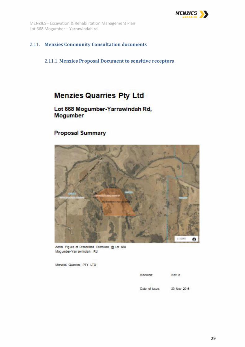
2.11. Menzies Community Consultation documents
2.11.1. Menzies Proposal Document to sensitive receptors

MENZIES - Excavation & Rehabilitation Management Plan Lot 668 Mogumber – Yarrawindah rd
30
MENZIES - Excavation & Rehabilitation Management Plan Lot 668 Mogumber – Yarrawindah rd
31

MENZIES - Excavation & Rehabilitation Management Plan Lot 668 Mogumber – Yarrawindah rd
32

MENZIES - Excavation & Rehabilitation Management Plan Lot 668 Mogumber – Yarrawindah rd
33
MENZIES - Excavation & Rehabilitation Management Plan Lot 668 Mogumber – Yarrawindah rd
34

MENZIES - Excavation & Rehabilitation Management Plan Lot 668 Mogumber – Yarrawindah rd
35
MENZIES - Excavation & Rehabilitation Management Plan Lot 668 Mogumber – Yarrawindah rd
36
MENZIES - Excavation & Rehabilitation Management Plan Lot 668 Mogumber – Yarrawindah rd
37

MENZIES - Excavation & Rehabilitation Management Plan Lot 668 Mogumber – Yarrawindah rd
38
MENZIES - Excavation & Rehabilitation Management Plan Lot 668 Mogumber – Yarrawindah rd
39

MENZIES - Excavation & Rehabilitation Management Plan Lot 668 Mogumber – Yarrawindah rd
40
2.11.2. Signed “Menzies Quarries Proposal Acceptance” – landowner

MENZIES - Excavation & Rehabilitation Management Plan Lot 668 Mogumber – Yarrawindah rd
41
2.11.3. Signed “Menzies Quarries Proposal Acceptance” – sensitive
receptors.
MENZIES - Excavation & Rehabilitation Management Plan Lot 668 Mogumber – Yarrawindah rd
42

MENZIES - Excavation & Rehabilitation Management Plan Lot 668 Mogumber – Yarrawindah rd
43
MENZIES - Excavation & Rehabilitation Management Plan Lot 668 Mogumber – Yarrawindah rd
44

MENZIES - Excavation & Rehabilitation Management Plan Lot 668 Mogumber – Yarrawindah rd
45
2.12. Figure 1 – Ortho photo – Quarry Area
Existing Quarry
Proposed Quarry
MENZIES - Excavation & Rehabilitation Management Plan Lot 668 Mogumber – Yarrawindah rd
46
2.13. Figure 2 – Existing Elevations – Quarry Area
Proposed Quarry
Existing Quarry

MENZIES - Excavation & Rehabilitation Management Plan Lot 668 Mogumber – Yarrawindah rd
47
3. Existing Environment
3.1. Topography
The gravel resource is located on a plateau 1km south of Mogumber – Yarrawindah rd.
Further to the south the elevation increases slightly before returning to undulating levels. To
the east and west of the quarry area, the ground level also falls, Figure 2.
The quarry area is to be excavated to a depth of 265m AHD with the majority of the area
being 290mAHD and the peak of the area being 312.5mAHD.
3.2. Geology
Preliminary testing of the quarry area shows it is made up mostly of loose and clumped
gravel, with portions of sand and clay present as overburden. The sand and clay become
more predominant as the elevation of 265mAHD is neared. This can be seen at the existing
excavated area where clay becomes visible.
3.3. Climate
The climate of the area is categorized as Mediterranean, with hot dry Summers and wet
cool Winters.
Climatic rainfall data is recorded at New Norcia, station number 009033, 11 km to the north
east of the prescribed premises. Precipitation is 514.5 mm per annum, with approximately
90% falls in the months April to October inclusive, figure 3. Evaporation exceeds rainfall in
all but the four wettest winter months.
Utilising the closest historical data, being Wongan Hills, station number 008137, the highest
monthly mean temperatures at Mogumber reach 37 degrees Celsius for the hottest months,
January and February and 19.8 degrees Celsius in July. Lowest monthly mean
temperatures for the coldest month July, is 15 degrees Celsius.
The climate data for Mogumber shows that the predominant winds are from the east to
southeast at 9.00 am and from the south west at 3.00 pm during the summer months
MENZIES - Excavation & Rehabilitation Management Plan Lot 668 Mogumber – Yarrawindah rd
48
3.3.1. Figure 3 – New Norcia rainfall graph.
3.3.2. Figure 4 – Wongan Hills Maximum temperatures

MENZIES - Excavation & Rehabilitation Management Plan Lot 668 Mogumber – Yarrawindah rd
49
3.3.3. Figure 5 – Wongan Hills wind rose – 9am

MENZIES - Excavation & Rehabilitation Management Plan Lot 668 Mogumber – Yarrawindah rd
50
3.3.4. Figure 6 – Wongan Hills wind rose – 3pm

MENZIES - Excavation & Rehabilitation Management Plan Lot 668 Mogumber – Yarrawindah rd
51
3.4. Soils
There is minimal topsoil present on site and overburden is also expected to be minimal and
consist of gravel sand with small amounts of clay becoming detected towards the lower level
of the excavation, 265mAHD.
The release of WAPC Planning Bulletin 64 has resulted in an increased awareness in acid
sulphate soils. There is no geological risk or evidence of acid sulphate on the prescribed
premises.
Typically, acid sulphate conditions exist when the soils and rocks are under reducing
conditions, or have been under reducing conditions. The type of oxidation minerals present
can be used to provide a highly definitive method of identifying materials at risk. Materials at
risk under reducing conditions have been noted as being grey in colour or have been grey
with no brown or red brown iron oxides. Where exposed to the atmosphere there is a
change to brown iron oxides, with yellow jarosite and other alteration minerals that are
distinctive.
The quarry area has been found to not be consistent with indications that acid sulphate soils
are present. Testing is normally only required if “at risk” materials are noted and to be
disturbed.
During excavation the topsoil and overburden are stockpiled separately for later use in
rehabilitation of the land surface. The manufactured soils utilised in the rehabilitation of the
quarry will be a mixture of gravelly sand and compost as specified within an agronomist
report to be conducted on the finished quarry, prior to rehabilitation.
3.5. Hydrology
The prescribed area has no watercourses or wetlands and is a significant elevation above
the maximum winter water table, being situated at an elevated height to the surroundings.
Water levels taken from historical data at Woury Pool, 1.1 km to the north of the quarry area
indicate a maximum winter water level of 178 mAHD (1999), figure 7. Excavation works
occur well above the winter ground water level with the maximum excavation depth being
265mAHD.
The Moore River East is located >1km to the north of the quarry area and is not affected by
the proposed facilities, Map 9 – 10. As part of the works approval process, it is anticipated
that bores will be required to monitor leachate associated with the composting operations to
be established at the southern end of the quarry area.
All water required for site operations will be supplied from dams currently located on the
property utilised to capture storm water run-off. A sediment and water trapping basin will be
constructed in the north east of the operations at the existing quarried area prior to
commencement of commercial extraction activities for supply of gravel outside the Shire as
MENZIES - Excavation & Rehabilitation Management Plan Lot 668 Mogumber – Yarrawindah rd
52
approved by the DER.. This collects the surface water from disturbed land on site. The
water storage is used for wetting down and dust suppression.
3.6. Figure 7 - Woury Pool historical Water Levels
3.7. Flora
The majority of the quarry area, 44.3 ha from 46 ha, is cleared pasture with only 1.7ha of
native bushland within the central portion.
A vegetation study was performed as part of the Dieback assessment of the 1.7ha to be
cleared. No noxious weeds, rare flora or dieback has been reported.
Upon receival of a clearing permit, all native vegetation will be replaced primarily along the
southern border of the prescribed premises to act as a visual barrier and replace natural
habitat.
MENZIES - Excavation & Rehabilitation Management Plan Lot 668 Mogumber – Yarrawindah rd
53
3.7.1. Dieback assessment report.

MENZIES - Excavation & Rehabilitation Management Plan Lot 668 Mogumber – Yarrawindah rd
54
MENZIES - Excavation & Rehabilitation Management Plan Lot 668 Mogumber – Yarrawindah rd
55

MENZIES - Excavation & Rehabilitation Management Plan Lot 668 Mogumber – Yarrawindah rd
56

MENZIES - Excavation & Rehabilitation Management Plan Lot 668 Mogumber – Yarrawindah rd
57

MENZIES - Excavation & Rehabilitation Management Plan Lot 668 Mogumber – Yarrawindah rd
58

MENZIES - Excavation & Rehabilitation Management Plan Lot 668 Mogumber – Yarrawindah rd
59

MENZIES - Excavation & Rehabilitation Management Plan Lot 668 Mogumber – Yarrawindah rd
60

MENZIES - Excavation & Rehabilitation Management Plan Lot 668 Mogumber – Yarrawindah rd
61
MENZIES - Excavation & Rehabilitation Management Plan Lot 668 Mogumber – Yarrawindah rd
62
3.8. Fauna
The excavation area is covered by pasture but surrounded on three sides by natural
bushland. The 1.7 ha of natural vegetation will contain some fauna however no significant
nesting or activity was noted within the 1.7ha proposed to be cleared. No evidence of
nesting locations utilised by the Caranby Cockatoo were noted on inspection.
It is proposed to clear the resource areas gradually to enable any fauna to relocate to the
perimeter of the quarry area. In addition, replacement of the cleared area along the southern
border of the prescribed premises will enable any fauna to utilise a bushland corridor from
east to west which is currently not available.
3.9. Aboriginal heritage
The Department of Indigenous Affairs database has no record of any aboriginal sites on the
subject land which has been utilised for pasture and grazing for many years. Should any
indications of significance be noted during excavations, operations will be ceased pending
evaluation by an accredited consultant.
MENZIES - Excavation & Rehabilitation Management Plan Lot 668 Mogumber – Yarrawindah rd
63
3.10. Map 9 – Separation from Moore River East, Map view – 668 Mogumber – Yarrawindah rd
Existing Quarry Proposed Quarry
MENZIES - Excavation & Rehabilitation Management Plan Lot 668 Mogumber – Yarrawindah rd
64
3.11. Map 10 – Separation from Moore River East, Aerial view – 668 Mogumber – Yarrawindah rd
Existing Quarry Proposed Quarry

MENZIES - Excavation & Rehabilitation Management Plan Lot 668 Mogumber – Yarrawindah rd
65
4. Excavation Programme
Environmental issues including odour, dust, noise and traffic will be managed to minimise
any potential impact on the local community. Dust and noise will be contained by the
methods of extraction and processing to be used and the control measures which will be put
into place. Measures to protect the site and minimise the other environmental factors are
addressed under Environmental Management, section 5.
4.1. Facility Operating Hours
The facility will operate during the following hours:
Monday to Saturday – 6.00 am to 5.00 pm;
o with no machinery operating before 7am;
Sundays and Public Holidays – Closed.
The extraction and C&D processing activities are expected to be performed on an ‘as
required’ basis. Composting is a continuous batch process requiring regular monitoring.
4.2. Material Quantities
The estimated breakdown of the material types includes:
Gravel extraction – up to 500,000 tonnes / year to meet demand for Great Northern
highway works,
o Typical extraction will not exceed 250,000 tonnes / year
C&D waste received and processed – up to 150,000 tonnes / year,
o Expected production of 100,000 tonnes/year, and
Compost produced – up to 35,000 tonnes / year.
4.3. Extraction and Processing of the Resource
Excavation is conducted in line with the Mines Safety and Inspection Act and Regulations.
The gravel and sand resources will be progressively extracted in a sequence starting with the
removal and storage of topsoil and overburden, the extraction and screening of gravel and
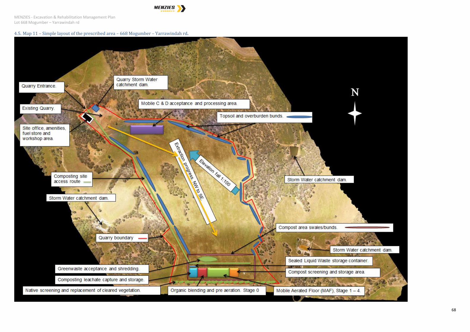
sand, and lastly the rehabilitation of the land surface. Simple layout of the prescribed area is
shown in map 11.

MENZIES - Excavation & Rehabilitation Management Plan Lot 668 Mogumber – Yarrawindah rd
66
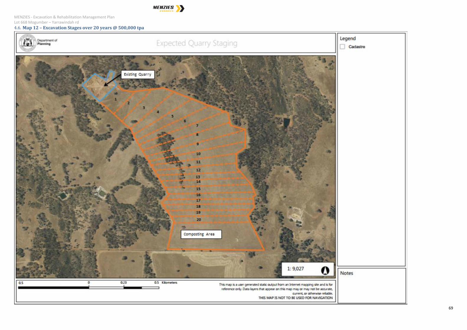
a) The resource will be excavated in stages across the excavation area (Map 12) on an
as required basis.
b) All trees are cleared in accordance with a relevant Clearing Permit. If further clearing
is required, the appropriate clearing permit will be sought from the DER. as required
by the Environmental Protection (Clearing of Native Vegetation) Regulations 2004.
Map 14 shows area proposed to be cleared.
Vegetation removed is replaced on a minimum of a one for one basis and
located predominately on the southern border of the quarry area to also
provide additional screening of activities.
c) Topsoil is removed by scraping from the resource and pushing to the perimeter to
form a 1 to 2 meter bund at the perimeter of the existing extraction area to provide
screening and reduce handling for later use in rehabilitation. The Topsoil may also
be directly transferred to a prior extraction point being rehabilitated.
d) Overburden is removed by scraping from the resource and captured through the
gravel screening process. The overburden is pushed or delivered by loader to form a
1 to 2 meter bund on the perimeter of the existing extraction area providing screening
and reducing handling for later use in rehabilitation. The Overburden may also be
directly transferred to a prior extraction point being rehabilitated.
e) Topsoil and Overburden storage locations follow the excavation of the resource as
indicated in Map 11.
f) Excavations commence in the North Western corner at the existing quarry and
progress in a South Easterly direction, map 12. The quarry is expected to have a life
span of over twenty (20) years subject to market demands.
g) The depth of the excavation will align with the existing quarry elevation of 265m. A
fall of 1 :100 will be developed during the excavation to direct water to the catchment
pond in the north east of the existing quarry.
h) The excavation is performed by a number of mobile plant depending on the nature of
the material and the design of the pit. Typically a bulldozer is used to extract the
material. Where this is not the safest option an excavator is utilised. Mobile plant will
commence excavations commencing from the existing quarry in the North and
progress to the east and west boundary of the quarry. Bulldozers are also used to
push the material for subsequent loading, processing and stockpiling of the finished
products.
i) A low bund and/or drain will be located upslope, to the south of the active extraction
face, to divert stormwater from the areas yet to be excavated away from the active pit
and towards the water storage dams utilising the current east – west gradient of the
land.
j) Small bunds and contours are developed within the working pit as required to direct
MENZIES - Excavation & Rehabilitation Management Plan Lot 668 Mogumber – Yarrawindah rd
67
water to the sumps and storage areas and prevent runoff from the disturbed areas.
All storage ponds are sufficiently sized to retain all water from 1:20 year storm events.
k) The quarry site contains large gravel rocks within the East which will require crushing
and screening while the west side of the quarry area predominately consists of loose
gravel typically only requiring screening. The two types of material are stockpiled
separately for processing and blending. Each product type produced post processing
is then stored in separate stockpiles. The locations of these stockpiles will change
from time to time as the excavations progress.
l) The locations of stockpiles are such that they are screened via the elevations and
native vegetation on all sides.
m) Collection of material from the stockpiles will be performed using a loader or
excavator loading the final products directly into trucks for transport to off takers.
n) Rehabilitation of the excavated area will predominately be carried out using a
bulldozer. An excavator may also be used to distribute the topsoil and overburden.
Rehabilitation will progressively follow excavation where future disturbance can be
avoided. The proposed additional use of the quarry as a C&D processing site means
that there will be little benefit in rehabilitating the operational land until the life of the
quarry is nearing completion.
No WDM will be utilised in the rehabilitation of the quarry without specific
approval from the DER following clarification of the definition and permitted
uses of these materials.
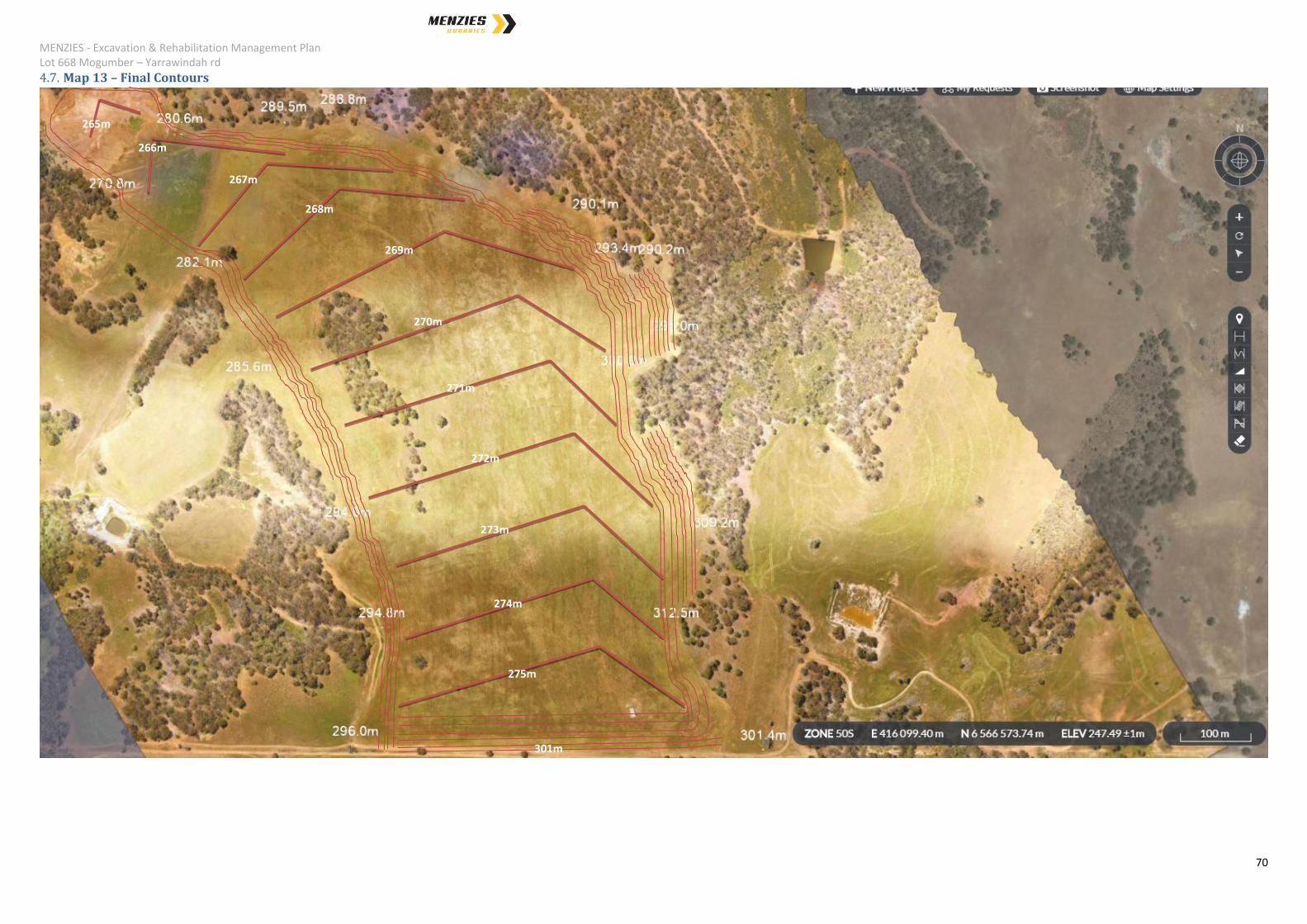
4.4. Final Contours
The land surface will be contoured to match the existing landform of the area. The elevation
will be formed into a self-draining landform that drains to a dam to be located on the northern
portion of the quarry area, currently occupied by the existing quarried area.
a) The depth of the dam will be 5 metres with a safe and stable batter slope to be
established to maximise the volume and minimise the surface area to reduce
evaporation effects.
b) By determining the runoff from the catchment area it can be assured that all storm
water is contained within the depression.
c) During operations and upon completion, the land surface is to be graded down to the
dam at the north eastern portion of the quarry. The east, west and south slopes will
be made to match the existing gradient beyond the extents of the quarry area and will
be 1:3 to 1:2, vertical to horizontal.
d) The Concept Final Contours show the land elevation ranging from 265meters AHD in
the north to 275 metres AHD in the south with the water level in the proposed dam
filling to an elevation of about 260mAHD, map 13.
MENZIES - Excavation & Rehabilitation Management Plan Lot 668 Mogumber – Yarrawindah rd
68
4.5. Map 11 – Simple layout of the prescribed area – 668 Mogumber – Yarrawindah rd.
MENZIES - Excavation & Rehabilitation Management Plan Lot 668 Mogumber – Yarrawindah rd
69
4.6. Map 12 – Excavation Stages over 20 years @ 500,000 tpa
MENZIES - Excavation & Rehabilitation Management Plan Lot 668 Mogumber – Yarrawindah rd
70
4.7. Map 13 – Final Contours
275m
273m
274m
266m
265m
272m
271m
270m
269m
268m
267m
301m

MENZIES - Excavation & Rehabilitation Management Plan Lot 668 Mogumber – Yarrawindah rd
71
4.8. Map 14 – Area to be cleared.
Area to be cleared
MENZIES - Excavation & Rehabilitation Management Plan Lot 668 Mogumber – Yarrawindah rd
72
5. Environmental management, reporting and monitoring
5.1. Air Emissions
There are no air emissions associated with the proposed activities.
Composition and Quantity – Nil.
Variability of Emissions – Nil.
Treatment Methodology – Nil.
Monitoring – Nil.
Contingency Plans – Nil.
Environmental Receptors – Nil.
Fugitive Emissions – Nil.
Cumulative Impact – Nil.
Targets and Limits – Nil.
Environmental Risk – Nil.
5.2. Dust Emissions
As a result of the temporary nature of the infrastructure within the lease area, all
materials handling activities occur out in the open. Due to the nature of some of the
activities on site, there is the potential to generate dust; however, there are
management options available to control dust such that there will be no off-site
impact.
A Dust Management Plan has been developed to provide guidance on how to
manage dust.
Potential sources of dust emissions include:
Dust from extraction of material – moderate consideration
Particularly dusty individual C&D loads – minor consideration;
Generally dusty waste loads - minor consideration;

MENZIES - Excavation & Rehabilitation Management Plan Lot 668 Mogumber – Yarrawindah rd
73
The mobile equipment sorting and moving materials - minor consideration;
Materials screening operations - minor consideration;
Stored material - minor consideration;
Bin/vehicle loading with fine screened material - minor consideration; and,
Vehicle wheels spreading dirt around the site - minor consideration.
Variability of Emissions – There is the potential for variable emissions, which will
depend of the following:
Material type;
Material quantities;
Ambient weather conditions; and,
Facility housekeeping.
Treatment Methodology – The following are the suite of preventative measures
available:
Water cart wetting down the internal access roads and lease area;
Should particularly dusty loads be identified these loads will be barred from
being delivered to the site unless the load is able to be delivered in such a
manner that reduces or prevents dust emissions;
Dust suppression systems, consisting of sprinklers installed along lease
boundary fences and within the lease area. The dust suppression system
comprises the following:
o Piped reticulation systems strung along the lease perimeter
boundary; and,
o Piped reticulation systems of sprinklers strategically placed to cover
dust generating operations and material stockpiles.
Dust suppression systems are standard, factory-fitted installations on
screening and stacking equipment to control dust generation. The equipment
utilised on site will come fitted with standard, factory installed dust suppression
system or if not, dust suppression systems will be installed on the equipment.
The systems will be utilised in accordance with the manufacturer's

MENZIES - Excavation & Rehabilitation Management Plan Lot 668 Mogumber – Yarrawindah rd
74
recommendations and in accordance with environmental requirements. The
systems typically operate at 30 L/min at 200 kpa;
Screening and stacking will only be carried out when weather conditions
permit. No screening or stacking will take place when the wind conditions
cause excessive dust generation; and,
Material handling areas will have sprinkler systems installed to enable the
adequate wetting down of the Receival, sorting and storage of material to
ensure appropriate dust control.
Monitoring – Dust emissions will be monitored on a continuous basis by lease area
operations staff. The Proponent will also maintain a comprehensive complaints
register, which will be used as a gauge of success with regards to dust emissions
management. In the event that there are dust emissions issues identified, formal dust
monitoring will be undertaken by an independent third party to determine the extent of
the problem and to propose appropriate improved dust management solutions.
Contingency Plans - If unacceptable dust emissions are identified onsite, the following
contingency plans are available to improve dust management:
Increased coverage by sprinkler system.
Slow vehicles down by traffic calming methods (speed humps);
Restrict dust generating activities to the appropriate time of day to reduce dust
generation (weather dependent);
Reject or restrict excessively dusty loads; and,
Utilisation of chemical dust suppressants.
Environmental Receptors - Environmental receptors include the lease area operations
staff, customers depositing and collecting materials at lease areas, neighbouring
lease areas and neighbouring properties.
Cumulative Impact – With there being similar activities on the site to the south of the
prescribed premises, there is the possibility that there could be a cumulative impact
with regards to dust generation. The consequence of this will be highly dependent on
the type of activity and the quantity of dust being generated. As there are
preventative measures that can be applied (primarily, temporally ceasing some
operations due to excessive wind), the impact on receptors will be controlled.

MENZIES - Excavation & Rehabilitation Management Plan Lot 668 Mogumber – Yarrawindah rd
75
Targets and Limits – No dust emissions beyond the prescribed boundary and nil
community complaints.
Environmental Risk – A risk assessment of all identified potential environmental risks
associated with the management of dust has been undertaken. The primary
consideration being the prevention of dust emissions beyond the prescribed
boundary.
The emissions and discharge risk assessment framework has been taken from the
DER Corporate Policy Statement No. 07 – Operational Risk Management.
Emissions Risk Matrix utilised in the risk assessment is based on the following:
Likelihood
Consequence
Insignificant Minor Moderate Major Severe
Almost
Certain
Moderate High High Extreme Extreme
Likely Moderate Moderate High High Extreme
Possible Low Moderate Moderate High Extreme
Unlikely Low Moderate Moderate Moderate High
Rare Low Low Moderate Moderate High
The outcome of the risk assessment is that there is a low risk of dust emissions
beyond the site boundary and hence, a low impact on any neighbouring receptors as
a result of the proposed activities.
Table 1 – Dust Management Risk Assessment provides the detail of the risk
assessment.
5.3. Asbestos Management
The site will NOT be licensed to accept asbestos and this material will not be
intentionally delivered or accepted on site. There is however the potential to
inadvertently receive this waste type at some of the proposed site operations.
The following processes will be put into place to manage this occurrence:
Customers will be advised that asbestos products are not accepted on
MENZIES - Excavation & Rehabilitation Management Plan Lot 668 Mogumber – Yarrawindah rd
76
site.
Appropriate signage will be erected at the site entrance notifying
customers that asbestos is not accepted on site.
Staff working at the facility will be trained to ensure that they are able to
recognize asbestos containing material and are aware of the protocols
to be followed if it is identified.
Upon arrival at the facility, the incoming waste will be inspected and
sorted into recyclable components and residual waste. If at any stage
asbestos is identified, the load will either be rejected (if the delivery
vehicle is still on site) or the asbestos containing material will be
separated and placed in a waste bin for immediate removal (at least
within 24 hours).
Sand and rubble products will be managed in accordance with the
most recent DER Asbestos Management Guidelines, 18 December 2012.
All relevant activities will be carried out in accordance with a site Asbestos
Management Plan, which has been developed to comply with the DER Asbestos
Management Guidelines, 18 December 2012.
MENZIES - Excavation & Rehabilitation Management Plan Lot 668 Mogumber – Yarrawindah rd
77
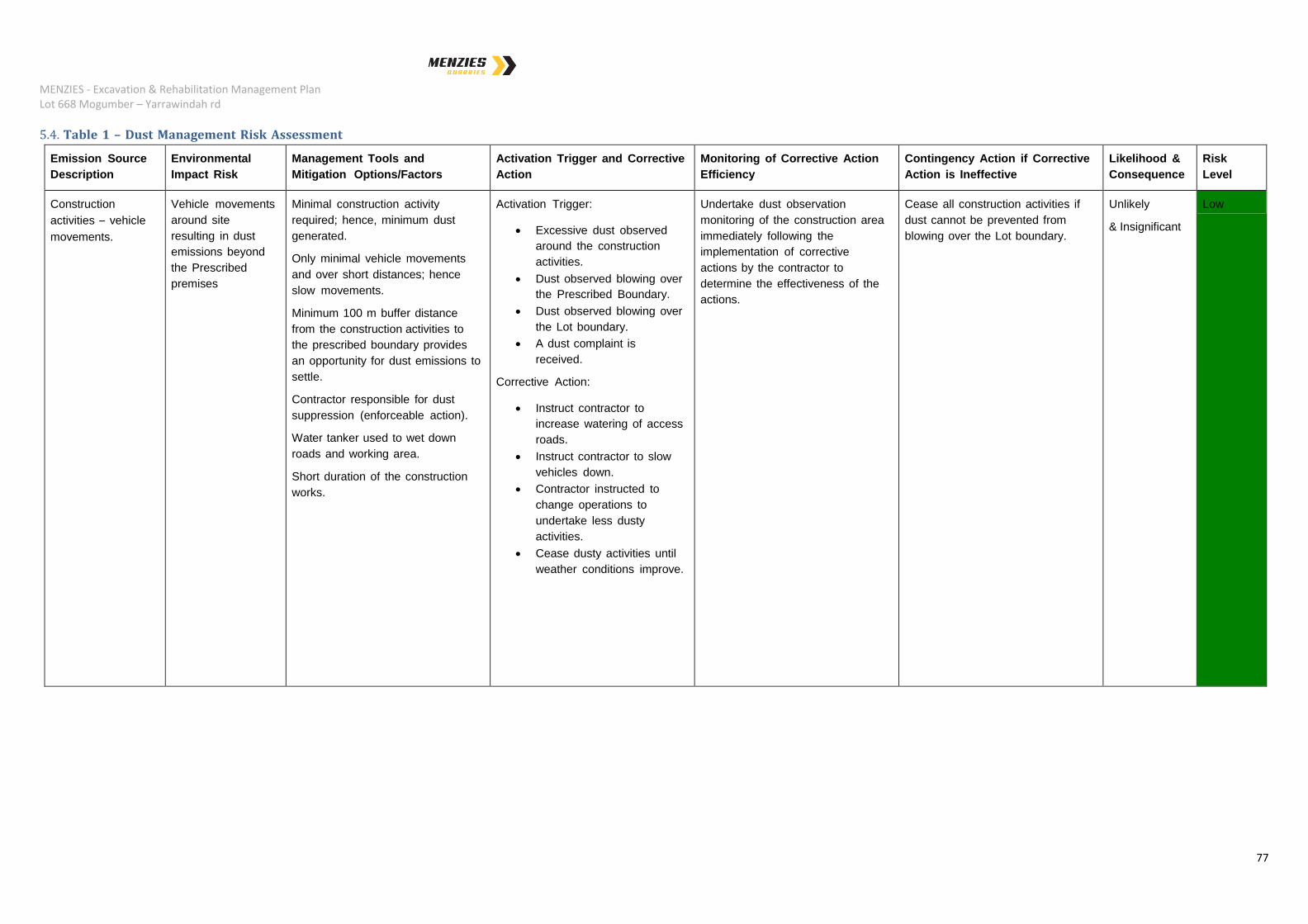
5.4. Table 1 – Dust Management Risk Assessment
Emission Source
Description
Environmental
Impact Risk
Management Tools and
Mitigation Options/Factors
Activation Trigger and Corrective
Action
Monitoring of Corrective Action
Efficiency
Contingency Action if Corrective
Action is Ineffective
Likelihood &
Consequence
Risk
Level
Construction
activities – vehicle
movements.
Vehicle movements
around site
resulting in dust
emissions beyond
the Prescribed
premises
Minimal construction activity
required; hence, minimum dust
generated.
Only minimal vehicle movements
and over short distances; hence
slow movements.
Minimum 100 m buffer distance
from the construction activities to
the prescribed boundary provides
an opportunity for dust emissions to
settle.
Contractor responsible for dust
suppression (enforceable action).
Water tanker used to wet down
roads and working area.
Short duration of the construction
works.
Activation Trigger:
Excessive dust observed
around the construction
activities.
Dust observed blowing over
the Prescribed Boundary.
Dust observed blowing over
the Lot boundary.
A dust complaint is
received.
Corrective Action:
Instruct contractor to
increase watering of access
roads.
Instruct contractor to slow
vehicles down.
Contractor instructed to
change operations to
undertake less dusty
activities.
Cease dusty activities until
weather conditions improve.
Undertake dust observation
monitoring of the construction area
immediately following the
implementation of corrective
actions by the contractor to
determine the effectiveness of the
actions.
Cease all construction activities if
dust cannot be prevented from
blowing over the Lot boundary.
Unlikely
& Insignificant
Low

MENZIES - Excavation & Rehabilitation Management Plan Lot 668 Mogumber – Yarrawindah rd
78
Vehicle movements
during operations.
Vehicle movements
on access road and
within the lease
area resulting in
dust emissions
beyond the Lot
boundary.
The majority of the site including the
access road is a significant distance
from sensitive receptors and is
compacted gravel road base; hence,
reduces dust generation and
increases the opportunity for dust to
settle before it blows over the Lot
boundary.
Restricting vehicle speed to 20
km/hr.
Water tanker used to wet down
internal access roads as the
primary dust suppression
methodology.
The use of dust suppression
agents. (Dustex or similar) will be
used, as a secondary methodology
if using only water proves
ineffective.
Activation Trigger:
Excessive dust observed on
the access roads.
Dust observed blowing over
the Lot boundary.
A dust complaint is
received.
Corrective Action:
More regular wetting down
of access roads.
More rigorous enforcement
of site speed limit.
Installation of speed humps
to further slowdown
vehicles.
Reduce site speed limit
even further.
Utilisation of additional dust
suppression agents.
Undertake dust observation
monitoring of the access roads
immediately following the
implementation of corrective
actions to determine the
effectiveness of the actions.
If installed, check dust monitors for
evidence of dust blowing over the
site boundary.
Only essential vehicle movements
along access roads where
problematic dust emissions occur
(these being primarily waste
vehicles and water tanker).
Unlikely
& Insignificant
Low
MENZIES - Excavation & Rehabilitation Management Plan Lot 668 Mogumber – Yarrawindah rd
79
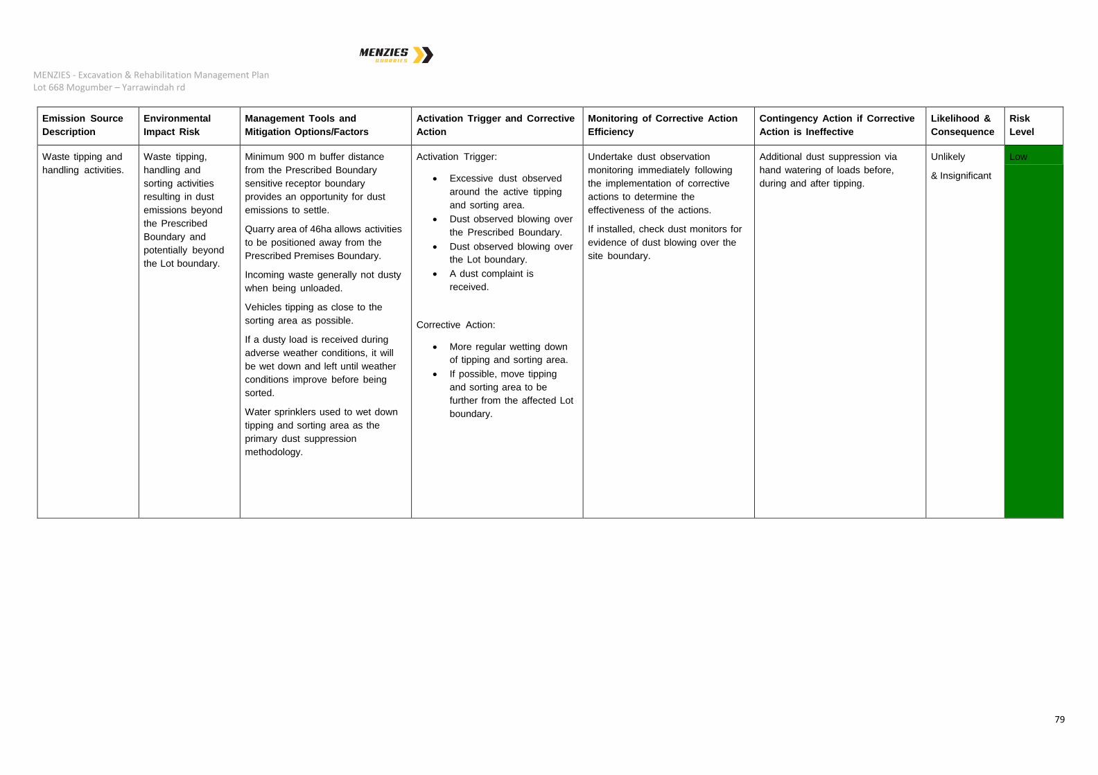
Emission Source
Description
Environmental
Impact Risk
Management Tools and
Mitigation Options/Factors
Activation Trigger and Corrective
Action
Monitoring of Corrective Action
Efficiency
Contingency Action if Corrective
Action is Ineffective
Likelihood &
Consequence
Risk
Level
Waste tipping and
handling activities.
Waste tipping,
handling and
sorting activities
resulting in dust
emissions beyond
the Prescribed
Boundary and
potentially beyond
the Lot boundary.
Minimum 900 m buffer distance
from the Prescribed Boundary
sensitive receptor boundary
provides an opportunity for dust
emissions to settle.
Quarry area of 46ha allows activities
to be positioned away from the
Prescribed Premises Boundary.
Incoming waste generally not dusty
when being unloaded.
Vehicles tipping as close to the
sorting area as possible.
If a dusty load is received during
adverse weather conditions, it will
be wet down and left until weather
conditions improve before being
sorted.
Water sprinklers used to wet down
tipping and sorting area as the
primary dust suppression
methodology.
Activation Trigger:
Excessive dust observed
around the active tipping
and sorting area.
Dust observed blowing over
the Prescribed Boundary.
Dust observed blowing over
the Lot boundary.
A dust complaint is
received.
Corrective Action:
More regular wetting down
of tipping and sorting area.
If possible, move tipping
and sorting area to be
further from the affected Lot
boundary.
Undertake dust observation
monitoring immediately following
the implementation of corrective
actions to determine the
effectiveness of the actions.
If installed, check dust monitors for
evidence of dust blowing over the
site boundary.
Additional dust suppression via
hand watering of loads before,
during and after tipping.
Unlikely
& Insignificant
Low
MENZIES - Excavation & Rehabilitation Management Plan Lot 668 Mogumber – Yarrawindah rd
80
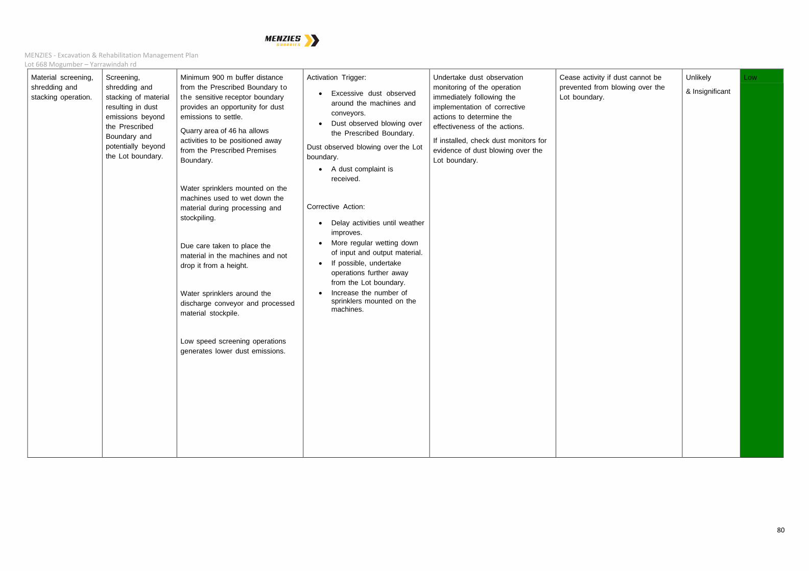
Material screening,
shredding and
stacking operation.
Screening,
shredding and
stacking of material
resulting in dust
emissions beyond
the Prescribed
Boundary and
potentially beyond
the Lot boundary.
Minimum 900 m buffer distance
from the Prescribed Boundary to
the sensitive receptor boundary
provides an opportunity for dust
emissions to settle.
Quarry area of 46 ha allows
activities to be positioned away
from the Prescribed Premises
Boundary.
Water sprinklers mounted on the
machines used to wet down the
material during processing and
stockpiling.
Due care taken to place the
material in the machines and not
drop it from a height.
Water sprinklers around the
discharge conveyor and processed
material stockpile.
Low speed screening operations
generates lower dust emissions.
Activation Trigger:
Excessive dust observed
around the machines and
conveyors.
Dust observed blowing over
the Prescribed Boundary.
Dust observed blowing over the Lot
boundary.
A dust complaint is
received.
Corrective Action:
Delay activities until weather
improves.
More regular wetting down
of input and output material.
If possible, undertake
operations further away
from the Lot boundary.
Increase the number of sprinklers mounted on the machines.
Undertake dust observation
monitoring of the operation
immediately following the
implementation of corrective
actions to determine the
effectiveness of the actions.
If installed, check dust monitors for
evidence of dust blowing over the
Lot boundary.
Cease activity if dust cannot be
prevented from blowing over the
Lot boundary.
Unlikely
& Insignificant
Low
MENZIES - Excavation & Rehabilitation Management Plan Lot 668 Mogumber – Yarrawindah rd
81
5.5. Odour Emissions
There are odour emissions possible associated with the operations of the composting facility
only. The emissions are mitigated through the use of appropriate technologies and operating
procedures.
Composition and Quantity – Odour from composting batches not operating correctly will be
anaerobic in nature. To avoid the release anaerobic odours, the MAF system enables
continuous or intermittent airflow to be set depending on the composting stage and material
type.
Variability of Emissions – Emissions will vary with feedstock type received.
Treatment Methodology – Odorous material is directly mixed with clean greenwaste when
received or stored in a liquid tank in preparation for blending. All odorous waste is delivered
with prior notification to ensure the site has sufficient means to control odours. The facility
has a stage 0 batch to aerate material until the batch volume has reached sufficient size to
move to stage 1 of the compositing process, or if stage 1 area is not available. Particularly
odorous batches will be covered with a biofilter crust at a minimum thickness of 200mm
consisting of the oversized fraction of screened compost. Process covers will also be
available to further trap odours and allow the biofilter layer to absorb odours present.
Monitoring – process monitoring for moisture, pH and Oxygen ensures the composting
process is active, minimising the possibility of odour production.
Contingency Plans – In the event of malfunction of the MAF system, generators and
additional blowers can be delivered within 24 hrs. during which time the affected batch will
remain covered.
Environmental Receptors – Environmental receptors include the lease area operations staff,
customers depositing and collecting materials, other site users and neighbouring properties.
Cumulative Impact – Surrounding properties utilise biosolids and manures from time to time
for direct application to land.
Targets and Limits – No odour complaints
Environmental Risk – The environmental risk on site and to neighbouring properties is
considered to be low.
5.6. Noise Emissions
Noise management is a consideration during the operations on site. The Environmental
Protection (Noise) Regulations 1997 have restrictions on noise emissions during the period
MENZIES - Excavation & Rehabilitation Management Plan Lot 668 Mogumber – Yarrawindah rd
82
7.00 pm to 7.00 am. Beyond this time restriction, normal noise regulations for industrial
areas apply.
The site opens at 6:00am however screening activities on site commence at 7.00 am and
finish by 5.00 pm; hence, these activities occur outside the restricted period. With the sorting
activities occurring out in the open, the management of noise emissions is a high priority.
Potential sources of noise emissions include:
Unloading of some material types;
Mobile equipment operating on site; and,
Sorting and screening equipment.
Composition and Quantity – The screening operations is the activity that is likely to
generate the most noise and the most consistent noise source.
5.6.1. Noise Treatment Methodology:
Should there be noise emissions concerns, there are a number of actions that can be
undertaken to further reduce noise emissions, and these include:
Vehicle reversing beacon: Should the standard vehicle reversing beacons be
identified as causing noise disturbance, the beacons will be changed to the
“croaker or low frequency” type beacons which emit a lower sound level, but are
still effective safety warning devices.
Screening operations: These activities could occur behind other site infrastructure
or materials stockpiles. The lease area is sufficiently large and the screening
operations are located to ensure that the operations occur 900m from the nearest
sensitive receptor (to the North west) with ~20m high quarry wall and native
bushland between which would absorb any noise emissions and prevent excessive
noise emissions reaching this receptor. In addition, with the site being located in
an industrial area, quarries to the south and west and market gardens to the east,
there are no neighbouring human receptors that would be negatively impacted by
the screening operations.
Staggered operations: Some site activities could be staggered to reduce the
cumulative effect of multiple plant and equipment operating simultaneously.
If noise is identified as a problem during operations, noise monitors will be used to provide
accurate information on the level of noise actually being generated and hence, if necessary,
identify potential remedial actions.
The overriding consideration is that the Proponent, commits to ensuring that the all

MENZIES - Excavation & Rehabilitation Management Plan Lot 668 Mogumber – Yarrawindah rd
83
lease area activities are carried out in accordance with the Environmental Protection
(Noise) Regulations 1997. In the event of noise being identified as a problem, third-party
independent specialists will be engaged to monitor noise emissions and where necessary
recommend site improvements to reduce noise emissions. If it is not possible/feasible to
reduce noise emission to below Noise Regulation requirements, then the offending
operations will be discontinued.
Monitoring – Noise emissions will be monitored on a continuous basis by lease area
operations staff.
Contingency Plans – Increased training of equipment operators to reduce operational noise,
install noise abatement devices or change/cease specific activities.
Environmental Receptors – Environmental receptors include the lease area operations staff,
customers depositing and collecting materials, other site users and neighbouring properties.
Cumulative Impact – A cumulative impact is not anticipated since the noise generated from
the prescribed premises is low with no crushing to be performed.
Targets and Limits – As defined by the Environmental Protection (Noise) Regulations 1997
and nil complaints.
Environmental Risk – The environmental risk on site and to neighbouring properties is
considered to be low.
5.7. Litter Emissions
There will be no litter emissions
Composition and Quantity – Nil.
Variability of Emissions – Nil.
Treatment Methodology – Nil.
Monitoring – Nil.
Contingency Plans – Nil.
Environmental Receptors – Nil.
Cumulative Impact – Nil
Targets and Limits – Not Applicable.
Environmental Risk – Nil.
MENZIES - Excavation & Rehabilitation Management Plan Lot 668 Mogumber – Yarrawindah rd
84
5.8. Light Emissions
There are no light emissions associated with the proposed activities.
All light spills associated with security lighting will be contained within the property, in
accordance with AS4282 - 1997 "Control of the Obtrusive Effects of Outdoor Lighting".
5.9. Discharge to Water
There will be no discharge to water.
Composition and Quantity – Nil.
Variability of Emissions – Nil.
Treatment Methodology – Nil.
Monitoring – Nil.
Contingency Plans – Nil.
Environmental Receptors – Nil.
Cumulative Impact – Nil
Targets and Limits – Not Applicable.
Environmental Risk – Nil.
5.10. Discharge to Land
The only discharge to land will be clean stormwater discharge to existing farm dams.
Composition and Quantity – Nil.
Variability of Emissions – Nil.
Treatment Methodology – Nil.
Monitoring – Nil.
Contingency Plans – Nil.

MENZIES - Excavation & Rehabilitation Management Plan Lot 668 Mogumber – Yarrawindah rd
85
Environmental Receptors – Nil.
Cumulative Impact – Nil
Targets and Limits – Not Applicable.
Environmental Risk – Nil.
5.11. Vermin Management
Based on the type of materials being handled on site, there is minimal, if any food source for
vermin; consequently, it is not anticipated that there will be a problem with vermin.
The potential sources of vermin include:
Arriving in material being delivered to the facility; and,
Living in and around the facility.
Preventative measures include:
Should vermin be observed on site, the appropriate eradication procedures are to be
undertaken, this will involve professional pest controllers being utilised to manage the
situation. Typically, vermin could include rats, mice, cats, birds and cockroaches.
On occasion both mouse and rat traps will be spread around the site even if vermin
have not been identified. This will assist in identifying the presence of any rats or
mice.
5.12. Native Vegetation, Flora and Fauna
The lease area has 1.7 ha of vegetation to be cleared and as such a clearing permit is
required for this proposal. A Dieback study has been completed (section 3.7.1)
Neighbouring or Other Local Native Vegetation – Not to be affected by the proposal.
Flora and Fauna – No rare or threatened species have been identified in the area. Species
of flora identified is listed within the Dieback assessment. No visible Carnaby Cockatoo
nesting sites were identified.
Impacts on Land, Soil, Salinity and Waterways - Nil.
Sustainability – Flora removed as listed within the clearing area will be replanted like for like
with new seedlings. The majority will be planted on the southern border to improve
screening and stormwater management with the remainder panted around the perimeter of
the quarry.
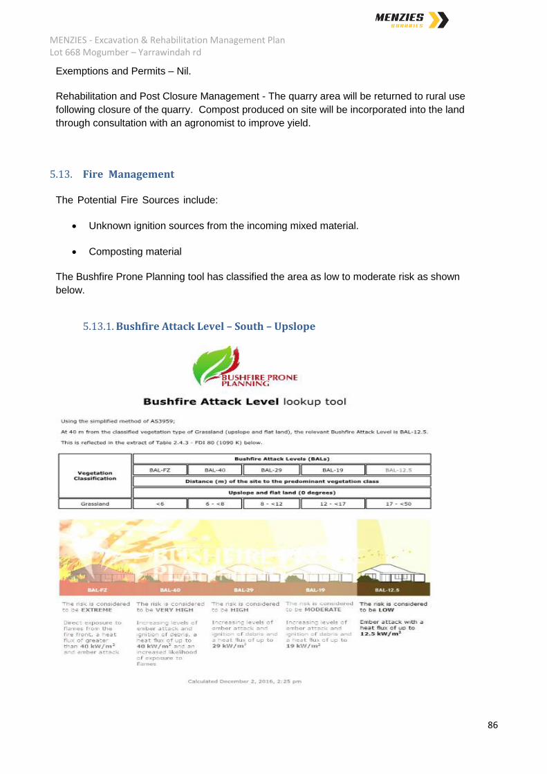
MENZIES - Excavation & Rehabilitation Management Plan Lot 668 Mogumber – Yarrawindah rd
86
Exemptions and Permits – Nil.
Rehabilitation and Post Closure Management - The quarry area will be returned to rural use
following closure of the quarry. Compost produced on site will be incorporated into the land
through consultation with an agronomist to improve yield.
5.13. Fire Management
The Potential Fire Sources include:
Unknown ignition sources from the incoming mixed material.
Composting material
The Bushfire Prone Planning tool has classified the area as low to moderate risk as shown
below.
5.13.1. Bushfire Attack Level – South – Upslope

MENZIES - Excavation & Rehabilitation Management Plan Lot 668 Mogumber – Yarrawindah rd
87
5.13.2. Bushfire Attack Level – West and North – Downslope

MENZIES - Excavation & Rehabilitation Management Plan Lot 668 Mogumber – Yarrawindah rd
88
5.13.3. Bushfire Attack Level – East – Upslope
Management Measures include:
Removal of flammable material from site as soon as possible after sorting.
Compost controls ensure that the pile is always within operational specifications to
ensure temperatures are not exceeded or the pile becomes to dry.
During operating hours lease area operations staff are to immediately take action to
extinguish any fires if safe to do so and call local fire station..
Afterhours security is to call out the local fire station.
The lease area has a supply of water for site usage. This water can be used to
extinguish small fires. An onsite water truck maintains all stockpiles in a damp state
and is available to supress fire when safe to do so.
MENZIES - Excavation & Rehabilitation Management Plan Lot 668 Mogumber – Yarrawindah rd
89
5.14. Solid/Liquid Waste
5.14.1. Solid Waste
There is minimal solid waste produced by the site operations. This is primarily waste material
generated by the site operations staff via crib rooms and amenities. This waste is simply
disposed of in waste bins and removed from site.
Composition and Quantity – Insignificant (typically domestic waste).
Variability of Emissions – Nil.
Treatment Method – Disposed of in waste bins and removed from site.
Controlled Waste Tracking – Not applicable.
Contingency Plans – Nil.
Environmental Receptors – Nil.
Comparison Against Relevant Standards – Nil.
Cumulative Impact – Nil.
Waste Reuse – Nil.
Environmental Risk - Nil.
5.14.2. Liquid Waste
There is minimal liquid waste produced by the site operations. This is primarily liquid waste
generated in ablutions, which are contained in portable chemical toilets.
Composition and Quantity – Insignificant.
Variability of Emissions – Nil.
Treatment Method – Storage and removed from site.
Controlled Waste Tracking – Not applicable.
Contingency Plans – Nil.
Environmental Receptors – Nil.

MENZIES - Excavation & Rehabilitation Management Plan Lot 668 Mogumber – Yarrawindah rd
90
Comparison Against Relevant Standards – Nil.
Cumulative Impact – Nil.
Waste Reuse – Nil.
Environmental Risk - Nil.
5.15. Hydrocarbon / Chemical Storage
5.15.1. Hydrocarbon Storage
Quantity and Type – Bulk hydrocarbon (diesel) for mobile vehicle and equipment refuelling
will either be delivered to site on an as required basis via mobile refuelling tanker or be
stored on site. If on site storage is utilised, the hydrocarbon will be stored in a purpose built,
self-bunded fuel dispensing container (typically up to 20,000 litres). These units come with
self-contained fuel pump, bowser and spill kit.
There will also be limited quantities of oils and greases stored on site for regular
maintenance of mobile equipment. These hydrocarbons will typically be contained in small
quantities of up to 5 litres, but occasionally in 25 litre drums. All of these hydrocarbons will
be stored undercover (in shipping containers).
5.15.2. Chemical Storage
Quantity and Type – There will be limited quantities of chemicals stored on site as part of the
regular site activities. These chemicals are typically domestic cleaning products and will
generally be up to a maximum of 5L containers, but more typically small containers and
spray cans of detergents and pesticides.
5.16. Contaminated Site Identification
A review of the DER Contaminated Sites Data Base
(https://secure.dec.wa.gov.au/idelve/css/) has indicated that the site is not a registered
Contaminated Site.
Due to there being no known site contamination, the site will not be registered as a
Contaminated Site.

MENZIES - Excavation & Rehabilitation Management Plan Lot 668 Mogumber – Yarrawindah rd
91
5.17. Surface Water Management
All surface water generated on any part of the site yet to be excavated or not involved in
composting activities is diverted from east to west where the water is captured in a
stormwater basin running beyond the western boundary of the Quarry Area , from where it is
captured in existing dams or soaks into the ground.
Surface water collected within the active quarry area is collected within a sediment dam to be
located at the northern end of the existing quarry.
Surface water collected within the composting area is diverted to and collected within the
leachate dam. No water from outside the composting area can enter the area via the
installation of swales surrounding the site.
5.18. Groundwater Management
There is no groundwater impact as a result of the proposed Excavation and C&D processing
facilities; hence, there is no requirement for any groundwater management from these
activities.
The composting facility will contain all leachate and stormwater within the composting area
leachate dam. As per the Composting standard draft, a minimum of three bores will most
likely be required to determine baseline levels and effectiveness of liquid containment
features and processes.
5.19. Reporting requirements
As the site requires DER approval, all activities and impacts are required to be reported
annually to the DER to maintain compliance. A copy of the report will be provided to the
Shire as required.

MENZIES - Excavation & Rehabilitation Management Plan Lot 668 Mogumber – Yarrawindah rd
92
6. Rehabilitation Program
The site is zoned Rural under the Shire of Victoria Plains Town Planning Scheme. The Local
Planning Policy #10, “Basic Raw materials and Extractive Industries” has the following
objectives;
To manage the extraction of basic raw materials within the rural zones in accordance
with best industry practices including consideration of end use and rehabilitation at
time of decommission;
To ensure appropriate buffer areas are applied to protect the extractive operations as
well as the living or agricultural environment in nearby areas.
The proposed excavation has been designed to enable rural activities to continue and thrive
once the site is no longer utilised for extractive purposes.
The site will be contoured to provide a useable surface to enable cropping to occur and a
quarry sediment dam will be in place as shown in Map 11.
The topsoil will be augmented with compost thorough the assistance of agronomists to
improve the yield of the land prior to returning it to rural use.