Embed Size (px)
Citation preview
Examining the Use of Physical Models in Earth Science Education
Ann RivetTeachers College Columbia University
Kim KastensLamont-Doherty Earth ObservatoryNSF Award DRL- 0909863
February 15, 2011
Masking tape person
flashlightglobe

The Fundamental Challenge of Geoscience Education:
The Earth is 18 orders of magnitude larger than a classroom
Classroom (exaggerated)
Earth

3. Use representations
Three ways to cope with this fundamental challenge:
http://www.school-assemblies-dinosaur-program.com/arts_in_education.htm
1. Bring small pieces of the Earth into the classroom (e.g. minerals, fossils)
2. Bring students out of the classroom to observe pieces of the Earth in nature.
http://eesc.columbia.edu/courses/v1010/index.html
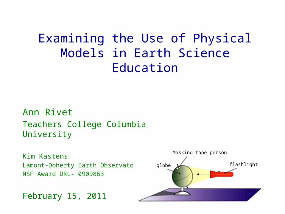
• Words • narratives (e.g., eye-
witness accounts) • textbook descriptions • analogy/metaphors
• Equations
• Numbers
• Gestures (e.g. hand over hand motion for subduction)
• Physical models • static models (e.g.
syncline) • working model (e.g.
stream table)
• Photographs
• Video
• Drawings • realistic drawings• artist’s rendering of
conceptual models
• Maps (including GIS)
• Data-based visualizations (other than maps, including graphs)
• Computer animations (not manipulatable)
• Computer models (manipulatable; student-built and non-student-built)
Many kinds of representationsfor teaching & learning about the Earth

Masking tape person
flashlightglobe
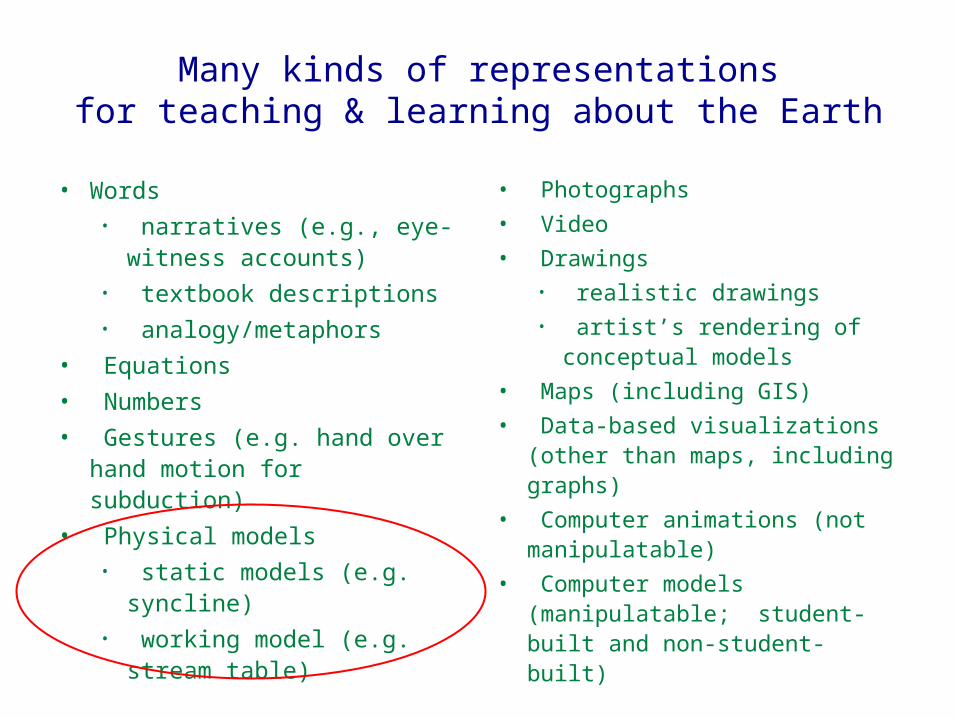
Extensive variety of physical models for Earth Science education
Widespread agreement among earth science educators that students find physical models engaging
Kim’s “Planet Earth” class at Columbialesson on open and closed systems
Holly’s 2nd grade classlesson on landforms under the ocean

But what are they actually learning about the Earth?
If the learning goal is to understand …..
... or ...
…what exactly is the value added of detouring through… ?

Biology
Chemistry
Physics
Biology: http://www.designshare.com/portfolio/project/1/604/Planting.jpg
Chemistry: http://static-p4.fotolia.com/jpg/00/05/25/83/400_F_5258352_bZa8jh896cmGWEBuGkPLjkGDKDbzRc4t.jpg
Physics: http://cse.lmu.edu/Assets/Colleges+Schools/CSE/SECOP/Physics+Project+1.jpg
Earth Science differs from the hands-on parts of other sciences
What’s in the classroom is the
actual phenomena in the curriculum

What’s in the classroom is an analog to the
phenomena under study

Reasons to be concerned: Lack of pedagogical support for making connection between model & Earth System
Freeman, C., 2008, Convection in a Fish Tank, The Science Teacher, January issue, 62-66. (magazine for high school teachers published by National Science Teachers Association)
Special issue on teaching Earth Science.Used by author in 9th grade Earth Science and 11th/12th grade Oceanography.

Reasons to be concerned: Known cognitive challenges
Small Large
Concrete Abstract
Visible Invisible
Experienced Experienced through perception through representation
Manipulatable Out of your control

Bottom Line: we don’t want to banish tabletop models from the Earth Science curriculum; we want them to be used as effectively as possible.
• What are students focused on when they learn about the Earth via a physical model?
• What pedagogical approaches increase the chances that students will learn about the Earth through their use of a tabletop model?

“Bridging the Gap Between Tabletop Models & the Earth System”
Funded by NSF/REESE
• Curriculum analysis
• Assessment of student thinking around Earth Science models
• Classroom testing of three nested interventions
• affordance of models
• pedagogical wrapping

Familiar source Unfamiliar target
Analogical mapping: the process of establishing a structural alignment between a familiar situation and and unfamiliar situation. As outcome of the alignment process, candidate inferences are projected from the base to the target.*
What is the process by which someone successfully learns about the Earth via a physical model?
* Gentner (1983); Gentner & Gentner (1983); Gentner & Toupin (1986); Gentner & Colhoun (in press)

A example of a “useful” model for Earth Science instruction

Genter’s Structure Mapping Framework for Analogical Reasoning

Genter’s Structure Mapping Framework for Analogical Reasoning
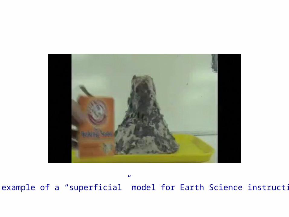
A example of a “superficial” model for Earth Science instruction
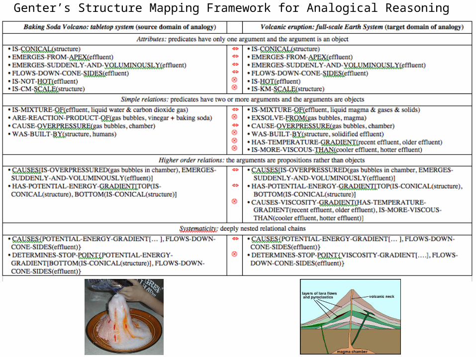
Genter’s Structure Mapping Framework for Analogical Reasoning
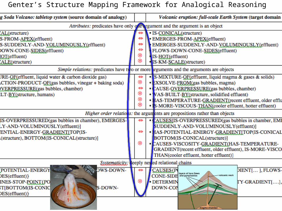
Genter’s Structure Mapping Framework for Analogical Reasoning
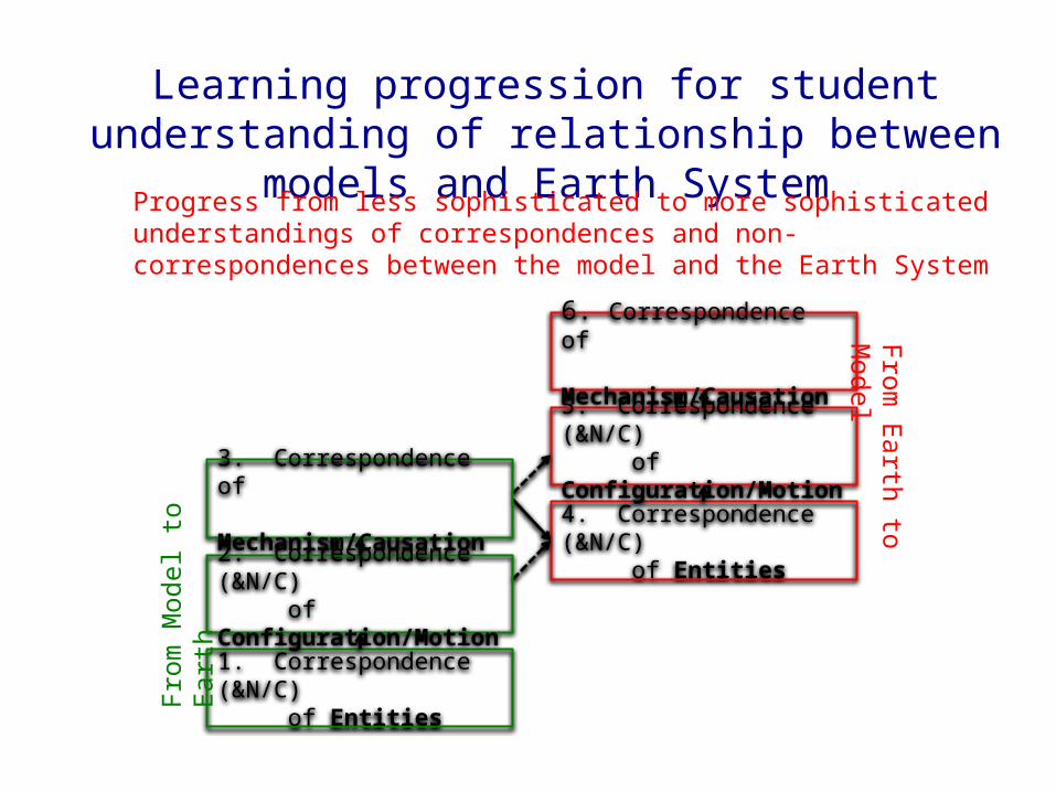
Learning progression for student understanding of relationship between
models and Earth System
4. Correspondence (&N/C) of Entities
5. Correspondence (&N/C) of Configuration/Motion
6. Correspondence of Mechanism/Causation
1. Correspondence (&N/C) of Entities
2. Correspondence (&N/C) of Configuration/Motion
3. Correspondence of Mechanism/Causation
From
Mod
el to
Ear
thFrom
Earth to Model
Progress from less sophisticated to more sophisticated understandings of correspondences and non-correspondences between the model and the Earth System

Our process
1. Form partnerships with middle and high school ES teachers
2. Identified three topics using models
3. Develop assessments of how students use models to understand three topics related to the Earth
4. Pretest students
5. Observe instruction
6. Posttest students
7. Revise/develop effective instructional strategies that best support students in learning from the models

Three parallel assessments
Seasons [differing amounts of insolation
due to orbit and tilt]
Sorting of sediment in depositional environments
Phases of the moon

Assessment development process
1. Interview 4-6 students about each model - What do you think this is a model of? - What in the model would you change to show the science idea better?
2. Develop items for each level of the construct map - 3-5 items per level
3. Multiple rounds of review and revision of items - Assessment consultant - Experienced teacher - Science expertConfounding influences:
- Student’s content understanding
- Student’s spatial reasoning ability

Example items
Lvl 1: Does the small yellow ball represent part of the real Earth System? YES NO If yes, what does it represent?
Lvl 2: What does the motion of the yellow ball around the basketball represent in the real Earth System?
Lvl 3: If the yellow ball represents the Moon at time “X”, how would it look to the doll on the basketball?
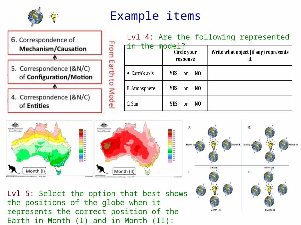
Example items
Lvl 5: Select the option that best shows the positions of the globe when it represents the correct position of the Earth in Month (I) and in Month (II):
Lvl 4: Are the following represented in the model?

Example itemsLvl 6: The graph below shows the amount of energy from the sun received at a location in the Northern Hemisphere. Each line on the graph shows the data for one day.
0 4 8 12 16 20 240
200
400
600
800
1000
1200
Time of Day (hrs.)
Ener
gy fr
om th
e Su
n (W
atts/
m2 )
xy
z
Imagine that the real Earth System is in the position represented by Position C of themodel, as shown by the experimenter at the front of the room. Which line on the graph corresponds to what the panda would experience when the model is in Position C?
a. Line (x)b. Line (y)c. Line (z)d. None of the above
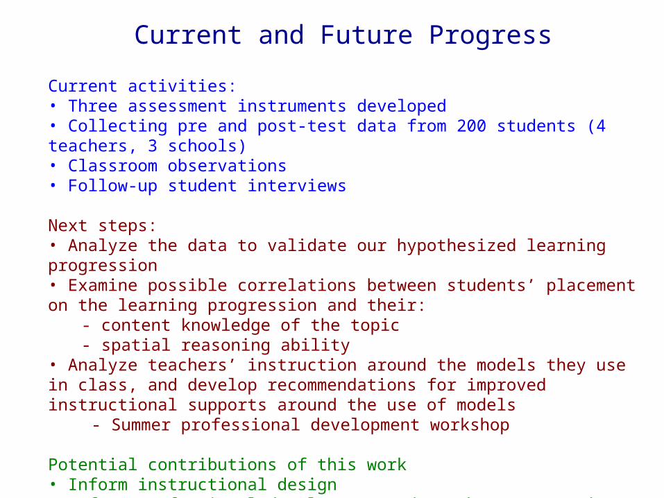
Current and Future Progress
Current activities:• Three assessment instruments developed• Collecting pre and post-test data from 200 students (4 teachers, 3 schools)• Classroom observations• Follow-up student interviews
Next steps:• Analyze the data to validate our hypothesized learning progression• Examine possible correlations between students’ placement on the learning progression and their:
- content knowledge of the topic- spatial reasoning ability
• Analyze teachers’ instruction around the models they use in class, and develop recommendations for improved instructional supports around the use of models - Summer professional development workshop
Potential contributions of this work• Inform instructional design• Inform professional development and teacher preparation in the Earth Sciences• Better understand students’ learning process related to the Earth

Thank you!
• Feedback?
• Suggestions?
• Ideas?
• Connections?


![Pitfalls [and Possibilities] in the Use of Maps to Visualize Earth Data and Understand Earth Processes Kim Kastens Lamont-Doherty Earth Observatory of](https://img.dokumen.tips/doc/110x75/56649d415503460f94a1c582/pitfalls-and-possibilities-in-the-use-of-maps-to-visualize-earth-data-and.jpg)