Embed Size (px)
Citation preview

Evolving Reference Networks and
Integrated Satellite Data (Product) Validation
Tony RealeNOAA/NESDIS
Center for SaTellite Applications and Research (STAR)Operational Products Development Branch (OPDB)
15th International TOVS Study Conference Maratea, Italy, Oct 4-10, 2006

Outline
• Evolving GCOS Atmospheric Reference Observations Network (GARON)
• Construction of Historical (TOVS) Psuedo-Reference Database (SEARCH)
• ATOVS Operational Data and Integrated Validation
• Expanded Integrated (Operational) Validation … in preparation for NPOESS via NOAA IPO award

GCOS Atmospheric Reference Observations Network (GARON):
Justification, Requirements, Siting and Instrumentation Options

Report (comments by Oct 15)(http://hadobs.metoffice.com/aopc_wg_aro)
• Scientific Requirement–– Climate record Climate record vsvs Measurement (uncertainty) record Measurement (uncertainty) record ……– Measurement Requirement Tables (Appendix-A)
• Network Operating Principles – Training, site (network) management, data management … user
• Data and Instruments– Pressure, temperature, humidity and wind … Priority 1– Srfc Radiation, microwave / infrared (AERI) sounder, clouds, trace gas, aerosol ….
Priority 2
• Candidate Networks and Sites
• Sampling – Spatial … global robustness ?–– Temporal Temporal …… synoptic synoptic vsvs satellite coincident (satellite coincident (““still an active area of ongoing debatestill an active area of ongoing debate””))
•• Cal / ValCal / Val

GARON Site CAL / Val
• “Sensor” and “calibration source” data uncertaintytraceable to International System of Units standards.
• Residual uncertainty evaluated as a function of time.– Simultaneous measurement by independent sensors.– In the laboratory when the sensor can be retrieved.– In the operational environment when the sensor cannot be
retrieved.
• Extended uncertainty computed and documented for every sensor and system.

Candidate Networks…• Baseline Surface Radiation Network (http://bsrn.ethz.ch/)
• Network for Detection of Atmospheric Composition Change (http://www.ndacc.org/)
• Aeronet (http://aeronet.gsfc.nasa.gov/)
• Global Atmospheric Watch ozone network
• International GNSS (Global Navigation Satellite Systems) Service (IGS) (see http://igscb.jpl.nasa.gov/)
• WMO Global Observing System
• The Atmospheric Radiation Measurement (ARM) Program (see http://www.arm.gov/)
• A number of individual national observatories
• The network of surface GPS total column water vapour instruments

… Initial Candidate Sites• ARM sites (Tropical Western Pacific, Southern Great Plains, North Slope of
Alaska) (http://www.arm.gov/, Ackerman and Stokes, 2003)
• Lindenberg, Germany (http://www.dwd.de/en/FundE/Observator/MOL/MOL.htm)
• Camborne, U.K., Payerne, Switzerland,
• Cabauw, Netherlands (http://www.cesar-observatory.nl/)
• Sodankylä, Finland (http://www.sgo.fi/)
• Heredia, Costa Rica
• Lauder, New Zealand
• Boulder / Denver, U.S,
• Beltsville, U.S. (http://meiyu.atmphys.howard.edu/beltsville/inde3.html)
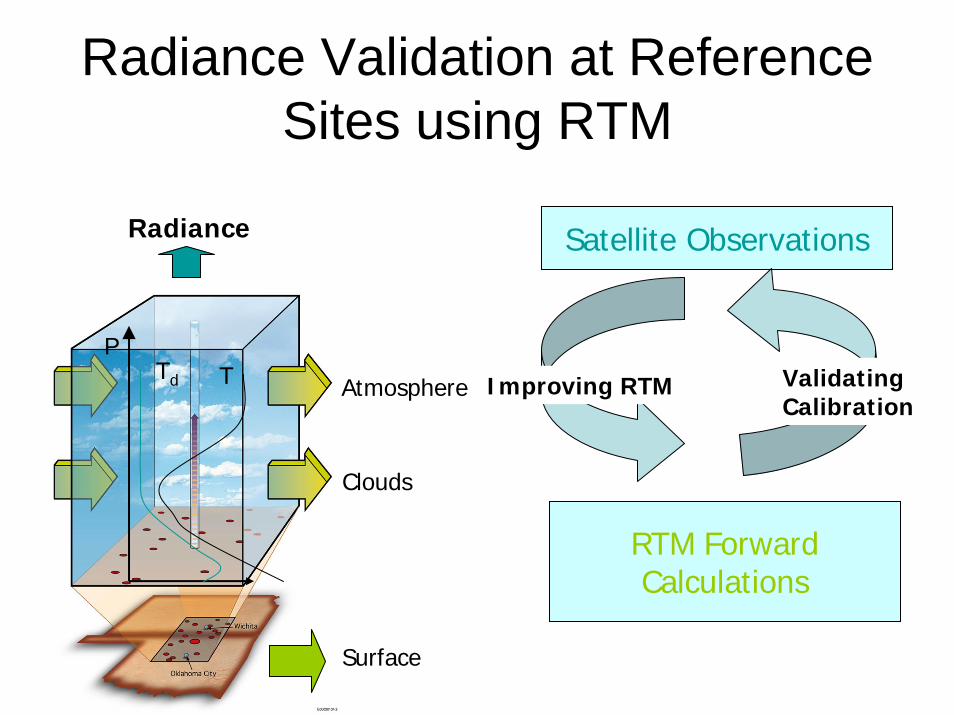
Radiance Validation at Reference Sites using RTM
RTM Forward Calculations
Radiance
PTTd
Surface
Clouds
Atmosphere
Satellite Observations
Improving RTM Validating Calibration

Referencing The Past … TOVS

Collocated TOVS and Radiosonde DataBasecompiled in support of
NOAA Study Of Environmental ARctic CHange Program(SEARCH)
• “Complete” 1b-level records for TOVS HIRS and MSU
• 1b-level readers (Schweiger, Univ Wash…)
• WMO and Special radiosondes 1979-2003
• Collocated Observations (poleward 45N) – referenced to sounder measurements
• Data Management – relational file structures
• Users and Access– Francis and Schweiger … compile RT bias (RTTOVS) and reprocess TOVS (ITPP-3I)– Plans for FTP and Web

“Global Climate Change” Proposal Submitted … 3-years (follow-up to SEARCH work)
• Baseline SEARCH Expansion – Global– TOVS SSU, operational soundings– DMSP, other ?– TOVS N14 to 2006– ATOVS (1998-onward)
• Special (simultaneous) TOVS and ATOVS (1998-2006) record
– In-situ, Research,
• Implement into ATOVS Product Operation …
• Serve as Baseline for NPOESS … Reference Network
• User Access– FTP and Web

OrientOperational Product Environment
to Provide Integrated Validation Datasets
andAnalysis

ATOVS Processing Diagram … Orbital, Daily, Weekly
Validation(tuning)
Product Generation

ATOVS Surface / Sounding Products– Incorporate MHS
– Integrate Microwave Integrated Retrieval (MIR) Products• TPW, CLW, Emissivity … (Weng, Boukabara; talk 11.6)
– Regression Guess replaces Library Search • Calculate First Guess Radiance (CRTM)
– Measurement (Radiance) Bias Adjustment• AMSU-A• MHS • HIRS
– Integrate MIR Retrieval Solution (CRTM) per sounding (Paul Van Delst, Fuzhong Weng, Yong Han)• based on Guess Temp and Moisture
– Baseline for NPOESS (… AIRS and IASI… Thomas King talk 12.3)
– Peripheral Upgrades• Limb-adjustment• Complete NWP Profile (Srfc data, +/- 90 minutes, 3hr fcst …)

a
d)
c)
b
Red areas are moister, blue areas drier (–10 to +10 mm): a) NVAP blended minus AIRS TPW. b) ATOVS (NOAA-15 and-16) minus AIRS. c) SSM/I (F-13 and F-14) minus AIRS d) TMI minus AIRS.
A PILOT STUDY OF SCIENTIFIC DATA STEWARDSHIP WITH GLOBAL WATER VAPOR Thomas. H. Vonder Haar, John M. Forsythe, and Ron W. Kessler
1Cooperative Institute for Research in the Atmosphere (CIRA), Colorado State University, Fort Collins, CO 80523
… ATOVS sounding product use in climate studies …???
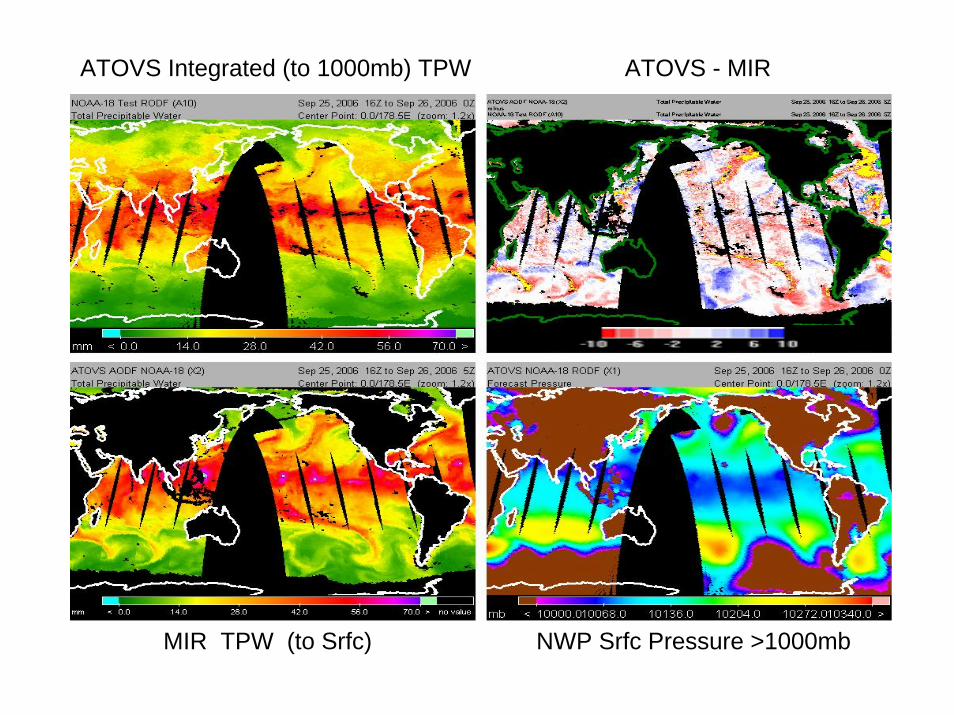
ATOVS Integrated (to 1000mb) TPW
MIR TPW (to Srfc) NWP Srfc Pressure >1000mb
ATOVS - MIR

ATOVS Oper WVMR @1000mb
ATOVS Test WVMR @1000mbTest NWP WVMR @ 1000mb
ATOVS - NWP

Orient to Integrated Data (Product) Validation (Part-1)
• Collocation DataBase Generation– Reference to Satellite Measurement (not Sounding)
– Expand Radiosonde Data stored• rad correction, drift parameters, updated instrument type• appended NWP, QC • Moisture Profile QC
– Expand data platforms to include• AIRS, GOES, COSMIC, • In-situ (ie from ARM), …• Research Experiment data
– Relational Data Management (…baseline SEARCH)
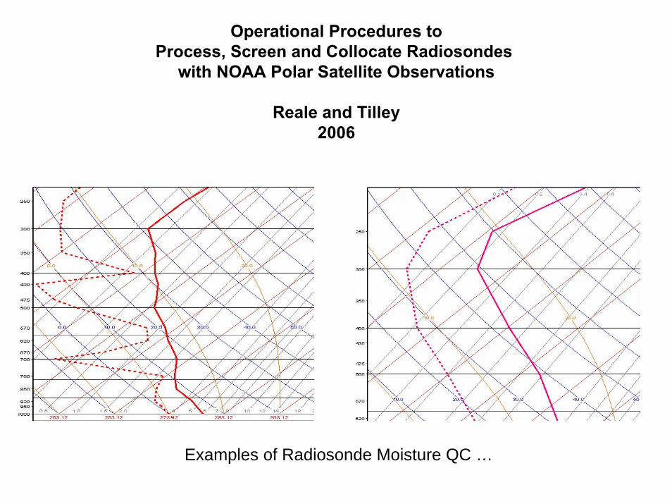
Operational Procedures toProcess, Screen and Collocate Radiosondes
with NOAA Polar Satellite Observations
Reale and Tilley2006
Examples of Radiosonde Moisture QC …

Orient to Integrated Data (Product) Validation (Part-2)
• Collocation DataBase Analysis– Product vs Product
– Radiance (Obs) vs Radiance (Obs)
– Radiance (RTM) vs radiance (Obs)
– Convergence studies,
– Other …
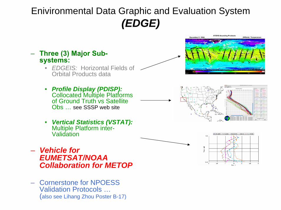
Enivironmental Data Graphic and Evaluation System (EDGE)
– Three (3) Major Sub-systems:
• EDGEIS: Horizontal Fields of Orbital Products data
• Profile Display (PDISP):Collocated Multiple Platforms of Ground Truth vs Satellite Obs … see SSSP web site
• Vertical Statistics (VSTAT):Multiple Platform inter-Validation
– Vehicle for EUMETSAT/NOAA Collaboration for METOP
– Cornerstone for NPOESS Validation Protocols …(also see Lihang Zhou Poster B-17)

Multi-platform Product Comparison Multi-channel Radiance Comparison
Obs - Calc
Calc – ObsAMSU-A 7
Cal – Obs183 +/- 3

… the independent nature of radio occultation soundings make them highly complementary to other atmospheric sounding systems, such as infrared and microwave sounders …
Eva Borbas (SSEC), Christian Rocken (UCAR), Jim Yoe (NOAA)
C O S M I C

In-situ Observations
• Atmospheric Profiling and Clouds– Microwave Radiometer (Column Integrated H20)
– Microwave Radiometer Profiler (T, H20 and CLW profiles @ 20-30 and 50-60 GHz)
– GVR (183 +/- 1,3,7,14 gHz)
– Raman Lidar (H20 Vapor, Cloud, Aerosol)
– Radiosonde (Vaisala RS-92, dual humicap)
– AERI (RT, Clouds , T, H20 and Trace Gas @ 3 -20 (25) Microns)

Initiatives for Satellite Coincident RadiosondeLaunches (RS-90) at ARM Site(s)
• continued NASA support for ARM (SGP, NSA, TWP) site radiosonde launches coincident with AIRS … (Tobin, Revercomb SSEC, Wisconsin)
• pending agreement for to launch “144 extra sondes at SGP” coincident with polar ATOVS … (Barry Lesht (ARM), Reale)
• studies to quantify impact of coincidence for GARON … (Menzel, Goldberg, Thorne and most recently Goodrich, Peterson) … possible funding opportunity
– results from EOS-Aqua-AIRS– user community – other

Spatial gradient in RS 90 radiosonde-retrieval RMS Comparison(ARM-SGP … 97W, 36N)
Antonia Gambacorta (a) , Chris Barnet (b) , Dave Tobin © , Leslie Moy ©, Scott Hannon (a) , Larrabee Strow (a) , Dave Whiteman (d)AIRS Science Meeting, 9-27-2006

Temporal Gradient in Dropsonde – AMSU/MHS retrieval (MIR) Comparison(Weng, Boukabara, Ferraro, Zhao; MIR, 9-30-2006)
• Dropping time ~ 12 minutes• Case of July 6th 2005
Furthest
apart
in tim
e
Closest
in tim
e
0.65
0.95
1.32
1.67
H20 Vapor Profiles

NOAA POES Simultaneous Nadir Overpasses (SNO)(… Cheng-Zhi Zhou)
Arctic Antarctic

2128 UTC
ARM North Slope of Alaska
2153-2159 UTC

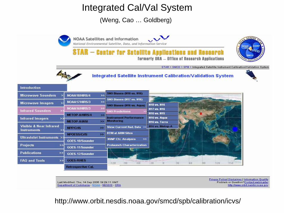
http://www.orbit.nesdis.noaa.gov/smcd/spb/calibration/icvs/
Integrated Cal/Val System (Weng, Cao … Goldberg)

Integrated Operational Product Data Validation(NPOESS IPO Award)
WG Satellite Sounding Science and Products (SSSP)

E X T R A S


Potential Ground Sites
ARM SGP
ARM NSA
ARM TWP
Dunhuan DesertQinghai Lake
Greenland
Libyan desert
Dome C

The NVAP dataset is a widely-used, global, daily, 1-degree resolution blended product suitable for studies of water vapor in the climate system (Randel et al, 1996; Simpson et al, 2001). NVAP contains
layered water vapor fields as well as TPW fields. NVAP has layered precipitable water at 1000-700, 700 – 500, 500 – 300 and above 300 hPa.
NVAP was constructed by blending observations from radiosondes, satellite sounder instruments (NOAA TIROS Operational Vertical Sounder (TOVS, or ATOVS after 1998)), and passive microwave radiometers (Special Sensor Microwave / Imager (SSM/I)). The TRMM Microwave Imager (TMI) was
used for 2000-2001. Retrievals are performed on each dataset, and the results are then blended together to create a global merged field. NVAP currently covers the time period 1988 – 2001. Our goal in the creation of the global NVAP dataset to compare with AIRS is to achieve a product which mimics a
withdrawal of the NVAP data from the NASA DAAC, as if it existed in 2003-2004.NVAP data for 1988-2001 is available from the NASA Langley DAAC at:
http://eosweb.larc.nasa.gov/PRODOCS/nvap/table_nvap.html.
The comparison of TPW indicates that the ATOVS TPW field is an outlier from the other datasets. These results make it questionable whether the ATOVS sounding
product should be used in climate studies. The ATOVS sounding product has historically been used in NVAP production, in particular to provide soundings over
land and provide vertical structure.AIRS validation and reprocessing is an ongoing process, so results from this study
must be viewed in that light. As AIRS validation increases in maturity, it can be used in scientific data stewardship studies with greater confidence in the AIRS products.

(PDISP)Compare individual profiles from Radiosonde, Satellite and NWP platforms
MSOffice1

Slide 38
MSOffice1 The slide illustrates the multiple profiles from different satellite product systems, for example, operational and test systems for NOAA-16, NOAA-15 and various NWP profiles that were appended to the satellite products data record during orbital processing, capable of being collocated with and evaluated against radiosonde observations.
Solid curves indicate tempertaure and dashed curves moisture profiles respectively.
Each profile source is color coded based on the legend on the right.
The file contains over 6700 collocations compiled over an approximate 30 day period, and available for statistical evaluations as shownin the next slide. ORA, 12/14/2004


ARM Site Satellite Overpass Dedicated Radiosondes for FY2007Draft recommendation letter, 3 August 2006
In the past several years, NASA has funded DoE’s Atmospheric Radiation Measurement (ARM) program to provide special radiosonde launches which are coincident with EOS Aqua overpasses of the primary ARM sites (SGP, TWP and NSA). This has been a scientifically productive interagency cooperation. Due to the high accuracy requirements of atmospheric soundings from
AIRS, such data is required for detailed and critical assessments of the satellite products. Examples of resulting work include the use of clear sky ensembles for radiative transfer model development and validation (Strow et al. 2006), assessment of upper level water vapor measurement accuracy (Miloshevich et al. 2006; Whiteman et al., 2006), and temperature and water vapor retrieval
validation (Tobin et al. 2006). Making use of the ARM site facilities, previous studies to characterize the ARM measurements, and routine, on-going operations, the ARM site efforts are a cost effective and fundamental part of the EOS validation program. While other validation datasets provide complimentary information for satellite validation studies, the ARM site products are considered
the “gold standard” for this work. The level of coincidence achieved markedly exceeds past efforts at this scale and quality. In addition to AIRS, the ARM site radiosondes have also been useful for Aqua MODIS and Aura TES studies.
To enable the development of long term and well-characterized Earth Science Data Records, we recommend that NASA support for these ARM site efforts continue. Specifically, we recommend that the same level of effort from the previous two years (i.e. 2 phases of radiosonde launches from each of the three primary ARM sites) be continued for FY2007. Considering inputs from all interested parties, a consensus plan will be developed in the near future detailing the timing and level of effort at each ARM site. In the future,
we also recommend that these efforts be extended to include the advanced sounders IASI on METOP and CrIS on NPP and NPOESS; discussions with the NPP and IPO programs should be pursued to facilitate this.
David TobinAssistant Scientist
Space Science and Engineering Center, University of [email protected]
(608) 265-6281Hank Revercomb
DirectorSpace Science and Engineering Center, University of Wisconsin-Madison
[email protected](608) 263-6758
George Aumann, JPLTony Clough, AER (representing TES)

To: [email protected]: A modest proposal...
Hi Jimmy,
Dan Rusk, Luci Walker, and I have been tracking down the source of 144 'extra' radiosondes that are at SGP. Luci has discovered thatthese were ordered for last year's AIRSexperiment, but not delivered until afterwards. Because they were marked 'For AIRS' they were not included in our estimates of sondes
needed for operations next year. Apparentlywe supported AIRS with sondes we already had in stock so, in a sense, these are extras. We could use them to offset future
operational needs, but I was thinking that perhaps abetter use might be to start a 'pilot' IOP to help Tony Reale at NOAA. As you certainly know by now, Rick Wegener has decided that
the added cost of processing the NOAAsatellite data that Tony has found for us would not offset the savings of cutting the SeaSpace contract and doing the extra soundings
that Tony had requested.
Maybe we could use a few of these extra sondes and start a one-per-day extra sounding to match Tony's needs at the SGP only as a kindof demonstration. If he is happy with the
result, perhaps we could then get support for a wider program. As you will recall, Tony was one of the more vocal ACRF supporters atthe Seattle GCOS workshop.
Anyway, I don't have a personal stake, I just think it might be good for the program and wanted to mention it. Whatever you guysdecide is of course fine with me. It seems that this
would be less of a cold and complete turn down to Tony - that's all.
Best, BarryBarry LeshtAST DirectorateMS203Argonne National Laboratory9700 S. Cass Ave.(630)-252-4208(630)[email protected]

VIIRS - vis/IR imagerCMIS - μwave imagerCrIS - IR sounderATMS - μwave sounder SESS - space environmentOMPS - ozoneADCS - data collection
NPP(1030)
NPOESS1330
NPOESS1730
NPOESS2130
N P O E S SSARSAT - search & rescueAPS - aerosol polarimeterERBS - Earth radiation budgetSS - laser sensorALT - altimeterTSIS - solar irradiance

Environmental Data Records (EDRs) with Key Performance Parameters
Cloud Top Pressure Cloud Top Temperature Downward Longwave Radiance (Sfc)
Downward Shortwave Radiance(Sfc) Electric FieldElectron Density ProfileEnergetic Ions Geomagnetic Field Ice Surface TemperatureIn-situ Plasma Fluctuations In-situ Plasma Temperature Ionospheric ScintillationMedium Energy Charged Particles Land Surface Temperature Net Heat FluxNet Solar Radiation (TOA) Neutral Density Profile Color/ChlorophyllOcean Wave Characteristics Outgoing Longwave Radiation (TOA) Ozone - Total Column/Profile
Precipitable Water Precipitation Type/Rate Pressure (Surface/Profile) Sea Ice CharacterizationSea Surface Height/Topography Snow Cover/Depth Solar Irradiance Supra-Thermal-Auroral ParticlesSurface Type Wind Stress Suspended Matter Total Water Content Vegetation Index
VIIRS (23)CMIS (19)CrIS/ATMS (3)OMPS (1)SES (13)ERBS (5)TSIS (1)ALTIMETER (3)APS (4)
Atmospheric Vertical Moisture ProfileAtmospheric Vertical Temp ProfileImagerySea Surface TemperatureSea Surface WindsSoil MoistureAerosol Optical ThicknessAerosol Particle SizeAerosol Refractive IndexAlbedo (Surface)Auroral BoundaryAuroral Energy DepositionAuroral ImageryCloud Base HeightCloud Cover/LayersCloud Effective Particle SizeCloud Ice Water Path Cloud Liquid Water Cloud Optical ThicknessCloud Particle Size/Distribution Cloud Top Height
NPOESS EDR-to-Sensor Mapping55 Product Sets [EDR, RDR, SDR]