Embed Size (px)
Citation preview

13
Caribbean Geology: An Introduction U.W.I. Publishers' Association, Kingston
© 1994 The Authors
CHAPTER 2
Evolution of the Gulf of Mexico and the Caribbean
JAMES L. PINDELL
Department of Earth Sciences, Fairchild Center, Dartmouth College, Hanover, New Hampshire 03755, U.S.A.
INTRODUCTION
FIXIST AND mobilist views of the evolution of Caribbean region have both been proposed. Strictly fixist views63 are difficult to entertain in light of the very well-documented opening history of the Atlantic Ocean and the fairly accurate Pangean continental assemblies, both of which show that little or no Gulf of Mexico and Caribbean region existed between the larger continents during the Triassic, Jurassic and early Cretaceous14,48,49,65,70,81. Mobilist views all accept significant amounts of eastward Caribbean migration relative to the Americas, but are split between models which generate the lithosphere of the Caribbean Plate between the Americas 6,29,42,48,82 and models which generate that litho-sphere in the Pacific27,30,69,72. Pindell67 listed cogent arguments for the plate's Pacific origin, but definitive proof will only come when the deep interior, and not just the rims, of the Caribbean Plate is shown to be pre-Aptian in origin, as plate reconstructions dictate that the Caribbean Plate could not have fitted between the America's until well after that time (see below). However, I note that the recent identifica-tion of a Jurassic boreal or austral radiolarian fauna in Hispaniola, Puerto Rico, and La Desirade62 also attests to the Pacific origin, as the Proto-Caribbean Seaway of Pin-dell65 developed essentially within the Jurassic palaeo-equatorial zone.
Important elements of (1) the methodology required for regional analysis, and (2) the actual history of the Caribbean inter-plate realm (Fig. 2.1), were outlined in progressively more detail by, among others, Ladd , Pindell and Dewey , Mann and Burke55, Pindell65, Buffler and Sawyer14, Dewev and Pindell26, Klitgord and Schouten48, Pindell et al.70, Rosencrantz et al.79, Burke16, Rowley and Pindell81, Pindell and Barrett69 (and other papers in Dengo and Case22), Rosencrantz78, Pindell68 and Pindell et al76. These papers
discussed:
(A) The reconstructions of Pangea, including the restoration of syn-rift extension along passive margins during con tinental breakup; the bulk shape changes due to transcurrent and convergent faulting in northern South America during Andean orogenesis; and the removal of Mesozoic-Cenozoic accreted arc terranes from northern South America for times prior to accretion.
(B) Atlantic opening kinematics and implications for North- South America motion.
(C) Mesozoic kinematic significance of the Equatorial At- lantic reconstruction.
(D) The opening history of the Gulf of Mexico. (E) The eastward migration of the Caribbean Plate from the
Pacific, independent of Cayman Trough magnetics, by tracing the timing of overthrusting of circum-Caribbean foredeep basins by Caribbean terranes.
(F) The occurrence of magmatic arcs, and their periods and polarities of associated subduction.
(G) Arc-continent collision suture zones marking the sites of former oceans/basins, and their timing and vergence of closure.
(H) The opening histories of the Cayman Trough, Grenada Basin and Yucatan Basin.
(I) Plate boundary zone development in the northern and southern Caribbean.
The present paper is a summary of an evolved plate tectonic model for the Gulf of Mexico and Caribbean region by Pindell et al76. The summary utilizes many of the above elements without repeating them, except where appropriate. The summary of the model is supported with a limited amount of local detail to point out how various aspects of local geology are explained by the model. Geographic areas

14

15
JAMES L. PINDELL
Figure 2.2. Plate kinematic history between North and South America, Triassic to present (after Pindell et al.70) Vectors denote flowlines travelled by points on South America relative to North Americ a.
where commonly accepted data are discordant to the model can be considered as candidates for future research, to either reassess those data or to modify the general model. Ulti-mately, constraints derived by the deductive (tectonic mod-els) and inductive (interpretation of field data) approaches of assessment should merge and agree in the future to produce a common interpretation of the region's plate tec-
tonic and palaeogeographic evolution.
PLATE KINEMATIC CONSTRAINTS
Atlantic Ocean Magnetics Interpretations of the geologic evolution of the Carib-
Figure 2.1. (opposite) General location and basin map of the Caribbean region and sites mentioned in text (after Pindell68).
Key to Proto-Caribbean/Caribbean episutural foredeep basins: 1, Sepur foredeep basin (and Chiapas foldbelt), Guatemala and Belize; 2, Cuba-Bahamas foredeep basin; 3, Maracaibo foredeep basin, Colombia and Venezuela; 4, Eastern Venezuelan/Trinidad foredeep basin.
Key to rift and pull-apart basins: 5, Yucatan basins (lithospheric rift); 6, Grenada basin (lithospheric rift); 7, Eastern Belize margin basins; 8, Cayman Trough basin (lithospheric rift); 9, Nicaraguan Rise basins (probably upper crustal grabens); 10, Falcon basin (lithospheric? rift); 11, Sambu Basin, Panama; 12, South America borderlands basins (Baja Guajira, Triste, Cariaco, Bonaire, La Vela, Carupano, Leeward Antilles inter-island basins) (probably upper crustal grabens, but Bonaire basin probably had Oligocene lithospheric extension like Falcon).
Key to accretionary prism/forearc basins: 13, Barbados Ridge and Tobago Trough basins; 14, South Carib-bean/Panama/Sinu-San Jacinto foldbelts and Lower Magdalena Basin; 15, San Juan-Azua-San Pedro-Enriquillo Basin, Dominican Republic; 16, Nicoya complex, Costa Rica.
Key to arc-flank and other basins: 17, Limon basin, Costa Rica; 18, North Puerto Rican basin; 19, South Cuban shelf; 20, Cibao basin; 21, Cesar basin, Colombia; 22, Saba Bank platform. Oil fields shown as blobs.
16
The Gulf of Mexico and the Caribbean
NOAM - SOAM SPREADING HISTORY
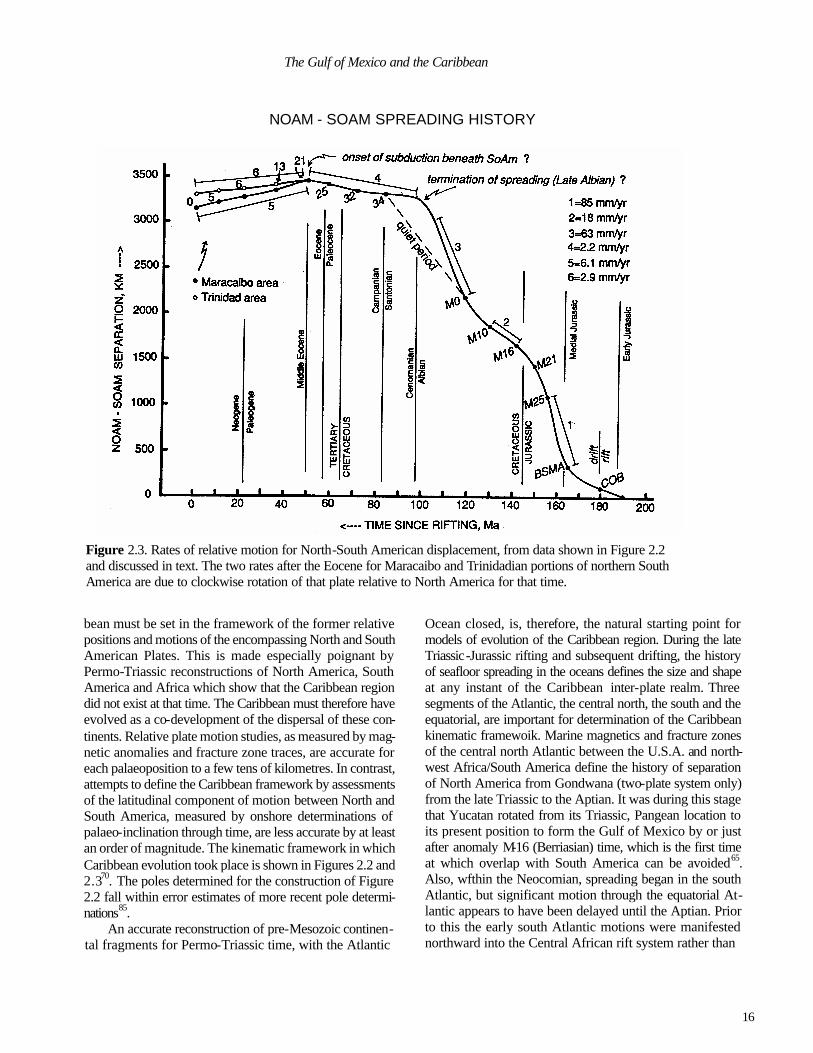
Figure 2.3. Rates of relative motion for North-South American displacement, from data shown in Figure 2.2 and discussed in text. The two rates after the Eocene for Maracaibo and Trinidadian portions of northern South America are due to clockwise rotation of that plate relative to North America for that time.
bean must be set in the framework of the former relative positions and motions of the encompassing North and South American Plates. This is made especially poignant by Permo-Triassic reconstructions of North America, South America and Africa which show that the Caribbean region did not exist at that time. The Caribbean must therefore have evolved as a co-development of the dispersal of these con-tinents. Relative plate motion studies, as measured by mag-netic anomalies and fracture zone traces, are accurate for each palaeoposition to a few tens of kilometres. In contrast, attempts to define the Caribbean framework by assessments of the latitudinal component of motion between North and South America, measured by onshore determinations of palaeo-inclination through time, are less accurate by at least an order of magnitude. The kinematic framework in which Caribbean evolution took place is shown in Figures 2.2 and 2.370. The poles determined for the construction of Figure 2.2 fall within error estimates of more recent pole determi-nations85.
An accurate reconstruction of pre-Mesozoic continen-tal fragments for Permo-Triassic time, with the Atlantic
Ocean closed, is, therefore, the natural starting point for models of evolution of the Caribbean region. During the late Triassic-Jurassic rifting and subsequent drifting, the history of seafloor spreading in the oceans defines the size and shape at any instant of the Caribbean inter-plate realm. Three segments of the Atlantic, the central north, the south and the equatorial, are important for determination of the Caribbean kinematic framewoik. Marine magnetics and fracture zones of the central north Atlantic between the U.S.A. and north-west Africa/South America define the history of separation of North America from Gondwana (two-plate system only) from the late Triassic to the Aptian. It was during this stage that Yucatan rotated from its Triassic, Pangean location to its present position to form the Gulf of Mexico by or just after anomaly M-16 (Berriasian) time, which is the first time at which overlap with South America can be avoided65. Also, wfthin the Neocomian, spreading began in the south Atlantic, but significant motion through the equatorial At-lantic appears to have been delayed until the Aptian. Prior to this the early south Atlantic motions were manifested northward into the Central African rift system rather than
17
JAMES L.PINDELL
the equatorial Atlantic 70'72. Therefore, early south Atlantic motions do not appear to have significantly affected Carib-bean kinematic history.
Unfortunately, the Cretaceous magnetic quiet period prevents resolution of detailed kinetics for Aptian to San-tonian times. Opening poles for the central north and south Atlantic Ocean show that by the early Campanian and until the Eocene (anomaly 34 to anomaly 21, that is, 84-49 Ma), little or no motion was occurring between North and South America, and it is likely that no significant plate boundary existed between them for that interval70. An important un-certainty is the exact time at which seafloor spreading actu-ally ceased in the Proto-Caribbean. It certainly had ceased by anomaly 34 time (as shown by the dashed portion of the curve in Fig. 2.3). I suggest that the exceedingly rapid Albian-Cenomanian transgression of cratonic areas (for ex-ample, in Venezuela37) and drowning of carbonate plat-forms was aided by loss of in-plane stress as a result of the death of the ridge71,76. This is supported by the occurrence of oceanic crust west of anomaly 34 immediately east of the Lesser Antilles in the western Atlantic, which has the same fabric orientation as that to the east of anomaly 3489, imply-ing that any adjustments in orientation associated with the death of the ridge (reorganization to a two-plate system again) had already taken place well before anomaly 34 time (late Albian?). If this is the case, then the period over which the African and North and South American plates behaved as a three-plate system was limited to the Aptian-Albian interval. This indicates that the opening history of both the central north and south Atlantic were essentially co-polar (that is, one greater American Plate) from the ?Albian to the Eocene, although some minor degree of wrenching probably occurred at Atlantic fracture zones, possibly along those extending to the Bahamas.
Since the middle Eocene, very slow north-south con-vergence (dextrally oblique relative to pre-existing fracture zones) occurred, with the magnitude of convergence in-creasing westward away from the North America-South America pole of rotation to the east of the Lesser Antilles (Figs 2.2,2.3). It is not yet known whether this convergence was accommodated only by descent, and maintenance of north-south slab distance, of Atlantic lithosphere into the Benioff zone beneath the eastward migrating Caribbean Plate, or if lithospheric shortening at an overthrust zone east of the migrating Caribbean Plate was also required, possibly along northern South America75.
Origin of the Caribbean Plate Within the above framework, there are two possibilities
for the origin of the lithosphere of the Caribbean Plate. Either it was generated by seafloor spreading between Yu-catan and South America and, therefore, represents litho-
sphere of the arm of the Atlantic called the Proto-Caribbean Seaway by Pindell65; or it was generated in the Pacific (Farallon Plate lithosphere?), such that Proto-Caribbean crust which was already formed by the separation of the Americas was then subducted beneath the Upper Cretaceous to Cenozoic arc systems of the Caribbean Plate during the westward drift to the Americas from Africa, thus producing a reactive east-west migration history of the Caribbean Plate between the Americas. In either case, westward drift of the Americas across the mantle was mainly responsible for east-west Caribbean relative motion. In the case of a Pacific origin, northerly and southerly extensions of Farallon litho-sphere were probably subducted beneath the North and South American Cordilleras, respectively, thereby produc-ing the condition of tectonic rafting of Caribbean lithosphere into the Proto-Caribbean Seaway between the Americas.
The primary difference of these two interpretations lies in the magnitude of the relative east-west migration of Caribbean and American lithospheres. Therefore, this dif-ference suggests different locations for much of the Carib-bean region's Jurassic and Cretaceous magmatism, sediment deposition, deformation and metamorphism. In models for a Pacific origin, early Caribbean stratigraphies and tectonism must have developed in the Pacific prior to the relative eastward migration, and are thus essentially part of 'Cordilleran' evolution. In Proto-Caribbean models of Caribbean Plate origin, such developments are strictly 'Car-ibbean', and should have involved the Yucatan, Bahamian, and northern South American cratonic margins.
Pindell67 outlined several independent arguments fa-vouring a Pacific origin. Briefly, these are (see Fig. 2.4):
1. Eastern Caribbean Volcanism. The Aves Ridge and Lesser Antilles volcanic arc complexes (Fig. 2.1) collec tively possess an Upper Cretaceous (about 90 Ma) to Recent record of intermediate arc magmatism. Polarity of subduc- tion for the Eocene-Recent Lesser Antilles arc has been eastward facing with westward dipping subduction, as was probably the case for the Cretaceous-Eocene Aves Ridge arc as suggested by its slightly convex shape and absence of an accretionary prism along it west flank. Assuming a 90 million year period of west-dipping subduction of Atlantic crust beneath the eastern Caribbean even at only slow con vergence rates suggests a minimum relative plate movement of circa 1000 km.
2. Cayman Trough, seismic tomography, and northern Caribbean strike-slip basins. Assessments of the develop ment of the Cayman Trough79,93, the Tabera and northern San Juan Basins in Hispaniola28,56, the 'Eocene Belt' of Puerto Rico36, and the Cibao Basin and north coastal area of Hispaniola34,73 (Fig.2.4) indicate late Eocene to Recent, east-west, sinistral strike-slip motion between the Caribbean

18
The Gulf of Mexico and the Caribbean
Figure 2.4. Summary of arguments for a Pacific origin of the Caribbean Plate, after Pindell67. Light lines denote approximate present-day general boundary configuration. Heavy lines denote approximate boundary (suture zones that formed during Caribbean evolution) between the allochthonous Caribbean arc/oceanic rocks, and the autochthonous and para-autochthonous Proto-Caribbean passive margin/foredeep basin rocks. Eastern Caribbean volcanism in Aves Ridge and Lesser Antilles (argument 1) shown with Vs. Post-Middle Eocene strike-slip basins (argument 2) shown as A (Cayman Trough), B (San Juan Basin), C (Tabera Basin), D (Eocene Belt). General stratigraphic differences of Caribbean and Proto-Caribbean rock suites (argument 3) shown in in-set. Aptian position of South American outline and shelf relative to North America, showing small separation be-tween the Americas at that time (argument 4) labeled 'Aptian So Am'. Sequential migrated positions of the Chortis block and the trench-trench-transformed (TIT) triple junction relative to Mexico (argument 5) shown by outlines southwest of Mexico: mainly Paleogene and Neogene/Quaternary arcs shown in ‘v’s. Division between pre-Campanian Pacific and Proto-Caribbean faunal realms (argument 6) nearly matches suture zones outlined in heavy lines. Foredeep basins that developed ahead of the relatively eastwardly migrating Caribbean Plate shown by dotted areas, where SF=Sepur Foredeep (late Cretaceous); CF=Cuban Foredeep (early Paleogene); MF= Maracaibo Foredeep (Eocene); EVF=Eastern Venezuelan or Maturin Foredeep (Miocene).
and North American plates (northern PBZ). Offset of about 100 km since the Eocene is indicated from the length of the deep oceanic portion of the Cayman Trough, and from reconstructions of Cuba, Hispaniola, Puerto Rico and the Aves Ridge arc fragments into a single, pre-middle Eocene Greater Antilles arc69. Seismicity61 and seismic tomogra-phy39 show a distinct west-dipping Atlantic Benioff zone extending at least 1,200 km beneath the eastern Caribbean, suggesting a similar minimum magnitude of displacement as the Cayman Trough. If this much motion has occurred since the Eocene, a much larger value for the total relative motion must have occurred as indicated by the late Creta-ceous period of arc activity of the Aves Ridge.
3. Caribbean vs. Proto-Caribbean stratigraphic suites. Cretaceous portions of the stratigraphies of two distinct suites of rock in the Caribbean region (Figs 2.4, 2.5) are genetically incompatible as presently juxtaposed across cir-cum-Caribbean ophiolite belts interpreted to be suture zones (Fig.2.4). The 'Caribbean suite' occurs 'Caribbeanward' of the suture zones, whereas the 'Proto-Caribbean suite' occurs 'Americanward' of the sutures. The Caribbean suite's Cre-taceous, tuff-dominated stratigraphy differs dramatically from the Proto-Caribbean suite's coeval Cretaceous, non-volcanogenic, passive shelf sediments. Spatial separation during deposition of these distinct suites of rock appears necessary for the Proto-Caribbean to contain no record of

19
JAMES L. PINDELL
Caribbean volcanism. As this difference extends from around the Caribbean Sea to the Santa Marta massif of Colombia and to Chiapas, Mexico, it is unlikely that the Caribbean arcs were situated any farther east than these locations for most of the Cretaceous.
4. Pre-Aptian geometrical incompatibility, Caribbean Plate and Proto-Caribbean Seaway. Numerous faunal and isotopic ages from the basements of most Caribbean arcs are pre-Aptian, and seismic sections of the Colombian and Venezuelan Basin90, particularly the basement continuity from the Jurassic rocks of Costa Rica to the Colombian Basin, suggest that the crust of the internal Caribbean plate is pre-Aptian (probably Jurassic) as well. However, plate separation between North and South America was insuffi cient (Fig. 2.4) to house a pre-Aptian Caribbean Plate until the late Cretaceous, probably the Albian. Thus, the Carib bean Plate must have formed outside the present Caribbean area, much farther west than the 1100 km of displacement indicated by the Cayman Trough and seismic tomography, and its migration history must have began well before the Eocene, probably in the early late Cretaceous as suggested by Aves Ridge subduction-related volcanism and by the Albian to early Tertiary ‘Antillean phase’ of magmatism in the Greater Antilles.
5. Truncation and uplift of the southwestern margin of Mexico. Structural trends and the Paleogene arc of south west Mexico have been truncated46 either by subduction erosion or by strike-slip removal of arc and forearc areas. Paleogene arc rocks in Mexico are largely restricted to the Sierra Madre Occidental; the Trans-Mexican Volcanic Belt arc is mainly Neogene in age, with volcanism commencing earlier in the west than in the east, implying an eastward migration of arc inception (Fig. 2.4). In the Chortis Block of Central America, evidence for Paleogene arc activity is abundant, with volcanism extending back into the Creta ceous. The Paleogene arc sequences were probably continu ous from western Mexico into Chortis, prior to eastward strike-slip offset of Chortis to its present position and pro gressive development of volcanism in the Trans-Mexican Volcanic Belt93. In addition, Precambrian rocks of the southwest margin of Mexico46 yield cooling ages that indi- cate uplift and erosion since Oligocene time, younging eastwards21. This probably occurred as a function of an intra-continental, strike-slip fault zone (between Mexico and Chortis) progressively becoming a Neogene subduction margin as Chortis migrated to the east, with associated uplift of the hanging wall (Mexico). Thus, it appears that Chortis has migrated with the Caribbean crust during Cenozoic time frpm a more westerly position72,93.
6. Faunal provinciality: Pacific versus Proto-Caribbean Realm. Two differing Cretaceous faunal realms exist across the Mexican-Caribbean region that remained distinct until
Campanian time44, suggesting spatial separation of shal-low-water organisms prior to that time. The areas of occur-rence for the two realms closely match the areas of the Caribbean and Proto-Caribbean stratigraphic suites. The Campanian initiation of faunal merging of the realms relates to the onset of tectonic juxtaposition of the shelfal areas they occupied, presumably during relative eastward migration of the Caribbean Plate between the Americas. Further, Montgomery et al62 identified cold water forms of Upper Jurassic radiolarians in the Puerto Plata Basement Complex of Hispaniola73, the Bermeja complex of Puerto Rico59, and on La Desirade, which can only be explained by a Pacific, non-Tethyan, original for the basements of those localities.
The above arguments collectively indicate that the crust of the Caribbean Plate and the Chortis block was situated west of the Cretaceous shelf sections of Yucatan, the Baha-mas, and northern South America prior to the later Creta-ceous (Campanian). Seafloor spreading between North and South America had ceased, probably in the Albian, leaving a Proto-Caribbean oceanic arm of the Atlantic to subside thermally in the absence of plate boundaries. In addition to understanding regional evolution, acknowledgement of the existence of this Proto-Caribbean Seaway, with the Carib-bean Plate situated to the west, is critical to the hydrocarbon story of the circum-Caribbean region because it was along this seaway's margins that the region's best source rocks were deposited, from Albian to Campanian time68.
In light of these arguments, the concept of the present-day Caribbean lithosphere representing a piece of the Proto-Caribbean Seaway is difficult to entertain. The implication is that the entire Caribbean Plate is allochthonous relative to the Americas and has migrated from well over 200 km to the west, and that (what are now) adjacent portions of the Mesozoic Caribbean and America (Proto-Caribbean) strati-graphic suites should not be correlated due to the large spatial separation during original deposition. Deep drilling within the interior of the Caribbean Plate would likely return an undeformed stratigraphic sampling of the eastern Pa-cific's Upper Jurassic(?) and Lower Cretaceous section, which elsewhere is only poorly preserved.
Merging the relative motions between North and South America (Fig.2.2) with a Jurassic or early Cretaceous Pacific origin of the Caribbean lithosphere implies a very simple history of Caribbean evolution that can be described generally by two phases. The first phase was Triassic to mid Cretaceous, northwest-southeast relative separation of North and South America, and the opening of the Proto-Car-ibbean Atlantic-type seaway bounded by passive margins along the Bahamas, eastern Yucatan and northern South America. The second phase involved the Albian to Recent subduction of that Proto-Caribbean lithosphere beneath arcs along the eastern Caribbean border, during westward drift

20
The Gulf of Mexico and the Caribbean
Figure 2.5. Generalized stratigraphic columns for portions of the Proto-Caribbean passive margins versus the central portion of the Caribbean Plate (after Pindell8).
of the America's from Africa. Eastwardly progressive de-struction of the Proto-Caribbean passive margins by the relative motion of the Caribbean Plate would be recorded by foredeep basin development above the pre-existing Proto-Caribbean shelf sections. Figure 2.4 shows four large basins formed by this process whose eastwardly-younging ages of foredeep loading are: Sepur, Guatemala (Campanian-Maas-trichtian); Cuban (early Paleogene); northern Maracaibo (Eocene); and Eastern Venezuelan (Miocene).
The often-cited Cretaceous orogenesis along northern South America9,10,19,57 does not fit the simple scenario of Caribbean-South American interaction26'66 implied by the above kinematics, and this discrepancy has been the subject of much recent study. No Cretaceous orogenesis affected Trinidad1-3. Similarly, passive margin conditions prevailed across northern South America until the Tertiary 74,75. An implication of these concepts is that all rocks in northern South America affected by metamorphism in the Cretaceous are Caribbean-derived and allochthonous. Flysch units con-taining South American shelf debris, once believed to be Cretaceous in age on the basis of clasts, are now known to have Tertiary matrices (Gaitapata and Paracotos Forma-tions), in keeping with the simple, two-phase tectonic model. A second important implication is that the belts of Cretaceous metamorphic rocks are not viable markers for
assessing total Tertiary strike-slip displacements, because they were not in place at the onset of the strike-slip disloca-tions. In the simple two-phase model, the emplacement of allochthons occurs as a direct consequence of mainly Terti-ary, Caribbean-South American relative motion. Therefore, most of the Caribbean-South American transcurrent offset occurred along the basal thrusts of the allochthons. The high angle strike-slip faults within the orogen, which are secon-dary in magnitude of offset, thus record only a minor portion (less than 150 km) of the total relative motion which is in excess of 1,000 km in the vicinity of Guajira Peninsula. However, it is apparent that as one heads east, the actual total offset between South American and Caribbean terranes becomes progressively less, because the Caribbean-South America plate boundary did not exist until progressively younger times toward the east.
CARIBBEAN EVOLUTION: PHASE 1; NORTH AND SOUTH AMERICA DRIFT STAGE
The following discussion on regional Caribbean evolution is adapted from a full synthesis by Pindell et al.76. The first phase of evolution (Triassic to Albian) was primarily asso-ciated with the development of the Proto-Caribbean Sear way. The second phase (Albian to Recent) involved the
21
JAMES L.PINDELL
progressive consumption of Proto-Caribbean crust beneath Caribbean arcs during westward drift of the Americas across the mantle, leading to the present plate configuration.
Late Triassic-Jurassic The western Pangean reconstruction of Figure 2.6a is
modified after Pindell65 and Rowley and Pindell81. The total closure pole for Yucatan/North America relative to North America is latitude 28.4, longitude -82.1, angle -47.781 and lies in northern Florida. The Atlantic closure poles are after Pindell et al.70. The Chiapas Massif is not included with the Yucatan Block. Andean deformations in northwest South America have been restored in a similar (but more rigorous) way to that of Dewey and Pindell26. Mexican terranes have been displaced by the minimum amount necessary to avoid overlap with South America. Chortis is not included along western Colombia as it is in some reconstructions because the Central Cordillera of Colombia possessed a Triassic - Ju-rassic arc axis and must have been adjacent to the Pacific lithosphere.
In late Triassic to early Jurassic time, North America began to rift from Gondwana along widespread, poorly-de-fined zones of intracontinental block-faulting, redbed depo-sition and dyke emplacement (Fig. 2.6a, b). In the southern U.S.A. , north-south extension77 produced an extension gra- ben system filled with Eagle Mills redbeds. Along the eastern U.S.A., redbeds, dykes and sills of the Newark Group and its equivalents were deposited and emplaced in a belt of grabens paralleling the coast from the Piedmont out to the continental shelf. The Eagle Mills and Newark systems are lithologically and tectonically equivalent. These systems relate to hanging wall collapse of pre-existing thrust faults of the Alleghanian Orogen, as the latter went into extension. Judging from subsidence history, in which post-rift thermal re-equilibration is lacking, these basins are upper crustal detachments rather than true lithospheric rifts. The true lithospheric rifts developed farther south and east, respectively, during the Jurassic.
Drift between Africa and North America was underway in the middle Jurassic (Fig. 2.6b). The Punta Alegre and Exuma Sound(?) salt of the Bahamas might correlate with the portions of the Louann and Campeche in the Gulf of Mexico, but these units are probably older and appear to relate to the opening of the central north Atlantic rather than to the Gulf of Mexico. Such is the case with the Senegal Basin and Guinea Plateau salt deposits43 which opposed the Bahamas at that time. The Blake Spur Magnetic Anomaly (BSMA; Fig. 2.6b) can be symmetrically correlated about the mid-Atlantic Ridge with the western margin of Africa, but internal stretching within the Blake Plateau accounts for divergence between North America and Africa until the time when the BSMA formed to the north (approximately 170
Ma). The crust to the north of the Blake Plateau that was created by seafloor spreading prior to formation of the BSMA produced the central north Atlantic's asymmetry with respect to the present ridge axis. An early ridge appar-ently was abandoned as the spreading centre jumped to the site of the BSMA86,92.
The northeastern Gulf of Mexico, Florida, the western Florida Shelf, the Blake Plateau and the western Bahamas is a complex region of continental blocks14,47,65. Sinistral motion along the Jay Fault began such that continental hosts (Sabine, Monroe, Wiggins, Middle Grounds or Florida El-bow, and Tampa or Sarasota Arches) became separated by rifts along the northeastern Gulf Coast margin. Extension was far greater south of the Jay than it was to the north, requiring a sinistral component of displacement in addition to normal offset at essentially a transfer zone. Total offset, which continued into the Jurassic, increased southwards relative to North America (differential shear) and perhaps was as much as 100 to 150 km between the Sarasota Arch and the Ouachitas, the latter of which serves as a fixed, North America reference frame. Thus, the North Louisiana and Mississippi Salt Basins (although no salt was yet deposited), the Northeast Gulf Basin and the Florida Elbow Basin between the aforementioned highs came into existence. Pindell65 noted that there is (a) sufficient overlap between the present day limit of continental crust in the Bahamas and that in the Guinea Plateau of western Africa during Pangean closure, and (b) an unfilled gap in the eastern Gulf of Mexico during closure, to warrant the suggestion that a fault zone in addition to the Jay exists between the Florida Elbow and Sarasota Arches (Florida Elbow Basin) along which crust of south Florida and the Bahamas migrated eastwards during Gulf opening. Although the Guinea overlap could be ex-plained also by magmatic addition during crustal stretching in the South Florida Volcanic Belt, this still does not satisfy the Gulf gap problem, suggesting that one or more faults cross Florida to allow the marginal offset between the Ba-hamas and the Blake Plateau. Buffler and Thomas 15 showed faulted basement at the west flank of the Florida Elbow Basin which could coincide with the Florida Elbow Fault zone of Pindell65, but the strike of the faults is not clear. In any case, it is noted that assessments of relative motion between North America and the Yucatan Block based on structural or tectonic style cannot be made in the eastern Gulf during the period over which the blocks south of the Jay Fault, including the Sabine and Wiggins Arches, were moving, because the blocks were independent, intervening terranes with their own relative motion65.
To the west, the Yucatan Block began to migrate south-wards along the eastern flank of the Tamaulipas Arch, producing the arcuate shear zone along eastern Mexico (Tamaulipas-Golden Lane-Chiapas transform fault of Pin-

22
The Gulf of Mexico and the Caribbean
dell65, not a rifted margin) which helps define the North America-Yucatan pole of rotation in Florida (Fig. 2.6b, c). This shear zone truncates any faults entering the Gulf from Mexico, including hypothetical extensions of the Mojave-Sonora trace, and therefore must have remained active longer. The absence of a major marginal offset (about 700 km6,48) on basement isopach maps of eastern Mexico15
precludes the possibility that a Mojave-Sonora fault zone entered the Gulf of Mexico during rifting, and renders unlikely all tectonic models which open the Gulf by moving Yucatan along Atlantic flowlines.
The question is, then, how did the terranes of Mexico get into the South American overlap position after rifting? One possibility is that strike slip systems such as the Mo-jave-Sonora and the Nacimiento may have been active dur-ing the Jurassic toward the northwest, but, rather than entering the Gulf of Mexico to the east, they instead trended more southwards to the west of the Tamaulipas Arch. Un-fortunately, this area has been overthrust by the Sierra Madre Oriental so that this hypothesis is not easily tested. However, the suggestion would provide a logical mecha-nism for the production of the deeper water depocentre of the section now comprising the Sierra Madre. I suggest that the southward trace of the fault system(s) became transten-sional in central Mexico, creating a Mexican backarc trough. This trough may have formed in order to maintain the subduction zone outboard of Mexico. In the southwest U.S.A., sinistrally transpressive Nevadan orogenesis oc -cured at this time due to migration of North America from Gondwana, but the margin presumably became progres -sively more oblique toward the south along Mexico (Fig. 2.6c). Backarc extens ion may have been driven by subduc-tion zone rollback at the trench, and a significant component in the backarc basin is predicted in order to help maintain trench-normal subduction at the trench. In this way, the terranes of Mexico could have migrated southwards, but in a more extensional direction relative to the Atlantic flowli-nes. Later, during late Cretaceous-Eocene shortening in the Sierra Madre thrustbelt, which was directed essentially to-ward the eastnortheast, the terranes encroached upon the Gulf of Mexico. The net travel path of southward transten-sion followed by eastnortheast thrusting (two sides of a triangle) may have produced an apparent transcurrent offset (third side of the triangle) along the hypothetical southeast-ward extension of the Mojave-Spnora trace. This suggested history would: explain basement offsets in northwest Mex-ico and southwest U.S.A. along the Mojave-Sonora and other faults6; provide a mechanism for Mexican terranes to migrate into the South American overlap position in Pangean reconstructions; account for Sierra Madre shorten-ing; avoid predictions of a large and missing marginal offset along the eastern Mexican margin; suggest a mechanism for
Legend for Caribbean Evolutionary Maps LEGEND FOR CARIBBEAN
EVOLUTIONARY MAPS
deeper water deposition across central Mexico, the depocen-tre for the Sierra Madre section; and fit very well into our perception of plate kinematics of the region at that time. The proposed basin probably began its formation in the Cal-lovian, concurrent with the earliest known marine spills into the Gulf of Mexico in the area (Tepexic Formation? in southern Mexico). Depending on the degree and variability of the obliquity of opening, the basin could have had vari-able water depths, with limited basaltic intrusion or produc-tion of oceanic basement.
In northern South America, rifting, igneous intrusion and redbed deposition occurred over Triassic -Jurassic times. Rifts can be divided between those east of Maracaibo (Takatu, Espino, Uribante/Tachira, Cocinas?), which are due to continental breakup from Yucatan/Florida-Bahamas, and those west of Maracaibo (Machiques, Cocinas?, Bo-gota/Cocuy, Santiago, Payande), which are Andean backarc basins with arc-related volcanism, as well as rift-related volcanism, in or adjacent to them. The Machiques, Uribante/Tachira and Bogota/Cocuy rifts would become the sites of Andean uplift during Neogene times (Perija, Merida, Eastern Cordillera, respectively) '41. The continental mar -

23
JAMES L. PINDELL
NORTH AMERICA
Figure 2.6a. Palaeogeography, late Triassic -early Jurassic.
Figure 2.6b. Palaeogeography, Bathonian.

24
The Gulf of Mexico and the Caribbean
gin to the north also formed at this time, as late and possibly middle Jurassic marine, passive margin sediments were deposited from Guajira to Trinidad3,37.The platform areas between these rifts behaved as basement highs during sub-sequent late Jurassic and early Cretaceous thermal subsi-dence. The backarc marginal trough predicted for Mexico (see above) is also predicted for offshore Colombia Triassic to Jurassic arc magmatism ceased in this area by the end of the Jurassic and all of autochthonous Colombia became a part of the northern South American passive margin74. The plate vector circuit for North America, South America and Cordilleran Mexico can be satisfied by a single RRR triple junction within the backarc basinal area, connecting the Mexican, Colombia and Proto-Caribbean zones of displace-ment (Fig. 2.6c, d). This allowed continuity of the Cordille-ran arc systems in an outboard position away from passive margin elements of Colombia and eastern Mexico: the back arc systems would collapse during the late Cretaceous Sevier-Peruvian orogenesis after Aptian-Albian onset of westward drift of South America from Africa and plate re-organization in the eastern Pacific.
By the middle Oxfordian, intra-continental extension in the Gulf of Mexico had reached a point (constrained South America divergence rate) where it had opened enough to accommodate the entire extent of the Louann and Campeche evaporite basin, but salt deposition may have been in the Callovian or earlier. Oxfordian salt deposition is supported by seismic studies which show no erosion of the salt below the Oxfordian Norphlet and Smackover Formations, sug-gesting very little time between the deposition of the two units . In most places, the salt appears to cover or mark the breakup unconformity around the Gulf: elevation and expo-sure of the surface across the Gulf Basin prior to salt deposition was probably controlled by the ratio of crustal to lithospheric thickness until a critical value24 was reached during continued extension. The salt often marks the onset of thermal subsidence which led to establishment of open marine conditions around most of the Gulf, but isolated pockets may have been well below sea level during the Oxfordian advance of the seas, resulting in rapidly deepen-ing conditions. Two likely entrances for marine waters into the Gulf during the Callovian-Oxfordian times are between Florida and Yucatan, as DSDP leg 77 documented Jurassic extension and marine sedimentary rocks83, and the southern Mexican Isthmus, where Callovian marine rocks of the Tepexic Formation occur.
During the entire late Jurassic, seafloor spreading was occurring in the Gulf of Mexico where it separated the salt basin into halves, and also in the Proto-Caribbean Sea (Fig. 2.6c). The crust of southern Florida/Bahamas may have been mobile relative to North America as well, by faulting along the Florida Elbow Fault Zone. The three components
of motion must have approximately summed to match the opening rate and azimuth of the central Atlantic Ocean. By Oxfordian times, rifting appears to have ceased between the blocks south of the Jay Fault, such that Gulf of Mexico marine magnetics and structural trends west, but not south-east, of the Florida Elbow Arch probably define Yucatan-North America motion. Hall et al38 suggested a pole for this time based on magnetics that is farther south in Florida than my total closure pole defined earlier, and it may be that crustal stretching during the rift stage in the Gulf Coast was northwest-southeast directed, followed by more north-south rotational seafloor spreading. If so, the two stages of opening may sum match the total closure pole. Given, among other things, the slight bend to the northwest in basement structure contours in the Burgos Basin area at the north end of the Tamaulipas Arch15, this two stage model appears to be justified58. To the north of the migrating junction be-tween the Tamaulipas-Golden Lane-Chiapas fault zone (TGLC) and the central Gulf ridge system, the TGLC evolved as a fracture zone separating regions of differential subsidence. The abrupt topographic low, or freeboard, east of TGLC has received enormous volumes of sediment through time (for example, Burgos Basin east of Monterrey, Mexico46). As strike-slip motion ceased along the Tamaulipas Arch after passage of the ridge system, it thermally subsided and eventually was onlapped by uppermost Jurassic and Cretaceous carbonates. In Chiapas, deposits of the Todos Santos 'rift facies' are younger (late Jurassic -early Cretaceous) than those in the northern Gulf. This is prob-ably because shear along the active TGLC continued longer in the south, well into the thermal subsidence stage of the north.
The whereabouts of the Chortis Block relative to North America during the Jurassic and early Cretaceous is un-known. However, by Aptian times the carbonate units of southern Mexico and Chortis became very similar, and it could be argued that the Cretaceous magmatic rocks of Chortis formed a southerly extension of the Cretaceous Mexican arc as well. For simplicity, I do not show the Chortis Block in the reconstructions until the Valanginian.
To the east, the juvenile Proto-Caribbean continued to open, fanlike, between Yucatan and Venezuela. The mid-ocean ridge in this basin must have been joined in some way with the plate boundary separating the Florida/Bahamas and Yucatan Blocks, which in turn have been connected to the Central North Atlantic system by a long transform along the south side of the Bahamas. A single triple junction is por-trayed connecting these plate boundaries in the northern Proto-Caribbean, for simplicity, but late Cretaceous to Pa-leogene subduction of this crust has eliminated direct evi-dence for this proposition. The crust east of Yucatan and south of the Bahamas may have had a rough bathymetric

25
JAMES L. PINDELL
Figure 2.6c. Palaeogeography, late Oxfordian.
Figure 2.6d. Palaeogeography, Valanginian.

26
The Gulf of Mexico and the Caribbean character (stretched continental blocks or raised oceanic fracture zones?), such that a complex pattern of carbonate highs and lows developed into the Cretaceous. Sediments originally deposited in the northern Proto-Caribbean depo-centre is now represented in the Cuban thrust belt north of and underneath the Cuban ophiolite/arc belt. Siliciclastic sands in those sections were probably derived laterally from Yucatan rather than the Bahamas. Hence, sedimentary evi-dence in Cuba for the Cuba-Bahamas collision appears older (late Cretaceous) than it actually was (Paleogene).
The opening of the Gulf of Mexico was achieved prob-ably within the Berriasian, when sufficient room existed between North and South America to avoid overlap between Yucatan and South America (anomaly M-16). At that time, the Yucatan block became part of the North America Plate (NOAM) as spreading ceased in the Gulf of Mexico, and a Neocomian circum-Gulf carbonate bank was established. Starting in the Berriasian, North America-Gondwana plate separation occurred solely within the Proto-Caribbean Sea, an arm of the Central North Atlantic (Fig. 2.6d). Most margins of the Proto-Caribbean Sea had been formed by rifting, and carbonate and terrigenous shelf deposits accu-mulated on the subsiding shelves throughout the Creta-ceous. The Proto-Caribbean ridge system connected the central North Atlantic ridge system to plate boundaries in the Pacific realm, presumably the backarc spreading centres of central Mexico and offshore Colombia.
Early Cretaceous and Aptian-Albian Cordilleran orogenesis
Plate separation continued between North and South America in the Proto-Caribbean, whose passive margin sections (Fig. 2.5) continued to develop during thermal subsidence (Fig. 2.6d, e). However, tectonically driven up-lift of unknown magnitude in northeastern South America may have been caused at the end of the Jurassic and earliest Cretaceous by a transient shift in the central North Atlantic spreading centre between M-21 and M-1035 . Also at this time, the eastern Bahamas was elevated to sea level so that a carbonate bank developed there, either by tectonism re-lated to the shift in the Atlantic spreading65 or by igneous extrusion which may have been associated with a hot spot trace extending from the Jurassic Florida Volcanic Belt.
Along the Cordillera, the Mexican (Sierra Madre) and Colombia backarc extensional zones probably continued to expand as divergence between North and South America continued. Deep water sedimentation has been suggested from rocks of central Mexico, and ophiolitic rocks occur in the Juarez Terrane east of Oaxaca18, but it is difficult to suggest the width of the basin. In continental portions of Colombia and northern Ecuador, there is no record of arc magmatism during the early and middle Cretaceous, sug-
gesting that the trenches of whatever arc systems existed west of the Proto-Caribbean area did not intersect the South America Andes until southern Ecuador. I speculate that an evolving and lengthening intra-oceanic arc system from Chortis/Mexico to southern Ecuador would form the roots to the Greater Antilles and Aves Ridge arcs of the Caribbean and the Amaime-Chaucha terrane of Colombia/Ecuador, although at this point the arc was westward facing. Subduc-tion of Pacific (Farallon?) lithosphere at this speculative arc configuration may have been accompanied by accretion of Jurassic ophiolitic fragments and cold water cherts now found in Dominican Republic, Puerto Rico, and La Desirade62. The relative velocity triangles of Figure 2.6d describe the relative plate motions at this time.
By the Barremian/Aptian (Fig. 2.6e), a plate boundary reorganization in at least the eastern portion of the Proto-Caribbean is required to accommodate the onset of opening in the equatorial Atlantic. The trace of the fracture zone which originally existed along the Guyana margin must have shifted north, possibly as a result of the kinematic adjustments made during the M-21 to M-10 kink in Atlantic fracture zones. Final development of the eastern Bahamas basement uplift also probably was associated with this reor-ganization.
Other important plate boundary reorganizations were also about to take place. Engebretson33 suggested that Far -allon crust may have begun to converge in a more northeast direction relative to North America during Aptian-Albian times, which would have relieved the sinistral component of strain along the Mexican Cordillera. The opening of the equatorial Atlantic was presumably well underway by the Albian, as evidenced by Albian marine inundation of all equatorial Atlantic rift basins, such that for the first time the South American lithosphere accelerated westward across the mantle. The Proto-Caribbean spreading ridge probably ceased to exist in the late Albian (Figs 2.2, 2.3), but the spreading rate in the central Atlantic increased dramatic ally during the Cretaceous Quiet Period48. Thus, South America accelerated from Africa faster in order to 'catch up' with North America, but in fact both American plates must have accelerated westward across the mantle. This would drive the Cordilleran arc systems into a compressional arc con-figuration in the sense of Dewey23, in which the overriding plate was actively thrust across the trace of the pre-existing trench(es). This process was a chief cause of Sevier and Peruvian orogenesis in the continental arc portions of the Cordillera, which involved Cordilleran uplift, reduction of the subduction angle, a general eastward shift in the axis of volcanism, and backthrusting and associated foredeep basin development.
However, the Aleutian-like Antillean-Amaime intra-oceanic arc between Chortis/Mexico and southern Ecuador

27
JAMES L. PINDELL
Figure 2.6e. Palaeogeography, Barremian.
appears to have flipped its polarity (Fig. 2.6f, g), possibly by the evolution of backthrusting taken to the extreme by the creation of a new Benioff zone. Aptian/Albian metamor-phic ages, often from high-pressure minerals, are common around the Antilles, Tobago, the Villa de Cura complex of Venezuela, the Ruma zone of northern Colombia and the Amaine terrane of Colombia, and possibly relate to the orogenesis pertaining to the flip and/or to the onset of west-dipping subduction (possible mechanism to elevate blueschists toward the surface) on the east side to the arc74. Albian metamorphic ages, such as from the Villa de Cura of Venezuela10, probably pertain to terranes which were pre-served at relatively shallow levels after the flip, such that the metamorphic age was preserved. Other terranes, such as the rocks of the northern Cordillera de la Costa Belt of central Venezuela8, probably remained deeper in the forearc or the trench setting such that they continued to develop metamorphic fabrics and ages at younger times and at progressively lesser depths. In some locations, the magmatic axis of the arc itself shifted during the Albian, for example in the Dominican Republic from the Los Ranchos area to the Central Cordillera, possibly as a result of the reversal.
The polarity reversal theoretically should have trans-formed the configuration of the intra-oceanic arc from con- vex to the west, to generally convex to the east. Given that
the arc was probably over 2,000 km long, the structural disruption within the arc as it changed convexity could have been intense: the arc may have been first shortened (uplift) and then extended (subsistence with much rifting) during the flip. Most of the arc's pre-Albian palaeogeographic elements were probably rendered beyond recognition, with many 'new' areas of the arc infilling gaps (such as larger batholiths) between older rearranged fragments. Likewise, seismic sections of the internal Caribbean Sea's lithosphere indicate that it underwent significant deformation in mid-Cretaceous times, including extrusion and intrusion of ba-salts and dolerites (seismic horizon B") onto and into, pre-existing Pacific-derived sediments and crust of probable early Cretaceous and ?Jurassic age. It has been suggested that the arrival from the Pacific of buoyant B" lithosphere at the west-facing arc helped to cause the flip in polarity51, and this may be so, but the age of the B" material (approximately Albian? to Coniacian) suggests that its extrusion may be a result, rather than a cause, of the flip.
Although many details of this event remain to be worked out, I will assume here that the well-known late Albian to Eocene phase of magmatic activity in many Car-ibbean arc terranes with Aptian-Albian, possibly amalga-mated, metamorphic basements is due to subduction of Proto-Caribbean and Colombian backarc oceanic crust be-

28
The Gulf of Mexico and the Caribbean
Figure 2.6f. Palaeogeography, late Albian.
neath the Greater Caribbean arc after a highly orogenic Aptian-Albian reversal of subduction polarity (see, for ex-ample, Fig. 2.6g). The reversal correlates tectonically to the Sevier and Peruvian orogenesis in continental areas to the north and south. From late Albian to Santonian times, the arc system may have defined the eastern edge of Farallon crust, but the Santonian onset of subduction at the Panama-Costa Rica arc isolated the Caribbean lithosphere by Campanian time as an independent plate with its own relative motion history for the first time69. Once this was achieved, the east-west component of motion of the Caribbean lithosphere remained approximately in the mantle reference frame, unable to shift east or west because of its bounding Benioff zones. Continued westward drift of the Americas from Africa produced the apparent late Cretaceous to Recent eastward migration of the Caribbean relative to the Americas, at rates very close to the Atlantic spreading rate through time.
CARIBBEAN EVOLUTION: PHASE 2; CONSUMPTION OF THE PROTO-CARIBBEAN SEAWAY BENEATH THE CARIBBEAN PLATE
Late Cretaceous Non-volcanogenic shelf sedimentation generally con-
tinued along the margins of the Proto-Caribbean during thermal subsidence in the absence of plate boundaries (Fig. 2.6g). The late Albian drowning of carbonate shelves and rapid landward transgression at most portions of the Proto-Caribbean margins may have been enhanced by the death of the Proto-Caribbean spreading ridge. The death of the ridge would reduce in-place stress around the region, due to the loss of the ridge push force as it subsided, also allowing the margins to subside. In contrast, arc activity was underway along the Greater Antilles, the Amaime-Chaucha Terrane (for example, Buga Batholith), and the Mexico/Chortis and southern Ecuador/Peruvian margins.
The onset of relative eastward migration of the Cordil-leran systems led to the progressive closure of the Mexican and Colombian backarc basins (Fig.2.6g, h). In Mexico, closure probably began in the Albian as in the rest of the Cordillera, but orogenic facies did not commonly appear until the Campanian. This was because the thrust belt would not become emergent until enough shortening had accumu-lated to roughly match the amount of extension which had taken place during the early Cretaceous. To the southeast, arc-continent collision and northward obduction of the Santa Cruz ophiolite took place alone southern Yucatan during the Campanian-Maastrichtian80,94. This was marked by the drowning of Cuban shelf carbonates by deeper-water
29
JAMES L. PINDELL
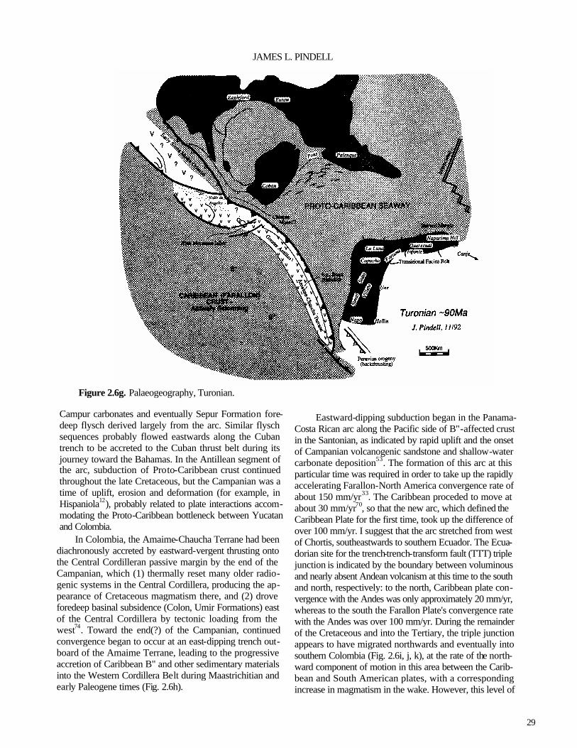
Figure 2.6g. Palaeogeography, Turonian.
Campur carbonates and eventually Sepur Formation fore-deep flysch derived largely from the arc. Similar flysch sequences probably flowed eastwards along the Cuban trench to be accreted to the Cuban thrust belt during its journey toward the Bahamas. In the Antillean segment of the arc, subduction of Proto-Caribbean crust continued throughout the late Cretaceous, but the Campanian was a time of uplift, erosion and deformation (for example, in Hispaniola12), probably related to plate interactions accom-modating the Proto-Caribbean bottleneck between Yucatan and Colombia.
In Colombia, the Amaime-Chaucha Terrane had been diachronously accreted by eastward-vergent thrusting onto the Central Cordilleran passive margin by the end of the Campanian, which (1) thermally reset many older radio-genic systems in the Central Cordillera, producing the ap-pearance of Cretaceous magmatism there, and (2) drove foredeep basinal subsidence (Colon, Umir Formations) east of the Central Cordillera by tectonic loading from the west74. Toward the end(?) of the Campanian, continued convergence began to occur at an east-dipping trench out-board of the Amaime Terrane, leading to the progressive accretion of Caribbean B" and other sedimentary materials into the Western Cordillera Belt during Maastrichitian and early Paleogene times (Fig. 2.6h).
Eastward-dipping subduction began in the Panama-Costa Rican arc along the Pacific side of B"-affected crust in the Santonian, as indicated by rapid uplift and the onset of Campanian volcanogenic sandstone and shallow-water carbonate deposition53. The formation of this arc at this particular time was required in order to take up the rapidly accelerating Farallon-North America convergence rate of about 150 mm/yr33. The Caribbean proceded to move at about 30 mm/yr70, so that the new arc, which defined the Caribbean Plate for the first time, took up the difference of over 100 mm/yr. I suggest that the arc stretched from west of Chortis, southeastwards to southern Ecuador. The Ecua-dorian site for the trench-trench-transform fault (TTT) triple junction is indicated by the boundary between voluminous and nearly absent Andean volcanism at this time to the south and north, respectively: to the north, Caribbean plate con-vergence with the Andes was only approximately 20 mm/yr, whereas to the south the Farallon Plate's convergence rate with the Andes was over 100 mm/yr. During the remainder of the Cretaceous and into the Tertiary, the triple junction appears to have migrated northwards and eventually into southern Colombia (Fig. 2.6i, j, k), at the rate of the north-ward component of motion in this area between the Carib-bean and South American plates, with a corresponding increase in magmatism in the wake. However, this level of

30
The Gulf of Mexico and the Caribbean
Figure 2.6h. Palaeogeography, Campanian. detail cannot be stated with confidence without further work.
Finally, in regard to the Cretaceous, the problem of having both the Chortis Block as well as the Caribbean Plate move synchronously eastwards relative to the Americas still appears to be best solved by northward underthrusting or subduction along the Lower Nicaraguan Rise69. The char -acter of the Rise is not unlike a submarine, oceanic crust-bearing accretionary prism22 and volcanism in the Upper Nicaraguan Rise to the north continued at least into the Paleocene. The Chortis Block must have moved relatively eastwards, while the Caribbean must have moved eastnorth-east, thereby producing convergence between the two at the Nicaraguan Rise.
Cenozoic The Caribbean Plate continued migration relatively
eastnortheastwards, subducting oceanic crust of the Proto-Caribbean. The Yucatan Basin opened by intra-arc spread-ing and extreme attenuation of Greater Antilles arc crust78
in a three-plate system (Fig. 2.6j, vector inset) between Cuba, the Cayman Ridge and North America69. The bulk of the Cuban portion of the Greater Antilles magmaiic arc is split between the basement of the Cayman Ridge and Cuba's southern arc belt. The Cretaceous volcanic assemblages of
onshore Cuba may represent mainly the forearc complex if rifting occurred nearly along the arc axis. A possible reason that Cuba lacks latest Cretaceous -Paleogene magmatic rocks is that the presently subaerial portion of Cuba was too close to the former trench: the arc-trench gap should have been greater, and plutons and volcanics of that age may exist offshore to the south. The opening of the Yucatan basin is defined by the three-plate system (NOAM-Caribbean-Cuba); trends and magnitudes of the relative motions may be calculated by vector completion69. Collision between the Greater Antilles and the Bahamas began in the Paleocene, although subduction accretion packages occur onshore Cuba which formed during the late Cretaceous and included late Cretaceous orogenic sediments probably derived from Yucatan, confusing the definition of the exact age of the onset of the Cuba-Bahamas collision.
A Paleogene age is also generally accepted for the opening of the Grenada Basin89. North-south extension best explains the east-west magnetic pattern and orientation of normal faults in and around the basin, as well as the sharp southeast boundary of the Aves Ridge (transform faulted?). Dextral oblique subduction of the Proto-Caribbean crust, dextral transform drag along South America, and subduc-tion zone rollback of the Jurassic oceanic crust along the northern South America passive margin may have combined

31
JAMES L. PINDELL
Figure 2.6i. Palaeogeography, Maastrichtian.
to drive the Andaman Sea-type intra-arc extension. The opening of both the Yucatan and the Grenada intra-arc basins was the mechanism by which the Caribbean Plate accommodated the shape of the Proto-Caribbean basin. It was apparently easier to rift the arc complexes (driven by rollback of existing Benioff zones) than to tear railroad transforms in the Jurassic Proto-Caribbean oceanic crust.
To the west, the Yucatan block prevented simple east-northeastward motion of Chortis and the Nicaraguan Rise/Jamaica with the rest of the Caribbean Plate, and compression was consequently set up between Chortis and the Caribbean Plate. Chortis, the Nicaraguan Rise, and Jamaica were internally deformed during the Paleogene (Wagwater and Montpelier Troughs in Jamaica; rifts of the Nicaraguan Rise54).
The middle Eocene was marked by the termination of Bahamian-Antillean collision and the onset of platform deposition in Cuba (overlap assemblage). Extension in the Yucatan Basin ceased as Cuba came to rest against the Bahamas. The reconstruction of Figure 2.6k is constrained by: restoring 1,050 km of offset in the Cayman Trough; the alignment of late Cretaceous-Eocene, subduction-related plutons throughout the Greater Antilles and Aves Ridge; and sedimentary facies changes across the Greater An-tilles69. Volcanism shifted eastwards from the Aves Ridge
to the Lesser Antilles arc, beginning in the Eocene in the northern Lesser Antilles, but possibly not until the Oligo-cene or early Miocene in the south. This diachroneity prob-ably relates to the north-south opening of the Grenada Basin and a consequently lesser subduction rate (component of eastward migration) in the south during the Eocene.
In the middle to late Eocene, just after the Antilles-Ba-hamas collision, east-northeast migration of the Caribbean Plate relative to North America continued along a new plate boundary system which became the northern Caribbean plate boundary zone (NCPBZ). The Cayman Trough nucle-ated as a pull-apart basin between Yucatan and Jamaica. Cuba, the Cayman Ridge and the Yucatan Basin were left as apart of the North American Plate by the development of the NCPBZ.
To the south, subduction of Caribbean crust beneath northwest Colombia produced an accretionary prism of Andean, Incaic phase orogenic sediments (San Jacinto Belt) which grew until the Miocene31,32. Progressive development of the early Barbados accretionary prism88 was due to southeastward migration relative to South America of the terrane to the east of the Grenada Basin (Grenada Terrane) during the opening of the Grenada Basin (three-plate sys-tem; Fig. 2.6j). Quartzose sands of Barbados and the Piemontine nappes of central Venezuela were accreted to

32
The Gulf of Mexico and the Caribbean
Figure 2.6j. Palaeogeography, Paleocene. the complex in the Eocene prior to emplacement onto the shelf. These probably originated from western and central Venezuela, where Precambrian acidic massifs were exposed at that time, and from the peripheral bulge ahead of the Venezuela foredeep basin.
Post-Eocene subduction of Proto-Caribbean crust is indicated by subduction-related magmatism in the Lesser Antilles. In the NCPBZ, the Cayman Trough progressively opened by seafloor spreading at the Mid-Cayman Spreading Centre, which linked transform faults connecting to the Middle America and Lesser Antilles subduction zones (Fig. 2.6j, k). These transforms have changed location through time, forming anastomosing fault systems across central Guatemala in the west and across Hispaniola/Puerto Rico in the east. Large-offset transcurrent motions between blocks of Hispaniola are indicated by incompatible Tertiary sedi-mentary facies which are presently juxtaposed across fault zones. The primary offset during the late Eocene and Oligo-cene occurred along faults of the northern San Juan Basin, juxtaposing the San Juan block with the Cordillera Central-Massif du Nord arc by the early Miocene, as indicated by the flooding of arc-derived elastics into the San Juan Basin at that time20,60. Motion on eastward extensions of this fault system separated Puerto Rico from central Hispaniola, and may have brought the Bermeja area of southwest Puerto
Rico into contact with central Puerto Rico along the 'Eocene Tectonic Belt'.
In the developing southern Caribbean plate boundary zone (SCPBZ)11,87, eastward migration of the Caribbean Plate progressively lengthened the zone of Caribbean-South American interaction (Fig. 2.61). Nappes have been em-placed southeastwards onto the Venezuela margin since the Paleocene; initiation of thrusting upon the autochthon be-comes progressively younger to the east. Subsidence of the Venezuela shelf near Maracaibo was Paleocene-early Eo-cene95 and subsidence in the Eastern Venezuela Basin was Miocene-Pliocene91. A transform fault between the Carib-bean Plate and the obducted terranes on South America basement developed progressively after thrust emplace-ment, and assisted with continuing strike-slip offset of the Caribbean, but not the obducted terranes, after emplace-ment. The Falcon64 and Cariaco84 Basins are two examples of Oligocene-early Miocene and Miocene-Recent, respec-tively, transtensional basins that developed in previously overthrust areas. I note that both opened only after the development of the Grenada Basin, when the relative mo-tion vector was extremely oblique.
Motion through Hispaniola during the early to middle Miocene (Fig. 2.6m) continued along the northern San Juan Basin, and possibly along the south flank of Sierra Neiba,

33
JAMES L. PINDELL
Figure 2.6k. Palaeogeography, middle Eocene.
but the main locus of motion became the Oriente Fault between Cuba and Hispaniola at about 20-25 Ma. This was responsible for the present separation of the two islands. By the late Miocene, convergence and uplift in Sierra Neiba had structually separated the San Juan and Enriquillo Basins. The logical continuation of this system is the Muertos Foldbelt50, which has become a south-vergent overthrust zone probably since Miocene time.
In the south, the North Venezuelan and Piemontine nappes reached final emplacement onto the Venezuelan shelf, overthrusting the Oligocene-early Miocene foredeep basin (Roblecito Formation). Out in the Pacific, spreading was initiated at the Galapagos spreading centre; its relation-ship to the Caribbean plate boundary circuit is unclear because its eastern portions have already been subducted.
The Panama arc, a part of the Caribbean Plate, has often been shown as having collided with Colombia in the Mio-cene. In Figure 2.6k-n, I show a speculative, more prolonged history of interaction, which: (1) considers slower relative motion rates farther south such that Panama was always closer to Colombia than previously thought (16 mm/yr for Neogene, 24 mm/yr for Paleogene); (2) portrays the Panama Orocline as a slowly developing feature as plate conver-gence continued; (3) allows for the east-vergent obduction of the Panamanian arc, or Choco Terrane, onto the Western
Cordillera, marking the suture zone within the Western Cordillera rather than at the Atrato Basin; and (4) shows that arc magmatism, which did not begin in Colombia until the middle? Miocene, pertains to subduction of the Cocos or Nazca Plates, rather than of the Caribbean Plate. In any case, the progressive collision hindered and eventually blocked circulation between the Caribbean and Pacific45, and was a major cause of northern Andean compression and uplift, helping to drive the Maracaibo Block northwards from the Eastern Colombian Cordillera. This escape produced the South Caribbean Foldbelt north of the Maracaibo block and offshore terranes 25, and development of the Panama Oro-cline produced the North Panama Foldbelt52. The arc terra-nes of Cuba and Hispaniola continued to separate by transform motion along the present-day Oriente Fault. Com-pression has continued in the Sierra Neiba/Enriquillo sys-tems, contributing to the present-day complexity of the NCPBZ.
Miocene to Recent deformation around the Caribbean was and is common and very strong. This Neo-Caribbean phase of deformation17,69 results from the continued drift of the Americas westward past the Caribbean, and from the general state of compression which can be related to at least three causes. First, North-South American relative motion vectors (Fig. 2.2) show convergence during the Neogene,

34
The Gulf of Mexico and the Caribbean
Figure 2.6l. Palaeogeography, early Oligocene.
which constricts the Caribbean Plate. Second, the restrain-ing bend in the Oriente-Puerto Rico Trench transform fault northeast of the Dominica Republic 13 constricts the east-ward migration of the north-central Caribbean and is respon-sible for much transpression in Hispaniola. The eastern part of Hispaniola, which has already passed this bend, has subdued topography relative to the western part. Third, the northeastward migration, relative to the Guyana Shield, of the Andean Cordilleran Terranes has induced a compression upon the Caribbean Plate to the northnorthwest, because the Caribbean Plate possesses an eastward component of mo-tion relative to the Guyana Shield that is slightly greater than that of the Cordilleran Terrane26. In the southeast Carib-bean, where the Caribbean and South American plates nearly come into contact, the relative motion of the two has been slightly north of east since the late Miocene4, but was more convergent (transpressional to the eastsoutheast) in the early and middle Miocene. A fourth cause, which pertains mainly to Colombia, is that the crust of the Caribbean Plate is buoyant and resists subduction, as attested to by the Andean orogenesis which has occurred in the absence of volcanism throughout the Cenozoic.
ACKNOWLEDGEMENTS—I thank John Dewey, Walter Pitman, Edward Robinson, Sam Algar and Johan Erikson for their input on various elements of this review.
REFERENCES
1 Algar, S.T. 1993. Structural, stratigraphic, and thermo-chronologic evolution of Trinidad. Unpublished Ph.D. thesis, Dartmouth College, Hanover.
2Algar, S.T. & Pindell, J.L. 199la. Structural development of the Northern Range of Trinidad, and implications for the tectonic evolution of the southestera Caribbean: in Gillezeau, K. A. (ed.), Transactions of the Second Geo-logical Conference of the Geological Society ofTrin-dad and Tobago, Port-of-Spain, Trinidad, April 3-8, 1990, 6-22.
3Algar, S.T. & Pindell, J.L. 1991b. Stratigraphy and sedi-mentology of the Toco region of the Northern Range of Trinidad: in Gillezeau, K.A. (ed.), Transactions of the Second Geological Conference of the Geological Society ofTrindad and Tobago, Port-of-Spain, Trinidad, April 3-8, 1990,56-69.
4Algar, S.T. & Pindell, J. 1993. Structure and deformation history of the Northern Range of Trinidad and adjacent areas. Tectonics, 12, 814-829.
5Anderson, T.H., Burkart, B., Clemons, R.E., Bohnenber-ger, O.K. & Blount, D.N. 1973. Geology of the Cuchu-mantanes, northwestern Guatemala. Geological Society of America Bulletin, 84, 805-826.

35
JAMES L. PINDELL
Figure 2.6m. Palaeogeography, early Miocene.
6Anderson, T.H. & Schmidt, V.A. 1983. The evolution of Middle America and the Gulf of Mexico-Caribbean Sea region during Mesozoic time. Geological Society of America Bulletin, 94, 941-966.
7Ave Lallemant, H.G. & Oldow, J.S. 1988. Early Mesozoic southward migration of Cordilleran transpressional ter-ranes. Tectonics,7,1057-1075.
8Ave Lallemant, H.G. & Sisson, V.B. 1993. Caribbean-South Americ an interactions: constraints from the Car-ibbean de la Costa Belt, Venezuela: in Pindell, J.L. (ed.), Mesozoic and Early Cenozoic Development of the Gulf of Mexico Caribbean Region. Transactions of the 13th Annual Research Conference, Gulf Coast Section, SEPM Foundation, 211-220.
9Barr, K.W. 1963. The Geology of the Toco District, Trini-dad, W.L Overseas Geological Surveys, HMSO, Lon-don.
10Beets, DJ., Maresch, W.V., Klaver, G.Th., Mottana, A., Bocchk), R., Beunk, F.F. & Monen, H.P. 1984. Mag-matic rock series and high-pressure metamorphism as constraints on the tectonic history of the southern Car-ibbean. Geological Society of America Memoir, 162, 95-130.
11Biju-Duval, B, Mascle, A., Rosales, H. & Young, G. 1983. Episutural Oligo-Miocene basins along the north
Venezuela margin. American Association of Petroleum Geologists Memoir, 34, 347-358.
12Bowin, C. 1975. The geology of Hispaniola: in Nairn, A.E.M. & Stehli, F.G. (eds), The Ocean Basins and Margins. Volume 3. The Gulf of Mexico and the Carib- bean, 501-550. Plenum, New York. 13Bracey, D.R. & Vogt, P.R. 1970. Plate tectonics in the Hispaniola area. Geological Society of America Bulle- tin, 81,2855-2860. 14Buffler, R.T. & Sawyer, D.S. 1985. Distribution of crust
and early history, Gulf of Mexico Basin. Transactions of the Gulf Coast Association of Geological Societies, 35,333-344.
15Buffler, R.T. & Thomas, W. (in press). Crustal structural and tectonic evolution of the southeastern margin of North America and the Gulf of Mexico basin: in Speed, R. (ed.), The geology of North America, Volume CTV-1, Phanerozoic Evolution of North American Continent-Ocean Transition. Geological Society of America, Boulder.
16Burke, K. 1988. Tectonic evolution of the Caribbean. Annual Review of Earth and Planetary Sciences, 16, 201-230.
17Burke, K., Grippi, J. & Sengor, A.M.C. 1980. Neogene structures in Jamaica and the tectonic style of the north-

36
The Gulf of Mexico and the Caribbean
Figure 2.6n. Palaeogeography, late Miocene. ern Caribbean plate boudary zone. Journal of Geology, 88,375-386.
18Campa, M. & Coney, PJ. 1983. Un modelo tectonic de Mexico y sus relaciones con America del Norte, Amer-ica del Sur y el Caribe. Revista del Instituto Mexicano delPetroleo,15,6-l5.
19Chevalier, Y., Stephan, J.-F., Darboux, J-R., Gravelle, M., Bellon, H., Bellizzia, A. & Blanchet, R. 1988. Obduc-tion et collision pre-Tertiaire dons les internes de la Chain Caraibe venezuelienne, sur le transect fle de Margarita-Pennisule d'Araya. Compte Rendu de la Academie des Sciences de Paris, serie II, 307, 1925-1932.
20Cooper, J.C. 1983. Geology of the Fondo Negro Basin and adjacent areas, Dominican Republic. Unpublished M.S. thesis, State University of New York at Albany. Damon, P. & Coney, P. 1983. Rate of movement
of nuclear Central America along the coast of Mexico during the last 90 Ma. Geological Society of America, Abtracts with Programs, 15, 553. Dengo, G. & Case, J.E. (eds). 1990. The Geology of North America, Volume H, The Caribbean region. Geological Society of America, Boulder. Dewey, J.F. 1980. Episodicity, sequence and style at
convergent plate boundaries: in Strangway, D.W. (ed.),
The continental crust and its mineral deposits. Special Paper of the Geological Association of Canada, 20, 553-573.
24Dewey, J.F. 1982. Plate tectonics and the evolution of the British Isles. Journal of the Geological Society of Lon-don, 129,371-412.
25Dewey, J.F. & Pindell, J.L. 1985. Neogene block tectonics of Turkey and northern South America: continental applications of the finite difference method. Tectonics, 4,71-83.
26Dewey, J.F. & Pindell, J.L. 1986. Neogene block tectonics of Turkey and northern South America: continental applications of the finite difference method—reply. Tectonics, 5, 703-705.
27Dickinson, W.R & Coney, PJ. 1980. Plate tectonics constraints on the origin of the Gulf of Mexico: in Pilger, R.H. (ed.), The Origin of the Gulf of Mexico and the Early Opening of the Central Atlantic, 27-36. Lou-isiana State University, Baton Rouge,
28Dolan, J.F., Mann, P., Monechi, S., de Zoeten, R., Heubeck, C., & Shiroma, J. 1991. Sedimentologic, stratigraphic, and tectonic synthesis of Eocene-Mio-cene sedimentary basins, Hispaniola and Puerto Rico. Geological Society of America Special Paper, 262, 217-240.
21
22
23
37
JAMES L. PINDELL
29Donnelly, T.W. 1989. Geologic history of the Caribbean and Central America: in Bally, A.W. & Palmer, A.R. (eds), The Geology of North America—An Overview, 299-321. Geological Society of Americ a, Boulder.
30Duncan, R A. & Hargraves, R.B. 1984. Plate tectonic evolution of the Caribbean region in the mantle refer-ence frame. Geological Society of America Memoir, 162, 81-84.
31Duque-Caro, H. 1979. Major structural elements and evo- lution of northwest Colombia. American Association of Petroleum Geologists Memoir, 29, 329-351.
32Duque-Caro, H. 1984. Structural style, diapirism, and accretionary episodes of the Sinu-San Jacinto Terrane, southwestern Caribbean borderland. Geological Soci- ety of America Memoir, 162,303-316. 33Engebretson, D.C. 1982. Relative motions between oce- anic and continental plates in the Pacific basin. Un-
published Ph.D. thesis, Stanford University, California. 34Erikson, J.P. 1992. Northeastern Venezuela's Jurassic
through Eocene passive margin, Hispaniola's Neogene Cibo Basin, and their histories and causes of evolution. Unpublished Ph.D. thesis, Dartmouth College, Hano- ver.
35Erikson, J.P. & Pindell, J.L. (in press). Cretaceous-Eocene passive margin relative sea level history, sequence stra-tigraphy, and the tectonic eustatic causes of strati-graphic development in northeastern Venezuela SEPM Special Publication.
36Erikson, J., Pindell, J.L. & Larue, D.K. 1990. Mid-Eo-cene-early Oligocene sinistral transcurrent faulting in Puerto Rico associated with formation of the northern Caribbean plate boundary zone. Journal of Geology,
98,365-384. 37Gonzalez de Juana, C., Arozena, J.A. & Picard Cardillat, X. 1980. Geologiade Venezuela y sus Cuencas Petro- liferas. Ediciones Foninzes, Carcas.
38Hall, S.A., Najmuddin, I. & Buffler, R.T. (in press). Contraints on the tectonic development of the Gulf of Mexico provided by magnetic anomaly data over the deep Gulf. Journal of Geophysical Research.
39Hilst, R.D. van der. 1990. Tomography with P, PP and pP delay-time data and the three-dimension mantle struc-ture below the Caribbean region. Geological Ultraiecu-tina, Mededelingenvan de Faculteit Aardwetenschap-pen der Rijksuniversiteit te Utrecht, 67, 250pp.
40Imlay, R.W. 1980. Jurassic paleobiogeography of the conterminous United States in its continental setting. U.S. Geological Survey, Professional Paper, 1062, 1-134.
41Irving, E.M. 1975. Structural evolution of the north-ernmost Andes, Colombia. U.S. Geological Survey, Professional Paper, 846, 1-47.
42James, K. 1990. The Venezuelan Hydro habitat: in Brooks, J. (ed.), Classic Petroleum Provinces. Geologi cal Society of London Special Publication, 50, 9-36. 43Jansa, L.F. & Weidmann, J. 1982. Mesozoic-Cenozoic development of the eastern North American and north west African continental margins: a comparison: in von Rad, U., Hinz, K., Sarnthein, M. & Siebold, E. (eds), Geology of the Northwest African Margin, 215-269. Springer-Verlag, New York. 44Johnson, C.C. & Kauffman, E.G. 1989. Cretaceous radis- tid paleobiogeography of the Caribbean Province. Ab- stracts, 12th Caribbean Geological Conference. St. Croix, U.S. Virgin Islands, 7th-llth August, 85. 45Keigwin, L.D., Jr. 1978. Pliocene closing of the Isthmus of Panama, based on biostratigraphic evidence from nearby Pacific Ocean and Caribbean sea cores. Geol-
ogy, 6, 630-634. King, P.B. 1969. Tectonic Map of North America, scale
1:5,000,000. United States Geological Survey, Reston, Virginia. Klitgord, K.D., Popenhoe, P. & Schouten, H. 1984. Florida:
a Jurassic transform plate boundary. Journal of Geophysical Research, 89, 7753-7772. Klitgord, K. & Schouten, H. 1986. Plate kinematics of the
central Atlantic: in Tucholke, B.E. & Vogt, P.R. (eds), The Geology of North America, Volume M, The Western Atlantic Region, 351-378. Geological Society of
America, Boulder. Ladd, J.W. 1976. Relative motion of South America with
respect to North America and Caribbean tectonics. Geological Society of America Bulletin, 87, 969-976. 50Ladd, J.W. & Watkins, J.S. 1978. Tectonic development of trench-arc complexes on the northern and southern margins of the Venezuelan Basin: in Watkins, J.S., Montadert, L. & Dickerson, P.W. (eds), Geological and Geophysical Investigations of Continental Margins. American Association of Petroleum Geologists Mem- oir, 29, 363-371.
51Livacarri, R.F., Burke, K. & Sengor, A.M.C. 1981. Was the Laramide Orogeny related to subduction of an oce- anic plateau? Nature, 189,276-278.
52Lu, R.S. & McMillen, K.J. 1983. Multichannel seismic survey of the Colombia Basin and adjacent margin: in Watkins, J.S. & Drake, C.L. (eds), Studies in Continental Margin Geology. American Association of Petro-
leum Geologists Memoir, 34, 395-410. Lunberg, N. 1983. Development of forearcs of intrao-
ceanic zones. Tectonics, 2, 51-61. 54Mann, P. & Burke, K. 1984a. Cenozoic rift formation in the northern Caribbean. Geology, 12,732-736. 55Mann, P. & Burke, K. 1984b. Neotectonics of the Caribbean. Reviews of Geophysics and Space Physics, 22,
46
47
48
49
53
38
The Gulf of Mexico and the Caribbean
309-362. 56Mann, P., Burke, K. & Matumoto, T. 1984. Neotectonics
of Hispaniola: plate motion, sedimentation, and seis-micity at a restraining bend. Earth and Planetary Sci-ence Letters, 70,311-324.
57Maresch, W.V. 1974. Plate tectonics origin of the Carib-bean mountain system of northern South America: dis-cussion and proposal. Geological Society of America Bulletin, 85, 669-682.
58Marton, G. & Buffler, R.T. 1993. The southern Gulf of Mexico in the framework of the opening of the Gulf of Mexico Basin: in Pindell, J.L. (ed.), Mesozoic and Early Cenozoic Development of the Gulf of Mexico Caribbean Region. Transactions of the 13th Annual Research Conference, Gulf Coast Section, SEPM Foundation, 51-68.
59Mattson, P.H. & Pessagno, E.A., Jr. 1979. Jurassic and early Cretaceous radiolarians in Puerto Rican ophiolite; tectonic implications. Geology, 7,440-444.
60Michael,R.C. 1979. Geology of the south-central flank of the Cordillera Central and the adjacent portions of the San Juan Valley between Rio San Juan and Rio Yaca-hueque, Dominican Republic. Unpublished M.S. thesis, George Washington University, Washington D.C.
61Molnar, P. & Sykes, L.R. 1969. Tectonics of the Carib-bean and Middle America regions from focal mecha-nisms and seismicity. Geological Society of America
Bulletin, 80, 1639-1684. Montgomery, H., Pessagno, E.A., Jr. & Munoz, I.M.
1992. Jurassic (Tithonian) radiolaria from La Desirade (Lesser Antilles): preliminary paleontology and tec tonic implications. Tectonics, 11,426-432.
63 Morris, A.E., Taner, I., Meyerhoff, H.A. & Meyerhoff, A. A. 1990. Tectonic evolution of the Caribbean region; alternative hypothesis: in Dengo, G. & Case, J.E. (eds), The Geology of North America. Volume H. The Carib bean Region, 433-457. Geological Society of America, Boulder. 64Muessig, K.W. 1984. Structure and Cenozoic tectonics of the Falcon Basin, Venezuela and adjacent areas. Geo logical Society of America Memoir, 162, 217-230. 65Pindell, J.L. 1985a. Alleghenian reconstruction and the subsequent evolution of the Gulf of Mexico, Bahamas and Proto-Caribbean Sea. Tectonics, 4,1-39. 66Pindell, J.L. 1985b. Plate-tectonic evolution of the Gulf of Mexico and Caribbean Region. Unpublished Ph.D. the
sis, University of Durham, Durham. Pindell, J.L. 1990. Arguments for a Pacific origin of the
Caribbean Plate: in Larue, D.K. & Draper, G. (eds), Transactions of the 12th Caribbean Geological Con ference, St. Croix, U.S. Virgin Islands, 7th-llth August, 1989, 1-4. Miami Geological Society, Florida.
68Pindell, J.L. 1991. Geological rationale for hydrocarbon exploration in the Caribbean and adjacent regions. Journal of Petroleum Geology, 14, 237-257.
69Pindell, J.L. & Barrett, S.F. 1990. Geologic evolution of the Caribbean region: a plate-tectonic perspective: in Dengo, G. & Case, J.E. (eds), The Geology of North America, Volume H, The Caribbean Region, 405-432. Geological Society of America, Boulder.
70Pindell, J.L., Cande, S.C., Pitman, W.C., Rowley, D.B., Dewey, J.F., LaBrecque, J. & Haxby, W. 1988. A plate-kinematic framework for models of Caribbean evolution. Tectonophysics, 155, 121-138. 71Pindell, J.L., Drake, C.L. & Pitman, W.C. 1991. Prelimi-
nary assessment of a Cretaceous to Paleogene Atlantic passive margin, Serrania del Interior and Central Ranges, Venezuela/Trinidad. Abstracts, American Association of Petroleum Geologists Annual Meeting, Dallas, 190.
72Pindell, J.L. & Dewey, J.F. 1982. Permo-Triassic recon-struction of western Pangea and the evolution of the Gulf of Mexico/Caribbean region. Tectonics, 1, 179-212.
73Pindell, J.L. & Draper, G. 1991. Stratigraphy and tectonic development of the Puerto Plata area, northern Domini-can Republic. Geological Society of America Special Paper, 262, 97-114.
74Pindell, J.L. & Erikson, J.P. (in press). The Mesozoic passive margin of northern South America: in Vogel, A. (ed.), Cretaceous Tectonics in the Andes. Vieweg
Publishing, Weisbaden. Pindell, J.L., Erikson, J. & Algar, S. 1991. The relation-
ship between plate motions and sedimentary basin de-velopment in northern South America: from a Mesozoic passive margin to a Cenozoic eastwardly-progressive transpressional orogen: in Gillezeau, K.A. (ed.), Transactions of the Second Geological Confer-ence of the Geological Society of Trinidad and Tobago, Port-of-Spain, Trinidad, April 3-8, 1990, 191-202.
76Pindell, J.L., Robinson, E. & Dewey, J.F. (in press). Paleogeographic evolution of the Gulf of Mexico/
Caribbean Region. SEPM Special Publication. Rodgers, D.A. 1984. Mexia and Talco fault zones, east
Texas: comparison of origins predicted by two tectonic models: in Presley, M.W. (ed.), The Jurassic of East Texas. Transactions of the East Texas Jurassic Explo- ration Conference, 23-31. East Texas Geological Soci-
ety, Tyler. Rosencrantz, E. 1990. Structure and tectonics of the Yu-
catan Basin, Caribbean Sea, as determined from seis -mic reflection studies. Tectonics, 9, 1037-1059.
79Rosencrantz, E., Ross, M. & Sclater, J.G. 1988. Age and spreading history of the Cayman Trough as determined
62
67
75
77
78

39
JAMES L. PINDELL
from depth, heat flow, and anomalies. Journal of Geo- physical Research, 93, 2141-2157. 80Rosenfeld, J.H. 1993. Sedimentary rocks of the Santa Cruz ophiolite, Guatemala—a Proto-Caribbean his- tory: in Pindell, J.L. (ed.), Mesozoic and Early Ceno- zoic Development of the Gulf of Mexico Caribbean Region. Transactions of the 13th Annual Research Conference, Gulf Coast Section, SEPM Foundation, 173-180. 81Rowley, D.B. & Pindell, J.L. 1989. End Paleozoic -early
Mesozoic western Pangean reconstruction and its im-plications for the distribution of Precambrian and Pa-leozoic rocks around Meso-America. Precambrian Research, 42, 411-444.
82Salvador, A. & Green, A.G. 1980. Opening of the Carib- bean Tethys, geology of the Alpine chain born of the Tethys. Memoir of the 26th International Geological Congress. Bureau de Recherches Geological et Min- erologie, 115, 224-229. 83Schlager, W. et al 1984. Deep Sea Drilling Project, Leg 77, southeastern Gulf of Mexico. Geological Society of America Bulletin, 95, 226-236. 84Schubert, C. 1982. Origin of Car iaco Basin, southern Caribbean Sea. Marine Geology, 47, 345-360. 85Shaw, P.R. & Cande, S.C. 1990. High-resolution inver- sion for South Atlantic plate kinematics using joint altimeter and magnetic anomaly data. Journal of Geo- physical Research, 95, B2625-B2644.
86Sheridan, R.E., Crosby, J.T., Kent, K.M., Dillon, W.P. & Paull, C.K. 1981. The geology of the Blake Plateau and Bahamas. Canadian Society of Petroleum Geologists Memoir, 1, 487-502.
87Silver, E.A., Case, J.E. & Macgillavry, H.J. 1975. Geo- physical study of the Venezuelan boreland. Geological Society of America Bulletin, 86, 213-226. 88Speed, R.C. 1985. Cenozoic collision of the Lesser An- tilles Arc and continental South America and origin of the El Pilar Fault. Tectonics, 4, 40-70. 89Speed, R.C. etaL 1984. Lesser Antilles Arc and adjacent terranes. Ocean Margin Drilling Program, Regional Atlas Series, Atlas 10. Marine Science International, Woods Hole. 90Stoffa, P.L., Mauffret, A., Truchan, M. & Buhl, P. 1981. "Sub-B" layering in the southern Caribbean: the Aruba gap and Venezuela Basin. Earth and Planetary Science Letters, 53, 131-146. 91Vierbuchen, R.C. 1984. The geology of the El Pilar fault zone and adjacent areas in northeastern Venezuela. Geological Society of America Memoir, 162,189-212. 92Vogt, P.R., Anderson, C.N. & Bracey, D.R. 1971. Mesozoic magnetic anomalies, seafloor spreading, and geomagnetic reversals in the southwestern north Atlantic. Journal of Geophysical Research, 76,4796- 4823. 93Wadge, G. & Burke, K. 1983. Neogene Caribbean plate
rotation and associated Central American tectonic evolution. Tectonics, 2, 633-643.
94Wilson, H.H. 1974. Cretaceous sedimentation and oro- geny in nuclear Central America. American Associa- tion of Petroleum Geologists Bulletin, 58, 1348-1396. 95Zambrano, E., Vasquez, E. , Duval, B., Latreille, M. & Coffinieres, B. 1972. Paleogeographic and petroleum synthesis of western Venezuela. Editions Technip, Paris.