Embed Size (px)
Citation preview

Evaluation of Autostereoscopic Visualization of Landscape
Dirk STENDEL
Abstract
Drawings, illustrations and visualizations have a long tradition in the field of landscape architecture. The designer communicates his ideas and concepts via these media to other people involved in the planning process (cf. BISHOP & LANGE, 2005a; b). The use of auto- stereoscopic pictures – illustrations with a visible spatial depth – may be helpful in the process. In a DFG-research project the circumstances and parameters responsible for a successful use of the lenticular technique were determined and evaluated.
This paper covers the research results, and ties in with the paper “Autostereoscopic Visuali-zation of Landscape” by D. STENDEL (2008). The first paper gives a detailed description of several technical as well as psychological mechanisms of autostereoscopic techniques. In addition, field related potentials of the technique are evaluated. The current paper covers the evaluation of practical experiences with autostereoscopic images from the point of view of landscape architecture. In the course of the research project, pros and cons of additional image information in form of spatial depth and depth dependent object shifting vs. illustra-tion constraints of technical nature were examined. The overall effect on the observer was evaluated as well. The results prove the techniques’ ability to suit the requirements of illu-strations in the line of business. The majority of the observers attests the pictures an in-creased unambiguousness and spatial precision. Some user groups even prefer this kind of presentation technique over the common 2D paper images.
Lenticular images may be perceived more intuitively than traditional illustrations. Misin-terpretations of the presented contents may be more easily avoided. The differences in the user groups’ reaction and evaluation to various advantages of the 3D illustrations could generally be correlated to their degree of expertise.
The data presented allows a first-time assessment of such presentation techniques in the context of landscape architecture and will be the foundation for further research. In the authors’ opinion, current knowledge advises further development of the lenticular technique and the establishment as a possible presentation standard in the planning business.
1 Introduction
The scope of the research project “Tauglichkeit der Lentikulartechnik für Planungswissen-schaften am Beispiel der Landschaftsarchitektur” covered the examination of the potential of autostereoscopic illustrations in the form of lenticular images1 in the context of land-scape architecture. This technique has been known and used in the field of business for only
1 Also known as a „motion-image“.

Evaluation of Autostereoscopic Visualization of Landscape 201
a few years. Before then, the hardware (the lenticular plate) had not been available in rele-vant sizes (e.g. DIN A0) and the essential 3D computer models had been rather uncommon.
In addition, for the first time a specifically adjusted method was developed which consi-dered the special needs of the profession of landscape architecture – the VLR-method (vir-tual lenticular rendering method). Despite the early stage of development, the method al-lows a simplified production of lenticular images with an enhanced spatial effect and quali-ty. The Deutsche Forschungsgemeinschaft (DFG) approved the research project in October 2005 for a duration of three years until December 2008. The administration and realization of the project was accomplished by Dipl.-Ing. DIRK STENDEL at the chair of Prof. FALK
TRILLITZSCH from the Berlin Institute of Technology (TU-Berlin).
The main question to be answered in this project was if the lenticular imaging technique may be successfully introduced to and employed in the planning sciences. Results of simi-lar research projects in the field of communications technology and engineering led to the hypothesis that this presentation technique would generate an added value to illustrations in landscape architecture due to its stereoscopic spatial impact. If this hypothesis was verified, the lenticular technique could be further developed to create a new visualization standard for the planning sciences.
Psychology of perception sees to it that stereoscopic respectively autostereoscopic illustra-tions have certain advantages over conventional illustrations. First of all, inconclusive visu-al situations may be interpreted by the observer with a reduced error rate of 11% (COURS, 2004). Secondly, the retentiveness of the information is increased compared to two-dimensional illustrations. This is accounted to the higher feeling of presence in the observer due to the obvious spatiality (REGENBRECHT, 1999). Furthermore, the impact of spatial illustrations was proven to be livelier and more fascinating (COURS, 2004; PETSCHEK &
LANGE, 2004). The time needed for interpretation of the seen is significantly reduced (COURS, 2004; KRAAK, 1988).
Regardless of the type of user group, the viewing of an autostereoscopic image should lead to a quicker and better understanding of the presented contents.
2 Research setup and Procedure
Four sub-questions were looked into in the course of the research project, all being related to the thematic fields of practice-oriented feasibility, potential benefit and assessment of the acceptance within the profession. Risks related to the presentation and interpretation of an autostereoscopic image were identified and discussed. An overall assessment allows the affirmation or rejection of the projects hypothesis. The main task for the duration of the project was the creation of autostereoscopic images, their presentation and evaluation of the survey results.
D. Stendel 202
Several 3D computer models in the context of landscape architecture were obtained. Four different 3D computer models were chosen and subjected to advanced treatment.
Competitions on urban development
Guangzhou, China (m 1:10.000)
Khalifa City C, Abu Dhabi (m 1:2.000)
Competitions on landscape architecture (cont.)
Spielbudenplatz, Hamburg (m 1:500)
Schillerplatz, Schweinfurt (m 1:100)
Subsequent editing of the 3D computer models was focused on the best possible photo-realistic implementation for conceptual reasons. The illustration of plant material in the designs was therefore primarily realised with 3D models as well (X-Frog models of Greenworks Comp., Berlin). The available model data was then edited further e.g. adding aspects of season change or systematic completion of the data.
Simultaneously illustrations using the new lenticular technique (VLR-method), developed at the chair of “Darstellung und Gestaltung in der Landschaftsarchitektur“, were created. The combined workflow of editing 3D models and prototyping lenticular pictures allowed a better understanding of stereoscopic specifications related to the 3d computer model as well as graphics needs of the profession. The implementation of the VLR-method proved to be effective and uncomplicated, disregarding the fact that all working steps have to be processed in separate and manual-adjusted steps. In the opposite of the standard procedure (interlace-method) no VLR-software solution has been developed so far to automate the synchronization process between 3D model and graphical needs2.
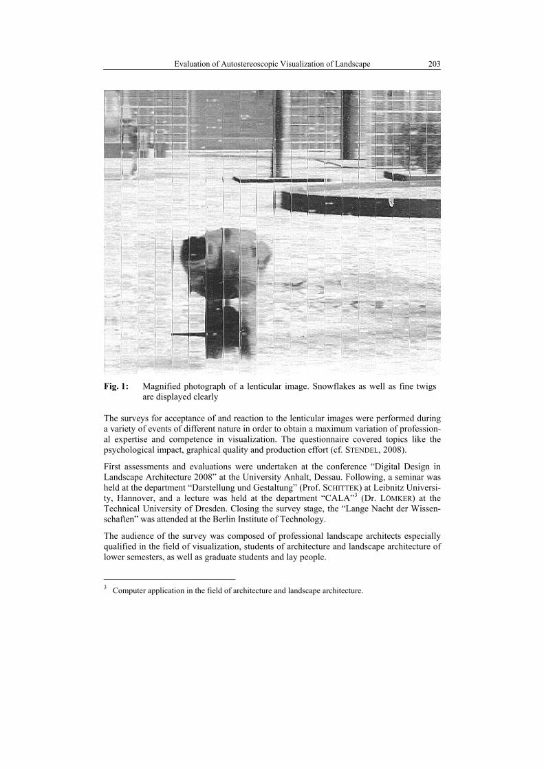
Using the example of plan view maps and supplemental perspective illustrations with spa-tial depth effects further aspects were examined. In these examples seasonal changes were considered and displayed. The illustration of seasonal changes allows an in-depth analysis of the potential for detail display of the lenticular technique (e.g. flying autumn foliage or snow fall). Figure 1 shows a photograph of a magnified section of a lenticular image.
2 Due to the complex production process and the premature stage of the VLR-technique it was de-
cided to reduce the amount of example illustrations and the amount of interviews. Two DIN-A0 lenticular images and according 2D images were produced, presented and evaluated. With an im-proved method, the original propositions may be followed.
Evaluation of Autostereoscopic Visualization of Landscape 203
Fig. 1: Magnified photograph of a lenticular image. Snowflakes as well as fine twigs are displayed clearly
The surveys for acceptance of and reaction to the lenticular images were performed during a variety of events of different nature in order to obtain a maximum variation of profession-al expertise and competence in visualization. The questionnaire covered topics like the psychological impact, graphical quality and production effort (cf. STENDEL, 2008).
First assessments and evaluations were undertaken at the conference “Digital Design in Landscape Architecture 2008” at the University Anhalt, Dessau. Following, a seminar was held at the department “Darstellung und Gestaltung” (Prof. SCHITTEK) at Leibnitz Universi-ty, Hannover, and a lecture was held at the department “CALA”
3 (Dr. LÖMKER) at the Technical University of Dresden. Closing the survey stage, the “Lange Nacht der Wissen-schaften” was attended at the Berlin Institute of Technology.
The audience of the survey was composed of professional landscape architects especially qualified in the field of visualization, students of architecture and landscape architecture of lower semesters, as well as graduate students and lay people.
3 Computer application in the field of architecture and landscape architecture.

D. Stendel 204
Figure 2 shows the number of interviewees per event and distinguishes between a profes-sional and a lay audience. The images had been presented on an easel due to the rigidity of the lenticular plates, which gave the audience a first impression of the handling of the lenti-cular image material. In each case, group discussions and one-on-one interviews took place respectively after the presentations. First reactions, doubts and suggestions were gathered. 119 questionnaires, each of 20 individual questions plus notes on the interviews, were eva-luated. The estimated applicability and the favoured fields of application (competitions, exhibitions, construction signs) were evaluated as well.
Fig. 2: Number of interviewees and percentage of lay people
Evaluation of Autostereoscopic Visualization of Landscape 205
3 Results
The qualitative analysis of the gathered data regarding the lenticular images can hardly be separated from effects of the production procedure. The quality of the stereoscopic image highly depends on the chosen method. The results presented here all relate to the VLR-method. Improvements in the production process and an enhanced illustration quality com-pared to the common Interlace-method will most likely also lead to better evaluation re-sults. Further development of the VLR-method may positively influence later evaluation results. However, the four raised sub questions may already be evaluated and an overall assessment undertaken.
3.1 General Tendencies
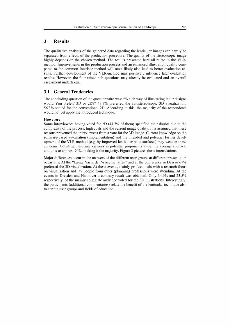
The concluding question of the questionnaire was: “Which way of illustrating Your designs would You prefer? 3D or 2D?” 43.7% preferred the autostereoscopic 3D visualization, 56.3% settled for the conventional 2D. According to this, the majority of the respondents would not yet apply the introduced technique.
However: Some interviewees having voted for 2D (44.7% of them) specified their doubts due to the complexity of the process, high costs and the current image quality. It is assumed that these reasons prevented the interviewees from a vote for the 3D image. Current knowledge on the software-based automation (implementation) and the intended and potential further devel-opment of the VLR-method (e.g. by improved lenticular plate surfaces) may weaken these concerns. Counting these interviewees as potential proponents to-be, the average approval amounts to approx. 70%, making it the majority. Figure 3 pictures these interrelations.
Major differences occur in the answers of the different user groups at different presentation occasions. At the “Lange Nacht der Wissenschaften” and at the conference in Dessau 67% preferred the 3D visualization. At these events, mainly professionals with a research focus on visualization and lay people from other (planning) professions were attending. At the events in Dresden and Hannover a contrary result was obtained. Only 34.9% and 23.5% respectively, of the mainly collegiate audience voted for the 3D illustrations. Interestingly, the participants (additional commentaries) relate the benefit of the lenticular technique also to certain user groups and fields of education.
D. Stendel 206
Fig. 3: General acceptance of VLR-method based lenticular images of the interviewees
3.2 Fields of Application and Chances for implementation
From the point of view of psychology of perception, all sorts of presentations in the discip-line of landscape architecture are suited for the use of the VLR-method. Due to existing conventions and for reasons of practicability it is not always reasonable, though. The inter-viewees were asked to give their opinion on the potential applicability of seven areas of implementation. These were named in random order without considering the frequency of use.
Professional fields of application mentioned by the interviewees were competitions (42%), exhibitions (78%), formal presentations (53%) and construction signs (36%). The results of an additional question, regarding the qualitative assessment of these fields of application, is shown in Figure 4. Above average results occurred for “exhibitions” throughout all user groups. It seems to be estimated as the most promising field of application. Formal presen-tations, competitions and construction signs are rated “good” to “sufficient” on average. User specific differences in the evaluation results show clearly. The graph for Berlin Insti-tute of Technology, for example, demonstrates a very positive reaction to the technique. Since most of the interviewees had been lay people, especially this user group attests an added-value for this technique (cf. fig. 2).
Despite obvious user group dependencies in the overall results, the same fields of applica-tion have been rated as suitable or less suitable. Implementation planning and permit plan-ning as well as preliminary planning were rated ill-suited by all user groups.

Evaluation of Autostereoscopic Visualization of Landscape 207
Fig. 4: Field related areas of application for the lenticular technique
91% of the interviewees would invest additional time of four or more hours compared to the common illustration process. Nearly 72% would be inclined to invest an additional charges (150€ or more). The current additional working time amounts to about two or three hours4. A lenticular plate of DIN-A0 size currently costs less than 150€. Under these cir-cumstances, 71.4% would approve of the lenticular technique.
3.3 Image Details and Their Perception
The majority of the twenty questions related to evaluations of optical and technical details such as visible image resolution and spatial effect. The results of the evaluated image reso-lution (fig. 5) were below average. Due to the method of operation of the lenticular tech-nique, the common image resolution of 150-230 dpi for DIN A0 illustrations may not be achieved. The lenticular plate reduces the initial image resolution to about 20%. The visible resolution of the presented illustrations equalled 50 dpi horizontally5. The vertical resolu-tion is not manipulated by the lenticular grid and remained at 250 dpi. Considering this data, the evaluation outcome may be interpreted positively. The development of the last few years in printer technology and processing power will allow the production of lenticular
4 The time needed for the production of the necessary 3D computer model is excluded from the time
calculation. It is taken for granted that 3D models are usually created in order to produce additional perspectives anyway.
5 None the less, the snow flakes in the winter illustration (figure 0) were easily identified. Small fonts in the images were readable as well and could be positioned in the spatial environment easily.

D. Stendel 208
Fig. 5: Evaluation of the visible resolution compared to an according 2D visualisation
images of comparable quality in the near future. The spatial perception of the scenes com-pensates for the reduced visible image resolution6.
The spatial depth of the illustrations was recognized as obvious and very obvious by more than 50%, despite the fact that the computed visual spatial depth only amounted to a few centimeters (2.5-3.5 cm). 70% of the interviewees saw need for improvement of the effect7.
General differences and a beneficial change compared to a 2D illustration were acknowl-edged by more than 82% of the interviewees. Written commentaries often attested a more lively atmosphere. The enhanced unambiguousness of the spatial illustrations was rated moderate to very clearly by 56% of the people. Thus these illustrations are more compre-hensible than according 2D illustrations (see fig. 6).
6 The binocular (two-eyed) spatial perception leads to a ten times higher image resolution compared
to a monocular (one-eyed) spatial perception. This phenomenon is called hyperacuity (VALJUS, 1966).
7 The effect of an increased spatial perception despite marginal spatial depth information in the pic-ture has been known in humans (METZGER, 1975; OKOSHI, 1976). First-time simulations concerning the VLR-method predict a possible tenfold increase in the presentable spatial depth. Therefore, new lenticular plates with customized surface structures need to be developed.

Evaluation of Autostereoscopic Visualization of Landscape 209
Fig. 6: Feeling of increased unambiguousness of lenticular images compared to accord-ing 2D illustrations
3.4 Contributions to the Discussions
Technical as well as content related contributions were made during the interviews and the open discussions. Helpful advice and practical experiences could be drawn from them. The most important are mentioned below.
Technical
Light reflection on the lenticular plate depended very much on the illumination of the exhi-bition room. It was rated in a wide range between unremarkable and very distracting. Due to the optical mode of operation of the lenticular plate, the illumination is a fundamental parameter for the 3D effect. At the moment a correlation between the different group results and the according room illumination may not be verified. The illumination at Anhalt Uni-versity of Applied Science (very brightly and diffusely illuminated foyer) and at Berlin Institute of Technology at the “Lange Nacht der Wissenschaften” (separate spotlights) was ideal. The according survey groups gave the best evaluations. At the Technical University of Dresden (lecture hall) and Leibniz University in Hannover (seminar room) the exhibition conditions were less bright and either illuminated from side windows or from above with artificial light. The according groups gave a discretely different and more skeptical evalua-tion of the 3D technique. The possible correlation of the mentioned facts needs to be inves-tigated further, since it may prove essential for the techniques success. In addition to the skepticism concerning the production process of the lenticular illustrations, possible com-plications connected to the transport of large-size plans were mentioned. The inelasticity of the illustrations reduces the possible fields of application for exhibitions and formal presen-tations, where a certain amount of time is necessarily taken for preparations.
D. Stendel 210
Content-related
Beyond the spatial effect of the presented illustrations, the general necessity of photo-realistic perspectives was discussed. The objective of the research project to create images as photo-realistic as possible was opposed by the professional audience. The variety of styles in designs was mentioned as very important in order to be able to evaluate the tech-nical potential and advantages of the lenticular technique. Lay people appraised the photo-realism as helpful for a better understanding8. The user dependent value of the lenticular technique was discussed intensely. The added-value was mainly attributed to lay addresses. It was rated unnecessary for communication processes within the profession9.
4 Conclusions and Outlook
The expected added-value of the lenticular images was recognized by about half of the interviewees. In this respect, the objective of the project could be verified. Results from related research projects of other disciplines could be affirmed. This kind of illustration technique allows a better comprehension of the planning contents and therefore leads to an increased transparency and reliability of the whole planning process. Provided that the planning situation is known to the observer, manipulations of the scene are more easily discovered in spatial illustrations. The demanded illustration qualities may be met (CF. SHEPPARD, 2005). The implementation requirements basically lead to an automated cor-rectness10.
The survey results, as well as the general appreciation, show no fundamental reservation to the lenticular technique. A general acceptance is verified. In the author’s opinion this ac-ceptance is to some degree connected to the print medium paper. How the evaluation results my change with a digital application of the lenticular technique is not known and needs to be investigated.
Further development and improvement of the lenticular technique and the VLR-method is the aim of continuative research projects. The most interesting field of research is the de-velopment of complete parallax images (integral images), which may be viewed from any angle with the same quality. It is expected that the acceptance and chances for implementa-tion will increase with an improved method and may reach values of more than 70%. The technique then might become a presentation standard.
Due to similar demands on illustrations across different planning professions (architecture, urban development, traffic planning, cartography etc.) transferability of the research results may be possible. Discussion results supported this estimation. The wide-spread use of the lenticular technique in the professional context therefore seems possible.
8 Non-photo-realistic images may be produced just as easily. The different user groups’ reactions to
the styles of illustration should be investigated further. 9 To the author’s knowledge, this sort of mere within the profession communication is compara-
tively rare. 10 The necessity of 3D computer models and the subsequently impossible manipulation of the con-
tents with image processing software, e.g. Photoshop, are two reasons for this.

Evaluation of Autostereoscopic Visualization of Landscape 211
References
Bishop, I. D. & E. Lange (2005a): Communication, Perception and Visualization. In Bi-shop, I. D. & E. Lange (Eds.): Visualization in landscape and enviromental planning: technology and applications. New York: Taylor & Francis, 3-21.
Bishop, I. D. & E. Lange (2005b): Presentation Style and Technology. In Bishop, I. D. & E. Lange (Eds.): Visualization in landscape and enviromental planning: technology and applications. New York: Taylor & Francis, 68-77.
Cours, N. (2004): Wahrnehmungspsychologische Evaluation eines dreidimensionalen Vi-sualisierungssystems. Dissertation, Universität Kassel.
Kraak, M.-J. (1988): Computer assisted cartographical three-dimensional imaging techni-ques. Dissertation, Univ. Pr., Delft.
Metzger, W. (1975): Gesetze des Sehens. Hrsg. v. d. Senckenberg. 3. Aufl. Frankfurt am Main: Kramer.
Okoshi, T. (1976): Three-dimensional imaging techniques. New York: Academic Press.
Petschek, P. & E. Lange (2004): Planung des öffentlichen Raumes – der Einsatz von neuen Medien und 3D Visualisierungen am Beispiel des Entwicklungsgebietes Zürich-Leutschenbach. In Schrenk, M. (Ed.): CORP 2004 – Competence Center for Urban and Regional Development, 9. Wien: TU Wien, 569-572 (digital published: http://www.corp.at/).
Regenbrecht, H. (1999): Faktoren für Präsenz in virtueller Architektur. Dissertation, Bau-haus Universität, Weimar.
Sheppard, S. (2005): Validity, Reliability and Ethics in Visualization. Bishop, I. D. & E. Lange (Eds.): Visualization in landscape and enviromental planning: technology and applications. New York: Taylor & Francis, 79-97.
Stendel, D. (2008): Autostereoscopic Visualization of Landscape. In Buhmann, E. et al. (Eds.): Digital design in landscape architecture 2008. Heidelberg: Wichmann, 114-123.
Stendel, D. (2009): Evaluation of Autostereoscopic Visualization of Landscape. In Buhmann, E., Pietsch, M. & M. Heins (Eds.): Digital Landscape Architecture 2009, Proceedings of Presented Papers, 21 - 23 May, 2009 – Malta, Anhalt University of Applied Sciences / Hochschule Anhalt (FH), Bernburg, Germany, 193-200.
Valjus, N. A. (1966): Streoscopy (Stereoskopija). London: The Focal Press.


![Three Dimensional Interaction with Autostereoscopic Displays...display systems with moving lenticular sheets or lenses in front of the display plane [7.8.9.10.11.12]. While we cannot](https://img.dokumen.tips/doc/110x75/60d14112b2a6360a0e4a9d1a/three-dimensional-interaction-with-autostereoscopic-displays-display-systems.jpg)