Embed Size (px)
Citation preview
Available online at www.sciencedirect.com
Energy Procedia 00 (2010) 000–000
EnergyProcedia
www.elsevier.com/locate/XXX
GHGT-10
EU-GeoCapacity in China – Towards CCS demonstration projects
in Hebei Province
Yves-Michel Le Nindrea*, Delphine Allier
a, Wenying Chen
b, Fei Teng
b, Ruina Xu
c,
Rongshu Zengd, and Ming Li
d
aBRGM, PO Box 36009, 45060 Orléans Cedex 2, France bEnergy Environment and Economy (3E) Research Institute, Tsinghua University, Beijing 100084, China
cInstitute of Thermal Engineering, Tsinghua University, Beijing 100084, China d Institute of Geology and Geophysics, Chinese Academy of Sciences, Beijing 100049, China
Elsevier use only: Received date here; revised date here; accepted date here
Abstract
EU GeoCapacity (Assessing European Capacity for Geological Storage of Carbon Dioxide) is a 3-year project that ran from
January 1st 2006 to December 31st 2008, and that was carried out by 26 partners in 21 countries including China, providing the
first detailed pan-European assessment of CO2 storage capacity. Other outcomes were the development of innovative methods for
capacity assessment, economic modelling and site selection. An important mission was to initiate scientific collaboration, with
China and other CSLF members (e.g. Russia). In China, the study was applied to the Hebei Province, which is located in the
Bohai Basin, NE China. The inventory of emission sources was performed for the entire Hebei Province, while storage potential
was studied in one of the major tectonic units of the basin, the Jizhong depression, in the south of the Province. The distribution
of the main CO2 emitters by sector has shown that besides the power sector, industry must be considered, in particular iron/steel
and cement sectors accounting for one third of the total. Least cost transport was calculated using a methodology developed by
3E/INET (Tsinghua University) and BRGM ([1] Chen et al., 2010) and applied also to the other CCS projects in China. The
NZEC Conference, held in Beijing (28-20 October 2009) to close phase 1 and launch phase 2 of this European programme in
China, concluded that storage is the most critical issue. At the present early stage, low-cost capture and transport should be
preferred. Therefore, should incentives, performing investigation tools and adequate partnership be in place, several small-scale
demonstration projects from local industry to local storage sites are recommended to improve knowledge and operating
conditions prior to any ambitious project. CCS deployment in the Hebei province could be performed from local sources to local
sinks of CO2. However, EOR is limited by the present water cut or reservoir geometry and geothermal reconversion might be
profitable. Tertiary aquifers would be a good target, but the Neogene (Guantao, Minghuazhen formations) seems restricted to
other uses (geothermal, water supply). Therefore, more coordination between geothermal exploration and CCS, and new
objectives in the deeper Tertiary (Paleogene) would be suitable for CCS deployment.
© 2010 Elsevier Ltd. All rights reserved
Keywords: Carbon Capture and Storage; China; Bohai; Hebei; Industry sector; Demonstration.
* Corresponding author. Tel.: +33 2 38 64 3496; fax: +33 2 38 64 3575.
E-mail address: [email protected].
c⃝ 2011 Published by Elsevier Ltd.
Energy Procedia 4 (2011) 6045–6052
www.elsevier.com/locate/procedia
doi:10.1016/j.egypro.2011.02.609
2 Y.M. Le Nindre et al. / Energy Procedia 00 (2010) 000–000
1. Introduction: the EU capacity assessment
1.1. Capacity assessment history in the EU
In 1995, the project JOULE II demonstrated the feasibility of the CO2 geological Storage. GESTCO (2000-2003)
involved the countries of western and north-western Europe. CASTOR (SP.1) and EU-GeoCapacity (2006-2008)
extended mapping to north-eastern, central-eastern and southern Europe as well as to other CSLF countries (China -
Russia), defining also standards and best practice for geological storage. Now, the ongoing project COMET (2010-
2012) extends the assessment to Portugal and Morocco, but goes further, building an ‘energy model’, and designing
an ‘Integrated infrastructure for CO2 transport and storage in the west Mediterranean’.
1.2. The EU-GeoCapacity project (http://www.geology.cz/geocapacity/publications)
EU GeoCapacity (Assessing European Capacity for Geological Storage of Carbon Dioxide) is a 3-year project
that ran from January 1st 2006 to December 31st 2008, and that was carried out by 26 partners in 21 countries. The
main objective of the project was to assess the European capacity for geological storage of CO2. The project
included the full assessment of several countries not studied before, as well as updates of previously covered
territory. Other priorities were the further development of innovative methods for capacity assessment, economic
modelling and site selection criteria ([2] Vangkilde-Pedersen et al., (2009). Finally, an important mission was to
initiate scientific collaboration, with China and other CSLF members, e.g. Russia ([3]Le Nindre et al., 2010). In
China the partner was 3E/INET, Tsinghua University, with the collaboration of IGG-CAS.
2. GeoCapacity and other cooperative action in China
In China, similarly to the programme carried out in parallel by the European GeoCapacity partners, the objective
was to make an inventory of CO2 emission sources in one province, assess the storage capacity in one test area (e.g.
petroleum province or aquifer system) and, using the available data at this scale, propose scenarios of sources-sink
matching. The study was applied to the Hebei Province, which is located in the Bohai Basin, NE China. The
inventory of emission sources was performed for the entire Hebei Province, while storage potential was studied in
one of the major tectonic units of the basin, the Jizhong depression, in the south of the Province. The following data
were entered into the Geographic Information System:
• CO2 emission sources,
• Oil and gas pipelines,
• Hydrocarbon fields, and injection points in 25 hydrocarbon fields,
• Thickness map and extent of the Tertiary Guantao aquifer at depths >850 m in the Jizhong depression,
• Structural base map.
A simplified geological model of the Guantao formation within the study area was constructed.
Due to the specific Chinese context, a dedicated type of decision-support system, based on GIS grids and least-
cost calculation was implemented thanks to a separate cooperation work by 3E/INET (Tsinghua University) and
BRGM ([1] Chen et al., 2010). This specific tool was also applied to other CCS projects in China.
3. Results
3.1. Emission sources: key points
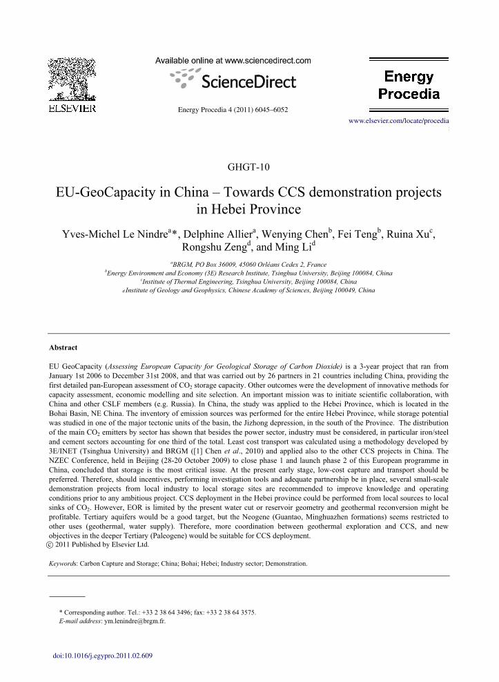
The inventory of the CO2 emission stationary sources performed in Hebei has shown that, although the main CO2
fluxes are from the power sector (up to 18 Mt/a by plant), iron and steel (up to 12 Mt/a by plant) and cement (up to 9
Mt/a by plant) are also huge emitters. Considering only the major point sources (>1MT/a), the power sector
represents only 62% of the total. The rest (38%) is produced by iron/steel and cement (33%), ammonia and
refineries (5%) sectors (Figure 1).
6046 Y.-M. Le Nindre et al. / Energy Procedia 4 (2011) 6045–6052
Y.M. Le Nindre et al. / Energy Procedia 00 (2010) 000–000 3
Figure 1 Emission sources in the Hebei Province. Mapping by size and distribution by sectors (data and GIS: [4] EU-GeoCapacity WP6; base
map: [5] Geological Atlas of China, 2002).
Among the criteria for selecting a source, the capture cost and the distance to the storage site are crucial.
Therefore products, technology and location of the existing or planned plant must be carefully weighted prior to any
decision.
3.2. Storage typology
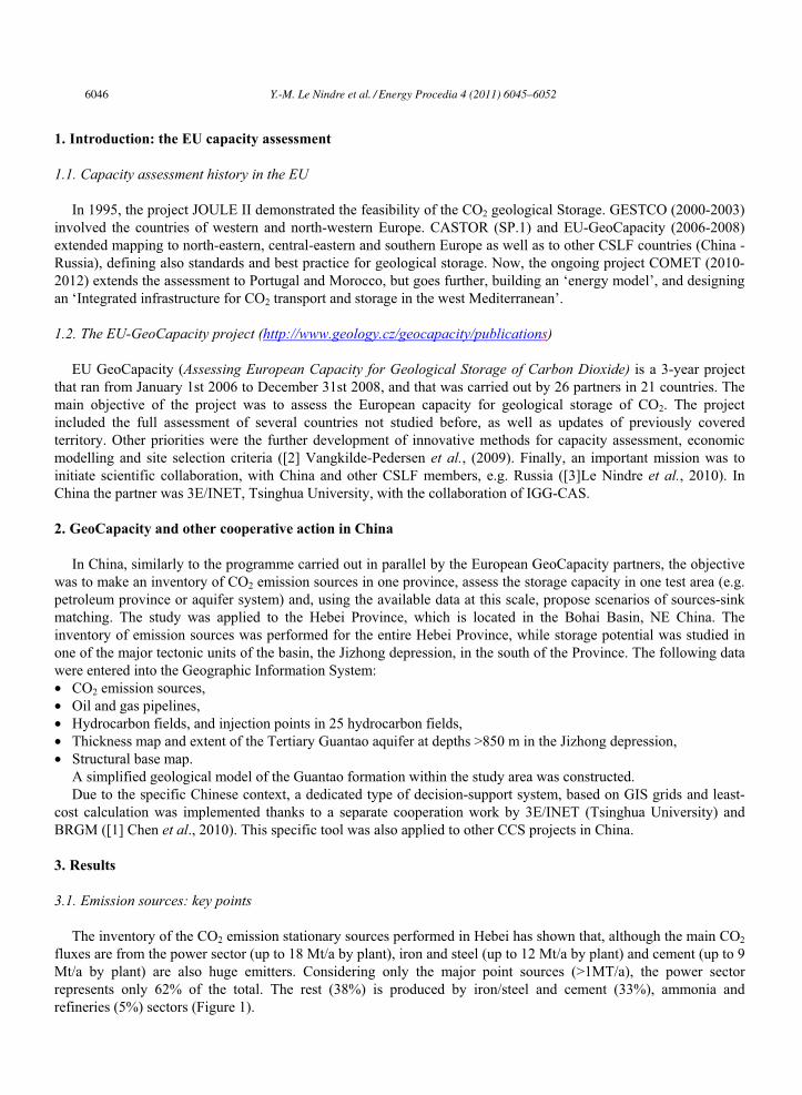
Two types of geological storage were studied: storage in hydrocarbon fields for Enhanced Oil Recovery (EOR)
or in depleted fields, and storage in aquifer. The selected work area was the Jizhong depression, located in the west
of the Bohai Basin, in the south of the Hebei Province (Figure 1 and Figure 2).
Figure 2 Main features of the storage options: buried hills and Tertiary cover (Paleogene, Neogene and target aquifer). Interpreted seismic W-E
cross section of the Jizhong depression trough the southern area of the Baxian sag (section by [6] Zhao and Windley, 1990)
Y.-M. Le Nindre et al. / Energy Procedia 4 (2011) 6045–6052 6047
4 Y.M. Le Nindre et al. / Energy Procedia 00 (2010) 000–000
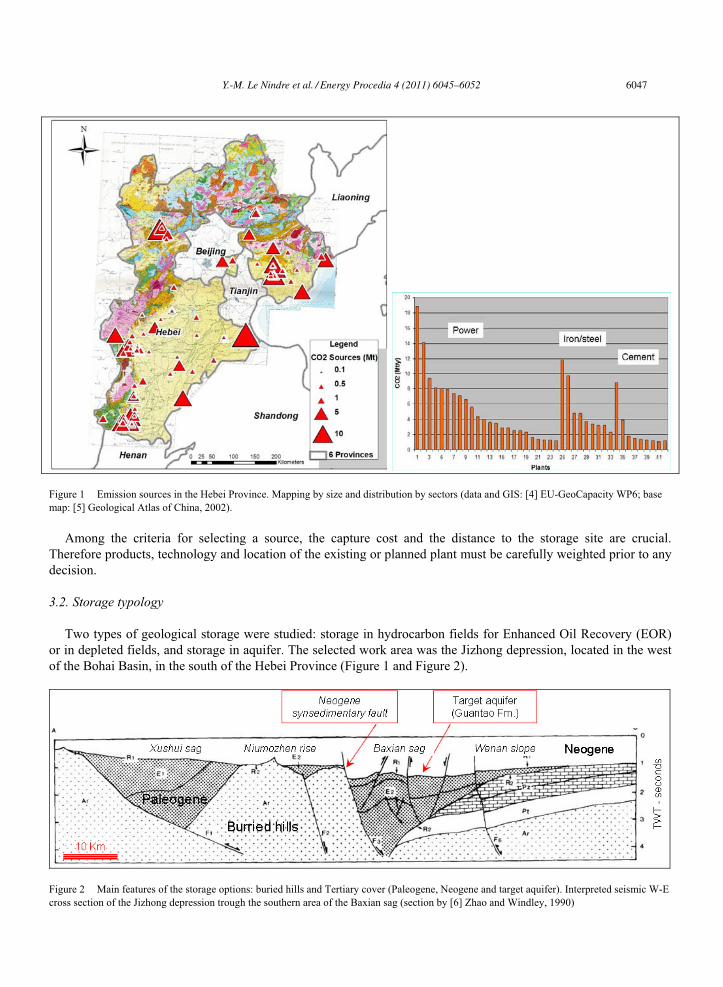
3.2.1. Storage in hydrocarbon fields The hydrocarbon fields of the Bohai basin can be grouped into two main categories: in the ‘buried hills’ and in
the Tertiary cover rock (Figure 3). The ‘buried hills’ correspond to paleo-structures of the Proterozoic and
Phanerozoic substratum of the Tertiary basin. Oil pools are located in fractured carbonates and sealed by the
Tertiary deposits. The type example is the Renqiu field (section B-B’, Figure 3). Within the Tertiary sediments, oil
pools are located in clastic horizons including porous sandstone bodies. Due to the mainly fluvio-lacustrine
depositional environment, the geometry of the reservoirs is complex and their connectivity is variable. The oil pools
may occur at different stratigraphic levels. One type example in the same Jizhong depression is the Chaheji oil field
(section C-C’, Figure 3). The oil was originally generated in the Paleogene Shahejie Formation, and may have
migrated laterally into the ‘buried hills’ or, through faults and with transient storage, into several porous horizons up
to the Minghuazhen Formation (Pliocene). Oil migration is in relation with the ‘fault fracture mesh’ mechanism
described by ([7] Zhang et al., 2004).
Those mechanisms have to be taken into account when considering the long term fate of the CO2 and potential
leakage.
Figure 3 Schematic cross-sections of the burried hill Renqiu and Tertiary Chaheji oil fields ([8] Lee, 1989). ZY: middle and late Proterozoic,
OC: Cambro-Ordovician, Pe: Paleogene, Pek: Kongdian Fm., Pes1-4 Shahejie Fm., members 1-4, Ped: Dongying Fm., QN: Neogene and
Quaternary
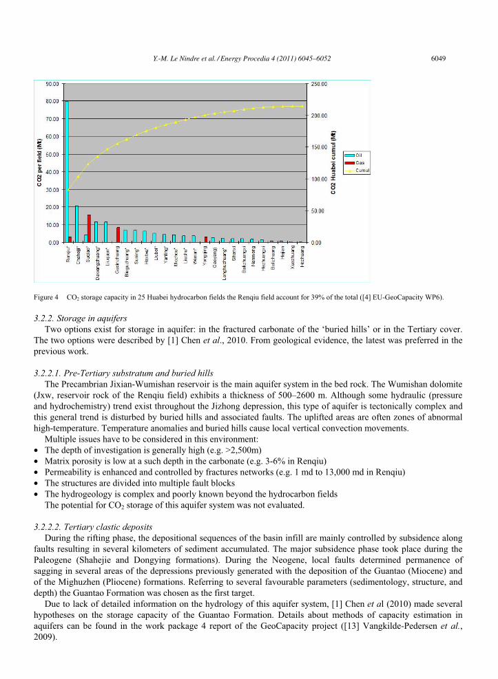
Within the Jizhong depression, 25 oilfields from the Huabei Complex were inventoried. Structures are much
disseminated and mostly small. Of the total 215 Mt estimated capacity ([1] Chen et al, 2010), only the Renqiu field
(Huabei Oil Field) may have enough capacity (83 Mt) for CO2 disposal (Figure 4). The oil bearing area covers 56.3
km2 at an average depth: from 2596 to 3510 m; temperature of oil is about 90 – 120°C. The reservoir is cut by a well
developed fault system: the oil pools are related to karst structures developed before the Eocene rifting up to 600 m
deep under the top of the ‘buried hills’ in the fractured carbonate. Oil pools are mainly located in the Wumishan
Group dolomite of the Jixian system (Precambrian).
The Renqiu oilfield, operated by Huabei Oilfield Co, PetroChina, was discovered in July 1975 and has been put
into development since April, 1976. Water flooding has been started at the end of 1976. From 1975 to 2000, the
production history shows, after a peak at 15 Mm3/a (95 Mb/a) in 1979, a drastic decline up to 0.8Mm3 (5 Mb/a) in
2000 ([9] Laherrère, 2008).
Original total dissolved solid (TDS) was up to 3000 - 5000 mg/l. Water flooding started by the end of 1976.
Consequently, due to injection of freshwater, the TDS dropped to less than 1000 mg/l; after that, de-oiled water was
injected to the reservoir. From 1976 to 1994, 7.68.107 m3 fresh water and 1.05 x 10⁸ m3 de-oiled water were injected
into the reservoir. Before 1987, TDS, C1-, Na + in oilfield waters decreased greatly and after 1987, C1-, Na +
increased gradually ([10]Feng Qiyan and Han Baoping, 2002). In 2005, the average water cut in Renqiu oil reservoir
was about 93.5%; the oil production was~1300 m3/day, and the water production was ~18,000 m3/day from 200
active wells ([11] Kewen Li et al., 2007).
The maximum expected recovery was ~209 Mm3 (~1.75Gb) (IHS Energy http://energy.ihs.com/ ), but it will be
in fact limited to ~119 Mm3 (~1Gb), corresponding to the recovery factor (RF) of 25-26% ([12] J. Allan and S. Qing
Sun, 2003, [9] Laherrère, 2008).
Among the other types of hydrocarbon fields, the Chaheji oil field is the second one for the capacity (20.7 Mt
CO2). It is an example of oil reservoirs disseminated in multiple horizons of the Donying 2 and Shahejie 1
formations (Paleogene).
6048 Y.-M. Le Nindre et al. / Energy Procedia 4 (2011) 6045–6052
Y.M. Le Nindre et al. / Energy Procedia 00 (2010) 000–000 5
Figure 4 CO2 storage capacity in 25 Huabei hydrocarbon fields the Renqiu field account for 39% of the total ([4] EU-GeoCapacity WP6).
3.2.2. Storage in aquifers Two options exist for storage in aquifer: in the fractured carbonate of the ‘buried hills’ or in the Tertiary cover.
The two options were described by [1] Chen et al., 2010. From geological evidence, the latest was preferred in the
previous work.
3.2.2.1. Pre-Tertiary substratum and buried hills The Precambrian Jixian-Wumishan reservoir is the main aquifer system in the bed rock. The Wumishan dolomite
(Jxw, reservoir rock of the Renqiu field) exhibits a thickness of 500–2600 m. Although some hydraulic (pressure
and hydrochemistry) trend exist throughout the Jizhong depression, this type of aquifer is tectonically complex and
this general trend is disturbed by buried hills and associated faults. The uplifted areas are often zones of abnormal
high-temperature. Temperature anomalies and buried hills cause local vertical convection movements.
Multiple issues have to be considered in this environment:
• The depth of investigation is generally high (e.g. >2,500m)
• Matrix porosity is low at a such depth in the carbonate (e.g. 3-6% in Renqiu)
• Permeability is enhanced and controlled by fractures networks (e.g. 1 md to 13,000 md in Renqiu)
• The structures are divided into multiple fault blocks
• The hydrogeology is complex and poorly known beyond the hydrocarbon fields
The potential for CO2 storage of this aquifer system was not evaluated.
3.2.2.2. Tertiary clastic deposits During the rifting phase, the depositional sequences of the basin infill are mainly controlled by subsidence along
faults resulting in several kilometers of sediment accumulated. The major subsidence phase took place during the
Paleogene (Shahejie and Dongying formations). During the Neogene, local faults determined permanence of
sagging in several areas of the depressions previously generated with the deposition of the Guantao (Miocene) and
of the Mighuzhen (Pliocene) formations. Referring to several favourable parameters (sedimentology, structure, and
depth) the Guantao Formation was chosen as the first target.
Due to lack of detailed information on the hydrology of this aquifer system, [1] Chen et al (2010) made several
hypotheses on the storage capacity of the Guantao Formation. Details about methods of capacity estimation in
aquifers can be found in the work package 4 report of the GeoCapacity project ([13] Vangkilde-Pedersen et al.,2009).
Y.-M. Le Nindre et al. / Energy Procedia 4 (2011) 6045–6052 6049
6 Y.M. Le Nindre et al. / Energy Procedia 00 (2010) 000–000
The minimum value of storage capacity estimated for the whole system is based on water and pore
compressibility of a closed, confined aquifer: 371 Mt CO2
An optimistic value of storage capacity estimated for the whole system is based on a statistical value of storage
efficiency (Seff) of 2% for an open or semi-closed aquifer, following the recommendation of CSLF and GeoCapacity
in such a case: 4757 Mt.
Working on a case study considering a specific horizon of the lower Guantao with a hypothesis of Seff=3% would
give a conservative value of 750Mt CO2.
4. Discussion of the sources and sinks options
4.1. Outcomes and proposals from the EU-GeoCapacity project
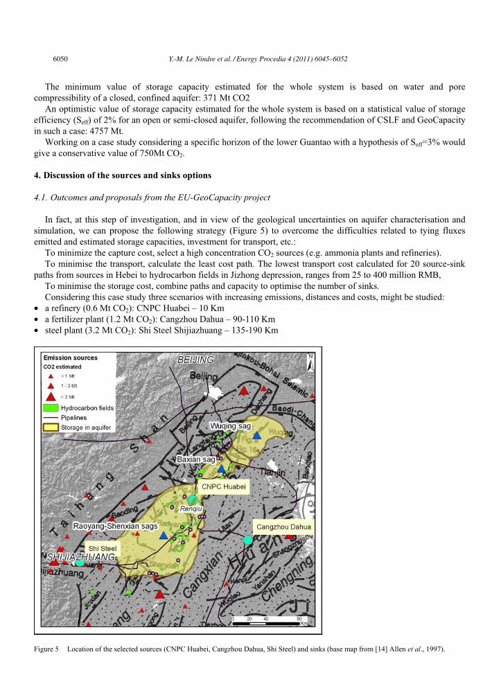
In fact, at this step of investigation, and in view of the geological uncertainties on aquifer characterisation and
simulation, we can propose the following strategy (Figure 5) to overcome the difficulties related to tying fluxes
emitted and estimated storage capacities, investment for transport, etc.:
To minimize the capture cost, select a high concentration CO2 sources (e.g. ammonia plants and refineries).
To minimise the transport, calculate the least cost path. The lowest transport cost calculated for 20 source-sink
paths from sources in Hebei to hydrocarbon fields in Jizhong depression, ranges from 25 to 400 million RMB,
To minimise the storage cost, combine paths and capacity to optimise the number of sinks.
Considering this case study three scenarios with increasing emissions, distances and costs, might be studied:
• a refinery (0.6 Mt CO2): CNPC Huabei – 10 Km
• a fertilizer plant (1.2 Mt CO2): Cangzhou Dahua – 90-110 Km
• steel plant (3.2 Mt CO2): Shi Steel Shijiazhuang – 135-190 Km
Figure 5 Location of the selected sources (CNPC Huabei, Cangzhou Dahua, Shi Steel) and sinks (base map from [14] Allen et al., 1997).
6050 Y.-M. Le Nindre et al. / Energy Procedia 4 (2011) 6045–6052
Y.M. Le Nindre et al. / Energy Procedia 00 (2010) 000–000 7
The study supposes to carry out a pre-screening of the possible storage areas and horizons using more detailed
geological data and to better characterise storage sites in terms of aquifer (sedimentology, hydrogeology), EOR
(modelling the expected results), or to combine the two (e.g. aquifer and laterally associated oil pools). A
demonstration project would provide the necessary information for implementing, in a second step, a large-scale
project from a remote power plant (e.g. Greengen Tianjin http://www.greengen.com.cn/en/index.asp) requiring
higher investment costs. This policy of low cost demo-projects in China was also advised by [15] Meng et al. (2007)
and during the1st CCUS Global Summit in Shanghai (17-19/08/2010).
4.2. Other issues, other uses of the aquifer systems
Storing in the hydrocarbon fields or in the aquifers supposes that those types of reservoir can be available for the
use of storing CO2 underground.
4.2.1. Buried hills, low yield hydrocarbon fields Water cut in many mature oil and gas fields is very high, up to 97%. That means that water replaced oil in the
reservoir. Producing more would require water disposal or re-injection, with low profit for the operators. Therefore,
projects are to use the benefit of water at high temperature to develop geothermal applications.
In many oil and gas fields the geothermal energy potential would be high enough to generate electricity,
extending the life of the field ([11] Kewen Li et al., 2007). The Peking University in partnership with the Stanford
University and Huabei Oil Field Co, PetroChina, studied a project of electricity generation from water produced by
the Renqiu field. The formation temperature of Renqiu oil reservoir is ~90-120°C and the average temperature
gradient is ~3.5°C/100m.. With a ‘binary cycle method’ for power generation, the authors calculate a power
potential of ~4 MW for the current water production of 18,000m3/day. However, the water production could be
increased up to 500,000 m3/day, and then the power potential would rise to ~100 MW. Therefore, a project of
building a pilot power plant with a design power of 300 KW was proposed.
Alternatively, air may be injected in these abandoned oil reservoirs and in-situ combustion will occur through
oxidization ([16]Lingyu Zhang, et al., 2008). The temperature in oil reservoirs could reach over 400°C for light oil
reservoirs (e.g. Ren9 reservoir in Renqiu oil field) and over 600°C for heavy oil reservoirs, (e.g.; Du84 reservoir in
Shuguang oil field). The oil reservoirs under such temperature conditions may be transformed as exceptional
enhanced geothermal reservoirs (EEGS). Another obvious benefit will be the crude oil produced by air injection.
4.2.2. Tertiary and other targets: geothermal program and water supply In view of space heating, several geothermal plans for exploitation of low to medium temperature fields in the
pre-tertiary substratum and in the tertiary also exist. [17] Li Hongying (2008) made a review of the geothermal
utilisation and development in Hebei province where conventional geothermal use and heat pump technology for
house heating are encouraged by the provincial government. The 241 deep geothermal wells are distributed in the
middle to southern part of Hebei, and 37 geothermal fields were identified in the Hebei plain. The average
temperature of these wells is 40-70°C, with a maximum temperature of 118°C. The exploitable horizons are from
the bed rock and from the Tertiary cover (Guantao and Minghuazhen formations). The energy content of the
exploitable geothermal resource (15 to 25% of the total energy) equals 9.4×10⁹ tons of standard coal. Geothermal
resources are utilized for bathing, sanatoria, space heating, flax processing, greenhouses, swimming pools,
accommodation and recreation, chicken hatching, fish farming, etc.
The Hebei Province and the area around Beijing and Tianjin are very populated and water supply is a crucial
issue. The salinity of the Guantao aquifer is not so high (<5,000 mg/l) and other uses than geological storage (e.g.
industrial water supply) could be the priority for these aquifers.
4.2.3. Other issues: cap rock integrity, seismic risk, data availability, policy Other issues have to be mentioned for CCS deployment in Hebei:
Tightness of the cap-rock is a crucial condition: fault fracture mesh, petroleum migration and reservoirs in
Minghuazhen formation demonstrate some risk of leakage and the need for a detailed knowledge of the cover.
The DSS developed by [1] Chen et al (2010) for least cost path calculation included the seismic risk, and many
important sources are located within or beyond seismic areas. The scenarios of storage have to deal with this hazard.
Y.-M. Le Nindre et al. / Energy Procedia 4 (2011) 6045–6052 6051
8 Y.M. Le Nindre et al. / Energy Procedia 00 (2010) 000–000
There will be no complete CCS project without storage (or CO2 use). Most of the subsurface geological and
hydrogeological data are scattered or private in the Oil and Gas Companies and not publicly available.
The current policies in China are more encouraging new and clean energy technologies than carbon storage, for
which incentives and regulations are still beginning.
5. Conclusion
CCS deployment in the Hebei province could be performed from local sources to local sinks of CO2. Should
incentives, performing investigation tools and adequate partnership be in place, several scenarios of demonstration
projects involving the industry (refineries, chemicals, cement) could be promoted. EOR in many fields, especially in
the buried hills is limited by the present water cut value and geothermal reconversion might be profitable. EOR in
many Tertiary fields is risky, due to a complex geometry of the oil pools (thin and discontinuous horizons, faults).
Tertiary aquifers would be a good target, but the Neogene (Guantao, Minghuazhen formations) seems restricted to
other uses (geothermal, water supply). However, geothermal exploration could provide a better knowledge of the
deep aquifers for CCS. New objectives in the deeper Tertiary in relation with oil pools (Shahejie Formation,
Paleogene) would be worth to explore but are more difficult.
References
[1] Chen W., Le Nindre Y-M, Xu R, Allier D., Teng F., Domptail K., Xiang X., Guillon L., Chen J., Huang L., and Zeng R., 2009. CCS scenarios
optimization by spatial multi-criteria analysis: Application to multiple source sink matching in Hebei province. International Journal of
Greenhouse Gas Control 4 (2010) 341–350.
[2] Vangkilde-Pedersen T., Anthonsen K.L, Smith N., Kirk K., Neele P., van der Meer B., Le Gallo Y., Bossie-Codreanu D., Wojcicki A.,
Le Nindre Y.M., Hendriks C, Dalhoff F., Christensen N.P. 2009. Assessing European capacity for geological storage of carbon dioxide – the
EU GeoCapacity project. Energy Procedia 1 (2009) 2663–2670.
[3] Le Nindre Y.M., ,Allier D., Duchkov A., Altunina L.K., S. Shvartsev S., Zhelezniak M., and Klerkx J., 2009. Storing CO2 underneath the
Siberian Permafrost: A win-win solution for long-term trapping of CO2 and heavy oil upgrading. GHGT10 Conference. 19-23 September
2010, Amsterdam. Enegy Procedia. Elsevier.
[4] Le Nindre Y.M., Chen W., Holloway S. and Klerckx J., 2008.EU-GeoCapacity. D 35. WP6: International Cooperation Report on the
communication actions and research initiated in the cooperation Framework. 31 pages (public report). http://www.geology.cz/geocapacity/
[5] Geological Atlas of China, 2002. Ma lifang ed. China Geological Press Publisher. 12/ 2002. 348 pages. ISBN: 7116022686 (english)
[6] Zhao, Z.Y., Windley, B.F., 1990. Cenozoic tectonic extension and inversion of the Jizhong basin, Hebei, northern China. Tectonophysics 185,
83–89.
[7] Zhang, S., Wang, Y., Shi, D., Xu, H., Pang, X., Li, M., 2004. Fault fracture mesh petroleum plays in the Jiyang superdepression of the Bohai
Bay Basin, eastern China. Marine and Petroleum Geology 21, 651–668.
[8] Lee K. Y., 1989. Geology of petroleum and coal deposits in the North China Basin, Eastern China. U. S. Geological Survey Bulletin, Report:
B 1871, 36 pp., 2 sheets.
[9] Laherrere, J., Questions to Feng Lianyong on the OGJ 14 January 2008 article: ‘‘Peak oil models forecast China’s oil supply, demand’’
http://aspofrance.viabloga.com/files/JL_Q-OGJ14Jan08.pdf.
[10] Feng Qiyan and Han Baoping, 2002. Hydrogeochemical Simulation of Water-Rock Interaction Under Water Flood Recovery in Renqiu
Oilfield, Hebei Province, China. Chinese Journal Of Geochemistry, Vol. 21 n°. 2.
[11] Kewen Li, Lingyu Zhang, Qingkun Ma, Mingsheng Liu, Jun Ma, Fan Dong, 2007. Low Temperature Geothermal Resources at Huabei
Oilfield, China. Geothermal Resources Council. GRC 2007 Annual Meeting 1-3 October 2007.
http://www.geothermal.org/Powerpoint07/Wednesday/Case%20Studies%202/KewenLi.ppt
[12] Allan, J., Qing, S.S., 2003. Controls on recovery factors in fractured reservoirs: lessons learned from 100 fractured fields. In: Annual
Technical Conference and Exhibition. October 5–8, 2003, Denver, CO, USA. Society of Petroleum Engineers, SPE 84590, 18 pp.
[13] Vangkilde-Pedersen, T., Vosgerau, H., Willsc, Neelle P. van der Meer B. Bossie-cCdreanu D, Wojcicki A, Le Nindre Y.M., Kirk K., von
Dalwigk I., and Anthonsen K.L, 2009 GeoCapacity work package reports D26. Capacity standards and site selection criteria. 45 p.(public
report) http://www.geology.cz/geocapacity.
[14] Allen, M.B., Macdonald, D.I., Xun, Z., Vincent, S.J., Brouet-Menzies, C., 1997. Early Cenozoic two phase extension and late cenozoic
thermal subsidence anf inversion of the Bohai Basin, northern China. Marine and Petroleum Geology 14 (7/8), 951–972.
[15] Meng K.C., Williams R.H., Celia M.A., 2007. Opportunities for low-cost CO2 storage demonstration projects in China. Energy Policy 35
(2007) 2368–2378
[16] Lingyu Zhang, Jianguo Yuan, Hongbin Liang, and Kewen Li, 2008. Energy from Abandoned Oil and Gas Reservoirs. SPE Asia Pacific Oil
and Gas Conference and Exhibition, 20-22 October 2008, Perth, Australia. ©2008. Society of Petroleum Engineers
[17] Li Hongying, 2008. Geothermal utilization and development in Hebei province. United Nations University. Geothermal Training
Programme, 30th Anniversary Workshop, Orkustofnun, Grensásvegur 9, August 26-27, 2008. IS-108 Reykjavík, Iceland. 8 pages.
6052 Y.-M. Le Nindre et al. / Energy Procedia 4 (2011) 6045–6052