Embed Size (px)
Citation preview

U n i v e r s i t y o f B o l o g n a – Y a g h n o b V a l l e y M i s s i o n 2 0 0 7
1
PE T R O G L Y P H S A L O N G T H E
YA G H N O B R I V E R (TA J I K I S T A N ) by Marta Passarelli (Yaghnob Valley Mission)
he valley of the Yaghnob river (northern Tajikistan, province of Sughd, district of Aynī) is well-known among Iranian scholars thanks to one of the language spoken by its inhabitants, the Yaghnobi language, which is associated with ancient Sogdian. Yaghnobi is spoken in some
remote mountain villages along the upper course of the river, 56 to 74 km c. from the confluence with the Fan river.
In August 2007, prof. Antonio C.D. Panaino, professor of Iranian studies at the University of Bologna (seat of Ravenna), organized and headed the first Italian ethno-linguistic mission in the Yaghnob valley. By his will, linguists and ethnographers were supported by historians, archaeologists and physicians with skills in biology and genetics. Among the scientific results collected during the two-week stay in the Valley, the discovery of petroglyphs deserves a sudden confrontation with the field specialists.
E n v i r o n m e n t d e s c r i p t i o n
The Yaghnob river flows from East to West for 120 km c., leading its waters to the Fan river, a tributary stream of the Zerafshon river. The valleys of the Zerafshon and of the Yaghnob run parallel, the first one to the North of the second; a ridge of high peaks (4000 m c.) separates the two. The highway M 34 (a one lane, not paved road), descending from the pass of Anzob, follows westward the Yaghnob river from the 87th kilometer from the spring on; from this point, a narrow and unpaved driveway leads 26.2 km eastward into the Valley; from the end of the driveway, the Yaghnobi’s villages can be reached only by foot or by riding a donkey.
The petroglyphs were discovered on 2007, August 19 (pl. I) in a gorge along the course of the Yaghnob, 8 km eastward from the end of the driveway in the Valley (64 km c. to the Fan confluence) in the middle of the Yaghnobi-spoken area, 2460 m above the sea level. The gorge, named Tang-i Dahona in Tajik language, splits the Valley in two and represents a forced waypoint between the western and eastern part since the dawn of man.
The petroglyphs are located at the entrance of the river in the gorge. The first discovered petroglyph (YP 001) is engraved on the upper part of a big stone lying in the bed of the river, emerging by 3.5 m c from the water level (pl. II). The engraved stone is near the left bank, 12 m c. from the footpath.
The other petroglyphs (YP 002-004) are located on the north side of the gorge (right bank of the river), on a 50 m long rock-face; between the river bed and the engraved rock-face, nearly underneath it, the footpath finds its way on a ground of stones and pebbles. The other side of the river is accessible by a footbridge over which the footpath runs. Two isolated figures, YP 002 and YP 003, are 75 m c. far from YP 001 in North-West direction. Further to the West, 30 m c. on the same rock-face (near to its left edge), the petroglyph YP 004, composed by many figures and engraved layers over a 6.5 m2 c. wide flat surface, is located.
E n g r a v i n g t e c h n i q u e
The petroglyphs were engraved through bushhammering of the rock surface, appearing visually as drawn by dotted strokes. The engraving tool was a pointed stone, harder than the rock, used as a chisel and perhaps struck by a percussor.
T

U n i v e r s i t y o f B o l o g n a – Y a g h n o b V a l l e y M i s s i o n 2 0 0 7
2
D e s c r i p t i o n o f t h e p e t r o g l y p h s
In the first petroglyph, YP 001 (pls. IIIa-b), a right-facing ibex is clearly visible on the surface of the stone. On the left, two hunters armed with long spears seem to chase the hybex. A smaller animal, probably a dog, is engraved between the hunters. From afar, the petroglyph can be mistaken for the grain of the stone. In the left part of the engraved area, the surface is encrusted by lichens; other figures may be hidden underneath.
Both the petroglyphs YP 002 and YP 003 (pl. IV) represent a left-facing horned animal (pls. Va-b and VIa-b) stilistically homogeneous to the ibex in YP 001. The horns of the animal drawn in YP 002 are engraved with a more sparse dotting; the bending is rough-sketched.
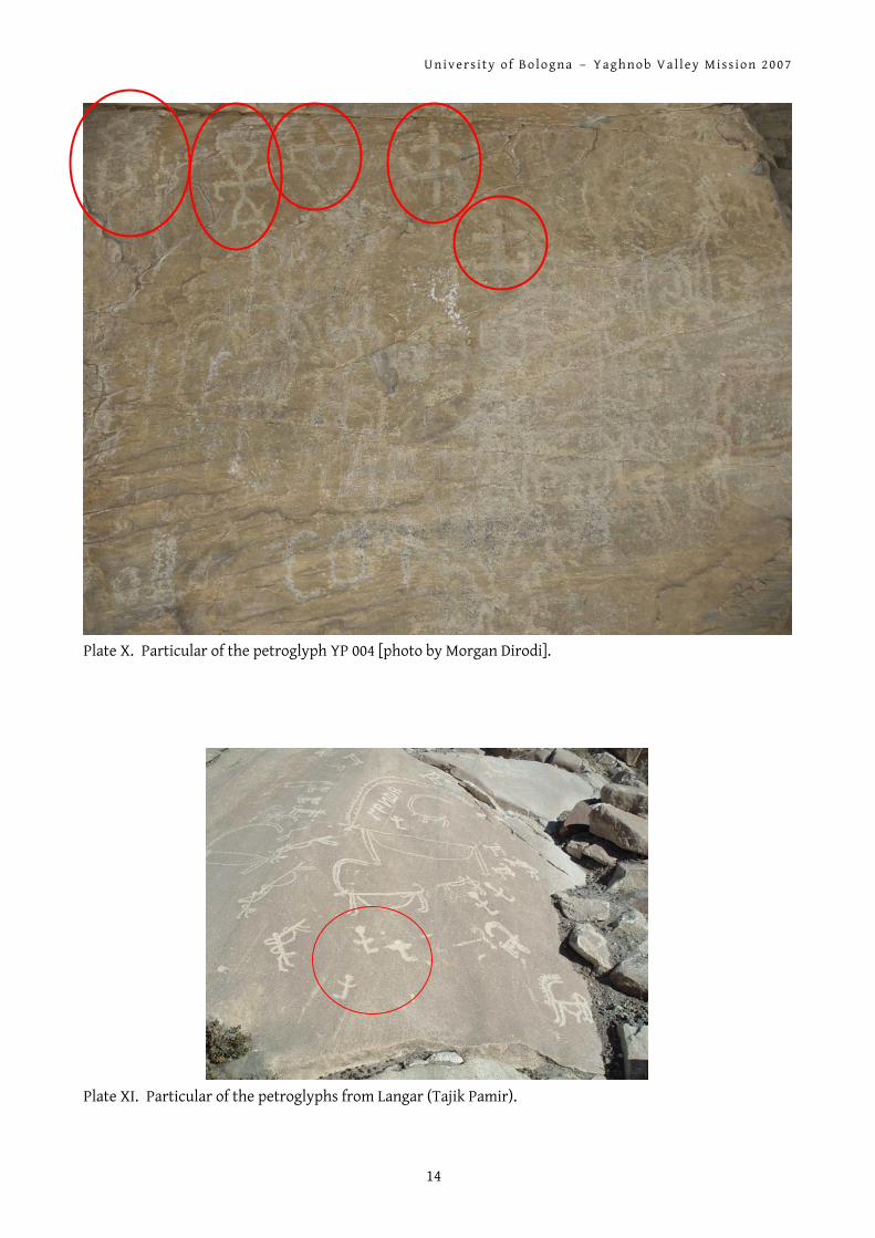
The petroglyph YP 004 represents a wider and more complex scene of hunting (pls. VIIa-b). In the lower part of the panel (0.6 m c. from the ground), a man with a bow (pl. VIII) pointing towards a big ibex stands out; the man looks right and also the ibex, to the right of the man, is right-facing. In the middle, a pack of ibexes or goats seems to be running towards the right as escaping from the hunting; several layers of drawings are superimposed in the right part of the engraved panel. In the upper part, cross-shaped signs, some in shape of a swastika, are clearly visible on the rock surface (pl. X). Some scattered cyrillic characters are engraved over the hunting scene. In the upper part of the panel, some short inscriptions in Arabic or Persian script are written in ink (pl. IX); to the left of these inscriptions, two sinuous strokes in lighter ink are visible, maybe representing two dancing men (comparable to the paintings of Zaraut-Say in Uzbekistan).
A S h o r t E x c u r s u s o n R o c k A r t S i t e s i n C e n t r a l A s i a
Rock art sites in Central Asia and especially in the ex Soviet Union are known by scholars in number of hundreds. A short discussion on the main sites and their dating may be useful as a background for the newly discovered petroglyphs along the Yaghnob river course.
1 . K a z a k h s t a n A lot of petroglyphs stylistically dated to the 2nd and 1st millennium B.C. are known from the eastern
and southern mountainous regions of the Kazakhstan. The rock art engravings discovered at Aktobe (southern Kazakhstan) in 1957-1959 are partially dated
from the 6th to the 5th century B.C., then from the 1st to the 3rd century A.D. and later. A few years before, similar engravings were discovered by Marikovskiy in Chulak mountains. Among
the Kuldzhabasy hills (a small area running parallel to the Chu-Ili mountains), scenes with animals (dogs, a camel, an elephant and an odd goat with two heads1) were found (fig. 1).
1 Frumkin 1970: 23, fig. 5. The second head of the goat may be better interpreted as the sac of fat under the tail of
the animal seen in profile; it is well known that in some instances this sac reaches a conspicuous size.

U n i v e r s i t y o f B o l o g n a – Y a g h n o b V a l l e y M i s s i o n 2 0 0 7
3
Fig. 1. Rock engravings from Kuldzhabasy (after Frumkin 1970: 24, fig. 5).
In 1957, about 1 000 rock engravings were found on the pass of Tamgaly mountain (South-West of Chu-Ili area); they were dated to the Saka period (7th-5th centuries B.C.) but also later (Turkish period, 6th-8th centuries A.D.).
The petroglyphs discovered in 1959 to the North of the Balkhash lake, in the Tesiktas and Karaungur mountains (southern Kazakhstan), represent, among other animals, aurochs, i.e. big size oxen extinct in the 17th century A.D. (fig. 2). The aurochs lived in this area in the Neolithic age or earlier.2
Fig. 2. Rock engravings from Tesiktas and Karaungur (after Frumkin 1970: 25, fig. 6).
In the Karatau region (southern Kazakhstan), about 2 300 stone slabs with 6 100 different scenes were found; the oldest ones represent chariots for hunting or warfare.
Camels and dogs are frequently shown as tamed animals in Arpauzen III rock engravings (fig. 3). 3
2 Frumkin 1970: 24. 3 Brentjes, s.d.

U n i v e r s i t y o f B o l o g n a – Y a g h n o b V a l l e y M i s s i o n 2 0 0 7
4
Fig. 3. Hunting chariots from Arpauzen (after Brentjes, s.d.).
In the Semireche area, a man (?) with a sun-like head, interpreted as the prototype of god Mithra, is attested in several site such as Tamgaly.
2 . S a i m a l y - T a s h i n t h e F e r g h a n a V a l l e y The most important rock art site in the Ferghana Valley is Saimaly-Tash at a height of 3200 m above
the sea level. Discovered in 1903, it counts over 100 000 engravings. The subjects include ploughing scenes, chariots for hunting, domestic and wild animals which can be dated to the bronze age (end of the 1st millennium B.C.). The eastern part of the site was explored by Zima in 1948; Bernshtam investigated the remaining area in 1950.
A petroglyph with two finely-incised horses was also found by Bernshtam at Aravan in 1946 (fig. 4).4
Fig. 4. Rock engraving with two horses from Aravan (after Frumkin 1970: 45, fig. 9).
4 Frumkin 1970: 44-46, fig. 9.

U n i v e r s i t y o f B o l o g n a – Y a g h n o b V a l l e y M i s s i o n 2 0 0 7
5
3 . A l t a y – T u v a : t h e m o u n t a i n s o f A l t a y a n d S a j a n The Altay mountains represent an important area for nomadic cultures. At least till the 4th
millennium B.C., the Altay was a refuge for nomads during winter, when the survival in the steppe was difficult due to snow and storms. Being a passage way between Siberia and Mongolia, the valleys of Altay provided also burial places, preserving biological remains and material culture thanks to the frozen soil and the dry climate. Since the end of nomadic cultures, the Altay became a desolate land between Russia and China and mountains sank into oblivion. Beyond burials and kurgans, rock art has survived in hundreds of engravings which are still discovered and investigated. The main subjects are hunting scenes and single animals.
From the Elangash river area are known bushhammered and also scratched petroglyphs, representing wild sheeps, deer, yaks, dogs, horses, camels, birds and human figures, mainly hunters or travellers. The hunters are represented in the act of shooting arrows; some are on a two-wheeled chariot or on horseback, others by foot. While foot hunters cannot be dated, the engraving of chariots points to the 2nd-1st millennia B.C.5
In the canyon of Sajan, several rock art sites were found between Ortaa-Sargol, the “way of Genghis Khan” and Mugur-Sargol. The rock engravings are dated to the bronze age (figs. 5a-b). 6
Figs. 5a-b. Rock engravings from Ortaa-Sargol, the “way of Genghis Khan” and Mugur-Sargol (after
Dėvlet 1982: 36, pl. IV and 38, pl. V).
4 . A f g h a n i s t a n : J ā g h ū r ī d i s t r i c t A rock engraving representing ibexes and, to the upper-right hand corner, two men in combat with
swords is known from the village of Bīdsay in Afghanistan (fig. 6).
5 Brentjes, s.d. 6 Devlet 1982: pls. 4 and 5.

U n i v e r s i t y o f B o l o g n a – Y a g h n o b V a l l e y M i s s i o n 2 0 0 7
6
Fig. 6. Rock engraving from the village of Bīdsay (after Bivar 1971: pl. I).
The question of its date is unanswered: ‘to judge from the patina covering the incised portion of the stone, the example at Bīdsay seems not to be very recent’.7 According to Bivar, it may be tentatively associated to the petroglyphs of the Ghorband valley, situated 100 km North of Kabul.8
I c o n o g r a p h i c a n d S t y l i s t i c C o m p a r i s o n s
Among the rock art sites discussed above, several iconographic and stylistic comparisons can be found for the petroglyphs discovered in the Yaghnob valley.
The bowmen and human figures engraved in southern Kazakhstan (fig. 2) are very similar, both stilistically and iconographically, especially to the bowman in the lower part of YP 004 (pl. VIII).
The rock engravings from the canyon of Sajan in the Altay mountains (figs. 5a-b) show stylistic similarities to YP 001, YP 002 and YP 003 (pls. IIIa-b, Va-b and VIa-b).
The environmental context of the petroglyphs, along a forced passage in a narrow gorge, is comparable to the one of the Sarmish-Say petroglyphs in Uzbekistan.
At last, iconographical similarities can be found in the rock art sites in the Tajik Pamir mountains, especially Langar (pls. XI-XIIa-c), whose engravings are commonly dated between 10 000 and 8 000 years B.C.
7 Bivar 1971: 81. 8 Bivar 1971: 81, pl. II.

U n i v e r s i t y o f B o l o g n a – Y a g h n o b V a l l e y M i s s i o n 2 0 0 7
7
Topographic map of the Tang-i Dahona.
Plate I. The gorge of Tang-i Dahona seen from its western end.

U n i v e r s i t y o f B o l o g n a – Y a g h n o b V a l l e y M i s s i o n 2 0 0 7
8
Plate II. The discovery of the first petroglyph (YP 001) [photo by Morgan Dirodi].
Plates IIIa-b. The petroglyph YP 001.

U n i v e r s i t y o f B o l o g n a – Y a g h n o b V a l l e y M i s s i o n 2 0 0 7
9
Plate IV. The petroglyphs YP 002 (right) and 003 (left).
Plates Va-b. The petroglyph YP 002.

U n i v e r s i t y o f B o l o g n a – Y a g h n o b V a l l e y M i s s i o n 2 0 0 7
10
Plates VIa-b. The petroglyph YP 003.

U n i v e r s i t y o f B o l o g n a – Y a g h n o b V a l l e y M i s s i o n 2 0 0 7
11
Plate VIIa. The petroglyph YP 004.

U n i v e r s i t y o f B o l o g n a – Y a g h n o b V a l l e y M i s s i o n 2 0 0 7
12
Plate VIIb. The petroglyph YP 004.
Plate VIII. A bowman in the lower part of YP 004 [photo by Morgan Dirodi].

U n i v e r s i t y o f B o l o g n a – Y a g h n o b V a l l e y M i s s i o n 2 0 0 7
13
Plate IX. Inscriptions in Arabic characters written in ink in the upper part of YP 004 [photo by Morgan
Dirodi].
U n i v e r s i t y o f B o l o g n a – Y a g h n o b V a l l e y M i s s i o n 2 0 0 7
14
Plate X. Particular of the petroglyph YP 004 [photo by Morgan Dirodi].
Plate XI. Particular of the petroglyphs from Langar (Tajik Pamir).

U n i v e r s i t y o f B o l o g n a – Y a g h n o b V a l l e y M i s s i o n 2 0 0 7
15
Plates XIIa-c. Particulars of the petroglyphs from Langar (Tajik Pamir).

U n i v e r s i t y o f B o l o g n a – Y a g h n o b V a l l e y M i s s i o n 2 0 0 7
16
R e f e r e n c e s
*Bernshtam, A.N. (1952) Istoriko-arkheologicheskiye Ocherki Central´nogo Tyan-Shana i Pamiro-Alaya (Materialy i issledovaniia po archeologii SSSR), 26, Moscow.
Bivar, A.D.H. (1971) ‘Petroglyphs and Buddhist Remains of Jāghūrī District, Afghanistan’, in C.E. Bosworth (ed.), Iran and Islam. In memory of the late Vladimir Minorsky, pp. 79-89 & plates 1-6, Edinburgh.
Brentjes, Burchard (s.d.) ‘Rock Art in Russian Far East and in Siberia. A bird’s eye view over a continent’, <www.rupestre.net/tracce/rusfra.html>, last visited 2007, September 08.
*Bubnova, M. & M. Hauser (2002) Pamir: Kryša mira: Krakoe vvdenie v istoriju Pamira (The Pamir Archive), Winterhur.
Dėvlet, M.A. (1982) Petroglify na kočevoj trope, Moskva.
Fairservis, W.A. Jr. (1993) Archaeology of the Southern Gobi of Mongolia, Durham [NA-IUO StAs MON X C 004].
Francfort, H.P. & J.A. Sher (1994) Répertoire des pétroglyphes d’Asie centrale (Mémoires de la Mission archéologique française en Asie centrale, 5), Paris; vol. I-IV: Sibérie du Sud, vol. V: Kazakhstan.
Frumkin, G. (1970) Archaeology in Soviet Central Asia (Handbuch der Orientalistik, siebente Abteilung, dritter Band, erster Abschnitt), Leiden/Könn.
Masov, R., S.G. Bobomulloev & M. Bubnova (2005) Nacional´nyj muzei drevnostej tadžikistana, Dušanbe.
*Ksica, M. (1971) ‘Felsbilder in der Sowier Union. Rock Art in the Soviet Union I, Introduction and map with catalogue of 563 sites of Rock Art’, Anthropologie, 9/1-2, Brno.
*Ksica, M. (1972) ‘Rock Art in Soviet Union III. Central Asia’, Anthropologie, 10/2-3, Brno.
*Ksica, M. (1974a) ‘L’art rupestre en Union Sovietique’, Archeologia, 33, Paris.
*Ksica, M. (1974b) The Art of Ancient Eurasia. Rock Pictures in the Soviet Union. Catalogue of 1226 Sites of Rock Art, Brno.
*Ksica, M. (1992) ‘Rock Art in Soviet Eurasia’, in M. Lorblanchet (ed.), Rock Art in the Old World. Papers presented in Symposium A of the Aura Congress, Darwin (Australia) 1988, pp. 491-512, New Delhi.
Mandel´stam, A.M. (1966) Pamjatniki epochi bronzy v južnom tadžikistane (Materialy i issledovanija po archeologii SSSR, 145; Trudy tadžikskoj archeologičeskoj ėkspedicii, 6), Moskva: Izd. Akademii Nauk [NA-IUO StAs AC X 024 (145)].
P´jankova, L.T. (1986) Jungbronzezeitliche Graberfelder im Stadt im Vachs-Tal, Sud-Tadzikistan (Materialien zur Allgemeinen und Vergleichenden Archaologie, 36), Munchen: C.H. Beck [NA-IUO StAs AC X C 074].
*Pomaskina, G. (1969) ‘Issledovanie petroglyfov uročišča Sajmaly-Taš’, Archeologičeskie Otkrytija 1968 g, pp. 450-452, Moskva.
Ranov, V.A. (1961) ‘Izučenke pamjatnikov kamennogo veka na vostočnom Pamire v 1958 g. III. Risunki kamennogo veka v grote Šachty’, in B.A. Litvinskij (ed.), Archeologičeskie raboty v Tadžikistane (Trudy Instituta Istorii, 27), 6 (1958), pp. 31-35, Dušanbe [NA-IUO StAs AC X B 007, voll. 1954, 1958 (VI), 1959 (VII), 1960 (VIII), 1973 (XIII)].
*Ranov, V.A. (1998) ‘Kamennyj vek’, Istorija tadžiskogo naroda, pp. 99-102, Dušanbe.
*Ranov, V.A. & A.V. Gurskij (1966) ‘Kratkij obzor naschal´nich risunkov Gorno-Badakhšanskoj avtonomnoj oblast´ Tadžikskoj SSR’, Sovetskaja ėtnografija, pp. 110-119.
Ranov, V.A. & E.D. Saltovskaja (1961) ‘O rabotach Ura-Tjubinskogo otrjada v 1959 g. 1. Razvedki kamennogo veka’, in B.A. Litvinskij (ed.), Archeologičeskie raboty v Tadžikistane (Trudy Instituta Istorii, 31), 7 (1959), pp. 108-117, Dušanbe [NA-IUO StAs AC X B 007, voll. 1954, 1958 (VI), 1959 (VII), 1960 (VIII), 1973 (XIII)].
Vinogradova, N.M. & G. Lombardo (2002) ‘Farming sites of the late bronze and early iron ages in southern Tajikistan’, East and West, 52/1-4, pp. 71-125, Rome.

U n i v e r s i t y o f B o l o g n a – Y a g h n o b V a l l e y M i s s i o n 2 0 0 7
17
Vinogradova, N. (2004) ‘The Settlement and the Cemetery of Kangurttut among the Late Bronze Age Sites of North-Eastern Bactria (South Tajikistan)’, Annali, 64, pp. 75-97, Napoli: Università degli Studi di Napoli “L’Orientale” [published in 2007].
Revised 2007, September 13