Embed Size (px)
Citation preview

PROCEEDINGS, 43rd Workshop on Geothermal Reservoir Engineering
Stanford University, Stanford, California, February 12-14, 2018
SGP-TR-213
1
Estimation of Fluid-rock Interaction Process and Recharge Area of the Tampomas Geothermal
Field, West Java, Indonesia by Water Chemistry
Yudi Rahayudin1,2, Koki Kashiwaya1, Andi Susmanto2, Yohei Tada1, Irwan Iskandar3, Katsuaki Koike1
1 Graduate School of Engineering, Kyoto University, Japan
2 Ministry of Energy and Mineral Resources, Indonesia
3 Faculty of Mining and Petroleum Engineering, Institute of Technology Bandung, Indonesia
email: [email protected] ; [email protected]
Keywords: Tampomas, Bandung, Water chemistry, Fluid-rock Interaction
ABSTRACT
Geochemistry is one of the most effective methods used in the geothermal exploration process, especially related to subsurface
temperature, interaction process, and geothermal fluid source. This preliminary research is aimed to clarify the origin of geothermal
fluid and process of rock and fluid interaction that occurred in the Tampomas geothermal field in the northern Bandung Basin, one of
the geothermal potential fields in this basin. The potential in the northern Bandung basin is estimated to be lower than the southern basin
in which several fields such as Kamojang, Darajat, and Wayang Windu produce considerable geothermal energy, ranging from 200 to
300 MWe. To reveal this potential difference is an important issue for the geothermal system in the plate subduction zone. The
geochemical analysis was applied to it. Generally, water type of hot spring in the Tampomas area is dominated by chloride-bicarbonate
water, where water is formed in the marginal area near the surface. CO2 gas and water vapor are condensed into cold groundwater as
well as steam heated processes. The low B / Cl ratio in the hot springs indicates a close relationship with the magmatic geothermal
system. The Ciuyah hot spring has the highest concentrations of chloride, calcium, and lithium among the other manifestations, which is
probably due to fluid interaction with the Tertiary marine sedimentary rocks in this area, in particular the Tertiary claystone of the
Subang Formation. The maximum subsurface temperature in the Tampomas area is 168 ˚C based on a silica geothermometer. Study on
stable isotopes of oxygen and hydrogen suggest that the recharge area in the Tampomas geothermal manifestation is located in the
elevation range from 425 to 900 m.a.s.l. Consequently, through our geochemical data, the geothermal fluids originating from meteoric
water have been influenced by the volcanic process of Mt.Tampomas and interacting with the sedimentary rocks around it.
1. INTRODUCTION
Tampomas geothermal is located in West Java province, Indonesia, about 42 km northeast of Bandung, with Tampomas mountaintop
position at 6°45'54.00"S and 107°57'37.43"E (Figure 1). Tampomas is one of several geothermal sites in the volcanic mountain range of
West Java that were formed as a result of the subduction activity between the Indian-Australian plate and the Eurasian plate in the South
of Java Island. Based on data from Directorate General of New, Renewable Energy and Energy Conservation (DG NREEC, MEMR)
Indonesia, the Tampomas area is estimated to have geothermal potential ranging from 20-50 MWe (Ministry of Energy and Mineral
Resources, 2016).
Hot spring manifestation is commonly found in this area, particularly at the eastern slopes of Mt. Tampomas. The presence of some
manifestations indicates the occurrence of thermal and magmatic subsurface processes. Several studies have been conducted for the
Tampomas area, such as Abdulah et al. (2015) that identified outflow areas using fluid geochemical data. Petrography of Mt. Tampomas
rocks, as well as its relationship with the subduction systems, has been investigated by Dirk (2008), He concluded that volcanic rocks in
the Tampomas are associated with the basalt, andesite basaltic, and andesite groups. The sources and processes that form variations in
the chemical composition and rocks are the picrite magmatic or olivine basaltic rock from the N-MORB mantle, enrichment by of Rb,
Ba, Th, K, and La elements of the crust. Dermawan et al. (2017) conducted geochemical research and stable isotopes in cold springs and
several manifestations in this area.
This research is conducted as a part of the research of geothermal system in the Bandung basin, including Wayang Windu, Patuha,
Tangkuban Perahu and Tampomas geothermal areas. Research in Tampomas area is preliminary research, aimed to clarify the origin of
geothermal fluid and process of rock–fluid interaction.

Rahayudin et al.
2
Fig 1. Tampomas geothermal field located in the northeast of Bandung, Indonesia and one of several geothermal sites around
the Bandung Basin.
2. GEOLOGICAL SETTING
The Indonesian archipelago is seated between three large tectonic plates, the Indian-Australian, Eurasian and Pacific Plate (Figure 2).
These plates contribute significantly to the evolution of geological settings in Indonesia. Java Island is one of the many islands
influenced by the movement of the Indian-Australian plate in the south and the Eurasian plate in the north (Clements and Hall, 2007;
Hall, 1995; Hamilton, 1979; Katili, 1975, 1973; Whittaker et al., 2007). The present subduction beneath Java began at about 45 Ma and
has been almost perpendicular to the Java Trench (Hall 2012). The subduction zone between the Indian-Australian plate and Eurasian
plate is located about 200 km south of the Java island by forming subducted slab dips gradually over 60 degrees and moving sliding
approximately northward beneath Java and Sumatra at a velocity probably near 6 cm/yr (Le Pichon, 1968)
Fig 2. Schematic tectonic of Indonesia region influenced by three primary plates, Indian-Australian in the south, Eurasia in the
north and Pacific Plate in the east. The subduction between two plates in the southern island of Java is the primary
factor affecting the formation of Java volcanism (Hall, 2012)

Rahayudin et al.
3
Based on the fisiography zone of Java island (Bemmelen, 1949), Mt. Tampomas is classified as a member of Bogor Zone that is
characterized by Quartenary volcanic activities such as Mt. Salak, Mt. Gede, Mt.Tangkuban Perahu and Mt. Tampomas. According to
geological map of Bandung and Arjawinangun (Geological Research and Development Centre, 2003; 2011), the Tertiary sedimentary
deposit is the oldest rock and underlies the volcanic rock complex. Subang (Upper Miocene), Kaliwangu (Lower Pliocene) and Citalang
Formation (Middle Pliocene) are major sediment rocks that has been directly affected by a tectonic process with fault and fold as a
result. Generally, the strike of sedimentary rock is Northwest to Southeast, with dip slope to Southwest. The oldest sediment is Subang
Formation (Miocene), dominated by claystone and in some areas laminated by limestone and glauconite sandstone.
Fig 3. Geology of Mt. Tampomas, dominated by sedimentary rock of Subang Formation (modified from Geological Research
and Development Center, 2003; 2011)
3. METHODS
A total eight samples were taken directly from hot spring manifestations around the Tampomas area. Some measurements such as pH,
Electric Conductivity (EC) and Temperature were measured on site. Anion and cation sampling methods use common standard
procedure noted in Clark (2015) and Arnorsson et al. (2006), which all samples were filtered through 0.20µm membrane. To avoid the
changes in oxygen and hydrogen isotope ratios as a result of atmospheric contact, water isotope sample were taken using glass bottle
without gas bubbling inside.
4. RESULTS AND DISCUSSION
Field and Laboratory data are described in Table 1, showing that the pH in the Tampomas manifestation is relatively neutral, between
6.2 to 7.1 with Na and HCO3 as a dominant cation and anion. Only in Ciuyah (CYH) thermal fluid, the anion is dominated by Chloride
(10407.5 mg/L). The content of silica is ranging from 86 to 199 mg/L. In thermal water, the high Na, HCO3 and Cl contents suggest an
increase in groundwater residence time which could enhance rock-water interaction. High bicarbonate concentration is due to the
reaction of circulating meteoric waters with limestone, forming CO2-rich waters, and possibly from magmatic fluid input as well
(Pasvanoğlu and Çelik, 2018).
By plotting the data in the HCO3-SO4-Cl ternary diagram (Giggenbach, 1988), the Tampomas thermal water is revealed to divided into
three group (Figure 4). Bicarbonate water type, including water samples from CBT, CHS, CHSKL, and COG, has value of bicarbonate
188.3, 1098.6, 771.6 and 812.3 mg/L. Bicarbonate water is formed by steam and gas condensation in the marginal area through poorly
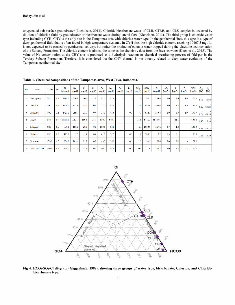
Rahayudin et al.
4
oxygenated sub-surface groundwater (Nicholson, 2013). Chloride-bicarbonate water of CLR, CTRB, and CLS samples is occurred by
dilution of chloride fluid by groundwater or bicarbonate water during lateral flow (Nicholson, 2013). The third group is chloride water
type Including CYH. CHY is the only site in the Tampomas area with chloride water type. In the geothermal sites, this type is a type of
deep geothermal fluid that is often found in high-temperature systems. In CYH site, the high chloride content, reaching 10407.5 mg / L,
is not expected to be caused by geothermal activity, but rather the product of connate water trapped during the claystine sedimentation
of the Subang Formation. The chloride content is almost the same as the chemistry data from the Java seawater (Deon et al., 2015). The
value of Na concentration at the CHY site is predicted as a hydrolysis reaction or chemical weathering process of feldspar in the
Tertiary Subang Formation. Threfore, it is considered tha the CHY thermal is not directly related to deep water evolution of the
Tampomas geothermal site.
Table 1. Chemical compositions of the Tampomas area, West Java, Indonesia.
Fig 4. HCO3-SO4-Cl diagram (Giggenbach, 1988), showing three groups of water type, bicarbonate, Chloride, and Chloride-
bicarbonate type.

Rahayudin et al.
5
Ternary diagram Cl-Li-B in Figure 5, can be used to interprets the origin of geothermal fluids in general. Since the alkali metal of Li is
least affected by secondary processes, it may, therefore, be used as a tracer for the initial deep rock dissolution process and as a
reference to evaluate the possible origin of two important conservative constitutes of geothermal waters; B and Cl (Torbehbar et al.,
2015). This ternary diagram, shows the formation three large groups. The first grouphas a relatively low B / Cl contentat the CLR, CLS,
and COG sites. This low B / Cl level indicates that the fluid origin is the older hydrothermal system, and the low B / Cl ratio can be
representative of andesitic geothermal reservoir group. At the CHY site, although this diagram indicates high Cl, the other data is more
indicative of a separate system. It appears that the B content of the CHY site is quite high, reaching 81.1 mg/L. According to Harder
(1970), in sedimentary rocks, the B content is very high, with an average of 85 ppm, especially in clay. This is also supported by the
high NH3 value at the CHY site reaching 21.6 mg / L, which is estimated as originating from organic-rich sediment.
Fig 5. Cl-Li-B ternary diagram of the Tampomas area
Ternary diagram of Na-K-Mg (Fig.6) shows that the majority of the samples are plotted close to Mg as immature waters, which
indicates that the thermal water has been through a mixing process with shallow groundwater and that all waters have unreliable
temperatures and the fluid is not at equilibrium phase with host rock. The calculation of subsurface temperature based on silica
geothermometer derives temperature in the Tampomas area as 168 ˚C. The diagram of 10K/(10K+Na) versus 10Mg/(10Mg+Ca)
(Giggenbach, 1988) is the major cations curve (Figure 7). No sample shows full equilibrium and all samples follow a common trend, the
transition from rock dissolution to rock equilibrium.

Rahayudin et al.
6
Fig 6. Ternary diagram of Na-K-Mg. Most samples are immature waters, indicating mixing process between thermal water and
shallow groundwater.
Fig 7. Giggenbach (1988) diagram of 10K/(10K+Na) versus 10Mg/(10Mg+Ca)
Rahayudin et al.
7
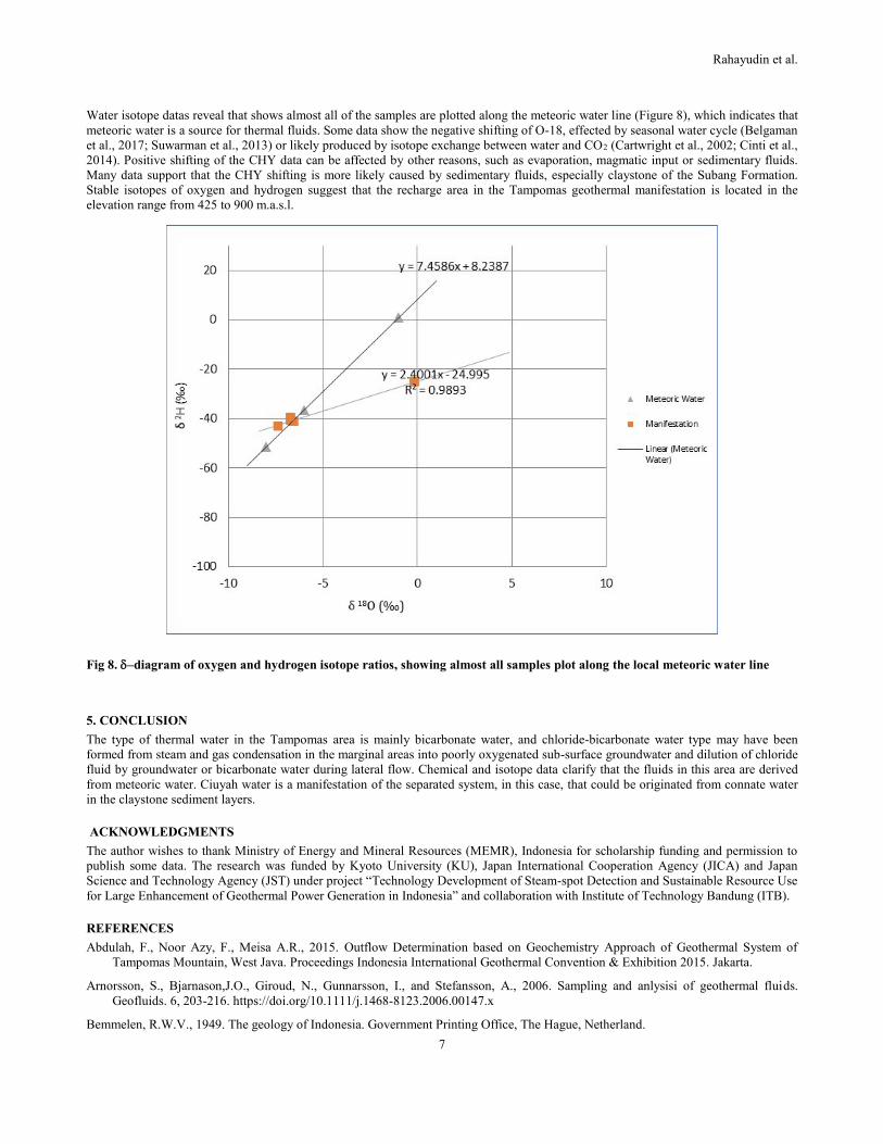
Water isotope datas reveal that shows almost all of the samples are plotted along the meteoric water line (Figure 8), which indicates that
meteoric water is a source for thermal fluids. Some data show the negative shifting of O-18, effected by seasonal water cycle (Belgaman
et al., 2017; Suwarman et al., 2013) or likely produced by isotope exchange between water and CO2 (Cartwright et al., 2002; Cinti et al.,
2014). Positive shifting of the CHY data can be affected by other reasons, such as evaporation, magmatic input or sedimentary fluids.
Many data support that the CHY shifting is more likely caused by sedimentary fluids, especially claystone of the Subang Formation.
Stable isotopes of oxygen and hydrogen suggest that the recharge area in the Tampomas geothermal manifestation is located in the
elevation range from 425 to 900 m.a.s.l.
Fig 8. –diagram of oxygen and hydrogen isotope ratios, showing almost all samples plot along the local meteoric water line
5. CONCLUSION
The type of thermal water in the Tampomas area is mainly bicarbonate water, and chloride-bicarbonate water type may have been
formed from steam and gas condensation in the marginal areas into poorly oxygenated sub-surface groundwater and dilution of chloride
fluid by groundwater or bicarbonate water during lateral flow. Chemical and isotope data clarify that the fluids in this area are derived
from meteoric water. Ciuyah water is a manifestation of the separated system, in this case, that could be originated from connate water
in the claystone sediment layers.
ACKNOWLEDGMENTS
The author wishes to thank Ministry of Energy and Mineral Resources (MEMR), Indonesia for scholarship funding and permission to
publish some data. The research was funded by Kyoto University (KU), Japan International Cooperation Agency (JICA) and Japan
Science and Technology Agency (JST) under project “Technology Development of Steam-spot Detection and Sustainable Resource Use
for Large Enhancement of Geothermal Power Generation in Indonesia” and collaboration with Institute of Technology Bandung (ITB).
REFERENCES
Abdulah, F., Noor Azy, F., Meisa A.R., 2015. Outflow Determination based on Geochemistry Approach of Geothermal System of
Tampomas Mountain, West Java. Proceedings Indonesia International Geothermal Convention & Exhibition 2015. Jakarta.
Arnorsson, S., Bjarnason,J.O., Giroud, N., Gunnarsson, I., and Stefansson, A., 2006. Sampling and anlysisi of geothermal fluids.
Geofluids. 6, 203-216. https://doi.org/10.1111/j.1468-8123.2006.00147.x
Bemmelen, R.W.V., 1949. The geology of Indonesia. Government Printing Office, The Hague, Netherland.
Rahayudin et al.
8
Belgaman, H.A., Ichiyanagi, K., Suwarman, R., Tanoue, M., Aldrian, E., Utami, A.I.D., Kusumaningtyas, S.D.A., 2017. Characteristics
of seasonal precipitation isotope variability in Indonesia. Hydrol. Res. Lett. 11, 92–98. https://doi.org/10.3178/hrl.11.92
Cartwright, I., Weaver, T., Tweed, S., Ahearne, D., Cooper, M., Czapnik, K., Tranter, J., 2002. Stable isotope geochemistry of cold
CO2-bearing mineral spring waters, Daylesford, Victoria, Australia: Sources of gas and water and links with waning volcanism.
Chem. Geol. 185, 71–91. https://doi.org/10.1016/S0009-2541(01)00397-7
Cinti, D., Tassi, F., Procesi, M., Bonini, M., Capecchiacci, F., Voltattorni, N., Vaselli, O., Quattrocchi, F., 2014. Fluid geochemistry and
geothermometry in the unexploited geothermal field of the Vicano–Cimino Volcanic District (Central Italy). Chem. Geol. 371, 96–
114. https://doi.org/10.1016/j.chemgeo.2014.02.005
Clark, I, 1995. Groundwater Geochemistry and Isotope. CRC Press. London UK.
Clements, B., Hall, R., 2007. Cretaceous to Late Miocene stratigraphic and tectonic evolution of West Java. Proc. Indones. Pet. Assoc.
1–18.
Dermawan, F.A., Notosiwoyo S., Iskandar, I., 2017. Karakteristik hidrogeokimia unsur-unsur terlarut dan isotop stabil di lapangan
panas bumi Tampomas, Jawa Barat, Indonesia. Proceeding PIT-PAAI Ke-2. Yogjakarta. Indonesia.
Deon, F., Förster, H.-J., Brehme, M., Wiegand, B., Scheytt, T., Moeck, I., Jaya, M.S., Putriatni, D.J., 2015. Geochemical/hydrochemical
evaluation of the geothermal potential of the Lamongan volcanic field (Eastern Java, Indonesia). Geotherm. Energy 3, 20.
https://doi.org/10.1186/s40517-015-0040-6
Dirk, M., H., 2008. Petrologi - geokimia batuan gunung api Tampomas dan sekitarnya. Jurnal Geologi Indonesia, Vol. 3 No.1 Maret
2008: 23-35
Geological Research and Development Centre, 2003. Peta Geologi Lembar Bandung. Indonesia
Geological Research and Development Centre, 2011. Peta Geologi lembar Arjawinangun. Indonesia
Giggenbach, W.F., 1988. Geothermal solute equilibria. Derivation of Na-K-Mg-Ca geoindicators. Geochim. Cosmochim. Acta 52,
2749–2765. https://doi.org/10.1016/0016-7037(88)90143-3
Hall, R., 2012. Late Jurassic–Cenozoic reconstructions of the Indonesian region and the Indian Ocean. Tectonophysics 570, 1–41.
https://doi.org/10.1016/j.tecto.2012.04.021
Hall, R., 1995. Plate tectonic reconstructions of the Indonesian region. Proc. Indones. Pet. Assoc. 95, 71–84.
Hamilton, W., 1979. Tectonics of the Indonesian Region, USGS Professional Paper, 1map, Washington1078, 345p.
Hamilton, W., 1979b. Tectonics of the Indonesian Region. Geol. Soc. Malaysia, Bull. 6, 3–10. https://doi.org/10.1016/0003-
6870(73)90259-7
Harder, H., 1970. Boron content of sediments as a tool in facies analysis. Sediment. Geol. 4, 153–175. https://doi.org/10.1016/0037-
0738(70)90009-6
Katili, J.A., 1975. Volcanism and plate tectonics in the Indonesian island arcs. Tectonophysics 26, 165–188.
https://doi.org/10.1016/0040-1951(75)90088-8
Katili, J.A., 1973. Geochronology of west Indonesia and its implications on plate tectonics. Tectonophysics 19, 195–212.
Le Pichon, X., 1968. Sea-Floor Spreading and Continental Drift. Journal of Geophysical Researc Vol. 73. No. 12.
Ministry of Energy and Mineral Resources, 2016. Statistik EBTKE 2016. Jakarta, Indonesia.
Nicholson, K., 1993. Geothermal Fluids: Chemistry and Exploration Techniques. Springer Verlag, (266 pp.).
Pasvanoğlu, S., Çelik, M., 2018. A conceptual model for groundwater flow and geochemical evolution of thermal fluids at the
Kızılcahamam geothermal area, Galatian volcanic Province. Geothermics 71, 88–107.
https://doi.org/10.1016/j.geothermics.2017.08.012
Suwarman, R., Ichiyanagi, K., Tanoue, M., Yoshimura, K., Mori, S., Yamanaka, M.D., Kurita, N., Syamsudin, F., 2013. The Variability
of Stable Isotopes and Water Origin of Precipitation over the Maritime Continent. Sola 9, 74–78. https://doi.org/10.2151/sola.2013-
017
Torbehbar, A.K., Sattari, S.M., Bakhtari, P., Potential, S., 2015. Geochemistry and Isotope Study of Discharged Geothermal Fluids ,
NW Sabalan Geothermal. World Geotherm. Congr. 2015 19–25.
Whittaker, J.M., Miiller, R.D., Sdrolias, M., Heine, C., 2007. Sunda-Java trench kinematics, slab window formation and overriding plate
deformation since the Cretaceous. Earth Planet. Sci. Lett. 255, 445–457. https://doi.org/10.1016/j.epsl.2006.12.031