Embed Size (px)
Citation preview

Establishment of a Partnership in Geo-spatial Information
by
The Ministry of Foreign Affairs of Italy Directorate General for Development Cooperation
and
The United States Agency for International Development
Report of Recent Accomplishments in Technical Cooperation including “The Bamako Workshop”

“Geo-spatial Information Partnership”
Objectives of Cooperation:1. Support and strengthen the capacity to
develop, integrate, analyze, disseminate, and use geo-spatial information
2. Make information available and accessible to policy-makers and resource managers
3. Improve livelihoods and sustain resources4. Encourage good governance with
transparency and incorporation of local interests
5. Establish a Geo-spatial Information Partnership for the African continent
The Bamako Workshop as an Example
RCMRDRCMRD
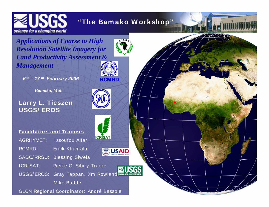
Applications of Coarse to High Resolution Satellite Imagery for Land Productivity Assessment & Management
6 th – 17 th February 2006
Bamako, Mali
Facilitators and Trainers
AGRHYMET: Issoufou Alfari
RCMRD: Erick Khamala
SADC/RRSU: Blessing Siwela
ICRISAT: Pierre C. Sibiry Traore
USGS/EROS: Gray Tappan, Jim Rowland,
Mike Budde
GLCN Regional Coordinator: André Bassole
“The Bamako Workshop”
Larry L. TieszenUSGS/EROS

“The Bamako Workshop”
Workshop Elements:• Funded by USAID, USGS,
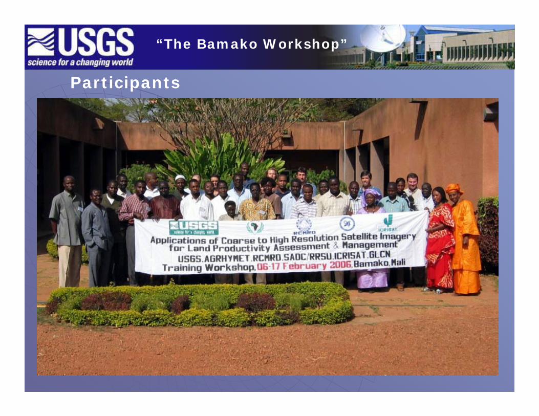
Participants• Organized and Implemented by
USGS, Africa Regional Centers (AGRHYMET-Niamey, RCMRD-Nairobi, RRSU-Gabarone), and ICRISAT
• Hosted by ICRISAT-Bamako• 35 participants from FAO, IAO,
UNEP, CGIAR Centers, CILSS, African countries,
“The Bamako Workshop”
Participants

“The Bamako Workshop”
Workshop Targets:• Assessments of changes in land cover
and land use• Impacts of management and climate on
carbon and climate change• African scientists who will benefit from
using remote sensing and geo-spatial information in agriculture, environmental management, natural resource management, biodiversity, land productivity, and food security

“The Bamako Workshop”
Workshop Approach:• Expert leaders from USGS and
Regional Centers• Remote Sensing data includes
MODIS, AVHRR, Landsat, Corona, aerial photography
• Field analysis supplements image interpretation
• Identification of national needs and “the way forward” in a Planning Meeting

“The Bamako Workshop”
Field Validation of Image Interpretation
Image Interpretation; ICRISAT Laboratory
Sahel Field Validation with Gray Tappan, USGS-EROS

Examples of NRM practices in northern Burkina Faso:
Improved soil fertility (compost)
Water retention by bunds Rock bunds on the contour
Use of planting pits (zai)
“The Bamako Workshop”

Monitoring Natural Resources in Senegal:Diversification of Production(Monitoring Site 586)
1996 1998
1984
1997
1997“The Bamako Workshop”

Decline in Biodiversity in Senegal (Monitoring Site 403)1994
1998
Woody Species at Site 403 – Mar. 1984Combretum micranthumCombretum nigricansCombretum glutinosumBombax costatumAdansonia digitataAcacia macrostachyaAcacia polyacanthaGardenia ternifolia
Woody Species at Site 403 – Feb. 1994Combretum micranthumCombretum nigricansCombretum glutinosumBombax costatumAcacia macrostachyaAdansonia digitataGrewia bicolorSterculia setigeraBoscia angustifoliaGuiera senegalensisPterocarpus lucens
1994
1984Grewia bicolorLannea acidaLonchocarpuslaxiflorusSclerocarya birreaSterculia setigeraStrychnos spinosaFeretiaapodantheraBoscia angustifoliaGuiera senegalensisPterocarpus lucens
“The Bamako Workshop”

“The Bamako Workshop”
Planning Meeting:• Detailed presentation of FAO-Global
Land Cover Network (GLCN)• Review
Data availability, Land cover and applications projects and plansModes of cooperationNational to Regional to Continental plans
• Resolutions• Project Formulation = WALCAP (West
Africa Land Cover Applications Program)

“The Bamako Workshop”
WALCAP (West Africa Land Cover Applications Program) The Way Forward:The resolutions from the Bamako Workshop conveyed a strong consensus among participants and representative organizations to move forward with an integrated plan to be implemented in West Africa CILSS and ECOWAS countries. This plan has the following scientific and development components:
1. Undertake collaborative and integrated land cover mapping combined with detailed “wall to wall” land cover change on a national basis with consistency across all countries,
2. National projects will be implemented as resources are obtained and capacity is attained and will start with Senegal, Burkina Faso, Benin, and Ghana in 2006,
3. Land cover mapping will be based on the GLCN standard with L7 or L5 data from 2005 or 2006. Land cover change will be based on Corona data supplemented with Landsat imagery, aerial photography, and ground data where possible,
“The Bamako Workshop”
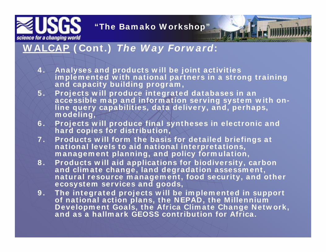
WALCAP (Cont.) The Way Forward:
4. Analyses and products will be joint activities implemented with national partners in a strong training and capacity building program,
5. Projects will produce integrated databases in an accessible map and information serving system with on-line query capabilities, data delivery, and, perhaps, modeling,
6. Projects will produce final syntheses in electronic and hard copies for distribution,
7. Products will form the basis for detailed briefings at national levels to aid national interpretations, management planning, and policy formulation,
8. Products will aid applications for biodiversity, carbon and climate change, land degradation assessment, natural resource management, food security, and other ecosystem services and goods,
9. The integrated projects will be implemented in support of national action plans, the NEPAD, the Millennium Development Goals, the Africa Climate Change Network, and as a hallmark GEOSS contribution for Africa.

“The Bamako Workshop”
Resolutions:

“Training and Data Distribution: USGS-CEOS”

“Training and Data Distribution: USGS-CEOS”
Applications of Coarse to High Resolution Applications of Coarse to High Resolution Satellite Imagery for Land ManagementSatellite Imagery for Land Management
Training CenterTraining Center
Guide des Formations VGuide des Formations Vééggéétales en tales en Afrique de l'OuestAfrique de l'Ouest
Training CenterTraining CenterU.S. Geological SurveyU.S. Geological Survey
Center for Earth Resources Center for Earth Resources Observation and Science (EROS)Observation and Science (EROS)Sioux Falls, South Dakota, USASioux Falls, South Dakota, USA
Section ThreeSection ThreeTerrain AnalysisTerrain Analysis
Training CenterTraining Center
Four Examples of Training Manuals
Section TwoSection TwoElevation and Analysis ExtentElevation and Analysis Extent
Training CenterTraining CenterU.S. Geological SurveyU.S. Geological Survey
Center for Earth Resources Center for Earth Resources Observation and Science (EROS)Observation and Science (EROS)Sioux Falls, South Dakota, USASioux Falls, South Dakota, USA

Significant Training Workshops:
Hydrologic Modeling with RS and GISDeveloped “Training Manual for the Geospatial Stream Flow
Model” (GeoSFM), May 2005 – 95 pp, including 8 step-by-step exercises
Developed “Geospatial Stream Flow Model (GeoSFM) Users Manual, May 2005 – 140 pp, draft version, with final edits to be finished shortly
Technical Manual in preparation Over 200 workshop (powerpoint) slides being updated
Classification Land CoverDeveloped training manual for W.Africa land cover classification
(version française) – 24 pp, including vertical and oblique aerial photography
Land performance workshop in Bamako, Mali (Feb. 2006)Collaboration with AGRHYMET, CGIAR (ICRISAT, IWMI), RCMRD,
RRSU, USAID, FAO/GLCN, UNEPArcIMS-Clearinghouse workshop with CSE (Centre de Suivi
Ecologique) in Dakar, Senegal (date TBD).
“Training and Data Distribution: USGS-CEOS”

Significant Data Distribution:Landsat data for 1972, 1986 and 2000distributed to Regional Centers for distribution to constituent countriesCorona satellite photography of ca. 1400 frames in digital format eventually to cover all of West, East, and Southern AfricaReprocessed AVHRR time series dataMODISSRTM 90m source data processedSRTM 30m derived productsAerial Digital, Video, and other
“Training and Data Distribution: USGS-CEOS”
“The Bamako Workshop”