Embed Size (px)
Citation preview

April 2011
Establishing Integrated Forest Policies to Reduce
Greenhouse Gas Emissions from Deforestation
and
Forest Degradation at the District Level
The District of Musi Rawas, South Sumatra
CEN
TER
FO
R C
LEA
N A
IR P
OLI
CY
Ce
nte
r fo
r C
lea
n A
ir P
oli
cy
D
ia
lo
gu
e.
I
ns
ig
ht
.
So
lu
ti
on
s.

ACKNOWLEDGEMENTS
This report was prepared by a team from Carbon and Environmental Research Indonesia (CER
Indonesia) in Bogor, Indonesia. The team included Dr. Rizaldi Boer, Dr. Lala Kolopaking, Dr.
Bramasto Nugroho, Muhammad Ridwan, Delon Marthinus, Syahrina Anggraini, Ari Suharto,
and M. Iqbal Bana. Matthew Ogonowski of the Center for Clean Air Policy (CCAP) also
contributed to the report. Editing and review of the document was provided by the CCAP team.
The authors would like to thank Dr. Nur Masripatin of the Forestry Research and Development
Agency (FORDA) at the Indonesian Ministry of the Forestry, and the members of the Musi
Rawas District Government and the REDD Working Group, for the support and information
provided. The authors also wish to express their gratitude to CCAP, the main sponsor of this
report, and especially to Ned Helme, William Whitesell, Matthew Ogonowski, Sally
Schlichting, Diana Movius, Anmol Vanamali, Marielle Walter, Ashley Lowe and Saba Raza.
The authors would like to thank Øyvind Dahl and the Norwegian Agency for Development
Cooperation (Norad) for their generous financial support for the project. For avoidance of any
doubt and for the purpose of clarity, the authors wish to state that this report is based on an
independent study, and the contents of the report reflect their views and not necessarily the
views of the Indonesian or Norwegian governments. The report and results are subject to
further refinement.

TABLE OF CONTENTS
EXECUTIVE SUMMARY ............................................................................................... i
1. Introduction .................................................................................................................. 1
1.1 Project Background ................................................................................................ 1
1.2 Indonesia Project Overview.................................................................................... 2
1.3 Goals and Objectives .............................................................................................. 3
1.4 Report Structure ...................................................................................................... 4
2. Overview of Musi Rawas District ................................................................................ 5
2.1 Geographic Condition ............................................................................................ 5
2.2 Land Use and Forest Cover .................................................................................... 5
2.3 Population ............................................................................................................... 6
2.4 Land Ownership System ......................................................................................... 6
2.5 Source of Income .................................................................................................... 7
3. GHG Emissions, Deforestation, and Forest Degradation in Musi Rawas .................... 9
3.1 Historical Emissions from Land Use Change and Potential Future Emissions in
Musi Rawas .................................................................................................................. 9
3.2 Drivers and Rate of Deforestation and Forest Degradation ................................... 9
3.3 Forest Management System ................................................................................. 10
4. District-Level Capacity and Institution Building for REDD+ Implementation ......... 12
4.1 Musi Rawas District Government: Background ................................................... 12
4.2 The Process of Establishing the REDD Working Group ..................................... 15
4.3 Current Institutional Capacity for Monitoring Carbon Stock and Land Use Cover
Change ........................................................................................................................ 16
4.4 Development of Institutional Capacity for Monitoring Carbon Stock and Land
Use Cover Change ...................................................................................................... 19
4.5 Development of the Forest Management Unit to Support the Implementation of
REDD in Musi Rawas District ................................................................................... 21
5. Strategies for Implementing a REDD Program in Musi Rawas District .................... 28
5.1 REDD+ Implementation under the Context of Regional Development ............... 28
5.2 Policy Strategy and Program for Institutional Development to Support REDD+
Implementation Leading to Low Carbon Development ............................................. 28
5.3 Implementation ..................................................................................................... 29
5.4 Financing .............................................................................................................. 31
5.5 Indicators to Measure the Success of Low Emission Development ..................... 33
6. REDD Demonstration Activities ................................................................................ 34
6.1 Demonstration Activity 1: Reduced Deforestation and Forest Degradation through
Integrated Coconut Utilization and Ecotourism in the Buffer Area of Bukit Cogong
Protection Forest (HLBC) .......................................................................................... 34
6.2 Demonstration Activity 2: Reducing Deforestation and Forest Degradation
through Intensive Agroforestry & Microhydro Activity in Kerinci Seblat National
Park (KSNP) ............................................................................................................... 40
6.3 Demonstration Activity 3: Development of a Community Rubber Plantation to
Reduce Threats to the Kerinci Seblat Conservation Forest and Increase the Carbon
Sink in the Ulu Terawas Sub-District ......................................................................... 45
6.4 Demonstration Activity 4. Development of Community Timber Plantation to
Enhance Carbon Sequestration and Community Participation in Forest Management
at Lakitan Sub-District ............................................................................................... 45
7. Co-benefits of REDD Implementation ....................................................................... 47
8. Local and National Lessons ........................................................................................ 49
8.1 Local Implications of the Project.......................................................................... 49
8.2 National Implications of the Project ..................................................................... 51
9. Conclusions and Recommendations ........................................................................... 52
References ...................................................................................................................... 54
Appendix 1: Summary of REDDI Feasibility Study for Musi Rawas District .............. 55
Appendix 2: Minutes of the Meeting of the Seminar on Community Based Rural
Development ................................................................................................................... 57
Appendix 3: Training on Reducing Emissions from Deforestation and Forest
Degradation (REDD) for RWG of Musi Rawas, 20 – 21 March 2010 .......................... 58
Appendix 4: Regent Decree No. 228/KPTS/BAPPEDA/2010 on the Establishment of
the Implementation Coordination Team for Reduction Emissions from Deforestation
and Degradation Program in the District of Musi Rawas ............................................... 61
Appendix 5: Integrated Coconut Utilization and Ecotourism in the Buffer Area of the
Bukit Cogong Protection Forest ..................................................................................... 65
Appendix 6: Intensive Agroforestry Activity and Development of Microhydro in
Kerinci Seblat National Park (KSNP) – Musi Rawas Area............................................ 70
Appendix 7: Final Workshop at Musi Rawas, July 20, 2010 ......................................... 73

List of Figures:
Figure 1: Map of Musi Rawas District ............................................................................. 5
Figure 2: Land Cover of Musi Rawas District in 2006 .................................................... 6
Figure 3: Emissions from Deforestation and Forest Degradation of Forested Lands in
Musi Rawas (CER Indonesia, 2008) ................................................................................ 9
Figure 4: Institutional Process for Acquisition of Spatial Data on Natural Resources .. 17
Figure 5: Spatial Analysis and Mapping for Decision-Makers ...................................... 18
Figure 6: Organization of Data Collection for MRV ..................................................... 19
Figure 7: Organizational System for Information Dissemination and Public Relations 20
Figure 8: Locations of Forest Management Units V, VI and VII at Musi Rawas .......... 25
Figure 9: Brief Summary of Development Stages of FMU Production Model Lakitan,
Musi Rawas District ....................................................................................................... 25
Figure 10: BLUD as Local Government Holding Company and its Relationship with
Financing Agencies and MRV Special Units ................................................................. 26
Figure 11: Strategic Program for Institutional Development of REDD+ in low
Emissions Development Policy of Musi Rawas District ................................................ 29
Figure 12: Master Plan for the Development of Agropolitan Region at Musi Rawas
District ............................................................................................................................ 30
Figure 13: Structure of Financing Systems for Supporting Low Carbon Development 32
Figure 14: Discussion with Local Stakeholders of Bukit Cogong ................................. 35
Figure 15: Bukit Cogong Protection Forest .................................................................... 36
Figure 16: Location of Demonstration Activity in Bukit Cogong (red circle). .............. 37
Figure 17: (a) Slash and Burn Activity in KSNP, (b): Agricultural Land inside KSNP 40
Figure 18: River near Napal Melintang Village, providing the Potential for Microhydro
Power Development ....................................................................................................... 41
Figure 19: Location of Demonstration Activity 2 (red circle)........................................ 42
Figure A.5-1: Products from the Integrated Coconut Utilization Program. ................... 66
Figure A.5-2: Production and Flow Chart of the Integrated Coconut Utilization Market
........................................................................................................................................ 67

List of Tables:
Table 1: Yield of Rubber and Coffee in Musi Rawas District ......................................... 7
Table 2: Main Elements of REDD Strategy ................................................................... 15
Table 3: Strengths, Weaknesses, Opportunities and Challenges of FMU Development in
Musi Rawas District: ...................................................................................................... 23
Table 4: Land Cover Condition of FMU Lakitan Model ............................................... 46
Table 5: Benefit Sharing in Ecotourism HLBC ............................................................. 47
Table A.5-1: Types of Coconut Products and its Prices ................................................. 66
Table A.5-2: Allocation for Profit sharing in BCPF Ecotourism Area .......................... 68
Table A.6-1: Community Land near KSNP ................................................................... 70
Table A.6-2: Yields of Communities‘ Coffee and Rubber Plantation inside KSNP ...... 71

Abbreviations
APBN Anggaran Pendapatan dan Belanja Negara (State Budget)
APBD Anggaran Pendapatan dan Belanja Daerah (Local/Regional Budget)
APL Area Penggunaan Lain (other purposes area)
BAPLAN Badan Planologi, now DG (Directorate General) Planologi
BAPPEDA Badan Perencanaan Pembangunan Daerah (Regional Development
Planning Agency)
BLUD Badan Layanan Umum Daerah (Local public service agency)
BPN Badan Pertanahan Nasional (National Land Affairs Agency)
CCAP Center for Clean Air Policy
CDM Clean Development Mechanism
CER Indonesia Carbon and Environmental Research Indonesia
CSR Corporate Social Responsibility
EIA Environmental Impact Assessment
FAD Future Actions Dialogue
FCPF Forest Carbon Partnership Facility
FMU Forest Management Unit
FORDA Forestry Research and Development Agency
FRIS Forest Resource Information System
GEF Global Environment Facility
GHG Greenhouse Gases
GIS Geographic Information System
GPS Global Positioning System
Hkm Hutan Kemasyarakatan (Community forests)
HLBC Hutan Lindung Bukit Cogong (Bukit Cogong Protection Forest)
HTI Hutan Tanaman Industri (Industrial Plantation Forest)
HTR Hutan Tanaman Rakyat (Smallholder plantation forest)
IPB Institut Pertanian Bogor (Bogor Agriculture University)
IPCC Intergovernmental Panel on Climate Change
JICA Japan International Cooperation Agency
KPTS Keputusan (Decision)
KSNP Kerinci Seblat National Park
LUCF Land-Use Change and Forestry
MoF Ministry of Forestry

MRV Measureable, Reportable, Verifiable
MRDG Musi Rawas District Government
NGO Non-Government Organization
Norad Norwegian Agency for Development Cooperation
NSDH Neraca Sumber Daya Hutan (Forest Resources Balance)
OPLB Organisasi Pemuda Langit Biru
PAD Pendapatan Asli Daerah (Local Revenue)
PFO Provincial Forestry Office
REDD Reduction Emissions from Deforestation and Forest Degradation
REL Reference Emission Level
REVBUN Revitalisasi Kebun (Plantation Revitalization)
RWG REDD Working Group
SOP Standard Operating Procedures
UNFCCC United Nations Framework Convention on Climate Change
UN REDD United Nation on Reduction Emissions from Deforestation and Forest
Degradation
UPTD Unit Pelaksana Teknis Daerah (Local Technical Implementation Unit)
WBH Wahana Bumi Hijau

i
EXECUTIVE SUMMARY
Indonesia Project Background and Rationale
In the current discussions on development of a new international climate policy structure for the
post-2012 period, the issue of addressing greenhouse gas (GHG) emissions from deforestation
and design of a mechanism to support actions for Reducing Emissions from Deforestation and
Forest Degradation (REDD) in developing countries has become one of the most important
areas of negotiation under the United Nations Framework Convention on Climate Change
(UNFCCC) and other international forums such as the REDD+ Partnership. As part of its
commitment to the global community and to the UNFCCC, the Government of Indonesia has
committed to reduce emissions from deforestation and degradation. With Indonesia‘s large
number of islands and diverse landscapes combined with the post-1998 decentralization of
forest governance, REDD implementation in the country faces a number of challenges. At the
same time, however, the complexities of the Indonesian situation make it an ideal test case for
developing strategies to design institutions (regulatory bodies, carbon payment distribution
mechanisms, procedures for measuring, reporting and verifying, or MRV, etc.) that can
implement a REDD program effectively -- on both a national and local basis -- and also address
and respond to local concerns and needs.
The Ministry of Forestry of Indonesia has highlighted five important aspects that require
comprehensive and in-depth analysis as the basis to undertake REDD activities: (i) in-depth
analysis of options for estimation of reference emission levels; (ii) analysis relevant to an
approach to REDD based on national accounting with sub-national implementation; (iii)
analysis of REDD financing, potential markets, and MRV; (iv) capacity building; and (v)
identification of specific on-the-ground investment and other activities that will lead to emission
reductions and sustainable development. Actions to protect forests at the provincial and district
levels are an integral part of Indonesia‘s REDD plan, and the Ministry of Forestry has stated that
REDD+ is a national commitment with sub-national implementation. The strategy for the
implementation of REDD+ in Indonesia developed by the Ministry and submitted to the World
Bank Forest Carbon Partnership Facility (FCPF) calls for establishment of provincial/district
reference emission levels and MRV systems, institutional development and strengthening, and
development and implementation of REDD demonstration activities. The plan will require that
institutions are developed at the province and district levels that can oversee local
implementation, link up effectively with corresponding national REDD structures, and
communicate and coordinate between the national and local levels.
While a large number of REDD pilot projects have been developed and implemented in
Indonesia, comparatively little work has been done to develop parallel institutional structures for
local REDD policy and implementation. The Ministry of Forestry therefore requested that the
Center for Clean Air Policy (CCAP) in Washington, DC and its local partner, Carbon and
Environmental Research Indonesia (CER Indonesia) in Bogor, Indonesia, lay the foundation for
such a plan and elaborate these sub-national goals in one pilot district. In May 2009, CCAP and
CER Indonesia, with support from the Norwegian Agency for Development Cooperation‘s
(Norad) International Climate and Forest Initiative and in collaboration with the Ministry of
Forestry and local government and other stakeholders, began a project called Establishing
Integrated Forest Policies to Reduce Greenhouse Gas Emissions from Deforestation and Forest
Degradation at the District Level. Musi Rawas District in South Sumatra was selected as the
target area of the study, based on consideration of potential future emissions and the strong
commitment expressed by the district government and community representatives to support
and facilitate the study. The study aims to assist local government in building capacity, to
create enabling conditions for the implementation of REDD activities at the local level, and to
utilize the lessons learned from the study as inputs for both Indonesia‘s national REDD program
and the international UNFCCC negotiation process.
ii
Musi Rawas District: Emissions and Forest Status
Musi Rawas District is in South Sumatra province. Its capital is Muara Beliti. One component
of a National Park, Kerinci Seblat National Park (KSNP) is located in the district. Based on
BAPLAN images from 2006, Musi Rawas District has an area of about 1.2 million ha, with
about 50% of this area having status as forest area. Much of the district‘s forest has already been
converted to other land uses. About 78% of the forested land is primary dry land forest, while
the remaining is plantation forest. Most of the forested lands are located in KSNP, with some in
other protection forests (e.g., Bukit Cogong). Based on data from the Badan Pertanahan
Nasional (National Land Affairs Agency) of Musi Rawas, most of the agricultural land is
covered by community plantations, particularly rubber and coffee.
From a rough estimation conducted in 2008, the rate of emissions from deforestation and forest
degradation in Musi Rawas District between 2003 and 2006 totaled about 5.9 million tons CO2
annually. 87% of these emissions came from deforestation of secondary swamp forest and from
degradation of primary dry land forest. In KSNP, the rate of emissions from deforestation and
forest degradation was about 2.16 million tons CO2 annually, caused mainly by illegal logging
and land encroachment. Absent major policy changes, agricultural activities, population
growth, mining, timber and palm oil plantations will increase the threat to forested areas of
Musi Rawas, including the National Park. Potential emissions from deforestation and forest
degradation at Musi Rawas District may reach about 45.6 million tons CO2 from planned and
unplanned activities in future years. Identified drivers of deforestation in Musi Rawas include:
(i) the conversion of forests to plantations by companies and individuals; (ii) the conversion of
forests for mining, generally by large companies, (iii) increased settlement due to a growing
population and increased demand for residential land in Musi Rawas; and (iv) forest fires,
which occur mostly as the result of land clearing for agricultural purposes. The drivers of forest
degradation in Musi Rawas are mainly illegal logging and HTI (Hutan Tanaman Industri –
Industrial Plantation Forest) activities.
The Musi Rawas District Government (MRDG) has already developed plans and programs to
improve the management of its land and forest resources. The MRDG aims to increase the
prosperity of its community through the improvement of the local economy using the
Agropolitan model. Agropolitan refers to agriculture-based economic development which is
designed and implemented by synergizing all existing potential resources, including mining.
The goal is to encourage the development of an agribusiness system which is competitive,
society-based, sustainable, decentralized, driven by the community and facilitated by the
Government. To improve the participation of the private sector in community development
programs and environmental protection, the MRDG has established the Team for Verification,
Monitoring and Evaluation of the implementation of Corporate Social Responsibility (CSR).
The MRDG, through the Office of Agriculture Plantation, has also launched the Revitalization
of Community Agriculture Plantation program. This program is intended to encourage
communities to optimize the use of degraded land in non-forest areas for establishing
agricultural plantations, particularly for rubber, and to improve the productivity of the lands. To
reduce the threat to KSNP and protection forests, the MRDG has also collaborated with the
Agency for KNSP to develop community-based forest rangers, and with the private sector to
implement community development programs for illegal loggers, miners and agricultural forest
encroachers.
Project Results: Capacity Building and Policy Recommendations
As discussed above, CER Indonesia had previously estimated a reference emission level for Musi
Rawas District. The CCAP project therefore focused on the two other sub-national elements
outlined in the FCPF program (institutional development and strengthening, and development
and implementation of REDD demonstration activities). While the MRDG has already taken
action to improve the management of its forests, there is still a need for a central REDD
iii
administrative structure to: a) integrate REDD into these existing local actions and implement the
national REDD plan at the district level, and b) guide, implement and expand REDD
demonstration actions in the district. To meet this need, CCAP, CER Indonesia and Bogor
Agriculture University (Institut Pertanian Bogor – IPB) facilitated the formulation of the Musi
Rawas REDD Working Group.
After a series of meetings and discussions including a training workshop on REDD+, the Musi
Rawas REDD Working Group (RWG) was established on April 8, 2010, through the Musi
Rawas Regent‗s Decree No. 228/KPTS/BAPPEDA/2010 concerning the Establishment of the
Implementation Coordination Team for Reduction of Emissions from Deforestation and
Degradation Program in the District of Musi Rawas. Activities of the RWG include: (1)
formulating REDD+ strategies and programs that are consistent with the land use programs
planned by Musi Rawas District, and integrating them with agropolitan; (2) developing
community based REDD+ demonstration activities; (3) preparing an implementation framework
for measuring, reporting and verifying REDD+ activities; and (4) developing a marketing
strategy for REDD+ and exploring potential national, regional and international funding to
support its implementation. Throughout this project, the technical team of the Musi Rawas
REDD Working Group worked closely with CCAP and CER Indonesia. REDD Working
Group staff worked with the CCAP team to develop the proposals detailed in this report for the
Forest Management Unit, MRV system design and potential REDD demonstration activities in
the district. The recommendations presented here are thus the product of collaboration and
broad agreement among a range of district government and other stakeholders working with the
CCAP/CER team.
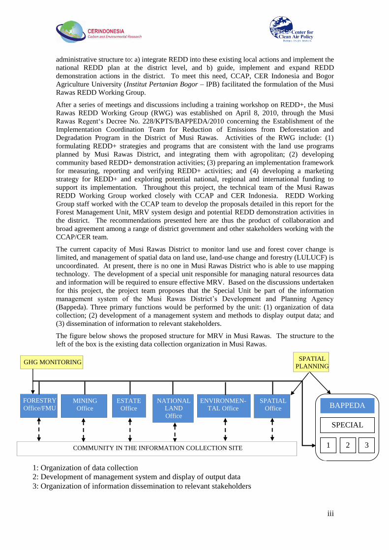
The current capacity of Musi Rawas District to monitor land use and forest cover change is
limited, and management of spatial data on land use, land-use change and forestry (LULUCF) is
uncoordinated. At present, there is no one in Musi Rawas District who is able to use mapping
technology. The development of a special unit responsible for managing natural resources data
and information will be required to ensure effective MRV. Based on the discussions undertaken
for this project, the project team proposes that the Special Unit be part of the information
management system of the Musi Rawas District‘s Development and Planning Agency
(Bappeda). Three primary functions would be performed by the unit: (1) organization of data
collection; (2) development of a management system and methods to display output data; and
(3) dissemination of information to relevant stakeholders.
The figure below shows the proposed structure for MRV in Musi Rawas. The structure to the
left of the box is the existing data collection organization in Musi Rawas.
BAPPEDA
SPECIAL
UNIT
1 2 3 COMMUNITY IN THE INFORMATION COLLECTION SITE
SPATIAL
PLANNING GHG MONITORING
FORESTRY
Office/FMU MINING
Office
ESTATE
Office
NATIONAL
LAND
Office
ENVIRONMEN-
TAL Office
SPATIAL
Office
1: Organization of data collection
2: Development of management system and display of output data
3: Organization of information dissemination to relevant stakeholders

iv
Following the decentralization of governance in Indonesia that began in 1998, the management
of protection forest has been given to the local government, while production forest and
conservation forest are still managed by the central government under the Ministry of Forestry.
Forest areas which do not have site-level management are commonly referred to as ―open
access‖ forest areas. These open access areas are normally subject to high risk of deforestation
due to agricultural encroachment and illegal logging. To address this, the Government of
Indonesia issued regulation PP No.6/2007 to facilitate the establishment of a site-level
management agency called the Forest Management Unit, or FMU.
The FMU is assigned with managing state forest area, while at this moment they have no
authority to manage non-forest area. Therefore FMU cannot be proposed for managing REDD
activity outside forest areas. In this regard, CER Indonesia proposes that the FMU take the form
of BLUD (Badan Layanan Umum Daerah – Local Service Unit), in which its authority would
include managing not only forest but also non-forest area. Unfortunately, the current regulation
on BLUD does not allow such an arrangement. To enable this, amendment of the BLUD
regulation is required. This process will involve at least three ministries, i.e. Ministry of
Domestic Affairs, Ministry of Forestry, and Bappenas.
Development of a REDD+ institution in Musi Rawas District should be done through enriching,
strengthening, and refining the Medium and Long Term Development Plan (RPJMP).
Optimization of land use in forest areas should enhance the development of agroforestry,
community forests, village forests, community timber plantations and forest
conservation/protection. The potential of ecotourism should be further explored and developed
and then channeled with the tourism network. The existing financing system for forest
protection is mainly through government‘s budget, both national and local. To ensure
integrated and sustainable REDD+ program implementation, the MRDG should establish both
Blending Financing and Hybrid Micro Financing systems. In the context of REDD+, both
Blending Financing and Hybrid Micro Financing systems should provide positive incentives
(low interest, tax deduction, concessional investment, etc.).
In addition to capacity building and development of proposals for effective implementation of
REDD at the local level, this study also explored potential designs of REDD demonstration
activities (DAs), another important component of Indonesia‘s national REDD program. CER
and CCAP began by identifying existing programs in the district that could serve as the basis for
future REDD projects. In Musi Rawas, deforestation has occurred due to agricultural
encroachment, illegal logging, mining activities and unsustainable forest management practices.
The Bukit Cogong Protection Forest (HLBC) is one of the important forests that are currently
threatened. Communities surrounding the forest still rely on HLBC to support their livelihoods,
while encroachment, illegal logging and stone mining in HLBC continue. To reduce this threat,
the MRDG has been educating the population about the importance of forests and assisting the
community to develop forest-friendly activities.
In 2008, the MRDG launched the Integrated Coconut Utilization Program to provide an
alternative livelihood for communities dependent upon the forest. Participating households
process coconuts using small-scale machines they purchase themselves, then sell the raw
material to the central processing center in the district where it is purified and refined into
products such as virgin coconut oil (VCO). The program was funded by the MRDG. About
300-400 households (nearly one-fifth of the total in five villages) participate in the program. In
the ecotourism program, beginning in 2009 the MRDG provided a series of grants to enable the
local community to set up a nature walk, an animal viewing center and other facilities, coupled
with planting of rubber and some shade-grown coffee. The MRDG has also sponsored a
community awareness program to educate the local population on the importance of forest
conservation and its role in protecting water supplies.

v
These programs include families formerly involved with illegal logging and illegal mining, and
have had some success in reducing deforestation. For example, prior to implementation of the
Integrated Coconut Utilization Program there were about 50 households in the program area
engaged in stone mining; at present however it is estimated that only about 10 households do so.
In addition, while illegal logging and agricultural encroachment were a problem in the past,
these activities have now all but ceased in the area of the HLBC located in the district. On-site
research by CER and CCAP indicates a significant potential for scaling up and expanding these
activities if challenges such as the upfront investment required, the high cost of production
inputs and the need for expanded community awareness can be addressed. There are also
additional new REDD programs that could be developed. In this project the MRDG, CER
Indonesia and CCAP have identified four potential DAs:
a. Reduced deforestation and forest degradation through Integrated Coconut Utilization and
Ecotourism in the buffer area of Bukit Cogong Protection Forest. This DA would build
upon the existing projects already underway. The ecotourism program will be expanded so
that it will involve more illegal loggers and illegal mining families. The scale of production
of virgin coconut oil and other commodities will also be expanded from current levels
b. Reduced deforestation and forest degradation through Intensive Agroforestry and
Microhydro activities in Kerinci Seblat National Park (KSNP). In the proposed REDD DA,
the intensive agroforestry program will be expanded from one village into five villages:
Taba Gindo, Muara Nilau, Karang Panggung, Batu Gane and Napal Melintang.
c. Development of a community plantation for reducing threats in the Kerinci Seblat
Conservation Forest and increasing carbon sinks at the Ulu Terawas sub-district
d. Development of a community timber plantation for enhancing carbon sequestration and
community participation in forest management in the Lakitan sub-district
This study identified two immediate steps which are necessary for REDD+ to be realized and
implemented effectively by the MRDG, namely:
Acceleration of the establishment of Forest Management Units, as the FMU is crucial
for successful implementation of community based REDD+ activities.
Integration of the REDD+ strategy into the Medium Term Regional Development Plan
2011-2015, which is now being prepared.
Next Steps for REDD in Musi Rawas The establishment of the Musi Rawas District REDD Working Group, facilitated in large part
by CCAP and CER Indonesia, was a key accomplishment of the CCAP project. However,
further capacity building for the RWG is still needed. This includes the following activities:
1. Increasing the understanding of the local government on the concept and mechanisms
of MRV.
2. Developing and improving the human resources capacity of the Musi Rawas District‘s
local government offices in the preparation and operation of MRV systems.
3. Developing capacity in defining and estimating reference levels and reference emission
levels.
4. Developing key local regulations and their link with national regulations required to
support the implementation of REDD activities, in accordance with REDD policy at the
national and international levels.
5. Further elaboration and design of potential REDD Demonstration Activities and
communication with potential funders and investors.
CCAP and CER Indonesia are continuing their work in the above areas in collaboration with the
Musi Rawas REDD Working Group and the Ministry of Forestry. It is expected that the

vi
elaboration of REDD policy by the MRDG going forward will incorporate and build upon the
REDD framework and recommendations presented in this report.

1
1. Introduction
1.1 Project Background
In the current discussions on development of a new international climate policy structure for the
post-2012 period, the issue of addressing greenhouse gas (GHG) emissions from deforestation
has emerged as one of the key topics. The land-use change and forestry (LUCF) sector is a
significant contributor to global GHG emissions, accounting for some 15% of net emissions
annually, most of which occur in developing countries. Beyond the climate-warming impact of
these emissions, however, deforestation is an unsustainable activity that brings harm to humans,
the environment and the well-being of national and local economies. It has damaged the
cultural and economic livelihood of local communities and indigenous peoples in many
countries, and has caused declines in biodiversity in some of the world‘s most important
ecosystems. Deforestation also contributes directly to local and regional climate change
through changes in rainfall, local temperatures and other factors.
The design of a mechanism to support actions for Reducing Emissions from Deforestation and
Forest Degradation (REDD) in developing countries has become one of the most important
areas of negotiation under the United Nations Framework Convention on Climate Change
(UNFCCC) and the REDD+ Partnership launched following the Copenhagen Accord. At the
same time, efforts to implement REDD pilot projects and test potential REDD policies and
programs on the ground in developing countries have been undertaken by a range of
organizations, including the World Bank‘s FCPF, UN-REDD, and NGOs such as the Center for
Clean Air Policy (CCAP). The successful implementation and coordination of these top-down
and bottom-up efforts will be crucial to the achievement of REDD worldwide in reducing GHG
emissions, and in promoting important co-benefits such as local and community development,
the promotion of gender equity and the rights of indigenous peoples, and the protection of
biodiversity. REDD must also integrate sub-national programs into a single national program,
so that both work in complementary fashion.
In our REDD work over the past three years, CCAP has identified key areas and gaps in current
understanding where additional work is needed if REDD is to succeed. First, while a number of
useful pilot projects are being developed to test specific policies and develop and refine carbon
accounting methods, there is an urgent need to expand the analysis of policy (as opposed to just
technical) implementation, and to develop complementary administrative and governance
structures to integrate pilots with national REDD programs and ensure the involvement of local
communities and indigenous groups. Second, while national programs are essential, such REDD
policies must be designed and carbon payments and other incentives distributed to convince
local actors of the value of REDD and the need to continue forest preservation activities over
the long term. Third, mechanisms being developed at the international, national and sub-
national levels for reducing deforestation, promoting local development, implementing
measurement, verification and reporting (MRV) and distributing carbon payments must be
harmonized and the lessons learned shared with policymakers and stakeholders at all levels.
Finally, in-country capacity must be developed and built to enable -- and encourage -- the
countries themselves to carry out REDD sustainably and contribute to the above goals.
It is from this perspective that CCAP, a climate change and environmental policy think tank
based in Washington, DC, launched its expanded Forestry and Climate Change Program in
2008 with support from the Norwegian Agency for Development Cooperation‘s (Norad)
International Climate and Forest Initiative. The goal of our program is to promote the
development of effective and robust policy and institutional designs for REDD at the
international, national and sub-national levels. CCAP is working with local research and
government partners in three key developing countries with forest-related emissions --
Indonesia, Mexico and Cambodia -- to help national and local governments design policies and

2
institutional mechanisms for REDD implementation. In addition, CCAP‘s work at the
international level explores potential support structures for REDD financing and capacity
building through the UNFCCC, the REDD+ Partnership, and other sources. We also provide
specific recommendations to the United States government to help ensure the effectiveness and
environmental integrity of the REDD support provisions included in potential US climate
legislation.
By conducting in-country case studies that are representative of the range of local
environmental and economic circumstances, CCAP and its national partners will have the
necessary data to formulate REDD frameworks from the ground up that meet national REDD
goals while also achieving local goals for sustainable development, ensuring indigenous peoples
rights, protecting biodiversity and alleviating poverty. Through iterative top-down and bottom-
up analyses and dialogue, the CCAP project develops plans each country can follow as they
implement REDD within their borders. The results and lessons from CCAP‘s on-the-ground
work are then used to inform the structure of a future international REDD framework and the
associated financing process to support countries in their REDD goals. To ensure that these
results feed into a wide range of climate policy discussions, CCAP will present the results at in-
country stakeholder workshops and consultations, sessions of the UNFCCC negotiations and
other forums. It is through this process that the CCAP Forestry and Climate Change Program
will contribute to the ultimate goal of reducing deforestation in ways that deliver not only
meaningful reductions in carbon emissions to the Earth‘s atmosphere, but also enhance the
livelihoods of forest dependent communities, support low-carbon economic development,
promote gender equality and the rights of indigenous peoples, protect biodiversity and achieve
other co-benefits.
An important foundation of this project is that it links directly with international climate change
negotiations through CCAP‘s Dialogue on Future Actions to Address Global Climate Change –
the Future Actions Dialogue, or FAD, which brings together key negotiators from over 30
developing and developed countries several times each year in an informal, off-the-record
setting to discuss options for the future of the UNFCCC and the Kyoto Protocol beyond 2012.
The Dialogue has a distinguished track record of success in many areas, such as the design of
the CDM, options for REDD financing, and sectoral programs for industrial GHG mitigation.
An integral part of CCAP‘s work includes presentation and discussion of results from this and
other projects at FAD sessions, where REDD has been a key focus, as well as at events and
consultations held at UNFCCC meetings. The analyses conducted in Indonesia, Cambodia and
Mexico will thus help international climate policymakers understand the issues related to
reducing emissions and potential REDD Plus actions in developing countries.
1.2 Indonesia Project Overview
All developing countries will face the challenges of coordinating and integrating REDD policies
and programs at various levels of government and among a wide range of policymakers and
stakeholders. In Indonesia however, the situation is compounded by the vast distances and land
and forest diversity across many islands, and most importantly by the post-1998
decentralization of forest governance during the post-1998 reformasi period. At the same time,
the complexities of the Indonesian situation make it an ideal test case of developing strategies to
design institutions (regulatory bodies, carbon payment distribution mechanisms, procedures for
measuring, reporting and verifying, or MRV, etc.) that can implement a REDD program
effectively -- on both a national and local basis -- and also address and respond to local
concerns and needs.
The Ministry of Forestry (MoF) has highlighted five important aspects that require
comprehensive and in-depth analysis as the basis to undertake REDD activities. These include:
3
1. In-depth analyses which can provide options as the basis to estimate reference emission
levels (RELs).
2. In-depth analyses relevant to the REDD Indonesia (REDDI) approach based on national
accounting with sub-national implementation, for example, how to ensure technical and
methodological consistency between regions at the sub-national level, and between
national and sub-national levels.
3. In-depth analyses of REDD financing (especially for readiness activities), potential
markets for REDD, and MRV issues under the Bali Action Plan which will affect
REDD implementation.
4. Capacity building at all levels, access to data/information, technology transfer and
know how, and shared learning.
5. Identification of specific on-the-ground investment and other activities that between
now and 2012 will lead to emission reductions and sustainable development.
Translation of these activities into a format that will provide the basis for appraisal by
interested private and public investors will also be carried out.
Considering this situation, in May 2009 CCAP and its research partner Carbon and
Environmental Research Indonesia (CER Indonesia) based in Bogor, Indonesia, with support
from Norad and in collaboration with the Ministry of Forestry and local government and other
stakeholders, began a study called Establishing Integrated Forest Policies to Reduce
Greenhouse Gas Emissions from Deforestation and Forest Degradation at the District Level.
The study is focused on policy analysis and building capacity and enabling conditions at the
local level for the implementation of REDD. Musi Rawas District in South Sumatra was
selected as the target area of the study. This district was selected based on consideration of the
potential future emissions from deforestation. A Feasibility Study conducted by CER Indonesia
with support from the Japan International Cooperation Agency (JICA) suggested that the
potential future emissions in future years may reach 45.6 million tons CO2 -- 4.1 million tons
CO2 from planned deforestation and 41.6 million tons CO2 from unplanned deforestation (see
Appendix 1). In addition, the Musi Rawas District Government has indicated its strong
commitment to support and facilitate the study.
1.3 Goals and Objectives
In general, the project aims to assist local government in creating enabling conditions for the
implementation of REDD activities and to utilize the lessons learned from the study as inputs
for both Indonesia‘s national REDD program and the international UNFCCC negotiation
process. Specifically, CCAP and CER Indonesia undertook efforts to fulfill the following
objectives:
(i) To facilitate local government establishment of a District REDD Working Group. This
institution will play an active role in establishing integrated forest policies to reduce
greenhouse gas emissions from deforestation and forest degradation.
(ii) To review policy, and regulatory aspects for the implementation of REDD and to work
with the REDD Working Group in formulating new policies and regulations to address
gaps in existing policies and regulations.
(iii) To assist the REDD Working Group in developing strategies for REDD and marketing
the REDD programs.
(iv) To facilitate the REDD Working Group to develop and implement REDD
demonstration activities.
(v) To evaluate national and international implications of the project.

4
1.4 Report Structure
In line with the above objectives, this report is divided into five sections. The first section
(Chapter 2) provides an overview of Musi Rawas District. Chapter 3 discusses the district‘s
GHG emissions and deforestation. The next chapter discusses capacity and institution building
for REDD+ implementation in Musi Rawas. Chapter 5 discusses strategies for REDD
implementation. The sixth section presents preliminary designs for potential REDD
demonstration activities. Chapter 7 discusses potential co-benefits of REDD implementation;
the report closes with some thoughts on the broader implications of the project.

5
2. Overview of Musi Rawas District
2.1 Geographic Condition
Musi Rawas District is in South Sumatra, spanning an area of 1,236,583 ha between 2o15‘ –
3o40‘ South and 102°00‘ - 103°40‘ East. Its capital is Muara Beliti. Musi Rawas District is
verged with Jambi Province to the North, Empat Lawang District to the South, Bengkulu
Province to the West, and Musi Banyuasin and Muara Enim Districts to the East. Musi Rawas
consists of 21 sub-districts.
One component of the Kerinci Seblat National Park (KSNP) is located in Musi Rawas (Figure
1). Other parts of KSNP are located in Bengkulu, Jambi, and West Sumatra. KSNP is
dominated by the Barisan Mountains, including Mount Kerinci, the highest mountain in
Sumatra, reaching about 3,805 meters. In the KSNP area, there are about 4,000 types of flora
from 63 families, including Dipterocarpaceae, Moraceae, Anacardiace, Myristicaceae,
Euphorbiaceae and Meliaceae. Between 500 meters and 2,000 meters above sea level the flora
is dominated by families including Fagaceae, Erycaceae, and brush wood of sub alpine from
Vaccinium and Rhododendron. KSNP plays a big role in maintaining the local environmental
balance. In 2003, KSNP was established as an ASEAN Heritage Park in a declaration signed by
the ASEAN Secretary General.
Figure 1: Map of Musi Rawas District
2.2 Land Use and Forest Cover
Based on BAPLAN images from 2006, about 50% of Musi Rawas District‘s 1.2 million ha has
status as forest area. Much of the district‘s forest has been converted to other land uses (Figure
2). About 78% of the forested land is primary dry land forest, while the remaining is plantation
forest. Most forested lands are located in KSNP, with some in other protection forests (Bukit
Cogong). Based the data from the Badan Pertanahan Nasional (National Land Affairs Agency)
of Musi Rawas, most agricultural land is covered by community plantations, particularly rubber
and coffee.

6
Figure 2: Land Cover of Musi Rawas District in 2006
2.3 Population
Musi Rawas District has 478,189 inhabitants with a relatively low population density of 39
persons per km2, and a population growth rate of about 1.68% per year
1. The residential
distribution is relatively uneven, and most residents live near Lubuk Linggau City, the former
capital of Musi Rawas District. Muara Beliti is the new capital, about 10 km away from Lubuk
Linggau City. Inside and surrounding KSNP there are approximately 26 villages. Four villages
are inside KSNP with populations of approximately 4,462 people, and 22 villages are outside
KSNP with populations of about 42,705 people. The family size is between three and four
persons per household.
2.4 Land Ownership System
The land ownership systems of most communities surrounding the state forest are based on
recognition of community members or relatives rather than certificate or other legal letters.
Ownership of land is gained by the person who clears the forest for the first time for farming
activities. In general, land borders are clearly defined and recognized by community leaders. In
many regions in Indonesia, traditional ownership is used by a community collectively for
generations.
To clear the forest, the farmers use slash and burn practices. This technique has been
implemented for many years in communities such as Kampung Malus. After clearing the land,
farmers often implement an intercropping system between annual crops and perennial plants
such as rubber and coffee. They plant annual crops for 4-5 years and then seek new land.
1 Statistical Bureau of Musi Rawas, 2009

7
2.5 Source of Income
According to 2008 statistical data of Musi Rawas2, the percentage of the population working as
farmers in the district is 80%. Most residents who live inside and surrounding the state forest
are farmers. The main crops are coffee, rubber, and rice (wet field/field). On average, each
family owns land of about 2-5 ha. Crop productivity is quite low, with average yields of coffee
and rubber generally less than the national average (Table 1). In South and Central Sulawesi,
the average yield of rubber reached 1.2 tons/ha/yr (Sopian 2008),3 while in North Sumatra, the
average yield of coffee at farmer level reached 1.29 tons/ha/yr (Ditjenbun, 2009).4
Other crops planted include corn (Zea mays), cassava (Marihot utilisima), Javanese sweet
potato (Ipomoea batatas), soybean (Glycine soya), peanut (Aracis hypogaea), green bean
(Vigna radiata), and other vegetables, which are mainly planted alongside river banks. The
population also engages in non-timber forest harvest and fishery. Non-timber forest harvest is
collected from pinang/areca nut trees (Areca catechu), biga (fluid in bamboo used to make
ceramics), and honey.
Table 1: Yield of Rubber and Coffee in Musi Rawas District2
No Village Sub-District Coffee
(tons/ha/yr) Rubber
(tons/ha/yr)
1 Batu Gane Selangit 0.3 0.4
2 Karang Panggung Selangit 0.5 0.3
3 Napal Melintang Selangit 0.6 0.6
4 Petanang LLG Utara/Lb. Linggau 0.7 1.0
Note: National averages of coffee and rubber yields are 0.7 and 1.0 tons/ha/yr, respectively.
Farmer incomes are quite variable depending on the farming systems being practiced. A field
survey given to farmers in Karang Panggung Village indicated that average family income for
families owning 4 ha of land is about 1.1 million Indonesian Rupiah (IDR) per month. This total
income comes from rubber trees (about 950,000 IDR per month) and upland crops and fishery
(150,000 IDR per month). Family size is about 4 persons per household, and income per capita
per year is about 2.64 million IDR. Meanwhile, in Batu Gane Village, the average family
income for families owning 4 ha of land is about 1.89 million IDR per month, slightly higher
than that of Karang Panggung Village. This income mainly comes from coffee.
Some communities also earn income from logging. Logging is carried out by groups of people,
including families and community members. A group usually consists of 4 people, one person
as logger, one as assistant and two who pull the log. The log will then be shaped into a window
or door frame. Group productivity is about 7 m3 per week. The log selling price is dependent on
the wood species. Hard woods such as damar (Agathis sp.) or meranti (Shorea pauciflora) are
priced around 3 to 4 million IDR per m3. Thus, from this activity, income of about 21 to 28
million IDR per week can be generated. Community awareness regarding the importance of
forest for water conservation has grown, and has contributed to decreased forest penetration
2 Statistical Bureau of Musi Rawas, 2008
3Sopian, T. 2008. Produksi Tanaman Karet (Hevea Brasiliensis) Di Daerah Bercurah Hujan Tinggi Di
Kabupaten Bogor. Inovasi on Line 4 http://www.deptan.go.id/infoeksekutif/bun/2006/Produktivitas-Kopi06.htm.

8
after 2008. Community and religious leaders have also had significant roles in changing
community perceptions regarding logging.

9
3. GHG Emissions, Deforestation, and Forest Degradation in Musi
Rawas
3.1 Historical Emissions from Land Use Change and Potential Future Emissions in
Musi Rawas
Based on a rough estimation conducted in 2008 (CER Indonesia, 2008)5, the rate of emissions
from deforestation and forest degradation in Musi Rawas District between 2003 and 2006
totaled about 5.9 million tons CO2 annually. 87% of these emissions came from deforestation of
secondary swamp forest and from degradation of primary dry land forest. In KSNP, the rate of
emissions from deforestation and forest degradation was about 2.16 million tons CO2 annually,
caused mainly by illegal logging and land encroachment.
Figure 3: Emissions from Deforestation and Forest Degradation of Forested Lands in
Musi Rawas (CER Indonesia, 2008)
Absent major policy changes, displacement of agricultural activities, population growth,
mining, timber and palm oil plantations will increase the threat to forested areas of Musi Rawas,
including those found in the national park. Potential emissions from deforestation and forest
degradation at Musi Rawas District may reach about 45.6 million tons CO2 from planned and
unplanned activities in future years.
3.2 Drivers and Rate of Deforestation and Forest Degradation
Deforestation and forest degradation in Indonesia are generally caused by economic need, as
forest resources are considered a quick and easy way to generate income. A weak law
enforcement system has also contributed to the destruction of Indonesian forests. Indirect causes
of deforestation and forest degradation in Musi Rawas include:
1. The poor economic conditions of local forest communities. In 2004, low income
individuals (income less than US $2 per day) accounted for 39% of the total population
of Musi Rawas.
5 CER Indonesia, 2009. REDDI Feasibility Study for Banyuasin District (Sembilang National Park) and
Musi Rawas District (Kerinci Seblat National Park). Report Submitted to JICA.
Emission from deforestation of Plantation forest
27,969 tCO2/y
Emission from deforestation of
Primary dryland forest,
411,803 tCO2/y
Emissions from Deforestation of
Secondary dryland
forest, 260,081 tCO2/y
Emission from Deforestation of
secondary
swamp forest, 2,194,067
tCO2/y
Emissions from Degradation of primary dryland
forest, 2,949,026 tCO2/y
Emission from degradation of
secondary dryland
forest, 38,987 tCO2/y

10
2. Conflicts of interest over forested land. Conflicts occur between the private sector, state
and individuals over how to utilize forest land.
3. Weak and inconsistent law enforcement in forested areas.
Direct drivers of deforestation include:
1. The conversion of forests to plantations by companies and individuals. Plantation
development in Musi Rawas is increasing yearly.
2. The conversion of forests for mining, generally by large companies. Musi Rawas
District has great mining potential. The predominant materials mined are gold, coal,
lead, iron ore, marble, phosphate, oil, natural gas, and C class minerals such as stone,
sand and clay. A data inventory from the Mining Agency found that the mining potency
in Musi Rawas is about 581,536 hectares, or 47% of the area of Musi Rawas. Although
there is a mechanism in place to manage mining activities in forested areas which has
been followed by companies in general, deforestation and forest degradation have
continued to occur.
3. Increased settlement due to a growing population and increased demand for residential
land in Musi Rawas. With resettlement, the local population growth of Musi Rawas
reaches 1.24% per year (Musi Rawas in Figures, 2009)6, and directly increases the need
for new residential locations. Many individuals still consider forested areas as one of
the easiest and cheapest options for residences.
4. Forest fires, which occur mostly as the result of land clearing for agricultural purpose.
The drivers of forest degradation in Musi Rawas are the following:
1. Illegal Logging. Significant illegal logging occurred in Musi Rawas between 2000 and
2005. The main targets of illegal logging are the KSNP and Bukit Cogong Protection
Forest, which are the only remaining primary forest in Musi Rawas.
2. HTI (Hutan Tanaman Industri – Industrial Plantation Forest) companies.7 HTI
activities generally include land clearing at the initial phases, which causes
deforestation. In 2006, the total area of plantations in Musi Rawas was about 69,857 ha.
3.3 Forest Management System
After the New Order Era came to an end in 1998, the governance system of Indonesia moved
from a centralized to a decentralized system. As a result, some elements of forest area
management which were initially taken care of by the Ministry of Forestry also became
decentralized. Forest area is divided into four categories based on function: (i) production
forest; (ii) convertible production forest; (iii) protection forest; and (iv) conservation forest (e.g.
National Park, Sanctuary, Reserve, or Recreational Park). The management of protection forest
has been given to the local government, while production forest and conservation forest are still
managed by the central government under the Ministry of Forestry. So far, the management of
forest at site level only exists for the conservation forests by the Agency for National Parks
(Balai Taman Nasional), and for the production forests by concessionaire holders. The forest
areas which do not have site-level management are commonly referred to as ―open access‖
forest area. These open access areas are normally subject to high risk of deforestation due to
6 Statistical Bureau of Musi Rawas, 2010
7 Currently known as the holder of Business Permit for Timber Forest Product Utilization of Forest
Plantation in production forest through the activities of land preparation, seeding, planting, maintenance,
harvesting, and marketing.
11
agricultural encroachment and illegal logging. To address this, the Government of Indonesia
issued regulation PP No.6/2007 to facilitate the establishment of a site-level management
agency called the Forest Management Unit, or FMU (see Section 4.5 for detail).
In Musi Rawas, the institution responsible for managing the forest area is the District Forest
Office. It works closely with the Balai Taman Nasional Kerinci Seblat, or the Agency for
KSNP, and assists the Regency in giving recommendations to the Ministry of Forestry on the
issuance of permits for production forest management. A permit for the establishment of
community forests and village forests can also be issued by the local government in the
protected forest.
To increase community income, local government, through the District Office for Agriculture
Plantation (Dinas Perkebunan), facilitates the establishment of community plantations on
degraded lands in non-forest areas (Area Penggunaan Lain-APL). This program is called
―revitalization of community agriculture plantation.‖ The District Forest Office also initiates
programs for improving the management of protected forest through community participation,
and has established two FMUs in the production forest areas. As all the initiatives are very in
line with the National Program on REDD+, CCAP, CER Indonesia and Bogor Agriculture
University assisted the Musi Rawas District Government to establish a REDD Working Group.
This Working Group is expected to coordinate the implementation of REDD+ program in Musi
Rawas District, both in Forest and Non-Forest areas. This work is discussed in the next chapter.

12
4. District-Level Capacity and Institution Building for REDD+
Implementation
4.1 Musi Rawas District Government: Background
The Musi Rawas District Government (MRDG) has already developed plans and programs to
improve the management of its land and forest resources. The MRDG aims to increase the
prosperity of its community through the improvement of the local economy using the
Agropolitan model. Agropolitan refers to agriculture-based economic development which is
designed and implemented by synergizing all existing potential resources, including mining.
The goal is to encourage the development of an agribusiness system which is competitive,
society-based, sustainable, decentralized, driven by the community and facilitated by the
Government. An Agropolitan is an agricultural town which is able to grow and spur
agricultural development activities (agribusiness) in surrounding regions. Agropolitan areas
consist of an agricultural town and the surrounding villages, for which boundaries are not
determined by administrative decisions, but are instead determined by the economic scale of the
agribusiness system.
To increase private sector participation in community development programs and environmental
protection, the MRDG has established the Team for Verification, Monitoring and Evaluation of
the implementation of Corporate Social Responsibility (CSR) through decree number
234/Kpts/BPM-PTP/2010 in May 2010. The team is led by the Head of the Investment Agency,
and all Head District Offices are members. The Integrated Services Licensing and Vice
Chairman is the Head of the Development and Planning Agency (Bappeda). The Regency
Decree on Guidelines for the Implementation of Corporate Social Responsibility (CSR) in Musi
Rawas is currently being drafted. It is expected that the formation of this team, in combination
with the issuance of the decree on CSR, will improve the implementation of environmental
protection programs by the companies and increase the contribution of the private sector in
community development programs.
The MRDG, through the Office of Agriculture Plantation, has also launched the Revitalization
of Community Agriculture Plantation program. This program is intended to encourage
communities to optimize the use of degraded land in non-forest areas (APL) for establishing
agricultural plantations, particularly for rubber, and to improve the productivity of the lands. To
improve the management of production forest areas, the MRDG is also establishing two Forest
Management Units in production forests. The presence of these FMUs can facilitate improved
forest management by communities, and can encourage reforestation of the land via the
establishment of community timber plantations, rubber-based and smallholder forestry systems
(HTR), community forests (Hkm) or village forests (Hutan Desa).
To reduce the threat to KSNP and protection forests, the MRDG has also collaborated with the
Agency for KNSP to develop community-based forest rangers, and with the private sector to
implement community development programs for illegal loggers, miners and agricultural forest
encroachers. At present, more than 50% of production forest areas have been encroached upon
by communities and illegal loggers, which is common in Indonesia.
Actions to protect forests at the provincial and district levels are an integral part of Indonesia‘s
national plan for REDD. As part of its commitment to the global community and to the United
Nations Framework Convention on Climate Change (UNFCCC), the Government of Indonesia
has committed to reduce emissions from deforestation and degradation. To achieve this
reduction, the government plans to increase forest conservation, sustainable forest management,
and sink enhancement by maintaining forest carbon stocks and increasing carbon sequestration
(REDD+). The Ministry of Forestry has stated that REDD+ is a national commitment with sub-

13
national implementation. The implementation of REDD+ will therefore be at the district or
provincial level (See Box 1).
At the sub-national level, the strategy for the implementation of REDD+ in Indonesia developed
by the Ministry of Forestry and submitted to the World Bank Forest Carbon Partnership Facility
(FCPF) calls for establishment of provincial/district reference emission levels and MRV
systems, institutional development and strengthening, and development and implementation of
REDD demonstration activities (see Table 2). The plan will require that institutions are
developed at the province and district levels that can oversee local implementation, link up
effectively with corresponding national REDD structures, and communicate and coordinate
between the national and local levels. While a large number of REDD pilot projects have been
developed and implemented in Indonesia, comparatively little work has been done to develop
such parallel institutional structures for local REDD policy and implementation. The Ministry
of Forestry therefore requested that CCAP and its local partner CER Indonesia lay the
foundation for such a plan and elaborate these sub-national goals in one pilot district.
As discussed above, CER Indonesia had previously estimated a reference emission level for
Musi Rawas District. The CCAP project therefore focused on the two other sub-national
elements outlined in the FCPF program. The MRDG has already taken action to improve the
management of its forests, and (as detailed later in this report) has launched and funded a
number of forest conservation programs. Still needed however is a central REDD
Box 1: Indonesia’s REDD Plan
The strategy for the implementation of REDD+ was developed by the Ministry of Forestry.
This strategy is described in the Readiness Plan/Readiness Preparation Proposal (R-Plan/R-
PP). This document was submitted to the World Bank Forest Carbon Partnership Facility
(FCPF) for approval. After the approval of this document, Indonesia became part of the
FCPF program in 2009 (see http://www.forestcarbonpartnership.org/fcp/ID).
The strategy elaborated in the R-PP is divided into two levels, one at the national level and
the other at the sub-national, or province and district level (see Table 2). At the national
level, the strategy consists of five main elements: (1) policy interventions to address drivers
of deforestation and forest degradation, (2) preparation of REDD regulations, (3)
establishment of Reference Emission Level/Reference Level (REL/RL) and Measurement,
Reporting and Verification (MRV) system, (4) institutional framework setting. and (5) other
relevant analysis (cost of alternative land uses, environmental and social impacts, etc.). At
the sub-national level, the strategy consists of the following: (1) establishment of
provincial/district RELs and MRV systems, (2) institutional framework setting, and (3)
development of REDD demonstration activities.
In line with the above mentioned strategy, the Government of Indonesia has also received
support from the Australian Government to develop the Indonesian National Carbon
Accounting System (INCAS). This system will be an important part of the National MRV
System and will support the development of an MRV system at the Sub-National Level. It is
designed to meet international requirements and to be consistent with the IPCC guidance.
Currently, the Government of Indonesia is in the process of developing regulations for MRV.
The regulation will define roles for sectors and local governments as well as institutional
processes in measuring, reporting and verifying the implementation of mitigation activities
and their impact on GHG emissions.

14
administrative structure to: a) integrate REDD into these existing local actions and implement
the national REDD plan at the district level, and b) guide, implement and expand REDD
demonstration actions in the district. CCAP and CER therefore worked with the local
government to create and launch a local institution in Musi Rawas District to meet this need.
To assist MRDG in developing a strategy for the implementation of REDD+, CCAP, CER
Indonesia and Bogor Agriculture University (Institut Pertanian Bogor – IPB) facilitated the
formulation of the Musi Rawas REDD Working Group (RWG). Although not compulsory by
national regulation, at the local level the REDD Working Group will play a significant role in
setting up the strategy for the implementation of REDD+. It will also coordinate all related
sectors in redesigning development programs and activities under the REDD scheme, and
getting additional support from external sources for implementation of the programs. With this
approach, implementation of development programs will result in much lower emissions and a
higher carbon sequestration rate. The following sections describe the process of establishing the
Musi Rawas REDD Working Group and the implementation of capacity and institution building
for REDD+.

15
Table 2: Main Elements of REDD Strategy
NATIONAL LEVEL
1. Tackling drivers
of deforestation and
degradation
Protected Areas: Develop more effective conservation and management
of protected areas Production Forest: Develop more effective management of production
forests, and discover options for forest harvesting to supply the
requirements of the pulp and paper industry)
Oil palm: Meeting requirements of oil palm industry
Peatlands: Testing strategies for restoration of peatlands
2. REDDI regulation Development of technical and institutional guidance to implement REDDI
3. Methodology Establishment of REL at the national level
Establishment of national level MRV system
4. Institutions Establishment of National Registry
Institutional setting to implement REDDI
Establishment of incentive/payment distribution mechanism
Stakeholders communications/coordination/consultations
Capacity building and institutional strengthening
SUB-NATIONAL LEVELS – PROVINCE AND DISTRICT
1. Methodology Establishment of REL at the provincial/district level
Establishment of provincial/district level MRV system
2. Institutions Stakeholders communications/coordination/consultations
Capacity building and institutional strengthening
3. Demonstration
Activities Provincial level: Enhance demonstration activities to represent different
bio-geographical conditions District level: Implement demonstration at district level or management
unit level (Forest Management Unit )
Enhance capacity of community groups, including adat communities, to
engage in forest management through REDD activities
RELEVANT ANALYSIS
Analysis of costs of alternative land uses
Analysis of environmental and socio-economic impacts of REDD
Evaluation of potential additional benefits of REDD
Assessment of trade-offs and risks to sustainable development
Assessment of risks of the REDDI strategy Source: Indonesia R-PP, May 2009.
4.2 The Process of Establishing the REDD Working Group
The REDD Working Group of Musi Rawas District was successfully established through
the facilitation of CCAP and CER Indonesia on April 8, 2010. The RWG was initiated and
discussed by the MRDG and a team from CCAP, CER Indonesia, and IPB during several events
as described below:
A community-based rural development seminar in March. This included a dialogue on
how REDD+ would contribute to community empowerment programs and the
development of Musi Rawas District (see Appendix 2). The seminar was organized by
the Office of Regional Development Planning Board with support from CCAP, CER
Indonesia and Bogor Agriculture University. Many offices participated, including the

16
Forestry Office, Plantation Office, Mining Office, Rural Community Empowerment
Board and the Extension Board for Agriculture, Plantation and Forestry. One of the
recommendations from the seminar was to establish a committee to develop the RWG,
in which the establishment will be facilitated by CCAP, CER Indonesia and the
Ministry of Forestry.
A one-day training workshop held by the Centre for Socio-Economic Forest Research,
CER Indonesia, and the Office of Regional Development Planning Board on REDD+
for the Committee, conducted in March 2010. Its goal was to build capacity and
improve understanding among the stakeholders in the district on REDD+ (see Appendix
3). After the workshop, the committee facilitated the process of establishing the
working group by formulating a draft of the Musi Rawas Regents Decree, and
submitting it to the Bureau of Justice District Musi Rawas. On April 8, 2010, the Musi
Rawas Regent issued Decree No. 228/KPTS/BAPPEDA/2010 for the establishment of
the Implementation Coordination Team for Reduction of Emissions from Deforestation
and Degradation Program in the District of Musi Rawas (See Appendix 4). This
coordination team was referred to as the Musi Rawas RWG.
The members of the RWG were divided into two categories with a meeting schedule and
precise roles:
A Committee representing the key Sectoral Offices (government agencies) and
including all leaders-ex officio.
A technical team appointed by the Regent to be the care taker of the RWG. The
technical team represents stakeholders ranging from district sectoral offices to
universities and NGOs, such as farmer and fishermen organizations.
As mandated by the Decree, the technical team is required to hold coordination meetings at least
once every two weeks, and is permitted to invite other stakeholders as necessary. These routine
meetings offer a forum to share information and enable the development of REDD+ strategies.
The technical team worked with CER Indonesia, CCAP and the Ministry of Forestry on the
project tasks, and explored further support to ensure long-term success of the program.
Activities of the RWG include: (1) formulating REDD+ strategies and programs that are
consistent with the land use programs planned by Musi Rawas District, and integrating them
with agropolitan; (2) developing community based REDD+ demonstration activities; (3)
preparing an implementation framework for measuring, reporting and verifying REDD+
activities; and (4) developing a marketing strategy for REDD+ and exploring potential national,
regional and international funding to support its implementation.
Throughout this project, the technical team worked closely with CCAP and CER Indonesia.
RWG staff worked with the CCAP team to develop proposals (detailed in this report) for the
Forest Management Unit, MRV system design and potential REDD demonstration activities
that could be developed in the district. The recommendations presented here are thus the
product of collaboration and broad agreement among a range of district government and other
stakeholders working with the CCAP/CER team. It is expected that elaboration of REDD
policy by the MRDG going forward will incorporate and build upon the REDD framework and
recommendations presented in this report.
4.3 Current Institutional Capacity for Monitoring Carbon Stock and Land Use Cover
Change
In order to measure the impact of actions taken to reduce emissions from deforestation and
forest degradation, local authorities must have the capacity to monitor and measure the spatial

17
distribution of land and forest resources, including carbon, throughout the district both
qualitatively and quantitatively. The geographic extent of land status zones generated through
spatial planning, and key factors causing the changes in land and forest sources due to legal or
illegal actions should be well understood. To meet such a capacity, a strong system must be
established to monitor land use, forest cover and carbon stock change. A system for managing
land use and forest data resources is also a necessity.
The current capacity of Musi Rawas District to monitor land use and forest cover change is
limited, and management of spatial data on land use, land-use change and forestry (LULUCF) is
uncoordinated. At present, there is no one in Musi Rawas District able to use mapping
technology. Although the Forestry Office should be the agency that establishes robust data
management of LULUCF actions, it does not have such capacity due to a lack of human
resources and a limited budget allocation from the local and central governments. For the time
being, the Musi Rawas District Forestry Office is relying on the Provincial Forestry Office
(PFO) for such data. The PFO obtains this data from the Directorate General of Forest Planning
of the Ministry of Forestry (Ditjenplan), which entails significant time and funds. PFO gives
the raw data to Musi Rawas, however at present no one at the District Forestry Office is able to
use it.
Other agencies in Musi Rawas depend on the District Forestry Office to get land based data.
Sometimes they cannot get the required data and must hire private consultants to develop land-
based data and maps. However, these agencies are not able to make use of the raw data for
other planning processes. The current institutional process for acquiring spatial data on natural
resources is shown in Figure 4.
Figure 4: Institutional Process for Acquisition of Spatial Data on Natural Resources
Consultant (Private)
Consultant (Private)
Forestry Agency
Estate Plantation Agency
Local Development Planning Body
Public Works (Spatial planning)
Agriculture Agency
Energy and Mining Agency
Forestry Agency (Province level)
Directorate General of Forest Planning
(MoF)
Consultant (Private)
Local Investment Body
Transmigration Agency
District of Musi Rawas
BPKH II

18
In 2006, the District Forestry Office proposed a program for monitoring and measuring forest
resources called Neraca Sumber Daya Hutan (NSDH), or ―Forest Resources Balance.‖
Principally, this program aims to measure and monitor changes on forest land in Musi Rawas,
but the methods proposed to measure and calculate carbon do not follow IPCC standards.
Further, this program has not been approved due to budget limitations. There is thus a need to
obtain better data, develop efficient systems for database management and monitoring, and
training local staff in their use.
Developing strong spatial analysis and mapping capacity at the district level is very important,
not only for the purpose of REDD implementation, but also for a wide range of planning and
regulatory functions (see Figure 5). The development of this capacity must be consistent with
broader efforts such as the Ministry of Forestry‘s Forest Resource Information System (FRIS),
the National Spatial Data Infrastructure8 in the Indonesian Coordinating Body of National
Survey and Mapping (also called Bakosurtanal), the national MRV system, and with national
policy on the establishment of the forest management unit. Some important elements for
capacity building programs include: (1) formalizing and strengthening legal and institutional
arrangements for generating, sharing and using spatial data; (2) training staff in the use of
spatial data and collecting, processing, integrating and analyzing geographically referenced
data, as well as presenting information derived from those analyses clearly and transparently to
inform decision-makers, (3) creating mechanisms to engage a broad range of stakeholders in
planning processes, thereby making planning objectives, procedures and outcomes clearer, more
accountable and more inclusive.
Figure 5: Spatial Analysis and Mapping for Decision-Makers
(Modified from ICRAF, 2008)
8 The National Spatial Data Infrastructure (Infrastruktur Data Spasial Nasional) defines the standard of
data for geospatial datasets.
HK/HL
2000 2010
KBNK
2000
2010
KBK 2000 2010
Protected Areas Management Monitoring deforestation and forest degradation from sifting cultivation, illegal logging, fires,
plantation development
Development Planning Monitoring actual & planned
development of settlements, oil palm plantation, agricultural land,
agro-processing plants
Suitability analyses Identifying the most suitable sites
for oil palm plantation, roads, ports, mines, housing development
Forest Management Conducting inventories, defining
annual work area and annual allowable cut, monitoring logging
activities, forest restoration, enrichment planting, etc
Spatial Planning Conducting integrated biophysical
and socioeconomic spatial analyses, delineating land use zones,
monitoring compliance

19
4.4 Development of Institutional Capacity for Monitoring Carbon Stock and Land Use
Cover Change
The development of a special unit responsible for managing natural resources data and
information will be required to ensure effective MRV. Based on the discussions undertaken for
this project, the CCP/CER/REDD Working Group project team proposes that the Special Unit
be part of the information management system of the Musi Rawas District‘s Development and
Planning Agency (Bappeda). Three primary functions would be performed by the unit: (1)
organization of data collection; (2) development of a management system and methods to
display output data; and (3) dissemination of information to relevant stakeholders. This unit will
be complemented by a set of information systems with the purpose of identifying and defining
data, presenting information from the monitoring process, providing quality assessment of
activities which lead to low emissions (low carbon development), and reporting. This
information can be used by the Special Unit together with independent institutions (NGO and/or
universities) and community groups which will provide recommendations for improving
development activities. The Special Unit will also develop a computer-based network of
database and communication centers at the district level, which be connected to the province,
national, and later the international levels.
The organization of data collection for MRV activities will involve government agencies,
NGOs, and the community (Figure 6). The structure will be established by the Special Unit by
taking into consideration an institution‘s technical capability for data collection. For example,
data related to spatial information (forest area, cultivation area, etc) will be collected by the
Development and Planning Agency of the Musi Rawas District, but will also involve
communities in respective locations. In this regard, the MRDG may set up a special task force
in each location that will assist the government in monitoring land use and forest cover changes
and will verify the results of satellite interpretation provided by the government. This task force
will be trained in the use of technical equipment such as GPS.
Figure 6: Organization of Data Collection for MRV
BAPPEDA
SPECIAL
UNIT
1 2 3 COMMUNITY IN THE INFORMATION COLLECTION SITE
SPATIAL
PLANNING GHG MONITORING
FORESTRY
Office/FMU
MINING
Office
ESTATE
Office
NATIONAL
LAND
Office
ENVIRONMEN-
TAL Office
SPATIAL
Office
1: Organization of data collection
2: Development of management system and display of output data
3: Organization of information dissemination to relevant stakeholders

20
In time, the data collected will not only be used to generate information regarding the status of
natural resources and carbon calculations, but will also be able to track and show key
development indicators in Musi Rawas District. Data to be collected in this regard includes: (1)
farmers‘ income and local income; (2) expansion of working opportunities in the agricultural,
industrial, and service sectors; (3) statistics regarding the number of low income individuals,
targeting reductions in comparison with the national target; (4) local social and economic
institutions, especially regarding finance and marketing of forests, community plantations, and
agricultural products; and (5) Human Development Index of Musi Rawas District. All data
collected will be stored in a computer database.
The MRV Special Unit will develop an information management system to process the data
collected. The output of the process can be in the form of a table, map, or picture. The MRV
Special Unit will later operate a system which includes data management and display of output.
The system will need to be supported with adequate technology and capable operators. Thus,
technology empowerment and operator training are two essential aspects for institutional
development of the MRV Special Unit.
In addition to serving as information provider for Musi Rawas District‘s low carbon
development, the Special Unit will also act as public relations coordinators (Figure 7). For this
role, the Special Unit should have a staff that is able to give public presentations, provide
forums for public debate, offer seminars, and enable consultations with policy makers on the
development of climate change mitigation in Musi Rawas District. The dissemination of
monitoring results can be a source of public complaints over the implementation of
development and other, low emission activities in Musi Rawas District. Thus, the Special Unit
needs to have the ability to: (1) coordinate and develop a grievance mechanism; (2) coordinate
and control the process; (3) verify, prepare and report information; and (4) document all
activities and programs.
Figure 7: Organizational System for Information Dissemination and Public Relations
The MRV system at the local (district and/or provincial) level must able to connect effectively
to the MRV system at the national level. Some needs of national level MRV must be fulfilled by
PROVINCIAL AND CENTRAL
GOVERNMENT, AND
INTERNATIONAL
COMMUNITY
BAPPEDA
SPECIAL UNIT
1 2 3 COMMUNITY IN NEED OF THE INFORMATION
MEDIA FORESTRY
AGENCY/FMU MINING
AGENCY
ESTATE
AGENCY
NATIONAL
LAND
AGENCY
ENVIRONMENTAL
AGENCY
SPATIAL
AGENCY
1: Organization of data collection
2: Development of management system and display of output data
3: Organization of information dissemination to relevant stakeholders

21
the MRV system at the district level.9 For the forestry sector, the standard to be used shall be
the IPCC guidelines. The MRV system should thus be prepared in two directions, not only
thinking about the needs and requirements at the national and sub-national levels, but also
paying attention to local needs and capabilities.
4.5 Development of the Forest Management Unit to Support the Implementation of
REDD in Musi Rawas District
The Forest Management Unit (FMU) is a forest management territory as stated under PP No.
6/2007. It aims to integrate the management of National Parks, agricultural lands, critical lands,
protected forests, plantations, etc. in one unit to ensure efficient coordination and sustainable
management. FMU has been in existence since the issuance of Law No. 41/1999, was later
reaffirmed in 2004 in PP No. 44 on Forestry Planning, and was further encouraged in PP No. 6
Year 2007 and PP No. 3 Year 2008 concerning forest management plans and forest utilization.
On Java Island, the state-owned forest management company Perum Perhutani has already used
this concept in managing forest areas at the field level under a different name, namely the Forest
Administration Unit (FAU). The two institutions (FMU and FAU) have a similar function: to
coordinate and manage forests and related activities at the site level. FMU development policy
was launched recently and focuses on forests outside Java, as management of forests in these
regions by the Regional Forest Service has been considered less than optimal. The central
government encourages local governments to build FMUs. Thus, FMU development is more
urgent for islands outside Java, and its organization is defined by local government.
Outside Java, establishment of FMUs is needed considering that:
1. The forest area is controlled by the state based on laws requiring intensive asset
management at the ground level. This arrangement has often caused inefficient
management due to conflicts of interest between national and local government in managing
the area. In this regard, the FMU is foreseen as playing a key role in managing the asset
since FMU can accommodate multiple interests.
2. Management (particularly of forest resource utilization), is given to the private sector
through a licensing mechanism for forest products utilization (IUPHH) for limited periods
of time. If licenses expire, areas may become unmanaged or open access, thereby
increasing the risk of deforestation.
3. A significant amount of funding resources have been spent for forest and land rehabilitation
under the GERHAN program, but many attempts have failed due to the absence of a
responsible agency at the field level that can maintain or ensure that planted trees grow to
form forest stands. So far, the program has only been concerned with the planting process
and has not considered maintenance. The survival rate of forests under this program -- a key
consideration for maintaining permanence under a REDD program -- has therefore been
very low.
4. Programs that allow the community to play an active role in managing forests such as
Smallholder Plantation Forest, Village Forest and Community Forest plans are growing in
number very slowly. This is due to the absence of an agency at the field level that can assist
the community in implementing programs.
In light of these challenges, the Forest Management Unit will therefore have significant
responsibilities and will perform a wide array of functions, as described in (PP No. 6/2007 jo PP
No. 3/2008). These will include:
9 The Presidential Regulation for MRV is under preparation

22
1. Carrying out forest management and forest governance, including the preparation of plans
and the management of forest utilization; forest rehabilitation and reclamation, and forest
conservation.
2. Describing the national, provincial and district forest policy to local forest managers and
stakeholders, and ensuring that policies are implemented at the ground level.
3. Undertaking forest management activities from planning and organizing to implementation,
monitoring and evaluation.
4. Opening investment opportunities to support achievement of the objectives of forest
management.
Musi Rawas District has identified the strengths, weaknesses, opportunities and challenges of
FMU development (Table 3). The consideration of these factors is very important for
establishing other FMUs in Musi Rawas District.

23
Table 3: Strengths, Weaknesses, Opportunities and Challenges of FMU Development in
Musi Rawas District:
STRENGTH
1. Presence of committed central, provincial
and district governments
2. Government policies exist in support of
FMU
3. Availability of some funding from various
sources
4. Availability of human resources
5. Willingness of stakeholders to participate in
planning for forest utilization
WEAKNESS
1. Coordination among governments and
institutions is not strong
2. Government policy is inconsistent
3. Limited budget and lack of financial
coordination
4. Inadequate training and experience of
human resources
5. Stakeholder willingness to commit to and
implement plans may not be very strong
OPPORTUNITY
1. Investment for forest services and
environmentally friendly businesses
2. Programs for forest and land rehabilitation
3. Support from foreign partner institutions
(related to climate change)
4. Development of Smallholder Plantation
Forests, community forests, village forests
CHALLENGE
1. Increased development leading to
increased land demands
2. Lack of coordination and integration and
by concession owners in management of
surrounding forested areas
3. Overlaps with social conflicts
4. Community apathy towards forest
programs as they often have not adequately
met local needs
5. Local autonomy and ethnocentrism
As discussed in Chapter 2, almost 50% of Musi Rawas District is forested area. However, of
the 603,540 ha of forest in the district, only 53% has a manager at the field level, such as the
251 ha Kerinci Seblat National Park (KSNP) managed by Balai Taman Nasional Kerinci Seblat,
and the 70,000 ha of production forest managed by a forest company of an industrial plantation.
Thus, large fractions of these forests are still open resources with high risk of deforestation and
degradation. Development of FMUs in these open resources is therefore crucial.
To reduce such risks, Musi Rawas District has assigned three areas for FMU development of
forest management units: Unit V, VI and VII (Figure 8):
The first two will be under the management of the MRDG
The third will be under the management of South Sumatra Province since the area is
located in four districts (Musi Rawas, Lahat, Musi Banyuasin and Muare Enim).
One of these units, Unit VI or FMU Lakitan Model (Forest Management Unit Lakitan), is in the
process of development. The district started the development of the Forest Management Unit
Lakitan in 2007, and obtained approval from the Ministry of Forestry in 2009 through the
Ministry of Forestry Decree No. SK. 790 / MENHUT-II/2009 for an area of 76,776 ha (Figure
9). FMU Production Model Lakitan has not had a definitive field level organization yet, but this

24
is expected to exist by the end of 2010. FMU Unit V, which will cover an area of about
200,000 ha, has not yet been established. The proposed organizational system for FMU Lakitan
is the Technical Implementation Unit (UPTD), which will function under the Musi Rawas
Forest Office. Within this structure, the UPTD coordinates all activities through the Head of the
Musi Rawas Forest Office.
CER Indonesia recommends that FMU be an independent entity with the authority to manage its
own funding and have a direct connection to the head of the district.
CER Indonesia recommends that in the long-term, the FMU should become the Local
Public Service Agency (Badan Layanan Umum Daerah, or BLUD) of Musi Rawas
District. Based on the Minister of Domestic Affairs‘ regulation No. 61 Year 2007,
BLUD is a working unit within the local government administration, established to
serve the community by providing services and goods on a not-for-profit basis. Only
with BLUD status can an FMU collect and disburse funds in accordance with the roles
and responsibilities mandated by law (PP No. 6/2007, PP No. 3/2008) as described
earlier, to ensure responsiveness in forest management.
This idea meets the requirements of Permenhut No. P.6/Menhut-II/2010, which states
that only BLUD can manage and implement activities in forest areas which have not
been granted to third parties (open access areas).
Activities in non-forest areas also must be targeted by BLUD. If BLUD is confirmed as
a holding company of small and medium green enterprises and its authority is only
granted for managing activities within the forest area, the effectiveness of the BLUD in
the implementation of REDD+ activities may not be optimal. Therefore, BLUD should
be proposed by two offices, the Forest Office (Dinas Kehutanan) and the Agriculture
Plantation Office (Dinas Perkebunan). In this context, the BLUD in Musi Rawas
District needs to be designed as BLUD+, i.e. a holding company of subsidiaries of
BLUD in forest areas and non-forest areas.
This BLUD+ should have a direct link with the head of the district (Figure 10).
Through BLUD+, Musi Rawas District can further improve services to the community
and develop activities for supporting REDD+ implementation, because BLUD has
flexibility in financial management and productivity based on economic principles and
application of green business practices.
An innovative financing system is also required (see chapter 5 for further discussion).

25
Figure 8: Locations of Forest Management Units V, VI and VII at Musi Rawas
Figure 9: Brief Summary of Development Stages of FMU Production Model Lakitan,
Musi Rawas District

26
Figure 10: BLUD as Local Government Holding Company and its Relationship with
Financing Agencies and MRV Special Units
Basics needed to support the development of FMU in Musi Rawas District include:
Support by all stakeholders.
Legal structure to guide the establishment of the FMU institutions. The government has
prepared a concept of law through the Minister of Home Affairs.
A formal decision from the Forestry Minister providing stimulus funding from central
government and other sources including, the Reforestation Fund10
and timber taxes.
Restructuring of roles and relationships between FMU and existing rights holders
(IUPHHK-HTI, HTR, HKM, Forest Village).
Capacity building and coordination between relevant of institutions
A workshop on FMU development and coordination will help to smooth vertical
relationships (district/city – province – central) as well as horizontal relationships (FMU
and relevant agency).
The FMU should consider regulation that allows for flexibility and meets the aspirations of
the community and stakeholders. Local apathy towards the community forestry program is
understandable since the programs developed by the sector are still using top-down
approaches. For example, only forestry plantations producing wood are permitted by MoF,
while the community wants to develop agriculture plantations. So far, the Ministry of
Forestry has allowed only the use of rubber trees in forest areas.
10
Reforestation Fund, commonly known as Dana Reboisasi and abbreviated as DR, is a fund collected
from the holders of a Business Permit for Timber Forest Product Utilization to reforest and rehabilitate
the forest nationally.

27
Development of basic data as a baseline for managing the FMU unit and for REDD+
implementation.
Forest rehabilitation and soil conservation on bare land and vulnerable areas. Development
of environmental services and improvement of community economies in and around the
FMU.
Forest security and law enforcement, including tenure conflict in FMU region and remedies
for tenure problems dealing with overlapping land use claims.
Creation of FMU assessment instrument which also can be used for MRV REDD+
implementation.
Expand the tasks and functions of the Forest Management Unit, including MRV functions.
The Forest Management Unit will be one of the agencies who will provide data and
information to the Special Unit (see Figures 6 and 7)
Moving FMU towards becoming a Local General Service Agency (Badan Layanan Umum
Daerah, BLUD).
Support KSNP to become part of the FMU conservation agreements, where all forest
regions will be fully managed by the FMU.

28
5. Strategies for Implementing a REDD Program in Musi Rawas
District
5.1 REDD+ Implementation under the Context of Regional Development
The success of a REDD+ program requires the implementation of a development policy which
combines community development programs with efforts to reduce emissions. Therefore, the
implementation of REDD policies should be done through the optimal utilization of natural
resources using a regional unit approach, and must also fit well with the existing Regional
Spatial Plan. The implementation of REDD policies will also involve technology application,
strengthening of economic development institutions, capacity building and human resources
development. The design of the REDD program should be integrated into existing development
programs, and all efforts designed and implemented by various stakeholders related to
community and development should be synergized to achieve low carbon development.
Referring to the above approach, the design of community-based REDD+ programs in Musi
Rawas should be focused on the development of strategic economic sectors. This development
should stimulate growth and accelerate the economic activities of communities who live in
forest and non-forest areas. The predominant economic activities in Musi Rawas District
include mining, agriculture, forestry and ecotourism.
To create such growth, linkage (both forwards and backwards) among community activities
should be established by providing infrastructure such as roads, energy, water, etc. With this
approach, development activities will support the livelihood of communities and the
development of local economies. This approach is in line with the concept of community-based
regional development. Referring to Law No. 26/2007 on Spatial Planning and Permendagri No.
51/2007 on community-based regional development, the development of regions should be
characterized by (1) rural community empowerment, (2) environmental quality improvement,
(3) conservation and rehabilitation of renewable natural resources, (4) preservation of local
culture, and (5) balance between rural and urban development.
Based on the above concepts, the development of REDD+ requires the synergy of activities
among stakeholders and necessitates financing systems. Further, community members and all
relevant stakeholders must be involved in development and must be committed to supporting
the implementation of low emission development planning in Musi Rawas District.
Development of a REDD+ institution in Musi Rawas District should be done through enriching,
strengthening, and refining the Local Medium Term Development Plan (RPJMP) 2011-2016.
This strategy aims to actualize the second stage of the National Government Working Plan,
which is directed to accelerate economic development supported by strong governance and a
synergy between central and local government.
5.2 Policy Strategy and Program for Institutional Development to Support REDD+
Implementation Leading to Low Carbon Development
The above mentioned strategy gives priority to development that stimulates and supports local
economic improvements aimed at integrating less developed regions in Musi Rawas District.
Application of this strategy will balance development of forestry, agriculture, mining and
settlement which will lead to the optimal utilization of land resources (effective spatial plan
with low emissions). As mining activities may expose forest resources to a higher risk of
deforestation and degradation directly or indirectly, the management of mining resources should
follow the principle of sustainable management of natural resources and community economic
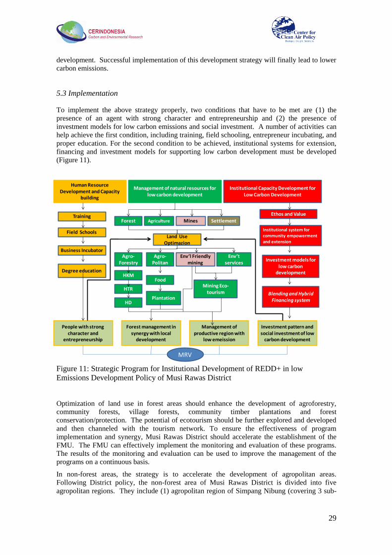
29
development. Successful implementation of this development strategy will finally lead to lower
carbon emissions.
5.3 Implementation
To implement the above strategy properly, two conditions that have to be met are (1) the
presence of an agent with strong character and entrepreneurship and (2) the presence of
investment models for low carbon emissions and social investment. A number of activities can
help achieve the first condition, including training, field schooling, entrepreneur incubating, and
proper education. For the second condition to be achieved, institutional systems for extension,
financing and investment models for supporting low carbon development must be developed
(Figure 11).
Figure 11: Strategic Program for Institutional Development of REDD+ in low
Emissions Development Policy of Musi Rawas District
Optimization of land use in forest areas should enhance the development of agroforestry,
community forests, village forests, community timber plantations and forest
conservation/protection. The potential of ecotourism should be further explored and developed
and then channeled with the tourism network. To ensure the effectiveness of program
implementation and synergy, Musi Rawas District should accelerate the establishment of the
FMU. The FMU can effectively implement the monitoring and evaluation of these programs.
The results of the monitoring and evaluation can be used to improve the management of the
programs on a continuous basis.
In non-forest areas, the strategy is to accelerate the development of agropolitan areas.
Following District policy, the non-forest area of Musi Rawas District is divided into five
agropolitan regions. They include (1) agropolitan region of Simpang Nibung (covering 3 sub-
Human Resource Development and Capacity
building
Management of natural resources for low carbon development
Institutional Capacity Development for Low Carbon Development
Training
Field Schools
Business Incubator
Degree education
Forest Agriculture Mines Settlement
Ethos and Value
Institutional system for community empowerment and extension
Blending and Hybrid Financing system
Investment models for low carbon
development
Land Use Optimazion
Agro-Forestry
Agro-Politan
Env’l Friendly mining
Env’tservices
Mining Eco-tourism
Food
Plantation
HKM
HTR
People with strong character and
entrepreneurship
Forest management in synergy with local
development
Management of productive region with
low emeission
Investment pattern and social investment of low
carbon development
HD
MRV

30
districts), (2) Megang Sakti (covering 4 sub-districts), (3) Simpang Terawas (covering 3 sub-
districts), (4) Simpang Semambang (covering 4 sub-districts), and (5) Prabumulih (covering 3
sub-districts; Figure 12). The development of agropolitan systems should optimize the use of
marginal land and maintain community rubber plantations through regeneration programs. To
increase the value added of agriculture products, specifically rubber and palm oil, local
governments should establish or facilitate the development of home-based industries and access
to markets and credit.
Figure 12: Master Plan for the Development of Agropolitan Region at Musi Rawas
District
To ensure the implementation of sustainable management principles and community economic
development in exploiting mining resources, local government should add a new component to
the environmental impact assessment. This should include assessment of the impact of mining
on GHG emissions and on mitigation plans. In this context, the Musi Rawas District
Government needs to issue local regulations that will force all the mining companies to develop
mitigation plans with community participation.
One of the elements in the regulation could be the application of an emissions cap for
mining companies. Any mining company would therefore only be allowed to release
certain emissions per unit of production, including LULUCF emissions. The allowable
emissions for each mining company should be defined based on the characteristic of the
mining. This would be coupled with requirements for forest and land rehabilitation.
The introduction of an emissions cap for mining companies is very important to ensure
the implementation of sustainable management principles by the companies.
Companies that release more than the allowable emissions shall do carbon offsets
blended with its CSR program.

31
The development of human capacity with entrepreneurship at the village level must be a key
program in implementing community-based REDD+. The target of the program should be
farmers/producers in the sectors of agriculture, fishery, and plantations, and groups living in and
around forests, with a special emphasis on women. The objectives of this program are to
increase the capability and skill of farmers in doing business, and to increase the bargaining
powers of farmers and women so that they can achieve positions such as traders,
businesswomen, or creditors. The development of human resources at the village level should
be accompanied with capable extension workers. Extension workers must work together with
communities and develop social learning systems which generate a reliable and beneficial
attitude toward entrepreneurship.
The process of community-based, regional development needs institutions which are not only
based on a government bureaucracy approach, but are also based on multi-stakeholder
cooperation. Strengthening community capacity to collaborate with various stakeholders
(government, business, academic, NGO) becomes important. Therefore, this multi-stakeholder
cooperation should be based on a participatory development approach which will give space to
various stakeholders to take a proactive and proportional role. This collaborative cooperation
provides space for all stakeholders by:
a. Providing a mechanism to collect and share the interests of the stakeholders by synergizing
technologies, human, information, and financing resources.
b. Increasing the participation of the community in planning, formulating, and deciding policy,
and also monitoring the implementation of low emissions development.
c. Expanding the network to influence stakeholders to support policies on low carbon
development.
d. Managing conflict to enable multi-stakeholder cooperation.
5.4 Financing
The existing system for financing forest protection activities is mainly through government
budgets, both national and local. To ensure integrated and sustainable REDD+ program
implementation, the Musi Rawas District Government should establish both Blending
Financing and Hybrid Micro Financing systems. The Blending Financing system will
synergize all financial sources such as CSR funding, government funding such as state budget
(APBN) and local government budget (APBD) funds, banking and international funding. This
system can help leverage private funding, and supports regional development based on urban
agriculture and agro-forestry:
Certain large companies can be utilized as financial sources through their CSR
activities.
Financing from CSR may be distributed to communities in various forms, such as in the
form of a fund to build human resource capacity through assistance and training
activities.
Financing can also be distributed as a capital fund that can be accessed by farmers
through micro finance institutions that have already been recognized by credit
assurance institutions. This will establish confidence between private companies and
communities regarding transparency of CSR fund distribution.
Unlike the Blending Financing model, the Hybrid Micro Financing system will utilize more
government funds than private funds. Funding to support smallholder forest plantation
development, which is currently handled by BLU-P3H (see Section 4.2), should be part of this
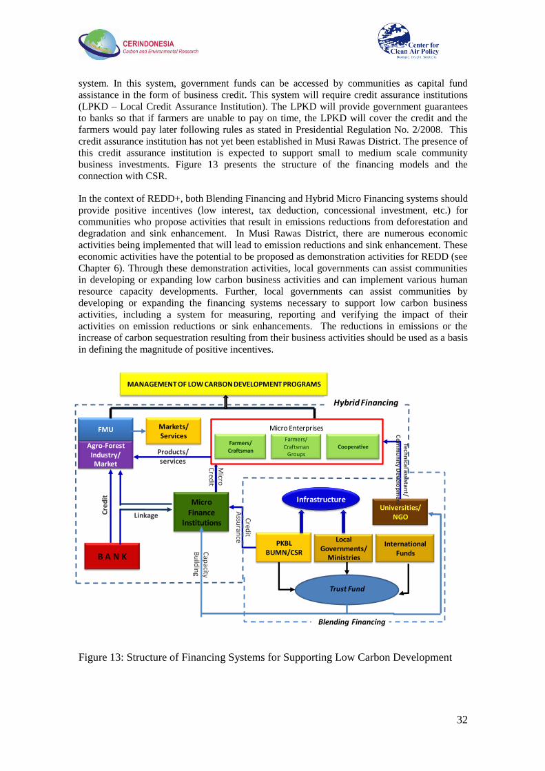
32
system. In this system, government funds can be accessed by communities as capital fund
assistance in the form of business credit. This system will require credit assurance institutions
(LPKD – Local Credit Assurance Institution). The LPKD will provide government guarantees
to banks so that if farmers are unable to pay on time, the LPKD will cover the credit and the
farmers would pay later following rules as stated in Presidential Regulation No. 2/2008. This
credit assurance institution has not yet been established in Musi Rawas District. The presence of
this credit assurance institution is expected to support small to medium scale community
business investments. Figure 13 presents the structure of the financing models and the
connection with CSR.
In the context of REDD+, both Blending Financing and Hybrid Micro Financing systems should
provide positive incentives (low interest, tax deduction, concessional investment, etc.) for
communities who propose activities that result in emissions reductions from deforestation and
degradation and sink enhancement. In Musi Rawas District, there are numerous economic
activities being implemented that will lead to emission reductions and sink enhancement. These
economic activities have the potential to be proposed as demonstration activities for REDD (see
Chapter 6). Through these demonstration activities, local governments can assist communities
in developing or expanding low carbon business activities and can implement various human
resource capacity developments. Further, local governments can assist communities by
developing or expanding the financing systems necessary to support low carbon business
activities, including a system for measuring, reporting and verifying the impact of their
activities on emission reductions or sink enhancements. The reductions in emissions or the
increase of carbon sequestration resulting from their business activities should be used as a basis
in defining the magnitude of positive incentives.
Figure 13: Structure of Financing Systems for Supporting Low Carbon Development
Micro Enterprises
Farmers/
Craftsman Groups
Farmers/
CraftsmanCooperative
Local Governments/
Ministries
PKBL BUMN/CSR
InfrastructureUniversities/
NGO
Tech
nica
l assista
nt/
Co
mm
un
ity De
velo
pm
ent
Micro
Cred
it
Cred
it A
ssuran
ce
MANAGEMENT OF LOW CARBON DEVELOPMENT PROGRAMS
Micro Finance
Institutions
B A N K
Agro-Forest Industry/Market
Products/services
FMU
Linkage
Cap
acityB
uild
ing
Trust Fund
International Funds
Cre
dit
Markets/Services
Hybrid Financing
Blending Financing
33
5.5 Indicators to Measure the Success of Low Emission Development
To be able to measure the impact of implementing a low carbon development strategy on
emission reductions, local governments and other stakeholders who participate in low carbon
business activities must be able to define the reference emission level and baselines for future
trajectories. These are crucial for establishing the amount of reductions that are deemed to have
occurred. The indicators should cover not only reduced carbon emissions and enhanced carbon
sequestration, but should also include socio-economic indicators. Local governments should
define a number of key socio-economic indicators to measure the achievement of implementing
low carbon development in the district. The key socio-economic indicators are:
1) Growth of low carbon business activities, such as forest protection/conversion through
ecotourism, sink enhancement activities in marginal lands, etc.
2) Community and local government income (Pendapatan Asli Daerah, PAD)
3) Job opportunity in the sector of cultivation, mining, as well as industry and service
4) Number of low income families
5) Human Development Index
Local governments may need to improve the current system of monitoring the above indicators.
34
6. REDD Demonstration Activities
Demonstration activities play an important part in the preparation of REDD+ implementation.
These demonstration activities provide lessons on the ground and experience in implementing
programs that address drivers of deforestation and forest degradation. Through such
demonstration activities, lessons in establishing reference emission levels and baselines,
development of financial institutions to support low carbon business activities, design of
effective programs for capacity building, monitoring and evaluating of programs, and required
policies/regulations for supporting good cases can be gained.
In addition to capacity building and development of proposals for effective implementation of
REDD at the local level, this study therefore also explored potential designs of REDD
demonstration activities (DAs) that could be implemented in Musi Rawas District. CER and
CCAP began by identifying existing programs in the district that could serve as the basis for
future REDD projects. The Musi Rawas District Government (MRDG), CER Indonesia and
CCAP have identified four potential REDD demonstration activities (DAs). These include:
a. Reduced deforestation and forest degradation through Integrated Coconut Utilization and
Ecotourism in the buffer area of Bukit Cogong Protection Forest. This REDD DA would
build upon two successful programs already underway in the district. In the proposed DA,
the ecotourism program will be expanded so that it will involve significantly more illegal
loggers and illegal mining families. The scale of production of virgin coconut oil and other
commodities will also be increased. b. Reduced deforestation and forest degradation through Intensive Agroforestry and
Microhydro activities in Kerinci Seblat National Park (KSNP). In this proposed REDD
DA, the intensive agroforestry program will be expanded from one village into five
villages: Taba Gindo, Muara Nilau, Karang Panggung, Batu Gane and Napal Melintang.
c. Development of a community plantation for reducing threats in the Kerinci Seblat
Conservation Forest and increasing carbon sinks at the Ulu Terawas sub-district
d. Development of a community timber plantation for enhancing carbon sequestration and
community participation in forest management in the Lakitan sub-district
During the study, the MRDG, CER Indonesia and CCAP have consulted with local
communities to design these REDD activities. However, due to limited time, the project was
only able to develop two preliminary designs for demonstration activities (DAs) with the
communities. Below, descriptions are provided for the first two demonstration activities
followed by short descriptions of two others.
6.1 Demonstration Activity 1: Reduced Deforestation and Forest Degradation through
Integrated Coconut Utilization and Ecotourism in the Buffer Area of Bukit Cogong
Protection Forest (HLBC)
Status
This activity has been discussed by the District Forestry Office, the Regional Planning Board,
the Board of Investment, the Estates Plantation Office and other agencies which are members of
the REDD Working Group in Musi Rawas. The local community is also very supportive and
welcomes this activity.

35
Figure 14: Discussion with Local
Stakeholders of Bukit Cogong
Rationale
The forests of Musi Rawas District have a high value for the livelihood of the residents there.
The forest provides clean water, biodiversity, temperature control and other benefits. About
50% of Musi Rawas is forest area. Based on the Minister of Forestry Decree No. 76/Kpts –
II/2001, the forest area at Musi Rawas District is divided into conservation forest, protected
forest, and production forest. Deforestation has occurred particularly in the production forest
due to the high rate of agricultural encroachment, illegal logging, mining activities and
unsustainable forest management practices. Currently, conservation and protected forests are
also exposed to a high risk of deforestation and degradation.
The Bukit Cogong Protection Forest (HLBC) is one of the important protected forest areas that
are currently threatened. Communities surrounding the forest still rely on HLBC to support their
livelihoods, and encroachment, illegal logging and stone mining in HLBC continue. If these
activities continue, the existence of HLBC will be at risk in the near future. To reduce this
threat, the local government has been educating the population and assisting the community to
develop forest-friendly activities.
In 2008, the government launched the Integrated Coconut Utilization Program to provide an
alternative livelihood for communities dependent upon the forest. Participating households
process coconuts using small-scale machines they purchase themselves, then sell the raw
material to the central processing center in the district where it is purified and refined into
products, including: virgin coconut oil (VCO); nata de coco; coconut briquettes; liquid smoke;
and cooking oil. With the exception of cooking oil, these products are then sold on the market.
The program was funded by the MRDG, which provided a one-time grant to cover the initial
investment in processing equipment. About 300-400 households (nearly one-fifth of the total in
five villages) participate in the program. In the ecotourism program, beginning in 2009 the
MRDG provided a series of grants to enable the local community to set up a nature walk, an
animal viewing center and other facilities, coupled with planting of rubber and some shade-
grown coffee. The government has also sponsored a community awareness program to educate
the local population on the importance of forest conservation.
These programs include families formerly involved with illegal logging and illegal mining, and
have had some success in reducing deforestation. For example, prior to implementation of the
Integrated Coconut Utilization Program there were about 50 households in the program area
engaged in stone mining; at present however it is estimated that only about 10 households do so.
In addition, while illegal logging and agricultural encroachment were a problem in the past,
these activities have now all but ceased in the area of the HLBC located in the district (See
Appendix 5). On-site research by CER and CCAP indicates a significant potential for scaling
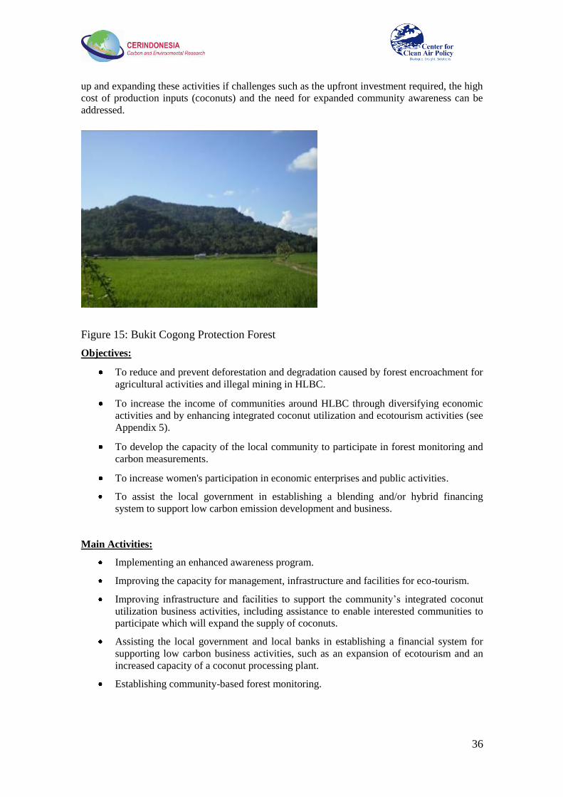
36
up and expanding these activities if challenges such as the upfront investment required, the high
cost of production inputs (coconuts) and the need for expanded community awareness can be
addressed.
Figure 15: Bukit Cogong Protection Forest
Objectives:
To reduce and prevent deforestation and degradation caused by forest encroachment for
agricultural activities and illegal mining in HLBC.
To increase the income of communities around HLBC through diversifying economic
activities and by enhancing integrated coconut utilization and ecotourism activities (see
Appendix 5).
To develop the capacity of the local community to participate in forest monitoring and
carbon measurements.
To increase women's participation in economic enterprises and public activities.
To assist the local government in establishing a blending and/or hybrid financing
system to support low carbon emission development and business.
Main Activities:
Implementing an enhanced awareness program.
Improving the capacity for management, infrastructure and facilities for eco-tourism.
Improving infrastructure and facilities to support the community‘s integrated coconut
utilization business activities, including assistance to enable interested communities to
participate which will expand the supply of coconuts.
Assisting the local government and local banks in establishing a financial system for
supporting low carbon business activities, such as an expansion of ecotourism and an
increased capacity of a coconut processing plant.
Establishing community-based forest monitoring.

37
Location
Proposed location is Desa Sukakarya, Kecamatan STL Ulu Terawas, Musi Rawas District.
Figure 16: Location of Demonstration Activity in Bukit Cogong (red circle).
Duration
5 years in phases: preparation phase (1 year); establishment phase (4 years).
Potential
This project will enhance and improve ecotourism and integrated coconut utilization, and will
encourage more illegal loggers and illegal miners to become involved. At least 60% of the
families will be involved in the programs, which is expected to significantly reduce the threat to
the HLBC.
Monitoring Plan
Monitoring activities will be conducted through collaboration between the District Forestry
Office, NGOs and communities around the forest. The project will provide training for staff of
the District Forestry Office in using GIS for measuring land use and forest cover change, and
will engage communities in performing carbon measurements and monitoring forest conditions
on the ground using GPS. Standard Operating Procedures (SOPs) for measuring and reporting
will be developed.

38
Participants, beneficiaries and stakeholders
The following stakeholders have been identified:
The local community
District Forestry Office
REDD Working Group Musi Rawas
NGOs such as OPLB (Organisasi Pemuda Langit Biru), APEL, and WBH (Wahana
Bumi Hijau)
Researchers
Local government
Central government
The local community will be the main project participant and beneficiary. Local NGOs are
expected to facilitate and assist the community to expand and improve the management of the
REDD project. Researchers in collaboration with the District Forestry Office and government
are expected to provide support and conduct the capacity building program. The REDD
Working Group will be responsible for registering the activities as one of the REDD DAs of
Musi Rawas, and for reporting to the Ministry of Forestry.
Capacity Building Requirements
The DA will require intensive capacity building for:
Geographic Information System (GIS)
Carbon estimation
MRV
Cultivation of coconuts, marketing and institutional strengthening
Benefits
The main incentives that can be obtained from these activities are the transfer of technology,
increased income, carbon credits, and increased environmental quality.
Regulatory Framework
Demonstration activity on REDD
The Minister of Forestry Regulation on REDD Demonstration Activity (P. 68/Menhut-II/2008)
was published in December 2008. This regulation aims at testing and developing methodology,
technology, and sustainable forest management institutions with the purpose of reducing carbon
emissions through controlling deforestation and forest degradation.
REDD Implementation
The Ministry of Forestry signed the Minister of Forestry Regulation (P. 30/Menhut-II/2009) on
Procedures for Reducing Emissions from Deforestation and Forest Degradation ("REDD
Regulation"). The REDD Regulation introduces the world's first national, legal regime for the
implementation of Reduced Emissions from Deforestation and Forest Degradation ("REDD")
projects and the issuance and trading of carbon credits.
Carbon Sequestration and/or Storage in Protected and Production Forests

39
The latest Minister of Forestry regulation regarding forest carbon trading is P. 36/Menhut-
II/2009. This regulation manages all activities that are related to carbon sequestration and
carbon storage in protected and production forests, including REDD+.
Bupati decree No. 228/2010, concerning the establishment of the REDD Coordinating Team in
Musi Rawas, and also national regulations related to REDD provide a starting point for
initiation of REDD activities in the district.
Risks
Risks which have been identified include the following:
Capacity of community-based organizations may be insufficient
Limited experience with community-based forest management
Government policy can change rapidly
Environmental Impact
These activities shall provide a beneficial environmental impact; the standing carbon stock on
HLBC will be protected.
Social Impacts
Relations between the local government (District Forestry Office) and local
communities surrounding HLBC will be improved
New income sources for the communities will be created (carbon credits, sale of non-
timber forest products)
Sustainability Prospects
These activities have the potential to create significant income for the community, and this will
encourage them to sustain these activities.
Links to National REDD Mechanism and Related Initiatives
The link to the national REDD mechanism will be provided mainly through district and
provincial working groups. Further proposed activities include:
Participation of local community in trainings, workshops and exhibitions related to
REDD+
Experience exchange with exposure visits to other demonstration activities
Enhancement of national REDD+ mechanism through experiences gained from the
demonstration activity and the piloted sub-national approach

40
6.2 Demonstration Activity 2: Reducing Deforestation and Forest Degradation through
Intensive Agroforestry & Microhydro Activity in Kerinci Seblat National Park (KSNP)
Status
This activity has been discussed by the District Forestry Office, the Regional Planning Board,
the Board of Investment, the Estates Plantation Office and by other agencies who are members
of the REDD Working Group in Musi Rawas. Local community is also very supportive.
Rationale
Kerinci Seblat National Park covers almost 1.4 million ha straddling four provinces, with
281,000 ha in South Sumatra province. Physically, KSNP is a part of the Bukit Barisan
Mountain Range, stretching north to south along Sumatra Island. The park‘s location makes
KSNP one of the richest conservation areas in terms of biodiversity, but KSNP is under great
threat of deforestation and forest degradation. A number of square kilometers of forest have
been lost annually in the national park, severely reducing the natural environment for animals
and other forest dwelling life.
The main drivers of deforestation and forest degradation in KSNP are encroachment by the
community for agricultural activities, illegal logging, and fires. Strong assistance from the
community will be essential to maintain KSNP.
Figure 17: (a) Slash and Burn Activity in KSNP, (b): Agricultural Land inside KSNP
Most of the villagers surrounding KSNP are involved in agricultural activities such as rubber
and coffee production. Each household has 1 to 25 ha of land for agriculture; although illegal,
some of this is done inside the KSNP area. Villagers enter the park because they need a large
amount of land for agriculture. The productivity of coffee beans is very low, at only 0.4 ton/ha
(normally 6-10 ton/ha), so they must cultivate a large area. There are at least four factors
contributing to the low productivity of rubber and coffee:
Seed sources. The source of coffee and rubber seeds used for agriculture is taken from
the forest or from their garden.
Maintenance. Most plantations are not well maintained. For example, there is no
fertilizer, no regular weeding and no spraying.
Harvesting. Harvesting is an important phase in determining quality and ultimately
affects the sales value of a product. The harvesting techniques currently used are
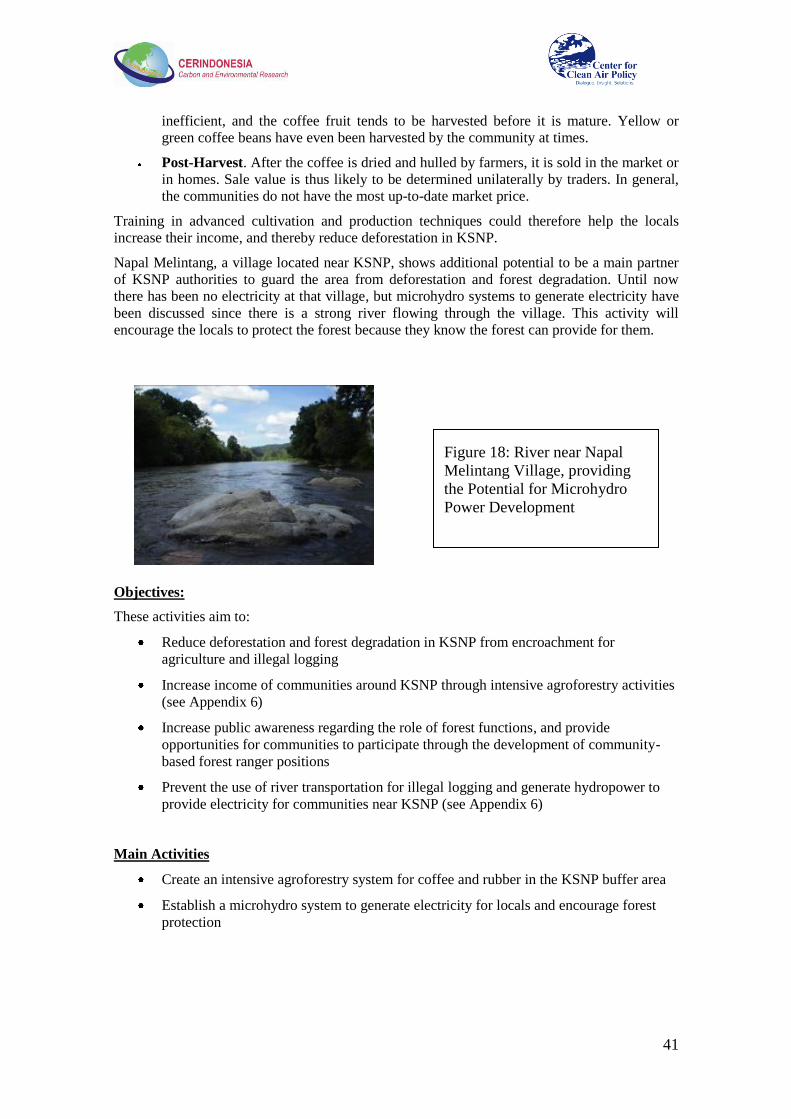
41
inefficient, and the coffee fruit tends to be harvested before it is mature. Yellow or
green coffee beans have even been harvested by the community at times.
Post-Harvest. After the coffee is dried and hulled by farmers, it is sold in the market or
in homes. Sale value is thus likely to be determined unilaterally by traders. In general,
the communities do not have the most up-to-date market price.
Training in advanced cultivation and production techniques could therefore help the locals
increase their income, and thereby reduce deforestation in KSNP.
Napal Melintang, a village located near KSNP, shows additional potential to be a main partner
of KSNP authorities to guard the area from deforestation and forest degradation. Until now
there has been no electricity at that village, but microhydro systems to generate electricity have
been discussed since there is a strong river flowing through the village. This activity will
encourage the locals to protect the forest because they know the forest can provide for them.
Objectives:
These activities aim to:
Reduce deforestation and forest degradation in KSNP from encroachment for
agriculture and illegal logging
Increase income of communities around KSNP through intensive agroforestry activities
(see Appendix 6)
Increase public awareness regarding the role of forest functions, and provide
opportunities for communities to participate through the development of community-
based forest ranger positions
Prevent the use of river transportation for illegal logging and generate hydropower to
provide electricity for communities near KSNP (see Appendix 6)
Main Activities
Create an intensive agroforestry system for coffee and rubber in the KSNP buffer area
Establish a microhydro system to generate electricity for locals and encourage forest
protection
Figure 18: River near Napal
Melintang Village, providing
the Potential for Microhydro
Power Development

42
Location
This activity is conducted on the buffer area of KSNP. There are four villages to be included,
Karang Panggung, Batu Gane, Napal Melintang and Petanang.
Figure 19: Location of Demonstration Activity 2 (red circle)
Duration
5 years in two phases: preparation phase (1 year); and implementation phase (4 years).
Potential
The activities are targeted to reduce encroachment and illegal logging activities in KSNP by
about 70% of the baseline.
Monitoring Plan
Monitoring activities will be conducted through collaboration between the District Forestry
Office, NGOs and communities around the forest. The project will provide training for staff of
the District Forestry Office to use GIS for measuring land use and forest cover change and will
engage communities to perform carbon measurement and monitor forest conditions on the
ground using GPS. Standard Operating Procedures (SOP) for measuring and reporting will be
developed.
43
Participants, Beneficiaries and Stakeholders
The following stakeholders have been identified:
Local Community, Pamhutswakarsa (Securing Community Forest)
The KSNP authority
District Forestry Office
REDD Working Group
NGOs such as WARSI, OPLB (Organisasi Pemuda Langit Biru), APEL, and WBH
(Wahana Bumi Hijau)
Researchers
Local government
Central government
The KSNP authority and local community will be the main project participants and
beneficiaries.
Capacity Building Requirements
The DA will require intensive capacity building for:
Geographic Information System (GIS)
Carbon estimation
MRV
Cultivation of rubber and coffee, marketing and institutional strengthening
Benefits
The main incentives that can be obtained from these activities include the transfer of
technology, increased income, carbon credits, and increased environmental quality.
Regulatory Framework
Demonstration activity on REDD
The Minister of Forestry Regulation on REDD Demonstration Activity (P. 68/Menhut-II/2008)
was published in December 2008. The intent of this regulation is to test and develop
methodologies, technologies, and sustainable forest management institutions that will contribute
to reduced carbon emissions through the control of deforestation and forest degradation.
REDD Implementation
This will also follow the Minister of Forestry Regulation (P. 30/Menhut-II/2009) on Procedures
for Reducing Emissions from Deforestation and Forest Degradation ("REDD Regulation").

44
Carbon Sequestration and/or Storage in Protected and Production Forests
The newest Minister of Forestry regulation regarding forest carbon trading is (P. 36/Menhut-
II/2009). This regulation manages all activities that relate to carbon sequestration and carbon
storage in protected and production forests, including REDD+. Musi Rawas Bupati decree No.
228/2010 regarding the establishment of the REDD Coordinating Team in Musi Rawas, in
combination with the three national regulations related to REDD, provides a strong foundation
for the implementation of these activities.
Risks
Risks identified include:
Capacity of community-based organizations may be insufficient
Limited experience with community-based forest management
Government policy can change rapidly
Environmental Impact
These activities shall reduce the rate of deforestation and forest degradation, and will provide
beneficial environmental impacts. Standing carbon stocks on KSNP will be protected and
increased as well.
Social Impacts
Relations between KSNP Authority and local communities surrounding KSNP will be
improved
New income sources for the communities will be created (carbon credits, sale of non-
timber forest products)
Sustainability Prospects
These activities have the potential to increase community incomes and to contribute to local
development by providing electricity. These benefits will in turn encourage the community to
sustain these activities. It is estimated that through this project, community income will increase
by some ten to twenty times of its current amount for the participating farmers.
Links to National REDD Mechanism and Related Initiatives
The link to the national REDD mechanism will be mainly provided through the proposed
district and provincial working groups. Further proposed activities include:
Participation of the local community in trainings, workshops and exhibitions related to
REDD+
Experience exchange with exposure visits to other demonstration activities
Enhancement of national REDD+ mechanism and modalities through experiences
gained from the demonstration activity and from the piloted sub-national approach

45
6.3 Demonstration Activity 3: Development of a Community Rubber Plantation to
Reduce Threats to the Kerinci Seblat Conservation Forest and Increase the Carbon
Sink in the Ulu Terawas Sub-District
In Musi Rawas District, the rubber plantation is a longstanding economic activity. In fact,
community economies in Musi Rawas District are predominantly supported by rubber
plantations. The total area of rubber plantations in this district is over 340,000 hectares. About
75% of it is owned by the community and the remaining is owned by large rubber estates. This
commodity is the main source of income for the community and also for the district. Most of
the existing rubber plantations have reached maturity, as they were planted 25 years ago. This
causes productivity to be lower than the optimum yield. On the other hand, the demand for
rubber is increasing. Without a progressive program to increase land productivity, the existing
forest may be threatened as communities expand to forested land.
The Musi Rawas Plantation and Estates Office has launched a rubber tree rejuvenation program
called The Revbun (Revitalisasi Kebun – Plantation Revitalization). The program aims to
accelerate the development of a community‘s plantation through the use of certified seedlings.
This proposed demonstration activity aims to reduce the risk of deforestation of KSNP forest
areas through improving productivity of existing rubber plantations. High quality rubber seed
will be used to rehabilitate degraded land in the non-forest area at Ulu Terawas Sub-District.
6.4 Demonstration Activity 4. Development of Community Timber Plantation to
Enhance Carbon Sequestration and Community Participation in Forest Management at
Lakitan Sub-District
In the past, the involvement of the community in forest management was very limited. Most
concession rights to manage forests were given to big companies. In many cases, this created
jealousy in local communities. With the issuance of Permenhut P.23/2007, an individual, group
of farmers or cooperative gained the ability to utilize forest area by attaining a Business Permit
for Utilization of Forest Wood Product from Smallholder Forest Plantation (IUPHHK-HTR).
Musi Rawas has already received approval to establish a Forest Management Unit of Production
Forest in Lakitan (see Chapter 4). The government also plans to propose to the Ministry of
Forestry that Musi Rawas be allowed to gain concession rights (permits) for communities in the
non-forested production forest area, to establish not only timber plantations but also agricultural
plantations in which trees can also be used as wood products. This demonstration activity
considers that most of the area in the FMU Lakitan has been used by the community illegally
(Table 4). This proposed demonstration activity also aims to provide legal access to the
community to use the land in the forest area under the FMU Lakitan to establish a timber
plantation and an agriculture plantation as envisioned under the scheme of the agropolitan
program. It would improve community income and reduce the community‘s interest in
encroaching upon or opening new lands by forest clearing. Access to financial sources for
smallholder forest plantations, which is currently managed by BLU-P3H, is proposed to be
simplified and integrated into a blended or hybrid financing system.
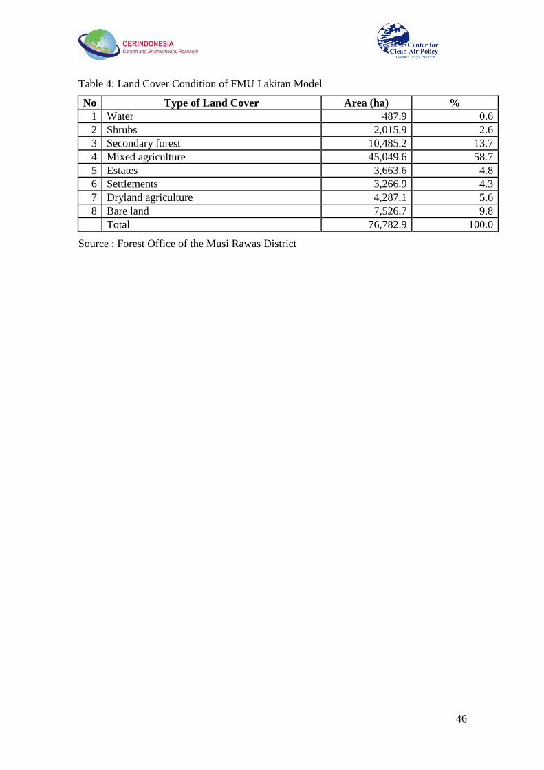
46
Table 4: Land Cover Condition of FMU Lakitan Model
No Type of Land Cover Area (ha) %
1 Water 487.9 0.6
2 Shrubs 2,015.9 2.6
3 Secondary forest 10,485.2 13.7
4 Mixed agriculture 45,049.6 58.7
5 Estates 3,663.6 4.8
6 Settlements 3,266.9 4.3
7 Dryland agriculture 4,287.1 5.6
8 Bare land 7,526.7 9.8
Total 76,782.9 100.0
Source : Forest Office of the Musi Rawas District
47
7. Co-benefits of REDD Implementation
The implementation of REDD+ activities can have a positive impact on the environment and on
the population. REDD+ activities can improve the quality of forests and hydrology, providing
direct or indirect benefits to humans surrounding the forest. These benefits include the
availability of clean water and improved health. Further, these activities will provide a space
for social interaction, community participation, and an increase in community income.
Some forest-related activities that have goals similar to those of REDD+ have been
implemented in several places in Musi Rawas, such as in the buffer zone of HLBC and KSNP
(see Chapter 6 and Appendices 5 and 6). Still, there is a need to expand the level of their
implementation in order to yield significant emission reductions from deforestation and
degradation. Nevertheless, many co-benefits have been delivered to local residents and also to
local governments. Below is a brief description of some of the co-benefits resulting from the
implementation of these two activities:
1. Improved community livelihood and reduced pressure on the forest. Local residents,
who once engaged in illegal logging and encroachment activities, now engage in the
management of the eco-tourism area around HLBC. Similarly in KSNP, local residents who
were involved with illegal logging and forest encroachment now are involved in the village
seedling program and Pamhutswakarsa (Community-Based Forest Ranger). There is also a
sense of pride for the residents who are involved in the management of tourism and
Pamhutswakarsa, which compliments increased incomes.
2. Increased household incomes. Before the integrated coconut utilization activity was
implemented, women were generally helping their husbands work in the fields or were at
home alone. With the participation of women in integrated coconut utilization, household
income has increased. Similarly, individuals involved in managing ecotourism and
integrated coconut utilization (in HLBC, these are generally male), and those who manage
the village nursery (in KSNP), earn income for their family.
3. Improved social role of the community. With their involvement in the management of
eco-tourism in HLBC and seed village activities in KSNP, these residents are providing
empowering examples and are providing positive social influence on surrounding villages.
This can change the perception of people towards the illegal actors from negative to
positive. Local residents who are involved in the management of tourism areas in HLBC are
not only employed, but also determine management policy. They also have started a system
of participatory planning and shared benefits. The distribution of benefits between actors
involved in ecotourism activities is given in Table 5 below.
Table 5: Benefit Sharing in Ecotourism HLBC
No Actors % Note
1 Local communities 60 Agreements between local
workers and landowners to not
cut down the trees around the
tourism area were legally binding
in the form of a Notary Act.
Percentages for these results will
be reviewed and approved by the
local government.
2 Land owner 20
3 Maintenance and development cost 20
48
4. Improved social role of women. In the HLBC programs, the composition of working staff
in the integrated coconut utilization program is dominated by women (more than 80%).
Many women involved in this program perform work that requires precision, patience and a
great deal of time. Increasing the role of women in this capacity therefore improves
women‘s livelihoods and enhances their role in society.

49
8. Local and National Lessons
8.1 Local Implications of the Project
As discussed in the strategic program for developing a REDD+ institution for the Musi Rawas
District (see Figure 12 above), the key objective is to develop a good spatial plan so that
utilization of lands can be optimized and lead to lower carbon emissions. Referring to Figure 8,
it can be seen that Musi Rawas has huge mining potential. Without adequate spatial plans, land
use policies, and strict regulation on exploitation of mining resources, the future GHG emission
from Musi Rawas, particularly from the mining sector, will grow very fast and low carbon
development may not be possible. To achieve low carbon development, two other strategic
programs have to be in place: the development of human resources and capacity building to
generate good agents of change in the community with strong entrepreneurship; and
establishment of strong institutional systems, including a financing system. To ensure that the
strategic programs are implemented, they must be streamlined into a local development plan.
Considering this fact, four local implications of the project are described below.
1. Optimization of Land Utilization
In the context of regional development, REDD+ implementation in Musi Rawas District
requires economic development that is based on natural resource management oriented to
community based low carbon development. The process must be in line with poverty reduction
and overcoming unemployment, and should increase local economic resilience. Therefore, the
MRDG should establish a team to oversee the implementation of land use arrangements based
on the Spatial Planning Law No. 26 of 2007. This team will be the source for the Musi Rawas
Regent to identify a balanced development of natural resource management information for
leading economic development (forestry, agriculture, food, fisheries, community plantations,
and mining). Enforcement of the law stipulating the use of space for the development of
economic sectors needs to be done consistently.
The MRDG should have concrete steps to implement the Regulation of the Minister of Home
Affairs Number 51 of 2007, which addresses community-based area development. This is
important because it develops community empowerment activities at the village level, and can
support the implementation of REDD+ Programs. The implementation of this program can also
encourage the formation of multi--stakeholder dialogues and environmentally friendly natural
resource management, conservation and rehabilitation efforts.
2. Human Resource Development and Capacity Building
Implementation of REDD program activities requires a change in the community work ethic.
Thus, Musi Rawas District needs to prepare a program to open a new mindset for communities
through dialogue and collective learning which develops productive activities on the basis of
ecological adaptiveness and socio-cultural adjustment. Activities of this program should be
developed through participatory training, field schooling and business incubation, with a
cultural approach to finding a form that improves the utilization of natural resources for
economic development and provides harmony with social and environmental change.
Such a program needs to be done systematically within a framework that encourages
communities to achieve better living in the future. Before training, field school or business
incubation, there are several steps that need to be taken. First, the community should be invited
to identify the conditions and potential in their own villages. Second, comparisons should be
made with other village development and rural-urban relations in Musi Rawas District. After
these two steps, communities are invited to learn from designing natural resource management
in accordance with the spatial planning government policy.
In the context of capacity building, the program needs to involve multiple stakeholders (e.g.
local government entities, facilitators of the women‘s empowerment program, facilitators of

50
village and community empowerment, business entities, religious leaders, NGOs and University
of Musi Rawas representatives). Cooperation should use a participatory method that builds
awareness and strengthens the ability of all parties involved to work together. The community
should also be encouraged to form and facilitate organizations to launch small- and medium-
sized enterprises.
3. Institutional Development
Institutional development needs to be improved in Musi Rawas District to accommodate the
activities of REDD+. The MRDG should be more focused on cooperating with stakeholders so
that efforts to reduce deforestation and degradation through economic diversification of
communities inside and outside the forest area can be more effective. In addition, multi-
stakeholder cooperation should be better organized to maintain forest conservation and
protection and to enable sustainable forest management.
Musi Rawas District also needs to set up institutional processes to define reference emission
levels, baselines and an institution system for MRV. Involvement of various stakeholders in
defining reference emission levels is very important to ensure each understands the reference
being used in measuring emission reductions achievements and agreed actions for REDD+.
This step is essential because the stakeholders will recognize the importance of developing
synergistic cooperation to achieve the effective implementation of REDD+.
The MRV mechanism should be built based on the current monitoring and evaluation systems
in operation. Therefore, it is recommended that a Special Unit be established in the Regional
Development Planning Board by a decree of the Musi Rawas Regent. Construction of this
Special Unit would be followed by support staff training, development of information systems,
and provisioning of computer equipment.
An important factor in effective REDD program implementation is the availability of a funding
system. The MRDG should build a financial institution to support REDD program activities that
formulate a policy to establish the Insurance Regional Credit Agency and Trust Fund. This
policy would allow the MRDG to exploit various sources of financing other than government
funds (APBN/APBD), such as from CSR and international agencies. This policy is a strategic
step in supporting the development of small and medium enterprises that are consistent with the
implementation of REDD +, and can encourage the development of low-emissions businesses.
4. Implementation Draft of REDD+ in Medium Term Regional Development Plan 2011 -
2015
The REDD Working Group (RWG) in Musi Rawas District should ensure that REDD+
concepts are incorporated into the Medium Term Regional Development Plan (RPJMD) for
2011-2015, a local environmental planning scheme currently in the preparation phase. REDD +
could thus become part of the official development agenda to be implemented during the next
five years. It is recommended that the RWG should be the ―voice‖ of REDD+ within regional
development, in ways such as:
Enhancing public opinion about the importance of the implementation of REDD+ by
using local newspapers and radios.
Communicate with the Regents and members of the District House of Representatives
to share ideas about low carbon development.

51
8.2 National Implications of the Project
1. Role of National Government in Monitoring Land Use and Forest Cover Change
As stated in UNFCCC guidance (such as decision 2/CP.13), when implementing REDD+
activities the national government should establish robust and transparent national and, if
appropriate, sub-national forest monitoring systems using a combination of remote sensing and
ground-based forest carbon inventory approaches. Monitoring systems should provide estimates
that are as transparent and consistent as possible, reduce uncertainties, and produce results
available for review as agreed by the UNFCCC. In this context, the national government should
establish institutional mechanisms to coordinating all monitoring systems developed by local
governments.
Considering that the capacity of local governments to use remote sensing and ground-based
forest carbon inventories varies considerably and that there is a need to have monitoring
systems that provide transparent and consistent estimates, the national government should be
responsible for providing the results of land use/forest cover change monitoring to local
governments regularly (on annual or seasonal basis). Local governments should be responsible
for providing the results of field verification to the national government. Through this process,
the national government can continuously improve the spatial land use map and provide the
local government with more accurate land use and forest cover maps.
2. Proposal for including a GHG Emissions Indicator in the Environmental Impact
Assessment
During the final workshop (Appendix 7), participants raised the possibility of including GHG
emissions into the environmental impact assessment of business operations, and using the GHG
emission level as an indicator to determine the level of contribution of companies to support
carbon offset programs conducted by communities. Under the current regulation, the impact of
implementing project activities on GHG emissions is not considered by the EIA. Therefore, it
was proposed that a regulation on applying an emissions cap for companies may be necessary to
encourage companies to adopt low carbon practices. If the emissions of the companies are over
the cap they would pay a certain amount of funds to the government, to be used for supporting
low carbon business activities and carbon offsets or emission reduction programs conducted by
communities.
52
9. Conclusions and Recommendations
With the absence of policy and program-driven REDD+ incentives, the potential for emissions
from deforestation and forest degradation in Musi Rawas District is high. Important drivers of
deforestation and forest degradation include conversion of forests to crop lands, conversion for
mining or settlement, illegal logging, forest fires, and forest clearing for timber plantations. In
collaboration with CCAP and CER Indonesia, the Musi Rawas District Government has
established a REDD Working Group. This institution will work with stakeholders in
formulating district REDD+ strategies consistent with programs related to land use and
management of forest resources underway or planned in Musi Rawas District.
This study recommends that the implementation of REDD+ be done through utilization of
natural resources using a regional unit approach that fits well with the existing Regional Spatial
Plan and with technology application, economic-development, institution strengthening,
capacity building and human resources development. REDD program design should involve
various stakeholders, and should be integrated into existing development programs. All
programs and efforts designed and implemented by various stakeholders and related to
community development should be synergized in order to achieve low carbon development.
Two conditions that have to be met in order to achieve low carbon development are the
presence of agents of change with strong character and entrepreneurship, and the presence of
investment models for low carbon emissions and social investment. The study also recommends
that local governments employ a system of capable extension workers to work together with
communities, and to develop social learning systems which generate a reliable and a positive
attitude of entrepreneurship.
The establishment of Blending and Hybrid Financing Systems is very important to support
community participation in low carbon business activities. These financial systems should
provide positive incentives for communities who propose activities that result in emission
reductions from deforestation and degradation and sink enhancement.
These systems will synergize and optimize all financial sources such as CSR funding,
government funding (APBN, APBD)
It is also strongly recommended that a GHG emission indicator is included in the
Environmental Impact Assessment of business activities, to be used as a basis for
determining companies‘ contributions though the CSR fund to support community
based-REDD activities
Support from the national government is required to implement community-based low carbon
development. Support is needed not only to provide financial support and greater access to land
in forest areas, but also to give more flexibility in selecting tree species that can be planted in
forest areas, meet local needs, and therefore improve the probability of success.
To measure the impact of implementing low carbon development strategies on emission
reductions, the local government and other stakeholders must be able to define the
reference emission level (REL) and baselines for future trajectories, and should
establish a strong MRV system.
To ensure that efforts to reduce emissions are within the context of sustainable
development as mandated by the UNFCCC, the MRV system should include key socio-
economic indicators. Among these key indicators are growth of low carbon business
activities, community and local government income, job opportunity, and incidence of
low income families.

53
At the local level, several immediate steps are necessary for effective implementation of
REDD+:
Acceleration of the establishment of Forest Management Units is crucial for successful
implementation of community based REDD+ activities. FMU specific roles and
functions, including establishing relationships with communities and with concession
holders, should be developed as soon as possible.
To ensure the REDD+ Program will become a part of the official development agenda,
it is necessary to integrate the REDD+ strategy into the Medium Term Regional
Development Plan 2011-2015, which is now being prepared.
The establishment of the Musi Rawas District REDD Working Group, facilitated in large part
by CCAP and CER Indonesia, was a key accomplishment of the CCAP project. However,
further capacity building for the RWG is still needed as indicated above. This includes the
following activities:
1. Increasing the understanding of the local government on the concept and mechanisms of
MRV.
2. Developing and improving the human resources capacity of the Musi Rawas District‘s local
government offices in the preparation and operation of MRV systems.
3. Developing capacity in defining and estimating reference levels and reference emission
levels.
4. Developing key local regulations and their link with national regulations required to support
the implementation of REDD activities, in accordance with REDD policy at the national and
international levels.
5. Further elaboration and design of potential REDD Demonstration Activities and
communication with potential funders and investors.

54
References
BPS, 2007. Musi Rawas in Figures 2006.
BPS, 2008. Musi Rawas in Figures 2007
BPS, 2009. Musi Rawas in Figures 2008
BPS, 2010. Musi Rawas in Figures 2009
CER Indonesia, 2009. REDDI Feasibility Study for Banyuasin District (Sembilang National
Park) and Musi Rawas District (Kerinci Seblat National Park).
Musi Rawas District Government, 2009. Rencana Tata Ruang Wilayah Kabupaten Musi Rawas
tahun 2009-2029.

55
Appendix 1: Summary of REDDI Feasibility Study for Musi Rawas
District
Study conducted by CER Indonesia and funded by the Japan International Cooperation
Agency (JICA)
Musi Rawas District is a district in South Sumatra with area of 1,236,583 ha, and lies between
2°15‘ – 3°40‘ South and 102°00‘ - 103°40‘ east. Its capital city is now Muara Beliti. The district
includes parts of one of Indonesia‘s main National Parks, Kerinci Seblat National Park (KSNP).
In 2008, the district population was 478,189 inhabitants, with 80% of them working as farmers.
There are 26 villages inside and surrounding the KSNP area: four are inside the area with a total
population of about 4,462 people, and 22 are outside with a population of about 42,705 people.
Based on interpretation of 2006‘s satellite imagery from BAPLAN, Musi Rawas District has an
area of about 1.25 million ha. Some 50% of this area is still covered by forest while other areas
have been converted to land uses such as plantations (particularly rubber and coffee) and paddy
fields. About 78% of the forested land is primary dry land forest, while the remaining is
plantation forest. Most of the forested land is located in Kerinci Seblat National Park.
The land ownership systems of most communities surrounding KSNP are based on the
recognition of community members or relatives rather than on certificates or other legal letters.
The owner of the land is the first person who cleared the forest for farming activities. Land
borders are clearly defined and generally the community leaders know the border. In many
regions in Indonesia, traditional ownership is used by the community collectively for
generations.
In opening the forest, farmers still perform slash and burn practices. This practice has been
implemented before establishment of KSNP; one example is the community of Kampung
Malus. After clearing the land, farmers in this community usually apply an intercropping system
between annual crops and perennial plants such as rubber and coffee. They plant annual crops
for 4-5 years and afterward they will seek new land.
The CER Indonesia Feasibility Study identified the following main drivers of deforestation and
forest degradation in Musi Rawas:
a. Illegal Logging
Illegal logging is conducted by communities surrounding KSNP and by timber
plantation companies. It is happening due to a significant difference between supply and
demand in Indonesia‘s logging industry. The high demand and low supply of timber
encourage illegal logging to fulfill the demands.
Statistical data shows that in the period of 2002-2008 there were 584 cases of illegal
logging in KSNP, with more than 200,000 hectares in KSNP having been degraded as a
result. Before 2005, almost all regions surrounding KSNP suffered illegal logging, but
nowadays it happens in only a few locations such as Napal Melintang Village and
Petanang Village, and at a lower level of intensity.
b. Agricultural Encroachment
Poverty and difficulty in finding jobs and creating successful businesses within the
surrounding community have triggered forest encroachment and extraction of forest
resources from the forest territory to fulfill people‘s needs.
The encroachment is also happening due to different perspectives on the forest/village
border with KSNP. At this moment, the formal border is about 500 m from the village.
However, the community is still applying the colonial period‘s understanding, which
56
stated that the border area is 10 km from the village. This leads locals to assume that
they do not have to ask for permission to enter KSNP and conduct land clearing.
c. Forest Fires
Forest fires are caused mainly by uncontrolled burning related to land conversion,
illegal cultivation, and extreme climate change, which may burn grass, trees and peat
land. Despite the fact that Sumatra frequently experiences forest fires, large-scale forest
fires have never happened in Musi Rawas District, particularly in KSNP. In this area
smaller forest fires occur mostly due to land conversion activities conducted by the
community.
Aside from the abovementioned drivers, establishment of industrial plantation forest and
plantations also stimulates the release of carbon to the atmosphere through land clearing
activities and canal construction. Development of a canal drainage system following the
opening of peatlands will accelerate peat subsidence and the release of CO2.
The analysis showed that annual emissions from deforestation and forest degradation in Musi
Rawas District from 2003-2006 were about 5,881,932 tons CO2, mostly from deforestation of
secondary swamp forest (peat forest)11
and degradation of primary dry land forest. These two
sources alone accounted for about 87% of the total emissions from deforestation and forest
degradation. Based on data from 2003 to 2006, the total area deforested or degraded in KSNP
was about 17,933 ha. The annual rate of deforestation over this three-year period was about
1,468 ha, while that of degradation was 4,509 ha. Degradation of forest was primarily due to
illegal logging. The rate of emissions from deforestation and forest degradation in the national
park was about 2,160,587 tons CO2 per year.
A potential source of future GHG emissions in Musi Rawas District may include the conversion
of forested lands to mining (planned deforestation) and to agricultural land (unplanned due to
the displacement of agriculture activities or unplanned deforestation). The potential emissions
from planned deforestation are estimated to rise to 4,051,997 tons CO2; emissions from
unplanned deforestation may reach about 41,588,052 tons CO2. In total, the potential future
emissions would be about 45,640,049 tons CO2.
For KSNP, potential emissions from planned deforestation are zero because planned
deforestation is illegal. Future emissions in the KSNP will mainly come from unplanned
deforestation from agriculture encroachment and illegal logging.
Reducing emissions from deforestation and degradation can be implemented through the
following activities: (1) Community business and economic development in buffer zone, (2)
Development of community ecotourism around Bukit Sulap and Napal Licin, (3) Improvement
of intensive agriculture system, (4) Development of jelutung crops for sap and timber
production, and (5) Safeguarding the forest territory. At present, these activities are already
implemented by NGOs and KSNP.
11
Emissions from the removal of living biomass. Emissions from land subsidence due to the establishment of canals
or fire were not taken into account.

57
Appendix 2: Minutes of the Meeting of the Seminar on Community
Based Rural Development
Date : 5 March 2010
Place : BAPPEDA Musi Rawas Building
Participants : 30 people (representatives from government, communities, NGOs and
universities)
This workshop was initiated and organized by IPB; logistic arrangement was assisted by a team
from CCAP and CER Indonesia. The event started with a brief presentation about opportunities
for community-based REDD+ by Dr. Lala Kolopaking. According to Dr. Kolopaking, this
activity is a form of cooperation between the Bogor Institute of Agriculture (represented by the
Center for Agricultural and Rural Development Studies, or PSP3) with Musi Rawas
(represented by the Bupati) and could demonstrate how to build a development in Musi Rawas
with good and effective governance.
In the process of this cooperation, PSP3 developed partnerships with CER Indonesia and
CCAP. The core of this activity is to reduce emissions of greenhouse gases from deforestation
and forest degradation, through integrated activities with communities that yield economic
value.
In order to help these activities succeed, the project established a formal Working Group in
Musi Rawas on REDD. This REDD Working Group consists of various stakeholders who have
the capacity and commitment to improve development in Musi Rawas. Stakeholders hope that
this forum will be established by formal policy, such as the Bupati Decree, which would show
the willingness of the Musi Rawas and local governments to participate in REDD+ activities.
The target is to establish the Bupati decree on March 2010, and BAPPEDA was assigned to
facilitate the establishment.

58
Appendix 3: Training on Reducing Emissions from Deforestation and
Forest Degradation (REDD) for RWG of Musi Rawas, 20 – 21
March 2010
A. Training materials:
1. The Opportunities of REDD+ Implementation in Musi Rawas (Prof. Rizaldi Boer)
2. Community based REDD+ (Dr. Lala Kolopaking)
3. Institutional REDD +: Challenges and Agenda (Dr. Bramasto Nugroho).
B. Discussion on the training process
There is an increased understanding of the RWG on REDD+.
Before the training, some members of the RWG assumed that REDD+ is not in line
with development programs in Musi Rawas related to agropolitan. Group members
consider that social welfare can be improved though an agrarian-based regional
economy with low emissions, through the development of agropolitan synergized with
REDD+.
Group members consider that the Musi Rawas development regime can be implemented
with the REDD+ mechanism.
RWG hopes for a good method in implementing REDD activities that will meet
national and international standards.
A question was raised regarding how the institutional system for REDD + will be
arranged (the cost of assistance, capacity building for MRV, and the system of
bureaucracy between district, provincial and national)
If the Minstry of Forestry is completing the national commission on REDD, the Musi
Rawas RWG could be a smaller unit of the regional/district REDD Commission.
Currently, in some areas in Musi Rawas people are reluctant to plant trees other than
rubber. The group should determine how rubber trees can store carbon compared to
other species. Rubber harvesting is an activity that has been carried out for generations,
and may have potential for conservation and carbon enhancement in Musi Rawas.
For the success of the program, we need to plant tree species continuously, such as
bamboo. Can bamboo be included in REDD? Musi Rawas once had an offer to try to
export bamboo, but it never happened.
Local strategies for REDD+ include forest conservation, decreasing the intensity of
illegal logging, encroachment, fires, afforestation and reforestation.
Is REDD just like a project or is it a program? If it is project, will it be sustainable?
The smallholder plantation forest in Musi Rawas has been formalized by the Ministry
of Forestry, with the total area about 20,000 ha. Currently, the forest office in Musi
Rawas is still developing the plan and strategies for its implementation
Musi Rawas currently has a planting and maintenance program and some potential for a
pilot project and scaling up with financing.
NGOs need to participate in the working group. NGOs need to hear the government's
policy, and the government needs to know the plan of NGOs and what type of
government assistance they require.
59
Musi Rawas has good opportunities for REDD demonstration activities, as JICA and
CER Indonesia previously conducted a technical feasibility study. With the CCAP
project the district now has some knowledge of policy and technical issues related to
REDD.
Microhydro is a potential activity that can be done if there is a clear request from the
community and the required data is collected.
C. Challenges and barriers in implementing REDD+ in Musi Rawas
30 mining concessions exist in Musi Rawas. 60% of this area is within the forest area,
and 70% overlaps with plantation concessions. This mining area is also very close to
the KSNP area. Production will begin in 2011, and threats to forest areas will increase.
Palm oil plantations have also become promising in Musi Rawas as people convert their
rubber plantations to palm oil frequently in expectation of higher incomes, leading to
deforestation. Many overlapping areas also exist between the concession of mining,
forestry and plantations, further complicating matters.
Earlier, there was an encroachment on Bukit Cogong Protection Forest by the
community because of efforts to develop alternative non land-based activities such as
making natade coco, charcoal briquettes, virgin coconut oil and liquid smoke (to harden
the rubber). The encroachment has been decreased through a program funded with a
grant from the forest office, but it cannot yet be optimized and marketed to other
regions because of lack of funding.
Many domestic funds such as CSR, national budget and special funds aim to reduce
emissions. Funds also arrive from abroad such as the UN REDD, PCPF, GEF, CIF and
various other sources. Can the Working Group prepare concrete activities that could use
these funds to support the low emissions development?
D. Things that need to be done by the RWG
1. Make a schedule of activities and deadlines for the RWG.
2. Identify the key drivers and causes of deforestation and forest degradation.
3. Identify the types of activities and programs that have been conducted already to address
deforestation and forest degradation.
4. Identify any successful programs to protect the forest that have been already done. Then,
identify what remains (e.g. monitoring, capacity building, replicating programs or funding).
5. For KSNP, find information on the condition of KSNP natural areas: which areas are still
intact, and which have the threat of mines, the pressure of the economy or other threats.
Further, provide alternative activities to be undertaken in these areas.
Organizational Note:
The estate plantation agency provided a room for the RWG secretariat.
The RWG will meet once in two weeks.
Participants:
1. Ir. Setio Yuwono, M.Si
2. Ir. Tri Retyanto, MM

60
3. Ir. Ramdani, M.Si
4. Ir. Subardi
5. Ir. H. Johan Firdaus, M.Si
6. Sri Lastuti, S.Hut
7. Erwin Sayrif, ST, MT
8. Muhammad Ichwan, S.Hut
9. Ir. Sunarso Wardhoyo
10. Harry Suwardi, S.Si
11. Ghufron
12. M. Zainuddin
From Bogor:
1. Prof. Dr. Rizaldi Boer
2. Dr. Lala Kolopaking
3. Dr. Bramasto Nugroho
4. Muhammad Ridwan
5. M. Iqbal
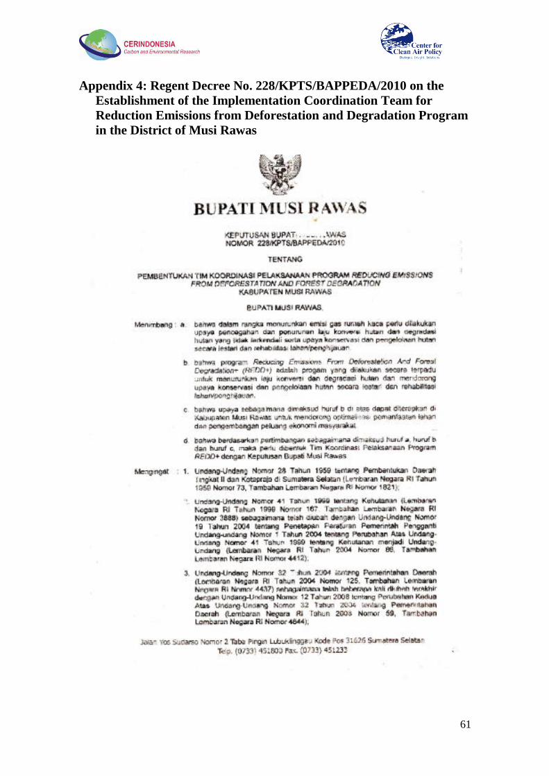
61
Appendix 4: Regent Decree No. 228/KPTS/BAPPEDA/2010 on the
Establishment of the Implementation Coordination Team for
Reduction Emissions from Deforestation and Degradation Program
in the District of Musi Rawas
62

63
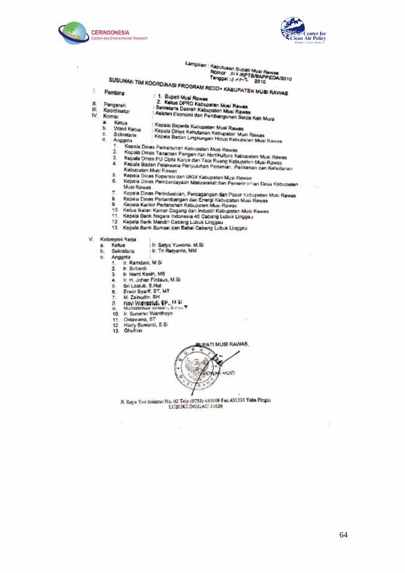
64
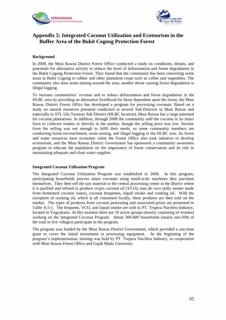
65
Appendix 5: Integrated Coconut Utilization and Ecotourism in the
Buffer Area of the Bukit Cogong Protection Forest
Background
In 2008, the Musi Rawas District Forest Office conducted a study on conditions, threats, and
potentials for alternative activity to reduce the level of deforestation and forest degradation in
the Bukit Cogong Protection Forest. They found that the community has been converting some
areas in Bukit Cogong to rubber and other plantation crops such as coffee and vegetables. The
community also does stone mining around the area; another threat causing forest degradation is
illegal logging.
To increase communities‘ revenue and to reduce deforestation and forest degradation in the
HLBC area by providing an alternative livelihood for those dependent upon the forest, the Musi
Rawas District Forest Office has developed a program for processing coconuts. Based on a
study on natural resources potential conducted in several Sub-Districts in Musi Rawas and
especially in STL Ulu Terawas Sub District (HLBC location), Musi Rawas has a large potential
for coconut plantations. In addition, through 2008 the community sold the coconut in its intact
form to collector traders or directly in the market, though the selling price was low. Income
from the selling was not enough to fulfil their needs, so some community members are
conducting forest encroachment, stone mining, and illegal logging in the HLBC area. As forest
and water resources have economic value the Forest Office also took initiative to develop
ecotourism, and the Musi Rawas District Government has sponsored a community awareness
program to educate the population on the importance of forest conservation and its role in
maintaining adequate and clean water supplies.
Integrated Coconut Utilization Program
The Integrated Coconut Utilization Program was established in 2008. In this program,
participating households process intact coconuts using small-scale machines they purchase
themselves. They then sell the raw material to the central processing center in the district where
it is purified and refined to produce virgin coconut oil (VCO), nata de coco (jelly sweets made
from fermented coconut water), coconut briquettes, liquid smoke and cooking oil. With the
exception of cooking oil, which is all consumed locally, these products are then sold on the
market. The types of products from coconut processing and associated prices are presented in
Table A.5-1. The briquette, VCO, and liquid smoke are sold to PT. Tropica Nucifera Industry,
located in Yogyakarta. At this moment there are 10 active groups (mostly consisting of women)
working on the Integrated Coconut Program. About 300-400 households (nearly one-fifth of
the total in five villages) participate in the program.
The program was funded by the Musi Rawas District Government, which provided a one-time
grant to cover the initial investment in processing equipment. At the beginning of the
program‘s implementation, training was held by PT. Tropica Nucifera Industry, in cooperation
with Musi Rawas Forest Office and Gajah Mada University.
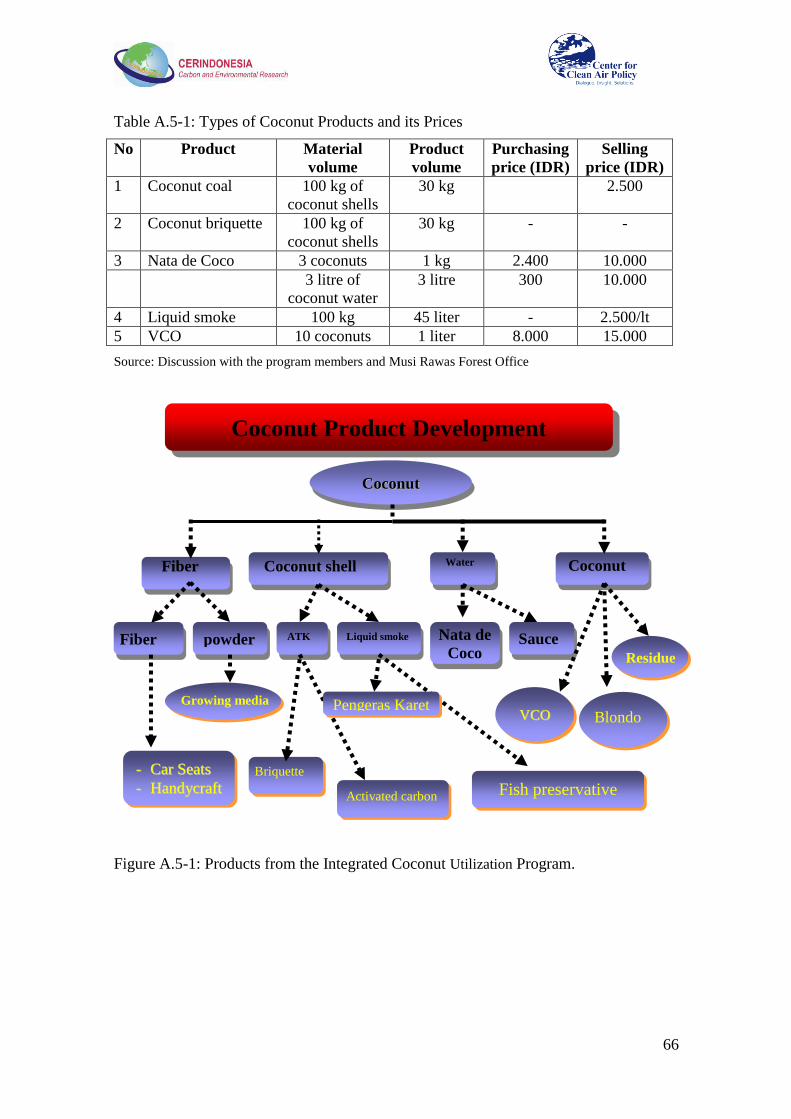
66
Table A.5-1: Types of Coconut Products and its Prices
No Product Material
volume
Product
volume
Purchasing
price (IDR)
Selling
price (IDR)
1 Coconut coal 100 kg of
coconut shells
30 kg 2.500
2 Coconut briquette 100 kg of
coconut shells
30 kg - -
3 Nata de Coco 3 coconuts 1 kg 2.400 10.000
3 litre of
coconut water
3 litre 300 10.000
4 Liquid smoke 100 kg 45 liter - 2.500/lt
5 VCO 10 coconuts 1 liter 8.000 15.000
Source: Discussion with the program members and Musi Rawas Forest Office
Figure A.5-1: Products from the Integrated Coconut Utilization Program.
Coconut Product Development
CCooccoonnuutt
VVCCOO
-- CCaarr SSeeaattss
-- HHaannddyyccrraafftt
Fiber Coconut shell Water Coconut
Fiber powder ATK Liquid smoke Nata de
Coco Sauce
Blondo
Residue
Growing media
Briquette
Activated carbon Fish preservative
Pengeras Karet
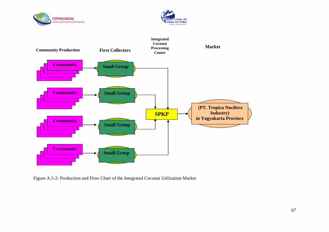
67
Figure A.5-2: Production and Flow Chart of the Integrated Coconut Utilization Market
Community Community
Community Community
Community Community
Community Community
Community Community
Community Community
Community Community
Community Community
Small Group
Small Group
Small Group
Small Group
SPKP
(PT. Tropica Nucifera
Industry)
in Yogyakarta Province
Community Production First Collectors
Integrated
Coconut
Processing
Center
Market

68
Ecotourism
To preserve the HLBC and raise community awareness of the importance of environmental
protection, a buffer zone with ecotourism was created within community lands. Some of the
tourism facilities to be built include a nature walk, swimming pools, a fish pond, and a mini zoo.
Former encroachers, illegal loggers, and others from the surrounding community have been
trained to operate these facilities.
A facility that has already started operation is the outbound facility, designed for outdoor
activities. It is built on an area previously planted with rubber. The community acts as owner
of the land and the rubber trees, and has made an agreement with the facility management to not
cut the trees in the tourism area. To compensate, the facility manager has arranged the following
profit sharing scheme with the land owners:
Table A.5-2: Allocation for Profit sharing in BCPF Ecotourism Area
No Beneficiaries of profit sharing % Note
1 Operator (community) 60
2 Land owner 20
3 Saving maintenance and
development 20
Source: Private discussion with the facility manager
These programs include families formerly involved with illegal logging and illegal mining, and
have had some success in reducing deforestation. For example, prior to implementation of the
current Integrated Coconut Utilization Program there were about 50 households in the program
area engaged in stone mining; at present however it is estimated that only about 10 households
do so. In addition, while illegal logging and agricultural encroachment were a problem in the
past, these activities have now all but ceased in the area of the HLBC located in the district.
The community still maintains rubber plantations inside the forest however. 12
Participation of Women
80% of the members of the workforce of the Integrated Coconut Utilization Program are
women, especially with respect to production of virgin coconut oil (VCO). Previously, women
usually assisted their husbands in managing crops or tending their home. In the Integrated
Coconut Utilization Program, women from many of the local households work in the
administrative center of the program. In the ecotourism activity, most women work as retailers
for traditional snacks. Implemented formally and more broadly as part of a larger REDD
project, this structure could thus increase women‘s incomes and help to build the understanding
and support of families for forest protection.
Sustainability of Programs
On-site research by CER and CCAP indicates a significant potential for scaling up and
expanding these activities (for example, at current installed capacity VCO production could be
increased by as much as 30 times), if challenges such as the upfront investment required, the
high cost of inputs, and the need for expanded community awareness can be addressed. For the
Integrated Coconut Utilization program, a lack of capital threatens activities that can help ensure
the sustainability of the program, such as money for purchasing coconut products from the
community. The high cost of coconuts also limits the ability of new households to join. The
last sale conducted by the centre to PT. Tropica Nucifera was in June 2009. To be able to sell
12
It should also be noted that a growing lack of accessible land in the local forest area and scarcity of
usable stone contributed to the drop in deforestation.

69
their products to Yogyakarta, the center needs to send around two tons to cover transportation
costs. In that month, the cost to purchase products from the community was sourced from loans
from the Forest Office and other offices. The loan has been paid, but the main office no longer
has money for such a purchase.
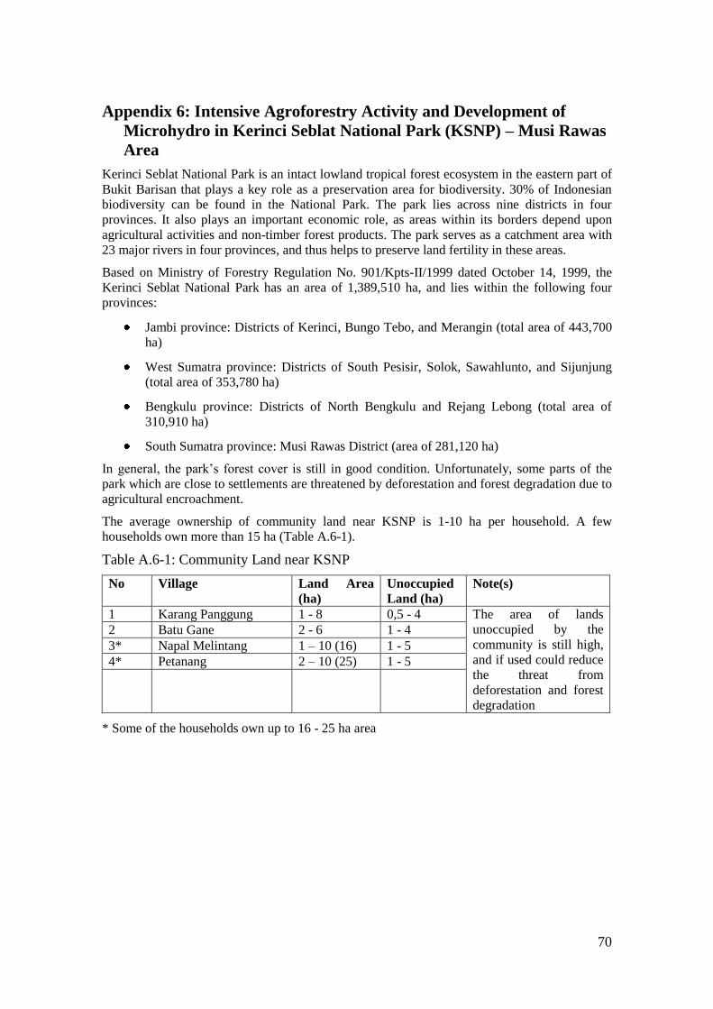
70
Appendix 6: Intensive Agroforestry Activity and Development of
Microhydro in Kerinci Seblat National Park (KSNP) – Musi Rawas
Area
Kerinci Seblat National Park is an intact lowland tropical forest ecosystem in the eastern part of
Bukit Barisan that plays a key role as a preservation area for biodiversity. 30% of Indonesian
biodiversity can be found in the National Park. The park lies across nine districts in four
provinces. It also plays an important economic role, as areas within its borders depend upon
agricultural activities and non-timber forest products. The park serves as a catchment area with
23 major rivers in four provinces, and thus helps to preserve land fertility in these areas.
Based on Ministry of Forestry Regulation No. 901/Kpts-II/1999 dated October 14, 1999, the
Kerinci Seblat National Park has an area of 1,389,510 ha, and lies within the following four
provinces:
Jambi province: Districts of Kerinci, Bungo Tebo, and Merangin (total area of 443,700
ha)
West Sumatra province: Districts of South Pesisir, Solok, Sawahlunto, and Sijunjung
(total area of 353,780 ha)
Bengkulu province: Districts of North Bengkulu and Rejang Lebong (total area of
310,910 ha)
South Sumatra province: Musi Rawas District (area of 281,120 ha)
In general, the park‘s forest cover is still in good condition. Unfortunately, some parts of the
park which are close to settlements are threatened by deforestation and forest degradation due to
agricultural encroachment.
The average ownership of community land near KSNP is 1-10 ha per household. A few
households own more than 15 ha (Table A.6-1).
Table A.6-1: Community Land near KSNP
No Village Land Area
(ha) Unoccupied
Land (ha) Note(s)
1 Karang Panggung 1 - 8 0,5 - 4 The area of lands
unoccupied by the
community is still high,
and if used could reduce
the threat from
deforestation and forest
degradation
2 Batu Gane 2 - 6 1 - 4 3* Napal Melintang 1 – 10 (16) 1 - 5 4* Petanang 2 – 10 (25) 1 - 5
* Some of the households own up to 16 - 25 ha area

71
Figure A.6-1. Immature coffee
being harvested
Agricultural Activities inside KSNP
There are three types of crops being developed by communities surrounding KSNP: rice, coffee,
and rubber. The land is planted in the first year after land is cleared (some farmers start planting
coffee and rubber in the second year). The rice will produce in the first to third year, while
coffee will produce in the fourth year. The production of coffee ends the planting of rice. In the
eighth year rubber plants are high and covering coffee plants, ending the period for coffee
planting.
Table A.6-2: Yields of Communities‘ Coffee and Rubber Plantation inside KSNP
No Village Average rubber production Average coffee production
Yield
(ton/yr/ha) Price (IDR/kg) Yield
(ton/yr/ha) Price of dried
coffee (IDR/kg)
1 Karang Panggung 0.30 3,000 0.40 13,000
2 Batu Gane 0.40 2,500 0.30 15,000
3 Napal Melintang 0.60 4,500 0.60 13,000
4 Kel. Petanang 0.48 3,500 0.70 14,000
5 Rata-Rata Kabupaten 0.85 0.68
Source: Data on village number 1 – 4 is based on survey conducted by CER Indonesia & JICA (2009), while data on
village number 5 is sourced from Musi Rawas Estate Agency (2009). Weight loss on conversion of coffee bean to dry
coffee is about 20 %.
The plantation‘s productivity is low and thus not sufficient to fulfill the community‘s needs, so
they continue to clear new lands to extend their plantation area.
The low productivity of the plantation is caused by several factors below:
1. Low quality of seeds. Seeds for coffee and rubber are
sourced from their own plantations and thus are lower
quality.
2. Lack of maintenance. The community does not apply
fertilizer, nor conduct weeding and watering.
3. Early stage of harvesting. Coffee beans are usually
harvested once they have crusted or become yellow,
which is not always a sign that it has matured. Immature
coffee beans result in a low selling price.
In selling the coffee and rubber, price is determined by the market
or the trader (buyer). The community typically lacks information
on the current market price however.
Reducing Deforestation and Forest Degradation through an Intensive Agroforestry
System
Multilevel intensive agroforestry systems can be conducted by implementing the following
activities:
1. Utilization of high quality seeds
2. Application of fertilizer
3. Implementation of maintenance activities such as regular weeding and watering, and
4. Introduction of advanced harvesting methods

72
By applying a multilevel intensive agroforestry system, it is expected that the community‘s
plantation productivity will increase. For example, in Pengalengan, Bandung District of West
Java province, using this system the yield of coffee could rise to 12 tons/ha/year, with an
average of about 6 tons/ha/year, nearly more than 10 times the farmer‘s yield at KSNP (see
Table A.6-2).
For the system to work in Musi Rawas, capacity building and assistance to the community is
needed. The assistance can include programs such as socialization, participatory planning,
training in cultivation methods and compost for fertilizer, and an introduction to the market. It
is also important to create an institution to assist farmers in marketing their products.
Development of Microhydro
Part of KSNP in Musi Rawas is traversed by the Lakitan River with three catchment areas,
Lakitan, Rumpit, and Air Rawas, which are used to transport wood from illegal logging
activities. The village nearest to KSNP is Napal Melintang, which is reached via the Lakitan
River. Up to now, the village has had no electricity system. In 2008, there was a plan from the
national electric power company PLN to construct an electricity system, but it has not yet been
realized.
The villagers understand that a hydro power system can be constructed by utilizing the Lakitan
River‘s flow. KSNP‘s officials also see the existence of electricity as a path to reduce threats to
the forest from villagers, who with education and training will understand the need to preserve
the forest to maintain the water supply that produces their electricity.
Self Initiative on Forest Security and Development of Community Seeds
In 2008, KSNP and the local community initiated a forest self initiative security group
(community based-forest rangers, or Pamhutswakarsa) in several villages such as Karang
Panggung, Napal Melintang and Batu Gane. Activities conducted by the group include forest
patrols and surveys for data collection on forest biodiversity. The community group also has a
village nursery with capacity of more than 70,000 seeds, and some were distributed for free to
the community to plant in degraded forest areas
.

73
Appendix 7: Final Workshop at Musi Rawas, July 20, 2010
The final workshop was officially opened by the Local Secretary and led by the Head of the
Planning and Development Office. Nearly all of the government officers of Musi Rawas came
to the workshop, as well as villagers, farmers, fisherman, and extension workers. Approximately
50 participants attended this event. This workshop aimed to (1) disseminate information on
REDD+ issues in Musi Rawas, (2) deliver the findings of CER Indonesia, CCAP and the RWG
on the implementation of REDD+, (3) obtain feedback from stakeholders on team findings, and
(4) define locations for demonstration activities.
Discussion process
The participants received comprehensive information from the study conducted by research
teams CER Indonesia, CCAP and the RWG through presentations by Prof. Rizaldi Boer, Dr.
Lala Kolopaking, I Wayan Susi Dharmawan (MoF), and from RWG Musi Rawas Setyono
Agus, Edi Cahyono, M. Zainuddin, Setyo Yuwono, and Ramdani.
Participants gave constructive responses to the study results. Discussion included:
funding/financing models for reducing emissions, including those that could be assisted by the
Ministry of Forestry for the region/district; financial assistance for the establishment of
demonstration activities; capacity building for establishing an MRV system; strengthening the
extension services of Musi Rawas District for REDD+ implementation and awareness raising
programs; institutional mechanisms for implementing monitoring, reporting and internal
verification of REDD+ programs; and the possibility of applying a GHG emissions cap for
mining companies and using that policy as a basis for determining mining companies‘
contribution to supporting the low carbon development of Musi Rawas District.
At the end of the discussion session, the WG presented two demonstration activities proposed
for the pilot projects:
• Emission reduction activities in the buffer area of KSNP through utilization of
microhydro, community forest protection and village nurseries.
• Development of ecotourism activities in the buffer area of Bukit Cogong Protection
Forest and integrated coconut utilization to reduce the emissions from deforestation and
forest degradation.
In addition, the representatives from the Plantation Office and Forest Office proposed two other
potential REDD demonstration activities that can be implemented at APL and FMU Lakitan.
In the context of developing demonstration activities at FMU Lakitan, the participants raised a
number of issues since most of the forest areas in this FMU have already been used or degraded
by the community. The issues were the following:
1. Under the FMU system, can a community that has already occupied the land be provided
with land use rights to establish an agriculture plantation in the non-forested land? If such
activity is allowed, what would be the mechanism for getting such land use rights -- what
type of plantation is allowed, what is the maximum fraction of the land in the FMU that can
be used for plantations, and what kind of management is allowed?
2. Is delineation needed to define non-forested land in forest areas allowed for agriculture
plantation? If it is needed, who will handle the ground technical matters, what kind of policy
needs to be prepared, and how long will it take?

74
3. What policies are needed to improve the communities‘ role in forest management and
preservation? Deforestation and forest degradation may be occurring due to the lack of
involvement of communities in managing forest resources.
In the closing ceremony, the Head of Musi Rawas Development Planning Agency
recommended the RWG to work further with the CER Indonesia team to develop a REDD
Development Strategy paper based on the project work. This can later be used by the head of
the district for promoting and marketing the Musi Rawas REDD Program to National
Government and Donor Agencies. In addition, the Project Team also recommended that the
strategy paper be used as an important input in developing the next Musi Rawas Short,
Medium, and Long Term Development Plan. The project team was also requested to provide
inputs in the process of drafting the local regulation on Corporate Social Responsibility—how
the private sector can best contribute to low carbon development in Musi Rawas. Inputs were
also requested for the design of an emissions cap (emissions standard) for mining activities,
since Musi Rawas has large mining potential.
Pictures of the event:
Since 1985, CCAP has been a recognized world leader in climate and air quality policy
and is the only independent, non-profit think-tank working exclusively on those issues at
the local, national and international levels. Headquartered in Washington, D.C. CCAP
helps policymakers around the world to develop, promote and implement innovative,
market-based solutions to major climate, air quality and energy problems that balance
both environmental and economic interests. For information about CCAP please visit
www.ccap.org.
Center for Clean Air Policy
750 First Street, NE • Suite 940
Washington, DC 20002
Tel: 202.408.9260 • Fax: 202.408.8896