Embed Size (px)
Citation preview

ESSEX COUNTY COUNCIL WITH BOROUGH OF BRENTWOOD
LOCAL HIGHWAY PANEL – 10 th April 2014 Date: Thursday 10th April 2014 Time 19:00 hrs Venue: Council Chamber, Brentwood Borough Council
Chair Panel Members Other Attendees
Cllr Keith Parker BC Member. Cllr Naylor CC Member (Deputy Chair), Cllr Aspinell CC Member, Cllr Kendall CC Member, Cllr Hirst CC Member Cllr Hossack BC Member, Cllr Sparling BC Member and Cllr Russell BC Member. Cllr Johnson CC Member (Deputy Cabinet Member for Highways), Adrian Tidbury (BBC), Jean Sharp (BBC) Hannah Neve (ECC) Chris Stoneham (ECC) and Peter Wright (Essex Highways)
Time Item Lead: Papers:
1 Welcome and Introductions Chair Verbal
2 Declarations of Interest All Verbal
3 Apologies for absence All Verbal
4 Minutes from Previous Meeting
5 Delegated A uthority Chair Verbal
6 Update on schemes approved o Schemes Recommended 2012-13
Schemes Recommended 2013-14
CS Report 1 Report 2
7 Schemes to Co nsider for Funding o Schemes for Funding Report
CS
Report 3
8 Public Right of Way Reports o Potential Scheme Requests (x3)
CS Report 4
9 Ashwells Road o Update/ Options
PW
10
11 Scheme Requests o Scheme Request Report
CS
Report 6
12 Great Ropers Lane CS Report 7
13 Rayleigh Road/ Poplar Drive traffic signals CS Report 8
14 Brentwood Station CS Report 9
15 Highway Rangers Report CS Report 10
16 Capital Maintenance Programme (for i nformation) CS Verbal
17 Items for Future Meeting Chair Verbal
18 Any other business Chair Verbal
19 Date of next meeting: TBC Chair
Feasibility Study (REPORT TO FOLLOW)o Tabors Corner traffic signals
CS Report 5
Local Highways Panel Meeting 10 April 2014 Page 1

Page 2Local Highways Panel Meeting 10 April 2014 Page 2

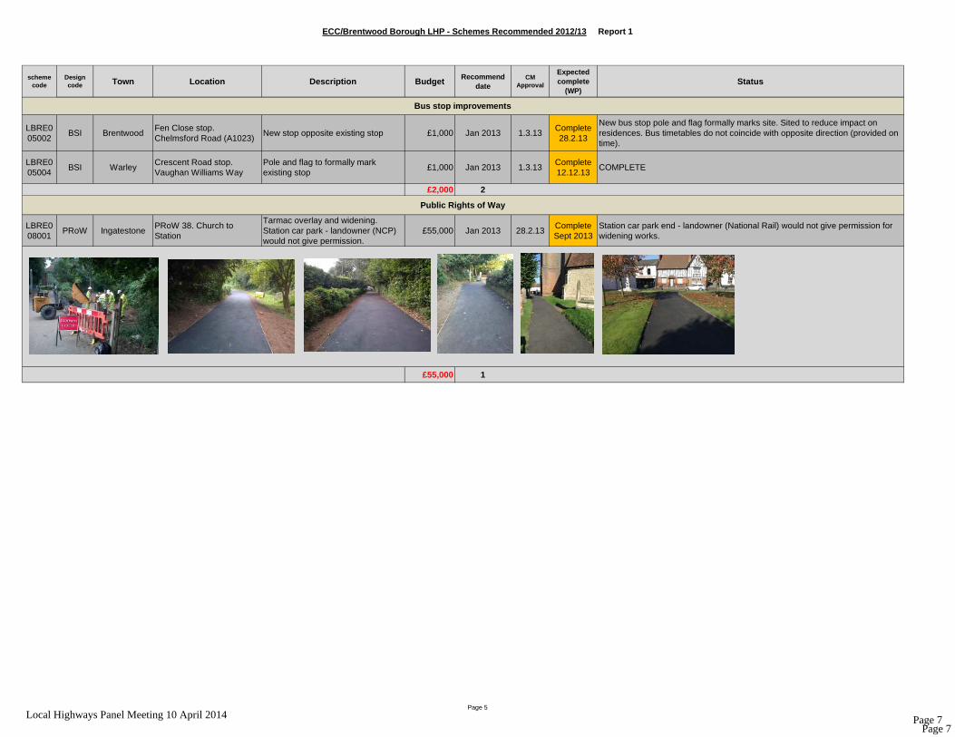
ECC/Brentwood Borough LHP - Schemes Recommended 2012/13 Report 1
scheme code
Design code Town Location Description Budget Recommend
dateCM
Approval
Expected complete
(WP)Status
LBRE002002
DC1470 ThorndonCountry Park entrance. A128 Brentwood Rd
Bellmouth improvement £20,000 Oct 2012 14.10.12Complete Mar 2014
LBRE007001
ITS HuttonRayleigh Road j/w Poplar Drive
Traffic Signal adjustment investigation for congestion at peak times
£6,000 Nov 2012 4.12.12Part
complete Mar 2014
The timings have been altered for Poplar Drive on a temporary setting; initial view is that they are working well and can be made permanent in 2014/15.
LBRE132016
DC1883 West Horndon Station RdGuard rails - extend by approx. 6 panels at existing ped. Crossing
£600 Sept 2012 2.10.12Complete Mar 2014
CAPITAL SCHEMES in PROCESS (2012-13)
Minor Schemes
LBRE132013
DC1877 MountnessingOld Church Rd (River Wid end)
Give way and side road ahead signs £2,300
Feb 2013 (£1k)
22.10.13 (£1.3k)
28.2.13 (£1k)
31.10.13 (£1.3k)
Complete Feb 2014
LBRE132014
DC1884 WarleyWarley Hill j/w Pastoral Way
3 bollards to prevent parking near mini roundabout
£750 Feb 2013 28.2.13 2014/15The double yellow lines have recently been extended in this area and the problem seems to have improved as a result; it was wondered whether the Panel wanted to proceed with these bollards in light of this information?
£29,650 5
Page 1
Page 3Local Highways Panel Meeting 10 April 2014 Page 3

ECC/Brentwood Borough LHP - Schemes Recommended 2012/13 Report 1
scheme code
Design code Town Location Description Budget Recommend
dateCM
Approval
Expected complete
(WP)Status
LBRE005001
DC1512a
BrentwoodGarden Centre stop, A128 Ongar Rd, near Langford Bridge over river Roding
Raised and dropped kerbs. New hardstand.
£8,500 July 2012 4.12.12 2014/15Provisionally approved last year but has been deferred to 14/15 because it could not be implemented in 13/14 financial year.
LBRE005001
DC1512b
IngatestoneWhadden Chase stop. Roman Road
Wooden shelter & raised kerbs £10,500 July 2012 4.12.12Complete Feb 2014
LBRE005001
DC1512c
Pilgrims Hatch Shops stop, Danes WayMove stop because resident objected to existing stop and threatened legal action
£1,000 July 2012 4.12.12 CancelledThere is a new proposal that has been included in the potential schemes list that can be considered for this location.
LBRE005003
BSI BrentwoodHornbeam Close, Pondfield Lane, East ham Estate
Bus cage markings to discourage parking at stop
£1,000 Jan 2013 1.3.13 On Hold ###############################################################
£21,000 4
Bus Stop Improvements
Page 2
Page 4Local Highways Panel Meeting 10 April 2014 Page 4

ECC/Brentwood Borough LHP - Schemes Recommended 2012/13 Report 1
scheme code
Design code Town Location Description Budget Recommend
dateCM
Approval
Expected complete
(WP)Status
LBRE001002
DC1750 BrentwoodHanging Hill Lane/Pondfield Lane
(1) Signing and road markings improvements. (2) Solar VAS signs (bend warning with slow down) outside nos. 88/90 & north of bus stop. (3) Proposal to widen inside of bend (BT apparatus might need costly diversion). VAS signs need to be installed.
£60,000 Jan 2013 12.2.13Part
complete Mar 2013
LBRE001001
DC1511 South Weald Weald RoadReflector posts to delineate the bends "Where You Look is Where You Go treatment"
£5,000 July 2012 4.12.12Complete Jan 2014
Design progressing. Road safety audit recommended that road is too narrow for existing double solid centre line, therefore broken hazard line to be installed. Design circulated to LHP 14.10.13
£65,000 2
LBRE003003
DC1522 Brentwood Borough wideCycling study. Cycle ways and facilities.
£25,000 Nov 2012 4.12.12 2014/15 ###############################################################
£25,000 1
£140,650 12Total Capital recommendations for Brentwood - In progress (2012-13)
Cycling
Casualty Reduction Schemes
Page 3
Page 5Local Highways Panel Meeting 10 April 2014 Page 5

ECC/Brentwood Borough LHP - Schemes Recommended 2012/13 Report 1
scheme code
Design code Town Location Description Budget Recommend
dateCM
Approval
Expected complete
(WP)Status
LBRE002003
DC392 Brentwood Crown StPedestrianisation, new signs, bollards, power connections and TRO
£21,000 Jan 2013 7.5.13Complete Aug 2013
###############################################################
£21,000 1
LBRE003002
DC1330 HerongateBillericay Rd, near Olde Dog PH
New footway £17,000 July 2012 14.8.12Complete Mar 2013
COMPLETE
£17,000 1
CAPITAL SCHEMES COMPLETE (2012-13)
Walking
Minor Schemes
Page 4
Page 6Local Highways Panel Meeting 10 April 2014 Page 6
ECC/Brentwood Borough LHP - Schemes Recommended 2012/13 Report 1
scheme code
Design code Town Location Description Budget Recommend
dateCM
Approval
Expected complete
(WP)Status
LBRE005002
BSI BrentwoodFen Close stop. Chelmsford Road (A1023)
New stop opposite existing stop £1,000 Jan 2013 1.3.13Complete 28.2.13
New bus stop pole and flag formally marks site. Sited to reduce impact on residences. Bus timetables do not coincide with opposite direction (provided on time).
LBRE005004
BSI WarleyCrescent Road stop. Vaughan Williams Way
Pole and flag to formally mark existing stop
£1,000 Jan 2013 1.3.13Complete 12.12.13
COMPLETE
£2,000 2
LBRE008001
PRoW IngatestonePRoW 38. Church to Station
Tarmac overlay and widening. Station car park - landowner (NCP) would not give permission.
£55,000 Jan 2013 28.2.13Complete Sept 2013
Station car park end - landowner (National Rail) would not give permission for widening works.
£55,000 1
Public Rights of Way
Bus stop improvements
Page 5
Page 7Local Highways Panel Meeting 10 April 2014 Page 7

ECC/Brentwood Borough LHP - Schemes Recommended 2012/13 Report 1
scheme code
Design code Town Location Description Budget Recommend
dateCM
Approval
Expected complete
(WP)Status
LBRE004001
DC1331 Shenfield Shenfield Station Cycle storage £23,000 July 2012 4.12.12Complete Mar 2012
Complete
£23,000 1
£118,000 6
TOTAL RECOMMENDATIONS CAPITAL In process & complete £258,650 18 (funds approved by CM)old info
new infocompleteaction
CM Cabinet MemberTRO Traffic Regulation OrderD&C Design & ConsultancyHLO Highways Liaison OfficerPIC Personal Injury CollisionsVAS Vehicle Activated SignSID Speed Indicator Device
Total Capital recommendations for Brentwood - Complete (2012-13)
Cycling
Page 6
Page 8Local Highways Panel Meeting 10 April 2014 Page 8

ECC/Brentwood Borough LHP - Schemes Recommended 2013-14 Report 2
scheme code
Design code
Town Location Description BudgetRecommend
dateCM
Approval
Expected complete
(WP)Status
LBRE132001
DC1864 BrentwoodHartswood Rd, near Woodman Rd
VAS sign to reduce speeds £8,500 1.7.13 10.7.13 2014/15
In design. Resident strongly objected to proposed location. Site visit with Solagen to assess new location was undertaken in December. Due to these problems there has been a delay in progressing the request but is on track to be delivered in 2014/15.
LBRE132002
DC1865 HuttonHanging Hill Ln, nr St Martin's School
2 speed activated VAS where crossing against policy
£17,000 1.7.13 10.7.13 2014/15In design. Site visits done. Required an additional Cabinet Decision on policy exception which has been resolved and can now proceed.
LBRE132006
DC1867 ShenfieldPriests Lane, between Woodway and approx. no. 147
Feasibility study, prelim. designs & costs to reduce speeds, improve visibility & improve footway (IT090)
£5,000 1.7.13 10.7.13 May 2014In design; study to be finalised at the beginning of 2014/15 financial year.
LBRE132003
DC1866 DC1875
Mountnessing St Annes Rd
Detailed designs for signing & lining improvements and initial drainage investigation. Accidents involving cars in pond and damaging property.
£2,500 1.7.13 10.7.13 2014/15In design. Seperated into 2 schemes. DC1866 for traffic management. DC1875 for drainage. £1250 ea.
LBRE132003
DC1866 DC1875
Mountnessing St Annes RdWORKS for signing & lining improvements and initial drainage investigation. Accidents involving cars in pond and damaging property.
£5,000 1.7.13 TBC 2014-15 CM to approve Q1 2014-15.
LBRE132007
DC1841Kelvedon
HatchA128 Ongar Rd, near Eagle Lane
Detailed designs for pedestrian refuge for Eagle Ln residents having problems accessing shops and bus stop, incl. investigate BT apparatus
£2,000 1.7.13 10.7.13 May 2014 In design; should be completed by the end of May 2014.
CAPITAL SCHEMES in PROCESS (2013-14)
Minor Schemes
and bus stop, incl. investigate BT apparatus
LBRE132008
DC1842 BrentwoodOrchard Ave j/w Ingrave Rd
Feasibility study & detailed design for improvement to inadequate pedestrian refuge and bell mouth junction
£5,000 1.7.13 10.7.13 June 2014
In design; should be completed by the end of June 2014. The cost of these works is estimated to be in region of £8k. The detailed design and estimate will be brought back to the Panel once this is completed.
LBRE132008
DC1842 BrentwoodOrchard Ave j/w Ingrave Rd
WORKS for improvement to inadequate pedestrian refuge and bell mouth junction
£8,000 1.7.13 TBC 2014-15CM to approve 2014-15 once the outcome of the feasibility is known.
Page 1
Page 9Local Highways Panel Meeting 10 April 2014 Page 9

ECC/Brentwood Borough LHP - Schemes Recommended 2013-14 Report 2
scheme code
Design code
Town Location Description BudgetRecommend
dateCM
Approval
Expected complete
(WP)Status
LBRE132009
DC1868 Pilgrims HatchAshwells Rd & j/w A128 Ongar Rd & Mores Lane
Feasibility study & detailed designs for solutions associated with parking and congestion at Bentley St Pauls school. Initial focus on creation of extra parking laybys and footways in Ashwells Rd, extending parking restrictions at junction, improving signing and lining at junction, extending 40mph limit on A128 south, flashing school lights/VAS.
£20,000 1.7.13 10.7.13 02.04.14A separate report has been provided for this scheme request (Report ).
LBRE132005
DC1840 Brentwood Honeypot LaneDesigns and legal costs (Traffic Order) to change 20mph zone to 20 mph limit
£2,700 1.7.13 10.7.13 2014/15In design; requires a separate Cabinet Decision prior to the traffic Order being advertised, currently being processed.
LBRE132005
DC1840 Brentwood Honeypot Lane WORKS to change 20mph zone to 20 mph limit £5,000 1.7.13 TBC 2014-15CM to approve 2014-15 once the formal consultation is completed.
LBRE132017
TBC Brentwood
Hogarth Estate (Hogarth Ave, Riseway, Shenfield Cres) - used as a shortcut between Priests Lane and A128 Ingrave Rd
Detailed study/design and TRO. Pilot for 20 limit on residential estate (local roads) which Brentwood BC would like to promote across the borough. Estate includes school. 3 estates were requested supported by local petition. Pilot to test the before and after impacts on 1 estate. 3 speed surveys (on streets above) with a combined mean of 23.3 mph for 12 hour 5 weekday results.
£5,000 22.10.13 31.10.132014-15 Delivery
In design; requires a separate Cabinet Decision prior to the traffic Order being advertised, currently being processed.
Detailed study/design and TRO. Pilot for 20 limit on local road with school which Brentwood BC would like to promote across the borough. Pilot In design; requires a separate Cabinet Decision prior to
LBRE132015
TBCKelvedon
HatchSchool Rd, Kelvedon Hatch
would like to promote across the borough. Pilot to test the before and after impacts. ECC policy is mean speeds must be below 29mph. Speed surveys met this criteria with a combined mean of 24.2 mph for 12 hour 5 weekday results.
£4,000 22.10.13 31.10.132014-15 Delivery
In design; requires a separate Cabinet Decision prior to the traffic Order being advertised, currently being processed.
LBRE132018
TBC Shenfield Hall Lane, Shenfield
Detailed study/design and TRO for pilot extending 30 limit on local road with school to incorporate residential properties outside the existing 30 and assess village gateway option.
£4,000 22.10.13 31.10.132014-15 Delivery
In design; Traffic Order being processed for formal consultation process.
Page 2
Page 10Local Highways Panel Meeting 10 April 2014 Page 10

ECC/Brentwood Borough LHP - Schemes Recommended 2013-14 Report 2
scheme code
Design code
Town Location Description BudgetRecommend
dateCM
Approval
Expected complete
(WP)Status
LBRE132019
TBC Shenfield
Tabors Corner - junction A1023 Chelmsford - Shenfield Rds w Hutton Rd
Feasibility study including video evidence to investigate; modifying crossing to a stagger; changing the signal sequencing, relocating crossing or introduce some form of enforcement (camera). During peak periods drivers regularly run the red light obstructing or driving through pedestrians during the period the green man.
£5,500 22.10.13 31.10.13 31.03.14
A separate report has been provided for this scheme request (Report ). A further £1,700 was approved by the Chairman to allow the report to be completed before the end of the financial year.
LBRE132020
TBCBrentwood &
Shenfield
Shenfield & Brentwood rail stns, A129 Raleigh Rd/Alexander Lane mini RAB
Feasibility study and designs - Station and passenger transport improvements and mini RAB capacity improvements to tie in with the implementation of Crossrail as part of the Crossrail urban design study.
£19,000 22.10.13 31.10.13 2014-15Original allocation of £25,000 was reduced to £19,000 at the January LHP meeting to allow funding for the designs of the two Casualty Reduction schemes to proceed.
£118,200 13
LBRE136001
BSI Ingatestone Alms Houses, High St New wooden shelter for elderly residents. £9,000 1.7.13 16.7.13 31.1.14Ordered for installation same time as Whaddon Chase stop (2012-13). Awaiting UK Power Networks permission for Whaddon.
LBRE136003
BSIKelvedon
Hatch
Rose & Crown, A128, 390 Ongar Road, CM15 9JH
WORKS - New wooden shelter for elderly residents. Straight forward installation
£9,000 22.10.13 31.10.13 2014-15Cllr requested change to metal shelter (lit) to match opposite stop. BSI Officer has confirmed OK and will re-cost.
LBRE1 Kelvedon A128, Ongar Rd, Nuclear Feasibility study - for 2 new stops for visitors.Nearest stops are 100m north with no footway or Scheme may require land purchase which will impact on
Bus Stop Improvements
LBRE136004
BSIKelvedon
HatchA128, Ongar Rd, Nuclear Bunker entrance
Nearest stops are 100m north with no footway or off road stand on busy road. May require land purchase.
£2,000 22.10.13 31.10.13 2014-15Scheme may require land purchase which will impact on the cost and delivery of the potential proposal.
LBRE136002
BSIKelvedon
Hatch
Garden Centre on A128, Ongar Rd, just south of River Roding bridge.
Raised and drop kerbs and new hardstand to prevent standing in road. Stop on opposite side of road already installed from 2012-13 budget. Risk assessment recommended same treatment for this side to prevent standing in a busy road.
£9,000 22.10.13 TBC 2014-15 CM to approve Q1 2014-15.
LBRE134001
BSI Shenfield Shenfield StationProvision of a solar powered light for existing cycle shelter
£360 20.1.14 3.4.14 2014-15 Order has been raised with supplier to install lighting unit.
£29,360 3
Page 3
Page 11Local Highways Panel Meeting 10 April 2014 Page 11

ECC/Brentwood Borough LHP - Schemes Recommended 2013-14 Report 2
scheme code
Design code
Town Location Description BudgetRecommend
dateCM
Approval
Expected complete
(WP)Status
LBRE131003
DC1863 South WealdChequers Rd/Weald Rd junction
Improve traffic island, signs and lines. 7 Personal Injury Collisions -(PICs) (over 3 years) & shunts.
£20,000 1.7.13 10.7.13 2014/15 In design; scheduled to be completed in April 2014.
LBRE131004
ITS Brentwood
Wilson's Corner - High St, Ongar Rd, A1023 Shenfield Rd junction including Ongar Rd, William Hunter Way junction
Detailed traffic study - view to installing traffic signals with S106 funds. 18 Personal Injury Collisions (PICs) (over 5 years) & many shunts.
£5,000 1.7.13 10.7.13 2014/15
The traffic/pedestrian surveys to allow modelling of possible solutions have been carried out to allow for the data to be analysed. It is planned to undertake the modelling work and feasibility study as soon as possible in the new financial year.
LBRE131005
DC WarleyB186 Warley Road j/w Great Ropers Lane
Preliminary design and investigation for safety scheme.
£3,000 20.1.14 3.4.14 2014/15
LBRE131006
DC BrentwoodCoxtie Green Road j/w Wheelers Lane
Preliminary design and investigation for safety scheme.
£3,000 20.1.14 3.4.14 2014/15
£31,000 2
Casualty Reduction Schemes
Walking
LBRE133005
TBC Pilgrims HatchHarewood Rd, outside community hall
PRIORITISE for delivery in 2013-14. Pedestrian drop kerb for prams and disabled
£2,500 1.7.13 24.9.13Complete Mar 2014
£2,500 1
£181,060 19Total Capital recommendations for Brentwood - In progress (2013-14)
Page 4
Page 12Local Highways Panel Meeting 10 April 2014 Page 12

ECC/Brentwood Borough LHP - Schemes Recommended 2013-14 Report 2
scheme code
Design code
Town Location Description BudgetRecommend
dateCM
Approval
Expected complete
(WP)Status
LBRE138002
N/A HuttonFootpaths 76 & 77. Hall Green Ln & Hanging Hill Ln
Improve often impassable surface - length of 890m - road planings for all-weather off-road heavily used link residential area to St Martins School.
£27,500 1.7.13 10.7.13Complete Sept 2013
Delivered in school holiday owing to temporary closure.
CAPITAL SCHEMES COMPLETE (2013-14)
Public Rights of Way
Page 5
Page 13Local Highways Panel Meeting 10 April 2014 Page 13

ECC/Brentwood Borough LHP - Schemes Recommended 2013-14 Report 2
scheme code
Design code
Town Location Description BudgetRecommend
dateCM
Approval
Expected complete
(WP)Status
LBRE138003
N/A Pilgrims Hatch Byway 15 (Hulletts Ln)
Improve often impassable surface - length of 600m - road planings for all-weather off-road heavily used link residential area to St Pauls Bentley School (Ashwells Rd). Also unblock or replace drainage.
£35,000 1.7.13 10.7.13Complete Sept 2013
Delivered in school holiday owing to temporary closure.
£62,500 2
£62,500 2
CAPITAL In process & complete £243,560 21 (recommended by LHP)
for Q1 2013-14 CM approval or defer till 2014-15 budgetnew infocompleteactionOld info
TRO Traffic Regulation OrderD&C Design & ConsultancyHLO Highways Liaison OfficerPIC Personal Injury CollisionsVAS Vehicle Activated Sign
SID Speed Indicator Device
Total Capital recommendations for Brentwood - Complete (2013-14)
SID Speed Indicator Device
ITS Intelligent Traffic Signals
Page 6
Page 14Local Highways Panel Meeting 10 April 2014 Page 14

1
ESSEX COUNTY COUNCIL AND
BOROUGH OF BRENTWOOD LOCAL HIGHWAY PANEL – 10 April 2014
REPORT 3: POTENTIAL SCHEMES To clarify the budget for 2014/15 is anticipated to be £449,000. Items which the panel have discussed and determined not to be relevant anymore have been removed from this list. Any items which have been discussed but that either the panel does not wish to progress at this stage or which cannot be completed at this time have been greyed out. The schemes have been broken down into the different types of scheme ie PROW, Safety, Passenger Transport, Cycling or Minor
PROW
LOCATION SCHEME PROBLEM COST RAG NOTES/ COMMENTS
1
Footpath 15 & Byway 22 (Kelvedon Hatch)
Surface Improvements
Significant rutting of the footpath has occurred with the ruts then filling with water
£25,000 Green
.Subject to funding being approved it is anticipated that these works will be completed by September 2014 as the type of work require ground conditions to be as dry as possible to prevent further damage. It is estimated that the work will take 10 days to complete. Extent of scheme: 100m of footpath; 320m of byway.
2
Bridleways 12 (Ingatestone and Fryerning) and 12 (Highwood)
Surface Improvements Extensive potholes in the existing surface.
£12,000 Amber
Note: currently at the design stage is yet to be completed and quotes will be required from contactors, this cost is an estimate. Part of the works falls under Chelmsford City.
3
Bridleways 12 and 13 (Highwood) and 13 (Ingatestone)
Surface & drainage improvements
To improve the surface condition and drainage of the bridleways.
£28,000 Amber
Extent of scheme: approx. length of 970m; width of 2m. This estimated costs involved staff time, labour, materials and the cost of a temporary closure. Part of the works falls under Chelmsford City.
Page 15Local Highways Panel Meeting 10 April 2014 Page 15

2
SAFETY SCHEMES
LOCATION SCHEME Issue COST RAG NOTES/ COMMENTS
1
B186 Warley Road j/w Great Ropers Lane
Improved signage warning of bend with junction
Casualty reduction site £10,000 Amber
£3,000 agreed for the preliminary design and investigation approved at the January Panel meeting; estimated £10,000 for detailed design and build. Waiting on preliminary investigations.
2
Coxtie Green Road j/w Wheelers Lane
Improvements to junction layout.
Casualty reduction site
£15,000 Amber
£3,000 agreed for the preliminary design and investigation approved at the January Panel meeting; estimated £15,000 for detailed design and build. Waiting on preliminary investigations.
Eagle Way j/w Hartswood Road (Devil's Head crossroad) - 16
small solid roundabout
Restarts, overshoots, failures to give way
£500k Amber
The 2 VAS signs on the approach to the crossroads are fully functional as of January 2012. Previously The ECC team have advised that a longer period of the signs being installed is recommended before analysis is undertaken in the form of a speed survey to indicate the speed that drivers are approaching the junction.
Page 16Local Highways Panel Meeting 10 April 2014 Page 16

3
PASSENGER TRANSPORT
LOCATION SCHEME PROBLEM COST RAG NOTES/ COMMENTS
1
Danes Way, Pilgrims Hatch
Provision of bus Lay-by/ re-alignment of footway opposite the parade of shops
There is an ongoing issue with the existing bus stop located near the parade of shops that needs to be resolved.
£2,000 (Design/ estimate only)
Green
The original request was for the provision of a lay-by adjacent to the shops. No justification for a layby, which if one was provided would be expensive due to utilities and the same outcome could be better achieved by a TRO (say 30mins in 4 hours) – Liaise with SEPP. Alternative option would be to provide a lay-by opposite for the bus with the option of a shelter.
Shenfield Station - IT649
Station Improvements and improvements to passenger transport arrangements
£25,000 Green
Improvements will tie in with Crossrail so not a decision for the panel to make at this stage. The Panel agreed to consider this next financial year. Following receipt of Crossrail urban design study we are now in a position to consider further feasibility work on these proposals
Page 17Local Highways Panel Meeting 10 April 2014 Page 17

4
PASSENGER TRANSPORT
LOCATION SCHEME PROBLEM COST RAG NOTES/ COMMENTS
1
Mountnessing Post Office
Replace with new wooden shelter.
Request from Parish to replace old shelter.
£9,000
Green
Shelter is very run down and becoming a safety concern and requires replacing as soon as possible.
2
The Chequers, Rayleigh Road
Install bus stop clearway (bus cage) in layby.
Cars are parking in lay-by blocking buses from accessing the stop
£2,000 Green .
3
Norman Crescent off Pondfield Lane
Install two new bus stop clearway (bus cages).
Cars parking within the bus stops.
£4,000 Green
Double yellow lines have recently installed in the area which has led to cars parking at the bus stops so buses are unable to access the stops.
4
Cherry Avenue Install two new bus stop clearways (bus cages).
Obstruction of bus stops
£4,000 Green Car(s) are parking at the bus stops making it difficult for buses to access the stop.
5
Hornbeam Close
Relocate bus stop on to 'island' area. Ex. shelter will need to be removed and a new shelter installed..
As the Panel are aware, original scheme was to install a bus stop clearway, however following strong objections from residents an alternative solution was investigated.
£12,000 Green
Breakdown of Costs: New shelter - £7,500 Drop kerbs - £3,500 Removal of ex. Shelter - £1,000 Originally there was £1,000 approved for the original proposal.
Page 18Local Highways Panel Meeting 10 April 2014 Page 18

5
6
A129 Rayleigh Road/Alexander Lane - IT059
Mini RAB capacity improvements
Pre-emptive work ahead of Crossrail
£25k for all 2 PT schemes
Possible tie in with Crossrail
MINOR SCHEMES
LOCATION SCHEME PROBLEM COST RAG NOTES/ COMMENTS
1
A128 Tilbury Road West Horndon
Pedestrian Refuge/ footway extension
.There is a perceived safety issue for school children disembarking their school bus
£14,000 Green Design estimate: £2,000 Construction
estimate: £12,000.
2
B186 Great Warley Street opposite Bird Lane
Footway extension
Short section of footway is required to join up existing footways either side of Bird Lane opposite this junction.
£17,000
Green
Design estimate: £2,000 Construction estimate: £15,000. Provide a short section of footway opposite Bird Lane; this project will improve pedestrian safety and encourage more parents to walk their children to school.
3
Childerditch Lane
An advance give way sign with supplementary distance plate on Childerditch Lane on the approach to the Devils Head crossroads.
The existing sign can be obscured by vehicles.There is a slight bend at the final approach to the junction.
£1,500 Green Provision and implementation of sign £1,500.
Page 19Local Highways Panel Meeting 10 April 2014 Page 19

6
4
Sandpit Lane Footway widening scheme
The footway from the junction with Ongar Road leading into Sandpit Lane is narrow.
£10,000 Green
Design estimate: £2,000 Construction estimate: £8,000. Although the Rangers have cleared some the vegetation, it is unclear on the ground where the extent of Highway Boundary.Nevertheless there is enough land to undertake footway and kerbing works. There is evidence utility apparatus within existing footway.
5
Burland Road j/w Wates Way.
Amend the kerbing at the Wates Way junction to direct all traffic to exit left, this would physically prevent vehicles turning left from Burland Road. Immediate improvement measure install temporary traffic barriers could be used.
Traffic on Burland Rd ignore the no entry at Wates Way.junction There are no entry signs but needs to be an advance no left turn sign on 2nd from last lamp post on Burland Rd.
£1,000 –temporary barriers. £10,000 to alter kerbing at junction.
Green
The request for an advance “No Left Turn” Sign (Dia 613) before Wates Way will be misleading for all drivers approaching the Ongar Road junction where traffic can turn both left and right; therefore request refused. However, either the temporary or alternative permanent solution can proceed.
6
Hunter Avenue, Shenfield
Provision of a pedestrian warning sign and new post at the junction with Public right of way 171.
Popular pedestrian route for the shops and Shenfield Station
£1,500 Green
The route is also used by vehicular traffic which has to use the route to gain access to private car parks and shops for delivery purposes. Currently there is no segregated footway/ carriageway.
7
Myrtle Road, junction with Warley Hill.
Provision of ‘bell’ bollard on the corner of the footway.
The area of footway has been damaged frequently due to vehicles mounting the footway.
£2,000 Green
The footway is wide enough to accommodate a ‘bell’ bollard at the corner of the footway to protect the surface from future vehicles mounting the footway.
8
Hartswood Road, Kings Rd, Pondfield Lane
Provision of new signage following recent safety assessment on the existing crossings.
Recommendation that advance warning signs are introduced.
TBC Amber
Currently waiting on the estimated works costs for introducing the signs at each site; it is anticipated to be in the region of £7,000.
Page 20Local Highways Panel Meeting 10 April 2014 Page 20

7
8
Orchard Avenue/ Ingrave Road
Improvements to pedestrian refuge and bell mouth junction.
Lack of pedestrian facilities at the junction.
TBC Amber
Currently waiting on the completion of the detailed design and estimated works costs for upgrading the pedestrian refuge; it is anticipated that the total works costs will be in the region of £8,000.
Page 21Local Highways Panel Meeting 10 April 2014 Page 21

Page 22Local Highways Panel Meeting 10 April 2014 Page 22

REPORT 4
POTENTIAL PROW SCHEMES 2014/15
Scheme location: Footpath 15 & Byway 22, located in the parish of Kelvedon Hatch
Scheme location:
This scheme will greatly improve Footpath 15 & Byway 22, located in the parish of Kelvedon Hatch in the
Brentwood Borough. This public footpath and byway provides a link in the surrounding public rights of
way network, significantly reducing the amount of road walking required when utilising the rights of way in
the area. Footpath 15 runs from Ongar Road, adjacent to the Army Navy shop, over Doddinghurst
Common to its junction with Byway 22 and in turn Byway 22 runs from Frog Street to the junction of Ongar
Road (A128) and Blackmore Road.
Scheme description:
This scheme is required to improve the surface of the above public footpath for a total length of 100m and
of the byway for 320m.
Currently off road vehicles are driving along the byway then coming off this into the adjacent woodland
through which Footpath 15 runs. As a result of this vehicle use, significant rutting of the footpath has
occurred with the ruts then filling with water. This unauthorised vehicle access on the footpath not only
poses a hazard to walkers because of the surface damaged caused but there is also the risk of an incident
between a pedestrian and vehicle. Also, on the byway there is a 30m long section where standing water is
present to a depth of approximately 30cm throughout most of the year due to this part of the byway being
below surrounding ground levels.
To improve the surface of the byway, crushed concrete will be used to infill ruts that have formed and to
raise the level of the part where water is collecting to bring them up to surrounding ground level. Soft
mud will also be scrapped off the surface of the remaining parts of the byway with recycled road planings
then being laid and compacted along the whole length of the route and to a width of 3m to provide a firm
surface for all users
The same action will be taken on the part of the footpath that has suffered from illegal vehicle use, with
crushed concrete being laid in the ruts then road planings being laid and compacted to a width of 1.5m,
thus creating a firm and level surface. To prevent further illegal vehicle access onto the footpath, heavy
duty wooden bollards will then be installed across the entrance of the footpath from the byway and also
along the side of the footpath for a total distance of 70m. Such bollards will also be installed alongside
those sections of the byway where vehicles are driving off the route into the adjacent woodland.
Complaints about this issue have been received from both the Brentwood Ramblers and the local PCSO.
Due to the nature of the works, a closure of the routes will be required for the duration of the works to
ensure the safety of members of the public.
Targets which the scheme will contribute towards:
This scheme will contribute towards the following Local Transport Plan and ROWIP targets –
T1 – 40% reduction on Essex Road Safety Index baseline (in line with traffic growth);
T2 – 40% reduction in Killed or Seriously Injured road casualties;
T3 – 58.6% reduction in children KSI road casualties;
T4 – 15% reduction in the number of people slightly injured in road accidents;
T9 – 75% of all lengths of footpath and other rights of way to be easy to use by members of the public;
T10 – To limit growth in area-wide vehicle kms to 9.6%.
Page 23Local Highways Panel Meeting 10 April 2014 Page 23

Risks/barriers to implementation:
Once the scheme has been approved letters will be sent to one residential property and farm that are
adjacent to the work site and also to the parish council to advise them of the planned works.
A land registry search has been undertaken to ascertain the landowner but the land over which the routes
run came back as not being registered. As the owner of the land involved is not known, they cannot be
contacted directly to let them know of the works. Therefore the notices posted on site in advance of any
work to advise members of the public will also notify the landowner.
It is not anticipated that any of those parties contacted in advance of the works will take issue with the
proposal due to the significant damage that has been caused to the area by vehicle use and as the works
will be enable public access again to routes that have otherwise been unusable.
Photos showing current condition of byway:
Photos showing current condition of footpath:
Page 24Local Highways Panel Meeting 10 April 2014 Page 24

Scheme delivery schedule:
Provided that funding is swiftly approved and cost codes added to Confirm in a timely manner it is
anticipated that these works will be completed by September 2014 as the type of works being undertaken
require ground conditions to be as dry as possible to prevent further damage from occuring. It is
estimated that the work will take 10 days to complete.
Scheme cost estimate: £25,000 (includes £995 for temporary closure).
Page 25Local Highways Panel Meeting 10 April 2014 Page 25

Page 26Local Highways Panel Meeting 10 April 2014 Page 26

Scheme Location: – Bridleways 12 (Ingatestone and F ryerning) and 12 (Highwood) – Surface Improvements
Scheme Location:
This scheme will improve the parts of Bridleway 12 (Ingatestone and Fryerning) and Bridleway 12
(Highwood), which are in the Brentwood borough and Chelmsford city respectively, also known as
Mapletree Lane.
These bridleways provide very valuable links in the surrounding network providing a significant distance off
road route for walkers, cyclists and horse riders who would otherwise be forced onto the local country
roads.
The route also provides the only means of access to a number of residential properties and businesses that
are located along Mapletree Lane and to forestry contractors undertaking works in the adjacent woodland.
These people have a private right to drive vehicles along the route.
The section of Bridleway 12 (Ingatestone and Fryerning) to be improved also forms part of the St Peters
Way, a promoted long distance path linking Ongar to the ancient chapel of St Peter-on-the-Wall at
Bradwell on Sea.
Scheme description:
This scheme is required to improve the surface condition of the bridleways, for a length of 810m and an
approximate width of 4m, following the formation of numerous and extensive potholes in the existing
surface which have been caused as a result of vehicle use and poor weather conditions.
Exact details of the works are yet to be confirmed as a site meeting will be required with contractors to
ensure the most appropriate works are undertaken to resolve the issue. However, it is likely that a
significant amount of recycled road planings will be imported laid and compacted on the route to infill
potholes and to raise the surface of the route above surrounding ground level to ensure improved run off
of rainwater. Despite the route only being publicly maintainable to a standard suitable for use
commensurate to that of a bridleway, i.e. for use by pedestrians, cyclists and horse riders only, any works
undertaken will need to be to a higher standard due to the significant amount of vehicle use by those with
private access rights.
Due to the nature of the works, the route will need to be closed to those exercising their public rights,
however access will remain for those properties located along the route, although residents should expect
minor delays.
No complaints have been received by those exercising their public rights but numerous complaints have
been received from those living along the route.
Scheme delivery schedule:
It is anticipated that the design of the scheme, to make certain that the most appropriate works are
undertaken to ensure the best result, will be undertaken by the end of May 2014. Following the design
stage, provided that funding is swiftly approved, a contractor chosen and cost codes added to Confirm in a
timely manner, these works will the be completed by October 2014 as the type of works being undertaken
require ground conditions to be as dry as possible. It is estimated that the work will take 10 days to
complete.
Targets which the scheme will contribute towards:
This scheme will contribute towards the following Local Transport Plan and ROWIP targets –
T1 – 40% reduction on Essex Road Safety Index baseline (in line with traffic growth);
T2 – 40% reduction in Killed or Seriously Injured road casualties;
T3 – 58.6% reduction in children KSI road casualties;
T4 – 15% reduction in the number of people slightly injured in road accidents;
T9 – 75% of all lengths of footpath and other rights of way to be easy to use by members of the public;
T10 – To limit growth in area-wide vehicle kms to 9.6%.
Page 27Local Highways Panel Meeting 10 April 2014 Page 27

Risks/barriers to implementation:
Residents along the bridleways as well as Lord Peter, who is the landowner of the area over which
Bridleway 12 (Inagestone and Fryerning) runs, will be sent letters advising them of the planned works once
a start date has been agreed. It is not envisaged that they will have any objections as the works being
undertaken will be improving access to their properties
As the current scheme cost is only an estimate and quotes are yet to be sought from contractors there is
the possibility that the cost of the scheme could exceed the budget allocated should the scheme be
approved. If this is the case, a request for additional funding will be submitted to the LHP as appropriate.
Photos showing current condition of bridleway:
Scheme cost estimate: £12,000
• Note: that as the design stage is yet to be completed and quotes will be required from contactors,
this cost is an estimate.
• The first 180m of Mapletree Lane from its junction with Mill Green Road is private with no public access
rights and therefore not maintainable at public expense. As such, the proposed LHP scheme does not
include works to this section.
Page 28Local Highways Panel Meeting 10 April 2014 Page 28

Page 29Local Highways Panel Meeting 10 April 2014 Page 29

Page 30Local Highways Panel Meeting 10 April 2014 Page 30

Scheme Location: Bridleways 12 and 13 (Highwood) an d 13 (Ingatestone) – Surface and Drainage Improvements
Scheme location:
This scheme will improve the parts of Bridleways 12 and 13 (Highwood) and Bridleway 13 (Ingatestone),
which are in Chelmsford city and the Brentwood borough respectively. The bridleways join Mapletree
Lane, Ingatestone Road and Mill Green Road.
These bridleways provide very valuable links in the surrounding network providing a significant distance off
road route for walkers, cyclists and horse riders who would otherwise be forced onto the local country
roads.
Scheme description:
This scheme is required to improve the surface condition and drainage of the bridleways, for an
approximate length of 970m and to a width of 2m.
The existing surface of the bridleways is heavily poached and in places rutted making access very difficult
for all user groups without having to deviate significantly off the route onto private land. This damage is
the result of a number of factors including large amounts of leaf litter build up due to the woodland nature
of the route, heavy use by horse riders, poor weather conditions, poorly maintained drainage and vehicle
use by contractors undertaking forestry operations in the woodlands.
Works will involve the scraping off of the leaf litter that has built up on the routes, laying crushed concrete
to provide a firm base then topping with recycled road planings. Along the bridleways there are also a
number of piped culverts where the routes cross drainage ditches. Many of these pipes appear to be
blocked which has resulted in water backing up and the surface of the paths becoming particularly boggy
and so these pipes will be jetted to ensure that water can flow freely. Should any pipes found to be
damaged, they will be replaced as necessary.
As the routes will be surfaced as a result of the works, bollards will be installed at each point where the
bridleways meet roads to prevent any unauthorised vehicle access which may result in the swift
deterioration of the new surface.
Due to the nature of the works, the route will need to be closed to all users to ensure the safety of the
public whilst works are being undertaken.
Numerous complaints have been received about these bridleways from Highwood Parish Council, walkers
and horse riders who regularly use the route as well as the local representative of the Essex Bridleways
Association.
Should this scheme be approved, discussions will take place with the company who manage the woodlands
on behalf of the landowner in regards to the possibility of using alternative access routes into the
woodland to remove or significantly reduce the need for occasional vehicle access along the bridleway
when undertaking forestry works.
Scheme delivery schedule:
Provided that funding is swiftly approved, a contractor chosen and cost codes added to Confirm in a timely
manner, these works will the be completed by October 2014 as the type of works being undertaken
require ground conditions to be as dry as possible. It is estimated that the work will take 10 days to
complete.
Targets which the scheme will contribute towards:
This scheme will contribute towards the following Local Transport Plan and ROWIP targets –
T1 – 40% reduction on Essex Road Safety Index baseline (in line with traffic growth);
Page 31Local Highways Panel Meeting 10 April 2014 Page 31

T2 – 40% reduction in Killed or Seriously Injured road casualties;
T3 – 58.6% reduction in children KSI road casualties;
T4 – 15% reduction in the number of people slightly injured in road accidents;
T9 – 75% of all lengths of footpath and other rights of way to be easy to use by members of the public;
T10 – To limit growth in area-wide vehicle kms to 9.6%.
Risks/barriers to implementation:
Lord Peter, who is the landowner of the woodlands through which these bridleways run, will be contacted
and advised of these planned works. It is not envisaged that he will be object to such works being
undertaken as he has given his consent to similar work envisaged that he will have any objections as the
works being undertaken are similar to those that we have carried out on public rights of way over his land
in previous years.
Photos showing current condition of bridleways:
Scheme cost estimate: £28,000
Page 32Local Highways Panel Meeting 10 April 2014 Page 32

• This estimated costs involved staff time, labour, materials and the cost of a temporary closure.
Page 33Local Highways Panel Meeting 10 April 2014 Page 33

Page 34Local Highways Panel Meeting 10 April 2014 Page 34
1
ESSEX COUNTY COUNCIL AND BOROUGH OF BRENTWOOD
LOCAL HIGHWAY PANEL – 10 April 2014
REPORT 6: SCHEMES REQUESTS UPDATE Scheme requests supported by LHP Members and/or Town/Parish Councillors should be submitted to the Highways Liaison Officer (HLO), ideally on a scheme request template. Scheme requests are submitted by the HLO for validation by an Essex Highways technical expert. Validation is an initial, brief assessment of the feasibility of a scheme, options for next steps and provisional cost estimates for the Brentwood Highways Panel to consider for funding. The cost estimates provided are purely an initial estimate and are subject to change once the sites have been investigated in greater detail. The validation will also assess whether the scheme request meets current implementation guidelines and satisfies ECC policy requirements. For some requests, a pre-validation survey is required. Where available, updates on the scheme requests are illustrated below in blue. Those schemes that can go forward once the validation has been completed are added to the ‘potential schemes list’ Report 3. The report is divided into: A: Scheme/ survey requests – survey results received since the last Panel meeting B: Scheme requests – for validation C: New survey requests that require funding
Page 35Local Highways Panel Meeting 10 April 2014 Page 35

2
A: Scheme requests - survey results received
A1: Woodman Road –speed related issues (Existing Sp eed Limit: 30mph) Request from Cllr Kendall with regard to residents in Woodman Road who have raised concerns over vehicle speeds using the road Although the road has existing road humps there is concern locally that these are not high enough to reduce speeding vehicles. Apparently there have been a number of collisions involving parked cars and vehicles passing each other at speed. Proposal:
• Checking the height of the existing road humps and if possible, increase the height of the road humps. • Consider installing a vehicle activated sign(s). • Looking at the option of installing a chicane
Location of survey undertaken (from 4 March 2014 for seven days)
The summarised results for the mean speeds for 12 hour period (7.00-19.00) for the 5 weekdays are below
Woodman Road east bound west bound combined
Mean average 25.9 25.4 25.6
The request has been submitted for validation. Waiting on update
Page 36Local Highways Panel Meeting 10 April 2014 Page 36

3
A2: Great Warley Street; south of Bird Lane. (Exist ing Speed Limit: 40mph) Cllr Kendall has been contacted by some residents who are concerned about a number of speed related issues that are affecting their quality of life and causing a danger not only to residents but also to the many motorists that use this busy road. The request has been submitted for validation and one of the recommendations was that a second speed survey should be carried out further south within the 40mph speed limit. The original speed surveys results recorded nearer the Village gateways are summarised below: Gt. Warley St North bound South bound combined
Mean average 41.6 44.6 43.1
The original results indicate slightly poor compliance of drivers observing the existing 40mph speed limit. However, the excess speed is less than +5mph and therefore measures such VAS would not be eligible.
The response from the initial validation and speed survey recorded north of Bird Lane junction was as follows: Officer response: 1. Existing BBC HGV prohibition which is signed from A127 – but this does not exclude HGVs on legitimate local business. Enforcement
should be requested direct to ECC Trading Standards.
2. Chicanes would not be appropriate on PR1 route. 3. There are already village gateways near St Mary the Virgin. New sign south of Woodlands Sch. would be part of validation. 4. Most traffic calming measures would not be appropriate on a PR1 route that is restricted to 40 and 30 in main residential area. There is
a double sided VAS near the top of Great Warley St. Request needs more clearly defining for validation. Speed survey ordered. 5. 5 year accident stats – 16 slight & 3 serious over 2 km stretch. Main cause driver error/carelessness, especially in wet. 2 alcohol
related, 2 possible speeding. 3 serious were 2 motorcycles and 1 bicycle. Does not currently meet accident reduction scheme criteria.
Page 37Local Highways Panel Meeting 10 April 2014 Page 37

4
Additional information:
Recommend undertaking a second Speed survey south of Bird Lane.
The summarised results for the mean speeds for 12 hour period (7.00-19.00) for the 5 weekdays are below.
Location of survey undertaken (from 4 March 2014 for seven days)
The new speed survey results have been submitted for validation. Waiting on update
Great Warley Street south bound north bound combined
Mean average 39.5 40..2 39.9
Again, the results indicate slightly better compliance of drivers observing the existing 40mph speed limit compared to the northern survey. However, the excess speed is less than +5mph and therefore measures such VAS would not be eligible.
Page 38Local Highways Panel Meeting 10 April 2014 Page 38

5
A3: Canterbury Tye, Pilgrims Hatch speed related is sues (Existing Speed Limit 60mph)
At the last panel meeting a request had been received to carry out a speed survey for this location due to speeding concerns raised by local residents... Location of survey undertaken (from 13 March 2014 for seven days)
The summarised results for the mean speeds for 12 hour period (7.00-19.00) for the 5 weekdays are below.
Canterbury Tye south bound north bound combined
Mean average 35.6 39.5 37.5
The results indicate good compliance of drivers observing the existing 60mph speed limit. .
Page 39Local Highways Panel Meeting 10 April 2014 Page 39

6
A4: Sandpit Lane, Pilgrims Hatch – HGV concerns
Request from Cllr Kendall with regard to residents in Sandpit Lane who are experiencing problems with heavy lorries using the lane causing congestion, significant erosion of the verges Assess what else can be done to tackle the problem. Would it be possible to introduce a total HGV ban and any further measures to prevent HGVs entering Sandpit Lane? The summarised results for the mean speeds for 12 hour period (7.00-19.00) for the 5 weekdays are below. The survey took place from 22 March for 7 days.
Currently the request has not been submitted for validation.
Sandpit Lane north bound south bound combined
Mean average 32.3 30.7 31.5
Average weekday HGVs (rigid) 1 7 8
Average weekday HGVs (Artic) 1 2 3
Average weekday LGVs/ MGVs 71 62 133
Page 40Local Highways Panel Meeting 10 April 2014 Page 40

7
B: Scheme requests for validation
Location Problem Cllr status
Requests submitted for validation
1 Devils Head
Re-assessment of the viability and cost of a feasibility study for roundabout or signalisation at Devils Head including an assessment of previous BBC research and plans.
Kendall Currently waiting on validation results.
2 Hartswood Road, Kings Rd, Pondfield Lane
New signage for 3 zebras following safety assessments
Kendall Currently waiting on cost estimates for the additional signs for the three sites. Added to the potential schemes list as an amber scheme.
3
Alexander Lane, between school astro turf pitch and recreation field
Build out to aid safe student crossing and calm traffic Cohen
Boundary check requested 11.12.13
Speed survey 2009 = av. 24.3 mph
Validation submitted 11.12.13; waiting on validation results.
4 Bird Lane
Problems with heavy lorries using the lane causing congestion, significant erosion of the verges and damage to low tree branches. Assess what can be done to tackle the problem. Would it be possible to introduce an HGV ban in Bird Lane?
Kendall Currently waiting on validation results.
5 Seven Arches Rd near County High School
Zebra crossing request Kendall Recommendation for a further pedestrian survey to be carried out in April/ May.
6 B186 Gt. Warley St – Warley St to A127 (approx. 2km)
Concerns with speeding Kendall Speed survey completed. See Report 6 section A
7 Woodman Road, Warley
Concerns with speeding Kendall Speed survey completed. See Report 6 section A. Waiting on validation results.
Page 41Local Highways Panel Meeting 10 April 2014 Page 41

8
8 Roman Road, Mountnessing Pedestrian Refuge Upgrade
Parish Council Currently waiting on validation results.
9 Myrtle Road j/w Warley Hill Provision of Bell bollard to protect footway Kendall Validation submitted 1.3.14 has been added to the
potential scheme list.
10 Hunter Avenue j/w PROW 171
Provision of pedestrian warning sign at junction
Aspinell Validation submitted 4.4.14 has been added to the potential scheme list.
11 Hunter Avenue adjacent to BBC car park
Footway widening request Cohen Validation submitted 4.4.14
12 Rayleigh Road/ Poplar Drive
Crossing request Hirst Validation submitted 4.4.14
13 Great Ropers Lane 20mph speed limit Kendall/
Tee Validation submitted 4.4.14
14
15
Requests awaiting survey results before validation
1 Warley Hill, Tescos Express forthcoming
Zebra crossing request. Failed CDPV² test. New test to be done when store opens. Tesco may consider contribution if test passed.
Kendall
CDPV² approved.
Order when store opens
Validation not drafted until survey in
Page 42Local Highways Panel Meeting 10 April 2014 Page 42

9
Requests declined
1 Burland Rd j/w Wates Way
Traffic on Burland Rd takes a short cup up no entry Wates Way. There are no entry signs but needs to be an advance no left turn sign on 2nd from last lamp post on Burland Rd
Aspinell
Burland Road is classified as a Local Road 20mph speed limit applies with TC measures. Wates Way is classified as a Private Road/Private Estate 20mph speed limit applies with TC measures
The request has been declined. However, an alternative proposal has been suggested and added to the potential schemes list.
2 Highland Ave near j/w Tree Tops
Island serves no purpose and restricts parking. Can it be removed?
Aspinell
The traffic island is a necessary measure to demarcate to change to the traffic flow in Highlands Avenue and cannot be removed; indeed a KLB bollard should be added to increase the visibility of the traffic island. This has been added to the potential schemes list.
3 Western Rd between William Hunter Way & Park Rd
Priority working island is a hazard and has been hit many times. Can it be removed?
Aspinell
The request for removal of this TC measure is inappropriate as it seems to be very effective by observation, poor driving standard coupled with speeding would probably account for all the accidents at this location; No reported personal injury accidents recorded.
4
C: New survey requests received
New Survey Requests
1 Great Ropers Lane Speed survey requests (x2) for a 20 mph speed limit request.
£420 Two surveys would be required along the lane
2 Seven Arches Road Zebra crossing request £910
The recommendation is that a second survey is carried out during April/ May as it is felt that the pedestrian survey will record a higher score.
Page 43Local Highways Panel Meeting 10 April 2014 Page 43
10
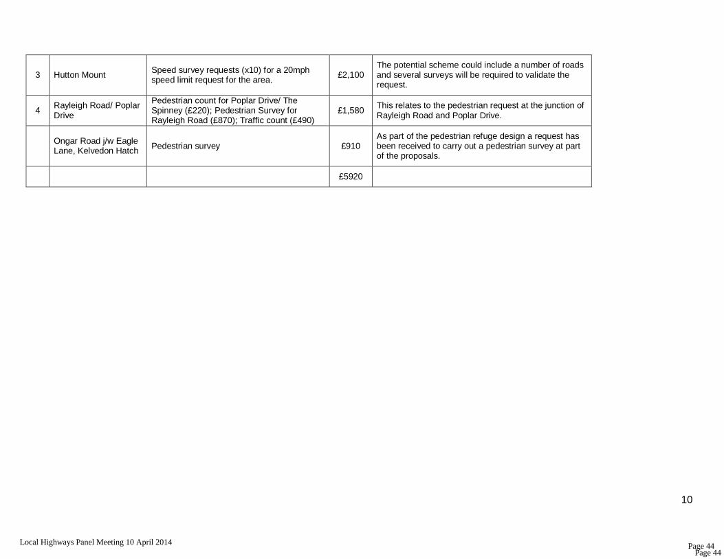
3 Hutton Mount Speed survey requests (x10) for a 20mph speed limit request for the area.
£2,100 The potential scheme could include a number of roads and several surveys will be required to validate the request.
4 Rayleigh Road/ Poplar Drive
Pedestrian count for Poplar Drive/ The Spinney (£220); Pedestrian Survey for Rayleigh Road (£870); Traffic count (£490)
£1,580 This relates to the pedestrian request at the junction of Rayleigh Road and Poplar Drive.
Ongar Road j/w Eagle Lane, Kelvedon Hatch Pedestrian survey £910
As part of the pedestrian refuge design a request has been received to carry out a pedestrian survey at part of the proposals.
£5920
Page 44Local Highways Panel Meeting 10 April 2014 Page 44

REPORT 7
Gt Ropers Lane & Ursuline Convent School, Brentwood 20mph Speed Limit Request
Purpose of Report: To advise the Panel that a number of queries have been received as a result of the recently imposed 40mph speed limit on B186 Warley Road as part of the Speed Limit Review. This note is intended to clarify the situation
Background/ Detailed Summary: A 40mph speed limit was proposed on the B186 Warley Road and associated side roads as part of the Speed Limit Review as shown on the attached plan reducing the speed limit from the national speed limit. The proposal was sent to the local Members on 12 December & advertised in the Brentwood Gazette on 19 December 2012 allowing 28 days for comments. No comments were received during the objection period. The proposal was sealed on 17 February 2014 and came into operation on 31 March 2014, the necessary signs been installed during this period as required under the procedure regulations. As set out in the advertised proposals part of Gt Ropers Lane, from its junction with Warley Road northwards for 35m, was included as part of the 40mph speed limit. This has required the introduction of terminal signs being installed at the change from 40mph to national speed limit at this point
Page 45Local Highways Panel Meeting 10 April 2014 Page 45
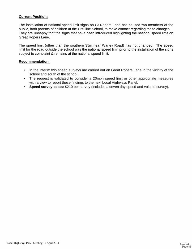
Current Position: The installation of national speed limit signs on Gt Ropers Lane has caused two members of the public, both parents of children at the Ursuline School, to make contact regarding these changes They are unhappy that the signs that have been introduced highlighting the national speed limit.on Great Ropers Lane. The speed limit (other than the southern 35m near Warley Road) has not changed. The speed limit for the road outside the school was the national speed limit prior to the installation of the signs subject to complaint & remains at the national speed limit. Recommendation:
• In the interim two speed surveys are carried out on Great Ropers Lane in the vicinity of the school and south of the school.
• The request is validated to consider a 20mph speed limit or other appropriate measures with a view to report these findings to the next Local Highways Panel.
• Speed survey costs: £210 per survey (includes a seven day speed and volume survey).
Page 46Local Highways Panel Meeting 10 April 2014 Page 46

REPORT 8
RAYLEIGH ROAD/ POPLAR DRIVE, BRENTWOOD Introduction: The purpose of the report is to advise the Local Highways Panel that a request has been received for the introduction of a pedestrian phase for the Poplar Drive/ Rayleigh Road traffic signals.
Background Information: A local resident who has a child attending one of the local schools has highlighted a number of difficulties for pedestrians trying to cross Rayleigh Road and would like to see the introduction of a formal crossing. The suggestion has been to investigate the provision of a pedestrian phase for the existing traffic signals at the junction of Poplar Drive. From the junction of Hanging Hill Lane down to Shenfield High Street there is no pedestrian crossing. Children attending Long Ridings School, have the option of using a back entrance at Poplars Hall, Poplar Drive. St Joseph's School also has a back entrance from Poplar Drive. The local resident likes to walk to and from school but finds it very difficult to cross the road; currently they use the lights at the Poplar Drive junction, but these lights are for traffic control only and do not have a pedestrian phase. Current Position: Following a previous request the phasing of these traffic signals have only recently been changed to improve the green phase for vehicles exiting Poplar Drive Previously the maximum green time for Poplar Drive was set to only 10 seconds, hence this is only enough time for 3-4 cars to exit. This has been increased for the off-peak max green time for Poplar Drive to 18 seconds which allows some 8-9 cars to exit, more than twice as many as before. A slight increase was also made to the Rayleigh Road maximum green time to compensate for the additional Poplar Drive green time. The increased max time for Poplar Drive will now run between 09:30 and 16:45 on weekdays between the AM and PM peak periods.
Page 49Local Highways Panel Meeting 10 April 2014 Page 49

Key Considerations: • There is no other crossing facility on Rayleigh Road for a long way each side of the
Poplar Drive junction as highlighted by the member of public.
• During the recent site visit by the Traffic Signal Engineer they didn't see anyone trying to cross Rayleigh Road at or near the junction but can understand it could be hazardous during peak times.
• The injury accident data has been checked for the most recent 3 year period although there are no recorded accidents at this junction there was one serious accident involving a pedestrian at the Burses Way junction in February 2013.
• The request has been discussed with the traffic signal team who have a concern on the impact on junction capacity if a crossing phase was introduced. This would require an additional stage in which all traffic is stopped due to the layout of the junction and this additional stopping time could cause increased queuing, particularly on Rayleigh Road at peak times.
• The Engineer didn't witness the junction during peak times but understands that flows on Rayleigh Road are heavy so a crossing phase is likely to have a detrimental effect on capacity. Having said that we obviously don't know what the actual level of pedestrian demand currently is to be able to assess this at present.
• Although this crossing would be at a junction rather than a standalone facility I think it would still be appropriate to undertake a pedestrian survey assessment. plus traffic count. Once this information is to hand modelling of the signals can be undertaken to assess the effect of adding a crossing phase on the junction capacity.
• It has been recommended to assess the pedestrian demands say 50m each side of the junction to capture an accurate picture of crossing demands. It is difficult to know whether the provision of a crossing would then attract more pedestrians to cross if the previous lack of a facility had suppressed demand. There is currently an uncontrolled crossing with dropped kerbs/tactile paving at the junction across Rayleigh Road east of The Spinney which could be modified as a controlled crossing. There are also uncontrolled crossings over Poplar Drive and The Spinney.
• If the panel are minded to go ahead with this assessment the traffic signal team could undertake this work as a feasibility study.
Recommendation: In light of this information, the following options may wish to be considered:
• Undertake a pedestrian survey and traffic count at the site plus additional pedestrian count for The Spinney and Poplar Drive (Estimated cost: £1,580)
• Complete a feasibility study to determine whether adding a pedestrian phase will
impact on the junction capacity and provide estimated costs for adding a pedestrian phase at this location. (Estimated cost: £4,000)
Page 50Local Highways Panel Meeting 10 April 2014 Page 50

REPORT 9
Brentwood Railway Station Warley Hill, Brentwood
Purpose of Report: To advise the Panel of the meeting that took place on 26 February 2014 with the Local Ward Members and County Member to do with the general condition of the area outside the main entrance to the station. Background/ Detailed Summary: The Councillors would like to see the area upgraded as it is the main gateway to the town and it looks very shabby and un-kept and preference would be to upgrade paving/ street furniture within the vicinity of the station
• Borough Councillors in Warley/ Brentwood West have all expressed concern about the state of the area.
• Petition signed by residents and local shop keepers in support of a scheme (not included with the validation form) and local Renaissance Group.
2010 Audley End Station Enhancement Scheme In the short term investigations have taken place to have the guard railing painted by the Highway Rangers and for some minor repairs to the pavements in the area, the carriageway markings refreshed for the crossings in the vicinity of the station and the litter to be removed from the bank on the western side opposite the station.
Page 51Local Highways Panel Meeting 10 April 2014 Page 51
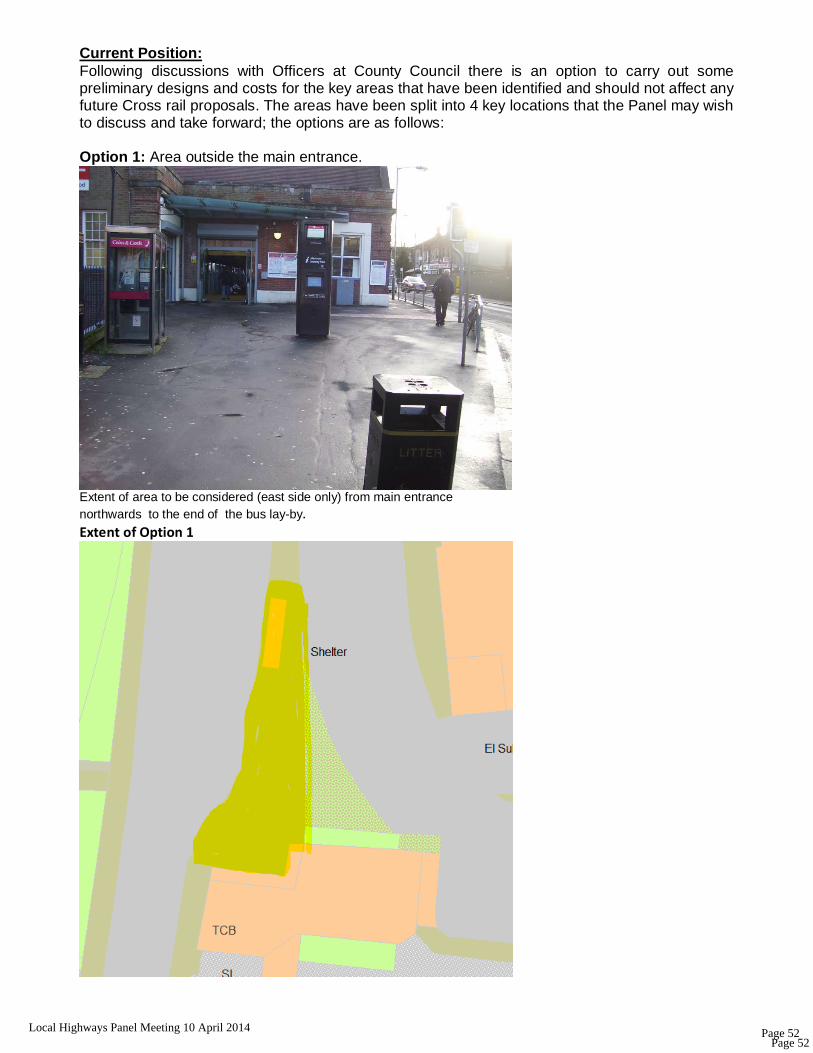
Current Position: Following discussions with Officers at County Council there is an option to carry out some preliminary designs and costs for the key areas that have been identified and should not affect any future Cross rail proposals. The areas have been split into 4 key locations that the Panel may wish to discuss and take forward; the options are as follows: Option 1: Area outside the main entrance.
Extent of area to be considered (east side only) from main entrance northwards to the end of the bus lay-by. Extent of Option 1
Page 52Local Highways Panel Meeting 10 April 2014 Page 52

Option 2: Western footway opposite Station entrance.
Extent of Option 2 –from pedestrian crossing northwards to j/w St James Road.
Page 53Local Highways Panel Meeting 10 April 2014 Page 53

OPTION 3: Eastern footway south of the Station.
East Side Only -Just south of the main entrance to the corner of Myrtle Road. Option 3
Page 54Local Highways Panel Meeting 10 April 2014 Page 54

Option 4: West Side Only: Corner of Warley Hill/ Crescent Road
Extent of Option 4: From Crescent Road Zebra to the corner of No.13
Recommendation: Currently there is £19,000 that has been approved as part of the Cross rail study (reduced from £25,000 to £19,000 at the last LHP meeting on 20.01.14) that could be used to prepare some designs and costs for the four areas featured in this report. Once these proposals have been designed and estimated they can be brought back to the Local Highways Panel for consideration and could be taken forward as one scheme or ‘phased’ subject to the overall costs.
Page 55Local Highways Panel Meeting 10 April 2014 Page 55

Page 56Local Highways Panel Meeting 10 April 2014 Page 56
1
ESSEX COUNTY COUNCIL AND
BOROUGH OF BRENTWOOD LOCAL HIGHWAY PANEL – 10th April 2014
REPORT 10: RANGERS AND REVENUE MONIES UPDATE
Purpose of report • To provide Members with an update on the Highways Rangers service for 2014/15 and
to highlight recent minor requests that have been received and could be funded from the revenue budget.
For this financial year there is again the £130,000 allocation for the provision of the Highways Rangers service. As with last year Brentwood Borough Council will be operating this service at a cost of £85,000 allowing the opportunity for the savings on this service to be reinvested back into the borough. Members are advised that like last year there is no longer a central budget for completing speed surveys or pedestrian/ vehicle surveys so the Panel need to consider providing some funds from the revenue budget for undertaking adhoc surveys; these will be essential in completing some of the validation requests that are received for speed limit and pedestrian crossing requests. It is suggested that this figure stays the same as last year (£10,000) the average cost of a seven day speed survey is £210 and pedestrian/ vehicle survey is £910. A suggested breakdown of the budget would be as follows: Ad hoc signs £8,500 Adhoc speed/ pedestrian surveys £10,000 Highway Rangers, delivered by Brentwood Borough Council £85,000 Locally determined schemes/ feasibility studies £26,500 Total £130,000 Please note any signing requests that receive funds from the ad hoc signing allocation would need to be ordered at the beginning of the financial year to allow the works to be completed in time and to avoid the allocation being lost at the end of the financial year.
Page 57Local Highways Panel Meeting 10 April 2014 Page 57

2
Highway Rangers works
Members are reminded that the type of works which can be undertaken the Rangers are as follows:
• Cleaning and minor repairs to non-electrical road signs
• Cleaning and minor repairs to street furniture
• Reinstatement of posts and bollards (minimal excavation)
• Trimming of vegetation and removal of arisings
• Adhoc grass cutting and strimming
• Localised cleaning and minor excavation of roadside grips
• Removal of weeds or vegetation from pavements
• Scavenging and removal of deposits and small fly tips from highway land
• Removal of illegal signs and fly posting
• Minor block/flag paving repairs
• Minor painting of street furniture
Requests for Highways works should be directed to: [email protected] with HIGHWAY RANGERS BRENTWOOD in the subject title.
Page 58Local Highways Panel Meeting 10 April 2014 Page 58