Embed Size (px)
Citation preview

ENVIRONMENTAL STATEMENTNON-TECHNICAL SUMMARY


Date
November 2016
P roject Number
UK11-23110
CHARLTON RIVERSIDE ENVIRONMENTAL STATEMENT NON-TECHNICAL SUMMARY

CHARLTON RIVERSIDE ENVIRONMENTAL STATEMENT NON-TECHNICAL SUMMARY
Ramboll Environ A rtillery House 11-19 Artillery Row London SW1P 1RT United Kingdom T +44 207 808 1420 www.ramboll-environ.com
P roject No. UK11-23110 Issue No. Final Date 01/12/2016 Made by Ceara Shields C hecked by Rachel Naylor A pproved by Rachel Naylor
Made by:
Checked/Approved by:
This report has been prepared by Ramboll Environ with all reasonable skill, care and diligence, and taking account of the Services and the Terms agreed between Ramboll Environ and the Client. This report is confidential to the Client, and Ramboll Environ accepts no responsibility whatsoever to third parties to whom this report, or any part thereof, is made known, unless formally agreed by Ramboll Environ beforehand. Any such party relies upon the report at their own risk. Ramboll Environ disclaims any responsibility to the Client and others in respect of any matters outside the agreed scope of the Services.
Version Control Log
Revision Date Made by C hecked by A pproved by Description
Final 01/12/2016 C S RN RN Final

Environmental Statement Non-Technical Summary
Charlton Riverside
CONTENTS
1. INTRODUCTION 12. THE EXISTING SITE AND SURROUNDING CONTEXT 33. DESIGN EVOLUTION AND ALTERNATIVES 64. DESCRIPTION OF THE PROPOSED DEVELOPMENT 95. DEMOLITION AND CONSTRUCTION WORKS 186. ENVIRONMENTAL IMPACT ASSESSMENT 207. DEMOLITION AND CONSTRUCTION MANAGEMENT AND
CONTROL 238. WHAT ARE THE LIKELY SIGNIFICANT ENVIRONMENTAL
EFFECTS OF THE PROPOSED DEVELOPMENT? 259. SUMMARY 33

Environmental Statement Non-Technical Summary
Charlton Riverside
1
1. INTRODUCTION
Purpose of this NTS
1.1 This is the Non-Technical Summary (NTS) of the Environmental Statement (ES) which has been
prepared by Ramboll Environ UK Limited in accordance with the statutory procedures set out in the
Town and Country Planning (Environmental Impact Assessment) (England) Regulations 2011 (as
amended in 2015). It has been prepared to accompany a full planning application made to the
Royal Borough of Greenwich (RBG) by Leopard Guernsey Anchor Propco Limited for the
redevelopment of a site in the Charlton area of south-east London.
1.2 In summary, the proposals include the demolition of existing buildings and erection of 9 buildings
ranging from two to 28 storeys in height for Class C3 residential use, with Class B1 employment
space and flexible uses comprising Class A1 (retail), Class A3 (Café/Restaurant), Class D1
(Community Use) and Class D2 (Leisure) at ground floor and first floor level, alterations to existing
vehicular access and creation of new pedestrian access from Anchor and Hope Lane and the
riverside, creation of new areas of open space and landscaping together with the provision of
associated car parking, cycle space, refuse and recycling storage, plant and all other associated
works.
1.3 Plans illustrating the location and boundaries of the application site are included as Figure 1.
1.4 This NTS is a summary of the main findings of the ES. The NTS provides:
• a description of the proposed development and surrounding area;
• an outline of the main development alternatives considered by the Applicant and an indicationof the main reasons for their choice, taking into account the potential environmental effects;
• a summary of the likely significant environmental effects predicted; and
• a summary of the measures proposed that would help avoid, reduce or control any significantadverse environmental effects.
1.5 The aim of the NTS is to summarise the content and main findings of the ES in a clear and concise
manner to assist the public in understanding what the likely significant environmental effects of
the proposed developments are likely to be.
Viewing the ES and Application
1.6 The full ES comprises:
• Volume 1: Main Text;
• Volume 2: Townscape, Heritage and Visual Impact Assessment (THVIA);
• Volume 3: Technical Appendices; and
• Non-Technical Summary (this document).
1.7 This NTS and the full ES, together with the planning application and other supporting documents
are available for viewing by the public in the Planning Department of the RBG during normal office
opening hours and on the RBG’s online planning portal.
1.8 CD versions of the ES are available for purchase at a cost of £25 from Ramboll Environ.

Environmental Statement Non-Technical Summary
Charlton Riverside
2
Commenting on the Application
1.9 Comments on the planning application should be forwarded to the RBG at: Royal Borough of
Greenwich, The Woolwich Centre, Wellington Street, Woolwich, SE18 6HQ
Figure 1: Site Location

Environmental Statement Non-Technical Summary
Charlton Riverside
3
2. THE EXISTING SITE AND SURROUNDING CONTEXT
The Application Site2.1 The application site comprises two parcels of land referred to as ‘Plot A’ and ‘Plot B’, Plot A being
the northern most plot, and Plot B being to the south-west of Plot A. Together they form the
application site, at a total area of 2.53 hectares (ha). The location and application site boundary is
shown in Figure 1.
2.2 Plot A is bound by:
• commercial units comprising Anchorage Point Industrial Estate and Imex House to the north;
• commercial and industrial units including a casting foundry and depot to the to the east;
• commercial and light industrial units comprising Ropery Business Park to the south; and
• an electricity substation, residential properties at Atlas Gardens and Derrick Gardens, andAnchor and Hope Lane with a distribution centre and units comprising Lombard TradingEstate beyond to the west.
2.3 Plot B is bound by:
• residential properties at Atlas Gardens to the north;
• commercial and light industrial units comprising Ropery Business Park to the east;
• commercial and retail properties comprising Charlton Gate Business Park to the south; and
• Anchor and Hope Lane and commercial units comprising Lombard Estate and Anchor andHope Business Park to the west.
2.4 As shown in Figure 1, the application site is irregularly shaped. It is currently hardstanding with
limited vegetation, occupied by industrial warehouse and business park units, as shown in Figure
2. Due to its proximity to the River Thames, the application site has been designated as an ‘Area
of High Archaeological Potential’ within the RBG’s Local Plan.
2.5 There are no known previous planning applications on this site.
The Surrounding Area 2.6 The application site’s surrounding context is of a predominantly industrial nature. This is
characterised by existing warehouses and retail outlets that border the application site, with the
exception of the Imex House and residential properties of Atlas Gardens and Derrick Gardens which
are located directly adjacent.
2.7 Beyond the northern boundary lies the River Thames, the closest surface water resource, and
beyond the southern boundary lies the A206 dual carriageway. A large Sainsbury’s distribution
centre is located further west of the application site, comprising a warehouse, an energy centre, a
vehicle wash and an area for refuelling. Stone Lake Retail Park is located to the south-east.
2.8 Charlton Railway Station is located approximately 350m to the south. The station is situated on
the Southeastern Line, providing a direct service to London Bridge, London Charing Cross and
London Cannon Street. The nearest underground station is North Greenwich, which is
approximately 2.6km north-west of the application site. The application site is situated within an
accessible road network, with Anchor and Hope Lane adjacent to the north which connects with
Environmental Statement Non-Technical Summary
Charlton Riverside
4
Charlton Church Lane and Woolwich Road (A206) to the south. To the west, Bugsby’s Way links
the application site with the Greenwich Peninsula and the Blackwall Tunnel (A102).
2.9 In addition, five bus routes are within easy access of the application site with bus stops on Bugsby’s
Way, Anchor and Hope Lane or Woolwich Road. There are also suitable pedestrian and cycle routes
in the vicinity of the application site to important destinations including the National Cycle Network
Route 1 which directly connects with the application site and runs along the Thames Path,
connecting to other local and national cycle routes.
2.10 Three safeguarded wharves, designated under GLA planning policy, are located within 900m of the
application site. The closest is Riverside Wharf, approximately 150m to the north-east.
2.11 The application site is located within Charlton Riverside – a Strategic Development Location
allocated for a new mixed use urban quarter by the RBG Core Strategy (2014).
Figure 2: Existing Site
Environmental Baseline Sensitivities 2.12 The environmental character and sensitivity of the application site is described below:
• The application site is not located within a conservation area;
• The application site does not contain any nationally designated (protected) heritage assets,such as scheduled monuments, listed buildings or registered parks and gardens;

Environmental Statement Non-Technical Summary
Charlton Riverside
5
• The entire application site lies within the Greenwich Peninsula and Foreshore Area of HighArchaeological Potential, which is characterised by the potential for prehistoric to medievalremains within alluvial deposits;
• There are no areas of ecological value on or around the application site;
• The application site is located within an Air Quality Management Area (AQMA) declared underthe Environment Act 1995, which incorporates the whole RBG; and
• The nearest significant noise sources are associated with road traffic and commercial andindustrial premises in proximity to the application site.

Environmental Statement Non-Technical Summary
Charlton Riverside
6
3. DESIGN EVOLUTION AND ALTERNATIVES3.1 In line with the EIA Regulations, the ES provides a description of the main alternatives to the
proposed development, considered by the Application. These include:
• The ‘No Development’ Option;
• Alternative sites; and
• Alternative designs through design evolution.
No Development Option 3.2 The ‘do nothing’ alternative refers to the option of leaving the application site in its current state.
This option would be undesirable and inappropriate for a number of reasons including:
• The application site is located within the Charlton Riverside Opportunity Area which isidentified by the London Plan for significant residential growth (including a minimum 3,500homes);
• Redevelopment of the application site is required to unlock access to adjacent developmentsites within the Opportunity Area; and
• It would represent a lost opportunity to open up the application site for greater publicaccessibility and significant improvements to the public realm.
3.3 Consequently, the ‘do nothing’ scenario was rejected by the Applicant.
Alternative Sites 3.4 The Applicant purchased the application site having regard to is location within an area identified
for significant redevelopment and growth. The application site is highly accessible and available for
delivery. No other sites were considered by the Applicant.
Design Evolution 3.5 Various design options were considered by the Applicant during 2015/2016 that evolved into the
residential-led development being sought for approval. These options were discussed with the RBG
and the GLA, and a number of points were considered in relation to the proposed scale of
development, relationship to the wider masterplan area, the quantum of residential accommodation
and associated issues relating to residential amenity, employment area, servicing strategy access,
parking provision and sunlight and daylight. Public consultation events were also a key process for
gaining stakeholder feedback.
3.6 Early proposals for the application site focused on generating a variety of design ideas and options
that would deliver the required density of accommodation to secure redevelopment of the
application site.
3.7 A number of potential block forms and layouts were examined, prior to discussion with key
stakeholders, and the development of these initial options allowed the Applicant and design team
to formulate a shared understanding of the key design issues, opportunities and constraints
associated with the application site.
3.8 Whilst the evolution of the proposed development took place continuously up until this point, for
ease, the alternative designs have been summarised into 2 key design stages as follows:

Environmental Statement Non-Technical Summary
Charlton Riverside
7
Phase 1: September 2015 – April 2016
3.9 A diagrammatic layout was established to create a framework for the detailed development of key
routes and spaces, and to inform key urban design principles. The layout of the built form
responded to the existing context, particularly the adjacent housing, and created frontages to the
key public spaces. The building heights responded to existing contextual 2-storey houses and the
hierarchy of proposed building heights stepped up from the west at 4 storeys, increasing in height
towards the east of the application site up to 26 storeys. The disposition of building heights also
maximised sunlight penetration to key public spaces. Existing and future routes were considered
to allow flexibility for connection to future masterplan phases.
3.10 A rich variety of garden spaces at ground level and at building roof levels were proposed,
comprising green pedestrian streets, pocket squares, small green courtyard spaces, urban SUDS,
river walkway, and landscaped edge conditions to Anchor and Hope Lane. The diversity of character
and typology of gardens, streets and squares was intended to create spaces at a human scale that
reflected the wider masterplan principles and objectives to establish a safe environment for people
to live, work and play and inspire and educate the new local community.
Phase 2: May 2016 - November 2016
3.11 Following the considerable period of time spent on design development, revision, and consideration
of alternatives, and based on the feedback received from key stakeholders during the evolution of
the various design proposals a new approach and concept was established, considering the adjacent
existing and future development. The key principles established were:
• A rich variety of residential typologies and characterful mix of public spaces, informed by viewand orientation.
• A ‘structured informality’ with the potential for future connections to the evolving CharltonRiverside masterplan area.
• A green place – maximising opportunities.
• A place people want to live in.
• Clear hierarchy in terms of massing and height, and relationship to existing and futurecontext and routes.
• High quality, residential-led.
• An exemplar for development of the wider masterplan area.
• A density that responds to the site’s urban location, suitable to establish the initial phase ofthis important new place.
3.12 Initial proposals were based on a series of streets running on a north-south orientation to allow
sunlight to pass through. Building heights ranged from 4 to 26 storeys, lowest at the west near
existing homes and rising to the east furthest away from these. However, there were concerns that
the tall buildings to the east of the application site might compromise future neighbouring
development sites.
3.13 It was recognised that there was a need to see more activity at ground level. Therefore, the second
iteration increased the amount of public space and routes through the application site, aiming to
better integrate it into the existing and future neighbourhood.

Environmental Statement Non-Technical Summary
Charlton Riverside
8
3.14 The second iteration also saw the introduction of a nursery and a range of active ground floor uses,
including business spaceas well as a focus on family homes and the inclusion of town houses.
Building heights were redistributed to lower buildings at the edges of the site, locating the tall
buildings in the centre of the scheme.
3.15 Further along the design process, building heights were reduced in the centre of the scheme and
redistributed to one landmark building at the south of the application site.
3.16 A pedestrian route cutting east-west through the site was also added to increase permeability and
access to the park area.
Environmental Influences
Environmental factors have influenced the proposals as they have evolved. Key environmental factors relate to:
• Wind microclimate – shaping the landscaping proposals and location of buildings entrances;
• Acoustics – affecting the façade design and influencing the location of winter gardens, whenconsidering existing local noise sources;
• Daylight and Sunlight - most importantly affecting the massing height and footprints inrelation to nearby existing residential properties;
• Drainage Strategy - influencing the design in respect of the local townscape;
• Playspace requirements – affecting the landscaping proposals to ensure sufficient playspace;and
• Ecology – enhancing local biodiversity was a key consideration in the landscaping proposals.

Environmental Statement Non-Technical Summary
Charlton Riverside
9
4. DESCRIPTION OF THE PROPOSED DEVELOPMENT4.1 The proposed development will involve the demolition of existing buildings and construction of nine
buildings ranging from two to 28 storeys in height for Class C3 residential use, with Class B1
employment space and flexible uses comprising Class A1 (retail), Class A3 (Café/ Restaurant),
Class D1 (Community Use) and Class D2 (Leisure) at ground floor and first floor level, alterations
to existing vehicular access and creation of new pedestrian access from Hope and Anchor Lane and
the riverside, creation of new areas of open space and landscaping together with the provision of
associated car parking, cycle space, refuse and recycling storage, plant and all other associated
works.
4.2 The proposed development would provide:
• 975 residential units;
• 1,560m2 (GIA) of office space;
• Ancillary residential facilities including gym, swimming pool, changing rooms totalling 864m2
(GIA);
• 690m2 (GIA) of flexible retail/restaurant/café/leisure use;
• 407m2 (GIA) of community uses (intended for a crèche and healthcare facility);
• 1,652 residential and commercial cycle spaces; and
• 198 car parking spaces provided in a partial basement-level car park.
4.3 The landscape proposals for the proposed development would deliver considerable public realm,
biodiversity and amenity enhancement.
4.4 The details of the proposed development are provided in Tables 1 – 3 below with breakdowns of
areas, and tenure and unit mix in relation to the residential units.
Table 1: Proposed Development Area Schedule
Land Use GEA (m2) GIA (m2)
Office space 1,957 1,560
Ancillary residential facilities including gym, swimming pool, changing rooms
1,142 864
Flexible retail/restaurant/café/leisure use 1,000 690
Community uses 490 407
Table 2: Proposed Development Tenure Mix
Tenure Units
Private 832 (85.3%)
Intermediate 40 (4.1%)
Affordable rent 103 (10.6%)
TOTAL 975 (100%)

Environmental Statement Non-Technical Summary Charlton Riverside
10
Table 3: Proposed Development Unit Mix
Unit Type Total
1 bed 1 person 168 (17.2%)
1 bed 2 person 227 (23.3%)
2 bed 306 (31.4%)
3 bed 253 (25.9%)
4 bed 21 (2.2%)
TOTAL 975 (100%)
4.5 The main components of the proposed development are shown in a series of plans and images that
are submitted as part of the full planning application. A selection are presented in this section
(Figures 3 – 5).
Site Arrangement
4.6 The buildings are located on two adjacent plots; Plot A (north) and Plot B (south). The built
footprints within the application site are presented in Figure 3 and are described as follows:
• Plot A
− Building A- East (North): Residential and commercial;
− Building A- East (South): Residential and commercial;
− Building A1: Residential and amenities;
− Building A2: Residential and amenities;
− Building A- West (North): Residential;
− Building A- West (South): Residential; and
− Basement: Parking and plant.
• Plot B
− Building B3: Residential;
− Building B- West: Residential, amenities and commercial;
− Building B- East: Residential; and
− Plinth: Amenities, commercial, parking and plant.

Environmental Statement Non-Technical Summary Charlton Riverside
11
Figure 3: Massing Model of the Proposed Development

Environmental Statement Non-Technical Summary Charlton Riverside
12
Figure 4: Building Layout Plan with Building Names
Figure 5: Internal Amenity Area of the Proposed Development

Environmental Statement Non-Technical Summary Charlton Riverside
13
Proposed Development Composition
4.7 Figure 3 shows a visual representation of the proposed development. The location of the buildings
on the two plots was developed from the desire to create an extensive green space in the centre
of each plot. The building locations and corresponding names are shown in Figure 4, and details
are provided in Table 4 below.
Table 4: Building Names, Heights and Basement Depth
Building No. of Storeys Building Height/Basement Depth
(mAOD)
Building Height/Basement Depth (m) Above
Ground Level
Parapet/Roof Height Parapet/Roof Height
Plot A
Building AEN
9-11 47.845m/46.010m 44.295m/42.460m
Plot A
Building AES
9-16 56.200m/54.880m 52.650m/51.330m
Plot A
Building A1
16 58.655m/54.226m 55.105m/50.675m
Plot A
Building A2
14 52.595m/48.165m 49.045m/44.615m
Plot A
Building AWN
2-6 24.130m/22.830m 20.580m/19.280m
Plot A
Building AWS
3-6 24.130m/22.830m 20.580m/19.280m
Plot A
Basement
1 1.150m (FFL) -2.400m (FFL)
Plot B
Building B3
28 94.130m/89.585m
95.930m (Top of flues)
90.580m/86.035m
92.380m (Top of flues)
Plot B
Building BW
9-11 33.530m/32.230m 29.980m/28.680m
Plot B
Building BE
6-12 43.300m/42.200m 39.750m/38.650m
Plot B Plinth
1 7.550m (FFL) 4.000m (FFL)
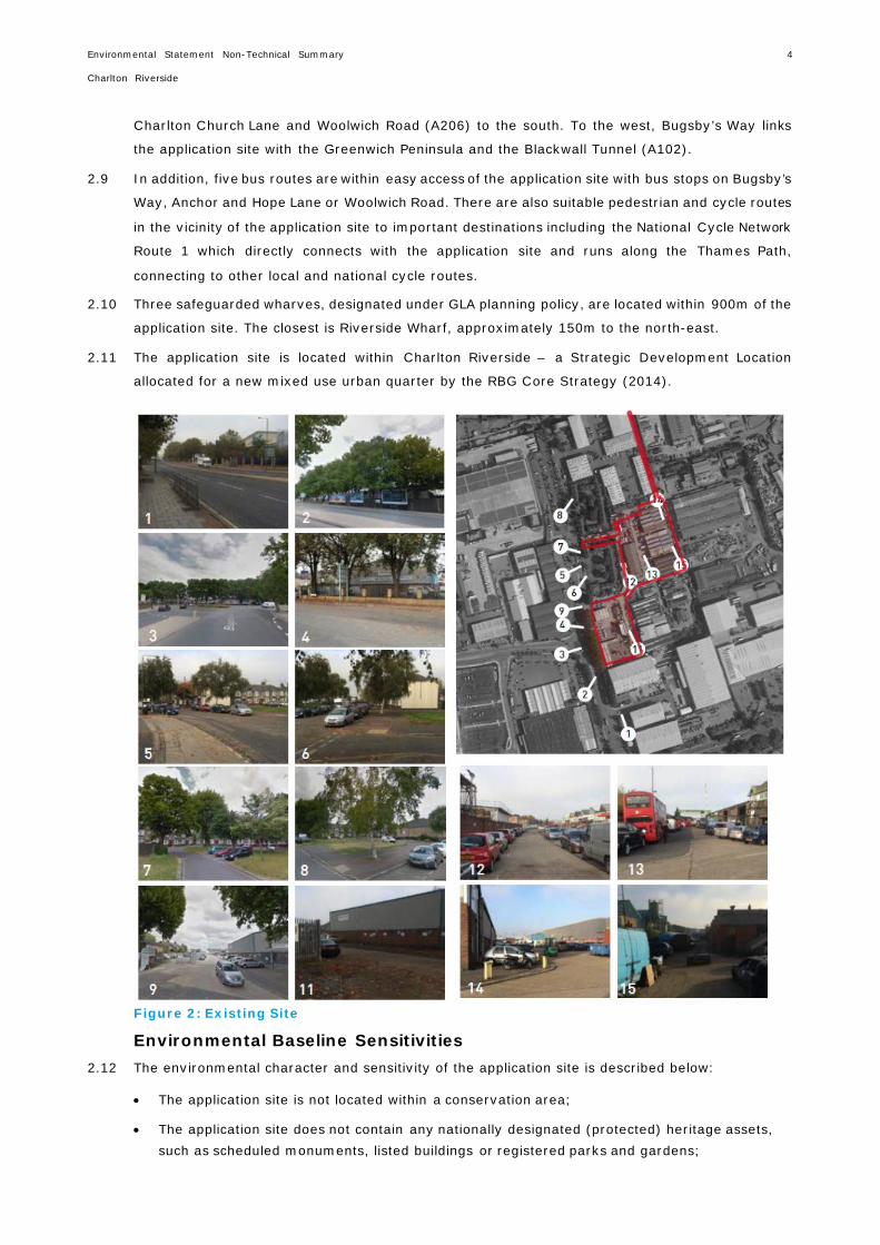
4.8 The following two images (Figures 6 and 7) show visualisations of the proposed development during
the day and night respectively.
Environmental Statement Non-Technical Summary Charlton Riverside
14
Figure 6: View of the Proposed Development during the Day
Figure 7: View of the Proposed Development at Dusk

Environmental Statement Non-Technical Summary Charlton Riverside
15
4.9 The distribution of land uses comprises the following:
• Plot A Residential Blocks
− The buildings to the western boundary AWN and AWS provide 2-storey 3-bedroom townhouses with private gardens on the ground floor and a variety of 1, 2 and 3 bedroom apartments and studios on the upper floors. All are provided with either a private winter garden, loggia space or private roof terrace.
− Buildings A1 and A2 provide community and residential facilities on the ground floor and a mix of 1, 2 and 3 bedroom apartments and studios on the upper floors. All apartments are provided with winter gardens.
− Buildings AEN and AES also provide commercial space on the ground floor and a mix of 1, 2 and 3 bedroom apartments and studios on the upper floors.
• Plot B Residential Blocks
− The buildings to the eastern boundary BW provide 2-storey 4-bedroom townhouses with private gardens on the ground floor and a variety of 1, 2 and 3 bedroom apartments and studios on the upper floors. All are provided with either a private winter garden, loggia space or private roof terrace.
− Buildings B3 and BW provide residential facilities and commercial space on the lower two floors and a mix of 1, 2 and 3 bedroom apartments and studios on the upper floors. All apartments are provided with winter gardens or loggias.
• Ground Level
− The ground level includes areas of active frontage across the two plots located at the perimeter along current and future access roads providing space for retail, café, restaurant, leisure and community use together with significant areas of public realm and some private secure gardens associated with the townhouses. Some of the spaces extend over two floors with access to the garden on plinth level on Plot B.
• Active Frontages
− Considerable care has been taken to establish linkages and physical and visual permeability across the application site and to maximise the area of internal and external space to which the public have access.
• Flexible Retail/Commercial Space
− Flexible retail space is located to the most eastern edge of the proposed development providing space on ground floor to the north and over two floors to the south.
− Further space is provided on the perimeter on the southern plot located in close proximity to Anchor and Hope Lane.
• Residential Amenities
− A residential lounge is located within the southern park building for flexible use facing the garden. Also a gym and swimming pool are located within the ground and first floor of Plot B.
• Crèche
− A crèche is located within the park building on ground floor with an associated private garden.

Environmental Statement Non-Technical Summary Charlton Riverside
16
• Concierge and Lobbies
− Both plots provide a concierge area and associated drop-off to service the buildings.
• Entrances
− The building entrances are located along the perimeter of the application site along current and future roads. The only exception is the western block on Plot B which is access via a private road within the application site.
• Parking
− Covered car and cycle parking is provided on Plot B accessed from the north-east corner of the application site.
• Plant
− The energy centre for the entire development is provided on the ground floor of Plot B. Further plant space is located within the basement of Plot A.
• Townhouses
− Townhouses are located backing onto the existing row of townhouses on Plot A to the western boundary and on Plot B the townhouses are located towards the eastern boundary with the gardens located on the Level 1 courtyard.
• Public Realm
− Extensive public realm is provided as part of the development and extends to 1.5ha and 61% of the overall site area.
• Private and Shared Roof Terraces
− Private and shared landscaped roof terraces are provided across the buildings of the development.
• Basement Level
− The basement level on Plot A accommodates parking, cycle parking, refuse stores and local plant space and takes up approximately half of the application site. The half basement creates a transition between the current levels of the application site and the approximately 1m higher adjacent site to the east.
Landscape Masterplan
4.10 The ground floor landscape masterplan has been provided in Figure 8. The proposed development
will bring forward approximately 1.5ha of publically accessible amenity space on-site comprising
the following:
• 1ha neighbourhood park within Plot A;
• 1,444m2 podium garden within Plot B; and
• 3,260m2 ground floor space within Plot B.
4.11 Within this space, playspace provision requirements are always an important driver for the
development of the landscape proposals. Creating safe, inviting spaces for children and families
has been a core principle of the scheme since the beginning. The design team has carefully
considered where to best place play areas for the range of target age groups. The proposed
development looks to locate playspace within close proximity to block cores, away from vehicular
routes and in sheltered areas of the scheme.

Environmental Statement Non-Technical Summary Charlton Riverside
17
There will also be private gardens within the proposed development, totalling 1,869m2.
The following areas of playspace will be brought forward on-site:
• Under five year olds: 1,675m2;
• 5-11 year olds: 1,314m2; and
• Over 12 year olds: 877m2.
4.12 Information received form the ecological assessments has greatly informed the development of the
landscape proposals. The landscape scheme has evolved and adapted to support (and enhance)
local biodiversity through changes to the soft landscape palette, by incorporating specific habitats
for birds and various invertebrates, and by establishing particular maintenance operations to
ensure continued success. The whole landscape scheme stems from some basic ecological
principles relating to connectivity, increased biodiversity, and careful landscape management.
Figure 8: Ground Floor Landscape Plan

Environmental Statement Non-Technical Summary Charlton Riverside
18
5. DEMOLITION AND CONSTRUCTION WORKS
Overview
5.1 At this stage the full details as to how the demolition and construction works would be undertaken
and the timescales associated with these works have not yet been settled, as these are affected
by very many different factors. The demolition and construction effects are therefore based on the
following reasonable assumptions.
5.2 It is assumed that demolition and construction works would take place in one continuous phase,
over a period of approximately 62 months. This would begin in 2018 with demolition of Plot B
followed by demolition works in Plot A. Construction works are expected to commence in mid-2018
for Plot B and early 2020 for Plot A. It is anticipated that all works will be complete by early 2023.
5.3 Whilst the actual construction programme is likely to be driven by market demand for the buildings,
these assumptions represents a reasonable ‘worst case’ scenario in terms of the scale of
construction works taking place at the same time, an approach that is in accordance with best
practice in EIA methodology.
5.4 Figure 9 shows the expected indicative construction works programme for the proposed
development.
5.5 In general terms, the proposed works comprise the following:
• site preparation (diversion of existing services including telecoms, electricity and water and erection of hoarding);
• demolition of existing structures;
• substructure (below ground works including piled foundations and basement construction);
• superstructure (above ground including steel and/or concrete structures and cladding);
• fit-out; and
• public realm works.
5.6 Prescribed hours of work would be agreed with the RBG. It is envisaged that, in general, the hours
of work would be as follows:
• 08:00 – 18:00 hours Monday to Friday;
• 08:00 – 13:00 hours Saturday;
• No working on Sundays or Bank Holidays.
5.7 It is recognised there is residential accommodation in close proximity to the parts of the application
site where noisy works or other activities would be undertaken, which could cause disruption. On-
going liaison with the neighbours would ensure that they are informed of the works being
undertaken and that consideration is taken of any concerns they may have.

Environmental Statement Non-Technical Summary Charlton Riverside
19
Figure 9: Anticipated Demolition and Construction Programme

Environmental Statement Non-Technical Summary Charlton Riverside
20
6. ENVIRONMENTAL IMPACT ASSESSMENT
EIA Process and Methodology
6.1 This NTS reports on the findings of the Environmental Impact Assessment (EIA) process. EIA is a
process that identifies the potential significant environmental effects (both beneficial and adverse)
of a proposed development and proposes mitigation to avoid, reduce and offset any likely
significant adverse environmental effects.
6.2 The EIA process adopted for the proposed development has followed best practice guidelines, as
set out by the Institute of Environmental Management and Assessment (IEMA) Quality Mark
scheme. The process involved a number of key steps as follows:
• Consultation was undertaken with key stakeholders such as the RBG, the GLA and CABE on the issues to be considered by the EIA;
• The most up-to-date information on the nature of the sensitivity of the environment was gathered and assessed where applicable;
• The EIA used best practice methods to predict the potential nature, size and significance of any environmental change; and
• The results of the EIA process have been reported in the ES in a transparent way, to provide the information required to support the decision making process.
Topics Included in the EIA 6.3 A number of environmental studies were carried out as part of the EIA. Key issues assessed were:
• Socio-Economics;
• Transport;
• Air Quality;
• Noise and Vibration;
• Archaeology (Buried Heritage);
• Daylight, Sunlight, Overshadowing and Solar Glare; and
• Wind Microclimate.
6.4 The ES provides assessments of potential significant environmental effects during demolition and
construction and once the proposed development is complete and operational. Each technical
assessment considers a range of different types of effects including direct effects and any indirect,
secondary, cumulative, short, medium and long-term, permanent and temporary, beneficial and
adverse effects.
6.5 Each of the above issues are addressed in the ES, with a chapter dedicated to each of these issues.
In each chapter, a description of the assessment methodology is given together with current Site
conditions. This is followed by an assessment of the likely significant effects of the proposed
development (both beneficial and adverse) and any measures that should be adopted to reduce or
offset any significant adverse effects identified during the assessment. The ES also provides an
assessment of the residual effects that would remain after mitigation measures have been
implemented, as well as the cumulative effects of the proposed development. The likely significant
environmental effects attributed to the proposed development are confirmed.

Environmental Statement Non-Technical Summary Charlton Riverside
21
Cumulative Effects
6.6 Two types of Cumulative Effects have been assessed:
• Intra-Project effects of different types of impacts from the proposed development that could interact to jointly affect a particular receptors at the application site. Potential impact interactions could include the combined effects of noise and dust during demolition and construction activities on a particular sensitive receptor; and
• Inter-Project effects which are combined effects generated from the proposed development with other committed or planned developments (‘other developments’). These ‘other developments’ may generate their own individually insignificant effects but when considered together could amount to a significant cumulative effect, for example, combined townscape and visual impacts from two or more (proposed) developments.
6.7 The ‘other developments’ identified for the purpose of the cumulative impact assessment are as
follows:
• 12/0022/O: Greenwich Millennium Village (Phases 3, 4 & 5), Peartree Way, Greenwich;
• 13/3281/R: Parcel 2, Sub-Phase 1, Greenwich Millennium Village Phases 3, 4 & 5;
• 14/0127/O: Morris Walk Estate (North), north of Pett Street, SE18;
• 14/0126/O: Morris Walk Estate, south of Maryon Road, SE7;
• 13/3285/O: Sainsbury's and former Comet Stores, 55 & 57 Bugsby's Way, Greenwich, SE10;
• 13/2086/F: Brocklebank Industrial Estate;
• 16/0132/F: Valley House, 445 Woolwich Road, Charlton, SE7;
• 13/2016/F: Former Matalan Site, 30 Bugsby Way, Charlton, SE7;
• 11/0868/F: Land to north of Woolwich Road;
• 14/2550/F: Land to north of Woolwich Road; and
• 14/0117/O: Maryon Road and Grove Estate.
Topics Excluded from the EIA
6.8 The EIA Scoping process identified the environmental topic areas which are not likely to give rise
to potential significant environmental effects and therefore would not need to be assessed as part
of the EIA:
• Light Spillage;
• Waste;
• Telecommunication Interference;
• Ecology;
• Water Resources and Flood Risk;
• Ground Conditions;
• Health and Wellbeing; and
• Aviation.
6.9 It was considered that waste and health and wellbeing would be addressed across the ES as a
whole, in a variety of different technical and non-technical chapters.

Environmental Statement Non-Technical Summary Charlton Riverside
22
6.10 Light spillage, telecommunication and aviation were not considered to require any form of
assessment, as effects were not considered likely. London City Airport has however been consulted
on the proposals.
6.11 Whilst it was not expected that ecology, flood risk and hydrology, and ground considerations would
experience any likely significant environmental effects, none the less technical information relating
to these topic areas have been included within the ES, as technical appendices.
6.12 This approach has been agreed with the RBG through the EIA Scoping process.
Environmental Statement Non-Technical Summary Charlton Riverside
23
7. DEMOLITION AND CONSTRUCTION MANAGEMENT AND CONTROL
Construction Environmental Management Plan 7.1 It is proposed that a Construction Environmental Management Plan (CEMP) would be prepared for
the proposed development which would include all details of relevant environmental management
controls necessary for environmental protection during the works. This would be discussed and
agreed with the relevant planning officers at the RBG following the approval of the detailed planning
application. It is envisaged that the CEMP would address as a minimum the following:
• the control and management of construction wastes;
• housekeeping procedures and environmental control measures relating to water, waste, noise, air quality, incidents, archaeology and contamination;
• details of any environmental monitoring proposed;
• details of prohibited or restricted operations (location, hours etc.);
• the details of proposed routes for HGVs travelling to and from the site; and
• details of all works involving interference with a public highway, including temporary carriageway / footpath closures, realignment and diversions.
Community Liaison 7.2 Measures for community liaison would be implemented by the contractor to co-ordinate the
dissemination of information. Communication methods typically used would include newsletters,
phone helpline, liaison meetings, notice boards/hoarding information and personal contact
particularly prior to abnormal work.
7.3 The CEMP would set out the arrangements for dealing with incidents or complaints. In general, all
complaints would be logged and reported to the appropriate authority where required. Measures
to remedy the complaint would also be recorded and reported back to the complainant.
Potential Construction Environmental Effects 7.4 The main sources of potential environmental effects during construction of the proposed
development have been identified as transport, dust, noise and vibration and archaeology. Potential
effects and associated mitigation measures to reduce potential effects are set out in Table 5.
Table 5: Key Potential Construction Environmental Effects
Topic Potential Effects Potential Mitigation/Enhancement Measures
Transport • Effects of traffic flows from construction vehicle movements upon the local highway network;
• Effects of construction activities on pedestrian movement and capacity, severance, delay, fear and intimidation, amenity;
• Effects of construction on cyclists;
• Environmental Management Plan (EMP) and Construction Logistics Plan (CLP) prior to commencement;
• Management of walkways, any temporary closures and routing would be agreed with the RBG through the CLP and EMP post-

Environmental Statement Non-Technical Summary Charlton Riverside
24
Table 5: Key Potential Construction Environmental Effects
• Effects of increased number of public transport trips as a result of construction workers’ travel.
planning and prior to commencement; and
• Management of road closures and routing would be agreed with the RBG through the CLP and EMP post-planning and prior to commencement.
Air Quality • Nuisance dust. • Incorporate mitigation measures from the IAQM Guidance on the assessment of dust from demolition and construction, such as dust monitoring, using solid screens around dusty activities and stockpiles, and ensuring adequate water supply for effective dust suppression.
Noise and Vibration
• Construction noise, vibration and traffic.
• Standard best practice measures, such as regularly maintaining all plant used on-site, provision of rest periods during any long prolonged noisy activities, and installing an acoustic barrier.
Archaeology (Buried Heritage)
• New piled foundations would locally remove remains within their footprints; and
• Preliminary site strip and excavation of new basement level.
• Following a written scheme of investigation, if any buried heritage is found preservation by record would be undertaken comprising a geoarchaeological borehole survey and sub- surface deposit model to greater understand the nature of the underlying geology and topography, and any potential prehistoric landscapes.
7.5 The overall potential environmental impacts of the demolition and construction phase have been
considered. These would be mitigated as far as practicably possible by the control and management
of all potential factors in accordance with legislative requirements, best practice and an agreed
CEMP.

Environmental Statement Non-Technical Summary Charlton Riverside
25
8. WHAT ARE THE LIKELY SIGNIFICANT ENVIRONMENTAL EFFECTS OF THE PROPOSED DEVELOPMENT?
Socio-Economics
8.1 A socio-economic assessment has been undertaken using a wide range of nationally recognised
research and survey information and previous professional experience of similar schemes.
8.2 The construction works associated with the proposed development would generate approximately
263 jobs throughout the 62 month construction period. Taking into account the proportion of
employment that would be outside of the local target area, the net annual construction employment
to the target area is estimated to be 35.
8.3 It has been estimated that the commercial floorspace proposed within the proposed development
would accommodate approximately 140-150 FTE jobs. Taking into account the proportion of
employment that would be outside of the local target area, the net operational employment to the
target area is estimated to be 37-39.
8.4 The proposed development will bring forward up to 975 new residential units with affordable
housing. A population forecast and child yield forecast has been undertaken in order to assess the
potential effect that the new population will have on educational facility capacity and primary
healthcare provision.
8.5 In addition, the building has been designed to facilitate reduction in crime and fear of crime, and
amenity space including playspace will be brought forward. A total of 1.5ha of publically accessible
amenity space will be brought forward on-site, including 3,866m2 of playspace, exceeding GLA
standards.
8.6 By implementing appropriate mitigation and enhancement measures, the adverse effects of the
proposed development can be reduced whilst beneficial effects are enhanced. Therefore, there are
no identified likely significant adverse environmental effects associated with socio-economics.
However, there are likely significant beneficial effects identified including the provision of new
housing, provision of playspace and improvements to site safety.
Transport
8.7 The proposed development has been assessed against relevant criteria for all modes of transport
and for the construction works and once the proposed development is complete and operational.
8.8 Consideration has been given to the likely numbers of construction vehicles and the routes to and
from the application site. The construction vehicles would be managed in accordance with a
Construction Logistics Plan (CLP) and an Environmental Management Plan (EMP). These documents
would be agreed with the RBG prior to the commencement of works.
8.9 The level of construction traffic is likely to be less than the traffic already generated by the
application site. Given the predicted level of peak hourly volumes of construction vehicles
associated with demolition and construction activities on the application site, the control measures
within the CLP and EMP that would be implemented, and the fact that construction workers would
be travelling outside of the peak periods due to their normal working hours, the majority of the
transport effects within the construction phase are likely to be not adversely significant. Instead,
Environmental Statement Non-Technical Summary Charlton Riverside
26
there is a likely significant beneficial effect associated with the highway network due to the
reduction in traffic.
8.10 The pedestrian environment within the application site will be of high quality with the provision of
an attractive open space, well maintained and legible pathways and lighting, thus providing
natural/passive surveillance. The pedestrian environment will be further enhanced by providing
new crossing points on Anchor and Hope Lane and additional pedestrian/cycle only links to the
Thames Path and Anchor and Hope Lane.
8.11 Proposed cycle parking facilities will encourage an increase in the use of cycling. Any increases
would be monitored as part of the Travel Plan surveys and ongoing monitoring. Overall, the
completed development would provide a well-designed pedestrian and cyclist environment.
8.12 TfL will require contributions towards improving bus service frequencies as part of the proposed
development to accommodate the additional patronage predicted which will be secured through a
financial contribution to bus services. As this would increase service frequencies or the number of
services provided it would also benefit the wider public within the area.
8.13 There will be highway enhancement works at the Site Access and Anchor and Hope Lane to reduce
the adverse effects relating to operational traffic flows. In addition, the completed development
will be subject to a Travel Plan, a Car Park Management Plan and a Delivery and Servicing Plan
detailed as follows:
• Travel Plan – a Residential Travel Plan would aim to encourage public transport use, walking and cycling amongst occupants of the proposed development with the aim of reducing private car use;
• Car Park Management Plan – this will set out the management and operation of the on-site parking provision. This would be in combination with a permit-free agreement; and
• Delivery and Servicing Plan – this will manage the arrival and departure of delivery and servicing vehicles and their activities when on-site.
8.14 By implementing appropriate mitigation and enhancement measures, the adverse effects of the
proposed development can be reduced whilst beneficial effects are enhanced. Therefore, there are
no identified likely significant adverse environmental effects associated with transport. However,
there would be likely significant beneficial effects associated with the demolition and construction
traffic in terms of the highway network and pedestrians, given the reduction in in traffic flows and
improvements in pedestrian crossings.
Air Quality
8.15 The application state is located within an Air Quality Management Area (AQMA).
8.16 An assessment of the potential significant environmental effects for air quality has been undertaken
for the proposed development. This has considered both the demolition and construction works
and the proposed development when it is complete and operational. The assessment focuses on
NO2 and PM10 as these are air pollutants most associated with development.
8.17 A qualitative assessment of the construction phase effects has been undertaken following guidance
published by the IEMA. The main effect on local air quality during demolition and construction
works relates to dust, which is most likely to be generated from demolition activities and
earthworks. A range of measures to minimise or prevent dust, such as the use of solid screens

Environmental Statement Non-Technical Summary Charlton Riverside
27
around dusty activities, would be implemented through the adoption of the CEMP. Effects on local
air quality associated with demolition and construction traffic are not anticipated to be significant.
8.18 Computer modelling was carried out to predict the impact of future traffic-related emissions and
the likely changes in local air quality following the completion of the proposed development. In
addition, the CHP plant was modelled (flue on the tallest building). The impact of the proposed
development on air quality was predicted for a number of existing sensitive locations surrounding
the application site such as residential properties at Derrick Gardens and Atlas Gardens, Woolwich
Road, and the Antigallican Hotel and also future sensitive locations within the application site such
as the new residents and outdoor amenity area users.
8.19 Changes to pollutant concentrations were predicted to be well below levels which would be deemed
as significant. Given that the assessments of operational road traffic and CHP plant emissions found
that the effects would be insignificant, no mitigation measures are proposed.
8.20 In addition, an odour diary was kept to ascertain if there were any existing odour issues within the
application site. The results demonstrated that odours close to the application site were attributable
to the current on-site activities which would not be present once the proposed development was
complete and operational.
8.21 By implementing appropriate dust mitigation, the adverse effects of the proposed development can
be reduced. Therefore, there are no identified likely significant environmental effects associated
with air quality.
8.22 In light of the air quality assessment undertaken, it is considered that the application site is suitable
for its intended uses in terms of air quality and odour.
Noise and Vibration
8.23 The effects of noise and vibration on the nearest noise sensitive receptors have been assessed
during the construction works and once the proposed development is complete and operational.
8.24 Baseline environmental logging surveys were conducted in 2016, to establish the baseline noise
climate at key locations around the application site as a basis for setting limiting noise emission
criteria for noise sources associated with the proposed development. These locations also included
the nearest safeguarded wharf. Figure 10 shows the nearest noise sensitive receptors and noise
monitoring locations.

Environmental Statement Non-Technical Summary Charlton Riverside
28
Figure 10: Noise Sensitive Receptors and Measurement Locations
8.25 Demolition and construction works are likely to include activities that would be likely to increase
noise levels within and adjacent to the application site. Construction vibration and noise increases
on local roads from construction traffic were found to be insignificant.
8.26 The implementation of noise and vibration control and management measures through a CEMP
would help to reduce noise and vibration disturbance to occupants of nearby properties. The CEMP
would include measures such as using low-noise machinery and equipment, enclosing and
screening machinery and using low-vibratory foundation methods.
8.27 An assessment of the likely effects of predicted changes in traffic noise levels from future increases
in road traffic once the proposed development is completed and operational has been undertaken
and the results indicate that the effects would be insignificant. In terms of operational plant noise
all fixed plant installations would have standard attenuation and acoustic screening, as required to
meet the noise emissions limits and therefore the effects would also be not significant.
8.28 By implementing appropriate mitigation, i.e. best practice measures during demolition and
construction works, the adverse effects of the proposed development can be reduced. Therefore,
there are no identified likely significant environmental effects associated with noise and vibration.

Environmental Statement Non-Technical Summary Charlton Riverside
29
8.29 A site suitability assessment was undertaken and it was concluded that the application site is
suitable for its intended uses in terms of noise and vibration.
Archaeology (Buried Heritage)
8.30 The likely significant effects of the proposed development on buried archaeological assets within
the application site have been assessed. The assessment has been carried out in accordance with
the standards specified by the Institute for Archaeologists and Greater London Archaeological
Advisory Service.
8.31 The archaeological assessment undertaken as part of the EIA identified high archaeological
potential for palaeoenvironmental remains within alluvial deposits and post-medieval industrial
remains. There is moderate potential for post-medieval wetland management and prehistoric
wetland exploitation. The significance (importance) of these potential remains vary between very
low and medium.
8.32 During demolition and construction damage to, or destruction of, potential buried heritage assets
might result due to works associated with the construction of basements and foundations. A
geoarchaeological borehole survey and sub-surface deposit model to provide a greater
understanding of the nature of the underlying geology and topography and any potential prehistoric
landscapes would be undertaken post-planning to mitigate this risk. If significant prehistoric or
palaeoenvironmental archaeological remains are recorded then further archaeological mitigation
measures would be required comprising of either archaeological excavation or an archaeological
watching brief (programme of monitoring and recording).
8.33 By implementing this appropriate mitigation, the adverse effects of the proposed development
would be reduced or eliminated. Therefore, there are no identified likely significant environmental
effects associated with archaeology (buried heritage).
Daylight, Sunlight, Overshadowing and Solar Glare
8.34 The likely significant effects of the proposed development on daylight, sunlight, overshadowing and
solar glare have been assessed. Daylight and sunlight effects on the surrounding residential
properties of Atlas Gardens, Derrick Gardens, and 1-8 Anchor and Hope Lane have been assessed.
Existing surrounding and proposed amenity areas have been assessed for overshadowing
implications. Potential solar glare effects at key local road locations have been assessed.
8.35 The construction of the proposed development would have a gradually increasing impact on the
levels of daylight, sunlight, overshadowing and solar glare on areas surrounding the application
site as the construction progresses. Those impacts that are perceptible as the superstructure
progresses would be similar to those of the completed development. Light pollution issues are not
expected during demolition and construction.
8.36 As the proposed development is of a significant scale and it is located immediately adjacent to
existing residential properties, the potential for adverse daylight and sunlight effects is high. In
this case the scheme replaces low rise buildings and as such the proportional reduction of daylight
available to adjacent residential buildings, on which significance is based, is considerable.
However, the number of properties that would experience any effects with the proposed
development in place would be low, as only a small number of neighbouring properties are of
residential use. As such there is a limited impact.

Environmental Statement Non-Technical Summary Charlton Riverside
30
8.37 The proposed development has been designed to step back to respect the adjacent residential
properties such that the impacts to the majority of the surrounding residential receptors will be
negligible. As there is little external obstruction to daylight and sunlight caused by the existing
buildings, any significant redevelopment of the application site would cause a substantial loss of
light to some residences. The proposed development buildings have been designed to respect their
neighbours' light where possible and where there are adverse impacts, these are generally to single
aspect, secondary bedrooms which have the lowest requirement for daylight.
8.38 The assessment of overshadowing found that there will be no significant effects on the receptors.
The assessment of solar glare has shown that there will be solar reflections from the top floors of
one building which would cause significant adverse effects, however through mitigation by using
low reflectivity glass these effects have been reduced to an acceptable level.
8.39 Therefore there are identified likely significant adverse environmental effects in regards to daylight
on a small number of residential properties. However, no adverse effects are identified for sunlight,
overshadowing or solar glare.
Wind Microclimate
8.40 An assessment of the likely wind conditions as a result of the proposed development both on the
application site and within the local surrounding context has been assessed in terms of pedestrian
comfort and safety. The assessment has been informed by appropriate meteorological data and
testing of a physical model within a wind tunnel (see Figure 11).
Figure 11: Proposed Development Model in the Wind Tunnel
8.41 With the implementation of design measures agreed with the project team, (i.e. site hoarding,
recessed entrances, landscaping and balustrades) wind conditions within and around the proposed
development are rated as suitable, both in terms of pedestrian comfort and safety, for the intended

Environmental Statement Non-Technical Summary Charlton Riverside
31
uses. There are therefore no likely significant environmental effects on wind conditions as a result
of the proposed development.
Townscape, Heritage and Visual
8.42 The application site in its existing state, closed off to the public and largely occupied by light
industrial buildings and areas of hardstanding, offers nothing positive to local and wider views and
townscape. The proposed development would comprehensively redevelop the application site with
a series of high quality buildings and public realm, and would represent a substantial improvement
on the existing state of the application site in townscape and visual terms.
8.43 The overall scale and massing of the proposed development, while a considerable increase on the
prevalent scale of development in the area around the application site, would be brought forward
in the context of regional and local planning policy which envisages comprehensive redevelopment
of the Charlton Riverside area, including the potential for tall buildings. The scale of the proposed
buildings would be comparable with that in regeneration areas such as the Royal Docks and, taken
as a whole, would provide the proposed development with sufficient visual ‘critical mass’ to form
an identifiable place in its own right.
8.44 Overall, the Proposed Development would enhance the Charlton Riverside Townscape Character
Area (TCA) within which it is located through its high quality architecture and public realm. The
proposed development would provide significant new public space. It would result in urban design
benefits including increased permeability, with new routes enhancing connections between Anchor
and Hope Lane, the application site, and the riverside walkway, and improved definition and
animation of Anchor and Hope Lane. The routes within the proposed development could also
facilitate wider connections in future, forming part of longer routes envisaged within the illustrative
masterplan produced by the architects of the scheme.
8.45 In respect of heritage assets, there are none located on the application site or near it. Where visible
in views towards heritage assets in the wider area, the proposed development would be understood
as being distinct from the heritage assets in question, located in the middle distance or distance,
and generally seen in an incidental manner.
8.46 There are a small number of identified likely significant adverse environment effects in regards to
views, however the majority are beneficial.
Cumulative Effects
8.47 A number of ‘other developments’ which in construction or have been submitted for planning which
are located within close proximity to the application site have been considered cumulatively.
8.48 The cumulative effects of the ‘other developments’ have been assessed in each technical area. The
only technical area which has significant cumulative effects is socio-economics, which are beneficial
in relation to provision of housing, provision of open space and playspace and improvements in site
safety. The townscape cumulative effects are considered to be exactly the same as the proposed
development. There were no significant cumulative effects in relation to the other technical areas
due to the fact that it can be assumed that the ‘other developments’ would mitigate their own
effects either through design or further mitigation measures, or the "other developments" were too
far away to have any effect.

Environmental Statement Non-Technical Summary Charlton Riverside
32
8.49 The ‘in combination’ cumulative effects assessment shows that there is the potential for both
adverse and beneficial combined cumulative effects. The identified adverse and beneficial combined
cumulative effects occur throughout the demolition and construction phase of the proposed
development. The combined cumulative effects have the potential to affect local residents in the
neighbouring residential properties. The identified adverse combined cumulative effects that could
occur once the completed development is operational would have the potential to affect existing
local residents and the existing highway network. The mitigation measures will reduce the potential
adverse and enhance the potential beneficial combined cumulative effects with the result that
overall the effects will not be significant.

Environmental Statement Non-Technical Summary Charlton Riverside
33
9. SUMMARY 9.1 Overall, the EIA process has demonstrated that likely significant environmental adverse effects are
limited to specific neighbouring residential properties lacking daylight and experiencing negative
views during the operation of the proposed development. This is to be expected with a scheme of
such significant scale. In addition, it is likely that there will be some significant adverse
environmental effects in relation to views during construction which are also to be expected,
however these would be only of a temporary nature. There are no other significant adverse effects
predicted by socio-economics, transport, air quality, noise and vibration, archaeology (cultural
heritage) or wind.
9.2 There are a number of significant environmental beneficial effects associated with the proposed
development in relation to socio-economics. These comprise provision of new housing, the
provision of playspace, and the improvements in site safety. In addition, there will be significant
beneficial effects in relation to improved pedestrian movement and capacity, improved wind
conditions and improved views of the application site. Furthermore, during construction there will
be significant beneficial effects in relation to traffic flows from construction vehicle movements
upon the local highway network.
9.3 The proposed development will bring forward high quality residential units with ancillary residential
facilities and associated public and private open space. The commercial and leisure space will
generate local employment and community facilities will benefit the local residents. In addition, the
proposed development will improve the existing highway network and public realm which will
benefit the wider local area.