Embed Size (px)
Citation preview

From: COBBAN Thomas [[email protected]]Sent: Thursday, 17 July 2014 12:54 PMTo: BLUMKE PeterSubject: RE: Washpool Coal Mine Project - EPBC 2009/5240 [SEC=UNCLASSIFIED]
Hi Peter, That is fine. Regards, Thomas CobbanGraduate Environmental Officer │ BScBiol/Geo, MEnvMan, MEIANZEnvironmental Services and Regulation - Mining │Central RegionDepartment of Environment and Heritage Protection99 Hospital Road Emerald QLD 4720PO Box 3028Tel: (07) 4987 9308Email: [email protected]: www.ehp.qld.gov.au EHP symbol
From: BLUMKE Peter Sent: Thursday, 17 July 2014 12:40 PMTo: COBBAN ThomasSubject: FW: Washpool Coal Mine Project - EPBC 2009/5240 [SEC=UNCLASSIFIED] Hi Thomas Please check my advice below to the DOTE and advice any changes. Regards Peter “I just wish to confirm that the proponent for Washpool Coal Mine project has lodged an EA application and an amended EMplan on 2 July 2014 and EHP is currently reviewing the EM plan to make sure it is adequate and that all requested issues havebeen addressed in particular issues with surface water and groundwater. The time frame to review of the EM plan is 30business days that would finish on 13 August 2014. Should the EM plan be adequate than EHP has 5 business days to issue theEnvironmental authority to the proponent. If the EM plan is not adequate the proponent would be issued with a noticerequesting more information to be provided in the EM plan.” Peter Blumke Statewide Environmental Assessments Department of Environment and Heritage Protection
RTI DL R
ELEASE - E
HP
RTI 14-152 File A 1 of 99

GPO Box 2454 Brisbane Q 4001Tel: (07) 3330 5599 Fax: (07) 3330 5875ehp-email-signature
From: Keast, Justin [mailto:[email protected]]Sent: Thursday, 17 July 2014 9:46 AMTo: BLUMKE PeterSubject: Washpool Coal Mine Project - EPBC 2009/5240 [SEC=UNCLASSIFIED] Hi Peter Further to our previous discussion, can you please advise if Aquila Resources Limited has submitted their application for anEnvironmental Approval (EA) for the Washpool Coal Mine Project? Once this application is received what are steps involved inorder to complete an EA and how long do these steps normally take. Many thanksJustin Keast | Assessment Officer | Queensland 3 and Sea DumpingEnvironment Assessment and Compliance Division | Department of the Environment(02) 6275 9953 | [email protected] Description: frog email
RTI DL R
ELEASE - E
HP
RTI 14-152 File A 2 of 99

From: COBBAN Thomas [[email protected]]Sent: Monday, 4 August 2014 3:26 PMTo: BLUMKE Peter; 'Keast, Justin'CC: CLARKE Liz; LOVEDAY ChrisSubject: Response to request for information: Washpool Coal Mine Project (EPBC 2009/5240)Attachments: Washpool Coal Mine Revised EM Plan June 2014.PDF
Good Morning All, As per the request made on the 31 July 2014 by please find the revised Environmental Management Plan (EMPlan) submitted to the Department of Environment and Heritage Protection on the 2 July 2014. A copy of the signed draftenvironmental authority was also requested, however the department has not been able to draft an environmental authorityfor the following reasons;
The proponent has proposed outdated environmental authority conditions which would have been relevant at the timeof the EIS, however due to considerable delays in submitting a revised EM Plan (26 months), new model miningconditions now exist which will require application to this project. Before the department can draft an environmentalauthority the proponent will need to update the revised EM Plan to reflect the model mining conditions that areavailable at the following link http://www.ehp.qld.gov.au/land/mining/pdf/model-mining-conditions-em944.pdf .The submitted EM Plan has a number of information gaps and issues in the following areas which will be requiredattention prior to any drafting of an environmental authority;
Surface water;Site water management;Receiving environmental monitoring program; andMine affected water releases.
Groundwater;Alluvial Cainozoic aquifer definition;Surface water interaction; andFinal void interaction.
Land;Rehabilitation requirements;Rehabilitation success criteria; andFinal voids.
Biodiversity offsets;Deed of agreement;Ecological equivalence assessment; andOffset matters.
The department has an August 13 2014 deadline to either approve or refuse the revised EM Plan. If the EM Plan wasapproved, assessment of the environmental authority under the Environmental Protection Act 1994 would commence,whereby a draft environmental authority would be approved at least 20 business days after the EM Plan approval. However,given the number of information gaps and issues listed above it is likely the EM Plan will be refused and EHP will liaise withthe proponent regarding the way forward. EHP will keep DoTE informed of all decisions relating to this project. If you require further information, feel free to call on thebelow details. Regards, Thomas Cobban
RTI DL R
ELEASE - E
HP
RTI 14-152 File A 3 of 99

Graduate Environmental OfficerEnvironmental Services and Regulation - Mining │Central RegionDepartment of Environment and Heritage Protection99 Hospital Road Emerald QLD 4720PO Box 3028Tel: (07) 4987 9308Email: [email protected]: www.ehp.qld.gov.au EHP symbol
RTI DL R
ELEASE - E
HP
RTI 14-152 File A 4 of 99

From: Blumke Peter [[email protected]]Sent: Monday, 14 May 2012 10:35 AMTo: Bennett JeremyCC: Legg WilliamSubject: FW: Washpool Coal Mine project
Follow Up Flag: Follow upFlag Status: Completed
Hi Jerry
Can you liaise with Bill regarding groundwater for the EA
Regards
Peter
Peter BlumkeStatewide Environmental AssessmentsTel: (07) 3330 5599 Fax: (07) 3330 5754
From: Legg William Sent: Monday, 14 May 2012 10:23 AMTo: Blumke PeterCc: Loveday ChrisSubject: RE: Washpool Coal Mine project
HI Peter, Chris
I have read the groundwater section in the report and i think that is ok considering what we had to work with. I assume that ESmining will draft the Ea terms so let me know if you need me to review
thanks
W LEGGPrincipal Project Officer (hydrology)Central West RegionRockhampton(ph) 07 48373467
From: Blumke Peter Sent: Friday, 11 May 2012 9:25 AMTo: Loveday ChrisCc: Bennett Jeremy; Cunningham Susan; Wirth Jacqueline; Legg WilliamSubject: Washpool Coal Mine project
Hi Chris
Please find attached EIS assessment report for the Washpool Coal Mine project that Lindsay approved yesterday.
RTI DL R
ELEASE - E
HP
RTI 14-152 File A 5 of 99

I'll give Jeremy an update of the project.
Any queries, please contact me.
Regards
Peter
Peter BlumkeStatewide Environmental AssessmentsTel: (07) 3330 5599 Fax: (07) 3330 5754
RTI DL R
ELEASE - E
HP
RTI 14-152 File A 6 of 99

DEPARTMENT OF ENVIRONMENT AND HERITAGE PROTECTION
Meeting agendaDate: 26 July 2012Time: Start: 09:00am Finish: 10:30amLocation: Small Conference Room, Level 2
Government Building209 Bolsover StreetRockhampton
Map attachedNot applicable
Meeting title: Washpool EIS & EMP
Purpose: Discussion regarding recommendations from the EIS assessment report concerning EHP’s expectations around groundwater,
Contact Jeremy BennettSenior Environmental [email protected] 4837 3489
Attendees Jeremy Bennett, Environmental Services - MiningCallum Gawne, Environmental Services - MiningDamien Taylor, Sinclair Knight Merz (SKM)Livia Maiorana, Project Development Manager, Aquila Resources Ltd (ARL)
Apologies No apologies
Agenda items:
1. Open meeting2. Next meeting – SKM/ARL to advise3. Meeting close
Page 1 of 1 • 26/07/2012
RTI DL R
ELEASE - E
HP
RTI 14-152 File A 7 of 99

DEPARTMENT OF ENVIRONMENT AND HERITAGE PROTECTION
Topic of Discussion SKM/ARL Comment EHP Comments/Outcome
Number of groundwater monitoring bores
Requested clarification regarding number of monitoring bores required.
SKM/ARL were advised that the number of monitoring bores was insufficient. Numbers required were as recommended in the EIS Assessment Report dated May 2012.
SKM/ARL indicated they would investigate and add additional wells as recommended
Monitoring private bores
Private bores had not been sampled as they are 4 – 5km away. Modelling suggests that the private bores are outside the zone of influence.
SKM/ARL advised they are still
EHP responded that the bores will need to be monitored to verify the modelling and to ensure there is no impact from mining activities.
Page 2 of 2 • 26/07/2012
RTI DL R
ELEASE - E
HP
RTI 14-152 File A 8 of 99

DEPARTMENT OF ENVIRONMENT AND HERITAGE PROTECTION
proposing to monitor the bores.
Data gaps in groundwater monitoringIt was indicated that data was not obtainable as the site was flooded and inaccessible.
Installation of new boresAny new bores wouldn’t be constructed until the operation has begun and the Plan of Op’s has been approved.
EHP indicated construction of new monitoring bores may need to be considered once the business case has been reviewed.
Strategic cropping land Queried SCL assessment.EHP advised that the EA could not be issued until the assessment has been completed.
Draft EAQueried if the draft EA can continued to be reviewed and amended.
EHP advised that the EA can continue to reviewed and re-drafted prior to the EMP plan being finalised.
Page 3 of 3 • 26/07/2012
RTI DL R
ELEASE - E
HP
RTI 14-152 File A 9 of 99

DEPARTMENT OF ENVIRONMENT AND HERITAGE PROTECTION
General Comments from SKM/ARL
Darrell Hunter is the Washpool project manager
SKM/ARL have been in contact with Lindsay Delzoppo
Page 4 of 4 • 26/07/2012
RTI DL R
ELEASE - E
HP
RTI 14-152 File A 10 of 99

From: Taylor, Damien J (SKM) [[email protected]]Sent: Wednesday, 7 August 2013 11:13 AMTo: BENNETT Jeremy; FRANKISH John; DUNLOP KylieCC: Livia Maiorana ([email protected]); [email protected]: Washpool Coal Project - Meeting Adenda - 12:30Attachments: EHP Meeting Agenda_Rockhampton_080813.docx
Good Morning All Please find attached a brief agenda for tomorrow’s meeting to discuss the Washpool Coal Project.Looking forward to meeting you again, discussing the project and planning a path forward for issuing the EA. Any questions please don’t hesitate to call. Kind Regards Damien TaylorProject ManagerWater & Environment
Sinclair Knight MerzCnr Cordelia & Russel Streets, South Brisbane QLD 4101
PO Box 3848 South Brisbane QLD 4101
T +61 7 3026 7253 F +61 7 3026 7306 M +61 E [email protected]
SKM is committed to working with its clients to deliver a sustainable future for all. Please consider the environmentbefore printing this e-mail.Notice - This message contains confidential information intended only for the exclusive use of the addressee namedabove. No confidentiality is waived or lost by any mistaken transmission to you. If you have received this message inerror please delete the document and notify us immediately. Any opinion, text, documentation or attachment received is valid as at the date of issue only. The recipient isresponsible for reviewing the status of the transferred information and should advise us immediately upon receipt ofany discrepancy. All email sent to SKM will be intercepted, screened and filtered by SKM or its approved Service Providers.
RTI DL R
ELEASE - E
HP
RTI 14-152 File A 11 of 99
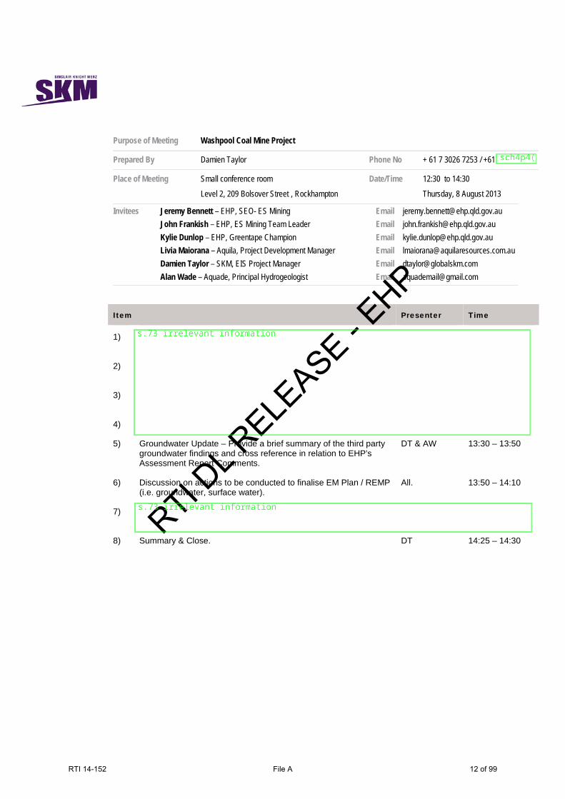
Purpose of Meeting Washpool Coal Mine Project
Prepared By Damien Taylor Phone No + 61 7 3026 7253 / +61
Place of Meeting Small conference room
Level 2, 209 Bolsover Street , Rockhampton
Date/Time 12:30 to 14:30
Thursday, 8 August 2013
Invitees Jeremy Bennett – EHP, SEO- ES Mining John Frankish – EHP, ES Mining Team Leader Kylie Dunlop – EHP, Greentape Champion Livia Maiorana – Aquila, Project Development Manager Damien Taylor – SKM, EIS Project Manager Alan Wade – Aquade, Principal Hydrogeologist
Email Email Email Email Email Email
[email protected] [email protected] [email protected] [email protected] [email protected] [email protected]
Item Presenter Time
1)
2)
3)
4)
5) Groundwater Update – Provide a brief summary of the third party groundwater findings and cross reference in relation to EHP’s Assessment Report Comments.
DT & AW 13:30 – 13:50
6) Discussion on actions to be conducted to finalise EM Plan / REMP (i.e. groundwater, surface water).
All. 13:50 – 14:10
7)
8) Summary & Close. DT 14:25 – 14:30
RTI DL R
ELEASE - E
HP
RTI 14-152 File A 12 of 99
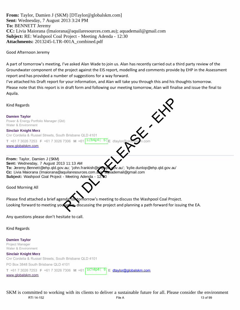
From: Taylor, Damien J (SKM) [[email protected]]Sent: Wednesday, 7 August 2013 3:24 PMTo: BENNETT JeremyCC: Livia Maiorana ([email protected]); [email protected]: RE: Washpool Coal Project - Meeting Adenda - 12:30Attachments: 2013245-LTR-001A_combined.pdf
Good Afternoon Jeremy A part of tomorrow’s meeting, I’ve asked Alan Wade to join us. Alan has recently carried out a third party review of theGroundwater component of the project against the EIS report, modelling and comments provide by EHP in the Assessmentreport and has provided a number of suggestions for a way forward.I’ve attached his Draft report for your information, and Alan will take you through this and his thoughts tomorrow.Please note that this report is in draft form and following our meeting tomorrow, Alan will finalise and issue the final toAquila. Kind Regards Damien TaylorPower & Energy Portfolio Manager (Qld)Water & Environment
Sinclair Knight MerzCnr Cordelia & Russel Streets, South Brisbane QLD 4101
T +61 7 3026 7253 F +61 7 3026 7306 M +61 E [email protected]
From: Taylor, Damien J (SKM) Sent: Wednesday, 7 August 2013 11:13 AMTo: [email protected]; '[email protected]'; '[email protected]'Cc: Livia Maiorana ([email protected]); [email protected]: Washpool Coal Project - Meeting Adenda - 12:30 Good Morning All Please find attached a brief agenda for tomorrow’s meeting to discuss the Washpool Coal Project.Looking forward to meeting you again, discussing the project and planning a path forward for issuing the EA. Any questions please don’t hesitate to call. Kind Regards Damien TaylorProject ManagerWater & Environment
Sinclair Knight MerzCnr Cordelia & Russel Streets, South Brisbane QLD 4101
PO Box 3848 South Brisbane QLD 4101
T +61 7 3026 7253 F +61 7 3026 7306 M +61 E [email protected]
SKM is committed to working with its clients to deliver a sustainable future for all. Please consider the environment
RTI DL R
ELEASE - E
HP
RTI 14-152 File A 13 of 99

before printing this e-mail.Notice - This message contains confidential information intended only for the exclusive use of the addressee namedabove. No confidentiality is waived or lost by any mistaken transmission to you. If you have received this message inerror please delete the document and notify us immediately. Any opinion, text, documentation or attachment received is valid as at the date of issue only. The recipient isresponsible for reviewing the status of the transferred information and should advise us immediately upon receipt ofany discrepancy. All email sent to SKM will be intercepted, screened and filtered by SKM or its approved Service Providers.
RTI DL R
ELEASE - E
HP
RTI 14-152 File A 14 of 99

2013245-LTR-001A Draft 1
Aquade Reference: 2013245-LTR-001
7 August 2013 Damien Taylor Project Manager – Washpool Coal Mine Project EIS Sinclair Knight Merz 32 Cordelia Street PO Box 3848 South Brisbane QLD 4101 Australia Dear Damien, Washpool Coal Mine Project Hydrogeological Review
1.0 Introduction and Background
1.1 Scope of Work This scope of this document was defined in a letter from Damien Taylor to Alan Wade, on 22 July 2013 and subsequent telephone conversations. This document provides an independent review of the hydrogeological work undertaken by SKM for the Environmental Impact Statement (EIS) for the Washpool Coal Mine Project (hereafter referred to as the Washpool Project). It is understood that the intent of the review is to either confirm the findings and/or make recommendations for additional works and detail what those may be and the timing of these works. The scope of work includes review of the references in Table 1. The reference numbers listed in Table 1 are used hereafter to refer to those references. Table 1. Reference List in Chronological Order
Reference # Reference Source Date
1 Final Terms of Reference Washpool EIS DERM July 2010
2 Washpool EIS Chapter 03 – Project Description SKM Feb 2012
3 Washpool EIS Chapter 04 – Land Resources SKM Feb 2012
4 Washpool EIS Chapter 07 – Surface Water SKM Feb 2012
5 Washpool EIS Chapter 08 - Groundwater SKM Feb 2012
6 Washpool EIS Appendix G SKM Feb 2012
7 Washpool EIS Assessment Report Section 4.8.3 DEHP May 2012
8 Draft Washpool Environmental Authority Conditions DERM July 2012
9 IESC Guidelines for Proposals Relating to the Development of Coal Seam Gas and Large Coal mines where there is a Significant Impact on Water Resources
IESC Feb 2013
Note: the primary references reviewed are bolded.
Draft
RTI DL R
ELEASE - E
HP
RTI 14-152 File A 15 of 99

2013245-LTR-001 Draft 2
The initial version of the EIS was not reviewed by this author. In addition, the groundwater model which was used to evaluate the potential impact of dewatering was not reviewed in detail by the author. However, Reference 6, which was reviewed, includes an overview of the groundwater model used.
2.0 Author’s Area of Expertise The author has 25 years of experience as a hydrogeologist in Australia, New Zealand, the USA, Canada and China. After having been a Principal Hydrogeologist at two major international consulting firms between 1999 and 2010, the author set up the independent consulting company, Aquade, in 2010. Through this company, the author provides independent advice, analysis, reviews, audits and expert witness statements to a variety of clients in the public and private sectors both in Australia and overseas. The author is currently Chairperson of the International Association of Hydrogeologists in Victoria, Australia The attached Curriculum Vitae provides a summary of the author’s qualifications and experience as well as a list of specific project experience. Specific areas of expertise include scoping and directing large-scale studies which incorporate field investigations and modelling, including environmental impact assessments.
3.0 Review and Comments on the DEHP Assessment Report This section summarises the main issues raised by DEHP and this reviewer’s comments regarding those issues. In addition, Table 2 considers in more detail several specific points made by DEHP, with comments by the author.
3.1 Summary of Issues Identified by DEHP Reference 7, the DEHP Assessment Report, provides a review by the Queensland Government of Reference 5, the hydrogeology section of the Washpool Project EIS. Reference 7 identifies several issues with Reference 5. The primary issues, as described by DEHP, concern the Conceptual Hydrogeological Model (CHM), specifically:
• The CHM is based on limited hydrogeological data. DEHP asks for more detail on the hydrostratigraphy, water levels, quality and yields.
• Overburden alluvial sediments should be separated into Tertiary and Quaternary sediments.
• More detail on the hydraulic relationship between the aquifers and the Mackenzie River.
• Insufficient monitoring wells. • Gaps in the groundwater monitoring program, i.e. in the collection of transient data. • Lack of background water quality in the alluvium.
In addition, Reference 7 asks for identification of all existing groundwater wells both on site and at neighbouring sites, i.e. a survey of landowner bores. Reference 7 also asks for proposed mitigation measures for potential dewatering impacts on the Mackenzie River. Reference 7 includes the statement that “the assessment of the potential groundwater impacts in the first version of the EIS was lacking in detail and clarity and the subsequent
Draft
RTI DL R
ELEASE - E
HP
RTI 14-152 File A 16 of 99

2013245-LTR-001 Draft 3
additional information provided by the proponent in response to requests from the former DERM was not as complete as EHP was seeking.”
3.2 Aquade Comments Regarding Conceptualisation
The most important information of relevance to the potential leakage rate from the Mackenzie River to a mine dewatering system is:
1. The stratigraphy between the proposed Mine Pit and the river to the north and between the proposed Mine Pit and the alluvial sediments, Coal Mine Lagoon and river to the west. These are the areas where additional boreholes and monitoring wells would be most useful in minimising uncertainty in the conceptual hydrogeology and, therefore, in estimates of losses from the river.
2. Hydraulic properties of the saturated materials, in particular those areas, particularly the most permeable saturated materials.
In particular, the magnitude of leakage flux from the river towards the dewatering system will likely depend largely on whether the top of bedrock is typically below the water table or not. The conceptualisation is that the bedrock highs to the north and the west of the Mine Pit will restrict the flux to the dewatering system because the water table is within the bedrock to the north and only slightly above the top of the bedrock to the west. Therefore, there would be no relatively high transmissivity pathway from the river through the Cainozoic sediments to the mine dewatering system. It is understood from Reference 5 and verbal communications between the author and SKM that Borehole AQ112 is located in an area of bedrock outcrop forming the river bank, where the ground surface is above the highest potential level of flooding of the river. Therefore, the water table is within the Permian bedrock at this location. Confirmation that the water table level is within the Permian bedrock between the proposed Mine Pit and the river to the north is an important part of the conceptualisation. Additional boreholes and monitoring wells between and/or to the south of wells AW111 and AQ112 would facilitate this. The drilling method for any new monitoring wells should be a dry method such that the level of the water table can be established during drilling. For any borehole drilled through Tertiary alluvium which proves to be dry through those sediments, it would be preferable to drill further until the water table is encountered in the bedrock and complete a bedrock monitoring well rather than to complete a dry well in the overburden. Alternatively, the borehole could be abandoned and simply used to log the stratigraphy at that point (in particular the elevation of the top of bedrock) and no monitoring well installed. There are some discrepancies in groundwater elevations as presented in different tables and figures in Reference 5, which may have contributed to the lack of clarity highlighted by DEHP. The author has been informed by SKM that this is likely to be due to inaccurate ground surface elevations from a GPS instrument, which were used in Table 8-4 of Reference 5 and in several subsequent figures. It is understood that the elevations shown in Figure 8-9 of Reference 5, which compares groundwater levels and river levels, are derived from the digital elevation model rather than from a GPS instrument and are, therefore, considered more likely to be correct. Bedrock groundwater levels which are illustrated in Figure 8-9 of Reference 5 support the conceptualisation in the text that the alluvium above the coal within the proposed Mine Pit area is unsaturated. When Reference 5 is revised, Table 4 and the subsequent figures which present data from this table should also be revised. In particular, the conceptualisation would likely be further clarified by revising the north-south cross section to a line between the AW111/112 area and the proposed Mine Pit, showing actual borehole logs, screened intervals and groundwater
Draft
RTI DL R
ELEASE - E
HP
RTI 14-152 File A 17 of 99
2013245-LTR-001 Draft 4
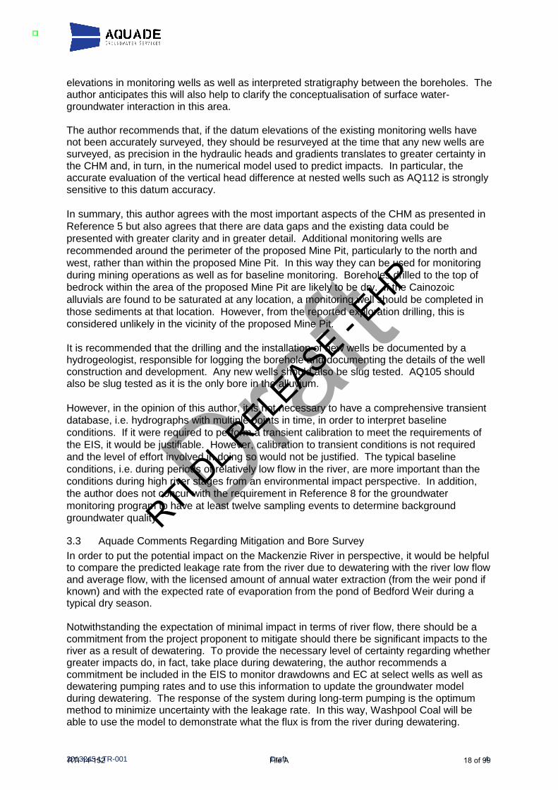
elevations in monitoring wells as well as interpreted stratigraphy between the boreholes. The author anticipates this will also help to clarify the conceptualisation of surface water-groundwater interaction in this area. The author recommends that, if the datum elevations of the existing monitoring wells have not been accurately surveyed, they should be resurveyed at the time that any new wells are surveyed, as precision in the hydraulic heads and gradients translates to greater certainty in the CHM and, in turn, in the numerical model used to predict impacts. In particular, the accurate evaluation of the vertical head difference at nested wells such as AQ112 is strongly sensitive to this datum accuracy. In summary, this author agrees with the most important aspects of the CHM as presented in Reference 5 but also agrees that there are data gaps and the existing data could be presented with greater clarity and in greater detail. Additional monitoring wells are recommended around the perimeter of the proposed Mine Pit, particularly to the north and west, rather than within the proposed Mine Pit. In this way they can be used for monitoring during mining operations as well as for baseline monitoring. Boreholes drilled to the top of bedrock within the area of the proposed Mine Pit are likely to be dry. If the Cainozoic alluvials are found to be saturated at any location, a monitoring well should be completed in those sediments at that location. However, from the reported exploration drilling, this is considered unlikely in the vicinity of the proposed Mine Pit. It is recommended that the drilling and the installation of new wells be documented by a hydrogeologist, responsible for logging the borehole and documenting the details of the well construction and development. Any new wells should also be slug tested. AQ105 should also be slug tested as it is the only bore in the alluvium. However, in the opinion of this author, it is not necessary to have a comprehensive transient database, i.e. hydrographs with multiple points in time, in order to interpret baseline conditions. If it were required to perform a transient calibration to meet the requirements of the EIS, it would be justifiable. However, calibration to transient conditions is not required and the level of effort involved in doing so would not be justified. The typical baseline conditions, i.e. during periods of relatively low flow in the river, are more important than the conditions during high river stages from an environmental impact perspective. In addition, the author does not concur with the requirement in Reference 8 for the groundwater monitoring program to have at least twelve sampling events to determine background groundwater quality.
3.3 Aquade Comments Regarding Mitigation and Bore Survey In order to put the potential impact on the Mackenzie River in perspective, it would be helpful to compare the predicted leakage rate from the river due to dewatering with the river low flow and average flow, with the licensed amount of annual water extraction (from the weir pond if known) and with the expected rate of evaporation from the pond of Bedford Weir during a typical dry season. Notwithstanding the expectation of minimal impact in terms of river flow, there should be a commitment from the project proponent to mitigate should there be significant impacts to the river as a result of dewatering. To provide the necessary level of certainty regarding whether greater impacts do, in fact, take place during dewatering, the author recommends a commitment be included in the EIS to monitor drawdowns and EC at select wells as well as dewatering pumping rates and to use this information to update the groundwater model during dewatering. The response of the system during long-term pumping is the optimum method to minimize uncertainty with the leakage rate. In this way, Washpool Coal will be able to use the model to demonstrate what the flux is from the river during dewatering.
Draft
RTI DL R
ELEASE - E
HP
RTI 14-152 File A 18 of 99

2013245-LTR-001 Draft 5
The off-site bores/wells shown in Reference 5 are likely to be sustained by the river. However, there may be other wells that are currently unknown because the survey of wells has not been undertaken. There should be a commitment from the project proponent to mitigate if it can be shown that there are groundwater levels impacts to those wells due to dewatering as stated in Reference 8. However, this requires the documentation of baseline conditions at these wells. Therefore, it is important that the bore survey is undertaken as part of the collection of baseline data.
4.0 Independent Calculation of Predicted Flux from River This section provides a “sanity check” of the potential long-term steady state flux from the river as a result of the proposed mine under steady state conditions of maximum drawdown due to dewatering. Along the northern boundary of the planned Mine Pit, the following are expected to be the primary factors that control the magnitude of losses from the river during mine dewatering:
• Distance between closest point of river or saturated river alluvium (point A) to the dewatering system along the northern edge of the pit (point B).
• Maximum head difference between river and dewatering system, which will be driven by the elevation of the base of the mine.
• Transmissivity between Point B and Point A.
• Length of river reach and pit perimeter over which the above applies
Wells 112a and b are reportedly screened in consolidated rock (Reference 5). These wells appear to show a downward gradient in Figure 8-9, which implies there is a downward flux across relatively low permeability materials under baseline conditions. Late 2011 groundwater levels in the eastern part of the proposed mine pit appear to be approximately 112 m AHD in the south east corner (AQ107C), some 4 km from the river, and approximately 115 m AHD in the north east corner (AQ96/97), some 2 km from the river. At the same time the river, controlled by the Bedford Weir, was at an elevation of approximately 123 m AHD. So, in the NE part of the proposed Mine Pit, the groundwater level is approximately 7 m below river level under baseline conditions. Therefore, there is currently a flux from the river towards the Washpool Project area which is driven by this 7 m head difference. However, it may be a very small flux, depending on the hydraulic properties (see below). From the E-W cross section (Figure 8-4), the base of the coal within the Washpool Project area is at elevation approximately 80 m AHD. Therefore, the head during dewatering of the coal will be no less than 80 m. Therefore, the maximum head difference between the river and the coal will be no more than around 43m. This is approximately 6 times the current baseline head difference. Therefore, whatever the flux is now from the river, it can be expected that the flux during Washpool dewatering will be no more than approximately 6 times as much during Washpool dewatering. Assuming there is no pathway through the overburden above the Permian bedrock, the “worst case scenario” in terms of the hydraulic connection would be via the coal measures, as they reportedly have the greatest hydraulic conductivity of the units tested (i.e. up to 0.18 m/day from slug tests). Table 8.1 in Reference 5 shows a combined thickness of the coals of approximately 4 m. The confined flow from a line source to a line sink such as a dewatering system can be estimated using the following formula, which is based on Darcy’s Law:
Draft
RTI DL R
ELEASE - E
HP
RTI 14-152 File A 19 of 99

2013245-LTR-001 Draft 6
Q = xKB(H-h)/L (Powers, 1992) Where B = aquifer thickness, x = aquifer width, and (H-h)/L = hydraulic gradient between the line source and the line sink. For northern boundary during dewatering, assuming average L = 1 km, head difference H-h = 40 m, x = 1.5 km, K = 0.18 m/day (the highest value from the slug tests), and average B = 4 m, potential leakage from river, Q = 1500 x 0.18 x 4 x 40/1000 = approximately 40 m3/day, i.e. 0.5 L/s, 0.04 ML/day or 20 ML/yr. (to 1 significant figure). The above calculation is simplistic compared to the numerical model and does not include the potential seepage through other layers of the Burngrove Formation. However, due to its lower hydraulic conductivity, any leakage through the non-coal Burngrove Formation would be expected to be less than through the coals. Also, the above calculation only considers the flux from the closest reach of the river to the north, with length 1500 m. It does not consider the flux from the west. If saturated coal does not extend to close to the river to the north, the above estimate of flux is likely to be an overestimate. It is understood from Section 8.6.5.2 that, based on the groundwater model, the predicted net effect of the dewatering could be a loss of 50 ML/yr. from the Mackenzie River. From the above “sanity check” calculation, the maximum leakage from the river of 50 ML/day evaluated using the model is considered likely to be conservative, i.e. more likely to be an overestimate than an underestimate.
5.0 Review and Comments on the IESC Guidelines This section provides comment on Reference 9, Table 1, in particular in the context of Reference 1, the terms of reference for the Washpool EIS. It is understood that it is not a requirement of the EIS to meet the guidelines documented in Reference 9. However, the author has been asked to review Reference 9 and provide comment regarding to what extent the EIS complies with this document.
5.1 Purpose of the IESC Guidelines The purpose of Reference 9 is to document guidelines for both CSG and large coal mining developments “that are likely to have a significant impact on water resources”. “Significant impact” is further defined in Reference 9 in several ways, including to:
• Result in substantial change in the quantity, quality or availability of surface or groundwater
• “substantially alter groundwater pressure or water table levels”.
As the Washpool Project would locally lower groundwater levels by tens of metres and would locally and temporarily result in substantial changes in the quantity of groundwater, it could be considered likely to have a significant impact under this definition. However, this would also mean that the majority of coal mining projects would fall into this category. This also does not take into account the minimal potential consequences.
Draft
RTI DL R
ELEASE - E
HP
RTI 14-152 File A 20 of 99

2013245-LTR-001 Draft 7
5.2 Compliance with the IESC Guidelines This section highlights the primary areas in which Reference 9 represents a higher level of impact assessment than Reference 1. The most significant of these additional components are as follows: Assessment of cumulative groundwater impacts Cumulative impacts are mentioned in Reference 1, in general terms at the start of Section 4. In addition, within the groundwater section, i.e. Section 4.5.2.2, of Reference 1, discussion of cumulative impacts is limited to potential impacts on water quality. There is the potential for cumulative physical impacts in an area where there are several coal mines within kilometres or tens of kilometres of each other. A true cumulative impact assessment would involve a large scale groundwater model that includes simulation of dewatering at other existing mines in the baseline model calibration and incorporates existing and approved mines in the impact assessment. Reference 9 explicitly includes the need for assessment of the cumulative impacts of all relevant developments. However, it also notes that this would require input from regulators regarding other existing and proposed projects. Risk assessment approach to potential impacts The guidelines in Reference 9 include assessment of the likelihood and consequence of identified groundwater impacts occurring and assessment of the consequential impacts on the water balance and water-related assets. This is not a specific requirement of Reference 1. Development of a water balance (regional and local) Reference 9 considers that applying a water balance model is the most appropriate basis for assessing potential changes in water resources. This is not an explicit requirement of Reference 1. Background data and modelling Reference 9 provides more detail than Reference 1 regarding the components of the baseline information collated into a CHM. It also explicitly requires numerical groundwater modelling “that enables probabilistic evaluation of potential future scenarios”. Reference 9 also provides explicit detail regarding multiple requirements of the numerical model, including simulation of the various stages of the proposed development, the time to maximum drawdown, annual dewatering volumes, and potential water level recovery rates. Surprisingly, Reference 9 does not appear to explicitly differentiate between the operational conditions and the post mining steady state recovery situation. However, it does mention that the model should “provide information on the potential water level recovery rates and timeframes for the life of the project and beyond”. It is this author’s expectation that the existing numerical model would have the capability to do this once recalibrated to the new data and based on any modifications to the conceptualisation that result from the new data. For the most part, the conceptualisation requirements of Reference 1 agree with those of Reference 9 and once the issues with data gaps, clarity and detail are addressed, the background data presented in the EIS would, for the most part, comply with Reference 9. However, Reference 9 would require some additional interpretation including local and
Draft
RTI DL R
ELEASE - E
HP
RTI 14-152 File A 21 of 99

2013245-LTR-001 Draft 8
regional water balances as described above, further description of the likely recharge sources and discharge pathways, more detail regarding the quantification of baseline groundwater fluxes (this is effectively the water balance information described above) including baseline surface water/groundwater fluxes. These fluxes can be initially estimated but the numerical model (calibration run) would be the optimum tool for quantifying the components of the groundwater balance.
6.0 Closure This letter report is provided subject to the attached limitations. If you have any questions or comments regarding this document, or require any additional opinions or interpretations, please contact the undersigned. Yours sincerely,
Alan Wade Aquade Groundwater Services Pty Ltd
Attachments:
Glossary of terms
Additional Hydrogeological References
Limitations
Table 2. Table of Specific Comments in DEHP Assessment Report
c.v. of Alan Wade
Draft
RTI DL R
ELEASE - E
HP
RTI 14-152 File A 22 of 99

2013245-LTR-001 Draft 9
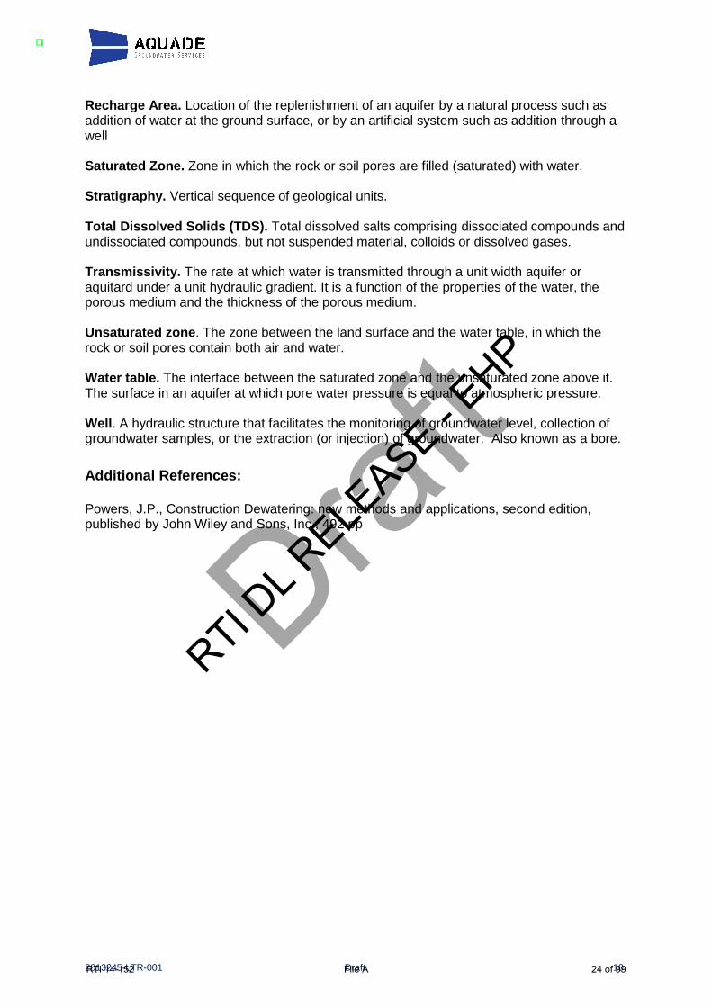
Glossary of terms: Alluvial Dep osits. Sediments deposited in a fluvial environment. Anisotropy condition in which one or more of the hydraulic properties of an aquifer vary according to the direction of flow. Aquifer. Rock or sediment that is a geological formation, group of formations, or part of a formation which is saturated and sufficiently permeable to transmit economic quantities of water to wells and springs. Aquitard. A unit of low-permeability that can store groundwater and also transmit it slowly. Bore . A hydraulic structure that facilitates the monitoring of groundwater level, collection of groundwater samples, or the extraction (or injection) of groundwater. Also known as a well. Borehole an uncased drill hole. Drawdown. Lowering of hydraulic head. Electrical Conductivity (EC). The EC of water is a measure of its ability to conduct an electric current. This property is related to the ionic content of the sample, which is in turn a function of the total dissolved (ionisable) solids (TDS) concentration. An estimate of TDS in fresh water can be obtained by multiplying EC by 0.65. Gradient. Rate of inclination of a slope. The change in elevation with distance in a given direction. Groundwater. The water held in the pores in the ground below the water table. Hydraulic Head . The sum of the elevation head and the pressure head at a point in an aquifer. This is typically reported as an elevation above a fixed datum, such as sea level. Heterogeneous. Condition of having different characteristics in different locations. Non-uniform. (Opposite of homogeneous ). Hydraulic conductivity. A coefficient describing the rate at which water can move through a permeable medium. It has units of length per time. Hydrostratigraphic unit. A formation, part of a formation, or group of formations in which there are similar hydrologic characteristics allowing for grouping into one aquifer or aquitard. Hydrostratigraphy. The framework of a groundwater flow system described in terms of its hydrostratigraphic units. Permeability. Property of porous medium relating to its ability to transmit or conduct liquid (usually water) under the influence of a driving force. Where water is the fluid, this is effectively the hydraulic conductivity. Piezometric or Potentiometric Surface. A surface that represents the level to which water will rise in cased wells. The water table is the potentiometric surface in an unconfined aquifer.
Draft
RTI DL R
ELEASE - E
HP
RTI 14-152 File A 23 of 99
2013245-LTR-001 Draft 10
Recharge Area. Location of the replenishment of an aquifer by a natural process such as addition of water at the ground surface, or by an artificial system such as addition through a well Saturated Zone. Zone in which the rock or soil pores are filled (saturated) with water. Stratigraphy. Vertical sequence of geological units. Total Dissolved Solids (TDS). Total dissolved salts comprising dissociated compounds and undissociated compounds, but not suspended material, colloids or dissolved gases. Transmissivity. The rate at which water is transmitted through a unit width aquifer or aquitard under a unit hydraulic gradient. It is a function of the properties of the water, the porous medium and the thickness of the porous medium. Unsaturated zone . The zone between the land surface and the water table, in which the rock or soil pores contain both air and water. Water table. The interface between the saturated zone and the unsaturated zone above it. The surface in an aquifer at which pore water pressure is equal to atmospheric pressure. Well . A hydraulic structure that facilitates the monitoring of groundwater level, collection of groundwater samples, or the extraction (or injection) of groundwater. Also known as a bore.
Additional References: Powers, J.P., Construction Dewatering: new methods and applications, second edition, published by John Wiley and Sons, Inc., 492 pp
Draft
RTI DL R
ELEASE - E
HP
RTI 14-152 File A 24 of 99

Draft
Table 2. Comments Regarding Issues Raised by the Former DEHP, Washpool Coal Mine Project
Aspect of EIS Issues and Comments of
Reviewers Aquade Comments
Monitoring wells. Only one monitoring bore in alluvial sediments and to the west of the area to be mined
True. This is insufficient. Also, all monitoring wells in saturated alluvium should be slug tested. However, it would not be worthwhile installing dry monitoring wells.
Conceptual Model Conceptual Model is based on limited hydrogeological data
True but there is always a limit to the hydrogeological data. It is important to focus on where additional data would be of greatest benefit. The bedrock highs shown along the northern perimeter of the study area and the western perimeter of the proposed Mine Pit, which result in thin or negligible overburden alluvials in these areas are important restrictions to lateral inflow to a dewatering system and, therefore, leakage from the river or from saturated alluvials below the elevation of, and likely in communication with, the river (e.g. at AQ105). Borehole logs from, and effective screened intervals in, AQ111 and AQ112 are important. The most important monitoring wells were slug tested, i.e. wells AQ111 and AQ112 located near the river and a bore in the coal measures. Therefore, it is this author’s perception that, in general, the most relevant information has been prioritised. However, there are some gaps. Another important aspect of the conceptualisation for calibration of the model is the vertical gradient at AQ112 between the river, and each bore. This means that the precise elevations of the groundwater measuring points (rather than the ground surface next to the bore) are important and it is important to also know the precise elevation of the river at the same time.
Conceptual Model Three components to the hydrostratigraphy rather than two, i.e. separate Cainozoic unconsolidated sediments into Tertiary and Quaternary.
The author concurs. The Quaternary alluvium is likely to be saturated, at least partly, whereas the Tertiary alluvium is likely to be dry, at least above the coal.
Conceptual Model More detail on hydrostratigraphy, water levels, quality and yields
See above responses The author recommends testing of the water quality of the groundwater in MW112a and b, at least measurements of EC. A low TDS in these monitoring wells would be evidence that recharge of the groundwater is taking place from the river under baseline conditions.
Monitoring wells. “Sufficient” monitoring wells to assess groundwater
There is a valid argument for several additional monitoring wells. This author recommends prioritising the perimeters around the proposed mine pit rather than the mine pit area itself.
RTI DL R
ELEASE - E
HP
RTI 14-152 File A 25 of 99

Draft
Aspect of EIS Issues and Comments of
Reviewers Aquade Comments
characteristics Conceptual Model Gaps in monitoring program
due to “small number of existing bores not having been monitored initially”
There is a valid argument for several additional monitoring wells.
Existing Wells in the Area
Identifying all existing groundwater wells on site and neighbouring site
The author concurs. If this has not been undertaken, it should be. Apart from the contribution to the understanding of the hydrogeology over a larger scale than the monitoring network, it will benefit all concerned to have an accurate understanding of the baseline condition at all such wells.
Background Groundwater Quality
Use private bore 111877 near Bedford Weir for background water quality in alluvium
Any bore near Bedford Weir may have been affected by the artificial recharge caused by the Weir itself. The author suggests using Bore AQ106, to the west of Coal Mine Lagoon, for evaluation of background groundwater quality in the Cainozoic sediments.
Hydrographs Separate hydrographs for the Cainozoic sediments, and the coal measures
There is only one bore in the Cainozoic sediments. As reported from the on-site drilling, the Tertiary alluvium is interpreted to be unsaturated. Therefore, it is unlikely that hydrographs for the Tertiary alluvium would be feasible, unless the alluvium at AQ106 is Tertiary in age.
Hydrographs Hydrographs “at appropriate scale” for adequate “representation” of trends in different aquifers
The y-axis scales in Figure 8-9 appear reasonable. Possibly these were modified after this comment.
Conceptual Model More investigation of relationship between the aquifers and the Mackenzie River (comparing water levels)
Reasonable request. See above. Revised cross section showing geology and groundwater levels. The hydrostratigraphy here is what the potential impact of dewatering depends on.
Assessment of Impacts on aquifer and surface water
Assessment of impacts to be revised. Numerical model to be used to assess them.
A numerical model was used. This is an appropriate tool.
Mitigation Propose mitigation measures for potential dewatering impacts on “effective take of water in Bedford Weir storage” on Mackenzie River
There is a statement on page 8-42 that the estimated increase in river leakage is small in comparison to average and even low flow conditions within the weir. Some discussion of possible mitigation could be included. There is a statement on page 8-42 that the estimated increase in river leakage is small in comparison to the licensing of water extraction from the Mackenzie river. However, the figure for the licensing is not given.
Monitoring Monitoring at Coal Mine Lagoon and river
Coal Mine Lagoon good idea. The river is already monitored with gauging stations.
RTI DL R
ELEASE - E
HP
RTI 14-152 File A 26 of 99

Draft
Aspect of EIS Issues and Comments of
Reviewers Aquade Comments
Mitigation Commitment to mitigate impacts on gw and sw
The author concurs.
Quantify Impacts Quantify how much water will be drawn from surface water
The numerical model has been used for this. It has predicted that the increase in leakage rate from the river due to dewatering could be up to 50 ML/yr. My independent flux sanity check backs this up. Note: Table G-6 describing aquifer properties used in model appears to have errors. Please check. It is recommended that, when the uncertainties with the stratigraphy is confirmed in key areas by the installation of additional monitoring wells, the model is recalibrated and rerun
Monitoring “Missing parameters” Sixth bullet points on page 28. Unclear on which parameters are missing. Monitoring Additional Monitoring Points
in “Table 12” Where is Table 12?
Monitoring At least three monitoring wells in each aquifer (Quaternary alluvium, Tertiary sediments and Permian coal measures)
It is recommended that this is revisited with DEHP after the issues with the existing groundwater levels are resolved. It may not be necessary to install three monitoring wells in the Quaternary alluvium.
Monitoring Network insufficient to monitor impacts on groundwater and surface water
True. Additional monitoring wells would be required for monitoring during operations.
Conceptual Model Can the river be connected to the mine pit area via the alluvial sediments during flooding?
Requires a simple comparison of elevations of top of bedrock and maximum flood level. However, more important for a mine operations perspective than from an impacts perspective.
Conditions at Base of Page 29 of Reference 7
GW Monitoring Plan, More monitoring wells between pit and river, landholder survey, 12 months of data before mining, revise model, consideration of mitigation measures for losses from river, outcomes from discussion with SunWater
These conditions are generally justified. However, it is the opinion of this author that gaps in the existing conceptualization can be addressed and the numerical model can be recalibrated with one round of data from new boreholes and wells rather than it being necessary to first collect one full year of baseline data.
RTI DL R
ELEASE - E
HP
RTI 14-152 File A 27 of 99

2013245-LTR-001 Draft 11
AQUADE GENERAL LIMITATIONS
Scope of Services This document (the report) has been prepared in accordance with the scope of services set out in the contract, or as otherwise agreed, between the client and Aquade (scope of services). In some circumstances, the scope of services may have been limited by a range of factors such as time or budget constraints.
Reliance on Data In preparing the report, Aquade has relied upon data, surveys, analyses, designs, plans and other information provided by the client and other individuals and organisations, most of which are referred to in the report (the data). Except as otherwise stated in the report, Aquade has not verified the accuracy or completeness of the data. To the extent that the statements, opinions, facts, information, conclusions and/or recommendations in the report (conclusions) are based in whole or part on the data, those conclusions are contingent upon the accuracy and completeness of the data. Aquade will not be liable in relation to incorrect conclusions should any data, information or condition be incorrect or have been concealed, withheld, misrepresented or otherwise not fully disclosed to Aquade.
Interpretations and Conclusions In accordance with the scope of services, Aquade has relied upon the data provided in the preparation of the report. The nature and extent of monitoring and/or testing conducted and reviewed is described in the report. On all sites, varying degrees of non-uniformity of the vertical and horizontal soil, rock and/or groundwater conditions are encountered. Hence no monitoring can eliminate the possibility that the data obtained are not totally representative of ground and/or groundwater conditions encountered. The interpretations and conclusions herein are based upon the available data and are therefore merely indicative of the conditions from the available data at the time of preparing the report. Also, it should be recognised that the data reviewed are from a limited time period and that site conditions can change with time. Within the limitations imposed by the scope of services, the analysis performed and the preparation of this report have been undertaken and performed in a professional manner, in accordance with generally accepted practices and using a degree of skill and care ordinarily exercised by reputable hydrogeological consultants under similar circumstances. No other warranty, expressed or implied, is made.
Report for Benefit of Client Only The report has been prepared for the benefit of the client and no other party. Aquade assumes no responsibility and will not be liable to any other person or organisation for or in relation to any matter dealt with or conclusions expressed in the report, or for any loss or damage suffered by any other person or organisation arising from matters dealt with or conclusions expressed in the report (including without limitation matters arising from any negligent act or omission of Aquade or for any loss or damage suffered by any other party relying upon the matters dealt with or conclusions expressed in the report). Parties other than the client should not rely upon the report or the accuracy or completeness of any conclusions and should make their own enquiries and obtain independent advice in relation to such matters.
Other limitations Any opinion of construction costs, including bore/well installation, refurbishment and decommissioning, prepared by Aquade (whether as part of the Services or otherwise) and provided to the Client is supplied for the general guidance of the Client only and Aquade provides no guarantee as to the accuracy or suitability of any such opinion for any purpose. Aquade will not be liable to update or revise the report to take into account any events or emergent circumstances or facts occurring or becoming apparent after the date of the report.
Draft
RTI DL R
ELEASE - E
HP
RTI 14-152 File A 28 of 99

From: Livia Maiorana [[email protected]]Sent: Thursday, 15 August 2013 9:19 AMTo: BENNETT JeremyCC: Taylor, Damien J (SKM)Subject: Washpool Groundwater ReportAttachments: Aquade Washpool Hydrogeological Review.pdf
Hi Jeremy, Please find attached the results of Alan Wades Groundwater Review on the Washpool Coal Project. As discussed at our meeting, we have now included a summary and recommendations section (6). As indicated in our discussions, from here we would like DEHP to review this report in line with the Assessment Report Comments to get yourfeedback if the Department agrees with our planned approach to address the remaining hydrogeological concerns. Please forward this around for review and if we could get your comments back by the end of next week that would be appreciated. Please give me a call if you have any questions about the report. Thanks and regards, Livia MaioranaProject Development Manager
Aquila Resources LimitedLevel 18, 10 Eagle Street, Brisbane, QLD 4000, Australia
Office: (61) 7 3229 5630Mobile: (61) E: lmaiorana@ s.com.auWeb: www.aquilaresources.com.au
This email (including attachments) is confidential and may be privileged. If you are not an intended recipient of this email, you are hereby notified that youmust not read, disseminate or copy it, or take any action in reliance on it. If you have received this email in error, please contact the sender immediately byreturn email. Please then delete both emails and do not disclose their contents to any person. Any confidentiality or privilege is not waived or lost becausethis email has been sent to you in error. The views expressed in this email are not necessarily those of Aquila Resources Limited or any member of theAquila group of companies. RTI D
L RELE
ASE - EHP
RTI 14-152 File A 29 of 99

2013245-LTR-001 1
Aquade Reference: 2013245-LTR-001
13 August 2013 Damien Taylor Project Manager – Washpool Coal Mine Project EIS Sinclair Knight Merz 32 Cordelia Street PO Box 3848 South Brisbane QLD 4101 Australia Dear Damien, Washpool Coal Mine Project Hydrogeological Review
1.0 Introduction and Background This scope of this document was defined in a letter from Damien Taylor to Alan Wade, on 22 July 2013 and subsequent telephone conversations. This document provides an independent review of the hydrogeological work undertaken by SKM for the Environmental Impact Statement (EIS) for the Washpool Coal Mine Project (hereafter referred to as the Washpool Project). It is understood that the intent of the review is to either confirm the findings and/or make recommendations for additional works and detail what those may be and the timing of these works. The scope of work includes review of the references in Table 1. The reference numbers listed in Table 1 are used hereafter to refer to those references. Table 1. Reference List in Chronological Order
Reference # Reference Source Date
1 Final Terms of Reference Washpool EIS DERM July 2010
2 Washpool EIS Chapter 03 – Project Description SKM Feb 2012
3 Washpool EIS Chapter 04 – Land Resources SKM Feb 2012
4 Washpool EIS Chapter 07 – Surface Water SKM Feb 2012
5 Washpool EIS Chapter 08 - Groundwater SKM Feb 2012
6 Washpool EIS Appendix G SKM Feb 2012
7 Washpool EIS Assessment Report Section 4.8.3 DEHP May 2012
8 Draft Washpool Environmental Authority Conditions DERM July 2012
9 IESC Guidelines for Proposals Relating to the Development of Coal Seam Gas and Large Coal mines where there is a Significant Impact on Water Resources
IESC Feb 2013
Note: the primary references reviewed are bolded. The initial version of the EIS was not reviewed by this author. In addition, the groundwater model which was used to evaluate the potential impact of dewatering was not reviewed in
RTI DL R
ELEASE - E
HP
RTI 14-152 File A 30 of 99
2013245-LTR-001 2
detail by the author. However, Reference 6, which was reviewed, includes an overview of the groundwater model used. 2.0 Author’s Expertise The author has 25 years of experience as a hydrogeologist in Australia, New Zealand, the USA, Canada and China. After having been a Principal Hydrogeologist at two major international consulting firms between 1999 and 2010, the author set up the independent consulting company, Aquade, in 2010. Through this company, the author provides independent advice, analysis, reviews, audits and expert witness statements to a variety of clients in the public and private sectors both in Australia and overseas. The author is currently Chairperson of the International Association of Hydrogeologists in Victoria, Australia The attached Curriculum Vitae provides a summary of the author’s qualifications and experience as well as a list of specific project experience. Specific areas of expertise include scoping and directing large-scale studies which incorporate field investigations and modelling, including environmental impact assessments. 3.0 Review and Comments on the DEHP Assessment Report This section summarises the main issues raised by DEHP and this reviewer’s comments regarding those issues. In addition, Table 2 considers in more detail several specific points made by DEHP, with comments by the author.
3.1 Summary of Issues Identified by DEHP Reference 7, the DEHP Assessment Report, provides a review by the Queensland Government of Reference 5, the hydrogeology section of the Washpool Project EIS. Reference 7 identifies several issues with Reference 5. The primary issues, as described by DEHP, concern the Conceptual Hydrogeological Model (CHM), specifically:
• The CHM is based on limited hydrogeological data. DEHP asks for more detail on the hydrostratigraphy, water levels, quality and yields.
• Overburden alluvial sediments should be separated into Tertiary and Quaternary sediments.
• More detail on the hydraulic relationship between the aquifers and the Mackenzie River.
• Insufficient monitoring wells both to the west and the north of the proposed pit area. • Gaps in the groundwater monitoring program, i.e. in the collection of transient data. • Lack of background water quality in the alluvium.
In addition, Reference 7 asks for identification of all existing groundwater wells both on site and at neighbouring sites, i.e. a survey of landowner bores. Reference 7 also asks for proposed mitigation measures for potential dewatering impacts on the Mackenzie River. Reference 7 includes the statement that “the assessment of the potential groundwater impacts in the first version of the EIS was lacking in detail and clarity and the subsequent additional information provided by the proponent in response to requests from the former DERM was not as complete as EHP was seeking.”
RTI DL R
ELEASE - E
HP
RTI 14-152 File A 31 of 99

2013245-LTR-001 3
3.2 Aquade Comments Regarding Conceptualisation The most important information of relevance to the potential leakage rate from the Mackenzie River to a mine dewatering system is:
1. The stratigraphy between the proposed Mine Pit and the river to the north and between the proposed Mine Pit and the alluvial sediments, Coal Mine Lagoon and river to the west. These are the areas where additional boreholes and monitoring wells would be most useful in minimising uncertainty in the conceptual hydrogeology and, therefore, in estimates of losses from the river.
2. Hydraulic properties of the saturated materials, in particular those areas, particularly the most permeable saturated materials.
In particular, the magnitude of leakage flux from the river towards the dewatering system will likely depend largely on whether the top of bedrock is typically below the water table or not. The conceptualisation is that the bedrock highs to the north and the west of the Mine Pit will restrict the flux to the dewatering system because the water table is within the bedrock to the north and only slightly above the top of the bedrock to the west. Therefore, there would be no relatively high transmissivity pathway from the river through the Cainozoic sediments to the mine dewatering system. It is understood from Reference 5 and verbal communications between the author and SKM that Borehole AQ112 is located in an area of bedrock outcrop forming the river bank, where the ground surface is above the highest potential level of flooding of the river. Therefore, the water table is within the Permian bedrock at this location. Confirmation that the water table level is within the Permian bedrock between the proposed Mine Pit and the river to the north is an important part of the conceptualisation. There are some discrepancies in groundwater elevations as presented in different tables and figures in Reference 5, which may have contributed to the lack of clarity highlighted by DEHP. The author has been informed by SKM that this is likely to be due to inaccurate ground surface elevations from a GPS instrument, which were used in Table 8-4 of Reference 5 and in several subsequent figures. It is understood that the elevations shown in Figure 8-9 of Reference 5, which compares groundwater levels and river levels, are derived from the digital elevation model rather than from a GPS instrument and are, therefore, considered more likely to be correct. Bedrock groundwater levels which are illustrated in Figure 8-9 of Reference 5 support the conceptualisation in the text that the alluvium above the coal within the proposed Mine Pit area is unsaturated. Additional boreholes and monitoring wells would help to clarify the hydrostratigraphy. The drilling method for any new monitoring wells should be a dry method such that the level of the water table can be established during drilling. For any borehole drilled through Tertiary alluvium which proves to be dry through those sediments, it would be preferable to drill further until the water table is encountered in the bedrock and complete a bedrock monitoring well rather than to complete a dry well in the overburden. When Reference 5 is revised, Table 4 and the subsequent figures which present data from this table should also be revised. In particular, the conceptualisation would likely be further clarified by revising the north-south cross section to a line between the AW111/112 area and the proposed Mine Pit, showing actual borehole logs, screened intervals and groundwater elevations in monitoring wells as well as interpreted stratigraphy between the boreholes. The author anticipates this will also help to clarify the conceptualisation of surface water-groundwater interaction in this area.
RTI DL R
ELEASE - E
HP
RTI 14-152 File A 32 of 99

2013245-LTR-001 4
The author recommends that, if the datum elevations of the existing monitoring wells have not been accurately surveyed, they should be resurveyed at the time that any new wells are surveyed, as precision in the hydraulic heads and gradients translates to greater certainty in the CHM and, in turn, in the numerical model used to predict impacts. In particular, the accurate evaluation of the vertical head difference at nested wells such as AQ112 is strongly sensitive to this datum accuracy. In summary, this author agrees with the most important aspects of the CHM as presented in Reference 5 but also agrees that there are data gaps and the existing data could be presented with greater clarity and in greater detail. Additional monitoring wells are recommended to the north and west of the proposed pit area, as requested by DEHP. If the Cainozoic alluvials are found to be saturated at any location, a monitoring well should be completed in those sediments at that location. Additional drilling within the area of the proposed Mine Pit is not recommended. Boreholes drilled to the top of bedrock within the area of the proposed Mine Pit are likely to be dry. It is recommended that the drilling and the installation of new wells be documented by a hydrogeologist, responsible for logging the borehole and documenting the details of the well construction and development. Any new wells should also be slug tested. AQ105 should also be slug tested as it is the only bore in the alluvium. In the opinion of this author, it is not necessary to have a comprehensive transient database, i.e. hydrographs with multiple points in time, in order to interpret baseline conditions. If it were required to perform a transient calibration to meet the requirements of the EIS, it would be justifiable. However, calibration to transient conditions is not required and the level of effort involved in doing so would not be justified. The typical baseline conditions, i.e. during periods of relatively low flow in the river, are more important than the conditions during high river stages from an environmental impact perspective. However, from a dewatering feasibility perspective, it would be advisable for the proponent to have an understanding of the maximum groundwater levels that are likely during a wet season with high precipitation and river levels. There is a requirement in Reference 8 for the groundwater monitoring program to have at least twelve sampling events to determine background groundwater quality. The author does not consider this requirement to be justifiable as baseline groundwater chemistry is unlikely to change measurably with time. Updating the conceptual model after the new wells are installed and recalibrating the numerical model to one round of late dry season water levels would be considerably more cost effective.
3.3 Aquade Comments Regarding Mitigation and Bore Survey In order to put the potential impact on the Mackenzie River in perspective, it would be helpful to compare the predicted leakage rate from the river due to dewatering with the river low flow and average flow, with the licensed amount of annual water extraction (from the weir pond if known) and with the expected rate of evaporation from the pond of Bedford Weir during a typical dry season. Notwithstanding the expectation of minimal impact in terms of river flow, there should be a commitment from the project proponent to mitigate should there be significant impacts to the river as a result of dewatering. The commitment in the EIS to continuously monitor groundwater conditions and to update the groundwater model during dewatering is important. The response of the system during long-term pumping is the optimum method to minimize uncertainty in quantification of the leakage rate. In this way, Washpool Coal will be able to use the model to evaluate and demonstrate what the flux is from the river during dewatering.
RTI DL R
ELEASE - E
HP
RTI 14-152 File A 33 of 99

2013245-LTR-001 5
The off-site bores/wells shown in Reference 5 are likely to be sustained by the river. However, there may be other wells that are currently unknown because the survey of wells has not been undertaken. There should be a commitment from the project proponent to mitigate if it can be shown that there are groundwater levels impacts to those wells due to dewatering as stated in Reference 8. However, this requires the documentation of baseline conditions at these wells. Therefore, it is important that the bore survey is undertaken as part of the collection of baseline data. 4.0 Independent Calculation of Predicted Flux from River This section provides a “sanity check” of the potential long-term steady state flux from the river as a result of the proposed mine under steady state conditions of maximum drawdown due to dewatering. Along the northern boundary of the planned Mine Pit, the following are expected to be the primary factors that control the magnitude of losses from the river during mine dewatering:
• Distance between closest point of river or saturated river alluvium (point A) to the dewatering system along the northern edge of the pit (point B).
• Maximum head difference between river and dewatering system, which will be driven by the elevation of the base of the mine.
• Transmissivity between Point B and Point A.
• Length of river reach and pit perimeter over which the above applies
Wells 112a and b are reportedly screened in consolidated rock (Reference 5). These wells appear to show a downward gradient in Figure 8-9, which implies there is a downward flux across relatively low permeability materials under baseline conditions. Late 2011 groundwater levels in the eastern part of the proposed mine pit appear to be approximately 112 m AHD in the south east corner (AQ107C), some 4 km from the river, and approximately 115 m AHD in the north east corner (AQ96/97), some 2 km from the river. At the same time the river, controlled by the Bedford Weir, was at an elevation of approximately 123 m AHD. So, in the NE part of the proposed Mine Pit, the groundwater level is approximately 7 m below river level under baseline conditions. Therefore, there is currently a flux from the river towards the Washpool Project area which is driven by this 7 m head difference. However, it may be a very small flux, depending on the hydraulic properties (see below). From the E-W cross section (Figure 8-4, Reference 5), the base of the coal within the Washpool Project area is at elevation approximately 80 m AHD. Therefore, the head during dewatering of the coal will be no less than 80 m. Therefore, the maximum head difference between the river and the coal will be no more than around 43m. This is approximately six times the current baseline head difference. Therefore, whatever the flux is now from the river, it can be expected that the flux during Washpool dewatering will be no more than approximately six times as much during Washpool dewatering. Assuming there is no pathway through the overburden above the Permian bedrock, the “worst case scenario” in terms of the hydraulic connection would be via the coal measures, as they reportedly have the greatest hydraulic conductivity of the units tested (i.e. up to 0.18 m/day from slug tests). Table 8.1 in Reference 5 shows a combined thickness of the coals of approximately 4 m. The confined flow from a line source to a line sink such as a dewatering system can be estimated using the following formula, which is based on Darcy’s Law:
RTI DL R
ELEASE - E
HP
RTI 14-152 File A 34 of 99

2013245-LTR-001 6
Q = xKB(H-h)/L (Powers, 1992) Where B = aquifer thickness, x = aquifer width, and (H-h)/L = hydraulic gradient between the line source and the line sink. For the northern boundary during dewatering, assuming average L = 1 km, head difference H-h = 40 m, x = 1.5 km, K = 0.18 m/day (the highest value from the slug tests), and average B = 4 m, potential leakage from river in this area, Q = 1500 x 0.18 x 4 x 40/1000 = approximately 40 m3/day, i.e. 0.5 L/s, 0.04 ML/day or 20 ML/yr. (to 1 significant figure). The above calculation is simplistic compared to the numerical model and does not include the potential seepage through other layers of the Burngrove Formation. However, due to its lower hydraulic conductivity, any leakage through the non-coal Burngrove Formation would be expected to be less than through the coals. Also, the above calculation only considers the flux from the closest reach of the river to the north, with length 1500 m. It does not consider the flux from the west. If saturated coal does not extend to close to the river to the north, the above estimate of flux from this direction is likely to be an overestimate. It is understood from Section 8.6.5.2 that, based on the groundwater model, the predicted net effect of the dewatering could be a loss of 50 ML/yr. from the Mackenzie River. From the above “sanity check” calculation, the figure of 50 ML/day evaluated using the model is considered likely to be conservative, i.e. more likely to be an overestimate than an underestimate. 5.0 Review and Comments on the IESC Guidelines This section provides comment on Reference 9, Table 1, in particular in the context of Reference 1, the terms of reference for the Washpool EIS. It is understood that it is not a requirement of the EIS to meet the guidelines documented in Reference 9. However, the author has been asked to review Reference 9 and provide comment regarding to what extent the EIS complies with this document.
5.1 Purpose of the IESC Guidelines The purpose of Reference 9 is to document guidelines for both CSG and large coal mining developments “that are likely to have a significant impact on water resources”. “Significant impact” is further defined in Reference 9 in several ways, including to:
• Result in substantial change in the quantity, quality or availability of surface or groundwater
• “substantially alter groundwater pressure or water table levels”.
As the Washpool Project would locally lower groundwater levels by tens of metres and would locally and temporarily result in substantial changes in the quantity of groundwater, it could be considered likely to have a significant impact under this definition. However, this would also mean that the majority of coal mining projects would fall into this category. This also does not take into account the minimal potential consequences.
5.2 Compliance with the IESC Guidelines
RTI DL R
ELEASE - E
HP
RTI 14-152 File A 35 of 99

2013245-LTR-001 7
This section highlights the primary areas in which Reference 9 represents a higher level of impact assessment than Reference 1. The most significant of these additional components are as follows: Assessment of cumulative groundwater impacts Cumulative impacts are mentioned in Reference 1, in general terms at the start of Section 4. In addition, within the groundwater section, i.e. Section 4.5.2.2, of Reference 1, discussion of cumulative impacts is limited to potential impacts on water quality. There is the potential for cumulative physical impacts in an area where there are several coal mines within kilometres or tens of kilometres of each other. A true cumulative impact assessment would involve a large scale groundwater model that includes simulation of dewatering at other existing mines in the baseline model calibration and incorporates existing and approved mines in the impact assessment. Reference 9 explicitly includes the need for assessment of the cumulative impacts of all relevant developments. However, it also notes that this would require input from regulators regarding other existing and proposed projects. Risk assessment approach to potential impacts The guidelines in Reference 9 include assessment of the likelihood and consequence of identified groundwater impacts occurring and assessment of the consequential impacts on the water balance and water-related assets. This is not a specific requirement of Reference 1. Development of a water balance (regional and local) Reference 9 considers that applying a water balance model is the most appropriate basis for assessing potential changes in water resources. This is not an explicit requirement of Reference 1. Background data and modelling Reference 9 provides more detail than Reference 1 regarding the components of the baseline information collated into a CHM. It also explicitly requires numerical groundwater modelling “that enables probabilistic evaluation of potential future scenarios”. Reference 9 also provides explicit detail regarding multiple requirements of the numerical model, including simulation of the various stages of the proposed development, the time to maximum drawdown, annual dewatering volumes, and potential water level recovery rates. Surprisingly, Reference 9 does not appear to explicitly differentiate between the operational conditions and the post mining steady state recovery situation. However, it does mention that the model should “provide information on the potential water level recovery rates and timeframes for the life of the project and beyond”. It is this author’s expectation that the existing numerical model would have the capability to do this once recalibrated to the new data and based on any modifications to the conceptualisation that result from the new data. For the most part, the conceptualisation requirements of Reference 1 agree with those of Reference 9 and once the issues with data gaps, clarity and detail are addressed, the background data presented in the EIS would, for the most part, comply with Reference 9. However, Reference 9 would require some additional interpretation including local and regional water balances as described above, further description of the likely recharge sources and discharge pathways, more detail regarding the quantification of baseline
RTI DL R
ELEASE - E
HP
RTI 14-152 File A 36 of 99
2013245-LTR-001 8
groundwater fluxes (this is effectively the water balance information described above) including baseline surface water/groundwater fluxes. These fluxes can be initially estimated but the numerical model (calibration run) would be the optimum tool for quantifying the components of the groundwater balance. 6.0 Summary and Recommendations This document presents an independent review of hydrogeological work undertaken for the Washpool Environmental Impact Statement (EIS) and associated comments from DEHP in Section 4.8.3 of the EIS Assessment Report. The review was undertaken between 24 July and 13 August 2013. The former DERM commented that the hydrogeological interpretations in the EIS were based on limited data and an insufficient number of monitoring wells. DEHP stated that the first version of the EIS was lacking in detail and clarity and that additional information provided in response to requests was not as complete as DEHP was seeking. The most significant potential impact of mine dewatering is induced leakage from the Mackenzie River. Therefore, DEHP is particularly concerned about uncertainty in the conceptual hydrogeology between the proposed Mine Pit and the River.
6.1 Conceptualisation and Impact Prediction This author agrees with the most important aspects of the conceptualisation in the EIS, including the interpretation of limited hydraulic connection between the project and the river, and agrees with the prediction that mining operations are expected to pose a low risk of impacts to surface water bodies, to ecosystems associated with them and to nearby groundwater users. However, the author also agrees with DEHP that there are data gaps and that the existing data could be presented with greater clarity and detail. It is in the interests of both the project proponent and the regulator that these issues are addressed. This author recommends additional drilling and monitoring-well installation with detailed logging of the boreholes and a clearer explanation of the conceptual hydrogeology using the new and previously existing information. Four additional monitoring wells are recommended, two to the north and two to the west of the proposed Mine Pit. It is recommended that they be constructed, developed and tested as follows:
• A dry drilling method should be employed. • Drilling, well installation and development should be supervised by a hydrogeologist
who is responsible for logging the borehole, selecting the screened interval to be monitored and documenting the well construction details.
• If saturated alluvium is encountered during drilling (which is more likely to the west than to the north of the proposed Mine Pit), the monitoring well should be screened in the alluvium.
• If the alluvium is unsaturated, drilling should continue into the bedrock and the monitoring well should be screened in saturated bedrock.
• All new monitoring wells should be slug tested. Existing well AQ105, screened in the alluvium to the west of the proposed Mine Pit, should also be slug tested. The slug tests should be undertaken and analysed by a hydrogeologist.
It is recommended that the EIS be updated to incorporate the new information and to correct for inconsistencies. The author considers the updating of the N-S and E-W cross sections depicting both the bedrock surface and the water table surface to be important in clarifying the conceptual hydrogeology. Following clarification of the baseline hydrogeology, the numerical model should be recalibrated. Where vertical gradients between
RTI DL R
ELEASE - E
HP
RTI 14-152 File A 37 of 99

2013245-LTR-001 9
hydrostratigraphic units exist, open boreholes across those units can provide imprecise groundwater levels and obscure those vertical gradients. Therefore, this author recommends that only data from monitoring wells with discrete screened intervals be used in subsequent model calibration, rather than data from open boreholes. This author does not consider temporal issues with the baseline data that have been identified by DEHP to be significant in comparison to spatial issues, and does not concur that it is necessary to collect a full year of groundwater levels or groundwater quality data prior to the initial box cut excavation. Commitment to Monitoring and Mitigation Although significant impacts to the river or to groundwater users are not expected, there should be a commitment to mitigate should such impacts take place as a result of dewatering. It is important that a survey is undertaken of unlicensed, as well as licensed, bores such that baseline groundwater conditions at existing bores are known to the extent practical. Notwithstanding the predicted lack of significant impacts, there should be a commitment from the project proponent to mitigate should there be significant impacts to the river as a result of dewatering. The commitment in the EIS to continuously monitor groundwater conditions and to update the groundwater model during dewatering is important. The response of the system during long-term pumping is the optimum method to minimize uncertainty in quantification of the leakage rate. In this way, Washpool Coal will be able to use the model to evaluate and demonstrate what the flux is from the river during dewatering. 7.0 Closure This letter report is provided subject to the attached limitations. If you have any questions or comments regarding this document, or require any additional opinions or interpretations, please contact the undersigned. Yours sincerely,
Alan Wade Aquade Groundwater Services Pty Ltd
Attachments:
Glossary of terms Additional References Aquade General Limitations Table 2. Table of Specific Comments in DEHP Assessment Report c.v. of Alan Wade
RTI DL R
ELEASE - E
HP
RTI 14-152 File A 38 of 99

2013245-LTR-001 10
Glossary of terms: Alluvial Deposits. Sediments deposited in a fluvial environment. Anisotropy condition in which one or more of the hydraulic properties of an aquifer vary according to the direction of flow. Aquifer. Rock or sediment that is a geological formation, group of formations, or part of a formation which is saturated and sufficiently permeable to transmit economic quantities of water to wells and springs. Aquitard. A unit of low-permeability that can store groundwater and also transmit it slowly. Bore. A hydraulic structure that facilitates the monitoring of groundwater level, collection of groundwater samples, or the extraction (or injection) of groundwater. Also known as a well. Borehole an uncased drill hole. Drawdown. Lowering of hydraulic head. Electrical Conductivity (EC). The EC of water is a measure of its ability to conduct an electric current. This property is related to the ionic content of the sample, which is in turn a function of the total dissolved (ionisable) solids (TDS) concentration. An estimate of TDS in fresh water can be obtained by multiplying EC by 0.65. Gradient. Rate of inclination of a slope. The change in elevation with distance in a given direction. Groundwater. The water held in the pores in the ground below the water table. Hydraulic Head. The sum of the elevation head and the pressure head at a point in an aquifer. This is typically reported as an elevation above a fixed datum, such as sea level. Heterogeneous. Condition of having different characteristics in different locations. Non-uniform. (Opposite of homogeneous). Hydraulic conductivity. A coefficient describing the rate at which water can move through a permeable medium. It has units of length per time. Hydrostratigraphic unit. A formation, part of a formation, or group of formations in which there are similar hydrologic characteristics allowing for grouping into one aquifer or aquitard. Hydrostratigraphy. The framework of a groundwater flow system described in terms of its hydrostratigraphic units. Permeability. Property of porous medium relating to its ability to transmit or conduct liquid (usually water) under the influence of a driving force. Where water is the fluid, this is effectively the hydraulic conductivity. Piezometric or Potentiometric Surface. A surface that represents the level to which water will rise in cased wells. The water table is the potentiometric surface in an unconfined aquifer.
RTI DL R
ELEASE - E
HP
RTI 14-152 File A 39 of 99

2013245-LTR-001 11
Recharge Area. Location of the replenishment of an aquifer by a natural process such as addition of water at the ground surface, or by an artificial system such as addition through a well Saturated Zone. Zone in which the rock or soil pores are filled (saturated) with water. Stratigraphy. Vertical sequence of geological units. Total Dissolved Solids (TDS). Total dissolved salts comprising dissociated compounds and undissociated compounds, but not suspended material, colloids or dissolved gases. Transmissivity. The rate at which water is transmitted through a unit width aquifer or aquitard under a unit hydraulic gradient. It is a function of the properties of the water, the porous medium and the thickness of the porous medium. Unsaturated zone. The zone between the land surface and the water table, in which the rock or soil pores contain both air and water. Water table. The interface between the saturated zone and the unsaturated zone above it. The surface in an aquifer at which pore water pressure is equal to atmospheric pressure. Well. A hydraulic structure that facilitates the monitoring of groundwater level, collection of groundwater samples, or the extraction (or injection) of groundwater. Also known as a bore. Additional References: Powers, J.P., Construction Dewatering: new methods and applications, second edition, published by John Wiley and Sons, Inc., 492 pp
RTI DL R
ELEASE - E
HP
RTI 14-152 File A 40 of 99

2013245-LTR-001 12
AQUADE GENERAL LIMITATIONS
Scope of Services
This document (the report) has been prepared in accordance with the scope of services set out in the contract, or as otherwise agreed, between the client and Aquade (scope of services). In some circumstances, the scope of services may have been limited by a range of factors such as time or budget constraints.
Reliance on Data In preparing the report, Aquade has relied upon data, surveys, analyses, designs, plans and other information provided by the client and other individuals and organisations, most of which are referred to in the report (the data). Except as otherwise stated in the report, Aquade has not verified the accuracy or completeness of the data. To the extent that the statements, opinions, facts, information, conclusions and/or recommendations in the report (conclusions) are based in whole or part on the data, those conclusions are contingent upon the accuracy and completeness of the data. Aquade will not be liable in relation to incorrect conclusions should any data, information or condition be incorrect or have been concealed, withheld, misrepresented or otherwise not fully disclosed to Aquade.
Interpretations and Conclusions In accordance with the scope of services, Aquade has relied upon the data provided in the preparation of the report. The nature and extent of monitoring and/or testing conducted and reviewed is described in the report. On all sites, varying degrees of non-uniformity of the vertical and horizontal soil, rock and/or groundwater conditions are encountered. Hence no monitoring can eliminate the possibility that the data obtained are not totally representative of ground and/or groundwater conditions encountered. The interpretations and conclusions herein are based upon the available data and are therefore merely indicative of the conditions from the available data at the time of preparing the report. Also, it should be recognised that the data reviewed are from a limited time period and that site conditions can change with time. Within the limitations imposed by the scope of services, the analysis performed and the preparation of this report have been undertaken and performed in a professional manner, in accordance with generally accepted practices and using a degree of skill and care ordinarily exercised by reputable hydrogeological consultants under similar circumstances. No other warranty, expressed or implied, is made.
Report for Benefit of Client Only The report has been prepared for the benefit of the client and no other party. Aquade assumes no responsibility and will not be liable to any other person or organisation for or in relation to any matter dealt with or conclusions expressed in the report, or for any loss or damage suffered by any other person or organisation arising from matters dealt with or conclusions expressed in the report (including without limitation matters arising from any negligent act or omission of Aquade or for any loss or damage suffered by any other party relying upon the matters dealt with or conclusions expressed in the report). Parties other than the client should not rely upon the report or the accuracy or completeness of any conclusions and should make their own enquiries and obtain independent advice in relation to such matters.
Other limitations Any opinion of construction costs, including bore/well installation, refurbishment and decommissioning, prepared by Aquade (whether as part of the Services or otherwise) and provided to the Client is supplied for the general guidance of the Client only and Aquade provides no guarantee as to the accuracy or suitability of any such opinion for any purpose. Aquade will not be liable to update or revise the report to take into account any events or emergent circumstances or facts occurring or becoming apparent after the date of the report.
RTI DL R
ELEASE - E
HP
RTI 14-152 File A 41 of 99

1
Table 2. Comments Regarding Issues Raised by the Former DEHP, Washpool Coal Mine Project
Aspect of EIS Issues and Comments of Reviewers
Aquade Comments
Monitoring wells. Only one monitoring bore in alluvial sediments and to the west of the area to be mined
True. This is insufficient. Also, all monitoring wells in saturated alluvium should be slug tested. However, it would not be worthwhile installing dry monitoring wells.
Conceptual Model Conceptual Model is based on limited hydrogeological data
True but there is always a limit to the hydrogeological data. It is important to focus on where additional data would be of greatest benefit. The bedrock highs shown along the northern perimeter of the study area and the western perimeter of the proposed Mine Pit, which result in thin or negligible overburden alluvials in these areas are important restrictions to lateral inflow to a dewatering system and, therefore, leakage from the river or from saturated alluvials below the elevation of, and likely in communication with, the river (e.g. at AQ105). Borehole logs from, and effective screened intervals in, AQ111 and AQ112 are important. The most important monitoring wells were slug tested, i.e. wells AQ111 and AQ112 located near the river and a bore in the coal measures. Therefore, it is this author’s perception that, in general, the most relevant information has been prioritised. However, there are some gaps. Another important aspect of the conceptualisation for calibration of the model is the vertical gradient at AQ112 between the river, and each bore. This means that the precise elevations of the groundwater measuring points (rather than the ground surface next to the bore) are important and it is important to also know the precise elevation of the river at the same time.
Conceptual Model Three components to the hydrostratigraphy rather than two, i.e. separate Cainozoic unconsolidated sediments into Tertiary and Quaternary.
The author concurs. The Quaternary alluvium is likely to be saturated, at least partly, whereas the Tertiary alluvium is likely to be dry, at least above the coal.
Conceptual Model More detail on hydrostratigraphy, water levels, quality and yields
See above responses The author recommends testing of the water quality of the groundwater in MW112a and b, at least measurements of EC. A low TDS in these monitoring wells would be evidence that recharge of the groundwater is taking place from the river under baseline conditions.
Monitoring wells. “Sufficient” monitoring wells to assess groundwater
There is a valid argument for several additional monitoring wells. This author recommends prioritising the perimeters around the proposed mine pit rather than the mine pit area itself.
RTI DL R
ELEASE - E
HP
RTI 14-152 File A 42 of 99

2
Aspect of EIS Issues and Comments of Reviewers
Aquade Comments
characteristics Conceptual Model Gaps in monitoring program
due to “small number of existing bores not having been monitored initially”
There is a valid argument for several additional monitoring wells.
Existing Wells in the Area
Identifying all existing groundwater wells on site and neighbouring site
The author concurs. If this has not been undertaken, it should be. Apart from the contribution to the understanding of the hydrogeology over a larger scale than the monitoring network, it will benefit all concerned to have an accurate understanding of the baseline condition at all such wells.
Background Groundwater Quality
Use private bore 111877 near Bedford Weir for background water quality in alluvium
Any bore near Bedford Weir may have been affected by the artificial recharge caused by the Weir itself. The author suggests using Bore AQ106, to the west of Coal Mine Lagoon, for evaluation of background groundwater quality in the Cainozoic sediments.
Hydrographs Separate hydrographs for the Cainozoic sediments, and the coal measures
There is only one bore in the Cainozoic sediments. As reported from the on-site drilling, the Tertiary alluvium is interpreted to be unsaturated. Therefore, it is unlikely that hydrographs for the Tertiary alluvium would be feasible, unless the alluvium at AQ106 is Tertiary in age.
Hydrographs Hydrographs “at appropriate scale” for adequate “representation” of trends in different aquifers
The y-axis scales in Figure 8-9 appear reasonable. Possibly these were modified after this comment.
Conceptual Model More investigation of relationship between the aquifers and the Mackenzie River (comparing water levels)
Reasonable request. See above. Revised cross section showing geology and groundwater levels. The hydrostratigraphy here is what the potential impact of dewatering depends on.
Assessment of Impacts on aquifer and surface water
Assessment of impacts to be revised. Numerical model to be used to assess them.
A numerical model was used. This is an appropriate tool.
Mitigation Propose mitigation measures for potential dewatering impacts on “effective take of water in Bedford Weir storage” on Mackenzie River
There is a statement on page 8-42 that the estimated increase in river leakage is small in comparison to average and even low flow conditions within the weir. Some discussion of possible mitigation could be included. There is a statement on page 8-42 that the estimated increase in river leakage is small in comparison to the licensing of water extraction from the Mackenzie river. However, the figure for the licensing is not given.
Monitoring Monitoring at Coal Mine Lagoon and river
Coal Mine Lagoon good idea. The river is already monitored with gauging stations.
RTI DL R
ELEASE - E
HP
RTI 14-152 File A 43 of 99
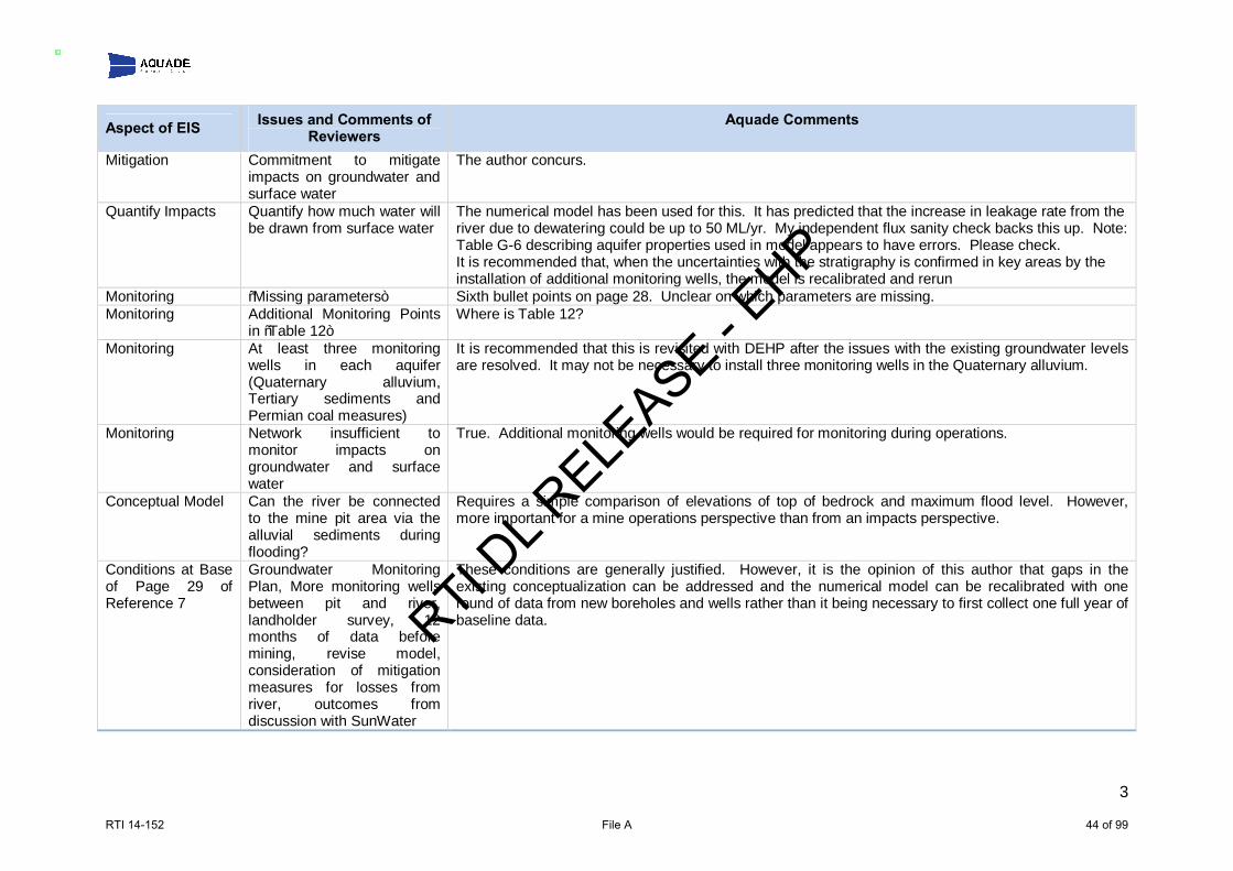
3
Aspect of EIS Issues and Comments of Reviewers
Aquade Comments
Mitigation Commitment to mitigate impacts on groundwater and surface water
The author concurs.
Quantify Impacts Quantify how much water will be drawn from surface water
The numerical model has been used for this. It has predicted that the increase in leakage rate from the river due to dewatering could be up to 50 ML/yr. My independent flux sanity check backs this up. Note: Table G-6 describing aquifer properties used in model appears to have errors. Please check. It is recommended that, when the uncertainties with the stratigraphy is confirmed in key areas by the installation of additional monitoring wells, the model is recalibrated and rerun
Monitoring “Missing parameters” Sixth bullet points on page 28. Unclear on which parameters are missing. Monitoring Additional Monitoring Points
in “Table 12” Where is Table 12?
Monitoring At least three monitoring wells in each aquifer (Quaternary alluvium, Tertiary sediments and Permian coal measures)
It is recommended that this is revisited with DEHP after the issues with the existing groundwater levels are resolved. It may not be necessary to install three monitoring wells in the Quaternary alluvium.
Monitoring Network insufficient to monitor impacts on groundwater and surface water
True. Additional monitoring wells would be required for monitoring during operations.
Conceptual Model Can the river be connected to the mine pit area via the alluvial sediments during flooding?
Requires a simple comparison of elevations of top of bedrock and maximum flood level. However, more important for a mine operations perspective than from an impacts perspective.
Conditions at Base of Page 29 of Reference 7
Groundwater Monitoring Plan, More monitoring wells between pit and river, landholder survey, 12 months of data before mining, revise model, consideration of mitigation measures for losses from river, outcomes from discussion with SunWater
These conditions are generally justified. However, it is the opinion of this author that gaps in the existing conceptualization can be addressed and the numerical model can be recalibrated with one round of data from new boreholes and wells rather than it being necessary to first collect one full year of baseline data.
RTI DL R
ELEASE - E
HP
RTI 14-152 File A 44 of 99

From: BENNETT Jeremy [[email protected]]Sent: Thursday, 17 July 2014 1:29 PMTo: COBBAN ThomasSubject: WashpoolAttachments: Washpool Groundwater Report; RE: Washpool Coal Project - Meeting Adenda - 12:30; Washpool CoalProject - Meeting Adenda - 12:30
Hi Thomas These are responses from Washpool prior to Ashley Bleakley comments on the Groundwater Report Cheers Jeremy
RTI DL R
ELEASE - E
HP
RTI 14-152 File A 45 of 99

From: WRNB System Administrator [[email protected]]Sent: Thursday, 17 July 2014 6:03 PMTo: CLARKE LizCC: CAGNEY JustinSubject: WRNB ID 1072 - New Water Work Request Created : EMP Review - Washpool Coal Pty Ltd - WashpoolCoal Mine Project
Follow Up Flag: Follow upFlag Status: Flagged
A new work request has been submitted to the Work Request Notice Board.
Service Group: Water (WAS) Request Task: EMP Review Proponent / Company: Washpool Coal Pty Ltd Facility Name: Washpool Coal Mine Project Facility Location: MLA80164 Project File Details: Project ref. 342833 Date of Request: 17/07/2014 12:00:00 AM Due Date of Request: 1/08/2014 12:00:00 AM Urgency: Normal Client Region: Central Region Category: Mining
To view more information about this work request visit: More Info To view the responsible officers for this work request visit: Responsible Officers To view a list of recent work requests please visit the Work Request Notice Board
You have received this email because you are either the requesting or managing officer.
Request SummaryService Group Water (WAS)Status New Hours Worked 0
Request Task EMP Review Proponent /Company
Washpool Coal PtyLtd
Facility Name Washpool Coal MineProject Facility Location MLA80164
Project FileDetails Project ref. 342833 Date of Request 17/07/2014
12:00:00 AMDue Date ofRequest
1/08/201412:00:00 AM Urgency Normal
Client Region Central Region Category Mining
Requesting OfficerFirst Name Liz Last Name ClarkePhone 4987 9386 Office EmeraldRegion Central Position Team LeaderEmail [email protected]
ManagerManager FirstName Justin Manager Last Name Cagney
Manager Phone 49879303 Manager Position A/Manager -
ES Mining
RTI DL R
ELEASE - E
HP
RTI 14-152 File A 46 of 99

Manager Email [email protected]
Request DetailsIt is requested that AERDS please review the revised EnvironmentalManagement Plan (EM Plan) for the Washpool Coal Mine Project. Anumber of recommendations were provided in the EIS AssessmentReport (May 2012) in regards to surface water, particularly concerningthe inadequate information associated with the proposed mine waterrelease scenarios (within the Fitzroy Basin) and the REMP.
EHP is concerned that all matters may not have been addressed, as thisis the case for the EM Plan groundwater review that has occurred todate.
Applicable surface water information and recommendations is in thefollowing pages of the EIS Assessment Report: 20-24, 48, 50 - 55.
As the EM Plan Assessment Report is due mid August 2014, it isrequested that the advice please be provided at the beginning of August2014 to allow EHP to consider all information (including any clientliaision) in our case to accept or reject the EM Plan.
Relevant DocumentsThe relevant documents have been attached. Please request anyadditional documentation that may be required.
EHP is happy to meet with DSITIA via teleconference to discuss anyissues.
JustificationTo ensure that all matters raised in the EIS Assessment Report havebeen appropriately addressed by the proponent to ensure ecosystemhealth and riverine protection, in line with the EPP Water and ANZECCGuidelines.
OtherBudget Availability Previous Contacts
Attachments
RTI DL R
ELEASE - E
HP
RTI 14-152 File A 47 of 99

From: Livia Maiorana [[email protected]]Sent: Friday, 18 July 2014 11:53 AMTo: COBBAN ThomasCC: CLARKE LizSubject: Groundwater Information Request Attachments: Existing_AQ_Logs.xlsx; SKM gint_logs3.pdf; SKM Logs_56_40R_27_185.xlsx
Hi Thomas, A summary of the groundwater bores is presented in Section 8.4 of the revised Groundwater Chapter (8) as follows:8.4.3.1 MONITORING NETWORK ESTABLISHMENT
A total of nine groundwater bores were installed in the Project area to assist in assessing potential impacts, risks and constraints to groundwaterassociated with the Project. An additional four monitoring wells were installed in September 2013 on the Project area. The 13 groundwater boresare presented in Figure 8-8 with details provided in Table 8-4.
TABLE 8 4 / GROUNDWATER MONITORING BORESGROUNDWATERREFERENCE NUMBER EASTING NORTHING SCREEN DEPTH SCREENED LITHOLOGY
To provide more detail around each of these bores I’ve have attached the full logs from the additional four bores that we installed as well as theexisting Aquila logs. Unfortunately the cross reference in the table should have been Appendix B, rather than Appendix C. Hope this addresses your queries, please let me know if they need any additional information. Thanks and regards, Livia MaioranaProject Development Manager
Aquila Resources Limited
RTI DL R
ELEASE - E
HP
RTI 14-152 File A 48 of 99

Level 18, 10 Eagle Street, Brisbane, QLD 4000, Australia
Office: (61) 7 3229 5630Mobile: (61) E: [email protected]: www.aquilaresources.com.au
This email (including attachments) is confidential and may be privileged. If you are not an intended recipient of this email, you are hereby notified that youmust not read, disseminate or copy it, or take any action in reliance on it. If you have received this email in error, please contact the sender immediately byreturn email. Please then delete both emails and do not disclose their contents to any person. Any confidentiality or privilege is not waived or lost becausethis email has been sent to you in error. The views expressed in this email are not necessarily those of Aquila Resources Limited or any member of theAquila group of companies. From: COBBAN Thomas [mailto:[email protected]] Sent: Thursday, 17 July 2014 1:18 PMTo: Livia MaioranaSubject: RE: Registered Address and Postal Address Details Hi Livia, Further to my below request for the electronic version of the revised EM Plan, can you please forward all groundwater borelogs. It is a stated in the EM Plan that bore logs are provided, however I cannot find them in Appendix C or Section 8.4 asstated on pages 19-38 and 8-1 respectively. Regards, Thomas CobbanGraduate Environmental Officer │ BScBiol/Geo, MEnvMan, MEIANZEnvironmental Services and Regulation - Mining │Central RegionDepartment of Environment and Heritage Protection99 Hospital Road Emerald QLD 4720PO Box 3028Tel: (07) 4987 9308 Email: [email protected]: www.ehp.qld.gov.au EHP symbol
From: COBBAN Thomas Sent: Thursday, 17 July 2014 12:59 PMTo: 'Livia Maiorana'Subject: RE: Registered Address and Postal Address Details Hi Livia, My apologies for the typo error, the 3 July 2014 is correct and yes the 13 August 2014 will be the statutory deadline. Can I please request you send through the electronic version of the revised EM Plan? I am in the process of reviewing thegroundwater component of the EM Plan and will require the input of our groundwater officer, who is located in anotheroffice and I will need to pass on via email. Can you please respond as soon as practicable in regards to this request. My understanding is after the EM Plan assessment period is over, five days is allowed for the decision and five days for the
RTI DL R
ELEASE - E
HP
RTI 14-152 File A 49 of 99

Draft EA to be issued. I hope this answers all your questions. Regards, Thomas CobbanGraduate Environmental Officer │ BScBiol/Geo, MEnvMan, MEIANZEnvironmental Services and Regulation - Mining │Central RegionDepartment of Environment and Heritage Protection99 Hospital Road Emerald QLD 4720PO Box 3028Tel: (07) 4987 9308 Email: [email protected]: www.ehp.qld.gov.au EHP symbol
From: Livia Maiorana [mailto:[email protected]] Sent: Thursday, 17 July 2014 11:22 AMTo: COBBAN ThomasSubject: RE: Registered Address and Postal Address Details Hi Thomas. Just checking in to see how the review is going and see if you have any questions or query’s on the revised EM Plan appreciating that you havehad to catch up on the history of the Project. If you need to book in a telecom to discuss any matter, please just let me know. In regards to the dates you provided below, I can only assume the date of June 3 is a typo which should have read July 3? If that is the case, Ihave calculated August 13 to be the date the assessment of the Revised EM Plan should be completed and feedback provided. Can you pleaseconfirm if this understanding is correct. Additionally, can you please also confirm that further to that date, subject to the approval of the EM Plan, then there will be 10 business days toissue the Draft EA. We are just trying to put together all out timeframes at the moment and would like to confirm this. Thanks and regards, Livia MaioranaProject Development Manager
Aquila Resources LimitedLevel 18, 10 Eagle Street, Brisbane, QLD 4000, Australia
Office: (61) 7 3229 5630Mobile: (61) E: [email protected]: www.aquilaresources.com.au
This email (including attachments) is confidential and may be privileged. If you are not an intended recipient of this email, you are hereby notified that youmust not read, disseminate or copy it, or take any action in reliance on it. If you have received this email in error, please contact the sender immediately by
RTI DL R
ELEASE - E
HP
RTI 14-152 File A 50 of 99

return email. Please then delete both emails and do not disclose their contents to any person. Any confidentiality or privilege is not waived or lost becausethis email has been sent to you in error. The views expressed in this email are not necessarily those of Aquila Resources Limited or any member of theAquila group of companies.
From: COBBAN Thomas [mailto:[email protected]] Sent: Wednesday, 9 July 2014 10:22 AMTo: Livia MaioranaSubject: RE: Registered Address and Postal Address Details Hi Livia, Thanks for the details. We received the EM Plan on the 2 July 2014 so the assessment report statutory timeframe of 30 business days began on the 3June 2014. I had to do some catching up on the history of the project as well as where the project sat within the relevantlegislation. Now I have got that done I will be working on assessing the EM Plan from today onwards. As such I do not haveany questions or matters to discuss just yet, however if you would like to schedule a teleconference next week sometime I amhappy to do so. I am free all of next week so whatever time suits you best. Regards, Thomas CobbanGraduate Environmental OfficerEnvironmental Services and Regulation - Mining │Central RegionDepartment of Environment and Heritage Protection99 Hospital Road │EmeraldTel 07 4987 9308 Email [email protected] www.ehp.qld.gov.au EHP symbol
RTI DL R
ELEASE - E
HP
RTI 14-152 File A 51 of 99

This email (including attachments) is confidential and may be privileged. If you are not an intended recipient of this email, you are hereby notified that youmust not read, disseminate or copy it, or take any action in reliance on it. If you have received this email in error, please contact the sender immediately byreturn email. Please then delete both emails and do not disclose their contents to any person. Any confidentiality or privilege is not waived or lost becausethis email has been sent to you in error. The views expressed in this email are not necessarily those of Aquila Resources Limited or any member of theAquila group of companies.
From: COBBAN Thomas [mailto:[email protected]] Sent: Wednesday, 9 July 2014 9:54 AMTo: Livia MaioranaSubject: Registered Address and Postal Address Details
Thomas CobbanGraduate Environmental OfficerEnvironmental Services and Regulation - Mining │Central RegionDepartment of Environment and Heritage Protection99 Hospital Road │EmeraldTel 07 4987 9308 Email [email protected] www.ehp.qld.gov.au
RTI DL R
ELEASE - E
HP
RTI 14-152 File A 52 of 99
EHP symbol
------------------------------
The information in this email together with any attachments is intended only for the person or entity to which it isaddressed and may contain confidential and/or privileged material. There is no waiver of any confidentiality/privilege by yourinadvertent receipt of this material.
Any form of review, disclosure, modification, distribution and/or publication of this email message is prohibited, unless asa necessary part of Departmental business.
If you have received this message in error, you are asked to inform the sender as quickly as possible and delete this messageand any copies of this message from your computer and/or your computer system network.
------------------------------
RTI DL R
ELEASE - E
HP
RTI 14-152 File A 53 of 99

From: Livia Maiorana [[email protected]]Sent: Thursday, 1 August 2013 1:19 PMTo: Bennett JeremyCC: Taylor, Damien J (SKM)Subject: Washpool Project
Follow Up Flag: Follow upFlag Status: Completed
Hi Jeremy, I hope you are well? It’s been a while since we last communicated so I thought it was about time we meet again to update you on the status ofthe Project, the additional work requested in the Assessment Report, and our timeframes for re-submitting our amended EM Plan. As a brief update on the outstanding items, I can advise you that we have completed another Groundwater Assessment of the informationavailable in line with DEHPs comments in the assessment report and as a result, I believe we will be in a position to present you with a plan toaction any outstanding questions in regards to groundwater in order to move forward with this Project to the Draft EA stage.
As I stated earlier, I think we are close to a position that will enable us to have a plan to propose to you in order to proceed to a Draft EA stageof assessment. As such, can I please suggest we meet (subject to your availability) on either Thursday or Friday next week (August 8 or 9). If either of thosedates suit, please advise what time suits you and I will send through a proposed agenda. Thanks and regards, Livia MaioranaProject Development Manager
Aquila Resources LimitedLevel 18, 10 Eagle Street, Brisbane, QLD 4000, Australia
Office: (61) 7 3229 5630Mobile: (61) E: [email protected]: www.aquilaresources.com.au
This email (including attachments) is confidential and may be privileged. If you are not an intended recipient of this email, you are hereby notified that youmust not read, disseminate or copy it, or take any action in reliance on it. If you have received this email in error, please contact the sender immediately byreturn email. Please then delete both emails and do not disclose their contents to any person. Any confidentiality or privilege is not waived or lost becausethis email has been sent to you in error. The views expressed in this email are not necessarily those of Aquila Resources Limited or any member of theAquila group of companies.
RTI DL R
ELEASE - E
HP
RTI 14-152 File A 54 of 99

From: Livia Maiorana [[email protected]]Sent: Friday, 18 July 2014 11:53 AMTo: COBBAN ThomasCC: CLARKE LizSubject: Groundwater Information Request
This message has been archived. View the original item
Hi Thomas,
A summary of the groundwater bores is presented in Section 8.4 of the revised Groundwater Chapter (8) asfollows:
8.4.3.1 Monitoring Network Establishment
A total of nine groundwater bores were installed in the Project area to assist in assessing potential impacts,risks and constraints to groundwater associated with the Project. An additional four monitoring wells wereinstalled in September 2013 on the Project area. The 13 groundwater bores are presented in Figure
Attachments:image001.png (10 KB)
image002.jpg (4 KB)
Existing_AQ_Logs.xlsx (75 KB)
SKM gint_logs3.pdf (189 KB)
SKM Logs_56_40R_27_185.xlsx (22 KB)
RTI DL R
ELEASE - E
HP
RTI 14-152 File A 55 of 99

Meeting Agenda: Washpool Coal Mine EM Plan and EA Application
Meeting Date & Time: 17 September 2014, 9:30 am – 11:30am.
Location: Meeting Room 3, 99 Hospital Road, EMERALD.
Facilitator: Thomas Cobban.
Attendees Department of Environment and Heritage Protection Liz Clarke – Team Leader Thomas Cobban – Graduate Environmental Officer Jo Hardy – Graduate Environmental Officer Washpool Coal/Aquila Resources Livia Maiorana – Project Development Manager Andrew Hocking – Operations Manager Jacobs Damien Taylor – Project Manager
Apologies N/A
Agenda
Items1 Description1 1. Introductions 1. Attendees give brief introduction. 2. EM Plan outstanding issues and requirements which require discussion
1. General Item 1.3 Model mining conditions 2. Surface Water Item 3.1 Schematics water structures Item 3.2 & Item 3.4 Water balance model Item 3.3 Regulated structures Item 3.6 Monitoring program Item 3.9 Figure 19-5 Item 3.11 Moderately/Highly disturbed ecosystem Item 3.12 Aquaculture Item 3.15 Downstream point Item 3.16 Downstream limit 5km or 20km 3. Groundwater Item 3.17 EIS Assessment Report requirements Item 3.18 Groundwater model Item 3.19 Final voids 4. Land Item 4.1 Rehabilitation requirements Item 4.3 Final voids
RTI DL R
ELEASE - E
HP
RTI 14-152 File A 56 of 99

5. Nature Conservation Item 5.1 Deed of Agreement Item 5.2 Ecological Equivalence Assessment Item 5.4 Little Pied Bat Item 5.5 RE 11.4.2 Item 5.6 Fitzroy River Turtle Survey
6. Waste (added late to the Agenda) Item 6.1 Sewage Effluent
3. EA Application – Withdrawal and Resubmission under Greentape
1. Application process 2. Timeframes 3. Information requirements 4. Public notification and land court
4. EA Application – Continue with current EA application and resubmit EA Amendment to add additional MLs
1. Application process a. Current EA application b. EA Amendment
2. Timeframes a. Current EA application b. EA Amendment
3. Information requirements a. Current EA application b. EA Amendment
4. Public notification and land court a. Current EA application b. EA Amendment
5. Miscellaneous Any other issues 1 Outstanding items which were agreed to in the letter written by Mr Stephen J Pilcher (Director, Washpool
Coal Pty Ltd) on the 01 September 2014 in reply to the Department of Environment and Heritage Protection EM Plan refusal letter dated 13 August 2014, were not included in the agenda as it is assumed those requirements will be implemented and do not require further discussion.
Commitments, Comments and Agreed Actions
The commitments made by Washpool Coal in the meeting as well as brief comments and agreed actions are provided in the table below. For details on the specific items discussed in the meeting please see Attachment B below.
Assessment Officer: Thomas Cobban Reviewer: Liz Clarke Reviewer:
Livia Maiorana
Position: Graduate Environmental Officer
Position: Team Leader Position: Proponent Representative
Date: 19 September 2014 Date:
22 September 2014 & 30 September 2014
Date:
26 September 2014 & October 1 2014
RTI DL R
ELEASE - E
HP
RTI 14-152 File A 57 of 99
Minutes agreed to by all parties:
Name of Representative Signature Date EHP Representative Liz Clarke Washpool Coal Representative Livia Maiorana
RTI DL R
ELEASE - E
HP
RTI 14-152 File A 58 of 99

Attachment A: List of Washpool Coal Project Commitments and Agreed Actions from Meeting 17 September 2014
Item (Details in
Attachment B)
Washpool Coal Commitment (Yes/No/Follow Up/Completed)
Comments, Commitment Details and Agreed Actions
EHP comments: • Only areas within the Mining Leases will be assessed. The rail area outside of Mining Lease
80202 will not be assessed as part of this EA and will be assessed under the application under the Sustainable Planning Act (or other relevant legislation) once the application has been lodged.
1.3 Yes Washpool Coal comments; • Will commit to implementing the model mining conditions as per EHP recommendation
1.3 of Attachment B.
3.1 Yes Washpool Coal comments; • Details of water management structures already in the EIS documents. Committed to
including details in the revised EMP/Greentape application documents as per recommendation 3.1 of Attachment B.
EHP comments; • Washpool is required to include all release points, monitoring points, structures (dams
and pipleines), mining footprint (disturbance areas), mine infrastructure area, ancillary activities (i.e. notifiable activities and environmentally relevant activities etc.) in figures.
Washpool Coal comments; • Agreed with required details.
RTI DL R
ELEASE - E
HP
RTI 14-152 File A 59 of 99

3.2 & 3.4 Yes Washpool Coal comments; • Details of water management structures already in the EIS documents. Committed to
including details outlined in item 3.2 & 3.4 of Attachment B in the revised EMP/Greentape application documents.
• Figures, diagrams and commentary regarding the water balance model will be included in EMP/Greentape application documents.
3.3 Yes, but requiring EHP
follow up
Washpool Coal comments; • Advised that the consequence category assessment of dams and levee has begun as per
recommendations for item 3.3 of Attachment B. • Raised concerns regarding the need for hydraulic performance assessment, development
of design plans and supporting documentation prior to EA approval and enquired if this could be submitted post EA approval.
EHP comments; • Could not confirm during the meeting whether the hydraulic performance assessment,
development of design plans and supporting documentation could be submitted post EA approval and would confirm prior to next meeting.
3.6 Yes Washpool Coal comments; • As per recommendations made in item 3.6 of Attachment B, committed to modifying the
monitoring program to be in alignment with the REMP and a flow indicator would be added to the program.
3.9 Yes EHP comments; • In addition to the item above, EHP requires all release points be identified as either
uncontrolled (i.e. spillways) or controlled (i.e. pump valves) in the revised figure. • Advised the proponent that it is preferable to have controlled release points for dams with
mine affected water. • Advised that northern sediment dams would be classed as containing mine affected water
initially, with provisions in EA allowing for revision after two years.
RTI DL R
ELEASE - E
HP
RTI 14-152 File A 60 of 99

Washpool Coal comments; • In addition to commitments made in item 3.2, the proponent advised that release point
details would be included in the revised figures. • Agreed that the northern sediment dams would be classed as mine affected water and
two years of monitoring results could be used to change that classification if applicable. • Advised that south-eastern sediment dams would not be releasing to the environment,
rather to the main retention dam for release via release point W1, thus, there will be only four release points for the project rather than six.
3.11 Yes EHP comments; • Explained the reasoning behind the decision; that the data provided was insufficient at re-
classifying the receiving ecosystem as highly disturbed rather than moderately disturbed. • Advised that Washpool Coal would need to undertake further water quality monitoring to
assess if the ecosystem is highly disturbed and macro-invertebrate surveys in order for EHP to re-assess the proposal.
• Advised that the management intent for moderately disturbed and highly disturbed ecosystems differ and the revised EMP/Greentape application documents would need to reflect that requirement.
• Advised Washpool Coal to refer to the Environmental Protection Policy (Water) and Queensland Water Quality Guidelines (2009) for details on the management intent.
Washpool Coal comments; • Advised that a moderately disturbed ecosystem classification would be applied in the
revised EMP/Greentape application documents, unless further monitoring data can be provided to EHP to support an argument for a highly disturbed ecosystem classification.
• Agreed that the management intent in the revised EMP/Greentape application documents would need to reflect a moderately disturbed ecosystem.
RTI DL R
ELEASE - E
HP
RTI 14-152 File A 61 of 99

3.12 Yes, but follow up from EHP
required.
EHP comments; • Advised that “Aquaculture” is an identified environmental value in the Mackenzie Sub-
Basin Water Quality Objectives Plan and as a result the revised EMP/Greentape application documents will need to address the environmental value whether there are aquaculture operations or not.
• Advised that the Mackay office would confirm if there was an aquaculture operation at Bingegang Weir and would notify Washpool Coal of the outcome.
Washpool Coal comments; • Committed to addressing the recommendations in item 3.12 Attachment B in line with
comments once received from EHP. 3.15 Yes EHP comments;
• Advised that the downstream point referred to in “note b” of Table 8 should be “monitoring point F” rather than “Bedford Weir” as it is approximately 24km downstream of the main release point W1 compared to 34 km. Given the receiving environment is generally defined as around 20 km downstream of the release of mine affected water (see model mining conditions and REMP guidelines), using monitoring point F as the downstream point is appropriate given its distance from release point W1.
Washpool Coal comments; • Agreed with EHP comments and committed to changing note b as per the
recommendation in item 3.15 of Attachment B. 3.16 Yes EHP comments;
• Advised that proposed monitoring point F is approximately 24 km downstream of the main release point W1 (sourced from Google Earth), not 7.151km as stated in the previous EMP. It is recommended Washpool Coal change the wording of W22 (equivalent to F21 of the model conditions) to 20km rather than 5km.
Washpool Coal comments; • Agreed with EHP comments and committed to changing the wording of W22 (equivalent
to F21 of the model conditions) as per the recommendation in item 3.16 of Attachment B.
RTI DL R
ELEASE - E
HP
RTI 14-152 File A 62 of 99

3.17 No commitment reached.
Required follow up from EHP and
further discussion in the next meeting in
October
EHP comments; • Outlined the issue regarding groundwater monitoring and modelling, as follows;
o Groundwater monitoring and modelling has been an issue consistently flagged during the EIS process, in the EIS Assessment Report, in the recent EM Plan Assessment and by the Commonwealths IESC.
o Both the State and Commonwealth departments agree that groundwater monitoring and modelling to date is inadequate.
o The EIS Assessment Report gave clear requirements to improve the project groundwater monitoring and modelling prior to EA approval.
• Explained the legislative requirements which oblige EHP to consider the EIS Assessment Report requirements when assessing the adequacy of the revised EM Plan.
• Raised concerns regarding the lack of monitoring bores in the Alluvial Aquifer particularly between the West of the Mine and the Mackenzie River.
• Raised the commitment made by Aquila in the February 2012 response to submission which stated Aquila would drill three monitoring bores between the saturated alluvial bore (AQ106) and the Mackenzie River.
• Raised concerns regarding the locations of the two bores AQ027 and AQ185 drilled in September 2013 as they did not target the western alluvial aquifer. This was a concern as it did not adequately assess the western alluvial aquifer between the Mackenzie River and the West of the Mine, therefore not adequately assessing the connectivity between the river and the mine, which were concerns raised throughout the EIS process.
• Advised that the best locations for the monitoring bores were between the saturated bore (AQ106) and the Mackenzie River, as that is the area with the most significant alluvial sediments where an aquifer would most likely reside, if in existence.
Washpool Coal comments; • Stated that over 300 drill holes had been drilled within the project area, with no significant
water make encountered. • Stated that bores AQ185 and AQ027 were selected for additional groundwater monitoring
RTI DL R
ELEASE - E
HP
RTI 14-152 File A 63 of 99

locations as the drill sites were already existing and would not require additional cultural heritage clearance and impacts on property owners land.
• Potential locations for the additional monitoring bores were marked on a plan and discussed with EHP during meeting on August 8, 2013. The All four locations were agreed during and post the meeting with an EHP Officer in August 2014 and subsequently were constructed in September 2013.
• Asked whether the groundwater monitoring requirements could be conditioned in the EA and required post grant of the mining lease and prior to construction/production.
EHP comments; • Advised that the issue would be raised with EHP Managers and would be discussed further
in the next meeting to be scheduled in October 2014. 3.18 See above This item will be dependent on the outcome of the above item.
3.19 Yes EHP comments; • Advised that the EM Plan is intended to be a standalone document. If information is not in
the EM Plan it is assumed to be missing. The proponent must include all required information and figures in the EM Plan if it is to be considered by the department.
• Advised that it is possible to have this item as a condition within the EA when approved rather than requiring this information prior to approval.
• Advised that EHP would provide a draft version of the conditions prior to any draft EA being developed for Washpool Coal’s consideration.
Washpool Coal comments; • Indicated that more final void details would be included in the revised EMP/Greentape
application documents. • Agreed that a condition in the EA would be preferred and would like to see a draft version
of the conditions prior to a draft EA being developed.
RTI DL R
ELEASE - E
HP
RTI 14-152 File A 64 of 99

4.1 Yes EHP comments; • Stated that the department agrees that a considerable amount of the information which is
applicable to the EHP Guideline (EM1122) is included in the EM Plan, however there are also some critical components absent, such as;
o Addressing all four rehabilitation goals, particularly; o Safe to humans and wildlife; and o Non-polluting.
• The separation of rehabilitation goals, objectives, indicators and completion criteria in to domains to account for differing rehabilitation requirements. For this project, domains could include;
o Levee o Final voids o Dams o Infrastructure o Out of pit spoil dumps o In pit spoil dumps
• Each domain should have rehabilitation objectives which address specific rehabilitation requirements that are designed to prevent environmental impacts or to achieve environmental outcomes specific to that domain. For example, a levee domain will have differing objectives to a spoil dump domain, due to the domains purpose, location, character and risks.
• Rehabilitation objectives, indicators and completion criteria must cover the following details;
o Safety measures o Water management and water quality o Landforms o Land use o Vegetation
RTI DL R
ELEASE - E
HP
RTI 14-152 File A 65 of 99

• Rehabilitation success criteria must be measurable and quantifiable. • Reference sites must be identified in order to assess the progress of rehabilitation; these
can be used in the development of measurable and quantifiable success criteria. • A figure with the final landforms and rehabilitation domains should be included in the
revised EMP/Greentape application documents. • Indicated that EHP could provide a recent example of good rehabilitation requirements
accepted by the department. Washpool Coal comments;
• Agreed that the rehabilitation requirements outlined in the original EMP were based on outdated standards and that the new rehabilitation requirements would be developed that would meet the new guideline.
• Advised that the update of the rehabilitation requirements had already begun. • Indicated that a figure with the final landforms and domains would be included in the
revised EMP/Greentape application documents. 4.3 Yes EHP comments;
• As per item 3.19 Washpool Coal comments;
• As per item 3.19. 5.1 Yes, but with a
different outcome to
items original recommendation
- requires EHP follow up
Washpool Coal comments; • Asked whether a financial settlement would be applicable to meet the biodiversity offset
requirements for the project if the EA application was withdrawn and resubmitted under greentape.
• Indicated that a financial settlement option was preferred and asked when the payment would be required.
EHP comments; • Confirmed that the new Environmental Offsets Act 2014 would apply if the EA application
RTI DL R
ELEASE - E
HP
RTI 14-152 File A 66 of 99

was withdrawn and resubmitted under greentape legislation. • Confirmed that financial settlement was an option for meeting the biodiversity offset
requirements. • Advised that EHP would confirm when the financial settlement is required.
5.2 See above. This item has been addressed in the above item. 5.4 Yes, but follow
up from Washpool Coal
required
EHP comments; • Advised that this item was not addressed in the EM Plan despite the Little Pied Bat
potentially being an offset requirement. • Requested that this item be addressed in the revised EMP/Greentape application
documents. Washpool Coal comments;
• Stated that during flora surveys the consultant noted the regional ecosystem could be habitat for the Little Pied Bat but it was not confirmed.
• Agreed that this item will be addressed in a revised EMP/Greentape application documents.
5.5 Yes, but follow up from
Washpool Coal required
EHP comments; • Explained that the mapped regional ecosystem 11.4.2 (in the mine pit area) which was
stated as cleared in the EM Plan (June 2014) was not formally re-mapped by the Queensland Herbarium. The normal process for remapping regional ecosystems is via an application to the Queensland Herbarium.
• Advised that EHP expected an application to be made to the Queensland Herbarium before the 11.4.2 RE is considered cleared.
Washpool Coal comments; • Explained that there was potential to use aerial imagery as an alternative to ground truth
surveys due to current difficulties with site access. • Advised that the Queensland Herbarium would be contacted to confirm whether the use
of aerial imagery for remapping was acceptable.
RTI DL R
ELEASE - E
HP
RTI 14-152 File A 67 of 99

5.6 Completed Washpool Coal comments; • Confirmed that the Fitzroy River Turtle survey (May 2013) had been completed and
supplied EHP with a hard copy of the report. A soft copy of the report would also be sent. • Confirmed that no turtles were found in the area and that nesting sites were not in areas
that could be impacted by mining activities. • The turtle management plan will be reviewed, updated and submitted to EHP to
incorporate the additional information collected during site surveys carried out in May 2013.
6.1 Yes, follow up from Washpool Coal required
Washpool Coal comments; • Confirmed that sewage treatment effluent was being planned for use in dust suppression. • Following EHP comments (below) stated that the application of effluent to roads would be
revised, the outcome would be incorporated in to a revised EMP/Greentape application documents.
EHP comments; • If sewage treatment effluent was to be applied to roads the model mining conditions
would still apply and the treated effluent quality limits for land disposal would need to be adhered to.
Proponent Decision on Process of
EA Application
Moving Forward
See to the right • Following extensive discussion regarding both the Pre-greentape and Greentape EA application processes the following was confirmed;
o The greentape process would not likely include the information and notification stages as the EIS process already occurred. These stages would only apply if the application had information that was significantly different to the original EIS; and that the administering authority considered that the changes would introduce new and significant potential environmental impacts and / or the changes were reasonably expected to attract submissions. EHP to confirm if changes to the rail would be deemed ‘significant’ and if subsequent notification will be required as this will form part of the decision to proceed with the current EA approval process or to re-lodge under greentape.
RTI DL R
ELEASE - E
HP
RTI 14-152 File A 68 of 99
o Under greentape, the draft EA would still be subject to submitter objections. o The mining lease applications have not been publicly notified under the Mineral
Resources Act 1989. The Department of Natural Resources and Mines have confirmed that this would not occur until the Notification stage occurred under the EP Act. This is so that both public notification stages would coincide to streamline the process.
o EHP would attempt to get the new application fee waivered as the application fee had already been paid upon the original application and that DEHP had incorrectly advised the proponent that they had accepted an amendment application to the original EA (that was being assessed) to include MLa801876 and MLa80177.
o Washpool Coal is likely to withdraw the current EA application and re-apply under the greentape process with all mining leases (80164, 80176, 80177 and 80202) in the application, however require confirmation if the changes in Project scope are significant and require further public notification. Any changes to the environmental approval process will be subject to corporate approval and a definitive decision would be made at the December Board Meeting.
RTI DL R
ELEASE - E
HP
RTI 14-152 File A 69 of 99

Attachment B: List of EM Plan outstanding issues and recommendations.
Item EM Plan Section
Issue EHP Recommendation
1. General
1.1 19.1.9 Environmentally Relevant Activity (ERA) 31 Mineral Processing (pursuant to Schedule 2 of the Environmental Protection Regulation 2008) is not listed as an ERA to be carried out. However, operation of the proposed coal handling and processing plant requires an approval for ERA 31.
Include the following as an ERA in the EM Plan:
• ERA 31 Mineral processing – Threshold 2 processing, in a year, the following quantities of mineral products, other than coke – (b) more than 100,000t.
1.2 19.1.9 Notifiable activities 15 Explosive production or storage and 29 Petroleum product or oil storage are not listed in s19.1.9 of EM Plan, but are listed in s19.4.8.4.
Include notifiable activities 15 and 29 in s19.1.9 of the EM Plan.
1.3 All The revised EM Plan proposes outdated environmental authority conditions which do not align with EHP’s Guideline Model mining conditions (EM944). The model conditions should be applied to all mining project applications where public notification of conditions has not occurred.
The above model mining conditions also cater for the inclusion of any conditions relevant to site specific environmental protection commitments.
For regulated structures (dams and levees), model conditions within Appendix A of EHP’s Guideline Structures which are dams or levees constructed as part of environmentally relevant activities (EM634) should be applied.
Revise the proposed draft environmental authority conditions to include;
• EHP model mining conditions.
• All conditions required for site specific environmental protection commitments.
2. Air
Comment [LM1]: These need to be reviewed and updated, in accordance with the comments in Attachment A.
Comment [CL2]: To be done by Thomas upon his return.
RTI DL R
ELEASE - E
HP
RTI 14-152 File A 70 of 99

Item EM Plan Section
Issue EHP Recommendation
2.1 19.4.2.6 The PM10 monitoring commitment made in section 19.4.2.6 (in summer and winter every 4 years) differs to the proposed EA condition B4 and B9 (continuous monitoring for one year). The EIS assessment report also recommends one year of PM10 monitoring in order to validate the air quality model.
Amend section 19.4.2.6 to reflect the proposed environmental authority conditions B4 and B9.
3. Water
Surface Water
3.1 19.4.3 Section 19.4.3; Figure 19-5:
The water management structures described in this section are not supported by any detailed schematics of their proposed location or release points.
Include detailed schematics of all water management structures and proposed release points.
3.2 19.2.6 Section 4 Revised Draft Environmental Management Plan (Amended June 2014), Section 19.2.6, Water Management (Page 19-10): The EMP does not present an integrated flowchart or diagram to illustrate the on-site mine surface water management system and the various water management structures.
Include a surface water management flowchart/diagram in the EM Plan that visually illustrates the movement and amount of water that runs into the site; identifies and quantifies how water is used both on and off site (e.g. external transfers); and discharges to the receiving environment.
3.3 19.2.7 Section 4 Revised Draft Environmental Management Plan (Amended June 2014), Section 19.2.7, Table 19-5 Mine Water Management System Storages (Page 19-12):
The proponent has described the mine water management system storages in Table 19-5. However, the anticipated consequence categories of each dam or levee according to the criteria in EHP’s Manual for Assessing Consequence Categories and Hydraulic Performance of Structures (EM635) have not been provided.
Provide a list of all dams and levees proposed on the project site and undertake an assessment to determine the consequence category of each dam or levee (low, significant, or high), according to the criteria in EHP’s Manual for Assessing Consequence Categories and Hydraulic Performance of Structures (EM635). This recommendation is in accordance with the model conditions in the EHP guideline Structures which are dams or levees constructed as part of environmentally relevant activities (EM634).
Formatted: Highlight
Comment [DT3]: EHP to clarify if the Hydraulic Performance of structures could be carried dover and done during detailed design.
RTI DL R
ELEASE - E
HP
RTI 14-152 File A 71 of 99

Item EM Plan Section
Issue EHP Recommendation
3.4 19.4.3 Section 4 Revised Draft Environmental Management Plan (Amended
June 2014), Section 19.4.3, Water Resources (Page 19-32):There is not an adequate amount of information in the EM Plan in relation to the mine water balance for the mine water management system that was modelled using the Goldsim modelling package. The EM Plan should include detailed information on the mine site water balance modelling results.
Include detailed information on the site water balance modelling results in the EM Plan.
3.5 19.4.5 Section 4 Revised Draft Environmental Management Plan (Amended June 2014), Section 19.4.5., Water Resources – Environmental Values (Page 19-43) and Washpool Coal Mine Project Receiving Environment Monitoring Program (June 2014), Table 5-2 to 5-4 (Page 15-17):
There is an inconsistency between the EM Plan and the Receiving Environment Monitoring Program (REMP) design report in relation to the environmental values that need to be protected.
It was stated in the EM Plan that:
“The Environmental water values to be protected are:
• the biological integrity of a modified surface water aquatic ecosystem;
• the suitability of surface water for domestic, agricultural and recreational use; and
• the availability and suitability of groundwater for agricultural use.”
Replace the identified environmental values to be protected in the EM Plan with the adopted environmental values based on the relevant EPP Water for the project area as presented in the REMP design report.
RTI DL R
ELEASE - E
HP
RTI 14-152 File A 72 of 99

Item EM Plan Section
Issue EHP Recommendation
However, the REMP design document indicated in Tables 5-2 to 5-4 that the adopted environmental values were based on those Scheduled within the Environmental Protection Policy (Water) 2009 (EPP Water) for the Project Area, which is the Mackenzie River Sub-basin Environmental Values and Water Quality Objectives; Basin No.130 (part), including all waters of the Mackenzie River Sub-basin (DEHP, 2011). The relevant waters covered by this document include the Mackenzie River and the southern tributaries, which include Burngrove Creek.
As a general rule, the more regionally-relevant guidelines should always be consulted first. The hierarchy is as follows:
1. locally-derived Water Quality Objectives (WQOs, most relevant)
2. EPP (Water) – sub regional guidelines
3. QWQG – regional guidelines
4. ANZECC & ARMCANZ (NWQMS, 2000) – national guidelines (least relevant).
As the waterway is scheduled under the EPP Water, the proponent should adopt the environmental values listed in this guideline.
3.6 19.4.5.3 Section 4 Revised Draft Environmental Management Plan (Amended June 2014), Section 19.4.5.3., Monitoring (Page 19-44):
The monitoring section of the EM Plan states:
“The likely quality parameters and sampling frequency will be:
Monthly - EC, pH, DO, TDS, Turbidity
It is recommended that the proponent amend the monitoring frequency in the EM Plan to be consistent with the proposed REMP design document. Furthermore, the proponent should include “flow indicator” as part of the monitoring program in the EM Plan and REMP reports. The proponent may need to seek further guidance on conducting a REMP by consulting the Receiving Environment
RTI DL R
ELEASE - E
HP
RTI 14-152 File A 73 of 99

Item EM Plan Section
Issue EHP Recommendation
Six monthly – Aluminium, Arsenic, Cadmium, Chromium, Copper, Iron, Lead, Mercury, Nickel, Zinc, Boron, Cobalt, Manganese, Molybdenum, Selenium, Silver, Uranium, Vanadium, Ammonia, Nitrate, Petroleum hydrocarbons (C6-C9), Petroleum hydrocarbons (C10-C36), Fluoride (total), phosphate (PO4) (filterable reactive phosphate), sulphate, TDS, Zinc.”
EHP assumes that the monitoring program proposed in the EM Plan is synonymous with the draft REMP design document. If this is not the case the proponent needs to outline the purpose of this monitoring program. The proposed sampling frequency is also inconsistent with that proposed as part of the proposed REMP. In the EM Plan , there is no clear justification for the frequency of sampling for each component of the monitoring program. Nor is there any information demonstrating whether the planned sampling frequency will be sufficient to facilitate the comparison of control site data with test site data, and comparison of test site data against guidelines. Additionally, the proponent has not proposed a “flow indicator” as part of their monitoring program. The rationale provided within the proposed REMP is more appropriate. Further guidance on REMP design is provided in EHP’s REMP guideline (EM1260)
Monitoring Program guideline (EM1260).
http://www.ehp.qld.gov.au/licences-permits/business-industry/guidelines.html
3.7 Section 4 Section 4 Revised Draft Environmental Management Plan (Amended June 2014), Proposed Environmental Authority Conditions: Schedule C - Water (Page 19-45 to 19-62):
EA conditions have been proposed by the proponent based on the previous “Model Water Conditions for Coal Mines in the Fitzroy Basin”. The current “Model Mining Conditions” are available and
The proponent should revise their proposed EA conditions to ensure that the content is in accordance with the current Model Mining Conditions (as discussed in item 1.3 of this document). Additionally, EHP has the following comments on the proposed Schedule C – Water EA conditions, which should be considered by the proponent when redeveloping the proposed surface water conditions:
RTI DL R
ELEASE - E
HP
RTI 14-152 File A 74 of 99

Item EM Plan Section
Issue EHP Recommendation
can be found in the link below:
http://www.ehp.qld.gov.au/land/mining/pdf/model-mining-conditions-em944.pdf
1. Table 1:
• the proponent needs to identify the number of release points that exist on their site. Table 1 shows there are at least 6 release points on site, but only 1 is listed in Table 4 and Figure 19-5.
• the proponent should replace the word “contaminant” written in the fourth column with “mine affected water”
3.8 REMP Washpool Coal Mine Project Receiving Environment Monitoring Program (June 2014), Table C-1 and C-2 (Page 50-52):
The proponent used “µS CM-1” and “MG L-1” units instead of “µS/cm” and “mg/L”.
The proponent should use lower case fonts and change the units into “µS/cm” and “mg/L”.
3.9 Section 4 There is an inconsistency in the draft EA between Table 1 (W1-W6) and Table 4 (only W1) regarding the number of release points.
The proponent has not included all the proposed water storage facilities for the project in Figure 19-5.
The proponent has to clarify the total number of their release points.
The proponent should amend Figure 19-5 by including:
• Discharge points (W2-W6 should be presented on the map if they are discharge points that release mine affected water to receiving waters) and Spillways of all water storages;
• Train load out facilities and raw water dam; and
• Pipes used to pump water between water storage dams.
3.10 REMP
19.4.3.2
Subsection 19.4.3.2 (page 19-36):
The REMP has been inconsistently referred to as “a routine environmental monitoring program” or as a “surface water
The proponent should consistently use “Receiving Environment Monitoring Program” (REMP) as suggested under the EHP’s Model mining conditions.
RTI DL R
ELEASE - E
HP
RTI 14-152 File A 75 of 99

Item EM Plan Section
Issue EHP Recommendation
monitoring program”. These should be replaced with 'Receiving Environment Monitoring Program'.
3.11 REMP
19.4.9.2, 19.4.9.7, Table 5-4, Section 8.2, 8.3 and Appendix C.
The following deficiencies are present in Table 5-2, Mackenzie River - Environmental Values, Table 5-3, Burngrove Creek - Environmental Values and Table 5-4, Coal Mine Lagoon - Environmental Values:
There is insufficient data to conclude that the condition of aquatic ecosystems is “highly disturbed”. The condition of aquatic ecosystems should be described as “moderately disturbed”, which reflects the management intent or level of protection for this waterway outlined in the Mackenzie River Sub-basin Environmental Values and Water Quality Objectives (DERM 2011) under Schedule 1 of the EPP Water.
The proponent use the term “highly disturbed” in the following sections; subsection 19.4.9.2, 19.4.9.7, Table 5-4, Section 8.2, 8.3 and Appendix C.
The proponent should use “moderately disturbed” for the aquatic ecosystem condition instead of “highly disturbed” until there is sufficient data to conclude that the condition of aquatic ecosystems is highly disturbed.
3.12 REMP Table 5-6, Water quality objectives:
• The Mackenzie River Sub-basin Environmental Values and Water Quality Objectives (DERM, 2011) should be used as the source for locally derived and validated WQOs for each indicator.
• The following parameters should be adjusted as indicated in Table A1 below:
Table A1
Indicator Adjustment required
Table 5-6:
• The proponent should change the pH value to 6.8-8.5 as the most stringent pH values in their WQOs.
• The proponent should change the unit into “mg/L”.
Table 5-3, 5-4 and 5-6:
• The proponent should clarify the comment “no commercial aquaculture practices are carried out”.
RTI DL R
ELEASE - E
HP
RTI 14-152 File A 76 of 99

Item EM Plan Section
Issue EHP Recommendation
pH 6.8-8.5
Sodium 20 mg/L and 180 mg/L in the ADWG (2011)
• The comment “no commercial aquaculture practices are carried out” should be clarified as this is an environmental value identified for the Mackenzie River main channel in table 1 of the Mackenzie River Sub-basin Environmental Values and Water Quality Objectives (DERM 2011).
• Table 5-6 (REMP, page 20) shows the WQOs for pH (Aquatic Ecosystem – SMD) between 6.8 and 8.5. Nonetheless, the proponent presented pH values from 6.5 to 8.5 as the most stringent WQOs.
• Sodium unit is written as “Mg/L”.
3.13 REMP Table C1:
In Table C-1 (page 50), Physical and Chemical Water Quality Measurements and Concentrations and comparison with Guideline Values – 2010/2011:
• The only WQO’s provided are for the environmental value of aquatic ecosystems from Table 2 of the Mackenzie River Sub-basin Environmental Water Quality Objectives. Other environmental values such as stock, drinking water, recreation and irrigation should be considered.
• Drinking water has not been considered as one of the environmental values in Table C-1.
WQO’s for environmental values such as stock, drinking water, recreation and irrigation to be included in Table C1.
Drinking water is included in Table C1 to be consistent with the EPP (Water) 2009 for the Mackenzie southern tributaries.
Comment [LM4]: EHP were going to confirm if there were defined commercial activities at the weir as no commercial activities came up on the Proponents search.
RTI DL R
ELEASE - E
HP
RTI 14-152 File A 77 of 99

Item EM Plan Section
Issue EHP Recommendation
3.14 EA Conditions - Schedule C – Water
The proponent has not changed the word “contaminant” in Table 1, Column 4th (column heading, page 19-45).
The proponent should change the column heading from “Contaminant Source and Location” to “Mine Affected Water Source and Location”.
3.15 EA Conditions - Schedule C – Water
In Table 8, Receiving Water Upstream Background Sites and Down Stream Monitoring Points:
• In “note (b)”, it states that the downstream point should not be greater than 1.6 km from the release point. This should be revised to 20 km in accordance with the location of Monitoring Point F in the Mackenzie River. This distance is more appropriate since the Mackenzie River wraps around the mine site and Monitoring Point F is located just after the end of the mine area which is appropriate and will incorporate any influence of discharge from the northern sediment dam or run-off.
• The proponent has revised the notes to Table 8 such that it now reads; “(b) the downstream point should not be greater than the Bedford Weir”. The distance between W1 (release point) and Bedford Weir is approximately 40 km which is too far downstream. Therefore, “note (b)” should be amended to ensure that the distance between W1 and a downstream monitoring point is relevant to the mine.
EHP recommends that a downstream monitoring site be selected that is within 20 km of the mine, as previously recommended.
Monitoring Point F will be moved to comply with this and the text updated to reflect this new location.
3.16 EA Conditions - Schedule
In Condition W22, the proponent should change 5 km to 20 km so the following sentence reads as follows:
The proponent should change the distance of downstream receiving waters from ~5 km to ~20 km.
RTI DL R
ELEASE - E
HP
RTI 14-152 File A 78 of 99

Item EM Plan Section
Issue EHP Recommendation
C – Water
“For the purpose of the REMP, the receiving environment is the waters of the Mackenzie River and connected or surrounding waterways within 20 km downstream of the release of mine affected water.”
Groundwater
3.17 19.4.4 The following EIS Assessment Report (May 2012) requirements have not been implemented in the revised EM Plan:
• Requirement: to address the deficiencies in the EIS, EHP will require the proponent to install additional monitoring bores cased to sample the base of the alluvial sediments, both to the west and the north of the proposed pit area.
• Requirement: revise the groundwater program to include adequate representation in all aquifers; in particular the Cainozoic Alluvial aquifer is not well represented.
• Requirement: install more groundwater bores between the proposed pit and Mackenzie River to investigate any aquifers in the Cainozoic sediments (i.e. closer to the river than the existing bores). However, only two bores, cased in the Burngrove formation, were drilled on the western boundary, rather than being in the Cainozoic Alluvial sediments between the river and mine.
• Requirement: obtain twelve months of groundwater data, recording the groundwater results quarterly. However, only one round of sampling has been recorded (December 2013).
• Requirement: revise the groundwater model and
The proponent will need to implement the recommendations made in the EIS Assessment Report, and as agreed to in the August 2013 meeting with DEHP in reference to the Groundwater peer review.
DEHP to confirm what is required regarding the Groundwater recommendations to Proponent at meeting to be scheduled to take place in October 2014.
RTI DL R
ELEASE - E
HP
RTI 14-152 File A 79 of 99
Item EM Plan Section
Issue EHP Recommendation
management plan after twelve months of groundwater monitoring. However, as stated above only one round of sampling was carried out.
• Requirement: propose mitigation measures for the take of water from the Mackenzie River. However, this has not been provided in the EM Plan.
• Requirement: provide outcomes from discussions with SunWater regarding the potential losses from the river as a result of mining. However, this has not been provided in the EM Plan.
• Requirement: provide the above information in the revised EM plan. However, not all items above were included in the revised EM Plan.
3.18 19.4.4 As a result of the monitoring and modelling deficiencies outlined in the EIS Assessment Report and the number of actions recommended which are still outstanding, the proponent may not have adequately defined the;
• Environmental value of the groundwater environment;
• Potential impacts of mining activities on the Cainozoic alluvial sediment aquifer;
• Connectivity between surface water features and the groundwater aquifers in the areas between the Mackenzie River, Burngrove Creek and the mine pit; and
• Indirect impacts on surface water features in the event that
Upon completion of the actions listed in item 3.19, the proponent must re-address the potential inadequacies listed in the issue column of this item.
RTI DL R
ELEASE - E
HP
RTI 14-152 File A 80 of 99

Item EM Plan Section
Issue EHP Recommendation
groundwater impacts are greater than expected upon completion of additional monitoring and modelling.
3.19 19.4.8 The proponent has indicated that 160 ha of final voids will exist post-closure. However, there are no details of the predicted impact of voids on groundwater resources or how groundwater will interact with the final voids i.e. groundwater infiltration affecting void water quality and quantity.
The proponent will need to;
• Detail the potential impact of final voids on groundwater resources;
• Detail the affect groundwater infiltration will have on the final voids water quality and quantity;
• Propose environmental protection commitments in the event that groundwater impacts are likely; and
• Propose control strategies if it is found that groundwater impacts are likely.
4. Land
4.1 19.4.8.7 Rehabilitation
The proponent has provided rehabilitation requirements and completion criteria that are out of date and not to the standard the department now deems acceptable. The proponent will need to revise the rehabilitation requirements and completion criteria to be in accordance with EHP’s Guideline Rehabilitation requirements for mining resource activities (EM1122).
Revise the rehabilitation requirements and completion criteria provided in the EM Plan to be in accordance with EHP’s Guideline Rehabilitation requirements for mining resource activities (EM1122).
4.2 19.4.8.7 The proponent may need to revise rehabilitation requirements depending on the outcome of item 5.5.
See issue column.
RTI DL R
ELEASE - E
HP
RTI 14-152 File A 81 of 99

Item EM Plan Section
Issue EHP Recommendation
4.3 19.4.8 Final Voids
The proponent has stated that 160 ha of final voids will be left at the closure of the project. However, there are no schematics or discussion in the EM Plan giving any details about the voids potential impact and subsequent environmental protection commitments and control strategies.
Provide detailed schematics and discussion indicating;
• Planned location(s);
• Proposed void design;
• Predicted depth or volume of final voids; and
• Likelihood of flooding and/or overflow in to the Mackenzie River based on location, design and existing flood models; and
• Potential for impacts on environmental values, and if impacts have the potential to occur, the environmental protection commitments and control strategies.
5. Nature Conservation
5.1 19.1.2.4 Biodiversity Offsets
No Deed of Agreement (DoA) has been submitted with EM Plan, despite this being stated as complete within the EM Plan.
A DoA will need to be completed as per the EIS Assessment Report requirements and commitments made by the proponent in the EIS assessment process. This will not be required if new application under greentape is lodged under the new legislation for biodiversity offsets.
5.2 Appendix D - BOS
Biodiversity Offsets – Ecological Equivalence Assessment (EEA)
The EEA provided by the proponent in the Biodiversity Offset Strategy (BOS) is not in accordance with the Queensland Biodiversity Offsets Policy 2011 (QBOP) requirements. The proponent has stated the EEA provided was preliminary and not a full assessment. The BOS includes ‘Preliminary scoring sheets’ for EEA – these are based on desktop assessment only and field assessment (ground thruthing) is required. An adequate EEA for the proposed offset area has not
The proponent will need to undertake a full EEA in accordance with the former DERM Ecological Equivalence Methodology Guideline, Policy for Vegetation Management Offsets, Queensland Biodiversity Offsets Policy (2011); including both desktop and field assessment. Scores then need to be included in the DoA which also has not been completed.
RTI DL R
ELEASE - E
HP
RTI 14-152 File A 82 of 99

Item EM Plan Section
Issue EHP Recommendation
been completed.
5.3 All Terminology
Biodiversity offsets will be assessed under the QBOP, which is now superseded by the Environmental Offsets Act 2014. However, the terminology used in the EM Plan and BOS is ‘Queensland environmental offsets policy’.
The proponent will need to change the terminology to QBOP rather than Queensland environmental offset policy.
5.4 Appendix D - BOS
Biodiversity Offset Strategy – Little Pied Bat
The EM Plan and BOS do not make clear the offset requirements for the Little Pied Bat. It is understood that the rail corridor plans have changed since the EIS assessment report was issued in May 2012, subsequently changing the impacts on MSES and offset requirements.
The EIS assessment report stated that;
• “The proponent stated that clearing of riparian woodlands (RE 11.3.3 and HVR 11.3.2) along the rail corridor would result in the fragmentation of two wildlife corridors including Burngrove Creek and a tributary of Mackenzie River. Loss of up to 5.93 ha of this habitat may also impact on the Little Pied Bat, which is likely to roost in hollows of eucalypts or bloodwoods in riparian woodlands along the Mackenzie River and Burngrove Creek.”
The BOS states that;
• “Development of the Project will result in the loss of 0.45 ha patch of remnant of concern regional ecosystem (RE) 11.3.3
The proponent will be required to clarify the impact and offset requirements on the Little Pied Bat in the revised EM Plan and BOS as a result of the revised rail corridor plans. Furthermore the Little Pied Bat will need to be included in the Table 2-1 of the BOS (page 6).
RTI DL R
ELEASE - E
HP
RTI 14-152 File A 83 of 99

Item EM Plan Section
Issue EHP Recommendation
along Burngrove Creek which is a designated state significant wildlife corridor.”
The proponent needs to clarify the impact and offset requirements on the Little Pied Bat in the revised EM Plan and BOS as a result of the revised rail corridor plans.
5.5 19.4.9.2 Biodiversity Offsets/Rehabilitation Requirements – RE 11.4.2
The Regional Ecosystem (RE) 11.4.2 residing in the mining lease which is mapped as a remnant RE under the department’s RE mapping was stated to be non-remnant and/or cleared by the proponent. However, there is no record of the proponent submitting an amendment application with the QLD Herbarium for the remapping of RE 11.4.2. Upon consultation with the QLD herbarium it was questioned whether the RE 11.4.2 was actually cleared or non-remnant, or whether it was drought stricken and therefore still considered remnant vegetation.
The proponent will need to submit an application with the Herbarium for the remapping of RE 11.4.2. This RE cannot be considered to be cleared or non-remnant until this is confirmed by the Herbarium’s mapping.
EHP to investigate how to expedite the re-mapping process if Proponent makes application seeks mapping amendment to t ehhe Qld Herbarium.
5.6 19.4.9 Fitzroy River Turtle and White Throated Snapping Turtle
The EIS Assessment Report states that:
• “At the time of preparation of the EIS, the presence of the Fitzroy River Turtle and White-throated Snapping Turtle and the extent of nesting habitat within the project area were not yet known and were still to be confirmed through a field survey. The proponent provided a commitment to undertake further surveys during the nesting season to assess the presence of the Fitzroy River Turtle and nesting habitats within the project area, including survey sites in the
The proponent must provide details of the additional field surveys as per the EIS assessment report requirements and the commitment provided during the EIS assessment process. The following actions must be incorporated in a revised EM Plan;
• Discuss the additional survey results;
• Revise environmental values;
• Revise environmental impacts;
• Revise environmental protection commitments;
Comment [CL5]: EHP cannot expedite this process as it is out of our control and depends on the Herbarium’s resourcing availability.
RTI DL R
ELEASE - E
HP
RTI 14-152 File A 84 of 99

Item EM Plan Section
Issue EHP Recommendation
Mackenzie River, Burngrove Creek and Coal Mine Lagoon.”
• “The draft Turtle Management Plan must then be amended and updated according to the results of this additional field work”.
The revised EM Plan contains no details of any additional turtle surveys. The Fitzroy River Turtle and White-throated Snapping Turtle are significant environmental values that need to be protected.
• Revise control strategies; and
• Update and finalise the draft turtle management plan as per the EIS Assessment Report requirements.
6. Waste
6.1 19.4.10.5 The EM Plan states effluent from sewage treatment plants will be applied to areas of land, however no details of where the treatment area is located, expected volumes or rates of application are included.
Include details of where the treatment area is located, expected volumes and rates of application.
RTI DL R
ELEASE - E
HP
RTI 14-152 File A 85 of 99

From: BENNETT Jeremy [[email protected]]Sent: Friday, 30 August 2013 8:43 AMTo: Livia MaioranaCC: FRANKISH JohnSubject: FW: Washpool Response to DEHP August 2013.docAttachments: Washpool Response to DEHP August 2013.doc
Hi Livia Attached is the peer review comments regarding the groundwater report submitted for Washpool. If you have any queriesconcerning the review please forward all queries to me. Kind Regards Jeremy Jeremy Bennett MSc | Senior Environmental Officer (ES Mining)Environmental Services & Regulation – Central Region______________________________________________Department of Environment & Heritage Protection Telephone 07 4837 3489 | Fax 07 4837 3418 | VOIP 21489 Level 2, 209 Bolsover Street | Rockhampton QLD 4700 |PO Box 413 | Rockhampton QLD 4700Email [email protected] | Website www.ehp.qld.gov.au
------------------------------
The information in this email together with any attachments is intended only for the person or entity to which it isaddressed and may contain confidential and/or privileged material. There is no waiver of any confidentiality/privilege by yourinadvertent receipt of this material.
Any form of review, disclosure, modification, distribution and/or publication of this email message is prohibited, unless asa necessary part of Departmental business.
If you have received this message in error, you are asked to inform the sender as quickly as possible and delete this messageand any copies of this message from your computer and/or your computer system network.
------------------------------RTI DL R
ELEASE - E
HP
RTI 14-152 File A 86 of 99
28/8/2013 Washpool Coal Mine Project
Review of Peer Review
Initially it should be noted that the DNRM officer/s who had previously been involved in reviewing groundwater issues for this project are no longer employed by DNRM. Hence I have reviewed the Peer Review, parts of the EIS groundwater documents and previous DNRM comments to develop an understanding of the project background, groundwater conditions and the issues. In section 3.2 of the Aquade document I believe the two dot points which summarise the ‘most important information of relevance’ are valid. These being;
• understanding the stratigraphy between the mine and the river and • the hydraulic properties of the saturated material within that stratigraphy.
Drilling logs for monitoring bores I understand that the role of DNRM here is to comment on whether the current Peer Review and recommendations adequately deal with previous DNRM concerns. However I think it important to raise a concern that appears not to have been touched on, in that there appear to be no drilling logs available for any of the monitoring bores. Surely it is important to chase these logs up with the proponent given stratigraphy is such an important issue. I would strongly recommend we get hold of these logs to enhance our understanding and we can then also enter them on the DNRM groundwater database. I note in section 6.1 of the Aquade report that the author recommends additional drilling and monitoring well installation ‘with detailed logging of the boreholes’. Again, lets get some logs for the old holes as well. Determining reference points for groundwater level measurement in AHD Similarly it appears that the reference points of the monitoring bores, from which water levels are measured may never have been levelled. This is a basic issue that needs resolving and has been commented on by Aquade. Additional Monitoring bores The reviewer recommends that two additional monitoring bores be drilled to the north and two to the west. He suggests that it is more likely that the bores to the west will strike saturated alluvium and I would agree. I support the additional bores as suggested. Need for a history of groundwater level data The reviewer advises that he does not believe it is necessary to have a comprehensive transient database of groundwater level data. This appears to be in response to the DNRM request for 12 months of water level data. Based on figure 8-9 of the groundwater chapter it would appear that the proponent monitored groundwater levels for some 3.5 months in the later part of 2009 then monitored again for a small period in June 2010 and took one reading in December 2011. Perhaps there is a reason for this but it does not relate to enhancing our understanding of hydrogeology. Have any
RTI DL R
ELEASE - E
HP
RTI 14-152 File A 87 of 99

water levels been monitored since December 2011? It is hoped that the monitoring performance improves in the future? An understanding of the seasonal variation in groundwater levels is important in understanding recharge for a start. I note also that in Appendix G of the EIS documents, in section G.2.2 the proponent states that ‘due to limited water level measurements and the uncertainty in the validity of the measurements to represent an average or steady state condition …..’ Hence the modeller was clearly concerned about the lack of data. The peer reviewer himself suggests it would be advisable for the proponent to have an understanding of the maximum groundwater levels that are likely during a wet season. So some understanding of seasonal change in groundwater level would be useful. In fact in the Aquade document under the heading ‘Background data and modelling’ the reviewer acknowledges that if they were to meet IESC requirements they would need ‘further description of the likely recharge sources and discharge pathways’. More data would help with that understanding. Despite all this I consider that the proposal by Aquade to update the conceptual model after the new monitoring bores are installed, utilising all available data, and recalibrating the numerical model to one future round of water levels is an acceptable way forward at this point. Landholder bore survey The land holder bore survey is supported by the Peer review. It has been a constant request from DNRM. If it has not been carried out yet, there needs to be a commitment to get it done as soon as possible. Monitoring Bore Program Whilst there is discussion in the Aquade review about additional monitoring bores it makes minimal mention about the previously stated concerns of DNRM about the final content of the monitoring program. It is not clear to me what the current proposed program is but I would think that water level monitoring should be carried out at the existing 9 bores and at the additional 4 bores to be drilled. As 4 of the sites appear to be in the mine footprint, I assume there will be a commitment to replace these bores nearby as the mining progresses. The monitoring program should include the monitoring of Coal Mine Lagoon. Predicted inflow volumes from river to pit In section 4.0 of the Aquade document the reviewer carries out a useful ‘sanity check’ of the predicted inflow from the river to the mine. He suggests that on the assumption that there is no connection by way of alluvium or Tertiary cover from the river to the mine that up to 20 ML/yr potentially may come from the river through the coal on the northern side of the mine. Something similar may come from the west and something less, through a greater thickness of far less permeable interburden will come from both north and west. He then goes on to say that on this basis the 50ML/year predicted by the model is more likely to be an overestimate than an underestimate. I would suggest that the reviewers figures just support the model figure. Note also that in the last paragraph of section 4.0 there is a typographical error which states 50ML/day when it appears that it should state 50ML/year.
RTI DL R
ELEASE - E
HP
RTI 14-152 File A 88 of 99
However it should also be noted that on the western side of the pit the assumption that there is no pathway through the overburden above the Permian bedrock, may be incorrect and has not been completely disproven. Note that when drilled in 2009 bore AQ105/106 had a depth of 23 metres to the base of the alluvium (assumption based on data available) and a water level of 11.53 below the top of the casing. This results in saturated depth of alluvium of some 11.5 metres just west of the pit edge. See figure 8-4. Note that by December 2011 the water level drops to 16.8 metres below top of casing. This drop seems unusual given the rainfall and streamflow conditions that prevailed for at least part of the period, see figure 8-9 although that is another issue. It is noted in the Aquade report that the author states that ‘the conceptualisation is that …. the water table is within the bedrock to the north and only slightly above the top of the bedrock to the west’. The definition of ‘slightly’ becomes of interest here. If there is some saturated alluvium/ tertiary above the western pit bottom then the 50ML/yr figure will increase. This has been the basis of the previous DNRM concern and should be considered as perhaps part of a sensitivity analysis in any future review of the model. Groundwater Model issues In section 6.1 of the Aquade report the author notes the inadequacies of utilising boreholes in model calibration where they are accessing multiple units or aquifers. He states that only data from monitoring wells with discrete screened intervals should be used in subsequent model calibration, rather than data from open bore holes. I completely agree. Furthermore in the section of the Aquade report ‘Commitment to Monitoring and Mitigation’ the author notes that the commitment in the EIS to continuously monitor groundwater conditions and to update the groundwater model during dewatering is important. Again this is supported by DNRM. Additional information in Table 2 includes: The author of the Aquade report concurs that the model should have separate layers for alluvium and tertiary. This should be incorporated into future model updates. This is supported by DNRM. Author raises some concerns about information presented in table G-6 and the proponent should be asked to elaborate on this. Peer reviewer should elaborate first. North south geological cross section The author also recommends a revised north south cross section to more accurately examine potential connection between the river and the mine. DNRM agree. Dewatering Requires a Licence to take groundwater It is noted that the mine site lies within the Highlands Groundwater Management area of the Fitzroy Water Resource Plan (WRP).
RTI DL R
ELEASE - E
HP
RTI 14-152 File A 89 of 99

Upon review and release of the WRP in December 2011, groundwater is now regulated under the WRP. Section 116 of the WRP provides provisions on the limitation on taking of groundwater under section 20 (6) of the Water Act 2000. Specifically, section 116 (2) of the WRP allows the take of groundwater in a groundwater management area (Schedule 3 of the WRP) under a water permit, a water licence, an interim water allocation, a water allocation, under section 124 of the WRP (taking groundwater using prescribed existing groundwater works) or for stock and domestic purposes. In accordance with section 32 of the WRP, a water licence application associated with the take of groundwater in a groundwater management area (other than from Callide Groundwater Unit 1) for dewatering purposes can be accepted. Therefore, in accordance with the provisions of the WRP, the proponent will need to apply for a water licence to authorise the proposed groundwater dewatering activities. A. Bleakley
RTI DL R
ELEASE - E
HP
RTI 14-152 File A 90 of 99

1
WHEELER Kathy
From: Gawne CallumSent: Thursday, 26 July 2012 2:04 PMTo: Bennett JeremySubject: Meeting notes Washpool 26 July
Jeremy Meeting with Damien Taylor SKM and Livia Maiorana Aquila General notes
Darrell hunter is the washpool project manager e
Ground water
plan to increase monitoring program and in particular in the alluvium. additional 3 bores in the alluvium? concerned that the recommendation of 12 months of monitoring data pre-mining is not feasible - it doesn't fit
in well with their proposed timelines (eg board approval) - and instead suggest 'a minimum of 6 months' the new bores wouldn't go in until operations begin (PoO has been approved) will try to get trigger levels pre-wet season the monitoring bores that disappeared with the update was because they are located in pit and would be
destroyed upon starting the data gaps are due to flooding impeding access private bores are 4-5km away (drawdown effects 1.5km). they haven't been sampled
Actions for yourself
find out if the trigger levels can be conditioned somewhat like "trigger levels must be supplied in a report X days after grant of ea"
find out if the 12 months of monitoring data is needed pre mining - or if this can be reduced. washpool to supply a business case?
find out when the offset due date is do they need 5 decimals on their gps points
Cheers Callum Gawne Graduate Environmental Officer Environmental Services (Mining) Phone: 07 4837 3334 Department of Environment and Heritage Protection 209 Bolsover St Rockhampton QLD 4700
RTI DL R
ELEASE - E
HP
RTI 14-152 File A 91 of 99

1
WHEELER Kathy
From: Livia Maiorana <[email protected]>Sent: Thursday, 12 June 2014 9:57 AMTo: BENNETT JeremySubject: Revised EM Plan - Washpool Coal Project
Hi Jeremy, Hope you are well? Long time since our last communication so I thought I would send you an email to give you an update. We have been busy actioning some last remaining project actions, of which we:
conducted further monitoring; revised the Groundwater report with the new results and redid the model; lodged a Water Report (IESC submission for the Department of Environment).
We are now at the stage where we are finalising the EM Plan and provide you with an update to each DEHP assessment report comment in the table below.
DEHP Assessment Report Comment Status
4.5.3 Geology Provide a full illustrated description of the geology based on 266 core logs. Use this description to update impacts on groundwater.
The project team have acquired additional groundwater data in the alluvium and this information will be inserted in to the overall groundwater model and included in the revised EM Plan.
4.7 Waste Include a date for when the waste management plan is to be completed.
A submission date will be inserted into the EM Plan.
4.8.1 Surface Water Amend the EM Plan document to reflect the comments in Appendix A.
The EM Plan has been updated to reflect the comments in Appendix A (see comments below).
4.8.2 Flood Impacts Recommendation of certain conditions be included in the EA for levee buffer zone, construction and maintenance.
The EM Plan has been amended to reflect the conditions as provided by DEHP.
4.8.3 Groundwater Update the EM Plan prior to the commencement of mining to include information on the following:
- Include two additional monitoring points in the alluvium (west and north)
- Implement a quarterly monitoring programme for a minimum of 12 months prior to commencement of the box cut.
Washpool have selected suitable sites for the installation of the monitoring bores and conducted a monitoring programme. Washpool has updated the EM Plan on collection of the groundwater data and the groundwater model updated. The results will be provided as outlined in section 4.8.3 of the assessment report.
5.0 Adequacy of the EM Plan A revised EM Plan is to be prepared for the purposes of assessment under the EA process pursuant to Chapter 5 of the EP Act. The revised EM Plan is to address those matters outlined in the assessment report and appendix A and summarised in this table.
As commented in this table.
Appendix A Comments on the draft EM Plan Sewage Effluent Inconsistent description of how effluent will be
EM Plan has been updated to reflect the containment, management and disposal of sewage effluent waste on site.
RTI DL R
ELEASE - E
HP
RTI 14-152 File A 92 of 99

2
DEHP Assessment Report Comment Status managed on site.
Water Storage Facilities Update of Figure 19-5 to show additional detail of water storage facility infrastructure.
Figure 19-5 will be updated during detailed design once the relevant infrastructure is designed. This will be integrated into the EM Plan and submitted to the DEHP prior to construction.
Inconsistent surface water terminology Inconsistent naming of dams across the MLa.
The EM Plan has been updated to reflect a consistent naming convention.
Revised groundwater monitoring programme Insufficient monitoring locations are identified within table 12, including the lack of identifying private bores that may be used for monitoring purposes. Insufficient details are provided in table 13 for defining trigger values. Lack of detail of how the groundwater monitoring program would achieve its stated goals.
Washpool have selected suitable sites for the installation of the monitoring bores and conducted a monitoring programme. Washpool has updated the EM Plan on collection of the groundwater data and the groundwater model updated. The results will be provided as outlined in section 4.8.3 of the assessment report. and tables 12 and 13 will be updated to reflect the data collected.
I am aiming to get you the revised EM Plan late next week. In addition to the revised EM Plan, we will also submit a revised REMP, updated groundwater chapter, soils technical report and biodiversity offsets strategy. It would also be good to touch base with you after you have received it, as such, can I suggest we meet on July 8 to discuss timeframes and process from here. Thanks and regards, Livia Maiorana Project Development Manager
Aquila Resources Limited Level 18, 10 Eagle Street, Brisbane, QLD 4000, Australia Office: (61) 7 3229 5630 Mobile: (61) E: [email protected] Web: www.aquilaresources.com.au
This email (including attachments) is confidential and may be privileged. If you are not an intended recipient of this email, you are hereby notified that you must not read, disseminate or copy it, or take any action in reliance on it. If you have received this email in error, please contact the sender immediately by return email. Please then delete both emails and do not disclose their contents to any person. Any confidentiality or privilege is not waived or lost because this email has been sent to you in error. The views expressed in this email are not necessarily those of Aquila Resources Limited or any member of the Aquila group of companies.
RTI DL R
ELEASE - E
HP
RTI 14-152 File A 93 of 99

From: WRNB System Administrator [[email protected]]Sent: Thursday, 17 July 2014 6:03 PMTo: CLARKE LizCC: CAGNEY JustinSubject: WRNB ID 1072 - New Water Work Request Created : EMP Review - Washpool Coal Pty Ltd - WashpoolCoal Mine Project
Follow Up Flag: Follow upFlag Status: Flagged
A new work request has been submitted to the Work Request Notice Board.
Service Group: Water (WAS) Request Task: EMP Review Proponent / Company: Washpool Coal Pty Ltd Facility Name: Washpool Coal Mine Project Facility Location: MLA80164 Project File Details: Project ref. 342833 Date of Request: 17/07/2014 12:00:00 AM Due Date of Request: 1/08/2014 12:00:00 AM Urgency: Normal Client Region: Central Region Category: Mining
To view more information about this work request visit: More Info To view the responsible officers for this work request visit: Responsible Officers To view a list of recent work requests please visit the Work Request Notice Board
You have received this email because you are either the requesting or managing officer.
Request SummaryService Group Water (WAS)Status New Hours Worked 0
Request Task EMP Review Proponent /Company
Washpool Coal PtyLtd
Facility Name Washpool Coal MineProject Facility Location MLA80164
Project FileDetails Project ref. 342833 Date of Request 17/07/2014
12:00:00 AMDue Date ofRequest
1/08/201412:00:00 AM Urgency Normal
Client Region Central Region Category Mining
Requesting OfficerFirst Name Liz Last Name ClarkePhone 4987 9386 Office EmeraldRegion Central Position Team LeaderEmail [email protected]
ManagerManager FirstName Justin Manager Last Name Cagney
Manager Phone 49879303 Manager Position A/Manager -
ES Mining
RTI DL R
ELEASE - E
HP
RTI 14-152 File A 94 of 99

Manag r Email [email protected]
Request DetailsIt is requested that AERDS please review the revised EnvironmentalManagement Plan (EM Plan) for the Washpool Coal Mine Project. Anumber of recommendations were provided in the EIS AssessmentReport (May 2012) in regards to surface water, particularly concerningthe inadequate information associated with the proposed mine waterrelease scenarios (within the Fitzroy Basin) and the REMP.
EHP is concerned that all matters may not have been addressed, as thisis the case for the EM Plan groundwater review that has occurred todate.
Applicable surface water information and recommendations is in thefollowing pages of the EIS Assessment Report: 20-24, 48, 50 - 55.
As the EM Plan Assessment Report is due mid August 2014, it isrequested that the advice please be provided at the beginning of August2014 to allow EHP to consider all information (including any clientliaision) in our case to accept or reject the EM Plan.
Relevant DocumentsThe relevant documents have been attached. Please request anyadditional documentation that may be required.
EHP is happy to meet with DSITIA via teleconference to discuss anyissues.
JustificationTo ensure that all matters raised in the EIS Assessment Report havebeen appropriately addressed by the proponent to ensure ecosystemhealth and riverine protection, in line with the EPP Water and ANZECCGuidelines.
OtherBudget Availability Previous Contacts
Attachments
RTI DL R
ELEASE - E
HP
RTI 14-152 File A 95 of 99

From: Mclaughlin Andrew [[email protected]]Sent: Thursday, 1 August 2013 2:16 PM To: Bennett Jeremy Subject: FW: SCLRD2012/000091 Washpool Coal Hi Jeremy From the sounds of this email (below) from Livia - she is confused about the difference between a validation application and a protection decision application - and it sounds like they are still chasing a protection decision (not validation) and have shifted they proposed access road further north somewhat to reduce SCL fragmentation. So at this stage it looks like the EA will still be dependant on an SCL Decision being issued - but I don't foresee anything that would prohibit that from happening - other than ongoing delays in SKM coming up with necessary info to support the application. Cheers and thanks for your call. Andrew McLaughlin Senior Natural Resource Management Officer Natural Resource Assessment Telepho 07 5480 5336 Facsimile: 07 5480 5301 Mobile: Department of Natural Resources and Mines 27 O’Connell St, Locked Bag 383 Gympie 4570
From: Livia Maiorana [mailto:[email protected]] Sent: Thursday, 1 August 2013 1:39 PM To: Mclaughlin Andrew; Taylor, Damien J (SKM) Cc: Crowley Susan Subject: RE: SCLRD2012/000091 Washpool Coal Hi Andrew, Firstly, apologies for the delayed response to this email. I think it was a matter of both Damien and I waiting for each of us to respond! Secondly, apologies for not being available to meet with you regarding this application. Richard Webb who stood in for me and Damien however have briefed me on the meeting and the outstanding issues that remain with regards to the validation assessment. Damien and his team are working together to prepare the additional information and will prepare a response to you with regards to timing of this information.
Due to this change, Damien is re-doing the information on the application to account for the new path and will provide all the additional information as requested in your previous meeting. Damien will advise you shortly on estimated timings in regards to when you can expect the additional information. Thanks and regards, Livia Maiorana Project Development Manager
Aquila Resources Limited Level 18, 10 Eagle Street, Brisbane, QLD 4000, Australia
Aquila_Logo_Letterhead (2).png
Page 1 of 4
30/01/2015file://C:\DDrive\Sniffer\2013 08 01 1416.htm
RTI DL R
ELEASE - E
HP
RTI 14-152 File A 96 of 99

Office: (61) 7 3229 5630 Mobile: (61) E: [email protected] Web: www.aquilaresources.com.au This email (including attachments) is confidential and may be privileged. If you are not an intended recipient of this email, you are hereby notified that you must not read, disseminate or copy it, or take any action in reliance on it. If you have received this email in error, please contact the sender immediately by return email. Please then delete both emails and do not disclose their contents to any person. Any confidentiality or privilege is not waived or lost because this email has been sent to you in error. The views expressed in this email are not necessarily those of Aquila Resources Limited or any member of the Aquila group of companies. From: Mclaughlin Andrew [mailto:[email protected]] Sent: Monday, 29 July 2013 1:32 PM To: Taylor, Damien J (SKM) Cc: Crowley Susan; Livia Maiorana Subject: RE: SCLRD2012/000091 Washpool Coal Hello Damien I just thought I'd check in to see whether there is any progress with how Aquila Resources Ltd wish to proceed with this SCL application - following our meeting at SKM in South Brisbane on 05/07/13 which Richard Webb attended on behalf of Aquila. At that meeting we identified some options for for progressing the SCL issues which relied on the applicant either choosing to pursue an SCL Validation application over the impacted area associated with the Washpool access road construction or to provide more specific detail around the extents of permanent and temporary impacts on SCL and also demonstrable restoration of predevelopment condition for any proposed temporary impacts. Could you please provide me with an update on yours and the applicant's intentions regarding the current SCL Protection Decision application and its advancement? Thanks in advance Regards Andrew McLaughlin Senior Natural Resource Management Officer Natural Resource Assessment Telephone: 07 5480 5336 Facsimile: 07 5480 5301 Mobile: Department of Natural Resources and Mines 27 O’Connell St, Locked Bag 383 Gympie 4570
From: Taylor, Damien J (SKM) [mailto:[email protected]] Sent: Tuesday, 12 February 2013 4:41 PM To: SCL North Subject: FW: SCLRD2012/000091 Washpool Coal
From: Taylor, Damien J (SKM) Sent: Tuesday, 12 February 2013 4:27 PM To: '[email protected]' Cc: '[email protected]'; Livia Maiorana ([email protected]) Subject: FW: SCLRD2012/000091 Washpool Coal Good Afternoon Susan Please find attached the response to your notice issued to Washpool Coal Pty Ltd dated 18 January 2013. Livia Maiorana from Aquila Resources Ltd, being the proponent for the Washpool Coal
Page 2 of 4
30/01/2015file://C:\DDrive\Sniffer\2013 08 01 1416.htm
RTI DL R
ELEASE - E
HP
RTI 14-152 File A 97 of 99

Project, has instructed me to prepare a response to your notice and forward this to you. Please find attached the following:
1) Covering letter 2) SCL Memo and associated maps. 3) Attachment A: Proposed access road construction methodology. 4) Attachment B: Reconnaissance Survey of soils within Transport Corridors (4T Consultants,
2011). 5) Attachment C: Original SCL Application and supporting information (Nov, 2012)
I hope this addresses your concerns raised in the notice; however should you have any questions regarding any of the attached, please don’t hesitate to call. Kind Regards. Damien Taylor Power & Energy Portfolio Manager (Qld) Water & Environment Sinclair Knight Merz Cnr Cordelia & Russel Streets, South Brisbane QLD 4101 T +61 7 3026 7253 F +61 7 3026 7306 M +61 E [email protected] www.globalskm.com From: Livia Maiorana [mailto:[email protected]] Sent: Friday, 18 January 2013 11:38 AM To: Taylor, Damien J (SKM) Subject: FW: SCLRD2012/000091 Washpool Coal Hi Damien, Happy New Year! Just left you a long winded voicemail message on your phone…. In summary, please find attached an information request from DNRM re: The SCL Assessment Application. Thanks and regards, Livia Maiorana Project Development Manager
Aquila Resources Limited Level 18, 10 Eagle Street, Brisbane, QLD 4000, Australia Office: (61) 7 3229 5630 Mobile: (61) E: [email protected] Web: www.aquilaresources.com.au This email (including attachments) is confidential and may be privileged. If you are not an intended recipient of this email, you are hereby notified that you must not read, disseminate or copy it, or take any action in reliance on it. If you have received this email in error, please contact the sender immediately by return email. Please then delete both emails and do not disclose their contents to any person. Any confidentiality or privilege is not waived or lost because this email has been sent to you in error. The views expressed in this email are not necessarily those of Aquila Resources Limited or any member of the Aquila group of companies. From: Whyte Karyn [mailto:[email protected]] Sent: Friday, 18 January 2013 10:47 AM To: Livia Maiorana Subject: SCLRD2012/000091 Washpool Coal
Description: Aquila_Logo_Letterhead (2)
Page 3 of 4
30/01/2015file://C:\DDrive\Sniffer\2013 08 01 1416.htm
RTI DL R
ELEASE - E
HP
RTI 14-152 File A 98 of 99

Hi Livia, Please find attached a copy of the signed application requisition relating to the Washpool Coal SCL protection decision application. The original will be forwarded to you by post. Should you have any questions in regards to this notice, please do not hesitate to contact Sue Burt on 07 4999 6960. Kind regards, Karyn Whyte Natural Resource Management Officer Department of Natural Resources and Mines Telephone: 074999 6829 Email: [email protected] 30 Wood Street, Mackay, Q 4740 PO Box 63, Mackay Q 4740
------------------------------
The information in this email together with any attachments is intended only for the person or entity to which it is addressed and may contain confidential and/or privileged material. There is no waiver of any confidentiality/privilege by your inadvertent receipt of this material.
Any form of review, disclosure, modification, distribution and/or publication of this email message is prohibited, unless as a necessary part of Departmental business.
If you have received this message in error, you are asked to inform the sender as quickly as possible and delete this message and any copies of this message from your computer and/or your computer system network.
------------------------------
Click here to report this email as spam.
SKM is committed to working with its clients to deliver a sustainable future for all. Please consider the environment before printing this e-mail. Notice - This message contains
confidential information intended only for the exclusive use of the addressee named above. No confidentiality is waived or lost by any mistaken transmission to you. If you have received this
message in error please delete the document and notify us immediately. Any opinion, text, documentation or attachment received is valid as at the date of issue only. The recipient is
responsible for reviewing the status of the transferred information and should advise us immediately upon receipt of any discrepancy. All email sent to SKM will be intercepted,
screened and filtered by SKM or its approved Service Providers.
Page 4 of 4
30/01/2015file://C:\DDrive\Sniffer\2013 08 01 1416.htm
RTI DL R
ELEASE - E
HP
RTI 14-152 File A 99 of 99