Embed Size (px)
Citation preview

ROAD DEVELOPMENT AGENCY
Environmental and Social Management Unit
ENVIRONMENTAL PRJECT BRIEF FOR LUSAKA-CHIRUNDU ROAD
FEBRUARY 2009
Prepared by Gauff JBG Ingenieure Plot 176A Kasangula Road, Roma P.O. Box 32817, Lusaka, Zambia Phone: +260-211-292136 Telefax: +260-211-290860 JBG Ingenieure
1st Revision: April 2009
E2174v2P
ublic
Dis
clos
ure
Aut
horiz
edP
ublic
Dis
clos
ure
Aut
horiz
edP
ublic
Dis
clos
ure
Aut
horiz
edP
ublic
Dis
clos
ure
Aut
horiz
edP
ublic
Dis
clos
ure
Aut
horiz
edP
ublic
Dis
clos
ure
Aut
horiz
edP
ublic
Dis
clos
ure
Aut
horiz
edP
ublic
Dis
clos
ure
Aut
horiz
ed

Ministry of Works and Supply Environmental Project Brief Road Development Agency Lusaka-Chirundu Road
i
TABLE OF CONTENTS
TABLE OF CONTENTS ................................................................................................................... I
LIST OF TABLES ........................................................................................................................... IV
LIST OF FIGURES .......................................................................................................................... V
LIST OF ANNEXES ........................................................................................................................ VI
ACRONYMS ..................................................................................................................................VII
EXECUTIVE SUMMARY ............................................................................................................VIII
1. INTRODUCTION .................................................................................................................... 1
1.1 BACKGROUND ............................................................................................................................ 1 1.2 THE PROCESS OF PROJECT IMPLEMENTATION ........................................................................ 1
1.2.1 Preparatory Works ............................................................................................................ 1 1.2.2 Tendering Process ............................................................................................................. 2 1.2.3 Organizing Implementation of a Project ........................................................................... 2 1.2.4 Approval and Awarding of Contracts ............................................................................... 2 1.2.5 Supervision of Physical Work .......................................................................................... 2
1.3 OBJECTIVE OF THE PROJECT .................................................................................................... 2 1.4 OBJECTIVE OF THE EPB ........................................................................................................... 3
2. APPROACH AND METHODOLOGY ................................................................................... 4
2.1 REVIEW OF RELEVANT LEGISLATION ...................................................................................... 4 2.1.1 Environmental Protection and Pollution Control Act No. 12 of 1990 .............................. 5 2.1.2 Land Act of 1995 and Land Acquisition Act of 1995 ....................................................... 7 2.1.3 Mines and Minerals (Environmental) Regulations, 1997 ................................................. 7 2.1.4 Water Act of 1949 - Chapter 312 of the Laws of Zambia ................................................ 7 2.1.5 Zambia Wildlife Act of 1998 ............................................................................................ 7 2.1.6 National Heritage Conservation Act of 1989 .................................................................... 7 2.1.7 Factory Act of 1967 .......................................................................................................... 7 2.1.8 Pneumoconiosis Act ......................................................................................................... 7 2.1.9 Public Roads Act No. 12 of 2002 ..................................................................................... 8 2.1.10 Road Traffic Act No.11 of 2002 .................................................................................. 8 2.1.11 Investment Act ............................................................................................................. 8 2.1.12 The Town and Country Planning ................................................................................. 8 2.1.13 World Bank Environmental Assessment (OP 4.01) ..................................................... 8
3. DESCRIPTION OF THE PROPOSED PROJECT ............................................................... 10
3.1 PROJECT DESCRIPTION ........................................................................................................... 10 3.2 PROJECT LOCATION ................................................................................................................ 10
4. PROJECT DESIGN CYCLE ................................................................................................. 12
4.1 PROJECT ACTIVITIES .............................................................................................................. 12 4.2 PRE-CONSTRUCTION (DESIGN) PHASE ................................................................................... 12
4.2.1 Geological Investigations ............................................................................................... 12 4.2.2 Construction Material Survey ......................................................................................... 13 4.2.3 Quarry Sites for Crushed Stone ...................................................................................... 13 4.2.4 Gravel Borrow Pits for Sub-base and Shoulders ............................................................ 14 4.2.5 Material for Embankment Widening .............................................................................. 15 4.2.6 Sand ................................................................................................................................ 15 4.2.7 Water .............................................................................................................................. 15 4.2.8 Cement and Bitumen ...................................................................................................... 16 4.2.9 Pavement and Subgrade Investigations .......................................................................... 16 4.2.10 Dynamic Cone Penetrometer (DCP) Investigations ................................................... 18

Ministry of Works and Supply Environmental Project Brief Road Development Agency Lusaka-Chirundu Road
ii
4.2.11 Pavement Analysis and Rehabilitation Design .......................................................... 19 4.3 CONSTRUCTION PHASE ........................................................................................................... 21
4.3.1 Road Rehabilitation Works ............................................................................................. 21 4.3.2 Reconstruction of the Shoulders ..................................................................................... 21 4.3.3 Cleaning and Clearing of Ditches, Culverts and Drains ................................................. 21 4.3.4 Installation of New Road Furniture and the Rehabilitation of Existing Road ................ 21 4.3.5 Reconstruction of Existing Lay-by ................................................................................. 22 4.3.6 Road Safety Measures .................................................................................................... 22
4.4 OPERATIONAL PHASE ............................................................................................................. 22 4.5 ANALYSIS OF ALTERNATIVE APPROACHES ............................................................................ 22
4.5.1 No-Action Alternative .................................................................................................... 22 4.5.2 Reconstruction Alternative ............................................................................................. 23 4.5.3 Rehabilitation Alternative ............................................................................................... 23
4.6 ROAD SAFETY ASPECTS .......................................................................................................... 24 4.6.1 Lusaka Chirundu Road Traffic Accidents From 2006-2008 ........................................... 25 4.6.2 Proposed Control Measure.............................................................................................. 26
5. SITE DESCRIPTION OF THE BASELINE ENVIRONMENT ........................................... 27
5.1 CLIMATE .................................................................................................................................. 27 5.2 SOILS AND VEGETATION ......................................................................................................... 27
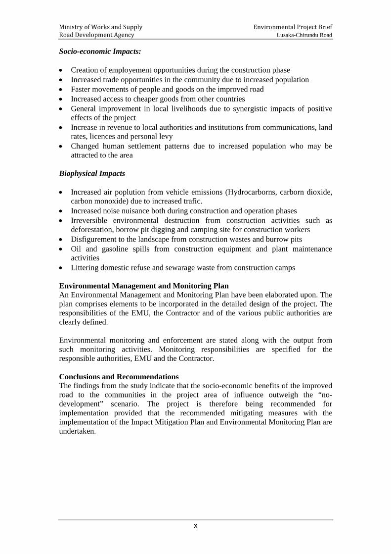
5.2.1 Lusaka/Kafue .................................................................................................................. 27 5.2.2 Siavonga ......................................................................................................................... 28 Table 5: Hydrology Along the Road ........................................................................................ 29
5.3 WATER RESOURCES ................................................................................................................ 29 5.4 DAMBOS ................................................................................................................................... 29
6. SOCIO-ECONOMIC AND CULTURAL ENVIRONMENT ................................................ 30
6.1 LUSAKA DISTRICT ................................................................................................................... 30 6.1.1 HUMAN SETTLEMENTS ....................................................................................................... 30 6.2 KAFUE DISTRICT ..................................................................................................................... 31
6.2.1 Human Settlements ......................................................................................................... 31 6.2.2 Agriculture ...................................................................................................................... 31
6.3 SIAVONGA DISTRICT ............................................................................................................... 32 6.3.1 Population and Human Settlements ................................................................................ 32 6.3.2 Agriculture ...................................................................................................................... 33
6.4 SETTLEMENTS ALONG THE ROAD ........................................................................................... 33 6.5 ARCHAEOLOGICAL, CULTURAL AND HISTORICAL SITES ...................................................... 36 6.6 MAJOR SOCIO-ECONOMIC ACTIVITIES ALONG THE ROAD.................................................... 36
6.6.1 Fisheries .......................................................................................................................... 36 a) Forestry Products Utilisation ............................................................................................... 37
7 CONSULTATIONS ................................................................................................................ 38
7.1 APPROACH AND METHODOLOGY............................................................................................ 38 7.2 KEY PRESENTATIONS, QUESTIONS AND CONCERNS FROM THE CONSULTATIVE MEETINGS 38 7.3 PROCEEDINGS FROM CONSULTATIVE MEETINGS .................................................................. 38
8. POTENTIAL ENVIRONMENTAL IMPACTS .................................................................... 42
8.1 IMPACT ON SOIL ...................................................................................................................... 42 8.2 IMPACT ON VEGETATION ........................................................................................................ 42 8.3 IMPACT ON WATER QUALITY ................................................................................................. 43 8.4 IMPACT ON AIR QUALITY ....................................................................................................... 44 8.5 IMPACT OF NOISE .................................................................................................................... 44 8.6 IMPACT ON LANDSCAPE AND AESTHETICS ............................................................................. 45 8.7 IMPACT ON LAND USE AND SURROUNDING ENVIRONMENT ................................................... 45 8.8 IMPACT ON SOCIO-ECONOMIC ................................................................................................ 46 8.9 IMPACT ON NATIONAL /REGIONAL ECONOMY ...................................................................... 46

Ministry of Works and Supply Environmental Project Brief Road Development Agency Lusaka-Chirundu Road
iii
8.10 IMPACT ON CULTURAL AND ARCHAEOLOGICAL SITES .................................................... 47 8.11 IMPACT ON HUMAN SETTLEMENTS ................................................................................... 47 8.12 IMPACT OF QUARRIES AND BORROW PITS ........................................................................ 47 8.13 IMPACT ON TRAFFIC ........................................................................................................... 48 8.14 IMPACT ON OCCUPATIONAL HEALTH AND SAFETY .......................................................... 48 8.15 IMPACT ON TOURISM .......................................................................................................... 48
9 MEASURES TO MITIGATE ADVERSE IMPACTS AND ENHANCE POTENTIALLY BENEFICIAL IMPACTS ...................................................................................................... 50
9.1 DECOMMISSIONING PLAN FOR THE QUARRIES AND BORROW PITS ...................................... 53
10 CONCLUSION AND RECOMMENDATION ...................................................................... 67
10.1 CONCLUSION ....................................................................................................................... 67 10.2 RECOMMENDATION ............................................................................................................ 67
11 ANNEXURE ........................................................................................................................... 68

Ministry of Works and Supply Environmental Project Brief Road Development Agency Lusaka-Chirundu Road
iv
LIST OF TABLES
Table 1: Project Road Reference Sections .............................................................. 10Table 2: Lusaka-Chirundu Traffic Accidents from 2006-2008 .................................. 25Table 3: Statistics of the Road Traffic Accidents Occurred between January 2007 to
November 2008 on the Lusaka-Chirundu Road ........................................... 25Table 4: Vegetation and Forestry resources ............................................................ 27Table 5: Hydrology Along the Road ...................................................................... 29Table 6: District Population and Growth Rates ....................................................... 31Table 7: Population by Ward ................................................................................ 32Table 8: Settlements along the Lusaka-Chirundu Road ............................................ 33Table 9: Infrastructure likely to be affected ............................................................ 34Table 10: Stakeholder Concerns ............................................................................. 38Table 11: Mitigations Measures .............................................................................. 50Table 12 Environmental Monitoring Plan ............................................................... 55

Ministry of Works and Supply Environmental Project Brief Road Development Agency Lusaka-Chirundu Road
v
LIST OF FIGURES
Figure 1: Map Showing Lusaka – Chirundu Road Project Area .................................. 11Figure 2: Agro Ecological Zones Map .................................................................... 29Figure 3: Small Scale Business along the Lusaka-Kafue Road, belonging to the Kafue
Crafts Association; the structure is about 25 m away from the Road .............. 33Figure 4: A number of billboards will have to be removed to pave way for road
rehabilitation ........................................................................................... 36

Ministry of Works and Supply Environmental Project Brief Road Development Agency Lusaka-Chirundu Road
vi
LIST OF ANNEXES
Annex 1: Submissions/Comments from Stakeholders ................................................ 68Annex 2: Names of People Consulted ..................................................................... 70

Ministry of Works and Supply Environmental Project Brief Road Development Agency Lusaka-Chirundu Road
vii
ACRONYMS
ACV Aggregate Crushing Value dB Decibel DBM Dense Bitumen Macadam DCP Dynamic Cone Penetrometer EIA Environmental Impact Assessment EMU Environmental and Social Management Unit EPB Environmental Project Brief EPPCA Environmental Protection and Pollution Control Act GMAs Game Management Areas GRZ Government of the Republic of Zambia IDA International Development Association LAA Los Angeles Abrasion Value LHS Left Hand Side NRFA National Roads Fund Agency OP Operational Procedure RDA Road Development Agency RHS Right Hand Side ROADSIP Road Sector Investment Programme SI Statutory Instrument SSS Sodium Sulphate Soundness TORs Terms of Reference ZAWA Zambia Wildlife Authority

Ministry of Works and Supply Environmental Project Brief Road Development Agency Lusaka-Chirundu Road
viii
EXECUTIVE SUMMARY Introduction The Government of the Republic of Zambia (GRZ) wishes to apply Road Fund revenues as managed by the National Roads Fund Agency (NRFA) to finance a project in support of the Road Sector Investment Programme (ROADSIP). The key objective of RoadSIP being is to construct, maintain, rehabilitate and improve or upgrade roads. The focus is on improving the Core Road Network (CRN) which has been identified as taking into account such aspects as connectivity (international or provincial linkages), poverty alleviation and agricultural/marketing activities. As part of the implementation of ROADSIP II the Road Development Agency intends to rehabilitate about 100 km of the remaining sections of Trunk Road T2 between Lusaka – Chirundu (Non-Escarpment Section). The Project is located in Lusaka and Southern Provinces and has its starting point at Chirundu, some 135km from Lusaka. In 2004 a consultant was appointed to carry out Techno-Economic Studies and Detailed Engineering Designs of 134.5 km of the project road from the intersection of Road T1 with D482 in Chirundu to Kafue Round about in Lusaka. The study also involved undertaking a detailed Environmental Impact Assessment. Although the design was carried out for the whole section only 34.7 km of the road in the escapement sections was rehabilitated between 2005 and 2008. This work intends to complete the remaining part of the Trunk Road T2 and since the environmental impacts anticipated from the rehabilitation works are minimal, an Environmental Project Brief has therefore been prepared in accordance with the Environmental Protection and Pollution Control Act, Cap 204 of the Laws of Zambia. The Government of the Republic of Zambia (GRZ) has received a credit from the International Development Association (IDA)] toward the cost of a project to support the Road Sector Investment Programme (ROADSIP), and intends to apply a portion of this loan to eligible payments under a civil works contract to complete the rehabilitation of 100.3 km of the remaining sections of the Lusaka – Chirundu road. In order to carry out these works full techno-economic and feasibility studies and detailed design need to be fully updated. Objective of the Project The objective of the project is to connect Lusaka with Chirundu, one of Zambia’s busiest border-crossing towns which borders with the Republic of Zimbabwe. The road is a life line for Zambia’s major imports and exports and is part of an important and critical route for passengers from Southern Africa to the Republics of Tanzania and the Democratic Republic of Congo. Some sections of the road are generally in mountainous terrain with sub-standard road geometry which particularly are very dangerous and accidents occur frequently, often resulting in death or serious injury.

Ministry of Works and Supply Environmental Project Brief Road Development Agency Lusaka-Chirundu Road
ix
Objective of the EPB The main objective of the EPB is to examine impacts on ecological units and ecological processes of the project area including impacts on physical, biological, socio-economics, socio-cultural and archaeological environment and to propose mitigation measures for identified adverse impacts of the road expansion project.
Zambian Law and the World Bank Environmental and Social Safeguard Policies The World Bank safeguard policies are operational policies whose primary objective is to ensure that the Bank funded operations do not cause adverse social and environmental impacts and that they “do no harm”. As all other World Bank funded operation, the road project must comply with the requirements of the Safeguard Policies, the Pollution Prevention and Abatement Handbook and World Bank Group Environmental, Health and Safety Guidelines. The contents of the road project have been designed to meet the Zambian Environmental Laws and the Environmental and Social Safeguard Policies of the World Bank including compliance with the Pollution Prevention and Abatement Handbook and World Bank Group Environmental, Health and Safety Guidelines relating to the following subprojects. The applicability of these guidelines will be determined during the screening process and the most stringent standards between Zambian and World Bank Group will apply. The Zambian Environmental Laws and the World Bank’s safeguard policies and their applicability are discussed under Chapter 2. Expected Road Rehabilitation Works The proposed project will involve complete rehabilitation and or pothole repairs plus a slurry seal, or single surface dressing of the road. In some sections the project may involve upgrading/rehabilitation or widening of the road and adding new drainage structures. Generally, the existing alignments are followed but could include improvements to the vertical and horizontal alignments of isolated sections, which will enhance the safety of road users. Earthworks will thus essentially be limited to the shoulders and drainage repairs. Since there will be no new alignment the potential impacts are therefore reduced, but can still rise during both the rehabilitation and operational phases of the road. Methodology Baseline data was collected through field appraisal, discussion with relevant agencies and institutions in the concerned districts and consultation with local communities and individuals in the project area. The proposed design of the various components of the road project was studied and discussed with the members of the Project team. The results were compiled and analysed to enable the preparation of this report. Potential Impacts and Mitigating Measures Rehabilitation is likely to cause both positive and impacts. The major environmental impacts have been indentified as:
Ministry of Works and Supply Environmental Project Brief Road Development Agency Lusaka-Chirundu Road
x
Socio-economic Impacts: • Creation of employement opportunities during the construction phase • Increased trade opportunities in the community due to increased population • Faster movements of people and goods on the improved road • Increased access to cheaper goods from other countries • General improvement in local livelihoods due to synergistic impacts of positive
effects of the project • Increase in revenue to local authorities and institutions from communications, land
rates, licences and personal levy • Changed human settlement patterns due to increased population who may be
attracted to the area Biophysical Impacts • Increased air poplution from vehicle emissions (Hydrocarborns, carborn dioxide,
carbon monoxide) due to increased trafic. • Increased noise nuisance both during construction and operation phases • Irreversible environmental destruction from construction activities such as
deforestation, borrow pit digging and camping site for construction workers • Disfigurement to the landscape from construction wastes and burrow pits • Oil and gasoline spills from construction equipment and plant maintenance
activities • Littering domestic refuse and sewarage waste from construction camps Environmental Management and Monitoring Plan An Environmental Management and Monitoring Plan have been elaborated upon. The plan comprises elements to be incorporated in the detailed design of the project. The responsibilities of the EMU, the Contractor and of the various public authorities are clearly defined. Environmental monitoring and enforcement are stated along with the output from such monitoring activities. Monitoring responsibilities are specified for the responsible authorities, EMU and the Contractor. Conclusions and Recommendations The findings from the study indicate that the socio-economic benefits of the improved road to the communities in the project area of influence outweigh the “no-development” scenario. The project is therefore being recommended for implementation provided that the recommended mitigating measures with the implementation of the Impact Mitigation Plan and Environmental Monitoring Plan are undertaken.

Ministry of Works and Supply Environmental Project Brief Road Development Agency Lusaka-Chirundu Road
1
1. INTRODUCTION 1.1 Background
The Government of the Republic of Zambia (GRZ) wishes to apply Road Fund revenues as managed by the National Roads Fund Agency (NRFA) to finance a project in support of the Road Sector Investment Programme (ROADSIP). The key objective of RoadSIP being is to construct, maintain, rehabilitate and improve or upgrade roads. The focus is on improving the Core Road Network (CRN) which has been identified as taking into account such aspects as connectivity (international or provincial linkages), poverty alleviation and agricultural/marketing activities. As part of the implementation of ROADSIP II the Road Development Agency intends to rehabilitate about 100 km of the remaining sections of Trunk Road T2 between Lusaka – Chirundu (Non-Escarpment Section). The Project is located in Lusaka and Southern Provinces and has its starting point at Chirundu, some 135km from Lusaka. In 2004 a consultant was appointed to carry out Techno-Economic Studies and Detailed Engineering Designs of 134.5 km of the project road from the intersection of Road T1 with D482 in Chirundu to Kafue Round about in Lusaka. The study also involved undertaking a detailed Environmental Impact Assessment. Although the design was carried out for the whole section only 34.7 km of the road in the escapement sections was rehabilitated between 2005 and 2008. This work intends to complete the remaining part of the Trunk Road T2 and since the environmental impacts anticipated from the rehabilitation works are minimal, an Environmental Project Brief has therefore been prepared in accordance with the Environmental Protection and Pollution Control Act, Cap 204 of the Laws of Zambia. The Government of the Republic of Zambia (GRZ) has received a credit from the International Development Association (IDA)] toward the cost of a project to support the Road Sector Investment Programme (ROADSIP), and intends to apply a portion of this loan to eligible payments under a civil works contract to complete the rehabilitation of 100.3 km of the remaining sections of the Lusaka – Chirundu road. In order to carry out these works full techno-economic and feasibility studies and detailed design need to be fully updated.
1.2 The Process of Project Implementation
The process leading to project implementation is organised under five main areas namely; preparatory works, tendering process, organizing project implementation, approval and awarding of contracts and supervision of physical works.
1.2.1 Preparatory Works This include selection of the road, field assessment (road interventions, surveys, collection of data, etc), preparing improvements plans (preparing of technical

Ministry of Works and Supply Environmental Project Brief Road Development Agency Lusaka-Chirundu Road
2
specification, local maps and standard cross sections for works to be carried out and calculations of quantities) preparation of EIA contract clauses and tender documents. According to the RDA Annual Workplan of 2009, this phase of feasibility studies is supposed to conclude in August 2009. Thereafter, processes below will follow. However, depending on the availability of funds the actual implementation of the project cannot be ascertained at this stage. The total cost of the feasibility studies is ZMK800 Million.
1.2.2 Tendering Process This process involves invitation to tender, making tender documents available to pre-qualified or registered contractors, organizing pre-tender site visits, issuing tender notices, receipt and opening of tenders, tender evaluation, contract negotiations and awarding of tenders.
1.2.3 Organizing Implementation of a Project This process involves giving notices to the contractor to commence work, liaising and reporting to the employer/ client and liaising with contractors on the work programme and mobilisation of staff, workers and equipment.
1.2.4 Approval and Awarding of Contracts This process entails obtaining performance bond, insurance of work and workers, giving notice to contractor to take possession of site, obtaining contractors work programme and mobilisation of staff, workers and equipment.
1.2.5 Supervision of Physical Work This involves day to day monitoring of physical progress of the workers, application of conditions of contract, enforcement of specifications, measuring of works with contractors' representatives, quality control in form of materials testing at laboratory and on site, certification of work done, preparation of interim payment certificates, control of material and equipment on site, issuing of site instructions and variation orders and settlement of disputes (arbitration, conciliation, etc).
1.3 Objective of the Project
The road connects Lusaka with Chirundu, one of Zambia’s busiest border-crossing towns which borders with the Republic of Zimbabwe. The road is a life line for Zambia’s major imports and exports and is part of an important and critical route for passage from Southern Africa to the Republics of Tanzania and The Democratic Republic of Congo. Some sections of the road are generally in mountainous terrain with sub-standard road geometry which particularly are very dangerous and accidents occur frequently, often resulting in death or serious injury. It is therefore in light of the above that an Environmental Project Brief (EPB) has been undertaken to ensure that environmental management is integrated with both construction and operational activities.

Ministry of Works and Supply Environmental Project Brief Road Development Agency Lusaka-Chirundu Road
3
1.4 Objective of the EPB
The main objective of the EPB is to examine impacts on ecological units and ecological processes of the project area including impacts on physical, biological, socio-economics, socio-cultural and archaeological environment and to propose mitigation measures for identified adverse impacts of the road expansion project.

Ministry of Works and Supply Environmental Project Brief Road Development Agency Lusaka-Chirundu Road
4
2. APPROACH AND METHODOLOGY The methodology used involved:- a) Literature Review: this involved desk study and review of the available
background information about the project proponent, the EPPCA Cap 204 of the Laws of Zambia, review of the route plan, the 2003 EIA report;
b) Field visits: which involved on- site field inspections of the project, i.e.,
involving on-site identification of the probable impacts, an estimation of their extents of coverage among other things, and
c) Stakeholder Consultations: The Consultants held consultative meetings
with key stakeholders in the Districts who included the District planning offices, works, police traffic division and traders along the Lusaka –Chirundu road.
2.1 Review of Relevant Legislation
This project brief was prepared in accordance with the legal framework on Environmental Management enshrined in the Environmental Protection and Pollution Control Act (EPPCA), Cap 204 of the Laws of Zambia and its subsidiary legislation, the Environmental Impact Assessment Regulations S.I. No. 28 of 1997. Section 3 (1) of the Environmental Impact Assessment (EIA) Regulations states that, “a developer shall not implement a project for which a project brief or environmental impact statement is required under these Regulations, unless the project brief or the environmental impact statement has been concluded in accordance with these regulations and the Environmental Council of Zambia has issued a decision letter.”
Roads projects are outlined in the Environmental Impact Regulations S.I. No.28 of 1997, Second Schedule (Regulations (7) (2)) Section 2 (a) under the heading, Transportation:) The regulations states that All major roads outside urban areas, the construction of new roads and major improvements over 10km in length if the road passes through a National Park or Game Management Area shall require an Environmental Impact Assessment. In this project, the rehabilitation works will be done along the existing Lusaka - Chirundu Road and the road does not pass through a National Park or Game Management Area. Further the project does not involve activities which may trigger resettlement of people. The anticipated environmental impacts by the project are therefore minimal. Pursuant to the EPPCA, S.I No. 28 of 1997 this

Ministry of Works and Supply Environmental Project Brief Road Development Agency Lusaka-Chirundu Road
5
road therefore falls under the First Schedule of project category that legally requires preparation of an Environmental Project Brief.
2.1.1 Environmental Protection and Pollution Control Act No. 12 of 1990
This Act was passed in the year 1990 and it’s the Principal Act governing and regulating environmental issues in Zambia. It’s main functions include the protection of the environment and control of pollution, in particular to provide for the health and welfare of people, animals, plants and the environment. Below are the Statutory Instruments which were reviewed under the EPPCA No 12 of 1990.
a) EPPCA Statutory Instruments
The following Statutory Instruments (SI) emanating from the EPPCA and other Acts applicable to the proposed road project were also reviewed:-
i) Statutory Instrument No. 28 of 1997 Environmental Impact Assessment (EIA) Regulations
These Regulations provides the framework for conducting and reviewing environmental impact assessment for any project. Regulation 3 (1) of the EIA Regulations states that, “a developer shall not implement a project for which a project brief or environmental impact statement is required under these Regulations, unless the project brief or the environmental impact statement has been concluded in accordance with these regulations and the Environmental Council of Zambia has issued a decision letter.” Road rehabilitation and construction activities fall within the category of projects that require a project brief in terms of Regulation 3(2), First Schedule of Projects. This Environmental Project Brief has been prepared in compliance with this legal requirement. i) Waste Management Regulations (SI No. 71 of 1993)
These Regulations sets out the licensing requirements for transporters and waste disposal sites and provides definitions of waste. Road rehabilitation and construction activities have the potential to generate solid waste whose transportation and disposal may require licensing. Management of all solid wastes should therefore have to be done in accordance with the requirements of these Regulations.

Ministry of Works and Supply Environmental Project Brief Road Development Agency Lusaka-Chirundu Road
6
ii) Water Pollution Control (Effluent and Waste Water) Regulations (SI No. 72 of 1993)
These Regulations prohibit unauthorized discharge of pollutants into the aquatic environment and require that all effluent likely to discharge should be licensed. Road rehabilitation and construction activities have the potential to cause leakages, oil spill or wash pollutants into the nearby aquatic environment. Therefore, management of the site should take into account the need to prevent pollution of the aquatic environment.
iii) Air Pollution Control (Licensing and Emissions Standards) Regulations (SI No. 141 of 1996)
These Regulations provides for the control of emissions to the environment and specifies the statutory discharge limits for respective parameters. The Regulations prohibit unauthorized emission of pollutants into air, sets out licensing requirements and provides long-term emission limits for air pollution. Road rehabilitation and construction activities may discharge particles and dust that have the potential to pollute ambient air. Therefore rehabilitation and construction activities will be required to take measures to prevent pollution of the ambient air.
iv) EPPCA (Ozone Depletion Substances) Regulations 2000 These regulations provides for the control of an importer, exporter, producer or distributor of controlled substance whether in transit or otherwise; an importer, exporter, producer or distributor of technology or product which uses or contains a controlled substance; a person who services refrigerator, air conditioner, mobile or other technology using controlled substances; a person or an institution using or servicing fire extinguishers; and a person, an institution, a farmer or other individual using any controlled substance. The project will take measures to avoid conducting any activity likely to produce any controlled substance or any other substance likely to deplete the ozone layer under these Regulations.
v) Hazardous Waste Management Regulations (S.I. No. 125 of 2001) These Regulations provides for the control of generation, collection, storage, transportation, pre-treatment, treatment, disposal, export, import and transboundary movement of hazardous waste as listed in Fourth Schedule or any waste specified in Sixth Schedule, if that waste exhibits characteristics found in the Fifth Schedule to these Regulations. Therefore generation, collection storage, transportation, pre-treatment and disposal of hazardous wastes resulting from rehabilitation and construction activities may require to be licensed under these Regulations.

Ministry of Works and Supply Environmental Project Brief Road Development Agency Lusaka-Chirundu Road
7
2.1.2 Land Act of 1995 and Land Acquisition Act of 1995 The Act provides for the alienation, transfer and change of land. It also provides for compulsory acquisition of land by the President whenever he is of the opinion that it is desirable or expedient to do so in the interest of the public. The land is divided into state, private and traditional land. 2.1.3 Mines and Minerals (Environmental) Regulations, 1997 This sector specific Regulations provide for the general protection of the environment in the mining sector through environmental impact assessments and audits, mine dump reporting, storage areas, handling of hazardous materials and contributions to the Environmental Protection Fund. 2.1.4 Water Act of 1949 - Chapter 312 of the Laws of Zambia The Act provides for the control, ownership and use of water excluding the Zambezi, Luapula and Luangwa Rivers that borders with other countries. The Act establishes the Water Board and regulates the use of public water including pollution. Closely associated with the water Act is the Water Policy of 1994, which regulates the importance of water public health, food production, the production of hydroelectric energy, the natural environment and other important aspects that enhance the quality of life such as transportation, recreation and tourism.
2.1.5 Zambia Wildlife Act of 1998 The Act provides for the protection and management of wildlife resources, national parks, bird and wildlife sanctuaries and GMAs. ZAWA enforces the Act
2.1.6 National Heritage Conservation Act of 1989 The Act provides for the protection and conservation of heritage resources, cultural and historical interest. National Heritage Conservation Commission enforces the Act.
2.1.7 Factory Act of 1967 The Act was enacted in 1967 and provides for the safety of employees working in the factories. It further provides for the appropriate protective clothing of employees in order to ensure safety of workers and their health.
2.1.8 Pneumoconiosis Act This Act provides for the assessment and payment of compensation in connection with pneumoconiosis. It also to provides for the medical examination and standards of physical fitness to be required of persons exposed or likely to be exposed to the risk of pneumoconiosis and for matters incidental to or connected with the foregoing.

Ministry of Works and Supply Environmental Project Brief Road Development Agency Lusaka-Chirundu Road
8
2.1.9 Public Roads Act No. 12 of 2002 An Act to establish the Road Development Agency and to define its functions; to provide for the care, maintenance and construction of public roads in Zambia; to regulate maximum weights permissible for transmission on roads; and to provide for matters connected with and incidental to the foregoing. The Public Roads Act was amended and assented to (Sections 63, 64, 65, 66 and 67) on 12 May 2006.
An Act to establish the Road transport and safety Agency and to define its functions; to provide for a system of roads safety and traffic management. The Road Traffic Act was amended and assented to (second schedule and repeal and replacement of section 37) on 1 April 2006.
2.1.10 Road Traffic Act No.11 of 2002
This Act revises the law relating to Investment in Zambia so as to provide a comprehensive legal framework for investment in Zambia; to repeal the Investment Act, 1991; and to provide for matters connected with or incidental to the foregoing.
2.1.11 Investment Act
The Town and Country Planning Act, came into force in 1962 and provide for the control, use and change of land use zones and reservations for various purposes, eg. siting of work sites. It also provides for the compensation of those affected by planning decisions and regulated development subdivisions.
2.1.12 The Town and Country Planning
2.1.13 World Bank Environmental Assessment (OP 4.01)
a) Applicability
The policy is triggered if a project is likely to have potential (adverse) environmental risks and impacts in its area of influence.
b) Objective The objective of the policy is to ensure that Bank-financed projects are environmentally and socially sound and sustainable, and that decision-making is improved through appropriate analysis of actions and of their likely environmental and social impacts. The policy covers impacts on the natural environment (air, water and land); human health and safety; physical cultural resources; and trans-boundary and global environment concerns. EA considers natural and social aspects in an integrated way. Particular social aspects (involuntary resettlement, indigenous peoples) as well as issues of natural habitats, pest management, forestry, and safety of dams are covered by separate policies with their own requirements and procedures. However, the environmental assessment process provides insights to ascertain the applicability of other safeguard policies to specific projects.

Ministry of Works and Supply Environmental Project Brief Road Development Agency Lusaka-Chirundu Road
9
This is especially the case for the policies on natural habitats, pest management, and physical cultural resources that are typically considered within the EA process. The policy describes an environmental assessment (EA) process for the proposed project. The breadth, depth, and type of analysis of the EA process depend on the nature, scale, and potential environmental impact of the proposed project. EA evaluates a project's potential environmental risks and impacts in its area of influence; examines project alternatives; identifies ways of improving project selection, siting, planning, design, and implementation by preventing, minimizing, mitigating, or compensating for adverse environmental impacts and enhancing positive impacts; and includes the process of mitigating and managing adverse environmental impacts throughout project implementation. The policy favours preventive measures over mitigatory or compensatory measures, whenever feasible. In Road Projects, all sub-projects are being screened in the earliest stages of their preparation to ensure compliance with the policy and ascertain whether other safeguard policies are triggered. The sub-projects are being screened not only for their direct impacts but also for indirect and cumulative impacts. Based on the screening, sub-projects are be assigned a category A, B, or C. Category A will be assigned to sub-projects with anticipated significant adverse environmental impacts that are sensitive, diverse or unprecedented. For these sub-projects, full EA (EIA, according to Zambian law) will be required. Category B will be assigned to sub-project with anticipated specific adverse environmental impacts that are less adverse than in category A. For these sub-projects, an Environmental Analysis limited to the specific environmental impacts of the sub-project will be required (EPB according to Zambian Law). Category C will be assigned to sub-projects with anticipated minimal or no adverse environmental impacts. For these projects, no further environmental review beyond environmental and social screening will be required.

Ministry of Works and Supply Environmental Project Brief Road Development Agency Lusaka-Chirundu Road
10
3. DESCRIPTION OF THE PROPOSED PROJECT 3.1 Project Description
The Lusaka – Chirundu Road, which is Trunk road T2, is a strategic route and forms the main north-south trunk link through Zambia linking Zambia to Zimbabwe in the south and Tanzania in the north. The project road is the southern portion of T2 that originates at the southern end of the Lusaka CBD and ends at the Zambia Border post on the main Lusaka – Harare link. The road passes through the towns of Chilanga and Kafue and Trunk road T1 to Livingstone intersects the T2 at km 55.20. This project assumes km 0.00 to be at the construction joint south of the Independence Road roundabout at the southern end of Cairo Road in Lusaka. The end of the project is at the intersection of D482 to Chiawa and where the access to the new Zimbabwe Border control will intersect with T2 at approximately km 134.50. The current Zambian border control gate is at km 135.00. From a project perspective, the road is divided into sections presented in the table below. Table 1: Project Road Reference Sections
From To Description Km 0,0 Kafue roundabout.
Km 4,1 D164 Makeni
This section was rehabilitated in 2003 and has a Pavement Design life of 15 - 20 years.
Km 4,1 Makeni
Km 53,2 Kafue River bridge
This section of the road received holding maintenance in 2003 with a Pavement Design life 2 - 5 years
Km 53,2 Km 75,0 Kafue river to start of escarpment in rolling to hilly terrain
Km 75,0 Km 105,2 Escarpment section in mountainous terrain with sub-standard road geometry. This section was rehabilitated between 2005 and 2008 and has a Pavement Design life of 15 - 20 years
Km 105,2 Km 134,5 D482-Chiwalo
Escarpment to end project road in Chirundu in rolling terrain. End project road at D482, the Chiawa junction where the new border control improvements intersects T2.
Source: RDA TORs, 2008 3.2 Project Location
The project road, which is Trunk Road T2 cuts across two provinces and is as such, located in the Southern and Lusaka Provinces of Zambia as shown on the locality map below.

Ministry of Works and Supply Environmental Project Brief Road Development Agency Lusaka-Chirundu Road
11
Figure 1: Map Showing Lusaka – Chirundu Road Project Area
Source: World Atlas
Project Route
Key Indicate the project route from Lusaka beginning at roundabout (Independence Avenue) through Kafue town to Chirundu

Ministry of Works and Supply Environmental Project Brief Road Development Agency Lusaka-Chirundu Road
12
4. PROJECT DESIGN CYCLE
4.1 Project Activities
The proposed project will be confined to the already existing road. The main aspects and activities of the project include; • The proposed project activities will involve complete rehabilitation
works to expand the road;
• More specifically, the sections between Km 0.0 Kafue roundabout and Km 4.1 (D164 –Makeni Road) and Km 75.0 and Km 105.2 (Escarpment Sections) that have undergone rehabilitation have been removed from the project scope. This implies that the project scope will include rehabilitation of the remaining 100.3 km of the road between Lusaka and Chirundu; and
• Road rehabilitation works may introduce some potential impacts, as it shall require the clearing of some sections of land .This assessment was carried out to ascertain the potential environmental impacts and to develop appropriate measures.
4.2 Pre-Construction (Design) Phase
This phase involves carrying out a survey of the proposed road rehabilitation works. Survey in this case refers to land investigations, drilling, measurements and pre-works examination of the entire route. To facilitate the development of a conceptual design, an environmental impact assessment has been undertaken and the key concerns from the study have been taken into account in the design phase. The output from this phase is an environmentally friendly engineered design for the road rehabilitation and construction, which has to be implemented in the construction phase. The Project Team has carried out a number of surveys and analysis to determine the condition of the road alignment to assess what it would require to rehabilitate and construct a road to an acceptable safety and environmentally friendly. According to these surveys the estimated work required to bring the road to an acceptable standard would include some interventions. Below are some investigations carried out.
4.2.1 Geological Investigations According to the available mapping, general geomorphology of the project area can be divided in four geological groups • Meta-carbonate rocks occur between Lusaka and Chilanga, extending
further south to Shimabala. The rocks include limestone, calcareous dolomite (lusaka dolomite), muscovite biotite, quartzite, sandstone, shale,

Ministry of Works and Supply Environmental Project Brief Road Development Agency Lusaka-Chirundu Road
13
mudstone and conglomerates. Sandstone and limestone are the most dominant.
• Alluvial deposits comprising alluvium and colluvium are traversed within
Kafue plain, commonly referred to as Kafue flats. The adjacent ridges to the north and north east of the plain are formed by the Kafue rhyorites, comprising meta- quartzite, tuff and a variety of volcanics. Conglomerates, mudstone, grit and sandstone are encountered on the lower slopes towards Mube River.
• The main escarpment section (beyond Mobe River) is underlain by
basement complex, composed of granite, gneiss, schist, granulites, amphibolites, phyllites, limestone and meta-quartzites.
• The last 30km inside Chirundu Valley is characterized by upper Karroo
system comprising sandstones, grit, mudstones, marls and basalts. Apart from Kafue plains where alluvial deposits are encountered, the solid geology for the remainder of project area is covered by sandy soils, gravels and weathered rock which offer suitable characteristics for road foundation and construction materials. The granite and gneiss formations within the basement complex can provide sources of stone for pavement and concrete construction.
4.2.2 Construction Material Survey A number of gravel and hardstone sites have been identified in the previous study report by WSP/Kiran Musonda & Associates. A construction materials review has been conducted which included inspection, sampling, testing and analysis for type, quality and availability of construction materials within the project corridor. During this review, a search for additional material sites specific to the project was conducted as follows: • Rock quarries for crushed aggregates to be used in concrete, bituminous
surfacing, crushed stone base, and masonry works • Borrow pits for selected material in improved subgrade, capping layers
and embankment construction, as required • Gravel sites for subbase and shoulder material • Sand for concrete and mortar • Water for concrete and compaction
4.2.3 Quarry Sites for Crushed Stone For this road category and level of traffic, it is important that suitable rock sources are available to provide the necessary aggregates for wearing course and concrete. The identified quarries should also have sufficient quantities to cater for graded crushed stone or DBM base as required. There is one operational quarry close to the project road at km 36 LHS in Kafue Area. This quarry is owned by Raubex Zambia Ltd and has supplied substantial

Ministry of Works and Supply Environmental Project Brief Road Development Agency Lusaka-Chirundu Road
14
quantities of crushed material to major construction projects, including the recently completed rehabilitation works for T2 Escarpment section. Other identified sources of hardstone include: Shimabala Quarry Km 28.3 km RHS Munali Hill Quarry Km 55.12 km RHS (Mazabuka Road) Musaya River Km 106.0.4 km RHS These sources have been assessed for various suitability criteria, including proximity to the alignment, accessibility, minimum overburden, ease of mining and impact on environment and local settlements. Three (3) out of the 4 rock sources investigated were sampled and tested for the following properties: • Aggregate Crushing Value (ACV) • Los Angeles Abrasion Value (LAA) • Sodium Sulphate Soundness (SSS) • Specific Gravity • Water Absorption • Bitumen Affinity The test results carried out indicate that all the 3 sites (HS 02, HS 03, HS 04) are suitable for concrete and crushed stone base. For wearing course and DBM, only Kafue Quarry (HS 02) is suitable, the other 2 sources (HS 03, HS 04) showing fairly high water absorption values. Shimabala Quarry, previously used for rehabilitation of Lusaka-Kafue road was not sampled due to high proportion of weathered rock observed on the quarry face.
4.2.4 Gravel Borrow Pits for Sub-base and Shoulders Natural gravels will be required for sub-base, shoulders and widening in the proposed rehabilitation works. A total of 7 sites have been identified for supply of gravel material as follows: • MS1 Chilanga Km15 LHS • MS2 Shimabala Km24 LHS • MS3 Kafue North Km 38.5 RHS • MS4 Kafue East Km 50.5 LHS • MS 5Chilileka Km 69 LHS • MS 6 Kabanana Km 104.7 RHS • MS 7 Makaingamwa km 128 LHS Gravel samples were obtained from each of the borrow pits and forwarded to RDA laboratory for testing of essential properties below. Test results are still pending.

Ministry of Works and Supply Environmental Project Brief Road Development Agency Lusaka-Chirundu Road
15
• Grading • Atterberg Limits • Compaction (T-180) • 3-point CBR (4 day soak) • UCS at 3% and 4% cement content
4.2.5 Material for Embankment Widening The material for fill and embankment widening does not require special quality. This can be sourced from cut widening or adjacent borrow pits. On the section, km 4-km15 which falls within the peri-urban area of Lusaka, borrow pits are not permissible and any material required has to be hauled from long distances. MS1 borrow pit in Chilanga area has been identified to provide the necessary material.
4.2.6 Sand Sand is required for concrete, asphalt mixes, stone pitching and masonry works. During the field investigations, 4 sources of natural sand were identified and sampled. These are: • Kafue Area , km 55 ( Mazabuka Road) • Mobe River, km 72 (start of escarpment section) • Katwesere River, km 109 (end of escarpment section) • Zambezi River Valley Test results on grading and clay content are pending. Crushed sand (quarry dust) which is a byproduct of aggregate production will also be available during construction.
4.2.7 Water Water will be required for compaction and production of concrete. During the previous investigations, suitable sources of water were identified as follows: • Kafue River, km 53 Perennial river • Nanduba Dam, km 62.3 Local dam • Mobe River, km 69.3 Seasonal stream • Kesaya River, km72.2 Seasonal stream • Musaya River, km106.5 Seasonal stream • Katweser River, km109.5 Seasonal stream • Zambezi River, km 134.9 Perennial river An additional water source has been identified in Shimabala (km 24) between Lusaka and Kafue. This source is an accumulation of rain water in the old Chilanga quarry pit and can be used for construction. Five (5) of the water sources, including Shimabala, were tested for various requirements and found to be acceptable.

Ministry of Works and Supply Environmental Project Brief Road Development Agency Lusaka-Chirundu Road
16
4.2.8 Cement and Bitumen Cement can be supplied by Chilanga Cement Company, sited along the project road. Currently, there is a sharp rise in demand for cement in Zambia and bulk quantities as required for a major project of this size may have to be imported from South Africa. Bitumen, although locally available from Ndola works, quality and supply cannot be guaranteed. It is proposed that this be procured from South Africa.
4.2.9 Pavement and Subgrade Investigations The investigations entailed a review of existing data, followed by field inspections, test pit excavation, sampling and testing of sub-grade and pavement layers. A DCP survey was also conducted to evaluate in situ condition of existing pavement and foundation, especially to identify any localized or extended weak areas in-between the test pits. The various activities carried out and the findings from site investigations are described under the following sub-headings.
a) Existing Pavement Structure For an existing road to be rehabilitated, it is vital to establish the existing pavement profile by measuring the various layer thicknesses, but also to determine the characteristics and properties of the in situ pavement materials and sub-grade. In the absence of as-built drawings, and in order to determine the profile of the existing pavement, test pits were excavated along the road at 2km intervals and at other locations which were deemed to require special attention. The test pits which were sited at the pavement edges were carefully excavated through the pavement layers up to sub-grade level to facilitate identification, measurements, and recording of layer thickness of the surfacing, base course, sub base and sub grade. The pavement layer thicknesses and their characteristics were found to vary, especially in Link 3 and 4 beyond Kafue Bridge.
b) The Road Foundation The existing road is founded on sandy clays and sandy gravels for the major length of the alignment. Silts and clayey sands occur in the low lying flat section within Kafue River Basin. High water table and poor drainage in the Kafue Plain have led to loss of stability in certain sections of the road, e.g. km 38- km 40, km 42-km44 and km 49 –km 55, resulting in unevenness, deformation and rutting. Special measure such as grade raising, drainage blankets or additional pavement thickness will be considered during the rehabilitation. In Chirundu Valley, sandstone boulders and rock are found in many road cuttings, indicating strong foundation.

Ministry of Works and Supply Environmental Project Brief Road Development Agency Lusaka-Chirundu Road
17
c) Sub-base Investigations revealed that the existing sub-base comprises mainly of granular material, thickness 150-200mm, except between Kafue Bridge and Mobe River (km 53 - km 68) where a sand layer was encountered immediately below the base course. It could not be established whether this layer is designed as part of the pavement or simply serves as a drainage blanket. It is thus observed that subbase layer is lacking on this section and the pavement is structurally inadequate.
d) Base Course The investigations undertaken show that the base course consists of 3 types of materials, namely: • 150mm - 200mm crushed stone from km 4 to km 53 (Makeni to Kafue
Bridge). • 150mm-200mm cement stabilized gravel from km 53 to km 75 (Kafue
bridge to escarpment) • 200mm thick cement stabilized base from km 109 to km 134 (esarpment
to Chirundu)
The main defect observed on the base course along the section, km 4.1 - km 53.0 is deformation (rutting) and unevenness. This is more pronounced in the north bound lane and could be due to attrition (granular layer subject to high traffic stresses). The base course between km 55 and km 61 is strongly cemented and is breaking up in many areas by block cracking. While some localized defects are intermittently observed within Link 3 and 4, there are 2 sections at km 69 – km 75 and km 124 – km 134 where little or no defects are manifested.
e) Bituminous Surfacing The section, km 4 – km 53, rehabilitated in the early 90s has an asphalt concrete surfacing of average thickness 75mm. This received a 13mm reseal in 2004 in form of periodic maintenance. Despite this intervention, many areas are showing significant distress in form of rutting, cracking and pothole patching. It is believed that surfacing failure is a result of the low bitumen content (4.0%) in the AC construction which led to brittleness, cracking and subsequent ingress of water in the pavement. The surfacing beyond Kafue Bridge (km 53) is constructed as surface dressing. Thicknesses vary between 25mm and 30mm depending on the number of reseals applied. There is evidence of an overlay between km 62 and km 68 where thickness was recorded as 100mm.

Ministry of Works and Supply Environmental Project Brief Road Development Agency Lusaka-Chirundu Road
18
f) Shoulders Road shoulders vary in width and material type. The variation in width is most noticeable on the hilly and mountainous sections west of Kafue. Typical characteristics are: • Km 4 - km 15 2m wide shoulders, cement stabilized gravel,
surfaced • Km 15 - km 53 3m wide shoulders, cement stabilized, partly
surfaced • Km 53 - km 61 2m wide shoulders, cement stabilized, semi rigid
layer, un-surfaced • Km 61 – km 75m 1-1.5m wide shoulders, natural gravel, no
asphalt surfacing • Km 110 – km 134 1.5 -2 m wide, natural gravel, partly surfaced.
4.2.10 Dynamic Cone Penetrometer (DCP) Investigations Dynamic Cone Penetrometer (DCP) tests were carried out to assess structural properties of the existing pavement and the foundation. Tests were performed at 1.0km intervals but reduced to 0.5km in sections of visible distress or poor drainage. No tests were carried out on boulderly or rocky material. DCP measurements were generally carried out to a minimum depth of 800mm below the road level. However, in coarse graded and strongly cemented layers, difficulties were encountered with penetration and some of the sections could not be tested. The results of DCP testing (in mm/blow) have subsequently been converted to insitu CBR using the TRL-developed correlation formula: Log CBR= 2.48-1.057 log (mm/blow) The underlying principle of the DCP is that the rate of penetration is inversely related to the strength of the material. Low penetration resistance is associated with high strength while high rate of penetration is encountered in weak layers. Compared to laboratory test results for the same material, the DCP derived CBR values are notably much higher due to the significant consolidation received under traffic compaction and also the differences in moisture content. The DCP tests were performed in the month of November before the start of rainy season when moisture contents would be considered at the optimum or lower. Some conclusions have been drawn from DCP testing as follows:

Ministry of Works and Supply Environmental Project Brief Road Development Agency Lusaka-Chirundu Road
19
• No weak layers were identified in the pavement or sub grade on Link 1, despite cracking and deformation observed between km 9 and km 14. The high in situ CBR values recorded can be attributed to the thick pavement/granular cover on this section (up to 1000mm).
• On the cracked and deformed section between km 32 and km 35 (Link 2),
no structural weaknesses were revealed by the DCP and the problem is most likely limited to the surfacing itself but this does not overrule seasonal wetting of the granular base course and consequent loss of shear strength. 600mm pavement/granular cover was recorded at this location.
• Relatively low in situ CBR values obtained between km 50 and km 55
indicate structural weakness. This is not surprising considering the high water table and alluvial soils associated with this section.
• High in situ CBR test results were recorded on link 4 (km 110 - km134),
indicating relatively strong sub-grades. On the stretch between km 125 – km 134, no DCP penetration was possible due to strongly cemented pavement and the hard foundation (weathered sandstone)
• The DCP identified a weak foundation on Link 3 (km 55 – km 64) where
it was possible to penetrate the overlying cemented base in many areas. This section will require substantial drainage and pavement improvements.
4.2.11 Pavement Analysis and Rehabilitation Design Considering the 2003 FWD deflections, and with the results obtained from in situ pavement evaluation and visual survey, the structural condition of the road was found to be variable and requiring different modes of rehabilitation. Variation in subgrade and pavement materials, non-uniformity in the original road construction and past maintenance operations would be the major contributing factors to the noted disparities in the structural condition. The overall design concept for the road rehabilitation is to utilize the existing pavement to the extent possible whilst incorporating the required widening and strengthening measures to satisfy the needs of the forecast traffic volumes and loading. In view of the significant pavement deterioration and the need for widening and grade raising in some sections, the design methodology is based on reconstruction and partial reconstruction with no emphasis for direct overlay. Reconstruction/ new construction design was based on SATTC Pavement Design Guide 19998 in accordance with the Terms of Reference. Reference has also been made to other design methodologies such as TRL Road Note 31, Kenya Road Design Manual and Tanzania Pavement & Materials Design Manual for data analysis and comparison.

Ministry of Works and Supply Environmental Project Brief Road Development Agency Lusaka-Chirundu Road
20
a) Preliminary Design Parameters In determining construction requirements for partial or full reconstruction, the following factors have been taken in consideration: • Climate of the project region • Forecast traffic loading • Availability of local construction materials • Subgrade strength The influence of the above factors on the pavement design is briefly described below:
(i) Climate The project region experiences 5 months of wet season and 7 months of moderate to dry weather. The design will be based on a wet operating climate.
(ii) Forecast Traffic Loading Forecast traffic loadings have been determined in cumulative Equivalent Standard Axles based on a 20-year design life. It is to be noted that the traffic loading of 39.40 MESA, estimated on the north bound lane of Link 1 exceeds the maximum loading considered in the SATTC Design Guide. Since this section is part of a proposed dual carriageway, the design provides for traffic loading to be revised downwards to 80% of the total ESA in the direction. The adjusted traffic loading of 32.8 is considered quite close to T8 Traffic Category. T 8 is thus selected as the appropriate design traffic class.
(iii) Road Construction Materials Hardstone and gravel sources have been identified along the project road. The properties and characteristics of the identified materials are discussed in Chapter 1, Section 6 of this Report. Graded crushed stone, cement stabilized gravel and Dense Bitumen Macadam (DBM) have been considered as appropriate materials for alternative pavement structures.
(iv) Subgrade Strength The reprocessed upper layers of the existing pavement will constitute the equivalent of improved subgrade. Where total thickness of granular layers is 500mm or greater, improved subgrade will be derived from the lower pavement, retaining the upper portion as the new subbase. The design CBR classification for various sections has been determined as follows:
Section Subgrade Class Km 4.1 -15 S5 Km 15- 49 S5 Km49 – 55 S3 Km55- 68 S4 Km68- 75 S6 Km110-124 S4

Ministry of Works and Supply Environmental Project Brief Road Development Agency Lusaka-Chirundu Road
21
Km124-134 S5
4.3 Construction Phase
The actual rehabilitation and construction of the road will take place in the construction phase. As the conditions of the project site vary, the road would have to undergo different degrees of work, which will have different levels of impact on the environment. During this phase the proposed route will be cleared in some sections to allow for gravel compaction. The estimated roadwork will cover the following activities:
4.3.1 Road Rehabilitation Works As the conditions of the road vary, the road would have to undergo different degree of work, which will have different levels of impact on the environment. Arising from the Project Team’s of surveys and analysis(1
4.3.2 Reconstruction of the Shoulders
) to determine the condition of the road to assess what it would require to improve the existing road to an acceptable safety, speed and environmentally friendly, the estimated work required to bring the road to an acceptable standard would include some interventions outlined in the sections below.
The general condition of the shoulders of the road is very poor. Most of the shoulders have completely disappeared or are covered with vegetation. Often the vegetation consists of tall grasses, obstructing road users and thus increasing the risk of accident. The shoulders will be completely reconstructed and rehabilitated to the original width of 1.8m. In certain areas, an increase in width may be envisaged to cater for the large number of non-motorised users of the road, such as pedestrians and cyclists.
4.3.3 Cleaning and Clearing of Ditches, Culverts and Drains Ditches have been constructed all along the side of the road. Most of these ditches are silted up and overgrown by vegetation, and they will need to be cleared and reshaped during the rehabilitation process. This would also include the mitre drains. The Project Team has observed several culverts on the road (to be elaborated in the hydrological and drainage survey).
4.3.4 Installation of New Road Furniture and the Rehabilitation of Existing Road
Presently the road has very little road furniture in the forms of road signs, demarcations and lining, safety barriers, kilometre posts, culvert beacons, traffic
1 These surveys include: topographical survey, hydrological and drainage survey, structural condition survey, road condition survey, soils and material analysis and a traffic survey

Ministry of Works and Supply Environmental Project Brief Road Development Agency Lusaka-Chirundu Road
22
lights. The Project will introduce all the above mentioned furniture where appropriate.
4.3.5 Reconstruction of Existing Lay-by The Project Team has observed some lay-bys along the road. The lay-bys vary from simple dirt areas of 2-3 m next to the road to wide half circle shaped lay-bys. Some of the lay-bys have concrete benches and tables in the Lusaka-Chirundu road area around the Muchinga/Zambezi escarpment hills. Given the type and frequency of traffic more lay-by will be considered necessary. The lay-bys will be paved and separated from the road.
4.3.6 Road Safety Measures At present there are no traffic safety measures or speed reducing devices along the road. The Project will install these at black spots and at strategic areas around settlements, villages and towns.
4.4 Operational Phase
This is the post-construction phase when all the road rehabilitation and construction works have been completed and the road has been commissioned for use.
4.5 Analysis of Alternative Approaches The Lusaka-Chirundu road connects Lusaka to the Southern Province and to Zambia’s neighbouring countries in Southern Africa. The main reasons for selecting the Lusaka-Chirundu road for rehabilitation include: • The corridor links the Southern Province to Lusaka;
• The southern part of Zambia has agricultural and tourism development
potential, which would lead to an improved living standard; and
• Upgrading of the main road accompanied by parallel development of feeder roads in the surrounding areas will add strongly to the possibility of realising this potential.
Taking the effect of road project on the environment other alternatives were taken into consideration. The purpose was to assess the effects of these alternatives on the environment against expected benefits. The alternatives considered are: • No-action alternatives • Reconstruction alternative • Rehabilitation alternatives
4.5.1 No-Action Alternative
This alternative assumes that there will be no improvement or changes in the present state of the road. This would imply that the road, which is presently

Ministry of Works and Supply Environmental Project Brief Road Development Agency Lusaka-Chirundu Road
23
paved but in a state of deterioration in the form of cracking, potholes and bleeding and edge breaking, would be left unimproved. In certain places the road is in such a bad condition that diversion roads have been created adjacent to the road. With this alternative the main reason for improving the Lusaka-Chirundu road, which is to link the Southern Province to Lusaka and to develop the agricultural and tourism potential of the southern part of Zambia, would not be achieved. This would mean that the economic and social development of the Southern Province would not take place, as all development opportunities, such as easy movement of agricultural produce, creation of new jobs, easy movement of people, reduced vehicle-operating costs, etc. would not be realised. The poor condition of the road in form of potholes, cracks and a rough road profile make the road very uncomfortable to ride on and very accident prone as drivers easily lose control in trying to avoid potholes. With the present advanced state of deterioration due to inadequate maintenance, the conditions of the road is likely to deteriorate further if the road remains unrehabilitated. A No-action alternative is not recommended as the choice to be adopted.
4.5.2 Reconstruction Alternative
This alternative implies the complete reconstruction of the entire road. It would not include any realignment as no other preferred stretch has been identified as a better way to the Southern Province and the Southern African countries. This alternative would require extensive roadworks both to rip up existing road and put in place the new road. According to technical surveys carried out by the project Team, some sections of the road would require rework on the base, while some parts of the road are in such good conditions that they require only limited work to bring the road to an acceptable state. This solution would not only be time consuming and very costly, but would also have significant negative impacts on the environment. The benefits would never overweigh the cost, both economic and environmental. A reconstruction alternative is not recommended as the choice to be adopted.
4.5.3 Rehabilitation Alternative
This alternative implies improving the existing road to an acceptable safety, speed and environmental standard. As the existing road alignment is already a paved road and a strategic road, the present alignment is the logical choice for rehabilitation and no other preferred roads (paved or gravel) were identified as a better way to Southern Province and the rest of Southern African countries. The rehabiltation strategy is to consider all possible alternatives based on the level of road deterioration, traffic loading and financing available. The project

Ministry of Works and Supply Environmental Project Brief Road Development Agency Lusaka-Chirundu Road
24
road has thus been divided in 2 sections for the purposes of the intended rehabilitation:
a) Section 1 (comprising link 1, 2a and 2b) This section carries the highest traffic (T8) and the pavement is severely distressed. The section calls for immediate reconstruction. The existing base and wearing course will be reprocessed as the new subbase. Type 2 Pavement and Type 3 Pavement are the favored alternatives. Selection will be based on the test results from in situ material and cost.
b) Section 2 (comprising link 3a, 3b, 4a and 4b) Distress on this section is moderate with traffic significantly lower than Section 1. A phased rehabilitation is proposed whereby full rehabilitation can take place now if money is available. But if not, periodic maintenance (pothole patching and resurfacing) can be executed to all links for the moment and full rehabilitation 4-5 years later. Pavement Type 1 is proposed for the rehabilitation works. It is to be noted that link 3a will require a new subbase (unlike the other sections) due to the noted deficiency in the pavement structure, Rehabilitation alternative would be costly, but far less than the reconstruction alternative and the environmental implications far lesser. There will be certain negative impacts on the environment during the rehabilitation phase, however the socio-economic benefits to especially the Southern Province and the country at large would be considerable as access will be improved. The advantages associated with the rehabilitation alternative far outweigh the disadvantages in terms of social, economic and environmental. Even though initial costs would be high, the accrued economic and cultural benefits far outweigh the other alternatives.
4.6 Road Safety Aspects
The immediate areas of concern are: i) The undivided 4 lane carriageway
ii) The sharp curve at Km37. Provision of the necessary sight distance here
would require approximately 20m of cut back into a large hillside which may be prohibitively costly. The detailed design will investigate sight distance at this point but localized speed limitation and some lane widening may be the only available solutions.
iii) The level crossing at Km 40. In light of low train traffic, grade separation is not warranted at this stage but signage should be improved and traffic control measures should be introduced if train speeds increased as sight distance along the rail line is poor.

Ministry of Works and Supply Environmental Project Brief Road Development Agency Lusaka-Chirundu Road
25
iv) Road widening with the introduction of some turning lanes and wider shoulders in busy townships such as Kafue and Chirundu is worth considering.
v) Permanent Police check points near Kafue Bridge, Siavonga turn and Chirundu require cross-section to avoid congestion.
4.6.1 Lusaka Chirundu Road Traffic Accidents From 2006-2008 According to the data from Lusaka Division Traffic, from the year 2006 to date the total number of 2,235 Road Traffic Accidents between Lusaka and Chirundu of which 199 were Fatal, 315 were Serious, 5l8 were Slight and 1,203 were Damage only road traffic accidents. The main causes of these accidents is attributed to drunken driving, excessive speed, inexperienced drivers and lack of road signs. Table 2: Lusaka-Chirundu Traffic Accidents from 2006-2008
2006 2007 2008 Fatal 78 51 70 Serious 76 93 146 Slight 257 104 157 Damage Only 415 408 380
Source: Lusaka Division Traffic Table 3: Statistics of the Road Traffic Accidents Occurred between January 2007 to
November 2008 on the Lusaka-Chirundu Road Year Month No. of RTA’S Deaths Injured
2007 January 32 1 9 2007 February 18 Nil 9 2007 March 23 1 5 2007 April 24 2 11 2007 May 28 2 10 2007 June 23 1 10 2007 July 28 1 20 2007 August 29 3 14 2007 September 26 3 10 2007 October 28 2 12 2007 November 21 Nil 3 2007 December 24 1 13 2008 January 8 Nil 17 2008 February 23 3 25 2008 March 20 3 17 2008 April 24 1 39 2008 May 32 3 21 2008 June 28 4 10 2008 July 14 1 8 2008 August 25 Nil 15 2008 September 30 Nil 35 2008 October 32 Nil 10 2008 November 30 Nil 30
Source: Zambia Police Kafue District

Ministry of Works and Supply Environmental Project Brief Road Development Agency Lusaka-Chirundu Road
26
4.6.2 Proposed Control Measure The existing roads need to be widened, sign posts erected/ warning devices increase highway traffic patrols and stiffen penalties on intentional offences such as driving under the influence of alcohol or drug.

Ministry of Works and Supply Environmental Project Brief Road Development Agency Lusaka-Chirundu Road
27
5. SITE DESCRIPTION OF THE BASELINE ENVIRONMENT 5.1 Climate
Kafue District has 3 distinct seasons: a dry cool season lasting from mid April to Mid August; a hot dry season lasting from mid -August to October and hot rainy season lasting from mid-November to early April. The rainfall pattern defines the district’s 2 agro-ecological regions. (Regions I and II), Region I, being a low rainfall region (<800mm) and Region II having moderate rainfall (800-1200mm). Region I covers much of the valley areas while region II covers much of the plateau areas. On the other hand, the climate of Siavonga, being part of the Gwembe valley, is one of the hottest and driest in the country. The mean annual temperatures are about 25° C while the maximum temperature is about 40° C. The minimum temperature is above 10°C.The mean annual rainfall is about 650 mm. The rainy season starts from middle November and ends in the middle of March. This results in a long dry season from April to November. The rainfall is erratic and insufficient. Further, dry spells of up to three weeks during the rain season are also common in the district and this adversely affects production of the rain-dependant crops.
5.2 Soils and Vegetation
5.2.1 Lusaka/Kafue At present Kafue District has two gazetted local forests and open areas with a wide range of trees found in them especially in private game ranches. The district does not have any national forests. The table below indicates the characteristics of the local Forests. Table 4: Vegetation and Forestry resources
Local Forest Size (Ha) Type of dominant Woodland and Tree Types Kafue Local Forest No.69
1,800 Miombo Woodland Brachystegia, (Mutondo) Jubernadia (Mutowo) Pterocarpus angolensis (Mukwa) Pericopsis (Mubanga) Uapaca (Musuku) Parinari (Mpundu) Combretum (Mulama)
Mpande Hills Local Forest No. 320
6,290 Miombo Woodland Brachystegia, (Mutondo) Jubernadia (Mutowo) Pterocarpus angolensis (Mukwa) Pericopsis (Mubanga) Uapaca (Musuku) Parinari (Mpundu) Combretum (Mulama)
Source: DSA, 2004.

Ministry of Works and Supply Environmental Project Brief Road Development Agency Lusaka-Chirundu Road
28
5.2.2 Siavonga The escarpments and its surrounding areas consist of gneiss, migmatites and schist underlying rocks which are covered by shallow to moderately deep good soils. Low lying areas are dominated by loamy-sand to clay -loam soils. These soils are shallow and poor in quality. The dominant vegetation cover is the Miombo woodland which covers the escarpment and its surrounding areas. The Miombo woodlands are open woodlands with grass covers. The lower Zambezi Valley and along tributaries such as Bbendele and Kafue Rivers and some low lying areas along the lake shore are covered by Mopane woodland which is characterized by one storeyed woodland with open deciduous canopy and long grass cover. It should be noted that only about 540 square kilometers (4,500 ha) of land in the district is arable. This represents approximately 15 % of the total district land. Further, 10 % of this arable land is degraded. Siavonga district falls into agro-ecological zone I characterized mainly by an escarpment zone which drops sharply from the plateau in the north to the valley which is now covered by Lake Kariba. The North Eastern part of the valley is bordered by the Zambezi and Kafue Rivers. The valley has an altitude of 500 to 600 meters but further decreases in the northern part of Lake Kariba to 400 – 500 meters. The most significant resources of Siavonga are Lake Kariba, The Zambezi and Kafue rivers and the land. Across the boarder in Zimbabwe there is a game reserve. The animals cross into Siavonga where a corridor was established to facilitate their movement. Fish is another major resource which is contributing significantly to the economy of the district. The district is well endowed with tourist attractions including the fossil forest near Chirundu, Ngómbe Ilede in the Lusitu area, Ibwe Munyama and Mulolobela. There are some gemstones in the district but there are no established mining activities.
Ministry of Works and Supply Environmental Project Brief Road Development Agency Lusaka-Chirundu Road
29
Figure 2: Agro Ecological Zones Map
Table 5: Hydrology Along the Road
No. Distance from Lusaka(km) Description Name 1. 15 Dambo Munda Wanda stream 2. 16 Dambo Mapepe 3. 55 River Kafue River 4. 58 Seasonal Stream Nansenga 5. 74 Seasonal Stream Gesha 6. 77.5 Seasonal Stream Moobe 7. 83 Seasonal Stream Mapoto 8. 86 Seasonal Stream Wamba 9. 98 Perennial /Seasonal Stream Musaya 10. 101 Seasonal Stream Mweela 11. 117.6 Seasonal Stream Katwezele 12. 121.2 Seasonal Stream Unknown 13. 129 Seasonal Stream Munenga 14. 136 Seasonal Stream Unknown
Source: Lsk –Chirundu Rd EIA, 2003/Field findings, 2008.
5.3 Water Resources
Kafue’s ground water resources are estimated at 800,000 million cubic metres with ground water recharge estimated at 160, 080 million cubic metres per year. The district has two major rivers of Kafue and Zambezi running through the district with a sizeable number of perennial rivers.
5.4 Dambos
The Lusaka – Chirundu Road passes through approximately 14 dambos or riverbed where embankments/culverts have been constructed. Most of them dry up in dry season and flood during the rain season. The road crosses the Kafue river at 55km.

Ministry of Works and Supply Environmental Project Brief Road Development Agency Lusaka-Chirundu Road
30
6. SOCIO-ECONOMIC AND CULTURAL ENVIRONMENT 6.1 Lusaka District
Lusaka City Council and the central government are responsible for the authority of directing public affairs of community/country/organisation through structures such as government, council area based organisation etc by controlling, directing, influencing and managing affairs. District Administration supervises co-ordinates and monitors the operations of Government Departments, parastatals and co-operating Non Governmental Organizations (NGOs) and collaborates with the Local Authorities, which includes the formulation and implementation of development projects and programmes in developing the district. This is done to promote integrated development planning through structure like District Development Coordinating Committee (DDCC). Lusaka district, which is also capital city, is situated in the Lusaka Province in the central part of Zambia. The district has a surface area of 360 square kilometers. Lusaka district shares district boundaries with Chongwe, Mumbwa, Chibombo and Kafue districts. The economic importance of Lusaka is very significant, in that it provides the market for the absorption of the agriculture produce from all provinces. Lusaka district is actually the second largest economic centre of Zambia and is notable for its substantial diversification in the production of goods and services. 6.1.1 Human Settlements
Residential and small holding development account for 30% of the total district and 10% of the total area is used for cultivation and plantation. It is estimated that at least 13% of Zambia’s population live in the urban centre of Lusaka District. The high density residential areas are located on the outskirts of the city while the low density residential areas are located in areas where most of the urban facilities are situated. Most of the administrative structures and services are concentrated within the Government area which is along Independence Avenue. Commercial and business activities are concentrated in the central business area which is bounded by Cairo and Lumumba Roads. Lusaka District hosts about 80 residential and industrial built up areas. Concentration of infrastructural facilities and job opportunities in Lusaka has resulted in the movement of people from other districts into the District. The influx of people into Lusaka and other nearby urban settlements like Kafue has brought considerable stress on the already inadequate infrastructure, including the shortage of suitable housing and other basic amenities. The situation has led to the development of unplanned and illegal settlements and consequent degradation of the District environment. Lusaka District hosts over 10 unplanned settlements. Lusaka like any other district in the country, has a

Ministry of Works and Supply Environmental Project Brief Road Development Agency Lusaka-Chirundu Road
31
diverse mix of ethnic or tribal groupings most of them with their corresponding Bantu languages. The most predominant spoken language of communication in the district province is Cewa and Nyanja.
6.2 Kafue District
Estimates from CSO based on census carried out in year 2000 indicate that the total population of Kafue District is 178, 344 people with an estimated annual growth rate of 3.2%. Over 51.2% of all inhabitants are between the ages of 0-14 years of age. There are more males (51.4%) than females (48.59%). These figures indicate that Kafue district has one of the highest growth rates exceeding the average national rate of 2.9%. Table 6: District Population and Growth Rates
2000 2001 2002 2003 Population 162,262 167,454 172,813 178,344 Growth rate (%) 3.2 3.2 3.2 3.2
A significant proportion of the growth in population can be attributed to the rural urban migration. The proximity of Kafue to Lusaka city makes it attractive a settlement area as people come to live in Kafue while they work and do business in Lusaka.
6.2.1 Human Settlements Human settlements are a major part of resource use in urban centres. It is estimated that at least 51% of the district population lives in the urban area which forms about less than 1% of the total district area. More than 99% of the land is rural. This pattern of settlement has been encouraged by the concentration of social amenities around the two urban centres of Chilanga and Kafue. Conversely, the rural areas of the districts have been starved of similar social infrastructure and services, such as health services, safe water, quality education and other economic infrastructure such as roads and markets. 6.2.2 Agriculture Agricultural production is the predominant resource use in rural parts of the districts. Both crop and livestock production takes place at both subsistence and commercial levels. The land is able to produce more crops and carry livestock over and above the current levels of production. Agriculture production and productivity are very low in Kafue because most farmers lack markets, low cost inputs, credit and support services. Of the total land mass of 23,250 sq.m, 60% is suitable for arable use but only 40% of the total arable land is presently cultivated on annual basis. Irrigable land is estimated at 14,300 ha but less than 10% (1361ha) is currently irrigated mostly by commercial farmers.

Ministry of Works and Supply Environmental Project Brief Road Development Agency Lusaka-Chirundu Road
32
On a 3 year average basis, maize production is the dominant crop with over 77% (22,300 ha) devoted to maize production and the rest to a mixture of cash crops. The production of maize on mono-cropping basis entails that farmers have to use a lot of inorganic fertilizers and chemical to boast production and control pests and diseases.
6.3 Siavonga District
6.3.1 Population and Human Settlements The population of the district is 58,8644 people (CSO, 2000). Out of this, 29,171 or 49.6% are males and 29,693 or 50.4% are females. There are 10,504 households in the district. About 88 % of this population lives in the rural areas, concentrating mainly along the Kafue, Zambezi and Lusitu rivers. The rural population is also concentrated along the Lakeshore of Lake Kariba. The urban population is concentrated in the two urban settlements of Siavonga and Chirundu. The population growth rate of the district is estimated at 3.9 % and the population density is about 15 people per km2
Table below shows the population distribution by ward in the district:
.
Table 7: Population by Ward
War
d
Popu
latio
n
%
of
peop
le
Vul
nera
ble
to
Hun
ger
Num
ber
of P
eopl
e V
ulne
rabl
e to
H
unge
r
Num
ber
of
Hou
seho
lds
Vul
nera
ble
to
Hun
ger
Kariba 11970 10 1197 199 Chirundu 10918 20 2183 363
Sikoongo 5214 30 1564 260 Lusangazi 5092 20 1018 169 Mulimya 3880 40 1552 258 Lusit 3918 50 1959 326 Simamba 1971 40 788 131 Nanyanga 2599 90 2339 389 Sinadambwe 2768 70 1937 322 Ng’ombe Ilede 9723 80 7778 1296 Ibbwemunyama 787 10 78 13 Mancanvwa 1087 60 652 108 Total 59934 23045 3834
Source: CSO, 2000
As shown in Table above, the most populated ward is Kariba followed by Chirundu ward. The least populated is Ibbwemunyama ward with only 787 inhabitants. Nanyanga ward has as high as 90% of the population vulnerable to hunger followed by N’gombe Illede with 80%.

Ministry of Works and Supply Environmental Project Brief Road Development Agency Lusaka-Chirundu Road
33
6.3.2 Agriculture The state of agriculture in Siavonga district is very much related to the history of the people. When the Kariba dam was built, the people were forcefully moved from the dam site to where they are located today. The relocation areas were marginal lands for agricultural purposes. Opening them up for agricultural purposes made Siavonga district one of the most degraded districts in Zambia. Agriculture in the district is largely subsistence and dependent on rainfall. The pattern of rainfall is unreliable, making rainfed agriculture a highly risky operation. The agroecology of the area favours production of drought-resistant and early maturing crops. The main crops grown in the district are sorghum, maize, millet, cotton, groundnuts, cowpeas and sunflower. Production of vegetables such as pumpkins, cucumbers, rape, tomatoes, onions and watermelons is common. There is poor outlook for anything but subsistence agriculture on the scattered pocket of arable soils, which are estimated at only 15% of the total area of the district (Chanda, B., 2000). Commercial farming activities include banana production and crocodile farming.
6.4 Settlements along the Road
The Road passes through a number of settlements of varying densities. Some of the settlements observed during the transect of this section of the road corridor are located close to the road, which serve as trading points for their merchandise. Figure 3: Small Scale Business along the Lusaka-Kafue Road, belonging to the Kafue
Crafts Association; the structure is about 25 m away from the Road
Table 8: Settlements along the Lusaka-Chirundu Road
Distance from Lusaka (Km)
Side of the Road Settlement name Comments
0km – 1km Both Industrial Industrial 1 South –East Misisi Compound Peri urban settlement 1 West Chibolya compound Peri urban settlement 2 West John Laing Peri urban settlement

Ministry of Works and Supply Environmental Project Brief Road Development Agency Lusaka-Chirundu Road
34
7 Both Makeni Small holdings 11 East Lilayi Small holdings 14 East Freedom Peri urban settlement 21 East Mapepe Settlement 26 East Chipongwe west Settlement 29 Both Shimabala Settlement 40.5 East Shikoswe Peri urban settlement 41 Both Kafue Central Business District 55 South Kasaka Settlement 57 North Kafue Bridge Settlement 59 Both Turn Pike Settlement 62 North Simuchende Settlement 62 North Nanduba School /Settlement 72 Both Chileleka Settlement 75 Both Roads Dept Settlement 77 North Chileleka School/ Settlement 82 Both siamikobo Settlement 84 North Kabulongo Settlement 84.8 North Siamikobo School/ Settlement 95.1 North Nalube Settlement 100.5 South Samboko Settlement 113 Both Kabanana Settlement 117.6 Both Hashaka /kabanana Settlement 125 South Siavonga turn off Settlement 126 North Chirundu fossil forest
monument Settlement
131 North Munenga Settlement 137.1 North Oasis pleasure Resort Small holding 141.2 Both Chirundu Settlement
Source: Lsk –Chirundu EIA, 2003
Table 9: Infrastructure likely to be affected
No. Type of structure affected
Side of the road
Distance from Kafue/Lusaka
(Km)
Distance away from the Tarmac
Right Left Both 1. Filling
station at Turn Pike
Right side from Chirundu
5m
2. Road side market at Turn Pike
Left side from Chirundu
5 -8m
3. Fence for Bus station at Kafue
Left side from Chirundu
5 -8m
4. Shops at Kafue town, opposite after police station
Right side from Chirundu
5 – 15m
5. BP filling station, Kafue
Right side from Chirundu
5 – 15m
6. Wall fence for Bayi Motel,
Right side from Chirundu
5 -10m

Ministry of Works and Supply Environmental Project Brief Road Development Agency Lusaka-Chirundu Road
35
Kafue 7. Barclays
Bank, Kafue Right side from Chirundu
10 -20m
8. Nkosi Breweries
Left side from Chirundu
5 -10 m
9. Huts for Craft Trading
Right side from Chirundu
2km from Kafue 10 - 15m
10. Workers settlement at Raubex Quarry plant
Right side from Kafue
7km from Kafue 5 -15m
11. Namakandodo Lodge wall fence
Right side from Chirundu
13km from Kafue 10m
12. Suzyo Riverside Lodge fence
Right side from Chirundu
13.5km from Kafue
10 -15m
13. Shops at Shimabala area
Both 16km from Kafue 10 -20m
14. Zesco Substation
Left side from Chirundu
17km 15 -20m
15. Chipongwe post office
Right side from Chirundu
19km from Kafue 20m
16. Private house fence
Right side from Chirundu
24km from kafue at Mapepe area
10m
17. Wall fences Right side from Chirundu
26km from Kafue, Chilanga area
10m
18. Multiple public buildings (Mundawanga school, Kafue council office)
Left side from Chirundu
Chilanga area 5 – 10m
19. BP Filling Station
Right side from Chirundu
29km from kafue (2km from chilanga)
5 -8m
20. Larfarge new plant fence
Right side from Chirundu
30km 5 m
21. Sandy’s creation fence
Left side from Chirundu
33km from kafue 10 - 15m
22. Eureka rental park, opposite Baobab
Right side from Chirundu
35km from Kafue 10m
23. Vuma Right side 37km 8m

Ministry of Works and Supply Environmental Project Brief Road Development Agency Lusaka-Chirundu Road
36
filling station, Budget hotel
from Chirundu
24. Quality Commodities
Right side from Chirundu
40km at Makeni Junction
10m
Source: Field Survey, December 2008.
Figure 4: A number of billboards will have to be removed to pave way for road
rehabilitation
6.5 Archaeological, Cultural and Historical Sites
Archaeological,cultural and historical sites of the immediate project environment are key sensitive areas, which should not be encroached on if the project is to have approval,support and appreciation of the community. During the survey, an area of archaeological interest and importance was found.This is the Chirundu National Petrified Forest Monument and is found in the area of Chief Sikongo in Siavonga district.It is located south of the Lusaka –Chirundu road, 21 km from Chirundu Border at the corner of the access road to lake Kariba. Approximately, it is at latitude 16 degrees 2 minutes south, longitude 28 degrees 40 minutes East. The site is under the care and protection of the National Heritage Conservation Commission.
6.6 Major Socio-economic Activities along the Road
6.6.1 Fisheries Fishing remains a significant part of the local economy with greater relative importance given to the decline of other economic sectors in Kafue District. Fishermen and traders come from all over the country. There are estimated 5,720 fishermen operating in Kafue fisheries without fishing licences. The production of fish from Kafue River is estimated to be 8,724 metric tonnes per year. The major market for the fish is Lusaka city. Fish production depends on the methods of fishing and management of the water bodies. The common methods in include gill netting, angling hooks, spears and

Ministry of Works and Supply Environmental Project Brief Road Development Agency Lusaka-Chirundu Road
37
seine netting and kutumpula. Methods like seine netting and kutumpula are not sustainable and tend promote overfishing. This has led to the extinction of some species like Tilapia rendalli. It has been noted that most fish caught from the Kafue natural fishery are relatively small in size due to over fishing and none observance of the fish closed season which starts on 1st of December and ends on 29th of February each year.
a) Forestry Products Utilisation
Forests provide several products and use that include the following: i) Charcoal Production.
A sizeable population in Kafue uses either charcoal or firewood as sources of energy. Local charcoal producers and their agents sell charcoal to Lusaka City. It was estimated, by 2004, that 15,000-20,000 standard grain bags of charcoal are exported to Lusaka annually (DSA, 2004).
ii) Timber Production The timber which is used for construction purposes is usually sold to traders from Lusaka, Kafue and Siavonga districts. It is noted that while demand is high, production is insignificant as the main species used for timber production is being depleted.
iii) Curio Making Kafue district has several curio based business activities using various types of wood species.
iv) Furniture Kafue district accommodates a number of furniture makers and trade schools such as St. Ambrose who export their products to Lusaka and other clients outside Kafue.

Ministry of Works and Supply Environmental Project Brief Road Development Agency Lusaka-Chirundu Road
38
7 CONSULTATIONS
7.1 Approach and Methodology
The method adopted during the preparation of the Environmental Project Brief involved consultative discussions with individuals and road users including residents from communities along the road. Consultative discussions were also held with some interested groups like traders, Local Authority Officials, Police, traffic section. Responses from the consultations and discussions provided the relevant background information and helped identify major environmental concerns of the communities along the road for preparation of this Environmental Project Brief.
7.2 Key Presentations, Questions and Concerns from the Consultative Meetings During consultations the environmental team discussed the project with the stakeholders and also received the questions/concerns from the community on issues that should be considered and investigated in the project. These discussions were centred on: • The road and its surroundings (land-use, natural resources, water, etc.); • The most important features (market places, gathering sites, schools,
clinics, quarries, borrow pits, access and feeder roads, etc.) • Sensitive areas (protected areas, graveyards, historical sites, etc.) • Where should construction materials be taken from/or not taken from? • Employment opportunities • Road accidents and where are the black spots? • Benefits (increased trade and transport) and inconveniences (illegal timber
trade), • poaching, increased traffic • Positive or negative experiences with other contractors
7.3 Proceedings from Consultative Meetings
The key issues and concerns from consultative meetings are elaborated below. Table 10: Stakeholder Concerns
Stakeholder Concern Specific Submission District Planning Office (Mr. Musonda Tresford Kafue)
Loss of infrastructure Recently surveyors have been sighted doing some markings on the Lusaka-Chirundu road. The

Ministry of Works and Supply Environmental Project Brief Road Development Agency Lusaka-Chirundu Road
39
District Director of Works (Mr. Malambo Stainely Kafue) Mr. Mabosha Mofat (Chairman-Wasinga 1 Crafts, Kafue)
areas which will be most affected is Chilanga/mapepe especially that on both sides of the road they are a number of government structures, small holdings and the road itself is very narrow after the bridge going to Kafue. The recently placed optic fibre network will also be affected as there isn’t enough land to go further in-land. In Kafue town not much but of course BP filling station will be affected. From Kafue to Chirundu there is no much space hence it will call for a lot of excavation works. A lot of property will be demolished since a number of them are close to the road; such e.g., BP filling station just next to Zambia Police Preferably 4 lanes will be better. In every development comes negative impacts but what is important is to find ways of cushioning them. Sensitization is vital in such a development people should be told even before the works start, so that they are aware Our shelters are simple structures but takes time to make them and business here is not on the daily basis, so our concern is that once our shelters are demolished we want to be compensated fairly either financially or by building another market.
District Planning Office (Kafue)
Loss of vegetation As you are coming from Chirundu a lot of vegetation will be lost and we have a number of global warming issues coming up, so as the wild animals

Ministry of Works and Supply Environmental Project Brief Road Development Agency Lusaka-Chirundu Road
40
Ms. Luchembe Mutale-Trader-Racco Agencies Ms. Luchembe Mutale-Trader-Racco Agencies Mr. Imasiku Godfrey (Chairman-Kafue Hand Craft Producers Association)
(Monkeys) around the stretch Safety of pedestrians Shimabala, Shikoswe and Kafue
town areas are densely populated areas. The expansion plan means pedestrians will be at a high risk of being knocked down as they cross the road. A foot bridge will be very expensive to put up so humps and a pedestrian crossing would be necessary but again those who have done high way planning will not be for the idea. So a solution has to be found in order to protect the life of pedestrian. With the expansion of the Lusaka-Chirundu road the number of road traffic accidents will reduce, since at the moment a lot of pedestrians are knocked down by fast passing vehicles. For example if you consider the area from Chilanga area to Turn Pike a lot of road traffic accidents occur.
Enhanced business The expansion of the Chirundu-Lusaka road will see more capital goods passing through enroute to the copperbelt. This will have enhanced social and economic gains for the locals They will be a boom in terms of business due to increased traffic; a lot of motorists will be stopping over for refreshments. All in all the expansion of the road will bring a number of developments to Kafue town. The expansion of the road there will be increased traffic hence a boom in business. If they will be need for resettlement, we are ready to be resettled as long as we are compensated and another place along the road is given
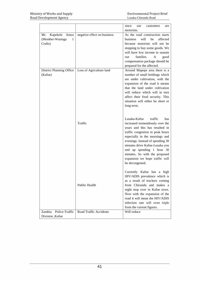
Ministry of Works and Supply Environmental Project Brief Road Development Agency Lusaka-Chirundu Road
41
since our customers are motorists.
Mr. Kapekele Amos (Member-Wasinga 1 Crafts)
negative effect on business As the road construction starts business will be affected because motorists will not be stopping to buy some goods. We will have low income to sustain our families. A good compensation package should be prepared for the affected.
District Planning Office (Kafue)
Loss of Agriculture land Traffic PubIic Health
Around Mapepe area there is a number of small holdings which are under cultivation, with the expansion of the road it means that the land under cultivation will reduce which will in turn affect their food security. This situation will either be short or long term. Lusaka-Kafue traffic has increased tremendously over the years and this has resulted in traffic congestion in peak hours especially in the mornings and evenings. Instead of spending 30 minutes drive Kafue-Lusaka you end up spending 1 hour 30 minutes. So with the proposed expansion we hope traffic will be decongested. Currently Kafue has a high HIV/ADIS prevalence which is as a result of truckers coming from Chirundu and makes a night stop over in Kafue town. Now with the expansion of the road it will mean the HIV/ADIS infection rate will even triple from the current figures.
Zambia Police-Traffic Division ,Kafue
Road Traffic Accidents Will reduce

Ministry of Works and Supply Environmental Project Brief Road Development Agency Lusaka-Chirundu Road
42
8. POTENTIAL ENVIRONMENTAL IMPACTS
Rehabilitation of the Lusaka- Chirundu will adversely affect the environment and the communities in the immediate surroundings of the rehabilitation site. Many of these impacts will arise not only at the rehabilitation site but also at quarries, borrow pits and materials storage areas serving the project. In addition, adverse environmental and socio-cultural impacts will occur during rehabilitation as a result of air pollution and soil contamination from asphalt plants, dust, noise from rehabilitation equipment and blasting; fuel and oil spills, trash and garbage; and the presence of non-resident labour forces.
8.1 Impact on Soil Construction phase In this phase dust raised from gravel access roads by haulage trucks while transporting laterite, stone aggregate, cement, lime, petroleum products and other chemicals may change the soil structure. This impact is considered insignificant. Soil contamination will be caused by leakages from the asphalt plant operations, poor handling of petroleum products such as oil and fuel spillage during dispensing as well as improper disposal of used oils, hydraulic fluids, toxic and empty oil containers. Within the construction phase some activities involving site installation, stock piles preparation, quarrying, construction of detours, access roads, plant park sites and drainage excavation will cause soil destabilisation. Soil compaction by plant machinery and vehicles movement will lead to reduced groundwater yields.
8.2 Impact on Vegetation
Operational phase Abandoned excess laterite and stone aggregate littered around stockpile areas after construction is completed change the soil structure in the surrounding areas. Similarly devegetated areas resulting from post excavation and grading works including drainage channels enhance soil erosion on discharge areas.
Construction phase The vegetation to be affected most is that which is confined to the road reserve and where gravel pits will be established.

Ministry of Works and Supply Environmental Project Brief Road Development Agency Lusaka-Chirundu Road
43
The ecological value of the inundated forests and woodlands to the riverine ecosystem cannot be ignored in that such vegetation stands to contain several niches for diversity of animal species. Should the design of the road rehabilitation confine the extent of land clearing to the limits of the road reserve, then this will not affect vegetation in the outlying areas Dust raised from gravel access roads by haulage trucks during the transportation of laterite, stone aggregate, cement, lime, petroleum products and other chemicals including emissions from plant machinery and vehicles hamper normal growth of roadside vegetation. Similarly poor disposal of toxic waste and petroleum products hampers normal growth of vegetation. Loss of vegetation in this phase is caused by activities related to clearing of sites for installation of works, clearing of the quarry site, preparation of stockpile area, construction of detours, access roads and park sites and the demand for fuel wood by labour force.
8.3 Impact on Water Quality
Operational phase Laterite dust and littered stone aggregate from the excess construction material left after road works will hinder normal vegetation growth around the stockpile areas.
Construction Phase During construction phase, the bridges/culverts, side drains, mitre drains and culverts will require cleaning, de-silting, reshaping and repair. Some of the drains and culverts might be prone to soil erosion, which will result in siltation of nearby watercourses. Also impacts on water quality may be caused by contaminated run-off of petroleum product spillages, leakages from storage areas and heavy vehicles, improper disposal of used oils and from hydraulic fluids which enters the nearby surface water sources. Similarly, easily eroded destabilised soils may be washed into surface water sources and cause siltation and sedimentation, which will reduce the water quality. Activities that will give rise to this impact include construction of detours, access roads, drainage channels, excavation and grading works. During construction phase water will be needed for various purposes such as for watering down the dust. Abstraction of water in large quantities from local sources may lead to water shortage to the local community. This impact is considered significant.

Ministry of Works and Supply Environmental Project Brief Road Development Agency Lusaka-Chirundu Road
44
8.4 Impact on Air Quality
Operational Phase Excess construction material left after construction works may be washed into the water sources and lead to sedimentation of water sources and lowering of the water quality. Erosion of bare areas resulting from excavation and grading works and construction of drainage channels may increase run-off that may lead to sedimentation and increased turbidity in surface water as well as reduced groundwater infiltration. Furthermore hazardous materials spilled from haulage vehicles and washed into water sources will result in water pollution.
Construction Phase
During construction phase large amounts of soil will be excavated and transported. The machinery used for excavation will generate dust, which can be dispersed by the wind affecting a zone of up to 100m around the excavation site. Emissions to the air in form of exhaust fumes and dust from vehicles and machines including operations from the asphalt plant may cause nuisance to the closest surroundings. Dust raised from gravel access roads by haulage trucks during transportation of materials will also pollute the air of the immediate local environment.
Operational Phase Impact on air quality in the operational phase is likely to come from increased vehicular traffic flows, which proportionately discharge emissions to the air. Also loose soils on cleared areas may be blown off during strong winds and raise dust particulate matter, which may affect the quality of the air.
8.5 Impact of Noise Construction Phase During construction phase heavy machinery will be used for the excavation of soil. The machines are noisy and will cause a certain degree of nuisance to the surrounding environment. The noise levels of machines and vehicles vary widely and depend on the type of noise generated and level of activity. A front-end loader has for instance a power level of 100dB(A) while a truck will have a power level of 85 dB(A). In the worst case a combined power level of 115 dB(A) will be in place during construction, which will result in the 50 dB(A) contour being located at a

Ministry of Works and Supply Environmental Project Brief Road Development Agency Lusaka-Chirundu Road
45
maximum 250m from the construction site. However since the equipment will never work at exactly the same location the 50 dB(A) contour will be confined to the construction site and within the road reserve area.
Some common impacts of noise nuisance include annoyance, sleep disturbance and interference with communication. Acceptable levels of noise are regarded to be 40 dB(A) during the night and 50 dB(A) during the day. Since construction will take place during the day only the 50 dB(A) level is of importance. Operational Phase During operational phase the source of noise is expected to come from increased traffic and heavy vehicles using the rehabilitated road.
8.6 Impact on Landscape and Aesthetics Construction Phase Generation of dust during quarrying, equipment movement including land clearing for stockpiles as well as reshaping during detour, access roads and park site construction distorts the natural landscape and may degrade areas of scenic beauty. Further extensive excavations and dumping of stripped top soils in scenic area spoils the beauty of the areas. Operational Phase Abandoned structures, which are left near areas of scenic after construction works, excess construction materials of laterite, stone aggregate and concrete slabs left in areas of scenic beauty reduces the quality of scenery
8.7 Impact on Land use and Surrounding Environment Construction Phase
The land-use along the road is characterised by residential,industrial and agricultural activity. Since the plan include rehabilitation and widening or upgrading of the road to five (5) lanes, significant impacts are therefore anticipated to the surrounding environment. The main source of impact expected is generation of dust by vehicles using detours and access roads. However, this activity will be confined to the road reserve areas and therefore the impact can be minimised through a programme, which ensures dust control such as regular watering down the dust roads.
Ministry of Works and Supply Environmental Project Brief Road Development Agency Lusaka-Chirundu Road
46
Operational Phase Increased traffic will entail a proportionate increase in exhaust fumes and will have an impact to the immediate surrounding environment
8.8 Impact on Socio-economic Construction Phase During this phase skilled and unskilled labour from the affected towns will be required. The project area, especially Kafue, Siavonga and the villages in between, is characterised by high level of unemployment and low level of skills and employment opportunities will therefore increase the positive benefits for the local people who are in dire need of income for sustenance. Furthermore, indirect opportunities for employment will arise from the provision of services to the construction teams, such as sale of food and beverages. In this sense the construction of the road may have a minimal positive impact on the employment situation in the nearby communities. This impact is considered to be significant and positive. It is anticipated that some employees will engage in drunkenness due to improved incomes. This habit could exacerbate the HIV/AIDS situation in the districts. This impact is considered to be significant and positive. Therefore ther will be need for sensitizations and awareness programmes to mitigate the impacts. Operational Phase Socio-economic benefits provided by road rehabilitation and upgrading project will include all-weather road reliability, reduced transportation costs and generally, (according to traders consulted) and enhanced business opportunities.
8.9 Impact on National /Regional Economy Road transport is the dominant form of transport in land locked Zambia. It accounts for the majority of passenger and freight transport (excluding pedestrian transport) and provides the only access to many communities. From a national standpoint maintaining, upgrading and improving the road is important in terms of communication between the Southern, Lusaka and the Southern Africa region (Zimbabwe, South Africa, Lesotho etc). Thus, an improved road will have a significant positive impact on the economic activities in the region.

Ministry of Works and Supply Environmental Project Brief Road Development Agency Lusaka-Chirundu Road
47
8.10 Impact on Cultural and Archaeological Sites
Within Chirundu sub district lies one of the most important national, natural heritage sites, the Chirundu National Petrified Forest Monument in the area of Chief Sikongo of Siavonga District. It is located 21 km from Chirundu border along Lusaka road at the corner of the access road to Lake Kariba. This may be impacted.
8.11 Impact on Human Settlements Construction Phase Since there are plans to widen or upgrade the road, there could be demolition, relocation or resettlement of a number of structures along the road. The potential impact is considered negative and significant. Operational Phase No additional negative impacts on human settlements are foreseen during operational phase.
8.12 Impact of Quarries and Borrow Pits Construction Phase During construction phase, a number of quarries and borrow pits along the route will be opened up. Potential impacts include vegetation clearance and landscape scars resulting from the absence of re-vegetation programmes and poor excavation techniques. Extraction of construction materials from quarries and borrow pits could generate excessive noise caused by blasting, movement of machinery and labourers and thus impact on the nearby communities. Also increased air pollution due to diesel fumes and dust generation resulting from the presence of construction machinery and site clearing activities. Quarries and borrow pits impact on the visual and aesthetic view. The excavated areas become prone to soil erosion during rain season and can contaminate nearby surface water. Operational Phase Quarries and borrow pits left abandoned after construction works could be a potential hazard to ecology and nearby communities. Transmission of diseases, such as malaria and their vector can occur in stagnant water collected in abandoned borrow pits. Malaria that is transmitted by the anopheles mosquito and diarrhoea are both water-related diseases. Thus the potential impact from poor extraction techniques and lack of re-vegetation programmes is considered significant. Further if the quarries and borrow pits are sited nearby communities the pits could become habitats for dangerous creatures such as snakes, which
Ministry of Works and Supply Environmental Project Brief Road Development Agency Lusaka-Chirundu Road
48
could easily attack unsuspecting children playing in these borrow pits and quarries.
8.13 Impact on Traffic Construction Phase Construction traffic could negatively impact on undisturbed areas adjacent to the proposed route. The construction process could impede momentum of the existing traffic flow and may lead to the use of improvised detours by other motorists, which may compromise with safety of pedestrians if not properly planned. Operational Phase The traffic intensity on the road is likely to increase once the rehabilitation is complete and the road become operational. This additional flow could be as a result of increased traffic between the Southern region and the Copperbelt province. This increase in traffic may cause an increase in the number of accidents despite the expansion or widening of the tarmac. The types of accidents include those involving vehicles, bicycles and pedestrians. The Road Traffic Division consulted however indicated that widening, expanding and improving the condition of the road will significantly reduce the accidents.
8.14 Impact on Occupational Health and Safety Construction Phase During the construction phase heavy machinery will be employed. Heavy machines make a lot of noise, cause carbon dioxide emissions and generate dust and may cause accidents among operators if not handled properly. This is likely to have negative impact on health of the workers. To limit the risk of accidents, safety procedures will be put in place and enforced by the foreman to ensure that vehicles and machinery only drive in designated places by authorised personnel. Operational Phase As the road rehabilitation project would have completed there will be no workers on site and there will be no more impacts on work accidents from this phase.
8.15 Impact on Tourism Construction Phase The impact on tourism will be during construction due to time delays as a result of the reconstruction process. The design allows for a detailed accommodation

Ministry of Works and Supply Environmental Project Brief Road Development Agency Lusaka-Chirundu Road
49
of traffic flow with sufficient road signs informing the travelling public of roadworks, detours or alternative routes. Operational Phase The long-term benefit to tourism is a high quality double or triple lane road with a design life of at least 20 years with minimal disruption during the life of the road. The Zambia National Tourist Board, Ministry of Tourism, Environment and Natural Resources and ZAWA will be responsible for monitoring and management of all indirect impacts occurring on tourism after the rehabilitation of the road.

Ministry of Works and Supply Environmental Project Brief Road Development Agency Lusaka-Chirundu Road
50
9 MEASURES TO MITIGATE ADVERSE IMPACTS AND ENHANCE POTENTIALLY BENEFICIAL IMPACTS
The following measures are recommended to mitigate the impacts identified above.
Table 11: Mitigations Measures Phase Impact Mitigation Measure
Impacts on Water Quality
Construction Phase
Siltation of water courses due to soil erosion of nearby drains and culverts.
• Sides of the drainage shall be planted with grass or stone pitched;
• Drainage systems shall have scour checks;
• Drainage systems shall discharge into settlement basins;
• Silt traps shall be put along drainage systems;
• Spoon drains shall have scour checks. Water shortage to the local community due to over exploitation for rehabilitation works.
• Exploitation of water sources for rehabilitation works shall be done with consultation from the local authority and the local community.
Ground water contamination due to construction of sub-standard campsite pit latrines for workers.
• Proper siting of pit latrines away from water logged areas;
• Good hygienic standards and proper maintenance of pit latrines.
Operational Phase
Sedimentation and increased turbidity in surface water caused by erosion of bare areas and runoffs resulting from excavation and grading works and drainage channels left after construction works.
• Excavated soils shall be used for other road works such as shoulder building;
• Sides of drainage channels shall be planted with grass or stone pitched;
• Drainage systems shall have scour checks.
Impacts on Air Quality
Construction Phase
Air pollution caused by exhaust fumes and dust from excavators, bull dozers, graders as well as site clearing will affect human, vegetation and also disturb habitats for birds and insects.
• Regular maintenance of construction vehicles and equipment in order to reduce emission of exhaust fumes;
• Periodically water down on temporary roads;
Unpleasant odours due to un-maintained toilets and poor waste management.
• Cleaning and regular maintenance of toilets to avoid unpleasant odours.
• Waste should be carefully managed to prevent unpleasant odours.
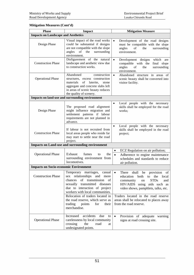
Ministry of Works and Supply Environmental Project Brief Road Development Agency Lusaka-Chirundu Road
51
Mitigation Measures (Cont’d)
Phase Impact Mitigation Measure Impacts on Landscape and Aesthetics
Design Phase
Visual impact of the road works could be substantial if designs are not compatible with the slope angles of the surrounding environment.
• Development of the road designs must be compatible with the slope angles of the surrounding environment.
Construction Phase
Disfigurement of the natural landscape and aesthetic view due to construction works.
• Development designs which are compatible with the final slope angles of the surrounding environment.
Operational Phase
Abandoned construction structures, excess construction materials of laterite, stone aggregate and concrete slabs left in areas of scenic beauty reduces the quality of scenery.
• Abandoned structure in areas of scenic beauty shall be converted into visitor facility.
Impacts on land-use and surrounding environment
Design Phase
Construction Phase
The proposed road alignment might influence migration and settlement patterns if labour requirements are not planned in advance.
• Local people with the necessary skills shall be employed for the road works;
If labour is not recruited from local areas people who reside far may start to settle near the road project.
• Local people with the necessary skills shall be employed in the road project;
Impacts on Land-use and surrounding environment
Operational Phase Exhaust fumes to the surrounding environment from locomotives.
• ECZ Regulation on air pollution; • Adherence to engine maintenance
schedules and standards to reduce air pollution.
Impacts on Socio-economic Environment
Construction Phase Temporary marriages, casual sex relationships and more chances of transmission of sexually transmitted diseases due to interaction of project workers with local communities.
• There shall be provision of education both to the local community on STDs and HIV/AIDS using aids such as video shows, pamphlets, talks, etc.
Relocation of traders located in the road reserve, which serve as trading points for their merchandise.
Traders located in the road reserve areas shall be relocated to places away from the road reserve.
Operational Phase
Increased accidents due to carelessness by local community crossing the road at undesignated points.
• Provision of adequate warning signs at road crossing site.

Ministry of Works and Supply Environmental Project Brief Road Development Agency Lusaka-Chirundu Road
52
Mitigation Measures (Cont’d)
Phase Impact Mitigation Measure Impacts on Human Settlements
Construction Phase
Insignificant impacts on human settlements are not foreseen since construction works will be confined to the existing road alignment.
• Construction shall be confined to the road reserve area;
Operational Phase
Rehabilitation of the road may lead to increased human settlements, changed settlement patterns, increased cultivation and commercial activities along the road;
• There shall be no conversion of communal land into state land along the rehabilitated road.
Rehabilitation of the road may lead to increased land values and land resource tenure along the road,
• There shall be no conversion of communal land into state land along the rehabilitated road.
Impacts of Quarries and Borrow Pits
Design Phase Quarries and borrow pit location may negatively impact on important ecological units.
• Quarrying shall not be done near surface water sources.
• There shall be no quarrying near heritage sites.
• There shall be no quarrying in National Parks. The provisions of the NHCC Act of 1989 shall be observed.
Construction Phase
Excessive noise from blasting, machinery may disturb nearby communities.
• Quarrying shall not be done nearby communities.
• Quarrying shall be done in conformity to the Mine and Minerals Act, No. 31 of 1995.
Operational Phase
Un-rehabilitated borrow pits could pose potential hazard to ecological units and residents.
• Quarrying shall not be done near water sources and human settlements.
Impacts of Increased Traffic
Design Phase
Failure to use established routes might result in surveyors' vehicles negatively impacting on the environment.
• Surveyors should not venture too far away from the proposed route in order to avoid impacts on the surrounding environment.
Construction Phase
Construction traffic could impact on undisturbed areas adjacent to the proposed route.
• Established routes should be used where possible in order to reduce impacting on undisturbed areas.
• Construction vehicles must only use pre-determined access road that should be determined in the design phase.
• Allowance should be made for alternative routes for interruption in existing road users during road rehabilitation.
Excessive dust from rehabilitation could disturb nearby communities.
• Control of dust through watering of access dust roads.

Ministry of Works and Supply Environmental Project Brief Road Development Agency Lusaka-Chirundu Road
53
Mitigation Measures (Cont’d)
Impacts of Increased Traffic
Phase Impact Mitigation Measure
Operational Phase Increased accidents due to increased traffic flow.
• Provision of adequate road warning signs in black spot areas and speed retarders at pedestrian crossing site.
Impacts of Work Accidents
Design Phase Advanced planning of safety requirements
• Development of safety procedures and operational manual.
Construction Phase
Lack of enforcement of safety and health regulations could impact negatively on construction workers.
• Enforcement of Public health and safety regulations.
Impacts of Construction Camps
Design Phase Advanced planning of construction camp site.
• Selection of camp site must be done in consultation with the local authority and local people.
Construction Phase
Loss of vegetation at construction site.
• Clearing for camp site must be limited to the actual site to avoid vegetation loss on a larger scale.
Waste generation at campsite. • Waste disposal to be done at designated sites approved by the local authority and ECZ.
Interaction of construction workers with the nearby communities may lead to transmission of sexually transmitted diseases.
• There shall be provision of education both to the local community and camp workers on STDs and HIV/AIDS using aids such as video shows, pamphlets, talks, etc.
• Local people with the necessary skills shall be employed in the road project;
9.1 Decommissioning Plan for the Quarries and Borrow Pits
The project will rely on existing borrow pits and quarries being currently operated by some companies. Where quarries and borrow pits may be opened these shall not be sited near the communities. However, road construction waste may be reused for rehabilitation of the borrow pits. Rehabilitation and closure is not simple. There are external and internal factors requiring resolution before a strategic closure plan can be developed. One of the single most difficult questions to be answered involves the anticipatory approach. What will conditions be at closure? This question embraces issues such as:- • Unknown resource values and on-going development options
• Changing attitudes and increasing social attention
• Changes in legislation, and
• Changes in the investment potential towards best practise management.

Ministry of Works and Supply Environmental Project Brief Road Development Agency Lusaka-Chirundu Road
54
The project will be committed to developing and implementing closure plan for all aspects of borrow pit and quarry operations to ensure that rehabilitation and final closure of the sites meet clearly defined objectives aimed at minimising long-term environmental impacts.

Ministry of Works and Supply Environmental Project Brief Road Development Agency Lusaka-Chirundu Road
55
Table 12 Environmental Monitoring Plan Element to be
Monitored Method of Monitoring & Responsible Person
Frequency of Monitoring
Indicator Means of Verification Authority Responsible for Supervision
Land and Soil
Land and Soil
• Site Engineer to make inspections of sites for storage of materials, oil and fuels and ensure they have sealed surfaces.
• Periodical inspections throughout the Construction Phase
• Clean storage sites free from any oil or fuel spillage maintained throughout Construction Phase.
• Inspection Report is available at RDA
• Contractor's Site Engineer
• EMU RDA
• Site Engineer to inspect the waste disposal sites.
• Periodical inspections throughout the Construction Phase
• Waste oil is being disposed of in designated sites and in approved method.
• Inspection Report is available at RDA
• Contractor's Site Engineer
• EMU RDA
• Site Engineer to ensure used oil is being collected for recycling.
• Periodical inspections throughout the Construction Phase
• Containers for collection of used oil are available on site.
• Used oil from serviced plant machinery has been collected in containers.
• Contractor • EMU-RDA
• Site Engineer to inspect storage tanks and ensure they have bund walls around them high enough to contain any spillage.
• Once before fuel storage tanks are put to use.
• Bund wall design and construction plan has been developed, approved and is available.
• Bund walls around fuel storage tanks have been constructed.
• Contractor • EMU-RDA

Ministry of Works and Supply Environmental Project Brief Road Development Agency Lusaka-Chirundu Road
56
Environmental Monitoring Plan (Cont’d)
Element to be Monitored
Method of Monitoring & Responsible Person
Frequency of Monitoring
Indicator Means of Verification Authority Responsible for Supervision
Land and Soil
Land and Soil
• Site Engineer to make inspections of sites for storage of materials, oil and fuels and ensure they have sealed surfaces.
• Periodical inspections throughout the Construction Phase
• Clean storage sites free from any oil or fuel spillage maintained throughout Construction Phase.
• Inspection Report is available at RDA
• Contractor's Site Engineer
• EMU RDA
• Site Engineer to inspect the waste disposal sites.
• Periodical inspections throughout the Construction Phase
• Waste oil is being disposed of in designated sites and in approved method.
• Inspection Report is available at RDA
• Contractor's Site Engineer
• EMU RDA
• Site Engineer to ensure used oil is being collected for recycling.
• Periodical inspections throughout the Construction Phase
• Containers for collection of used oil are available on site.
• Used oil from serviced plant machinery has been collected in containers.
• Contractor • EMU-RDA
• Site Engineer to inspect storage tanks and ensure they have bund walls around them high enough to contain any spillage.
• Once before fuel storage tanks are put to use.
• Bund wall design and construction plan has been developed, approved and is available.
• Bund walls around fuel storage tanks have been constructed.
• Contractor • EMU-RDA

Ministry of Works and Supply Environmental Project Brief Road Development Agency Lusaka-Chirundu Road
57
Environmental Monitoring Plan (Cont’d)
Element to be Monitored
Method of Monitoring & Responsible Person
Frequency of Monitoring
Indicator Means of Verification Authority Responsible for Supervision
Vegetation
Vegetation
• Site Engineer to ensure that excessive clearance of vegetation is avoided and should be confined to the project site.
• Each time clearance of vegetation is being done throughout Construction Phase
• The area of vegetation cleared is minimal
• Area for vegetation clearance is clearly marked and is confined to the designs.
• Contractor • EMU RDA
Water Quality
Water Quality
• Site Engineer to inspect and satisfy that interceptors are put in place and working well.
• Periodical inspections throughout the Construction Phase.
• Clean water supply maintained throughout the Construction Phase.
• Absence of water pollution incidents
• Contractor • EMU RDA

Ministry of Works and Supply Environmental Project Brief Road Development Agency Lusaka-Chirundu Road
58
Environmental Monitoring Plan (Cont’d)
Element to be Monitored
Method of Monitoring & Responsible Person
Frequency of Monitoring
Indicator Means of Verification Authority Responsible for Supervision
Water Quality (Cont'd)
Water Quality (Cont'd)
• Site Engineer to inspect and satisfy that areas where hazardous liquids are stored are bunded.
• Periodical inspections out the Construction Phase.
• Clean water supply maintained throughout the Construction Phase.
• Absence of water pollution incidents
• Contractor • EMU RDA
• Site Engineer to inspect and satisfy that water from concrete batching plants is treated.
• Periodical inspections out the Construction Phase.
• Clean water supply maintained throughout the Construction Phase.
• Absence of water pollution incidents
• Contractor • EMU RDA
• Site Engineer to inspect and satisfy that silt traps are put along drainage systems;
• Periodical inspections throughout the Construction Phase.
• Clean water supply maintained throughout the Construction Phase.
• Absence of water pollution incidents
• Contractor • EMU RDA
• Site Engineer to inspect and satisfy that spoon drains has scour checks.
• Periodical inspections throughout the Construction Phase.
• Clean water supply maintained throughout the Construction Phase.
• Absence of water pollution incidents
• Contractor • EMU RDA
• Site Engineer to inspect and satisfy that siting of pit latrines is done away from water logged areas;
• Before construction of pit latrines.
• Construction is done according to design specifications.
• Pit latrine siting and construction report
• Contractor • EMU RDA

Ministry of Works and Supply Environmental Project Brief Road Development Agency Lusaka-Chirundu Road
59
Environmental Monitoring Plan (Cont’d)
Element to be Monitored
Method of Monitoring & Responsible Person
Frequency of Monitoring
Indicator Means of Verification Authority Responsible for Supervision
Water Quality (Cont'd)
Water Quality (Cont'd)
• Site Engineer to inspect and satisfy that written detail of the procedures to be followed in the event of pollution incident is given to the Site Engineer By the Contractor.
• Immediately there is a pollution incident during Construction Phase.
• Operational procedures are being followed.
• Presence of Operational Manual on site.
• Contractor • EMU RDA
Air Quality
Air Quality
• Site Engineer to observe the level of dust generated during Construction. Watering down should be done if dust levels are unacceptable.
• Regular inspections throughout the Construction Phase.
• Deposition of dust on surfaces such as grasses, shrubs, trees and rooftops should decrease with watering.
• Dust deposition on the immediate surroundings is controlled.
• Contractor • EMU RDA
• Site Engineer to check and ensure that construction vehicles and equipment are maintained in order to reduce emission of exhaust fumes;
• Regular inspections throughout the Construction Phase.
• Exhaust fume emissions are controlled.
• Maintenance logbook is available on site.
• Contractor • EMU RDA

Ministry of Works and Supply Environmental Project Brief Road Development Agency Lusaka-Chirundu Road
60
Environmental Monitoring Plan (Cont’d)
Element to be Monitored
Method of Monitoring & Responsible Person
Frequency of Monitoring
Indicator Means of Verification Authority Responsible for Supervision
Air Quality (Cont'd)
Air Quality
• Site Engineer to inspect and ensure that toilets are cleaned and maintained to avoid unpleasant odours.
• Regular inspections throughout the Construction Phase.
• Unpleasant odours are controlled.
• Clean toilet environment free from unpleasant odours.
• Contractor • EMU RDA
• Site Engineer to inspect and ensure waste is carefully managed and disposed of in designated places to prevent unpleasant odours.
• Regular inspections throughout the Construction Phase.
• Controlled waste disposal method.
• Waste is dumped in designated places.
• Contractor • EMU RDA
Noise
Noise
• Sit Engineer to monitor noise and vibrations on an ad-hoc basis in order to establish noise levels at the project site and the nearest sensitive receptors and should not exceed 90-decibels.
• Regular inspections throughout the Construction Phase.
• Noise levels at the nearest sensitive receiver are minimised.
• Number of complaints of noise disturbance is controlled.
• Contractor • EMU RDA

Ministry of Works and Supply Environmental Project Brief Road Development Agency Lusaka-Chirundu Road
61
Environmental Monitoring Plan (Cont’d)
Element to be Monitored
Method of Monitoring & Responsible
Person
Frequency of Monitoring
Indicator Means of Verification Authority Responsible for Supervision
Noise (Cont'd)
Noise Cont'd)
• Site Engineer to check and ensure that working hours are limited to day light only;
• Daily inspections throughout the Construction Phase.
• Sleep disturbance is minimised.
• Number of complaints of sleep disturbance is minimised.
• Contractor • EMU RDA
Landscape and Aesthetics
Landscape and Aesthetics
• Site Engineer to make visual inspection of earth works to ensure that excessive excavation other than those agreed upon is not carried out, particularly at borrow pit sites, temporary and approach roads and around the contractor's camp.
• Daily inspections throughout the Construction Phase.
• Landscape alterations are reduced to a minimum.
• Final landscape and aesthetic view is compatible with the surrounding environment.
• Contractor • EMU RDA

Ministry of Works and Supply Environmental Project Brief Road Development Agency Lusaka-Chirundu Road
62
Environmental Monitoring Plan (Cont’d)
Element to be Monitored
Method of Monitoring & Responsible
Person
Frequency of Monitoring
Indicator Means of Verification Authority Responsible for Supervision
Land-use and surrounding environment
Land-use and Surrounding Environment
• Contractor shall ensure that local people with the necessary skills are employed to work on the road project to avoid migration and settlement near the road by construction workers who are taken from far areas.
• Before recruitment, planning for labour requirements shall be done during the Pre-Construction Phase.
• Potential construction workers from the local community are identified.
• Construction workers are recruited from the local community
• Contractor • EMU RDA
• The Site Engineer to monitor and ensure that detours, access roads and equipment park site location takes into account the existing land use in settled areas.
• Planning for detours, access roads and equipment park site location shall be done during the Pre-Construction Phase.
• Designs for detours, access roads and equipment park site location have taken into account the existing land use in settled areas.
• Designs for detours, access roads and equipment park site location are being implemented according to specifications.
• Contractor • EMU RDA

Ministry of Works and Supply Environmental Project Brief Road Development Agency Lusaka-Chirundu Road
63
Environmental Monitoring Plan (Cont’d)
Element to be Monitored
Method of Monitoring & Responsible Person
Frequency of Monitoring
Indicator Means of Verification Authority Responsible for Supervision
Socio-economic Environment
Socio-economic Environment
• Contractor shall conduct and ensure that education is given to both the construction workers and local community on STDs and HIV/AIDS using communication aids such as video shows, pamphlets, talks is disseminated.
• Planning for education both to the construction workers and local community on STDs and HIV/AIDS shall be done during the Pre-Construction Phase.
• Programme for education both to the construction workers and local community on STDs and HIV/AIDS is developed during the Pre-Construction Phase.
• Target group for receiving education on STDs and HIV/AIDS is identified and the programme is being implemented during the Construction Phase.
• Contractor • EMU RDA • Local Community • CBO
• Site Engineer to check and ensure that adequate warning road signs in black spot areas and speed retarders at pedestrian crossing site are erected.
• Planning for erection of warning road signs in black spot areas and speed retarders at pedestrian crossing site shall be done in the Pre-Construction Phase.
• Black spot areas are identified for erection of warning road signs and speed retarders and are included in the overall road designs
• Warning road signs and speed retarders in black spot areas and pedestrian are constructed.
• Contractor • EMU RDA • Local Authority • Road Safety Council

Ministry of Works and Supply Environmental Project Brief Road Development Agency Lusaka-Chirundu Road
64
Environmental Monitoring Plan (Cont’d)
Element to be Monitored
Method of Monitoring & Responsible
Person
Frequency of Monitoring
Indicator Means of Verification Authority Responsible for Supervision
Cultural and Historic Sites
Cultural and Historic Sites
• Site Engineer to monitor and ensure that detours, access roads and equipment park sites are not constructed through heritage sites.
• Planning for construction of detours, access roads and equipment park sites shall be done in the Pre-Construction Phase.
• A Road design, which takes into account protection of the petrified forest in Chirundu
• Detours, access roads and equipment park sites are constructed outside the heritage and historic sites during the Construction Phase.
• Contractor • EMU RDA • NHCC
Human Settlements
Human Settlements
• Site Engineer to inspect and satisfy that exploitation of water sources for rehabilitation works is done with approval from the local authority and with consent from the local community.
• Planning for exploitation of water resources from the local community shall be done during the Pre-Construction Phase in consultation with the Local authority and local community.
• Exploitation of water resources from the local community for road rehabilitation works is controlled.
• Water to local community is available.
• Contractor • EMU RDA • Local Authority • Local community

Ministry of Works and Supply Environmental Project Brief Road Development Agency Lusaka-Chirundu Road
65
Environmental Monitoring Plan (Cont’d)
Element to be Monitored
Method of Monitoring & Responsible
Person
Frequency of Monitoring
Indicator Means of Verification Authority Responsible for Supervision
Human Settlements (Cont'd)
Human Settlements
(Cont'd)
• Site Engineer to check and ensure that adequate warning road signs in black spot areas and speed retarders at pedestrian crossing site are erected in human settlement areas.
• Planning for erection of warning road signs in black spot areas and speed retarders at pedestrian crossing site shall be done in the Pre-Construction Phase.
• Black spot areas are identified for erection of warning road signs and speed retarders and are included in the overall road designs
• Warning road signs and speed retarders in black spot areas and pedestrian are constructed.
• Contractor • EMU RDA • Local Authority • Road Safety Council
Quarries and Borrow Pits
Quarries and Borrow Pits
• Site Engineer to monitor and ensure that quarries and borrow pit areas are not located near surface water sources.
• Planning for exploitation of construction materials from quarries and borrow areas shall be done in the Pre-Construction Phase.
• A road design, which takes into account the protection of the water resources is developed.
• Quarries and borrow areas are located outside the water resources catchment areas during the Construction Phase.
• Contractor • EMU RDA • Ministry of Mines
• Site Engineer to ensure that an EPB for material extraction site is prepared in accordance with the requirement of the EPPCA
• An EPB for exploitation of construction materials from quarries and borrow areas shall be done in the Pre-Construction Phase
• An EPB is undertaken and submitted to ECZ
• A decision Letter has been issued by ECZ with respect to EPB for material extraction
• Contractor • EMU RDA • Ministry of Mines

Ministry of Works and Supply Environmental Project Brief Road Development Agency Lusaka-Chirundu Road
66
Environmental Monitoring Plan (Cont’d)
Element to be Monitored
Method of Monitoring & Responsible
Person
Frequency of Monitoring
Indicator Means of Verification Authority Responsible for Supervision
Quarries and Borrow
Pits
• Site Engineer to monitor and ensure that quarries and borrow areas are not located nearby communities.
• Planning for exploitation of construction materials from quarries and borrow areas shall be done in the Pre-Construction Phase.
• A road design, which takes into account the protection of the local community is developed.
• Quarries and borrow areas are located far away from the local community during Construction Phase.
• Contractor • EMU RDA • Ministry of Mines • Local Authority
Work Accidents
Work Accidents
• Site Engineer to monitor and ensure that the procedures on Safety, Health and Environment for construction workers are being followed during the Construction Phase.
• Periodical inspections throughout the Construction Phase.
• Operational Manual on Safety, Health and Environment for construction workers is developed and available on site.
• Operational Manual on Safety, Health and Environment for construction workers is being implemented during the Construction Phase.
• Contractor • EMU RDA • Local Authority

Ministry of Works and Supply Environmental Project Brief Road Development Agency Lusaka-Chirundu Road
67
10 CONCLUSION AND RECOMMENDATION
10.1 Conclusion
The findings from the Environmental Brief show that although the proposed road rehabilitation project is expected to have a number of negative impacts on the environment, most of these are anticipated to occur during the rehabilitation phase and operational life of the road and are mitigated in the overall road design. Generally, the proposed route is expected to have immense benefits that outweigh the negatives. It is also noteworthy that the road will provide an improved, reliable and safe link to the rest of the region.
10.2 Recommendation
The study has proposed an Environmental Monitoring Plan (EMP) to addres the management of the identified environmental issues associated with the project. We recommend that the EMP is strictly followed and implemented to ensure optimal management of the environment.
Ministry of Works and Supply Environmental Project Brief Road Development Agency Lusaka-Chirundu Road
68
11 ANNEXURE
Annex 1: Submissions/Comments from Stakeholders Mr. Musonda Tresford-Director of Planning –Kafue District Council Recently surveyors have been sighted doing some markings on the Lusaka-Chirundu road. The areas which will be most affected is Chilanga/mapepe especially that on both sides of the road they are a number of government structures, small holdings and the road itself is very narrow after the bridge going to Kafue. Around Mapepe area there is a number of small holdings which are under cultivation, with the expansion of the road it means that the land under cultivation will reduce which will in turn affect their food security. This situation will either be short or long term. In Kafue town not much but of course BP filling station will be affected. From Kafue to Chirundu there is no much space hence it will call for a lot of excavation works. As you are coming from Chirundu a lot of vegetation will be lost and we have a number of global warming issues coming up, so as the wild animals (Monkeys) around the stretch. Lusaka-Kafue traffic has increased tremendously over the years and this has resulted in traffic congestion in peak hours especially in the mornings and evenings. Instead of spending 30 minutes drive Kafue-Lusaka you end up spending 1 hour 30 minutes. So with the proposed expansion we hope traffic will be decongested. Currently Kafue has a high HIV/ADIS prevalence which is as a result of truckers coming from Chirundu and makes a night stopover in Kafue town. Now with the expansion of the road it will mean the HIV/ADIS infection rate will even triple from the current figures. The recently placed optic fibre network will also be affected and it cannot go further in-land because that’s private property. Around Shimabala, Shikoswe and Kafue town areas will have a lot of activities taking place on both sides of the road. Now with the expansion it will mean pedestrians will be at a high risk of being knocked down as the cross the road. A foot bridge will be very expensive to put up and also humps followed by pedestrian crossing would be necessary but again those who have done high way planning will not be for the ideal. So a solution has to be found in order for us to protect the pedestrian. The expansion of the Chirundu-Lusaka road will see a more capital goods passing through enroute to the copperbelt. As a local authority, we are interested in how the affected people will be impacted. Of course they will be economical gain but we have to make sure that there is social gain as well. Community sensitization and awareness should be factored in at the interim phase.

Ministry of Works and Supply Environmental Project Brief Road Development Agency Lusaka-Chirundu Road
69
Mr. Malambo Stainely-Director of Works –Kafue District Council A lot of property will be demolished since a number of them are close to the road; such as the BP filling station just next to Zambia Police Kafue District. Preferably 4 lanes will be better. In every development comes negative impacts but what is important is to find ways of cushioning them. Sensitization is vital in such a development people should be told even before the works start, so that they are aware. Ms. Luchembe Mutale-Trader-Racco Agencies With the expansion of the Lusaka-Chirundu road the number of road traffic accidents will reduce, since at the moment a lot of pedestrians are knocked down by fast passing vehicles. For example if you consider the area from Chilanga area to Ten Park a lot of road traffic accidents occur. Also on the other side, they will be a boom in terms of business due to increased traffic; a lot of motorists will be stopping over for refreshments. All in all the expansion of the road will bring a number of developments to Kafue town. Mr. Imasiku Godfrey-Chairman-Kafue Hand Craft Producers Association As at now the business is slow but with the expansion of the road, they will be increased traffic hence they will be a boom in business. If they will be need for resettlement, we are ready to be resettled as long as we are compensated and another place along the road is given since our customers are motorists. Mr. Maboshi Mofat-Chairman-Wasinga 1 Crafts Our shelters are simple structures but takes time to make them and business here is not on the daily basis, so our concern is that once our shelters are demolished we want to be compensated fairly either financially or by building another market. Mr. Kapekele Amos-Member-Wasinga 1 Crafts As the road construction starts business will be affected in the sense that due to the works motorists will not be stopping to buy some goods. Hence, business will be low and they will be no income to sustain our families. A good compensation package should be prepared for the affected.

Ministry of Works and Supply Environmental Project Brief Road Development Agency Lusaka-Chirundu Road
70
Annex 2: Names of People Consulted No. Name Organisation Occupation Address 1 Sub-Insp. Tembo Zambia Police Sub-Inspector 0977-821940 2 Luchembe Mutale Racco Angencies Trader 3 Malambo Stainely Kafue District
Council Director of Works
0977-877298
4 Musonda Tresford Kafue District Council
Director of Planning
5 Kapekele Amos Wasinga 1 Association
Member
6 Kubwela Jailious Wasinga 1 Association
Member
7 Maboshi Charles Wasinga 1 Association
Member
8 Nyangu Tobias Wasinga 1 Association
Member
9 Kapekele Chrispin Wasinga 1 Association
Member
10 Maboshi Mofat Wasinga 1 Association
Chairman
11 Imasiku Godfrey Kafue Handcraft Association
Chairman

Ministry of Works and Supply Environmental Project Brief Road Development Agency Lusaka-Chirundu Road
71
CONSULTING SERVICES FOR THE UPGRADING OF TECHNO-ECONOMIC STUDIES AND DETAILED ENGINEERING DESIGN OF THE LUSAKA CHIRUNDU ROAD (NON-ESCARPMENT AREA)
REPONSES TO COMMENTS FROM ECZ
No. ECZ COMMENTS RESPONSE TO ECZ COMMENTS
1. • The whole project cycle (site preparation, construction and operation phases) is missing from the EPB. A thorough description of what will be involved during each phase of the project should be included
This issue has been addressed under items 4.2, 4.3 and 4.4 where Pre-construction (Design), Construction and Operational Phases have been elaborated in the revised document.
2. • What is/are the objective/s of the project The objective of the project has been addressed under item 1.3 of the revised document.
3. • Include the following information:
a) Proposed Implementation date This issue has been addressed under item 1.2 and subsequent subsections under items 1.2.1 to 1.2.5 in the revised document.
b) Total project cost This issue has been addressed under item 1.2.1 in the revised document. The total cost for feasibility studies currently being undertaken is ZMK800 Million according to the RDA Annual Workplan of 2009. Actual implementation of the project is dependent on government securing funds and cannot be ascertained at this stage.
4. • Section 2.1, review of relevant legislation: include more pieces of legislation within whose mandate you will be operating, e.g.
• Public Roads Act This legislation has been included under item 2.1.9 in the revised document.
• The RTSA Act This legislation has been included under item 2.1.10 in the revised document.
• Pneumoconiosis Act This legislation has been included under item 2.1.8 in the revised
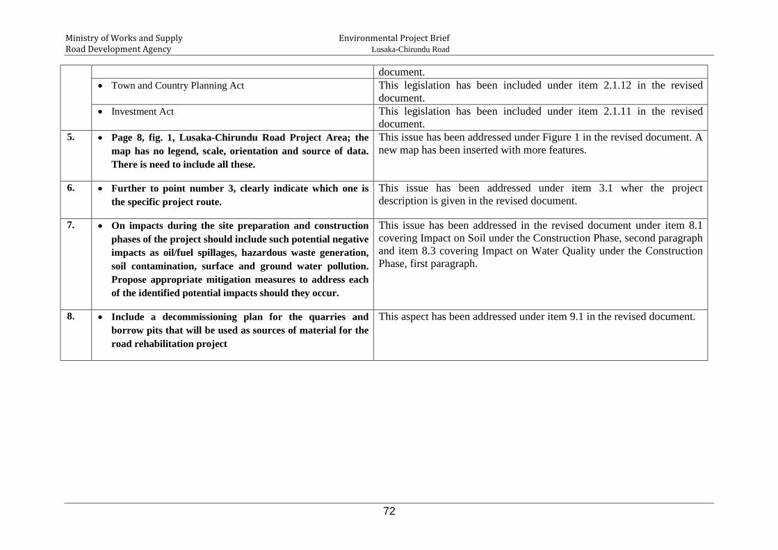
Ministry of Works and Supply Environmental Project Brief Road Development Agency Lusaka-Chirundu Road
72
document. • Town and Country Planning Act This legislation has been included under item 2.1.12 in the revised
document. • Investment Act This legislation has been included under item 2.1.11 in the revised
document. 5. • Page 8, fig. 1, Lusaka-Chirundu Road Project Area; the
map has no legend, scale, orientation and source of data. There is need to include all these.
This issue has been addressed under Figure 1 in the revised document. A new map has been inserted with more features.
6. • Further to point number 3, clearly indicate which one is the specific project route.
This issue has been addressed under item 3.1 wher the project description is given in the revised document.
7. • On impacts during the site preparation and construction phases of the project should include such potential negative impacts as oil/fuel spillages, hazardous waste generation, soil contamination, surface and ground water pollution. Propose appropriate mitigation measures to address each of the identified potential impacts should they occur.
This issue has been addressed in the revised document under item 8.1 covering Impact on Soil under the Construction Phase, second paragraph and item 8.3 covering Impact on Water Quality under the Construction Phase, first paragraph.
8. • Include a decommissioning plan for the quarries and borrow pits that will be used as sources of material for the road rehabilitation project
This aspect has been addressed under item 9.1 in the revised document.