Embed Size (px)
Citation preview

Environmental Planning Atlas
September 2004Victoria
Agriculture Victoria ServicesHume City Council

ENVIR ON MENTAL PLANNING ATLAS HUME CITY CO UN C I L
SRP I
HUME CITY COUNCIL
ENVIRONMENTAL
PLANNING
ATLAS
September 2004

ENVIR ON MENTAL PLANNING ATLAS HUME CITY CO UN C I L
SRP I I
ACKNOWLEDGEMENTS
The Hume Environmental Planning Atlas has been developed under contract by Agriculture Victoria Services Pty Ltd (AVS) for the Hume City Council. The valuable input of many different groups and individuals into the project is much appreciated. Special thanks are to extended Bill Hansen, DSE; Graham Hawk, Southern Rural Water; Brad Roberts, PPWCMA; Heather Bannerman, PPWCMA, Adam Kay, DPI; and to Hume City Council officers, Michael Sharp and Matt Ruchel.
© Hume City Council, 2004
Disclaimer: This is a report of work carried out by Agriculture Victoria Services Pty Ltd (ACN 006 598 198) of Mickleham Road, Attwood, Victoria, (“AVS”) under contract and on behalf of the client identified above (“Client”). The Representations, statements, opinions and advices, expressed or implied in this report (“Content”) are for the benefit of the Client only and are not endorsed by the Government of Victoria. This report is a commercial document. Neither it nor its Contents are Government policy, nor does the report or its Contents purport to be reflective of Government policy. The Content is produced in good faith but on the basis that the Client and AVS (and any person or entity represented by or acting through AVS), and their respective agents and employees are not liable (whether by reason of negligence, lack of care or otherwise) to any person for any damage or loss whatsoever which has occurred or may occur in relation to that person taking or not taking (as the case may be) action in respect of any or all of the Content.

ENVIR ON MENTAL PLANNING ATLAS HUME CITY CO UN C I L
SRP I I I
EXECUTIVE SUMMARY
Hume City Council occupies a strategic position in Metropolitan Melbourne owing to its unique community, industry and natural environment. The region lies at an important meeting point between the expanding urban areas of Melbourne and the surrounding, natural and rural areas. This is a zone, where strategic planning must strike a balance between a multitude of competing interests and priorities. In this context, the Environmental Planning Atlas provides a foundation for strategic, long term planning, and provides key spatial data as the basis for the assessment of land use and development in the area. This Atlas provides the most up to date information on the distribution of environmental resources in Hume and specifically, provides mapped information about the areas biodiversity, water resources, landform and soils. A key aspect of the Atlas and its approach is the philosophy of "sustainable development", or "sustainability", and its underpinning principles. To achieve sustainable development, it is essential to incorporate ecological thinking into decision-making processes. Among an endless list of benefits, this Atlas will provide invaluable environmental input into the development of the Council's Growth Area Plan and the Green Wedge Management and Implementation Plan. Chapter 1 of this Atlas presents an outline of how the Atlas fits into the Hume planning framework and, in particular, underpins the Sustainable Growth Plan. The chapter outlines the key principles that lay behind the Atlas, and places those key principles in their international, national, regional and local policy context. Chapter 2 provides a snapshot of Hume City Council, its regional setting, a description of current land use and its cultural context. The region is presented as a dynamic area where a growing population is accommodated within a largely rural setting. This setting contains sites of historical and cultural importance and includes sites of significance to the areas Indigenous heritage. Chapter 3 is an important chapter in the Atlas, providing the most up to date information on the distribution of the areas biological resources. The chapter begins by defining the key concepts that underpin the role of biodiversity and outlines the importance of biodiversity from the perspectives of ecosystem processes, ethics, aesthetics, culture, and economics. Key maps are presented showing how the area fits into the regional management of biological resources as Bioregions and Landscape zones. Important biological assets are mapped, and are presented as Ecological Vegetation Classes showing the distribution of current vegetation, predicted historical vegetation and the conservation significance of the present remnant vegetation. The challenges involved in mapping rare and threatened species are discussed and the distribution of pest plants and animals is dealt with in detail. Chapter 4 discusses in detail the role of water in the landscape of the region, discussing catchment management, water supply, water availability, water quality and groundwater issues. Water is presented as an important issue in the region, not confined to the stream itself, but as an active component of the wider landscape. Chapter 5 presents a detailed description of the physical landscape. The chapter begins by telling the story of the geological history of the area and then discusses its key geological features. The available geological data is mapped, as well as sites of geological and geomorphological scientific significance. Maps are then presented showing the unique topography of the region and the distribution of slopes, including the steeper slopes that are critical to the development of soil

ENVIR ON MENTAL PLANNING ATLAS HUME CITY CO UN C I L
SRP IV
erosion. Chapter 5 also contains a detailed analysis of agricultural soils. The analysis reports on an investigation of activities included collation and examination of previous studies, aerial photography, radiometry and field work conducted to verify the desktop study. Importantly, the soil analysis discusses the agricultural potential of soils in the region, concluding that future work would be wisely expended on investigating the agricultural potential of those valuable soils developed from alluvial sediments and the rich soils on the slopes of volcanoes. The picture formed by these chapters is of a unique natural environment, altered by generations of agricultural development. This Atlas comes at a decisive time in the history of this region, as the encroachment of urban development is increasingly, coming into conflict with the natural and agricultural values of the regional landscape. The Atlas represents the most up to date information on the distribution of environmental resources within the region and will provide an invaluable input into planning for the future.

ENVIR ON MENTAL PLANNING ATLAS HUME CITY CO UN C I L
SRP V
TABLE OF CONTENTS
ACKNOWLEDGEMENTS .......................................................................................................................................II EXECUTIVE SUMMARY .......................................................................................................................................III TABLE OF CONTENTS......................................................................................................................................... V LIST OF FIGURES.............................................................................................................................................. VI LIST OF TABLES ............................................................................................................................................... VI LIST OF MAPS ...............................................................................................................................................VII
SCOPE, PROCESS AND STRUCTURE ............................................................................................................ 1 1.1 SCOPE AND BASIS OF THE ATLAS................................................................................................ 1 1.2 INTERNATIONAL, NATIONAL, STATE, AND REGIONAL POLICY CONTEXT ......................................... 6 1.3 LOCAL POLICY CONTEXT .......................................................................................................... 13
LAND USE AND CULTURAL CONTEXT......................................................................................................... 16 2.1 A SNAPSHOT OF THE HUME CITY COUNCIL................................................................................. 16 2.2 LAND USE ............................................................................................................................... 18 2.3 CULTURAL CONTEXT................................................................................................................ 23
REGIONAL BIODIVERSITY ............................................................................................................................. 28 3.1 BIOLOGICAL DIVERSITY ............................................................................................................ 28 3.2 VICTORIAN BIOREGIONS........................................................................................................... 30 3.3 PRE-COLONISATION NATIVE VEGETATION.................................................................................. 35 3.4 BIOLOGICAL CONSERVATION SIGINIFICANCE.............................................................................. 41 3.5 SITES OF BIOLOGICAL SIGNIFICANCE ........................................................................................ 45 3.6 RARE AND THREATENED FLORA AND FAUNA.............................................................................. 47 3.7 PEST PLANTS AND ANIMALS ..................................................................................................... 50
WATER ............................................................................................................................................................. 63 4.1 WATERWAYS........................................................................................................................... 63 4.2 GROUNDWATER ...................................................................................................................... 78
LANDFORMS ................................................................................................................................................... 85 5.1 REGIONAL GEOLOGY ............................................................................................................... 85 5.2 GEOMORPHOLOGICAL OR GEOLOGICAL SITES ........................................................................... 88 5.3 TOPOGRAPHY ......................................................................................................................... 90 5.4 SOIL ANALYSIS ........................................................................................................................ 94
REFERENCES................................................................................................................................................ 113 REFERENCES CITED IN REPORT ..................................................................................................................... 113 RELEVANT LEGISLATION................................................................................................................................ 116
APPENDIX ONE ............................................................................................................................................. 117 A1 ECOLOGICAL VEGETATION CLASSES DESCRIPTION .................................................................. 117 A2 RARE OR THREATENED FAUNA AND FLORA.............................................................................. 120 A3 SITES OF BIOLOGICAL SIGNIFICANCE ...................................................................................... 133 A4 PEST PLANTS ........................................................................................................................ 134 A5 GEOMORPHOLOGICAL SITES OF SIGNIFICANCE........................................................................ 136

ENVIR ON MENTAL PLANNING ATLAS HUME CITY CO UN C I L
SRP V I
LIST OF FIGURES
FIGURE 1.1 RELATIONSHIP OF ENVIRONMENTAL PLANNING ATLAS TO EXISTING COUNCIL POLICY.................. 2 FIGURE 1.2 HUME SUSTAINABLE GROWTH PLAN.......................................................................................... 3 FIGURE 1.3 DECISION-MAKING FIELDS FOR SUSTAINABLE DEVELOPMENT....................................................... 5 FIGURE 1.4 POLICY CONTEXT OF ENVIRONMENTAL AND NATURAL RESOURCES MANAGEMENT ...................... 7 FIGURE 1.5 HUME STRATEGIC FRAMEWORK PLAN 1................................................................................... 14 FIGURE 1.6 HUME STRATEGIC FRAMEWORK PLAN 2................................................................................... 15 FIGURE 5.1 ROCKY PADDOCK AT WILDWOOD........................................................................................... 102 FIGURE 5.2 A CUTTING AT THE SUNBURY LANDFILL AND WASTE RECYCLING CENTRE ............................... 103 FIGURE 5.3 FITZGERALD HILL, SUNBURY ................................................................................................. 104
LIST OF TABLES
TABLE 3.1 CLASSIFICATION OF EVC CONSERVATION STATUS................................................................... 41 TABLE 3.2 CONSERVATION STATUS OF EVC IN HUME............................................................................... 44 TABLE 3.3 PRIORITY WEEDS IN HUME LGA.............................................................................................. 50 TABLE 4.1 SUMMARY OF CURRENT WATER ALLOCATION IN THE YARRA, WERRIBEE AND MARIBYRNONG
CATCHMENTS.......................................................................................................................... 73 TABLE 4.2 BENEFICIAL USES OF WATER PROTECTED IN VICTORIA.............................................................. 74 TABLE 5.1 GEOLOGICAL TIME SCALE ....................................................................................................... 85 TABLE 5.2 DESCRIPTIONS OF GEOLOGY IN HUME ..................................................................................... 86 TABLE 5.3 LANDSYSTEMS IN HUME FROM JEFFERY (1981) ....................................................................... 94 TABLE 5.4 SOIL TYPES IN HUME FROM WHITE AND KELYNACK (1985)........................................................ 97 TABLE A1 ECOLOGICAL VEGETATION CLASS (EVC) DESCRIPTION.......................................................... 117 TABLE A2 AUSTRALIAN RARE OR THREATENED SPECIES IN HUME (AROTS) .......................................... 120 TABLE A3 VICTORIAN RARE OR THREATENED SPECIES IN HUME (VROTS)............................................. 122 TABLE A4 SITES OF BIOLOGICAL SIGNIFICANCE ..................................................................................... 133 TABLE A5 DECLARED NOXIOUS WEEDS................................................................................................. 134 TABLE A6 GEOMORPHOLOGICAL SITES OF SIGNIFICANCE ...................................................................... 136

ENVIR ON MENTAL PLANNING ATLAS HUME CITY CO UN C I L
SRP V I I
LIST OF MAPS
MAP 1.1 GREEN WEDGE AND URBAN GROWTH BOUNDARY.................................................................... 12 MAP 2.1 HUME CITY COUNCIL .............................................................................................................. 17 MAP 2.2 LAND USE IN HUME................................................................................................................. 22 MAP 2.3 CULTURAL HERITAGE SITES .................................................................................................... 26 MAP 2.4 ABORIGINAL CULTURAL HERITAGE SITES ................................................................................. 27 MAP 3.1 VICTORIAN BIOREGIONS.......................................................................................................... 33 MAP 3.2 LANDSCAPE PLANNING ZONES ................................................................................................ 34 MAP 3.3 PRE-COLONISATION ECOLOGICAL VEGETATION CLASSES......................................................... 36 MAP 3.4 CURRENT ECOLOGICAL VEGETATION CLASSES ........................................................................ 38 MAP 3.5 EVC DATA COLLECTED BY HUME ............................................................................................ 39 MAP 3.6 CURRENT EVCS WITH PROTECTION OVERLAYS ....................................................................... 40 MAP 3.7 ECOLOGICAL VEGETATION CLASSES: CONSERVATION SIGNIFICANCE........................................ 43 MAP 3.8 SITES OF BIOLOGICAL SIGNIFICANCE ....................................................................................... 46 MAP 3.9 VICTORIAN RARE OR THREATENED FLORA SPECIES – POST 1986 ............................................ 48 MAP 3.10 FAUNA OBSERVATIONS FROM HUME DATA............................................................................... 49 MAP 3.11 APPLICATIONS FOR WEED REBATE .......................................................................................... 54 MAP 3.12 APPLICATIONS FOR WEED REBATE .......................................................................................... 55 MAP 3.13 APPLICATIONS FOR WEED REBATE .......................................................................................... 56 MAP 3.14 APPLICATIONS FOR WEED REBATE .......................................................................................... 57 MAP 3.15 APPLICATIONS FOR WEED REBATE .......................................................................................... 58 MAP 3.16 APPLICATIONS FOR WEED REBATE .......................................................................................... 59 MAP 3.17 APPLICATIONS FOR WEED REBATE .......................................................................................... 60 MAP 3.18 RABBIT CONTROL AREAS ........................................................................................................ 62 MAP 4.1 SURROUNDING CATCHMENTS.................................................................................................. 65 MAP 4.2 SURROUNDING CATCHMENT MANAGEMENT AUTHORITIES ........................................................ 69 MAP 4.3 MAJOR WATERWAYS AND DRAINAGE. ...................................................................................... 70 MAP 4.4 ACTIVE WATER QUALITY MONITORING SITES. .......................................................................... 75 MAP 4.5 INDEX OF STREAM CONDITION................................................................................................. 77 MAP 4.6 GROUNDWATER MANAGEMENT UNITS ..................................................................................... 79 MAP 4.7 BORE LOCATIONS AND DEPTH ................................................................................................. 81 MAP 4.8 ACTIVELY MONITORED BORES: LOCATIONS AND DEPTH ........................................................... 82 MAP 4.9 DEPTH TO GROUNDWATER ...................................................................................................... 83 MAP 4.10 RISK OF SALINITY – BASED ON DEPTH TO GROUNDWATER ....................................................... 84 MAP 5.1 GEOLOGY OF HUME ................................................................................................................ 87 MAP 5.2 SITES OF GEOLOGICAL AND GEOMORPHOLOGICAL SIGNIFICANCE............................................. 89 MAP 5.3 SHADED RELIEF DEVELOPED FROM THE 25M DIGITAL ELEVATION MODEL (SCALE OF TOPOGRAPHY
IS EXAGGERATED). .................................................................................................................. 91 MAP 5.4 SLOPE ANALYSIS .................................................................................................................... 92 MAP 5.5 CRITICAL SLOPES ................................................................................................................... 93 MAP 5.6 LAND SYSTEMS IN HUME FROM JEFFERY (1981) ...................................................................... 96 MAP 5.7 SOIL TYPES IN HUME REPORT BY WHITE AND KELYNACK (1985) ............................................... 99 MAP 5.8 OBSERVATION POINTS AND SOIL SAMPLING SITES IN HUME .................................................... 100 MAP 5.9 GENERALIZED INDICATION OF THE LOCATION OF SOILS IN HUME.............................................. 110

ENVIR ON MENTAL PLANNING ATLAS HUME CITY CO UN C I L
SRP 1
SCOPE, PROCESS AND STRUCTURE 1.1 SCOPE AND BASIS OF THE ATLAS
Project Context
The current State Government metropolitan strategy, Melbourne 2030, (see below) confirmed the designation of Hume as a "growth area" and reiterated the commitment to the retention of the non-urban wedge between Broadmeadows and Sunbury. Within this context, the Hume City Council (hereafter “Hume”) decided to prepare a "Sustainable Growth Management Plan" for its jurisdiction. It also decided to formulate the plan in stages as shown in Figure 1.1. This study is the first stage of work described in that figure under Stage 1 - Environmental Planning Atlas. See Figure 1.1. Rural land occupies approximately 72 per cent of the municipality. In particular, extensive rural areas to the north and west of the Merri Growth Corridor and Melbourne Airport, and around Sunbury, define the character of Hume's towns and suburbs, providing open space and a sense of spaciousness, and providing a home to valuable environmental assets. A portion of this land is used for rural living or hobby farm purposes; however, the majority is generally used for some form of agricultural activity, predominantly for sheep and cattle grazing and cereal cropping. The proximity to Melbourne and expectations of development potential has, in the past, limited investment in agriculture across the peri-urban areas of Metropolitan Melbourne. Ecologically sustainable management of our landscape demands that planning decisions are made using the most up to date evidence of the scope and quality of our environmental resources. It is with this background that the Environmental Planning Atlas provides the most up to date information on the distribution of environmental resources in Hume. Specifically, the Atlas provides mapped information about biodiversity, water resources, landform and soils. The accompanying text, then, discusses the important issues in Hume and places them in the regional context. The objective for the Atlas is that it will provide Council with specific information that can, directly, feed into all policy areas that require environmental information. In particular, this information can serve as fundamental input into the Municipal Strategic Statement, and provide valuable input into other policies and strategies, including the Hume Sustainability Framework and the State of Environment report (see Figure 1.1).

ENVIR ON MENTAL PLANNING ATLAS HUME CITY CO UN C I L
SRP 2
Figure 1.1 Relationship of Environmental Planning Atlas to Existing Council Policy

ENVI
RO
NM
ENTA
L PL
ANN
ING
ATL
AS
H UM
E CI
TY C
OU
NC
IL
SRP
3
Fi
gure
1.2
Hum
e Sus
tain
able
Grow
th P
lan
Stag
e 1
–E
nvir
onm
enta
l Pla
nnin
g an
d L
and
Suita
bilit
y A
tlas
Obj
ectiv
e: D
evel
op E
nvir
onm
ent &
Lan
d Su
stai
nabi
lity
Atla
s (1:
100,
000
Cou
ncil-
wid
e, 1
:25,
000
Gro
wth
Are
as -
See
Map
1)
•Ind
igen
ous V
eget
atio
n, W
etla
nds &
Wat
erw
ay H
abita
t/Fau
na v
alue
s *
•Pes
t, Pl
ants
& A
nim
als,
Bio
logi
cal C
onse
rvat
ion,
Sal
inity
•Gro
undw
ater
Man
agem
ent,
Eros
ion
Ris
k•S
oils
* La
nd U
se, R
ecyc
led
Wat
er u
se o
ptio
ns•L
ands
cape
& G
eolo
gica
l/Geo
mor
phol
ogic
Site
s of s
igni
fican
ce *
•C
ultu
ral H
erita
ge V
alue
* Ad
ditio
nal D
ata
Col
lect
ion
Requ
ired
: To
be c
olle
cted
by
AVS
and/
or it
s con
sulta
nts.
Som
e of
thes
e at
tribu
tes w
ill n
eed
furt
her e
nhan
cem
ent i
n th
e 1:
25,0
00 g
row
th a
reas
dur
ing
the
full
deve
lopm
ent o
f St
age
two.
Stat
e of
the
Envi
ronm
ent
Rep
ortin
gFa
una
Stud
yV
eget
atio
n St
udy
Not
e: th
ese
stud
ies a
re
com
plem
enta
ry
Stag
e 2
–Po
licy
Dev
elop
men
t & M
odel
ling
Nat
ural
Her
itage
Str
ateg
yIn
tegr
atio
n of
Reg
iona
l Pol
icy
•Ana
lysi
s Stra
tegi
c Pr
inci
ples
-Lin
kage
s-C
orrid
ors
-Buf
fers
-Int
egra
tion
-Cre
ek V
alle
ys•M
appi
ng &
mod
ellin
gR
espo
nsib
le C
ounc
il D
ept :
Env
ironm
ent
Gre
enw
edge
Act
ion
Plan
Inte
grat
ing
Req
uire
d Po
licy
•Rur
al L
and
Use
Sui
tabi
lity
Mod
elin
g-F
ruits
-Cro
ps-V
eget
able
s-F
low
ers
-Pas
ture
s-F
ores
try•-
Ren
ewab
le E
nerg
y –
Win
d O
ptio
ns e
tc.
•-R
ecyc
led
Wat
er P
oten
tial
Res
pons
ible
Cou
ncil
Dep
t: St
rate
gic
Plan
ning
Gro
wth
Are
a Pl
ans
-Urb
anB
uild
abili
ty-S
ocio
-Eco
nom
ic P
rofil
e-E
cono
mic
Ana
lysi
s-I
nfra
stru
ctur
e pl
anni
ng-L
ocal
Stru
ctur
e Pl
anni
ng-D
etai
led
Ass
essm
ent
Res
pons
ible
Cou
ncil
Dep
t: St
rate
gic
Plan
ning
Stag
e 3:
Pol
icy
& S
trat
egy
Dev
elop
men
t St
age
4: Im
plem
enta
tion

ENVIR ON MENTAL PLANNING ATLAS HUME CITY CO UN C I L
SRP 4
Project Principles - Sustainable Development
A key aspect of the Atlas and its approach is the underlying philosophy of "sustainable development", or "sustainability", and its underpinning principles. The World Commission on Environment and Development (WCED), or the “Brundtland Commission” (named after its chairperson) defined the concept as follows; “Humanity has the ability to make development sustainable – to ensure that it meets the needs of the present without compromising the ability of future generations to meet their own needs.” (WCED 1987), p. 8). Similarly, Ecologically Sustainable Development (ESD) is defined in the National Strategy for Ecologically Sustainable Development, adopted by the Australian Governments, as follows; “Ecologically Sustainable Development (ESD) is using, conserving and enhancing the community’s resources so that ecological processes, on which life depends, are maintained, and the total quality of life, now and in the future, can be increased” (COAQ 1992). This definition is the one adopted in this study. The principles underpinning the concept of ESD provide guidance about the way it can be made operational. However, what constitutes the core principles is subject to some debate. For the purpose of this study, the relevant sustainability principles are the following; Maintenance of biological diversity (or biodiversity) - maintenance of the variety of all life forms, the genes they contain, and the ecosystems of which they form a part. Conservation and use of natural resources - conservation of non-renewable resources and use of renewable resources according to their rate of replenishment. Intra- and inter-generational equity - ensuring that each generation passes on its inheritance to the next, so protecting its inherited capital in perpetuity for the enjoyment of all future generations. Enhancement of socio-cultural and economic wellbeing - improved quality of life and economic prosperity which does not compromise the other principles. Social integrity - community involvement and participation - ensuring the resilience and continuity of social and cultural systems. Precautionary measures - taking a precautionary approach to decisions that affect the environment and natural resources, which means dealing with risks and irreversibility. This was adopted as Principle 15 of the “Declaration of Rio de Janeiro on Environment and Development” in 1992: “In order to protect the environment, the precautionary approach shall be widely applied by states according to their capabilities. Where there are threats of serious or irreversible damage, lack of full scientific certainty shall not be used as a reason for postponing cost-effective measures to prevent environmental degradation.” (UN 1992) It follows from the above that to achieve sustainable development, it is essential to incorporate ecological thinking into decision-making processes. In Australia, however, much current decision making is still based on the implicit premise that the prime consideration is economic and that environmental problems can always be solved if the economy is sound. (SEAC 1996), p. 10-12). The Environmental Sustainability Framework (2002) contains a number of principles and these are used to guide the operations of Hume. The principles that the council follows are based on the

ENVIR ON MENTAL PLANNING ATLAS HUME CITY CO UN C I L
SRP 5
general principles presented above and include: equity within and between generations, commitment to continuous improvement, ecological integrity, community involvement, integration, economic policies and incentives, solutions orientation, focus on long term outcomes and the precautionary principle. The only basis for sensible long-term decisions is the approach shown in Figure 1.3. At the broad level of aggregation chosen here this gives explicit recognition to four dimensions (or sub-processes) of development taking place in corresponding fields or domains. It indicates that development must be analysed simultaneously in socio-cultural, economic, ecological, and organisational or politico-administrative fields. It recognises that the economy is a sub-set of overall sustainable development since many important aspects of society or nature do not involve economic activity. Similarly, human activity is constrained by the natural ecology of our planet.
Figure 1.3 Decision-making fields for sustainable development
Politico-Administrative
Space
Socio-Cultural
Space
EconomicSpace
EcologicalSpace
Politico-Administrative
Space
Socio-Cultural
Space
EconomicSpace
EcologicalSpace
The organisational (or politico-administrative or institutional) field is, by its nature, different to the others; nonetheless, the view that sustainable organisations/institutions are crucial for the realisation of ESD is supported by initial evidence from development studies in developing countries (Brinkerhoff. D and Goldsmith. A 1990) and more recently by studies in developed countries (Hall. P 2000); (Dimitrou. H & Thompson. R 2001); (OECD 2002). Everything that happens in one of the fields inevitably affects the others and causes changes in them. Thus, transformations in the various fields can be produced either directly, by changes within a given field, or indirectly, by changes occurring in the other fields and causing repercussions in the first one. Further, these decision-making fields (encapsulated in the diagram of Figure 1.3) suggest the need for a holistic approach to reconcile (not to trade-off) socio-cultural, economic, and environmental values and principles for the long-term good of the environment and the present and future members of the community. In this approach, it is not merely the end objective that drives the decision-making, but the key principles which we agree to that shape the direction in which we head and the outcomes to be attained.

ENVIR ON MENTAL PLANNING ATLAS HUME CITY CO UN C I L
SRP 6
1.2 INTERNATIONAL, NATIONAL, STATE, AND REGIONAL POLICY CONTEXT
International and National Policy Context
Many Treaties and Bilateral Agreements relate to the environment, conservation and heritage and, hence, they are relevant to the preparation of the strategy for Hume. The extensive list is presented in Appendix 1 to the Australia - State of the Environment Report (SEAC 1996). The National Strategy for Ecologically Sustainable Development (COAQ 1992) and The National Strategy for the Conservation of Australia's Biological Diversity are particularly significant because they tie the actions of the Commonwealth and State Governments to pursue Ecologically Sustainable Development (ESD) and identify, conserve and manage Australia's biodiversity (COAQ 1992).
State and Regional Policy Context
At State Government level, the main policy documents can be divided into Acts, Policy Statements and Strategies. Important legislation for the planning and management of natural resources and the environment includes the Catchment and Land Protection Act (CaLP Act; 1994, the Flora and Fauna Guarantee Act (1988), the Planning and Environment Act (1987), and several acts related to agriculture, fisheries and minerals. The relevant Acts, policy statements and strategies fall within the areas of natural resource management, environment, and planning - portfolios of the newly established Department of Sustainability and Environment (DSE) and Department of Primary Industries (DPI). The new Department of Infrastructure is responsible for transport, ports and airports. Another important area of State Government activity, related to regional and local development, falls within the portfolio of the new Department of Innovation, Industry and Regional Development (DIIRD). Figure 1.4 acknowledges the various levels of governance that influence the policy context for environmental and Natural Resource Management.

ENVI
RO
NM
ENTA
L PL
ANN
ING
ATL
AS
H UM
E CI
TY C
OU
NC
IL
SRP
7
Figu
re 1.
4 Po
licy C
onte
xt o
f Env
ironm
enta
l and
Nat
ural
Reso
urce
s Man
agem
ent
Inte
rnat
iona
l/Nat
iona
lIn
tern
atio
nal/N
atio
nal
Trea
ties,
Legi
slat
ion,
Stra
tegi
es, P
rogr
ams
Plan
ning
and
Plan
ning
and
Env
iron
men
tE
nvir
onm
ent
Nat
ural
Res
ourc
esN
atur
al R
esou
rces
and
Indu
stri
esan
d In
dust
ries
Env
iron
men
tE
nvir
onm
ent
Plan
ning
Plan
ning
R
egio
nal
R
egio
nal
Cat
chm
ent S
trat
egie
sC
atch
men
t Str
ateg
ies
Agr
icul
ture
Agr
icul
ture
Fish
erie
sFi
sher
ies
Min
eral
sM
iner
als
Leg
isla
tion,
Str
ateg
ies
Cat
chm
ent &
Lan
d Pr
otec
tion
Act (
1987
)Fl
ora
& F
auna
Gua
rant
ee A
ct (1
988)
Vic
toria
n G
reen
hous
e St
rate
gyV
icto
ria’s
Sal
inity
Man
agem
ent F
ram
ewor
k
Leg
isla
tion,
Str
ateg
ies
Plan
ning
& E
nvir
onm
ent A
ct (1
987)
Mel
bour
ne 2
030
Stat
e-w
ide
Plan
ning
Fram
ewor
k
Leg
isla
tion,
Str
ateg
ies
Agri
cultu
re In
dust
ry D
evel
opm
ent A
ct (1
990)
Fish
erie
s Act
(199
5)M
iner
al R
esou
rce
Dev
elop
men
t Act
(199
0)
Loca
l Pla
nnin
gFr
amew
ork
Loc
alPl
anni
ngSc
hem
es
MSS
Act
ion
Plan
sA
ctio
n Pl
ans
Loc
al S
trat
egie
sL
ocal
Str
ateg
ies

ENVIR ON MENTAL PLANNING ATLAS HUME CITY CO UN C I L
SRP 8
Natural Resources and Environment Framework Relevant State Government strategies and recent initiatives in the areas of biodiversity greenhouse emissions, vegetation, salinity and agriculture are briefly outlined below. Victoria’s Biodiversity: Directions in Management aims to increase an awareness for the need to conserve biodiversity and indicate how objectives of flora and fauna conservation and management in the context of ecological sustainability can be achieved (DNRE 1997). Various goals and actions are outlined for the management of biodiversity within a set of defined bioregions in Victoria. Victorian Greenhouse Strategy describes in detail the background and key issues that impact upon Victoria through the “enhanced greenhouse effect”. It is considered that climate change is one of the most serious challenges facing the World, and Victoria, in particular. The Strategy advances a series of initiatives in the areas of renewable energy development, waste management, reducing Government energy consumption, and greenhouse best practice in industry and agriculture. The Victorian Government has allocated $100 million to climate change programs over the period to 2004; the actions range from R&D to direct grants to households for the use of greenhouse-friendly devices. (DNRE 2002c). Victoria's Native Vegetation Management Framework sets up the strategic direction for the protection, enhancement, and revegetation of native vegetation across the State (Dept. Of Sustainability and Environment DSE 2003). The framework identifies principles and goals that apply to private and public land but recognise that the management approaches to achieving the goals will vary according to the tenure status and the conservation value of the vegetation. The primary objective of the native vegetation framework is to reverse the trend of net loss, particularly of Ecological Vegetation Classes. Victoria’s Salinity Management Framework provides an outline of Victoria's progress in the management of salinity since Salt Action: Joint Action, Victoria's strategy for managing land and water salinity (DNRE 2000a). The framework was released in August 2000 and establishes directions and targets to guide action for the future. Right to Farm - As part of this initiative, the State Government has recently launched an educational campaign, which includes facts about rural impacts so that people know each other’s rights and responsibilities. The campaign works alongside other actions, particularly an Amendment to the “Sale of Land Act” that warns potential rural land buyers that may be affected by agricultural activity. At regional level, the main strategic documents used by the ten Catchment Management Authorities (CMAs) are the Regional Catchment Strategies (RCS). These documents identify catchment management issues for each region of concern, and develop a vision and set of integrated programs for sustainable development. A RCS is an overarching strategy for the development, management, and conservation of land and water resources in each region and play an important role in ensuring the health of our catchments. The Port Phillip and Westernport CMA has recently released its Regional Catchment Strategy for Port Phillip and Westernport that provides for the development of better information about the biophysical and environmental values and risk of the area. It recommends a range of activities that focus on issues facing the Hume landscape and water resources.

ENVIR ON MENTAL PLANNING ATLAS HUME CITY CO UN C I L
SRP 9
The Planning Framework Under the Planning and Environment Act, planning schemes provide for a single instrument of planning control for any area of Victoria. In the current Planning Scheme Structure, every planning scheme includes the State Planning Policy Framework (SPPF) and the Local Planning Policy Framework (LPPF). The SPPF sets out state-wide policies and requirements for the use, development and protection of land. It covers matters of strategic importance which are listed under six headings; Settlement, Environment, Housing, Economic Development, Infrastructure, and Particular Uses and Development. The Victoria Planning Provisions (VPP) is a state-wide planning reference document from which planning schemes are sourced and constructed; it is not a planning scheme and does not apply to any land. The components of the VPP are: (a) Objectives of planning in Victoria, (b) Purposes of the planning scheme of concern, (c) User guide, (d) State Planning Policy Framework (SPPF), (e) Standard zones, (f) Overlays, (g) General and Particular Provisions, (h) Incorporated documents, and (i) List of amendments to the planning scheme. The SPPF underlies the planning scheme of each municipality in Victoria and is substantially implemented through the LPPF. All local policies must therefore be consistent with those at the state level. The LPPF consists of two components: (i) the Municipal Strategic Statement (MSS), and (ii) the Local Planning Policy (LPP); see section below on Local Policy Context for more detail.
Melbourne Metropolitan Strategy - Melbourne 2030 Melbourne 2030 - Planning for sustainable growth is the Victorian Government's strategic plan for the sustainable management of growth in the urban and non-urban areas of Metropolitan Melbourne and surrounds (Doi 2002). It envisions a liveable, prosperous and sustainable Melbourne within a long-term timeframe of 30 years. "The main thrust is to continue to protect the liveability of the established areas and to increasingly concentrate major change in strategic redevelopment sites such as activity centres and underdeveloped land. This will help prevent urban expansion into surrounding rural land.” (Doi 2002). The substance of Melbourne 2030 is contained in nine key "directions" (D) that embody the Government's aims of sustainability and providing a better future for all. The directions and key policies pertinent to this study are: D1 - A more compact city - Build up activity centres as a focus for high-quality development, activity, and living for the whole community - (Policy 1.1). The "Principal Activity Centre" in Hume is Broadmeadows, while "Major Activity Centres" are Gladstone Park, Roxburgh Park and Sunbury. D2 - Better management of metropolitan growth - Establish an urban growth boundary to set clear limits to Metropolitan Melbourne's outward development (Policy 2.1). Protect the green wedges of Metropolitan Melbourne from inappropriate development (Policy 2.4). D3 - Network with the regional cities - Control development in rural areas to protect agriculture and avoid inappropriate rural residential development (Policy 3.2). D4 - A more prosperous city - Maintain access to productive natural resources and an adequate supply of well-located land for energy generation, infrastructure and industry (Policy 4.1). Create opportunities for innovation and the knowledge economy within existing and emerging industries (Policy 4.4). D5 - A great place to live - Protect heritage places and values (Policy 5.4). Improve the quality and distribution of local open space and ensure long-term protection of public open space (Policy 5.6).

ENVIR ON MENTAL PLANNING ATLAS HUME CITY CO UN C I L
SRP 10
Rectify gaps in the network of metropolitan open space by creating new parks and ensure major open space corridors are protected and enhanced (Policy 5.7). D6 - A fairer city - Increase the supply of well-located affordable housing (Policy 6.1). D7 - A greener city - Protect water and land resources (Policy 7.5). Protect native habitats and areas of important biodiversity through appropriate land-use planning (Policy 7.7). D8 - Better transport links - Plan urban development to make jobs and community services more accessible (Policy 8.3). D9 - Better planning decisions, careful management - Develop a strong partnership with Local Government (Policy 9.4). DSE is the lead agent and is working with Local Councils, industry, and the community to implement the vision set out in Melbourne 2030. Six (draft) Implementation Plans directly support the metropolitan strategy through policy initiatives, planning measures, and new legislation. The first plan demarcated the (then interim) urban growth boundary (UGB) which essentially places limits on urban expansion, directs future urban growth to existing urban settlements, and protects rural areas. Recently, the Government introduced legislation to ensure that a legislative process is followed to modify the UGB; and it also adjusted the boundaries in some municipalities, including Hume. Other implementation plans deal with growth areas, housing, activity centres, integrated transport, and green wedges. For the preparation of the Atlas, the Growth Areas and the Green Wedges Implementation Plans are especially relevant.
Hume Growth Area Growth Areas are locales on the fringe of Metropolitan Melbourne that have been designated for urban use. They are in or around major regional transport corridors. Already prominent in planning for Metropolitan Melbourne and accommodating many tens of thousands of people, they will be extended to house and serve new communities of the future. They are located in the municipalities of Hume, Wyndham, Melton, Whittlesea, Casey and Cardinia.
Green Wedges Green wedges are open landscapes that will conserve rural activities and significant features and resources between the growth areas of metropolitan Melbourne, as they develop out along major roads and rail links. They were “set aside over 30 years ago, to conserve rural activities and significant natural features and resources” (DoI 2002b). Green wedges are designed to “protect important non-urban uses including conservation areas, recreation, agriculture, airports, sewage treatment plants and quarries”. Melbourne 2030 designates twelve green wedges outside the urban growth boundary (Map 1.1). It also introduced a new “Green Wedge Zone” to the current suite of rural zones in the Planning Scheme, which specifically deals with rural land within the metropolitan areas and, if required, rural land adjacent to regional cities and towns. The role of green wedges is detailed accordingly: Provide opportunities for agricultural uses, such as market gardening, viticulture and broad hectare farming Preserve rural and scenic landscapes Preserve conservation areas close to where people live Preserve renewable and non-renewable resources and natural areas (such as catchments) Provide and safeguard sites for infrastructure that supports urban areas (such as airports and sewage plants) Allow industries such as sand and stone extraction to operate close to major markets Enable the development of networks of open space

ENVIR ON MENTAL PLANNING ATLAS HUME CITY CO UN C I L
SRP 11
Provide opportunities for tourism and recreation. A number of recommended actions are associated with green wedge implementation, including the development of an individual Action Plan for each green wedge. The Atlas will provide important inputs to the development of the Growth Area Plan and for the Green Wedges Management and Implementation Plan.

ENVI
RO
NM
ENTA
L PL
ANN
ING
ATL
AS
H UM
E CI
TY C
OU
NC
IL
SRP
1
2
Map
1.1
G
reen
Wed
ge a
nd U
rban
Gro
wth
Bou
ndar
y
Port
Philli
p Ba
y
Yarra
Val
ley
and
Dan
deno
ng R
ange
s
Sout
h E
ast
Wes
tern
port
Mor
ning
ton
Pen
insu
la
Sout
hern
Ran
ges
Nillu
mbi
k
Whi
ttles
ea
Sunb
ury
Wes
tern
Pla
ins
Nor
th
Wes
tern
Pla
ins
Sout
h
Wer
ribee
Sou
th
Wes
tern
Por
t
Exis
ting
Urb
an A
rea
Man
ning
ham
Dat
a So
urce
: P
lann
ing
Dat
a, D
SE,
200
3.Ba
se D
ata
Sour
ce: C
orpo
rate
Geo
spat
ial D
ata
Libr
ary,
DS
E.0
1020
3040
Kilo
met
ers
NTh
e da
ta c
anno
t be
guar
ante
ed to
be
with
out f
law
of a
ny k
ind,
and
ther
efor
eAV
S d
iscl
aim
s al
l lia
bilit
y of
err
or o
r ina
ppro
pria
te u
se o
f the
map
dat
a.Ed
ition
Jul
y 20
04Pr
ojec
t: V0
1Hum
e, M
ap N
o: v
01hu
gwAM
G Z
one
55 (T
rans
vers
e M
erca
tor)
Pro
ject
ion.
Hum
e LG
AU
rban
Gro
wth
Bo
unda
ryG
reen
Wed
ge
LGA
Bou
ndar
ies
Exis
ting
urba
n ar
eas
(Met
ropo
litan
Mel
bour
ne)
Mel
bour
ne 2
030
Gre
en W
edge
s
This
map
is s
uita
ble
for s
trate
gic
plan
ning
purp
oses
. Fur
ther
det
aile
d si
te a
naly
sis
shou
ldbe
car
ried
out p
rior t
o de
velo
pmen
t pro
ceed
ing.

ENVIR ON MENTAL PLANNING ATLAS HUME CITY CO UN C I L
SRP - 13
1.3 LOCAL POLICY CONTEXT
Hume Municipal Strategic Statement (MSS)
The Hume Municipal Strategic Statement (MSS) outlines the vision for the future of the municipality, with a focus on strategic planning, land use and development. The MSS sets out the key objectives and a system of strategies and actions founded on the Council’s long-term goals. Zones and overlays are applied as spatial tools guiding land use management. Achieving a balance between community, environmental and economic interests are central to the overall planning process. Often, this means reconciling complex planning decisions in an environment with conflicting interests and varied strategic objectives. The MSS's vision for Hume is reflective of community aspirations, the Hume Corporate Plan and existing strategies and policies. It is as follows: "Hume City Council will recognise, enhance and plan for a community which: - is diverse, prosperous, safe and respectful of our heritage and environment; - provides a range of education and employment opportunities; and - works in partnership to achieve the long-term sustainability of quality urban and rural lifestyle choices." The MSS has an overall timeframe of 2011; however, with the release of Melbourne 2030, this needs to be extended to that year. Broad planning objectives in relation to land use and development support the MSS vision. The Council has developed a Strategic Framework Plan (Clause 21.02-5) which shows the future land uses and movement patterns for Hume, and, in essence, is a physical interpretation of the MSS vision and broad planning objectives. See Figure 1.5 and 1.6.

ENVIR ON MENTAL PLANNING ATLAS HUME CITY CO UN C I L
SRP - 14
Figure 1.5 Hume Strategic Framework Plan 1

ENVIR ON MENTAL PLANNING ATLAS HUME CITY CO UN C I L
SRP - 15
Figure 1.6 Hume Strategic Framework Plan 2

ENVIR ON MENTAL PLANNING ATLAS HUME C ITY CO UNCIL
SRP 16
LAND USE AND CULTURAL CONTEXT 2.1 A SNAPSHOT OF THE HUME CITY COUNCIL1
Regional Setting
Hume City (hereafter "Hume") is located about 20 kilometres north-west of the centre of Melbourne. It is bordered by the Merri Creek to the east, Jacksons Creek, Gunns Gully Road and Deep Creek to the north, the Maribyrnong River and the Calder Highway to the west and the Western Ring Road to the South. Hume covers an area of 504 square kilometres, extending approximately 21 kilometres in north-south direction and 22 kilometres in an east-west direction. See Map 2.1. The Hume City Council (hereafter "the Council") was created in December 1994. It shares borders with the City Councils of Whittlesea to the east, Moreland to the south and Brimbank to southwest; and with the Shire Councils of Melton to the northwest, and of Macedon Ranges and Mitchell to the north. Despite its size, the majority of Hume’s population reside in the eastern-most third of the municipality or in the town of Sunbury. There are a number of smaller townships and settlements located within Hume, which provide local services and facilities to surrounding rural areas and are important foci for community interaction. The upper reaches of the Maribyrnong River and Merri and Moonee Ponds Creeks are in Hume and have regional environmental, recreation and heritage value. Other notable heritage and landscape features include the Organ Pipes National Park, Woodlands Historic Park, Cooper Street and Evans Street Grasslands, Rupertswood Mansion, Emu Bottom Homesteads, "Glenara' and five aboriginal ceremonial rings. Hume is situated within the Port Phillip and Westerport Region. Approximately 40 per cent of the municipality is located in the catchment of the Yarra River and the remainder in the catchment of the Maribyrnong River. A small area west of Sunbury along the Calder Highway drains to the Werribee River catchment. Land use within Hume significantly influences the health of both the Yarra and Maribyrnong Rivers and their catchments. The Hume Highway, Western Ring Road, Calder and Tullamarine Freeways pass through Hume giving it excellent access to the national road network, the principal seaports of Melbourne and Geelong, regional centres such as Bendigo and Ballarat, and the northern and western sub-regions of Metropolitan Melbourne. The Melbourne-Sydney rail service passes through the eastern sector of Hume, whilst the Melbourne-Bendigo rail line passes through Sunbury.
1 Otherwise stated, most of the information in this section is extracted from the Hume Planning Scheme, Municipal Strategic Statement, Hume City Council (2003). Municipal Strategic Statement. Melbourne, State of Victoria. .

ENVI
RO
NM
ENTA
L PL
ANN
ING
ATL
AS
H UM
E C
ITY
CO
UN
CIL
SRP
1
7
Map
2.1
Hu
me
City
Cou
ncil
HUM
E
MIT
CH
ELL
MAC
EDO
N R
AN
GES
MEL
TON
WH
ITTL
ESEA
BRIM
BAN
K
DAR
EBIN
M
OR
ELAN
D
MO
ON
EE
VALL
EY
NTh
is d
ata
cann
ot b
e gu
aran
teed
to b
e w
ithou
t fla
w o
f any
kin
d, a
nd th
eref
ore
AVS
disc
laim
s al
l lia
bilit
y of
err
or o
r ina
ppro
pria
te u
se o
f the
map
dat
a.
Dat
a So
urce
: Pla
nnin
g D
ata,
DS
E, 2
003.
Base
dat
a so
urce
: Cor
pora
te G
eosp
atia
l Dat
a Li
brar
y, D
SE.
Editi
on J
uly
2004
Proj
ect:
v01H
ume,
Map
No:
v01
hu1
AMG
Zon
e 55
(Tra
nsve
rse
Mer
cato
r) P
roje
ctio
n.0
24
68
Kilo
met
ers
This
map
is s
uita
ble
for s
trate
gic
plan
ning
purp
oses
. Fur
ther
det
aile
d si
te a
naly
sis
shou
ldbe
car
ried
out p
rior t
o de
velo
pmen
t pro
ceed
ing.
Reg
iona
l Con
text
Urb
an Z
onin
g
Com
mon
wea
lth L
and
Rur
al Z
onin
g
Publ
ic L
and
Oth
er Z
onin
g
Urb
an G
row
th B
ound
ary
Loca
l Gov
ernm
ent B
ound
arie
s
Hum
e Bo
unda
ry
Airp
ort R
unw
ays
Res
ervo
irs /
Lake
s

ENVIR ON MENTAL PLANNING ATLAS HUME C ITY CO UNCIL
SRP - 18
The international Melbourne Airport is located within Hume which, due to ownership by the Commonwealth, is excluded from the Hume Planning Scheme. Nevertheless, the transport and other impacts of the airport operations are of great significance to the planning of Hume. The airport also contributes substantially to the Local, State and National economy. Hume is experiencing rapid development and population growth owing mainly to a large supply of serviced and reasonably priced residential and industrial land.
2.2 LAND USE
Key Concepts
Land Use, Land Cover and Land Management Practice Changes in land use and land management practice (combined selectively with land cover changes and engineering solutions) are major tools for improving the condition of the land resource, vegetation and water resources. Land uses have a major impact on Australia's natural resources and environment through their effects on water, soil, nutrients, plants and animals. There is also a strong link between changing patterns of land use and social and economic conditions, particularly in peri-urban (urban-rural interface) areas and in regional Australia. Hume is an example of a peri-urban locality that experiences rapid changes in land use and socio-economic conditions. Land use mapping shows how and where the land resources are used. This includes the production of goods (such as crops, timber and manufactures) and services (such as biodiversity, recreation and natural resources protection). Land use information contributes to a better understanding and the sustainable use of our landscape systems. However, there is often confusions between the terms "land use" and "land cover" because of the common use of remotely sensed data (either satellite-based or airborne) for mapping (see Hossain and Morse McNabb, 2004). The distinction between land use and land management practice is also poorly understood. The accepted definitions at the national level are the described below (Bureau of Rural Sciences - BRS, 2002): Land cover - This refers to the physical surface of the Earth, including various combinations of vegetation types, soils, exposed rocks, water bodies as well as anthropogenic elements such as agriculture and built environments. Land cover classes can generally be discriminated by characteristics patterns using remote sensing applications. Land use - This refers to the land management objectives. Some land uses, such as agriculture, have a characteristic land cover pattern. These generally appear in land cover classifications. Other land uses, such as nature conservation, are not readily discriminated by a characteristic land cover pattern. For example, where the land cover is woodland, land use may be timber production or nature conservation. Land management practice - The means by which the land management objective is achieved - the "how" of land uses. For example, cultivation practices such as minimum tillage and direct drilling. Patterns in land cover can relate to land management practice and land use.

ENVIR ON MENTAL PLANNING ATLAS HUME C ITY CO UNCIL
SRP - 19
Commodity - Usually refers to an agricultural or mining product that can be processed. Commodity information may relate to land use and land cover, particularly at fined division of classification.
ALUM Classification - Key Concepts Land use mapping in Australia is based on the Australian Land Use and Management (ALUM) Classification Scheme that entails the ordering of land use in a systematic and logically consistent way. The ALUM Classification has a three-tiered hierarchical structure with primary, secondary and tertiary classes broadly organised in terms of the potential degree of modification and impact on a supposed 'natural state' (essentially unmodified native land cover). The principles that underpin the ALUM Classification approach include (Bureau of Rural Sciences, 2002, p. 14) the following:
• Level of intervention - The classification is based on identification and delineation of types and levels of intervention in the landscape, rather than descriptions of land use based on outputs. Precedence is also given to the modelling capabilities of data over monitoring capabilities, and monitoring capabilities over descriptive uses.
• Generality - The classification is designed to provide for users who are interested in both
processes (e.g., land management practices) and outputs (e.g. commodities).
• Hierarchical structure - A hierarchical structure provides for and promotes the aggregation/disaggregation of related land uses, the addition of levels or classes and relevance at a range of scales.
• Prime/ Ancillary use - Parcels of land may be subject to a number of concurrent land
uses. A multiple production forest has for instance, its main management objective being the production of timber. However, the forest may also provide conservation, recreation, grazing and water catchment services. Land use class allocations based on prime use are based on the primary land management objective of the nominated land manager. Ancillary or secondary uses can also be recorded.
Five primary levels of land use are distinguished in order of generally increasing levels of intervention or potential impact on the natural landscape. Given its importance, water is also included in the classification as a sixth primary class. Tertiary classes can include commodity groups, individual commodities, land management practice or vegetation information. Data at this level is of particular value in many land use and natural resource planning and management applications, but it is often expensive to collect. The classification is intended to be flexible so that new land uses or management systems can be accommodated as long as there is no conflict with other existing elements in the classification.
ALUM Land Use Class Definitions The six levels employed in the ALUM classification are the following (Bureau of Rural Sciences, 2002, pp. 15 - 23): 1. Conservation and natural environments - A relatively low level of human intervention, with the anticipated consequence of little change to natural ecosystems. There may be change in the condition of the land in response to natural processes in isolation from any imposed use. The land may be formally reserved by government for conservation purposes, or conserved through other legal or administrative arrangements. Areas may have multiple uses; however, nature conservation

ENVIR ON MENTAL PLANNING ATLAS HUME C ITY CO UNCIL
SRP - 20
is the prime use. Some land may be unused as a result of a deliberate decision of the government or landowner, or due to special circumstances. 2. Production from relatively natural environments - Land generally subject to relatively low levels of intervention. The land may not be used more intensively owing to its limited capability. The structure of the native vegetation generally remains intact despite deliberate use, although the floristics of the vegetation may have changed markedly. Where the native vegetation structure is, for example, open woodland or grassland, the land may be grazed. Where the native grasses have been deliberately and extensively replaced with improved species, the use should be treated under the next category. 3. Production from dryland agriculture and plantations - Land in this class is used principally for primary production, based on dryland systems. Native vegetation has largely been replaced by introduced species through clearing, the sowing of new species, the application of fertilisers or the dominance of volunteer species. The range of activities in this category includes plantation forestry, pasture production for stock, cropping and folder production, and a wide range of horticultural production. 4. Production for irrigated agriculture and plantations - This class includes agricultural land uses where water is applied to promote additional growth over normally dry periods, depending on the season, water availability and commodity prices. This includes land uses that receive only one or two irrigations per year, through to those uses that rely on irrigation for much of the growing season. The degree of intervention involved in irrigation and its potential impact on hydrology and geohydrology warrants the creation of this primary class. 5. Intensive uses - Land uses involving high levels of intervention with natural processes in associations with human settlements. This level of intervention may be sufficiently high as to completely remodel the natural landscape (the vegetation, surface and groundwater systems and the land surface). They include intensive horticulture in glasshouses; manufacturing and industrial uses; residential, both urban and rural; services; utilities, transport and communications; mining; and waste treatment and disposal. 6. Water - Water features are regarded as essential to the classification because of their importance for natural resources management and as points of reference in the landscape. The inclusion of water is, however, complicated as it is normally classified as a land cover type. At the secondary level the classification identifies water features, both natural and artificial. Tertiary classes relate water to intensive use (Class 5). ANZLUC CLASSIFICATION The Australian and New Zealand Land Use Code (ANZLUC) is a hierarchical code for describing the purpose and manner in which land is used. It has an Australian and New Zealand standard (AS/NZS 4584). The code consists of a four level hierarchy, with auxiliary codes used for specific purposes. Land management (tenure) is not covered in the classification. For example National Parks and State Forests are not represented in the classification. Surface cover and physical features are also absent from the ANZLUC classification. The codes do not exclude any land; they only restrict coding to the purpose and manner for which the land is used. Standards Australia, (1999), AS/NZS 4584(Int):1999: Geographic information - Australian and New Zealand land use codes, Sydney, http://www.standards.com.au/catalogue/script/Details.asp?DocN=stds000023916

ENVIR ON MENTAL PLANNING ATLAS HUME C ITY CO UNCIL
SRP - 21
COMPARISON OF ANZLUC TO ALUM LANDUSE CODES The ALUM and ANZLUC land use classifications are both currently used in Australia and concentrate on different types of land use mapping. The ANZLUC classification has 9 primary classes, as compared to the 6 primary classes of the ALUM classification. The primary ANZLUC classes are:
1000 Accommodation 2000 Manufacturing 3000 Commerce 4000 Services 5000 Agriculture, Forestry and Aquaculture 6000 Mining or Extractive Industries 7000 Protected and Recreational Areas 8000 Transport, Storage, Utilities and Communication 9000 Land not elsewhere classified
The ANZLUC classification comprises more than 1,400 classes with emphasis on commercial and industrial uses rather than rural and conservation land uses. For the 71 classes that discriminate dryland and irrigated agriculture at the tertiary level in the ALUM classification, there are 64 ANZLUC classes. For the 19 tertiary ALUM classes describing uses associated with conservation and natural environments there are 11 ANZLUC classes. The ALUM classification is more suitable for land use mapping of rural / agricultural land and nature conservation / natural environments.
Land Use in Hume
Land Use mapping for Hume was undertaken using a staged process. The first stage involved collecting existing land use information and compiling it into a digital dataset using a Geographic Information System (GIS). The second stage involved the interpretation and assignment of land uses according to the ALUM Classification. The final stages included field checking, editing draft land use maps and validation. This mapping presents a single ‘snapshot’ in time. However the use of digital data and GIS means that new information can be easily incorporated to update the existing map. Current land use in Hume is shown in Map 2.2. The dominant land uses in the non-urban areas are modified grazing pastures and rural residential.

ENVI
RO
NM
ENTA
L PL
ANN
ING
ATL
AS
HU
ME
CIT
Y C
OU
NC
IL
SRP
- 2
2
Map
2.2
La
nd U
se in
Hum
e
NTh
is d
ata
cann
ot b
e gu
aran
teed
to b
e w
ithou
t fla
w o
f any
kin
d, a
nd th
eref
ore
AV
S di
scla
ims
all l
iabi
lity
of e
rror
or i
napp
ropr
iate
use
of t
he m
ap d
ata.
Dat
a So
urce
: Bur
eau
of R
ural
Sci
ence
Lan
d U
se M
ap,2
002.
D
epar
tmen
t of P
rimar
y In
dust
ries
2004
.
Editi
on F
ebru
ary
2004
Proj
ect:
v01H
ume,
Map
No:
vO
1hu2
4AM
G Z
one
55 (T
rans
vers
e M
erca
tor)
Pro
ject
ion.
02
46
8Ki
lom
eter
s
Land
Use
This
map
is s
uita
ble
for s
trate
gic
plan
ning
purp
oses
. Fur
ther
det
aile
d si
te a
naly
sis
shou
ldbe
car
ried
out p
rior t
o de
velo
pmen
t pro
ceed
ing.
1.1.
1 S
trict
nat
ure
rese
rves
(0.1
%)
1.1.
3 N
atio
nal p
ark
1.1.
7 O
ther
con
serv
ed a
rea
(2.8
%)
1.2.
0 M
anag
ed re
sour
ce p
rote
ctio
n (<
0.1%
)
1.2.
2 S
urfa
ce w
ater
sup
ply
(0.3
%)
1.3.
0 O
ther
min
imal
use
(2.9
%)
1.3.
3 R
emna
nt n
ativ
e co
ver (
<0.1
%)
2.1.
0 G
razin
g na
tura
l veg
etat
ion
(1.1
%)
3.1.
2 S
oftw
ood
plan
tatio
n (<
0.1%
)
3.1.
4 E
nviro
nmen
tal (
<0.1
%)
3.2.
0 G
razin
g m
odifi
ed p
astu
res
(47.
9%)
3.3.
0 C
ropp
ing
(0.9
%)
3.3.
1 C
erea
ls (0
.8%
)
3.4.
0 P
eren
nial
hor
ticul
ture
(0.1
%)
3.4.
2 O
leag
inou
s fru
its (<
0.1%
)
4.2.
0 Irr
igat
ed m
odifi
ed p
astu
res
(0.1
%)
4.4.
0 Irr
igat
ed p
eren
nial
hor
ticul
ture
(<0.
1%)
4.4.
1 Irr
igat
ed tr
ee fr
uits
(<0.
1%)
4.4.
4 Irr
igat
ed v
ine
fruits
(0.2
%)
4.5.
0 Irr
igat
ed s
easo
nal h
ortic
ultu
re (0
.1%
)
4.5.
4 Irr
igat
ed v
eget
able
s &
her
bs (<
0.1%
)
1.1.
3 N
atio
nal p
ark
(0.1
%)
1.1.
5 H
abita
t/spe
cies
man
agem
ent a
rea
(<0.
1%)
5.1.
0 In
tens
ive
horti
cultu
re (<
0.1%
)
5.2.
0 In
tens
ive
anim
al p
rodu
ctio
n (1
.0%
)
5.2.
4 P
oultr
y (<
0.1%
)
5.3.
0 M
anuf
actu
ring
and
indu
stria
l (3.
1%)
5.4.
1 U
rban
resi
dent
ial (
7.8%
)
5.4.
2 R
ural
resi
dent
ial (
14.8
%)
5.5.
0 S
ervi
ces
(<0.
1%)
5.5.
1 C
omm
erci
al s
ervi
ces
(1.0
%)
5.5.
2 P
ublic
ser
vice
s (0
.9%
)
5.5.
3 R
ecre
atio
n an
d cu
lture
(1.1
%)
5.5.
4 D
efen
ce fa
cilit
ies
(0.5
%)
5.5.
5 R
esea
rch
faci
litie
s (0
.2%
)
5.7.
1 A
irpor
ts/a
erod
rom
es (4
.6%
)
5.7.
2 R
oads
(5.2
%)
5.7.
3 R
ailw
ays
(0.3
%)
5.8.
2 Q
uarr
ies
(0.9
%)
5.9.
0 W
aste
trea
tmen
t and
dis
posa
l (0.
1%)
5.9.
2 La
ndfil
l (0.
2%)
6.2.
0 R
eser
voir
(0.4
%)
6.2.
1 W
ater
sto
rage
and
trea
tmen
t (<0
.1%
)

ENVIR ON MENTAL PLANNING ATLAS HUME C ITY CO UNCIL
SRP - 23
2.3 CULTURAL CONTEXT
Urban Areas
The urban areas of Hume are located principally in the south-eastern corner of the City, and extend from the suburbs of Broadmeadows and Jacana, to Dallas, Coolaroo and Meadow Heights to the north, Campbellfield to the east, and Tullamarine, Gladstone Park, Westmeadows and Greenvale to the west. The combined population of these areas in 2001 was approximately 91,000 people. Sunbury is the other major urban area within Hume and is situated approximately 15 km northwest of Broadmeadows. In 2001, it had a population of approximately 23,000. Sunbury's distance from the metropolitan built-up area, its location in the Jacksons Creek Valley and its rural surrounds, give it a distinct country town atmosphere that is enhanced by the presence of streetscapes, landscapes, and sites of heritage value. One of the challenges for the Council and Hume residents is to achieve a balance between maximising Sunbury's development potential and maintaining the distinctive rural landscape character and heritage. The focus for residential development is in the Merri Growth Corridor, which is bounded by Somerton Road, Merri Creek, Mt. Ridley road and Mickleham Road, comprising Roxburgh Park, Craigieburn and substantial tracks of undeveloped land around Craigieburn. Growth in this area is being driven primarily by new residential development, although new industrial development predominates along the Hume Highway.
People
On the 2001 Census night (7 August 2001), the population of Hume was 135,986, whilst the estimated resident population one year later was 140,353; thus giving a growth rate of 3.2 per cent.2 The forecast population in 2031 is 218,364, represents an increase of 82,378 residents over the 30 year period (2001 - 2031) (DSE 2003). Hume is one of the outer municipalities with growth rates consistently higher that the metropolitan average. Overall, of outer Melbourne's total forecast for residential building activity in the next ten years, 9,500 dwellings are expected to be located in Hume. The Merri Growth Corridor and Sunbury are expected to accommodate most new population growth over the 30 year planning period. When fully developed, the Hume Growth Corridor is likely to accommodate around 200,000 persons, while the total population of Sunbury is estimated to increase to between 50,000 to 55,000. In contrast, the older established areas of Hume are predicted to remain stable or decline over that period. Hume has a more youthful age structure than Melbourne as whole, with a substantially larger proportion of the population under 18 years of age (32.4% in Hume) compared with 25% in Metropolitan Melbourne. Hume also has a smaller proportion of people in the post-retirement age.
2 Australian Bureau of Statistics (ABS) population figures are published in three stages: preliminary, revised and final. Final figures are only produced for the five years preceding a Census, once the Census has been fully counted and all components of population change reconciled. In this report, data to June 2002 are preliminary estimates, whereas data to 30 June or earlier are final, since the last Census was conducted in 2001. Preliminary figures are usually updated to revised figures one year later, once all data is available. DSE (2003). “Victorian Population Bulletin.” (9). .
ENVIR ON MENTAL PLANNING ATLAS HUME C ITY CO UNCIL
SRP - 24
Hume is home to a culturally diverse community. Over a quarter of the residents were born overseas and over a third of the population speak a language other than English at home. The residents also have a diverse range of religious beliefs and lifestyles.
Housing
Currently, the most common form of housing in Hume is the single, detached dwelling and is likely to remain so for some years even though the size and type of HH is gradually changing from the traditional 4-person HH (two parents and two children) to "empty nesters" (two parents only), single parents, and lone persons. Another important challenge for the Council is then to facilitate the construction of a greater variety of housing types to meet the changing accommodation and lifestyle need of the community. In common with other peri-urban metropolitan municipalities, the amount of medium density housing construction and site development is considerably less when compared with inner or middle metropolitan municipalities. Nevertheless, the issue of protecting areas of unique urban character and streetscape value from inappropriate medium density development remains. This is especially the case in the 'old areas' of Sunbury and Westmeadows, and in the townships of Kalkallo and Bulla. Housing in the non-urban areas of Hume is generally in the form of rural dwellings, rural living and low density residential. Rural living and low density residential is becoming increasingly popular throughout the peri-urban and regional areas of Victoria. Hume has seen an increase in the number of rural living developments, especially in the Sunbury area and environs. Rural living developments can cause a number of problems in these non-urban environments. There is a trend for developments to occur on land with a high degree of slope, as they are able to enjoy the increased viewsheds. These developments can cause an increased risk of erosion, examples of development induced erosion can be found in the Sunbury area. The other potential impact these developments have is on native vegetation.
Rural Areas
Rural land occupies about 72 per cent of the total area of Hume. Much of this land is characterised by a flat and sparsely treed landscape that enables open views across wide expanses of cleared grazing land and of attractive creek valleys. One of the consequences of such open landscape is that there is only a limited amount of development that can be absorbed without changing the rural character substantially. Three small townships are located within the rural areas. Bulla is a township of about 350 people situated between the metropolitan built-up area and Sunbury, within the Deep Creek Valley. Kalkallo township is located in the north-eastern corner of the municipality, adjacent to the Hume Highway and has about 150 permanent residents. Bulla is constrained in its growth due to its proximity to the airport. The third township is Mickleham which contains few residential buildings, a school, recreation reserve, and several heritage places.
Cultural Heritage
Hume has also a rich and diverse cultural heritage that includes a significant collection of heritage bridges, ruins of bluestone cottages, flour mills, pastoral homesteads, sites associated with John Batman's explorations in the 1800s, wineries, and sites associated with community events. Map 2.3 shows the cultural heritage sites within Hume. The sites are divided into three categories, sites that

ENVIR ON MENTAL PLANNING ATLAS HUME C ITY CO UNCIL
SRP - 25
are of state or national significance and are included on the Victorian Heritage Register, sites that are covered by a Council heritage overlay and sites that have been proposed to be covered by a heritage overlay. Aboriginal Cultural Heritage sites are abundant within Hume, with five ceremonial Earth Rings located across the municipality. This is very significant as only another three have been found across the remainder of the state. The Earth rings in the Sunbury area range between 15 and 25 metres in diameter and are located near the tops of hills or ridges on the western side of Jacksons Creek Valley (Sutherland & Richards, 1994). The location of Aboriginal Cultural Heritage sites have been protected by only allowing their location to be mapped in 1km grid squares. Map 2.4 shows the approximate locations of known heritage sites in the Hume area. Each grid square shown on the map illustrates the heritage category which is dominant within that grid square. For example if in one grid square a scar tree and two artefact scatter sites where found then the grid square on the map would be coloured to indicate the artefact scatter.

ENVI
RO
NM
ENTA
L PL
ANN
ING
ATL
AS
HU
ME
CIT
Y C
OU
NC
IL
SRP
- 2
6
Map
2.3
Cu
ltura
l Her
itage
Site
s
This
map
is s
uita
ble
for s
trate
gic
plan
ning
purp
oses
. Fur
ther
det
aile
d si
te a
naly
sis
shou
ldbe
car
ried
out p
rior t
o de
velo
pmen
t pro
ceed
ing.
02
46
8Ki
lom
eter
s
Editi
on M
ay 2
004
Proj
ect:
v01H
ume,
Map
No:
v01
huC
H3
AMG
Zon
e 55
(Tra
nsve
rse
Mer
cato
r) Pr
ojec
tion.
Dat
a So
urce
: CG
DL,
DPI
. 200
4, D
SE
2004
Base
dat
a so
urce
: Cor
pora
te G
eosp
atia
l Dat
a Li
brar
y, D
PI.
2004
This
dat
a ca
nnot
be
guar
ante
ed to
be
with
out f
law
of a
ny k
ind,
and
ther
efor
eAV
S di
scla
ims
all l
iabi
lity
of e
rror o
r ina
ppro
pria
te u
se o
f the
map
dat
a.N
Cul
tura
l Her
itage
HO
25
#
HO
53
HO
61#
HO
45
#
HO
58#
HO
38
HO
41
#
HO
18#
HO
11
HO
4HO
3
HO63
HO
6
#
Prop
osed
add
ition
s to
Her
itage
Ove
rlay
Her
itage
regi
ster
Cur
rent
Her
itage
Ove
rlay
Urb
an A
reas

ENVI
RO
NM
ENTA
L PL
ANN
ING
ATL
AS
HU
ME
CIT
Y C
OU
NC
IL
SRP
- 2
7
Map
2.4
Ab
orig
inal
Cul
tura
l Her
itage
Site
s
MICKLEHAM ROAD
CALDER FREEWAY
MELBOURNE-LANCEFIELD
ROAD
HUME HIGHWAY
NTh
is d
ata
cann
ot b
e gu
aran
teed
to b
e w
ithou
t fla
w o
f any
kin
d, a
nd th
eref
ore
AVS
disc
laim
s al
l lia
bilit
y of
erro
r or i
napp
ropr
iate
use
of t
he m
ap d
ata.
Dat
a So
urce
: Cor
pora
te G
eosp
atia
l Dat
a Li
brar
y, D
PI. 2
004
Base
dat
a so
urce
: Cor
pora
te G
eosp
atia
l Dat
a Li
brar
y, D
SE.
200
4
Editi
on M
arch
200
4Pr
ojec
t: v0
1Hum
e, M
ap N
o: v
01hu
CH
1AM
G Z
one
55 (T
rans
vers
e M
erca
tor)
Proj
ectio
n.0
24
68
Kilo
met
ers
Abor
igin
alC
ultu
ral
Her
itage
This
map
is s
uita
ble
for s
trate
gic
plan
ning
purp
oses
. Fur
ther
det
aile
d si
te a
naly
sis
shou
ldbe
car
ried
out p
rior t
o de
velo
pmen
t pro
ceed
ing.
Abor
igin
al P
lace
Arte
fact
Sca
tter
Mou
ndSc
arre
d Tr
eeSu
b-su
rface
Dep
osit

ENVIR ON MENTAL PLANNING ATLAS HUME CITY CO UN C I L
SRP 28
REGIONAL BIODIVERSITY 3.1 BIOLOGICAL DIVERSITY
Definitions
Biological diversity or "biodiversity is the variety of all life forms - the different plants, animals and micro-organisms, the genes they contain and the ecosystems of which they form a part. Consequently, biodiversity is considered at three levels: ecosystem diversity, species diversity and genetic diversity." (State of the Environment Advisory Council - SOEAC, 1996, p. 4-4). Genetic diversity is the variety of genes contained in all the species in a given area. There are so many genes and different possible combinations of genes, that for most type of organisms, every individual, population and species is genetically distinct. Species diversity refers to the number of species and their relative abundance in a defined area. Ecosystem diversity relates to the variety of habitats, biotic communities and ecological processes, as well as the tremendous diversity present within ecosystems in terms of habitat differences and the variety of ecological processes. Each ecosystem differs from all others because it contains a unique combination of species (and therefore genes) because these species interact with each other and with each environment in distinctive ways. Australia has evolved in relative isolation for at least the past 50 million years. This has resulted in a rich diversity of unique life forms. Many of them are found nowhere else (that is, they are endemic). The SOEAC points out that the conservation and maintenance of biodiversity are important for four key reasons related to ecosystem processes, ethics, aesthetics and culture, and economics (SOEAC, 1996, p. 4-5): • Biodiversity provides the critical ecosystem processes that make life possible and are often
taken for granted. Healthy ecosystems are necessary to maintain the quality of the atmosphere including the air that we breathe, and to maintain and regulate the climate, fresh water, soil formation, cycling of nutrients and disposal of wastes.
• Ethical values reflect the view that all species have an inherent right to exist. Biodiversity
belongs to future as well as the present and no species or generation has the right to sequester Earth's resources solely for their own benefit.
• Biodiversity has intrinsic values, such as beauty, tranquillity and isolation. Many Australians
place a high value on native plants, animals and ecosystems, which are essential to a sense of cultural identity, spiritual enrichment and recreation.
• Elements of biological diversity have economic value and can be used to create wealth.
Australia's plants and animals attract tourists and provide food, medicines and other pharmaceutical products, energy and many kinds of raw materials, including building ones. They are used for controlling pest plants, animals and diseases and pollinating crops.

ENVIR ON MENTAL PLANNING ATLAS HUME CITY CO UN C I L
SRP 29
While the benefits of such biodiversity components are considerable, the value of biodiversity is not restricted to them. The sheer diversity of life is of inestimable value. It provides a foundation for the continued existence of a healthy planet and our own well-being. Possibly the greatest value of the variety of life may be the opportunities it gives us for adapting to change. The many values of biodiversity and its importance for development indicate why biodiversity conservation differs from traditional nature conservation. It entails a shift from a reactive posture - protecting nature from the impacts of development - to a proactive effort, seeking to meet people's needs from biological resources while ensuring the long-term ecological sustainability of Earth's biotic wealth. Thus, the conservation of biodiversity seeks to maintain the life-support systems provided by nature in all its variety, and the living resources essential for Ecologically Sustainable Development (ESD), (DEST, 1993).

ENVIR ON MENTAL PLANNING ATLAS HUME CITY CO UN C I L
SRP 30
3.2 VICTORIAN BIOREGIONS
Definitions
Native flora and fauna are inherently diverse and exists within complex ecosystems. There is a need, therefore, for a framework that can simplify this complexity and connect us more directly to the biodiversity assets and challenges in our own environments. "Biogeographic regions (bioregions) capture the patterns of ecological characteristics in the landscape or seascape providing a natural framework for recognising and responding to biodiversity values. As bioregions reflect underlying environmental features, they can also be related to the patterns of use of land and sea. Thus, they can be used to identify the relationships between many natural resource based activities and biodiversity assets" (DNREc, 1997, p. 26). Bioregions can be defined at national or state level. Bioregions identified in Victoria form part of national frameworks for terrestrial and marine environments: the "Interim Bioregionalisation for Australlia" (IBRA) and the "Interim Marine and Coastal Regionalisation for Australia" (IMCRA). However, the broad scale that is appropriate for national purposes may no discriminate adequately between areas with meaningful differences at the state-wide scale. This is particularly the case for terrestrial systems where further refinement has delineated 27 Victorian Bioregions. In Victoria, there are thus 5 marine and 27 terrestrial bioregions. Hume is included in two Victorian bioregions - the Victorian Volcanic Plain (VP), and the Central Victorian Uplands (CVU)( See Map 3.1).
Bioregional Biodiversity Action Planning
Biodiversity Action Planning (BPD) at the Landscape Scale Bioregional biodiversity action planning (BAP) is a structured approach to identifying priorities and mapping significant areas for native biodiversity conservation at the bioregional and landscape geographical scales. It is based on the application of scientific principles for the landscape conservation of biodiversity. The purpose of BAP is to identify the key biodiversity assets of the bioregion and/ or landscape of concern, and summarise the actions and tools that are required to realise national and state biodiversity goals. In particular, BAP translates the principles and process identified in the State's Biodiversity Strategy (DNREa, 1997) to the regional and landscape scales. BAP is also guided by the Native Vegetation Management Framework (DSE, 2002), the River Health Strategy, and wetlands policy. These policy documents spell out the priorities by assigning conservation significance to each biodiversity type. The significance of each asset type is assessed on the basis of the extent of depletion, the condition of the asset relative to its natural conditions, and its use by significant species. (Taylor et al, 2003). Specific information on assets and priorities for actions in landscape zones within the bioregion in question is assembled in Landscape Plans. These plans include the native vegetation priorities identified in the regional Native Vegetation Plans (NVP) and advance the best options for restoring native vegetation at a more detailed scale than is possible in the NVPs. The Landscape Plans

ENVIR ON MENTAL PLANNING ATLAS HUME CITY CO UN C I L
SRP 31
provide the foundation for producing detailed local area biodiversity action plans to direct on-ground works by private landholders, community groups, corporations, and all levels of Government. Conservation management of the bioregions must target the specific environmental threats. In considering biodiversity across large bioregions, (e.g., > 100 km wide), it is however useful to define manageable sub-units (for instance, zones of < 100 km across, or about 30 square km) within which common features of landscape and biota are identifiable. The Victorian Volcanic Plain (VP) Bioregion has thus been divided into 19 smaller zones, whilst the Central Victorian Uplands (CVU) Bioregion has been divided into 10 zones for landscape action plans. These zones are largely based on landscape, land-use and pre-1750 Ecological Vegetation Classes (EVCs), see below. Three of these landscape zones fall partially within Hume: the Craigieburn Landscape Zone, the Wallan Landscape zone and the Werribee Landscape Zone (Map 3.2).
Key Features of the Bioregions and Landscape Zones in Hume
Victorian Volcanic Plain Bioregion and the Werribee and Craigieburn Landscape Zones The Victorian Volcanic Plain (VP) Bioregion covers a large part of western Victoria from Craigieburn in the east to Portland in the west, and from Clunes in the north to Colac in the south. This bioregion has formed over old lava flows and its landscape is dominated by flat or undulating plains, extinct volcanoes and a variety of grasslands and woodland vegetation. Few major rivers cross the VP, although the Hopkins River system is a prominent feature of the landscape. The bioregion has a unique and relatively early history of European settlement due partly to the ease access to the open grassland plains. The landscape has radically been altered within the last 150 years. The native vegetation of the VP Bioregion is one of the most depleted of Victoria. Most of the region is private freehold land dominated by agriculture and there are small areas of public land.
The Craigieburn Landscape Zone The Craigieburn Landscape Zone falls entirely within the Port Phillip and Westernport Catchment Management Authority (CMA) Region. Its boundaries have been determined by reference to land systems, EVCs and hydrology (Maribyrnong River and Jacksons, Deep and Emu Creeks). This landscape consists predominantly of undulating volcanic and stony volcanic plains with deeply incised river a number of prominent volcanoes, including Mount Fraser, Bald Hill, Mount Gisborne, Mount Kororoit and Melbourne Hill. Average annual rainfall varies from 560 mm to 695 mm and generally increases to the north and east. Although the native vegetation has been extensively cleared and altered for agricultural, urban and industrial use, there are relative large remnants of predominantly native vegetation, including woodlands, wetlands and grasslands. (Ross, Lowe, Boyle and Moorrees, 2003a)
Werribee Landscape Zone The Werribee Landscape Zone extends from the south-west region of the Port Phillip and Westernport CMA into the eastern region of the Corangamite CMA. The zone is bounded by the Moorabool River and Sutherland Creek in the west and by the Maribyrnong River and Jacksons Creek in the east. In the north it is bounded by Toolern Vale, Bacchus Marsh and the foothills of the Brisbane Ranges and in the south by Port Phillip Bay, Corio Bay and the coastal plains. The zones boundaries have been determined by land systems, pre-1750 EVCs and hydrology. Only a small proportion of the Werribee Zone extends into Hume City Council (see Map 3.2).

ENVIR ON MENTAL PLANNING ATLAS HUME CITY CO UN C I L
SRP 32
The landscape of the Werribee zone is primarily undulating volcanic plains with steep incised gorges along the Werribee, Maribyrnong and Little Rivers. Significant landscape features include the lava shield volcano of Mount Cottrell and the scoria cone of Mount Anakie. Average annual rainfall is lower in the central regions of the zone and varies from 450mm at Eynesbury up to 595mm at Sunbury. Vegetation on the dry plains of the Werribee Zone previously consisted of Plains Grasslands. Other types of grasslands and various types of woodlands and wetlands formerly occurred throughout the region, with the vegetation communities reflecting the low rainfall. Extensive clearing of native vegetation through agricultural activities, urban expansion and industrial uses has occurred; however, there are some areas of remnant woodlands, wetlands and grasslands remaining. There are numerous conservation reserves and other areas of public land; however they are generally small with vegetation in relatively poor condition. Ross, Lowe, and Moorrees (2003b)
Central Victorian Uplands and the Wallan Landscape Zone The Central Victorian Uplands (CVU) Bioregion covers 1.2 million hectares extending over 20 Local Government Areas and seven CMAs. It stretches from the Grampians and Ararat in the west, to Porepunkah in the east, and from Lurg in the north, to the You Yangs and Lara in the south. It is dominated by Lower Paleozoic deposits giving rise to dissected uplands at higher elevations, amongst granitic and sedimentary terrain (with Tertiary colluvial aprons). Metamorphic and old volcanic rocks have also formed steeply sloped peaks and ridges. The bioregion has a unique and relatively early history of European settlement due to the Gold rushes in nearby regions in the 1850s. The settlers of that period were quick to recognise the productive potential of the VU's woodlands and Dry Grassy Forest complexes and, consequently, the landscape has been radically and rapidly changed in the last 150 years. In particular, the fertile valleys have been extensively used for agriculture (primarily sheep and beef cattle grazing). Sharing a common boundary with the Goldfields Bioregion, some areas of the western VU suffered extensive clearing and modification. Freehold land accounts today for about 78% of the region and is dominated by agriculture, and there are large areas of public land including major National Parks and State Forests. There is currently no published information describing the Wallan Landscape zone. Information in this section has been drawn from general information on the Central Victorian Uplands Bioregion: (Hengstler, Way and Lowe, 2003)

ENVI
RO
NM
ENTA
L PL
ANN
ING
ATL
AS
H UM
E CI
TY C
OU
NC
IL
SRP
33
Map
3.1
Vi
ctor
ian
Bior
egio
ns
N
Cen
tral V
icto
rian
Upl
ands
(CV
U)
Vict
oria
n Vo
lcan
ic P
lain
(VP)
This
dat
a ca
nnot
be
guar
ante
ed to
be
with
out f
law
of a
ny k
ind,
and
ther
efor
eAV
S di
scla
ims
all l
iabi
lity
of e
rror o
r ina
ppro
pria
te u
se o
f the
map
dat
a.
Dat
a So
urce
: pD
ata,
200
1, D
epar
tmen
t of I
nfra
stru
ctur
e (D
OI)
Base
dat
a so
urce
: Cor
pora
te G
eosp
atia
l Dat
a Li
brar
y, D
SE.
Editi
on F
ebru
ary
2004
Proj
ect:
v01H
ume,
Map
No:
v01
hu3
AMG
Zon
e 55
(Tra
nsve
rse
Mer
cato
r) Pr
ojec
tion.
01
23
4Ki
lom
eter
s
Vict
oria
nBi
oreg
ions
This
map
is s
uita
ble
for s
trate
gic
plan
ning
purp
oses
. Fur
ther
det
aile
d si
te a
naly
sis
shou
ldbe
car
ried
out p
rior t
o de
velo
pmen
t pro
ceed
ing.

ENVI
RO
NM
ENTA
L PL
ANN
ING
ATL
AS
H UM
E CI
TY C
OU
NC
IL
SRP
34
Map
3.2
La
ndsc
ape
Plan
ning
Zon
es
NTh
is d
ata
cann
ot b
e gu
aran
teed
to b
e w
ithou
t fla
w o
f any
kin
d, a
nd th
eref
ore
AVS
disc
laim
s al
l lia
bilit
y of
err
or o
r ina
ppro
pria
te u
se o
f the
map
dat
a.
Dat
a So
urce
: Lan
d S
tew
ards
hip
and
Biod
iver
sity
, DS
E, 2
004.
Base
dat
a so
urce
: Cor
pora
te G
eosp
atia
l Dat
a Li
brar
y, D
SE.
Editi
on J
uly
2004
Proj
ect:
v01H
ume,
Map
No:
v01
hu3a
AMG
Zon
e 55
(Tra
nsve
rse
Mer
cato
r) P
roje
ctio
n.0
24
68
Kilo
met
ers
Land
scap
e Pl
anni
ng
Cra
igeb
urn
Zone
Wal
lan
Zone
Wer
ribee
Zon
e
This
map
is s
uita
ble
for s
trate
gic
plan
ning
purp
oses
. Fur
ther
det
aile
d si
te a
naly
sis
shou
ldbe
car
ried
out p
rior t
o de
velo
pmen
t pro
ceed
ing.

ENVIR ON MENTAL PLANNING ATLAS HUME CITY CO UN C I L
SRP 35
3.3 PRE-COLONISATION NATIVE VEGETATION
Ecological Vegetation Classes
Australian native vegetation includes all vegetation that naturally occurs in the country and has not been introduced to the continent by humans from other parts of the World. Native vegetation has a large impact on many sectors of the community's activities including agriculture, forestry, fisheries and tourism. The extent of native vegetation throughout Australia has been dramatically reduced since European settlement, mainly through land clearing and urbanisation. Approximately 66% of Victoria's native vegetation has been cleared since the 1750s. Nevertheless, the existing native biodiversity of the state is diverse and complex. There are some 3,221 native plant species, of which 1,479 are threatened and around 220 Ecological Vegetation Classes. (DNRE, 2002 Biodiversity Action Planning) Ecological Vegetation Classes (EVCs) are the basic unit used in Victoria for mapping biodiversity and describe areas of similar native vegetation. The definition of an EVC is based on plant communities, ecological information (such as life form and reproduction), and information about variations in the physical environment (such as climate, soils, and aspect). Each EVC represents one or more plant communities that occur in similar types of environments and respond to environmental events, such as bushfires, in similar ways. For a detailed list of all EVCs recorded in Hume (both historical and extant) see Appendix 1, Table A1. Map 3.3 shows the approximate distribution of EVCs in Hume prior to European settlement; i.e., prior to 1750. The map is the result of modelling based on the landscape systems, likely climate in that period and other factors influencing plant growth. Pre-1750, the plains of the Craigieburn Landscape Zone supported extensive areas of Plains Grassy Woodland communities often in a mosaic with Plains Grassland communities. Grassy Woodlands were also relatively common on freer draining soils. Riverine areas supported Valley Grassy Forest, Floodplain Riparian Woodland, Creekline Grassy Woodland, Riparian Woodland and Swampy Riparian Complex with Escarpment Shrubland on steeper escarpments. Scoria Cone Woodland was found on volcanoes such as Mount Gisborne, Mount Fraser and Mount Kororoit. Small areas of Box Ironbark Forest occurred in the west along with Heath Dry Forest and Grassy Dry Forest. A variety of wetland communities formerly occurred throughout including Plains Grassy Wetlands, Plains Sedgy Wetland, Canegrass Wetlands, and Grey Clay Drainage Line Complex. The native vegetation has been extensively cleared and altered for agriculture and increasingly for urban and industrial uses (Ross, Lowe, Boyle and Moorrees, 2003).

ENVI
RO
NM
ENTA
L PL
ANN
ING
ATL
AS
H UM
E CI
TY C
OU
NC
IL
SRP
36
Map
3.3
Pr
e-Co
loni
satio
n Ec
olog
ical
Veg
etat
ion
Clas
ses
NTh
is d
ata
cann
ot b
e gu
aran
teed
to b
e w
ithou
t fla
w o
f any
kin
d, a
nd th
eref
ore
AV
S di
scla
ims
all l
iabi
lity
of e
rror
or i
napp
ropr
iate
use
of t
he m
ap d
ata.
Dat
a So
urce
: pD
ata,
200
1, D
epar
tmen
t of I
nfra
stru
ctur
e (D
OI)
Base
dat
a so
urce
: Cor
pora
te G
eosp
atia
l Dat
a Li
brar
y, D
SE.
Editi
on F
ebru
ary
2004
Proj
ect:
v01H
ume,
Map
No:
v01
hu5
AMG
Zon
e 55
(Tra
nsve
rse
Mer
cato
r) Pr
ojec
tion.
02
46
8Ki
lom
eter
s
Pre-
Col
onis
atio
nEc
olog
ical
Veg
etat
ion
Cla
sses
.(6
8) C
reek
line
Gra
ssy
Woo
dlan
d(2
2) G
rass
y D
ry F
ores
t(6
41) R
ipar
ian
Woo
dlan
d(7
1) H
ills
Her
b-ric
h W
oodl
and
(851
) Stre
am-b
ank
Shru
blan
d(1
91) R
ipar
ian
Scru
b(1
32) P
lain
s G
rass
land
(55)
Pla
ins
Gra
ssy
Woo
dlan
d(1
75) G
rass
y W
oodl
and
(895
) Bas
alt E
scar
pmen
t Shr
ubla
nd
(47)
Val
ley
Gra
ssy
Fore
st(1
25) P
lain
s G
rass
y W
etla
nd(6
54) C
reek
line
Tuss
ock
Gra
ssla
nd(6
47) P
lain
s S
edgy
Wet
land
(124
) Gre
y C
lay
Dra
inag
e Li
ne C
ompl
ex
EVC'
s no
t lis
ted
as
curr
ently
occ
urin
g.
This
map
is s
uita
ble
for s
trate
gic
plan
ning
purp
oses
. Fur
ther
det
aile
d si
te a
naly
sis
shou
ldbe
car
ried
out p
rior t
o de
velo
pmen
t pro
ceed
ing.

ENVIR ON MENTAL PLANNING ATLAS HUME CITY CO UN C I L
SRP 37
EVC Distribution in Hume
Map 3.4 shows the approximate current distribution of EVCs in Hume. As a result of limited recordings of the current EVCs, the map may not be conclusive. Since European settlement over 96% of the native vegetation has been altered, degraded or cleared for agriculture and urban or industrial development. Some EVCs are currently present in Hume that were not present prior to 1750. This may be due to a number of factors including disturbance, changes in land use and climate as well as the introduction of species to the area by humans. EVCs may also have been present prior to European settlement but have not been recorded. Additionally, modelling methodologies used to compile these data sets vary. It must be stressed that these data sets represent an interpretation of evidence for the distribution of vegetation types, they do not represent the results of an intensive survey. Additional EVC data has been collected by Hume and is shown in Map 3.5. This data represents a valuable addition to available information about biodiversity within Hume. While, in general, the two maps are in agreement; in detail, significant differences are visible. Differences between the two maps spring from three probable sources. Firstly, the original EVC data was collected for a study conducted on behalf of the Regional Forests Agreement. The coverage of this data was significantly less reliable in areas where there was little public land, and this was compounded even more in areas where there was little tree cover. Consequently, the coverage of grasslands away from broad areas of public land is the least reliable component of this data set. The second factor that has probably helped create the difference between the two data sets has been differing data collection methodologies. The DSE data is the result of a desktop study where areas on the map are defined, essentially, by regions identified from aerial photographs. Areas on the Hume map have been identified by verification from observations made on the ground, and then generalised to the map. Consequently, the mapped areas in both maps show considerably different texture. A third factor that may have influenced this variation is that there, is at present, no clear guidance for making corrections to the state-wide data set, or verifying that data collected by local governments can be confidently combined with data collected from elsewhere.

ENVI
RO
NM
ENTA
L PL
ANN
ING
ATL
AS
H UM
E CI
TY C
OU
NC
IL
SRP
38
Map
3.4
Cu
rren
t Eco
logi
cal V
eget
atio
n Cl
asse
s
NTh
is d
ata
cann
ot b
e gu
aran
teed
to b
e w
ithou
t fla
w o
f any
kin
d, a
nd th
eref
ore
AV
S di
scla
ims
all l
iabi
lity
of e
rror
or i
napp
ropr
iate
use
of t
he m
ap d
ata.
Base
dat
a so
urce
: Cor
pora
te G
eosp
atia
l Dat
a Li
brar
y, D
SE.
Editi
on F
ebru
ary
2004
Proj
ect:
v01H
ume,
Map
No:
v01
hu6
AMG
Zon
e 55
(Tra
nsve
rse
Mer
cato
r) Pr
ojec
tion.
02
46
8Ki
lom
eter
s
Cur
rent
Eco
logi
cal
Vege
tatio
n C
lass
es.
This
map
is s
uita
ble
for s
trate
gic
plan
ning
purp
oses
. Fur
ther
det
aile
d si
te a
naly
sis
shou
ldbe
car
ried
out p
rior t
o de
velo
pmen
t pro
ceed
ing.
(68)
Cre
eklin
e G
rass
y W
oodl
and
(22)
Gra
ssy
Dry
For
est
(641
) Rip
aria
n W
oodl
and
(71)
Hill
s H
erb-
rich
Woo
dlan
d(8
51) S
tream
-ban
k Sh
rubl
and
(191
) Rip
aria
n Sc
rub
(132
) Pla
ins
Gra
ssla
nd(5
5) P
lain
s G
rass
y W
oodl
and
(175
) Gra
ssy
Woo
dlan
d(8
95) B
asal
t Esc
arpm
ent S
hrub
land
(64)
Roc
ky C
heno
pod
Woo
dlan
d(5
6) F
lood
plai
n R
ipar
ian
Woo
dlan
d(9
97) P
rivat
e La
nd N
o Tr
ee C
over
EVC'
s no
t lis
ted
as o
ccur
ing
inpr
e-co
loni
al ti
mes

ENVI
RO
NM
ENTA
L PL
ANN
ING
ATL
AS
H UM
E CI
TY C
OU
NC
IL
SRP
39
Map
3.5
EV
C Da
ta C
olle
cted
by
Hum
e
N
Dat
a So
urce
: City
of H
ume
Base
dat
a so
urce
: Cor
pora
te G
eosp
atia
l Dat
a Li
brar
y, D
SE.
02
46
8Ki
lom
eter
s
Addi
tiona
l EV
C d
ata
colle
cted
by
Hum
e.
This
map
is s
uita
ble
for s
trate
gic
plan
ning
purp
oses
. Fur
ther
det
aile
d si
te a
naly
sis
shou
ldbe
car
ried
out p
rior t
o de
velo
pmen
t pro
ceed
ing.
Editi
on F
ebru
ary
2004
Proj
ect:
v01H
ume,
Map
No:
v01
hu6a
AMG
Zon
e 55
(Tra
nsve
rse
Mer
cato
r) Pr
ojec
tion.
This
dat
a ca
nnot
be
guar
ante
ed to
be
with
out f
law
of a
ny k
ind,
and
ther
efor
e A
VS
disc
laim
s al
l lia
bilit
y of
err
or o
r ina
ppro
pria
te u
se o
f the
map
dat
a.
(662
) Esc
arpm
ent S
hrub
land
/Gra
ssy
Woo
dlan
d/R
ipar
ian
Woo
dlan
d
(68)
Cre
eklin
e G
rass
y W
oodl
and
(22)
Gra
ssy
Dry
For
est
(191
) Rip
aria
n Sc
rub
(61)
Box
Iron
bark
For
est
(132
) Pla
ins
Gra
ssla
nd(5
5) P
lain
s G
rass
y W
oodl
and
(54)
Box
Woo
dlan
d(6
4) R
ocky
Che
nopo
d W
oodl
and
(47)
Val
ley
Gra
ssy
Fore
st

ENVI
RO
NM
ENTA
L PL
ANN
ING
ATL
AS
H UM
E CI
TY C
OU
NC
IL
SRP
40
Map
3.6
Cu
rren
t EVC
s w
ith P
rote
ctio
n O
verl
ays
NTh
is d
ata
cann
ot b
e gu
aran
teed
to b
e w
ithou
t fla
w o
f any
kin
d, a
nd th
eref
ore
AV
S di
scla
ims
all l
iabi
lity
of e
rror
or i
napp
ropr
iate
use
of t
he m
ap d
ata.
Base
dat
a so
urce
: Cor
pora
te G
eosp
atia
l Dat
a Li
brar
y, D
SE.
Editi
on F
ebru
ary
2004
Proj
ect:
v01H
ume,
Map
No:
v01
hu28
AMG
Zon
e 55
(Tra
nsve
rse
Mer
cato
r) Pr
ojec
tion.
02
46
8Ki
lom
eter
s
Cur
rent
Eco
logi
cal
Vege
tatio
n C
lass
es a
nd
Prot
ectio
n O
verla
ys
This
map
is s
uita
ble
for s
trate
gic
plan
ning
purp
oses
. Fur
ther
det
aile
d si
te a
naly
sis
shou
ldbe
car
ried
out p
rior t
o de
velo
pmen
t pro
ceed
ing.
(68)
Cre
eklin
e G
rass
y W
oodl
and
(22)
Gra
ssy
Dry
For
est
(641
) Rip
aria
n W
oodl
and
(71)
Hill
s H
erb-
rich
Woo
dlan
d(8
51) S
tream
-ban
k Sh
rubl
and
(191
) Rip
aria
n Sc
rub
(132
) Pla
ins
Gra
ssla
nd(5
5) P
lain
s G
rass
y W
oodl
and
(175
) Gra
ssy
Woo
dlan
d
(64)
Roc
ky C
heno
pod
Woo
dlan
d(5
6) F
lood
plai
n R
ipar
ian
Woo
dlan
d(9
97) P
rivat
e La
nd N
o Tr
ee C
over
EVC'
s no
t lis
ted
as o
ccur
ing
inpr
e-co
loni
al ti
mes
Vege
tatio
n Pr
otec
tion
Ove
rlay
Envi
ronm
enta
l Sig
nific
ance
Ove
rlay

ENVIR ON MENTAL PLANNING ATLAS HUME CITY CO UN C I L
SRP 41
3.4 BIOLOGICAL CONSERVATION SIGINIFICANCE
Biological Conservation Status of EVCs
Classification of Conservation Status The conservation status of an EVC is established within each separate bioregion. It is based on the classification assigned to a vegetation type within an entire bioregion, not specifically to a particular Local Government area. The conservation status is determined by comparing the current area of an EVC with the area covered by the same EVC prior to European settlement. Others factors to be considered are the degree of degradation of the remaining native vegetation and the status of the EVC prior to European settlement. Table 3.1 shows the full list of conservation classification and criteria.
Table 3.1 Classification of EVC Conservation Status
Status Criteria Extinct (x) • Probably no longer present in the bioregion Endangered (E) • Contracted to less than 10% of former range or less than 10% of pre-European
settlement extent remains • 10 - 30% of pre-European settlement extent remains and is severely degraded
over the majority of the area • Naturally restricted EVC reduced to less of than 30% of former range and is
moderately degraded over the majority of the area • Rare EVC moderately degraded/cleared over the majority of the former area
Vulnerable (V) • 10 - 30% if pre-European settlement remains • 30 - 50% of pre-European settlement extent remains and is moderately
degraded over the majority of the area • > 50% of pre-European settlement extent remains and is severely degraded
over the majority of the area • Naturally restricted EVC where > 30% of pre-European settlement extent
remains and is moderately degraded over the majority of the area • Rare EVC moderately degraded/cleared over a minority of the former area
Depleted (D) • 30 - 50% of pre-European settlement remains • > 50% of pre-European settlement extent remains and is moderately degraded
over the majority of the area Least Concern (LC) • > 50% of pre-European settlement extent remains and is subject to little or no
degradation Rare (R) • Total range generally < 10,000ha
• Pre-European settlement extent in one Victorian bioregion < 10,000 ha • Patch size generally < 100 ha
Naturally Restricted (NR)
• Pre-European settlement extent in one Victorian bioregion < 10,000 ha
Minor • Pre-European settlement extent In one Victorian bioregion less than approximately 1% of Statewide extent

ENVIR ON MENTAL PLANNING ATLAS HUME CITY CO UN C I L
SRP 42
Conservation Status in Hume Map 3.6 shows the approximate distribution of remnant vegetation in Hume and its conservation status, while Table 3.2 records the species and its status. Much of the native vegetation remaining in Hume is depleted, endangered or vulnerable.

ENVI
RO
NM
ENTA
L PL
ANN
ING
ATL
AS
H UM
E CI
TY C
OU
NC
IL
SRP
43
Map
3.7
Ec
olog
ical
Veg
etat
ion
Clas
ses:
Con
serv
atio
n Si
gnifi
canc
e
NTh
is d
ata
cann
ot b
e gu
aran
teed
to b
e w
ithou
t fla
w o
f any
kin
d, a
nd th
eref
ore
AV
S di
scla
ims
all l
iabi
lity
of e
rror
or i
napp
ropr
iate
use
of t
he m
ap d
ata.
Base
dat
a so
urce
: Cor
pora
te G
eosp
atia
l Dat
a Li
brar
y, D
SE.
Editi
on F
ebru
ary
2004
Proj
ect:
v01H
ume,
Map
No:
v01
hu10
AMG
Zon
e 55
(Tra
nsve
rse
Mer
cato
r) Pr
ojec
tion.
02
46
8Ki
lom
eter
s
Ecol
ogic
al V
eget
atio
n C
lass
es:
Con
serv
atio
n S
igni
fican
ceTh
is m
ap is
sui
tabl
e fo
r stra
tegi
c pl
anni
ngpu
rpos
es. F
urth
er d
etai
led
site
ana
lysi
s sh
ould
be c
arrie
d ou
t prio
r to
deve
lopm
ent p
roce
edin
g.
Dep
lete
dEn
dang
ered
Vuln
erab
le

ENVIR ON MENTAL PLANNING ATLAS HUME CITY CO UN C I L
SRP 44
Table 3.2 Conservation Status of EVC in Hume
Ecological Vegetation Class
Bioregion Conservation Status
Proportion of Hume (%)
68 Creekline Grassy Woodland
Central Victorian Uplands Endangered 0.22
Victorian Volcanic Plain (VP) Endangered 22 Grassy Dry Forest Victorian Volcanic Plain (VP) Depleted 0.07
641 Riparian Woodland Central Victorian Uplands Endangered 0.13 Victorian Volcanic Plain (VP) Endangered
71 Hills herb-rich Woodland Central Victorian Uplands Vulnerable 0.69 56 Floodplain Riparian
Woodland Victorian Volcanic Plain (VP) Endangered 0.01
851 Stream-bank Shrubland Central Victorian Uplands Vulnerable 0.41 Victorian Volcanic Plain (VP) Endangered
191 Riparian Scrub 0.002 132 Plains Grassland Victorian Volcanic Plain (VP) Vulnerable 0.21 55 Plains Grassy Woodland Central Victorian Uplands Endangered 1.92
Victorian Volcanic Plain (VP) Endangered
175 Grassy Woodland Central Victorian Uplands Endangered 0.31 Victorian Volcanic Plain (VP) Endangered
895 Basalt Escarprment Shrubland
Central Victorian Uplands Endangered 0.15
Victorian Volcanic Plain (VP) Endangered 64 Rocky Chenopod
Woodland Victorian Volcanic Plain (VP) Vulnerable 0.3

ENVIR ON MENTAL PLANNING ATLAS HUME CITY CO UN C I L
SRP 45
3.5 SITES OF BIOLOGICAL SIGNIFICANCE
Within the City of Hume, there are a number of sites that are biologically important, with significance of these sites ranging from local to international. Biologically significant sites identified in Hume, are shown in Map 3.7 and listed in Appendix 1. Significance is determined considering factors such as species or vegetation rareness, the representativeness of the vegetation, the cover of weeds at a site, the size of the remnant vegetation and the viability of the vegetation or populations of species (McDougall, 1987).
Sites of national significance generally contain species or vegetation types that are threatened with extinction.
Sites of State significance contain species or vegetation that were once common in Victoria and are now considered rare, with few viable disjunct populations (McDougall, 1987).
Sites of regional significance contain species or vegetation that were once common in the region, but are now restricted, with several disjunct populations in the region (McDougall, 1987).
Local sites of significance generally contain remnant vegetation that has been substantially altered, with better examples of the communities persisting at other sites.
Significance may also be determined on historical, cultural and geomorphological significance.

ENVI
RO
NM
ENTA
L PL
ANN
ING
ATL
AS
H UM
E CI
TY C
OU
NC
IL
SRP
46
Map
3.8
Si
tes
of B
iolo
gica
l Sig
nific
ance
NTh
is d
ata
cann
ot b
e gu
aran
teed
to b
e w
ithou
t fla
w o
f any
kin
d, a
nd th
eref
ore
AVS
disc
laim
s al
l lia
bilit
y of
erro
r or i
napp
ropr
iate
use
of t
he m
ap d
ata.
Dat
a So
urce
: pD
ata,
200
1, D
epar
tmen
t of I
nfra
stru
ctur
e (D
OI)
Base
dat
a so
urce
: Cor
pora
te G
eosp
atia
l Dat
a Li
brar
y, D
SE.
Editi
on F
ebru
ary
2004
Proj
ect:
v01H
ume,
Map
No:
v01
hu7
AMG
Zon
e 55
(Tra
nsve
rse
Mer
cato
r) Pr
ojec
tion.
01
23
4Ki
lom
eter
s
Site
s of
Bi
olog
ical
Si
gnifi
canc
e
This
map
is s
uita
ble
for s
trate
gic
plan
ning
purp
oses
. Fur
ther
det
aile
d si
te a
naly
sis
shou
ldbe
car
ried
out p
rior t
o de
velo
pmen
t pro
ceed
ing.
Loca
lN
atio
nal
Reg
iona
lSt
ate
Yet t
o be
det
erm
ined

ENVIR ON MENTAL PLANNING ATLAS HUME CITY CO UN C I L
SRP 47
3.6 RARE AND THREATENED FLORA AND FAUNA
Although the area of Hume has been the subject of massive environmental change, there are still many rare or threatened species that are present. Map 3.8 shows the distribution of recorded specimens of Victorian Rare or Threatened flora species after 1986. A complete list of these species appears in Appendix 1, Table A3. Also listed is a list of rare and threatened species from the Australia wide perspective in Table A2. The location of these species is an important consideration in conservation activities and the protection of these species and their habitat should be a conservation priority. The overall objective of mapping our environmental resources is to make sure that valuable environmental assets are accounted for, and protected. The spatial distribution of these assets must be an invaluable input into the planning process. However, as shown in the case of the data on rare and threatened flora and fauna, mapping these assets is not always simple. There are some crucial issues that pertain to this data and they are summarised as follows. When an observation of a rare plant or animal is made, in the past it has been duly noted, its location and other characteristics recorded. This is opportunistic data collection; it is extremely valuable information. However, when this information is mapped, it shows only the sightings that have been made; it does not show where other sightings would not have been successful. In the case of flora, such observations show where the flora is at the particular time, and we know that this observation probably indicates the presence of the species for a time before and after the observation. On the other hand, the observation of fauna may only indicate a transitory visit to a location by a specific animal. The range of a species may be over a large area, as it is with a number of species of birds, or over a small area, as it is with small mammals. The observation of a bird at a location on a particular day only tells us about that bird on that day, it does not tell us where the bird spends most of its time, and it does not tell us how many of these birds are in the area. This kind of information can be thought of as evidence in the continual work toward mapping our natural resources. We use evidence when we do not have all the information and, as is nearly always the case, resources for mapping environmental information are sporadic and seldom comprehensive; in truth we cannot continually monitor all aspects of our natural environment. The key to finding information about the probable distribution of our fauna and flora is to adopt spatially systematic data collection. Spatially systematic data collection involves the collection of data across readily identifiable spatial units. This data can either be collected intensively at the local scale and modelled to other locations, or collected regionally and modelled between locations. Central to these techniques is the consistent application of data collection methodologies across all sampled sites. Additionally, mapping of such data requires that the data collection is spatial in nature; qualitative descriptions that are so valuable at the local scale cannot easily be used as the basis for mapping at the broader scale. In the case of Hume, and in the case of nearly all of Victoria, data sets that show spatially systematic changes to flora or fauna over time and space are very limited. At the regional scale, data that might reliably show this kind of information is currently not available. Some systematic information is, however, clearly available from with current data sets. Map 3.9 shows the areas in which observations of fauna in Hume have been recorded over the last two hundred years. A one square kilometre grid has been used to summarise observations for that area. This is an indication of where, over the years, observations have been made, and could be used to infer the perceived environmental value of those locations.

ENVI
RO
NM
ENTA
L PL
ANN
ING
ATL
AS
H UM
E CI
TY C
OU
NC
IL
SRP
48
Map
3.9
Vi
ctor
ian
Rare
or
Thre
aten
ed F
lora
Spe
cies
– P
ost 1
986
##
##
##
# ###
##
####
# ##
###
# ##
##
###
##
###
##
##
##
##
# ##
##
##
##
# ##
##
###
##
##
##
##
##
##
##
###
##
## # #
## ##
##
###########
###
##
##
##
##
##
##
###
##
##
##
##
##
##
# ##
##
##
#
###
## #
##
##
##
##
# ###
##
###
##
##
##
##
##
##
##
##
##
# ##
###
### # ### ##
##
##
##
##
##
## # ##
##
##
##
##
##
# ##
##
###
##
##
###
##
##
##
#### ### #
##
## #
##
##
##
##
####
###
##
##
##
###
##
##
##
##
# # #
# ##
# # ##
##
####
####
##
NTh
is d
ata
cann
ot b
e gu
aran
teed
to b
e w
ithou
t fla
w o
f any
kin
d, a
nd th
eref
ore
AV
S di
scla
ims
all l
iabi
lity
of e
rror
or i
napp
ropr
iate
use
of t
he m
ap d
ata.
Base
dat
a so
urce
: Cor
pora
te G
eosp
atia
l Dat
a Li
brar
y, D
SE.
Editi
on F
ebru
ary
2004
Proj
ect:
v01H
ume,
Map
No:
v01
hu9
AMG
Zon
e 55
(Tra
nsve
rse
Mer
cato
r) Pr
ojec
tion.
02
46
8Ki
lom
eter
s
Vict
oria
n R
are
or
Thre
aten
ed F
lora
Spec
ies
- Pos
t 198
6R
ecor
ding
s
This
map
is s
uita
ble
for s
trate
gic
plan
ning
purp
oses
. Fur
ther
det
aile
d si
te a
naly
sis
shou
ldbe
car
ried
out p
rior t
o de
velo
pmen
t pro
ceed
ing.
Enda
nger
ed in
Vic
toria
#
Poor
ly k
now
n in
Vic
toria
#
Rar
e in
Vic
toria
#
Vuln
erab
le in
Vic
toria
#
Pres
umed
ext
inct
in V
icto
ria#

ENVI
RO
NM
ENTA
L PL
ANN
ING
ATL
AS
H UM
E CI
TY C
OU
NC
IL
SRP
49
Map
3.1
0 Fa
una
Obs
erva
tions
from
Hum
e Da
ta
NTh
is d
ata
cann
ot b
e gu
aran
teed
to b
e w
ithou
t fla
w o
f any
kin
d, a
nd th
eref
ore
AVS
disc
laim
s al
l lia
bilit
y of
erro
r or i
napp
ropr
iate
use
of t
he m
ap d
ata.
Dat
a So
urce
: City
of H
ume
Editi
on M
arch
200
4Pr
ojec
t: v0
1Hum
e, M
ap N
o: V
01hu
20AM
G Z
one
55 (T
rans
vers
e M
erca
tor)
Proj
ectio
n.0
24
68
Kilo
met
ers
Num
ber o
f Fau
na
Obs
erva
tions
Per
One
Kilo
met
re C
ell
This
map
is s
uita
ble
for s
trate
gic
plan
ning
purp
oses
. Fur
ther
det
aile
d si
te a
naly
sis
shou
ldbe
car
ried
out p
rior t
o de
velo
pmen
t pro
ceed
ing.
1-20
21- 5
051
-100
101
- 250
251
- 400
401
- 814

ENVIR ON MENTAL PLANNING ATLAS HUME CITY CO UN C I L
SRP 50
3.7 PEST PLANTS AND ANIMALS
Pest plants and animals are a significant environmental issue in Hume. Pest species can reduce agricultural productivity along with land degradation and can lead to a loss of biodiversity in an area. The impact of pest species in agricultural regions has been estimated to cost hundreds of millions of dollars annually in Victoria. The environmental value of an area is also often affected by the presence of pests, as these species out-compete native species for vital resources. The control of pest plants and animals in Victoria is governed by the Catchment and Land Protection Act 1994. The Act maintains that it is primarily the responsibility of the individual land owner or manager to take all reasonable steps to ensure that the growth and spread of pest species is prevented. The Victorian Pest Management – A Framework for Action (2002) provides for the management of pest species and identifies actions, responsibilities and timelines.
Pest Plants
The Catchment and Land Protection Act defines four categories of noxious weed. These are State Prohibited, Regionally Prohibited, Regionally Controlled and Restricted. The formal definition of each of these categories is included as Appendix 1. Weeds are categorised according to the level of infestation in a catchment area and the threat that the weed poses to an area. A table outlining the categorisation for each weed is included in the Act; Appendix 1 contains the declared noxious weeds for the Port Phillip East region. A number of high priority weeds have been identified in Hume. These weeds were outlined in the report by the Council, ‘Sustainable Land Management and Integrated Weed Control Strategy 2003 – 2006’. Table 3.3 lists those weeds identified as priorities within the Hume LGA. New emerging weeds should be of particular concern as the potential for impact is high. Prairie Ground Cherry and Boneseed are examples of emerging weeds in Hume.
Table 3.3 Priority Weeds in Hume LGA Weed Noxious Weed (controlled under CALP Act)
Serrated Tussock Yes Chilean Needlegrass Proposed for Listing Paterson’s Curse Yes Artichoke Thistle Yes Other Thistle Some declared Boxthorn Yes Furze/Gorse Yes Cape Tulip Yes Prairie Ground Cherry Yes Texas Needlegrass No Blackberry Yes Bathurst Burr Yes Boneseed Yes Cape Broom Listed for Port Phillip East Apple of Sodom Yes
Source: Hume City Council 2003.

ENVIR ON MENTAL PLANNING ATLAS HUME CITY CO UN C I L
SRP 51
Hume introduced a new Farm (Weed Management) Rate Rebate Scheme in 2002. In order to receive the rate rebate Council requires that eligible land owners practice weed control according to a Weed Management Plan. This new rebate scheme has a number of advantages, it gives land owners an incentive to practice responsible land management and it also provides council with mechanism for collecting data about the distribution of certain weeds across the local government area. Maps 3.10 and 3.16 illustrate the distribution of selected weeds across Hume. The information stored in the rebate database in highly valuable, however it must be emphasised that the rebate scheme is only available to those land owners that own ‘farm land’ (54% of rural land) and so does not include all privately owned land outside of the existing urban areas. Spatial information is also not available for the distribution of weeds on public land. So whilst this information provides a useful tool for monitoring weed distribution it does not tell the whole story.
Artichoke Thistle (Cynara cardunculus) Artichoke Thistle is an important pasture weed as it can become established and dominate the vegetation. Whilst sheep and cattle can graze on this plant if no other alternatives are available, it is common for stock to avoid the species because of its spiny nature (Parsons and Cuthbertson, 2001). Artichoke Thistle is listed as Regionally Controlled for the Port Phillip East region and as shown in Map 3.10 is well established across the entire Hume area.
Paterson’s Curse (Echium plantagineum) Paterson’s Curse can have a major impact on agricultural land, particularly on grazing pastures. The species is considered to be a concern for grazing areas as it reduces the quantity and quality of fodder. Management of the weed can be difficult and involves using a combination of cultivation and carefully managed livestock grazing. Paterson’s Curse is listed as a Regionally Controlled weed in the Port Phillip East region. The information from the Rate Rebate Scheme (Map 3.11) shows that the weed is well established and fairly dispersed across Hume.
Prairie Ground Cherry (Physalis viscose) Prairie Ground Cherry is a perennial herb that is highly invasive and forms dense coverages. The weed is found in pasture, crops, on roadsides and public land. This weed is very hardy and will survive drought, shading and stock trampling. The weed is also easily dispersed by wind, water and animals, making control difficult. At present the information from the Rate Rebate scheme suggests that there are a relatively small number of infestations (Map 3.12). However, as the weed is classified as regionally prohibited major eradication measures should be undertaken before the weed becomes more widely established in Hume.

ENVIR ON MENTAL PLANNING ATLAS HUME CITY CO UN C I L
SRP 52
Serrated Tussock (Nassella trichotoma) Serrated Tussock is a significant problem in Hume, Map 3.12 shows that the weed is widely distributed throughout the local government area. It is listed as one of 20 weeds of National Significance and as a Regionally Controlled weed in the Port Philip East Region. This weed is a particular problem on land used for grazing due to the weeds tolerance of poor soil and low rainfall. Serrated Tussock is extremely invasive and can completely dominate pasture land, which has significant implications as the weed has no nutritional value for livestock. Native grasslands are also threatened by the serrated tussock as it out-competes native species, reducing regional biodiversity. This weed will continue to present a major risk to the Hume area due to the ease with which the species spreads.
Chilean Needle Grass (Nassella neesiana) This weed species is a problem in areas of sown pasture and native grasslands. Farm productivity can be significantly reduced as the plant is relatively unpalatable and the sharp seeds can injure stock and downgrade fleece and hide. The impact of Chilean Needle Grass on Native Grasslands may also be significant due to competition with indigenous species. Once established, Chilean Needle Grass is extremely difficult to manage as it is vigorous and highly competitive. The species thrives in a wide range of soils and climate conditions and tolerates drought and heavy grazing. The plant possesses a unique method of reproduction where by it produces self-fertilised seeds. This means that the plant can reproduce despite grazing, slashing and fire. The species also creates large seed banks in the soil allowing infestation to persist for many years. Chilean Needle Grass is not currently listed as a noxious weed in the Port Phillip East region. This species is, however, a serious problem in the Hume local government area and its listing for the region is under review. Map 3.15 illustrates that this weed is a particular problem in areas to the north of Bulla.
Boneseed (Chrysanthemoides monilifera) Boneseed does not have a major impact on agriculture, as it does not persist in areas that are cultivated or heavily grazed. However, the species is highly invasive in native bushland areas, tolerating a wide range of climatic conditions and preferring sandy or medium textured soils. The long term control of this species is particularly important due to its production of large seed banks within the soil. Boneseed is an emerging weed in Hume and is primarily located around Deep Creek. As the weed primarily occurs on public land very little of the infestation in Hume has been identified by the Rate Rebate Scheme (Map 3.16).

ENVIR ON MENTAL PLANNING ATLAS HUME CITY CO UN C I L
SRP 53
Cape Tulip (Homeria flaccida) Both the one and two leaf varieties are listed as regionally controlled in the western portion of the Port Phillip and Westernport Catchment. The information gathered from the rate rebate scheme indicates that Cape Tulip is confined to a small number of properties. The weed is regarded as an important emerging weed in Hume (Map 3.16). The weed occurs mainly in grazing land and is particularly hazardous as it is poisonous to stock. Newly infested areas present the greatest risk of stock loss as the animals are unaccustomed to the plant. As Cape Tulip is an emerging weed in Hume the risk of stock loss in the area is reasonably high. The weed can be difficult to control as it maintains a large seed in the soil.

ENVI
RO
NM
ENTA
L PL
ANN
ING
ATL
AS
H UM
E CI
TY C
OU
NC
IL
SRP
54
Map
3.1
1 Ap
plic
atio
ns fo
r W
eed
Reba
te
NTh
is d
ata
cann
ot b
e gu
aran
teed
to b
e w
ithou
t fla
w o
f any
kin
d, a
nd th
eref
ore
AVS
disc
laim
s al
l lia
bilit
y of
err
or o
r ina
ppro
pria
te u
se o
f the
map
dat
a.D
ata
Sour
ce: H
ume
City
Cou
ncil.
Base
dat
a so
urce
: Cor
pora
te G
eosp
atia
l Dat
a Li
brar
y, D
SE.
Editi
on J
uly
2004
Proj
ect:
v01H
ume,
Map
No:
VO
1hu1
9aAM
G Z
one
55 (T
rans
vers
e M
erca
tor)
Pro
ject
ion.
03
69
12Ki
lom
eter
s
Appl
icat
ions
for W
eed
Reb
ate
This
map
is s
uita
ble
for s
trate
gic
plan
ning
purp
oses
. Fur
ther
det
aile
d si
te a
naly
sis
shou
ldbe
car
ried
out p
rior t
o de
velo
pmen
t pro
ceed
ing.
Urb
an A
reas
Rur
al L
and
Elig
ible
for R
ebat
e
Prop
ertie
s El
igib
le fo
r Wee
d R
ebat
eAr
ticho
ke
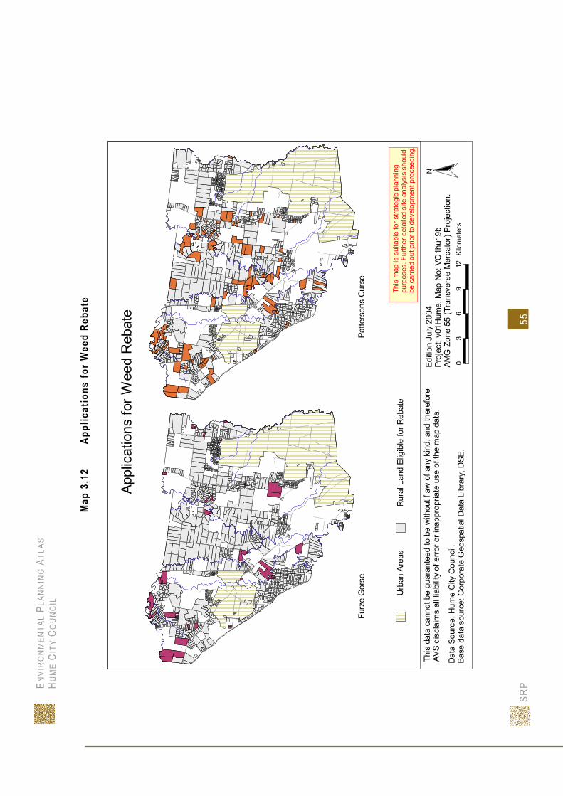
ENVI
RO
NM
ENTA
L PL
ANN
ING
ATL
AS
H UM
E CI
TY C
OU
NC
IL
SRP
55
Map
3.1
2 Ap
plic
atio
ns fo
r W
eed
Reba
te
Rur
al L
and
Elig
ible
for R
ebat
eU
rban
Are
asTh
is m
ap is
sui
tabl
e fo
r stra
tegi
c pl
anni
ngpu
rpos
es. F
urth
er d
etai
led
site
ana
lysi
s sh
ould
be c
arrie
d ou
t prio
r to
deve
lopm
ent p
roce
edin
g.
03
69
12Ki
lom
eter
s
Editi
on J
uly
2004
Proj
ect:
v01H
ume,
Map
No:
VO
1hu1
9bAM
G Z
one
55 (T
rans
vers
e M
erca
tor)
Pro
ject
ion.
This
dat
a ca
nnot
be
guar
ante
ed to
be
with
out f
law
of a
ny k
ind,
and
ther
efor
eAV
S di
scla
ims
all l
iabi
lity
of e
rror
or i
napp
ropr
iate
use
of t
he m
ap d
ata.
N
Furz
e G
orse
Patte
rson
s C
urse
Dat
a So
urce
: Hum
e C
ity C
ounc
il.Ba
se d
ata
sour
ce: C
orpo
rate
Geo
spat
ial D
ata
Libr
ary,
DSE
.
Appl
icat
ions
for W
eed
Reb
ate

ENVI
RO
NM
ENTA
L PL
ANN
ING
ATL
AS
H UM
E CI
TY C
OU
NC
IL
SRP
56
Map
3.1
3 Ap
plic
atio
ns fo
r W
eed
Reba
te
Serr
ated
Tus
sock
Prai
rie G
roun
d C
herr
y
Rur
al L
and
Elig
ible
for R
ebat
eU
rban
Are
asTh
is m
ap is
sui
tabl
e fo
r stra
tegi
c pl
anni
ngpu
rpos
es. F
urth
er d
etai
led
site
ana
lysi
s sh
ould
be c
arrie
d ou
t prio
r to
deve
lopm
ent p
roce
edin
g.
03
69
12Ki
lom
eter
s
Editi
on J
uly
2004
Proj
ect:
v01H
ume,
Map
No:
VO
1hu1
9cAM
G Z
one
55 (T
rans
vers
e M
erca
tor)
Pro
ject
ion.
This
dat
a ca
nnot
be
guar
ante
ed to
be
with
out f
law
of a
ny k
ind,
and
ther
efor
eAV
S di
scla
ims
all l
iabi
lity
of e
rror
or i
napp
ropr
iate
use
of t
he m
ap d
ata.
N
Dat
a So
urce
: Hum
e C
ity C
ounc
il.Ba
se d
ata
sour
ce: C
orpo
rate
Geo
spat
ial D
ata
Libr
ary,
DSE
.
Appl
icat
ions
for W
eed
Reb
ate
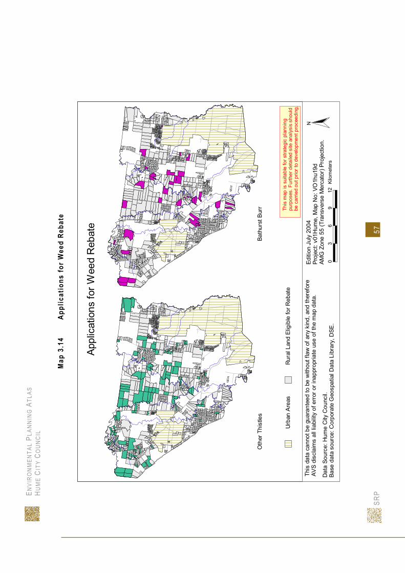
ENVI
RO
NM
ENTA
L PL
ANN
ING
ATL
AS
H UM
E CI
TY C
OU
NC
IL
SRP
57
Map
3.1
4 Ap
plic
atio
ns fo
r W
eed
Reba
te
Rur
al L
and
Elig
ible
for R
ebat
eU
rban
Are
asTh
is m
ap is
sui
tabl
e fo
r stra
tegi
c pl
anni
ngpu
rpos
es. F
urth
er d
etai
led
site
ana
lysi
s sh
ould
be c
arrie
d ou
t prio
r to
deve
lopm
ent p
roce
edin
g.
03
69
12Ki
lom
eter
s
Editi
on J
uly
2004
Proj
ect:
v01H
ume,
Map
No:
VO
1hu1
9dAM
G Z
one
55 (T
rans
vers
e M
erca
tor)
Pro
ject
ion.
This
dat
a ca
nnot
be
guar
ante
ed to
be
with
out f
law
of a
ny k
ind,
and
ther
efor
eAV
S di
scla
ims
all l
iabi
lity
of e
rror
or i
napp
ropr
iate
use
of t
he m
ap d
ata.
N
Oth
er T
hist
les
Bath
urst
Bur
r
Dat
a So
urce
: Hum
e C
ity C
ounc
il.Ba
se d
ata
sour
ce: C
orpo
rate
Geo
spat
ial D
ata
Libr
ary,
DSE
.
Appl
icat
ions
for W
eed
Reb
ate

ENVI
RO
NM
ENTA
L PL
ANN
ING
ATL
AS
H UM
E CI
TY C
OU
NC
IL
SRP
58
Map
3.1
5 Ap
plic
atio
ns fo
r W
eed
Reba
te
Rur
al L
and
Elig
ible
for R
ebat
eU
rban
Are
asTh
is m
ap is
sui
tabl
e fo
r stra
tegi
c pl
anni
ngpu
rpos
es. F
urth
er d
etai
led
site
ana
lysi
s sh
ould
be c
arrie
d ou
t prio
r to
deve
lopm
ent p
roce
edin
g.
03
69
12Ki
lom
eter
s
Editi
on J
uly
2004
Proj
ect:
v01H
ume,
Map
No:
VO
1hu1
9eAM
G Z
one
55 (T
rans
vers
e M
erca
tor)
Pro
ject
ion.
This
dat
a ca
nnot
be
guar
ante
ed to
be
with
out f
law
of a
ny k
ind,
and
ther
efor
eAV
S di
scla
ims
all l
iabi
lity
of e
rror
or i
napp
ropr
iate
use
of t
he m
ap d
ata.
N
Boxt
horn
Blac
kber
ry
Dat
a So
urce
: Hum
e C
ity C
ounc
il.Ba
se d
ata
sour
ce: C
orpo
rate
Geo
spat
ial D
ata
Libr
ary,
DSE
.
Appl
icat
ions
for W
eed
Reb
ate

ENVI
RO
NM
ENTA
L PL
ANN
ING
ATL
AS
H UM
E CI
TY C
OU
NC
IL
SRP
59
Map
3.1
6 Ap
plic
atio
ns fo
r W
eed
Reba
te
Rur
al L
and
Elig
ible
for R
ebat
eU
rban
Are
asTh
is m
ap is
sui
tabl
e fo
r stra
tegi
c pl
anni
ngpu
rpos
es. F
urth
er d
etai
led
site
ana
lysi
s sh
ould
be c
arrie
d ou
t prio
r to
deve
lopm
ent p
roce
edin
g.
03
69
12Ki
lom
eter
s
Editi
on J
uly
2004
Proj
ect:
v01H
ume,
Map
No:
VO
1hu1
9fAM
G Z
one
55 (T
rans
vers
e M
erca
tor)
Pro
ject
ion.
This
dat
a ca
nnot
be
guar
ante
ed to
be
with
out f
law
of a
ny k
ind,
and
ther
efor
eAV
S di
scla
ims
all l
iabi
lity
of e
rror
or i
napp
ropr
iate
use
of t
he m
ap d
ata.
N
Chi
llean
Nee
dle
Gra
ssC
ape
Broo
m
Dat
a So
urce
: Hum
e C
ity C
ounc
il.Ba
se d
ata
sour
ce: C
orpo
rate
Geo
spat
ial D
ata
Libr
ary,
DSE
.
Appl
icat
ions
for W
eed
Reb
ate

ENVI
RO
NM
ENTA
L PL
ANN
ING
ATL
AS
H UM
E CI
TY C
OU
NC
IL
SRP
60
Map
3.1
7 Ap
plic
atio
ns fo
r W
eed
Reba
te
Rur
al L
and
Elig
ible
for R
ebat
eU
rban
Are
asTh
is m
ap is
sui
tabl
e fo
r stra
tegi
c pl
anni
ngpu
rpos
es. F
urth
er d
etai
led
site
ana
lysi
s sh
ould
be c
arrie
d ou
t prio
r to
deve
lopm
ent p
roce
edin
g.
03
69
12Ki
lom
eter
s
Editi
on J
uly
2004
Proj
ect:
v01H
ume,
Map
No:
VO
1hu1
9gAM
G Z
one
55 (T
rans
vers
e M
erca
tor)
Pro
ject
ion.
This
dat
a ca
nnot
be
guar
ante
ed to
be
with
out f
law
of a
ny k
ind,
and
ther
efor
eAV
S di
scla
ims
all l
iabi
lity
of e
rror
or i
napp
ropr
iate
use
of t
he m
ap d
ata.
N
Bone
seed
Cap
e Tu
lip
Dat
a So
urce
: Hum
e C
ity C
ounc
il.Ba
se d
ata
sour
ce: C
orpo
rate
Geo
spat
ial D
ata
Libr
ary,
DSE
.
Appl
icat
ions
for W
eed
Reb
ate

ENVIR ON MENTAL PLANNING ATLAS HUME CITY CO UN C I L
SRP 61
Pest Animals
There are a number of pest animals that are a cause for concern in the Port Phillip region. The most serious for the Hume area is the European Rabbit (Oryctolagus cuniculus) and to a lesser extent the Red Fox (Vulpes vulpes).
European Rabbit (Oryctolagus cuniculus) The establishment of the wild rabbits across Victoria has lead to a wide range of environmental and agricultural impacts. These impacts include loss of potential grazing or agricultural land, increased soil erosion, reduction in plant coverage through intensive rabbit grazing and the alteration of plant species composition in some areas (Bloomfield, 1999b). The cost of these impacts to Victoria’s economy in 1998 is estimated to be $360 million (Bloomfield, 1999b). Rabbits were declared an established pest species in Victoria in the Catchment and Land Protection Act 1994. Several management programs have been developed to control the rabbit population including the release of the Myxomatosis virus, the release of the Rabbit Calicivirus Disease, the Victorian Rabbit Buster program and Catchment Management Plans. The Port Phillip and Westernport Catchment Management Authority (PPWCMA) has developed a Rabbit Action Plan. The intention of the plan is to provide land managers with a clear understanding of their responsibilities and to provide a strategic framework for the management of rabbits on public and private land (PPWCMA, 2003). Currently within the Port Phillip region there are approximately 190,000 hectares of land classified as being “under long term control”. This means that rabbit numbers in those areas are at a level where they do not have a measurable impact on land suitability, productivity and biodiversity, and can be maintained with a routine program (PPWCMA, 2003). The PPWCMA has also identified a ‘high priority zone’ within the region were enhanced Government services will be focussed. This ‘high priority zone’ was defined following an analysis of:
• Soil type and rainfall data (indicating the inherent rabbit proneness); • The presence of native vegetation (indicating environmental importance); • Land use indicating potential economic value. (PPWCMA, 2003)
Map 3.17 illustrates the ‘long term control’ area and the ‘high priority zone’ within Hume. Most of Hume is covered by the ‘high priority zone’ area; this shows that the rabbit problem in Hume will receive extra government services. A small area to the south west of Sunbury is in the ‘long term control’ area which indicates that rabbits in this area are at a manageable level.

ENVI
RO
NM
ENTA
L PL
ANN
ING
ATL
AS
H UM
E CI
TY C
OU
NC
IL
SRP
62
Map
3.1
8 Ra
bbit
Cont
rol A
reas
Editi
on F
ebru
ary
2004
Proj
ect:
v01H
ume,
Map
No:
v01
hu26
AMG
Zon
e 55
(Tra
nsve
rse
Mer
cato
r) Pr
ojec
tion.
This
map
is s
uita
ble
for s
trate
gic
plan
ning
purp
oses
. Fur
ther
det
aile
d si
te a
naly
sis
shou
ldbe
car
ried
out p
rior t
o de
velo
pmen
t pro
ceed
ing.
City
of H
ume:
Rab
bit C
ontro
l Are
as
02
46
8Ki
lom
eter
sBa
se d
ata
sour
ce: C
orpo
rate
Geo
spat
ial D
ata
Libr
ary,
DS
E.D
ata
Sour
ce: P
ort P
hillip
and
Wes
tern
port
Cat
chm
ent M
anag
emen
t Aut
horit
y
This
dat
a ca
nnot
be
guar
ante
ed to
be
with
out f
law
of a
ny k
ind,
and
ther
efor
e A
VS
disc
laim
s al
l lia
bilit
y of
err
or o
r ina
ppro
pria
te u
se o
f the
map
dat
a.N
Long
Ter
m C
ontro
l Are
a
Hig
h Pr
iorit
y Ar
ea

ENVIR ON MENTAL PLANNING ATLAS HUME C ITY CO UNCIL
SRP 63
WATER 4.1 WATERWAYS
In Hume, waterways with their sinuous watercourses, their sunken riparian land and the sometimes imposing escarpments support a wide variety of flora and fauna species and supply important freshwater for agriculture, industry and urban development. They also provide recreational opportunities and are an important element in the visual landscape. The water cycle involves complex interactions and relationships between different water resource components. In the urban and rural settings these different components can include waterways, but they also include groundwater, wetlands, estuaries, coasts, marine waters, sewage, urban stormwater and irrigation districts. All of these components can influence each other, and can, in turn, be influenced by each other. When humans enter this complex web and attempt to manage any one aspect of the water cycle what may seem like a simple intervention can have complex and sometimes unexpected results. Not only are the various components of the water cycle interconnected, but waterway systems are an integral part of the overall catchment system and their condition and health is directly linked to land use across this catchment. However, as in the case of Hume, administrative boundaries are often inconsistent with catchment boundaries. Hume straddles three important catchments, the Werribee River Catchment, the Maribyrnong River Catchment and the Yarra River Catchment (See Maps 4.1 and 4.3). The health of the waterways flowing through Hume is influenced by the diversity of habitats and biota within the area of Hume itself, and upstream, within the broader catchments. The health of a particular waterway is also determined by the effectiveness of its linkages. That is, the way that the waterway transfers sediments, nutrients and biota; how it connects to groundwater systems, and how it connects with its floodplain and the riparian land (DNRE, 2002). The waterways that flow through Hume and their catchments have been greatly altered from their pristine condition by the expansion of farming and urbanisation. The ongoing effects of these changes to catchment land use further threaten the health of these waterways. Threats to waterways include flow reduction due to water use and storage, degradation from adjoining land use practices, erosion resulting in the sedimentation of the watercourse and water pollution (DNRE, 1997). Water quality is threatened by both point sources and diffuse sources of pollutants. Point sources that contribute pollution can be domestic wastewater from wastewater treatment plants, or industrial wastewater. Diffuse sources of pollution, that is, pollutants carried in surface runoff, or via groundwater can include; sediment from erosion, runoff from forestry or construction sites, septic tanks, urban stormwater, irrigation drainage, litter, industrial effluent or rising water tables. Stream flow is a fundamental element of healthy stream ecology and alteration to flow can change the diversity of aquatic and riparian habitats and biota and affect the linkages between river and floodplain. In Hume, stream flow is threatened by upstream regulation of streams to supply irrigation, urban water supplies and also urbanisation in unregulated waterways (DNRE, 2002).

ENVIR ON MENTAL PLANNING ATLAS HUME C ITY CO UNCIL
SRP 64
Waterways comprise several important visual components of the landscape, including the watercourse, adjoining riparian land, nearby escarpments and surrounding land. The watercourse is the river or stream itself and, in Hume, most waterways have been altered through vegetation clearance or adjacent urban development, which effect drainage patterns, rates of run-off and ultimately regional hydrological regimes. River and stream flow is also reduced as water is diverted for irrigation, urban and other off stream uses. Significant threats to watercourses include, bed and bank erosion, mobilisation and deposition of sediment, removal of in-stream woody debris, dredging or bridge building, drainage improvements and the introduction of barriers. Riparian land or ‘the area of land that adjoins, regularly influences, or is influenced by, a river’ (DNRE, 2002. p.90), may include the stream bank, regularly flooded gullies, wetlands and billabongs located on the floodplain. Riparian land, particularly that component nearest the watercourse, has a large influence on the health of the waterway. In particular riparian land contributes organic matter, supplies key habitat for many fish and invertebrates, is a source of shade which influences water temperature and light penetration and assists in bank stabilisation Land surrounding the riparian zone of waterways often has a large impact on the health of the waterway system and may contain significant areas of habitat (DNRE, 2002). In particular, significant threats to riparian land include: clearing, erosion, uncontrolled stock access, recreational use, weed invasion, stream crossings, salinity, urban development and water management.

ENVI
RO
NM
ENTA
L PL
ANN
ING
ATL
AS
HU
ME
CIT
Y C
OU
NC
IL
SRP
6
5
Map
4.1
Su
rrou
ndin
g Ca
tchm
ents
.
Hum
e
Gou
lbur
n R
iver
Cat
chm
ent
Buny
ip R
iver
Cat
chm
ent
Mar
ibyn
ong
Riv
er
Cat
chm
ent
Lodd
on R
iver
C
atch
men
t
Yarr
a R
iver
Cat
chm
ent
Barw
on R
iver
Cat
chm
ent
Moo
rabo
ol R
iver
Cat
chm
ent
Wer
ribee
Riv
er
Cat
chm
ent
Cam
pasp
e R
iver
C
atch
men
t
Latro
be R
iver
C
atch
men
t
NTh
is d
ata
cann
ot b
e gu
aran
teed
to b
e w
ithou
t fla
w o
f any
kin
d, a
nd th
eref
ore
AVS
disc
laim
s al
l lia
bilit
y of
erro
r or i
napp
ropr
iate
use
of t
he m
ap d
ata.
Base
dat
a so
urce
: Cor
pora
te G
eosp
atia
l Dat
a Li
brar
y, D
SE.
Editi
on F
ebru
ary
2004
Proj
ect:
v01H
ume,
Map
No:
v01
hu4
AMG
Zon
e 55
(Tra
nsve
rse
Mer
cato
r) Pr
ojec
tion.
010
2030
40Ki
lom
eter
s
Surro
undi
ng C
atch
men
ts

ENVIR ON MENTAL PLANNING ATLAS HUME C ITY CO UNCIL
SRP 66
Catchment Management
At a state level, responsibility for catchment management in Victoria is divided among ten Catchment Management Authorities (CMAs). Hume is situated wholly within the responsibility of the Port Phillip and Westernport CMA. The management of individual CMAs is guided by a Catchment Management Strategy. The strategy for Port Phillip and Westernport CMA was formulated in 1997; however, it currently undergoing revision and the draft of a new strategy should be available during 2004 (see Map 4.2).
At a more local level, each CMA is responsible for the development of catchment management plans for individual sub-catchments. The Port Phillip and Westernport CMA is divided into five sub-catchments. As mentioned earlier, Hume straddles three of these catchments: Werribee River Catchment, Maribyrnong River Catchment and the Yarra River Catchment (see Map 4.3).
Maribyrnong River Catchment The Maribyrnong River catchment has an area of 143,000 ha and contains around 470 kilometres of waterways including the Maribyrnong River. Grazing and broad acre cropping are the main agricultural industries. There are approximately 420 farms covering 82,000 ha. Together, these farms annually contribute around $30 million to the Region's economy (Port Phillip CALP, 1999). At a regional level the Maribyrnong River has been identified as a major corridor for wildlife which provides habitat and passage for native fish including the vulnerable Australian Grayling. The river is also a corridor for a number of bird species, including sections of riparian forest that are much depleted throughout western parts of the Region. The catchment also supports some of the last remaining areas of native grassland close to Melbourne (Port Phillip CALP, 1999). The Maribyrnong River catchment covers the largest area of the three catchments in Hume. Jackson Creek, Deep Creek and its tributary Emu Creek are the most significant streams in the catchment (see Map 4.3).
Deep Creek Deep Creek rises in the Cobaw State Forest and drains about half the total catchment of the Maribyrnong River. Like other creeks in the basin, it is not a permanently flowing stream. It is not unusual for it to cease to flow during the summer months. When it does cease flowing, however, deep pools in some reaches provide important habitat for aquatic flora and fauna (Heron, Doeg et al.).
Emu Creek Within the Hume City Council, Emu Creek is the major tributary of Deep Creek. Emu Creek drains approximately 160 sq. km and, like the Deep Creek, it also dries out during the summer months. Its major tributaries are Bolinda Creek, Main Creek and Charlies Creek (Heron et al., 2002.).
Jacksons Creek According to Heron et al., (2002), under natural conditions, Jacksons Creek, like the others in the basin, would have been a temporary flowing waterway and dried into a series of pools during low rainfall periods. However, Jacksons Creek is now a regulated waterway whos flow is partly

ENVIR ON MENTAL PLANNING ATLAS HUME C ITY CO UNCIL
SRP 67
determined by releases, including specified environmental flows, from Rosslynne Reservoir, a 24,700 ML storage located just upstream of the township of Gisborne. These releases generally occur between late November and the end of April and include 7 licences totalling 203 ML/year in Jacksons Creek and, in the Maribyrnong River downstream of the Deep Creek junction, 47 licences totalling 1096 ML/year (Heron et al., 2002.).
While catchment management is overseen by the Port Phillip and Westernport Catchment Management Authority which has established the Regional Catchment Strategy (RCS), specific management objectives have been developed by a community committee of the CMA; the Maribyrnong Catchment Committee (CC). In 1999, this group developed a Catchment Action Program (CAP) with ‘aims to promote partnerships in the catchment and to guide the development of annual works programs by agencies, local government councils, community groups and other stakeholders by identifying priorities for local action including on-ground works’ (Port Phillip CALP,1999). The CAP identified the following specific management needs of the catchment:
Pest plant and animal control Waterway management and flood protection Water quality protection Integrated land management Native vegetation and habitat protection
Within the theme of waterway management and flood protection, the CAP identified the loss and decline of native vegetation in riparian areas, modified flow regimes, bed and bank erosion and channel modification as important issues in the catchment. Specifically, the CAP noted that streams in the Maribyrnong catchment ‘have become increasingly degraded over time through activities such as clearing and grazing of riparian areas, channelisation, de-snagging and urban development’ (Port Phillip CALP, 1999, p.17). As part of its integrated approach to management of the catchment, the CAP identified several organisations that overlap in responsibility for catchment management and would be required to participate in the action program. Apart from the CMA and the CIC, these were: Melbourne Water, Local Government, NRE (DSE), EPA Victoria and Southern Rural Water. In 1995, a scientific reference panel was established to identify and prioritise flow-stressed rivers in Victoria. The panel identified eight priority rivers including the Maribyrnong River. That is, the catchment’s significant environmental values were being threatened by changes to water quality and natural flow (Heron et al., 2002). The subsequent report by Heron et al. found that the following reaches had overall moderate and high flow stress:
Jacksons Creek downstream of Rosslynne Reservoir in the Low Flow Season; Jacksons Creek at Sunbury in the Low Flow Season; Barringo Creek in the Low Flow Season and in June; Deep Creek upstream of Jacksons Creek in the Low Flow Season; Deep Creek upstream of Emu Creek in the Low Flow Season; and Emu Creek upstream of Deep Creek in the Low Flow Season.
The report also noted that a number of other flow components were identified as highly different from natural in a number of reaches, including:
Mean flow in Jacksons Creek downstream of Rosslynne Reservoir in June;

ENVIR ON MENTAL PLANNING ATLAS HUME C ITY CO UNCIL
SRP 68
Median flow in Jacksons Creek downstream of Rosslynne Reservoir in the High Flow Zero flows in Deep Creek upstream of Boyd Creek.
According to the Hume City Council State of the Environment Report 2003, ‘Waterway management is a long standing and ongoing issue affecting the health or waterways in the northern part of Hume’. Central to the issue is that tributaries to Jacksons Creek, Deep Creek and Emu Creek in the upper part of the Maribyrnong Catchment are outside Melbourne Water’s jurisdiction, and have historically had no designated Waterway Management Authority to assist in managing the pressures of urbanisation (Hume City Council, 2003). Southern Rural Water (SRW) is the storage operator that regulates flow releases from Rosslynne Reservoir as requested by urban and rural customers as specified under the Bulk Entitlements. As a Licensing Authority on behalf of the Minister, SRW manages extractions including restrictions in low flow periods. No further surface water licences are to be issued. Significant gaps exist in the provision of assistance and direction to residents, developers and local government. These gaps have been identified as:
There are often no floodplain or drainage plans; There is no formal referral authority under the Planning & Environment Act for many
planning decisions (SRW and Melbourne Water are delegated to issue Works on Waterway Licences in their respective areas of control)
Little work has been done on erosion and weed control along Creeks; Little prioritisation and coordination of works; and Poor levels of funding for works on waterways.

ENVI
RO
NM
ENTA
L PL
ANN
ING
ATL
AS
HU
ME
CIT
Y C
OU
NC
IL
SRP
6
9
Map
4.2
S
urro
undi
ng C
atch
men
t Man
agem
ent A
utho
ritie
s.
NO
RTH
CE
NTR
ALG
OU
LBU
RN
BR
OKE
N
WES
T G
IPPS
LAN
D
CO
RAN
GAM
ITE
POR
T PH
ILLI
P A
ND
WES
TER
NP
OR
T
HU
ME
NTh
is d
ata
cann
ot b
e gu
aran
teed
to b
e w
ithou
t fla
w o
f any
kin
d, a
nd th
eref
ore
AV
S di
scla
ims
all l
iabi
lity
of e
rror
or i
napp
ropr
iate
use
of t
he m
ap d
ata.
Base
dat
a so
urce
: Cor
pora
te G
eosp
atia
l Dat
a Li
brar
y, D
SE.
Editi
on F
ebru
ary
2004
Proj
ect:
v01H
ume,
Map
No:
V01
hu2
AMG
Zon
e 55
(Tra
nsve
rse
Mer
cato
r) Pr
ojec
tion.
020
4060
80Ki
lom
eter
s
Surro
undi
ng C
atch
men
t Man
agem
ent A
utho
ritie
s
This
map
is s
uita
ble
for s
trate
gic
plan
ning
purp
oses
. Fur
ther
det
aile
d si
te a
naly
sis
shou
ldbe
car
ried
out p
rior t
o de
velo
pmen
t pro
ceed
ing.

ENVI
RO
NM
ENTA
L PL
ANN
ING
ATL
AS
HU
ME
CIT
Y C
OU
NC
IL
SRP
7
0
Map
4.3
M
ajor
Wat
erw
ays
and
Drai
nage
.
DEEP CREEK
JACKSON CREEK
EMU CREEK
AITK
EN C
REE
K
MALCOLM CREEK
MOONEE PONDS CREEK
LONGVIEW CREEK
STEELE CREEK
MERRI C
REEK
JACKSON CREEK
KOR
OR
OI T
CR
EEK
GR
EEN
VA
LER
ESE
RV
OIR
NTh
is d
ata
cann
ot b
e gu
aran
teed
to b
e w
ithou
t fla
w o
f any
kin
d, a
nd th
eref
ore
AVS
disc
laim
s al
l lia
bilit
y of
erro
r or i
napp
ropr
iate
use
of t
he m
ap d
ata.
Base
dat
a so
urce
: Cor
pora
te G
eosp
atia
l Dat
a Li
brar
y, D
SE.
Editi
on M
arch
200
4Pr
ojec
t: v0
1Hum
e, M
ap N
o: v
01hu
16AM
G Z
one
55 (T
rans
vers
e M
erca
tor)
Proj
ectio
n.0
24
68
Kilo
met
ers
Maj
or C
atch
men
tsW
ater
way
s an
dD
rain
age
This
map
is s
uita
ble
for s
trate
gic
plan
ning
purp
oses
. Fur
ther
det
aile
d si
te a
naly
sis
shou
ldbe
car
ried
out p
rior t
o de
velo
pmen
t pro
ceed
ing.
Mar
ibyn
ong
Riv
erW
errib
ee R
iver
Yarra
Riv
er

ENVIR ON MENTAL PLANNING ATLAS HUME C ITY CO UNCIL
SRP 71
Yarra River Catchment According to the Yarra River Catchment Action Plan (Port Phillip CALP, 1998), the catchment of the Yarra River is the most populous and diverse of any major catchment in Victoria. It encompasses a variety of landscapes, from pristine bushland to the highly urban central business district of the City of Melbourne. The Yarra River is 245 kilometres long from its source in the Yarra Ranges National Park to its estuary at Port Phillip Bay. Its catchment covers 4044 square kilometres and includes sub-catchments based on the Little Yarra River, Woori Yallock Creek, Plenty River, Diamond, Merri and Gardiners Creeks. Of the 78 local government councils in Victoria and 18 of these are located in the Yarra catchment.
Merri Creek The Merri Creek forms the eastern boundary of the Hume City Council and since 1989 has been actively monitored by the Merri Creek Management Committee Incorporated. This integrated environmental management agency was formed in 1989 to create a shared vision for the Creek of between the many stakeholders of the Merri Creek Catchment. Members of the group include, the Darebin, Hume, Moreland, Whittlesea and Yarra City Councils, the Friends of Merri Creek and, from 2003, the Mitchell Shire Council. The group does not include members from the major management authorities of DSE or Melbourne Water. The Merri Creek Management Committee aims to ‘ensure the preservation, restoration, environmental protection and ecologically sensitive development and maintenance of the Merri Creek and adjoining catchment areas, with a long term aim of securing a major regional park ("the Merri Creek Parklands") with significant recreation and conservation value’ (Merri Creek Management Committee, 2004).
Werribee River Catchment Only a relatively small area of the Werribee River catchment lies within Hume but, significantly, this small area contains the headwaters of the Kororoit Creek which first appears on the slopes of Mount Holden in Sunbury. The Werribee River catchment has an area of 270,000 ha, containing 430 farms which supply agricultural produce worth around $70 million per annum. Over 100,000 ha of these plains support agricultural enterprises based on broad acre cropping and livestock. Around Bacchus Marsh and Werribee where water from the river is available for irrigation, there is intensive farming including market gardens and orchards. Six areas in the catchment are designated for water supply and together provide 25,600 ML for domestic, industry and agricultural use. Similar to the Maribyrnong Catchment, specific management objectives for the Werribee River Catchment have been developed by a Catchment Implementation Committee.
Water supply
The provision of water supply in Victoria is under the control of two types of water authorities. Urban water authorities provide water and dispose of urban and industrial waste for towns and cities, and rural water authorities supply water for non-urban water uses like irrigation and stock and domestic supply, manage public reservoirs and supply bulk water to urban water authorities. In addition, Licensing Authorities (Rural Water Authorities and Melbourne Water) regulate the ‘take & use’ of water from streams, and RWA’s similarly regulate and manage the extraction of groundwater. Urban water supply in Hume is shared between Melbourne Water and Western Water, while the regulation of rural water in the Hume City Council is under the control of Southern Rural Water.

ENVIR ON MENTAL PLANNING ATLAS HUME C ITY CO UNCIL
SRP 72
Southern Rural Water operates one significant impoundment in the Maribyrnong catchment, Rosslynne Reservoir on Jacksons Creek at Gisborne. While some water from Rosslynne Reservoir is diverted into Jacksons Creek and the Maribyrnong River for local irrigation, the majority of water (86% of the total entitlement) is supplied to Western Water for non-metropolitan urban water supply. Melbourne Water operates a balancing reservoir at Greenvale (27,000 ML) to manage supply in Melbourne's west.
Water availability
In its recent green paper, Securing Our Water Future (DSE, 2003), the Victorian State government announced its intention to make significant changes to the way water is allocated for urban, industrial and rural purposes. As part of its proposed framework for sustainable water allocation the intention is to:
• Establish an environmental reserve under the Water Act 1989. • For rivers and aquifers that are not over allocated, allocation of further entitlements only
within sustainable diversion limits. • For rivers and aquifers that are over allocated and stressed:
- capping consumptive entitlements and diversions at current levels, and then - improving environmental entitlements and reducing caps
• Metering all significant water uses. (DSE, 2003)
The environmental reserve is intended to be a quantity of water in all streams in Victoria that will be allocated to the environment and will be managed on behalf of the environment by the Catchment Management Authority. There are no new licences to be issued in Victoria for diversions in summer. In some catchments, water is available for new licences for diversion in the winter and spring months. To guide the allocation of water within sustainable limits, the government has developed guidelines through the Sustainable Diversions Limit Project. Sustainable diversion limits (SDL) are upper limits on water extraction during the period July to October, beyond which, there is unacceptable risk of damage to the riverine environment (DSE, 2002). The green paper recommends that water allocation in the Werribee and Yarra catchments should be capped at current levels, to prevent further deterioration in environmental health. This would include the Maribyrnong catchment which is also highly committed, the potential diversion into Rosslynne Reservoir exceeding the sustainable diversion limit (SDL) for this catchment (as estimated from the Sustainable Diversion Limits Project) (Bill Hansen, DSE Catchment & Water Services; Personal Communication). The licensing authorities (Southern Rural Water and Melbourne Water) currently take the SDL's into account when issuing or transferring licences. No new licences are issued by SRW, although further winterfill licences have being issued by Melbourne Water on Maribyrnong River downstream of Deep Creek junction (with scope for up to a further 250ML). Table 4.1 summarises the current water allocation in the Yarra, Werribee and Maribyrnong Catchment.

ENVIR ON MENTAL PLANNING ATLAS HUME C ITY CO UNCIL
SRP 73
Table 4.1 Summary of current water allocation in the Yarra, Werribee and Maribyrnong catchments.
Catchment Type of entitlement Average allocation (ML/year)
Yarra (fully allocated) Indicative environmental reserve
1 Bulk entitlements
Melbourne (not yet finalized)Unregulated licenses
Private rights2 (farm dams)Total consumptive entitlement
Total river flow
685,600
460,200 34,000 20,200 514,400
1,200,000
Werribee (fully allocated) Indicative environmental reserve
1 Bulk entitlements
Western WaterCentral Highlands Water
Southern Rural WaterUnallocated share of Lake Merrimu
Unregulated licensesPrivate rights2 (farm dams)
Total consumptive entitlementTotal river flow
104,170
7,190 590
21,810 2,020 860
10,360 42,830 147,000
Maribyrnong
Indicative environmental reserve1
Bulk entitlements - Western Water
Southern Rural WaterMelbourne Water
Unregulated licencesPrivate rights2 (farm dams)
Total consumptive entitlement
Water available for new development under the Statewide SDL's Total river flow
106,450
8,370 380
1,100 1430 7,670 18,950
0 125,400
Notes The environmental reserve is expressed here as an average annual volume and applies at the end of valley. The amount is at best indicative because a single number cannot adequately represent the various flow regimes at many different locations within the river basin which determine how effective the environmental reserve is in meeting environmental objectives at each location.
This number is an estimate of water taken under private rights (Water Act s.8(1)) from farm dams. This estimate includes dams used for commercial or irrigation purposes which are currently subject to a licensing process which is not yet completed. When completed, the numbers will be adjusted. At this stage, no estimate is available to record water taken directly from waterways under private rights.
The numbers in this table are estimates and will be verified in consultation with water authorities. Source: DSE Catchment & Water Services

ENVIR ON MENTAL PLANNING ATLAS HUME C ITY CO UNCIL
SRP 74
Water Quality
The Environment Protection Authority, Victoria, (EPA) has a responsibility to protect the beneficial uses of Victoria's environment of through the employment of a range of measures. These responsibilities are outlined in the Environment Protection Act 1970. 'Beneficial uses' that impact on the use of water in Victoria are listed under the State Environment Protection Policy (Waters of Victoria) (see Table 4.2).
Table 4.2 Beneficial uses of water protected in Victoria. Beneficial Uses
Aquatic ecosystems that are: Largely unmodified Slightly to moderately modified Highly modified
Water suitable for: Primary contact recreation Secondary contact recreation Aesthetic enjoyment Indigenous cultural and spiritual values Non-indigenous cultural and spiritual values Agriculture and irrigation Aquaculture Industrial and commercial use Human consumption after appropriate treatment Fish, crustacean and molluscs for human consumption.
Source: State Environment Protection Policy (Waters of Victoria) Monitoring of water quality in Victoria is carried out by a range of organisations, including EPA, Victoria and the Department of Sustainability. Since 1996 a project has been underway to consolidate all water quality data in Victoria's Water Resources Data Warehouse. Currently, in the Data Warehouse there are 7 active monitoring sites within, or adjacent to Hume (see Map 4.4).

ENVI
RO
NM
ENTA
L PL
ANN
ING
ATL
AS
HU
ME
CIT
Y C
OU
NC
IL
SRP
7
5
Map
4.4
Ac
tive
Wat
er Q
ualit
y M
onito
ring
Site
s.
#
#
#
#
#
#
#
JAC
KSO
N C
REE
K @
SU
NBU
RY
EMU
CR
EEK
@ C
LAR
KFIE
LD (M
MB
W)
ARU
ND
EL C
K D
RAI
N A
T TU
LLAM
ARIN
E
DEEP
CR
EEK
@ B
ULL
A D
/S O
F EM
U C
REE
K
JAC
KSO
NS
CR
EEK
@ O
RG
AN P
IPE
S N
AT
MAR
IBYR
NO
NG
RIV
ER
D/S
/JA
CKS
ON
S C
REE
K
MER
RI C
REE
K @
CO
OP
ER S
TRE
ET,
NTh
is d
ata
cann
ot b
e gu
aran
teed
to b
e w
ithou
t fla
w o
f any
kin
d, a
nd th
eref
ore
AV
S di
scla
ims
all l
iabi
lity
of e
rror
or i
napp
ropr
iate
use
of t
he m
ap d
ata.
Dat
a So
urce
: Vic
toria
n W
ater
Res
ourc
es D
ata
War
ehou
seBa
se d
ata
sour
ce: C
orpo
rate
Geo
spat
ial D
ata
Libr
ary,
DS
E.
Editi
on M
arch
200
4Pr
ojec
t: v0
1Hum
e, M
ap N
o: v
01hu
22AM
G Z
one
55 (T
rans
vers
e M
erca
tor)
Proj
ectio
n.0
24
68
Kilo
met
ers
Activ
e W
ater
Qua
lity
Mon
itorin
g Si
tes
This
map
is s
uita
ble
for s
trate
gic
plan
ning
purp
oses
. Fur
ther
det
aile
d si
te a
naly
sis
shou
ldbe
car
ried
out p
rior t
o de
velo
pmen
t pro
ceed
ing.

ENVIR ON MENTAL PLANNING ATLAS HUME C ITY CO UNCIL
SRP 76
Water quality in Victoria is monitored using the presence of physico-chemical measures such as nitrogen, conductivity and turbidity. Water quality is also regularly assessed through the assessment of biological quality using the AUSRIVAS biological protocol. Additionally, an Index of Stream Condition has been developed and applied to streams within Hume. A state wide snapshot of stream condition using this method was carried out in 1996, while Melbourne Water has carried out its own assessment of stream condition within its drainage area using this methodology. In Map 4.5 this data has been consolidated to produce a map of stream condition for Hume.

ENVI
RO
NM
ENTA
L PL
ANN
ING
ATL
AS
HU
ME
CIT
Y C
OU
NC
IL
SRP
7
7
Map
4.5
In
dex
of S
trea
m C
ondi
tion
NTh
is d
ata
cann
ot b
e gu
aran
teed
to b
e w
ithou
t fla
w o
f any
kin
d, a
nd th
eref
ore
AV
S di
scla
ims
all l
iabi
lity
of e
rror
or i
napp
ropr
iate
use
of t
he m
ap d
ata.
Dat
a So
urce
: Mel
bour
ne W
ater
Cor
pora
tion
Base
dat
a so
urce
: Cor
pora
te G
eosp
atia
l Dat
a Li
brar
y, D
SE.
Editi
on M
ay 2
004
Proj
ect:
v01H
ume,
Map
No:
Vo1
hu25
AMG
Zon
e 55
(Tra
nsve
rse
Mer
cato
r) Pr
ojec
tion.
02
46
8Ki
lom
eter
s
Inde
x of
Stre
am
Con
ditio
n
This
map
is s
uita
ble
for s
trate
gic
plan
ning
purp
oses
. Fur
ther
det
aile
d si
te a
naly
sis
shou
ldbe
car
ried
out p
rior t
o de
velo
pmen
t pro
ceed
ing.
mod
erat
epo
orve
ry p
oor

ENVIR ON MENTAL PLANNING ATLAS HUME C ITY CO UNCIL
SRP 78
4.2 GROUNDWATER
Groundwater is one of the largest sources of freshwater. As water from precipitation penetrates the soil surface, excess water percolates downwards finally reaching a level where all the spaces between soil particles are saturated with water. This level is known as the water table and the area below it as the saturated zone. Water located in the soils saturated zone or within the bedrock below is known as groundwater. The value of groundwater as an alternative to surface water supply is becoming increasingly important. The effects of salinisation are a major threat to this use of groundwater, and an important environmental issue in Australia. Salinisation is often caused by the rising of groundwater levels in the soil, bringing salts in the soil to the surface and, in turn allowing the filtering of salts back down into the groundwater. Other environmental issues involving groundwater include pollution and subsidisation (Nott, 1998). According to Nott (1998), management of groundwater resources should:
• Ensure sustainable use of groundwater resources • Minimise pollution or contamination from surface sources such as industry • Promote no or minimal rise in watertable levels, reducing the risk of salinity in the area • Promote vegetation retention and revegetation in groundwater recharge areas • Prevent inappropriate development in areas affected by groundwater salinity
As part of the National Land and Water Resources Audit (2004), groundwater management units were mapped for the whole of Victoria. These units represent discrete aquifers at the regional scale (see Map 4.7). They do not represent the smaller scale complexity that might characterise groundwater flow in Hume.

ENVI
RO
NM
ENTA
L PL
ANN
ING
ATL
AS
HU
ME
CIT
Y C
OU
NC
IL
SRP
7
9
Map
4.6
G
roun
dwat
er M
anag
emen
t Uni
ts
NTh
is d
ata
cann
ot b
e gu
aran
teed
to b
e w
ithou
t fla
w o
f any
kin
d, a
nd th
eref
ore
AV
S di
scla
ims
all l
iabi
lity
of e
rror
or i
napp
ropr
iate
use
of t
he m
ap d
ata.
Base
dat
a so
urce
: Cor
pora
te G
eosp
atia
l Dat
a Li
brar
y, D
SE.
Editi
on A
pril
2004
Proj
ect:
v01H
ume,
Map
No:
v01
hu23
AMG
Zon
e 55
(Tra
nsve
rse
Mer
cato
r) Pr
ojec
tion.
02
46
8Ki
lom
eter
s
Gro
undw
ater
M
anag
men
t Uni
ts
This
map
is s
uita
ble
for s
trate
gic
plan
ning
purp
oses
. Fur
ther
det
aile
d si
te a
naly
sis
shou
ldbe
car
ried
out p
rior t
o de
velo
pmen
t pro
ceed
ing.
Lach
lan
Port
Philli
p (L
ower
Ter
tiary
Aqu
ifer)

ENVIR ON MENTAL PLANNING ATLAS HUME C ITY CO UNCIL
SRP 80
Groundwater Levels and Usage (bores)
Allocation of groundwater is managed by State Government agencies. In the Hume region, Southern Rural Water is responsible for the allocation and management of groundwater. The quantity of groundwater allocated for use each year has been established through estimates of the sustainable yield, within each Groundwater Management Area. These estimates must be declared by the Minister for Water as Permissible Annual Volumes, and serve to assist in the allocation of groundwater and may indicate when protection and monitoring of groundwater should be increased. Map 4.8 shows the distribution of historical bores in the Hume and their depth. There have been a large number of bores dug in the Hume, most of these for stock and domestic purposes, although only irrigation and commercial bores are actively monitored. In addition, the State Observation Bore Network monitors groundwater levels at selected points. Map 4.9 shows those bores which are currently monitored.
Groundwater Quality
The quality of groundwater involves measurements of both suspended material in the water (such as soils) and dissolved material (such as salts and other chemicals). The salinity of water is often used as a measure of quality and suitability of the water for different uses. There are two main methods of determining the salt content of water. Total dissolved salts (TDS) is measured by evaporating a known volume of water and weighing the remaining salt. Electrical Conductivity (EC) is measured using an EC meter and measures the current flowing in the water (Anderson and Cummings, 1999). Higher EC measurements indicate a stronger current flow and therefore more dissolved salt in the water. The analysis of groundwater data involves the establishment of background levels of suspected pollutants and the determination of trend. That is, what are natural levels, and is it getting better or worse? To answer these questions there is a need for historical data. Groundwater volume and water quality variables fluctuate as a natural response to variation in rainfall and soil and rock chemistry. The mapped data presented here (Map 4.9), indicate that there are insufficient actively monitored groundwater bores in Hume to reliably state groundwater quality or indicate the likelihood of rising groundwater levels. Maps 4.10 and 4.11 represent modelled groundwater levels. That is, they are an estimation of groundwater levels, and likely salinity risk. This data was constructed for the National Land and Water Resources Audit and is an estimate based on historical data and evidence from analysis of regional topography.

ENVI
RO
NM
ENTA
L PL
ANN
ING
ATL
AS
HU
ME
CIT
Y C
OU
NC
IL
SRP
8
1
Map
4.7
Bo
re L
ocat
ions
and
Dep
th
NTh
is d
ata
cann
ot b
e gu
aran
teed
to b
e w
ithou
t fla
w o
f any
kin
d, a
nd th
eref
ore
AVS
disc
laim
s al
l lia
bilit
y of
erro
r or i
napp
ropr
iate
use
of t
he m
ap d
ata.
Base
dat
a so
urce
: Cor
pora
te G
eosp
atia
l Dat
a Li
brar
y, D
SE.
Editi
on F
ebru
ary
2004
Proj
ect:
v01H
ume,
Map
No:
v01
hu15
AMG
Zon
e 55
(Tra
nsve
rse
Mer
cato
r) Pr
ojec
tion.
01
23
4Ki
lom
eter
s
Bore
Loc
atio
nan
d D
epth
This
map
is s
uita
ble
for s
trate
gic
plan
ning
purp
oses
. Fur
ther
det
aile
d si
te a
naly
sis
shou
ldbe
car
ried
out p
rior t
o de
velo
pmen
t pro
ceed
ing.
##
##
###
##
##
##
##
##
##
##
###
##
###
# ##
##
##
##
##
####
##
##
##
##
##
####
## ##
##
###
###
##
# ##
##
##
##
### #
###
###
##
##
##
##
##
##
##
##
##
##
##
##
##
##
##
##
##
##
##
##
##
###
##
##
###
##
###
##
###
##
##
##
##
##
##
##
##
##
##
##
##
##
##
##
##
##
##
##
##
##
##
###
###
##
##
##
##
##
##
##
##
###########
##
##
##
##
##
##
##
##
##
###
##
##
##
##
##
# #####
#
## #
##
##
##
###
# ###
# # ##
##
####
###
#### ###
###
## ###
##
###
##
##
### ##
###
#### ###
##
#
##
#
###
##
##
###
##
##
##
##
##
##
##
###
##
###
# ##
##
##
##
##
####
##
##
##
##
##
####
## ##
##
###
###
##
# ##
##
##
##
### #
###
###
##
##
##
##
##
##
##
##
##
##
##
##
##
##
##
##
##
##
##
##
##
###
##
##
###
##
###
##
###
##
##
##
##
##
##
##
##
##
##
##
##
##
##
##
##
##
##
##
##
##
##
###
###
##
##
##
##
##
##
##
##
###########
##
##
##
##
##
##
##
##
##
###
##
##
##
##
##
# #####
#
## #
##
##
##
###
# ###
# # ##
##
####
###
#### ###
###
## ###
##
###
##
##
### ##
###
#### ###
##
#
##
#
###
<10
m#
10 -
25 m
#
25 -
50 m
#
50 -
100
m#
>100
m#

ENVI
RO
NM
ENTA
L PL
ANN
ING
ATL
AS
HU
ME
CIT
Y C
OU
NC
IL
SRP
8
2
Map
4.8
Ac
tivel
y M
onito
red
Bore
s: L
ocat
ions
and
Dep
th
NTh
is d
ata
cann
ot b
e gu
aran
teed
to b
e w
ithou
t fla
w o
f any
kin
d, a
nd th
eref
ore
AVS
disc
laim
s al
l lia
bilit
y of
erro
r or i
napp
ropr
iate
use
of t
he m
ap d
ata.
Base
dat
a so
urce
: Cor
pora
te G
eosp
atia
l Dat
a Li
brar
y, D
SE.
Editi
on F
ebru
ary
2004
Proj
ect:
v01H
ume,
Map
No:
v01
hu15
aAM
G Z
one
55 (T
rans
vers
e M
erca
tor)
Proj
ectio
n.0
24
68
Kilo
met
ers
Activ
ely
Mon
itore
dBo
res:
Loc
atio
nan
d D
epth
This
map
is s
uita
ble
for s
trate
gic
plan
ning
purp
oses
. Fur
ther
det
aile
d si
te a
naly
sis
shou
ldbe
car
ried
out p
rior t
o de
velo
pmen
t pro
ceed
ing.
####
## ## # #
#
<10
m#
10 -
25 m
#
25 -
50 m
#
50 -
100
m#
>100
m#
##
###
##
##
#
#

ENVI
RO
NM
ENTA
L PL
ANN
ING
ATL
AS
HU
ME
CIT
Y C
OU
NC
IL
SRP
8
3
Map
4.9
De
pth
to g
roun
dwat
er
NTh
is d
ata
cann
ot b
e gu
aran
teed
to b
e w
ithou
t fla
w o
f any
kin
d, a
nd th
eref
ore
AV
S di
scla
ims
all l
iabi
lity
of e
rror
or i
napp
ropr
iate
use
of t
he m
ap d
ata.
Dat
a So
urce
: Nat
iona
l Lan
d an
d W
ater
Res
ourc
es A
udit
Base
dat
a so
urce
: Cor
pora
te G
eosp
atia
l Dat
a Li
brar
y, D
SE.
Editi
on F
ebru
ary
2004
Proj
ect:
v01H
ume,
Map
No:
v01
hu14
AMG
Zon
e 55
(Tra
nsve
rse
Mer
cato
r) Pr
ojec
tion.
02
46
8Ki
lom
eter
s
Estim
ated
Dep
th
to G
roun
dwat
er
This
map
is s
uita
ble
for s
trate
gic
plan
ning
purp
oses
. Fur
ther
det
aile
d si
te a
naly
sis
shou
ldbe
car
ried
out p
rior t
o de
velo
pmen
t pro
ceed
ing.
(in M
etre
s)
1 - 2
m3
- 5 m
6 - 1
0 m
11 -
20 m

ENVI
RO
NM
ENTA
L PL
ANN
ING
ATL
AS
HU
ME
CIT
Y C
OU
NC
IL
SRP
8
4
Map
4.1
0 Ri
sk o
f Sal
inity
– B
ased
on
Dept
h to
Gro
undw
ater
NTh
is d
ata
cann
ot b
e gu
aran
teed
to b
e w
ithou
t fla
w o
f any
kin
d, a
nd th
eref
ore
AV
S di
scla
ims
all l
iabi
lity
of e
rror
or i
napp
ropr
iate
use
of t
he m
ap d
ata.
Dat
a So
urce
: Nat
iona
l Lan
d an
d W
ater
Res
ourc
es A
udit
Base
dat
a so
urce
: Cor
pora
te G
eosp
atia
l Dat
a Li
brar
y, D
SE.
Editi
on F
ebru
ary
2004
Proj
ect:
v01H
ume,
Map
No:
v01
hu12
AMG
Zon
e 55
(Tra
nsve
rse
Mer
cato
r) Pr
ojec
tion.
02
46
8Ki
lom
eter
s
Ris
k of
Sal
inity
- Ba
sed
on D
epth
to G
roun
dwat
er.
This
map
is s
uita
ble
for s
trate
gic
plan
ning
purp
oses
. Fur
ther
det
aile
d si
te a
naly
sis
shou
ldbe
car
ried
out p
rior t
o de
velo
pmen
t pro
ceed
ing.
Hig
h- Im
med
iate
Mod
erat
eLo
wVe
ry L
owN
ot A
pplic
able
- C
oast
al/T
idal
/Low
land
/Urb
an/Ir
rigat
ed

ENVIR ON MENTAL PLANNING ATLAS HUME CITY CO UN C I L
SRP 85
LANDFORMS 5.1 REGIONAL GEOLOGY
Throughout geologic history, various tectonic events have occurred resulting in the folding, faulting and deformation of the Earth’s crust. Constant erosion and deposition has shaped the Earth’s surface resulting in the deposition of a variety of igneous and sedimentary geological layers. Table 5.1 lists the various geological ages some of which are referred to below.
Table 5.1 Geological Time Scale Era Period Epoch Approximate Age
(million of years) Canoizoic Quaternary Recent 0.01
Pleistocene 1.8 Tertiary Pliocene 5 Miocene 25 Oligocene 35 Eocene 55 Palaeocene 65
Mesozoic Cretaceous 140 Jurassic 200 Triassic 250
Palaeozoic Permian 290 Carboniferous 370 Devonian 410 Silurian 440 Ordovician 500 Cambrian 570
Precambrian There is no outcropping in Victoria The ancient Precambrian rocks that form the basement of the Australian continent have not been found to outcrop in Victoria. The oldest known rocks are of Cambrian origin and are approximately 550 million years old. They form narrow but well defined belts or axes, and are composed of highly altered sediments and basaltic rocks called "Greenstones". These outcrop in several areas, and are readily accessible at Mt. William (Lancefield, Macedon Ranges Shire Council). The Early Palaeozoic was also the timing for a number of episodes of igneous activity, as well as the deposition of Palaeozoic marine sediments within the Tasman Geosyncline; a major basin extending over the majority of eastern Australia. The most extensive Early Palaeozoic beds, in the Victorian part of the Tasman Geosyncline comprise Ordovician and Late Cambrian shales, slates and fine grained sandstones. The Early Silurian Benambran Orogeny, folded the Ordovician beds of the Ballarat and Wagga Troughs, and was followed by rapid deposition in the Melbourne Troughs and in the newly formed Buchan and Grampians Troughs. The Melbourne Trough deposition occurred in the form of alternating sandstones and mudstones that reached many thousands of metres in thickness. During the late Devonian and the Early Carboniferous Periods granitic rocks intruded into the Ballarat and Melbourne Troughs. While extensive extrusions of lava formed the Dandenong and

ENVIR ON MENTAL PLANNING ATLAS HUME CITY CO UN C I L
SRP 86
Macedon Ranges. Further the subsidence of large cauldrons resulted in the deposition of massive lavas in the Acheron and Marysville areas. Late in the Tertiary Period and continuing into the Quaternary Period (in the Cainozoic Era) volcanism increased due to the separation of the Australian and Antarctic continental plates. This resulted in the deposition of one of the World's great basalt plains in the Western region of Victoria, termed the Newer Volcanics Province. This province is characterised by approximately 250 eruption points and lava flows. This extensive volcanic activity extended from approximately 6 million years ago to as recently as 1,400 years ago at Mt Gambia in nearby South Australia. Several types of lava flows occurred including sheet flows ands constricted flows along valleys (as seen in the Melbourne Hills near Lancefield). Irregular and chaotic Stony Rises occupy large areas of the basalt plains. Numerous volcanic cones dot the landscape with scoria cones being the most common (e.g.; Mt. Elephant, Mt Napier and Mt Noorat). The majority of the elevation is below 250 m above sea level. Hume is predominantly covered by Newer Volcanics (Map 5.1) and is located in the Macedon-Trentham Province of the Newer Volcanics Province. It is dominated by basaltic and felsic lava flows, scoria cones and mounds approximately 6-7 Million years old. The lava fields in the Lancefield-Sunbury areas were deposited from small lava and lava-scoria cones. Table 5.2 describes the key geological features depicted on Map 5.1 within Hume.
Table 5.2 Descriptions of Geology in Hume
Unit Name Age Description Lithology Bulla Adamellite Devonian Igneous (Intrusive) Granite
Dargile Formation Silurian Sedimentary (Marine) Siltstone, thin-bedded sandstone
Deep Creek Siltstone Silurian Sedimentary (Marine)
Siltstone, thin-bedded, minor sandstone, conglomerate
Fluvial gravels, silts and sands Quaternary Sedimentary (Non-
Marine) Alluvium, gravel, sand, silt
Newer Volcanics Quaternary Igneous (Extrusive) Tholeiitic to alkaline basalts, minor scoria and ash
Older Volcanics Tertiary Igneous (Extrusive) Tholeiitic and minor alkaline basalts
Riddell Sandstone Ordovician Sedimentary (Marine)
Sandstone, thin to thick bedded, shale, mudstone, minor
conglomerate Springfield Sandstone + Chintin Formation Silurian Sedimentary
(Marine) Sandstone, thick to thin bedded,
siltstone, conglomerate Upper Devonian
Granite Devonian Igneous (Intrusive) Granite
Undifferentiated Ordovician Sedimentary (Marine) Sandstone, shale, mudstone
Anderson Creek Formation Silurian Sedimentary
(Marine) Sandstone, thick to thin bedded,
siltstone, minor conglomerate Brighton Gp/
Moorabool Viaduct Sd/ Hanson Plain
Sand Tertiary Sedimentary (Non-
Marine) Gravel, sand, silt
Source: GIS Layer (vic_geol_poly_z55), Geological Survey of Victoria

ENVI
RO
NM
ENTA
L PL
ANN
ING
ATL
AS
H UM
E CI
TY C
OU
NC
IL
SRP
87
Map
5.1
G
eolo
gy o
f Hum
e
#
#
#
#
##
#
#
BULL
A
SUN
BUR
Y
KALK
ALLO
SOM
ERTO
N
MIC
KLE
HAM
GR
EEN
VALE
CRA
IGIE
BUR
N
BRO
AD
MEA
DO
WS
NTh
is d
ata
cann
ot b
e gu
aran
teed
to b
e w
ithou
t fla
w o
f any
kin
d, a
nd th
eref
ore
AV
S di
scla
ims
all l
iabi
lity
of e
rror
or i
napp
ropr
iate
use
of t
he m
ap d
ata.
Base
dat
a so
urce
: Cor
pora
te G
eosp
atia
l Dat
a Li
brar
y, D
SE.
Editi
on F
ebru
ary
2004
Proj
ect:
v01H
ume,
Map
No:
v01
hu8
AMG
Zon
e 55
(Tra
nsve
rse
Mer
cato
r) Pr
ojec
tion.
02
46
8Ki
lom
eter
s
Geo
logy
This
map
is s
uita
ble
for s
trate
gic
plan
ning
purp
oses
. Fur
ther
det
aile
d si
te a
naly
sis
shou
ldbe
car
ried
out p
rior t
o de
velo
pmen
t pro
ceed
ing.
Ande
rson
Cre
ek F
orm
atio
nBr
ight
on G
p/ M
oora
bool
Via
duct
Sd/
Han
son
Plai
n Sa
nd
Bulla
Ada
mel
lite
Dar
gile
For
mat
ion
Dee
p C
reek
Silt
ston
eFl
uvia
l gra
vels
, silt
and
san
dN
ewer
Vol
cani
csO
lder
Vol
cani
csR
idde
ll Sa
ndst
one
Sprin
gfie
ld S
ands
tone
+ C
hint
in F
orm
atio
nU
pper
Dev
onia
n G
rani
teun
diffe
rent
iate
d

ENVIR ON MENTAL PLANNING ATLAS HUME CITY CO UN C I L
SRP 88
5.2 GEOMORPHOLOGICAL OR GEOLOGICAL SITES
Geomorphological or Geological sites of significance are sites that represent a specific characteristic of a region, or includes an outstanding, rare or unique geological or geomorphological feature (VRO, 2004). These sites are of primary interest to research and teaching in the earth sciences, and enable an understanding of the composition, origin and dynamics of the physical landscape of the area. The Geological Society of Australia regularly assesses the significance of geological heritage sites, including sites of geomorphological interest (VRO, 2004). Specifically, geological features identify sites that have significance to the study of the structure of the Earth and the processes responsible for its creation. Geomorphology on the other hand, is a study of the features of the Earth's surface and the processes that created landforms. Sites of geological and geomorphological scientific significance in Hume are shown in Map 5.1.The significance of sites in Hume, fall into the following categories: state, regional, local and unknown. The sites have been identified in the Minerals and Petroleum Sites Database from the Department of Primary Industries, Victoria. Table A5, Appendix 1 summarises the major sites of geological and geomorphological significance in Hume. The table shows the name of the site, provides a short description of the site, the size category of the site, the site’s significance and the management status of the site.

ENVI
RO
NM
ENTA
L PL
ANN
ING
ATL
AS
H UM
E CI
TY C
OU
NC
IL
SRP
89
Map
5.2
Si
tes
of G
eolo
gica
l and
Geo
mor
phol
ogic
al S
igni
fican
ce
#
#
#
#
#
##
#
##
#
##
#
#
#
#
#
#
#
#
##
#
#
#
#
#
1
2
3
4
56
7
89
28
10
1112
13
14
15
16
17
18
19
20
2122
23
24
25
26
27
NTh
is d
ata
cann
ot b
e gu
aran
teed
to b
e w
ithou
t fla
w o
f any
kin
d, a
nd th
eref
ore
AVS
disc
laim
s al
l lia
bilit
y of
err
or o
r ina
ppro
pria
te u
se o
f the
map
dat
a.
Dat
a So
urce
: pD
ata,
Cor
pora
te G
eosp
atia
l Dat
a Li
brar
y, D
SE, 2
004.
Base
dat
a so
urce
: Cor
pora
te G
eosp
atia
l Dat
a Li
brar
y, D
SE.
Editi
on J
uly
2004
Proj
ect:
v01H
ume,
Map
No:
v01
hu8a
AMG
Zon
e 55
(Tra
nsve
rse
Mer
cato
r) P
roje
ctio
n.0
24
68
Kilo
met
ers
Site
s of
Geo
logi
cal
and
Geo
mor
phol
ogic
al
Sign
ifica
nce
This
map
is s
uita
ble
for s
trate
gic
plan
ning
purp
oses
. Fur
ther
det
aile
d si
te a
naly
sis
shou
ldbe
car
ried
out p
rior t
o de
velo
pmen
t pro
ceed
ing.
Loca
l Sig
nific
ance
#
Reg
iona
l Sig
nific
ance
#
Stat
e S
igni
fican
ce#
Unk
now
n#

ENVIR ON MENTAL PLANNING ATLAS HUME CITY CO UN C I L
SRP 90
5.3 TOPOGRAPHY
The topography of Hume is dominated by undulating volcanic and stony volcanic plains with deeply incised rivers. Map 5.3 shows an exaggerated relief map of Hume. While this map is mostly for illustrative purposes, a more complex analysis of slopes was undertaken to highlight the unique distribution of slopes that characterise the Hume landscape. The slope analysis used a Digital Elevation Model of the Hume area with a resolution of 25 metres. The Digital Elevation Model consists of a picture formed from an array of square cells; much like a television screen is made of an array of pixels. Each cell has a value for the altitude at that location. Using Geographic Information System technology this basic information can be used to produce maps of slope; that is the vertical change between one cell and its neighbour, and using a more sophisticated process, it can be used model the way sunlight casts shadows across this digital terrain. The result of this model shadow is clear in Map 5.3. Map 5.4 shows the results of the more complex slope analysis, illustrating the range of slopes in Hume. Clearly the steeper slopes are mostly near waterways. More specifically, 5.5 highlights areas of critical slope, 18 degrees and over. These critical slopes represent a significant concern for the all types of development within Hume. Steep slopes also provide high levels of visual amenity; properties with views from escarpments and other vantage points are sought after for residential development. However, steep slopes also represent a significant risk of soil erosion. Visual inspection of such residential development shows that soil erosion is currently a widespread problem on these slopes.

ENVI
RO
NM
ENTA
L PL
ANN
ING
ATL
AS
H UM
E CI
TY C
OU
NC
IL
SRP
91
Map
5.3
Sh
aded
rel
ief d
evel
oped
from
the
25m
Dig
ital E
leva
tion
Mod
el (S
cale
of t
opog
raph
y is
exa
gger
ated
).
NTh
is d
ata
cann
ot b
e gu
aran
teed
to b
e w
ithou
t fla
w o
f any
kin
d, a
nd th
eref
ore
AV
S di
scla
ims
all l
iabi
lity
of e
rror
or i
napp
ropr
iate
use
of t
he m
ap d
ata.
Base
dat
a so
urce
: Cor
pora
te G
eosp
atia
l Dat
a Li
brar
y, D
SE.
Editi
on A
ugus
t 200
4Pr
ojec
t: v0
1Hum
e, M
ap N
o: V
01hu
27AM
G Z
one
55 (T
rans
vers
e M
erca
tor)
Proj
ectio
n.0
24
68
Kilo
met
ers
Topo
grap
hy
This
map
is s
uita
ble
for s
trate
gic
plan
ning
purp
oses
. Fur
ther
det
aile
d si
te a
naly
sis
shou
ldbe
car
ried
out p
rior t
o de
velo
pmen
t pro
ceed
ing.
(Sca
le is
exa
gger
ated
)

ENVI
RO
NM
ENTA
L PL
ANN
ING
ATL
AS
H UM
E CI
TY C
OU
NC
IL
SRP
92
Map
5.4
Sl
ope
Anal
ysis
NTh
is d
ata
cann
ot b
e gu
aran
teed
to b
e w
ithou
t fla
w o
f any
kin
d, a
nd th
eref
ore
AV
S di
scla
ims
all l
iabi
lity
of e
rror
or i
napp
ropr
iate
use
of t
he m
ap d
ata.
Dat
a So
urce
: pD
ata,
200
1, D
epar
tmen
t of I
nfra
stru
ctur
e (D
OI)
Base
dat
a so
urce
: Cor
pora
te G
eosp
atia
l Dat
a Li
brar
y, D
SE.
Editi
on F
ebru
ary
2004
Proj
ect:
v01H
ume,
Map
No:
V04
huAM
G Z
one
55 (T
rans
vers
e M
erca
tor)
Proj
ectio
n.0
24
68
Kilo
met
ers
Slop
e an
alys
is
from
25m
DEM
This
map
is s
uita
ble
for s
trate
gic
plan
ning
purp
oses
. Fur
ther
det
aile
d si
te a
naly
sis
shou
ldbe
car
ried
out p
rior t
o de
velo
pmen
t pro
ceed
ing.
0 - 1
5 16
- 30
31 -
39
Slop
e in
deg
rees
from
hor
izon
tal

ENVI
RO
NM
ENTA
L PL
ANN
ING
ATL
AS
H UM
E CI
TY C
OU
NC
IL
SRP
93
Map
5.5
Cr
itica
l Slo
pes
HUME FREEWAY
DA
LRYM
PLE
RO
AD
MELBOURNE-LANCEFIELD ROAD
MICKLEHAM ROAD
HUME HIGHWAY
VINEYARD ROAD
SUNBU
RY R
OAD
THE
GA
P R
OA
D
TULLAMARIN
E FREEWAY
CALDER HIGHWAY
SOM
ER
TON
RO
AD
CALDER FREEWAY
PASCOE VALE ROAD
DO
NNY
BR O
OK
RO
AD
SUNBURY-RIDDELLS CREEK ROAD
BAR
RY
ROA
D
HUME HIGHWAY
CALDER HIG
HWAY
NTh
is d
ata
cann
ot b
e gu
aran
teed
to b
e w
ithou
t fla
w o
f any
kin
d, a
nd th
eref
ore
AV
S di
scla
ims
all l
iabi
lity
of e
rror
or i
napp
ropr
iate
use
of t
he m
ap d
ata.
Base
dat
a so
urce
: Cor
pora
te G
eosp
atia
l Dat
a Li
brar
y, D
SE.
Editi
on A
ugus
t 200
4Pr
ojec
t: v0
1Hum
e, M
ap N
o: V
01hu
12a
AMG
Zon
e 55
(Tra
nsve
rse
Mer
cato
r) Pr
ojec
tion.
02
46
8Ki
lom
eter
s
Slop
e: 1
8 de
gree
san
d gr
eate
r fro
mho
rizon
tal.
This
map
is s
uita
ble
for s
trate
gic
plan
ning
purp
oses
. Fur
ther
det
aile
d si
te a
naly
sis
shou
ldbe
car
ried
out p
rior t
o de
velo
pmen
t pro
ceed
ing.
0 -
17 d
egre
es18
- 38
deg
rees
This
dat
a ha
s be
en p
rodu
ced
by s
lope
ana
lysi
s of
a d
igita
l el
evat
ion
mod
el w
ith a
re
solu
tion
of 1
:250
00.

ENVIR ON MENTAL PLANNING ATLAS HUME CITY CO UN C I L
SRP 94
5.4 SOIL ANALYSIS
Introduction
A study of the green wedge area of Hume was conducted to investigate soils as a basis for mapping soil types at a scale of 1:100,000, and assessing their potential for dryland cropping and irrigated cropping.
Published soil surveys relevant to Hume
Two soil surveys have been conducted which cover most of the green wedge area of Hume. Jeffery (1981) reported a survey of land to the north of Melbourne which included Hume. Jeffery’s landsystem map was printed at a scale of 1:250,000. It was not reported if field observation intensity was sufficient or in excess of that needed (this is estimated from the mapping scale and the complexity of the land). Jeffery (1981) stated that the boundaries of some map units were arbitrarily drawn given the difficulties in distinguishing between some landsystems. Ninety five soil profiles were described, but only one is described and presented in the published report from Hume. White and Kelynack (1985) published a survey of 230,000 ha of the semi-rural fringe of Melbourne, at a scale of 1:25,000. Their survey includes the rural areas of Hume. Their survey was substantially based on aerial photo interpretation since they had limited resources for field work and soil analyses. These authors caution the reader about the statistical deficiencies of the published report. It is not known if any soil samples used as reference samples by White and Kelynack (1985) for soil types mapped in Hume originated from Hume. Table 5.1 and Map 5.5 outline landsystems identified by Jefferey, while, Table 5.2 and Map 5.6 outline soil types identified by White and Kelynack.
Table 5.3 Landsystems in Hume from Jeffery (1981)
Landsystem Area (ha)
Geological period Landform pattern
Dominant soil(s)
Monegeeta 4,657
Pleistocene basalt Lava plain with volcanic cones
Mottled yellow, grey sodic duplex* soils, coarse structure
Mickleham 10,065 Pleistocene basalt Lava plain with volcanic cones
Mottled yellow, grey sodic duplex soils, coarse structure
Wollert 313 Pleistocene basalt Lava plain with stony rises
Shallow stony red gradational soils
Maribyrnong 892 Pleistocene basalt Lava plain with volcanic cones
Red calcareous sodic duplex soils, coarse structure
Footscray 9,997 Pleistocene with Lava plain Grey calcareous sodic

ENVIR ON MENTAL PLANNING ATLAS HUME CITY CO UN C I L
SRP 95
deposits from Silurian sedimentary rock and Devonian igneous rock
clay soils, coarse structure
Sunbury 4,657 Ordovician sedimentary rock
Low hills Mottled yellow, brown sodic duplex soils, coarse structure, and shallow stony gradational soils
Greenvale 3,804 Devonian granodiorite Low hills Brown sodic duplex soils, coarse structure
Darraweit Guim 2,764 Silurian sedimentary rock
Low hills Mottled yellow, brown sodic duplex soils, coarse structure
Marnong 576 Silurian sedimentary rock
Plain Yellow sodic duplex soils, coarse structure
*Duplex soils have a strong contrast in texture between the surface soil and the sub-surface soil in which the change in texture between the two occurs over a depth of less than 10 cm. In contrast, gradational soils either do not have a strong texture contrast or the change in texture occurs over a depth greater than 10 cm, and uniform soils have little change in texture. In Hume, the surface soil of Duplex soils is clay loam or lighter, and the sub-surface soil is light medium clay or heavier.

ENVI
RO
NM
ENTA
L PL
ANN
ING
ATL
AS
H UM
E CI
TY C
OU
NC
IL
SRP
96
Map
5.6
La
nd S
yste
ms
in H
ume
from
Jef
fery
(198
1)
NTh
is d
ata
cann
ot b
e gu
aran
teed
to b
e w
ithou
t fla
w o
f any
kin
d, a
nd th
eref
ore
AVS
disc
laim
s al
l lia
bilit
y of
err
or o
r ina
ppro
pria
te u
se o
f the
map
dat
a.
Dat
a So
urce
: Soi
l Con
serv
atio
n A
utho
rity,
198
1.Ba
se d
ata
sour
ce: C
orpo
rate
Geo
spat
ial D
ata
Libr
ary,
DSE
.
Editi
on J
uly
2004
Proj
ect:
v01H
ume,
Map
No:
v01
huso
il1AM
G Z
one
55 (T
rans
vers
e M
erca
tor)
Pro
ject
ion.
01
23
4Ki
lom
eter
s
Land
Sys
tem
s
This
map
is s
uita
ble
for s
trate
gic
plan
ning
purp
oses
. Fur
ther
det
aile
d si
te a
naly
sis
shou
ldbe
car
ried
out p
rior t
o de
velo
pmen
t pro
ceed
ing.
Dar
raw
eit G
uim
Foot
scra
yG
reen
vale
Mar
nong
Mic
kleh
amM
oneg
eeta
Mar
ibyr
nong
Sunb
ury
Wol
lert
Urb
an G
row
th B
ound
ary
Jeffe
ry (1
981)

ENVIR ON MENTAL PLANNING ATLAS HUME CITY CO UN C I L
SRP 97
Table 5.4 Soil types in Hume from White and Kelynack (1985)
Soil type
Area (ha)
Brief description Landscape Parent material
3 4 Deep friable stratified loams Terraces of the Werribee River
Quaternary alluvium
4 172 a) Deep gradational soils with a bleached A2 horizon often present, or b) Deep, often gravelly, duplex and gradational soils with mottling at depth
a) Upper terraces of the Deep, Emu and Konagaderra Creeks, or b) Terraces of drainage lines of the Deep, Emu and Konagaderra Creeks and the Maribynong River
Quaternary alluvium
10 1,337 a) Deep, medium duplex soils with an A2 horizon* that may be bleached, or b) Moderately deep, well structured gradational soils
Alluvial plains and drainage lines receiving alluvium from Silurian or Ordivician sedimentary rock
Quaternary alluvium
11 76 Deep, well structured duplex soils with a friable surface
Alluvial plains of the Plenty River
Quaternary alluvium
16 4 Deep, well structured duplex soils
Plain representing an intergrade zone between the Werribee delta and neighbouring lava plain covered in loess
Quaternary pulludium
17 694 A complex of deep duplex and uniform soils. A2 horizons and calcareous inclusions may occur
Drainage lines of lava plains
Quaternary alluvium of basaltic origin
18 130 Deep, strongly structured uniform saline clays
Terraces and drainage lines near Kororoit and Donnybrook
Quaternary alluvium of basaltic origin
19 189 Deep, structured mottled yellow and yellow-grey alluvial duplex soils
Terraces and drainage lines of Greenvale, Oaklands Junction, Berwick and Pakenham
Quaternary alluvium of granitic origin
22 2 Moderately deep to deep non-coherent acidic sands
Dunes and sand sheets of Chelsea, Keysborough and Carrum Downs
Pleistocene aeolian deposits
25 1,265 Moderately deep heavy plastic cracking clays
Lava plains of Woodstock, Wollert and Mill Park
Early Quaternary and Late Tertiary basalt
26 19,920 A complex of deep well structured duplex or gradational soils of basaltic origin
Lava plains of Port Phillip catchment
Early Quaternary and Late Tertiary basalt
27 553 Deep, well structured gradational and duplex soils
Lava plains west and south of Sunbury
Early Quaternary and Late Tertiary

ENVIR ON MENTAL PLANNING ATLAS HUME CITY CO UN C I L
SRP 98
Soil type
Area (ha)
Brief description Landscape Parent material
which are calcareous at depth
basalt
28 12 Moderately deep self-mulching cracking clays
Lava plains near Diamond Creek and Maribynong River
Tertiary basalt
34 12 Moderately deep to deep duplex soils which often exhibit a bleached A2 horizon
Low hills of the Shire of Eltham
Silurian or Devonian sedimentary rock
35 13 Deep friable well structured gradational and duplex soils
Low hills of Kinglake Silurian or Devonian sedimentary rock
36 7,367 Shallow to deep gradational soils with loamy topsoils overlying gritty clay subsoils
Low hills of Toolern Vale and Sunbury
Ordovician sedimentary rock
38 2,595 A complex of deep well structured duplex soils with clayey subsoils
Low hills of Bulla, Greenvale, Oaklands Junction, Westmeadows, Konagaderra, South Morang
Devonian Granodiorite
*Lower part of the surface soil (A horizon). A1 horizon is the upper part. The two are differentiated by the A1 horizon being darker, it having more organic matter and roots. The sub-surface soil is the B horizon and is differentiated from the A horizon by being more clayey. Soils in their natural state, have at least an A1 horizon and may or may not have an A2 horizon or B horizon.

ENVI
RO
NM
ENTA
L PL
ANN
ING
ATL
AS
H UM
E CI
TY C
OU
NC
IL
SRP
99
Map
5.7
So
il ty
pes
in H
ume
repo
rt b
y W
hite
and
Kel
ynac
k (1
985)
NTh
is d
ata
cann
ot b
e gu
aran
teed
to b
e w
ithou
t fla
w o
f any
kin
d, a
nd th
eref
ore
AVS
disc
laim
s al
l lia
bilit
y of
err
or o
r ina
ppro
pria
te u
se o
f the
map
dat
a.
Dat
a So
urce
: Dep
artm
ent o
f Con
serv
atio
n, 1
985.
Base
dat
a so
urce
: Cor
pora
te G
eosp
atia
l Dat
a Li
brar
y, D
SE.
Editi
on J
uly
2004
Proj
ect:
v01H
ume,
Map
No:
v01
huso
il2AM
G Z
one
55 (T
rans
vers
e M
erca
tor)
Pro
ject
ion.
01
23
4Ki
lom
eter
s
Soil
Type
s
This
map
is s
uita
ble
for s
trate
gic
plan
ning
purp
oses
. Fur
ther
det
aile
d si
te a
naly
sis
shou
ldbe
car
ried
out p
rior t
o de
velo
pmen
t pro
ceed
ing.
Urb
an G
row
th B
ound
ary
0 3 4 10 11 16 17 18 19
22 25 26 27 28 34 35 36 38
Whi
te a
nd K
elyn
ack
(198
5)

ENVIR ON MENTAL PLANNING ATLAS HUME CITY CO UN C I L
SRP 100
Methods
Investigative activities included collation and examination of the above reports, aerial photography and radiometry. Field work was also undertaken. Most effort was focused on the major soil types that had previously been reported in Hume. Soil types of minor extent were only examined where circumstances allowed. It is conceded that some minor soil types, especially those which occur on alluvial plains and terraces, may have greater agricultural potential or versatility than the major soils types of Hume. However, at the scale of 1:100,000 as used for this study, small areas, i.e. < 20 ha, or thin linear areas, i.e. < 300 m, are ignored. Field work consisted of in situ description of soils and classification of the landscape in which the soils were set (MacDonald et al. 1990). The map below illustrates the sampling of the study area (Map 5.6). Field work utilised auger holes, land surface condition, road cuttings, dams and earth works. Detailed soil descriptions were limited to auger holes in paddocks or undisturbed roadside reservations. Soil descriptions were limited to soil colour (moist), field texture, horizon classification and horizon boundary distinctness. This allowed classification of the soil types to the level of division using the Factual Key (Northcote, 1979) for comparison with previous surveys. Further analysis based on samples taken from pits is needed to classify these soils using the Australian Soil Classification (Isbell, 1996), and to indicate their fertility and hydraulic properties.
Map 5.8 Observat ion Points and Soi l Sampling si tes in Hume

ENVIR ON MENTAL PLANNING ATLAS HUME CITY CO UN C I L
SRP 101
Assessment of reports of Jeffery (1981) and White and Kelynack (1985)
Many areas in the maps of the reports by Jeffery (1981) and White and Kelynack (1985) need improvements as does the soil data base used to provide information about soils in each map unit. While at the time of publication, both surveys had sufficient chemical and physical data for their purpose, they are now deficient in terms of their range of soil analyses. The wider range of crops used in today’s agriculture demands a wider range of soil fertility analyses. Furthermore, new research has shown traditional crops have been limited by previously unknown soil factors. For example, boron analyses were not undertaken by Jeffery (1981) and White and Kelynack (1985) and it has become suspected that boron toxicity may limit cereal and grape production on the western plains of Melbourne. Data on soil hydraulic properties and moisture retention is needed to assess salinity risk posed by irrigated agriculture. Obviously, the arbitrary drawing of map unit boundaries by Jeffery (1981) to differentiate land systems of similar geologies needs improvement. However, Jeffery (1981) separated the basalt land systems on rockiness of the land surface and stoniness of the soils, amongst other characteristics, which is valuable given their impact on agricultural potential. The assignment of soil types to map units can be questioned in several instances in the maps published by White and Kelynack (1985). Here are some examples:
• Soil types 3, 11, 16 and 22, are described from landform/soil type combinations associated with areas outside Hume. For instance, soil type 22 represents aeolian sand deposits, i.e. sand dunes, related to the Carrum Swamp.
• Several map units assigned soil type 10 would have soils whose parent material would be derived from basalt rather than the stated sedimentary rock, given that these map units represent drainage lines exclusively draining lava plains, e.g. most of Longview Creek.
• Radiometric data suggests that some map units are incorrectly assigned soil type 36 when they should be a soil type associated with basalt.
• Extensive areas of some map units associated with sedimentary rock are drawn so as to represent lava plains. Radiometry and on-ground inspection suggest that they need to be redrawn.
• Several map units in the parishes of Mickleham and Kalkallo are assigned soil type 25, a cracking clay. Field inspection suggests that all or some parts of these map units are not cracking clays.
Volcanoes were not mapped by Jeffery (1981) or White and Kelynack (1985). Field work suggests separation of volcanoes would be valuable since their agricultural potential contrasts with the surrounding lava plain. Despite the above, these reports make contributions to knowledge of the landscape of Hume. They provide a useful starting point from which to improve the knowledge of soils in Hume and their fitness for sustainable agricultural production.
Soils in relation to geology and geomorphology
The soils, geology and geomorphology of Hume are dominated by four features: a) the products of volcanic activity, b) low hills of sedimentary rock, c) low hills of granodiorite and d) the incised drainage system. Of these four, the products of volcanic activity dominate the landscape.

ENVIR ON MENTAL PLANNING ATLAS HUME CITY CO UN C I L
SRP 102
Lava has flowed from volcanoes and fissures in and around Hume. Volcanic activity was not consistent. For example, soils formed on older flows have been covered by newer flows. The basalt on the land surface is between 2.28 and 2.85 million years old (Price et al. 2003). Prominent volcanoes are still evident today in Hume, e.g. Mount Holden, Fitzgerald Hill, Red Rock Hill, Bald Hill at Sunbury, Bald Hill at Kalkallo. Also, there are several unnamed hills which may be related to unrecognised eruption points. Volcanoes differ in age and composition, i.e. lava versus lava-scoria. Some volcanoes are different to their surrounding lava plain. In terms of soil parent material, basalt from sheet and tongue flows of lava is the main and most important product from eruptions in Hume. The topography of Hume was greatly altered by lava. Lava flowed over marine sedimentary rock (Ordovician and Silurian) and granodiorite (Devonian), and down drainage lines. Lava cooled and solidified into basalt. Rivers and streams changed course, sometimes to flow down the side of the basalt sheet or tongue, sometimes cutting new courses across new terrain whether it be country rock or basalt. High points such as hills would have protruded through the lava and some still do, e.g. Gellibrand Hill. Sedimentary rock was more susceptible to weathering than basalt, and it has eroded away, sometimes to levels below the lava plain. In places, incision by water erosion has cut through, and undercut, the basalt sheet, resulting in deeply incised valleys. Some deeply incised valleys have steep slopes with basalt cliffs overhanging the steep slope. Some of the areas of the lava plain which abut or once abutted sedimentary or granodiorite hills are overlain by alluvial and colluvial deposits of weathered material from these hills. Wind blown material also covers some areas of the lava plain. The surface of the lava flows were originally rough, often had no defined drainage lines and would have been covered by ejecta from explosive eruptions, e.g. tuff, scoria, lava bombs, fragments of country rock, and loose lava fragments that are part of the lava flow. Soils formed on the surface of this landscape still have loose rocks on the surface and within the profile where insufficient time has passed to completely weather away the loose rocks. The amount of outcrop, loose surface stone and “floaters” within the soil profile varies across Hume, as do the characteristics of basalt rock fragments such as size and spatial distribution. Surface rock, rock outcrops and floaters, limit cultivation on the lava plains between Jacksons Creek and Deep Creek (Figure 5.1). Some areas have been rock picked to facilitate cultivation. There is also a low broad rocky ridge, which more or less joins Bald Hill to Mount Ridley and then Mount Ridley to a hill (probably an unrecognised eruption point) at Mickelham, where little cultivation can occur. The ridge is bisected by a drain to Merri Creek. Its different parts may represent lava flows from these eruption points. There is also considerable rock in the terrain to the east of Kalkallo, between the Hume Highway and Merri Creek. All of these areas are limited to grazing.
Figure 5.1 Rocky Paddock at Wildwood

ENVIR ON MENTAL PLANNING ATLAS HUME CITY CO UN C I L
SRP 103
Many of the volcanoes are characterised by their rock outcrops and soils which contrast with the surrounding lava plains. For example, Mount Holden consists of a basalt rock cap (originally the lava in the crater) in which most of the slopes have been eroded away or excavated to expose the underlying Ordivician sedimentary rock (Figure 5.2). A road cut into the northern mid-slope of Fitzgerald Hill demonstrates the variation in composition of the volcanoes (Figure 5.3).
Figure 5.2 A Cutting at the Sunbury Landfill and Waste Recycling Centre
A cutting at the Sunbury landfill and waste recycling centre, showing scoria (material above tape) and sedimentary rock (material under tape). The white part of the sedimentary rock could be the lower part of an ancient soil.

ENVIR ON MENTAL PLANNING ATLAS HUME CITY CO UN C I L
SRP 104
Figure 5.3 Fitzgerald Hill, Sunbury
The cutting of Mundy Road, Sunbury into the mid slope of Fitzgerald Hill has exposed basalt (dark blue rock) and scoria (red unconsolidated material). Note the void in the basalt is the upper part of a volcanic vent, partly filled with scoria (grey material below void). Note also the rocky skyline and the thin layer of soil.
Soil development
Soils developed from basalt contain little sand. Generally, such soils are clay throughout the soil profile. In contrast, soils developed from granodiorite and sedimentary rock contain quartz sand and usually have a coarse textured surface soil (A horizon) overlying a finer textured, i.e. more clayey, sub-surface soil (B horizon). The sand in the soils derived from marine sediments tends to be finer in size than the sand in soils developed from granodiorite. Soils developed on the lava plains which have sand in the A horizon, show the influence of sediments from these neighbouring geologies. Soils develop in areas of the landscape where deposition occurs tend to be variable. In particular, the geology of the walls of the incised valleys may be sedimentary rock but the soil may be the product of basalt derived clay, spilling from the plain above. Soils developed on the alluvial terraces in the same incised valleys may contain more material from erosion of land upstream of Hume than the immediate vicinity or from up-slope.

ENVIR ON MENTAL PLANNING ATLAS HUME CITY CO UN C I L
SRP 105
Soil types
Most soil types in the green wedge are associated with basalt. For example, Jeffery (1981) identified 25,900 ha of soils and land systems associated with basalt, while White and Kelynack (1985) mapped 22,400 ha of soil types associated with basalt. The next most common soil types/land systems were those associated with marine sedimentary rock; Jeffrey (1981) estimated these occupied 8,000 ha while White and Kelynack (1985) mapped 9,800 ha, followed by soils associated with granodiorite; Jeffrey (1981) estimated these occupied 3,800 ha while White and Kelynack (1985) mapped 2,800 ha. There are smaller areas of soils associated with drainage lines and alluvial deposits. These have been mapped by White and Kelynack (1985) but many are too small to be mapped here (total area estimated to be 1,700 ha). The main soil types are outlined below. A brief description of a soil profile is provided to illustrate their characteristics. Finally, broad comments on their agricultural potential are given.
Uniform soils on lava plains
These soils are found on gently undulating or level lava plains. They are clay throughout the soil profile. They crack when dry. Generally, they have hard surfaces, although at the edge of lava flows, they are self mulching. Many examples have gilgai surfaces (a land surface with humps and hollows). Depth of soil profiles are variable as is the depth to rock. When wet, these soils expand so that water infiltration is very slow, drainage is poor and the soil is anaerobic. Site 1: Hume Highway, Kalkallo.
A1 0-25 cm 10YR3/2, Light medium clay, gradual change to A3 25-55 cm 10YR3/2, Medium clay, gradual change to B21 55-85 cm 10YR3/2, Mottled (10YR3/6), Medium heavy clay,
diffuse change to B22 85-115
cm 10YR3/2, Mottled (10YR3/6), Medium heavy clay, diffuse change to
C 115-150 cm
10YR5/3, Medium heavy clay, (end of core)
Agricultural potential in these soils is limited by their rockiness (abundance of rock outcrops), the abundance of coarse fragments (i.e. mineral particles > 2 mm) such as basalt boulders in the soil profile, their high clay content and their poor drainage. For example, much of the lava plain containing these soils in Wildwood, is not cultivated because of the abundance of basalt boulders on the surface and in the soil profile. In contrast, rock free areas of this plain and the rock free lava plains north of Sunbury and can be cultivated. Poor drainage, due to the clayey texture and gentle slopes, makes these soils prone to waterlogging. Crops and pastures which do not tolerate anaerobic soil conditions are at risk of failure in wet winters. Such soils are unsuitable for irrigation without measures to improve drainage.

ENVIR ON MENTAL PLANNING ATLAS HUME CITY CO UN C I L
SRP 106
Duplex soils on the lava plains
These soils are found on gently undulating or level lava plains. In contrast to the uniform soils, these have fine sandy clay loam A horizons overlying medium clay B horizons. The fine sand in the A horizon indicates that these soils may consist of uniform soils, as described above, overlain and buried by sediments eroded from neighbouring sedimentary and granitic rock. The lighter textured A horizon will provide more hospitable aeration conditions where water can be drained from the soil. The iron staining of root channels in the A horizon, and the bleached lower part of this horizon in some sites, indicates that a perched watertable sits above the B horizon in the lower part of the A horizon, i.e. the internal drainage of the soil is restricted. Site 81: Wildwood Road, Wildwood (Opposite Wildwood CFA station). A1 0-5 cm 10YR3/2, Clay loam (fine sandy), clear change to A21 5-10 cm 10YR5/2, Fine sandy clay loam, abrupt change to A22 10-15 cm 10YR4/2, Fine sandy clay loam, clear change to B21 15-60 cm 10YR4/3, Medium clay, gradual change to B22 60-80 cm 10YR4/3, Medium clay, diffuse change to C 80-90 cm 2.5Y5/2, Medium clay, (end of core)
Jeffrey (1981) provided similar descriptions of these soil types but put the surface texture in a coarser class, i.e. loam or sandy loam. White and Kelynack (1985) reported that the surface texture generally was clay loam or silty clay loam. These soils are difficult to distinguish from the uniform soils described above. Extensive field work would be required to map the boundaries separating these two soil types since they are not easily to separate using topography, radiometry and aerial photography. This would be worthwhile since the duplex soils have greater agricultural potential then the uniform soils. Agricultural potential of this soil type is limited by rockiness, the basalt boulders in and on the soil profile, and poor drainage. Rock limits the usefulness of this soil type in the same way as uniform soils on the lava plains. Poor drainage in these soils could be improved by improving surface drainage. Stony examples of this soil type with a deeper A horizon, support open woodlands of red gums in Mickleham. In contrast, anecdotal comment from a landholder in Wildwood, indicated that the establishment of eucalypt seedlings in uniform soils or duplex soils with shallower A horizons is likely to fail. Rock free examples, with deep A horizons are used for cereal cropping. Where drainage limitations are addressed, they may have potential for more intensive cropping.
Duplex soils on volcanoes
Soils on the slopes, summits and craters of volcanoes are variable since the process and material which forms the volcano varies. Each volcano would require separate sampling to properly map soil types. However, both sites sampled, on the slopes of Bald Hill at Kalkallo, and Fitzgerald Hill at Sunbury, were similar in that they were strongly structured and had clay loam A horizons over clay B horizons. Soils on volcanoes may be better drained and less prone to waterlogging than the soils on the lava plains.

ENVIR ON MENTAL PLANNING ATLAS HUME CITY CO UN C I L
SRP 107
Site 2: cnr. Gums Gully Road and Hume Highway, Kalkallo. A 0-25 cm 10YR2/1, Clay loam, clear change to B21 25-45 cm 7.5YR2/1, Medium clay, gradual change to B22 45-60 cm 10YR2/1, Medium clay, (end of core)
Agricultural potential of this soil type is limited by rockiness and slope. Where examples of this soil type are not rocky, or too steep for agricultural vehicles, they are much more versatile than soils of the lava plains, since they are likely to be well drained and their clay texture will retain nutrients and moisture. The slopes of several volcanoes near Sunbury have been, and are currently, being planted with grapes; an irrigated crop requiring good drainage.
Gradational soils on marine sediments
These soils are found on low hills of the Ordivician and Silurian sedimentary rock of marine origin, and vary with topographic position and their history of soil erosion. Generally, they have clay loam (very fine sandy) or clay loam fine sandy A horizons overlying clay loam or light clay (fine sandy) B horizons. The boundary between the two may be clear or gradual. Soils on crests are shallower than those on slopes and drainage lines. In many instances, sheet erosion of soil has stripped away the soil and deposited sediment in drainage lines remote from the site, or further down the slope. Some areas of these soils are completely stripped away to expose bare rock. Others, for example, footslopes, have deep A horizons and may have clay B horizons with a clear boundary between the two, in which case these are duplex soils. Thus, depth to bedrock varies and bedrock can outcrop. Generally, these soils are shallow. Site 73: Old Sydney Road, Mickleham.
A1 0-17 cm 10YR3/1, Clay loam (very fine sandy), clear change to A3 17-40 cm 10YR3/2, Light clay (very fine sandy), gradual change to B2 40-65 cm 10YR5/6, Mottled (10YR6/5, 10YR3/2) Light medium clay, sharp
change to rock Agricultural potential of this soil type is limited by the shallow depth of the soil, steep slopes and the risk of tunnel, sheet and gully erosion. Iron staining of the A1 horizon indicates that these soils are prone to waterlogging in winter. Most are not cultivated and are used for grazing or remain under native vegetation. The site described above was next to a eucalypt windbreak where deep ripping was done prior to planting, to improve rooting depth. Where ripping was not done, growth of some species had been limited by the lack of rooting depth. There is some potential for grape production where it is desired to stress grapes for the purposes of affecting juice quality and hence the style of wine. However, considerable care is needed in utilising these soils given the risk of water erosion in these soils.
Duplex soils on granodiorite
These soils are found on low hills of Devonian granodiorite.
Generally, these soils have sandy clay loam A horizons overlying sandy clay B horizons. The boundary between the two horizons may be clear or sharp. The lower part of the A horizon may be bleached. Depth to bedrock varies and rock can outcrop, as torrs, in some areas. The depth and texture of the A horizon varies. White and Kelynack (1985) reported that depth of the soil profile can range from 50 cm to beyond 150 cm and gave typical profile descriptions where A horizon depth varied from 20 cm to 80 cm. Jeffrey (1981) classified the surface texture in a coarser class,

ENVIR ON MENTAL PLANNING ATLAS HUME CITY CO UN C I L
SRP 108
i.e. sandy loam, while White and Kelynack (1985) reported that the texture of the A horizon ranged from clayey coarse sand to loamy sand to coarse sandy loam. The nature of the A horizon at any site will affected by erosion history. Jeffery (1981) reported that near the lava plains, the B horizon is similar to the lava plain soils, i.e. less sandy and greyer in colour, suggesting that such examples of this soil type are developed from granodiorite derived colluvial material overlaying material developed from basalt. Site 94: Dunhelen Lane, Greenvale. A11 0-3 cm , Sandy clay loam, abrupt change to A12 3-21 cm , Light clay (coarse sandy), abrupt change to A2 21-25 cm , Light clay (coarse sandy), sharp change to B21 25-45 cm , Mottled (Yellow, Black), Coarse sandy clay, diffuse change to B22 45-54 cm , Medium clay, (end of hole)
Agricultural potential of this soil type is less limited than the soils developed on sedimentary rock or lava plains. Slopes are not as steep in most areas of this soil type. Apart from small areas of torrs, rocks and drainage are less limiting. There is a risk of sheet and gully erosion in these soils especially in steep areas or in bare fallow.
Soils developed in incised drainage lines
These soils are mainly developed from recent colluvial and alluvial sediments on the flats and slopes of incised drainage lines. They exist on land surfaces below or downstream of the land surfaces occupied by the above soil types. Important soil forming factors include topographic position, erosion/deposition history and origin of sediment deposited on-site. These factors are more important than underlying bedrock in contrast to the soil types above. Deeply incised drainage lines have cut through basalt sheet underlying the lava plain. Soil types change over short distances. In deeply incised drainage lines, such as Jacksons Creek and Deep Creek, erosion has often under cut the basalt sheet. Valley slopes are often steep along these two creeks. Soils on their valley slopes often have considerable amounts of colluvial material more derived from the basalt up-slope, than the underlying sedimentary bedrock. Similarly, valley flats, terraces and alluvial plains in the deeply incised drainage lines have a mix of colluvial and alluvial material derived from basalt and sedimentary rock. Furthermore, sediments on the terraces and alluvial plains along Deep Creek and Jacksons Creek are in part, derived from land outside Hume. Mapping such variations in soil types within drainage lines of Hume at a scale of 1:100,000 is beyond the scope of this study. Agricultural potential of the strongly incised drainage lines are often limited by steep slopes and rocks rather than by soil type. Overhanging basalt makes some areas of these drainage systems, dangerous. Also, many slopes are too steep for pedestrians and animals, let alone agricultural vehicles. Such slopes are unsuitable for nearly all agricultural enterprises, including pastoral enterprises. The variation in soil types on along slopes and flats of low enough grade for agricultural vehicles, makes it difficult to assess agricultural potential based on soil type alone. Utilising the surveys of Jeffery (1981) and White and Kelynack (1985) to assess soil types in incised drainage lines requires further field work. White and Kelynack (1985) lists several soil types, all small in extent, some of which have more favourable characteristics for plant growth, especially where irrigation is available, than the majority of soils in the remainder of Hume. For example, 40 ha of terrace in Jacksons Creek, at Keilor has long been used for irrigated horticulture. White and Kelynack (1985) report that

ENVIR ON MENTAL PLANNING ATLAS HUME CITY CO UN C I L
SRP 109
these soils, soil type 4, are deep moderately to strongly structured gradational or duplex soils. Their surface textures were reported as being loams to clay loams. Other soil types in drainage lines are much less favourable. Where drainage lines have not yet incised through the basalt bedrock of the lava plains, soils are similar to soils of the lava plains. Slopes of these soils may be greater than the surrounding lava plain and, in some, rock outcrops more abundantly. Agricultural potential is likely to be less than the surrounding lava plains given the higher incidence of rock and steeper slopes. Where drainage is better, agricultural potential is greater.
Special comments on agricultural potential for irrigated cropping
The agricultural potential of land for irrigated cropping in Hume depends on the supply, quality and use of irrigation water as well as climate, soil type and topography. The limited development of irrigated horticulture reflects the lack of supply of water near suitable soils. However, the potential for future development must reflect salinity risk as well as the supply of suitable water and land. Current knowledge of ground water flow systems in the Port Phillip catchment is poor as is the knowledge on hydraulic characteristics of the soils in Hume. Without this knowledge it is not possible to determine the potential impact of irrigation development on soil salinity and the health of waterways both within and down stream. Therefore, the above comments on agricultural potential for irrigated crops are limited to factors measured for this report and do not relate to salinity risk. Further development of irrigated agriculture in Hume must address the salinity risk for the land and water down stream of Hume.
Summary
A limited assessment was conducted of the agricultural potential of the soils of the green wedge area of Hume. The assessment was limited by the kinds of analyses conducted on these soils, i.e. limited to physical description of the soil using auger holes, and the mapping resources, i.e. limited to ground truthing of previous surveys, such that only broad comments are made on the potential of the rural land for current and new agricultural enterprises and the validity of previous surveys. Comments are also made on the future work, especially chemical analyses of soil, needed to fully assess the agricultural potential of the green wedge area. No indication could be given as to the boundaries of all of the different soils; instead Map 5.9 gives a broad indication based on the survey of Jeffrey (1981). This illustrates the broad extent of the soils developed on the lava plains and the lesser extent of soils developed on marine sedimentary rock and granite. Map unit boundary lines are not definitive. Importantly, volcanoes and their soils have not separately mapped in any previous soil surveys but are indicated here based on previously mapped eruption points (gazetted as hills and mounts) and peaks speculated to be eruption points. Future work would be needed to delineate the different soil types and to classify the soils using the current classification scheme: Australian Soil Classification, rather than the superseded Factual Key (Northcote, 1979).

ENVI
RO
NM
ENTA
L PL
ANN
ING
ATL
AS
H UM
E CI
TY C
OU
NC
IL
SRP
11
0
Map
5.9
Gen
eral
ized
indi
catio
n of
the
loca
tion
of s
oils
in H
ume
$T
$T
$T
$T
$T
$T$T
$T
$T
$T
$T$T
$T
$T$T
$T
$T
$T$T $T$T
$T
$T
$T$T
$T
$T $T$T
NTh
is d
ata
cann
ot b
e gu
aran
teed
to b
e w
ithou
t fla
w o
f any
kin
d, a
nd th
eref
ore
AVS
disc
laim
s al
l lia
bilit
y of
err
or o
r ina
ppro
pria
te u
se o
f the
map
dat
a.
Dat
a So
urce
: Soi
l Con
serv
atio
n A
utho
rity,
198
1.Ba
se d
ata
sour
ce: C
orpo
rate
Geo
spat
ial D
ata
Libr
ary,
DSE
.
Editi
on J
uly
2004
Proj
ect:
v01H
ume,
Map
No:
v01
huso
il3AM
G Z
one
55 (T
rans
vers
e M
erca
tor)
Pro
ject
ion.
01
23
4Ki
lom
eter
s
Gen
eral
ised
Indi
catio
n of
the
Loca
tion
of S
oils
This
map
is s
uita
ble
for s
trate
gic
plan
ning
purp
oses
. Fur
ther
det
aile
d si
te a
naly
sis
shou
ldbe
car
ried
out p
rior t
o de
velo
pmen
t pro
ceed
ing.
Urb
an G
row
th B
ound
ary
Erup
tion
Poin
ts
$T
Lava
Pla
inG
rani
teM
arin
e S
edim
enta
ry R
ock
(Map
ped
and
Spec
ulat
ed)
Adap
ted
from
Jef
fery
(198
1)
Ad
apted
from
Jeffr
ey (1
981)
No
te tha
t soil
s dev
elope
d in i
ncise
d vall
eys a
nd on
volca
noes
wer
e not
sepa
ratel
y map
ped b
y Jeff
rey (
1981
). Ma
p unit
boun
darie
s can
not b
e tak
en as
defin
itive a
nd do
not c
orre
spon
d with
surve
y of W
hite a
nd K
elyna
ck (1
985)

ENVIR ON MENTAL PLANNING ATLAS HUME CITY CO UN C I L
SRP 111
Agriculture in the green wedge of Hume is limited by the two main types of soil, both developed on the lava plains. These soils are a) duplex soils with fine sandy clay loam surface soil and medium clay subsoil, and b) cracking clays of uniform texture, both developed on lava plains. The physical characteristics which limit the agricultural potential of these soils are heavy texture, poor drainage and rockiness. However, these characteristics are not consistent across the lava plains of Hume such that the agricultural potential of the soils developed on lava plains is not constant. Therefore, future survey work should be aimed at a) separating the duplex soils from the cracking clays since the former have better drainage and are likely to be responsive to ameliorating technologies such as raised bed cropping, b) map rock free areas since these can be cultivated, and c) separating lava plains from volcanoes. Previous soil and land surveys suggest that the soils developed on lava plains also have undesirable chemical characteristics, e.g. strong alkalinity, sodicity, salinity and boron toxicity. It is also likely that these characteristics are not consistent across the lava plains (as has been shown in soil surveys studying the lava plains in Wyndham City Council) especially since the rainfall has a north-south trend (climate will affect these characteristics) and the lava plains are composed of lava flows of varying age (development of the undesirable characteristics varies). Therefore, further investigation of these chemical characteristics in phase 2, would be valuable in separating areas where agricultural potential is limited from areas which are not limited by soil chemistry. Historically, the soils of the lava plains have been and are being used for extensive dryland grazing. They are only used for dryland cropping where they are free of rock (Map 5.9). The better versions of these soils in other areas are used for other enterprises, e.g. forestry, especially where technologies such as raised bed cropping have been adopted to overcome poor drainage, or where undesirable characteristics have been ameliorated, e.g. application of gypsum to sodic soils. Assessment of the possibility of using such technology depends on further assessment of the rockiness of the soils and their chemical characteristics. Gradational soils developed on sedimentary rock are limited by their shallow depth, typically steep slopes and erosion risk. Of the two main areas of this soil type, the area along the hilly land to the west of Jacksons Creek, from Sunbury to Clarkefield, shows many instances of tunnel and gully erosion. The other area of this soil, along the land to the east of Deep Creek, from Konagaderra Springs to Bulla, has many examples of gully erosion. Most areas of these soils are not cultivated but are used for grazing or remain under native vegetation. In other areas, similar soils in wetter climates are limited by acidity and aluminium toxicity and those in drier climates are not but are limited by sodicity. Similar soils in other areas are used for more intensive agriculture, e.g. wine grapes. Soil chemical analysis in phase 2 would clarify the potential of these soils for such enterprises. Development of agriculture on these soils must address soil degradation, especially erosion, to ensure sustainability. Duplex soils developed on granite are located at Greenvale. These are limited by slope, shallow depth of the surface soil and erosion, although less so than the gradational soils developed on sedimentary rock. They have more potential for agricultural development than the soils developed on the lava plain and sedimentary rock, since they have better drainage than the lava plain soils, and have gentler slopes and are deeper than the gradational soils developed on sedimentary rock. In other areas, these soils are used for a wider range of agricultural enterprises than occurs in Hume, but also have been found to be limited by acidity in the surface soil and sodicity in the subsoil, and they have been found to be prone to soil degradation, particularly soil erosion and acidification. Further work in phase 2 would indicate if these factors also limiting and differentiate these soils from those developed on the lava plains and sedimentary rock. Soils which have greatest potential for agriculture in Hume are also smallest in extent. These are the a) soils developed from alluvial sediments on alluvial plains and terraces of the incised valleys of

ENVIR ON MENTAL PLANNING ATLAS HUME CITY CO UN C I L
SRP 112
Jacksons Creek, Deep Creek and Emu Creek, and b) well drained rock free soils developed on the slopes of volcanoes. The agricultural potential of the soils developed from alluvial sediments is illustrated by their long and profitable history of intensive irrigated horticulture. Future survey work would seek to identify new areas of alluvial terraces and alluvial plains in the incised valleys of Hume and separate them from the valley slopes. Further work is needed to separate soils developed on volcanoes which are well drained and free of rock from those with too much rock in the soil profile and/or poor drainage and/or slopes too steep for agricultural traffic. Further survey work is also needed to delineate the boundaries of these soils developed from the volcanoes, from the soils developed from the surrounding lava plains. Such work would also account for any limitations from their chemical characteristics. In other areas, e.g. Ballarat, soils developed on volcanoes are valued for their agricultural versatility, but it is not yet known if the examples in Hume are similar to those in Ballarat or other areas in which these types of soils occur. Data on the hydraulic characteristics of all of the soils in Hume is needed to understand the impact of irrigated agriculture on salinity especially where soils are sodic and have less than ideal structure and/or if poor quality irrigation water or recycled waste water is to be used. Such analyses are also an important basis for assessing the suitability of the soils for urban uses.

ENVIR ON MENTAL PLANNING ATLAS HUME CITY CO UN C I L
SRP 113
REFERENCES REFERENCES CITED IN REPORT
Anderson, H. and Cumming, D. (1999) Landcare Notes: Measuring the salinity of water. Department of Natural Resources and Environment, Melbourne. Birch, W.D (ed) (2003) Geology of Victoria, Geological Society of Australia - Special Publication 23, Geological Society of Australia Victorian Division Bloomfield, T. (1999a) Landcare Notes: Foxes and their impact, Department of Natural Resources and Environment, Melbourne. Bloomfield, T. (1999b) Landcare Notes: Rabbits and their impact, Department of Natural Resources and Environment, Melbourne. Brinkerhoff. D and Goldsmith, A. (1990) Institutional Sustainability on Agriculture and Rural Development: A Global Perspective. New York, Praeger. Bureau of Rural Sciences [BRS] (2002) Land Use Mapping at Catchment Scale: Principles, Procedures and Definitions, Edition 2. Bureau of Rural Sciences, ACT. COAG (1992) National Strategy for Ecologically Sustainable Development. Canberra, Council of Australian Governments.
DEST (1996) The National Strategy for the Conservation of Australia’s Biological Diversity. Department of Environment, Sport and Territories, Canberra. Dimitrou. H & Thompson, R. (2001) The Planning of Sustainable Development: The Institutional Dimension.”Planning for a Sustainable Future. DNRE (1997) Victoria’s Biodiversity: Directions in Management, Department of Natural Resources and Environment, Melbourne. DNRE (2000) Victoria’s Salinity Management Framework: Restoring our Catchments, Department of Natural Resources and Environment, Victoria. DNRE (2002a) Healthy Rivers Healthy Communities & Regional Growth: Victorian River Health Strategy, Department of Natural Resources and Environment, Victoria. DNRE. (2002b) Biodiversity Action Planning. Department of Natural Resources and Environment, Victoria. DNRE (2002c) Victorian Greenhouse Strategy. Department of Natural Resources and Environment., Victoria. DNRE (2002d) Victorian Pest Management – A Framework for Action. Department of Natural Resources and Environment, Victoria.

ENVIR ON MENTAL PLANNING ATLAS HUME CITY CO UN C I L
SRP 114
DNRE (2002) Victorian River Health Strategy, Department of Natural Resources and Environment, Melbourne. DOI (2002a) Melbourne 2030 - Implementation Plan 5 (Draft): Green Wedges. Department of Infrastructure, Victoria. DOI (2002b) Melbourne 2030 - Planning for Sustainable Growth Department of Infrastructure, Victoria. DSE (2003a) Interim Population Projections. Melbourne, Department of Sustainability and Environment DSE (2003b) Securing our Water Future, Department of Sustainability and Environment, Melbourne, Victoria. DSE (2003c) Rabbit Buster Program, Phase 2 Report. Department of Sustainability and Environment, Melbourne, Victoria. DSE (2003d). Victorian Population Bulletin. (9). Melbourne, Department of Sustainability and Environment. DSE (2003e) Victoria's Native Vegetation Management Framework. Melbourne, Department of Sustainability and Environment. DSE (2002) Sustainable Diversions Limit Project, Victorian Department of Sustainability and Environment, Melbourne. EPA (2003) Waters of Victoria - State of Environment Protection Policy, EPA, Melbourne Hall, P. (2000) Thames Gateway - Nine Year On. Thames Gateway London Partnership - Occasional Paper No.1. Hengstler, J., Way, S. and Lowe, K. (2003) Biodiversity Action Planning - Landscape Plan fro Buninyong Zone, Central Victorian Uplands Bioregion, Victoria, DSE, Melbourne. Heron, S., Doeg, T. and Sovitslis, A. (2002) Maribyrnong River Flow Restoration Plan: Management Options for Ameliorating Flow Stress. Unpublished report for the Port Phillip Catchment and Land Protection Board and the Department of Natural Resources and Environment. Hossain and Morse McNabb (2004) GIS and Remote Sensing for Transport, Land Use, Site and Landscape Planning, TEC 15, BDP Environment Design Guide, Australian Council of Building Design Professions, Melbourne. Hume City Council (2002) Environmental Sustainability Framework.t. Melbourne, State of Victoria. Hume City Council (2003a) Municipal Strategic Statement. Melbourne, State of Victoria. Hume City Council (2003b) State of the Environment Report 2003. Melbourne, State of Victoria. Hume City Council (2003c) Sustainable Land Management and Integrated Weed Control Strategy 2003-2006. Melbourne, State of Victoria. Isbell, R. F. (1996) The Australian Soil Classification. CSIRO Publishing, Collingwood, Victoria.

ENVIR ON MENTAL PLANNING ATLAS HUME CITY CO UN C I L
SRP 115
Jeffery, P. J. (1981) A study of the land in the catchments to the north of Melbourne. Technical Communication No. 65. Soil Conservation Authority, Kew, Victoria. McDougall, K. (1987) Sites of Botanical Significance in the Western region of Melbourne. The Department of Geography, University of Melbourne. Prepared for the Department of Conservation, Forest and Lands. Arthur Rylah Institute – Ecological Inventory and Evaluation Section, Melbourne. MacDonald R. C., Isbell, R. F., Speight, J. G., Walker, J., and Hopkins M. S. (1990) Australian Soil and Land Survey: Field Handbook 2nd Ed., Inkata Press, Melbourne. Merri Creek Management Committee (MCMC) (Visited March 2004) http://home.vicnet.net.au/~mcmc/ Natural Heritage Trust (2004) National Land and Water Resources Audit, http://www.nlwra.gov.au , Last Accessed: 28 May 2004. Northcote, K. H. (1979) A Factual Key for the Recognition of Australian Soils. Fourth Edition. Rellim Technical Publications Pty. Ltd., Adelaide, South Australia. Nott, R. (1998) Groundwater Notes: What is Groundwater? Department of Natural Resources and Environment, Melbourne. OECD (2002) Governance for sustainable development , Five OECD case studies.”. Parsons, W.T and Cuthbertson, E.G. (2001) Noxious Weeds of Australia, CSIRO Publishing, Melbourne. Port Phillip CALP (1999) Maribyrnong Catchment Action Plan, Port Phillip Regional Catchment And Land Protection Board, Melbourne. Port Phillip CALP (1998) Yarra Catchment Action Plan, Port Phillip Regional Catchment And Land Protection Board, Melbourne, http://ppwcma.vic.gov.au/yarra/yapweb/index.htm. Port Phillip and Westernport Catchment Management Authority (2003) Port Phillip and Westernport Rabbit Action Plan, Victorian Government, Melbourne. Port Phillip and Westernport Catchment Management Authority (2004) Draft Port Phillip and Westernport Regional Catchment Strategy: Internal Draft for discussion by CMA Catchment Committees, Victorian Government, Melbourne Price, R. C., Nicholls, I. A., and Gray, C. M. (2003) Cainozoic igneous activity. In Birch W. D. ed. Geology of Victoria, pp. 361-375. Geological Society of Australia Special Publication 23. Geological Society of Australia (Victorian Division). Ross, R., Lowe, K.W., Boyles, C. and Moorrees, A. (2003a) Biodiversity Action Planning – Landscape Plans for the Northern zones in the Victorian Volcanic Plain Bioregion. Department of Sustainability and Environment, Victoria. Ross, J., Lowe, K. W., and Moorrees, A., (2003b) Biodiversity Action Planning – Landscape Plan for the Werribee Zone, Victorian Volcanic Plain Bioregion, Department of Sustainability and Environment, Victoria.

ENVIR ON MENTAL PLANNING ATLAS HUME CITY CO UN C I L
SRP 116
SOEAC (1996) Australia - State of the Environment. Melbourne, CSIRO - State of the Environment Advisory Council. Sutherland, P. and Richards, T. (1994) Shire of Bulla Aboriginal Archaeological Study, Shire of Bulla, Melbourne. UN (1992) Declaration of Rio de Janeiro on Environment and Development. United Nations Conference on Environment and Development, Rio de Janeiro. WCED (1987) Our Common Future. White, L. and Kelynack, J. (1985) Land Resource Data Atlas: Non Urban Areas. Department of Conservation, Forest and Lands, Kew, Victoria.
RELEVANT LEGISLATION
Victorian Government Legislation
Agriculture Industry Development Act, 1990 Mineral Resource Development Act, 1990 Catchment and Land Protection Act, 1994 Fisheries Act, 1995 Planning and Environment Act, 1987 Flora and Fauna Guarantee Act, 1988 Environmental Protection Act, 1970 (updated 2003)

ENVIR ON MENTAL PLANNING ATLAS HUME CITY CO UN C I L
SRP - 117
APPENDIX ONE A1 ECOLOGICAL VEGETATION CLASSES DESCRIPTION
Table A1 Ecological Vegetation Class (EVC) Description
EVC No.
EVC Name 1750 / Current
EVC Description
22 Grassy Dry Forest 1750 & Current
Generally occurs on moderately fertile soils derived from Ordovician shales and sandstones, usually on sheltered slopes. The overstory is a low forest with woodland form. Long-leaf Box Eucalyptus goniocalyx, Red Box, E. polyanthemos, Red Stringybark E. macrorhyncha, Yellow Box E. melliodora and Candelbark E. rubida are common species. The ground layer is dominated by grasses and forbs and includes Grey Tussock-grass Poa sieberiana, Plume-grasses Dichelachne spp. and Wallaby grasses Austrodanthonia spp..
47 Valley Grassy Forest
1750 & Current
Occurs in drier areas on quaternary alluvial deposits of valley floors and dry or intermittent streams. The overstorey has a variety of eucalypts, including Yellow Box Eucalyptus melliodora, Red Box E. polyanthemos, Messmate E. obliqua, Narrow-leaf Peppermint E. radiata and Candelbark E. rubida. Scattered shrubs occur throughout the EVC. The ground is usually covered with dense grasses and forbs
55 Plains Grassy Woodland
1750 & Current
Due to grazing and clearing this EVC has mostly disappeared, and remnant areas are severely degraded. Occurs on flat landscapes, with fertile soils of Tertiary sands and clays. Dominant species include Yellow Gum Eucalyptus leucoxylon, Swamp Gum E. ovata, Yellow Box E. melliodora or Manna Gum E. viminalis. There is generally no shrub layer. The ground layer is species rich with a mixture of low ericoid shrubs and a diversity of lilies, forbs and grasses.
56 Floodplain Riparian Woodland
Current Open woodland -dominated over a medium to tall shrub layer with a ground layer consisting mainly of grasses, herbs and sedges. Occurs along the floodplains of the larger meandering rivers, Restricted to the riparian areas of the mainly basalt plains west of Melbourne, and the Plenty and Yarra River floodplains.
64 Rocky Chenopod Woodland
An open woodland dominated by Bull Mallee, Grey Box or Yellow Gum. A very restricted EVC occurring in the lowest rainfall areas of the study area on infertile soils. Restricted to a few isolated occurrences near the Djerriwarrh Creek west of Melton and Jacksons Creek between Sunbury and Diggers Rest.
68 Creekline Grassy Woodland
1750 Only Occurs on low gradient intermittent streamlines, with fertile alluvia l/ colluvial soils. The EVC is Eucalyptus dominated with scattered shrubs over grasses and herbs. The overstorey is dominated by Red Gum Eucalyptus camaldulensis. A scattered shrub layer includes Black Wattle Acacia mearnsii, Blackwood Acacia melanoxylon and Sweet Bursaria Bursaria spinosa. Dense grasses and sedges usually include Tall Sedge Carex Appressa.
71 Hills Herb-rich Grassy or herb-dominated woodland with a variable, but often sparse

ENVIR ON MENTAL PLANNING ATLAS HUME CITY CO UN C I L
SRP - 118
Woodland shrub layer. The overstorey is a woodland of large trees, usually Yellow Box Eucalyptus melliodora though Grey Box Eucalyptus microcarpa and Bundy Eucalyptus goniocalyx can occur. Occurs in the Gellibrand hill area.
124 Grey Clay Drainage Line Complex
1750 only This complex occurs as strings of brackish seasonal wetlands associated with ephemeral drainage lines on heavy basalt-derived grey clays. It is separated from Plains Grassy Wetland by the presence of species indicative of salinity. Very localised on tributaries of the Merri and Darebin Creeks.
125 Plains Grassy Wetland
1750 Only Occurs along shallow freshwater lakes and swampy drainage lines on heavy black clays. Occasional occurrences of River Red Gum Eucalyptus camaldulensis or Swamp Gum Eucalyptus ovata may be present. Shrubs are usually sparse. Grasses, small sedges and forbs dominate ground cover. Species may include Common Spike-sedge Eleocharis acuta and Australian Sweet-grass Glyceria australis. Aquatic herbs include Floating Pondweed Potamogeton tricarinatus and Water-milfoil Myriophyllum spp.
132 Plains Grassland 1750 & Current
Occurs on lowland plains on fertile clay loams of Quaternary and Tertiary origin. Tussock grassland dominated by Kangaroo Grass Themeda triandra or Smooth Wallaby grass Austrodanthonia laevis. Scattered occurrences from Craigieburn, west to Laverton. Isolated occurrence on sandstone at Evans Street, Sunbury.
175 Grassy Woodland 1750 & Current
This EVC is open Eucalypt woodland over diverse groundcover of grasses and herbs. It occurs on moderately fertile soils on plains and undulating terrain. The overstorey can be dominated by Drooping Sheoak Allocasuarina verticillata and Black Sheoak Allocasuarina littoralis or Eucalypt species including Narrow-leaf Peppermint Eucalyptus radiata, Coast Manna Gum Eucalyptus viminalis subsp. pryoriana, Snow Gum Eucalyptus pauciflora and Swamp Gum Eucalyptus ovata. There is high diversity of grasses and herbs in the ground cover. Some common species include Weeping Grass Microlaena stipoides var. stipoides, Kangaroo Grass Themeda triandra, Soft Tussock-grass Poa morrisii, Grey Tussock Grass Poasieberiana, Velvet Wallaby-grass Austrodanthonia pilosa, Bristly Wallaby-grass Austrodanthonia setacea and Wetland Wallaby-grass Notodanthonia semiannularis.
191 Riparian Scrub 1750 & Current
Typically a dense scrub of relatively high rainfall areas that grows on infertile waterlogged substrates often with a peaty surface horizon. Riparian Scrub often occurs on the margins of wetlands and Wet Heathland and therefore often includes a suite of wetland species. Trees are not usually present in this EVC though emergent Swamp Gum Eucalyptus ovata may occasionally occur.
641 Riparian Woodland 1750 & Current
Occurs beside permanent streams, typically on narrow alluvial deposits with soil moderately deep fertile alluvial loams. Overstorey is dominated by River Red Gum Eucalyptus camaldulensis with occasional Manna Gum Eucalyptus viminalis subsp. viminalis. The ground cover is dominated by Common Tussock-grass Poa labillardierei. Other ground layer species include Stiped Wallaby-grass Austrodanthonia racemosa, Kidney-weed Dichondra repens and Saloop Saltbush Einadia hastata.
647 Plains Sedgy Wetland
1750 only Sedgy-herbaceous vegetation occurring in ephemeral to seasonal wetlands on fertile soils of volcanic and sedimentary plains. Soils are silty peaty or heavy clay paludal. Dominant species include Carex

ENVIR ON MENTAL PLANNING ATLAS HUME CITY CO UN C I L
SRP - 119
tereticaulis, Amphibromus sinuatus and aquatic herbs (Stellaria angustifolia, Isolepis fluitans, Myriophyllum spp., Triglochin procerum, Neopaxia ustralasica).
654 Creekline Tussock Grassland
1750 only A treeless grassland dominated by dense swards of Common Tussock-grass Poa labillardierei with herbs and other grasses in the inter-tussock spaces. It occurs along low gradient ephemeral and intermittent drainage lines of the volcanic plains and often includes small areas of sedgeland and/or wetland. Most of the flora isdisplaced by impacts of land use and relatively intact examples are non-existent.
851 Stream-bank Shrubland
1750 & Current
Occurs as Shrubland or occasionally low open woodland, on the rocky banks and beds of creeks and major rivers. Soils are skeletal sedimentary or alluvial sands and gravels. The overstorey is generally sparse, usually consisting of Manna Gum Eucalyptus viminalis subsp. viminalis or Red Gum Eucalyptus Camaldulensis. The shrub layer is dominant and can include Woolly Tea-tree Leptospermum lanigerum and River Bottlebrush Callistemon sieberi amongst the rocks on the stream bed. Species on the stream banks include Sweet Bursaria Bursaria spinosa, Tree Violet Hymenanthera dentata and Shiny Cassinia Cassinia longifolia.
895 Basalt Escarpment Shrubland
1750 & Current
Occurs on escarpments associated with the edges of basalt flows or where watercourses have cut through the basalt. It occurs in lower rainfall areas on fertile, skeletal soils. Species present vary depending on soil and water availability. Scattered Drooping Sheoke Allocasuarina verticillata and Candelbark E. rubida, may be present on the escarpment edges. Common shrubs include Tree Violet Hymenanthera dentata, Varnish Wattle Acacia verniciflua, Lightwood A. implexa, Hedge Wattle A. paradoxa, Sweet Bursaria Bursaria spinosa and Sticky Hop-Bush Dodonea viscosa. Ground cover may include grasses and herbs.
997 Private Land No Tree Cover
Current Only
Source: Vegetation Mapping Of the Port Phillip & Westernport Region Alison Oates & Maria Taranto, Arthur Rylah Institute for Environmental Research, 2001.

ENVIR ON MENTAL PLANNING ATLAS HUME CITY CO UN C I L
SRP - 120
A2 RARE OR THREATENED FAUNA AND FLORA
Table A2 Australian Rare or Threatened Species in Hume (AROTS) NAME COMMON_NAM ENDEMIC FFG ESP ACTION Acacia ausfeldii Ausfeld's Wattle X Acacia enterocarpa
Jumping-jack Wattle L E A
Acacia lucasii Woolly-bear Wattle Acacia phasmoides
Phantom Wattle V
Acacia subtilinervis
Net-veined Wattle
Acacia williamsonii
Williamson's Wattle 1 X
Agrostis adamsonii
Adamson's Blown-grass 1 L E
Agrostis meionectes
Alpine Bent
Asplenium hookerianum
Maidenhair Spleenwort L V
Astelia Australiana
Tall Astelia 1 L V A
Asterolasia phebalioides
Downy Star-Bush L V
Astrotricha parvifolia
Small-leaf Star-hair 1
Caladenia tensa Rigid Spider-orchid E Babingtonia crenulate
Fern-leaf Baeckea 1 N V
Ballantinia antipoda
Southern Shepherd's Purse L E
Caladenia clarkiae
Clark's Caladenia
Bertya findlayi Mountain Bertya Boronia citrata Lemon-scented Boronia 1 X Borya mirabilis Grampians Pincushion-lily 1 L E Brachyscome muelleroides
Mueller Daisy L V
Brachyscome petrophila
Rock Daisy 1
Brachyscome riparia
Snowy River Daisy 1
Brasenia schreberi
Water-shield L
Caladenia versicolor
Candy Spider-orchid 1 N V
Caladenia pumila Dwarf Spider-orchid 1 L X Caladenia tessellate
Thick-lip Spider-orchid V
Callitriche brachycarpa
Short Water-starwort
Callitriche cyclocarpa
Western Water-starwort V

ENVIR ON MENTAL PLANNING ATLAS HUME CITY CO UN C I L
SRP - 121
Caladenia robinsonii
Frankston Spider-orchid 1 L E
Calochilus richiae
Bald-tip Beard-orchid 1 L E A
Dampiera fusca Kydra Dampiera Caladenia valida Robust Spider-orchid N Almaleea capitata
Slender Parrot-pea L
Dodonaea procumbens
Trailing Hop-bush V
Dodonaea rhombifolia
Broad-leaf Hop-bush
Haegiela tatei Small Nut-heads Epilobium willisii Carpet Willow-herb L Eucalyptus froggattii
Kamarooka Mallee 1 L A
Eucalyptus mitchelliana
Buffalo Sallee 1 N
Eucalyptus neglecta
Omeo Gum 1
Eucalyptus yarraensis
Yarra Gum 1 X
Euphrasia eichleri
Bogong Eyebright 1 V
Euphrasia scabra
Rough Eyebright L A
Glycine latrobeana
Clover Glycine L V
Diuris sp. aff. lanceolata (La
Small Golden Moths 1 L E
Trichanthodium baracchianum
Dwarf Yellow-heads L V
Diuris ochroma Pale Golden Moths 1 V Goodenia macbarronii
Narrow Goodenia L V A
Grevillea barklyana
Gully Grevillea 1 L A
Grevillea confertifolia
Grampians Grevillea 1
Grevillea floripendula
Ben Major Grevillea 1 L V
Grevillea repens Creeping Grevillea 1 Grevillea williamsonii
Serra Grevillea 1 E
Grevillea willisii Rock Grevillea 1 Haloragis exalata ssp. Exalata
Square Raspwort V
Haloragodendron baeuerlenii
Shrubby Raspwort
Hierochloe submutica
Alpine Holy Grass
Lepidium hyssopifolium
Basalt Peppercress L E
Leptorhynchos gatesii
Wrinkled Buttons 1 L V A
Cystopteris tasmanica
Brittle Bladder-fern

ENVI
RO
NM
ENTA
L PL
ANN
ING
ATL
AS
H UM
E CI
TY C
OU
NC
IL
SRP
- 1
22
Tabl
e A3
Vict
orian
Rar
e or T
hrea
tene
d Sp
ecies
in H
ume (
VROT
S)
NA
ME
CO
MM
ON
_NA
M
EN
DE
MIC
FF
GE
SP
AC
TIO
NN
OX
IOU
SA
caci
a au
sfel
dii
Aus
feld
's W
attle
X
Aca
cia
dean
ei
Dea
ne's
Wat
tle
Aca
cia
deco
ra
Wes
tern
Silv
er
Wat
tle
Aca
cia
ente
roca
rpa
Jum
ping
-jack
Wat
tle
L
E
A
A
caci
a fle
xifo
lia
Ben
t-lea
f Wat
tle
Aca
cia
kybe
anen
sis
Kyb
ean
Wat
tle
Aca
cia
linea
ta
Stre
aked
Wat
tle
Aca
cia
luca
sii
Woo
lly-b
ear W
attle
A
caci
a m
elvi
llei
Mya
ll
Aca
cia
nota
bilis
M
alle
e G
olde
n W
attle
A
caci
a om
alop
hylla
Y
arra
n W
attle
L
A
caci
a os
wal
dii
Um
brel
la W
attle
A
caci
a pe
ndul
a W
eepi
ng M
yall
L
A
Aca
cia
penn
iner
vis
var.
penn
iner
vis
Hic
kory
Wat
tle
Aca
cia
phas
moi
des
Pha
ntom
Wat
tle
V
Aca
cia
subp
oros
a B
ower
Wat
tle
Aca
cia
subt
iline
rvis
N
et-v
eine
d W
attle
A
caci
a vi
ctor
iae
ssp.
vic
toria
e B
ram
ble
Wat
tle
Aca
cia
will
iam
soni
i W
illia
mso
n's
Wat
tle
1 X
A
ciph
ylla
sim
plic
ifolia
M
ount
ain
Acip
hyll
Acr
onyc
hia
oblo
ngifo
lia
Yel
low
-woo
d
A
crot
riche
cor
data
C
oast
Gro
und-
berr
y
A
crot
riche
dep
ress
a W
iry G
roun
d-be
rry
Acr
otric
he le
ucoc
arpa
Ta
ll G
roun
d-be
rry
Adi
antu
m c
apill
us-v
ener
is
Ven
us-h
air F
ern
L
A
Adi
antu
m h
ispi
dulu
m
Rou
gh M
aide
nhai
r
A
dria
na to
men
tosa
var
. tom
ento
sa
Eas
tern
Bitt
er-b
ush

ENVI
RO
NM
ENTA
L PL
ANN
ING
ATL
AS
H UM
E CI
TY C
OU
NC
IL
SRP
- 1
23
Adr
iana
qua
drip
artit
a (p
ubes
cent
form
) C
oast
Bitt
er-b
ush
Adr
iana
qua
drip
artit
a s.
s. (g
labr
ous
form
) R
are
Bitt
er-b
ush
L
Aus
tralo
pyru
m re
trofra
ctum
C
omb
Whe
at-g
rass
Aus
tralo
pyru
m v
elut
inum
M
ount
ain
Whe
at-
gras
s
Agr
ostis
ada
mso
nii
Ada
mso
n's
Blo
wn-
gras
s 1
L E
A
gros
tis a
ustra
liens
is
Tiny
Ben
t
A
gros
tis m
eion
ecte
s A
lpin
e B
ent
Agr
ostis
mue
lleria
na
Mue
ller's
Ben
t
A
ltern
anth
era
nodi
flora
C
omm
on J
oyw
eed
Am
aran
thus
gra
ndifl
orus
La
rge-
flow
er
Am
aran
th
Am
aran
thus
mac
roca
rpus
var
. mac
roca
rpus
D
war
f Am
aran
th
Am
man
nia
mul
tiflo
ra
Jerr
y-je
rry
Am
mob
ium
ala
tum
W
inge
d E
verla
stin
g
A
mph
ibol
is a
ntar
ctic
a S
ea N
ymph
Cal
aden
ia s
p. (D
adsw
ells
Brid
ge)
Dad
swel
ls B
ridge
S
pide
r-or
chid
A
mye
ma
linop
hylla
ssp
. orie
ntal
e B
ulok
e M
istle
toe
Ang
iant
hus
brac
hypa
ppus
S
prea
ding
A
ngia
nthu
s
A
ngop
hora
flor
ibun
da
Rou
gh-b
arke
d A
pple
A
pium
insu
lare
Is
land
Cel
ery
Ara
bide
lla n
astu
rtium
Y
ello
w C
ress
A
ristid
a ho
lath
era
var.
hola
ther
a Ta
ll K
eros
ene
Gra
ss
Asp
erul
a am
blei
a S
tiff W
oodr
uff
Asp
erul
a ge
mel
la
Twin
-leaf
Bed
stra
w
Asp
erul
a m
inim
a M
ossy
Woo
druf
f
Asp
leni
um h
ooke
rianu
m
Mai
denh
air
Spl
eenw
ort
L
V
Ast
elia
aus
tralia
na
Tall
Ast
elia
1
L V
A
Ast
erol
asia
phe
balio
ides
D
owny
Sta
r-B
ush
L
V

ENVI
RO
NM
ENTA
L PL
ANN
ING
ATL
AS
H UM
E CI
TY C
OU
NC
IL
SRP
- 1
24
Ast
rotri
cha
sp. 4
Th
ick-
leaf
Sta
r-ha
ir
A
stro
trich
a lin
earis
N
arro
w-le
af S
tar-
hair
Ast
rotri
cha
parv
ifolia
S
mal
l-lea
f Sta
r-ha
ir 1
D
epar
ia p
eter
seni
i ssp
. con
grua
Ja
pane
se L
ady-
fern
A
tripl
ex a
cutib
ract
ea
Poi
nted
Sal
tbus
h
A
tripl
ex a
ngul
ata
Ang
ular
Sal
tbus
h
A
tripl
ex li
mba
ta
Spr
eadi
ng S
altb
ush
Dip
odiu
m p
arda
linum
S
potte
d H
yaci
nth-
orch
id
Atri
plex
pal
udos
a ss
p. p
alud
osa
Mar
sh S
altb
ush
Atri
plex
pap
illata
C
oral
Sal
tbus
h
A
tripl
ex p
seud
ocam
panu
lata
M
ealy
Sal
tbus
h
A
tripl
ex rh
agod
ioid
es
Silv
er S
altb
ush
Atri
plex
hol
ocar
pa
Pop
Sal
tbus
h
C
alad
enia
tens
a R
igid
Spi
der-
orch
id
E
Avi
cenn
ia m
arin
a ss
p. a
ustra
lasi
ca
Whi
te M
angr
ove
Bab
ingt
onia
cre
nula
ta
Fern
-leaf
Bae
ckea
1
N
V
Bae
ckea
lini
folia
S
wam
p B
aeck
ea
Bal
lant
inia
ant
ipod
a S
outh
ern
She
pher
d's
Pur
se
L
E
Barb
area
gra
yi
Nat
ive
Win
terc
ress
B
ergi
a am
man
nioi
des
Jerr
y W
ater
-fire
B
ergi
a tri
mer
a S
mal
l Wat
er-fi
re
Ber
tya
cunn
ingh
amii
Stic
ky B
erty
a
B
erty
a fin
dlay
i M
ount
ain
Ber
tya
Bey
eria
lasi
ocar
pa
Wal
laby
-bus
h
B
eyer
ia v
isco
sa
Pin
kwoo
d
B
oron
ia a
lgid
a A
lpin
e B
oron
ia
Bor
onia
citr
ata
Lem
on-s
cent
ed
Bor
onia
1
X
Bor
onia
filif
olia
S
lend
er B
oron
ia
Bor
onia
ledi
folia
S
how
y B
oron
ia

ENVI
RO
NM
ENTA
L PL
ANN
ING
ATL
AS
H UM
E CI
TY C
OU
NC
IL
SRP
- 1
25
Bor
ya m
irabi
lis
Gra
mpi
ans
Pin
cush
ion-
lily
1 L
E
Bos
siae
a br
acte
osa
Mou
ntai
n Le
afle
ss
Bos
siae
a
B
ossi
aea
cord
iger
a W
iry B
ossi
aea
Bos
siae
a en
sata
S
wor
d B
ossi
aea
Bos
siae
a he
tero
phyl
la
Var
iabl
e B
ossi
aea
Bos
siae
a rip
aria
R
iver
Lea
fless
B
ossi
aea
Bos
siae
a w
alke
ri C
actu
s B
ossi
aea
Bot
rych
ium
aus
trale
A
ustra
l Moo
nwor
t
B
otry
chiu
m lu
naria
G
rass
y M
oonw
ort
Bra
chys
com
e de
bilis
W
eak
Dai
sy
Bra
chys
com
e ex
ilis
Sle
nder
Dai
sy
Bra
chys
com
e gr
acilis
D
ooki
e D
aisy
L
B
rach
ysco
me
mue
llero
ides
M
uelle
r Dai
sy
L
V
Bra
chys
com
e ob
ovat
a B
aw B
aw D
aisy
B
rach
ysco
me
petro
phila
R
ock
Dai
sy
1
Bra
chys
com
e pt
ycho
carp
a Ti
ny D
aisy
B
rach
ysco
me
radi
cans
M
arsh
Dai
sy
Bra
chys
com
e re
ader
i R
eade
r's D
aisy
B
rach
ysco
me
ripar
ia
Sno
wy
Riv
er D
aisy
1
B
rach
ysco
me
sp. 3
M
ount
ain
Dai
sy
L
Bra
chys
com
e tra
chyc
arpa
In
land
Dai
sy
Bra
seni
a sc
hreb
eri
Wat
er-s
hiel
d
L
C
aloc
hilu
s gr
acill
imus
S
lend
er B
eard
-orc
hid
Bru
noni
ella
pum
ilio
Dw
arf B
runo
niel
la
L
Cal
aden
ia v
ersi
colo
r C
andy
Spi
der-
orch
id
1 N
V
C
alad
enia
aur
antia
ca
Ora
nge-
tip C
alad
enia
Cal
aden
ia le
ptoc
hila
N
arro
w-li
p S
pide
r-or
chid
C
alad
enia
pum
ila
Dw
arf S
pide
r-or
chid
1
L X
Cal
aden
ia te
ssel
lata
Th
ick-
lip S
pide
r-
V

ENVI
RO
NM
ENTA
L PL
ANN
ING
ATL
AS
H UM
E CI
TY C
OU
NC
IL
SRP
- 1
26
orch
id
Cal
aden
ia to
xoch
ila
Bow
-lip
Spi
der-
orch
id
X C
alas
sodi
a tu
tela
ta
Blu
ebea
rd W
axlip
H
ybrid
Orc
hid
Cal
andr
inia
cor
rigio
loid
es
Stra
p P
ursl
ane
Cal
liste
mon
sub
ulat
us
Dw
arf B
ottle
brus
h
C
allit
riche
bra
chyc
arpa
S
hort
Wat
er-s
tarw
ort
Cal
litric
he c
yclo
carp
a W
este
rn W
ater
-st
arw
ort
V
Cal
litric
he p
alus
tris
Sw
amp
Wat
er-
star
wor
t
Cal
aden
ia ro
bins
onii
Fran
ksto
n S
pide
r-or
chid
1
L E
C
aloc
hilu
s ric
hiae
B
ald-
tip B
eard
-orc
hid
1 L
E
A
C
alot
is c
ymba
cant
ha
Bur
r-da
isy
Cal
yste
gia
sold
anel
la
Sea
Bin
dwee
d
C
arex
als
ophi
la
Fore
st S
edge
1
C
arex
iynx
Tu
ssoc
k S
edge
S
enna
aci
phyl
la
Spr
awlin
g C
assi
a
S
enna
arte
mis
ioid
es s
sp. X
arte
mis
ioid
es
Silv
er C
assi
a
A
lloca
suar
ina
gram
pian
a G
ram
pian
s S
heoa
k 1
A
lloca
suar
ina
nana
S
tunt
ed S
heoa
k
C
aust
is re
stia
cea
Sle
nder
Tw
ist-r
ush
Cer
atop
hyllu
m d
emer
sum
C
omm
on H
ornw
ort
Che
ilant
hes
lasi
ophy
lla
Woo
lly C
loak
-fern
C
hore
trum
glo
mer
atum
C
omm
on S
our-
bush
G
neph
osis
tenu
issi
ma
Dw
arf C
up-fl
ower
C
omm
erso
nia
sp. a
ff. fr
aser
i B
lack
fello
w's
Hem
p
C
opro
sma
moo
rei
Turq
uois
e C
opro
sma
Cop
rosm
a pe
rpus
illa s
sp. p
erpu
silla
C
reep
ing
Cop
rosm
a
Cor
ybas
aco
nitif
loru
s S
purre
d H
elm
et-
orch
id
Cyp
erus
flac
cidu
s Fl
acci
d Fl
at-s
edge

ENVI
RO
NM
ENTA
L PL
ANN
ING
ATL
AS
H UM
E CI
TY C
OU
NC
IL
SRP
- 1
27
Cyp
erus
flav
idus
Y
ello
w F
lat-s
edge
D
ampi
era
purp
urea
M
ount
ain
Dam
pier
a
D
ampi
era
fusc
a K
ydra
Dam
pier
a
D
esch
amps
ia c
aesp
itosa
Tu
fted
Hai
r-gr
ass
Des
mod
ium
bra
chyp
odum
La
rge
Tick
-tref
oil
Dey
euxi
a cr
assi
uscu
la
Thic
k Be
nt-g
rass
C
alad
enia
val
ida
Rob
ust S
pide
r-or
chid
N
D
igita
ria b
row
nii
Cot
ton
Pan
ic-g
rass
A
lmal
eea
capi
tata
S
lend
er P
arro
t-pea
L
Dill
wyn
ia o
reod
oxa
Gra
mpi
ans
Par
rot-
pea
1
Lept
ochl
oa fu
sca
ssp.
fusc
a B
row
n B
eetle
-gra
ss
Diu
ris b
ehrii
G
olde
n C
owsl
ips
Diu
ris X
fast
idio
sa
Pro
ud D
iuris
D
iuris
pun
ctat
a va
r. pu
ncta
ta
Pur
ple
Diu
ris
L
Dod
onae
a pr
ocum
bens
Tr
ailin
g H
op-b
ush
V
Dod
onae
a rh
ombi
folia
B
road
-leaf
Hop
-bus
h
D
odon
aea
trunc
atia
les
Ang
ular
Hop
-bus
h
E
leoc
haris
pla
na
Flat
Spi
ke-s
edge
E
pacr
is g
laci
alis
R
eddi
sh B
og-h
eath
E
pacr
is p
etro
phila
S
now
Hea
th
Epa
ltes
cunn
ingh
amii
Tall
Nut
-hea
ds
Hae
giel
a ta
tei
Sm
all N
ut-h
eads
E
pilo
bium
tasm
anic
um
Sno
w W
illow
-her
b
E
pilo
bium
willi
sii
Car
pet W
illow
-her
b
L
E
ragr
ostis
set
ifolia
B
ristly
Lov
e-gr
ass
Ere
mop
hila
div
aric
ata
ssp.
div
aric
ata
Spr
eadi
ng E
mu-
bush
E
rem
ophi
la g
ibbi
folia
C
occi
d E
mu-
bush
Ryt
idos
perm
a au
stra
le
Sou
ther
n S
heep
-gr
ass
Euc
alyp
tus
aggl
omer
ata
Blu
e-le
aved
S
tring
ybar
k

ENVI
RO
NM
ENTA
L PL
ANN
ING
ATL
AS
H UM
E CI
TY C
OU
NC
IL
SRP
- 1
28
Euc
alyp
tus
bosi
stoa
na
Coa
st G
rey-
box
Euc
alyp
tus
cyan
ophy
lla
Blu
e-le
af M
alle
e
E
ucal
yptu
s di
vers
ifolia
ssp
. meg
acar
pa
Coa
st G
um
Euc
alyp
tus
frogg
attii
K
amar
ooka
Mal
lee
1 L
A
Euc
alyp
tus
glau
cesc
ens
Ting
arin
gy G
um
Euc
alyp
tus
glob
ulus
ssp
. mai
deni
i M
aide
n's
Gum
C
orym
bia
gum
mife
ra
Red
Blo
odw
ood
Cor
ymbi
a m
acul
ata
Spo
tted
Gum
E
ucal
yptu
s m
itche
lliana
B
uffa
lo S
alle
e 1
N
E
ucal
yptu
s ne
glec
ta
Om
eo G
um
1
Euc
alyp
tus
yarr
aens
is
Yar
ra G
um
1 X
E
ucry
phia
moo
rei
Eas
tern
Lea
ther
woo
d
E
ulal
ia a
urea
S
ilky
Bro
wnt
op
Eup
hras
ia c
auda
ta
Taile
d E
yebr
ight
E
uphr
asia
cra
ssiu
scul
a Th
ick
Eye
brig
ht
1
Eup
hras
ia e
ichl
eri
Bog
ong
Eye
brig
ht
1
V
Eup
hras
ia g
ibbs
iae
ssp.
sub
glab
rifol
ia
Bro
ad E
yebr
ight
1
E
uphr
asia
lasi
anth
era
Hai
ry E
yebr
ight
1
E
uphr
asia
sca
bra
Rou
gh E
yebr
ight
L
A
E
xoca
rpos
syr
ticol
a C
oast
Bal
lart
Ficu
s co
rona
ta
San
dpap
er F
ig
Fran
keni
a fo
liosa
Le
afy
Sea
-hea
th
Fran
keni
a se
rpyl
lifol
ia
Bris
tly S
ea-h
eath
Fr
anke
nia
sess
ilis
Sm
all-l
eaf S
ea-h
eath
G
ahni
a an
cist
roph
ylla
D
onke
y S
aw-s
edge
G
ahni
a gr
andi
s B
rickm
aker
s' S
edge
G
aliu
m c
ompa
ctum
C
ompa
ct B
edst
raw
G
aliu
m c
urvi
hirtu
m
Tigh
t Bed
stra
w
Gei
jera
par
viflo
ra
Wilg
a
L
A
G
eran
ium
ses
silif
loru
m s
sp. b
revi
caul
e A
lpin
e C
rane
sbill
Gin
gidi
a ha
rvey
ana
Sle
nder
Gin
gidi
a
G
loss
odia
min
or
Sm
all W
ax-li
p O
rchi
d

ENVI
RO
NM
ENTA
L PL
ANN
ING
ATL
AS
H UM
E CI
TY C
OU
NC
IL
SRP
- 1
29
Glo
ssoc
ardi
a bi
dens
C
obbl
er's
Tac
k
G
loss
ostig
ma
drum
mon
dii
Des
ert M
ud-m
at
Glo
ssos
tigm
a cl
eist
anth
um
Spo
on M
ud-m
at
Gly
cine
can
esce
ns
Silk
y G
lyci
ne
L
Gly
cine
latro
bean
a C
love
r Gly
cine
L V
E
uchi
ton
ford
ianu
s A
lpin
e C
udw
eed
Diu
ris b
revi
ssim
a S
hort-
tail
Leop
ard-
orch
id
Diu
ris s
p. A
ff. la
nceo
lata
(Lav
erto
n)
Sm
all G
olde
n M
oths
1
L E
E
uchi
ton
trave
rsii
Mat
Cud
wee
d
E
uchi
ton
umbr
icol
a C
liff C
udw
eed
Tric
hant
hodi
um b
arac
chia
num
D
war
f Yel
low
-hea
ds
L
V
Lem
ooria
bur
kitti
i W
iry G
neph
osis
Tr
icha
ntho
dium
ski
rrop
horu
m
Woo
lly Y
ello
w-h
eads
G
omph
olob
ium
gla
brat
um
Dai
nty
Wed
ge-p
ea
Gon
ocar
pus
mez
ianu
s H
airy
Ras
pwor
t
G
onoc
arpu
s se
rpyl
lifol
ius
Flat
Ras
pwor
t
G
oode
nia
hete
roph
ylla
ssp
. het
erop
hylla
V
aria
ble
Goo
deni
a
G
oode
nia
bent
ham
iana
C
lasp
ing
Goo
deni
a
D
iuris
och
rom
a Pa
le G
olde
n M
oths
1
V
Goo
deni
a m
acba
rron
ii N
arro
w G
oode
nia
L
V
A
G
oodi
a m
edic
agin
ea
Wes
tern
Gol
den-
tip
Gra
tiola
nan
a M
atte
d B
rook
lime
Gra
tiola
ped
uncu
lata
S
talk
ed B
rook
lime
Gre
ville
a ba
rkly
ana
Gul
ly G
revi
llea
1 L
A
Gre
ville
a ch
ryso
phae
a G
olde
n G
revi
llea
1
Gre
ville
a co
nfer
tifol
ia
Gra
mpi
ans
Gre
ville
a 1
G
revi
llea
dim
orph
a Fl
ame
Gre
ville
a 1
G
revi
llea
dryo
phyl
la
Gol
dfie
lds
Gre
ville
a 1
G
revi
llea
florip
endu
la
Ben
Maj
or G
revi
llea
1 L
V
Gre
ville
a ro
smar
inifo
lia s
sp. g
labe
lla
Sm
ooth
Gre
ville
a
G
revi
llea
poly
brac
tea
Crim
son
Gre
ville
a

ENVI
RO
NM
ENTA
L PL
ANN
ING
ATL
AS
H UM
E CI
TY C
OU
NC
IL
SRP
- 1
30
Gre
ville
a ra
mos
issi
ma
ssp.
hyp
argy
rea
Fan
Gre
ville
a 1
G
revi
llea
repe
ns
Cre
epin
g G
revi
llea
1
Gre
ville
a w
illiam
soni
i S
erra
Gre
ville
a 1
E
G
revi
llea
will
isii
Roc
k G
revi
llea
1
Hak
ea d
acty
loid
es
Fing
er H
akea
H
akea
leuc
opte
ra s
sp. l
euco
pter
a S
ilver
Nee
dlew
ood
Hak
ea te
phro
sper
ma
Hoo
ked
Nee
dlew
ood
Hal
ophi
la d
ecip
iens
D
evio
us S
ea-w
rack
H
alop
hila
aus
tralis
O
val S
ea-w
rack
H
alor
agis
eic
hler
i E
ichl
er's
Ras
pwor
t
H
alor
agis
exa
lata
ssp
. exa
lata
var
. exa
lata
S
quar
e R
aspw
ort
V
Ely
mus
mul
tiflo
rus
Sho
rt-aw
ned
Whe
at-
gras
s
H
alor
agis
myr
ioca
rpa
Pric
kly
Ras
pwor
t
H
alor
agod
endr
on b
aeue
rleni
i S
hrub
by R
aspw
ort
Hal
osar
cia
lyle
i W
iry G
lass
wor
t
H
alos
arci
a ni
tida
Shi
ning
Gla
ssw
ort
Hal
osar
cia
pter
ygos
perm
a ss
p. p
tery
gosp
erm
a W
hite
seed
Gla
ssw
ort
Hal
osar
cia
sync
arpa
Fu
sed
Gla
ssw
ort
Ozo
tham
nus
alpi
nus
Alp
ine
Eve
rlast
ing
Ozo
tham
nus
argo
phyl
lus
Spi
cy E
verla
stin
g
A
rgen
tipal
lium
dea
lbat
um
Silv
er E
verla
stin
g
R
hoda
nthe
pol
ygal
ifolia
M
ilkw
ort S
unra
y
R
hoda
nthe
stri
cta
Sle
nder
Sun
ray
L
Hem
ichr
oa d
iand
ra
Mal
lee
Hem
ichr
oa
L
A
Hib
berti
a ci
stifl
ora
ssp.
rost
rata
R
ock
Ros
e G
uine
a-flo
wer
1
Hib
berti
a de
ntat
a Tr
ailin
g G
uine
a-flo
wer
H
ibbe
rtia
rufa
B
row
n G
uine
a-flo
wer
H
iero
chlo
e su
bmut
ica
Alp
ine
Hol
y G
rass
H
uper
zia
aust
ralia
na
Fir C
lubm
oss

ENVI
RO
NM
ENTA
L PL
ANN
ING
ATL
AS
H UM
E CI
TY C
OU
NC
IL
SRP
- 1
31
Hyb
anth
us m
onop
etal
us
Sle
nder
Vio
let-b
ush
Hyb
anth
us v
erno
nii s
sp. v
erno
nii
Ere
ct V
iole
t
H
alor
agis
odo
ntoc
arpa
f. o
ctof
orm
a To
othe
d R
aspw
ort
Isol
epis
aus
tralie
nsis
In
land
Clu
b-se
dge
Isol
epis
con
grua
S
lend
er C
lub-
sedg
e
L
Is
olep
is v
icto
riens
is
Vic
toria
n C
lub-
sedg
e
K
ippi
stia
sua
edifo
lia
Fles
hy M
inur
ia
Koe
leria
cris
tata
C
rest
ed H
air-
gras
s
Lasi
opet
alum
sch
ulze
nii
Dro
opin
g V
elve
t-bu
sh
Last
reop
sis
deco
mpo
sita
Tr
im S
hiel
d-fe
rn
Last
reop
sis
hisp
ida
Bris
tly S
hiel
d-fe
rn
Last
reop
sis
mic
roso
ra s
sp. m
icro
sora
C
reep
ing
Shie
ld-fe
rn
Law
renc
ia b
erth
ae
Sho
wy
Law
renc
ia
Law
renc
ia s
pica
ta
Sal
t Law
renc
ia
Laxm
anni
a gr
acilis
S
lend
er W
ire-li
ly
Lem
na tr
isul
ca
Ivy-
leaf
Duc
kwee
d
Le
pidi
um d
esva
uxii
Bus
hy P
eppe
rcre
ss
Lepi
dium
fasc
icul
atum
B
undl
ed
Pep
perc
ress
Le
pidi
um h
ysso
pifo
lium
B
asal
t Pep
perc
ress
L E
Le
pidi
um p
seud
ohys
sopi
foliu
m
Nat
ive
Pep
perc
ress
Le
pido
sper
ma
limic
ola
Raz
or S
wor
d-se
dge
Lept
orhy
ncho
s ga
tesi
i W
rinkl
ed B
utto
ns
1 L
V
A
Le
ucop
ogon
cos
tatu
s Tw
iggy
Bea
rd-h
eath
Le
ucop
ogon
esq
uam
atus
S
wam
p B
eard
-hea
th
Leuc
opog
on w
oods
ii N
oddi
ng B
eard
-hea
th
Li
mon
ium
aus
trale
Y
ello
w S
ea-la
vend
er
Gen
ople
sium
cilia
tum
Fr
inge
d M
idge
-orc
hid
Luzu
la a
trata
S
lend
er W
oodr
ush
Mai
rean
a ap
hylla
Le
afle
ss B
lueb
ush
Muk
ia m
icra
ntha
M
alle
e C
ucum
ber

ENVI
RO
NM
ENTA
L PL
ANN
ING
ATL
AS
H UM
E CI
TY C
OU
NC
IL
SRP
- 1
32
Nic
otia
na g
oods
peed
ii S
moo
th-fl
ower
To
bacc
o
C
opro
sma
perp
usilla
ssp
. per
pusi
lla
Cre
epin
g C
opro
sma
Cor
rea
refle
xa v
ar. a
ngus
tifol
ia
Gra
mpi
ans
Cor
rea
1
Cor
ybas
aco
nitif
loru
s S
purre
d H
elm
et-
orch
id
Cor
ybas
his
pidu
s B
ristly
Hel
met
-orc
hid
Cus
cuta
vic
toria
na
Inla
nd D
odde
r
C
yper
us fl
acci
dus
Flac
cid
Flat
-sed
ge
Cyp
erus
pol
ysta
chyo
s B
unch
y Fl
at-s
edge
C
yper
us p
ygm
aeus
P
ygm
y Fl
at-s
edge
C
yper
us ri
gide
llus
Dw
arf F
lat-s
edge
C
yper
us s
quar
rosu
s B
eard
ed F
lat-s
edge
C
yper
us s
ubul
atus
P
oint
ed F
lat-s
edge
C
yper
us v
agin
atus
S
tiff F
lat-s
edge
C
yper
us v
icto
riens
is
Flat
-sed
ge
Cyp
hant
hera
alb
ican
s ss
p. a
lbic
ans
Hoa
ry R
ay-fl
ower
C
ysto
pter
is ta
sman
ica
Brit
tle B
ladd
er-fe
rn
Dam
pier
a pu
rpur
ea
Mou
ntai
n D
ampi
era

ENVIR ON MENTAL PLANNING ATLAS HUME CITY CO UN C I L
SRP - 133
A3 SITES OF BIOLOGICAL SIGNIFICANCE
Table A4 Sites of Biological Significance Site of Biological Significance Significance Level Aitken Creek Parkland, Craigieburn Regional Attwood Creek, Grey Box Stand, Attwood Regional Banksia Gardens Grassland Regional Broadmeadows Valley Park - Bracken, Glycine, Pimelea & Poa sites
Regional
Broadmeadows Valley Park - Stylidium & Themeda sites State Bulla-Sunbury Road Local Bundanoon Park - middle and northern sections Regional Cooper Street Grassland Public and Private State Craigieburn Grasslands Flora and Fauna Reserve National Deep Creek Lower Reaches State Dry Creek Shrubland State Emu Creek, Goonawarra Regional Evans Creek Drainage Reserve, Sunbury Regional Evans Street Grassland Reserve State Gellies Road Woodland, Wildwood State Greenvale Former Geriatric Centre Regional Holden Flora Reserve National Jacksons Creek, Sunbury State Jacksons Creek, Sunbury North Regional Kalkallo Cemetery State Kalkallo Public/Common State Kinnear Road Woodland Regional Lancefield Road Grassland, Clarkefield State Maygar Army Barracks Yet to be determined Maygar Gardens Regional Merri Creek - Barry Road Gorge State Merri Creek - Craigieburn to Donnybrook State Mickleham - Mt Ridley State Mt Ridley Road - Craigieburn Regional Northern Rail Reserve, north of Sunbury Regional Oaklands Road She-Oaks (Oaklands Junction) Regional Organ Pipes National Park National Radar Hill Woodland State Raes Rd Grassland (Plantation Reserve, Sunbury) Regional Reservoir Road Woodland Private Local Riddell Rd, Sunbury, roadside remnants Regional Salesian College Woodlands & Escarpment Regional Spavin Drive Reserve (Albert Rd Nature Reserve) State Sunbury - Diggers Rest Rail Reserve 1/5 Regional Sunbury Landfill State Tullamarine Airport - Oaklands Road Regional Tullamarine Retarding Basin (Wright St), Westmeadows Regional Watsons Road, Sunbury Regional Wildwood Woodlands and Escarpments, Wildwood district Regional Woodlands Historic Park (Gellibrand Hill) State

ENVIR ON MENTAL PLANNING ATLAS HUME CITY CO UN C I L
SRP - 134
A4 PEST PLANTS
Table A5 Declared Noxious Weeds

ENVIR ON MENTAL PLANNING ATLAS HUME CITY CO UN C I L
SRP - 135

ENVI
RO
NM
ENTA
L PL
ANN
ING
ATL
AS
H UM
E CI
TY C
OU
NC
IL
SRP
- 1
36
A5
GEOM
ORPH
OLOG
ICAL
SIT
ES O
F SI
GNIF
ICAN
CE
Tabl
e A6
Geom
orph
olog
ical S
ites o
f Sig
nific
ance
Si
te
Nam
e D
escr
iptio
n La
nd S
tatu
s Si
ze C
ateg
ory
Sign
ifica
nce
Man
agem
ent
1 TH
E O
RG
AN
P
IPE
S
Col
umna
r joi
ntin
g in
New
er
Vol
cani
cs. A
lso
pres
ent a
re s
coria
con
e, te
ssel
late
d pa
vem
ent a
nd
sphe
roid
al w
eath
erin
g.
Cro
wn
Larg
e (o
ver 2
5 ha
) S
tate
A
dequ
ate
2 C
RO
WE
HIL
L D
oubl
e la
va c
one
with
sco
ria. C
rate
rs a
bsen
t. O
livin
e ba
salt
flow
s. S
patte
r and
pum
ice
on
sum
mit.
Free
hold
M
ediu
m (t
o 25
ha
) Lo
cal
Inpu
t R
equi
red
3 M
T. H
OLD
EN
Q
uate
rnar
y N
ewer
Vol
cani
cs
sco
ria c
one,
cra
ter
abse
nt a
nd la
va c
ap o
f idd
ings
ite.
Free
hold
M
ediu
m (t
o 25
ha
) Lo
cal
Ade
quat
e
4 R
ED
RO
CK
N
ewer
Vol
cani
cs e
rupt
ion
poin
t, di
stin
ctiv
e fla
t lav
a ca
p re
sem
blin
g a
lava
dis
c ov
er a
sco
ria m
ound
. Fr
eeho
ld
Med
ium
(to
25
ha)
Reg
iona
l A
dequ
ate
5 TU
LLA
MA
RIN
E A
IRP
OR
T Q
UA
RR
Y
Hor
nfel
s, L
ower
Silu
rian
s
edim
ents
m
etam
orph
osed
by
D
evon
ian
Bul
la A
dam
ellit
e.
Whi
te m
agne
site
.
Mix
ed c
row
n an
d pr
ivat
e M
ediu
m (t
o 25
ha
) R
egio
nal
Ade
quat
e
6 G
ELL
IBR
AN
D
HIL
L La
rge
tors
of D
evon
ian
Bul
la A
dam
ellit
e w
ith
xeno
liths
. Not
cov
ered
by
Qua
tern
ary
New
er
Vol
cani
cs.
Cro
wn
Med
ium
(to
25
ha)
Loca
l A
dequ
ate
7 O
AK
LAN
DS
R
OA
D
CU
TTIN
G
Con
tact
met
amor
phos
ed
sedi
men
ts o
f S
iluria
n ag
e.
Dev
onia
n gr
aniti
c ro
cks
resp
onsi
ble
for m
etam
ophi
sm.
Cro
wn
Sm
all
(to 1
ha)
Loca
l A
dequ
ate
8 P
YK
ES
C
RE
EK
R
ES
ER
VO
IR
FW C
UTT
ING
Per
mia
n se
dim
enta
ry s
truct
ures
, Lac
ustri
ne
sedi
men
t, sl
ump
depo
sits
, rip
pled
san
dsto
ne a
nd
faul
ts.
Cro
wn
Med
ium
(to
25
ha)
Reg
iona
l A
dequ
ate
9 B
ULL
A
KA
OLI
N P
IT
NO
.2
Dev
onia
n B
ulla
Ada
mel
lite
is a
ltere
d to
whi
te
kaol
inite
(cla
y). G
anod
iorit
e te
xtur
e is
reta
ined
. Fr
eeho
ld
Sm
all
(to 1
ha)
Loca
l A
dequ
ate

ENVI
RO
NM
ENTA
L PL
ANN
ING
ATL
AS
H UM
E CI
TY C
OU
NC
IL
SRP
- 1
37
10
DE
EP
CR
EE
K
KA
OLI
N
QU
AR
RY
The
aban
done
d qu
arry
in D
evon
ian
Bul
la
Ada
mel
lite
show
s a
prog
ress
ion
from
fres
h gr
anite
to
stro
ngly
wea
ther
ed.
Cro
wn
Sm
all
(to 1
ha)
Reg
iona
l A
dequ
ate
11
GR
EE
NV
ALE
H
OS
PIT
AL
Tors
of t
he D
evon
ian
Bul
la
Ada
mel
lite.
Thi
s lo
calit
y is
in th
e co
rdie
rite-
free
inne
r zon
e.
Xeno
liths
are
hor
nble
nd.
Free
hold
M
ediu
m (t
o 25
ha
) R
egio
nal
Ade
quat
e
12
BU
LLA
A
DA
ME
LLIT
E-
PR
OV
IDE
NC
E R
D
Dev
onia
n B
ulla
Ada
mel
lite
in b
road
flat
sla
bs &
so
me
tors
. Xen
olith
s in
clud
e da
rk b
iotit
e cl
ots
and
Cor
dier
ite.
Free
hold
S
mal
l (to
1ha
) Lo
cal
Ade
quat
e
13
BU
LLA
A
DA
ME
LLIT
E,
SO
ME
RTO
N
RD
Dev
onia
n B
ulla
Ada
mel
lite.
L
arge
var
iety
of
xeno
liths
. Gar
net a
nd g
arne
t-bea
ring
incl
usio
ns
and
cord
erite
.
Free
hold
S
mal
l (to
1ha
) Lo
cal
Ade
quat
e
14
DE
VE
RA
LL
HIL
L E
xpos
es th
e ce
ntra
l plu
g of
the
volc
ano
and
the
side
s of
the
final
lava
flow
that
bre
ache
d th
e co
ne.
Free
hold
M
ediu
m (t
o 25
ha
) R
egio
nal
Inpu
t req
uire
d
15
MO
UN
T Y
UR
OK
E
ER
UP
TIO
N
PO
INT
Qua
tern
ary
volc
anic
con
e bu
ilt o
f sco
ria a
nd b
asal
t flo
ws.
At s
umm
it a
V-s
hape
d w
all o
f
basa
lt is
a
rem
nant
lava
plu
g.
Free
hold
M
ediu
m (t
o 25
ha
) Lo
cal
Inpu
t req
uire
d
16
BU
LLA
M
ETA
MO
RP
HIC
AU
RE
OLE
Ther
mal
met
amor
phis
m o
f Silu
rian
sedi
men
tary
ro
cks
by th
e in
trusi
on o
f the
Dev
onia
n B
ulla
G
rano
dior
ite.
Free
hold
La
rge
(ove
r 25
ha)
Reg
iona
l A
dequ
ate
17
FITZ
GE
RA
LD
HIL
L S
mal
l Qua
tern
ary
lava
dis
c ov
erly
ing
broa
der l
ava
flow
s. It
illu
stra
tes
the
stag
es a
nd g
row
th o
f the
vo
lcan
o.
Free
hold
M
ediu
m (t
o 25
ha
) S
tate
Th
reat
ened
18
JAC
KS
ON
S
CR
EE
K -
OR
DO
VIC
IAN
Wel
l exp
osed
con
tact
zon
e,
foss
il lo
calit
ies,
rive
r cl
iffs,
dep
ositi
onal
feat
ures
and
sev
eral
type
s of
va
lley
slop
es.
Cro
wn
Med
ium
(to
25
ha)
Reg
iona
l Th
reat
ened
19
MO
ON
EE
P
ON
DS
C
RE
EK
- O
LDE
R
VO
LCA
NIC
S
Val
ley
wal
ls d
ispl
ay e
xcel
lent
sec
tions
of a
lluvi
al
sand
s,
silts
& c
lays
and
laye
rs o
f w
ater
wor
n co
bble
s of
bas
alt.
Free
hold
La
rge
(ove
r 25
ha)
Reg
iona
l In
put r
equi
red

ENVI
RO
NM
ENTA
L PL
ANN
ING
ATL
AS
H UM
E CI
TY C
OU
NC
IL
SRP
- 1
38
20
MO
UN
T R
IDLE
Y T
WIN
E
RU
PTI
ON
P
OIN
T
Qua
tern
ary
volc
ano
with
two
vent
s. B
oth
vent
s ar
e fla
t dom
es w
ithou
t cra
ters
or c
onsp
icuo
us e
rupt
ion
feat
ures
.
Free
hold
M
ediu
m (t
o 25
ha
) R
egio
nal
Ade
quat
e
21
SU
NB
UR
Y
AV
ULS
ION
C
HA
NN
EL
On
the
flood
plai
n of
Jac
kson
s C
reek
is a
n av
ulsi
on
chan
nel o
ver 5
00 m
long
and
par
ts s
till c
onta
in
wat
er.
Mix
ed c
row
n an
d pr
ivat
e M
ediu
m (t
o 25
ha
) R
egio
nal
Thre
aten
ed
22
VO
LCA
NIC
/ S
ED
IME
NTA
RY
CO
NTA
CT
SU
NB
UR
Y
Ver
y sh
arp
boun
dary
whe
re s
edim
ents
hav
e be
en
trunc
ated
by
volc
anic
rock
. Min
or e
rupt
ion
pipe
or
dyke
.
Cro
wn
Sm
all
(to 1
ha)
Reg
iona
l Th
reat
ened
23
SU
NB
UR
Y
HA
NG
ING
V
ALL
EY
Sm
all s
tream
form
s a
hang
ing
valle
y w
here
it
cros
ses
the
edge
of Q
uate
rnar
y ba
salt
flow
(p
roba
bly
from
Mou
nt H
olde
n).
Free
hold
S
mal
l (to
1ha
) Lo
cal
Inpu
t req
uire
d
24
SO
ME
RTO
N
RO
AD
G
RA
NO
-D
IOR
ITE
Exp
osur
e of
the
Dev
onia
n B
ulla
Gra
nodi
orite
. In
clus
ions
(
xeno
liths
) in
the
gran
ite,
tor
s,
dom
ed o
utcr
ops
etc.
Free
hold
La
rge
(ove
r 25
ha)
Loca
l In
put r
equi
red
25
DE
EP
CR
EE
K
WIL
DW
OO
D
OU
TCR
OP
S
Terti
ary
Bul
leng
aroo
k G
rave
l res
ting
unco
nfor
mab
ly o
n
Silu
rian
and
Ord
ovic
ian
sedi
men
ts w
hich
hav
e be
en e
xpos
ed b
y D
eep
&
Em
u C
reek
s.
Mix
ed c
row
n an
d pr
ivat
e La
rge
(ove
r 25
ha)
Loca
l In
put r
equi
red
26
MA
RIB
YR
-N
ON
G R
IVE
R
TER
RA
CE
S
Pai
red
terr
aces
occ
ur a
long
the
Mar
ibyr
nong
R
iver
. A s
hallo
w d
epre
ssio
n m
arks
an
aban
done
d riv
er c
ours
e ac
ross
terr
aces
.
Free
hold
M
ediu
m (t
o 25
ha
) Lo
cal
Ade
quat
e
27
TUFF
O
UTC
RO
P
New
er V
olca
nic
basa
lt ov
erla
in b
y al
luvi
al c
hann
el
depo
sit o
f con
glom
erat
e an
d as
h/tu
ff ba
se s
urge
de
posi
ts, f
rom
a m
aar.
Mix
ed c
row
n an
d pr
ivat
e M
ediu
m (t
o 25
ha
) U
nkno
wn
Ade
quat
e
28
RID
DE
LLS
C
RE
EK
- G
ISB
OR
NE
C
RE
EK
JU
NC
TIO
N
Ear
ly O
rdov
icia
n (D
arriw
ilian
Zon
e) &
Lat
e O
rdov
icia
n
(G
isbo
rnia
n Zo
ne) o
f ric
h, w
ell
pres
erve
d, g
rapt
olite
s.
Mix
ed c
row
n an
d pr
ivat
e M
ediu
m (t
o 25
ha
) S
tate
A
dequ
ate
Last
ed 10
/09/20
04 11
:26 A
M