Embed Size (px)
Citation preview
Environmental inducers of schistosomiasis mansoni inCampinas, Brazil
Francisco Anaruma Filho1, João Moreno Sant’Ana1, Rozely Ferreira dos Santos1, CláudioLuiz Castagna1,2
1Laboratory of Environmental Planning, Department of Water Resources, Faculdade de Engenharia Civil,Arquitetura e Urbanismo, Universidade Estadual de Campinas, UNICAMP, Campinas, Brazil; 2Secretariatof Health in Campinas City Hall, Brazil
Abstract. Human occupation/activity in the suburbs of the large cities in Brazil, together with high social vulnerabilityassociated with poor living conditions, influence the dynamics of schistosomiasis mansoni as well as several otheremerging and re-emerging diseases. Previous notification data surveys for Campinas, São Paulo state, Brazil, carried outby the Information System for Notification Disease, show that there are distinct prevalence differences across health-care districts of the city. This paper supports the hypothesis that the distribution of schistosomiasis is not random andthat the centralized location of cases are linked to human behaviour, in particular to human activities that interfere withbasic landscape structure. This paper analyzes the spatial patterns of the parasitic worm Schistosoma mansoni and itsintermediate host Biomphalaria comparing disease prevalence with natural conditions and the current pattern of terri-tory occupation by the population. The spatial and hierarchical distribution of factors related to the environmental con-ditions and land use that indicate the risk for schistosomiasis has been surveyed. It was found that landscape charac-teristics define the areas at risk for this endemic disease and, as a result, a risk map comprising different risk classeswas established. This risk map highlights the regions prone to become new foci for infection or that serves to maintainan existing focus. The research approach used attempts to introduce “geotechnology”, i.e. a social application in whichbetter knowledge about these foci, designated endemic “hot spots” can assist preventive public intervention measuresin a way that is inexpensive and easy to handle.
Keywords: schistosomiasis, risk, inducers, landscape ecology, geographical information system, Brazil.
Introduction
Schistosomiasis is a major parasitic disease relyingon water for its transmission accommodated byfreshwater intermediate host snails. Since humansdepend on access to water, urban settlements run therisk of contributing to its spread. Several authorshave pointed out that the progress and dissemina-tion of schistosomiasis in the Brazilian cities are
related to space occupation and organization, socialvulnerability and domicile, which all play a role inthe propagation process of this endemic disease(Lima, 1995; Katz and Peixoto, 2000; Coura andAmaral, 2004). The metropolitan region ofCampinas, São Paulo state, Brazil, is a good exam-ple since it has been suffering for a long time from achaotic urbanization process. This has led to a situ-ation where occupation of peripheral areas of thecity (the suburbs) prevails as the dominant demo-graphic scenario, a trend interfering with the controlof intra-urban transmission of various endemic dis-eases (Lima, 1993; Martelli, 1995).
In the past, there was a supposition that migrationwas the most important cause in the disseminationand transmission of schistosomiasis in the city of
Corresponding author:Francisco Anaruma FilhoFaculdade de Engenharia Civil, Arquitetura e UrbanismoUniversidade Estadual de CampinasCampinas, Brazil Tel. +55 19 35212385; Fax +55 19 3521 2411 E-mail: [email protected]
Geospatial Health 5(1), 2010, pp. 79-91

F. Anaruma Filho et al. - Geospatial Health 5(1), 2010, pp. 79-9180
Campinas (Piza and Ramos, 1960), obfuscating theinfluence of other factors. Today, there is clear evi-dence that the mere introduction of an individualwith a high parasite load in a given area is notenough to establish a disease focus since transmis-sion requires a combination of different factors(Jordan and Webbe, 1982). Examples include lackof sanitary conditions, occupation of river banksand presence of locations favourable for breedingsites of the intermediate snail host. Some man-made,environmental changes influence schistosomiasistransmission, and prevalence may increase ordecrease depending on the type of change. This hap-pens when the change alters the lifecycle of the par-asite and the living conditions of the host. A clearunderstanding of how natural disturbances and per-turbations induced by human influence the parasite-host relationship enables healthcare technicians toanticipate location, abundance and transmission ofparasites for vulnerable host species (Anaruma Filhoet al., 2007; Mckenzie, 2007).
This study supports the hypothesis that the inves-tigation of a disease such as schistosomiasis man-soni requires the identification of the ecologicalcomponents related to the disease transmission.These factors can be obtained by prior knowledge ofthe biology of the agents involved and of the ele-ments in the landscape which relate to the lifecycleof this organism. Regarding this line of investiga-tion, some premises of landscape ecology is an effec-tive path to indicate spatio-temporal relationsamong environmental elements and their connectiv-ity. Thus, relationships such as these could be instru-mental in identifying areas with high transmissionand considerable risk for infection, i.e. endemic“hot spots”. However, the mapping of disease andrisk requires geographical information system (GIS)tools such as capture, storage, handling, analysis,demonstration and reporting of geographically ref-erenced data. In addition, the utilization of GIS inhealth-related research promotes higher speed inspatial data flow, enables the identification of fac-tors and risk areas and assists in the outlining ofcontrol strategies by orienting more accurately the
interventions suitable for a given endemic disease(Beck et al., 2000; Correia et al., 2004; Chaves andRocha, 2006; Gazzinelli and Kloos, 2007). Withinthis context, the search for a relation between thepattern of land use and its role in inducing diseasemight be a significant contribution to the under-standing of the schistosomiasis dynamics in a par-ticular area. This work aims to identify potentialrisk areas by surveying the spatial and hierarchicaldistribution of factors that induce schistosomiasismansoni with special emphasis on landscape ecolo-gy. The results should eventually support environ-mental planning concerned with the prevention,monitoring and control of the disease.
The city of Campinas was selected as study areaand model due to its current low level of endemici-ty for schistosomiasis. Previous studies have shownthat schistosomiasis is not distributed in a homoge-nous way in the population and it was neitherdirectly related to the low socio-economic index,nor to the lack of basic sanitation commonly relat-ed to endemic disease dynamics in Brazil (Lima,2000). Health managers still do not know exactlywhat the ecological factors that provide this hetero-geneous distribution are. According to informationfrom the Authority Supervising Endemic DiseaseControl (SUCEN), the snail breeding sites inCampinas are found in all healthcare districts.However, Lima (2000) observed that the schistoso-miasis distribution is not as random as it appearsand that the centralizing locations of cases are relat-ed to human activities, in particular those that inter-fere with the basic structures of the landscape.According to data available from the InformationSystem for Notification of Disease in Brazil(SINAN), the mosaic structure of Campinas, theSouth Healthcare district, may contribute to thehigher number of schistosomiasis mansoni casesreported from January 1998 to August 2005 (Fig.1). Thus, this district was chosen as a sampling area(Fig. 2). The city of Campinas has 1,039,297 inhab-itants spread over a total area of 796 km2 (Brazil,2009). The South Healthcare district has 276,578inhabitants and covers approximately 130 km2.

F. Anaruma Filho et al. - Geospatial Health 5(1), 2010, pp. 79-91 81
Materials and methods
To evaluate possible relations between the charac-teristics of landscape occupation patterns and theircapacity to contribute to schistosomiasis, diseaseinducers were identified by bibliography, whichexpresses conditions related to the presence andmaintenance of breeding sites and disease foci.Based on the Batelle method logic (Dee et al., 1973),all inducers received a value (from 1 to 10) as afunction of the relative importance of the criterionfor acquiring the disease. Due to the possibility oferrors arising from information generalization,insufficient information gathered or error of inter-pretation, these values were in turn corrected(between exponential values from 0.1 to 0.3)
according to the degree of information confidenceachieved in the field. Seven professionals from thefields of landscape, health and earth sciencesreceived a checklist of 62 disease inducers and askedto assign a value to each, calculating the averages toobtain final scores.
In order to identify and represent the spatial dis-tribution of the disease inducers related to the land-scape, a base-map was plotted with the free GISsoftware SPRING 5.0 (Câmara et al., 1996). Datawere obtained from planimetric maps of the SãoPaulo Metropolitan Planning Company(EMPLASA) for the year 2001, scale 1:10,000; pla-nialtimetric maps of the Geographical andCartographical Institute (IGC) for the MetropolitanRegion of Campinas for the year 2005, scale1:10,000; and different layers in Shapefile format,provided by the Campinas City Hall. The informa-tion provided by these maps includes hydrography,topography, roads and urban zone delimitation.
The parameters that contribute to or hinder theoccurrence of B. glabrata breeding sites and schisto-somiasis mansoni foci (Table 1) were mapped usingthe SPRING software and based on the aerial pho-tographs provided by Campinas City Hall for theyears 2002 and 2005. Viewing scales between1:3,000 and 1:5,000 were chosen as this was thelevel of detail required for the targets selected asindicators. Bibliographical data and maps of theregion produced by SUCEN and the Planning,Development and Environment Secretariat ofCampinas City Hall (SEPLAMA) supported byimages from Google Earth free software(http://www.earth.google.com) as interpretationsupport. Data related to pollution by urban wastewere obtained by interpreting occupation patternsand by basic sanitation data from the census for theyear 2000 from the Brazilian Institute forGeography and Statistics (IBGE) (Brazil, 2001).These data appear in the legend of the maps as“sewage disposal”, “sewage without disposal” or“direct sewage discharge into the river”.
For the purpose of localization and assignment ofvalues for the disease inducers, i.e. preferred loca-
Fig. 1. Schistosomiasis mansoni cases reported by SINAN,from 1998 to 2005, in the healthcare districts of Campinas,São Paulo, Brazil.
Fig. 2. The geographical situation of Campinas, São Paulo,Brazil with the division by healthcare districts, highlightingthe South district.

F. Anaruma Filho et al. - Geospatial Health 5(1), 2010, pp. 79-9182
tions in water streams and ponds used for humanactivities (bathing, sporting, fishing, dish washing aswell as presence of water springs and small garbagedumps), 15 interviews were carried out with resi-dents and health technicians from public institutes.The number of interviews varied according to thelocation and the number and availability of peopleto interview. They were therefore not treated as rep-resentative, significant values in statistical terms butused as a general trend measure of risk for disease.Six visits were made to the field in order to confirmthe map of disease inducers by observing successand mistakes in the recognition of land use patterns.The control points were achieved with a global posi-tining system (GPS) (Trimble - GeoExplorer II)equipment. After the spatial distribution of theinducing factors, seven professionals defined theirimportance in relation to disease. As a consequence,a risk value was obtained for each map polygon,according to the equation:
Rpn= ∑ [(IRn)c]
where: Rpn is the risk of occurrence of schistosomia-sis mansoni in polygon n, IRn the relative impor-tance of the incident inducer and the exponent c theinformation confidence degree.
The risk factors Rpn were groped at five levels(very high, high, medium, low and very low) and themap was accordingly reclassified. This mapexpressed the potential of the area for the occur-rence of new cases of schistosomiasis mansoni. Toverify the accuracy of the map, two layers were builtwith annual data for: (i) the distribution ofB. glabrata collection stations (carried out bySUCEN - Campinas); and (ii) the distribution oflocations with evidence of schistosomiasis transmis-sion (evaluated by SUCEN - Campinas). This subse-quently information was added to the risk map.
From a database provided by SINAN, all thereported schistosomiasis cases, from January 1998to August 2005, of individuals with complete andfixed addresses were georeferenced (for each year)and the data plotted on the base-map using the
SPRING software. A loss of 62% of reports wasexperienced, basically due to incomplete or incor-rect filling-in of the registration forms that comprisethe SINAN database. Thus, it became necessary to:(i) map the individuals with domicile perfectly local-ized; and (ii) use all the other registration forms byseparating them by neighbourhood and puttingthem on the centroid point of each neighbourhood.The domicile was localized over the map of address-es with their respective land lots, scale 1:10,000.The domiciles were plotted as points centered on thefront line of the land lots.
The evaluation of data for SUCEN Campinas,related to the sampling stations of B. glabrata andtransmission foci, revealed imprecision in theirpunctual localization. Thus, it was necessary tomake a map to design the sampling stations andtransmission focus as polygons; in other words, thedelimitation of the places that encompass the pre-sumable area of occurrence.
Results and discussion
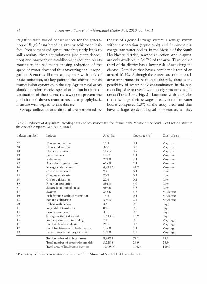
Table 1 provides a general chart of disease induc-ers for schistosomiasis mansoni, which may beapplied to any region characterized as endemic forthe disease. Sixty-one inducers, expressing condi-tions related to the presence and maintenance ofbreeding sites or disease focus, were identified.Among the inducers described in the literature, only23 were identified in the study area (Table 2 and Fig.3). Among them, agricultural activities, sewage dis-charge into the river and presence of ponds werefound to be correlated to increased risk.
Agricultural activities represented coverage of13.0% of the total study area. The district is char-acterized as a concentration of several small familiarproperties distributed in three subsets in the south-west, sout-heast and north-east regions of the studyarea and aimed at cultivation of fruits and vegeta-bles. The arrangement of the elements is peripheralto the urban area.
In the region of Campinas, some agriculturalpractices require different ways of storing water for

F. Anaruma Filho et al. - Geospatial Health 5(1), 2010, pp. 79-91 83
Table 1. Disease inducers that favour the formation and maintenance of breeding sites or schistosomiasis foci.
Inducer group
Inducer number
Type of inducer
Relative inducer importance
Degree of reliability (weight)
Transmission evolution
Annual andsubsistenceagriculture
12345678910111213
Irrigated rice plantationDry rice cultivationSugar cane plantation (ethanol production)Onion cultivationBean cultivationCassava cultivationCorn cultivationSorghum cultivationTomato cultivationSoybean cultivationVegetable/strawberry cultivationFlowers/vivariumChayote plantation
8215111141653
0.30.30.30.30.20.20.20.20.30.20.30.30.3
Cultivation → aggradations andpuddle creation → higherprobability of breeding site formationCultivation → water impoundmentfor irrigation → snail fixation,feeding, shelter and reproduction →higher probability of breeding siteformation
Semi-annualor perennialagriculture
1415161718192021222324
Coffee (dripping)Banana plantationAvocado plantationPersimmon plantationGrape plantationFig plantationGuava plantationCitrus plantationMango plantationPassion fruit plantationPeach plantation
54122223222
0.20.30.10.10.10.10.10.20.10.20.2
Cultivation → aggradations due tosoil movement → increased puddlecreation → higher occurrence ofbreeding sitesCultivation → water impoundmentfor irrigation → snail fixation,feeding, shelter and reproduction →higher occurrence of breeding sites
Permanentlyoroccasionallyflooded areas
25
26
2728
Swampy areaHigh density of people (fishingpoint, local information andfootprints on river banks, etc.)Medium densityLow density
8
8
64
0.3
0.3
0.30.1
Water depth → snail fixation,feeding, shelter and reproduction →frequent human water contact →higher occurrence of breeding sites
Naturalmeanders andcanals
29
30
>0.3 m/s
<0.3 m/s
5
9
0.2
0.3
Water flow less than 0.3 m/s →higher occurrence of breeding sites
Artificialchannels forcarrying waterand trenchesfor irrigation
31
3233
High density of people (fishingpoint, local information andfootprints on channel/trenchbanks)Medium densityLow density
9
86
0.3
0.30.1
Minor channel inclination → slowwater flow → vegetation growth →snail fixation, feeding, shelter andreproduction → frequent humanwater contact → higher occurrenceof breeding sites
Continued

F. Anaruma Filho et al. - Geospatial Health 5(1), 2010, pp. 79-9184
Inducer group
Inducer number
Type of inducer
Relative inducer importance
Degree of reliability (weight)
Transmission evolution
Straightenedmeanders
3435
>0.3 m/s<0.3 m/s
58
0.20.3
Water flow less than 0.3 m/s →higher occurrence of breeding sites
Habitats nearwater streamslikely to becontaminatedwith humanwaste
3637
38
With sewage disposalSewage without disposal, but withseptic tankDirect sewage discharge in theriver
16
9
0.30.2
0.3
Sewer → faeces with S. mansonieggs → water contact → majordisease focus
Fish farmingponds
39
40
With vegetation
Without vegetation
6
4
0.2
0.2
Water → certain fish species →snail predation → minor breedingsite formation
Aggraded orshallow pond
41
Ponds with the presence offloating aquatic vegetation ormacrophytes (water plants) fixedat the bottom
9 0.3
Water → floating aquaticvegetation or macrophytes →shelter and substrate for snailfixation, feeding and egg laying →major breeding site formation
Lakes orwaterstreams usedfor sports,fishing,dishwashingand bathing
42
4344
High density (local information,footprints on river banks, field onhot weather holiday)Medium densityLow density
9
65
0.3
0.30.2
Water → human access → faecalcontamination → human watercontact for large areas of the bodyfor extended periods of times →major disease focus
Presence ofwater springsor spouts
45
46
With trampling
Without trampling
8
7
0.3
0.2
Water → areas of human andanimal trampling → puddleformation → snail attraction point→ human water contact → majordisease focus
Swamp 47Flooded lowlands with or withoutabandoned meanders
6 0.3Water → puddle creation → snailattraction point → major breedingsite formation
Sandydeposits closeto rivers,withoutvegetation
48
49
Water speed >0.3 m/s
Water speed <0.3 m/s
2
4
0.3
0.3
Sand → minor occurrence of snails→ minor breeding site formationSand → place without vegetation→ easy water contact point →higher contact with water (leisure)→ focus formation
Continued

F. Anaruma Filho et al. - Geospatial Health 5(1), 2010, pp. 79-91 85
Inducer group
Inducer number
Type of inducer
Relative inducer importance
Degree of reliability (weight)
Transmission evolution
Humanactivities closeto waterstreams
525354555657
Sand portDishwashing placeSportsBathingFishingPump for irrigation/domestic use
499995
0.20.20.20.30.30.3
Water → human contamination →water contact point → majordisease hotspot
Preparation ofagriculturalareas
58 Agricultural preparation area 3 0.1Soil preparation → source ofaggradations and creation ofpuddles → more breeding sites
Vegetationcoverage
59
60
61
Riparian forest and forestfragmentsReforestation (Pinus orEucalyptus)Successional stage start area
4
2
5
0.2
0.2
0.2
Deforestation → aggradation ofstream beds → water overflow →creation of puddles → morebreeding sitesCultivation → source ofaggradations and creation ofpuddles → more breeding sites
Fig. 3. Map of disease inducers that contribute to the formation and maintenance of breeding sites or foci for schistosomiasismansoni in the South Healthcare district of Campinas, São Paulo, Brazil.
F. Anaruma Filho et al. - Geospatial Health 5(1), 2010, pp. 79-9186
irrigation with varied consequences for the genera-tion of B. glabrata breeding sites or schistosomiasisfoci. Poorly managed agriculture frequently leads tosoil erosion, river aggradations (sediment deposi-tion) and macrophyte establishment (aquatic plantsrooting in the sediment) causing reduction of thespeed of water flow and thus favouring snail propa-gation. Scenarios like these, together with lack ofbasic sanitation, are key point in the schistosomiasistransmission dynamics in the city. Agricultural areasshould therefore receive special attention in terms ofdestination of their domestic sewage to prevent thepollution of downstream areas as a prophylacticmeasure with regard to this disease.
Sewage collection and disposal are performed by
the use of a general sewage system, a sewage systemwithout separation (septic tank) and in natura dis-charge into water bodies. In the Mosaic of the SouthHealthcare district, sewage collection and disposalare only available in 34.7% of the area. Thus, only athird of the district has a lower risk of acquiring thedisease. Domiciles that have a septic tank totaled anarea of 10.9%. Although these areas are of minor rel-ative importance in relation to the risk, there is thepossibility of water body contamination in the sur-roundings due to overflow of poorly structured septictanks (Table 2 and Fig. 3). Locations with domicilesthat discharge their sewage directly into the waterbodies comprised 1.3% of the study area, and thushave a large epidemiological importance, as they
Table 2. Inducers of B. glabrata breeding sites and schistosomiasis foci found in the Mosaic of the South Healthcare district inthe city of Campinas, São Paulo, Brazil.
Inducer number Inducer Area (ha) Coverage (%)a
Class of risk
2220181960583621131459614740155011443745414238
Mango cultivationGuava cultivationGrape cultivationFig cultivationReforestationAgricultural preparationSewage with disposalCitrus cultivationChayote cultivationCoffee cultivationRiparian vegetationSuccessional, initial stageSwampFish farming without vegetationBanana cultivationDebris with accessVegetables/strawberryLow leisure pondSewage without disposalWater spring with tramplingPond with water plantsPond for leisure with high densityDirect sewage discharge in river
15.137.6119.5139.1276.0658.04,425.57.620.722.4391.3497.6853.613.2307.33.688.633.81,413.27.124.5138.8173.8
0.10.30.91.12.15.134.70.10.20.23.03.86.60.12.40.00.70.310.90.00.21.11.3
Very lowVery lowVery lowVery lowVery lowVery lowVery lowLowLowLowLowLowModerateModerateModerateHighHighHighHighVery highVery highVery highVery high
Total number of inducer areasTotal number of areas without riskTotal area of healthcare districts
9,668.13,228.812,996.9
75.124.9100.0
75.124.9100.0
a Percentage of inducer in relation to the area of the Mosaic of South Healthcare district.

F. Anaruma Filho et al. - Geospatial Health 5(1), 2010, pp. 79-91 87
increase the risk to the environmental health, both intheir surrounding areas and downstream.
Figure 4 provides a risk map, which includes thevarious inducers in the landscape (Table 1), valuedfrom the weighs estimated by the risk equationabove and classified according to Table 3.
The analysis of risk in the Mosaic of the SouthHealthcare district disclosed a clearly distinctive dis-tribution pattern. The areas (polygons) defined as“very high” risk, many times characterized by smallterritorial portions, were primarily associated withriver banks that cross districts and water reservoirslocated in farms close to populous regions, thusforming corridors associated to a watershed. Anexample of this pattern is the area surrounding theBradesco farm (Fig. 5).
Areas with “very high” risk corresponded toregions most favourable to transmission of schisto-
somiasis mansoni in the Mosaic and they are thusthe ones with higher priority of intervention by thepublic institutions. In some of the regions identifiedas “very high” risk, no transmission focus were inthe SUCEN report and no domiciles were foundwith cases reported to SINAN, probably becausethey are isolated or distant from the more populousneighbourhoods. However, this result does notinvalidate the need for immediate intervention sinceall other requirements for the schistosomiasis trans-mission cycle were found there. The arrival of indi-viduals with active schistosomiasis in this environ-ment is probably the key to transform an endemic“hotspot” into a new disease focus.
The regions considered as “very high” are few. Theyhave small territorial proportions (0.1 - 2.9 ha), main-ly used for cultivation of vegetables and characterizedby presence of areas with debris dump. These places
Fig. 4. Map of risk classes of schistosomiasis mansoni foci and B. glabrata breeding sites in the Mosaic of the South Healthcaredistrict, Campinas, Sao Pãulo, Brazil.

are predominantly distributed south of the district inCampo Belo, Helvetia, east of the Bandeirantes high-way and to the north, close to Jardim Nova Moradarepresenting a total area of 24.6 ha.
According to the strategy adopted in this study,the risk does not proceed directly from land use thatmay be observed, but from the summation of dis-ease inducers that occur at one point because of theparticular characteristics of that place. With the per-
spective of method application, the proposal to thepublic institutions is that these patterns need to bemonitored throughout the city since they are thevariables that generate higher risk. Thus, it is impor-tant that any endemic “hotspot” found receives spe-cial attention and is immediately addressed by:(i) execution of a control and monitoring pro-
gramme;(ii) intervention with regard to landscape “inducer
characteristics”; and(iii) strengthening of the “primary attention”
aspect.The basic healthcare units close to these locations
must be informed and their agents trained forprompt intervention on suspicious schistosomiasiscases. In synthesis, this study suggests that maps ofthe endemic hotspots could help in the control orelimination of the endemic disease in the city.
F. Anaruma Filho et al. - Geospatial Health 5(1), 2010, pp. 79-9188
Fig. 5. Map of the South Healthcare district, representing “high” and “very high” hazardousness areas for B. glabrate breed-ing sites or schistosomiasis mansoni foci in Campinas, São Paulo, Brazil. Detail of the Bradesco farm with populous districtsclose to several water reservoirs.
Table 3. Classes of polygons with regard to risk and corre-sponding intervals.
Risk classes Interval
Very lowLowMediumHighVery high
>1.0>1.2>1.4>1.6 >1.8
≤1.2≤1.4≤1.6≤1.8≤2.0

F. Anaruma Filho et al. - Geospatial Health 5(1), 2010, pp. 79-91 89
By using a 5-level classification of disease inducers,we confirmed that the “moderate”, “high” and“very high” classes pointed to areas with conditionsat particular risk for the occurrence of new schisto-somiasis cases. The inducers rated as “low” and“very low” risk, on the other hand, led us to areaswith unfavourable conditions for the transmissioncycle, thus showing that these locations do notrequire a high need for immediate public interven-tion. When overlapping historic information relatedto the B. glabrata collection stations and schistoso-miasis foci, as assessed by SUCEN (Fig. 6), was con-sulted, this study confirmed that, in spite of lack ofhigh accuracy in the localization of these points1, therisk areas rated as “high” and “very high”, most ofthe time were located within, or very close, to thedistricts where there was any collection station or a
focus. This observation suggest reasonable accuracyin the risk map due to the correlation between theprobable occurrence, expressed by the map, andeffective occurrence in the field according to theSUCEN data.
Fig. 6. Snail collection stations and areas with schistosomiasis focus, both surveyed by SUCEN from 1998 to 2005, overlap-ping with the “high” and “very high” risk classes in the Mosaic of the South Healthcare district in Campinas, São Paulo, Brazil.
1 The distribution of schistosomiasis cases reports by SINAN cannot
be used to check the accuracy of the risk map because the likely place
of infection was not reported but only the domicile of the individual
infected by the parasite. However, it is evident that the overlapping of
reported cases with the areas with favourable conditions for disease
results in locations with higher probability of risk since these individ-
uals play the role of infection source. These patients received treat-
ment but there is evidence that many refused taking the drug. Leite
and Vasconcellos (2003) argued that the absence of signs and symp-
toms of disease, such as in the case of schistosomiasis in areas with
low endemicity, are factors that lead a great part of the infected indi-
viduals to refuse appropriate treatment.

F. Anaruma Filho et al. - Geospatial Health 5(1), 2010, pp. 79-9190
Since the risk maps, produced according to theproposed methodology, are capable of pinpointingschistosomiasis “hot spots”, they should be usefulas guides for public preventive interventions. Thus,the risk-maps facilitate the implementation of sim-ple and cost-effective actions that would effectivelyhinder completion of the parasite lifecycle, and thusthe continuity of the disease, significantly reducingpublic expenses.
The following conclusions emanate from the pres-ent paper:(i) the methodological proposal was found to be
appropriate in the spatial and hierarchical dis-tribution of inducing factors of schistosomiasismansoni;
(ii) among all the disease inducers evaluated, theones rated in the “low” and “very low” riskclasses might be excluded in future risk map-ping in similar studies;
(iii) as a prophylactic measure to combat schistoso-miasis in downstream areas, agricultural areasmust be frequently monitored in terms ofsewage disposal;
(iv) it is proposed that regions with concentrationof risk areas rated as “moderate”, “high” and“very high” be named endemic hotspots andbe subjected to control and monitoring and itis suggested that they also receive interven-tion, whenever required, as guided by theinducing characteristics of the landscape andthe local “primary attention” be strengthened;and
(v) it was possible to represent potentialities,weaknesses and risk conditions by overlappingan extensive dataset using GIS, which couldhelp controlling schistosomiasis in Brazil.
Acknowledgements
We acknowledge the Campinas City Hall and SUCEN
(Superintendence of Endemic Disease Control). Financial
support was obtained from FAPESP (The State of São Paulo
Research Foundation) and CAPES (Coordination of
Personnel’s of Superior Level Improvement).
References
Anaruma Filho F, Santos RF, Santana, JM, 2007. Indicadores
da relação entre estrutura da paisagem, degradação ambi-
ental e esquistossomose mansoni. Anais do VIII Congresso
de Ecologia do Brasil, 23 a 28 de setembro de 2007,
Caxambu - MG, Brazil.
Beck LR, Lobitz BM, Wood BL, 2000. Remote sensing and
human health: new sensors and new opportunities. Emerg
Infect Dis 6, 217-227.
Brazil, 2001. Instituto Brasileiro de Geografia e Estatística -
Censo demográfico 2000. http://www.ibge.gov.br/home/
estatistica/populacao/censo2000/default.shtm
Brazil, 2009. Instituto Brasileiro de Geografia e Estatística -
Cidade@. http://www.ibge.gov.br/cidadesat/topwindow.
htm?1
Câmara G, Souza RCM, Freitas UM, Garrido J, 1996.
SPRING: integrating remote sensing and GIS by object-ori-
ented data modelling. J Comp Graph 20, 395-403.
Chaves JM, Rocha WJSF, 2006. Geotecnologias: trilhando
novos caminho nas geociências, 1a ed. SBG, São Paulo,
Brazil, pp. 222.
Correia VRM, Monteiro AMV, Carvalho MS, Werneck GL,
2004. Remote sensing as a tool to survey endemic diseases
in Brazil. Cad Saúde Púb 20, 891-904.
Coura JR, Amaral RS, 2004. Epidemiological and control
aspects of schistosomiasis in Brazilian endemic areas. Mem
Inst Oswaldo Cruz 99, 13-19.
Dee N, Baker J, Drobny N, Duke K, Whitman I, Fahringer D,
1973. An environmental evaluation system for water
resource planning. Water Resour Res 9, 523-535.
Gazzinelli A, Kloos H, 2007. The use of spatial tools in the
study of Schistosoma mansoni and its intermediate host
snails in Brazil: a brief review. Geospat Health 2, 51-58.
Jordan P, Webbe G, 1982. Schistosomiasis: epidemiology,
treatment and control, 1st ed. Willian Heinemann Medical
Book LTD, London, UK, pp. 361.
Katz N, Peixoto SV, 2000. Análise crítica da estimativa do
número de portadores de esquistossomose mansoni no
Brasil. Rev Soc Bras Med Trop 33, 303-308.
Leite NL, Vasconcellos MPC, 2003. Adesão à terapêutica
medicamentosa: elementos para a discussão de conceitos e
pressupostos adotados na literatura. Ciência & Saúde
Coletiva 8, 775-782.

F. Anaruma Filho et al. - Geospatial Health 5(1), 2010, pp. 79-91 91
Lima VLC, 1993. A esquistossomose no município de
Campinas. Tese (Doutorado) - Faculdade de Ciências
Medicas, Universidade Estadual de Campinas, Campinas,
217 pp.
Lima VLC, 1995. A esquistossomose urbana e a heterogenei-
dade social e epidemiológica da população do município de
Campinas, São Paulo, Brasil. Cad Saúde Púb 11, 45-56.
Lima VLC, 2000. A esquistossomose no Município de
Campinas, Brasil: uma abordagem histórica e social. In:
Barata Rcb, Briceño-León R. Doenças endêmicas: aborda-
gens sociais, culturais e comportamentais. Rio de Janeiro,
Fiocruz 9, 167-179.
Martelli CMT, 1995. Spatial patterns of leprosy in an urban
area in Central Brazil. Bull World Health Organ 73, 315-
319.
Mckenzie VJ, 2007. Human land use and patterns of parasitism
in tropical amphibian hosts. Biol Conserv 137, 102-116.
Piza JT, Ramos AS, 1960. Os focos autóctones de esquistos-
somose no Estado de São Paulo. Arq Hig e Saúde Púb São
Paulo 25, 261-271.