Embed Size (px)
Citation preview

Environmental impact assessment:
sea-outfall for the Larnaca sewerage system
UNEP Regional Seas Reports and Studies No. 131
UNEP 1990

CONTENTS
PREFACE AND ACKNOWLEDGEMENTS
PART 1:
PART II:
PART Ill:
PART IV:
ANNEX 1:
ANNEX II:
ANNEX Ill:
ANNEX IV:
ANNEX V:
APPENDIX:
ANALYSIS OF THE CASE STUDY
PROCEDURES USED IN THE ENVIRONMENTAL IMPACT ASSESSMENT
Background Request for building of a sea-outfall for the Larnaca
Sewerage System Decision on the need for an EIA Guideliness for the preparation of the EIA document The environmental impact assessment document Evaluation of the EIA document Decision of the Authorizing Authority Monitoring of the impact of the sea-outfall References
GUIDELINES FOR THE PREPARATION OF THE ENVIRONMENTAL IMPACT ASSESSMENT DOCUMENT FOR THE LARNACA SUBMARINE SEWERAGE OUTFALL
ENVIRONMENTAL IMPACT ASSESSMENT DOCUMENT FOR A SEA-OUTFALL OF THE LARNACA SEWERAGE SYSTEM
Introduction Descripction of the proposed project Description of the environment Identification of possible impacts Proposed measures to prevent, reduce or mitigate the adverse
effects of the proposed submarine sewerage outfall References
Layout plan and estimated dilutions for the out fall
Site of the outfall
Meteorological and hidrographic information
Information on benthos
Microbial pollution
Organizations and institutions which were represented in the Review Meeting on EIA Procedures, Nicosia, Cyprus, 24-27 October 1988
2 2 2 2 2 3 4 4
5
7
7 7 9
12
13 15
16
19
21
38
42
46

PREFACE AND ACKNOWLEDGEMENTS
Environmental impact assessments (EIA) have been extensively prepared and used over the last 15 years. Their wide application clearly indicates a need to ensure that environmental considerations are included in the decision-making process. However, particularly In developing countries, the procedures established for EIA in developed countries have met much criticism.
Realizing the shortcomings of these procedures and responding to frequent requests for a simple and practical, but still adequate approach to EIA, the Oceans and Coastal Areas Programme Activity Centre (OCA/PAC) of UNEP has attempted to formulate procedures, supplemented with guidelines, which could be used in preparing EIAs for typical development projects in the context of legal agreements supporting the UNEP Regional Seas Programme.
The procedures and guidelines advocated by UNEPll were tested through a series of concrete case studies. One of the first case studies and the way it was prepared is described in this document.
The analysis of the case study and the description of the procedures used in the environmental impact assessment (Part I and II of the document) were prepared by the Priority Actions Programme Regional Activity Centre of the Mediterranean Action Plan, with assistance of consultants (Messrs. A. Baric and A. Jernelov). The guidelines for the preparation of the EIA document for the sea-outfall for the L..arnaca sewerage system (Part Ill of this document) were originally prepared by Messrs. A. Jernelov and U. Marinov, and modified for the specific situation in L..arnaca by Mr. A. Baric. The environmental impact assessment document (Part IV of the document) was prepared by Mr. L Loizldes and Ms. L. Athanassiadou, Fisheries Officers of the Fisheries Department, Ministry of Agriculture and Natural Resources of Cyprus, with Ms. M. Hadjichristophorou, Fisheries Officer of the same Department, contributing on biological conditions. They provided all the information in tables, graphs etc., for which sources are not given. In the preparation of the document they were assisted and guided by Messrs. A. Baric and A. Jernelov, consultants of the Priority Actions Programme Regional Activity Centre of the Mediterranean Action Plan.

PART 1: ANALYSIS OF THE CASE STUDY
In evaluating the process of preparation of EIAs in Cyprus, the general background has to be kept in mind. No EIA procedure had previously been practiced in Cyprus. Evolving environmental groups were suspicious of the Government's attitude to environmental questions. Governmental bodies had no experience in collaboration on multidisciplinary environmental questions.
The first positive effect of the procedure of EIA preparation was that interagency governmental collaboration was established and functioned well.
Secondly, public participation was for the first time formally introduced in Cyprus in connection with the presentation and evaluation of the EIA documents. NGOs and concerned individuals participated in the meeting and were in agreement with the decisions reached.
Thirdly, a decision was reached to prolong the outfall to 2.8 km and locate it below the thermocline to achieve a better protection of beaches. The fact that the EIA procedure led to a modification of the project, even at a higher cost, contributed to the positive attitude among NGOs and the public.
Naturally, some problems arose as existing information was not always in the format foreseen in the guidelines and as collected data were tailored for other needs that those of an EIA. However, these problems were considered to be of minor importance and not affecting the quality of the assessment as such but only the elegance of the presentation.
PART It! PROCEDURES USED IN THE ENVIRONMENTAL IMPACT ASSESSMENT
Background
The fourth ordinary meeting of the Contracting Parties to the Barcelona Convention (Genoa, September 1985), when considering the workplan of the Priority Actions Programme Regional Activity Centre (PAP /RAC) of the Mediterranean Action Plan, "stressed the interest to develop suitable methodologies for environmental impact assessment, with a view to their introduction in coastal zone development planning"Y. The same meeting adopted ten targets to be achieved as a matter of priority during the second decade (1986-1995) of the Mediterranean Action Plan (MAP). Among these targets wer#:
establishment, as a matter of priority, of sewage treatment plants in all cities around the Mediterranean with more than 100,000 inhabitants and appropriate outfalls and/or appropriate treatment plants for all towns with more than 10,000 inhabitants; and
applying environmental impact assessment as an important tool to ensure proper development activities.
In response to similar requests from other meetings convened in the framework of the UNEP Regional Seas Programme, UNEP has developed a simple and practical approach to the environmental impact assessment (EIA)lf which might be applicable in the context of the legal agreements supporting that Programme.
In consultation between PAP /RAC and the National Focal Point of Egypt for the Mediterranean Action Plan, the preparation of an EIA for the sewage treatment for the city of Port Said was among the first case studies selected to test the new approach to EIAs.
This chapter of the present document describes, step-by-step the application of the general approach advocated for the EIA procedural/.
1

Request for tuding a saHUfall for the L.amaca sewerage system
The Municipality of Larnaca originally planned to use treated waste-water for irrigation. However, the feasibility study demonstrated that the high salinity of the water, due to intrusion of sea-water into the sewage system, would render it unsuitable. Hence the Municipality looked at the option of a sea-outfall and requested a permit to build one.
Decision on the need for an EIA
According to a newly adopted governmental policy an EIA is a requirement for any such development project.
Guidelines for the preparation d an EIA document
Building on the goals and principles of EIAs, adopted by the Governing Council of UNEP and endorsed by the United Nations General AssembiY-1 and on the procedures developed for a practical approach to E1As11
the guidelines for the preparation of the EIA document for a sewage treatment plant were prepared by PAP /RAC with assistance of consultants (Part Ill of this document). The guidelines list the issues which were expected to be addressed in the preparation of the EIA document for the Larnaca sewerage system.
The environmental impact assessment document
The preparation of the EIA document was entrusted to the Fisheries Department of the Ministry of Agriculture and Natural Resources of the Republic of Cyprus.
Several consultations were held between the staff of the organization and of PAP /RAG's consultants during the preparation of the EIA.
The information used for the preparation of the EIA consisted of:
meteorological data available from the nearby airport;
hydrographic, microbiological and sea-current data obtained through earlier measurements. as well as measurements during the preparation of the EIA, at the site of the proposed outfall and in its vicinity;
hydrographic data available from the Limassol area (situation analogous to Larnaca bay); and
biological data on benthos and detailed bathymetric measurements collected specifically for the EIA.
The EIA document was prepared in a period of 5 months, (from May to September 1988) and it involved an estimated time of 1 wjm (working/month) of a scientist and of 0.5 wjm of a technical staff.
The EIA document, as submitted for evaluation. is reproduced as Part IV of this document.
Evaluation d the EIA document
The draft of the EIA document was presented, together with a draft of an EIA for a marina in Paphos 21•
to the Review Meeting on Environmental Impact Assessment Procedure, jointly organized in Nicosia, Cypurs, 24-27 October 1988, by PAP/RAC, OCA/PAC and the Co-ordinating Unit for MAP, in co-operation with the Environmental Conservation Service and the Fisheries Department of the Ministry of Agriculture and Natural Resources of Cyprus.
2

The meeting was hosted by the Agricultural Research Institute in Nicosia and was attended by 26 participants from seven Ministries and Departments of the Cyprus Government, one participant of a nongovernmental environmental organization from Cyprus, four participants from the government departments of four countries other than Cyprus, two UNEP staff members and two consultants to UNEP (for a full list see Appendix of this document).
The meeting started by the participants' visit to the planned location of the outfall in order to familiarize them with the physical setting and the technical details of the planned project.
The visit to the site was followed by the presentation of the approach used in the preparation of the EIA and by the detailed presentation and discussion of the EIA.
The main comments and suggestions offered at the meeting may be summarized as follows:
(a) the general approach proposed by UNEP for the preparation of EIAs was considered as suitable in principle, although some amendments were introduced into the proposed procedures·;
(b) the guidelines used for the preparation of the EIA were considered, with some amendments•, as sufficient general guidelines for the preparation of EIAs related to sewerage sea-outfalls but they should have been supplemented with more specific guidelines tailored to the concrete case of the outfall for L.arnaca.
(c) the presented draft EIA document was considered, after some amendments, as adequate for the decision-making process; the suggested amendments included the following:
information on the method for corrosion control was missing from the submission of the consultants who proposed the design of the outfall;
although a bathymetric map covering a distance of 2 km was prepared as part of the draft EIA (tentatively the length of the outfall was estimated as 1.5 km), the result of the study indicates that a longer outfall may be needed in order to take full advantage of the thermocline and therefore the bathymetric map should be extended to cover 2.5 km;
no information was provided on the possible effects of turbulence and waves;
data on the present nutrient levels and colour are lacking; and
there is no information on plankton.
The EIA document was also considered by the governmental technical committee which was established to advise the Municipality of L.arnaca on the project.
Decision of the Authorizing Authority
The conclusion of the EIA study was accepted. The provision for a prolonged outfall was included in a new feasibility study and was part of the terms of reference for the tenders. The project proceeded as modified.
The EIA study of the L.arnaca sewage outfall has also been a model for a corresponding study of a sewerage system in Limasol due for completion in 1995.
* The amendments suggested at the meeting are incorporated in the document listed under Reference!'.
3

Monitoring of the impact of the sea-outfall
As the execution of the project has not yet started the monitoring programme is not in force.
References
1/ UNEP: An approach to environmental impact assessment for projects affecting the coastal and marine environment. UNEP Regional Seas Reports and Studies No. 122, UNEP, 1990.
2./ Report of the fourth ordinary meeting of the Contracting Parties to the Convention for the Protection of the Mediterranean Sea Against Pollution and its related Protocols. UNEP /IG.56/5, Part I, para. 89. UNEP, 1985.
;l/ Ibid. Part II, para. 17 (b) and (c).
1/ Decision 14/25 of UNEP Governing Council; 17 June 1987. UNEP/GC/14/26, Annex I.
fl./ UNEP: Environmental impact assessment: The Marina in Paphos. UNEP Regional Seas Reports and Studies No. , UNEP, 1990.
4

PART Ill: GUIDEUNES FOR THE PREPARATION OF THE ENVIRONMENTAL IMPACT ASSESSMENT DOCUMENT FOR THE l.ARNACA SUBMARINE SEWERAGE OUTFAll.
Introduction
The main purpose of a sea outfall is to enable effluents to be discharged at a point well away from the coast. The discharge point should be selected with respect to the flushing characteristics of the proposed area to ensure dilution and dispersal of the effluent.
Until fairly recently, the sea was taken for granted as a convenient natural body of water to discharge sewage, disregarding the fact how much polluted effluent it is able to accept. Growing interest in environmental problems brought forth the awareness that the sea capacity is, in fact, limited. In addition, present policy concerning the reuse of water should be taken into consideration.
However, a sea outfall is sometimes the only feasible solution. In such cases, the importance of minimizing pollution impacts is generally recognized and, accordingly, official regulations were issued on the subject and optimized outfall design methods developed.
Once a decision on sea outfall project implementation has been taken, it is up to the project authority's technical staff to site the outfall so as to ensure the water in respective areas to be protected from contamination and meet the required quality criteria. The effects of sea outfall effluent should be determined keeping in mind the most critical pollution conditions for the areas which need to be protected.
The location of the discharge point will be considered acceptable, if the pollution inputs are consistent with the anticipated use of the waters in question (beaches, shellfish breeding areas) and the quality of seawater required.
A. Description d the proposed project
The proposed outfall should be described, including the following:
(a) The outfall
Length of the outfall pipeline, diameter, depth, pipe materials; Pipeline laying method: anchoring on seabed, buried below the sea bed; Diffuser length, orifices, configuration and diameter;
- Discharge rate; and - Initial dilution, final dilution.
(b) The effluents
- Effluent characteristics: quantity, degree of treatment, physical, chemical and bacteriological composition, seasonal variations; and
- T90 measurements.
B. Description d the environment
A description of the environment of the site of the proposed discharge point should include the following:
(a) Physical site characteristics
- An onshore topographic and offshore bathymetric map of the site and its surroundings at a scale of 1 :5000 covering at least 2 kilometres of the coast, appropriate distance from the waterline offshore and 200 meters from the waterline inland; and
- Geological and geophysical conditions at outfall site, including rock outcrops on and offshore, sedimentary properties and cliff stability.
5

(b) Hydrographic and meteorological information
- Surface and subsurface currents under various tides, densities and weather conditions; - Currents at depth of effluent disposal; - Existence and characteristics of thermocline; - Seawater temperature and salinity and their variation with depth; - Wind velocities and intensities; and - Oxygen and nutrient concentration, turbidity and colour;
(c) Biological conditions
- Status of benthic communities on different substrates; - Microbial pollution - pathogens survivaL
(d) Present and intended uses of the seawater and beaches
- Tourism, recreation, fishing, aquaculture; and - Shellfish breeding.
(e) Ambient quality criteria
C. ldertilication aJ Possible Impacts
An assessment of anticipated or forecasted impacts, using accepted standards whenever possible, should include the following:
(a) Impacts of construction from
Earthworks; - Road access; and
Noise of equipment.
(b) Impacts of operation on
Flora and fauna; - Seawater temperature;
Bacterial concentration; - Oxygen and nutrient concentrations; and - Water turbidity and colour;
(c) Impacts on other present and intended land uses on and offshore
Recreational activities, including bathing waters and sand beaches; and Fishing grounds, particularly with respect to shellfish.
(d) Expected impacts on the reduction of enteric diseases
D. Proposed Measures to Prevent, Reduce or Mitigate the Adverse Effects aJ the Proposed Submarine Sewage Outfall
This section should describe all the measures, either technical, legal, social, economic or other, to prevent, reduce or mitigate the adverse effects of the proposed submarine sewage discharge. In addition, it should propose the elements for monitoring the effects on a long-term basis, including the collection and analysis of data, as well as the available enforcement procedures to ensure the implementation of the measures.
6

PART IV: ENVIRONMENTAL IMPACT ASSESSMENT DOCUMENT FOR A SEA..QUTFAU... OF THE l.ARNACA SEWERAGE SYSTEM ,
INTRODUCTION
L.amaca is a tourist resort with a resident population of S2,000 which depends on tourism for a significant proportion of its prosperity. Currently there is no main sewerage system in the town, almost all of which is served by ground disposal systems: septic tanks, absorption pits and simple holding tanks.
Presently, occasional discharges and temporary but repeated leakage of sewage water result in excess bacterial concentration in bathing waters. A sewerage system with treatment plant and outfall will improve the present situation.
However, there is some public concern that sewage disposal may harm or interfere with recreational pursuits. Therefore the EIA study of the sea outfall is of particular importance, taking into consideration the decision to discharge treated effluents into the sea.
Description of the Proposed Project
(a) The outfall
The proposed outfall would be located adjacent to Dates Point, approximately s km south of the town centre. The outfall will be 600 mm in diameter and tentatively about 1.2S km to 1.S km long, reaching a depth of 1S m. The pipeline, of steel or HOPE, wUI be buried below the seabed with one metre cover and should follow the line of the prominent trough running east of Dates Point.
A layout plan and a longitudinal section of the outfall as provided by the designers are given in the enclosed ANNEX I.
Tables 1 and 2 given in ANNEX I present the results of calculations of the initial dilution for different outfall lengths and for different diffuser systems. Considered flows for the outfall design were as follows:
1231/s- Commissioning peak flow in 1988 based on 3.1 x average flow plus infiltration. 382 1/s - Year 2000 peak flow of 33000 m3 /day.
(b) The effluents
(i) Daily flow of sewage to treatment plant (in m3 /d)
Phase I Cto 1992)
Winter S,400 Summer 13,200
Phase II (to 2000)
8,060 19,760
(ii) Predicted composition of raw sewage to treatment plant
Phase I (to 1992)
BODS TDS
156 mg/1 (S04, a) 1000 mgjl
(iii) Degree of treatment.
Phase II Cto 2000)
194 mgjl 700 mgjl
- The treatment plant will be operated to attain the following standards in the discharged effluent: BODS: 20 mgjl Suspended Solids: 30 mgjl pH: in the range 6-9

- Disinfection
The effluent quality range is expected after full treatment and chlorination to be:
Total coliforms 10-103 /100 ml (Typically 100/100 ml) Faecal coliforrns 0-103 /100 ml (Typically 100/100 ml) Faecal streptococci 0-10/100 ml (Typically 10/100 ml) Salmonellae 0-10/100 ml (Typically 0/100 ml) Enteroviruses 5-20/10 litres
It was assumed that T -90, time within which 90 % die, will be 4h for bacteria and 18h for enteroviruses. However, doubts about the efficiency of chlorination in the presence of ammonia and the likelihood of generating trihalomethane compounds by reaction with remaining organics will necessitate reconsideration of disinfection by chlorination.
Legislation concerning discharges into the marine environment
Regulations issued on 22 July 1971 in pursuance of the Fisheries Law CAP. 135 prohibit (in section 8B) the contamination of maritime waters by substances that may have an adverse effect, whether directly or indirectly, upon the development or survival of marine life. Free translation of regulation 8B as amended by Law No.322/81 with the introduction of a set of standards appears here below:
4. The basic regulations are modified by the insertion immediately after regulation 8 the following regulations:
8A "No person shall kill, pursue, catch or possess or endeavour to kill, pursue, catch, possess or sell sea turtles or turtle eggs, or seals, or dolphins of any species without the written permission of the Fisheries Officer."
8B "No person shall pollute sea areas or waters in dams, river waters, lake waters or any other natural or artificial reservoirs, where fish are found by any substance which might have direct or indirect harmful effects on the growth or survival of the following fish stocks:
(a) Freshwater fish (b) Fish of the coastal sea areas within a radius of 6 miles from the coast."
Note: Regulation 8B was made under section 6 of the Fisheries Law Cap.135.
7. Section 8A of the Basic Regulations is amended and the word "sea" is deleted and substituted by the word "aquatic".
8. Section 8B of the Basic Regulations is amended by the insertion at the end of the following:
For the purpose of the present Regulation the phrase "direct or indirect harmful effect on the growth or survival of the said fish stocks" includes the act of introduction of sewage waters into the sea water for which:
(a) The temperature exceeds by 10 degrees (10°C) the temperature of the aquatic environment which is accepting such water.
(b) The concentration of organic substances is such that the consumption of oxygen for their oxidation estimated as the consumption of oxygen for biological oxidation (20° C) within five days (Biochemical Oxygen Demand BODS) shall not exceed 30 mg per litre of water.
(c) The concentration of any substance is such that the consumption of oxygen for their oxidation (Chemical Oxygen Demand COD) shall not exceed 80 mg per litre of water.
(d) Its pH range is not outside the range of pH6 - pH9.
n

(e) The total content of solid substances shall not exceed 80 parts per million (80 ppm).
(f) The concentration of zinc (Zn) shall not exceed 0.1 parts per million (0.1 ppm).
(g) The concentration of copper (Cu) shall not exceed 0.1 parts per million (0.1 ppm).
Description of the Environment
(a) Physical site characteristics
The proposed site for the outfall location is given in ANNEX II.
A seabed survey showed that the seabed is fine silt overlaid by up to 0.5 m sand. There are several prominent rock pinnacles offshore and calcareous rock outcrops closer to the shore and alongshore. A prominent ridge runs perpendicular to the shore with a trough on its northern flank. This trough offers the possibility of attaining deeper water at the same distance from the coast.
(b) Hydrographic and meteorolooical information
Extensive hydrographic studies carried out at Limassol show a general picture with the following main features.
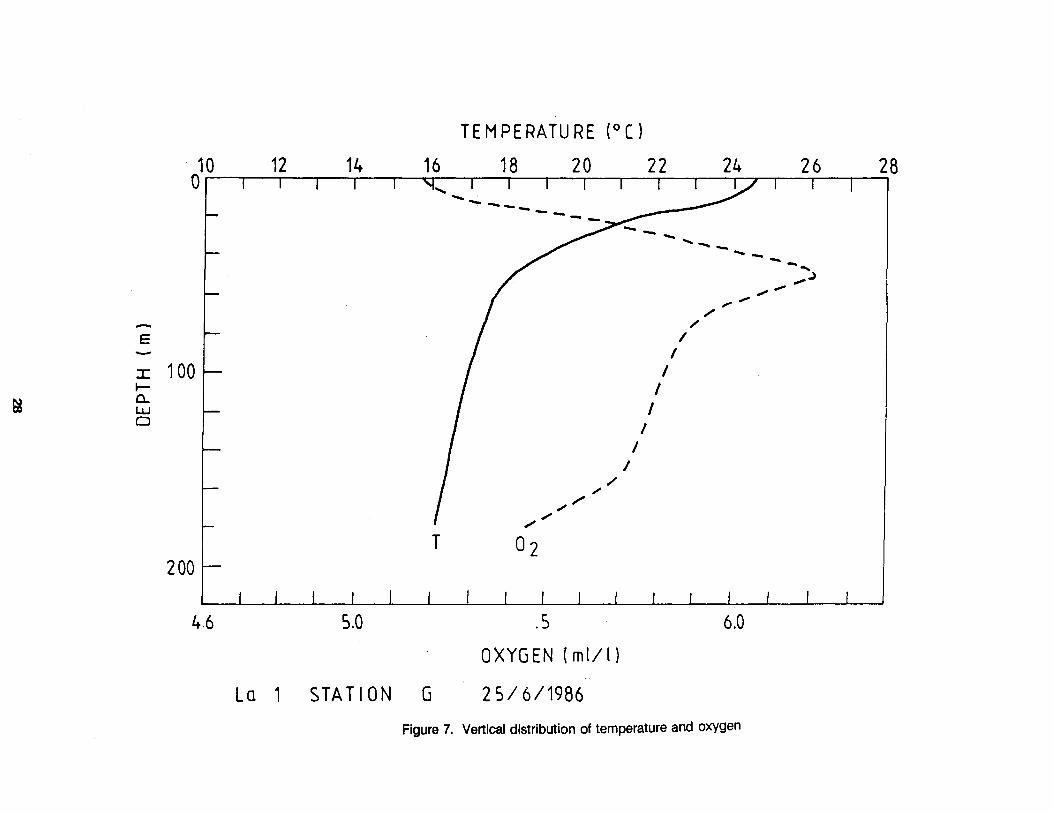
From May through October, the seawater is thermally stratified with maximum 27"C temperature. The thermocline (the sharp gradient between warm surface and cold bottom water) generally occurs at 25-40 m depth. A thermocline does not occur from November to April. Throughout the water column temperature ranges from 16°-17"C. The Larnaca area has been much less studied. The results of measurements outside the fishing port are consistent with the data for Limassol (Figures 5, 7, 8 and 13; Tables 2 and 3 of ANNEX Ill).
Surface currents are mainly wind-generated and change direction during the day following the wind pattern. Bottom currents are generally weak ( <0.1 mjs) and periodically absent. Currents flow to the south in summer and the north in winter.
A single surface drift was performed in the proposed sewage discharge area, on November 11, 1985. Four drifters were released at a depth of 1 mat hourly intervals. Position readings and wind speed and direction measurements were performed at half-hour intervals over approximately 11 hours. All the drifters followed the changes of wind direction. The flow patterns are presented in Figures 1-4 of ANNEX Ill. When superimposed, they showed northern drift. Currents were measured by current metre at a depth of 18 fathoms (33 metres) and 29 metres above the seabed, for about two months (March 29 to June 7, 1985). Results show most current speeds to be mostly lower than 0.10 mjs and to the south.
Another current metre used at the proposed effluent disposal site again at a depth of 18 fathoms but 4 metres above the seabed during the same period, gave the same results.
Wind valocilies and intensities
In winter the winds at night blow from the northwest with a characteristic speed of 7 knots. In the late morning the direction changes to south with a speed of 10-12 knots. In the afternoon the wind will start to blow towards west at a somewhat reduced speed and at nightfall turns northwest again, completing the daily cycle.
The daily cycle is the same in summer, with winds from northwest at night. Wind speed is typically 4 knots. The shift via east to the south occurs earlier in the morning and the summer southerly winds are generally stronger then the winter ones (16 knots). In the evening the winds again turn to northwest completing the cycle.
Mean hourly wind speed and direction at 10 metres height at Larnaca Airport (1981-85) are given in the table 1 of ANNEX IlL
9

Oxygen and nulrtent COIICellbalion, tu'bidly and coku'
In summer, oxygen concentrations range from about 5.0 ml/1 at the surface, to a maximum of approximately 6.0 ml/1 at a depth of 50 meters (Figures 7, 11 and 13; Tables 2 and 3).
Oxygen saturation exceeds 100% at all the depths for this period.
Data on nutrients are not avaUable, but based on our experience, waters around Cyprus are very poor in nutrients. Water is blue and highly transparent, with light penetrating to about 40 metres (Secchi disc).
(c) Bio!oolca! conditions
Benthic fauna and flora from the proposed site of the sewage outfall were sampled at four stations, using a dredge sampler (orange peel) (Figure 1 of ANNEX IV).
The station (A) is at 5 fm depth and 1 km offshore, the station (B) at 10 fm and 1.5 km offshore, station (C) at 20 tm and 2 km and station (D) at 30 fm and 2.5 km offshore at the point at which discharge is to take place.
The data obtained from a total of 80 samples (at each station 20 grab samples of 5 lltres were collected) are tabulated in Table 1 of ANNEX IV.
The bottom is mainly covered by sand and mud. The hydrometer analysis and wet sieve analysis (according to B.S 13n of 1975) show that sediment cover becomes more fine-grained from shallower to deeper stations.
The samples show the presence of green algae, with Cauleroa prolifera dominant at three stations (A, B and C). At station D the seagrass Halophila stipulacea is dominant.
Marine phanerogams Zostera marina and Posidonia oceanica were recorded only at station A (5 fm).
The bottom fauna study also show a diverse fauna of Crustacea, Mollusca, Echinodermata and Polychaeta dominated by molluscs Loripinus lacteus and Nucula nucleus at 10 fm depth and Pseudentalis rubescens at 20 fm depth. Echinodermata with Amphiyra chiajei are dominant at 30 fm depth. A higher number of species and individuals was expected at station B (10 fm) (ANNEX IV). The bottom at this station is sandy-muddy, while It is predominantly sandy at station A (5 fm) and mostly muddy at all deeper stations. The number of individual organisms was mostly small and the total biomass low. The species diversity is high with as many as 45 animal species present in the samples, even though in small numbers. Therefore, the total biomass was low (see Figure 2 of ANNEX IV).
Thus, it may be stated that the flora and fauna are typical of an area poor in nutrients and largely unaffected by pollution.
Microbial pollDJrl - pathogen SlniYal
Assessment of microbial pollution in Larnaca Bay is based on the data provided by the Medical Services of the Ministry of Health. Sampling and analysis for faecal coliforms are carried out at a series of 29 fixed stations, covering the entire coastal area of Larnaca Bay, on a monthly basis.
The results of the bacterial monitoring for the years 1985, 1986, and 1987 are shown in Tables 1 , 2 and 3 of Annex V. As seen from the tables, there is no station with results exceeding the proposed criteria set by UNEP fWMO for bathing waters.
In other studies, occasional excess faecal coliform numbers were recorded but at a small number of stations.
Although no data for bacteria inactivation in Cyprus waters are available, it is well known that the rate of bacterial disappearance in the Mediterranean Sea is greater than in other seas (Paoletti et al., 1978).
10

Experiments carried out by C.E.R.B.O.M. in Nice and in Israel in the waters off Nice and Tel-Aviv show T-90 to range from less than an hour to a little less than two hours. (Aubert and Desirotte,1968).
(d) Present and intended uses of the seawater and beaches
Larnaca beach is extensively used for local and tourist recreational activities especially during May-October. The activities include swimming, wind surfing, small boat sailing and angling.
Larnaca Bay has an overall beach area of 287,500 sq. metres and a total length of 13,650 metres from north of Larnaca town up to the Kiti observatory. The beach is mostly sandy and has a capacity for approximately 34,000 persons. In this area, there are hotel apartments and villas which could accommodate a total population of 7,75 I in 1986, which is expected to expand to 8,350 for 1988 and up to 8,900 for 1990.
FIShing lnduslry
There is a fishing shelter in Larnaca Bay which accommodates 171 coastal fishing boats. Three trawlers are stationed in the port of Larnaca . The total catch and earnings for the years 1982-1986 are given below:
CATCH EARNINGS TOTAL
Year Trawling Coastal Trawling Coastal Catch Earnings in m.t. in m.t. CYP CYP in m.t. CYP
1982 130 627 142,055 1,301,084 757 1,443,139 1983 219 963 230,782 1,890,671 1,182 2,121,453 1984 215 1,097 227,463 2,525,000 1,312 2,752,463 1985 264 1 '171 290,638 2,634,000 1,435 2,924,638 1986 275 1,169 300,000 3,330,000 1,444 3,630,000
Red mullet (M. barbatus). picarel (M. smaris), bogue (B. boops), and pandora (P. ervtrinus) dominate in the catches. Shellfish culture has not been developed in the area as yet and is not anticipated in the near future.
Meneou Hatchery
A hatchery for marine species is being established at Meneou, an area adjacent to the proposed site of sewage discharge.
Water for the hatchery will be taken from a distance of 250 metres from the shore. The pumping rate of the sea water will be 250 m3 per day all year round. Half of this water quantity must be crystal clear, i.e. will be passed through a gravel filter and a bench-type plastic filter. The rest will be used directly from the sea and is required to have the quality of natural sea water, i.e. pH 8.2, S 39.8 0/00.
(e) Ambient aualitv criteria
Although there is an obvious concern to protect the beaches in the Larnaca area from sewage pollution, no specific requirements have been set with regard to the minimum levels of water pollution acceptable in the bathing areas.
The Government of Cyprus has adopted the WHO jUNEP interim environmental quality criteria for coastal recreational waters, shellfish and shellfish-growing areas and has applied them, to the extent possible, through appropriate legal andjor administrative measures.
11

ldentilicalion of Possible Impacts
(a) Impacts of construction
A 3 km long access road is to be constructed at the site of the outfall, starting from the main L.arnaca -Meneou road. Alternatively the existing earth road can be widened and reinforced. Earthworks will be carried out for the construction or reinforcement of these roads and for burying the outfall.
However, given the location, the type of ground and the short duration of the work, the impact on landscape, flora and fauna is considered negligible.
Machines used for the earthworks will be noisy. Since the site is well apart, the degree of disturbance will be very low.
(b) Impacts of ooeration
Earlier experience from other places show that the effects of the initial discharge of treated municipal sewage can be expected in three main forms:
- bacterial concentration in bathing water and on the shore; - oxygen depletion in the bottom layer adjacent to the point of sewage discharge; and - concentration of nutrients in the area in question.
(i) Flora and Fauna
As to the bottom fauna, polychaetes are expected to increase in abundance at the expense of crustaceans and molluscs.
Attached green algae in the phototrophic zone are expected to increase in surface coverage.
Algal communities may be degraded as a result of turbidity and sedimentation.
(ii) Sea Water Temperature
No significant change is expected as a consequence of sewage discharge.
(iii) Bacterial concentration
According to the engineers, the sewage outfall is designed to meet the EEC criteria for the quality of bathing waters and shellfish-growing areas.
Since the discharge point is above the thermocline, and thus in the surface water, and since daytime winds and surface currents are onshore, excess bacterial levels may be expected to occur in bathing waters, especially during periods of malfunctioning of the sewage treatment works.
A computer simulation model by M. Bonazountas of the Technical University of Athens indicates that the WHO/UNEP water quality criteria can be met with the present design, provided that the sewage undergoes secondary treatment and chlorination, but not otherwise.
(iv) Oxygen and nutrient concentrations
As the sewage treatment plant will substantially reduce the BOD of the sewage, resulting in a BODS of 20 mgjl, and the discharge point following the present design of the outfall is above the thermocline, no oxygen deficiency is expected.
In case a discharge point below the thermocline is chosen, oxygen deficiency and anaerobic conditions in the bottom water close to the point of discharge are to be expected during periods when there are no currents in the bottom layer.
12

Nutrient concentrations are going to increase substantially consequent to the sewage discharge in surface waters.
In addition, production of phytoplankton and attached green algae will increase, possibly suppressing other forms of underwater vegetation such as Posidonia sp.
(v) Water turbidity and colour
During normal operation of the sewage treatment works, no direct effects on turbidity and colour are expected.
As a secondary effect of the nutrient enrichment and increased production of phytoplankton, transparency is going to decrease and a greenish water colour is expected.
In case of disturbances in the sewage treatment plant, direct effects on turbidity and colour could occur. If the sewage is discharged below the thermocline, these effects are likely to be negligible at least during the summer water stratification.
(c) lmoacts on other present and potential uses on and offshore
Recreational activities. including bathing waters and sand
The L.arnaca Bay is intensively used for bathing. Presently occasional discharges and leakage of sewage water temporarily but repeatedly result in excess bacterial levels in bathing waters.
Generally, the sewerage system with treatment plant and outfall will result in an improvement of the present situation. However, the position of the sewage discharge point in the surface water above the thermocline combined with the daytime wind and surface currents towards the shore will result in decreased transparency, some colouration of the water, and possibly excessive bacterial levels in bathing waters and on beaches especially in periods of malfunctioning of the sewage treatment works. These may be factors of importance.
The location of the sewage discharge point below the thermocline would eliminate these risks.
FIShing grounds
No interference with the present small scale seine-net fishing is expected. Trawling in the area is carried out at the depth of 54 m or more which is outside the area of primary consideration. There is no shellfish culture or catch in the area.
(d) Expected impacts on the reduction of enteric diseases
No statistics are available on present or past extent and frequency of enteric diseases. Therefore, there is no basis from which to forecast the expected reduction.
Proposed Measures to Prevent, Reduce or Mitigate the Adverse Effects of the Proposed Submarine Sewage OtMall
(a) Technical measures
From the previous analyses it seems that the proposed length of the submarine sewage outfall discharging above the thermocline would cause adverse effects, especially when the sewage treatment works malfunction.
Therefore, it is proposed to lengthen the outfall to reach the depth below the thermocline.
The impact of sewage on the marine environment will depend on the proper function of the sewage treatment plant. The proposed type of sewage treatment plant (activated sludge) is very sensitive to changes in the sewage load. Since this treatment system will serve tourist complexes too, during the tourist season,
13

the treatment plant could be less effective during that pericxJ. To avoid this, the following technical options are suggested:
-construction of a buffer pond to accept the temporarily increased load; - speeding up the sedimentation process by adding appropriate chemicals; and - oxidation of organic matter in sewerage system by adding chemical oxidants.
Each of the above-mentioned options should be carefully examined before a final decision is taken.
Another very important prerequisite for the proper functioning of the sewage treatment plant is the constant supply of electric power. A power shortage for a few hours could make the activated sludge process anaerobic. To return the process back to full operation will take about a week.
Chlorination is frequently used to kill bacteria and other organisms in waste waters and to achieve a partial oxidation of organic matter. However, chlorination will also lead to the formation of various organo-chlorine compounds, which may be of environmental concern. Thus, it is desirable to design the sewage outfall so as to enable water quality criteria for micro-organisms to be met without chlorination.
(b) Monitoring
A continuous monitoring system must be set up which can be undertaken jointly by the relevant authorities, i.e. Medical Services, Fisheries Department, Health Engineers of the Department of Town and Planning. Monitoring should include the following:
(I) Sampling
Sampling of treated effluents before entering the outfall. Sampling at the site of effluent discharge and at a number of stations covering the whole coastline of Larnaca Bay.
(II) Analysis of the samples
Samples will be analysed for the following parameters:
1. Bacterial concentration (faecal coliforms and from time to time viruses) 2. Nitrites, nitrates, ammonia, phosphates, BODS.
At the same time permanent stations will be positioned by the Fisheries Department to observe any changes of the physico-chemical characteristics of the seawater, i.e. salinity, dissolved oxygen, density and turbidity at different depths (profiles). Studies of the effects on the bottom fauna and flora will also be carried out by the Fisheries Department.
(iii) Frequency
Sampling for microbiological analyses on the beach will be carried out on a weekly basis at least during the tourist season. Sampling should preferably be carried out late in the afternoon.
Other microbiological analyses (out of season on the beach and at other stations) will be carried out on a monthly basis.
Samplings for physico-chemical parameters will be carried out on a monthly basis all year round.
Studies of the effects on the bottom fauna and flora will be performed on a yearly basis.
14

1/ Lamaca Stormwater Drainage and Sanitary System. Final design Incorporating the preliminary engineering report. Book 2 c:A 2. REID CROWTHER INTERNATIONAL LTD In association with SOLON HADJIMINAS AND ASSOCIATES.
2/ Waste discharge Into the Marine Environment. Published by WHO jUNEP-Pergamon Press, 1982.
a/ Comprehensive National Tourism Development Plan for Cyprus. Published by CYPRUS TOURISM ORGANIZATION, 1987.
!/ A study c:A the surface winds in Cyprus. Meteorological Service, Ministry of Agriculture and Natural Resources.
15

ANNEX I
LAYOUT PLAN AND ESTIMATED DILUTIONS FOR THE OUTFALL
Contents: Figure 1 Tables 1 and 2
16

-3.00-----
-4.00- - - - - -
-5.00------
-6~00-- ----7.00------8.00----
-9.00--- --10.oo----
V\ m )>
OJ fT1
·15.00 --- D
-20.00--
·25.00-
-30.00
35.00
V\ fT1 )>~
m I)> mz < fT1 I
V' I n)>
e.-< tDO
c -~
100~ 4.00
5.00 6-00
7.00
8.00
15.00
20.00 ---25.00 30.00 35.00
Figure 1. Layout plan and longitudinal section of the outfall
17

TABLE 1
Dilution achieved by 600 mm diameter outfall with different diffuser systems for current speeds of 0.2 and 0.5 m/s
Port Arrangement Current Speed m/s
0.2 0.5
No. Dia (mm) 1988 2000 Stage 3 1988 2000
1 km Outfall 25 100 353 72 60 834 171 11 150 208 45 37 492 106 6 200 139 31 26 328 74
1.25 km Outfall 25 100 525 102 82 1241 242 11 150 308 62 51 727 148 6 200 204 43 35 482 102
1.5 km Outfall 25 100 1055 193 153 2492 456 11 150 614 115 92 1450 273 6 200 404 78 63 954 184
TABLE2
Dilution achieved by 700 mm diameter outfall with different diffuser systems for current speeds of 0.2 and 0.5 mjs
Port Arrangement Current Speed mjs
0.2 0.5
No. Dia (mm) 1988 2000 Stage 3 1988 2000
1.5 km Outfall 34 100 1695 298 235 3979 705 15 150 980 177 140 2316 419 8 200 621 115 91 1467 272
1. 75 km Outfall 34 100 387 581 453 8000 1372 15 150 1963 342 267 4638 807 8 200 1239 219 172 2926 517
18
Stage 3
139 87 61
194 120 83
361 218 148
Stage 3
554 331 216
1069 631 406

ANNEX II
SITE OF THE OUTFALL
Contents: Figure 1

. , ' '(-----~
' ' ' ' ,_ '
, I I
/
"' , I \
' ' ' ' I
' ' I ' I I
I --,
\ , I
I , I /
I I I
I I
I \
' : ' ' .
I 1
/1' I
,
LARNACA BAY
J PROPOSED LINE I ~ OFOUTFALL .
DATES POINT
I I , \
MENEOU HATCHERY
Figure 1. Larnaca Bay Map
20
SCALE 1 : 50,000

ANNEX Ill
METEOROLOGICAL AND HYDROGRAPHIC INFORMATION
Contents: Figures 1 - 13 Tables 1 - 3
21

Figure 1. Surface current information
~\ ~ \'1. \
~b~ ~ \'l-~ ~\ ~b?i \'1.? ~\ ~~~ \ \J'\I't ~ ~~ ~\ ~"· \1.. ~co~~ J'l. ~\ \)'b.':>'> \\ /1 ~'
Clq .1S \\
()9 _s() ~ 0' ,().1Cl ~o) ''-00 ~o) 11.32 ( 1 sw) 12.01 ( 1 E )
12.31 ( 2E)
13.00 ( 2 E)
13.32 (2£)
14. 0 1 ( 2 V2 E J
14. 32 ( 1 1/2 E J
15.03 (2E)

2
X X X X ,xxx
Figure 2. Surface current information
23
"1 oo \' V1 ~ v - N) 01-30 \' V1
f\1'\ \1N) o s.\J\.1 '
\"\ ,11N 0~.30 N'
\' ,11 o~.c.>' ~'
1C) \,/1 (,)q.
(,) q . ')') \ 0 )
10.24 { o)
11.06 ( 0 )
11.37 (1 SW)
12.04 ( 1 E)
12.34 ( 3 E)
13.02 (2E)
13.35 (2E)
14.03 ( 1 V2 E)
1 4 . 3 5 ( 1 112 E)
15.05 (2E)

+
2
08.00 (1 V2 N) 08 . 30 ( 1 112 N
09.00 {V2 N)
09.58 {o)
10.27 { 0)
11.10 {o)
-----11.41 ( V2 SW)
Figure 3. Surface current information
12.07 {1112 El
12.38 ( 3 E l
13.06 { 2 E)
13.39 { 2 V2 E) 14.08 {2 E l 14.40 (2 E)
15.10 ( 2 E) 15.40 (2 E)

2
09.00 { 0 )
09.30 ( 0)
10.02 ( 0 )
10.30 ( o)
11.14 ( o)
11.44 ( 1/2 SW) 12.09 (2E)
12.39 ( 3 E )
13.10 (.3 E)
13.42 (2E)
14.10 (2E)
14.43 (2 E)
15.13 (2E)
15.45 (2E)
Figure 4. Surface current information
25

~
LARNACA AREA I ~-----~.-_:.':..':.:."__-::.-_-. __ _ """" ,.. .,. . _.. . .. . -- ............. --
34°))
LARNACA q
.,- ....... 2 0 -- . -- - ........... , ,.,- ,. . ..._ . . ....... -, . ...... , ' ___ .............. ,, ---- ,. ....... ....:'·' / , 10 ~ / . - - • . ....... .. .,..,.. - •• - ·~' .......... ,.
c./ . .; / ....--30 .·-.. , ...... '·' J / •• • / • ' • ,, , . ., ~ ·---. . . . '· / -, . . .., . ·~
/ . /. / . / - .. - .. - .. / 1.· ..... '· • ,, '. '·' ~ I . / ·· SO··_.,· ·. " ·': .: ' \ . ' \ '~· I . / / . .· -'- . • . . \
I / / .· ·. ·7c.-. / ,• :\ ' \ I. I.· : . .,-. ... :: J •• ••••• • • : '. • \. I I / I /' •• • ••• • •• ...._,.. • ••• • , .. . . . . . .
I • . / . . . .. . .. . . .. . . . \ I I :/ : · .. ··: 100 ·· ... ·· ·... ~ " I . I . ... . . . .. . . ' . "' . . . . I . . . .
I . . I . . : :' ·... . ' '·· , I I ' i I ... ·: ·. - .. , I . I . . ...
', /if _,.. 1: : ~
' ,: ,.· )~ . . .-.. . .
/ .~ . . . .
\ . \ \ . . I . \ I I \ • :
. / -·· ... . ,· ...... · ...
I \ \ ( \ . \: I \ \
E : .-· .. ·
I l ·, . . \ ,· .· .• I • "
1 _i j (' \ t.''·· ... I I . • \ .
I I . . .. · I l20 j SO: ~ 5/· : J!~
I I 30 . . . , )O. 7 17s/
La 1
Figure 5. Hydrographic stations
.......... . . . . ...
SCALE 1 : 100 000 I · _I : :/100 ~ I ~ ~ .· :1 DEPTH IN FATHOMS

~ .J
E
S A L I N I T Y ( 0/o o )
.5 39.0 _5 38.0 o~~r-,_~~-,~~--r-~~-.-n~~~~~~-
---------- -- -- .......
' \ \ \ \
:r: 100 \ \ 1---
0.. w 0
200
26.4 27.0
\ \ \ \ \ \ \ \
s 0
28.0 29.0
DENSITY ( g/cm3)
La 1 STATION G 25/6/1986
Figure 6. Vertical distribution of salinity and density
30.0
~
TEMPERATURE (0()
1 14 24 2 14 16 18 20 22 24 26 28 o~~~~--~~~--~~~~--~~~--~~~--~
E
:I: 1 00 ...... 0.. LLJ 0
200
4.6 5.0
La 1 STATION G
/ /
T 02
/ /
I /
/
.5
OXYGEN (ml/1)
25/6/1986
I I
I
I I
I
'~ ......... __
I
/ /
..,. ,.,. ..,.
6.0
Figure 7. Vertical distribution of temperature and oxygen
-- .... ..... ~ .....

0 25°(-~-~ . . . . . . . .. .. -
24 ° c 23° c
22 ° c - 21° c 2 0 ° c
19 ° ( - .
so~ . . . . .
18 ° c • -- - .
E LARNACA -:r: PROFILE La 1 r- - . . CL • • • w TEMPERATURE D . . .
25 -26/6/1986 . . •
100 ~ . . . . . .. -.\ 17°( . . . . . . .
• •
•
• • • • • • . .
Figure 8. Temperature profile

0
39.2 °/oo-----------1
--..... 39. 1 o/oo
•
Figure 9. Salinity profile

0. - - 26.5 • • . . 27.0 ••..••... -. .............._ ~ 27t.
• • •••••••••• -~ .:J • . . . . . • . . . . . . . . . . . . . . . . ~ - 28.0
. . - . . . -......._ 2 8 . 1 - - 28 2 . . . . . . . -~ . • . . . . . . . . · ... · . ~ 28 3
sot-- ·.·. ·.·. ·:··.·: ·. · _....... . 28.4 . . . . - . """'" __.,..,.,... . . . . . .
E I LARNACA • ·-:-:·· - ~ . . :r: PROFILE La 1 • • •••
6: DENSITY (g/cm3) < · ·. < ··.~ --2 8.6-----w 0 25-26/6/1986 •
I . 100
•
• . •
• . • • 28.8 • •
• . . •
•
Figure 10. Density profile

0 • •
5.5
50
I LARNACA . . . . . . . . . . .
E I PROFILE La 1 . .
:r: I 0 ISSOLVEO OXYGEN ( ml/ l ) t-a.. I 2 5-2616 /19B6 UJ 0
100
Figure 11. Dissolved oxygen profile

SA L I N I TY ( 0/oo)
38.0 .5 39.0 ·-0
E -I ..._ 100 a.. UJ 0
200
26.4
-----------........
......
' ' "' \ \ \ \ \
\ \ \ \ \
s \o
27.0 28.0 29.0
0 E N SIT Y ( g /cm3)
L A R N A C A La 1 STAT I 0 N G 14/10/1987
Figure 12. Vertical distribution of salinity and density
30.0

TEMPERATURE (0()
010 12 14 16 18 20 22 24 26 28
~ \'
' ' ...... --- --- --------- -- )
I /
/ /
E I I ,. ,. ,. ,.
~ 100 r I ,.
/
"' / /
:..,) / ~ /
/ /
/ /
/ /
/
0 24T I
200
I I I I I I I I I I I I I I I I I I I 4.2 .5 5.0 .5 6.0
OXYGEN ( mlll)
LARNACA La 1 STATION G 14 I 10 I 1987
Figure 13. Vertical distribution of oxygen and temperature (October 1987)
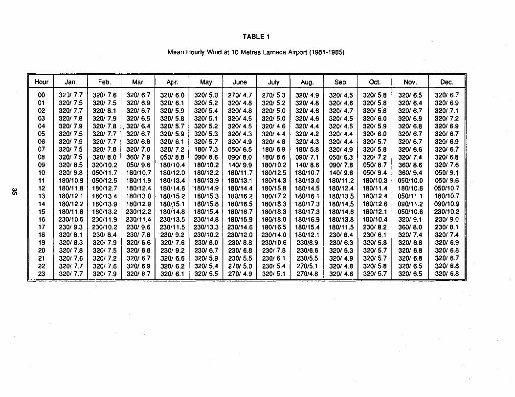
TABLE 1
Mean Hourly Wind at 10 Metres Larnaca Airport (1981-1985)
-- --- ---·-
Hour Jan. Feb. Mar. Apr. May June July Aug. Sep. Oct. Nov. Dec.
00 32)/ 7.7 320/7.6 320/6.7 320/6.0 320/5.0 270/4.7 270/ 5.3 320/4.9 320/4.5 320/5.8 320/6.5 320/6.7 01 320/7.5 320/7.5 320/6.9 320/ 6.1 320/ 5.2 320/4.8 320/ 5.2 320/4.8 320/4.6 320/5.8 320/6.4 320/ 6.9 02 320/7.7 320/8.1 320/6.7 320/5.9 320/5.4 320/4.8 320/ 5.0 320/4.6 320/4.7 320/5.8 320/6.7 320/ 7.1 03 320/7.8 320/7.9 320/6.5 320/5.8 320/ 5.1 320/4.5 320/ 5.0 320/4.6 320/4.5 320/6.0 320/6.9 320/7.2 04 320/7.9 320/7.8 '320/6.4 320/5.7 320/5.2 320/4.5 320/4.6 320/4.4 320/4.5 320/5.9 320/6.8 320/6.9 05 320/7.5 320/ 7.7 320/6.7 320/5.9 320/ 5.3 320/4.3 320/4.4 320/4.2 320/4.4 320/6.0 320/ 6.7 320/6.7 06 320/7.5 320/ 7.7 320/6.8 320/ 6.1 320/5.7 320/4.9 320/4.8 320/4.3 320/4.4 320/5.7 320/6.7 320/6.9 07 320/7.5 320/7.8 320/7.0 320/7.2 180/7.3 050/6.5 180/ 6.9 180/ 5.8 320/4.9 320/5.8 320/6.6 320/6.7 08 320/ 7.5 320/8.0 360/7.9 05018.8 090/8.6 090/8.0 180/ 8.6 090/ 7.1 050/6.3 320/7.2 320/7.4 320/6.8 09 320/8.5 320/10.2 050/9.6 180/10.4 180/10.2 140/ 9.9 180/10.2 140/ 8.6 090/7.8 050/8.7 360/8.6 320/7.6 10 320/9.8 050/11.7 180/10.7 180/12.0 180/12.2 180/11.7 180/12.5 180/10.7 140/ 9.6 050/9.4 360/9.4 050/9.1 11 180/10.9 050/12.5 180/11.9 180/13.4 180/13.9 180/13.1 180/14.3 180/13.0 180/11.2 180/10.3 050/10.0 050/9.6
~ 12 180/11.8 180/12.7 180/12.4 180/14.6 180/14.9 180/14.4 180/15.8 180/14.5 180/12.4 180/11.4 180/10.6 050/10.7 13 180/12.1 180/13.4 180/13.0 180/15.2 180/15.3 180/16.2 180/17.2 180/16.1 180/13.5 180/12.4 050/11.1 180/10.7 14 180/12.2 180/13.9 180/12.9 180/,15.1 180/15.8 180/16.5 180/18.3 180/17.3 180/14.5 180112.6 090/11.2 090/10.9 15 180/11.8 180/13.2 230/12.2 180/14.8 180/15.4 180/16.7 180/18.3 180/17.3 180/14.6 180/12.1 050/10.6 230/10.2 16 230/10.5 230/11.9 230/11.4 230/13.5 230/14.8 180/15.9 180/18.0 180/16.9 180/13.8 180/10.4 320/ 9.1 230/9.0 17 230/ 9.3 230/10.2 230/9.6 230/11.5 230/13.3 230/14.6 180/16.5 180/15.4 180/11.5 230/8.2 360/8.0 230/8.1 18 320/ 8.1 230/8.4 230/ 7.8 230/9.2 230/10.2 230/12.0 230/14.0 180/12.1 230/8.4 230/ 6.1 320/7.4 320/7.4 19 320/8.3 320/7.9 320/6.6 320/7.6 230/8.0 230/8.8 230/10.6 230/8.9 230/6.3 320/5.8 320/6.8 320/6.9 20 320/ 7.8 320/ 7.5 320/6.8 230/9.2 230/6.7 230/6.8 230/7.8 230/6.6 320/5.3 320/5.7 320/6.8 320/6.8 21 320/7.6 320/ 7.2 320/6.7 320/6.6 320/ 5.9 230/5.5 230/ 6.1 230/5.5 320/4.9 320/5.7 320/6.8 320/6.7 22 320/ 7.7 320/ 7.6 320/6.9 320/ 6.2 320/ 5.4 270/5.0 230/ 5.4 270/5.1 320/4.8 320/5.8 320/6.5 320/6.8 23 320/7.7 320/ 7.9 320/ 6.7 320/ 6.1 320/ 5.5 270/4.9 320/ 5.1 270/4.8 320/4.6 320/ 5.7 320/6.5 320/6.8

TABLE2
Oceanographic data (Stations A-E refer to June 26 and F-G to June 25, 1986)
STATION DEPTH TEMPER SALINITY DENSITY OXYGEN SECCHI-m oc o;oo gjcm3 ml/1 DISK
m
A 0 24.74 39.211 26.626 4.96 5 24.41 39.206 26.724 5.03
10 24.04 39.214 26.842 5.03
B 0 24.90 39.218 26.583 4.76 10 23.99 39.200 26.846 5.03 15 23.55 39.177 26.960 4.96 18 23.21 39.163 27.050 5.24
c 0 25.38 39.223 26.437 4.90 10 24.26 39.200 26.764 5.03 20 22.03 39.120 27.359 5.38 31 30 20.26 39.069 27.814 5.52 35 19.66 39.054 27.963 5.52
D 0 24.52 39.195 26.689 5.07 10 24.24 39.202 26.772 5.14 20 21.20 39.105 27.582 5.31 32 30 19.98 39.093 27.907 5.58 50 18.23 39.043 28.328 5.55
E 0 24.15 39.234 26.823 5.10 10 23.73 39.245 26.957 5.03 20 21.13 39.140 27.629 5.31 30 19.65 39.142 28.034 5.52 32 50 18.21 39.120 28.392 5.62 75 17.41 39.087 28.568 5.49 85 17.29 39.102 28.609 5.31
F 0 24.66 39.249 26.679 5.59 10 24.14 39.236 26.827 5.93 20 21.60 39.166 27.516 6.00 30 20.31 39.109 27.830 5.93 50 18.23 39.058 28.340 5.52 32 75 17.44 39.084 28.558 5.38
100 17.09 39.127 28.678 5.17 135 16.60 39.086 28.765 5.35
G 0 24.63 39.243 26.685 5.17 10 24.16 39.235 26.821 5.27 20 21.48 39.164 27.549 5.59 30 20.27 39.143 27.867 5.83 50 17.95 39.129 28.465 6.21 35 75 17.44 39.129 28.592 5.90
100 17.04 39.141 28.701 5.83 150 16.37 39.118 28.845 5.72 180 16.15 39.163 28.932 5.45
36
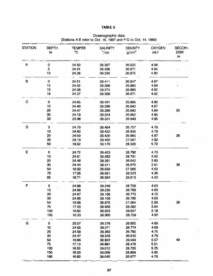
TABLE 3
Oceanographic data (Stations A-E refer to Oct. 15, 1987 and F-G to Oct. 14, 1989)
STATION DEPTH TEMPER SALINITY DENSITY OXYGEN SECCHI-m oc 0
/00 gjcm3 ml/1 DISK m
A 0 24.50 38.387 26.832 4.98 5 24.41 39.496 26.871 4.84
10 24.38 39.336 26.875 4.82
B 0 24.51 39.411 26.847 4.87 10 24.42 39.398 26.863 4.84 15 24.38 39.374 26.860 4.92 18 24.37 39.388 26.871 4.82
c 0 24.65 39.491 26.865 4.90 10 24.49 39.396 26.843 4.87 20 24.47 39.389 26.843 4.84 30 30 24.19 39.354 26.902 4.95 35 23.98 39.331 26.949 4.95
D 0 24.79 39.404 26.757 4.76 10 24.60 39.432 26.836 4.79 20 24.50 39.430 26.865 4.87 36 30 24.19 39.492 27.007 4.82 50 18.62 39.170 28.326 5.72
E 0 24.72 39.423 26.792 4.73 10 24.61 39.363 26.781 3.82 20 24.48 39.391 26.842 3.83 30 24.44 39.411 26.870 3.91 38 50 18.93 38.830 27.985 4.63 75 17.05 38.921 28.523 4.36 85 16.71 38.924 28.613 4.23
F 0 24.98 39.249 26.708 4.63 10 24.68 39.236 26.769 4.69 20 24.67 39.166 26.773 4.72 30 24.65 39.109 26.765 4.63 50 19.06 38.875 27.984 5.60 36 75 17.20 38.838 28.382 5.64 100 16.62 38.923 28.637 5.18 135 16.33 38.993 28.759 4.92
G 0 25.07 39.378 26.650 4.69 10 24.65 39.371 26.774 4.69 20 24.58 39.363 26.790 4.75 30 24.47 39.345 26.810 4.79 50 18.66 38.822 28.049 5.57 40 75 17.13 38.881 28.478 5.51 100 16.55 39.012 28.720 5.25 150 16.33 39.059 28.809 4.95 180 16.60 39.045 28.877 4.79
37
ANNEX IV
INFORMATION ON BENTHOS
Contents: Figures 1 - 2 Table 1
38
34 ° 55'
~ L~~CA ~
3fl 40' ,---------- -,...- -. -· -. -. -· -. -. -· ---~- -· -· -... . 20 -· --,-' 10., ,-· --· -.... -·---" - ..... --·· . . --... t. .-- , 30 .-·· - --·--·--· ·- ..... J/ • -. .... -· "'/. ..- ....... .. --·· --·· -::::·'·'-. . ......... . ..............
/ / / ," .·-·· / ....... ''·'~. / / / .· / -.. .· ·. ' ' ~
I . I " _..-50 ,_.· . . - • . -' . r..·. \ . ' :>
I
/ / . ' -·· • • . . . ,, . . .· / . . . / .... , . ·.·• ·. ) . . ' ' .,. I I / / · / - . . : : 75 · · ·' / • : \ ' \ '"
I . I I . . .. . ' .... , . : ... . .
I I
. . .. . . . . . . . . . .
I
. . ..... 1 . . . • ~· . . I · · · . · 00 .. · : .. - • . . I /. I I . I : . . . ·. '... . . . : \ ' . .
I
. . . . . . . .
' I
• • . . . . . . . I I . · ; : ··· •. ·, \ . . . ' I • • • •
. . . . . . .......
I • \.. I • '\
.. I I . . . I I : /. ., ·: -""' . . .
I . .,. . .. .. .
I /·· ••• ,.,.,.. • . / -· ...... . . .. I
. . ... . . . . I . . . I . : . . ~ i ;
, , . . I . . . .
} .' . 1 l 75 :: I I I , . : ...
/ 10.1 : so· ~
I I I 30 I! .: r:..
1 /20 1 :; 100 ,:J. I • II,
OUTFALL
Figure 1 . Location of sampling stations
: ' .. .
SCALE 1 : 100 000 DEPTH IN FATHOMS

0 r-
II)
c II) QJ QJ E u·u QJ QJ a. a. V) V)
' ' ' \ ' ' \ )
0 (T'l
0 N
0 ~
Figure 2. Number of species and specimens at sampling stations
40
II)
E I..L N c
QJ L-
..r::. :J -a. 0'1
QJ I..L Cl

TABLE 1
Benthos
Stations A B c 0
Depth in fathoms 5 10 20 30 Number of dredgings 20 20 20 20 Callianassa tyrrhena 1 1 Processa cariculata 2
MOLLUSCA Gastroooda Pseudodentalis dentalis 1 Srnaragdia viridis 1 2 Natica hebraea 2
Scaohoooda Dentalium dentalis 2 Pseudodentalis rubescens 5
Lame!libranchiata Solemya togata 1 Parvicardium exiguum 1 Parvicardium papillosum 1 Area barbata Gafrarium minimum 3 Venerubis pullastra 1 1 Glycimeris pilosus 1 Lorlpinus fragilis 23 2 Myrtea spinifera 1 Phaxas pe!lucidus (Pennant) 2 Aloidis giba 6 Nuclea nucleus 8 Cerastoderrna eduli 1
Series A A B c 0
Depth in fathoms 5 10 20 30 Number of dredgings 20 20 20 20
I;;~!::IINQDERMATA Astropecten platyacanthus Astropecten splnulosus 1 Holothurla tubulosa 2 Amphlura chiajei 3 11 Centrostephanus longispinus 1 Schlzaster canallferus 1 2
VARIQUS Ascidia (Ascldla sp.) 1 lsopoda (Cymodocea truncata) 2 Fishes (Gobius sp.) 1
TOTAL SPECIES 13 22 16 15 TOTAL SPECIMENS 11 60 27 29
41
ANNEX V
MICROBIAL POLLUTION
Contents: Tables 1 - 3
42
TABLE 1
Results on microbial pollution monitoring for the year 1985
GREATER THAN 10 SMALLER THAN 10 NIL STATION No. % No. % No. %
28 3 33.33 1 11.11 5 55.56 29 2 25.00 1 12.50 5 62.50 30 1 7.69 10 76.92 2 15.38 31 1 8.33 7 58.33 4 33.33 32 3 23.08 6 46.15 4 30.n 33 3 23.08 5 38.46 5 38.46 34 2 15.38 6 46.15 5 38.46 35 6 50.00 2 16.67 4 33.33 36 3 23.08 7 53.85 3 23.08 37 3 23.08 6 46.15 4 3o.n 38 3 23.08 6 46.15 4 30.n 39 2 16.67 6 50.00 4 33.33 40 6 46.15 7 53.85 0 0.00 41 9 64.29 5 35.71 0 0.00 42 9 69.23 4 30.n 0 0.00 43 9 69.23 4 30.n 0 0.00 44 6 46.15 6 46.15 1 7.69 45 5 38.46 6 46.15 2 15.38 46 3 23.08 6 46.15 4 30.n 47 4 30.77 6 46.15 3 23.08 48 5 38.46 4 3o.n 4 30.n 49 5 41.67 4 33.33 3 25.00 50 1 7.69 8 61.54 4 30.n 51 2 15.38 6 46.15 5 38.46 52 1 7.69 8 61.54 4 30.n 53 2 15.38 8 61.54 3 23.08 54 1 7.69 8 61.54 4 30.n 55 2 15.38 2 15.38 9 69.23 56 1 9.09 2 18.18 8 72.73 57 1 9.09 3 27.27 7 63.64
43

TABLE 2
Results on microbial pollution monitoring for the year 1986
GREATER THAN 10 SMALLER THAN 10 NIL STATION No. % No. % No. %
28 1 5.56 9 50.00 6 33.33 29 2 10.53 10 52.63 6 31.58 30 1 5.56 7 38.89 5 27.78 31 2 10.53 8 42.11 6 31.58 32 1 5.56 10 55.56 6 33.33 33 2 10.53 9 47.37 7 36.84 34 2 11.11 5 27.78 8 44.44 35 3 15.79 9 47.37 3 15.79 36 2 11.11 4 22.22 6 33.33 37 2 10.53 9 47.37 6 31.58 38 2 11.11 7 38.89 8 44.44 39 2 10.00 12 60.00 4 20.00 40 3 16.67 7 38.89 6 33.33 41 2 10.53 9 47.37 6 31.58 42 1 5.56 7 38.89 8 44.44 43 2 10.53 10 52.63 5 26.32 44 2 11.11 7 38.89 7 38.89 45 5 26.32 10 52.63 3 15.79 46 1 5.56 7 38.89 8 44.44 47 0 0.00 0 0.00 2 100.00 48 4 20.00 10 50.00 6 30.00 49 2 10.00 11 55.00 7 35.00 50 2 10.00 4 20.00 14 70.00 51 0 0.00 5 25.00 15 75.00 52 1 5.00 3 15.00 16 80.00 53 0 0.00 4 20.00 16 80.00 54 0 0.00 4 20.00 16 80.00 55 4 20.00 3 15.00 13 80.00
44

"TABLE3
Results on microbial pollution monitoring for the year 1987
GREATER THAN 10 SMALLER THAN 10 NIL STATION No. % No. % No. %
28 1 7.69 8 61.54 4 30.77 29 6 46.15 4 30.77 3 23.08 30 2 14.29 5 35.71 7 50.00 31 2 14.29 5 35.71 7 50.00 32 5 35.71 6 42.86 3 21.43 33 2 14.29 7 50.00 5 35.71 34 2 14.29 7 50.00 5 35.71 35 2 14.29 6 42.86 6 42.86 36 3 21.43 6 42.86 5 35.71 37 3 21.43 7 50.00 4 28.57 38 2 14.29 5 35.71 7 50.00 39 2 14.29 8 57.14 4 28.57 40 10 71.43 4 28.57 0 0.00 41 9 64.29 5 35.71 0 0.00 42 13 92.86 1 7.14 0 0.00 43 11 68.75 4 25.00 1 6.25 44 7 43.75 6 37.50 3 18.75 45 3 18.75 10 62.50 3 18.75 46 7 43.75 4 25.00 5 31.25 47 5 25.00 6 30.00 9 45.00 48 2 12.50 10 62.50 4 25.00 49 3 18.75 8 50.00 5 31.25 50 2 12.50 5 31.25 9 56.25 51 0 0.00 5 31.25 11 68.75 52 3 20.00 5 33.33 7 46.67 53 1 6.25 6 37.50 9 56.25 54 2 12.50 7 43.75 7 43.75 55 1 7.14 7 50.00 6 42.86 56 0 0.00 3 42.86 4 57.14
-----· ----··~-
45

APPENDIX
ORGANIZATIONS AND INSTITUTIONS WHICH WERE REPRESENTED IN THE
REVIEW MEETING ON EIA PROCEDURES
Nicosia, Cyprus, 24-27 October 1988
- Six departments of the Ministry of Agriculture and Natural Resources (Cyprus): 14 participants
- Department of Town Planning and Housing of the Ministry of the Interior (Cyprus): 5 participants
- Department of Public Works of the Ministry of Communications and Works (Cyprus): 2 participants
- Ministry of Commerce and Industry (Cyprus): 1 participant
- Ministry of Health (Cyprus): 1 participant
- Ministry of Justice (Cyprus): 1 participant
- Planning Bureau (Cyprus): 2 participants
- Cyprus Ornithological Society: 1 participant
- Ministry of Urban Development and Ecology (Mexico): 1 participant
- Organization for Physical Planning and Environmental Protection (Greece): 1 participant
--=~nistry of the Interior (Morocco): 1 participant
- Department of Natural Sciences, Faculty of Arts, University of Split (Yugoslavia): 1 participant
- PAP jRAC: 1 staff member and 1 consultant
- UNEP (Co-ordinating Unit for MAP): 1 staff member
- UNEP (OCA/PAC): 1 consultant
46