Embed Size (px)
Citation preview
ENVIRONMENTAL ASSESSMENT
GRAZING PERMIT RENEWAL FOR SMITH ALLOTMENT
EA #ID-074-2004-017
BUREAU OF LAND MANGEMENT
Idaho Falls Field Office 1405 Hollipark Drive Idaho Falls, ID 83401
(208)524-7500
August 2004

2
CHAPTER 1 INTRODUCTION ................................................................................................... 3
1.1 Introduction .......................................................................................................................... 3 1.2 Purpose and Need for the Proposed Action ......................................................................... 3 1.3 Conformance with Land Use Plan ....................................................................................... 3 1.4 Fundamentals of Rangeland Health ..................................................................................... 3 1.5 Grazing Allotment Background ........................................................................................... 3 1.6 Public Contact and Issue Identification. .............................................................................. 4
CHAPTER 2 PROPOSED ACTION AND ALTERNATIVES .................................................... 4 2.0 Management Guidelines Common to all Alternatives ......................................................... 4 2.1 Alternative A (Proposed Action) –Issue Modified Grazing Permit ..................................... 5 2.2 Alternative B - Issue Modified Grazing Permit ................................................................... 6 2.3 Alternative C – Issue Modified Grazing Permit .................................................................. 7 2.5 Alternatives Considered but not Further Analyzed. ............................................................ 9
2.5.1 No Change .................................................................................................................... 9 2.5.2 No Livestock Grazing. .................................................................................................. 9
CHAPTER 3 AFFECTED ENVIRONMENT ............................................................................... 9 3.1 Critical Elements of the Affected Environment. ................................................................... 9
3.1.1 Cultural Resources ...................................................................................................... 10 3.1.2 Recreation ................................................................................................................... 10 3.1.3 Soils............................................................................................................................. 11 3.1.4 Vegetation ................................................................................................................... 11 3.1.5 Visual/Wilderness ....................................................................................................... 12 3.1.6 Wildlife ....................................................................................................................... 12
CHAPTER 4 ENVIRONMENTAL IMPACTS .......................................................................... 14 4.1 Alternative A (Proposed Action) ....................................................................................... 15
4.1.1 Cultural Resources ...................................................................................................... 15 4.1.2 Recreation ................................................................................................................... 15 4.1.3 Soils............................................................................................................................. 15 4.1.4 Vegetation ................................................................................................................... 15 4.1.5 Visual/Wilderness ....................................................................................................... 16 4.1.6 Wildlife ....................................................................................................................... 17
4.2 Alternative B ...................................................................................................................... 17 4.2.1 Cultural Resources ...................................................................................................... 17 4.2.2 Recreation ................................................................................................................... 17 4.2.3 Soils............................................................................................................................. 18 4.2.4 Vegetation ................................................................................................................... 18 4.2.5 Visual/Wilderness ....................................................................................................... 18 4.2.6 Wildlife ....................................................................................................................... 18
4.3 Alternative C ...................................................................................................................... 19 4.3.1 Cultural Resources ...................................................................................................... 19 4.3.2 Recreation ................................................................................................................... 19 4.3.3 Soils............................................................................................................................. 19 4.3.4 Vegetation ................................................................................................................... 19 4.3.5 Visual/Wilderness ....................................................................................................... 20

3
4.3.6 Wildlife ....................................................................................................................... 20 CHAPTER 5 MITIGATION MEASURES ................................................................................. 20
5.1 Cultural Resources ......................................................................................................... 20 CHAPTER 6 CONSULTATION AND COORDINATION ....................................................... 21
CHAPTER 1 INTRODUCTION
1.1 Introduction Several authorities mandate or allow the Bureau of Land Management (BLM) to authorize livestock grazing as an accepted and valid use of public lands as part of multiple-use management of natural resources. These authorities include the Taylor Grazing Act of 1934, the Federal Land Policy and Management Act (FLPMA) of 1976, and the Public Rangelands Improvement Act (PRIA) of 1978. The BLM issues grazing permits and leases for a term not to exceed ten years.
1.2 Purpose and Need for the Proposed Action The purpose of this action is to renew the grazing permit in the Smith Allotment. The need for action is to authorize grazing on these public lands in accordance with all applicable statues and regulations, and in conformance with the objectives and decisions of the applicable land use plan.
1.3 Conformance with Land Use Plan The Big Desert Management Framework Plan was approved on October 15, 1981 and is supported by the Big Desert Grazing Final Environmental Impact Statement of August 1981. This plan guides public land use management, including grazing management in the area where Smith Allotment is located. Reissuance of the grazing permit in the allotment would be in conformance with the Land Use Plan because the reissuance would not result in a change in the scope of resource uses or a change in the terms, conditions, and decisions of the approved plan.
1.4 Fundamentals of Rangeland Health On August 12, 1997, Idaho Standards for Rangeland Health and Guidelines for Livestock Grazing Management were approved by the Secretary of the Interior. Subsequently, livestock management practices must be in conformance with the approved standards and guidelines. Alternatives A and B are in compliance with these standards and guidelines. The Smith Allotment was evaluated in 2003 to assess whether the allotment was meeting the requirements of the Idaho Standards for Rangeland Health and Guidelines for Livestock Management. In March 2004, a Determination of Achieving Standards for Rangeland Health was issued for the allotment. The Determination for the Smith Allotment found that Standard 1 was being met and that Standards 4, 5, and 8 were not being met and current livestock grazing management practices are a significant factor. The determination found that livestock management practices do not conform with the Guidelines for Livestock Grazing Management.
1.5 Grazing Allotment Background The Smith Allotment is located in the Big Desert planning unit and is approximately 20 miles south of Arco, Idaho in Butte County. There are 20, 873 acres within Smith Allotment.

4
Approximately 6,370 acres are within the boundaries of Craters of the Moon National Monument and Preserve (CMNMP). There is one permittee in the allotment who is authorized to graze 500 cattle from April 21 to September 20 in a deferred grazing system. Authorized use is 2,515 AUMs.
1.6 Public Contact and Issue Identification. In the spring of 2003, the Idaho Falls Field Office sent letters to the permittee, interested publics, and other agencies inviting them to participate in the assessment for Smith Allotment. In November 2003, the allotment assessment was sent to the aforementioned requesting comments and additional data. In March 2004, the allotment determination and proposed action was sent to the aforementioned and they were asked to identify issues and alternatives. Western Watersheds Project responded to all of the Determinations that were issued in 2004 with generalized comments not specific to any allotment. No other responses were received.
CHAPTER 2 PROPOSED ACTION AND ALTERNATIVES
2.0 Management Guidelines Common to all Alternatives 1. Upland Utilization – Utilization studies would be conducted using the key forage plant
method in key upland areas and use areas would be mapped by pasture. Average utilization will be no more than 50 percent of the annual growth of key upland species. Heavy use areas (as defined by the key forage method) will be limited to 20 percent of the suitable acreage in each pasture.
2. Upland Trend – Trend studies would be conducted in the uplands using the step point
method in key areas. One photo plot would be established at each key area. Long term trend studies would be conducted using the ecological site inventory method.
3. Distribution of livestock salt and mineral supplements shall be at least ¼ mile from the
nearest water source. 4. In connection with allotment operations under this authorization, if any human remains,
cultural, archaeological, historical, paleonological, or scientific objects and sites are discovered, the permittee shall stop operations in the immediate area of the discovery, protect such resources, and immediately notify the BLM Authorized Officer (AO) of the discovery. The immediate area of the discovery must be protected until the operator is notified to resume operations by the AO.
5. There will be no authorized construction during the periods March 15 thru June 15 in order to
minimize potential disturbance to sage grouse. All disturbed areas resulting from construction will be reseeded with a BLM approved mix of native grasses and forbs to protect the site from erosion and establishment of invasive and noxious weeds.
6. All livestock water troughs must have functional bird ladders. Installation and maintenance
of the bird ladders are the responsibility of the permittee.

5
2.1 Alternative A (Proposed Action) –Issue Modified Grazing Permit The Determination found that Standards 4, 5, and 8 are not being met and current livestock grazing practices were a significant factor. The Determination also found that current livestock management does not conform with Guidelines 3, 9, 12, and 13 of the Guidelines for Livestock Grazing Management. Guideline 3 is “Use grazing management practices and/or facilities to maintain or promote soil conditions that support water infiltration, plant vigor, and permeability rates and minimize soil compaction appropriate to site potential.” Guideline 9 is “Apply grazing management practices to maintain adequate plant vigor for seed production, seed dispersal, and seedling survival of desired species relative to soil type, climate, and landform.” Guideline 12 is “Apply grazing management practices and/or facilities that maintain or promote the physical and biological conditions necessary to sustain native plant populations and wildlife habitats in native plant communities.” Guideline 13 is “On areas seeded predominantly with non-native plants, use grazing management practices to maintain or promote the physical and biological conditions to achieve healthy rangelands.” The Determination identified the need for changes to the current management of the allotment; therefore the BLM Field Manager would authorize continued grazing within Smith Allotment with changes to the current allotment management and facilities. The operator has proposed changes to the current management, including the construction of approximately 18.5 miles of underground pipeline from Finger’s Butte Well to eight new troughs and five existing troughs. The construction of the proposed facilities would result in more uniform distribution of livestock across the allotment and under the proposed action the allotment would make significant progress towards meeting Standards 4, 5, and 8. The construction of the facilities would insure that grazing management is in conformance with Guidelines 3, 9, 12, and 13. All of the land use plan’s Standard Operating Procedures pertaining to authorizing livestock grazing would apply. The grazing permit would be renewed for a term of ten years. Should information collected subsequent to any renewal indicate that changes in management are needed to ensure this allotment is meeting or making significant progress toward meeting Standards and conforming to Guidelines, the permit may be modified at any time during the ten- year period. The proposed action includes the following actions: 1. Authorize construction of approximately 18.5 miles of underground pipeline to five existing
troughs, three new troughs at existing water haul locations, and five new troughs at new sites. The pipeline would be constructed in stages over the life of the permit, and would use polyethylene pipe between 1.25 and 2 inches in diameter. The permittee would be responsible for design, construction, and maintenance of the pipeline. Design and construction must be approved by the BLM prior to implementation. The pipeline would be buried and the disturbed area may be no wider than three feet. Less than ten acres would be disturbed by construction. The pipeline route would not be bladed. The pipeline would be constructed adjacent to existing roads and no construction or soil disturbance would take place within the boundary of Craters of the Moon National Monument and Preserve, though a portion of the pipeline and one new trough would be adjacent to the boundary.
2. Authorize construction of eight permanent troughs along the proposed pipeline route.
6
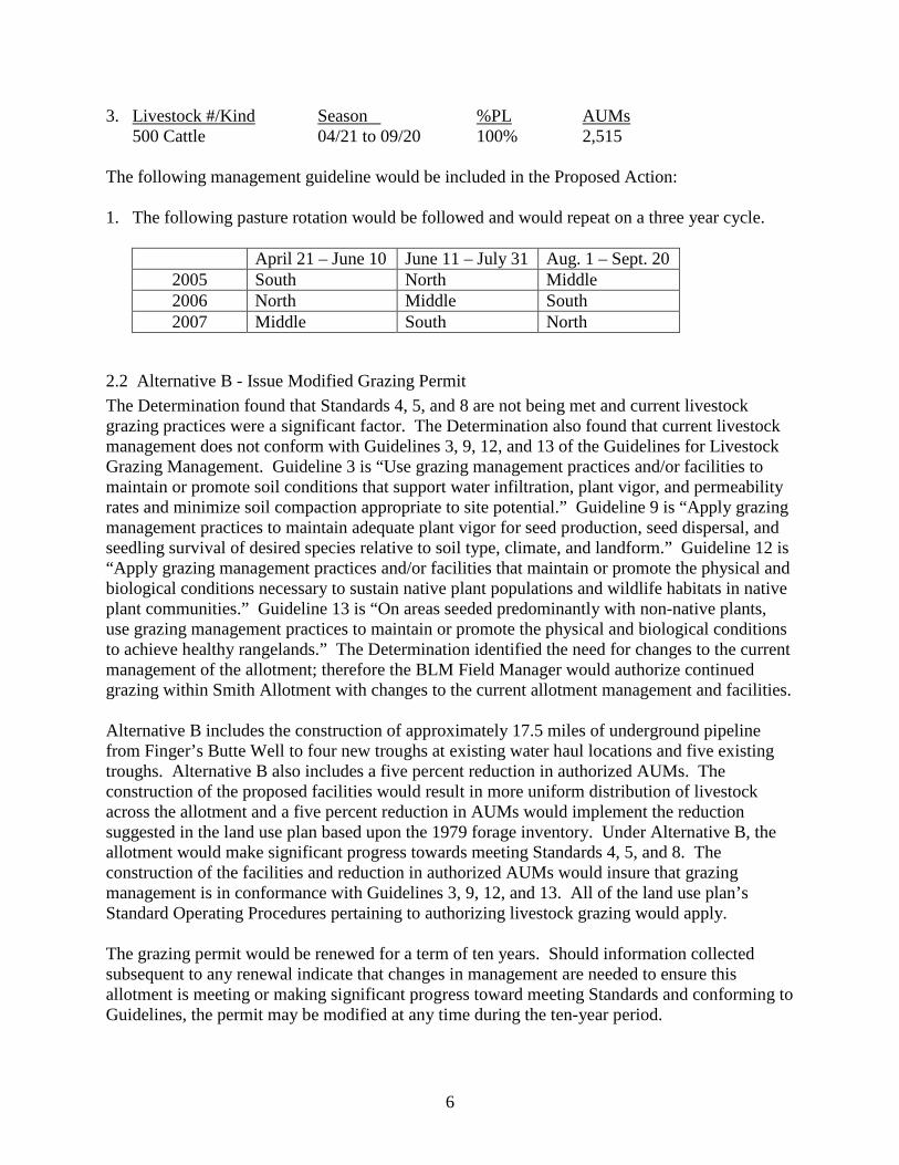
3. Livestock #/Kind Season %PL AUMs 500 Cattle 04/21 to 09/20 100% 2,515
The following management guideline would be included in the Proposed Action: 1. The following pasture rotation would be followed and would repeat on a three year cycle.
April 21 – June 10 June 11 – July 31 Aug. 1 – Sept. 20 2005 South North Middle 2006 North Middle South 2007 Middle South North
2.2 Alternative B - Issue Modified Grazing Permit The Determination found that Standards 4, 5, and 8 are not being met and current livestock grazing practices were a significant factor. The Determination also found that current livestock management does not conform with Guidelines 3, 9, 12, and 13 of the Guidelines for Livestock Grazing Management. Guideline 3 is “Use grazing management practices and/or facilities to maintain or promote soil conditions that support water infiltration, plant vigor, and permeability rates and minimize soil compaction appropriate to site potential.” Guideline 9 is “Apply grazing management practices to maintain adequate plant vigor for seed production, seed dispersal, and seedling survival of desired species relative to soil type, climate, and landform.” Guideline 12 is “Apply grazing management practices and/or facilities that maintain or promote the physical and biological conditions necessary to sustain native plant populations and wildlife habitats in native plant communities.” Guideline 13 is “On areas seeded predominantly with non-native plants, use grazing management practices to maintain or promote the physical and biological conditions to achieve healthy rangelands.” The Determination identified the need for changes to the current management of the allotment; therefore the BLM Field Manager would authorize continued grazing within Smith Allotment with changes to the current allotment management and facilities. Alternative B includes the construction of approximately 17.5 miles of underground pipeline from Finger’s Butte Well to four new troughs at existing water haul locations and five existing troughs. Alternative B also includes a five percent reduction in authorized AUMs. The construction of the proposed facilities would result in more uniform distribution of livestock across the allotment and a five percent reduction in AUMs would implement the reduction suggested in the land use plan based upon the 1979 forage inventory. Under Alternative B, the allotment would make significant progress towards meeting Standards 4, 5, and 8. The construction of the facilities and reduction in authorized AUMs would insure that grazing management is in conformance with Guidelines 3, 9, 12, and 13. All of the land use plan’s Standard Operating Procedures pertaining to authorizing livestock grazing would apply. The grazing permit would be renewed for a term of ten years. Should information collected subsequent to any renewal indicate that changes in management are needed to ensure this allotment is meeting or making significant progress toward meeting Standards and conforming to Guidelines, the permit may be modified at any time during the ten-year period.

7
Alternative B includes the following actions: 1. Authorize construction of approximately 17.5 miles of underground pipeline to five existing
troughs and four new troughs at existing water haul locations. The pipeline would be constructed in stages over the life of the permit, and would use polyethylene pipe between 1.25 and 2 inches in diameter. The permittee would be responsible for design, construction, and maintenance of the pipeline. Design and construction must be approved by the BLM prior to implementation. The pipeline would be buried and the disturbed area may be no wider than three feet. Less than ten acres would be disturbed by construction. The pipeline route would not be bladed. The pipeline would be constructed adjacent to existing roads and no construction or soil disturbance would take place with the boundary of Craters of the Moon National Monument and Preserve, though a portion of the pipeline and one new trough would be adjacent to the boundary.
2. Authorize construction of four permanent troughs at existing water haul locations along the proposed pipeline.
3. Reduce Active Use by five percent (from 2,515 AUMs to 2,386 AUMs). 4. Livestock #/Kind Season %PL AUMs
474 Cattle 04/21 to 09/20 100% 2,386 The following management guideline would be included in Alternative B: 1. The following pasture rotation would be followed and would repeat on a three year cycle.
April 21 – June 10 June 11 – July 31 Aug. 1 – Sept. 20 2005 South North Middle 2006 North Middle South 2007 Middle South North
2.3 Alternative C – Issue Modified Grazing Permit The Determination found that Standards 4, 5, and 8 are not being met and current livestock grazing practices were a significant factor. The Determination also found that current livestock management does not conform with Guidelines 3, 9, 12, and 13 of the Guidelines for Livestock Grazing Management. Guideline 3 is “Use grazing management practices and/or facilities to maintain or promote soil conditions that support water infiltration, plant vigor, and permeability rates and minimize soil compaction appropriate to site potential.” Guideline 9 is “Apply grazing management practices to maintain adequate plant vigor for seed production, seed dispersal, and seedling survival of desired species relative to soil type, climate, and landform.” Guideline 12 is “Apply grazing management practices and/or facilities that maintain or promote the physical and biological conditions necessary to sustain native plant populations and wildlife habitats in native plant communities.” Guideline 13 is “On areas seeded predominantly with non-native plants, use grazing management practices to maintain or promote the physical and biological conditions to achieve healthy rangelands.” The Determination identified the need for changes to the current management of the allotment; therefore the BLM Field Manager would authorize continued grazing within Smith Allotment with changes to the current allotment management and facilities.

8
Alternative C includes the construction of approximately 17.5 miles of underground pipeline from Finger’s Butte Well to four new troughs at existing water haul locations and five existing troughs. Alternative B also includes a five percent reduction in authorized AUMs and a change in the season of use from April 21 thru September 20 to May 1 thru July 16, which is a reduction from 153 days authorized use to 77 days authorized use. The construction of the proposed facilities would result in more uniform distribution of livestock across the allotment. The change in season of use would place more livestock on the allotment for a shorter period of time which would result in less selective grazing pressure. Some forage species would receive less grazing pressure than under the current grazing management, however other species would be grazed at higher utilization levels than under the current grazing management. A five percent reduction in AUMs would implement the reduction suggested in the land use plan based upon the 1979 forage inventory. Under Alternative C, the allotment may make significant progress towards meeting Standards 4, 5, and 8. The construction of the facilities and reduction in authorized AUMs would insure that grazing management is in conformance with Guidelines 3, 9, 12, and 13. All of the land use plan’s Standard Operating Procedures pertaining to authorizing livestock grazing would apply. The grazing permit would be renewed for a term of ten years. Should information collected subsequent to any renewal indicate that changes in management are needed to ensure this allotment is meeting or making significant progress toward meeting Standards and conforming to Guidelines, the permit may be modified at any time during the ten-year period. Alternative C includes the following actions: 1. Authorize construction of approximately 17.5 miles of pipeline to five existing troughs and
four new troughs at existing water haul locations. The pipeline would be constructed in stages over the life of the permit, and would use polyethylene pipe between 1.25 and 2 inches in diameter. The permittee would be responsible for design, construction, and maintenance of the pipeline. Design and construction must be approved by the BLM prior to implementation. The pipeline would be buried and the disturbed area may be no wider than three feet. Less than ten acres would be disturbed by construction. The pipeline route would not be bladed. The pipeline would be constructed adjacent to existing roads and no construction or soil disturbance would take place with the boundary of Craters of the Moon National Monument and Preserve, though a portion of the pipeline and one new trough would be adjacent to the boundary.
2. Authorize construction of four permanent troughs at existing water haul locations along the proposed pipeline.
3. Reduce Active Use by five percent and adjust season of use to May 1 thru July 16. 4. Livestock #/Kind Season %PL AUMs
943 Cattle 05/01 to 07/16 100% 2386

9
The following management guidelines will be included in Alternative C: 1. The following pasture rotation would be followed and would repeat on a three year cycle.
May 1 – July 16 May 1 – May 31 June 1 – July 16 2005 South North Middle 2006 North Middle South 2007 Middle South North
2.5 Alternatives Considered but not Further Analyzed.
2.5.1 No Change Under a “no change” alternative, the BLM Field Manager would authorize continued livestock grazing under the same management guidelines and with the same terms and conditions as the current permit. The Determination identified that Standards 4, 5, and 8 were not being met and livestock grazing management practices were a factor. This finding requires a change in the management guidelines and/or terms and conditions of the grazing permit; therefore a “no change” alternative was not analyzed as it would not meet the purpose and need for action.
2.5.2 No Livestock Grazing. Under a “no-grazing” alternative, the BLM Field Manager would discontinue livestock grazing in the allotment. The BLM would allow the current permit for the permittee currently using the allotment to complete their terms in the allotment. A “no livestock grazing” alternative was not analyzed because it would not meet the purpose and need for action.
CHAPTER 3 AFFECTED ENVIRONMENT
3.1 Critical Elements of the Affected Environment. Table 1 lists the critical elements of the environment which are subject to statute, regulation, or executive order. Critical elements that are present and affected are discussed in detail below.

10
Table 1 – Critical Elements of the Affected Environment Critical Element Not Present Present Not
Affected Present and
Affected Air Quality X ACEC’s X Cultural Resources X Environmental Justice X Prime or Unique Farmlands X Floodplains X Invasive, Nonnative Species X Migratory Birds X Native American Religious Concerns X T & E Species X Hazardous or Solid Wastes X Water Quality, Drinking/Ground X Wetlands/Riparian Zones X Wild and Scenic Rivers X Wilderness X
3.1.1 Cultural Resources One prehistoric Native American property has been recorded in the allotment. Raptor Cave is a small lava tube cave. The cave features rock art and ice. This property is eligible for listing on the NRHP. Raptor Cave and other Native American heritage sites in the Smith Allotment are related to 150 to 12,000 years of use and habitation by nomadic hunting and gathering peoples. Native American hunters followed seasonal travel routes across the allotment. Flake and stone tool scatters indicate the utilization of the allotment’s natural resources and topography. The eastern Snake River Plain has historically supported bison, elk, deer, antelope, ground squirrels, rabbits, fish, waterfowl and upland game birds. These animals would have been hunted and harvested by Native American peoples. No Traditional Cultural Properties (TCPs), sacred sites or other areas used for traditional cultural purposes have been identified in the allotment. However, Raptor Cave may be considered a sacred site by Shoshone-Bannock Tribal members.
3.1.2 Recreation In November 2000, Presidential Proclamation 7373 greatly expanded the boundaries of Craters of the Moon National Monument. The Proclamation also directed that the Bureau of Land Management (BLM) and the National Park Service (NPS) cooperatively manage the area. In August 2002, President George W. Bush signed legislation designating the expanded area within the NPS boundaries of the Monument as a National Preserve. Roughly one-quarter of the allotment, along the west edge, is within the National Preserve.
11
Recreation uses in and adjacent to the allotment include viewing geological features, dispersed camping and hiking, and hunting. Recreational activities take place primarily in the spring and early fall. Summer use is reduced due to high temperatures and dry conditions. The Draft Management Plan/Environmental Impact Statement (Plan/EIS) for the Craters of the Moon National Monument and Preserve (CMNMP) sets forth the proposed management direction for approximately 740,000 acres of public lands located on the Snake River Plain of Southern Idaho including a part of the Smith Allotment. None of the draft management plan alternatives for the Preserve are expected to result in a significant increase in recreational activities within the allotment.
3.1.3 Soils The allotment is characterized by flat to rolling plains with numerous lava outcroppings and generally slopes to the southwest. The average elevation is 5,250 feet. Sandy loams to clay loams, with varying depth to basalt, cover the allotment. Average precipitation ranges from nine to 12 inches with most precipitation occurring between November and June.
3.1.4 Vegetation An Ecological Site Inventory (ESI) was completed on 27 sites between 1978 and 1979. Of the 27 sites, 26 sites were revisited in 1990. Seventeen sites remained static with fourteen in good condition and three in poor condition. Four sites had an upward trend, improving from fair to good ecological condition. Five sites had a downward trend with two sites changing from good to poor and three sites changing from good to fair condition. Grazing utilization levels have been mapped for 14 years between 1980 and 2003. Grazing utilization pattern maps in the allotment were examined and the maps indicate that the west side of the upper and middle pastures typically have slight to light livestock use with some areas receiving no use. The east side of north and middle pasture, and the south pasture, show moderate to heavy utilization in several locations. The east side of the allotment contains the Arco-Minidoka, which is a county maintained road in good condition that has been used as the primary water haul road within the allotment. The most common range site in the allotment is Wyoming big sage (Artemisia tridentata ssp. wyomingensis)/bluebunch wheatgrass (Pseudogeneria spicata). Two other range sites are found within the allotment: basin big sage (Artemisia tridentata ssp. tridentate)/basin wildrye (Leymus cinereus) and three tip sage (Artemisia tripartita)/bluebunch wheatgrass. Wildfires in 1964 and 1966 combined to burn over 60 percent of the allotment. A portion of the area burned in 1964 was reseeded with crested wheatgrass (Agropyron cristatum), intermediate wheatgrass (Agropyron intermedium), and hard fescue (Festuca longifolia). A small area of the allotment burned in 1996. Invasive and noxious weeds are known to exist in the allotment. Cheatgrass (Bromus tectorum) is present in understory in several locations. When noxious weeds become established, they can dominate a site and reduce vegetative diversity.

12
All data known to the Idaho Falls Field Office, including data from the Idaho Conservation Data Center, has been considered to identify any plant species currently listed under the Endangered Species Act (ESA) or any other special status species. There are no known occurrences of threatened or endangered plant species within the allotment. Table 2 lists special status plant species that have been identified as occurring or potentially occurring within the allotment. Table 2 - Special Status Plant Species and Occurrence within Smith Allotment
Species Statusª Occurrence Rationale Manybranched ipomopsis (Ipomopsis polycladon)
S Potential Potentially suitable habitat
Red swampfire (Salicornia rubra)
S Potential Potentially suitable habitat
Iodinebush (Allenrolfea occidentalis)
S Potential Potentially suitable habitat
Picabo milkvetch (Astragalus oniciformis)
S Potential Potentially suitable habitat
Hidden phacelia (Phacelia inconspicua)
S Potential Potentially suitable habitat
a. S = BLM Sensitive Species
3.1.5 Visual/Wilderness The Smith Allotment is in Visual Resource Management Class (VRM) III. VRM Class III objectives are to partially retain the existing character of the landscape. The level of change to the landscape should be moderate. Management activities may attract attention but should not dominate the view of the casual observer. Changes should repeat the basic elements found in the predominant natural features of the landscape.
3.1.6 Wildlife The Smith Allotment is important to a wide range of native wildlife species, including migratory birds, which seasonally occupy an increasingly important sagebrush habitat. The allotment is spring, summer, and fall range for antelope, mule deer, and elk. The allotment is also identified as sage grouse breeding and winter habitat. The avian community within the shrub steppe is dominated by three sagebrush obligate passerine species which are also considered BLM sensitive species. These species include the sage thrasher, sage sparrow, and Brewer’s sparrow. Raptor species that inhabit the allotment, which are also classified as sensitive species, include the ferruginous hawk and burrowing owl. The wildlife habitats on the Smith Allotment are comprised of sagebrush-grass communities. The present value of these habitats to wildlife, including migratory bird species, depends on the ecological status, season-of-use, and species involved. The Big Desert planning unit has had a 70 percent reduction in sagebrush cover since 1995 due to wildfires. A small portion of the Smith Allotment was reseeded to exotic grasses after past fire occurrence and as a result the native grass forb community has been disrupted and this has resulted in lower habitat values for wildlife. The northern portion of the allotment is in good ecological condition with intact shrub and grass communities. There have been no studies conducted in the Smith Allotment to

13
specifically evaluate big game habitat. Mule deer populations are limited and limited habitat potential and wildfires have reduced the areas ability to support higher deer populations. Water is a limiting factor in the ability to support wildlife populations. A BLM program to develop season-long water sources has resulted in improved distribution and carrying capacity for some wildlife species in the Big Desert. Current habitat conditions are favorable for elk populations to increase within the allotment. Improving conditions which favor perennial grasses and the development of season long water has improved habitat quality for elk. Idaho Department of Fish and Game elk management plans suggest that current numbers exceed management objectives (IDF&G. 1998). There are no threatened or endangered species present within the allotment. Inventory and monitoring data are mostly limited or absent for many special status species including sagebrush obligates and migratory birds associated with the Smith Allotment, thus little is known about their population status or trends within the allotment. Pygmy rabbits are expected to occur within the project area, although no current information exists on distribution and abundance. A predictive habitat model developed to prioritize habitat within Idaho (Rachlow, 2003) shows the project area to have moderately high potential for pygmy rabbit occurrence. Table 3 lists special status wildlife species that have been identified as occurring or potentially occurring within the Smith Allotment. BLM includes the following as special status species:
(1) Species officially listed or proposed for listing as threatened or endangered under the ESA or candidates for listing as threatened or endangered under the ESA.
(2) Species listed by a State in a category such as threatened or endangered
implying potential endangerment or extinction. (3) Species designated by the BLM State Director as sensitive.
The probability of species occurring and justification for occurrence is also provided. Species not occupying seasonal ranges or not expected to occur within these allotments will not be discussed in this environmental assessment.

14
Table 3 - Wildlife Special Status Species and Occurrence within the Smith Allotment
Species Statusª Occurrence Rationale
Sage grouse
(Centrocerus urophasianus)
S Present Population stronghold
Prairie Falcon
(Falco mexicanus)
S Present Forages throughout allotment. Nesting aeries not identified
Ferruginous Hawk
(Buteo regalis)
S Present Breeding habitat. Nest sites within allotment
Brewer’s sparrow
(Spizella breweri) S Present Breeding habitat
Sage Sparrow
(Amphispiza belli) S Present Breeding habitat
Pygmy rabbit
(Brachylagus idahoensis)
S Unknown No observations
a. S = BLM Sensitive Species Sage grouse, a BLM sensitive species, shows a declining population trend in Idaho based on long term averages (Connelly et al, 2004). Populations within the Big Desert area have shown increases within the past five years according to Department of Fish and Game lek route data. Sage grouse within the Smith Allotment are largely migratory with the majority of use in the allotment being breeding/early brood rearing and winter habitat. There are presently four active leks within the allotment and six historic leks. Sage grouse habitat was evaluated in 2003 utilizing Idaho BLM’s Sage Grouse Habitat Assessment Framework. Approximately 70 percent of the allotment meets standards for sage grouse breeding and wintering habitat. Key indicators in the 30 percent of the allotment not meeting standards as breeding habitat were forb cover and diversity, and grass heights.
CHAPTER 4 ENVIRONMENTAL IMPACTS Impacts are measured in terms of direct, indirect, long-term, and short-term impacts. Impacts may also be cumulative. Cumulative impacts result from the incremental impact of the action when added to other past, present, and reasonably foreseeable future actions regardless of what agency or person undertakes such other actions. Cumulative impacts can result from individually minor but collectively significant actions taking place over a period of time (40 CFR 1508.7).

15
4.1 Alternative A (Proposed Action)
4.1.1 Cultural Resources Livestock grazing could directly and indirectly damage archaeological sites in the allotment. Trampling on fragile open, surface sites breaks artifacts and stone tool making waste material (flakes). It also can alter a site’s features and the spatial relationships of artifacts, stone flakes and features. Trampling indirectly damages cultural resources by removing vegetation. Bare exposed soil increases surface run off from streams and melting snows. It also accelerates wind erosion. This removes more artifacts, flakes and other cultural materials from archaeological sites. Erosion and surface runoff can completely destroy archaeological sites. Vegetation loss and soils erosion may also expose sites to detection and discovery by looters and surface collectors. If livestock are dispersed in the allotment and not concentrated on archaeological sites, continued livestock grazing in the allotment would have no effect on NRHP eligible properties and other cultural resources. Continued livestock grazing in the allotment would have no adverse effect on NRHP eligible properties and other cultural resources. Under the most effective grazing plan there will be some loss of cultural materials, elements and features. Cumulative effects: No cumulative effects for cultural resource values have been identified.
4.1.2 Recreation Visitor use in the allotment varies due to weather and road conditions. Public interaction with livestock would continue. Public interaction with livestock would be a minor impact. Construction of the pipeline may cause a temporary inconvenience to the public using the roads that are either adjacent or cross the pipeline path. Cumulative effects: No cumulative effects for recreation have been identified.
4.1.3 Soils Continued cattle traffic on livestock trails and existing watering areas would maintain the level of soil compaction. Soil compaction would increase at five of the proposed water trough locations along the pipeline that have not been used or have not recently been used as water haul location. Soil compaction by heavy objects, including trampling by cattle and use of heavy equipment for project construction, penetrates and compacts soil material to depths of 15 to 20 inches. The surface to a depth of six inches, is usually released from compaction by frost action. The deeper soil compaction that is not affected by frost action may remain in the soil for years. Deep soil compaction restricts root growth, reduces soil productivity and contributes to water and soil erosion. Deep soil compaction can increase over time. Cumulative effects: No cumulative effects for soils have been identified.
4.1.4 Vegetation Direct impacts to vegetation result from herbage removal by foraging animals. Appropriate grazing or utilization levels can have the effect of stimulating plants, resulting in increased plant production if energy reserves are adequate. If the amount of grazing use or utilization is high for

16
a given year, or especially for a sequence of years, the composition of the vegetative community may become modified as the more desirable, and more utilized species lose vigor and decrease in density throughout the site. This concern is heightened during years of drought as plants are stressed before grazing occurs. The current level of authorized AUMs is in excess of the forage capacity of the allotment, determined by the 1979 forage inventory to be 2,386 AUMs. The following upland grass species are likely to be directly affected by livestock grazing: bluebunch wheatgrass, basin wildrye, Nevada bluegrass (Poa nevadensis), squirreltail (Elymus elymoides), and needle-and-thread (Hesperostipa comata). Annual and perennial forbs are present and would receive grazing pressure. Prior to 1997, the season of use within the allotment was April 21 to June 23. The season of use was extended to September 20 and a deferred rotation grazing system was implemented in 1998 to ensure that the timing of defoliation is alternated throughout the allotment allowing the native species in portions of the allotment area to complete their seasonal growth cycle prior to being grazed. The amount of authorized use in the allotment may be higher than appropriate for the site potential based on the 1979 forage inventory. The ESI studies indicate that the trend of the allotment is static. The construction of a pipeline system would provide a reliable water source within the allotment. The construction of eight new troughs along the pipeline route, three at existing water haul locations and five at new locations, would help to resolve the distribution problem noted in the use pattern maps. In the past, water has been hauled primarily only to sites along the access road to Finger’s Butte Well and to areas easily accessible from the Arco-Minidoka road. This limited distribution of water can be attributed to good road conditions along these routes. The new facilities would promote plant vigor in those locations that have received higher utilization levels in the past as utilization would be more uniform with an increased number of watering locations. Uniform distribution and utilization levels within the management guidelines are grazing management practices which would maintain adequate plant vigor, seed production and dispersal, and sustain native plant populations. By maintaining or promoting the physical and biological conditions needed for healthy rangelands, the proposed action would be in conformance with the Guidelines for Livestock Grazing Management. Soil disturbance through livestock grazing is one factor in the spread of invasive plants and may or may not have contributed to the initial establishment of invasive plants in the surrounding area. Other spreading agents include vehicles (both on and off road use), recreationists, road construction and maintenance equipment, wildlife, wildfire, wind, and flood events. All disturbance areas related to project construction would be reseeded with a BLM approved mix of native grass and forb species to control erosion and reduce the potential for invasive or noxious weed establishment. The Proposed Action would maintain the ecological condition of the allotment. This, along with the Idaho Falls Field Office’s weed control program would slow the spread of any noxious weeds into the allotment. Cumulative effects: No cumulative effects for vegetation have been identified.
4.1.5 Visual/Wilderness Construction of the pipeline would be within the management guidelines of VRM Class III which allows for moderate change to the visual landscape.

17
Cumulative effects: No cumulative effects to visual/wilderness have been identified.
4.1.6 Wildlife There does not appear to be elk-livestock competition for forage within the allotment. The deferred rotation allows for growing season rest for one-third of the allotment annually. The long grazing season has the potential to impact mule deer seasonal habitat as livestock consumption of browse species occurs during the late summer months. This late season use would only affect one-third of the allotment. The area of browse competition may expand beyond the current level under the proposed action due to increased of livestock distribution resulting from new water development. Many of the allotments within the Big Desert planning unit involve water hauling for livestock consumption. This practice has worked well with early season use as hauling augments water supplies when small reservoirs are exhausted or dry-up. Increasing the uniformity of livestock use would result in fewer areas where sage grouse are free from disturbance and where brooding and nesting requirements are met or exceeded annually. The construction of permanent water facilities at new locations would increase the utilization levels in those areas and may result in those areas not meeting sage grouse habitat requirements. While areas of lower ecological condition may improve in the long-term with better livestock distribution, some areas of higher ecological condition now located away from water may shift toward lower condition with increased use associated with increased water availability. The pipeline would provide for a more consistent and reliable water distribution. Water trucks are constantly in operation on BLM desert roads during the authorized grazing season, creating dust problems and deteriorating roads. This constant activity may cause some level of disruption to wildlife activity, however the affects of such disruption are unknown. Cumulative effects: A total of thirty-eight miles of pipeline are being proposed for construction in the Big Desert Planning Unit. Construction of all the proposed pipelines would increase the existing number of pipeline miles by 280 percent within the planning unit. This should have a minor impact on wildlife habitat since the majority of the proposed pipeline service existing water haul locations or existing troughs.
4.2 Alternative B
4.2.1 Cultural Resources Direct and indirect impacts would be similar to the Proposed Action. Cumulative effects: No cumulative effects for cultural resource values have been identified.
4.2.2 Recreation Direct and indirect impacts would be similar to the Proposed Action. Cumulative effects: No cumulative effects for recreation values have been identified.
18
4.2.3 Soils Direct and indirect impacts would be similar to the Proposed Action. The construction of the five troughs at new locations would not be authorized under Alternative B, therefore there would be no increased soil compaction at these locations. Cumulative effects: No cumulative effects for soils have been identified
4.2.4 Vegetation Direct and indirect impacts would be similar to the Proposed Action. Under Alternative B, the pipeline would be constructed only to existing troughs and four new troughs at existing water-haul locations. The level of livestock distribution would not be as uniform as the proposed action due to the number and location of proposed troughs. However, Alternative B may provide for increased distribution of livestock use when compared to current conditions as water would be delivered to all troughs within a pasture during the authorized season rather than the somewhat sporadic availability associated with the current water-haul operation. Increased livestock distribution is needed to ensure utilization levels are within the management guidelines allowing for maintenance or improvement of ecological condition. The reduction in active AUMs to the level of the most recent forage inventory should further ensure significant progress toward meeting the Idaho Standards for Rangeland Health. Alternative B would promote plant vigor in those locations that have received higher utilization levels in the past as utilization would be more uniform due to increased reliability in available water and in the number of watering facilities. Average utilization levels would be slightly lower due to the AUM reduction. Uniform distribution and utilization levels within the management guidelines are grazing management practices which would maintain adequate plant vigor, seed production and dispersal, and sustain native plant populations. By maintaining or promoting the physical and biological conditions needed for healthy rangelands, alternative B would be in conformance with the Guidelines for Livestock Grazing Management. Cumulative effects: No cumulative effects for vegetation have been identified.
4.2.5 Visual/Wilderness Direct and indirect impacts would be similar to the Proposed Action. Cumulative effects: No cumulative effects for vegetation have been identified.
4.2.6 Wildlife Direct and indirect impacts would be similar to the Proposed Action. The pipeline would be constructed to five existing troughs and four new troughs at existing water-haul locations. The operator may need to haul water to established water-haul locations to meet the allotment management guidelines on an annual basis. If water continues to be distributed unevenly throughout the allotment, higher levels of utilization would continue to occur in certain areas. This, however, would result in some sections of the allotment where sage grouse would be free from livestock disturbance. The stocking rate for the Smith Allotment is currently slightly higher than the average stocking rate for livestock operations in the Big Desert. The proposed reduction would result with a stocking rate similar to the average for the Big Desert and provide

19
for significant progress toward meeting the wildlife habitat requirements for Standard 8 of the Idaho Standards for Rangeland Health. Cumulative effects: Thirty-eight miles of pipeline are being proposed for construction in the Big Desert Planning Unit. Construction of all the proposed pipelines would increase the existing number of pipeline miles by 280 percent within the planning unit. This should have a minor impact on wildlife habitat since the majority of the proposed pipeline service existing water haul locations or existing troughs.
4.3 Alternative C
4.3.1 Cultural Resources Direct and indirect impacts would be similar to the Proposed Action. Cumulative effects: No cumulative effects for cultural resource values have been identified.
4.3.2 Recreation Direct and indirect impacts would be similar to the Proposed Action. Cumulative effects: No cumulative effects for recreation have been identified.
4.3.3 Soils Direct and indirect impacts would be similar to Alternative B. Cumulative effects: No cumulative effects for soils have been identified.
4.3.4 Vegetation Direct impacts would be similar to the Proposed Action. Alternative C would return the authorized season to the historic season of use prior to 1997 and would implement the AUM reduction indicated by the 1979 forage inventory. As with Alternative B, the active AUMs would be reduced by five percent to 2,386 AUMs. The authorized season-of-use would take place in the spring during the active growing season of the key forage species, bluebunch wheatgrass. The herd would be split, with one-half of the authorized numbers using one pasture throughout the authorized season and the other half splitting the authorized season between the two remaining pasture. There would be no deferment of grazing pressure until after plant maturity under Alternative C. Both the Proposed Action and Alternative B allow for deferment of one pasture until after the active growing season. While the stocking rate (acres per active AUM) is similar between the Proposed Action and both alternatives, the timing of defoliations is substantially different in Alternative C. Defoliation after maturity, which would occur in both the proposed action and Alternative B, has the least effect, either detrimental or beneficial, on plant vigor and sustainability in the community. Defoliation under Alternative C would all occur within the growing season of the key forage species. Heavy utilization levels during the growing season may lead to reduced vigor and a downward trend in ecological condition for portions of the allotment. A downward trend in

20
ecological condition would not be in conformance with the Guidelines for Livestock Grazing Management. The pipeline would be constructed to five existing troughs and four new troughs at existing water-haul locations. The pipeline would provide reliable water distribution to the allotment. The level of livestock distribution would not be as uniform as the proposed action due to the number and location of proposed troughs. However, Alternative C may provide for increased distribution of livestock use when compared to current conditions as water would be delivered to all troughs within a pasture during the authorized season rather than the somewhat sporadic availability associated with the current water-haul operation. Increased livestock distribution is needed to ensure utilization levels are within the management guidelines allowing for maintenance or improvement of ecological condition. While a more uniform utilization pattern would reduce utilization levels to those of the management guidelines for Alternative C, heavy utilization that may occur on portions of the allotment would occur during the active growing, as opposed to a portion of the heavy utilization taking place after plant maturity, as in the Proposed Action and Alternative B. This heavy use during the growing season may lead to decreased vigor and would not be expected to result in significant progress toward meeting the Idaho Standards for Rangeland Health on portions of the allotment.
4.3.5 Visual/Wilderness Direct and Indirect impacts would be similar to Alternative B. Cumulative effects: No cumulative effects for visual/wilderness have been identified.
4.3.6 Wildlife Alternative C would allow all AUMs to be used during growing season. This would result in potential conflicts with sage grouse as livestock would use the entire allotment during much of the breeding period. The proposed action and alternative B would allow one pasture to be completely deferred from grazing during the sage grouse breeding period, which would provide areas completely free from effects of livestock during the breeding season. Average utilization rates should not differ under the proposed action and the alternatives as the allotment was adjudicated based upon forage available at moderate utilization levels. However, the timing of utilization would have an effect of long-term sustainability of native plant communities. The pipeline may not be an economically viable concept under the two month grazing period. Cumulative effects: Thirty-eight miles of pipeline are being proposed for construction in the Big Desert Planning Unit. Construction of all the proposed pipelines would increase the existing number of pipeline miles by 280 percent within the planning unit. This should have a minor impact on wildlife habitat since the majority of the proposed pipeline service existing water haul locations or existing troughs.
CHAPTER 5 MITIGATION MEASURES
5.1 Cultural Resources The BLM Field Office Archaeologist will establish baseline conditions for cultural resource properties damaged by livestock grazing. They will document effects of livestock grazing on

21
recorded cultural resource properties and develop a monitoring schedule for these properties. Survey methods will include pedestrian transects and visual professional assessment of the effected area. Physical barriers will be constructed as needed to exclude livestock from trampling on cultural resource inventories. Fencing a cultural resource site could keep livestock from directly trampling on cultural resources. Improved ground cover would stabilize soils and hide artifacts, flakes, and other features. The BLM Field Office Archaeologist will complete project specific cultural resource inventories prior to planned range and habitat improvement projects. Cultural resource inventories would be completed for any projects authorized. The impacts of these projects would be identified and addressed in a separate report on a case-by-case basis. Survey methods will include pedestrian transects and visual professional assessment of the effected area. If such inventories yield previously unknown findings requiring mitigation measures, these mitigations will be described in a revised grazing decision record. These measures would protect and preserve NRHP eligible cultural resource properties for future management, cultural, and scientific purposes. These measures would provide and maintain a no adverse effect for the Proposed Action.
CHAPTER 6 CONSULTATION AND COORDINATION Persons or Agencies Consulted. Soren Pierce – Permittee Idaho Department of Fish and Game Robert Hales – Idaho State Dept. of Agriculture Jon Marvel – Western Watersheds Project Tony Galloway – Chairman, Land Use Policy Committee, Shoshone-Bannock Tribes Bruce Parry – Northwest Band of Shoshone Nation Fredrick Auck – Chairman, Tribal Business Council, Shoshone-Bannock Tribes Rick Vander Voet - Monument Manager, CMNMP/BLM Committee for the High Desert U.S. Fish and Wildlife Service Preparers Bill Boggs: Recreation/Visual Resources/Wilderness Bret Herres: Proposed Action/Alternatives/Vegetation Richard Hill: Cultural Resources Darwin Jeppesen: Soils Joe Lowe: Wildlife

22
Attachments Figure 1 – Smith Allotment Map Figure 2 – Smith Allotment Projects (Alt. A) Figure 3 – Smith Allotment Projects (Alt. B and C) References: Compton, B.B., ed., 1998. Status & Objectives of Idaho’s White-Tailed Deer, Mule Deer, and
Elk Resources. Idaho Dept of Fish and Game, Boise ID, pages 38-1 and 38-2. Connelly, J.W., S.T. Knick, M.A. Schroeder, and S.J. Stiver. 2004. Conservation Assessment of
Greater Sage-Grouse and Sagebrush Habitats. Western Association of Fish and Wildlife Agencies. Unpublished Report. Cheyenne, Wyoming.
Rachlow, J., 2003. Pygmy Rabbit Habitat in Idaho, Dept. of Fish and Wildlife Resources,
University of Idaho, pages 6-8.