Embed Size (px)
Citation preview

The environmental impact assessment is a document of the borrower. The views expressed herein do not necessarily represent those of ADB’s Board of Directors, Management, or staff, and may be preliminary in nature.
Environmental Assessment Report
Executive Summary of the Environmental Impact Assessment Report Project Number: 41627-04 December 2009
IND: Himachal Pradesh Clean Energy Development Investment Program – Tranche 3
Prepared by: Himalayan Forest Research Institute in association with Mantec Consultants Pvt. Ltd. for Himachal Pradesh Power Corporation Ltd.

Executive Summary for Integrated Kashang HEP Page 1 of 44
Executive Summary
EXECUTIVE SUMMARY (EIA / EMP)
1.0 INTEGRATED KASHANG H.E. (243 MW) PROJECT: AN OVERVIEW
Integrated Kashang Hydroelectric Project is proposed for development using waters of Kashang and Kerang streams, right bank tributaries of river Sutlej. The project is located in Kinnaur district of Himachal Pradesh and is owned by HPPCL, Shimla. Kashang and Kerang river valleys are adjacent to each other and are separated by a high altitude ridge in the area of the project. Topographic features permit diversion of Kashang khad at an altitude of roughly 2830 m to an underground powerhouse located on the right bank of Sutlej river, developing a head of approximately 830 m. Topographic and geological features between Kerang and Kashang valleys are also conducive to diversion of Kerang khad, which has higher inflows than Kashang, into the Kashang water conductor system for significant augmentation of generating capacity at Kashang powerhouse. The proposed Integrated Kashang Project comprises of four distinct stages of development: • Stage-I, comprising of diversion of the Kashang stream, at El. 2829 m, to an
underground powerhouse located on the right bank of Sutlej near Powari village, developing a head of approximately 830 m;
• Stage-II, comprising of diversion of the Kerang stream, at El. 2870 m, into an
underground water conductor system leading the upstream end of Stage-I water conductor system;
• Stage-III, consisting of augmenting the generating capacity of Stage-I
powerhouse using Kerang waters over the 820 m head available in Kashang Stage-I powerhouse.
• Stage-IV, comprising of more or less independent scheme harnessing the power
potential of Kerang stream upstream of the diversion site of Stage-II. In this scheme, a head of approximately 300 m could be utilized to develop power in an underground powerhouse located on the right bank of Kerang khad.
A general layout plan of the Integrated Project is shown in Figure-1.1. The project would have a total installed capacity of 243 MW: 195 MW in Kashang powerhouse and 48 MW in Kerang right bank powerhouse.

Executive Summary for Integrated Kashang HEP Page 2 of 44
Executive Summary
2.0 SALIENT FEATURES OF THE PROJECT 2.1 Project Location
State Himachal Pradesh, India District Kinnaur Rivers Kashang and Kerang khads
(Tributaries of river Sutlej) 2.2 Kashang Stage-I Scheme
Hydrology Catchment area 124 km2 Average annual inflow 196.4 mcm Average discharge 6.3 m3/s Specific average discharge 50.8 I/s/ km2 Minimum ecological water release in Kashang Khad 0.3 m3/s Design flood (1 in 1000) 100 m3/s Intake (Trench Weir) River Kashang Vicinity Dollo-Dogri Village Latitude 31º 37’ 30” Longitude 78º 17’ 30” Water inlet elevation (Centerline of Trench weir Trash rack) 2829.00 m.a.s.l. Nominal discharge 14 m3/s Dimension of trash rack opening (L x W) 12 m x 3 m Dimension of trash rack units (L x W) 1 m x 3.3 m Number of trash rack units 12 Control Structure No. of Gates 1 Type Fixed wheel Type - Sill elevation 2826.3 m.a.s.l. - Dimensions (W x H) 3.0 m x 3.0 m (Clear opening) - Design Head 4.0 m Shingle Excluder No. of Gates 2 Type of Gate Slide Type Dimension (W x H) 1.0 m x 1.2 m(Clear Opening) Design Head 5.85 m Length of flushing duct 80 m Size (W x H) 1 m x 2 m

Executive Summary for Integrated Kashang HEP Page 3 of 44
Executive Summary
Overflow weir Length 20 m Crest Elevation 2827.8 m.a.s.l. Discharging capacity 44 cumecs Water level at maximum discharge 2828.9 m.a.s.l. Desanding Arrangement Number of Basins 2 Type Hopper or Vortex Tube type Size (L x H x W) 67.2 m x 7.9 m x 9.6 m
(Hopper type) 52 m x 7.8 m x 1.1 m (Vortex Tube type)
Nominal discharge through each chamber 6.6 m3/s Size of Particle to be removed 0.2 mm Inlet Gate for De-sanding Arrangement No. of Gates 1 Type Slide Type Sill elevation 2825.82 m Dimensions (H x W) 1.75 m x 2.69 m
(Clear opening) Design Head 3.1 m Outlet Gate for De-sanding Arrangement No. of Gates 1 Type Slide Type Sill elevation 2824.77 m Dimensions (H x W) 2.00 m x 4.31 m
(Clear opening) Design Head 4.13 m Flushing System Type Circular openings in Hopper
bottom or Central flushing channel in Vortex Tube type
Openings (in Hopper type) No. and size 7, 140/120 mm Discharge from each chamber 0.86 m3/s Headrace Tunnel Excavated Shape D- Shaped Finished Size (W x H) 3.5 m x 4.115 m Length 2 km Velocity for nominal discharge 2.0 m/s Slope 1 in 900
Executive Summary for Integrated Kashang HEP Page 4 of 44
Executive Summary
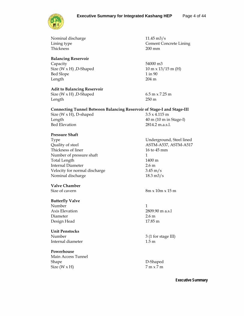
Nominal discharge 11.45 m3/s Lining type Cement Concrete Lining Thickness 200 mm Balancing Reservoir Capacity 54000 m3 Size (W x H) ,D-Shaped 10 m x 13/15 m (H) Bed Slope 1 in 90 Length 204 m Adit to Balancing Reservoir Size (W x H) ,D-Shaped 6.5 m x 7.25 m Length 250 m Connecting Tunnel Between Balancing Reservoir of Stage-I and Stage-III Size (W x H), D-shaped 3.5 x 4.115 m Length 40 m (10 m in Stage-I) Bed Elevation 2814.2 m.a.s.l. Pressure Shaft Type Underground, Steel lined Quality of steel ASTM-A537, ASTM-A517 Thickness of liner 16 to 45 mm Number of pressure shaft 1 Total Length 1400 m Internal Diameter 2.6 m Velocity for normal discharge 3.45 m/s Nominal discharge 18.3 m3/s Valve Chamber Size of cavern 8m x 10m x 15 m Butterfly Valve Number 1 Axis Elevation 2809.90 m a.s.l Diameter 2.6 m Design Head 17.85 m Unit Penstocks Number 3 (1 for stage III) Internal diameter 1.5 m Powerhouse Main Access Tunnel Shape D-Shaped Size (W x H) 7 m x 7 m

Executive Summary for Integrated Kashang HEP Page 5 of 44
Executive Summary
Length 174 m Type of Turbine Pelton Number of units 2 + 1 (for Stage-III) Turbine setting elevation 1999.2 m a.s.l Rated discharge per unit 9.15 m3/s Turbine speed 600 rpm Max. / Min. gross head 828 / 818 m Rated head 821 m Installed capacity per unit 65 MW Main Inlet valve Type Spherical Number 3 Axis elevation 1999.2 m.a.s.l Diameter of valve 1.5 m Design Head (Static + Water hammer) 908 m Generator Type Suspended type Number 2 + 1 (for Stage-III) Nominal speed 600 rpm Voltage / Frequency 11 kV/50 Hz Load factor (CosØ) 0.9 Powerhouse Cavern Dimensions (L x W x H) 87 m x 16 m x 29.9 m Turbine Pit Elevation 1992.6 m.a.s.l Crown Elevation 2022.50 m.a.s.l Crane Rail Elevation 2016.15 m.a.s.l Erection Bay Elevation 2008.0 m.a.s.l Capacity of EOT Crane 100/10 T Bus Duct Tunnel Shape D-Shaped Size (H x W) 5 m x 5.5 m No. 2 + 1 (Stage-III) Transformer Hall Cavern Dimensions (L x W x H) 88.2 m x 15.5 m x 23.6 m Transformer type OFWF Number 6 + 3 ( Stage-III) + 1 (Spare) Unit Capacity 26.5 MVA Voltage ratio 11 kV/ (220/√3) kV Cable Tunnel Shape D- Shaped Size (H x W) 5 m x 6 m Length 125 m

Executive Summary for Integrated Kashang HEP Page 6 of 44
Executive Summary
EOT Crane Capacity (GIS Hall ) 5 T Tailrace Tunnel Number 3 Combined into One
(1 for Stage-III) Length 342 m (combined) Shape D-Shaped Size (W x H) 3.4 m x 4 m (Units 1 and 3) 5 m x 6 m (Unit 2) Slope 1 in 220 Nominal discharge 18.3 m3/s Outlet sill elevation 1992.0 m.a.s.l Pothead Yard Type Out door Area (L x W) 60 m x 30 m Estimated Cost (Indian Rupees) Civil works 288.79 Crores E & M works 246.50 Crores Total basic cost (excluding transmission line cost) 535.29 Crores Cost of Transmission Works (included in DPR as per information supplied by H.P.S.E.B.) a) LILO of Bhaba-Kunihar Line 27.00 Crores b) Shunt capacitors to the extent of 75% of the installed capacity 2.40 Crores c) Project Share towards development of composite evacuation plan 37.36 Crores Total 66.76 Crores Construction Period Construction Period 4 Years Power Benefits 90% dep. Energy 245.8 GWh Completion cost of the Project (a) Project cost (excluding Transmission) Basic Cost of Project including LADA 543.32 Crores Escalation during construction period 69.29 Crores Interest during construction & Financing Charges 91.12 Crores Total - Generation works 703.73 Crores Cost per MW installed 5.41 Crores LADA provision 9.19 Crores

Executive Summary for Integrated Kashang HEP Page 7 of 44
Executive Summary
(b) Project cost (including Transmission) Basic Cost of Project including LADA 543.32 Crores Transmission works 66.76 Crores Escalation during construction period 77.08 Crores Interest during construction & Financing Charges 98.38 Crores Total - Generation and Transmission works 785.54 Crores Cost per MW installed 6.04 Crores LADA provision 9.19 Crores Financial Aspects Cost of generation (Average for 35 years per kWh at power house bus bars, including IDC) during 90% dependable year Rs. 3.71 / kWh Cost of generation (Average for 35 years per kWh at purchase center, including IDC) during 90% dependable year Rs. 4.30 / kWh
2.3 Kashang Stage-II (Kerang-Kashang Link) and Stage-III Schemes Hydrology for Kerang Trench Weir Catchment area 400 km2 Average annual inflow 440 mcm Average discharge 14 m3/s Specific average discharge 35 I/s/ km2 Minimum ecological water release in Kerang Khad 0.65 m3/s Design flood (1 in 1000) 315 m3/s Intake (Trench Weir) River Kerang Location Near Lippa Village Latitude 310 39’ 21.3” Longitude 780 21’ 36.4” Water inlet elevation (Centerline of Trench weir Trash rack) 2872.00 m.a.s.l Nominal discharge 22 m3/s Dimension of trash rack opening (L x W) 15 m x 3 m Dimension of trash rack units (L x W) 1 m x 3.3 m Number of trash rack units 15 Control Structure No. of Gates 1 Type Fixed Wheel Type - Sill elevation 2868.6 m - Dimensions (H x W) 3.0 m x 2.65 m (Clear Opening) - Design Head 5.2 m

Executive Summary for Integrated Kashang HEP Page 8 of 44
Executive Summary
Shingle Excluder No. of Gates 2 Type of Gate Slide Type Dimension (W x H) 1.5 m x 1.5 m (Clear Opening) Design Head 7.17 m Length of flushing duct 52 m Size (W x H) 1.5 m x 2 m Siphon Spillway Length 3.5 m Discharging capacity 7 cumecs Adit For Desanding Basin Shape D-Shaped Size (W x H) 5 m x 6 m Length 220 m
Desanding Arrangement Number of Basins 2 Size (L x H x W) 140 m x 8.35 m x 9.0 m Type Dufour type Nominal discharge through each basin 10.5 m3/s Size of Particle to be removed 0.2 mm
Inlet Gate for De-sanding Arrangement No. of Gates 1 Type Slide Type Sill elevation 2867.50 m Dimensions (H x W) 3.0 m x 2.65 m
(Clear opening) Design Head 4.0 m
Outlet Gate for De-sanding Arrangement No. of Gates 1 Type Slide Type Sill elevation 2866.87 m Dimensions (H x W) 3.00 m x 2.65 m
(Clear opening) Design Head 4.63 m Flushing System Type Flushing duct with holes
in the top slab Size 500 mm wide x
300 to 1200 mm high Discharge per basin 1.35 m3/s No. of holes Alt.-I 37 (1 of 270 mm dia and
36 of 60 mm dia) Alt-II 23 (1 of 270 mm dia and 22 of 75 mm dia)

Executive Summary for Integrated Kashang HEP Page 9 of 44
Executive Summary
Flushing Tunnel Size (W x H) 1.5 m x 2.0 m Length 235 m Link Tunnel Excavated Shape D- Shaped Finished Size (W x H) 3.5 x 4.5 m Length 6300 m Velocity for nominal discharge 2.13 m/s Slope 1 in 1025 Nominal discharge 18.3 m3/s Lining type Cement Concrete Lining Thickness 200 mm Estimated Cost (Indian Rupees) Civil works 274.28 Crores E & M works 97.50 Crores Total basic cost (excluding transmission line cost) 371.78 Crores Cost of Transmission Works (included in DPR as per information supplied by H.P.S.E.B.) a) Shunt capacitors to the extent of 75% of the installed capacity 1.20 Crores b) Project Share towards development of composite evacuation plan 18.68 Crores Total 19.88 Crores Construction Period Construction Period 4 Years Power Benefits 90% dep. Energy 735.2 GWh Completion cost of the Project (a) Project cost (excluding Transmission) Basic Cost of Project including LADA 377.36 Crores Escalation during construction period 88.74 Crores Interest during construction & Financing Charges 59.27 Crores Total - Generation works 525.37 Crores Cost per MW installed (Stage-I + K-K Link & Stage-III) 6.32 Crores LADA provision (K-K Link & Stage-III) 6.99 Crores (b) Project cost (including Transmission) Basic Cost of Project including LADA 377.36 Crores Transmission works 19.88 Crores Escalation during construction period 94.24 Crores

Executive Summary for Integrated Kashang HEP Page 10 of 44
Executive Summary
Interest during construction & Financing Charges 61.95 Crores Total - Generation works and Transmission works 553.43 Crores Cost per MW installed (Stage-I + K-K Link & Stage-III) 6.86 Crores LADA provision (K-K Link & Stage-III) 6.99 Crores Financial Aspects Cost of generation (Average for 35 years per kWh at power house bus bars, including IDC) during 90% dependable year (Stage-I + K-K Link & Stage-III) Rs. 2.20 / kWh Cost of generation (Average for 35 years per kWh at purchase center, including IDC) during 90% dependable year (Stage-I + K-K Link & Stage-III) Rs. 2.47 / kWh
2.4 Kashang Stage-IV Scheme Hydrology Catchment area 374 km2 Average annual inflow 413 mcm Average discharge 13.1 m3/s Specific average discharge 35 l/s/ km2 Minimum ecological water release in Kashang Khad 0.6 m3/s Design flood (1 in 1000) 300 m3/s Intake (Trench Weir) River Kerang Vicinity Toktu Village Latitude 31º 40’ 12” Longitude 78º 19’ 01” Water inlet elevation (Centerline of Trench weir Trash rack) 3155.00 m.a.s.l. Nominal discharge 22 m3/s Dimension of trash rack opening (L x W) 15 m x 3 m Dimension of trash rack units (L x W) 1 m x 3.3 m Number of trash rack units 15 Control Structure No. of Gates 1 Type Fixed wheel Type - Sill elevation 3152.2 m.a.s.l. - Dimensions (W x H) 3.0 m x 2.65 m
(Clear Opening) - Design Head 4.56 m Shingle Excluder No. of Gates 2 Type of Gate Slide Type

Executive Summary for Integrated Kashang HEP Page 11 of 44
Executive Summary
Dimension (H x W) 1.5 m x 1.5 m Design Head 6.53 m Length of flushing duct 280 m Size (W x H) 1.5 m x 2 m Overflow weir Length 16 m Crest El. 3154.22 m.a.s.l. Discharging capacity 32 cumecs Water level at maximum discharge 3155.22 m.a.s.l. Desanding Arrangement Number of Basins 2 Size (L x H x W) 140 m x 9 m x 9.35 m Type Dufour type Nominal discharge through each chamber 10.65 m3/s Size of Particle to be removed 0.2 mm Inlet Gate for De-sanding Arrangement No. of Gates 1 Type Slide Type Sill elevation 3150.41 m Dimensions (H x W) 3.0 m x 2.65 m
(Clear opening) Design Head 4.81 m Outlet Gate for De-sanding Arrangement No. of Gates 1 Type Slide Type Sill elevation 3149.01 m Dimensions (H x W) 3.00 m x 3.15 m
(Clear opening) Max. Head 6.21 m Flushing System Type Flushing duct with
holes in the top slab Size Alt-I 500mm (w) x 300
to 1200mm (H) (1 of 270 and 36 of 60mm dia) Alt-II 500mm (w) x 300 to 1200mm (H) (1 of 270 and 22 of 75mm dia)
Discharge per chamber 1.40 m3/s

Executive Summary for Integrated Kashang HEP Page 12 of 44
Executive Summary
Headrace Tunnel Tunnel Excavated Shape D- Shaped Finished Size (W x H) 3 m x 3.15 m Length 5 km Velocity for nominal discharge 2.1 m/s Slope 1 in 1000 Nominal discharge 18.5 m3/s Lining type Cement Concrete
Lining Thickness 200 mm Surge Tank Type Surface Diameter 10 m Max upsurge level El 2867.00 Pressure Shaft Type Underground, Steel
lined Quality of steel ASTM-A537 Thickness of liner 16 to 25 mm Number 1 Total Length 375 m Internal Diameter 2.1 m Velocity for normal discharge 5.34 m/s Nominal discharge 18.5 m3/s Unit Penstocks Number 2 Internal diameter 1.5 m Length 50 m Powerhouse Main Access Tunnel Shape D-Shaped Size (W x H) 7 m x 7 m Length 500 m Type of Turbine Pelton Number of units 2 Turbine setting elevation 2844.3 m a.s.l Rated discharge per unit 9.25 m3/s Turbine speed 375 rpm Rated head 300 m Installed capacity per unit 24 MW

Executive Summary for Integrated Kashang HEP Page 13 of 44
Executive Summary
Main Inlet valve Type Spherical Number 2 Axis elevation 2844.3 m.a.s.l Diameter 1.5 m Design Head (Static + Water hammer) 323 m Generator Type Suspended type Number 2 Nominal speed 375 rpm Voltage / Frequency 11 kV/ /50 Hz Power factor (CosØ) 0.9 Powerhouse Cavern Dimensions (L x W x H) 62.8 m x 16 m x 29.2 m Turbine Pit Elevation 2837.60 m.a.s.l Crown Elevation 2866.8 m.a.s.l Crane Rail Elevation 2860.65 m.a.s.l Erection Bay Elevation 2852.5 m.a.s.l Capacity of EOT Crane 70/10 MT Bus Duct Tunnel Shape D-Shaped Size (H x W) 5 m x 5.5 m No. 2 Transformer Hall Cavern Dimensions (L x W x H) 61.4 m x 15.5 m x 23.6 m Transformer type OFWF Number 7 (One spare) Unit Capacity 9.5 MVA Voltage ratio 11 kV/ (220/√3) kV EOT Crane Capacity ( GIS Hall ) 5 MT Tailrace Tunnel Number 2 Combined into One Length 100 m (combined) Shape D-Shaped Size (W x H) 2.5 m x 3.2 m (for Units)
3.2 m x 3.2 m for combined
Slope 1 in 600 Nominal discharge 18.5 m3/s Outlet sill elevation 2837.43 m.a.s.l

Executive Summary for Integrated Kashang HEP Page 14 of 44
Executive Summary
Pothead Yard Type Out door Area (L x W) 40 m x 20 m Estimated Cost (Indian Rupees) Civil works 186.87 Crores E & M works 108.50 Crores Total basic cost (excluding transmission line cost) 295.37 Crores Cost of Transmission Works (included in DPR as per information supplied by H.P.S.E.B.) a) D/c line to Kashang- 6.41 Crores b) Terminal bays for D/c line between Stage-I and Stage-IV (installed at Stage-I powerhouse) 7.00 Crores c) Shunt capacitors to the extent of 75% of the installed capacity 0.94 Crores d) Project Share towards development of composite evacuation plan 13.79 Crores Total 28.13 Crores Construction Period Construction Period 4 Years Power Benefits 90% dep. Energy 178.0 GWh Completion cost of the Project (a) Project cost (excluding Transmission) Basic cost of Project including LADA 299.80 Crores Escalation during construction period 94.11 Crores Interest during construction & Financing Charges 53.84 Crores Total - Generation works 447.75 Crores Cost per MW installed 9.33 Crores LADA provision 5.91 Crores (b) Project cost (including Transmission) Basic cost of Project including LADA 299.80 Crores Transmission works 28.13 Crores Escalation during construction period 103.35 Crores Interest during construction & Financing Charges 58.33 Crores Total - Generation and Transmission works 489.61 Crores Cost per MW installed 10.20 Crores LADA provision 5.91 Crores

Executive Summary for Integrated Kashang HEP Page 15 of 44
Executive Summary
Financial Aspects Cost of generation (Average for 35 years per kWh at power house bus bars, including IDC) during 90% dependable year Rs. 3.26 / kWh
Cost of generation (Average for 35 years per kWh at purchase center, including IDC) during 90% dependable year Rs. 3.66 / kWh
3.0 ENVIRONMENT IMPACT ASSESSMENT
As per MoEF notification dated 14th September 2006, construction of new project or activities or the expansion or modernization of existing projects or activities listed in the schedule to the notification shall be undertaken in any part of India only after the prior environmental clearance from the Central Government in the Ministry of Environment and Forests, New Delhi for matters falling under Category ‘A’ in the schedule and at state level the State Environment Impact Assessment Authority (SEIAA) for matters falling under Category ‘B’ in the said schedule, the latter duly constituted by the Central Government under sub-section (3) of section 3 of the said act.
The integrated Kashang HEP having 243 MW generation is a river valley project falling under project category with threshold limit “A”. The project is an integration of earlier Kashang HEP (66 MW) on stream of the same name and antoher HEP on Kerang Khad. The integrated project has four stages with erstwhile Kashang HEP (66 MW) as Stage-I, the MoEF had already accorded EC for stage-I project on 15-11-2002. However, in view of integration with other stages of development making total proposed generation 243 MW, fresh environmental clearance is being sought.
4.0 OBJECTIVES OF THE STUDY
The main objective of the study is to prepare the environmental impact assessment report for obtaining environmental clearance from the regulatory agencies. The study has been conducted to carryout Comprehensive Environmental Impact Assessment (CEIA) based on two season data (Winter & Pre-monsoon 2008)) covering the following: • Assessment of the existing status of land, water, biological, climatic, socio-
economic, health and cultural components of the environment. • Identification of potential impact on various environmental components due to
activities envisaged during pre-construction, construction and operational phases of the proposed Hydroelectric Project.
• Prediction of significant impacts on the major environmental components using appropriate mathematical/simulation models.
• Preparation of environmental impact statement based on the identification, prediction and evaluation of impacts.
• Formulation of Environmental Management Plan (EMP) out lining preventive and mitigative strategies for ameliorating adverse impacts during pre-construction, construction and operational phases of the proposed project along with the cost and time schedule for implementation of EMP.
Executive Summary for Integrated Kashang HEP Page 16 of 44
Executive Summary
5.0 METHODOLOGY The methodology and techniques used for studying the various parameters of the environment viz. land, air, noise, water, flora, fauna, socioeconomics in the study area are described as follows:
5.1.1 Land Environment Study
The Digital Satellite data IRS P6 LISS-III (Gen:22 November 2007, Path 96, Row 48) was acquired from NRSA and evaluated on ERDAS Imagine Software.
The 1:50,000 scale toposheets (53 I/1, I/2, I/5 and I/6) of the free/directly draining catchment area were used for the purpose of geo-referencing
Detailed field survey was conducted for study of soil characteristics of erosion prone areas and landslides in the catchment area. The vulnerable and problematic areas were identified in different physiographic zones in the entire catchment area.
The data was generated on physiography, landuse/landcover, lithology, structure, drainage pattern, slope characteristics, landslides/slips etc.
These data sets were used for preparation of the thematic maps, calculation of sediment yield index and Erosion Intensity Units in the catchment area according to the following procedures.
5.1.2 Air Quality Assessment
The air pollution analysis techniques include the evaluation of the following: 1. Suspended Particulate Matter (SPM) and Respirable Suspended Particulate Matter (RSPM). 2. Sulphur dioxide (SO2) 3. Oxides of Nitrogen (NOx) In regard to the techniques for collection of sample of particulate matter, the “Respirable Dust Sampler Envirotech Model APM 460 BL” was used for air monitoring. The dust particulate matter was collected on filter paper (size GF/A20.3x25.4 cm) and dust cup and the gaseous pollutants were collected simultaneously by a known volume of air through a number of bubblers of different flow rate through appropriate solution for absorbing different gases. The collected sample when analyzed according to standard method for different pollutants for samples in air was collected in glass impinges by displacement of distilled water.
5.1.3 Sound Level Measurement
The sound level was measured by sound level meter RS 232 (digital Instrument).
5.1.4 Water Environment Assessment The baseline data for water quality assessment was done based on the parameters given below. 1. General survey of the Kashang and Kerang khads 1 km upstream of proposed
weir sites up to confluence with river Sutlej. 2. Selection of spots for water sampling and collection of aquatic organisms.

Executive Summary for Integrated Kashang HEP Page 17 of 44
Executive Summary
3. Distribution and population density of macro-zoo benthos in Kashang and Kerang khads.
4. Periodical monitoring of physical, chemical and biological characteristics of river water.
5. Estimation of coliform (MPN) and E. Coli organisms in river water. 6. Importance of water quality on existing aquatic fauna in mountain rivers.
5.1.5 Aquatic Environment
Data on existing aquatic environmental conditions in and around proposed project has been generated as per following: • Biological characteristics of river water. • Inventorization of phytobenthos and Zoobenthos • Estimation of coliform organisms. • Present status of riverine fish fauna: Identification of obligate fish species. Their Migratory pattern, diseases, feeding and breeding grounds
5.1.6 Floral Study
The present report on the plants of project area is based on extensive field survey of the area. The seasonal study has been conducted between February 2008 to July 2008, for two different seasons covering winter and pre-monsoon season. The plant species were identified with the help of Botany Division, FRI, Dehradun. Besides the collection of plant species, information was also collected on the vernacular names and uses of plants made by local inhabitants
5.1.7 Faunal Study
Ground surveys were carried out by trekking the impact zone for identification of important animal groups such as butterflies (insects), birds, mammals, reptiles, and some fishes inhabiting the area, along the riverbanks, adjoining forest on the slopes, nallahs, hill top and agricultural fields.
• For sampling butterflies the standard ‘Pollard Walk’ methodology was used by
recording all the species that were encountered while trekking along the foot trails between these two sites, daily. Voucher specimens of species were collected by means of a butterfly net for only those species that could not identified in the field besides photographing them for the same purpose. Sampling was done for 1 hour in a stretch on each transect (n = 4).
• For sampling birds ‘point sampling’ along the fixed transects (foot trails) was
carried out to record all the species of birds observed with the help of binoculars; field guides and photography for 1 hour on each transect (n=4).
• For sampling mammals, ‘direct count on open width (20m) transect’ was used on
the same transects (n=4) for 1 hour in each transect. Besides, information on recent sightings/records of mammals by the villagers and locals was also collected from these areas.

Executive Summary for Integrated Kashang HEP Page 18 of 44
Executive Summary
• ‘Reptiles’ mainly lizards were sampled by ‘direct count on open width transects’ (n = 4) for 1 hour in each transect.
• Seasonal variation in species diversity of different groups of animals (butterflies
and birds) were evaluated using Shannon-diversity Index (H’) to know the season of peak diversity in the area amongst the two seasons i.e. winter and pre-monsoon studied.
H’ = -ΣN 1 Pi In Pi
(from species 1 to n; n= total number of species) Where Pi is the proportion of the individual species in the total population
5.1.8 Socioeconomic Study
The data on socio economic and dependency aspects were collected in two stages. The first stage involved a rapid assessment of the study area in order to obtain an overall perspective of the villages that were located in the project area. The second stage of data collection was done in the villages which are going to be directly affected by acquisition of land for construction of project. A sampling frame for survey area was initially devised and as per this the villages going to be affected due to project construction were surveyed. These villages fall in District Kinnaur. Data collection from secondary sources has also been made to validate some of the information and to supplement the data on demographic aspects. Secondary information was collected from different government and non government offices. The data collected mainly was of secondary nature and involved information regarding access to facilities such as PHC’s, schools, bus services, LPG distribution centers, type of roads, livestock information, land utilization, demographic profile of the villages, location and distribution of villages with respect to Project. The public hearing at village level was also conducted during October 2008.
6.0 EXISTING STATUS OF ENVIRONMENT
The EIA study includes the study of various base line parameters of environment viz; Land, Water, Air, Noise, Flora, Fauna and Socioeconomics. Integration of these parameters gives an overall perception of positive and negative impacts due to construction of a hydroelectric project if any. The existing status of the different components of the environment was studied in detail. The findings of the study are as follows:
6.1 Physical Environment
The catchment is having variable physiography, climate, geology, slope, soil types and land use/land cover. While evaluating the land environment various parameters were analyzed in detail and the environmental impacts were predicted accordingly. In order to study the land environment of the study area the baseline data pertaining to climate, basin characteristics, physiography, slope, geology, seismicity, soil, sedimentation and landuse/ landcover etc were studied.
Executive Summary for Integrated Kashang HEP Page 19 of 44
Executive Summary
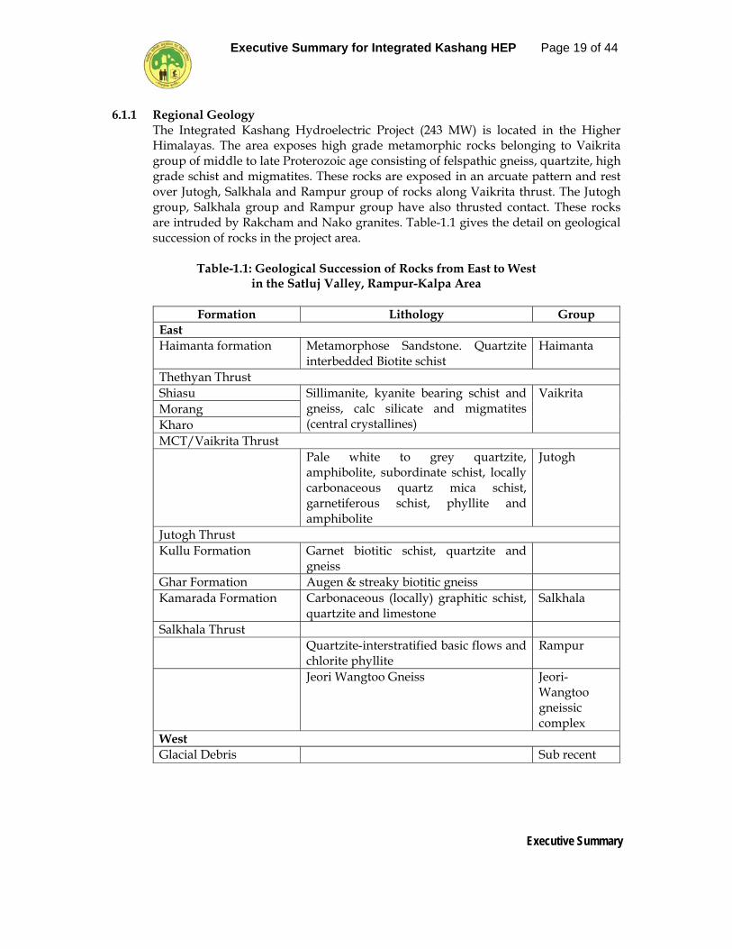
6.1.1 Regional Geology The Integrated Kashang Hydroelectric Project (243 MW) is located in the Higher Himalayas. The area exposes high grade metamorphic rocks belonging to Vaikrita group of middle to late Proterozoic age consisting of felspathic gneiss, quartzite, high grade schist and migmatites. These rocks are exposed in an arcuate pattern and rest over Jutogh, Salkhala and Rampur group of rocks along Vaikrita thrust. The Jutogh group, Salkhala group and Rampur group have also thrusted contact. These rocks are intruded by Rakcham and Nako granites. Table-1.1 gives the detail on geological succession of rocks in the project area.
Table-1.1: Geological Succession of Rocks from East to West
in the Satluj Valley, Rampur-Kalpa Area
Formation Lithology Group East Haimanta formation Metamorphose Sandstone. Quartzite
interbedded Biotite schist Haimanta
Thethyan Thrust Shiasu Sillimanite, kyanite bearing schist and
gneiss, calc silicate and migmatites (central crystallines)
Vaikrita Morang Kharo MCT/Vaikrita Thrust Pale white to grey quartzite,
amphibolite, subordinate schist, locally carbonaceous quartz mica schist, garnetiferous schist, phyllite and amphibolite
Jutogh
Jutogh Thrust Kullu Formation Garnet biotitic schist, quartzite and
gneiss
Ghar Formation Augen & streaky biotitic gneiss Kamarada Formation Carbonaceous (locally) graphitic schist,
quartzite and limestone Salkhala
Salkhala Thrust Quartzite-interstratified basic flows and
chlorite phyllite Rampur
Jeori Wangtoo Gneiss Jeori-Wangtoo gneissic complex
West Glacial Debris Sub recent

Executive Summary for Integrated Kashang HEP Page 20 of 44
Executive Summary
6.1.2 Landuse / Landcover The Modern technique of Satellite Remote sensing facilitates such type of studies. The inaccessibility to the region in diverse weather conditions, requirement of synoptic coverage at various locations, and the computer adaptability for land use classification makes the digital image processing and remote sensing an inevitable tool. As already stated under physiography that the catchment area is characterized by steep hills and deep valleys, the dominating classes are dense forest, open forest, waste land, agriculture & settlement patches and some degraded forest. The land use pattern of the study area is summarized in Table-1.2.
Table-1.2: Land Use Details of Study Area
Sl. No. Land Use Category Area in Sq Km % Area
1. Dense Forest 21167.99 29.00 2. Open Forest 16703.12 23.00 3. Scrub/ Scattered Vegetation 8286.29 11.50 4. Alpine Vegetation 3873.84 5.00 5. Alpine Barren 9886.49 13.50 6. Snow 12922.21 18.00
6.1.3 Project Component Wise Total Land Requirement
Overall land requirement of the project is 85.7356 ha out of which forest and private land is 61.889 ha and 23.8357 respectively. The project shall not submerge any land per se. The project component wise break up of land is given in Table-1.3.
Table-1.3: Land Requirement of Submergence and
Project Component Area
S No Description Private area (ha)
Forest area(ha)
Total area (ha)
Stage-1
1 Quarry Site near intake - 3.2558 3.2558 2 Approach road to Quarry site
near Intake (1400m) - 0.6801 0.6801
3 Approach road to Intake up to HRT 95200m)
0.49789 3.5508 4.0497
4 Intake Site, Power Channel, Sedimentation tank, balancing reservoir.
0.4309 1.2777 4.7086
5 Approach road to Surge shaft and drift at surge shaft (400m)
- 0.4175 0.4175
6 Approach road to Penstock Adit/Drift (3200m)
- 2.8044 2.8044

Executive Summary for Integrated Kashang HEP Page 21 of 44
Executive Summary
7 Approach road to Power House (2200m)
- 1.5990 1.5990
8 Power House area - 0.2115 0.2115 9 Quarry site near Akpa - 3.7340 3.7340 10 Dumping yard 9.9465 1.1834 11.1299 11 Pangi Khas colony and intake
road 1.6100 - 1.610
Total Stage-I 15.4863 18.7142
34.2005
Stage-II 1 Trench weir, Protals of Adits - 1.8496 1.8496 2 Road ti intake - 1.2000 1.2000 3 Dumping area No.1 - 2.3695 2.3695 4 Stone crusher near Kashang
Khad - 0.1748 0.1748
5 HRT outlet Portal - 0.1920 0.1920 6 Colony site at Lappo 0.4441 - 0.4441 7 Inlet tunnel at Lappo - 0.0540 0.0540 8 Desanding chamber at Lappo - 0.8550 0.8550 9 Head Race Tunnel - 3.1275 3.1275 10 Adits - 0.6160 0.6160 11 Flushing tunnel 0.0720 0.0720 Total Stage-II 0.4441 10.5104 10.9545 Stage-III 1 Material Stacking yard - 2.6503 2.6503 2 Dumping area of Powerhouse
i.e. D2, D3 and D11 - 1.2702 1.2702
3 Dumping area D-4 at Kashang Khad
- 0.4936 0.4926
4 Dumping area at Pangi-Intake road i.e. D-5, D-6 and D-7
- 0.7666 0.7666
5 Dumping area at old H.T. Road i.e. D-8
- 0.7000 0.7000
6 Job facilities at old HT Road - 0.3000 0.3000 7 Portal of adit to balancing
reservoir - 0.0256 0.0256
8 Colony Site at Dakhao (Reckong Peo)
2.9053 - 2.9052
9 Balancing reservoir - 0.9690 0.9690 Total Stage-III 2.9053 7.1753 10.0806 Total Stage II and III 303494 17.6857 21.0351 Total Stage-IV 5.0000 25.5000 30.5000 Ground Total Stage I, II, III
and IV 23.8957 61.8999 85.7356

Executive Summary for Integrated Kashang HEP Page 22 of 44
Executive Summary
6.2 AIR AND NOISE ENVIRONMENT In order to generate the data base for air and noise quality an extensive study of air and noise parameters around the project area was conducted covering two seasons i.e. Winter and Pre-Monsoon 2008. The basic parameters evaluated are as follows.
6.2.1 Ambient Air Quality
The ambient air quality was monitored at four locations. The air quality in the project area and its surroundings is free of pollution. The air pollutants concentration in the air is well below the permissible limit as there are no industries in the area and the vehicular traffic is bare minimum. Moreover, forest cover and ground vegetation around the site serve as a carbon sink. There is no dust producing sources except vehicular traffic which is also very small.
Observation on Respirable Particulate Matter (RPM) levels In winter, the highest RPM level of 45 µg/m3 was observed at Near Power House station and the lowest level of 20.0 µg/m3 at Lapo Dogri. In pre-monsoon, the highest RPM level of 54 µg/m3 was observed at Near Power House station and the lowest level of 24.0 µg/m3 at Lapo Dogri Suspended Particulate Matter In winter, the highest SPM level of 160 µg/m3 was observed at Near Power House station and the lowest level of 105 µg/m3 at Lapo Dogri. In pre-monsoon, the highest SPM level of 180 µg/m3 was observed at Near Power House station and the lowest level of 118 µg/m3 at Lapo Dogri Based on the findings of the ambient air quality it can be concluded that the ambient air quality is quite good in all the sampling stations. The values of SO2, NOx are well within the permissible limit. The absence of major air pollution sources is responsible for the good ambient air quality in the project as well as study area.
6.2.2 Ambient Noise Quality
The ambient air quality was monitored during pre-monsoon and winter at five locations. Having no industries around the project area and not much traffic horns in the vicinity, the noise level, at the moment is much below the threshold limits at all the locations.
6.3 WATER ENVIRONMENT
Eight samples were collected from the sampling stations and were either analyzed at the sampling spots or in the laboratory.
The water quality results shows that all the parameters are within the permissible limit of Drinking Water Standards (IS: 10500), except the bacteriological parameters.

Executive Summary for Integrated Kashang HEP Page 23 of 44
Executive Summary
6.4 STATUS OF BIOLOGICAL ENVIRONMENT The ecological impact assessment study has been done in the study area which are sub-divided in the following areas:-
1. Trench Weir Stage-I at Dollo – Dogri 2. Dumping Site at Dollo – Dogri 3. Powerhouse and Dumping Site Stage-I & III at National Highway 4. Intake Trench Weir State-IV at Toktu 5. Power House Stage-IV at Lappo near Lippa 6. Influence Area under 10 kms periphery of the proposed Hydroelectric Project Issues to be covered in these areas have been identified those will include, floral and faunal diversity including aquatic ecology.

Executive Summary for Integrated Kashang HEP Page 24 of 44
Executive Summary
Table-1.4: Values of Different Phytosociological Parameters in the Study Area
Study Area Concentration of
Dominance (C)
Species Diversity Index (H)
Richness Index (R)
Evenness Index (E)
Trees Shrubs Herbs Trees Shrubs Herbs Trees Shrubs Herbs Trees Shrubs Herbs 1. Trench Weir Stage-I at Dollo-
Dogri 0.489 0.245 0.064 0.878 1.598 3.248 0.52 1.01 5.47 0.80 0.82 0.89
2. Dumping Site at Dollo-Dogri 0.511 0.358 0.074 0.685 1.283 2.969 0.27 1.05 4.09 0.98 0.66 0.89 3. Powerhouse and Dumpting Site
Stage-I & III at NH 0.597 0.337 0.112 0.729 1.232 2.332 0.69 0.63 1.80 0.66 0.89 0.94
4. Intake Trench Weir Stage-IV at Toktu
0.394 0.159 0.059 1.105 2.090 3.127 0.86 1.75 4.90 0.79 0.87 0.90
5. Powerhouse Stage-IV at Lappo near Lippa
0.324 0.134 0.077 1.450 2.087 2.952 1.50 1.45 4.14 0.74 0.94 0.88
6. Influence Area under 10 Kms Periphery
i) Powerhouse Stage-I & IV at NH to Powari
0.160 0.251 0.091 2.140 1.615 2.762 3.03 1.09 3.21 0.86 0.83 0.89
ii) Powerhouse Stage-I & IV at NH to Akpa
0.184 0.087 0.067 1.925 2.598 3.024 2.18 2.96 4.37 0.87 0.93 0.91
iii) Intake Trench Weir Stage-IV at Tokto to Akpa
0.103 0.097 0.034 2.586 2.620 3.759 3.32 3.07 9.27 0.91 0.87 0.90
iv) Trench Weir Stage-I at Dollo-Dogri to Pangi
0.346 0.132 0.057 1.509 2.301 3.202 2.01 2.17 5.28 0.63 0.87 0.88

Executive Summary for Integrated Kashang HEP Page 25 of 44
Executive Summary
Threat Status of the Foristic Diversity: Flora recorded from the study sites during the survey when compared with the available literature revealed that the following species recorded from the region fall under the categories of threat status: Hyoscyamus niger, Ephedra gerardiana, Ferula jaeschkeana, Heracleum candicans, Betula utilis, Juniperus macropoda, Dactylorhiza hatagirea, Datisca cannabina, Rheum webbianum, Dioscorea deltoidea, Rheum australe.
ETHNOBOTANICAL STUDIES IN THE STUDY AREA Ethnobotany includes all sorts of relationships between people and plants. The definition of ethnobotany can be summed up in four words i.e. People, Plants, Interactions and Uses. Plants provide us readymade food, medicines for ailment, fodder and forage for our domestic animals, fuel wood for burning, flowers for aesthetics and celebration, raw materials for many industries, timber for construction and many more useful items. A survey was conducted in Pangi, Akpa, Asarang, Lippa and Toktu villages to document the plant species used by the people to meet their day-today requirements. During the survey, ethno-botanical information on 62 plant species was documented. It was found that these plant species are used for medicinal, timber, fuel wood, fodder, ornamental, agricultural tools, thatching, fencing, etc. This supports the truth that there is a great influence of human life on the local vegetation. Medicinal Plants: Information on medicinal uses of 21 plant species was documented during the study. Medicinal plants commonly used by the people of the area included, Angelica glauca (Chora), Allium sp (Junglibiaj), Berberis lycium (Kashmal), Berginia ciliata, Cannabis sativa, Corydalis govaniana, Dactylorhiza hatagirea (Salampanja), Datisca cannabina, Datura stramonium, Delphinium denudatum, Ephedera gerardiana (Somlata), Ferula jaeskeana, Heracleum candicans, Hyoscyaus niger, Juniperus macropoda (Dhoop), Juniperus communis (Dhoop), Nasturtium officinale, Origanum vulgare, Rheum webbianaum (Revandchini), Tagetus minuata and Thymus linearis. Although, people have knowledge on medicinal uses of plants, only few people follow the traditional medicinal system. Species such as Ephedera gerardiana (Somlata) and Rheum webbianaum (Revandchini) are commercially exploited in large scale. These medicinal plants recorded in the proposed project area and their adjoining areas are also distributed elsewhere in the NW Himalaya. Collection of Fodder: During the survey, it was found that local people collected fodder from the study area. Plant species such as Celtis australis, Quercus ilex and Robinia pseudoacacia (Robinia) were collected for fodder.

Executive Summary for Integrated Kashang HEP Page 26 of 44
Executive Summary
Food Plants: Vegetables and Potherbs: Flowers of Indigofera gerardiana are eaten as a salad. Nasturtium officinale, Solanum nigrum, Amaranthus viridis, Chenopodium album, Rumex hastatus and Urtica dioica, are used as a potherbs. Seeds of Pinus gerardiana are eaten raw or cooked. Prinsepia utilis seed oil is used for burning and as a cooking medium. Edible Fruits: Wild fruits form an important diet of the local people. Some ripe wild fruits/nuts eaten in the area are obtained from plant species such as; Berberis lycium, Duchesnea indica, Pyrus pashia, Rosa macrophylla, Rubus biflorus, R.ellipticus, Prunus armeniaca (Chulli), Prunus cornuata (Jamun), Punica granatum (Anar) Solanum nigrum, Ficus palmata, Pinus gerardiana (Chilgoza/neoza) and Juglans regia (Akhrot). Chilgoza/ Neoza is collected in large scale from the cones of Pinus gerardiana by the local people for their own consumption and for commercial purposes.
6.4.1 Terrestrial Fauna
FAUNAL DIVERSITY OF THE STUDY SITE: AN OVERVIEW During the surveys, two groups of Arthropoda were selected as the indicator of the ecosystem in the Kashang Project Area. The butterfly groups belonging to the insect order Lepidoptera and spider groups belonging to the arachnid order Araneae, were selected for evaluation of arthropod diversity. Butterfly being the most abundant voracious feeders of herbs, shrubs and other lower vegetations of forests acts as an indicator of diversity of flora in the ecosystem. On the contrary, the spider groups acts as the predatory species and their diversity indicate the abundance of insect prey prevalent in the region. During the surveys, three major locations of the project area, were selected for the study. These are,
1. Area from Pangi bridge to Kashang Khad ( indicated as K in the faunal list) 2. Areas from Lippa, Asrang to Kiren Khad (indicated as L in the faunal list) 3. Areas from Kharo bridge to Thopan (indicated as T in the faunal List)
In the Lepidoptera group, 19 different species of butterfly belonging to 5 families, viz., Papilionidae, Satyridae, Pieridae, Nymphalidae and Lycaenidae, were found predominant in the region. Venessa cashmiriensis, commonly called as Indian Tortoiseshell that feeds on nettle plants, and Candida canis were the most abundant butterfly species in the region. Among the predatory group, 22 different species of spiders belonging to 8 families, viz., Agelenidae, Linyphidae, Pscheridae, Salticidae, Corinnidae, Tetragnathidae, Uloboridae, Araneidae, were found to be the most abundant species in the region. Agelina stamila and Tikaderia pscherina belonging to the family Agelenidae, choose its

Executive Summary for Integrated Kashang HEP Page 27 of 44
Executive Summary
habitat in the crevices of rocks and tree trunks. Whereas the presence of Linyphia hartensis of the family Linyphidae and Leucauge decorata of the family Tetragnathidae, indicate richness of moist ground vegetation. Neoscona nautica belonging to the family Araneidae, being the nocturnal predatory spider, inhabit open forest area.
FAUNAL LISTINGS FROM KHASHANG HYDROELECTRIC PROJECT AREA
During this survey butterfly (Lepidoptera) was selected as an indicator insect group and spiders (Arachnida) was selected as an indicator insect- predator group.
Sl. No.
Insect Group Species Family Locality Frequency
1 BUTTERFLY (LEPIDOPTERA)
Polyura athamas Papilionidae L 6 2 Papilio polytes Papilionidae L,T 5, 4 3 Graphium sarpedon
luctatius Papilionidae T 5, 3
4 Graphium colanthus Papilionidae T 9 5 Erabia nirmala Satyridae L 6 6 Aulocera swaha Satyridae L 7 7 Pieris brassicae Pieridae K,L,T 7,5,7 8 Pieris candida indica Pieridae K 7 9 Coleus croceus edusina Pieridae K 9
10 Candida canis Pieridae KL 7,4 11 Pontia daplidice Pieridae KLT 5,5,6 12 Venessa csahmeriensis Nymphalidae K, L 6,6 13 Venessa sp. Nymphalidae L 3 14 Mycalesis francisca Nymphalidae L,T 7,8 15 Neptis hylas Nymphalidae T 5 16 Lethe sp. Nymphalidae T 5 17 Argynnis sp. Nymphalidae L 2 18 Lycaena phleas Lycaenidae K,L 7,4 19 Zizeeria lysimon Lycaenidae T 3
Sl. No.
Predator Group Species Family Locality Frequency
1 SPIDER (ARACHNIDA: ARANEAE)
Agelina stamila Agelenidae K,L,T 20,8,11 2 Tikaderia pscherina Agelenidae K,L,T 9,9,14 3 Linyphia straminea Linyphidae K,L,T 33,20,21 4 Linyphia hartensis Linyphidae T 20,19,31 5 Neriene sp. Linyphidae K 36 6 Psechrus ghecuanus Psechridae K,L 12,25 7 Psechrus himalayanus Psechridae K,L 17,19 8 Plexippus paykhuli Salticidae T 9 9 Salticus beneficus Salticidae T 7 10 Binor pseudomaculata Salticidae K 9

Executive Summary for Integrated Kashang HEP Page 28 of 44
Executive Summary
11 Menemerus fulvus Salticidae K,T 11,8 12 Rhene mus Salticidae K 13 13 Castianeira himalayansis Corinnidae L,T 22,16 14 Castianeira zetes Corinnidae T 11 15 Corrina sp. Corinnidae L,T 8 16 Leucauge decorata Tetragnathidae T 19 17 Uloborus bigibbosus Uloboridae T 22 18 Miagrammopes extensus Uloboridae T 31 19 Hiptyotes himalayansis Uloboridae T 15 20 Neoscona nautica Araneidae K,L,T 10,22,9 21 Cyclosa confraga Araneidae K,L,T 11,7,9 22 Araneus sp. Araneidae K 17
Locality: 1. Pangi bridge to Kashang Khad = K 2. Lippa, Asrang to Kiren Khad = L 3. Kharo bridge to Thopan = T
6.5 SOCIAL AND CULTURAL BACKGROUND OF THE AREA
The social milieu of this region is comprised mostly of the Hindu community, consisting of Scheduled Tribes. The Kinnaur District is having 660 villages/62 panchayats with a total population of about 78,334 (according to 2001 census), where the majority of the population lives in rural areas. In this district cultivators constitute the majority of the population. The sex ratio of district is 979: 1000 whereas; the ratio is 970:1000 in Himachal Pradesh in a whole. The literacy rate of Kinnaur district is 75.2 % in comparison to the state, which is around 77.13 %. As per socio-economic survey, 4 villages namely Pangi, Lippa, Toktu and Asrang are falling in affected zone.
6.5.1 Identification of Project Affected Families (PAF) The details of affected settlement and population like demographic information, livestock and other household assets have been obtained through door to door field survey conducted at household levels whereas the details of land likely to be acquired in different (project affected) villages have been obtained from the concerned Revenue Authorities and HPSEB. According to the land records and ground truth survey 253 household in Pangi village of Kinnaur district are likely to be affected due to the acquisition of land/house/shops for “ Kashang Project”. Land of other 3 project affected villages has not been acquired yet. Families were categorized into along 0-10 bigha, 10-20 bigha 20-30 bigha and Landless farmers on the basis of the land holding that remains with them after acquisition of the land. The village wise details of the project-affected families and villages are given in Table-1.5.

Executive Summary for Integrated Kashang HEP Page 29 of 44
Executive Summary
Table-1.5: Categorization of affected families of Kashang Project
Project affected Villages
Categories of Farmers 0-10 Bigha
10-20 Bigha 20-30 Bigha Landless Bigha
Pangi 14.50% 5.66% 2.78% 0.38% Lippa 2.80% 0.72% 0.18% 0.18% Toktu 2.68% 4.69% 0.67% 0% Asrang 2.01% 0.57% 0.86% 0.28%
Further, during the door to door socio-economic survey of 4 villages, a total number of 397 families were interviewed, in all likelihood the number of families in four villages would increase during land acquisition when the finalization of disbursement of compensation takes place as the all the claimant will stand up and real time bifurcation of families will be presented to Land Acquisition Officer by the state government.
6.5.2 Demographic profile of PAP 6.5.2.1 Village - wise Distribution of PAP
PAP include the population getting affected and losing (Part or full) land, homestead, cattle shed, livelihood, income and common property resources due to the establishment of the “Kashang Project”. The distribution of PAP i.e. the people who are losing private land, cultivable land, cattle shed, shops and horticultural trees due to the project activity for Pangi village has been estimated. Out of total respondent population of PAP (1041), 43.90 % (457) are males and 39.86 % (415) are females in Pangi village.
6.5.2.2 Educational Status of PAP Educational status is positively correlated to the economic development of a person and the society as a whole. According to the survey conducted it has been found that in Pangi village the total number of students going to different nursery schools are 65, for primary school 146 and for junior high school are 300. In Lippa village, 150 students are going to primary school and 8 students are going to intermediate college. In Toktu village, 15 students are going in nursery school, 26 students to primary school. Whereas, in Asrang village 35 students are going to nursery school, 40 students to primary school and 20 to junior school.
6.5.2.3 Religion Status of PAP
The state of Himachal Pradesh is dominated by the Hindu community. Similarly majority of the families of project affected area belongs to the Hindu and Buddhist community. The study conducted in PAVs show that more than 99 % of the affected population belongs to the Hindu community.

Executive Summary for Integrated Kashang HEP Page 30 of 44
Executive Summary
6.5.2.4 Caste Categories of PAP
Social stratification on the basis of caste is very much prevalent in our society from the date back to the history. In the mountainous region, the population from general/upper castes is richer than SCs in terms of land and livestock from days back to the times of local kingdoms. As per the classification under our constitution castes are divided into 4 major groups i.e., General, SC, ST and OBC as per their social status. As per the study conducted 1 caste i.e ST is observed in the all four project affected villages.
6.6 ECONOMIC PROFILE OF PAP
The economic aspect of the project affected villages as well as the project affected families is one of the most important part of this survey. Besides this some salaried jobs in govt., and private sector, small-scale business, non-wood forest products etc. contribute to the income of the PAP. This part of the survey work deals with the occupational profile of PAP, their source of income, property ownership, details of movable and immovable property and the expenditure pattern.
6.6.1 Source of income of PAP Agriculture and Horticulture is the main occupation of the people of the project affected area and also the primary and most important source of income. Most of the area falling in the zone has a well-developed irrigation system with water channels drawn from the natural springs through the pipes. The Socio-economic survey revealed that in Pangi village 22.09% people are engaged in agriculture whereas in Lippa, Toktu and Asrang villages 11.50%, 8.05%, 7.78% people respectively are engaged in agriculture. The income status of PAFs of 4 villages is given in table-1.6.
Table-1.6: Annual income of PAFs from agriculture and other sources
Project Affected Villages Annual Income (%) <50,000 50,000-1lakh 1lakh-3 lakh >3 lakh
Pangi 41.89 12.25 10.27 3.16 Lippa 62.79 11.62 20.93 4.65 Toktu 75 8.33 16.66 8.33 Asrang 76.92 - 7.69 7.69 6.6.2 Property ownership of PAFs
The data related to the ownership of property has been classified broadly into two categories namely movable and immovable. Movable property includes details related to the livestock and domestic goods (comprised of Electronic appliances, Vehicles etc.) and the immovable property includes the information on land holding, residential/non residential structures, Cattle sheds and trees.

Executive Summary for Integrated Kashang HEP Page 31 of 44
Executive Summary
6.6.3 Movable Property – Live Stock Population The livestock is the major part of the economy of rural areas as they depend on them for milk, wool, meat, ploughing and transportation. Same is the case for the people of project affected villages. Other than these main utilizations cattles also provide them with the manure very rich in nutrient. The whole project affected region is rich in live stock population particularly in Sheep and Goats due to availability of moderate amount of agricultural wastes and fodder from the nearby area.
Table-1.7: Details of live stock population owned by the PAVs (%) of Kashang Project
Project Affected Villages Livestock (%) Cow Goat Sheep others
Pangi 14.22 48.80 34.99 1.96 Lippa 35.29 42.01 8.40 15.12 Toktu 10.22 18.18 68.18 3.40
Asrang 3.14 41.57 54.15 1.12
6.6.4 Movable Property – Material Assets
For assessing the family condition as per movable (material) assets information has been taken from the PAFs. The village-wise details are given in Table-1.8.
Table-1.8: Details of material assets owned by PAP (%)
Project Affected Villages TV Radio Pangi 44.66 28.85 Lippa 27.90 34.88 Toktu 8.33 4.5
Asrang 23.07 30.76 6.6.5 Immovable Property – Land Holdings
The study conducted on the PAFs of Kashang project shows that the land holding of the people ranges between 0.5-150 bigha/family. On the basis of land holding, PAFs have been classified into 5-categories provided in Table-1.9.
Table-1.9: Land holdings of PAP % of Kashang Project
Project Affected Villages LAND HOLDING IN BIGHA <5 5-10 10-25 25-50 >50
Pangi 28.45 21.73 20.55 4.34 0.79 Lippa 25.58 27.90 34.88 6.97 - Toktu - 13.33 50 16.66 - Asrang 30.76 15.38 23.07 7.69 15.38
Executive Summary for Integrated Kashang HEP Page 32 of 44
Executive Summary
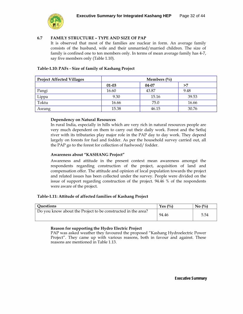
6.7 FAMILY STRUCTURE – TYPE AND SIZE OF PAP It is observed that most of the families are nuclear in form. An average family consists of the husband, wife and their unmarried/married children. The size of family is confined one to ten members only. In terms of mean average family has 4-7, say five members only (Table 1.10).
Table-1.10: PAFs - Size of family of Kashang Project Project Affected Villages Members (%) 01-03 04-07 >7 Pangi 16.60 43.87 9.48 Lippa 9.30 15.16 39.53 Toktu 16.66 75.0 16.66 Asrang 15.38 46.15 30.76
Dependency on Natural Resources In rural India, especially in hills which are very rich in natural resources people are very much dependent on them to carry out their daily work. Forest and the Setluj river with its tributaries play major role in the PAP day to day work. They depend largely on forests for fuel and fodder. As per the household survey carried out, all the PAP go to the forest for collection of fuelwood/ fodder.
Awareness about “KASHANG Project” Awareness and attitude in the present context mean awareness amongst the respondents regarding construction of the project, acquisition of land and compensation offer. The attitude and opinion of local population towards the project and related issues has been collected under the survey. People were divided on the issue of support regarding construction of the project. 94.46 % of the respondents were aware of the project.
Table-1.11: Attitude of affected families of Kashang Project Questions Yes (%) No (%) Do you know about the Project to be constructed in the area?
94.46 5.54
Reason for supporting the Hydro Electric Project PAP was asked weather they favoured the proposed “Kashang Hydroelectric Power Project”. They came up with various reasons, both in favour and against. These reasons are mentioned in Table 1.13.

Executive Summary for Integrated Kashang HEP Page 33 of 44
Executive Summary
Table-1.13: Views of PAP in Kashang Project S. No. Reason for supporting
Kashang Project Views of PAP (%)
1 Water 43.08 2 Employment opportunities 41.89 3 Electricity 18.18 4 Don’t know 28.45 6.8 IDENTIFICATION, PREDICTION AND EVALUATION OF IMPACTS
Environmental impact assessment of any developmental project highlights the existing environmental status vis-à-vis the changes supposed to be generated due to the commencement and execution of the project.
6.8.1 Physical Environment 6.8.1.1 Impact on Microclimate of the Area
The major construction activities involve underground excavation and concreting works in underground water conductor system and power house and the project does not entail any reservoir. Therefore, due to these activities there shall not be any effect on the ambient temperature, humidity, wind speed and direction and other meteorological parameters. The operation stage of a hydro electric project through an underground power house shall also not create any impact on the meteorology and climatology of the area.
6.8.1.2 Change in Landuse / Landcover
Construction Phase • For construction of the project about 85.7356 ha. land will be acquired from
private owners and forest department. Out of this 23.8357 ha land will be private land, being agriculture land which will be used for colonies, road construction and project components. The land use of about 6.0 ha of private land being used for establishing colonies shall not change as it will continue under Land Use Class Agriculture & Settlement but the land use of balance 17.8357 ha will change from agriculture to forest as extensive plantation in the area along road, dump area has been proposed. The underground components falling in forest area will not cause any impact on the land use. Similarly the land use of forest area diverted for dump areas and quarry sites will not cause any impact on land use as these shall continue to be under forest land use class.
• Excavation of underground components of the project will generate 1173895 cum
of muck. Out of this about 293933 cum of muck is expected to be utilized as construction/filling material. The remaining 879962 cum of muck will be dumped in designated dumping areas, which may bring change in landscape of the dumping yard.

Executive Summary for Integrated Kashang HEP Page 34 of 44
Executive Summary
• The headrace tunnel, after entering into the bed rock, will have in general a rock cover varying from 5 m in the initial reaches to about 150-250 m near underground reservoir. No buildings are sited on surface immediately above the proposed alignment and in fact not upto 0.8 km distance from it. The K-K-Link is totally aligned across the ridge separating Kashang and Kerang Khad and has no village interspersed on surface above the tunnel alignment or to a distance of 1.5 km to 2.0 km from the axis of tunnel. The rock cover varies from 5 m to 1400 m. The alignment of Stage-IV tunnel shall also have a rock cover varying from 10 m to 250 m. The village Asrang and Toktu shall be located away from the tunnel axis and above it. In village Lapo Dogri a few houses shall be below the tunnel alignment but away from the tunnel axis. The sufficient rock cover coupled with controlled blasting technique shall reduce the vibrations imparted to a minimal.
Operational Phase • During the operation phase no significant change on land use is expected,
however, the land cover will improve, due to implementation of landscape and restoration and catchment area treatment works. Many of the redundant areas having no further usage will be brought under plantation.
6.8.1.3 Soil Erosion and Siltation
Construction Phase Soil erosion due to excavation of different components of the project, construction of roads and dumping of muck into disposal yards will accelerate soil erosion during the construction period and this increase siltation for which precaution like siltation tanks shall have to be resorted to at aggregate crushing and processing plants, dewatering from tunnels etc. Operational Phase Soil erosion due to project activities will not exist in the operation phase as the construction would be completed and landscape restoration work would also be implemented. In addition to this under catchment area treatment stabilization of landslides / slip prone areas will restore erosion. The rate of siltation of both the Khads shall substantially reduce.
6.8.1.4 Impact on Geology
Construction Phase Geological investigation for the project was carried out and details of the geology of the project area have been discussed in Chapter 3 of this report. As per site observations, the rock formations in the area are inherently loose and prone to landslides at various locations. However, as per site specific investigations, the geological formations in the selected project sites are judged stable and will be able to withstand the impacts of drilling and blasting. However, at any unstable formation encountered during tunneling, blasting may lead to high vibrations, which in turn may result in soil erosion, subsidence and loss of vegetation. Hence, controlled blasting is to be adopted at such geologically fragile locations. Likewise, the combined effect of selection of stable sites for construction of the link tunnel, and use of controlled blasting at fragile locations are expected to have a less impact on the geological environment.

Executive Summary for Integrated Kashang HEP Page 35 of 44
Executive Summary
Intensity of anticipated environmental impacts will be low based on environmental value and degree of disturbance. Therefore, intensity of anticipated environmental impact on geology of the area will be weak and extent of anticipated impact will be local. Duration of impact will be medium leading to low significance of the impact. Operation Phase No impact is anticipated on the geology of the area during the operation phase
6.8.1.5 Environmental Degradation Due to Labour Immigration
Construction Phase During the construction phase congregation of approximately 1200 workers is likely to take place in the project area, for which semi permanent / temporary accommodation would be required. Due to this, pressure on land and water resource would occur. The disposal of sewage, solid waste would be required. If the labour force is not provided with proper fuel arrangements, the pressure on adjoining forest for fuel wood may take place. In order to reduce the dependence on forest the project proponent / contractors will be asked to provide adequate boarding and lodging to the workforce. Conflict between the migrants and the local population may occur for employment. Operation Phase In the operation phase the project will have full-fledged infrastructure to meet our requirement of project workers. The labour force engaged in construction activity will also move away once the project work is completed; therefore no additional impact is expected
6.8.2 Impacts on Air and Noise Environment
Construction Phase • Temporary changes in air quality during construction phase are expected due to
emission of hydrocarbons from vehicles and gases from blasting operations. The present levels of NOx, SOx, SPM, RSPM and TSPM indicate that the air does not contain abnormal concentration of the above. During construction monitoring of above parameters requires to be carried out periodically to keep the levels within prescribed limits by adopting rectification measures.
• Temporary changes in noise levels are expected during construction phase only.
In order to check the noise, pollution noise filters may be erected around crushing and batching plants and regular maintenance of heavy earth vehicles may be adopted to reduce noise levels.
Operation Phase • The ambient air quality during the operation phase is not expected to deteriorate.
Noise level in power house is also not expected to increase as the powerhouse is underground

Executive Summary for Integrated Kashang HEP Page 36 of 44
Executive Summary
6.8.3 Impacts On Water Environment The water environment of Kashang and Kerang khad due to proposed project will have minor impact on the water quality and aquatic fauna of temporary nature. The project (R-O-R), with neither any dam nor barrage across khads, has no inbuilt surface reservoir, thus there is no stagnation of water. Construction Phase • During the construction phase of the project the river water is not supposed to
catch considerable amount of sediment from the ongoing underground works as the water coming out from such area will be dislodged of sediment in the silt trapping tanks before being released to river.
• The silt laden water emanating from all other open air works and from the foundation works of power house, however will require sediment extraction before releasing the water into the river section.
• The muck disposal yards, quarry areas would be the areas of concerns for
leaching of sediments during rains.
• The discharge coming out of batching and crushing plants would also bring considerable sediments in water due to washing of plants and aggregate material.
• The sewage generated at the labour camps and other residential areas may also
bring considerable pollutants to river sections, if disposed off in the river section without treatment.
Operation Phase • In the operation phase of the proposed project the water environment in general
will not deteriorate owing to its being a run of the river scheme whereby the water will be continuously used for power generation and will be released simultaneously.
• However, the underground balancing reservoir will accumulate a very negligible
amount of silt in its bottom for which silt flushing will be undertaken at periodic intervals. In view of the above the water quality deterioration is not anticipated considerably. The periodic monitoring of water quality will be required to evaluate the quality status.
• For downstream usages of river course will have a minimum environmental flow
of 0.3 cumecs and 0.65 cumes respectively released from the downstream of weir site of Kashang (Stage-I) and Kerang (Stage-II) for downstream riparian usage. The discharge quantity in case of Kerang khad shall be further supplemented by the discharge flowing in Pager Garong and Chakra Nala both of which are located downstream of trench weir of Stage-II.
Near Lippa village just downstream of the confluence of Pager Khad with Kerang Khad, there is a shoal formation due to the left bank of both khads following an outer curve which results in aggradation process of sediments. At this location the flow

Executive Summary for Integrated Kashang HEP Page 37 of 44
Executive Summary
section has become wider and the effect is visible in shoal deposit. Though the process is natural and no threat or danger is caused to the village, yet the villagers apprehend that the shoal may pile up with the abstraction of water of Kerang khad. The villagers have shown their concern to the project proponents and the study teams during their visit. It is, therefore, proposed that besides normal flushing of silt deposits during floods, if needed, the abstraction of Kerang water shall be suspended or reduced so as to enable the flushing of new deposited silt loads near the banks
6.8.4 Impacts On Flora And Fauna Of Project Area
The site of proposed project is in the enviable position because of its cultural, and social importance to the local populace besides having a diversity of natural resources. Therefore, it becomes imperative to minimize the loss of habitats and destruction of ecosystems upon which the region’s social, ecological and economic well being depends. Normally, aim of the conservation strategies is to build on, improve and coordinate the existing conservation measures to increase community ownership of nature’s conservation programs in the region under investigation.
6.8.5 Impact on Flora (Plant Biodiversity) Based on the survey carried out during the present study the following impacts on flora/vegetation was predicted due to the construction of Integrated Kashang Hydroelectric Power project in Kinnaur District of Himachal Pradesh. 1. Degradation/destruction of Dry Temperate and Cold Desert Forests Influx of outside population during construction of dam and other project related activities will certainly affect the quality of the habitat around the project site in many ways. Besides, there is possibility of regular decline especially in the plant diversity may be in the form of collection of fuel wood and mowing away of the floristics in the study area. 2. Loss of threatened/ economically important species
The results of baseline survey on the flora carried out during the study in the project and its adjoining area revealed that some of the species viz; Hyoscyamus niger, Ephedra gerardiana, Ferula jaeschkeana, Heracleum candicans, Betula utilis, Juniperus macropoda, Dactylorhiza hatagirea, Datisca cannabina, Rheum webbianum, Dioscorea deltoidea, Rheum austral recorded from the region fall under category of threat status (Rare/Endangered/Vulnerable) as per the Red Data Book on Indian Plants and CAMP reports. Since most of the project activities are under ground and threatened plant species do not coincide with the project activities. Moreover, plant species found in the studied project and its adjoining areas also occur in other parts of cold desert of Kinnaur district and therefore, as there is no threat for extinction of these species from the region. Sixty two plant species with medicinal, timber, fuel wood, fodder, ornamental value were recorded from the study area. In other words, the proposed project and its adjoining area provide food, fodder and fuel wood to the local people because of the presence of large number of species. Hence, to sustain livelihood of the rural people, massive plantation of species having medicinal, fodder, fuel wood values should be done in suitable areas.

Executive Summary for Integrated Kashang HEP Page 38 of 44
Executive Summary
6.8.6 Impacts on Fauna So far as the insect and spider species of the area are concerned, we have listed 19
species of butterfly and 22 species of spiders. The species enlisted was not specifically endemic to the Khasang Khad area of Kinnour valley but are abundant in high hills of Himachal Pradesh. Noteworthy to mention is Venessa cashmeriensis (Lepidoptera:Nymphalidae) commonly called the “Indian Tortoiseshell” which was the most abundant species, and caterpillars of which feeds on Urtica spp., known as “Stinging Nettle”. This species is an indicator of rich ground vegetation in the area. Similarly Leucauge decorata (Araneae:Tetragnathidae), an orb-weaving spider, that basically breed near watery and moist sources. This species is an excellent indicator of water-rich environment where there is thick presence of insect-prey.
Due to construction of different hydroelectric structures, none of these species would be directly impacted. But as the sites are best habitat for these species, alternative arrangements must be made. To keep a balanced environment for the survival of these small terrestrial invertebrates, a green belt around the project areas must be created which should be rich in ground vegetation.
6.8.7 Impacts on Socioeconomics
The partial population of four villages i.e. Pangi Lippa, Toktu and Asran are likely to be impacted in terms of agriculture land, cattle shed and horticulture trees etc. The overall impact due to the project will be positive due to generation of direct and indirect employment due to the proposed project. The project affected families should be given proper training and financial assistance to earn their living and facility like hospital, school, community hall etc. or existing facility will be enhanced.
7.0 IMPACT MANAGEMENT Based on the evaluation of baseline data and predicted impacts, suitable management plans have been formulated for implementation, in order to ameliorate the negative impacts in the sphere of land, water, air, noise, biological and socioeconomic environments. The implementation of all the management plans should commence concurrent to project execution so that all the environmental ambiguities going to arise may be resolved before the project is commissioned. It would be appropriate to have strict monitoring of implementation of the mitigatory measures at the level of MOEF for which a Monitoring Committee may be constituted to evaluate the progress during implementation of mitigative measure and to suggest any improvement thereof. Strict monitoring will also be required to watch out the implementation of air, water and noise measures to be adopted by the contractors at various project sites by the Project Authorities / Project level monitoring committee.
In order to ameliorate the negative affects of the project construction and overall improvement of the environment following management plans are formulated for implementation concurrent to the project construction.

Executive Summary for Integrated Kashang HEP Page 39 of 44
Executive Summary
8.0 CATCHMENT AREA TREATMENT PLAN The study of erosion and sediment yield from catchments is of utmost importance as the deposition of sediment in reservoir reduces its capacity, thus affecting the water availability for the designated use. The removal of top fertile soil from catchment also adversely affects the agricultural production. Another important factor that adds to the sediment load, and which contributes to soil degradation is grazing pressure. The lack of proper vegetation cover is a factor for degradation and thereby results in severe run off/soil erosion, and subsequently premature siltation of the reservoir. Thus, a well-designed Catchment Area Treatment (CAT) Plan has been formulated to mitigate the adverse affects of soil erosion. The catchment area treatment involves understanding of the erosion characteristics of the terrain and suggests remedial measures to reduce the erosion rate. The catchment area treatment plan contains the methodology of treatment measures to be adopted along with the cost estimates of the works to be accomplished.
9.0 RESETTLEMENT AND REHABILITATION PLAN
Kashang Hydro Electric Project would require land, some of which is being acquired from private persons. The construction of the project will also involve under ground works, transportation of large quantities of material, more than usual activity in the area and therefore, all this is likely to have an impact on the lives of people living in the area. H.P. Power Corporation Limited would like to improve the life of people living in the area besides mitigating any hardships that may arise due to the construction of the project. A scheme for Resettlement and Rehabilitation of the persons affected on this account has been prepared. This has been prepared by taking into consideration the R&R Policy notified by Govt. of HP vide notification No. Rev (PD)F(5)-1/1999 dated 27/04/2006 National Rehabilitation and Resettlement Policy 2007 and National Hydro Policy 2008.
10.0 COMPENSATORY AFFORESTATION SCHEME
For construction of the project 85.7456 ha of land is required which comprises of 61.8999 ha of forest land and 23.8357 ha of private land. Break up of the forest land and private land required for different stages of project including colonies and office, roads, muck disposal sites and quarry of borrow areas is given in Table-1.14.
Table-1.14: Land Requirement of the Project
Stage Forest Land (ha) Private Land (ha) Total Land (ha)
I 18.7142 15.4863 34.2005 II & III 17.6857 3.3494 21.0351 IV 25.500 5.000 30.500
Total 61.8999 23.8357 85.7356
The total forest land requirement of 61.8999 ha for the project falls under Kinnaur Forest Division at Reckong Peo under Forest Circle at Rampur. As such, compensatory afforestation is proposed in lieu of 61.8999 ha of forest land. In the
Executive Summary for Integrated Kashang HEP Page 40 of 44
Executive Summary
light of the fact that concurrence of diversion of 18.7142 ha of forest land under stage-I has already been granted by the MoEF letter dated 23.06.2004, the total forest land now to be diverted is 43.1857 ha only. Accordingly, the compensatory afforestation in double of the degraded forest area i.e. on 86.37 ha or say 86.40 ha is proposed to be carried out. The scheme has been formulated to compensate for the loss of forest due to construction of project and its appurtenant works, quarry site and aggregate crushing, dumping areas, approach roads to adits, other amenities and infrastructure facilities. The compensatory afforestation scheme has to be systematically implemented along with other soil conservation measures and barbed wire fencing i.e. protection measures to mitigate biotic interference. The species to be planted would be area specific; to meet the basic needs of the people with respect to fuel wood, fodder, and timber with an objective on ecological balance and conservation.
11.0 GREEN BELT DEVELOPMENT PLAN
Green belt development in around hydro electric power projects has a special significance as the project construction process emanates lot of dust due to excavation works, crushing of material and batching of aggregates. Beside this the air pollution also takes place due to vehicular movement during construction and operation phases. Forest canopy has the inherent capacity to absorb pollution, increase water retention of soil and decrease sediment transport. The green belt development along the project site, roads, colonies and around other infrastructural facilities also adds to the aesthetic environment. Selection of Local plant species is always advantageous for success of green belt development. The green belt is proposed to be developed within the project area along the network of approach roads, residential areas, office complex, trench weir sites, power house site and other working areas. The strategy worked out for development of green belt consists of following:
• Broad leaf trees growing above 10 m in height should be planted along the
approach roads and colonies • Plantation of trees should be undertaken in appropriate encircling rows. • Generally local/indigenous fast growing trees shrubs should be planted. • The trees should be protected by plantation of non palatable shrub species to
avoid browsing by animals. • Placement of Bamboo/Iron tree guards be provided to save the plants
12.0 MUCK DISPOSAL PLAN For construction of different components of the project substantial surface and underground excavation in over burden and rock for intake structure tunnel, balancing reservoir and powerhouse etc. would be required. The excavation shall result in large quantity of excavated material i.e. muck which shall have to be evacuated, disposed off and roller compacted or laid on mild slopes pari-passu with the excavation work, to such designated areas where the muck piles do not

Executive Summary for Integrated Kashang HEP Page 41 of 44
Executive Summary
substantially interfere with either environment / ecology or the river flow regime and cause turbidity impairing the quality of water. The disposal of muck has to be scientifically planned keeping in view the pecuniary aspects necessitating nearness to the generating component of work, which understandably reduce the travel time of dumpers, interference to surface flow and ground water aquifer, disposition of habitation are a few aspects borne in mind in evolving a muck management plan. The Hydro Power policy, 2006 of Himachal Pradesh government under Chapter-V para (XXIV) lays down that the company shall use such material for the project activities as may be found suitable for construction and the remaining material shall be allowed to be used by other development departments like PWD, I & PH etc. Even the private crusher owners etc and private users shall also be allowed to use such material from the site free of cost. In the present case it is proposed of utilize about 25% of the excavated material on the project activities and about 10% of the muck generated through free-of-cost lifting by other Government agencies and private users. The balance 65% shall have to be disposed off away from sites so as to make available the clear site for construction activities. The balance muck shall be properly stacked and roller compacted or laid on slopes and treated to mix and match with the surrounding environ with least change in landscape.
Based on the quantities of surface and underground excavation including 10% over break as contained in DPR a muck management plan, therefore, has been formulated to manage the disposal of muck and restore such areas from further degradation of the environment.
13.0 RESTORATION PLAN FOR QUARRY SITES In construction of the project 6.49 lac Cum aggregate/stone material is required. To meet this demand stream/river bed shoals in Kashang, Kerang and River Satluj were investigated. It is also proposed that the excavated material derived from the underground and open surface works will be utilized to a maximum and about 2.94 lac cum excavated material will therefore, be used out of the total quantity of 11.74 lac cum excavated material. The coarse aggregate obtained through crushing of excavated muck shall be utilized in non-wearing concrete works like back fill concrete in water conductor system like HRT, balancing reservoir, pressure shaft, MAT, TRT and other adits and also in shotcreting and grouting works for which 2.3 lac cum quantity is required.
14.0 LANDSCAPE AND RESTORATION PLAN The Integrated Kashang HEP has three trench weirs located in the interior area of District Kinnaur. The Stage-I trench weir is located across Kashang Khad near village Dolo Dogri which is 16 km from Reckong Peo. The Stage II trench weir are located across Kerang Khad near village Lapo and Toktu which are 45 km and 50 km from Reckong Peo. For construction of trench weir site minimum of forest land shall be diverted so as to accommodate the structure. Thus being in remote interior and at a detour from NH-22, the weir sites do not provide a great site for landscaping besides being aesthetically unattractive too. The water conductor system, the powerhouse and appurtenant works are all underground structures and thus their landscaping is not warranted. Considering this the landscape plan is

Executive Summary for Integrated Kashang HEP Page 42 of 44
Executive Summary
restrictive in nature being limited to residential, office complex areas and also the approach road to powerhouse MAT area. In view of a provision of Rs 9.0 lacs in DPR, for development of garden, parks and lawns in the residential areas/office complexes under the head M-Plantation, it is only proposed to provide landscaping for the area near power house MAT and the approach road to powerhouse.
15.0 HEALTH MANAGEMENT PLAN
All the necessary medical attendance to the local inhabitants/patients will obviously be provided by the project proponents as a gesture of public welfare. Under this scheme, the project doctors and para-medical staff may visit different places and provide the necessary attendance to the villagers in general and to old and sick people in particular. Provision is also being made for providing medicines to project affected families and labours. Similarly, provisions are also made for organizing awareness camps, regular health checkups, vaccination, malaria control measures and spraying of insecticide. Budgetary provision for running and maintenance of ambulance are also made. The budgetary estimate for health management plan is Rs. 65.0 lacs.
16.0 PROVISION FOR SUBSIDIZED FUEL
The subsidized fuel provision plan is prepared to formulate guidelines for meeting the demands of fuel supply for labours and workman, who are engaged through contractors during the construction of the project. As per the plan adequate clause with regard to free fuel supply will be built-up in the tender document for execution of different works making the supply of free fuel to work force mandatory by the respective contractors .However a provision has also been kept to meet out the subsidized fuel supply to the work force engaged during the construction of the project. The plan envisages distribution of subsidized Kerosene, LPG and electricity and infrastructure for free fuel facilities. This provision will facilitate in the maintenance of ecosystem and control encroachment in the forest area for fuel wood gathering. Subsidy of LPG, kerosene, electricity and infrastructure for free fuel subsidies are suggested with a cost provision of Rs. 113.0 lacs.
17.0 SOLID WASTE MANAGEMENT PLAN
During the construction phase of the project, there will be an influx of technical staff, labourers and other service providers into the project area. The proposed project has also envisaged four colonies to house 600 project employees including personal for other utility services with their families. Sewage and solid waste will be generated from the colonies. It is very essential that from the planning stage, sewerage management and solid waste disposal facilities should be conceptualized to maintain the health of the people and the environment.
Since most of the dam operations shall be automated or mechanized, very few people shall be staying in the project during the operation phase. The solid waste is primary problem during the construction phase of the project. Solid waste generated from temporary and permanent colonies in construction as well as operation phase requires special management to dispose off as warranted under the Municipal Solid Wastes (Management and Handling) Rules 2000.

Executive Summary for Integrated Kashang HEP Page 43 of 44
Executive Summary
The project authority shall, within the territorial area of the project complex /colony , be responsible for the implementation of the provision of Municipal Solid Wastes ( Management and Handling ) Rules, 2000 issued by MOEF New Delhi vide so 908 (E) dt 25, September,2000, and for any infrastructure development for collection , storage, segregation, transportation, processing and disposal of municipal solid wastes.
Any municipal solid waste generated in the project complex / project colony / labour colony, shall be managed and handled in accordance with the compliance criteria and the procedure laid down in Schedule –II of under rules 6 (1) and (3), 7 (1) of notification dt 25 September,2000.
18.0 DISASTER MANAGEMENT PLAN
It is clear that the Scheme has been conceptualized as Run-of-the River type hydroelectric project with no open surface reservoir or water impoundment within the river banks. Also there does not exists any hydroelectric project upstream of the proposed Integrated Scheme and thus, these are no hazard involved to the Scheme from the failure of any upstream project also. Thus if any disaster may happen it could be due to failure of one or more components of the proposed scheme though the chances of which are remote but can not be ruled out. The disaster management of any mega projects relates to the management of any exigency arising due to failure of such projects given to natural factors such as floods, sudden release of heavy water flows due to formation of artificial lakes in the catchment and their outburst, heavy downpour, earth quakes etc. Disaster management plans are therefore, formulated to meet the consequences of such failures if incase it happens. In case a disaster takes place, despite preventive actions disaster management will have to be done. The emergency planning for disaster scenario interlaid include provision like setting up of alarms and warning, systems, establishing communication system besides aspects concerning human behaviors, procedure to be adopted, roles and responsibilities. The plan is intended to serve as a reference document or blue book containing of salient information indicating the action to be taken in the emergency situation.
19.0 ENVIRONMENTAL MONITORING PLAN
Monitoring is an essential component for sustainability of water resource project and is an integral part of any environmental assessment process. Water resource development project introduces complex inter-relationships in the project area between people, natural resources including biota thus manipulating the overall environment. In order to have a holistic approach the overall measures for monitoring of air, noise, water related vectors and overall ecosystem have been proposed under different heads with suitable financial provisions for the implementation.

Executive Summary for Integrated Kashang HEP Page 44 of 44
Executive Summary
SUMMARY OF COST ESTIMATE
S. No Plans Cost (Rs. In Lacs) 1 Catchment Area Treatment Plan 1820.00 2 Resettlement and Rehabilitation Plan 3 Compensatory Afforestation 541.00 4 Green Belt Development Plan 55.00 5 Muck Management Plan 552.00 6 Restoration Plan for Quarry sites 64.00 7 Landscape and Restoration Plan 26.00 8 Health Management Plan 65.00 9 Subsidized Fuel Scheme 113.00 10 Solid waste Management Plan 178.00 11 Disaster Management Plan 40.00 12 Environment Monitoring Plan 46.00