Embed Size (px)
Citation preview
Environment CanadaCanadian Meteorological Centre
Environnement CanadaCentre météorologique canadien
Meteorological Service of Canada Status Report
Montréal, Canada, May 26-28, 2004
Gilles VernerChief, Data Assimilation and Quality Control
Canadian Meteorological Centre
17th NOAM-Europe Data Exchange Meeting

Environment CanadaCanadian Meteorological Centre
Environnement CanadaCentre météorologique canadien
Outline
• Current status:– Canadian Forecast System
– Telecoms and Computers
– NWP System at CMC
– MSC Observing Networks and Canadian AMDAR
• Changes to NWP System since last meeting– Results from AMSU-B / GOES radiances
– Results from 15-km regional GEM
– Results from new OSE’s
• Future Plans and Requirements for Data
• Part II presented by Godelieve Deblonde

Environment CanadaCanadian Meteorological Centre
Environnement CanadaCentre météorologique canadien
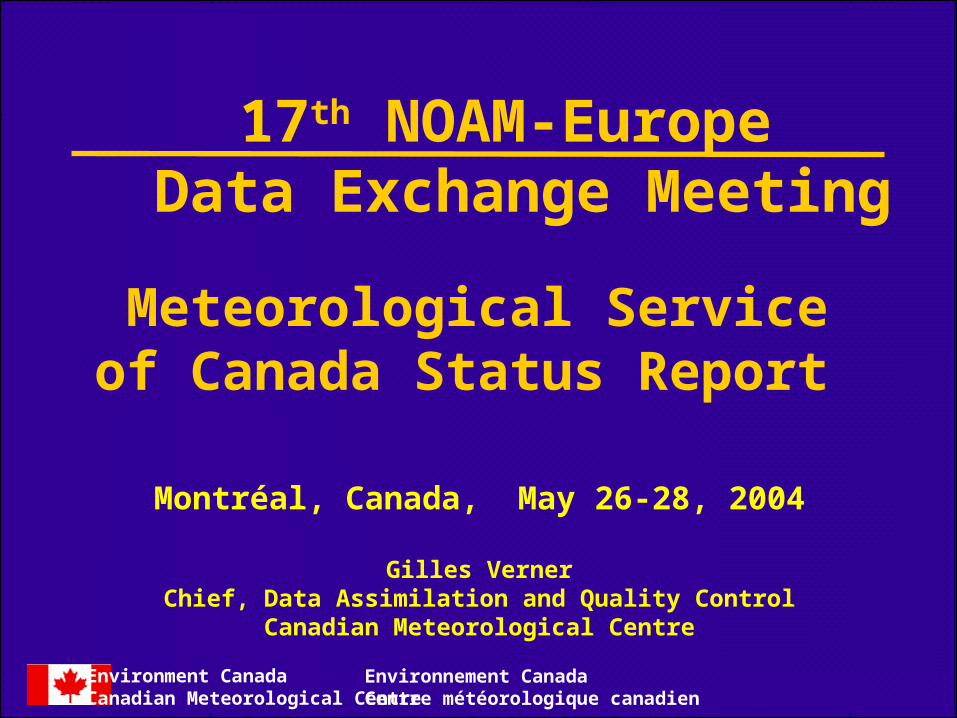
MSC Forecast Offices and Satellite Reception Facilities
Each MSC Officehas a GOES Direct Readout Station.
CMC has 3 GOESReadout Stations.
MSC operates 3 HRPTStations: Halifax, Gander and Edmonton.Data from a non-MSCNorthern station is alsoavailable (Resolute).CMC has DOMSAT system for AVHRR-GAC (TeraScan)
Environment CanadaCanadian Meteorological Centre
Environnement CanadaCentre météorologique canadien
MSC Forecast Offices and Satellite Reception Facilities
Each MSC Officehas a GOES Direct Readout Station.
CMC has 3 GOESReadout Stations.
MSC operates 3 HRPTStations: Halifax, Gander and Edmonton.Data from a non-MSCNorthern station is alsoavailable (Resolute).CMC has DOMSAT system for AVHRR-GAC (TeraScan)
XX
X X
XX
X
X

Environment CanadaCanadian Meteorological Centre
Environnement CanadaCentre météorologique canadien
CMC Computer Center ConfigurationCMC Computer Centre Configuration
2004/03
6x ea
Supercomputing Cluster
SGIO3000's40 PEs
(MIPS R12K)
O2000 4 xR10K PEs
1.2 TB14x SCSIfrom OSS
Climate Archive
HPModel 30 &
60 RAID0.2 TB?
3x
1000 Mb/s switched128ports. Each host has links to
ops & dev net
SGIO300:8 PEs
Central File Server145 TB
4 DST drives20 MB/s ea.
LSI (1 TB 4X FC)
10x FCdual
attach
LSI11TB
Front Ends
FC Hubs 32 ports
Data Acquisition& Distribution
opsnet switched(1000+100+10)
CriticalWorkstations
devnet switched(1000+100+10)
Dev HPpairs
NationalProduct
DistributionServerMC/SG
2 x HP K370
SmallerHP pairs
PC's & WksNT/OTServers
2 x o200Monitoring
Servers
routers
8 x Front-End3 x Back-End
2 Data4 Climate
2 x Greenlane
DMZ nets (10)
router
AWWS2xHP
L-series
InternetServers
100 UNIX &150 MSdesktops
3x o200WrkGrpServers
Satnet Tx
PC's, Wks.&
Tandem
F820.05 TB
NASO3000 18 xR14K PEs
ASEPLinuxCluster
17 DL380
IBM SP -928 PE &2.19TB
LSI (8.67 TB FC)
8x
Environment CanadaCanadian Meteorological Centre
Environnement CanadaCentre météorologique canadien
Telecommunications
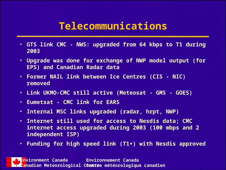
• GTS link CMC - NWS: upgraded from 64 kbps to T1 during 2003
• Upgrade was done for exchange of NWP model output (for EPS) and Canadian Radar data
• Former NAIL link between Ice Centres (CIS - NIC) removed
• Link UKMO-CMC still active (Meteosat - GMS - GOES)
• Eumetsat - CMC link for EARS
• Internal MSC links upgraded (radar, hrpt, NWP)
• Internet still used for access to Nesdis data; CMC internet access upgraded during 2003 (100 mbps and 2 independent ISP)
• Funding for high speed link (T1+) with Nesdis approved
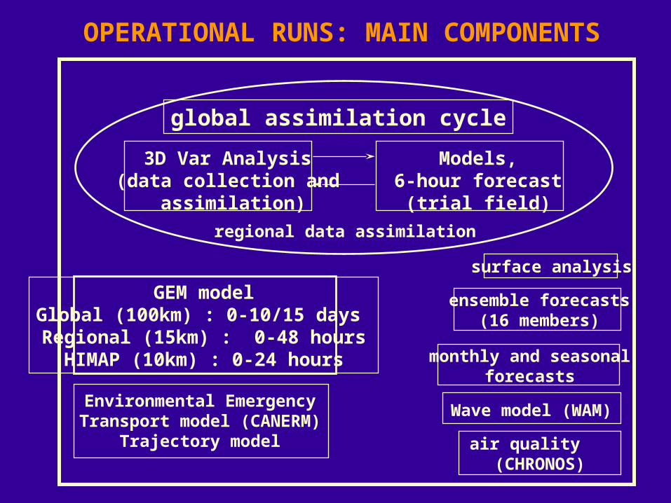
OPERATIONAL RUNS: MAIN COMPONENTS
GEM modelGlobal (100km) : 0-10/15 days Regional (15km) : 0-48 hoursHIMAP (10km) : 0-24 hours
air quality (CHRONOS)
Environmental EmergencyTransport model (CANERM)
Trajectory model
monthly and seasonalforecasts
global assimilation cycle
3D Var Analysis (data collection and
assimilation)
Models,6-hour forecast
(trial field)
Wave model (WAM)
regional data assimilation
ensemble forecasts(16 members)
surface analysis

CMC Operational Models
Global Model Regional Model• Uniform grid• Resolution of .9º (~100 km)• 28 eta levels• Kuo convection scheme• Sundqvist stratiform scheme• Force-restore surface module with climatogical soil moisture• 10 day forecasts at 00Z and 6 day forecasts at 12Z.• Cut-off of T+3h00
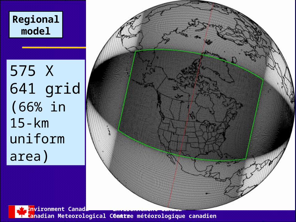
• Variable resolution grid• Resolution of .1375º (~15 km) • 58 eta levels• Kain-Fritsch scheme• Sundqvist stratiform scheme• ISBA surface module with soil moisture pseudo-analysis (error feedback, no data)• 48-hour forecasts (00Z -12Z)• Cut-off of T+1h35
• 3D-Var assimilation on model η levels (T108)• Background errors from 24-48 method• Observations QC with BG check and QC-VAR• GEM model (global, regional, meso)
Environment CanadaCanadian Meteorological Centre
Environnement CanadaCentre météorologique canadien
575 X 641 grid (66% in 15-km uniformarea)
Regionalmodel
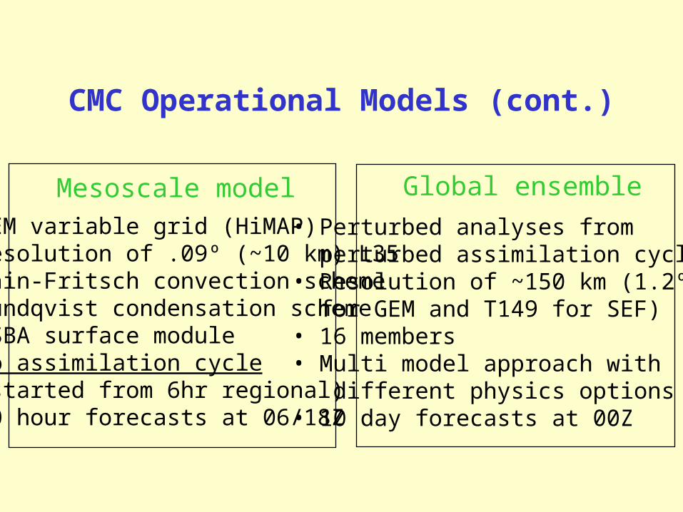
CMC Operational Models (cont.)
Mesoscale model Global ensemble
• GEM variable grid (HiMAP)• Resolution of .09º (~10 km) L35• Kain-Fritsch convection scheme• Sundqvist condensation scheme• ISBA surface module• No assimilation cycle (started from 6hr regional)• 30 hour forecasts at 06/18Z
• Perturbed analyses from perturbed assimilation cycles• Resolution of ~150 km (1.2º for GEM and T149 for SEF)• 16 members• Multi model approach with different physics options• 10 day forecasts at 00Z
Environment CanadaCanadian Meteorological Centre
Environnement CanadaCentre météorologique canadien
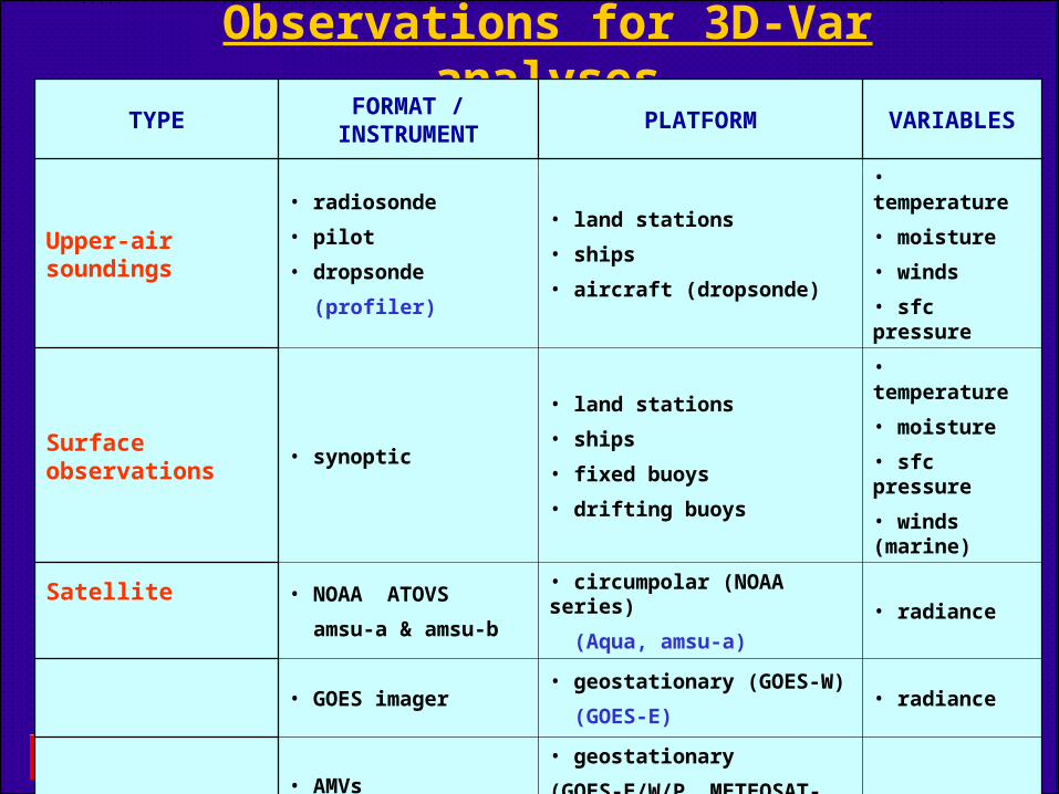
Observations for 3D-Var analysesTYPE
FORMAT / INSTRUMENT
PLATFORM VARIABLES
Upper-air soundings
• radiosonde
• pilot
• dropsonde
(profiler)
• land stations
• ships
• aircraft (dropsonde)
• temperature
• moisture
• winds
• sfc pressure
Surface observations • synoptic
• land stations
• ships
• fixed buoys
• drifting buoys
• temperature
• moisture
• sfc pressure
• winds (marine)
Satellite • NOAA ATOVS
amsu-a & amsu-b
• circumpolar (NOAA series)
(Aqua, amsu-a) • radiance
• GOES imager• geostationary (GOES-W)
(GOES-E)• radiance
• AMVs
( IR, WV, VI channels)
• geostationary
(GOES-E/W/P, METEOSAT-5/7)
(circumpolar, Terra & Aqua)
• derived winds
Aircrafts• BUFR / AMDAR
• AIREP / ADS
• Aircrafts
(single level & profiles)
• temperature
• winds

Network now completed!

Environment CanadaCanadian Meteorological Centre
Environnement CanadaCentre météorologique canadien
Canadian AMDAR Programme Business Case and Workshop March-April 2000
Canadian AMDAR Program Implementation Team:– TORs (EC, NC, airlines, WMO, NOAA, Sypher)– Canadian AMDAR s/w’s Specifications - enhanced ARINC 620-4– Data Ownership and Process & Communication Studies– AMDAR Data Control System’s Specifications (ongoing)
Completion of DASH-8’s AMDAR s/w by UASC (Unilink)
• Lobbying airlines to join, including major PR actions
Air Canada Jazz began reporting July 2002: 21 Air Nova DASH-8s and 10 CRJs presently reporting data– probable fleet expansion to Air BC and Air Ontario (2004-05), JAZZ now planning ~65
CRJ and 60 DASH-8 by March 2006 reception and processing of data by CMC; C-ADAS software
• Partnering with First Air for an alternative AMDAR system
Environment CanadaCanadian Meteorological Centre
Environnement CanadaCentre météorologique canadien
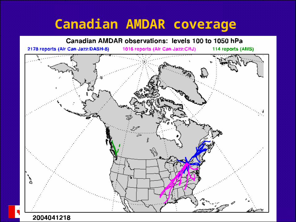
Canadian AMDAR coverage

Environment CanadaCanadian Meteorological Centre
Environnement CanadaCentre météorologique canadien
Canadian AMDAR coverage - soundings

Environment CanadaCanadian Meteorological Centre
Environnement CanadaCentre météorologique canadien
Monitoring of Canadian AMDAR - DASH-8 Temp.
August 02

Environment CanadaCanadian Meteorological Centre
Environnement CanadaCentre météorologique canadien
Monitoring of Canadian AMDAR - DASH-8 Wind
August 02
Environment CanadaCanadian Meteorological Centre
Environnement CanadaCentre météorologique canadien
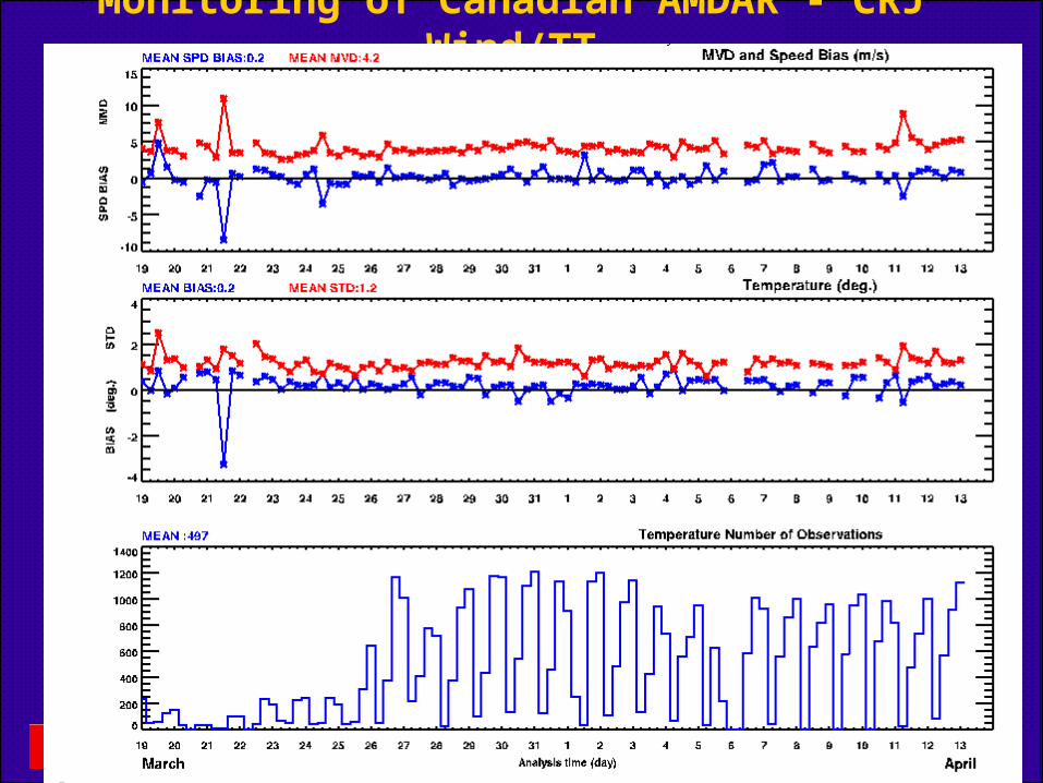
Monitoring of Canadian AMDAR - CRJ Wind/TT
Environment CanadaCanadian Meteorological Centre
Environnement CanadaCentre météorologique canadien
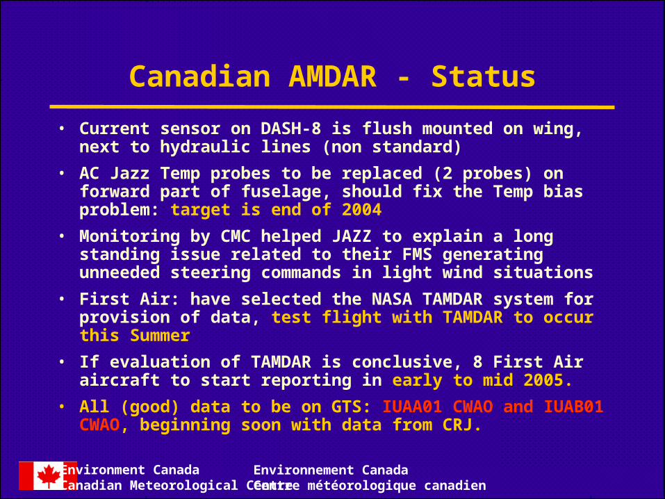
Canadian AMDAR - Status
• Current sensor on DASH-8 is flush mounted on wing, next to hydraulic lines (non standard)
• AC Jazz Temp probes to be replaced (2 probes) on forward part of fuselage, should fix the Temp bias problem: target is end of 2004
• Monitoring by CMC helped JAZZ to explain a long standing issue related to their FMS generating unneeded steering commands in light wind situations
• First Air: have selected the NASA TAMDAR system for provision of data, test flight with TAMDAR to occur this Summer
• If evaluation of TAMDAR is conclusive, 8 First Air aircraft to start reporting in early to mid 2005.
• All (good) data to be on GTS: IUAA01 CWAO and IUAB01 CWAO, beginning soon with data from CRJ.

Environment CanadaCanadian Meteorological Centre
Environnement CanadaCentre météorologique canadien
First Air Route (http://www.firstair.ca/images/FA-ROUTE.gif)
Environment CanadaCanadian Meteorological Centre
Environnement CanadaCentre météorologique canadien
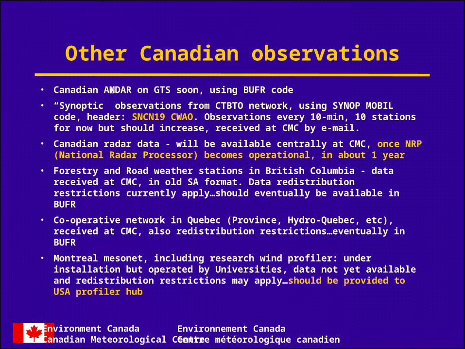
Other Canadian observations
• Canadian AMDAR on GTS soon, using BUFR code
• “Synoptic” observations from CTBTO network, using SYNOP MOBIL code, header: SNCN19 CWAO. Observations every 10-min, 10 stations for now but should increase, received at CMC by e-mail.
• Canadian radar data - will be available centrally at CMC, once NRP (National Radar Processor) becomes operational, in about 1 year
• Forestry and Road weather stations in British Columbia - data received at CMC, in old SA format. Data redistribution restrictions currently apply…should eventually be available in BUFR
• Co-operative network in Quebec (Province, Hydro-Quebec, etc), received at CMC, also redistribution restrictions…eventually in BUFR
• Montreal mesonet, including research wind profiler: under installation but operated by Universities, data not yet available and redistribution restrictions may apply…should be provided to USA profiler hub
Environment CanadaCanadian Meteorological Centre
Environnement CanadaCentre météorologique canadien
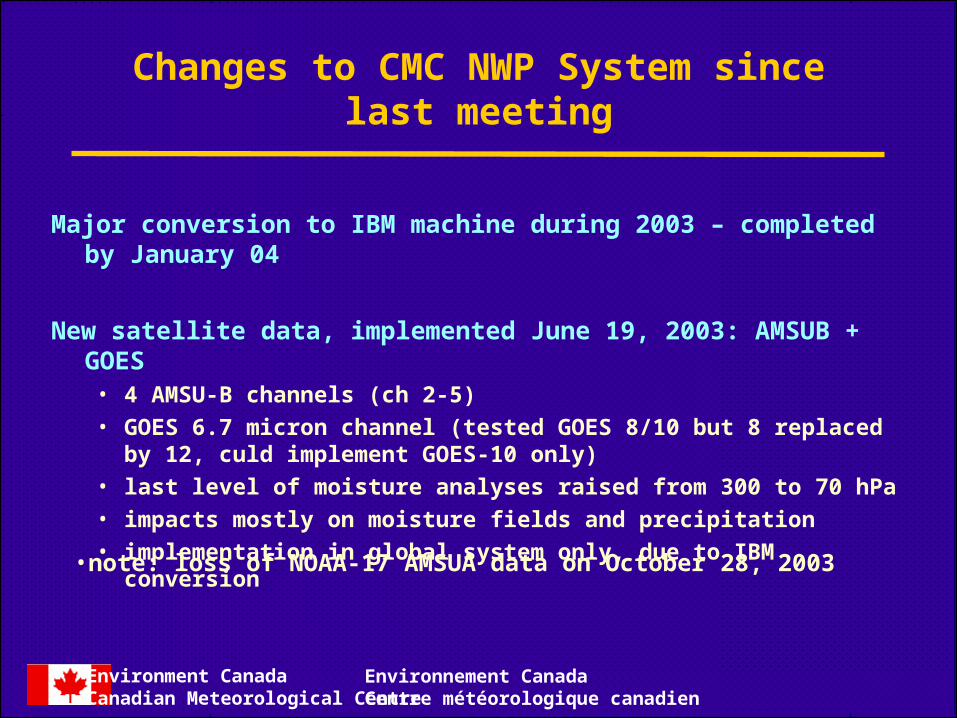
Changes to CMC NWP System since last meeting
Major conversion to IBM machine during 2003 – completed by January 04
New satellite data, implemented June 19, 2003: AMSUB + GOES• 4 AMSU-B channels (ch 2-5)
• GOES 6.7 micron channel (tested GOES 8/10 but 8 replaced by 12, culd implement GOES-10 only)
• last level of moisture analyses raised from 300 to 70 hPa
• impacts mostly on moisture fields and precipitation
• implementation in global system only, due to IBM conversion
•note: loss of NOAA-17 AMSUA data on October 28, 2003

Environment CanadaCanadian Meteorological Centre
Environnement CanadaCentre météorologique canadien
Average 250 mb (T-Td) analysis increments forAverage 250 mb (T-Td) analysis increments forthe 22 Dec 01 to 31 Jan 02 assimilation periodthe 22 Dec 01 to 31 Jan 02 assimilation period
GOES - CONTROL AMSUB - CONTROL
• AMSUB and GOES have similar average (quite large!!) corrections at 250 mb for T-Td

Environment CanadaCanadian Meteorological Centre
Environnement CanadaCentre météorologique canadien
ATOVS available for Reg ATOVS available for GlobATOVS available for Reg ATOVS available for Glob
GOES available for RegGOES available for Reg

Environment CanadaCanadian Meteorological Centre
Environnement CanadaCentre météorologique canadien
AMSU-B+GOES OPE
Results:48h forecast verification
over S. HemisphereAug-Sep 2002

Environment CanadaCanadian Meteorological Centre
Environnement CanadaCentre météorologique canadien
Verification of 24-48 hr
precipitation NOAM
Dec 02-Jan 03
Environment CanadaCanadian Meteorological Centre
Environnement CanadaCentre météorologique canadien
Environment CanadaCanadian Meteorological Centre
Environnement CanadaCentre météorologique canadien
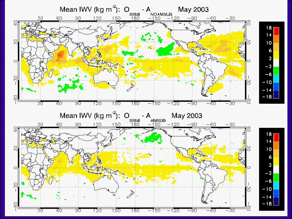
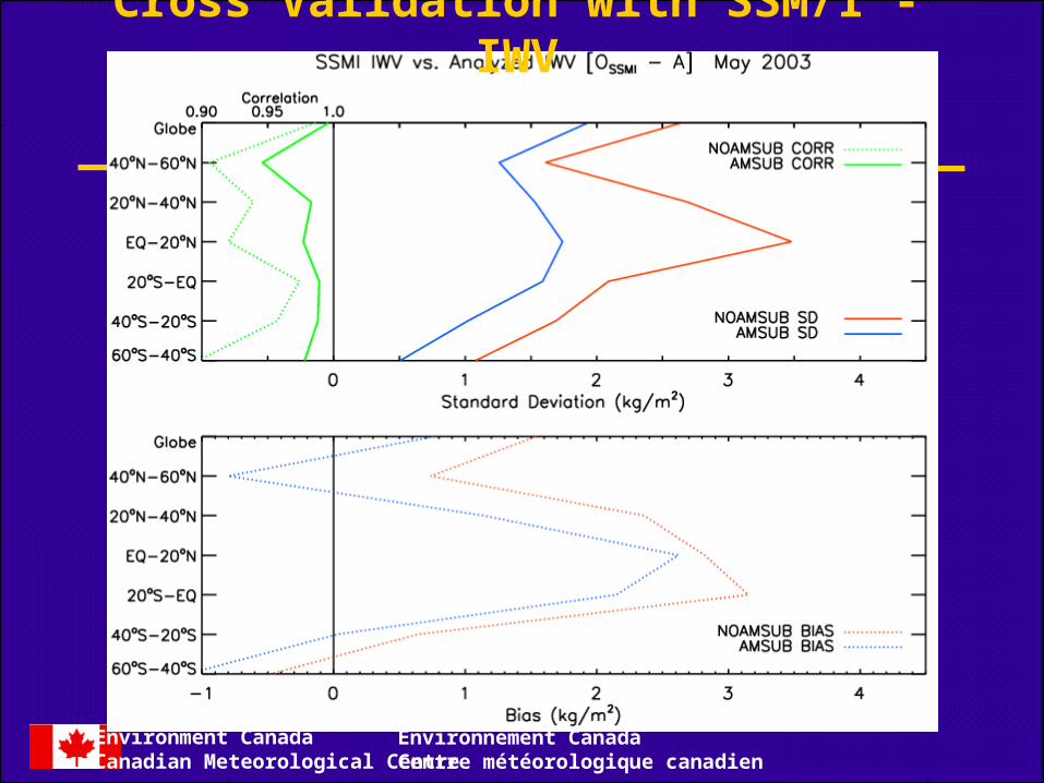
Cross Validation with SSM/I - IWV
Environment CanadaCanadian Meteorological Centre
Environnement CanadaCentre météorologique canadien
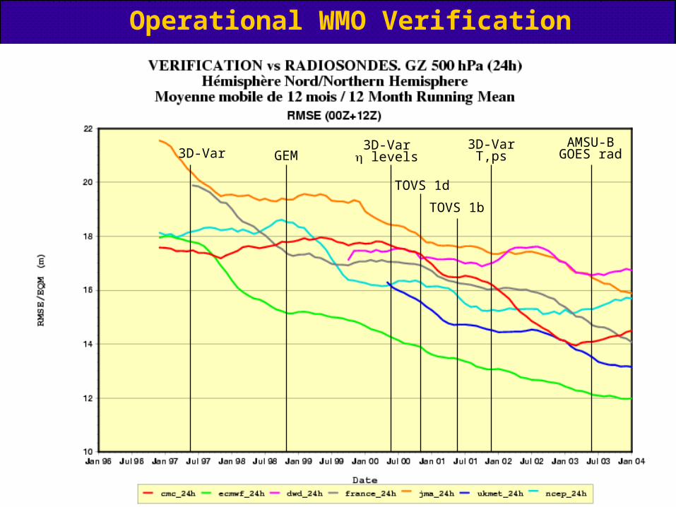
Operational WMO Verification
3D-Var GEM3D-Var levels
TOVS 1d
TOVS 1b
3D-VarT,ps
AMSU-BGOES rad

Environment CanadaCanadian Meteorological Centre
Environnement CanadaCentre météorologique canadien
Changes to CMC NWP System since last meeting
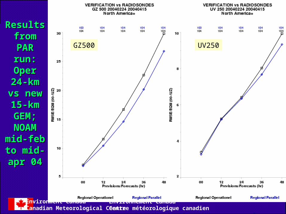
New GEM regional model evaluated in parallel during last 3 months
• MPI code
• 15 km, 58 levels (575 x 641 grid)
• Minimum resolution of 350 km
• Sundqvist condensation scheme
• Kain-Fritsch convection scheme
• Moist TKE (Turbulence en air saturé)
• Ktrans Shallow convection
• Very good results for mass/wind and PCPN
• 8x more cpu than previous regional model (24km, 28 levels)
• Incorporates AMSUB and GOES radiance data (as in global)
• Implemented May 18, 2004
Environment CanadaCanadian Meteorological Centre
Environnement CanadaCentre météorologique canadien
Results Results fromfrom
PAR run:PAR run:Oper 24-Oper 24-
km vs new km vs new 15-km 15-km GEM;GEM;NOAMNOAM
mid-feb to mid-feb to mid-apr mid-apr
0404
GZ500 UV250

Environment CanadaCanadian Meteorological Centre
Environnement CanadaCentre météorologique canadien
Results Results fromfrom
PAR run:PAR run:Oper 24-Oper 24-
km vs new km vs new 15-km 15-km GEM;GEM;NOAMNOAM
mid-feb to mid-feb to mid-apr mid-apr
0404
Environment CanadaCanadian Meteorological Centre
Environnement CanadaCentre météorologique canadien
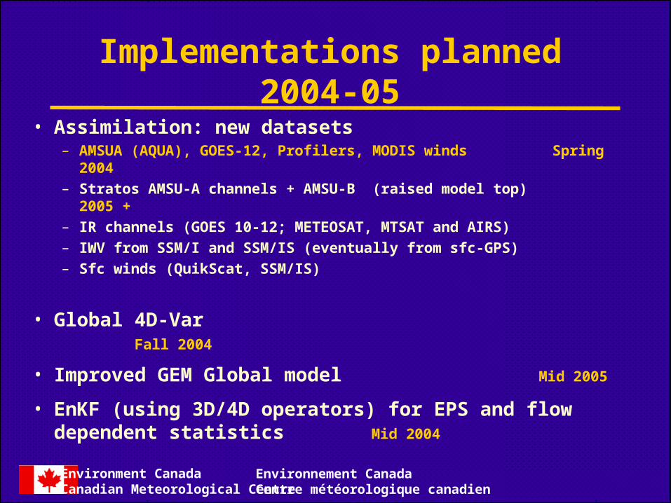
Implementations planned 2004-05
• Assimilation: new datasets– AMSUA (AQUA), GOES-12, Profilers, MODIS winds Spring 2004– Stratos AMSU-A channels + AMSU-B (raised model top) 2005 +– IR channels (GOES 10-12; METEOSAT, MTSAT and AIRS)– IWV from SSM/I and SSM/IS (eventually from sfc-GPS)– Sfc winds (QuikScat, SSM/IS)
• Global 4D-Var Fall 2004
• Improved GEM Global model Mid 2005
• EnKF (using 3D/4D operators) for EPS and flowdependent statistics Mid 2004

Environment CanadaCanadian Meteorological Centre
Environnement CanadaCentre météorologique canadien
Difference in RMS of 24-hours Forecast errors, verified against Control analyses done with all the observations:
No Polar Winds – Polar Winds exp., 500 hPa wind vector (m/s), 2003110800-2004012512
Impact of MODIS Polar Winds
Environment CanadaCanadian Meteorological Centre
Environnement CanadaCentre météorologique canadien
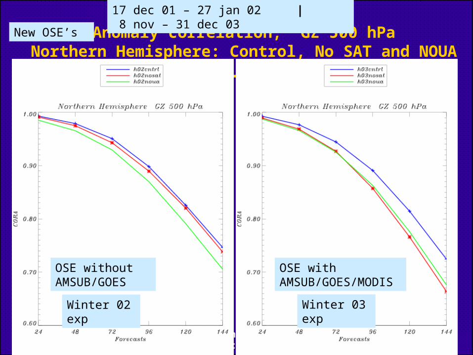
Anomaly correlation, GZ 500 hPaNorthern Hemisphere: Control, No SAT and NOUA
Winter 02 exp Winter 03 exp
17 dec 01 – 27 jan 02 | 8 nov – 31 dec 03
OSE without AMSUB/GOES
OSE with AMSUB/GOES/MODIS
New OSE’s

Environment CanadaCanadian Meteorological Centre
Environnement CanadaCentre météorologique canadien
Anomaly correlation, GZ 500 hPaSouthern Hemisphere: Control, No SAT and NOUA
17 dec 01 – 27 jan 02 | 8 nov – 31 dec 03
OSE without AMSUB/GOES
OSE with AMSUB/GOES/MODIS
Winter 02 exp Winter 03 exp

Environment CanadaCanadian Meteorological Centre
Environnement CanadaCentre météorologique canadien
Anomaly correlation, GZ 500 hPaNorth America: Control, No SAT and NOUA
17 dec 01 – 27 jan 02 | 8 nov – 31 dec 03
OSE without AMSUB/GOES
OSE with AMSUB/GOES/MODIS
Winter 02 exp Winter 03 exp

Environment CanadaCanadian Meteorological Centre
Environnement CanadaCentre météorologique canadien
Global 4D-Var assimilation cycle
• 6h window with 45 min time step.
• 4D data thinning. Spatial data selection is done for each 45 min time bin.
• Incremental analysis performed at T108.
• GEM tangent-linear and adjoint models on 240 x 120 grid.
• 2 outer loops: 40 inner loops : adiabatic physics (vertical diffusion) 30 inner loops : improved physics (SGO, large scale condensation,
convection)
Environment CanadaCanadian Meteorological Centre
Environnement CanadaCentre météorologique canadien
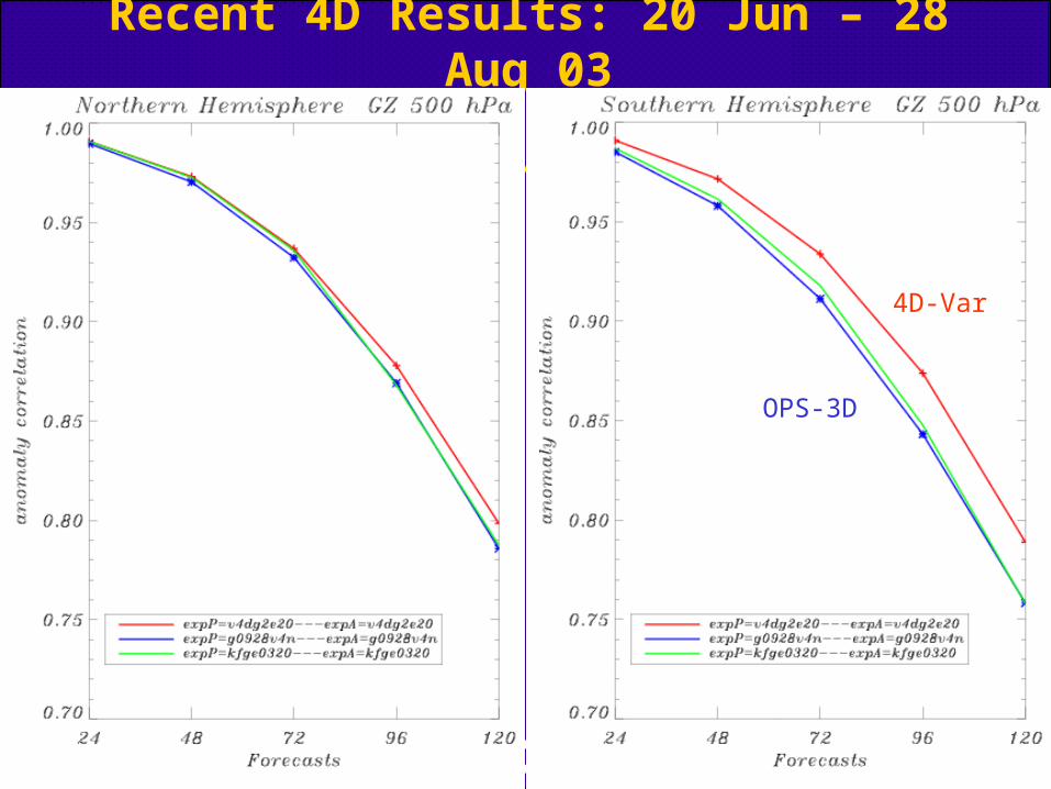
Recent 4D Results: 20 Jun – 28 Aug 03
4D-Var
OPS-3D

Environment CanadaCanadian Meteorological Centre
Environnement CanadaCentre météorologique canadien
Improved Global GEMImproved Global GEM
Numerics / Dynamics
• 800 x 600 x L58 (i.e., 33 km at 49o)
• Timestep of 15 min
• Numerical poles at geographical poles
• 6 horizontal diffusion on momentum variables
• Modified sponge layer at model top
• Filtered orography from USGS
Physics
• Constant thermodynamic roughness over water surfaces
• No vertical smoothing on net radiational fluxes
• Bougeault-Lacarrere mixing length for the vertical diffusion
• MoisTKE for boundary-layer clouds
• Shallow convection with Kuo Transient
• Deep convection with Kain-Fritsch
• Grid-scale condensation with a modified Sundqvist scheme (consun)

Environment CanadaCanadian Meteorological Centre
Environnement CanadaCentre météorologique canadien
Priorities for Satellite Data
• ATOVS: Improved access to Level 1B data (new link with Nesdis), Canadian HRPT data (processing with AAPP) for regional model (cut-off of T+90 min.) and EARS
• SSM/IS
• QuikScat and Envisat (AATSR), both now received, tests underway
• MODIS Products (Winds, SST, LAI, Cloud), winds now tested. A more “operational like” status of NOAA wind product would be very useful.
• METEOSAT and GOES-9 Imagery (MTSAT) (CSR product)
• High Density AMV for GOES9/MTSAT, GOES 9 soon in parallel
• AIRS (assimilation now being tested)
• METOP (IASI,…)