Embed Size (px)
Citation preview

Journal of Conventional Weapons DestructionVolume 22Issue 3 The Journal of Conventional WeaponsDestruction Issue 22.3
Article 5
November 2018
Enhancing Humanitarian Mine Action in Angolawith High-Resolution UAS IMInna CruzGICHD
Luan JaupiThe HALO Trust
Shadrack Kassanga Njamba SequessequeMAG, Mines Advisory Group
Olivier CottrayGICHD
Follow this and additional works at: https://commons.lib.jmu.edu/cisr-journal
Part of the Other Public Affairs, Public Policy and Public Administration Commons, and thePeace and Conflict Studies Commons
This Article is brought to you for free and open access by the Center for International Stabilization and Recovery at JMU Scholarly Commons. It hasbeen accepted for inclusion in Journal of Conventional Weapons Destruction by an authorized editor of JMU Scholarly Commons. For moreinformation, please contact [email protected].
Recommended CitationCruz, Inna; Jaupi, Luan; Sequesseque, Shadrack Kassanga Njamba; and Cottray, Olivier (2018) "Enhancing Humanitarian MineAction in Angola with High-Resolution UAS IM," Journal of Conventional Weapons Destruction: Vol. 22 : Iss. 3 , Article 5.Available at: https://commons.lib.jmu.edu/cisr-journal/vol22/iss3/5
15ISSUE 22.3 @ NOVEMBER 2018
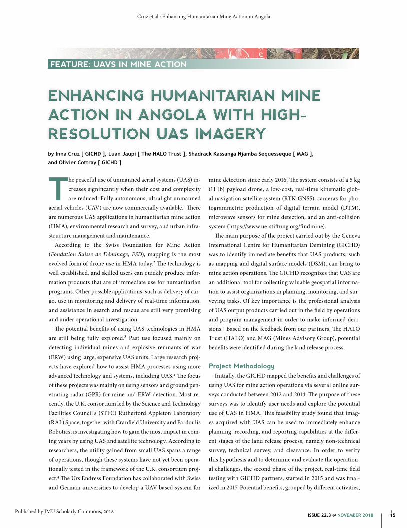
ENHANCING HUMANITARIAN MINE ACTION IN ANGOLA WITH HIGH-RESOLUTION UAS IMAGERYby Inna Cruz [ GICHD ], Luan Jaupi [ The HALO Trust ], Shadrack Kassanga Njamba Sequesseque [ MAG ],
and Olivier Cottray [ GICHD ]
The peaceful use of unmanned aerial systems (UAS) in-creases significantly when their cost and complexity are reduced. Fully autonomous, ultralight unmanned
aerial vehicles (UAV) are now commercially available.1 There are numerous UAS applications in humanitarian mine action (HMA), environmental research and survey, and urban infra-structure management and maintenance.
According to the Swiss Foundation for Mine Action (Fondation Suisse de Déminage, FSD), mapping is the most evolved form of drone use in HMA today.2 The technology is well established, and skilled users can quickly produce infor-mation products that are of immediate use for humanitarian programs. Other possible applications, such as delivery of car-go, use in monitoring and delivery of real-time information, and assistance in search and rescue are still very promising and under operational investigation.
The potential benefits of using UAS technologies in HMA are still being fully explored.3 Past use focused mainly on detecting individual mines and explosive remnants of war (ERW) using large, expensive UAS units. Large research proj-ects have explored how to assist HMA processes using more advanced technology and systems, including UAS.4 The focus of these projects was mainly on using sensors and ground pen-etrating radar (GPR) for mine and ERW detection. Most re-cently, the U.K. consortium led by the Science and Technology Facilities Council’s (STFC) Rutherford Appleton Laboratory (RAL) Space, together with Cranfield University and Fardoulis Robotics, is investigating how to gain the most impact in com-ing years by using UAS and satellite technology. According to researchers, the utility gained from small UAS spans a range of operations, though these systems have not yet been opera-tionally tested in the framework of the U.K. consortium proj-ect.4 The Urs Endress Foundation has collaborated with Swiss and German universities to develop a UAV-based system for
mine detection since early 2016. The system consists of a 5 kg (11 lb) payload drone, a low-cost, real-time kinematic glob-al navigation satellite system (RTK-GNSS), cameras for pho-togrammetric production of digital terrain model (DTM), microwave sensors for mine detection, and an anti-collision system (https://www.ue-stiftung.org/findmine).
The main purpose of the project carried out by the Geneva International Centre for Humanitarian Demining (GICHD) was to identify immediate benefits that UAS products, such as mapping and digital surface models (DSM), can bring to mine action operations. The GICHD recognizes that UAS are an additional tool for collecting valuable geospatial informa-tion to assist organizations in planning, monitoring, and sur-veying tasks. Of key importance is the professional analysis of UAS output products carried out in the field by operations and program management in order to make informed deci-sions.5 Based on the feedback from our partners, The HALO Trust (HALO) and MAG (Mines Advisory Group), potential benefits were identified during the land release process.
Project MethodologyInitially, the GICHD mapped the benefits and challenges of
using UAS for mine action operations via several online sur-veys conducted between 2012 and 2014. The purpose of these surveys was to identify user needs and explore the potential use of UAS in HMA. This feasibility study found that imag-es acquired with UAS can be used to immediately enhance planning, recording, and reporting capabilities at the differ-ent stages of the land release process, namely non-technical survey, technical survey, and clearance. In order to verify this hypothesis and to determine and evaluate the operation-al challenges, the second phase of the project, real-time field testing with GICHD partners, started in 2015 and was final-ized in 2017. Potential benefits, grouped by different activities,
FEATURE: UAVS IN MINE ACTION
1
Cruz et al.: Enhancing Humanitarian Mine Action in Angola
Published by JMU Scholarly Commons, 2018

16 FEATURE @ THE JOURNAL OF CONVENTIONAL WEAPONS DESTRUCTION
Although a more detailed overview of UAS outputs with regard to land release activities are described later, imagery products were used for the following purposes:
» Indicate the impact of uncleared land to donors. » Show evidence of blocked resources. » Illustrate visible, indirect indicators of contamination. » Document evidence for land cancellation. » Monitor and report on progress and completion. » Map demolition sites and identify patterns.
Before OperationsUAS imagery with information on confirmed hazardous
areas (CHA) visually shows the impact of contaminated land to donors and the public. It also shows blocked access to water, agricultural land, paths, roads, and important infrastructure. The aim is to use such maps for fundraising purposes.
are listed in Figure 1; UAS mine action operators scored information manage-ment (IM) output products by their de-gree of usefulness during operations. Moreover, challenges and alternative options were identified and described.
Results of the UAS Case Study in Angola
The fixed-wing, small, and light-weight UAS eBee (manufactured by senseFly) is being used in Angola across a range of different demining applica-tions and was first operated by HALO in the framework of the current project and later by MAG.
UAS produce high-resolution imag-ery and information that bring added operational value across a wide range of different applications. These uses range from updating cartography before mine action operations take place and non-technical survey tasks such as geo-locating suspected hazardous areas (SHA), to operational planning for technical survey, clearance, and post clearance land documentation (Figure 1).6 During the test period, HALO and MAG field personnel reported that UAS produced imagery and information products that assisted organizations in planning, internal and external com-munication, and reporting.
HALO and MAG highly valued information products de-veloped during testing for communications with the public and donors, and that could show land use changes after de-mining operations. Based on the questionnaire answers filled out by the UAS test manager from HALO “pre-and post-clear-ance land use is a great way to demonstrate value for money” as it shows the positive impact of humanitarian demining on agricultural and urban land development of previously con-taminated areas.
The two organizations also highly rated high-resolution map products that assisted in the planning of demining operations. For example, imagery was used for information collection and planning purposes in inaccessible hazardous areas. Moreover, MAG used maps for monitoring and planning future clearance operations that had been suspended during the rainy season.
Highly rated by both organizationsHighly rated by one organization
Not yet tested
Use of Output Product Benefits1.1. UAS imagery shows impact of un-cleared land to donors and the public
FundraisingIncreased public awareness
1.2. Proof of blocked agricultural land, paths, access to water, roads and impor-tant infrastructure
FundraisingLocal prioritisation analysisMRE (mine-risk education)
1.3. To update cartography material PlanningPrioritisationCollection of information about the envi-ronment in inaccessible areas
2.1. To indicate visible indirect evidence of contamination/explosive remnants of war
Proof of indirect evidence for suspected hazardous area (SHA) identification
2.2. To document evidence for land cancellation
Land cancellation justification, liability
2.3. To record coordinates of hazardous area polygons/points
Coordinates for hazardous areas and de-mining operations collected and recorded
3.1. To assist in planning of demining operations
Selection of appropriate tool, selection of best TS paths, analysis of environmental conditions of terrain
3.2. To monitor demining operations, and report on progress and completion
Monitoring of mine action operation progress, estimation of completion date, evidence for completion documentation
3.3. To map demolitions and identify patterns
Providing completion documentation and identification of possible patterns for future NTS activities
4.1. External communication with the public and donors
Use of high-resolution imagery during land handover to local communities, to il-lustrate progress of mine action clearance to donors
4.2. To show land use changes Changes in land use after demining op-erations can justify prioritisation choices made by the mine action centre and oper-ators to donors, act as proof of resources used, collection of socio-economic data
4.3. Liability justification Reliable justification in case of accidents/incidents inside released area
Figure 1. Matrix of UAS output products.All graphics courtesy of authors.
2
Journal of Conventional Weapons Destruction, Vol. 22, Iss. 3 [2018], Art. 5
https://commons.lib.jmu.edu/cisr-journal/vol22/iss3/5

17ISSUE 22.3 @ NOVEMBER 2018
As shown in the HALO story map, most people living in Cutato village survive on agriculture. During the Angolan Civil War (1975–2002) the village was repeatedly mined, and at least 11 people have suffered landmine accidents here; how-ever, HALO has cleared the minefields in and around Cutato. UAS imagery shows that newly built infrastructure is in close proximity to recently cleared areas, so without mine clearance, growing communities are at risk from landmines laid over 30 years ago. At the same time, UAS imagery provides informa-tion on land that is not accessible due to landmines. In Figure
2, the remains of the old bridge destroyed during the war are visible inside the perimeter of the minefield. Furthermore, de-velopment activities are not viable on that side because they are blocked by mine contamination.
In Bié Province, access to water for agricultural develop-ment was blocked by a minefield located between the vil-lage and the river. However, it was recently cleared by HALO personnel. The imagery shows the importance of water and irrigation for this region, as the area around the river is no-ticeably greener than the rest (Figure 3).
Imagery collected with UAS is also used to update cartography material. Most actors in the field of humanitar-ian demining today employ publicly available satellite data like Google Earth or old topographic maps of the areas in which they operate. This assists mine action organizations over large areas. However, compared to UAS outputs, satellite data is often low-resolution, expensive, and inac-cessible for certain areas when there is dense cloud coverage.6
Non-technical SurveyThe most common use of extremely
high-resolution, low-cost aerial photos produced by UAVs is for data collec-tion and observation, and serves as an
Figure 2. Cutato village.
Figure 3. Bié Province where access to water is blocked.
3
Cruz et al.: Enhancing Humanitarian Mine Action in Angola
Published by JMU Scholarly Commons, 2018

18 FEATURE @ THE JOURNAL OF CONVENTIONAL WEAPONS DESTRUCTION
most densely-covered vegetated areas, UAS-assisted operations are excellent for data col-lection in areas with difficult access.
HALO conducted several UAS flights over an active minefield in Cuando Cubando province. These flights enabled the specif-ic pinpointing of a tank that had been aban-doned in the minefield (Figure 4). Trenches are also visible on UAS imagery in Bié Province (Figure 5).
Information collected on the ground was used together with UAS imagery as support-ing evidence that the area had already been used for some time for agriculture by the returning population, was not mined, and could therefore be cancelled (Figure 6). In this way, UAS imagery combined with ar-chived non-technical survey interviews was used as justification for land cancellation.
Technical Survey and Clearance During technical survey and clearance op-
erations, imagery produced by UAS helps in planning future operations by providing in-formation about available paths, types of terrain and vegetation, and information on slope gradients.
HALO’s task was to clear minefields in Cuando Cubando province. Each side of the road was assigned a similar task. While clearance of the right side of the road was already completed at the time of the UAS survey flight, the information about envi-ronmental variables (slope, soil type, and vegetation) and the pattern of found mines was thought to be similar to the hazardous area on the left side of the road. The high- resolution map produced by the UAS with overlaid completion report data was very
useful for the site supervisor in order to plan the remain-ing clearance task more efficiently. The UAS imagery would be useful for site supervisors planning clearance; however, it was not immediately accessible for such operational analy-sis as most supervisors do not have laptops on which to see it. Hence, the analysis was done in their offices several weeks later. An additional difficulty was the lack of availability and capacity for using specialized geographic information system (GIS) software to preview and analyze the data.
Figure 4 (top). Indirect evidence of contamination, tank.Figure 5 (middle). Visible trenches. Figure 6 (bottom). Land cancellation proven by the use of UAS imagery combined with information on the ground.
additional helpful tool during non-technical survey activities. Currently, these systems are not considered adequate to de-tect the presence of ERW contamination, although indirect indicators of contamination can be detected, such as the pres-ence of trench lines, barbed wire, and impact craters. Very of-ten, the main challenge to carrying out timely and accurate surveys is poor physical access due to heavy vegetation, the absence of roads, security obstacles, flooding, bodies of wa-ter, snow and ice, or steep hills and gorges.7 For all but the
4
Journal of Conventional Weapons Destruction, Vol. 22, Iss. 3 [2018], Art. 5
https://commons.lib.jmu.edu/cisr-journal/vol22/iss3/5

19ISSUE 22.3 @ NOVEMBER 2018
Figure 7. Craters from controlled demolition of anti-vehicle mines in a minefield in Cuito Cuanavale.
Figure 8. Tepa minefield, October 2016 (left), April 2017 (right).
5
Cruz et al.: Enhancing Humanitarian Mine Action in Angola
Published by JMU Scholarly Commons, 2018
20 FEATURE @ THE JOURNAL OF CONVENTIONAL WEAPONS DESTRUCTION
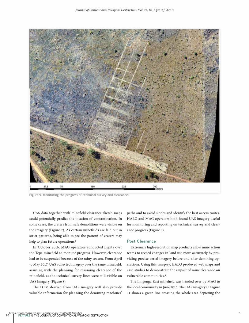
UAS data together with minefield clearance sketch maps could potentially predict the location of contamination. In some cases, the craters from safe demolitions were visible on the imagery (Figure 7). As certain minefields are laid out in strict patterns, being able to see the pattern of craters may help to plan future operations.6
In October 2016, MAG operators conducted flights over the Tepa minefield to monitor progress. However, clearance had to be suspended because of the rainy season. From April to May 2017, UAS collected imagery over the same minefield, assisting with the planning for resuming clearance of the minefield, as the technical survey lines were still visible on UAS imagery (Figure 8).
The DTM derived from UAS imagery will also provide valuable information for planning the demining machines’
paths and to avoid slopes and identify the best access routes. HALO and MAG operators both found UAS imagery useful for monitoring and reporting on technical survey and clear-ance progress (Figure 9).
Post ClearanceExtremely high-resolution map products allow mine action
teams to record changes in land use more accurately by pro-viding precise aerial imagery before and after demining op-erations. Using this imagery, HALO produced web maps and case studies to demonstrate the impact of mine clearance on vulnerable communities.6
The Lingonga East minefield was handed over by MAG to the local community in June 2016. The UAS imagery in Figure 11 shows a green line crossing the whole area depicting the
Figure 9. Monitoring the progress of technical survey and clearance.
6
Journal of Conventional Weapons Destruction, Vol. 22, Iss. 3 [2018], Art. 5
https://commons.lib.jmu.edu/cisr-journal/vol22/iss3/5

21ISSUE 22.3 @ NOVEMBER 2018
footpath inside the already released area leading to the river where the local community fetches water for drinking, baths, and laundry (Figure 11).
Another example is the Muhinhi 2 minefield that was cleared by MAG and handed over to the local population in 2013. It has since turned into a highly-populated village in Lucusse commune. The successful clearance of the minefield, which yielded over 100 anti-personnel mines and 16 items of unexploded ordnance (UXO) has directly benefited 2,292 members of the local community (Figure 12).
Operational Exploitation of UASGenerally, UAS technologies have proven to be user
friendly. Several days of training provided by the GICHD and senseFly were sufficient to start UAS operations, al-though operators asked for remote assistance throughout the testing period.
HALO and MAG have good relationships with local authori-ties, so it was not difficult to obtain all the necessary permissions for the UAS flights. However, the amount of attention UAS oper-ations attract meant that it was essential to communicate prop-erly with the local government and police, providing them with flight details and sending flight plans in advance.
Both organizations encountered some difficulties with equipment maintenance (logistics, battery replacement, ad-ditional repairs). Constraints such as difficult terrain for
landing, weather conditions, poor electricity supply, and un-reliable Internet access were also listed by HALO and MAG representatives. Public curiosity, particularly from local chil-dren, presented another challenge and could be an issue dur-ing UAV landing operations.
Some hypotheses could not be proved. While UAS can rap-idly produce georeferences (accurate GPS references) or 3D maps that outline the boundaries of hazardous areas more accurately than walking along the same path on the ground with a standard GPS, there were insufficient personnel to test this. Nevertheless, initial surveys can be conducted more quickly and without risks to the survey team carrying a hand-held GPS, who thereafter communicate the imagery to local communities to confirm the mapping results.8
As previously noted, the FSD report on “Drones in Humanitarian Action” states that drones are becoming easier to use and that the main challenge is shifting from flying the drones to processing, analyzing, and storing the data that the drones capture.2 The same conclusion was reached as a result of the case study in Angola. Insufficient capacity, such as spe-cialized software and hardware, for imagery and data analysis meant that the scope of the imagery produced by UAS could not be used. For example, the DSM generated from UAS im-ages also calculates the gradient of different slopes and could potentially be used in determining suitable access routes for demining machines.6
Figure 10. Land use changes after demining was completed (the imagery on the left is from 2011, whereas the right is from 2016).
7
Cruz et al.: Enhancing Humanitarian Mine Action in Angola
Published by JMU Scholarly Commons, 2018

22 FEATURE @ THE JOURNAL OF CONVENTIONAL WEAPONS DESTRUCTION
Selecting Appropriate UAS Equipment or Service Providers
The most important element in the selection process is to identify imagery requirements for a project. In order to ad-dress decision-making requirements, the focus should be on what kind of imagery an organization needs. Alternative UAS-produced imagery should also be considered and prop-erly analyzed. Before starting to collect data, an organization needs to decide whether it will build its own UAS capacities or to seek a service provider. The following selection criteria should be taken into account:
» Price (of equipment, maintenance, capacity building, li-censes, insurance).
» Import/export regulations (time and resources). » Qualifications (to operate UAVs and to process, ana-
lyze, and store imagery).
Figure 11. Access to the river after minefield clearance.
» Length and frequency of UAS surveys. » Data ownership.
The main conclusion from the case study in Angola is user- friendly UAS technology is already available on the market, and several days of training are enough to learn how to oper-ate UAS and collect data. However, the main challenges are the capacities for professional imagery analysis, the storage of huge amounts of collected imagery data, and the use of specialized software.
For example, according to a case study described by FSD, the data collected for the Dar es Salaam flood risk map had to be processed externally and took six weeks with high-speed processors. Mapping an area of 88 sq km (34 sq mi) with an average resolution of 5 cm created a data set con-taining 20,000 optical images. After processing, the result-ing files totaled 700 Gb, and the data could only be moved by
8
Journal of Conventional Weapons Destruction, Vol. 22, Iss. 3 [2018], Art. 5
https://commons.lib.jmu.edu/cisr-journal/vol22/iss3/5

23ISSUE 22.3 @ NOVEMBER 2018
Figure 12. Muhinhi 2 minefield cleared by MAG.
physically transferring the hard disk. Clearly, requirements such as these make it challenging for the technology to be op-erational in a crisis situation.2 In some cases, specific tasks can be outsourced. For example, imagery data collection can be performed by an organization, while the imagery process-ing and analysis part can be outsourced to a qualified NGO or commercial company.
There are legal prerequisites to consider when conducting UAS operations, which will depend on the legislation of the respective country. Generally, UAS operations should be ap-proved by local authorities, airspace controllers, and the local police. Mine action organizations usually operate in post-con-flict areas where drones might be used for military purposes.
Therefore it may be useful to inform the local community about a UAS flight path and purpose in order to avoid any problems during the flight. Equipment maintenance and insurance re-quirements should also be considered, as both testing organi-zations in Angola emphasized the difficulty in maintaining the eBee equipment in a rural environment. Since the eBee soft-ware required regular updates, poor Internet availability in the areas of operation presented a challenge.
ConclusionTogether with HALO and MAG, GICHD conducted a case
study in Angola, illustrating how UAS imagery—when infra-structure and permissions allow this data to be collected—helps
9
Cruz et al.: Enhancing Humanitarian Mine Action in Angola
Published by JMU Scholarly Commons, 2018
24 FEATURE @ THE JOURNAL OF CONVENTIONAL WEAPONS DESTRUCTION
Inna CruzAdvisor, Information ManagementGICHD
Inna Cruz is an Information Management Advisor at the GICHD. Her expertise lies in geographic information systems (GIS), remote sensing, aerial imagery, cartogra-phy, and geodetics. One of her key proj-ects is the use of unmanned aerial vehicles for mapping and reporting in mine action. She is also the country focal point for sup-port to Russian-speaking users, Eastern
Europe, and Turkey. Prior to joining the GICHD she worked as a consultant for two projects for the United Nations Environment Programme, using remote sensing and GIS technologies. Cruz has a degree in Environmental Sciences from the National University of Kyiv-Mohyla Academy in Ukraine, a Masters in Environmental Natural Sciences from Geneva University, and she participated in the Certificate in Geomatics courses.
Luan JaupiHead of Information and GISThe HALO Trust
Luan Jaupi joined The HALO Trust in 2005. He is responsible for all information man-agement and GIS in headquarters and all HALO programs. He has a master’s degree in computer science from the University of Tirana, Albania, and a master’s degree in business informatics from the European University of Viadrina, Germany.
Shadrack Kassanga Njamba SequessequeOperations Coordinator for AngolaMAG (Mines Advisory Group)
Shadrack Kassanga Njamba Sequesseque has four years’ experience working in hu-manitarian mine action (HMA). Sequesseque joined Mines Advisory Group (MAG) in 2014 and is currently operations coordinator for the MAG Angola program, coordinating MAG’s HMA operations and liaising with the government of Angola to ensure successful outcomes.
in the planning and monitoring of HMA operations. These out-puts can also be used to record proof of cancellation for SHA, and the DSM generated from UAS imagery can be used to help teams prepare routes for demining machines. The fact that UAS can be used to accurately document land use changes, such as urbanization and agricultural development, is also of great help in communicating demining efforts to donors.
To summarize, using UAS in HMA improves operational efficiencies by providing an on-demand eye from the sky. As UAS become more affordable and easier to operate in diffi-cult terrain, and as imagery processing and analysis becomes more intuitive and less dependent on the internet, the com-munity might see their deployment on a large scale in the years to come.
However, successful deployment of UAS requires clearly-defined project needs, an assessment of available capacities, and careful consideration of safety and situational suitability. These recommendations can assist HMA actors in the effec-tive use of UAS, which indeed lend themselves as the best tool for this kind of work.2
Looking AheadUAS show promise in applications involving close, in-house
inspections for improvised explosive devices (IED) in Iraq (JANUS, MAG), direct/indirect evidence detection based on the analysis of UAS imagery, GPR technology used in the case of larger UAS and for mine/UXO detection and much more. The GICHD has developed a UAS Portal where the results of various case studies carried out around the world are present-ed. It is a knowledge exchange platform to disseminate UAS case study results, and we encourage organizations to share their UAS case studies on it.
We also provide consultancy services to assist interested or-ganizations in:
» Advice for building one’s own UAS capacity. » Imagery analysis training (available soon). » Selecting appropriate imagery sources. » Selecting UAS imagery service providers. » UAS imagery analysis.
UAS imagery products are easy to integrate into the IMSMA Core environment and are a valuable source of information on contaminated terrain, priority settings, geolocation of con-taminated areas, and post-clearance analysis. An appropriate IMAS technical note will be developed between 2019 and 2020 to guide the use of this technology in HMA.
See endnotes page 59
Olivier CottrayHead of Information ManagementGICHD
Olivier Cottray joined the GICHD in January 2012, initially as the division’s Information Services Coordinator. As head of the Information Management Division, he is now in charge of managing the team that provides information management capac-ity development and technical support to the mine action community. Prior to joining the GICHD, Olivier worked in humanitarian
emergencies, running geographic information systems (GIS) support cells in U.N. and NGO field operations. He started working in hu-manitarian GIS in 2002, when he helped found the NGO MapAction, a rapid response organization that provides immediate IM/GIS sup-port in the weeks following a crisis. He has set up and run emergen-cy GIS cells in a number of countries, including Pakistan, Lebanon, Colombia, Haiti, Sudan, the Democratic Republic of the Congo, and Ethiopia. Olivier completed a Bachelor of Science degree in Geography and Economics at the London School of Economics in 1998, and a master’s degree in GIS and Remote Sensing at the University of Cambridge in 1999.
10
Journal of Conventional Weapons Destruction, Vol. 22, Iss. 3 [2018], Art. 5
https://commons.lib.jmu.edu/cisr-journal/vol22/iss3/5