Embed Size (px)
Citation preview
1 England Coast Path | Aldeburgh to Hopton-on-Sea | AHS 2: Sizewell to Dunwich
www.gov.uk/englandcoastpath
England Coast Path Stretch: Aldeburgh to Hopton-on-Sea Report AHS 2: Sizewell to Dunwich
Part 2.1: Introduction Start Point: Sizewell beach car park (grid reference: TM 4757 6300)
End Point: Dingle Marshes south, Dunwich (grid reference: TM 4735 7074)
Relevant Maps: AHS 2a to AHS 2e
2.1.1 This is one of a series of linked but legally separate reports published by Natural England under section 51 of the National Parks and Access to the Countryside Act 1949, which make proposals to the Secretary of State for improved public access along and to this stretch of coast between Aldeburgh to Hopton-on-Sea.
2.1.2 This report covers length AHS 2 of the stretch, which is the coast between Sizewell and Dunwich. It makes free-standing statutory proposals for this part of the stretch, and seeks approval for them by the Secretary of State in their own right under section 52 of the National Parks and Access to the Countryside Act 1949.
2.1.3 The report explains how we propose to implement the England Coast Path (“the trail”) on this part of the stretch, and details the likely consequences in terms of the wider ‘Coastal Margin’ that will be created if our proposals are approved by the Secretary of State. Our report also sets out:
any proposals we think are necessary for restricting or excluding coastal access rights to address particular issues, in line with the powers in the legislation; and
any proposed powers for the trail to be capable of being relocated on particular sections (“roll-back”), if this proves necessary in the future because of coastal change.
2.1.4 There is also a single Overview document for the whole of this stretch of coast, explaining common principles and background. This and the other individual reports relating to the stretch should be read in conjunction with the Overview. The Overview explains, among other things, how we have considered any potential environmental impacts of improving public access to this part of the coast, and this report, and other separately published assessments we refer to, then provides more detail on these aspects where appropriate.

2 England Coast Path | Aldeburgh to Hopton-on-Sea | AHS 2: Sizewell to Dunwich
Part 2.2: Proposals Narrative
The trail: 2.2.1 Generally follows existing walked routes, including public rights of way, along most of this length.
2.2.2 Mainly follows the coastline quite closely and maintains good views of the sea.
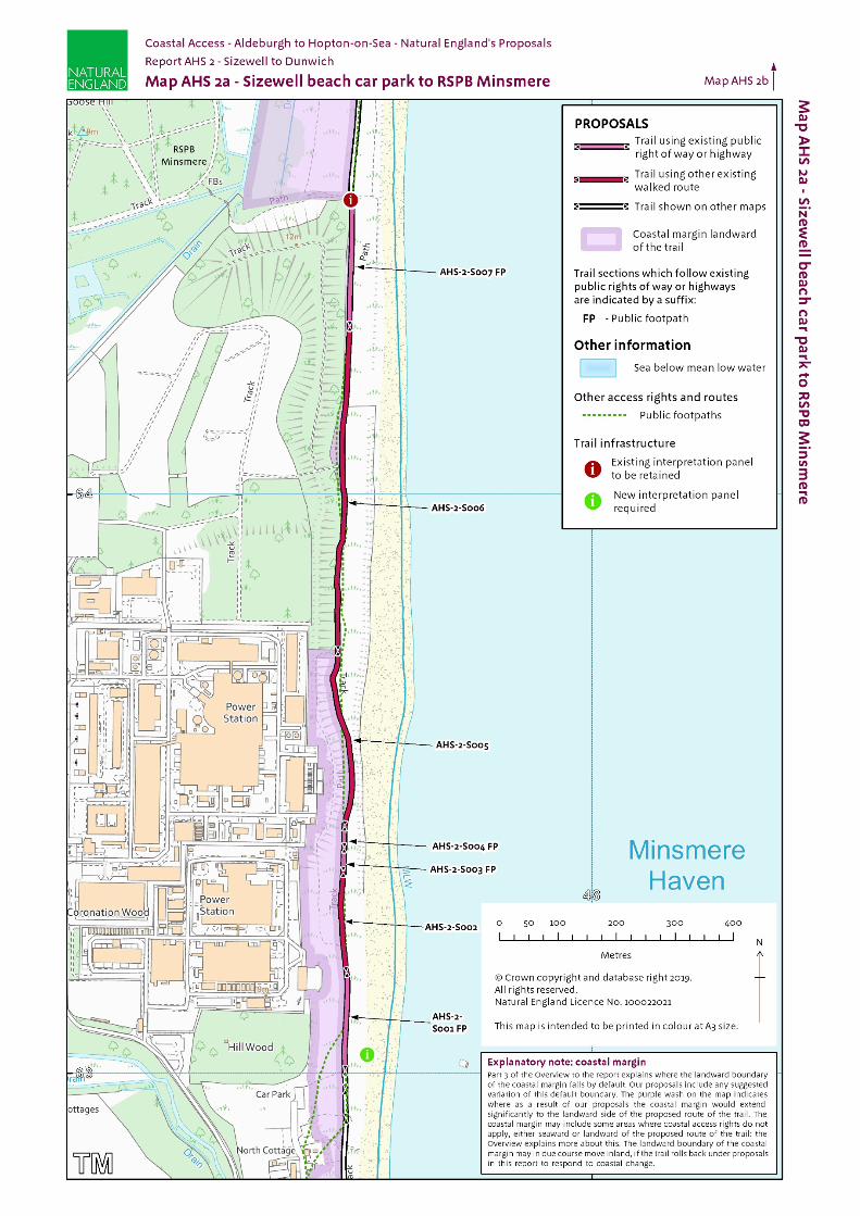
2.2.3 Is aligned on the beach or foreshore between the Coastguard Lookout at Sizewell (section AHS-1-S040 on Map AHS 1e) for about 5km north to Coney Hill, Minsmere Nature Reserve (section AHS-2-S017 on Map AHS 2c). See part 2.3 for details.
2.2.4 In some areas (sections AHS-2-S029 to AHS-2-S048 on Maps AHS 2d and 2e), a significant inland diversion is necessary to take the trail past Cliff House caravan park and Dunwich Cliffs Estate caravan park where we could not identify a continuous seaward access strip. There are also several properties with gardens which extend to the cliff edge which are excepted from coastal access rights. (See Future Change, below and Part 8 of the Overview).
2.2.5 Follows a route similar to the existing Suffolk Coast Path but departs from this in places in order to be closer to and gain views of the sea.
Protection of the environment: In this part of the report, we explain how we have taken account of environmental protection objectives in developing our proposals for improved coastal access. 2.2.6 The following designated sites affect this length of coast:
Minsmere to Walberswick Heaths and Marshes Special Area of Conservation (SAC)
Southern North Sea Special Area of Conservation (SAC)
Minsmere-Walberswick Special Protection Area (SPA)
Outer Thames Estuary Special Protection Area (SPA)
Minsmere-Walberswick Ramsar site
Minsmere-Walberswick Heaths and Marshes Site of Special Scientific Interest (SSSI) for its wildlife interest
Leiston Abbey (second site) and moated site - Scheduled Monument
Leiston Abbey (first site) with later chapel and pill box, Minsmere – Scheduled Monument
Greyfriars, Dunwich - Scheduled Monument
Maison Dieu (or Hospital of the Holy trinity), Dunwich - Scheduled Monument
The following table brings together design features included in our access proposals to help to protect the environment along this length of the coast.

3 England Coast Path | Aldeburgh to Hopton-on-Sea | AHS 2: Sizewell to Dunwich
2.2.7 Measures to protect the environment
Map(s) Route section number(s)
Design features of the access proposals Reason included
AHS 2c and AHS 2d
AHS-2-S026 to AHS-2-S027
The existing national restriction on the Countryside and Rights of Way Act (2000) access rights will be replicated.
There will be a seasonal restriction of coastal access rights under section 26 (nature conservation) of the Countryside and Rights of Way Act (2000) requiring visitors to keep their dogs on leads between 1st March and 31st August each year to protect ground nesting birds.
Signage will be rationalised and renewed and will include advisory signage specifically requesting no close up photography of ground nesting birds. See Map D.
Protection of ground nesting birds
AHS 2e AHS-2-S055 to AHS-2-S064
There will be a seasonal exclusion in the margin to the north between 1st April and 31st August each year to protect ground nesting birds. See Map E.
Protection of beach/ ground nesting birds
AHS 2e AHS-2-S055 to AHS-2-S064
As mitigation against any trampling of vegetated shingle, access to the coastal margin will not be actively promoted by Natural England. All signage and literature for the England Coast Path (ECP), with the exception of OS maps, will direct walkers away from the beach onto the trail which is landward of the sensitive area between Dunwich and Walberswick.
Walkers will be encouraged directly to the sea at specific points in the coastal margin where vegetated shingle is not present or unlikely to recover (as damaged and not subject to coastal processes).
Success of zonation and signage measures will be monitored and reviewed on a regular basis in agreement with the Responsible Officer (RO) from Natural England and site managers.
Protection of vegetated shingle

4 England Coast Path | Aldeburgh to Hopton-on-Sea | AHS 2: Sizewell to Dunwich
Map(s) Route section number(s)
Design features of the access proposals Reason included
AHS 2a to AHS 2e
AHS-2-S001 to AHS-2-S064
Whilst the proposed route of the ECP does not raise concerns, there is a risk to vegetated shingle habitat through access by their inclusion within coastal margin between Dunwich Cliff and Sizewell, although this increase is determined to be negligible. Mitigation is required to overcome this risk of adverse impact. This includes:
1. Encouraging access along the ECP trail with good signage to try and limit footfall into the coastal margin, minimising impact on vegetated shingle.
2. Encouraging those seeking access to the water to cross the beach at specific points where vegetated shingle is not present or unlikely to recover (as damaged and not subject to coastal processes), notably at key access points through appropriate signage and interpretation:
AHS-2-S054 to AHS-2-S055 (Map AHS 2e): access to the beach at Dunwich Heath car park (as part of the establishment works)
AHS-2-S017 to AHS-2-S022 (Map AHS 2c): North Wall Junction
AHS-2-S010 to AHS-2-S011 (Maps AHS 2b and 2c): Minsmere Sluice
3. Discouraging walking the whole beach frontage at Minsmere Haven, but if walkers do use this route, they will be encouraged to walk at low tide below the high tide line to protect perennial vegetated shingle further back plus the annual vegetated strandline habitat through appropriate signage and interpretation.
2. and 3. above to be part of a single interpretation panel located near Coastguard Cottages.
Land managers will involve the RO when the current interpretation signs need to be reviewed to ensure future signs reflect the advice to walk on the inter-tidal area.
Future management of the site after the new coastal access rights have commenced will involve monitoring the effectiveness of signage measures and levels of trampling of route and wider margin. This will be reviewed on a regular basis in agreement between the RO and site managers, with the RO to address any issues raised.
Protection of vegetated shingle
5 England Coast Path | Aldeburgh to Hopton-on-Sea | AHS 2: Sizewell to Dunwich
Map(s) Route section number(s)
Design features of the access proposals Reason included
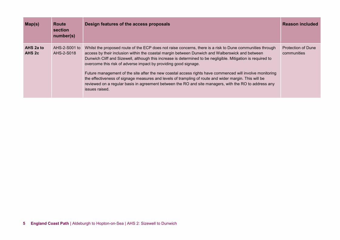
AHS 2a to AHS 2c
AHS-2-S001 to AHS-2-S018
Whilst the proposed route of the ECP does not raise concerns, there is a risk to Dune communities through access by their inclusion within the coastal margin between Dunwich and Walberswick and between Dunwich Cliff and Sizewell, although this increase is determined to be negligible. Mitigation is required to overcome this risk of adverse impact by providing good signage.
Future management of the site after the new coastal access rights have commenced will involve monitoring the effectiveness of signage measures and levels of trampling of route and wider margin. This will be reviewed on a regular basis in agreement between the RO and site managers, with the RO to address any issues raised.
Protection of Dune communities

6 England Coast Path | Aldeburgh to Hopton-on-Sea | AHS 2: Sizewell to Dunwich
2.2.10 Natural England is satisfied that the proposals for coastal access in this report are made in accordance with relevant environmental protection legislation. For more information about how we came to this conclusion; see the following assessments of the access proposals that we have published separately:
A Habitats Regulations Assessment relating to any potential impact on the conservation objectives of European sites.
Our Nature Conservation Assessment, in which we document our conclusions in relation to other potential impacts on nature conservation.
Part 6b of the Overview includes some contextual information about protecting the environment along this length of coast.
Accessibility: 2.2.11 There are few artificial barriers to accessibility on the proposed route. However, the natural coastal terrain is often challenging for people with reduced mobility and this is the case on sections of our proposed route because:
the trail would follow an uneven sand/shingle surface along the front of Minsmere Nature Reserve (sections AHS-2-S011 to AHS-2-S017 on Map AHS 2c) which is prone to puddling;
there are steps in places for example between the clay bank just north of Coney Hill (section AHS-2-S020 on Map AHS 2c) and along the public right of way from Coastguard Cottages (section AHS-2-S022 on Map AHS 2c) down towards the sea;
the trail would follow an uneven grass or bare soil path through Greyfriars Wood and Pale’s Dyke (sections AHS-2-S034 to AHS-2-S039 on Map AHS 2e) and also on the cliff top at Dunwich Cliffs (sections AHS-2-S027 and AHS-2-S028 on Map AHS 2d).
See part 6a of the Overview - ‘Recreational issues’ - for more information.
Where we have proposed exercising statutory discretions: 2.2.12 Landward boundary of the coastal margin:
We have used our discretion on some sections of the route to map the landward extent of the coastal margin to an adjacent physical boundary such as a fence line, pavement or track to make the extent of the new access rights clearer. See Table 2.3.1 below.
2.2.13 In some places (e.g. AHS-2-S008 to AHS-2-S010), we have used our discretion to propose the inclusion of additional, more extensive landward areas within the coastal margin, to secure or enhance public enjoyment of this part of the coast. The owner of this land is content for us to propose this.
2.2.14 The Proposals Tables show where we are proposing to alter the default landward boundary of the coastal margin. These proposals are set out in columns 5b and 5c of table 2.3.1. Where these columns are left blank, we are making no such proposals, so the default landward boundary applies. See the note relating to Columns 5b & 5c [above Table 2.3.1] explaining what this means in practice.
See also part 3 of the Overview - ‘Understanding the proposals and accompanying maps’, for a more detailed explanation of the default extent of the coastal margin and how we may use our discretion to adjust the margin, either to add land or to provide clarity.
7 England Coast Path | Aldeburgh to Hopton-on-Sea | AHS 2: Sizewell to Dunwich
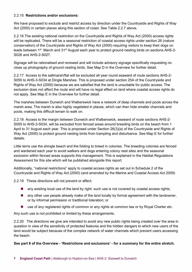
2.2.15 Restrictions and/or exclusions:
We have proposed to exclude and restrict access by direction under the Countryside and Rights of Way Act (2000) in certain places along this section of coast. See Table 2.2.7 above.
2.2.16 The existing national restriction on the Countryside and Rights of Way Act (2000) access rights will be replicated. There will be a seasonal restriction of coastal access rights under section 26 (nature conservation) of the Countryside and Rights of Way Act (2000) requiring visitors to keep their dogs on leads between 1st March and 31st August each year to protect ground nesting birds on sections AHS-2-S026 and AHS-2-S027.
Signage will be rationalised and renewed and will include advisory signage specifically requesting no close up photography of ground nesting birds. See Map D in the Overview for further detail.
2.2.17 Access to the saltmarsh/flat will be excluded all year round seaward of route sections AHS-2-S055 to AHS-3-S034 at Dingle Marshes. This is proposed under section 25A of the Countryside and Rights of Way Act (2000) because we are satisfied that the land is unsuitable for public access. The exclusion does not affect the route and will have no legal effect on land where coastal access rights do not apply. See Map E in the Overview for further detail.
The marshes between Dunwich and Walberswick have a network of deep channels and pools across the marsh area. The marsh is also highly vegetated in places, which can then hide smaller channels and pools, making this difficult terrain to walk on.
2.2.18 Access to the margin between Dunwich and Walberswick, seaward of route sections AHS-2-S055 to AHS-3-S034, will be excluded from fenced areas around breeding birds on the beach from 1 April to 31 August each year. This is proposed under Section 26(3)(a) of the Countryside and Rights of Way Act (2000) to protect ground nesting birds from trampling and disturbance. See Map E for further details.
Little terns use the shingle beach and the folding to breed in colonies. The breeding colonies are fenced and wardened each year to avoid walkers and dogs entering colony nest sites and the seasonal exclusion within fenced areas supports this management. This is explained in the Habitat Regulations Assessment for this site which will be published alongside this report.
Additionally, “national restrictions” apply to coastal access rights as set out in Schedule 2 of the Countryside and Rights of Way Act (2000) (and amended by the Marine and Coastal Access Act 2009)
2.2.19 These directions will not prevent or affect:
any existing local use of the land by right: such use is not covered by coastal access rights;
any other use people already make of the land locally by formal agreement with the landowner, or by informal permission or traditional toleration; or
use of any registered rights of common or any rights at common law or by Royal Charter etc.
Any such use is not prohibited or limited by these arrangements.
2.2.20 The directions we give are intended to avoid any new public rights being created over the area in question in view of the sensitivity of protected features and the hidden dangers to which new users of the land would be subject because of the complex network of water channels which prevent users accessing the beach.
See part 8 of the Overview - ‘Restrictions and exclusions’ - for a summary for the entire stretch.

8 England Coast Path | Aldeburgh to Hopton-on-Sea | AHS 2: Sizewell to Dunwich
2.2.23 Coastal erosion:
Natural England is able to propose that the route of the trail would be able to change in the future, without further approval from the Secretary of State, in response to coastal change. This would happen in accordance with the criteria and procedures for ‘roll-back’ set out in part 7 of the Overview.
Natural England may only propose the use of this roll-back power:
as a result of coastal erosion or other geomorphological processes or encroachment by the sea, or
in order to link with other parts of the route that need to roll back in direct response to such changes.
2.2.24 Column 4 of table 2.3.1 indicates where roll-back has been proposed in relation to a route section. Where this is the case, the route, as initially determined at the time the report was prepared, is to be at the centre of the line shown on Maps AHS 2a to AHS 2e as the proposed route of the trail.
2.2.25 If at any time in the future any part of a route section upon which roll-back has been specified needs, in Natural England’s view, to change in order for the overall route to remain viable, the new route for the part in question will be determined by Natural England without further reference to the Secretary of State. This will be done in accordance with the criteria and procedures described under the title ‘Roll-back’ in part 7 of the Overview and section 4.10 of the Coastal Access Scheme. If this happens, the new route will become the approved route for that section for the purposes of the Order which determines where coastal access rights apply.
On sections for which roll-back is not proposed in table 2.3.1, the route is to be at the centre of the line shown on Maps AHS 2a to AHS 2e as the proposed route of the trail.
Other future change: 2.2.26 There are also places described in this report where we foresee the need for future changes to the proposed access provisions, for example, the shingle barrier beach has a limited lifespan of between 2 and 20+ years. The resultant flooding of parts of Minsmere Nature Reserve (sections AHS-2-S009 to AHS-2-021 on Map AHS 2b and 2c) will result in the need for a new route landward of the current proposed trail.
2.2.27 Plans are being developed for a further nuclear power plant at Sizewell. During construction, there will be periods during which the main route between sections AHS-1-S040 and AHS-2-S010 (Maps AHS 1e and 2a) will not be available on its original alignment. The developer, in conjunction with Natural England and the Access Authority, Suffolk County Council (SCC), will ensure that a temporary route, seaward of the power plant, is made available and signed at such times.
There will also be periods during both construction and operation of Sizewell C when the main route and the associated coastal margin will not be available for use. Plans include a temporary route landward of the power plant for use on these occasions. The developer will work with SCC and Natural England to ensure closures are kept to a minimum, the route is well-signed and that walkers are informed of the operation of the temporary route well before reaching the site.
See parts 7 - ‘Future changes’ of the Overview for more information.

9 England Coast Path | Aldeburgh to Hopton-on-Sea | AHS 2: Sizewell to Dunwich
Establishment of the trail: 2.2.28 Below we summarise how our proposed route for the trail would be physically established to make it ready for public use before any new rights come into force.
Establishment works will only start on this length of coast once these proposals have been approved by the Secretary of State. The works may therefore either precede or follow the start of establishment works on other lengths of coast within the stretch, and detailed in their separate reports.
2.2.29 Our estimate of the capital costs for physical establishment of the trail on the proposed route within Report AHS 2 is £14,142 and is informed by:
information already held by the access authority, Suffolk County Council, in relation to the management of the existing Suffolk Coast Path and public rights of way.
the conclusions of our deliberations in relation to potential impacts on the environment; and
information gathered while visiting affected land and talking to the people who own and manage it about the options for the route.
2.2.30 There are two main elements to the overall cost:
Improvements to the surface of the clay bank on section AHS-2-S018 (Map AHS 2c) is required. The bank performs a flood defence role but is difficult to walk on when saturated.
An off-road route will be provided between sections AHS-2-S059 to AHS-2-S064 (Map AHS 2e) in Dunwich. This will require pedestrian gates onto the land linking St James’s Street to the bridleway at Dingle Tea Rooms; extensive clearance of a culvert over a drain and a new footbridge over the River Dunwich.
Table 1 shows our estimate of the capital cost within Report AHS 2 for each of the main elements of physical establishment described above.
Table 1: Estimate of capital costs
Item Cost Signs & interpretation £1,193 Steps £1,000 Boardwalks £720 Clearance of vegetation £80 Surfacing works £7,635
Project management £2,434
Total £14,142 (Exclusive of any VAT payable)
2.2.31 Once the Secretary of State’s decision on our report has been notified, and further to our conversations with land managers during the route planning stage, Suffolk County Council will liaise with affected land owners and occupiers about relevant aspects of the design, installation and maintenance of the new signs and infrastructure that are needed on their land. Prior to works being carried out on the ground, all necessary permissions, authorisations and consents will be obtained. All such works would conform to the published standards for National Trails and the other criteria described in our Coastal Access Scheme.

10 England Coast Path | Aldeburgh to Hopton-on-Sea | AHS 2: Sizewell to Dunwich
Maintenance of the trail: 2.2.32 Because the trail on this length of coast will form part of the National Trail being created around the whole coast of England called the England Coast Path, we envisage that it will be maintained to the same high quality standards as other National Trails in England (see The New Deal; Management of National Trails in England from April 2013: details at Annex A of the Overview).
2.2.33 We estimate that the annual cost to maintain the trail within Report AHS 2 will be £4,676 (exclusive of any VAT payable). In developing this estimate we have taken account of the formula used to calculate Natural England’s contribution to the maintenance of other National Trails.

11 England Coast Path | Aldeburgh to Hopton-on-Sea | AHS 2: Sizewell to Dunwich
Part 2.3: Proposals Tables See Part 3 of Overview for guidance on reading and understanding the tables below
2.3.1 Section Details: Maps AHS 2a to AHS 2e: Sizewell beach car park to Dingle Marshes south, Dunwich
Key notes on table:
1. Column 2 – an asterisk (*) against the route section number means see also table 2.3.2: Other options considered.
2. Column 4 – ‘No’ means no roll-back is proposed for this route section. ‘Yes – normal’ means roll-back is proposed and is likely to follow the current feature (e.g. cliff edge/beach) for the foreseeable future as any coastal change occurs.
3. Column 4 – ‘Yes – see table 2.3.3’ means roll-back is proposed, but refer to that table below about our likely approach to implementing it for this route section. This is because a more complex situation exists in this case and consideration must be given to how roll-back may happen in relation to excepted land, a protected site etc.
4. Column 5a - Certain coastal land types are included automatically in the coastal margin where they fall landward of the trail if they touch it at some point. The relevant land type (foreshore, cliff, bank, barrier, dune, beach, flat or section 15 land – see Glossary) is shown in this column where appropriate. “No” means none present on this route section.
5. Columns 5b and 5c – Any entry in these columns means we are proposing to align the landward boundary of the coastal margin on this route section with the physical feature(s) shown in 5b, for the reason in 5c. No text here means that for this route section the landward edge of the margin would be that of the trail itself - or if any default coastal land type is shown in 5a, that would be its landward boundary instead.
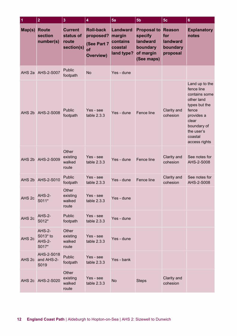
1 2 3 4 5a 5b 5c 6
Map(s) Route section number(s)
Current status of route section(s)
Roll-back proposed?
(See Part 7 of Overview)
Landward margin contains coastal land type?
Proposal to specify landward boundary of margin (See maps)
Reason for landward boundary proposal
Explanatory notes
AHS 2a AHS-2-S001 Public footpath No Yes - dune
AHS 2a AHS-2-S002
Other existing walked route
No Yes - dune
AHS 2a AHS-2-S003 and AHS-2-S004
Public footpath No Yes - dune
AHS 2a AHS-2-S005 and AHS-2-S006
Other existing walked route
No Yes - dune
12 England Coast Path | Aldeburgh to Hopton-on-Sea | AHS 2: Sizewell to Dunwich
1 2 3 4 5a 5b 5c 6
Map(s) Route section number(s)
Current status of route section(s)
Roll-back proposed?
(See Part 7 of Overview)
Landward margin contains coastal land type?
Proposal to specify landward boundary of margin (See maps)
Reason for landward boundary proposal
Explanatory notes
AHS 2a AHS-2-S007 Public footpath
No Yes - dune
AHS 2b AHS-2-S008 Public footpath
Yes - see table 2.3.3 Yes - dune Fence line Clarity and
cohesion
Land up to the fence line contains some other land types but the fence provides a clear boundary of the user’s coastal access rights
AHS 2b AHS-2-S009
Other existing walked route
Yes - see table 2.3.3 Yes - dune Fence line Clarity and
cohesion See notes for AHS-2-S008
AHS 2b AHS-2-S010 Public footpath
Yes - see table 2.3.3 Yes - dune Fence line
Clarity and cohesion
See notes for AHS-2-S008
AHS 2c AHS-2-S011*
Other existing walked route
Yes - see table 2.3.3 Yes - dune
AHS 2c AHS-2-S012*
Public footpath
Yes - see table 2.3.3 Yes - dune
AHS 2c
AHS-2-S013* to AHS-2-S017*
Other existing walked route
Yes - see table 2.3.3 Yes - dune
AHS 2c AHS-2-S018 and AHS-2-S019
Public footpath
Yes - see table 2.3.3
Yes - bank
AHS 2c AHS-2-S020
Other existing walked route
Yes - see table 2.3.3 No Steps Clarity and
cohesion

13 England Coast Path | Aldeburgh to Hopton-on-Sea | AHS 2: Sizewell to Dunwich
1 2 3 4 5a 5b 5c 6
Map(s) Route section number(s)
Current status of route section(s)
Roll-back proposed?
(See Part 7 of Overview)
Landward margin contains coastal land type?
Proposal to specify landward boundary of margin (See maps)
Reason for landward boundary proposal
Explanatory notes
AHS 2c AHS-2-S021*
Other existing walked route
Yes - see table 2.3.3 No Hedge bank Clarity and
cohesion
AHS 2c AHS-2-S022*
Public bridleway
Yes - Normal No Hedge bank Clarity and
cohesion
AHS 2c AHS-2-S023*
Other existing walked route
Yes - see table 2.3.3 No Road Clarity and
cohesion
AHS 2c AHS-2-S024*
Other existing walked route
Yes - see table 2.3.3 No Hedgerow Clarity and
cohesion
AHS 2c AHS-2-S025*
Other existing walked route
Yes - see table 2.3.3 No
Crossing a section of car park
AHS 2c AHS-2-S026*
Other existing walked route
Yes - see table 2.3.3 No Various Clarity and
cohesion
AHS 2d AHS-2-S027*
Other existing walked route
Yes - Normal
No Road Clarity and cohesion
AHS 2d AHS-2-S028*
Public highway Yes - normal No Road crossing
AHS 2d
AHS-2-S029* and AHS-2-S030*
Other existing walked route
Yes - normal No
AHS 2d AHS-2-S031*
Other existing walked route
Yes - normal No Fence line Clarity and cohesion
AHS 2d AHS-2-S032*
Public bridleway Yes - normal No

14 England Coast Path | Aldeburgh to Hopton-on-Sea | AHS 2: Sizewell to Dunwich
1 2 3 4 5a 5b 5c 6
Map(s) Route section number(s)
Current status of route section(s)
Roll-back proposed?
(See Part 7 of Overview)
Landward margin contains coastal land type?
Proposal to specify landward boundary of margin (See maps)
Reason for landward boundary proposal
Explanatory notes
AHS 2d AHS-2-S033*
Public highway
No No
AHS 2e AHS-2-S034*
Public footpath No No
AHS 2e AHS-2-S035*
Multi-use route
No No
AHS 2e AHS-2-S036*
Public footpath
No No
AHS 2e AHS-2-S037*
Other existing walked route
No No
AHS 2e AHS-2-S038*
Public footpath No No
AHS 2e
AHS-2-S039* and AHS-2-S040*
Public footpath No No Fence line
Clarity and cohesion
AHS 2e AHS-2-S041*
Other existing walked route
No No Fence line Clarity and cohesion
AHS 2e AHS-2-S042*
Public footpath No No Fence line Clarity and
cohesion
AHS 2e AHS-2-S043*
Public highway No No Road Clarity and
cohesion Using grass verge
AHS 2e AHS-2-S044*
Public highway No No
Landward edge of road
Clarity and cohesion
Route follows road
AHS 2e
AHS-2-S045* and AHS-2-S046*
Public footpath No No Path Clarity and
cohesion
AHS 2e AHS-2-S047*
Public footpath
Yes – see table 2.3.3 No Fence line
Clarity and cohesion
15 England Coast Path | Aldeburgh to Hopton-on-Sea | AHS 2: Sizewell to Dunwich
1 2 3 4 5a 5b 5c 6
Map(s) Route section number(s)
Current status of route section(s)
Roll-back proposed?
(See Part 7 of Overview)
Landward margin contains coastal land type?
Proposal to specify landward boundary of margin (See maps)
Reason for landward boundary proposal
Explanatory notes
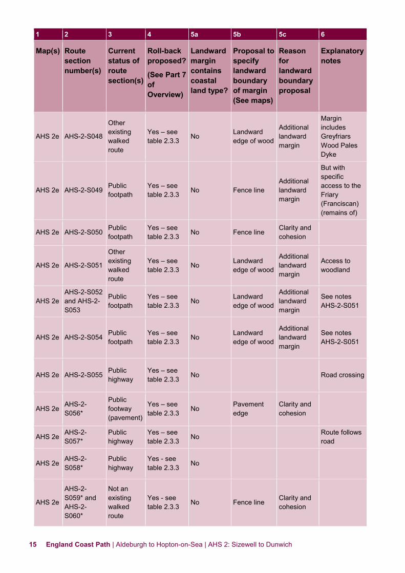
AHS 2e AHS-2-S048
Other existing walked route
Yes – see table 2.3.3 No Landward
edge of wood
Additional landward margin
Margin includes Greyfriars Wood Pales Dyke
AHS 2e AHS-2-S049 Public footpath
Yes – see table 2.3.3 No Fence line
Additional landward margin
But with specific access to the Friary (Franciscan) (remains of)
AHS 2e AHS-2-S050 Public footpath
Yes – see table 2.3.3 No Fence line Clarity and
cohesion
AHS 2e AHS-2-S051
Other existing walked route
Yes – see table 2.3.3 No Landward
edge of wood
Additional landward margin
Access to woodland
AHS 2e AHS-2-S052 and AHS-2-S053
Public footpath
Yes – see table 2.3.3 No Landward
edge of wood
Additional landward margin
See notes AHS-2-S051
AHS 2e AHS-2-S054 Public footpath
Yes – see table 2.3.3 No Landward
edge of wood
Additional landward margin
See notes AHS-2-S051
AHS 2e AHS-2-S055 Public highway
Yes – see table 2.3.3 No Road crossing
AHS 2e AHS-2-S056*
Public footway (pavement)
Yes – see table 2.3.3
No Pavement edge
Clarity and cohesion
AHS 2e AHS-2-S057*
Public highway
Yes – see table 2.3.3 No Route follows
road
AHS 2e AHS-2-S058*
Public highway
Yes - see table 2.3.3 No
AHS 2e
AHS-2-S059* and AHS-2-S060*
Not an existing walked route
Yes - see table 2.3.3 No Fence line Clarity and
cohesion

16 England Coast Path | Aldeburgh to Hopton-on-Sea | AHS 2: Sizewell to Dunwich
1 2 3 4 5a 5b 5c 6
Map(s) Route section number(s)
Current status of route section(s)
Roll-back proposed?
(See Part 7 of Overview)
Landward margin contains coastal land type?
Proposal to specify landward boundary of margin (See maps)
Reason for landward boundary proposal
Explanatory notes
AHS 2e AHS-2-S061*
Not an existing walked route
Yes - see table 2.3.3 No Bridge Clarity and
cohesion Footbridge
AHS 2e AHS-2-S062*
Not an existing walked route
Yes - see table 2.3.3 No Fence line Clarity and
cohesion
AHS 2e AHS-2-S063*
Not an existing walked route
Yes - see table 2.3.3 No Fence line Clarity and
cohesion Route follows boardwalk
AHS 2e AHS-2-S064*
Not an existing walked route
Yes - see table 2.3.3 No Fence line Clarity and
cohesion

17 England Coast Path | Aldeburgh to Hopton-on-Sea | AHS 2: Sizewell to Dunwich
2.3.2 Other options considered: Maps AHS 2a to AHS 2e: Sizewell beach car park to Dingle Marshes south, Dunwich
Map(s) Route section numbers(s)
Other option(s) considered Reasons for not proposing this option
AHS 2c AHS-2-S011 to AHS-2-S017
We considered aligning the trail along the existing walked route on top of the dune ridge, seaward of the trail to give views of the sea.
We opted for the proposed route because:
we concluded that the proposed route better protected the sensitive features of the site;
the ridge would remain available for people to use as part of the seaward coastal margin, but would not form part of the designated trail.
AHS 2e to AHS 2e
AHS-2-S021 to AHS-2-S047
We considered aligning the trail along the beach
We opted for the proposed route because:
there is no access from the beach onto the cliff top to enable an onward journey;
we concluded that overall the proposed route struck the best balance in terms of the criteria described in chapter 4 of the Coastal Access Scheme;
under our proposals, the beach would remain available for people to use as part of the seaward coastal margin.
AHS 2e and AHS 3a
AHS-2-S058 to AHS-2-S064
We considered aligning the trail along the route of the Suffolk Coast Path: from St James’s Street, onto Westleton Road, and over the River Dunwich bridge to the bridleway at the start of AHS-3-S001 (Map AHS 3a).
We opted for the proposed route because:
we concluded that overall the proposed route struck the best balance in terms of the criteria described in chapter 4 of the Coastal Access Scheme.
AHS 2e AHS-2-S055 to AHS-2-S064
We considered aligning the trail along the shingle ridge which can be accessed from the seaward end of Beach Road and which continues north to Walberswick.
We opted for the proposed route because:
this section has a long distance on shingle beach which is difficult to walk on;
we concluded that overall the proposed route struck the best balance in terms of the criteria described in chapter 4 of the Coastal Access Scheme;
Note: Any public rights of way not forming part of the proposed trail would remain available for people to use under their pre-existing rights.

18 England Coast Path | Aldeburgh to Hopton-on-Sea | AHS 2: Sizewell to Dunwich
2.3.3 Roll-back implementation – more complex situations: Maps AHS 2a to AHS 2e: Sizewell beach car park to Dingle Marshes south, Dunwich
Map(s) Route section number(s)
Feature(s) or site(s) potentially affected
Our likely approach to roll-back
AHS 2b and AHS 2c
AHS-2-S008 to AHS-2-S021
Minsmere-Walberswick Heaths and Marshes SSSI, Minsmere-Walberswick SPA, Minsmere-Walberswick Heaths and Marshes SAC, Minsmere-Walberswick Ramsar and Suffolk Coast NNR
If it is no longer possible to find a viable route seaward of the designated sites at Minsmere’s SSSI, SAC, SPA, and Ramsar, we will choose a new route after detailed discussions with the relevant experts and with any potentially affected owners or occupiers, which will either (a) pass through the site, if appropriate or (b) if necessary, be routed landward of it.
In reaching this judgement we will have full regard to the need to seek a fair balance between the interests of potentially affected owners and occupiers and those of the public.
AHS 2c AHS-2-S023 to AHS-2-S026
Coastguard Cottages, buildings and curtilage
If it is no longer possible to find a viable route seaward of the specified excepted land (e.g. buildings, curtilage, gardens etc.), we will choose a route landward of it, following discussions with owners and occupiers.
In reaching this judgement we will have full regard to the need to seek a fair balance between the interests of potentially affected owners and occupiers and those of the public.
AHS 2e AHS-2-S047 and AHS-2-S064
Road, buildings and curtilage
If it is no longer possible to find a viable route seaward of the specified excepted land (e.g. buildings, curtilage, gardens and road etc.), we will choose a route landward of it, following discussions with owners and occupiers.
In reaching this judgement we will have full regard to the need to seek a fair balance between the interests of potentially affected owners and occupiers and those of the public.
AHS 2e AHS-2-S058 to AHS-2-S064
St James’s Street and Westleton Road
If it is no longer possible to find a viable route seaward of the specified excepted land, we will choose a route landward of it, following discussions with owners and occupiers.
In reaching this judgement we will have full regard to the need to seek a fair balance between the interests of potentially affected owners and occupiers and those of the public.
In relation to all other sections where roll-back has been proposed, any later adjustment of the trail is likely to follow the current feature (e.g. cliff edge/beach) for the foreseeable future as any coastal change occurs.

19 England Coast Path | Aldeburgh to Hopton-on-Sea | AHS 2: Sizewell to Dunwich
Part 2.4: Proposals Maps 2.4.1 Map Index
Map reference
Map title
AHS 2a Sizewell Beach car park to RSPB Minsmere
AHS 2b RSPB Minsmere to The Sluice
AHS 2c The Sluice to Dunwich Heath Coastguard Cottages
AHS 2d Dunwich Heath Coastguard Cottages to Greyfriars Wood
AHS 2e Greyfriars Wood to Dingle Marshes south
Map D Dunwich Heath: Proposed direction to restrict access
Map E Margin between Dunwich and Walberswick: Proposed directions to exclude access
20 England Coast Path | Aldeburgh to Hopton-on-Sea | AHS 2: Sizewell to Dunwich
AHS 2a: Sizewell Beach car park to RSPB Minsmere

21 England Coast Path | Aldeburgh to Hopton-on-Sea | AHS 2: Sizewell to Dunwich
AHS 2b: RSPB Minsmere to The Sluice

22 England Coast Path | Aldeburgh to Hopton-on-Sea | AHS 2: Sizewell to Dunwich
AHS 2c: The Sluice to Dunwich Heath Coastguard Cottages

23 England Coast Path | Aldeburgh to Hopton-on-Sea | AHS 2: Sizewell to Dunwich
AHS 2d: Dunwich Heath Coastguard Cottages to Greyfriars Wood

24 England Coast Path | Aldeburgh to Hopton-on-Sea | AHS 2: Sizewell to Dunwich
AHS 2e: Greyfriars Wood to Dingle Marshes south

25 England Coast Path | Aldeburgh to Hopton-on-Sea | AHS 2: Sizewell to Dunwich
Map D : Dunwich Heath: Proposed direction to restrict access

26 England Coast Path | Aldeburgh to Hopton-on-Sea | AHS 2: Sizewell to Dunwich
Map E : Margin between Dunwich and Walberswick: Proposed directions to exclude access