Embed Size (px)
Citation preview

Report on the UNESCO mission to
Lalibela, Ethiopia (21st June – 1st July, 2004)
Engineering Geology aspects related to the EU feasibility project for rehabilitation of
rock hewn churches of Lalibela (Northern Ethiopia)
July 2004
Prof. Geol. Claudio Margottini

Index 1. Background……………………………………………………….pag. 1 2. Introduction……………………………………………………….pag. 1 3. Topographic data………………………………………………….pag. 2 4. Geological settlement of the area…………………………………pag. 2 5. Mechanical properties of tuff and basalt………………………….pag. 5 6. Hydrology and hydrogeology……………………………………..pag. 7 7. Seismicity of the area……………………………………………..pag. 8 8. Weathering processes and causes of damage to Churches………..pag. 8 9. Present condition of the churches…………………………………pag. 11 10. The European Union project………………………………………pag. 16 11. Conclusion and recommendation…………………………………pag. 18 References……………………………………………………………..pag. 19

Report on the UNESCO mission to Lalibela, Ethiopia (21 June – 1 July)
ENGINEERING GEOLOGY ASPECTS RELATED TO THE EU FEASIBILITY PROJECT FOR REHABILITATION OF ROCK HEWN CHURCHES OF LALIBELA (NORTHERN ETHIOPIA)
Prof. Geol. Claudio Margottini
UNESCO Consultant
1. Background The aim of the mission was to investigate the possible problems (political, social, administrative and technical) that caused the freezing of the EU project on the rehabilitation of the rock hewn Churches of Lalibela. The mission included:
1. meetings with EU representatives, Ethiopian authorities at central regional and local level, Officials of Ethiopian Orthodox Church, head of UNESCO Office in Addis Abeba; main details on this aspect are in the report on mission of the UNESCO officer Mr. Jim Williams. A special meeting was organized in Italy, on 14 of July, with the Director of TEPRIN, to investigate directly with them, the difficulties encountered in the implementation of the shelters, after being awarded at the international design competition;
2. engineering geology survey of Lalibela site, to investigate the present day conditions of Churches and difficulties for rehabilitation and consolidation. As far as this last point the activities considered:
a. collection of all available technical bibliography; b. reconstruction of geological stratigraphy; c. engineering geology characterization of rocks on both natural slopes and churches, directly on site
(uniaxial compressive strength on dry and wet rock for both natural and weathered materials, joint distribution and roughness, tilt test, classification of rock masses, slaking test, in situ density);
d. inspection of existing crack gauges, settled on 1968 from Mr. Angelini; e. gps measurements and topographical reconstruction; f. kinematic analysis of unstable churches; g. classifying the static condition of all Churches to identify the most vulnerable ones; h. collection of rock sample for:
i. point load test; ii. Vp/Vs characterization;
iii. Mineralogical characterization by means of X-ray diffratometer and scanning electronic microscope, on both natural and weathered samples;
iv. Petrographical composition of natural rocks; i. rock slope numerical analysis;
3. identification of possible causes of Churches degradation 4. proposal of modification to the original EU project, according to the field survey experience, the
identification of weathering processes and the need of defining immediate emergency intervention in selected sites.
2. Introduction Lalibela is located in the northern-central part of Ethiopia, approx. 600 km north of Addis Ababa in Northern Wollo, one of the most structural food deficit areas of the Amhara Region. The town, which has about 12,000 inhabitants, is situated at an altitude of 2,500 metres. In its centre lies a unique complex of 11 rock-hewn churches cut out of the living rock some 800 years ago whose construction is attributed to King Lalibela (1167-1207) of the Zagwe dynasty. The churches are still used daily for religious practices and ceremonies, whilst on major religious occasions large crowds of believers and pilgrims at the site. Since 1978, the churches and their surrounding area have been included in UNESCO’s World Heritage List.
Pag. 1

Some of churches are sculpted out of solid volcanic rock. Others are connected by long underground tunnels and mazes. Some are quarried enlargements of caves. The maze of churches offers a tremendous variety of styles: Grecian pillars, Arabesque windows, ancient swastika and Star of David carvings, arches, and Egyptian-like buildings. The main cluster of 11 churches are located in the village center -- Bet Golgotha/Bet Mia'el, Bet Maryam, Betk Meskel, Bet Danaghel, Bet Medhane Alem, Bet Amanuel, Bet Merkorios, Bet Abba Libanos, Bet Gabriel-Rufa'el, and Bet Gyorgis. Legend has it that Lalibela was built by angels armed with masonry tools. No one knows the true story of how these churches came to be. Archaeologists say it would have required the work of 40,000 men to carve the labyrinths of grottoes, courtyards, caverns, and walls out of the mauve-colored rock. The locals have maintained over centuries that the man responsible was King Lalibela who lived in XII century. According to legend, angels carried Lalibela to heaven while he was under the influence of a sleeping potion administered by his jealous brother, Harbay. God told Lalibela to return to earth and construct unique churches. He did just that, and angels worked through the night to speed up the process. Over the years, the churches have been exposed to wind, rain, thermal changes as well as to human activities. This has resulted in a severe degradation of the monuments, most of which are now considered to be in critical condition. However, because of the outstanding value and the nature of the monuments, the conservation of the Lalibela churches attracted long ago the interest of the international community. A first restoration attempt of the Lalibela rock-hewn churches was carried out in 1920. In a most recent protection measure from direct exposure to the rain, between 1989-97 five churches, namely Bete Medhane Alem, Bete Maryam, Bete Masqal, Bete Emanuel and Bete Abba Libanos, have been provisionally covered by temporary shelters. However, the present shelters offer insufficient protection and their durability and resistance to wind forces is questionable. 3. Topographic data Rough topographic data were provided by UNESCO (1995) and integrated with TEPRIN (2002) for the two site of intervention for shelters. Some more GPS points in selected sites were collected during the UNESCO mission of June 2004. All the data has been compiled within a GIS environment and displayed in the following figure.
Figure 1 – Synthesis of available topographic data
4. Geological settlement of the area The region of Lalibela is characterised by the outcropping of tertiary volcanic rocks, composed of basalt, trachyte and tuff (Kazmin, 1973). The geological series of the area, from the oldest and geometrically lower, consist of (ACEL-SAVA, 1997):
Pag. 2

1. the Ashangi formation (Oligocene-Miocene) which is mainly composed of olivine basalt alternating with agglomerates and tuff (Merla et al. 1973).
2. the Amba Aiba basalts (Oligocene-Miocene) which mainly consists of flood basalt with rare tuffs. The flows are always evident with columnar jointing and thickness up to tens of meters (Merla et al. 1973);
3. the Amba Alaji rhyolites (Miocene) cover generally the Aiba basalts. This formation consist of an alternation of alkaline to perialkaline rhyolites, alkaline trachyalkaline and flood basalt. The acidic terms are large ignimbrites and tuffaceous levels, which can be followed for a great distance and which are typical landscape elements such as steep walls and pyramids. Furthermore, the flat terminal surface of Ethiopian plateau is often constituted by the upper part of thick igninmbrites of the Amba Alaji rhyolites (Merla et al. 1973);
4. the Termaber basalt Miocene to Plioecne) formation is at the top of local stratigraphyc series. The Termaber unit is made of lenticular basalts with a large amount of tuffs, scoriaceous lava flows and typical red paleosoils (Merla et al. 1973).
Following is the general geological map of the area (Merla et al., 1973)
Figure 2 – Geological map of the Lalibela region (Merla et. Al. 1977)
According to ACEL-SAVA (1997), the Churches are carved out within the Amba Aiba formation, in two distinct unit as the lower basalt and the basic tuff. On the top can be clearly seen the fill material (silt to stone) composed of silt to tuffaceous angular chips which was deposited by men during the excavation of Churches and tunnels. Also a regolith, product of weathering processes on the basaltic rock was identified by ACEL-SAVA (1997) in the northern side of Bet Medihanialem Church. ICCROM (1978) details the local geological terms of Amba Aiba in (from the oldest and geometrically lower):
1. dark grey basalt, fine grained, very tough rock, igneous in origin. It contains mineral such as olivine, pyroxene and plagioclase, which in fault-brecciated zone disintegrate rapidly. Chloritization is prominent in the fault breccia;
2. scoria is an angular reddish (iron enriched) volcanic agglomerate. The particle size ranges from a fine ash to a large lava bombs up to 2 m. in diameter. Secondary mineralization is prevalent with calcite found along planes and a large amount of salt precipitation within the vesicles. The scoria is heavily differentially weathered with basalt pyroclasts standing out against the more easily weathered components. Secondary silica produced by metasomatic fluid had precipitated quartz in scoria vesicles.
TEPRIN (2002) has conducted the best investigation available to the subscriber: Ground Penetrating Radar, Seismic Refraction Survey, 7 Boreholes and Laboratory Tests were performed for the International Design Competition for the Shelter of five Churches, and made available to UNESCO (see annex). Stratigraphy around the churches, starting from the top, is characterized by a fill layer by-product of tuff alteration or tuff debris from trench excavation and, where tuff comes in contact with atmosphere, by heavy weathered tuff (porosity and water absorption is the mean feature). Immediately a tuff from moderately weathered to hard follow in depth lean on basaltic bed rock, from fractured to hard. In synthesis, the Amba Aiba formation (basic tuff and basalt) described by Merla at al. (1973) and ACEL-SAVA (1997) was defined by ICCROM (1978) in Basalt and Scoria and later , by TEPRIN (2002), sub-devided in a more lito-technical way (from the lower level) in fresh basalt, fractured basalt, moderately weathered tuff, highly weathered tuff and fill sediments on the top as also mentioned by ACEL-SAVA (1997). Following is a sketch of stratigraphyc and lythotecnical unit in Lalibela churches site, as provided by references.
Pag. 3

Table 1 – Reconstruction of stratigraphic units il Lalibela area Age Merla et al.
(1973) ICCROM (1978) ACEL-SAVA (1997) TEPRIN (2002)
fill fill fill Holocene-recent Weathering
regolith Weathering
regolith
highly weathered reddish tuff
highly weathered tuff Scoria Basic tuff
moderately weathered tuff
moderately weathered tuff fractured basalt
Oligocene to Miocene Amba Aiba basalt
Basalt Basalt Basalt fresh basalt
Distribution of different units is described in the following figure were some of the geotechnical sections of TEPRIN (2002) have been re-assembled to give a better 3D spatial view.
Figure 3 – Geotechnical section of the Lalibela Church sites with traces displayed over an aerial photograph.
According to the field investigation the geological situation might be slightly different with a level of basalt, close to Biet Gabriel-Rufael dividing the tuff in two units: in other words there is the chance that the first group of Churches (Medhane-Alem, Maryam, Mascal, Danagel and Golgota) are carved out on a tuff unit lying over a first basalt level which is bedding over a second tuff unit that is the one were the church of the second group were carved (Amanuel, Aba Libanos, Marqorewos and Gabriel-Rufael). The main bedrock is a second level of basalt. The drillings of TEPRIN (2002) do not help in solving this stratigraphycal problem for their location external to the archaeological sites. The two levels of tuff, whether it exists, do not differ each other from a geo-mechanical point of view (see following paragraph). Chemical composition of basalt and tuff is reported in TEPRIN (2002) and presented in the following table.
Pag. 4

Table 2 - Chemical composition of basalt and tuff (TEPRIN, 2002)
Chemical Contents in % Sr. No.
Borehole No.
Depth (m)
Visual Description
SiO2 Al2O3 Fe2O3 CaO MgO Na2O K2O H2O LOI MnO TiO2 P2O5
Total (%)
1 1 15.0-16.5
Gray highly weathered, intensively fractured basalt and dark gray, occsionally fractured, massive, fine grained hard basalt
47,44 9,97 12,24 9,60 5,57 1,73 1,22 0,53 2,87 0,19 5,89 0,75 98,00
2 3 8.5-9.5
Fresh pink slightly jointed tuff with occasional white secondary minerals
46,96 13,87 10,82 4,88 6,03 2,30 0,99 4,20 4,93 0,15 2,99 0,52 98,64
3 4 6.5-7.5 Pink moderetly to slightly weathered massive hard tuff
48,53 13,98 10,81 5,80 3,03 3,86 0,97 1,65 6,21 0,18 2,96 0,67 98,65
4 5 17.0-18.5
Slightly jointed dark basalt with white secondary minerals
46,83 14,16 11,99 6,43 3,65 3,60 1,34 0,81 5,47 0,16 3,34 0,75 98,53
5 6 1.0-1.60
Stiff, dense pink tuff with secondary big quartz grains
47,16 15,04 9,41 4,07 2,70 6,05 0,62 3,06 7,80
0,14
2,53 0,56 99,14
5. Mechanical properties of tuff and basalt The general geology of the area (ACEL-SAVA, 1997; TEPRIN, 2002) comprise the presence of a basalt bedrock, fresh in the lower geometrical part and fractured in the upper part of the formation. The basalt is covered by red tuff, moderately weathered in the lower part and highly weathered on the upper. On the top weathering regolith is described in a northern side of Bet Medihanialem Church and, finally, a large coverage of fill sediment produced by the excavation of Churches and trenches. The basalt is a good material with bulk density ranging 2.25-2.43 g/cm3. Uniaxial Compressive Strength (UCS or σc) obtained in laboratory (TEPRIN, 2002) show value of 7.8 in the fractured unit and 21.4 in the fresh material. The same UCS obtained in the field with Scmidht hammer (ISMR, 1978), on the fractured unit, reveal higher values between 33 MPa (Biet Gyorgis) and 55 MPa (Biet Medane-Alem), both in the fractured unit. Also, this material it is quite difficult to excavate and it is rather difficult it is exhibiting the same UCS of the tuff, as shown from laboratory tests. The tuff material it seems to belong only to the highly weathered unit of the basic tuff. The in situ density was established in about 1.78 g/cm3 while the bulk density was estimated by TEPRIN (2002) ranging from 2.04 - 2.16 g/cm3. Surface degradation of material it is evident in the unit, as well as the creation of large holes (alveols) probably as consequence of chemical and physical alteration of constituent minerals. Investigation are in progress (x-ray diffrattograms, Scanning Electronic Microscope, microscope thin section) to understand the exact cause of the degradation (see following paragraph). The value of UCS reported from laboratory test (TEPRIN, 2002) shown a distribution ranging between 19 MPa to22 MPa. The same UCS obtained in the field with Scmidht hammer, in the weathered unit, reveal higher values and larger spreading of data, as usual when a more intensive field survey is performed. Data were collected for fresh tuff (27 MPa < UCS <44 MPa), alveolizer tuff (27 MPa < UCS <45 MPa), alveolizer wet tuff UCS about 38 MPa) and wet tuff (18 MPa < UCS <38 MPa). All collected data are reported on the following table
Pag. 5

Table 3 – Uniaxial Compressive Strength (UCS) in MPa for the investigated sites and typology of material. Uniaxial Compressive Strength (MPa)
Fresh tuff
Alveolizer tuff
Aveolizer wet tuff Wet tuff Basalt
Biet Medane-Alem 44 45 38 38 55
Biet Maryam 37 38 18
Biet Mascal 37
Biet Danagel 38
Biet Dabra Sina and Biet Mikael-Golgota 42 38
32 32
42 Biet Amanuel
37
Biet Marqorewos 28 27
38
27 Biet Abba-Libanos
42
34 30 Biet Gabriel-Rufael 31
37 30 33 Biet Giyorgis
25
The main result of the survey can be summarised as follow:
1. even if the tests were performed apparently on the same unit, there is scatter of 70% in results, confirming the impression of large internal dis-homogeneity; this is the consequence of the dis-homogeneity in the deposition of the original piroclastic flow;
2. alveolizer tuff generally exhibit the same values, or pretty lower, of nearby fresh material; nevertheless alveoli phenomena are more evident were the average values of σc are lowers (figure). This is to support that the alveoli phenomena is mainly connected with joint chemical-physical process in specific strata;
3. wetting of tuff is probably highly reducing the strength of material (ex. Biet Marqorewos) ;
0
10
20
30
40
50
60
0 5 10 15 20 25 30
n. of sample
UC
S
good tuff alveolizer tuff aveolizer wet tuff wet tuff basalt
Figure 4 – Distribution of UCS for different typology of material.
Since the water was determined to play an important role on degradation of tuff, a slaking test was performed on a sample from Biet Aba-Libanos, showing that not slake phenomena affect the tuff. Shear strength parameters were determined to investigate the potential résistance to sliding of rock-walls, like in Biet Aba-Libanos. A tilt test was performed on site providing a friction angle of about 45° (s.d. 5.7).
Pag. 6

Tilt test Biet Aba Lebanon
0
0,5
1
1,5
2
2,5
3
3,5
30 35 40 45 50 55 60 65
Phi
Figure 5 – Friction angle (basic plus first order asperities) as resulting from tilt test
The tuff formation shows sub-horizontal discontinuities of syngenetic origin, probably as consequence of litostaic load or different pirocalstic flows. These discontinuities are spacing about 5 -10 meters, with a limited dip that it is probably following the original morphology at the time of the volcanic eruption. Nevertheless, this dipping is, in some cases like Biet Aba-Libanos, capable to produce the sliding of the Church, if shear strength parameters are not providing adequate resistance. A sliding phenomena has already occurred in the past, destroying part of the entrance façade. The roughness coefficient is between 12 and 14. 6. Hydrology and hydrogeology The town of Lalibela is located on the western flank of an area of high mountainous ground whose principal summits are Mount Abune Yosef, Mount Degosach, and Mount Asheten Mariam. The mountain chain is composed of a volcanic series, created by a succession of lava flows and pyroclastic emissions now lying in horizontal beds. The available meteorological data (TEPRIN, 2002) allows us to draw up a graph of average monthly rainfall figures. This shows a long dry season and a rainy season, falling between April and September. The average rainfall for the years in which records exist, is 740 mm per year. However, the overall rainfall figures are in fact much more irregular from one year to the next, with rainfall totals oscillating between 300 mm and more than 1000 mm annually. The maximum intense rainfall rate, based on our knowledge of similar tropical climates, attains up to 50 mm in less than 20 minutes. No more information are available about hydrological and hydrogeological regimes. Nevertheless this is a very important factor since, even in Bianchi Barriviera (1963), it is mentioned that the position of Churches, in the slope of the hill, was determined by the need to protect from water run off and flash flooding. An important drainage system was realized during the construction of the Churches. Nowday this drainage system it is almost completely obliterated and there is a strong need to better understand water circulation an run off. This is because water is believed to be one of the major factors for tuff weathering and, consequently, the best effort should be addressed to moderate, as much as possible, the water seepage and run off. About hydrogeology, in the area of Lalibela it is common opinion that the basalt is acting as impermeable layer, sustaining a water table. During the mission no springs have been detected at the contact between tuff and basalt. Also we were almost in the middle of rainy season. The only evidence of a possible water table was in the Church of Biet Gabriel-Rufael where, in the courtyard, a cave it seems to be connected with some water table (see figure). This water was, according to local eye witness, still available even during the Sahel drought of ’80.
Figure 6 – The cisterna for collecting water in Biet Biet Gabriel-Rufael
Pag. 7

The idea that basalt was not permeable is likely coming from ICCROM (1978) where it is mentioned that this material is exhibiting a very low porosity and than the water cannot flow through it. This an assumption correct for soil but rock shows a secondary permeability connected with fractured and the basalt is heavily fractured, as clearly evident on site; in such a way it is rather difficult to accept the basalt as lower impermeable strata. 7. Seismicity of the area Studies are still under development. According to Ambraseys (personal communication) who studied the historical and modern seismicity of Northern Africa no information on earthquakes affecting the town of Lalibela are available. This information encourage in the assumption that seismic risk it is not a major problem for the area. 8. Weathering processes and causes of damage to Churches The inspection conducted on the 11 churches revealed a complexity of phenomena acting in the area. Sometime only one mechanism is prevailing, some other times there is the combination of multiple factors leading to the damage of the structure. All the churches have been hewn in monolithic rock belonging likely to the tuff lents of the Amba Aiba basalt formation (Miocene-Oligocene) (Merla et. Alii, 1973). The tuffs exhibit an average uniaxial compressive strength of about 36 MPa in natural condition (γ=16 kN/m3), decreasing to 28 MPa when saturated. The basalt exhibits an uniaxial compressive strength of about 44 MPa (γ=20 kN/m3). According to ICCROM (1978) (…) It is opinion of authors that the cracking due to whatever cause is of secondary importance to the phenomena associated with water. The presence of basalt is integral in the deterioration, as it forms an impermeable membrane through which water cannot penetrate. A structure built on basalt will absorb the water lying directly on top of basalt. Alternate wetting and drying of the scoria will result in hydratation and dehydratation and the crystallisation of salts at the evaphoration surfaces. In the case of salts such as Nitrates and Sulphates this will involve a significant change of volume, accompanied by the generation of pressures capable of disrupting rock surfaces. (…) According to ACEL & SAVA (1997) (…) The mineralogical composition of the basic tuff, out of which the churches are carved, it’s lithological characteristics and its tremendous high surface area exposure to the outer environment are the basic factors accelerating weathering processes. Weathering due to hydratation and cyclic hot and cold (like thawing & freezing) air temperature leads to easy decomposition of feldspar mineral constituents. As a result wall and roofs elements of the churches have started to pill off since long period of time before present. (…) More detail investigation and studies on weathering ore on UNESCO (1965). Their information will be used in the description of degradation for any individual Church. At present Scanning Electronic Microscope investigation, x-ray diffrattometer, petrographic and mineralogic analysis are under investigation and the result will be shortly available. In any case, as mentioned before, several phenomena has been identified in the area, leading to the present day precarious state of conservation; generally speaking there are clear geological processes on the tuff formation that are logically affecting also the rock-hewn churches. It is also possible to consider that some of present day problems are consequence of design error from ancient engineers. Finally also biological colonisation may play a relevant role in some specific places. The identified effect of chemical/physical degradation include :
1. mechanical erosion produced by rain drops; 2. alteration of uncovered external part of tuff formation exposed to meteo-climatic factors (pedogenesis?),
also benefited by vegetation and plant roots action; this a particular severe problem where there is limited thickness of roof;
3. degradation (alveolization) of some particular sensitive tuff strata and/or critically exposed (Panizza M., Piacente S., 2003, UNESCO 1995); investigation are still in progress to better clarify this specific problem;
4. corrosion of tuff formation in consequences of water percolation; 5. limited carrying capacity of some walls, due the very heavy load to sustain; in this case it is possible to
assume a possible wrong design, in terms of rock mechanic point of view, from the ancient engineers; 6. presence of discontinuities with direction and dip capable to generate a sliding.
Pag. 8

The main causes for the above can be assumed in: 1. water run off without any control; 2. limited thickness of roof; 3. water infiltration from existing discontinuities and weathering of tuff strata; 4. structural geology of the area; 5. mechanical properties of tuff formation; 6. original engineering design.
It is also evident that all the identify phenomena and related causes are strictly connected each other and they mutually contribute to the amplification of some degradation effect. The following figure is giving a summary of the possible causes of weathering/degradation and related effects on the tuff material; also possible interaction are proposed. The ongoing investigation will help in clarify the real chemical cause of degradation.
Mechanical Engineering Structural Property Water design geology
rainfall
Run off
Air/humidity Water
Surface Structural Mechanical Degradation Static Corrosion Alteration asset erosion (alveolizer, diss.?) design (diss.?) (Pedogenesis (dip, direction, etc.)
Changing mechanical properties
Figure 8 – Chemical and physical degradation phenomena of Lalibela rocks and Churches and possible causes. All the churches haves been classified according to their state of conservation and vulnerability (Burland et al. 1977). This is to identify highest priority of intervention, with respect to their static condition. According to the investigation the result was quite dramatic, since 1 Church is at very severe risk (Biet Amanuel) and three Churches are at severe risk (Biet Medhane-Alen, Biet Aba Libanos, Biet Mercurius). This classification is intended for building but it may give a first idea of conservation level and risk of loss for Lalibela Churches.
Pag. 9

Table 4 - Classification of visible damage to walls with particular reference to ease of repair of plaster and brickwork or masonry (Burland et al. 1977).
Degree of damage
Description of typical damage # Approximate crack width (mm)
1. Very slight Fine cracks which can easily be treated during normal decoration. Perhaps isolated slight fracture in building. Cracks in external brickwork visible on close inspection.
Not greater than 1 *
2. Slight Cracks easily filled. Re-decoration probably required. Several slight fractures showing inside of building. Cracks are visible externally and some re-pointing may be required externally to ensure watertightness. Doors and windows may stick slightly.
Not greater than 5 *
3. Moderate The cracks require some opening up and can be patched by a mason. Recurrent cracks can be masked by suitable linings. Repointing of external brickwork and possibly a small amount of brickwork to be replaced. Doors and windows sticking. Service pipes may fracture. Weathertightness often impaired.
5 to 15* or a number of cracks greater than 3
4. Severe Extensive repair work involving breaking-out and replacing sections of walls, especially over doors and windows. Windows and door frames distorted, floors sloping noticeably. Walls leaning or bulging noticeably, some loss of bearing in beams. Service pipes disrupted.
15 to 25* but also depends on number of cracks
5. Very severe This requires a major repair job involving partial or complete rebuilding. Beams lose bearing, walls lean badly and require shoring. Windows broken with distortion. Danger of instability
Usually greater than 25 * but depends on number of cracks.
# In assessing the degree of damage, account must be taken of its location in the building or structure.
* Crack width is only one aspect of damage and should not be used on its own as a direct measure of it.
Figure 9 - State of conservation of Lalibela Churches and degree of damage
Pag. 10

9. Present condition of the churches The churches were cut out of the Amba Aiba formation, tuff unit some eight hundred years ago. Since then, they have been exposed to wind, rain and thermal changes as well as to human activities. This has resulted in a severe degradation of the monuments, most of which are considered to be in a critical condition. As an example, the roof has collapsed on one church, whilst on another several pillars and part of the roof have caved in. From a general point of view it is possible to say that any Church suffer for a specific problem or for a combination of them and any monument has to be investigated individually. In such a way, in the next paragraphs a brief description of major encountered problems is reported. As far as it concern the weathering aspects the UNESCO (1995) provide a comprehensive background of information. The following pages are mainly focusing on static problems, not completely investigated by previous analysis. The grade reported close the name of the Church reflect the static damage index as revealed by the Burland et all. (1975) classification, and above described. For all of the Churches also a discontinuity pattern has been carefully reconstructed, starting from the work of UNESCO (1995). These data are later on reported only for some of the monuments, due to the very shortage of time for re-drawing the field survey investigation. In any case, all data have been used in interpretation and recommendations.
Biet Medane-Alem (grade 4) This is a very important church. The roof is completely altered, as consequence of rainfall mechanical erosion, degradation and bad restoration with epoxidic resins, removed by the restorer Angelini in 1965-1968. The two lateral arcades inside the church exhibit a continue long crack in all the structure. In the N-E corner water percolation and discontinuities claim high attention. The external facades show a wide set of discontinuities, mainly concentrated on windows and on the corner. Specifically, the N-W and S-W corners are at the limit of collapse. The major reason for the static instability can be identified in the high over load, consequence of the high thickness of the roof (about 6 m.).
Figure10 – Geological profile of the Church and cliff of Biet Medhan Alem
The general conditions were aggravated, in the past before the installation of the shelter, by the water percolation from the roof. Particularly in the N-W and N-E corners the situation was aggravated by the water running over the roof in these lower part, without any system of flowing it away. The existing shelter has clearly avoided major and further damages. A major effort is required to protect this monument, hereby considered as an emergency situation. Main intervention should include the above described N-W and N-E corners and the general stability of the entire structure. Use of stainless steel anchors and bolt, fixed on the roof, could play an important role. Similarly, chains crossing transversally N-S all the structure could provide an important benefit. Nevertheless, the most important action should has to consider the strengthening of the external walls, highly compressed by the weight of the roof. As far as alteration, the northern face is the most deteriorated and the southern face seems to be least affected.
Pag. 11

Figure 11 – Discontinuity pattern on the Church facades
Biet Maryam (grade 2)
Largely restored to protect from weathering processes, clearly evident on the natural slope close to the church. Presently the small entrance on the W and the two on N and S facades are suffering for degradation. Probably the existing shelter is not enough protecting from rainfall. The global static condition are relatively good. There are no evidences of major instabilities; the corners on N-E and S-E probably collapsed and have been reconstructed. The south façade seems to have been less deteriorated whereas the north façade has been significantly affected by alteration. Various part of the monument reveal losses of material through crumbling and granular disintegration (UNESCO, 1995).
Biet Mascal (grade 2) The church is hewn in very good tuff. Only one important discontinuities (about 2mm wide) has been detected, going from the top of the entrance to the middle of the structure. Minor discontinuities are also present. At the mid level of the church an horizontal discontinuities, originated by the cooling of original ignimbrite flow, it is evident. No major intervention are required. The stabilisation of the crack can be easily performed with a simple emergency plan. Alteration phenomena were detected and repaired in the past.
Biet Danagel (grade 3) The church exhibit an important discontinuity cutting the entire structure, and dipping toward the facade. Kinematic analysis confirm that the façade is almost at the condition for sliding (figure), for the friction angle determined from tilt test for tuff unit. Nevertheless, the crack is also slightly dipping into the ground and this is contributing to stability. The joint roughness coefficient (JRC) has been estimated with Burton equipment about 12. Other two large singenetic discontinuities are cutting horizontally the church at 1 m from the floor and at the top. The entire structure is probably in condition to sustain for time but a simple intervention with stainless steel anchors/nails can be foreseen. Especially to stabilise the discontinuity crossing the façade.
figure 12 – Kinematic analysis and external view of the major discontinuity; inside it is quite wide and disconnected.
Biet Dabra Sina and Biet Mikael-Golgota (grade 3)
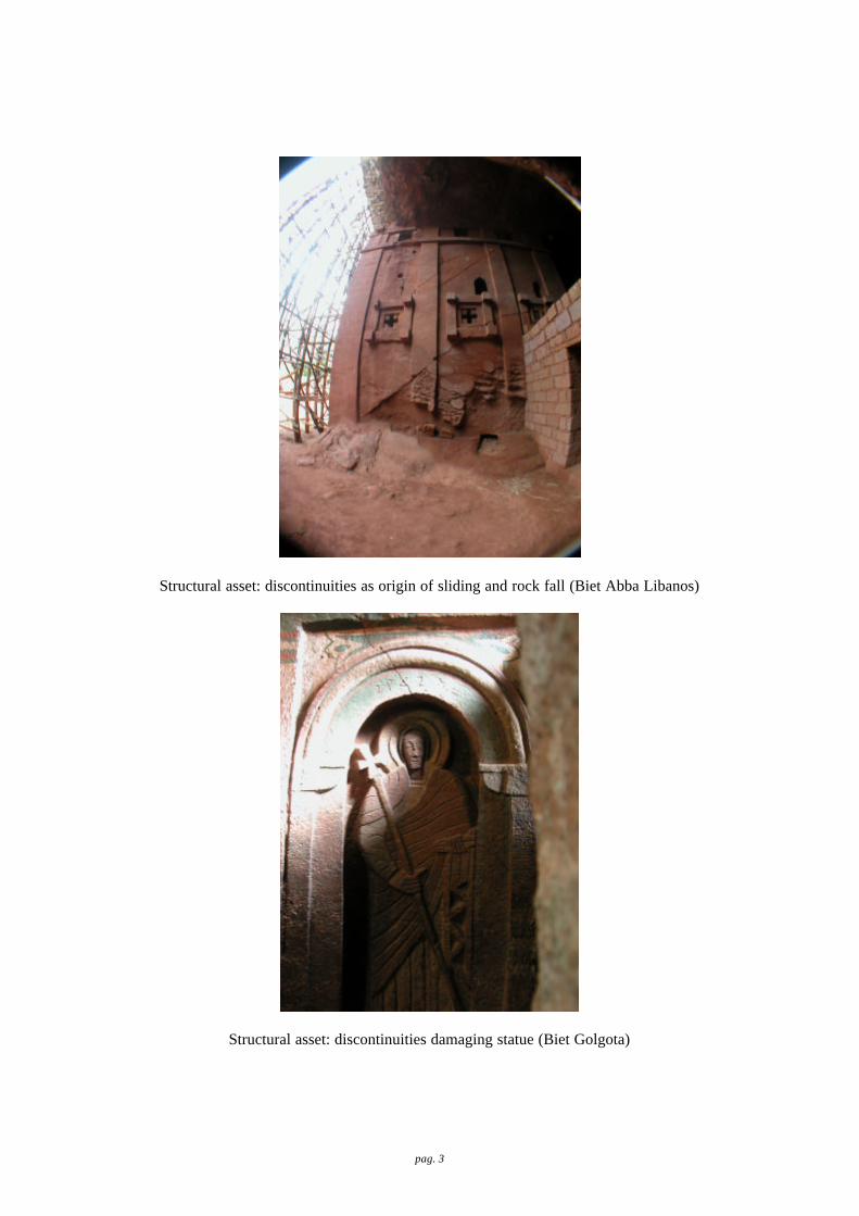
A major crack, cutting the statue of S. Peter(?) and a similar few meter lower, cutting a back statue produce a major attention. The same discontinuity is quite evident on the cliff in front to the main entrance (dip direction
Pag. 12

290°, dip 30°). The S. Peter (?) fracture was monitored by Angelini in 1968 and presently seem to have enlarged of about 1 mm. The presence also of an important crack, about 5 mm wide spanning 1 m, in the middle of Biet Dabra Sina church, in the volt, require attention. The North wall of Biet Mikael-Golgota is completely weathered and statues are irreparably damaged. Water flowing from the upper level should be avoided the prevent surface tuff corrosion.
Biet Amanuel (grade 5) It is probably the monument in the worst condition. The static weight of the roof, the carrying capacity of walls and weathering processes are all together acting negatively for future conservation. The existing shelter was extremely useful but there is certainly the need of a systemic plan for conservation, starting from the structural engineering investigation. The pattern of discontinuities of next figure clearly show the number of cracks affecting the facades and the weathering processes. A long fracture about 10 cm wide is crossing the whole Church. The vaults between ground floor and mezzanine, on the right arcade exhibit a net of cracks while the first from the entrance, is badly disconnected. Almost all arches in both longitudinal and transversal direction have cracks in the center.
Figure 13 – Discontinuity pattern for the South façade.
The comparison of this pattern with the one of Biet Medhan Alem clearly show the dramatic situation of the Church. The main reason for the structural situation is the static load of the roof, about 3 meters. The following axonometry from Bianchi Barriviera, (1963) it clearly depicts the thickness of the roof and the below walls.
Figure14 – 3D axonometry of the Church
Pag. 13

All the facades are suffering for weathering, with the only exception of the west one, restored by Angelini in 1967. Efflorescence was also observed, probably connected with weathering of concrete after modern restoration (UNESCO, 1995).
Biet Marqorewos (Mercurios) (grade 4) The edifice is composed by chambers supported by pillars opening onto a longitudinal courtyard of irregular shape. The roof of the Church was partially collapsed and also recently a new small portion went down. The reason is in the alteration of the tuff (pedogenesis) in an edifice showing a small thickness of the roof (figure ); as demonstration, the Uniaxial Compressive Strenght measured on the field reach, in this site, the minimum values, typical for wet material. The remaining roof is completely weathered and water is flowing inside, especially in the western wall. Some of the outside columns present weathering phenomena in the lower part, while an internal pillar is affected by a wide sub horizontal crack. A very interesting mural painting is present inside the Church. This painting is damaged by a nail fixed by priest to support electricity cable. It will be important also to define a management guideline to avoid similar situation.
Figure15 – Section of Biet Marqorewos (Bianchi Barriviera, 1963) with the central part collapsed and comparison with present day situation.
Biet Abba-Libanos (grade 4)
This is a monolithic Church anchored to the rock out of which it was carved. By its excavation within the rock face (height of the circular tunnel 7 m) and by its small dimension, it imitates a cave Church. Two major phenomena affect the Church: alveolization in the lower part of the edifice and the presence of a geological discontinuity (the same sub horizontal fissures of everywhere) that in this case is dipping to facilitate the sliding of the walls (figure). Alveolization is producing a fine sand, a sample of which has been taken to compare the analysis (x-ray and scanning electronic microscope) with fresh material. According to UNESCO (1995) the sand produced by crumbling of the tuff had been considerably enriched with nitronatrite (NaNO3) and nitrocalcite (Ca(NO3) 2). It can therefore be preliminary assumed that the cristallisation of soluble salts was the cause of the process of crumbling and alveolisation of the tuff. Water is probably the driven agent. Also interesting is the weathering of the indoor columns, probably connected with flux of fresh air from the entrance. Most serious is the relationship with local discontinuity. The frontal façade partially collapsed in the past and has been reconstructed. The reason of collapse was the sliding along the detected discontinuity. Also now, according the shear strength of the discontinuity based on tilt test, the kinematic analysis (plot in figure), clearly show that all the conditions leading to a possible slide are satisfied. To aggravate the situation there is the connection with an iron bar (tie rod), of the two lateral walls prone to slide. In such a way the most unstable sides were tied together, when a correct intervention had to fix unstable walls with stable ground (direction of bar perpendicular to present one). The joint roughness coefficient (JRC) of discontinuity has been estimated with Burton equipment in about 14. Crack gauges installed by Angelini in 1968 do not exhibit any movement.
Pag. 14

Figure 16 – Section and lateral prospect of Biet Aba Libanos showing the dipping discontinuities which
kinematically lead to possible slide (right plot). Biet Gabriel-Rufael (grade 3)
This Church is a very impressive structure, with different architectural style with respect to others. In this area there are major weathering processes, especially in the two courtyard that surround the edifice South and North. Especially in the North courtyard the presence of water is testify by a deep underground cistern (figure). This cistern provided water even during the Sahel drought of ’80. One large horizontal crack is crossing the Church. Other fissures are inside, one of those 10 mm wide. Also the roof exhibit a vertical crack, as well as one of the internal pillar. Water is infiltrating from the roof and the environment suffer for humidity. Also mechanical property of tuff inside the Church it seems to reflect the general wetting of material (UCS about 30 MPa inside; UCS about 34 MPa outside).
Figure 17 – 3D sketch of Northern courtyard (Bianchi Barrivera, 1963) with the deep cistern and the weathering processes on the cliff and wall (photo on the right).
In the same Courtyard of cisterna, the column also displayed in figure 17 (photo on the left), is prone to collapse and a simple intervention with metal belt could temporary solve the problem, before a final stabilisation with stainless steel bars.
Biet Giyorgis (grade 1) General good conditions. Small minor cracks on external walls. The major identified problem is the weathering of South wall as consequence of water falling on the roof, channelled, concentrated through a short gutter and from this going inside the church. It would be enough to get the water farther away from the wall to avoid any problem (and probably to protect the roof for the future).
Pag. 15

10. The European Union project With very high responsibility the European Commission decided to fund a project for the Preservation and Conservation of the Lalibela Churches. The project sum up to € 9.100 Million. The following table is giving the exact allocation of funding.
Table 5 – The EU project and funding assessment Works including dismantling and erection, site offices and facilities, etc Supervision of works and other associated technical studies Conservation study (including field surveys, pilot yard tests/waterproofings, etc) Capacity building and support for the project management and administration Community development activities (by NGOs) Creation of a database on Lalibela and on other rock-hewn and/or historical churches Conservation programme preparation and promotion (including basic infrastructure, a documentary film, an internet-site and activities aimed to increase visibility) Project Evaluation Sub-total Contingency +/- 7 %
5,500 160 1,200 350 500 270 480 50 8,510 590
Grand Total
9,100
The project is following the logical framework described in figure 18. The activity expected to be covered by EU funding are those described within the sky boxes.
UNESCO identification studyservation of rock hewn Churches in
• Protection (2) Conservation (3) Other Project
Formulation of the Conservation Related Activities
International Architects Finalisation of the TOR for the Study Preparation and Publication TA to ARCCH for the Formulation of the Concervation Competition of a Book on Lalibela
Design Study
Conservation Study
Construction of Supervision of Setting-up and Promotion Other Related Activities
& New Shelters the Works of theConservation contingency Programme
Implementation of the
Figure 18 – Logical framework of the EU project (from EU documents available to UNESCO). The foreseen activities are
related to the sky boxes only. The project it is quite well designed and aimed at solving a very important issue in Lalibela. Nevertheless, if UNESCO is going to take over the project some minor changes might be foreseen. The project plans to have 5.5 M € for the construction of new shelters, 0.16 M € for supervision of the construction, 1.2 M € for the conservation study, 1.65 M € for other services (see table 5) and 0.59 M € for contingency. It is opinion of the consultant that this a very important amount of money that should implement as much as possible practical work in Lalibela. In detail:
Pag. 16

1) the situation is quite dramatic in some Churches: an emergency intervention plan for sites where without large investigation it is possible to recommend definitively solution should be pursued;
2) any proposed intervention should have, in any case, the largest as possible consensus from experts, local and internationals. A multidisciplinary Scientific Committee is then required;
3) the shelters have been demonstrated to be the most efficient system for protection from water rainfall and run off; they should be implemented as emergency measurement; it must be investgated the possibility to protect also Biet Gyorgis to prevent future degradation;
4) alternative system for protecting from water rainfall and run off should be investigated. Expert from ARCCH described a technique implemented within a Swiss project for protecting a Church from seepage by means of impermeable layers covered by local soil. This technique could be implemented in those sites were there are not roof of artistic value (e.g. Biet Marqorewos);
5) there is certainly the need of a study phase, probably not consistent as expected in the EU project. Many investigation have been performed at international (e.g. International Design Competition for Shelters) and local level. The collection of most available information may solve some of the uncertainties existing at the time of preparing the EU project, that it was before the international Design Competition for shelters. Nevertheless there are still large uncertainties, especially for the hydrological and hydrogeological situation, structural engineer, etc.;
6) there is a need of implementing local capacity building. According to the above comments but also having in mind the EU project main articles, the project should be organised in the following manner to include the priorities imposed:
1) Establishment of a Multidisciplinary Scientific Committee (MSC) 2) Emergency intervention
a. Construction of new shelters i. Determining the Churches to be protected by shelters and those that can be protected by
alternative means ii. Approval by MSC
iii. Tendering for shelters iv. Construction of new shelters and supervision
b. Alternative protection i. Approval by MSC
ii. Tendering iii. Implementation
c. Emergency consolidation i. Identification of sites in imminent risk of collapse, to be stabilise without further
complicated investigation ii. Determination of the most suitable technique of intervention
iii. Approval by MSC iv. Tendering v. implementation
3) Study phase for long term preservation and conservation programme (as well as for very difficult task like Biet Amanuel). Main items should include (not exhaustive):
a. Hydrology/Hydrogeology b. Petrography c. Rock mechanic characterisation d. Structural engineering investigation e. Archaeological investigation f. Mural paintings g. Rehabilitation and consolidation
4) Technical assistance and capacity building to ARCCH (Authority for Research and Conservation of Cultural Heritage) and local community
Finally, the study phase should be multidisciplinary and multiscale. In fact, most of local problems are the consequence of large processes, as run off. The following table is trying to give an idea of typology of processes and scale of problems; in such a way it is possible to notice that some phenomena are the consequence of regional
Pag. 17

processes while, on the same Church, there are also other processes that can be solved at site level. This last are probably the situation where an emergency plan may solve most of critical points without large technical investigations and investments.
Scale of problem Process
Areal (territory) Local (Church level) Site (sub-set of Church)
Example
Mechanical rainfall erosion X Biet Medhane Alem
Surface degradation (pedogenesis) run off ----> X X Bet Merkorios, Bet Abba Libanos
Corrosion, efflorescence, etc run off ----> X Biet Giorgys
degradation (alveolize, etc.) run off ----> X Bet Amanuel
Static design X X Bet Medhane Alem, Bet Amanuel
Structural asset (discontinuities, dip, direction, etc.) run off ----> X Bet Abba Libanos, Betk Meskel
11. Conclusion and recommendation During the mission in Lalibela it was possible to understand basic processes acting on the rock hewn Churches as well as the best way to proceed in the near future. The inspection conducted on the 11 churches revealed a complexity of phenomena acting in the area. Sometime only one mechanism is prevailing, some other times there is the combination of multiple factors leading to the damage of the structure. All the churches have been hewn in monolithic rock belonging likely to the tuff lents of the Amba Aiba basalt formation (Miocene-Oligocene) (Merla et. Alii, 1973). The tuffs exhibit an average uniaxial compressive strength of about 36 MPa in natural condition (γ=16 kN/m3), decreasing to 28 MPa when saturated. The basalt exhibits an uniaxial compressive strength of about 44 MPa (γ=20 kN/m3). The identified effect of chemical/physical degradation processes include :
1. mechanical erosion produced by rain drops; 2. alteration of uncovered external part of tuff formation exposed to meteo-climatic factors (pedogenesis?),
also benefited by vegetation and plant roots action; this a particular severe problem where there is limited thickness of roof;
3. degradation (alveolization) of some particular sensitive tuff strata and/or critically exposed; 4. corrosion of tuff formation in consequences of water percolation; 5. limited carrying capacity of some walls, due the very heavy load to sustain; 6. presence of discontinuities with direction and dip capable to generate a sliding. 7. biological colonisation
The main causes for the above can be assumed in: 1. water run off without any control; 2. limited thickness of roof; 3. water infiltration from existing discontinuities and weathering of tuff strata; 4. structural geology of the area; 5. mechanical properties of tuff formation; 6. original engineering design.
All the churches haves been classified according to their state of conservation and vulnerability. This is to identify highest priority of intervention, with respect to their static condition. According to the investigation the result was quite dramatic, since 1 Church is at very severe risk (Biet Amanuel) and three Churches are at severe risk (Biet Medhane-Alen, Biet Aba Libanos, Biet Mercurius). This classification is intended for building but it may give a first idea of the degree of conservation and risk of loss for Lalibela Churches. All the identified problems are, in principle, suitable to be solved, by means of a correct comprehension of acting mechanisms and proper stabilisation measurements. In some cases there is also the chance to realize immediate emergency intervention to avoid further and more severe damage. Also the foreseen shelters, for which there is no doubt about the utility, can be put into the context of an emergency intervention. The project of the European Union address quite correctly the major problems of the area. Nevertheless there is large emphasis to study and investigation that can be highly reduced in favour of most concrete intervention. In
Pag. 18

such a way the project should be modified manly in the financial allocation according to the following possible scheme:
1. Establishment of a Multidisciplinary Scientific Committee (MSC) 2. Designing, planning and implementing Emergency intervention 3. Study phase for long term preservation and conservation programme 4. Technical assistance and capacity building to ARCCH and local community
This scheme is quite close to the originally proposed by EU but the content are relatively different, since it consider a major effort, still to be quantified, in emergency interventions. Also the location of proposed shelter should be better investigated to see if alternative solutions may provide similar benefit to monuments (e.g. Swiss project for impermeabilisation of soil above Churches where there is no roof of artistic value) and, possibly, to extend shelters to other edifices presently not in crises but certainly to be preserved for the future. References ACEL-SAVA (1997). Geology and engineering geology of Lalibela Churches. (restricted). ARCCH (1994). Plan and section of the rock hewn churches of Lalibela. (restricted). Bianchi Barriviera L. (1963) Le chiese in roccia di Lalibela e di altri luoghi del Lasta. Rassegna di Studi Etiopici. Kazmin V. (1973). Geological map of Ethiopia. Imperial Ethiopian Government, Ministry of Mines, Geological Survey of
Ethiopia. ICCROM (1978). Proceeding of the Symposia of International Experts on Stone Conservation. Lalibela. (restricted). International fund for monuments (1967). Lalibela –Phase 1. Adventure in restoration. New York ISMR, 1978 Merla G., Abbate E., Azzaroli A., Bruni P., Canuti P., Mazzuoli M., Sagri M., Tacconi P. (1979). A geological map of
Ethiopia and Somalia (1973) 1:2.000.000 and comment with a map of major landforms. Consiglio Nazionale delle Ricerche, Italy.
Mohr P., Zanettin B. (1988). The Ethiopian flood basalt province. In J.D. Macdougall (ed.), Continental flood Basalt. Kluwer Academic Publisher.
Panizza M., Piacente S. (2003). Geomorfologia culturale. Pitagora Editrice Bologna. TEPRIN (2002). Shelters for five Churches in Lalibela project. Tender dossier. (restricted). UNESCO (1995). Preservation of the rock-hewn Churches in Lalibela. Vol. I, II and III. Paris. (restricted),
Pag. 19

pag. 1
Annex 1
Weathering forms in Lalibela area

pag. 2
The following pages contain some photos describing the major degradation processes detected during the mission. The purpose of this atlas it is not to give a comprehensive and detail technical description of processes but simply to present most of the degradation forms we have fund in the field mission, and that should be better investigated in the future. It is clear that any individual process must be investigated by respectively specialists.
pag. 3
Structural asset: discontinuities as origin of sliding and rock fall (Biet Abba Libanos)
Structural asset: discontinuities damaging statue (Biet Golgota)

pag. 4
Degradation: alveolization process (Biet Gabriel Rufael)
Degradation: alveolization process (Biet Medhan Alem)

pag. 5
Biological colinisation (Biet Gyorgis)
Surface alteration: production of soil – pedogenesis (Biet Marqorews)

pag. 6
Rainfall mechanical erosion (Biet Medhan Alem) - not only
Rainfall mechanical erosion (Biet Amanuel) – not only

pag. 7
Static design and mechanical properties of rock (Biet Medhane Ale)
Static design and mechanical properties of rock (Biet Medhane Alem - detail)

pag. 8
Corrosion (Biet Gyorgis)
Corrosion (Biet Golgota)

pag. 9
Efflorescence (Biet Medhane Alem)